Embed Size (px)
Citation preview
Clim. Past, 10, 167–180, 2014www.clim-past.net/10/167/2014/doi:10.5194/cp-10-167-2014© Author(s) 2014. CC Attribution 3.0 License.
Climate of the Past
Open A
ccess
Late Pliocene lakes and soils: a global data set for the analysis ofclimate feedbacks in a warmer world
M. J. Pound1, J. Tindall2, S. J. Pickering2, A. M. Haywood2, H. J. Dowsett3, and U. Salzmann1
1Department of Geography, Faculty of Engineering and Environment, Northumbria University, Ellison Building,Newcastle upon Tyne, UK2School of Earth and Environment, University of Leeds, Woodhouse Lane, Leeds, UK3Eastern Geology and Paleoclimate Science Center, US Geological Survey, Reston, Virginia 20192, USA
Correspondence to:M. J. Pound ([email protected])
Received: 29 April 2013 – Published in Clim. Past Discuss.: 17 June 2013Revised: 16 December 2013 – Accepted: 17 December 2013 – Published: 23 January 2014
Abstract. The global distribution of late Pliocene soils andlakes has been reconstructed using a synthesis of geologi-cal data. These reconstructions are then used as boundaryconditions for the Hadley Centre General Circulation Model(HadCM3) and the BIOME4 mechanistic vegetation model.By combining our novel soil and lake reconstructions with afully coupled climate model we are able to explore the feed-backs of soils and lakes on the climate of the late Pliocene.Our experiments reveal regionally confined changes of lo-cal climate and vegetation in response to the new bound-ary conditions. The addition of late Pliocene soils has thelargest influence on surface air temperatures, with notableincreases in Australia, the southern part of northern Africaand in Asia. The inclusion of late Pliocene lakes increasesprecipitation in central Africa and at the locations of lakes inthe Northern Hemisphere. When combined, the feedbacks onclimate from late Pliocene lakes and soils improve the datato model fit in western North America and the southern partof northern Africa.
1 Introduction
1.1 Background
The late Pliocene (Piacenzian: 3.6–2.6 Ma) is the most re-cent geological time period of considerable global warmth,before the onset of the glacial–interglacial cycles of the Pleis-tocene (Dowsett et al., 1992, 1994; Haywood et al., 2011b;Salzmann et al., 2011). As it is, geologically speaking, rel-
atively recent, it represents a recognisable world (in termsof its geography, orography and bathymetry) in which as-pects of the Earth’s climate can be explored through prox-ies and modelling studies to better understand the feed-backs, processes and impacts of sustained global warmth(Dowsett et al., 1996, 2012; Salzmann et al., 2009; Lunt etal., 2010, 2012). The focus on the late Pliocene palaeocli-mates has been driven by the PRISM (Pliocene Research In-terpretations and Synoptic Mapping) project of the US Ge-ological Survey. PRISM3 (the third iteration of the PRISMproject, which includes a three-dimensional ocean recon-struction) provides palaeoenvironmental reconstructions ofthe Pliocene world, from geological data, in a form suitablefor use in climate modelling studies (Dowsett et al., 2010).With the availability of boundary conditions (aspects of theworld required to initialise climate modelling experiments)from PRISM, it has been possible to undertake meaningfulclimate modelling studies to explore Pliocene climates (e.g.Chandler et al., 1994; Sloan et al., 1996; Haywood et al.,2009; Lunt et al., 2012). Building on single model studiesof the Pliocene, PlioMIP (Pliocene Model IntercomparisonProject) has brought together ten different climate modellinggroups to simulate identical experiments and investigate notonly the climate of the Pliocene but also inter-model variabil-ity and uncertainty (Haywood et al., 2010, 2011a; Dowsettet al., 2012, 2013; Salzmann et al., 2013). PlioMIP uses thepalaeoenvironmental reconstructions from PRISM3, whichincludes palaeogeography, orography, bathymetry, vegeta-tion, ice sheet configuration and oceanic temperatures. How-ever, there is currently no information on late Pliocene global
Published by Copernicus Publications on behalf of the European Geosciences Union.
168 M. J. Pound et al.: Late Pliocene lakes and soils
soils or lakes. In PlioMIP experiments 1 and 2, global soilswere specified in a manner consistent with the vegetation, orthey were kept as modern (Haywood et al., 2010; Contoux etal., 2012). Lakes were specified as absent and not includedin any of the PlioMIP experiments. In this paper we presentglobal data sets and palaeoenvironmental reconstructions ofglobal late Pliocene soils and lakes. These are intended to beincorporated into the PRISM4 Pliocene global reconstructionand future PlioMIP experimental design.
1.2 The importance of soils and lakes in palaeoclimatestudies
Albedo-related soil and vegetation feedbacks are key uncer-tainties in the Earth System and climate models differ consid-erably in estimating their strength (e.g. Haywood and Valdes,2006; Knorr and Schnitzler, 2006). For the terrestrial realm,large inland water bodies and wetlands have also been shownto significantly affect surface temperatures and energy bal-ance in past and present climate systems (e.g. Sloan, 1994;Delire et al., 2002; Sepulchre et al., 2009; Burrough et al.,2009; Krinner et al., 2012). Studies of the African HumidPeriod in the Holocene have found that lakes and wetlandscontribute to the “greening of the Sahara” by increasing re-gional precipitation (Krinner et al., 2012). A similar increasein regional precipitation was found for the late PleistoceneLake Makgadikgadi in the middle Kalahari (Burrough et al.,2009). In deeper time palaeoclimate studies, Sloan (1994)found that, when simulating the early Eocene of North Amer-ica, the addition of a lake had as much impact on the cli-mate of the continental interior as the 1680 ppmv CO2 inthe model’s atmosphere. The addition of a modest lake de-flected the winter freezing line north and improved the data-to-model fit for winter temperatures (Sloan, 1994).
Soil albedo has also been shown to have a large impact onregional precipitation (Knorr and Schnitzler, 2006). A seriesof climate model experiments on the mid- to late Holoceneshowed that soil albedo in the Sahara had a larger effecton regional precipitation than orbital forcing and sea sur-face temperatures (Knorr and Schnitzler, 2006). Other exper-iments have shown that wetter and darker soils in the mid-Holocene Sahara would have facilitated the northward move-ment of the African monsoon, creating a positive feedback(Levis et al., 2004).
Current palaeoclimate modelling studies of the latePliocene often struggle to generate sufficient precipitation,particularly in the semi-arid and arid tropical and subtropicalregions, to match proxy data (Salzmann et al., 2008; Hay-wood et al., 2009; Pope et al., 2011). As some studies haveshown that lakes and soils have had significant regional im-pacts on mid-Holocene precipitation (e.g. Knorr and Schnit-zler, 2006; Krinner et al., 2012), it stands to reason that sim-ilar effects could be seen in the late Pliocene. Conversely,recent work focussing on the Megalake Chad region duringthe late Pliocene did not show significant increases in precip-
30
821
822
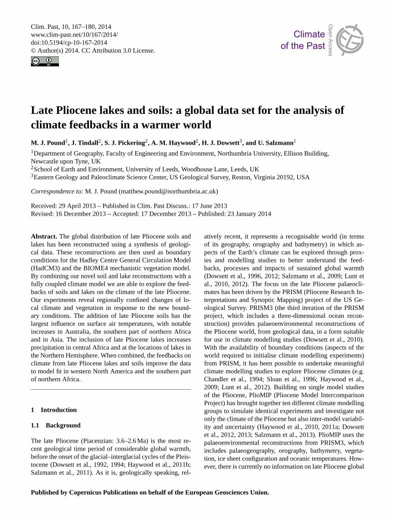
Figure 1. The location of the soils and lake data used in this study to reconstruct global Late 823
Pliocene land surface features. Soils data has the prefix S (Supplementary table 1), whilst 824
lakes data has the prefix L (Supplementary table 2). 825
826
827
Fig. 1. The location of the soils and lake data used in this study toreconstruct global late Pliocene land surface features. Soil data havethe prefix S (Supplement Table S1), whilst lake data have the prefixL (Supplement Table S2).
itation (Contoux et al., 2013). However, Holocene palaeocli-mate studies benefit from comprehensive published data setsof soils and lakes (e.g. Hoelzmann et al., 1998), and up topresent no such data have been available for late Plioceneclimate model studies (Haywood et al., 2010). In this pa-per we present the first global data sets of late Pliocene soiland lake distributions, and these data sets have been trans-formed into climate model boundary conditions suitable forexploring the feedbacks of soils and lakes in a warmer world.The data sets provide previously missing boundary condi-tions for late Pliocene palaeoclimate modelling studies. Wepresent the initial results of the first late Pliocene palaeo-climate model studies using the new realistic soil and lakeboundary conditions. Finally, we compare BIOME4 (Kaplan,2001) output, from our new simulations, to the global vegeta-tion database of Salzmann et al. (2008, 2013) to qualitativelyevaluate data–model similarity.
2 Methods
2.1 Construction of the lake and soil database
Late Pliocene lake and soil data have been collected andsynthesised into an internally consistent format using a Mi-crosoft Access–ArcGIS database that is based on the vege-tation database TEVIS (Salzmann et al., 2008). The soil andlake data have been compiled from published literature: soildata (Fig. 1; Supplement Table S1) are based upon paleosoloccurrences (e.g. Mack et al., 2006), whereas evidence forlakes (Fig. 1; Supplement Table S2) comes from sedimen-tology (e.g. Müller et al., 2001), dynamic elevation modelsand topographic studies (e.g. Drake et al., 2008), fauna (e.g.Otero et al., 2009) or a combination of these (e.g. Adamet al., 1990). Both the soil and lake data are recorded witha latitude–longitude (for lakes this represents the centre), amaximum and minimum age in millions of years (Ma) andthe method used to date the deposit. The documented soildata also include a soil type, which is based upon the orders
Clim. Past, 10, 167–180, 2014 www.clim-past.net/10/167/2014/

M. J. Pound et al.: Late Pliocene lakes and soils 169
Table 1.The colour (for albedo) and texture translations for the soilorders used in the modelling of late Pliocene soils.
Soil Colour Texture Albedo
Gelisol Intermediate Medium 0.17Histosol Dark Fine 0.11Spodosol Intermediate Medium/Coarse 0.17Oxisol Intermediate Fine/Medium 0.17Vertisol Dark Fine 0.11Aridisol Light Coarse 0.35Ultisol Intermediate Fine/Medium 0.17Mollisol Dark Medium 0.35Alfisol Intermediate Medium 0.17
of the US Department of Agriculture soil taxonomy scheme(Soil Survey Staff, 1999). The lake data also record an es-timated surface area extent, the shape of the lake and forlakes with a surface area greater than 1500 km2 the latitude–longitude of its northern-, eastern-, southern- and western-most points. In addition to this, any reported information onwater chemistry, details of inflows and outflows or whetherthe lake was ephemeral have also been recorded. Full detailsof the databasing methodology and the data sets are availablein the Supplement.
2.2 Preparing the data for inclusion in a climate model
From the geological data recorded in the late Pliocene lakesand soil database we have produced three maps to allow theinclusion of lakes and soils in palaeoclimate modelling ex-periments. The three maps are a global soil map, which isaccompanied by a table providing preferred soil characteris-tics (Fig. 2a; Table 1); a dry-lakes scenario (Fig. 2b); and awet-lakes scenario (Fig. 2c). All maps use a grid cell size of2.5◦ latitude× 3.75◦ longitude; this equates to a spatial reso-lution of 278 km× 417 km at the Equator.
To develop a global late Pliocene soil map (Fig. 2a) fromthe 54 palaeosol occurrences recorded in the database (Sup-plement Table S1), we combined the soil data with thePiacenzian biome reconstruction presented in Salzmann etal. (2008). This allowed a soil type to be assigned to eachmodel grid cell even if late Pliocene palaeosol data had notbeen reported from that region. This technique of combininga realistic biome reconstruction with palaeosol data uses theknowledge that at a global scale the distribution of each soilorder mirrors certain vegetation biomes (Soil Survey Staff,1999). When the palaeosol data were combined with the veg-etation reconstruction, there were no mismatches between apalaeosol occurrence and a biome that we did not expect tobe associated with that soil order.
Both the late Pliocene dry-lake scenario and wet-lake sce-nario are based upon the estimated surface area of the palae-olakes, translated into a percentage of a model grid cell
(Fig. 2b, c). A wet and a dry scenario have been generatedto compensate for the uncertainty in the dating of many ofthese features, which often cover several orbital cycles. Byproducing a dry- and a wet-scenario map it is possible forclimate modelling experiments to explore the impacts of latePliocene lakes in a warm-wet climate period or a cold-dryclimate; this follows the vegetation work of Salzmann etal. (2013). Late Pliocene lake surface areas have been eithertaken from the published literature or calculated from pub-lished estimates of lake extent. These were then translatedinto percentages of grid cells by calculating how much of agrid cell would be occupied by each lake. Where megalakesoccupied more than one grid cell, the geographic distributionof the lake was based upon the published shape and the distal-most latitude–longitude points of the reconstructed lake.
2.3 Uncertainties in reconstructing soils and lakes fromgeological data
This study is the first to present realistic late Pliocene soiland lake maps derived from the synthesis of geological data(Fig. 2). Despite these maps being the current state of theart it is important to discuss the uncertainty involved inthem. For the global soils reconstruction the greatest uncer-tainty comes from the limited geographic distribution of data(Fig. 1) and the reliance on the global biome reconstruction(Salzmann et al., 2008) to fill in the gaps. However, therewere no soil data points coinciding with a vegetation typethey would not normally be associated with, so we can haveconfidence in our methodology to generate a global map. Onediscrepancy between the late Pliocene reconstruction and themodern global soil order map is that the late Pliocene doesnot have any regions of Inceptisols or Entisols (Fig. 2a). To-day these two soil orders make up about 30 % of the landsurface and represent undeveloped or moderate pedogenicdevelopment (Soil Survey Staff, 1999). Producing a globalsoil order map for the late Pliocene requires the incorpo-ration of many distinct palaeosol occurrences, and most ofthese are preserved as a pedogenically developed soil order,rather than preserved as an undeveloped or moderately de-veloped soil (e.g. Gürel and Kadir, 2006). Where inceptisolpalaeosols are preserved they are commonly associated witha fully developed soil order (e.g. Mack et al., 2006). Furtherto their limited geological preservation, Inceptisols and Enti-sols are not commonly associated with particular vegetationtypes, being a product of limited soil development rather thanambient climate and biome (Soil Survey Staff, 1999). Thismade them near impossible to plot on a late Pliocene soil mapwith the available data and methodology. Inceptisols and En-tisols were therefore omitted from the reconstruction, but itshould be noted that they were not absent during the Pliocene(Sangode and Bloemendal, 2004; Mack et al., 2006). It is dif-ficult to assess the likely impacts on albedo and texture thatthe addition of Inceptisols and Entisols may have had duringthe late Pliocene. As these soil orders have limited pedogenic
www.clim-past.net/10/167/2014/ Clim. Past, 10, 167–180, 2014

170 M. J. Pound et al.: Late Pliocene lakes and soils
31
828
Figure 2. The reconstructed distribution of A) Late Pliocene soils, B) Late Pliocene dry-lakes 829
scenario and C) Late Pliocene wet-lakes scenario. 830
831
Fig. 2.The reconstructed distribution of(A) late Pliocene soils,(B) late Pliocene dry-lakes scenario and(C) late Pliocene wet-lakes scenario.
development, they are more intimately tied to their parentmaterial than other soil orders. This could mean that Incepti-sols and Entisols could have had any combination of albedoand texture depending on late Pliocene surface geology.
The late Pliocene biome reconstruction from Salzmann etal. (2008) is a hybrid map combining 240 palaeobotanicaldata sites with a “best fit to data” BIOME4 output (forcedby HadAM3-predicted late Pliocene climate), which weremerged using expert knowledge. Although this means thatlimited regions of the biome reconstruction do rely more onmodel predictions than real data, the overall product is pri-
marily based on an exhaustive database of late Pliocene plantfossil localities. Developing a global late Pliocene soil mapwith only 54 paleosol localities required either extensive in-terpolation (with all the possible errors that may have comewith that) or the use of another data set (the hybrid biome re-construction) and the knowledge that most soil orders (withthe exception of Inceptisols and Entisols) are related to par-ticular vegetation types.
The reconstructed late Pliocene lakes represent a synthe-sis of the published geological data. What is most obvious isthe vast areas with no percentage of the grid cell covered by
Clim. Past, 10, 167–180, 2014 www.clim-past.net/10/167/2014/

M. J. Pound et al.: Late Pliocene lakes and soils 171
surface water (Fig. 2). This is not meant to mean that theseregions were without any surface water, but that there areno published records of lake sediments with the lake extentestimated. However, it is highly likely that during wetter cli-mates in the past many presently arid regions were coveredwith river systems, as has been shown for the Sahara duringthe Eemian (MIS 5e) and Holocene (e.g. Hoelzmann et al.1998; Coulthard et al., 2013). With continued research intolate Pliocene lake faunas, floras and sediments these regionswill contain more evidence for surface water. Of the lakespresented in the reconstructions of this study the one withthe greatest uncertainty is the substantial Megalake Zaire(Fig. 2). This megalake has long been speculated due to allthe major tributaries of the Congo River being orientated tothe centre of the basin (Summerfield, 1991; Goudie, 2005)and the presence of a submarine canyon rather than a delta(Cahen, 1954; Peters and O’Brien, 2001; Goudie, 2005).However, it has not been ground-truthed with recent geologi-cal data and this should be an imperative (Peters and O’Brien,2001). For further discussion on the uncertainties surround-ing the reconstructions of late Pliocene soils and lakes pleasesee Supplement 1.
2.4 Modelling
The potential effects of the new lake and soil databaseson the Pliocene climate were tested using modelling sim-ulations with the UK Hadley Centre General CirculationModel (GCM), HadCM3. This is a coupled atmosphere–ocean GCM described by Gordon et al. (2000) and Pope etal. (2000), with horizontal resolution of 3.75◦
× 2.5◦ in theatmosphere and 1.25◦
× 1.25◦ in the ocean. The atmosphericcomponent has 19 levels in the vertical and 30 min time steps,while the oceanic component has 20 levels in the vertical and1 h time steps.
To investigate the impacts of realistic soil and lake distri-butions on the late Pliocene climate we analyse the resultsof 5 simulations: a control simulation of 850 yr (PRISM3control), a simulation with late Pliocene lake levels from thewet-lakes scenario (PRISM3+ wet-lakes scenario) (Fig. 2c),a simulation with late Pliocene lake levels from the dry-lakesscenario (PRISM3+ dry-lakes scenario), a simulation withlate Pliocene soils (PRISM3+ soils) and a simulation withsoils and the wet-lakes scenario (PRISM3+ soils + wet-lakes scenario). The PRISM3+ wet-lakes scenario, PRISM3+ dry-lakes scenario, PRISM3+ soils, and PRISM3+ soils+ wet-lakes scenario simulations were all started 500 yr intothe PRISM3 control simulation and were run for a further350 yr. This is sufficient to spin up all atmosphere and vegeta-tion parameters of interest (Hughes et al., 2006). The controlexperiment comprises boundary conditions from PRISM3;these include a near-modern orography (except for areas ofthe Andes) and a reduced Greenland Ice Sheet (for full detailsplease see Dowsett et al., 2010; Haywood et al., 2010, 2011).Although the preferred boundary conditions for PRISM3 are
to remove the West Antarctic Ice Sheet, here we utilise the al-ternative PRISM3 boundary conditions, which remove all icefrom the West Antarctic Ice Sheet and reduce the topographyto sea level (Haywood et al., 2011). The control experimenthas a modern orbit and CO2 levels of 405 ppmv. The initialvegetation patterns for the control run were prescribed fromPRISM3; however the version of HadCM3 used here com-prises the MOSES2.1 land surface scheme and the TRIFFIDdynamic vegetation model (Cox et al., 1999; Cox, 2001) suchthat vegetation dynamically changes with the climate, andthe relative proportions of different vegetation types adjustthroughout a long simulation. TRIFFID was run in equilib-rium mode for the first 50 yr of the control run; after thisTRIFFID was run in dynamic mode throughout. For the con-trol simulation, soil parameters were set to be the same asmodern and there were assumed to be no lakes. The lake andsoil experiments were initialised from a state 500 yr into thePRISM3 control run; hence their initial vegetation patternswere predicted by HadCM3+ MOSES2/TRIFFID for thePRISM3 climate. Vegetation continued to respond dynami-cally in all experiments.
The PRISM3+ wet-lakes scenario simulation was iden-tical to the control except that the high-level lakes were in-cluded in a very simple way. In the MOSES2.1/TRIFFID ver-sion of HadCM3, each grid box is assigned a fractional cov-erage of 9 different surface types (broadleaf trees; needleleaftrees; shrubs; C4 grasses; C3 grasses; ice; urban – not usedin the late Pliocene; bare soil; or water); lakes are includedin a grid box by increasing the water surface type, whilethe fractions of all other surface types are reduced as ap-propriate. It is noted that, although trees, grasses and shrubscan dynamically change throughout the model simulation,the lake fraction of the grid box will remain constant andwill be neither increased by precipitation nor decreased byevaporation (Essery et al., 2001). This means that the lakesin the simulation are static and do not depend on precipi-tation/evaporation/runoff patterns. The prescribed albedo ofthe lakes is 0.06, whilst roughness length is 0.0003 m.
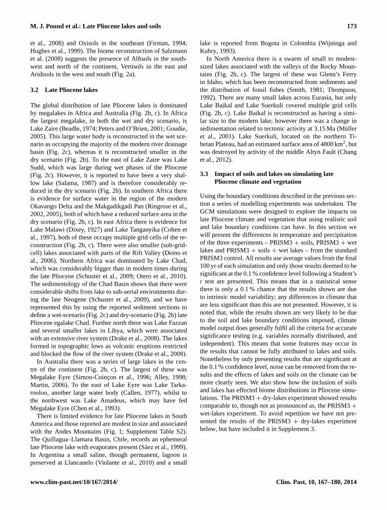
The PRISM3+ soils simulation required changes to sev-eral HadCM3 boundary conditions. The simplest of these issoil albedo, which was determined from the colour of the soiltype shown in Table 1. Following Jones (2008) light soilswere prescribed an albedo of 0.35, medium soils an albedoof 0.17 and dark soils an albedo of 0.11. These albedo valuesare based on the assumption that medium and dark soils haveaverage wetness, while light soils are dry. It is noteworthythat, although there are differences in soil types between thelate Pliocene and the modern, the simple way that these soiltypes are incorporated into HadCM3 means that their poten-tial for changing the climate is limited. Table 1 shows that,of the 9 soil types to be included in the PRISM4 database,five are intermediate colour, three are dark and one is light.This means that, even though a soil type may change be-tween the Pliocene and the modern, it is only if the soil typechanges to one of a different colour that the climate can be
www.clim-past.net/10/167/2014/ Clim. Past, 10, 167–180, 2014

172 M. J. Pound et al.: Late Pliocene lakes and soils
32
832
Figure 3. The changes in soil albedo between the PRISM3 control experiment and the new 833
Late Pliocene soils reconstruction. Differences in other soil components can be found in 834
Supplementary Information 2. 835
836
837
Fig. 3.The changes in soil albedo between the PRISM3 control ex-periment and the new late Pliocene soils reconstruction. Differencesin other soil components can be found in Supplement 2.
altered via albedo feedbacks (Fig. 3). Other soil parametersused in HadCM3 (Clapp–Hornberger exponent, saturated hy-draulic conductivity, saturated soil water suction, volumetricsoil moisture concentrations at critical, saturation and wiltingpoints, dry soil volumetric heat capacity and dry soil thermalconductivity) are prescribed values depending on soil textureas suggested by Cox et al. (1999). Again, it is noteworthythat, even though a soil type may have changed between themodern and the late Pliocene, it is where a soil changes to oneof a different texture that will have the potential to impact theclimate.
Although HadCM3 dynamically predicts vegetation pat-terns, this is limited to only 5 types of vegetation, and theseare difficult to compare with data sets of late Pliocene veg-etation such as PRISM3 (Salzmann et al., 2008). To facili-tate a better comparison with palaeobotanical proxy data theclimate output from HadCM3 were used to drive the offlinevegetation model BIOME4. The BIOME4 model (Kaplan,2001) is a mechanistic global vegetation model which pre-dicts the distribution of 28 global biomes based on themonthly means of temperature, precipitation, cloudiness andabsolute minimum temperature. The model includes 12 plantfunctional types (PFTs) from cushion forb to tropical ever-green tree (Prentice et al., 1992). It is the bioclimatic toler-ances of these that determine which is dominant in a gridcell and, from this, which biome is predicted. The BIOME4model was run in the anomaly mode with a CO2 of 405 ppmv.The model was driven from the average annual climate dataobtained from the last 100 yr of each HadCM3 experiment,to assess which PFTs were feasible in each grid box and toallocate an appropriate biome at each location.
3 Results
In this section we will first describe the geographic distri-bution of late Pliocene soils and lakes that have been re-constructed from geological data and then the results of in-cluding these reconstructions in a series of GCM simulationsusing the PRISM3 boundary conditions.
3.1 Late Pliocene soils
During the late Pliocene there were significant differences inthe global distribution of soils (Fig. 2a). Overall, the distri-bution of soils reflects the warmer and wetter world seen inthe vegetation reconstruction. Gelisols, associated with tun-dra type vegetation are restricted to very high latitude areasof North America, Greenland and Eurasia, as well as coastalregions of Antarctica (Fig. 2a). The more northern distribu-tion of boreal and temperate forests is accompanied by exten-sive high-latitude Spodosols and Alfisols at higher than mod-ern latitudes (Fig. 2a). There is evidence supporting Alfisolsat 54◦ N from around Lake Baikal, where grey forest soilsare preserved (Mats et al., 2004). The extensive grasslandand savannas in the continental interiors of North Americaand Eurasia are translated into extensive Mollisols (Fig. 2a).South of the Alfisol, in North America, there were Ultisolsalong the west coast and in the southeast of the continent(Fig. 2a). The centre of North America contains a large re-gion of Aridisols, and a mixture of Alfisols (Abbott, 1981)and Vertisols (Mack et al., 2006) along the southern margin.In Europe there is evidence for Alfisols (Icole, 1970; Günsterand Skowronek, 2001), Histosols (Basilici, 1997; Bechtel etal., 2003) and extensive Ultisols (Gerasimenko, 1993). At theeastern end of the Mediterranean there was a region of mixedAlfisols (Quade et al., 1994), Oxisols (Kelepertsis, 2002), Ul-tisols (Paepe et al., 2004) and Vertisols (Graef et al., 1997)(Fig. 2a). The Indian subcontinent contained a mixture of Ul-tisols and Vertisols during the late Pliocene (Fig. 2a). Thereis also evidence for Alfisols close to the Himalayas (Sangodeand Bloemendal, 2004). In southeast Asia the biome recon-struction translates into extensive Ultisols across this region(Fig. 2a).
In South America there is a large region of Oxisols as ev-idenced from palaeosols (Mabesoone and Lobo, 1980) andthe biome reconstruction. In southern South America Ulti-sols, Molisols and Alfisols dominated during the Piacenzian(Fig. 2a). The soils reconstruction for Africa relies heavilyon the biome reconstruction, except for direct evidence ofVertisols in east Africa (Wynn, 2000; Campisano and Feibel,2008), Oxisols in southern Africa (Helgren and Butzer, 1977)and Histosols in Madagascar (Lenoble, 1949). Combiningthese palaeosol occurrences with the biome reconstruction,the distribution of soils in Africa is shown to be dominated byAridisols in northern Africa and Oxisols in central and south-ern Africa (Fig. 2a). Palaeosol evidence in Australia showsthe presence of Aridisols in the middle of the continent (Hou
Clim. Past, 10, 167–180, 2014 www.clim-past.net/10/167/2014/
M. J. Pound et al.: Late Pliocene lakes and soils 173
et al., 2008) and Oxisols in the southeast (Firman, 1994;Hughes et al., 1999). The biome reconstruction of Salzmannet al. (2008) suggests the presence of Alfisols in the south-west and north of the continent, Vertisols in the east andAridisols in the west and south (Fig. 2a).
3.2 Late Pliocene lakes
The global distribution of late Pliocene lakes is dominatedby megalakes in Africa and Australia (Fig. 2b, c). In Africathe largest megalake, in both the wet and dry scenario, isLake Zaire (Beadle, 1974; Peters and O’Brien, 2001; Goudie,2005). This large water body is reconstructed in the wet sce-nario as occupying the majority of the modern river drainagebasin (Fig. 2c), whereas it is reconstructed smaller in thedry scenario (Fig. 2b). To the east of Lake Zaire was LakeSudd, which was large during wet phases of the Pliocene(Fig. 2c). However, it is reported to have been a very shal-low lake (Salama, 1987) and is therefore considerably re-duced in the dry scenario (Fig. 2b). In southern Africa thereis evidence for surface water in the region of the modernOkavango Delta and the Makgadikgadi Pan (Ringrose et al.,2002, 2005), both of which have a reduced surface area in thedry scenario (Fig. 2b, c). In east Africa there is evidence forLake Malawi (Dixey, 1927) and Lake Tanganyika (Cohen etal., 1997), both of these occupy multiple grid cells of the re-construction (Fig. 2b, c). There were also smaller (sub-grid-cell) lakes associated with parts of the Rift Valley (Deino etal., 2006). Northern Africa was dominated by Lake Chad,which was considerably bigger than in modern times duringthe late Pliocene (Schuster et al., 2009; Otero et al., 2010).The sedimentology of the Chad Basin shows that there wereconsiderable shifts from lake to sub-aerial environments dur-ing the late Neogene (Schuster et al., 2009), and we haverepresented this by using the reported sediment sections todefine a wet-scenario (Fig. 2c) and dry-scenario (Fig. 2b) latePliocene egalake Chad. Further north there was Lake Fazzanand several smaller lakes in Libya, which were associatedwith an extensive river system (Drake et al., 2008). The lakesformed in topographic lows as volcanic eruptions restrictedand blocked the flow of the river system (Drake et al., 2008).
In Australia there was a series of large lakes in the cen-tre of the continent (Fig. 2b, c). The largest of these wasMegalake Eyre (Simon-Coinçon et al., 1996; Alley, 1998;Martin, 2006). To the east of Lake Eyre was Lake Tarka-rooloo, another large water body (Callen, 1977), whilst tothe northwest was Lake Amadeus, which may have fedMegalake Eyre (Chen et al., 1993).
There is limited evidence for late Pliocene lakes in SouthAmerica and those reported are modest in size and associatedwith the Andes Mountains (Fig. 1; Supplement Table S2).The Quillagua–Llamara Basin, Chile, records an ephemerallate Pliocene lake with evaporates present (Sáez et al., 1999).In Argentina a small saline, though permanent, lagoon ispreserved at Llancanelo (Violante et al., 2010) and a small
lake is reported from Bogota in Colombia (Wijninga andKuhry, 1993).
In North America there is a swarm of small to modest-sized lakes associated with the valleys of the Rocky Moun-tains (Fig. 2b, c). The largest of these was Glenn’s Ferryin Idaho, which has been reconstructed from sediments andthe distribution of fossil fishes (Smith, 1981; Thompson,1992). There are many small lakes across Eurasia, but onlyLake Baikal and Lake Suerkuli covered multiple grid cells(Fig. 2b, c). Lake Baikal is reconstructed as having a simi-lar size to the modern lake; however there was a change insedimentation related to tectonic activity at 3.15 Ma (Mülleret al., 2001). Lake Suerkuli, located on the northern Ti-betan Plateau, had an estimated surface area of 4800 km2, butwas destroyed by activity of the middle Altyn Fault (Changet al., 2012).
3.3 Impact of soils and lakes on simulating latePliocene climate and vegetation
Using the boundary conditions described in the previous sec-tion a series of modelling experiments was undertaken. TheGCM simulations were designed to explore the impacts onlate Pliocene climate and vegetation that using realistic soiland lake boundary conditions can have. In this section wewill present the differences in temperature and precipitationof the three experiments – PRISM3+ soils, PRISM3+ wetlakes and PRISM3+ soils+ wet lakes – from the standardPRISM3 control. All results use average values from the final100 yr of each simulation and only those results deemed to besignificant at the 0.1 % confidence level following a Student’st test are presented. This means that in a statistical sensethere is only a 0.1 % chance that the results shown are dueto intrinsic model variability; any differences in climate thatare less significant than this are not presented. However, it isnoted that, while the results shown are very likely to be dueto the soil and lake boundary conditions imposed, climatemodel output does generally fulfil all the criteria for accuratesignificance testing (e.g. variables normally distributed, andindependent). This means that some features may occur inthe results that cannot be fully attributed to lakes and soils.Nonetheless by only presenting results that are significant atthe 0.1 % confidence level, noise can be removed from the re-sults and the effects of lakes and soils on the climate can bemore clearly seen. We also show how the inclusion of soilsand lakes has effected biome distributions in Pliocene simu-lations. The PRISM3+ dry-lakes experiment showed resultscomparable to, though not as pronounced as, the PRISM3+
wet-lakes experiment. To avoid repetition we have not pre-sented the results of the PRISM3+ dry-lakes experimentbelow, but have included it in Supplement 3.
www.clim-past.net/10/167/2014/ Clim. Past, 10, 167–180, 2014
174 M. J. Pound et al.: Late Pliocene lakes and soils
33
838
839
Figure 4. Mean annual and seasonal surface air temperature for the soils and lakes 840
experiments. Anomalies relative to the standard PRISM3 control run (with modern lake and 841
soil distribution). Everything plotted is significant at the 0.1% confidence level. 842
843
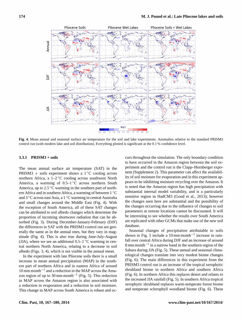
Fig. 4. Mean annual and seasonal surface air temperature for the soil and lake experiments. Anomalies relative to the standard PRISM3control run (with modern lake and soil distribution). Everything plotted is significant at the 0.1 % confidence level.
3.3.1 PRISM3 + soils
The mean annual surface air temperature (SAT) in thePRISM3 + soils experiment shows a 1◦C cooling acrossnorthern Africa, a 1–2◦C cooling across southwest NorthAmerica, a warming of 0.5–1◦C across northern SouthAmerica, up to 2.5◦C warming in the southern part of north-ern Africa and in southern Africa, a warming of between 1◦Cand 3◦C across east Asia, a 1◦C warming in central Australiaand small changes around the Middle East (Fig. 4). Withthe exception of South America, all of these SAT changescan be attributed to soil albedo changes which determine theproportion of incoming shortwave radiation that can be ab-sorbed (Fig. 3). During December-January-February (DJF)the differences in SAT with the PRISM3 control run are gen-erally the same as in the annual ones, but they vary in mag-nitude (Fig. 4). This is also true during June-July-August(JJA), where we see an additional 0.5–1◦C warming in cen-tral northern North America, relating to a decrease in soilalbedo (Figs. 3, 4), which is not visible in the annual mean.
In the experiment with late Pliocene soils there is a smallincrease in mean annual precipitation (MAP) in the south-ern part of northern Africa and in eastern Africa of around10 mm month−1 and a reduction in the MAP across the Ama-zon region of up to 30 mm month−1 (Fig. 5). This reductionin MAP across the Amazon region is also associated witha reduction in evaporation and a reduction in soil moisture.This change in MAP across South America is robust and oc-
curs throughout the simulation. The only boundary conditionto have occurred in the Amazon region between the soil ex-periment and the control run is the Clapp–Hornberger expo-nent (Supplement 2). This parameter can affect the availabil-ity of soil moisture for evaporation and in this experiment ap-pears to be inhibiting moisture recycling over the Amazon. Itis noted that the Amazon region has high precipitation withsubstantial internal model variability, and is a particularlysensitive region in HadCM3 (Good et al., 2013); howeverthe changes seen here are substantial and the possibility ofthe changes occurring due to the influence of changes to soilparameters at remote locations cannot be discounted. It willbe interesting to see whether the results over South Americaare replicated with other GCMs that make use of the new soildatabase.
Seasonal changes of precipitation attributable to soilsshown in Fig. 5 include a 10 mm month−1 increase in rain-fall over central Africa during DJF and an increase of around8 mm month−1 in a narrow band in the southern region of theSahara during JJA (Fig. 5). These annual and seasonal clima-tological changes translate into very modest biome changes(Fig. 6). The main differences in this experiment from thePRISM3 control run is an increase of the tropical xerophyticshrubland biome in northern Africa and southern Africa(Fig. 6). In northern Africa this replaces desert and relates tothe increased JJA rainfall (Fig. 5). In southern Africa tropicalxerophytic shrubland replaces warm-temperate forest biomeand temperate sclerophyll woodland biome (Fig. 6). These
Clim. Past, 10, 167–180, 2014 www.clim-past.net/10/167/2014/
M. J. Pound et al.: Late Pliocene lakes and soils 175
34
844
Figure 5. Mean annual and seasonal precipitation for the soils and lakes experiments. 845
Anomalies relative to the standard PRISM3 control run (with modern lake and soil 846
distribution). Everything plotted is significant at the 0.1% confidence level. 847
848
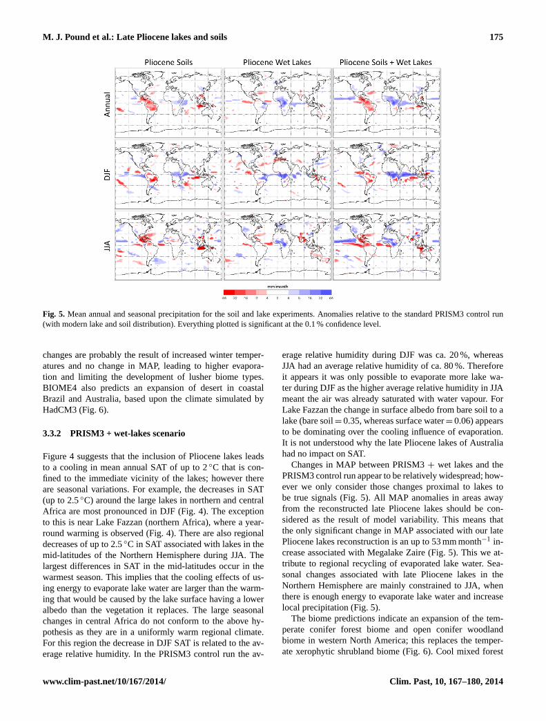
Fig. 5. Mean annual and seasonal precipitation for the soil and lake experiments. Anomalies relative to the standard PRISM3 control run(with modern lake and soil distribution). Everything plotted is significant at the 0.1 % confidence level.
changes are probably the result of increased winter temper-atures and no change in MAP, leading to higher evapora-tion and limiting the development of lusher biome types.BIOME4 also predicts an expansion of desert in coastalBrazil and Australia, based upon the climate simulated byHadCM3 (Fig. 6).
3.3.2 PRISM3 + wet-lakes scenario
Figure 4 suggests that the inclusion of Pliocene lakes leadsto a cooling in mean annual SAT of up to 2◦C that is con-fined to the immediate vicinity of the lakes; however thereare seasonal variations. For example, the decreases in SAT(up to 2.5◦C) around the large lakes in northern and centralAfrica are most pronounced in DJF (Fig. 4). The exceptionto this is near Lake Fazzan (northern Africa), where a year-round warming is observed (Fig. 4). There are also regionaldecreases of up to 2.5◦C in SAT associated with lakes in themid-latitudes of the Northern Hemisphere during JJA. Thelargest differences in SAT in the mid-latitudes occur in thewarmest season. This implies that the cooling effects of us-ing energy to evaporate lake water are larger than the warm-ing that would be caused by the lake surface having a loweralbedo than the vegetation it replaces. The large seasonalchanges in central Africa do not conform to the above hy-pothesis as they are in a uniformly warm regional climate.For this region the decrease in DJF SAT is related to the av-erage relative humidity. In the PRISM3 control run the av-
erage relative humidity during DJF was ca. 20 %, whereasJJA had an average relative humidity of ca. 80 %. Thereforeit appears it was only possible to evaporate more lake wa-ter during DJF as the higher average relative humidity in JJAmeant the air was already saturated with water vapour. ForLake Fazzan the change in surface albedo from bare soil to alake (bare soil= 0.35, whereas surface water= 0.06) appearsto be dominating over the cooling influence of evaporation.It is not understood why the late Pliocene lakes of Australiahad no impact on SAT.
Changes in MAP between PRISM3+ wet lakes and thePRISM3 control run appear to be relatively widespread; how-ever we only consider those changes proximal to lakes tobe true signals (Fig. 5). All MAP anomalies in areas awayfrom the reconstructed late Pliocene lakes should be con-sidered as the result of model variability. This means thatthe only significant change in MAP associated with our latePliocene lakes reconstruction is an up to 53 mm month−1 in-crease associated with Megalake Zaire (Fig. 5). This we at-tribute to regional recycling of evaporated lake water. Sea-sonal changes associated with late Pliocene lakes in theNorthern Hemisphere are mainly constrained to JJA, whenthere is enough energy to evaporate lake water and increaselocal precipitation (Fig. 5).
The biome predictions indicate an expansion of the tem-perate conifer forest biome and open conifer woodlandbiome in western North America; this replaces the temper-ate xerophytic shrubland biome (Fig. 6). Cool mixed forest
www.clim-past.net/10/167/2014/ Clim. Past, 10, 167–180, 2014
176 M. J. Pound et al.: Late Pliocene lakes and soils
35
849
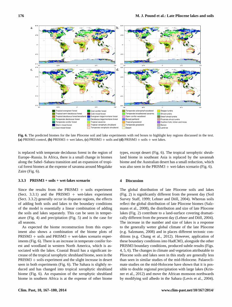
Fig. 6. The predicted biomes for the late Pliocene soil and lake experiments with red boxes to highlight key regions discussed in the text.(a) PRISM3 control,(b) PRISM3+ wet lakes,(c) PRISM3+ soils and(d) PRISM3+ soils+ wet lakes.
is replaced with temperate deciduous forest in the region ofEurope–Russia. In Africa, there is a small change in biomesalong the Sahel–Sahara transition and an expansion of tropi-cal forest biomes at the expense of savanna around MegalakeZaire (Fig. 6).
3.3.3 PRISM3 + soils + wet-lakes scenario
Since the results from the PRISM3+ soils experiment(Sect. 3.3.1) and the PRISM3+ wet-lakes experiment(Sect. 3.3.2) generally occur in disparate regions, the effectsof adding both soils and lakes to the boundary conditionsof the model is essentially a linear combination of addingthe soils and lakes separately. This can be seen in temper-ature (Fig. 4) and precipitation (Fig. 5) and is the case forall seasons.
As expected the biome reconstruction from this exper-iment also shows a combination of the biome plots ofPRISM3+ soils and PRISM3+ wet-lakes scenario exper-iments (Fig. 6). There is an increase in temperate conifer for-est and woodland in western North America, which is as-sociated with the lakes. Coastal Brazil has a significant in-crease of the tropical xerophytic shrubland biome, seen in thePRISM3+ soils experiment and the slight increase in desertseen in both experiments (Fig. 6). The Sahara is slightly re-duced and has changed into tropical xerophytic shrublandbiome (Fig. 6). An expansion of the xerophytic shrublandbiome in southern Africa is at the expense of other biome
types, except desert (Fig. 6). The tropical xerophytic shrub-land biome in southeast Asia is replaced by the savannahbiome and the Australian desert has a small reduction, whichwas also seen in the PRISM3+ wet-lakes scenario (Fig. 6).
4 Discussion
The global distribution of late Pliocene soils and lakes(Fig. 2) is significantly different from the present day (SoilSurvey Staff, 1999; Lehner and Döll, 2004). Whereas soilsreflect the global distribution of late Pliocene biomes (Salz-mann et al., 2008), the distribution and size of late Pliocenelakes (Fig. 2) contribute to a land-surface covering dramati-cally different from the present day (Lehner and Döll, 2004).The increase in the number and size of lakes is a responseto the generally wetter global climate of the late Pliocene(e.g. Salzmann, 2008) and in places different tectonic con-ditions (e.g. Chang et al., 2012). However, application ofthese boundary conditions into HadCM3, alongside the otherPRISM3 boundary conditions, produced subtle results (Figs.4, 5, 6). The changes in climate and vegetation attributable toPliocene soils and lakes seen in this study are generally lessthan seen in similar studies of the mid-Holocene. Palaeocli-mate studies on the mid-Holocene have shown that it is pos-sible to double regional precipitation with large lakes (Krin-ner et al., 2012) and move the African monsoon northwardsby modifying soil albedo in the Sahara (Levis et al., 2004).
Clim. Past, 10, 167–180, 2014 www.clim-past.net/10/167/2014/
M. J. Pound et al.: Late Pliocene lakes and soils 177
Although the results of our study are not as obvious as thosefrom the Holocene, they do offer a glimpse that some of theprocesses, previously identified in the Holocene, may oper-ate in the Pliocene. Although the addition of late Pliocenelakes did not double regional precipitation, as was simulatedfor the Holocene (Krinner et al., 2012), our experiments doshow a 50 % increase around Lake Chad and notable summerincreases in western North America. We also show a similaraustral summer increase in precipitation around MegalakeMakgadikgadi to that which Burrough et al. (2009) pro-duced in their late Quaternary experiments. These similari-ties suggest that similar forcings are operating in the Plioceneand the Holocene, with regard to large lakes. However, in astudy on Megalake Chad during the late Pliocene Contoux etal. (2013) found that the presence of a large lake did not suf-ficiently influence late Pliocene climate to impact on regionalvegetation.
The parameterisation of Alfisol along the southern mar-gin of the late Pliocene Sahara led to a summer increase inprecipitation (Figs. 2a, 4), which led to a change from thedesert biome type to a tropical xerophytic shrubland (Fig. 6).The Alfisol is a darker soil type than the Aridisol (Table 1),and this result is comparable, although more subtle, to thosepresented by Levis et al. (2004). When the soil and wet-lakeboundary conditions were combined, this precipitation signalis increased, but the vegetation response remains the same(Figs. 5, 6). A northwards shift of the Sahel–Sahara bound-ary is consistent with the few vegetation data available forthis region (Leroy and Dupont, 1994; Salzmann et al., 2008).
The climatological changes in western North America(Figs. 4, 5) have changed the regional vegetation from drieropen biomes to a region dominated by the temperate coniferforest biome and the conifer parkland biome, which is consis-tent with reconstructions from palaeobotanical data (Thomp-son, 1991; Fleming, 1994; Salzmann et al., 2008). The maindriving force for these vegetation changes appears to be in-creased evaporation of the lakes, reducing summer temper-ature and increasing summer precipitation. When soils andlakes are combined there is a further increase in less sea-sonal biome types (Fig. 6). This suggests that, although thedifferences between the control experiment and the PRISM3+ soils experiment are localised, the combination of realis-tic late Pliocene soils and lakes has positive feedbacks thatfacilitate the expansion of less seasonal biome types. De-spite the limited improvements in the modelled climates andbiome distribution of the late Pliocene, there are positivechanges between the experiments containing the soils andlake data and the control run. We therefore encourage the useof the late Pliocene soil and lake boundary conditions in fu-ture climate modelling studies, including the future PlioMIPexperiments (Haywood et al., 2010, 2011a).
5 Conclusions
Through a synthesis of geological data we have recon-structed the global distribution of late Pliocene soils andlakes. From these reconstructions we have conducted a suiteof climate modelling experiments to test the impacts of re-alistic soils and lakes on the climate of the late Pliocene.The inclusion of soils and lakes does not significantly mod-ify global climate, but does have important regional im-pacts. Some of these regions have previously been simu-lated as too dry (e.g. western North America), when com-pared to palaeobotanical data. We see improvements in theseasonal amounts of precipitation in the southern part ofnorthern Africa and in western North America, which resultsin the model-predicted biomes comparing more favourablywith vegetation proxy data. We strongly encourage the useof these newly developed boundary conditions in future latePliocene climate research, and the boundary conditions willbe made available on the PRISM4 website (http://geology.er.usgs.gov/eespteam/prism/index.html). These new boundaryconditions improve regional data–model comparisons, andtheir feedbacks in a warmer world should be explored fur-ther in future palaeoclimate modelling studies.
Supplementary material related to this article isavailable online athttp://www.clim-past.net/10/167/2014/cp-10-167-2014-supplement.zip.
Acknowledgements.M. J. Pound, U. Salzmann and A. M. Hay-wood acknowledge funding received from the Natural EnvironmentResearch Council (NERC Grant NE/I016287/1). J. Tindall,S. J. Pickering and A. M. Haywood acknowledge that the researchleading to these results has received funding from the EuropeanResearch Council under the European Union’s Seventh FrameworkProgramme (FP7/2007-2013)/ERC grant agreement no. 278636.H. J. Dowsett acknowledges support from the US GeologicalSurvey Land Use and Climate Change R&D Program and thePowell Center for Analysis and Synthesis. We wish to thankC. Contoux, P. Hoelzman and E. Stone for their reviews whichgreatly improved the manuscript.
Edited by: V. Brovkin
References
Abbott, P. L.: Cenozoic paleosols San Diego area, California,CATENA, 8, 223–237, 1981.
Adam, D. P., Bradbury, J. P., Rieck, H. J., and Sarna-Wojcicki, A.M.: Environmental changes in the Tule Lake Basin, Siskiyou andModoc Counties, California, from 3 to 2 Million years beforepresent, USGS Bulletin, 1933, 1–13, 1990.
Alley, N. F.: Cainozoic stratigraphy, palaeoenvironments and geo-logical evolution of the Lake Eyre Basin, Palaeogeogr. Palaeocli.Palaeoecol., 144, 239–263, 1998.
www.clim-past.net/10/167/2014/ Clim. Past, 10, 167–180, 2014

178 M. J. Pound et al.: Late Pliocene lakes and soils
Basilici, G.: Sedimentary facies in an extensional and deep-lacustrine depositional system: the Pliocene Tiberino Basin, Cen-tral Italy, Sediment. Geol., 109, 73–94, 1997.
Beadle, L. C.: The inland waters of tropical Africa: an introductionto tropical limnology, Longman, London, 365 pp., 1974.
Bechtel, A., Sachsenhofer, R. F., Markic, M., Gratzer, R., Lücke,A., and Püttmann, W.: Paleoenvironmental implications frombiomarker and stable isotope investigations on the Pliocene Ve-lenje lignite seam (Slovenia), Org. Geochem., 34, 1277–1298,2003.
Burrough, S. L., Thomas, D. S. G., and Singarayer, J. S.: Late Qua-ternary hydrological dynamics in the Middle Kalahari: Forcingand feedbacks, Earth-Sci. Rev., 96, 313–326, 2009.
Cahen, L.: Geologie du Congo Belge. Liège: Vaillant-Carmanne,577 pp., 1954.
Callen, R. A.: Late Cainozoic environments of part of northeasternSouth Australia, J. Geol. Soc. Aust., 24, 151–169, 1977.
Campisano, C. J. and Feibel, C. S.: Depositional environments andstratigraphic summary of the Pliocene Hadar Formation at Hadar,Afar Depression, Ethiopia, The Geol. Soc. Am. Special Paper,446, 179–201, 2008.
Chandler, M., Rind., D., and Thompson, R.: Joint investigations ofthe middle Pliocene climate II: GISS GCM Northern Hemisphereresults, Global Planet. Change, 9, 197–219, 1994.
Chang, H., Ao, H., An, Z., Fang, X., Song, Y., and Qiang, X.: Mag-netostratigraphy of the Suerkuli Basin indicates Pliocene (3.2Ma) activity of the middle Altyn Tagh Fault, northern TibetanPlateau, J. Asian Earth Sci., 44, 169–175, 2012.
Chen, X. Y., Bowler, J. M., and Magee, J. W.: Late Cenozoic stratig-raphy and hydrologic history of Lake Amadeus, a central Aus-tralian playa, Aust. J. Earth Sci., 40, 1–14, 1993.
Cohen, A. S., Lezzar, K. E., Tiercelin, J. J., and Soreghan, M.: Newpalaeogeographic and lake-level reconstructions of Lake Tan-ganyika: implications for tectonic, climatic and biological evo-lution in a rift lake, Basin Res., 9, 107–132, 1997.
Contoux, C., Ramstein, G., and Jost, A.: Modelling the mid-Pliocene Warm Period climate with the IPSL coupled model andits atmospheric component LMDZ5A, Geosci. Model Dev., 5,903–917, doi:10.5194/gmd-5-903-2012, 2012.
Contoux, C., Jost, A., Ramstein, G., Sepulchre, P., Krinner, G., andSchuster, M.: Megalake Chad impact on climate and vegetationduring the late Pliocene and the mid-Holocene, Clim. Past, 9,1417–1430, doi:10.5194/cp-9-1417-2013, 2013.
Coulthard, T. J., Ramirez, J. A., Barton, N., Rogerson, M.,and Brücher, T.: Were Rivers Flowing across the Sa-hara During the Last Interglacial? Implications for Hu-man Migration through Africa, PLoS ONE 8, e74834,doi:10.1371/journal.pone.0074834, 2013.
Cox, P.: Description of the “TRIFFID” Dynamic Global VegetationModel. Hadley Centre technical note 24, 1–16, 2001.
Cox, P. M., Betts, R., Bunton, C. B., Essery, R. L. H., Rowntree, P.R., and Smith, J.: The impact of new land surface physics on theGCM simulation of climate and climate sensitivity, Clim. Dy-nam., 15, 183–203, 1999.
Deino, A. L., Kingston, J. D., Glen, J. M., Edgar, R. K., and Hill,A.: Precessional forcing of lacustrine sedimentation in the lateCenozoic Chemeron Basin, Central Kenya Rift, and calibrationof the Gauss/Matuyama boundary, Earth Planet. Sci. Lett., 247,41–60, 2006.
Delire, C., Levis, S., Bonan, G., Foley, J. A., Coe, M., and Vavrus,S.: Comparison of the climate simulated by the CCM3 coupled totwo different land-surface models, Clim. Dynam., 19, 657–669,2002.
Dixey, F.: The Tertiary and Post-Tertiary Lacustrine Sediments ofthe Nyasan Rift-Valley, Q. J. Geol. Soc., 83, 432–442, 1927.
Dowsett, H. J., Cronin, T. M., Poore, R. Z., Thompson, R. S., What-ley, R. C., and Wood, A. M.: Micropaleontological evidence forIncreased meridional heat transport in the North Atlantic Oceanduring the Pliocene, Science, 258, 1133–1135, 1992.
Dowsett, H. J., Thompson, R., Barron, J., Cronin, T., Fleming, F.,Ishman, S., Poore, R., Willard, D., and Holtz Jr., T.: Joint in-vestigations of the Middle Pliocene climate I: PRISM paleoenvi-ronmental reconstructions, Global Planet. Change, 9, 169–195,1994.
Dowsett, H. J., Barron, J., and Poore, R.: Middle Pliocene sea sur-face temperatures: a global reconstruction, Mar. Micropaleontol.,27, 13–26, 1996.
Dowsett, H. J., Robinson, M., Haywood, A., Salzmann, U., Hill, D.,Sohl, L., Chandler, M., Williams, M., Foley, K., and Stoll, D.:The PRISM3D paleoenvironmental reconstruction, Stratigraphy,7, 123–139, 2010.
Dowsett, H. J., Robinson, M. M., Haywood, A. M., Hill, D. J.,Dolan, A. M., Stoll, D. K., Chan, W.-L., Abe-Ouchi, A., Chan-dler, M. A., Rosenbloom, N. A., Otto-Bliesner, B. L., Bragg, F.J., Lunt, D. J., Foley, K. M., and Riesselman, C. R.: Assessingconfidence in Pliocene sea surface temperatures to evaluate pre-dictive models, Nat. Clim. Change, 2, 365–371, 2012.
Dowsett, H., Foley, K., Stoll, D., Chandler, M., Sohl, L., Bentsen,M., Otto-Bliesner, B., Bragg, F., Chan, W.-L., Contoux, C.,Dolan, A., Haywood, A., Jonas, J., Jost, A., Kamae, Y.,Lohmann, G., Lunt, D., Nisancioglu, K., Abe-Ouchi, A., Ram-stein, G., Riesselman, C., Robinson, M., Rosenbloom, N.,Salzmann, U., Stepanek, C., Strother, S., Ueda, H., Yan,Q., and Zhang, Z.: Sea surface temperature of the mid-Piacenzian ocean: A data-model comparison, Sci. Reports, 3, 1–8, doi:10.1038/srep02013, 2013.
Drake, N. A., El-Hawat, A. S., Turner, P., Armitage, S. J., Salem,M. J., White, K. H., and McLaren, S.: Palaeohydrology of theFazzan Basin and surrounding regions: The last 7 million years,Palaeogeogr. Palaeocli. Palaeoecol., 263, 131–145, 2008.
Essery, R. L. H., Best, M., and Cox, P.: MOSES 2.2 technical doc-umentation, Hadley Centre technical note, 30, 1–30, 2001.
Firman, J. B.: Paleosols in laterite and silcrete profiles Evidencefrom the South East Margin of the Australian PrecambrianShield, Earth-Sci. Rev., 36, 149–179, 1994.
Fleming, R. F.: Palynological records from Pliocene sediments inthe California region: Centerville Beach, DSDP Site 32, andthe Anza-Borrego desert. Pliocene Terrestrial Environments andData/Model Comparisons, edited by: Thompson, R. S., 11–15,USGS Open-File Report, 1994.
Gerasimenko, N.: Vegetation development cycles of the Ukrainianforest-steppe zone in the Middle – Late Pliocene, in: Paleofloris-tic and paleoclimatic changes during Cretaceous and Tertiary,edited by: Planderova, E., Konzalova, M., Kvacek, Z., Sitar, V.,Snopkova, P., and Suballyova, D., Geologicky Ustav DionyzaStura, Bratislava, 199–204, 1993.
Good, P., Jones, C., Lowe, J., Betts, R., and Gedney, N.: Compar-ing tropical forest projections from two generations of Hadley
Clim. Past, 10, 167–180, 2014 www.clim-past.net/10/167/2014/
M. J. Pound et al.: Late Pliocene lakes and soils 179
Centre Earth System Models, HadGEM2-ES and HadCM3LC,J. Climate, 26, 495–511, 2013.
Gordon, C., Cooper, C., Senior, C. A., Banks, H., Gregory, J. M.,Johns, T. C., Mitchell, J. F. B., and Wood, R. A.: The simulationof SST, sea ice extents and ocean heat transports in a versionof the Hadley Centre coupled model without flux adjustments,Clim. Dynam., 16, 147–168, 2000.
Goudie, A. S.: The drainage of Africa since the Cretaceous, Geo-morphology, 67, 437–456, 2005.
Graef, F., Singer, A., Stahr, K., and Jahn, R.: Genesis and diagen-esis of paleosols from Pliocene volcanics on the Golan Heights,CATENA, 30, 149–167, 1997.
Günster, N. and Skowronek, A.: Sediment–soil sequences in theGranada Basin as evidence for long- and short-term climaticchanges during the Pliocene and Quaternary in the WesternMediterranean, Quaternary Int., 78, 17–32, 2001.
Gürel, A. and Kadir, S.: Geology, mineralogy and origin of clayminerals of the Pliocene fluvial-lacustrine deposits in the Cap-padocian Volcanic Province, central Anatolia, Turkey, ClaysClay Miner., 54, 555–570, 2006.
Haywood, A. M. and Valdes, P. J.: Vegetation cover in a warmerworld simulated using a dynamic global vegetation model forthe Mid-Pliocene, Palaeogeogr. Palaeocli. Palaeoecol., 237, 412–427, 2006.
Haywood, A. M., Chandler, M. A., Valdes, P. J., Salzmann, U., Lunt,D. J., and Dowsett, H. J.: Comparison of mid-Pliocene climatepredictions produced by the HadAM3 and GCMAM3 GeneralCirculation Models, Global Planet. Change, 66, 208–224, 2009.
Haywood, A. M., Dowsett, H. J., Otto-Bliesner, B., Chandler, M. A.,Dolan, A. M., Hill, D. J., Lunt, D. J., Robinson, M. M., Rosen-bloom, N., Salzmann, U., and Sohl, L. E.: Pliocene Model Inter-comparison Project (PlioMIP): experimental design and bound-ary conditions (Experiment 1), Geosci. Model Dev., 3, 227–242,doi:10.5194/gmd-3-227-2010, 2010.
Haywood, A. M., Dowsett, H. J., Robinson, M. M., Stoll, D. K.,Dolan, A. M., Lunt, D. J., Otto-Bliesner, B., and Chandler, M.A.: Pliocene Model Intercomparison Project (PlioMIP): experi-mental design and boundary conditions (Experiment 2), Geosci.Model Dev., 4, 571–577, doi:10.5194/gmd-4-571-2011, 2011a.
Haywood, A. M., Ridgwell, A., Lunt, D. J., Hill, D. J., Pound, M.J., Dowsett, H. J., Dolan, A. M., Francis, J. E., and Williams,M.: Are there pre-Quaternary geological analogues for a futuregreenhouse warming? Philosophical Transactions of the RoyalSociety A: Mathematical, Phys. Eng. Sci., 369, 933–956, 2011b.
Helgren, D. M. and Butzer, K. W.: Paleosols of the southern CapeCoast, South Africa: Implications for laterite definition, genesis,and age, Geogr. Rev., 67, 430–445, 1977.
Hoelzmann, P., Jolly, D., Harrison, S. P., Laarif, F., Bonnefille,R., and Pachur, H. J.: Mid-Holocene land-surface conditionsin northern Africa and the Arabian Peninsula: A data set forthe analysis of biogeophysical feedbacks in the climate system,Global Biogeochem. Cy., 12, 35–51, 1998.
Hou, B., Frakes, L. A., Sandiford, M., Worrall, L., Keeling, J., andAlley, N. F.: Cenozoic Eucla Basin and associated palaeovalleys,southern Australia – Climatic and tectonic influences on land-scape evolution, sedimentation and heavy mineral accumulation,Sedim. Geol., 203, 112–130, 2008.
Hughes, M. J., Carey, S. P., and Kotsonis, A.: Lateritic weatheringand secondary gold in the Victorian Gold Province, Regolith, 98,155–172, 1999.
Hughes, J. K., Valdes, P. J., and Betts, R.: Dynamics of a global-scale vegetation model, Ecol. Modell., 198, 452–462, 2006.
Icole, M.: Une nouvelle methode pour la paleopedologie duPliocene et du Villafranchien des Pyrenees centrales, Bulletin del’Association française pour l’etude du Quaternaire, 1970, 135–143, 1970.
Jones, C. P.: Ancillary file data sources, Unified Model Documen-tation, 70, 1–38, 2008.
Kaplan, J.: Geophysical applications of vegetation modeling, LundUniversity, Lund, p. 128, 2001.
Kelepertsis, A.: Mineralogy and geochemistry of the pliocene iron-rich laterite in the Vatera area, Lesvos Island, Greece and its gen-esis, Chinese J. Geochem., 21, 193–205, 2002.
Knorr, W. and Schnitzler, K.-G.: Enhanced albedo feedback inNorth Africa from possible combined vegetation and soil-formation processes, Clim. Dynam., 26, 55–63, 2006.
Krinner, G., Lézine, A.-M., Braconnot, P. Sepulchre, P. Ramstein,G. Grenier, C., and Gouttevin, I.: A reassessment of lake and wet-land feedbacks on the North African Holocene climate, Geophys.Res. Lett., 39, L07701, doi:10.1029/2012GL050992, 2012.
Lehner, B. and Döll, P.: Development and validation of a globaldatabase of lakes, reservoirs and wetlands, J. Hydrol., 296, 1–22,2004.
Lenoble, A.: Les depots lacustres Pliocenes-Pleistocenes deL’Ankaratra (Madagascar): Etude geologique, Ann. Geolog.Serv. Mines, 18, 9–82, 1949.
Leroy, S. and Dupont, L.: Development of vegetation and conti-nental aridity in northwestern Africa during the Late Pliocene:the pollen record of ODP site 658, Palaeogeogr. Palaeocli.Palaeoecol., 109, 295–316, 1994.
Levis, S., Bonan, G. B., and Bonfils, C.: Soil feedback drivesthe mid-Holocene North African monsoon northward in fullycoupled CCSM2 simulations with a dynamic vegetation model,Clim. Dynam., 23, 791–802, 2004.
Lunt, D. J., Haywood, A. M., Schmidt, G. A., Salzmann, U., Valdes,P. J., and Dowsett, H.J.: Earth system sensitivity inferred fromPliocene modelling and data, Nat. Geosci., 3, 60–64, 2010.
Lunt, D. J., Haywood, A. M., Schmidt, G. A., Salzmann, U., Valdes,P. J., Dowsett, H. J., and Loptson, C. A.: On the causes of mid-Pliocene warmth and polar amplification, Earth Planet. Sci. Lett.,321–322, 128–138, 2012.
Mabesoone, J. M. and Lobo, H. R. C.: Paleosols as strati-graphic indicators for the cenozoic history of northeastern Brazil,CATENA, 7, 67–78, 1980.
Mack, G. H., Seager, W. R., Leeder, M. R., Perez-Arlucea, M.,and Salyards, S. L.: Pliocene and Quaternary history of the RioGrande, the axial river of the southern Rio Grande rift, New Mex-ico, USA, Earth-Sci. Rev., 79, 141–162, 2006.
Martin, H. A.: Cenozoic climatic change and the development ofthe arid vegetation in Australia, J. Arid Environ., 66, 533–563,2006.
Mats, V. D., Lomonosova, T. K., Vorobyova, G. A., and Granina,L. Z.: Upper Cretaceous–Cenozoic clay minerals of the Baikalregion (eastern Siberia), Appl. Clay Sci., 24, 327–336, 2004.
Müller, J., Oberhänsli, H., Melles, M., Schwab, M., Rachold, V., andHubberten, H. W.: Late Pliocene sedimentation in Lake Baikal:
www.clim-past.net/10/167/2014/ Clim. Past, 10, 167–180, 2014
180 M. J. Pound et al.: Late Pliocene lakes and soils
implications for climatic and tectonic change in SE Siberia,Palaeogeogr. Palaeocli. Palaeoecol., 174, 305–326, 2001.
Otero, O., Pinton, A., Mackaye, H. T., Likius, A., Vignaud, P.,and Brunet, M.: Fishes and palaeogeography of the Africandrainage basins: Relationships between Chad and neighbour-ing basins throughout the Mio-Pliocene, Palaeogeogr. Palaeocli.Palaeoecol., 274, 134–139, 2009.
Otero, O., Pinton, A., Mackaye, H. T., Likius, A., Vignaud, P., andBrunet, M.: The early/late Pliocene ichthyofauna from Koro-Toro, Eastern Djurab, Chad. Geobios, 43, 241–251, 2010.
Paepe, R., Mariolakos, I., Van Overloop, E., Nassopoulou, S., Hus,J., Hatziotou, M., Markopoulos, T., Manutsoglu, E., Livaditis, G.,and Sabot, V.: Quaternary soil-geological stratigraphy in Greece,B. Geol. Soc. Greece, 36, 856–863, 2004.
Peters, C. R. and O’Brien, E. M.: Palaeo-lake Congo: Implicationsfor Africa’s Late Cenozoic climate – some unanswered ques-tions, Palaeoecol. Africa, 27, 11–18, 2001.
Pope, V. D., Gallani, M. L., Rowntree, P. R., and Stratton, R. A.: Theimpact of new physical parametrizations in the Hadley Centreclimate model: HadAM3, Clim. Dynam., 16, 123–146, 2000.
Pope, J. O., Collins, M., Haywood, A. M., Dowsett, H. J., Hunter,S. J., Lunt, D. J., Pickering, S. J., and Pound, M. J.: QuantifyingUncertainty in Model Predictions for the Pliocene (Plio-QUMP):Initial results, Palaeogeogr. Palaeocli. Palaeoecol., 309, 128–140,2011.
Quade, J., Solounias, N., and Cerling, T. E.: Stable isotopic evi-dence from paleosol carbonates and fossil teeth in Greece forforest or woodlands over the past 11 Ma, Palaeogeogr. Palaeocli.Palaeoecol., 108, 41–53, 1994.
Ringrose, S., Kampunzu, A. B., Vink, W., Matheson, W., andDowne, W. S.: Origin and palaeo-environments of calcareoussediments in the Moshaweng dry valley, southeast Botswana,Earth Surf. Process. Landf., 27, 591–611, 2002.
Ringrose, S., Huntsman-Mapila, P., Basira Kampunzu, A., Downey,W., Coetzee, S., Vink, B., Matheson, W., and Vanderpost,C.: Sedimentological and geochemical evidence for palaeo-environmental change in the Makgadikgadi subbasin, in relationto the MOZ rift depression, Botswana, Palaeogeogr. Palaeocli.Palaeoecol., 217, 265–287, 2005.
Sáez, A., Cabrera, L., Jensen, A., and Chong, G.: Late Neogene la-custrine record and palaeogeography in the Quillagua-Llamarabasin, Central Andean fore-arc (northern Chile), Palaeogeogr.Palaeocli. Palaeoecol., 151, 5–37, 1999.
Salama, R. B.: The evolution of the River Nile. The buried salinerift lakes in Sudan – I. Bahr El Arab Rift, the Sudd buried salinelake, J. Afr. Earth Sci., 6, 899–913, 1987.
Salzmann, U., Haywood, A. M., Lunt, D. J., Valdes, P. J., andHill, D. J.: A new global biome reconstruction and data-modelcomparison for the Middle Pliocene, Global Ecol. Biogeogr., 17,432–447, 2008.
Salzmann, U., Haywood, A. M., and Lunt, D. J.: The past is a guideto the future? Comparing Middle Pliocene vegetation with pre-dicted biome distributions for the twenty-first century, Philos.Trans. Royal Soc. A, 367, 189–204, 2009.
Salzmann, U., Williams, M., Haywood, A. M., Johnson, A. L. A.,Kender, S., and Zalasiewicz, J.: Climate and environment of aPliocene warm world, Palaeogeogr. Palaeocli. Palaeoecol., 309,1–8, 2011.
Salzmann, U., Dolan, A. M., Haywood, A. M., Chan, W.-L., Voss,J., Hill, D. J., Abe-Ouchi, A., Otto-Bliesner, B., Bragg, F. J.,Chandler, M. A., Contoux, C., Dowsett, H. J., Jost, A., Kamae,Y., Lohmann, G., Lunt, D. J., Pickering, S. J., Pound, M. J.,Ramstein, G., Rosenbloom, N. A., Sohl, L., Stepanek, C., Ueda,H., and Zhang, Z.: Challenges in quantifying Pliocene terrestrialwarming revealed by data-model discord, Nat. Clim. Change,doi:10.1038/nclimate2008, 2013.
Sangode, S. J. and Bloemendal, J.: Pedogenic transformation ofmagnetic minerals in Pliocene–Pleistocene palaeosols of theSiwalik Group, NW Himalaya, India, Palaeogeogr. Palaeocli.Palaeoecol., 212, 95–118, 2004.
Schuster, M., Duringer, P., Ghienne, J.-F., Roquin, C., Sepulchre,P., Moussa, A., Lebatard, A.-E., Mackaye, H. T., Likius, A., Vi-gnaud, P., and Brunet, M.: Chad Basin: Paleoenvironments ofthe Sahara since the Late Miocene, Compt. Rendus Geosci., 341,603–611, 2009.
Sepulchre, P., Ramstein, G., and Schuster, M.: Modelling the im-pact of tectonics, surface conditions and sea surface temperatureson Saharan and sub-Saharan climate evolution, Compt. RendusGeosci., 341, 612–620, 2009.
Simon-CoinÇon, R., Milnes, A. R., Thiry, M., and Wright, M. J.:Evolution of landscapes in northern South Australia in relation tothe distribution and formation of silcretes, J. Geolog. Soc., 153,467–480, 1996.
Smith, G. R.: Late Cenozoic Freshwater Fishes of North America,Ann. Rev. Ecol. System., 12, 163–193, 1981.
Soil Survey Staff: Soil taxonomy: A basic system of soil classi-fication for making and interpreting soil surveys United StatesDepartment of Agriculture Agriculture Handbook 436, 871 pp.,1999.
Sloan, L. C.: Equable climates during the early Eocene: Signifi-cance of regional paleogeography for North American climate,Geology, 22, 881–884, 1994.
Sloan, L. C., Crowley, T. J., and Pollard, D.: Modeling of Mid-dle Pliocene climate with the NCAR Genesis general circulationmodel, Mar. Micropaleontol., 27, 51–61, 1996.
Summerfield, M. A.: Global Geomorphology, Longman, Harlow,1991.
Thompson, R. S.: Pliocene environments and climates in the west-ern United States, Quaternary Sci. Rev., 10, 115–132, 1991.
Thompson, R. S.: Palynological data from a 989-FT (301-M) coreof Pliocene and Early Pleistocene sediments from Bruneau,Idaho, USGS Open File Report 92–713, 1–28, 1992.
Violante, R., Osella, A., Vega, M. d. l., Rovere, E., and Osterrieth,M.: Paleoenvironmental reconstruction in the western lacustrineplain of Llancanelo Lake, Mendoza, Argentina, J. South Am.Earth Sci., 29, 650–664, 2010.
Wijninga, V. M. and Kuhry, P.: Late Pliocene paleoecology ofthe Guasca Valley (Cordillera Oriental, Colombia). Review ofPalaeobotany and Palynology 78, 69-127, 1993.
Wynn, J. G.: Paleosols, stable carbon isotopes, and paleoenviron-ment interpretation of Kanapoi, Northern Kenya, J. Human Evol.,39, 411–432, 2000.
Clim. Past, 10, 167–180, 2014 www.clim-past.net/10/167/2014/