Embed Size (px)
Citation preview
Chapter 12Climate Change and the Riseof the Central Asian Silk Roads
Daniel J. Hill
Abstract Thefinal centuriesBCE (BeforeCommonEra) saw themain focus of tradebetween the Far East and Europe switch from the so called Northern Route across theAsian steppes to the classical silk roads. The cities across central Asia flourished andgrew in size and importance.While clearly therewere political, economic and culturaldrivers for these changes, there may also have been a role for changes in climate inthis relatively arid region of Asia. Analysis of a new ensemble of snapshot globalclimate model simulations, run every 250 years over the last 6000 years, allows us toassess the long term climatological changes seen across the central Asian arid regionthroughwhich the classical Silk Roads run.While the climate is comparatively stablethrough the Holocene, the fluctuations seen in these simulations match significantcultural developments in the region. From 1500 BCE the deterioration of climatefrom a transient precipitation peak, along with technological development and theimmigration of Aryan nomads, drove a shift towards urbanization and probablyirrigation, culminating in the founding of the major cities of Bukhara and Samarkandaround 700–500 BCE. Between 1000 and 250 BCE the modelled precipitation inthe central Asian arid region undergoes a transition towards wetter climates. Thechanges in the Western Disturbances, which is the key weather system for centralAsian precipitation, provides 10%more precipitation and the increased hydrologicalresources may provide the climatological foundation for the golden era of Silk Roadtrade.
Keywords Silk roads · Climate change · Climate model · 6000 yearsPrecipitation
D. J. Hill (B)School of Earth and Environment, University of Leeds, Leeds LS2 9JT, UKe-mail: [email protected]
© The Author(s) 2019L. E. Yang et al. (eds.), Socio-Environmental Dynamics along the Historical Silk Road,https://doi.org/10.1007/978-3-030-00728-7_12
247
248 D. J. Hill
12.1 Introduction
Climate has changed throughout the course of the human civilization (Mayewski et al.2004). The last 6000 years has seen significant climatic and precipitation changes,which have been well documented from both proxy records and modelling studies(Braconnot et al. 2004; Harrison et al. 2014). However, the relationship betweenthese broad-scale, long-term changes in climate and the local environmental impactsis little understood, despite the major disruptions to ancient civilizations across Asiaand Africa these have been implicated in (Butzer 2012). Across the world majorcivilizations have responded to climate change, from Africa (Welc andMarks 2014),Europe (Büntgen et al. 2011; Drake 2012), Asia (Staubwasser et al. 2003; Donget al. 2012), the New World (Kennett et al. 2012) and maybe even the colonizationof the Pacific Islands (Anderson et al. 2006). As well as driving civilization collapse,climate change could affect societal structures, polities and trade routes, particularlyin the Silk Road region, where a complex network of trading routes cross the centralAsian dry region.
CentralAsia has been continuously inhabited for thousands of years andwas hometo thriving late Bronze Age cultures, including the Oxus Civilization (Lamberg-Karlovsky 2013) and Sapalli culture (Kaniuth 2007). The city of Samarkand wasfounded around 600 BCE (Grenet 2002) and this may be associated with dryingof central Asia and the initiation of irrigation of the Samarkand Oasis (Malatestaet al. 2012). Although there is evidence for settlement in the region of Bokhara from3000 BCE, the city itself was founded around 500 BCE as part of the AchaemenidEmpire or first Persian Empire (LoMuzio 2009). Trade along the classical Silk Roadaccelerated greatly with the rise of the Han Dynasty in China in the second centuryBCE and continued, with only minor interruption during the rise and fall of empires,for almost 2000 years until the collapse of the Safavid Empire in the 1720s (Faroqhi1994).
Trade in precious materials, such as lapis lazuli, between the great civilizationsof the Bronze Age, shows evidence of 4th millennium BCE trade, at least in sectionsof the classical Silk Roads (Herrmann 1968). However, the main exchange of goods,technologies and culture across Eurasia seems to have accompanied the move tomobile pastoralism in the vast Eurasian steppe region (Christian 2000). Central Asiahosted a unique Bronze Age culture, the Oxus Civilization, with established contactswith surrounding cultures inMesopotamia and the IndusValley (Lamberg-Karlovsky2013) between roughly 2200 and 1700 BCE. Although the demise of central AsianBronzeAge cultures has not been extensively investigated, two hypotheses have beenput forward for the collapse of the Oxus Civilization. Firstly, reduced hydrologicalresources and the demise of the agricultural canal system (Salvatori 2008), suggestsa climatological driver for collapse. Whilst the second hypothesis, the increasinginfluence and hostile advance of pastoral nomads (Cattani 2008), suggests morecultural forces at work. Despite the interconnected nature of Bronze Age Eurasia,it was only after Chinese expansion in the second century BCE that a continuousconnection was established across Asia from China to the Mediterranean (McNeill
12 Climate Change and the Rise of the Central Asian Silk Roads 249
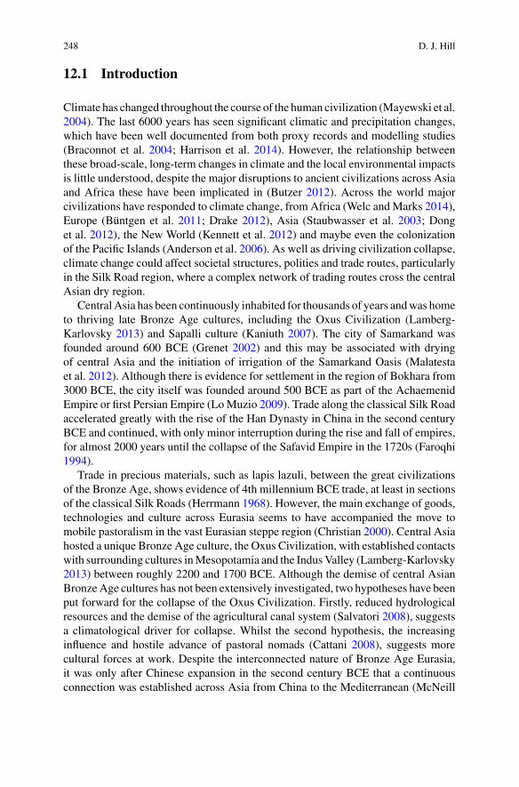
Fig. 12.1 Map of Central Asia, showing the biomes (Olson et al. 2001) and the older trade routeof the Northern or Steppe Route (blue) and Classical Silk Roads (red)
1998). This seems to have shifted the main route of trade across Eurasia from thesteppe to central Asian trade routes (Fig. 12.1), which in the late nineteenth centurywould become known as the Silk Roads (Christian 2000). This paper will investigatethe evolution of climate of central Asia over the last 6000 years, using a climatemodeland investigate its impact on the changing trade, cultural and settlement patterns alongthe Silk Roads of Central Asia.
12.2 Methods
12.2.1 Climate Model
The HadCM3 version of the UK Met Office’s Unified Model (Gordon et al. 2000),used in this study, is a fully coupled ocean-atmosphere General Circulation Model(GCM). It incorporates an atmospheric model with a resolution of 3.75°×2.5° with19 levels in a hybrid vertical coordinate and an ocean model of 1.25°×1.25° with20 levels (Cox 1984). Among the improvements in this version of the model are thesimulation of convection (Gregory et al. 1997), orographic drag (Milton and Wilson1996), the gravity wave drag scheme (Gregory et al. 1998) and themixed phase cloudparameterizations (Gregory andMorris 1996). The land surface scheme incorporatesthe TRIFFID Dynamic Global Vegetation Model (Cox 2001), which is run coupledto the HadCM3 climate model.
GCMs have a long history of simulating global climate and have shown greatskill in simulating modern day climate and palaeoclimatic change (Braconnot et al.
250 D. J. Hill
2012; McMahon et al. 2015). Asian climate is dominated by the monsoonal regimesoriginating in the tropical Indian and Pacific Oceans. HadCM3 has been shown toperform skilfully in reproducing these monsoons and climate across Asia (Innessand Slingo 2003; Turner et al. 2005). The HadCM3model has also been shown to beable to produce realistic representations of theWestern Disturbance weather systemsthat dominate rainfall totals in central Asia and simulate changes in weather patternsin line with other similar GCM models (Ridley et al. 2013). As is a common featureof modelled precipitation, different GCMs predict different sensitivity of regionalrainfall to increased greenhouse gas forcing, but the increases seen in future warmingscenarios from HadCM3 are at least in line with the observational record (Dash et al.2009).
12.2.2 Methodology
This study uses an ensemble of HadCM3 simulations covering the last 6000 years.This consists of 25 snapshot simulations, with boundary conditions appropriate toevery 250 years between 6000 years B.P. and 250 years ago, with a final simulationusing the full standard pre-industrial boundary conditions. Each of the simulationswas initialized from an existing pre-industrial simulation and run for 250 years toallow the model to respond to the altered greenhouse gas and orbital forcing. Clima-tological means were taken from the last 50 years of the simulations.
12.2.3 Boundary Conditions
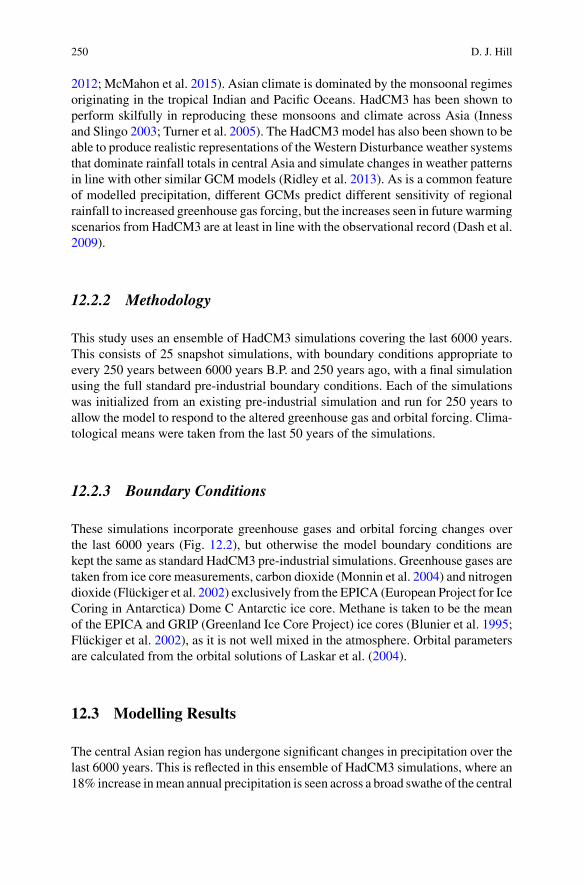
These simulations incorporate greenhouse gases and orbital forcing changes overthe last 6000 years (Fig. 12.2), but otherwise the model boundary conditions arekept the same as standard HadCM3 pre-industrial simulations. Greenhouse gases aretaken from ice core measurements, carbon dioxide (Monnin et al. 2004) and nitrogendioxide (Flückiger et al. 2002) exclusively from the EPICA (European Project for IceCoring in Antarctica) Dome C Antarctic ice core. Methane is taken to be the meanof the EPICA and GRIP (Greenland Ice Core Project) ice cores (Blunier et al. 1995;Flückiger et al. 2002), as it is not well mixed in the atmosphere. Orbital parametersare calculated from the orbital solutions of Laskar et al. (2004).
12.3 Modelling Results
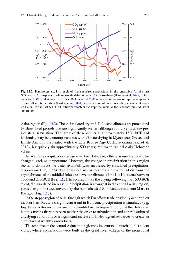
The central Asian region has undergone significant changes in precipitation over thelast 6000 years. This is reflected in this ensemble of HadCM3 simulations, where an18% increase inmean annual precipitation is seen across a broad swathe of the central
12 Climate Change and the Rise of the Central Asian Silk Roads 251
Fig. 12.2 Parameters used in each of the snapshot simulations in the ensemble for the last6000 years. Atmospheric carbon dioxide (Monnin et al. 2004), methane (Blunier et al. 1995; Flück-iger et al. 2002) and nitrogen dioxide (Flückiger et al. 2002) concentrations and obliquity componentof the full orbital solution (Laskar et al. 2004) for each simulation representing a snapshot every250 years of the last 6000. All other parameters are kept the same as the standard pre-industrialsimulation
Asian region (Fig. 12.3). These simulated dry mid-Holocene climates are punctuatedby short-lived periods that are significantly wetter, although still dryer than the pre-industrial simulation. The latest of these occurs at approximately 1500 BCE andits demise may be contemporaneous with climate drying in Mycenaean Greece andHittite Anatolia associated with the Late Bronze Age Collapse (Kaniewski et al.2013), but quickly (in approximately 500 years) returns to typical early Holocenevalues.
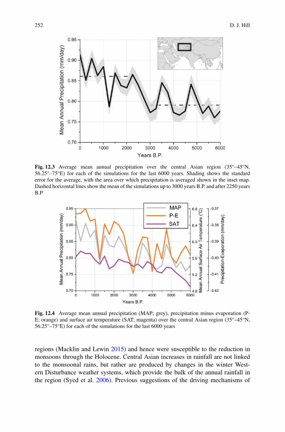
As well as precipitation change over the Holocene, other parameters have alsochanged, such as temperature. However, the change in precipitation in this regionseems to dominate the water availability, as measured by simulated precipitation-evaporation (Fig. 12.4). The ensemble seems to show a clear transition from thedryer climates of themiddleHolocene towetter climates of the lateHolocene between1000 and 250 BCE (Fig. 12.3). In common with the drying following the 1500 BCEevent, the simulated increase in precipitation is strongest in the central Asian region,particularly in the area covered by the main classical Silk Road cities, from Merv toKashgar (Fig. 12.5).
In the steppe region of Asia, throughwhich East-West trade originally occurred onthe Northern Route, no significant trend in Holocene precipitation is simulated (e.g.Fig. 12.5).Water resources aremore plentiful in this region throughout the Holocene,but this means there has been neither the drive to urbanization and centralization ofaridifying conditions or a significant increase in hydrological resources to create anelite class of wealthy individuals.
The response in the central Asian arid regions is in contrast to much of the ancientworld, where civilizations were built in the great river valleys of the monsoonal
252 D. J. Hill
Fig. 12.3 Average mean annual precipitation over the central Asian region (35°–45°N,56.25°–75°E) for each of the simulations for the last 6000 years. Shading shows the standarderror for the average, with the area over which precipitation is averaged shown in the inset map.Dashed horizontal lines show the mean of the simulations up to 3000 years B.P. and after 2250 yearsB.P
Fig. 12.4 Average mean annual precipitation (MAP; grey), precipitation minus evaporation (P-E; orange) and surface air temperature (SAT; magenta) over the central Asian region (35°–45°N,56.25°–75°E) for each of the simulations for the last 6000 years
regions (Macklin and Lewin 2015) and hence were susceptible to the reduction inmonsoons through the Holocene. Central Asian increases in rainfall are not linkedto the monsoonal rains, but rather are produced by changes in the winter West-ern Disturbance weather systems, which provide the bulk of the annual rainfall inthe region (Syed et al. 2006). Previous suggestions of the driving mechanisms of

12 Climate Change and the Rise of the Central Asian Silk Roads 253
(a)
(b)
Fig. 12.5 Spatial patterns of modelled precipitation changes between 1500 and 1250 BCE (a) andthe transition that occurs between 1000 and 250 BCE (b). Precipitation changes in central Asia arefocussed on the area of interest (Fig. 12.2), although the link to other areas varies over time. Forexample, the pattern of change in Indian monsoon region and the EasternMediterranean is differentbetween a and b
variations inWestern Disturbances, based on observational datasets, include changesin Icelandic Low related to NAO (North Atlantic Oscillation) or the Siberian Highrelated to ENSO (El Niño Southern Oscillation).
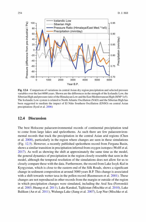
Although there are times when changes in these pressure systems correlate withcentral Asian precipitation, particularly the Icelandic Low over the last millennium,for much of the last 6000 years the changes are decoupled. HadCM3 has previouslybeen shown not to represent the teleconnections between ENSO and the monsoonsystems (Turner et al. 2005), which may explain some of this decoupling. However,these simulations showchanges in centralAsian precipitation are relatedmost closelyto the contrast inHimalayan andMediterranean pressure (Fig. 12.6). As these regionsrespectively represent the locations where the Western Disturbances initiate andultimately disburse, the forcing mechanisms from these mean pressure features areclear.
254 D. J. Hill
Fig. 12.6 Comparison of variations in central Asian dry region precipitation and selected pressurevariables over the last 6000 years. Shown are the differences in the strength of the Icelandic Low, theSiberianHigh andpressure ratio of theHimalayanLowand theEastMediterraneanHigh (H/M*1e5).The Icelandic Low system is related to North Atlantic Oscillation (NAO) and the Siberian High hasbeen suggested to mediate the impact of El Niño Southern Oscillation (ENSO) on central Asianprecipitation (Syed et al. 2006)
12.4 Discussion
The best Holocene palaeoenvironmental records of continental precipitation tendto come from large lakes and speleothems. As such there are few palaeoenviron-mental records that track the precipitation in the central Asian arid regions (Chenet al. 2008), particularly in the region where changes are seen in these simulations(Fig. 12.5). However, a recently published speleothem record from Fergana Basin,shows a similar transition in precipitation inferred from oxygen isotopes (Wolff et al.2017). As well as showing the shift at approximately the same time as the model,the general dynamics of precipitation in the region closely resemble that seen in themodel, although the temporal resolution of the simulations does not allow for us toclosely compare these with the data. Furthermore, the record from Lake Issyk-Kul inKyrgyzstan, which is close to the eastern end of the Silk Roads, shows a significantchange in sediment composition at around 3000 years B.P. This change is associatedwith a shift towards wetter taxa in the pollen record (Rasmussen et al. 2001). Thesechanges are not reproduced in other records from the margin or outside of the regionin which precipitation changes were simulated, including the Aral Sea (Ferronskiiet al. 2003; Huang et al. 2011), Lake Karakul, Tajikistan (Mischke et al. 2010), LakeBalikun (An et al. 2011), Wulunga Lake (Jiang et al. 2007), Lop Nur (Mischke et al.
12 Climate Change and the Rise of the Central Asian Silk Roads 255
2017), Lake Karakuli (Aichner et al. 2015), China or the Chinese Loess plateaux(Zhang et al. 2013).
There seem to be significant changes in precipitation in central Asia over theHolocene, which are linked to changes in the Western Disturbances, driven by varia-tions in the Himalayan Low—East Mediterranean High pressure contrast. Althoughsignificant changes in precipitation and P-E are simulated within this modellingframework, increased resolution in the atmosphere model, could greatly improve thesignal and spatial definition of the climatic changes. Moving to transient simulationof Holocene climate would give better temporal coverage, rather than relying onequilibrium climate response to snapshot climate forcing. This study has shown thechanges in regional climate associated with the largest forcing of Holocene climatechange, namely greenhouse gases and orbital forcing, but could be further extendedby incorporating changes in volcanic forcing (Kobashi et al. 2017), solar variability(Steinhilber et al. 2012) and Himalayan glacial coverage (Solomina 2015).
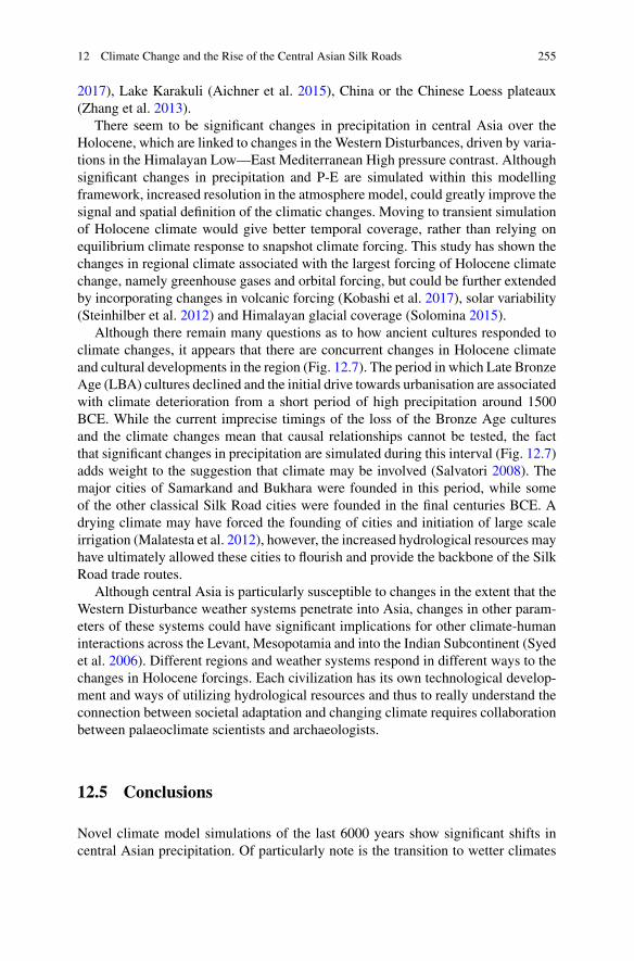
Although there remain many questions as to how ancient cultures responded toclimate changes, it appears that there are concurrent changes in Holocene climateand cultural developments in the region (Fig. 12.7). The period in which Late BronzeAge (LBA) cultures declined and the initial drive towards urbanisation are associatedwith climate deterioration from a short period of high precipitation around 1500BCE. While the current imprecise timings of the loss of the Bronze Age culturesand the climate changes mean that causal relationships cannot be tested, the factthat significant changes in precipitation are simulated during this interval (Fig. 12.7)adds weight to the suggestion that climate may be involved (Salvatori 2008). Themajor cities of Samarkand and Bukhara were founded in this period, while someof the other classical Silk Road cities were founded in the final centuries BCE. Adrying climate may have forced the founding of cities and initiation of large scaleirrigation (Malatesta et al. 2012), however, the increased hydrological resources mayhave ultimately allowed these cities to flourish and provide the backbone of the SilkRoad trade routes.
Although central Asia is particularly susceptible to changes in the extent that theWestern Disturbance weather systems penetrate into Asia, changes in other param-eters of these systems could have significant implications for other climate-humaninteractions across the Levant, Mesopotamia and into the Indian Subcontinent (Syedet al. 2006). Different regions and weather systems respond in different ways to thechanges in Holocene forcings. Each civilization has its own technological develop-ment and ways of utilizing hydrological resources and thus to really understand theconnection between societal adaptation and changing climate requires collaborationbetween palaeoclimate scientists and archaeologists.
12.5 Conclusions
Novel climate model simulations of the last 6000 years show significant shifts incentral Asian precipitation. Of particularly note is the transition to wetter climates
256 D. J. Hill
Fig. 12.7 Comparison of average annual mean precipitation over the central Asian dry region(35°–45°N, 56.25°–75°E) for each of the simulations for the last 6000 years (Fig. 12.2) and culturaldevelopment of the central Asian region. Times of the classical Silk Roads correspond to increasedhydrological resources, while period of urbanization began as climate deteriorated from a temporaryhigh, before a time of increasing precipitation
that is simulated to occur between 1000 and 250 BCE. This coincides with thefounding of the great cities of central Asia and the rise of the classical Silk Roadtrade routes through the region. While much more work is required to understandthe impacts of this climate changes and the cultural responses to these, this studyprovides a provocation to explore these relationships in greater detail.
Acknowledgements These climatemodelling simulationswere undertakenon theARC(AdvancedResearchComputing) facilities, part of theHigh PerformanceComputing at theUniversity of Leeds,UK.
References
Aichner, B., Feakins, S. J., Lee, J. E., Herzschuh, U., & Liu, X. (2015). High-resolution leaf waxcarbon and hydrogen isotopic record of the late Holocene paleoclimate in arid Central Asia.Climate of the Past, 11, 619–633.
An, C.-B., Lu, Y., Zhao, J., Tao, S., Dong, W., Li, H., et al. (2011). A high-resolution record ofHolocene environmental and climatic changes fromLakeBalikun (Xinjiang, China): Implicationsfor central Asia. The Holocene, 22, 43–52.
Anderson, A., Chappell, J., Gagan, M., & Grove, R. (2006). Prehistoric maritime migration inPacific Islands: An hypothesis of ENSO forcing. The Holocene, 16, 1–6.
Blunier, T., Chappellaz, J., Schwander, J., Stauffer, B., & Raynaud, D. (1995). Variations in atmo-spheric methane concentration during the Holocene epoch. Nature, 374, 46–49.
12 Climate Change and the Rise of the Central Asian Silk Roads 257
Braconnot P., Harrison, S. P., Joussaume, S., Hewitt, C. D., Kitoch, A., Kutzbach, J. E., Liu, Z., Otto-Bliesner, B., Syktus, J., & Weber, S. L. (2004). Evaluation of PMIP coupled ocean-atmospheresimulations of theMid-Holocene. In R.W. Battarbee, F. Gasse, C. E. Stickley (Eds.), Past climatevariability through Europe and Africa. Developments in paleoenvironmental research (vol. 6).Dordrecht: Springer.
Braconnot, P., Harrison, S. P., Kageyama, M., Bartlein, P. J., Masson-Delmotte, V., Abe-Ouchi, A.,et al. (2012). Evaluation of climate models using palaeoclimatic data. Nature Climate Change,2, 417–424.
Büntgen,U., Tegel,W.,Nicolussi,K.,McCormick,M., Frank,D., Trouet,V., et al. (2011). 2500yearsof European climate variability and hu, man susceptibility. Science, 331, 578–582.
Butzer, K. W. (2012). Collapse, environment and society. Proceedings of the National Academy ofSciences of the United States of America, 109, 3632–3639.
Cattani, M. (2008). The final phase of the bronze age and the “Andronovo Question in Margiana”.In S. Salvatori & M. Tosi (Eds.), The bronze age and early iron age in the Margiana Lowlands,BAR international series 1806 (pp. 133–148). Oxford: Archaeopress.
Chen, F., Yu, Z., Yang, M., Ito, E., Wang, S., Madsen, D. B., et al. (2008). Holocene moistureevolution in arid central Asia and its out-of-phase relationship with Asian monsoon history.Quaternary Science Reviews, 27, 351–364.
Christian, D. (2000). Silk roads or steppe roads? The silk roads in world history. Journal of WorldHistory, 11, 1–26.
Cox, M. D. (1984). A primitive equation, 3 dimensional model of the ocean. GFDL Ocean GroupTechnical Report 1, Princeton NJ, USA, p. 143.
Cox, P. (2001). Description of the TRIFFID dynamic global vegetation model. Hadley CentreTechnical Report 24. Bracknell, UK: UK Met Office.
Dash, S. K., Kulkarni, M. A., Mohanty, U. C., & Prasad, K. (2009). Changes in the characteristicsof rain events in India. Journal of Geophysical Research, 114, D10109. https://doi.org/10.1029/2008JD010572.
Dong, G., Jia, X., An, C., Chen, F., Zhao, Y., Tao, S., et al. (2012). Mid-Holocene climate changeand its effect on prehistoric cultural evolution in eastern Qinghai Province, China. QuaternaryResearch, 77, 23–30.
Drake, B. L. (2012). The influence of climatic change on the late bronze age collapse and the greekdark ages. Journal of Archaeological Science, 39, 1862–1870.
Faroqhi, S. (1994). Crisis and change, 1590–1699. In I. Halil, & D. Quataert (Eds.), An economicand social history of the ottoman empire, 1300–1914 (p. 505). Cambridge University Press.
Ferronskii, V. I., Polyakov, V. A., Brezgunov, V. S., Vlasova, L. S., Karpychev, Y. A., Bobkov, A. F.,et al. (2003). Variations in the hydrological regime of Kara-Bogaz-Gol Gulf, Lake Issyk-Kul andthe Aral Sea assessed based on data of bottom sediment studies. Water Resources, 30, 252–259.
Flückiger, J., Monnin, E., Stauffer, B., Schwander, J., & Stocker, T. F. (2002). High-resolutionHolocene N2O ice core record and its relationship with CH4 and CO2. Global BiogeochemicalCycles, 16, 1. https://doi.org/10.29/2001gb001417.
Gordon, C., Cooper, C., Senior, C. A., Banks, H., Gregory, J. M., Johns, T. C., et al. (2000). Thesimulation of SST, sea ice extents and ocean heat transports in a version of the Hadley Centrecoupled model without flux adjustments. Climate Dynamics, 16, 147–168.
Gregory, D., & Morris, D. (1996). The sensitivity of climate simulations to the specification ofmixed phase clouds. Climate Dynamics, 12, 641–651.
Gregory, D., Kershaw, R., & Inness, P. M. (1997). Parametrisation of momentum transport byconvection II: Test in a single column and general circulation model. Quarterly Journal of theRoyal Meteorological Society, 123, 1153–1183.
Gregory, D., Shutts, G. J., & Mitchell, J. R. (1998). A new gravity wave drag scheme incorporatinganisotropic orography and low level wave breaking: Impact upon the climate of the UK Mete-orological Office Unified Model. Quarterly Journal of the Royal Meteorological Society, 124,463–493.
Grenet, F. (2002). Samarkand I. History and Archeology. Encyclopaedia Iranica. Online edition.
258 D. J. Hill
Harrison, S. P., Bartlein, P. J., Brewer, S., Prentice, I. C., Boyd, M., Hessler, I., et al. (2014). Climatemodel benchmarking with glacial and mid-Holocene climates. Climate Dynamics, 43, 672–688.
Herrmann, G. (1968). Lapis Lazuli: The early phases of its trade. Iraq, 30, 21–57.Huang, X., Oberhänsli, H., von Suchodoletz, H., &Sorrel, P. (2011). Dust deposition in theAral Sea:Implications for changes in atmospheric circulation in central Asia during the past 2000 years.Quaternary Science Reviews, 30, 3661–3674.
Inness, P. M., & Slingo, J. M. (2003). Simulation of the Madden-Julian oscillation in a coupledgeneral circulation model. Part I: Comparison with observations and an atmosphere-only GCM.Journal of Climate, 16, 345–364.
Jiang, Q., Shen, J., Liu, X., Zhang, E., & Xiao, X. (2007). A high-resolution climatic change sinceHolocene inferred from multi-proxy of lake sediment in westerly area of China. Chinese ScienceBulletin, 52, 1970–1979.
Kaniewski, D., Van Campo, E., Guiot, J., Le Burel, S., Otto, T., & Baeteman, C. (2013). Environ-mental roots of the late bronze age crisis. PLoS ONE, 8(e71004), 17.
Kaniuth, K. (2007). The metallurgy of the late bronze age sapalli culture (southern Uzbekistan) andits implications for the ‘tin question’. Iranica Antiqua, 17, 23–40.
Kennett, D. J., Breitenbach, S. F. M., Aquino, V. V., Asmerom, Y., Awe, J., Baldini, J. U. L., et al.(2012). Development and disintegration of Maya political systems in response to climate change.Science, 338, 788–791.
Kobashi, T., Menviel, L., Jeltsch-Thömmes, A., Vinther, B. M., Box, J. E., Muscheler, R., Nakae-gawa, T., Pfister, P. L., Döring, M., Leuenberger, M., Wanner, H., & Ohmura, A. (2017). Volcanicinfluence on centennial tomillennial HoloceneGreenland temperature change. Scientific Reports,7, Article number: 1441.
Lamberg-Karlovsky, C. C. (2013). The oxus civilization. Cuadernos de Prehistoria y ArqueologiaUniveridad Autonoma de Madrid, 39, 21–63.
Laskar, J., Robutel, P., Joutel, F., Gastineau, M., Correia, A. C. M., & Levrard, B. (2004). A long-term numerical solution for the insolation quantities of the earth. Astronomy & Astrophysics, 428,261–285.
Lo Muzio, C. (2009). An archaeological outline of the Bukhara Oasis. Journal of Inner Asian Artand Archaeology, 4, 43–68.
Macklin, M. G., & Lewin, J. (2015). The rivers of civilization. Quaternary Science Reviews, 114,228–244.
Malatesta, L. C., Castelltort, S., Mantellini, S., Picotti, V., Hajdas, I., Simpson, G., et al. (2012).Dating the irrigation system of the Samarkand Oasis: A geoarchaeological study. Radiocarbon,54, 91–105.
Mayewski, P. A., Rohling, E. E., Stager, J. C., Karlén, W., Maasch, K. A., Meeker, L. D., et al.(2004). Holocene climate variability. Quaternary Research, 62, 243–255.
McMahon, T. A., Peel, M. C., & Karoly, D. J. (2015). Assessment of precipitation and temperaturedata fromCMIP3 global climatemodels for hydrological simulation.Hydrology and Earth SystemSciences, 19, 361–377.
McNeill, W. H. (1998). World history and the rise and fall of the West. Journal of World History,9, 215–236.
Milton, S. F., Wilson, C. A. (1996). The impact of parameterized subgrid-scale orographic forcingon systematic errors in a global NWP model. Monthly Weather Review, 124, 2023–2045.
Mischke, S., Rajabov, I., Mustaeva, N., Zhang, C., Herzschuh, U., Boomer, I., et al. (2010). Modernhydrology and late Holocene history of Lake Karakul, eastern Pamirs (Tajikistan): A reconnais-sance study. Palaeogeography, Palaeoclimatology, Palaeoecology, 289, 10–24.
Mischke, S., Liu, C., Zhang, J., Zhang, C., Zhang, H., Jiao, P., et al. (2017). The world’s oldest AralSea type disaster: The decline of the Loulan Kingdom in the Tarim Basin. Scientific Reports, 7,43102. https://doi.org/10.1038/srep43102.
Monnin, E., Steig, E. J., Siegenthaler, U., Kawamura, K., Schwander, J., Stauffer, B., et al. (2004).Evidence for substantial accumulation rate variability in Antarctica during the Holocene, through
12 Climate Change and the Rise of the Central Asian Silk Roads 259
synchronization of CO2 in the Taylor Dome, Dome C and DML ice cores. Earth and PlanetaryScience Letters, 224, 45–54.
Olson, D. M., Dinerstein, E., Wikramanayake, E. D., Burgess, N. D., Powell, G. V. D., Underwood,E. C., D’amico, J. A., Itoua, I., Strand, H. E.,Morrison, J. C., Loucks, C. J., Allnutt, T. F., Ricketts,T. H., Kura, Y., Lamoreux, J. F., Wettengel, W.W., Hedao, P., & Kassem, K. R. (2001). Terrestrialecoregions of the world: A new map of life on earth: A new global map of terrestrial ecoregionsprovides an innovative tool for conserving biodiversity. BioScience, 51, 933–938.
Rasmussen, K. A., Ricketts, R. D., Johnson, T. C., Romanovsky, V. V., & Grigina, O. M. (2001).An 8,000 year multi-proxy record from Lake Issyk-Kul, Kyrgyzstan. PAGES News, 9, 5–6.
Ridley, J., Wiltshire, A., &Mathison, C. (2013). More frequent occurrence of westerly disturbancesin Karakoram up to 2100. Science of the Total Environment, 468–469, S31–S35.
Salvatori, S. (2008). The Margiana settlement pattern from the middle bronze age to the Partian-Sasanian period: A contribution to the study of complexity. In S. Salvatori & M. Tosi (Eds.),The bronze age and early iron age in the Margiana Lowlands, BAR international series 1806(pp. 133–148). Oxford: Archaeopress.
Solomina, O. N., Bradley, R. S., Hodgson, D. A., Ivy-Ochs, S., Jomelli, V., Mackintosh, A. N., et al.(2015). Holocene glacier fluctuations. Quaternary Science Reviews, 111, 9–34.
Staubwasser, M., Sirocko, F., Grootes, P. M., & Segl, M. (2003). Climate change at the 4.2 kaBP termination of the Indus valley civilization and Holocene south Asian monsoon variability.Geophysical Research Letters¸ 30, 1425. https://doi.org/10.1029/2002gl016822.
Steinhilber, F., Abreu, J. A., Beer, J., Brunner, I., Christl, M., Fischer, H., et al. (2012). 9,400 yearsof cosmic radiation and solar activity from ice cores and tree rings. Proceedings of the NationalAcademy of Sciences of the United States of America, 109, 5967–5971.
Syed, F. S., Giorgi, F., Pal, J. S., & King, M. P. (2006). Effect of remote forcings on the winterprecipitation of central southwestAsia part 1:Observations.Theoretical and Applied Climatology,86, 147–160.
Turner, A. G., Inness, P.M., & Slingo, J.M. (2005). The role of the basic state in the ENSO-monsoonrelationship and implications for predictability. Quarterly Journal of the Royal MeteorologicalSociety, 131, 781–804.
Welc, F., & Marks, L. (2014). Climate change at the end of the Old Kingdom in Egypt around 4200BP: New geoarchaeological evidence. Quaternary International, 324, 124–133.
Wolff, C., Plessen, B., Dudashvilli, A. S., Breitenbach, S. F. M., Cheng, H., Edwards, L. R., et al.(2017). Precipitation evolution of Central Asia during the last 500 years. The Holocene, 27,142–154.
Zhang, W., Shi, Z., Chen, G., Liu, Y., Niu, J., Ming, Q., et al. (2013). Geochemical characteristicsand environmental significance of Talede loess-paleosol sequences of Ili Basin in Central Asia.Environmental Earth Sciences, 70, 2191–2202.
Open Access This chapter is licensed under the terms of the Creative Commons Attribution 4.0International License (http://creativecommons.org/licenses/by/4.0/), which permits use, sharing,adaptation, distribution and reproduction in any medium or format, as long as you give appropriatecredit to the original author(s) and the source, provide a link to the Creative Commons license andindicate if changes were made.
The images or other third party material in this chapter are included in the chapter’s CreativeCommons license, unless indicated otherwise in a credit line to the material. If material is notincluded in the chapter’s Creative Commons license and your intended use is not permitted bystatutory regulation or exceeds the permitted use, you will need to obtain permission directly fromthe copyright holder.


![Volume 10.1007978-1-4471-4884-5 issue Chapter 3 2013 [doi 10.1007_978-1-4471-4884-5_3] Bramer, Max -- [Undergraduate Topics in Computer Science] Principles of Data Mining Introduction](https://img.pdfslide.us/doc/110x75/577cc66d1a28aba7119e2c17/volume-101007978-1-4471-4884-5-issue-chapter-3-2013-doi-101007978-1-4471-4884-53.jpg)