Embed Size (px)
Citation preview
63
Climate Change and Infrastructure in the Gulf of
Mexico and Caribbean Basin:
New Risks to Building Blocks of Resilience
Esther Conrad6
International Research Institute for Climate and Society/Earth Institute, Columbia
University
6 Corresponding Author Address: Esther Conrad, Columbia University, International Research Institute for
Climate and Society, 132 Monell, Lamont Campus, Palisades NY 10964.
Email: [email protected]
64
Abstract
The countries in the Gulf of Mexico and Caribbean Basin regions depend upon a range of
infrastructure to enable critical economic sectors and protect against extreme weather events,
particularly storms and floods. Natural infrastructure, including wetlands, barrier islands and
coral reefs, play a critical role alongside built infrastructure. Drawing upon existing literature,
this paper examines current climate-related risks and potential implications of climate change
for critical infrastructure functions and their implications for key services and economic
sectors. For three key infrastructure functions (flood and storm protection, transportation, and
water supply and sanitation), current risks are dominated by hurricane and flood damages.
These may be heightened by a changing climate, such as by sea level rise, which may
compound on-going land subsidence, leading to inundation of larger areas and increased
storm surges. Wetlands play a crucial role in maintaining resilience in the face of storm and
flooding risks, and climate change is expected to add to the risks for this already stressed
natural infrastructure. Loss of infrastructure functions may have serious implications for
critical economic sectors and services; fisheries, tourism, energy production and urban
services are examined here. These depend upon multiple types of infrastructure whose
functions are often closely connected. In the case of dense urban areas, the failure of
infrastructure-related services can have cascading impacts on communities, livelihoods, and
economic development. Overall, climate change is one of multiple risks to infrastructure in
the region, and impacts of climate change must be examined in the context of an integrated
analysis that accounts for a wide range of climate and non-climate stressors. The interactions
between them, and the potential for multiple pressures to push natural and built systems
beyond their capacity, may present the greatest risks.
65
1. Introduction
Infrastructure plays a crucial role in sustaining human well-being. In addition to ensuring
basic services such as water, sanitation, electricity, and mobility, it enables diverse
economic activity in the Gulf of Mexico and Caribbean Basin, including energy
production, tourism, and fisheries. The value of many types of infrastructure lies partly in
the protection it provides against extremes. For example, water supply infrastructure
helps ensure water availability during extremely dry periods, as well as protect against
flooding in wet periods. The importance of infrastructure for resilience is all the more
clear when we consider ―natural‖ infrastructure, such as wetlands, barrier islands, and
coral reefs. The aftermath of recent natural disasters in the Gulf of Mexico region, such
as the recent earthquake in Haiti and hurricanes Katrina and Rita of 2005, has shown the
kind of devastation that can occur when infrastructure, both built and natural, is
inadequate or overwhelmed.
Various aspects of climate change, particularly sea level rise, and increased temperature,
and changes in precipitation patterns, are anticipated to directly affect infrastructure
performance. At the same time, climate change may alter the very patterns of extremes
that much infrastructure helps to protect against. This may have serious implications for
the already flood- and storm-prone Gulf of Mexico region. In addition to accounting for
possible impacts to existing infrastructure, we must also understand how this affects
future infrastructure needs. This is timely, given increasing recognition of the need to
renew aging infrastructure in the United States, and the pressing need in other countries
across the region for infrastructure to support economic development. The climate is not
the only risk the region faces - a point made abundantly clear by the catastrophe that has
unfolded in the Gulf following the massive BP oil spill this year. Understanding how a
combined set of pressures will affect built or natural infrastructure may be one of the
most significant challenges presented by climate change.
2. Assessing risks to infrastructure functions: scope and
approach
Infrastructure has been variously defined, but in general refers to physical assets or
networks that provide certain critical functions to society.7 The value of infrastructure
derives from the services it provides, such as mobility, energy supply, water,
connectivity, and flood protection, and economic activity that it enables, ranging from
production and transport of goods to providing an attractive environment for tourists.
Research indicates that high economic productivity is difficult to sustain without quality
infrastructure (National Research Council, 2009). In addition to built infrastructure, the
services of ―natural infrastructure‖ (sometimes called ―natural capital,‖) such as wetlands,
7 See, for example, the definition in the Online Compact Oxford English Dictionary,
http://www.askoxford.com/concise_oed/infrastructure.
66
watersheds, and coral reefs, are gaining increasing recognition (Costanza, 1997). It is
useful to consider natural and built infrastructure together, particularly in the context of
resilience. First, natural infrastructure provides certain services that if lost, built
infrastructure would have to be created to replace. This is particularly evident in water
management, where wetlands provide water quality services and flood protection that can
be hard to match. Second, built infrastructure can sometimes lead to unintended
consequences for natural infrastructure, which can reduce resilience (Smith and
Barchiesi, 2009). For example, much wetland loss in Louisiana is related to navigation
and flood control infrastructure built over the past century. Yet, this wetland loss has left
the region more vulnerable to storm surge flooding (van Heerden, 2007). Finally, in some
cases, natural services are simply irreplaceable, as may be the case for the Caribbean
coral reefs that protect against storms, support fisheries, and attract tourists (WRI, 2004).
This paper is chiefly concerned with the risks that climate change may pose to
infrastructure functions. There are many different types of infrastructure, often
interconnected and serving multiple purposes. This paper does not seek to be
comprehensive, but rather focuses on several core infrastructure functions that are critical
for the region: flood and storm protection, transportation, and water and sanitation.
For each, the impacts of selected aspects of climate change are discussed, particularly sea
level rise and changes in temperature and rainfall patterns. Next, several examples
highlight how economic activity and community life may be affected by the loss of
infrastructure functions: fisheries, tourism, energy production and urban services are
the selected areas of focus. A final section concludes.
Given the complexity of the climate system, linkages with other biophysical and socio-
economic processes, and the potential for non-linear responses, assessing the
vulnerability of a particular system or place to climate change is a complex task (Turner
et al., 2003). In addition to understanding physical exposure to risks, a vulnerability
assessment may require analysis of how socio-economic and institutional factors affect
the capacity of particular groups to adapt. This paper does not attempt this, but instead
focuses on exposure of infrastructure to stressors related to climate change, and general
implications for impacts on livelihoods and the economy.8 Accompanying papers address
some of these other aspects.
Climate change impact studies often combine an overview of current climate-related risks
with a review of studies of how these risk patterns may be affected by future climate
change.9 Broadly, the paper takes this approach. Rather than providing an exhaustive
review, it seeks to highlight some of the most critical aspects of climate change risk in the
context of infrastructure. With regard to future climate projections, studies cited here
have used a variety of modeling approaches, and it should be kept in mind that climate
projections vary greatly in their assumptions and ranges of uncertainty (an accompanying
8 The approach of this paper is closer to the risk-hazard model of impact analysis, which analyzes exposure
to hazards to understand impacts, compared to the pressure-and-release model, which incorporates analysis
of differential vulnerability of exposed groups (Turner et al., 2003). 9 There is evidence that climate change has already altered some climate patterns, particularly temperature,
and that these changes are already affecting certain systems (Rosenzweig et al., 2007).
67
paper addresses these questions). This desk review draws upon existing research as
represented in peer-reviewed and gray literature, including from academic researchers,
US federal and state government agencies, relevant agencies in Mexico and Caribbean
nations, multi-lateral agencies such as the World Bank, Inter-American Development
Bank, and the United Nations, non-governmental organizations, and the private sector. In
general, more research is available focused on the U.S. Gulf states and Mexico, compared
to Belize, Cuba, Dominican Republic, Haiti, and the Caribbean island countries. The
review inevitably reflects this.
3. Climate change risks to critical infrastructure
functions
This section examines how three critical infrastructure functions – flood and storm
protection, transportation, and water and sanitation – may be affected by climate change.
These are not the only ways that infrastructure helps meet basic needs and enable
economic activity – power and telecommunications are also critical (National Research
Council, 2009). However, these illustrate some of the ways in which climate change may
affect infrastructure, and the critical role of natural infrastructure in the region,
particularly in storm and flood protection. They also highlight the importance of
understanding interactions between climate change and other stressors.
3.1 Flood and storm protection
Protection against flooding, waves and high winds is a particularly critical role for
infrastructure in the hurricane-prone Gulf Coast and Caribbean. The Gulf Coast is among
the highest disaster loss regions in the United States, with hurricanes and coastal hazards
(flooding, storm surge inundation, and erosion) as the leading risks (Cutter et al., 2007).
In the Caribbean, aggregate economic losses from hurricanes during the period 1979-
2005 are estimated at $613 million per year, of which infrastructure damage accounts for
a significant portion (World Bank, 2008). Over the past several decades, hurricane losses
have increased in both the U.S. Gulf Coast and Caribbean. However, normalization of
these trends suggests that this is due to increasing social vulnerability rather than
increased intensity or frequency of hurricanes (Pielke Jr. et al., 2008, 2003). In the United
States, increasing losses are partly attributed to the increasing value of infrastructure at
risk, especially along the coast (Field et al., 2007, Cutter et al, 2007).
Along the U.S. Gulf Coast, built infrastructure has provided important protection against
flood and storm damages. Major federal and state projects to construct levees, canals and
floodgates over the past century, such as those in the Mississippi Delta and South Florida,
have helped protect human settlements. Storm damage to these structures can be costly;
during the 2005 hurricane season, federal costs for repair due to Katrina alone have
amounted to $125 billion in Mississippi, Louisiana, and Alabama (USACE, 2009).
However, in recent decades, awareness has increased about the unintended consequences
of these structures for wetlands, which also provide critical flood protection (Twilley,
2007). It has become clear that in the future, particularly as climate change emerges as an
68
additional threat, we cannot do without protection from natural infrastructure, and this is
the focus of discussion here.
Barrier islands, wetlands, and coral reefs are three types of natural infrastructure that play
a prominent role in storm and flood protection in the Gulf of Mexico and Caribbean
region. Barrier islands, such as the Galveston and Pelican Islands near Galveston, Texas
and the Chandeleur Islands off the coast of Louisiana, serve to break waves, slow
windspeeds, and reduce inundation in the surrounding mainland (Stone et al., 2004).
Coastal wetlands help reduce waves and erosion resulting from storms (Twilley, 2007).
Analysis based on Hurricane Rita indicates that wetlands reduce storm surge by about
one foot for every 1.4 miles that a hurricane travels over these natural systems (Wilkins et
al., 2008). Another recent study has estimated the annual value of wetlands for reducing
hurricane damage at $3300 per acre (Costanza et al., 2008). Over half of all wetlands in
the United States are located along the Gulf Coast, concentrated in Louisiana and Florida
(National Ocean Service, 2008). Mexico‘s Gulf Coast contains about 75% of the
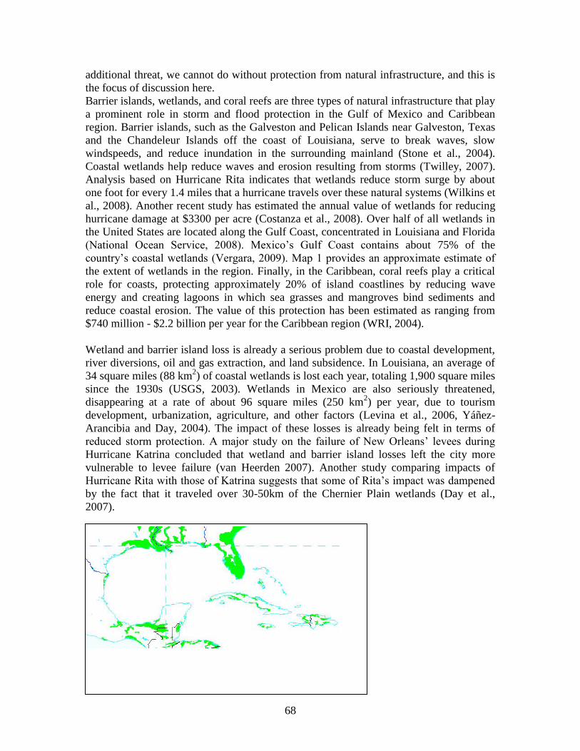
country‘s coastal wetlands (Vergara, 2009). Map 1 provides an approximate estimate of
the extent of wetlands in the region. Finally, in the Caribbean, coral reefs play a critical
role for coasts, protecting approximately 20% of island coastlines by reducing wave
energy and creating lagoons in which sea grasses and mangroves bind sediments and
reduce coastal erosion. The value of this protection has been estimated as ranging from
$740 million - $2.2 billion per year for the Caribbean region (WRI, 2004).
Wetland and barrier island loss is already a serious problem due to coastal development,
river diversions, oil and gas extraction, and land subsidence. In Louisiana, an average of
34 square miles (88 km2) of coastal wetlands is lost each year, totaling 1,900 square miles
since the 1930s (USGS, 2003). Wetlands in Mexico are also seriously threatened,
disappearing at a rate of about 96 square miles (250 km2) per year, due to tourism
development, urbanization, agriculture, and other factors (Levina et al., 2006, Yáñez-
Arancibia and Day, 2004). The impact of these losses is already being felt in terms of
reduced storm protection. A major study on the failure of New Orleans‘ levees during
Hurricane Katrina concluded that wetland and barrier island losses left the city more
vulnerable to levee failure (van Heerden 2007). Another study comparing impacts of
Hurricane Rita with those of Katrina suggests that some of Rita‘s impact was dampened
by the fact that it traveled over 30-50km of the Chernier Plain wetlands (Day et al.,
2007).
69
Map 1. Extent of wetlands in the Gulf of Mexico region. Adapted from the Global Distribution of
Wetlands Map, USDA Natural Resources Conservation Service. Green area represents five wetland classes,
combined. http://soils.usda.gov/use/worldsoils/mapindex/wetlands.html
Combined with these other stresses – including major new ones such as the current oil
spill in the Gulf – the additional effects of climate change may decrease the ability of
wetlands and coral reefs to protect against storm impacts. Sea level rise and increased
storm intensity, the focus of discussion in this section, pose some of the most significant
risks (Karl et al. 2009). Rising ocean temperatures are linked to coral reef damage; this
will be discussed in Section 3 under impacts on tourism. Changing precipitation patterns
may also have an effect on wetlands, but these are more uncertain (discussed briefly in
Section 3 under impacts on fisheries).
Globally, mean sea level rose 1.7 +/- 0.5 mm/year during the 20th
century, and recent
rates for 1993-2003 are higher, at 3.1 +/- 0.7 mm/year (Bindoff et al., 2007). Rates of sea
level rise are anticipated to increase as a result of climate change, but the size of the
increase is still uncertain (see accompanying paper, Sobel et al. 2010, for further
discussion). In addition, many locations across the Gulf and Caribbean have already
experienced significant land subsidence, often exceeding the current rate of sea level rise.
Subsidence has long been a problem in the Houston-Galveston Bay region, where
groundwater and oil extraction led to an average of 1 inch of subsidence per year over the
last century (Coplin and Galloway, 1999). In New Orleans, land subsidence averages
about 5mm/year, and in certain parts of the city, it as much as 25 mm/year (Dixon et al.,
2006). In four sites monitored along the Mexican coast of the Gulf, observations range
from about 2mm/year in Veracruz to over 9mm/year in Tamaulipas (SEMARNAT-INE,
2009).
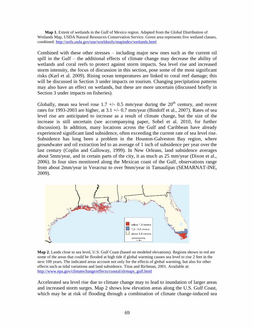
Map 2. Lands close to sea level, U.S. Gulf Coast (based on modeled elevations). Regions shown in red are
some of the areas that could be flooded at high tide if global warming causes sea level to rise 2 feet in the
next 100 years. The indicated areas account not only for the effects of global warming, but also for other
effects such as tidal variations and land subsidence. Titus and Richman, 2001. Available at:
http://www.epa.gov/climatechange/effects/coastal/slrmaps_gulf.html
Accelerated sea level rise due to climate change may to lead to inundation of larger areas
and increased storm surges. Map 2 shows low elevation areas along the U.S. Gulf Coast,
which may be at risk of flooding through a combination of climate change-induced sea
70
level rise and continued land subsidence (Titus and Richman, 2001). The map highlights
large vulnerable areas in Louisiana, Florida and Texas. The extent of wetlands is also
considerable in these areas (see Map 1).
There have been several studies projecting rates of sea level rise for specific locations and
land areas that would be inundated in the coming decades.10
A study on six counties in
Florida projected relative sea level rise ranging from 0.23-0.29 feet by 2030 and 0.83-
1.13 feet by 2080. In Dade County in South Florida, 1.02 feet of rise by 2080 is estimated
to inundate over 15,000 acres valued at $6.7 billion, in 2005 dollars. A 7-foot storm
surge, currently expected once every 76 years, would be expected once every 21 years
with one foot of sea level rise (Harrington and Walton, 2008). A study on member states
of the Caribbean Community (CARICOM) indicates that sea level rise of 1m would
inundate approximately 2,700 km2, with greatest total land loss in the Bahamas,
amounting to 10% of its land area. Significant percentages of wetland areas in Belize
(17%), Jamaica (22%), and the Bahamas (15%), would be inundated (Simpson et al.
2009). Additional areas would be subject to higher storm surges. A study of the effects of
1 meter of sea level rise in Mexico indicates that of the eight states with largest affected
land areas, six are on the Gulf Coast (Campeche, Quintana Roo, Veracruz, Tabasco,
Yucatán, and Tamaulipas). In these states, it is estimated that a total of 17,413 km2 would
be impacted (INE, 2008).
Wetlands, beaches, and barrier islands have some capacity to adapt as they evolve and
migrate according to natural cycles of erosion and accretion, which depend upon varying
rates of sea level rise, wave action, and sediment deposits from rivers. However, the
acceleration of sea level rise will likely speed up erosion, and in locations with
considerable coastal development, or where the land slope is too high, wetlands and
beaches may not be able to migrate inland, a problem termed the ―coastal squeeze‖
(Scavia et al., 2002, Field et al., 2007). It has been estimated that a one foot sea level rise
in Florida would erode 100-200 feet of most beaches (US EPA, 2002). While building
sea walls and replenishing beach sand are possible options, these have high costs, and in
some cases, structures along the coastline can themselves increase erosion rates, as has
occurred in Galveston (Yoskowitz et al., 2009). Finally, wetlands may be further stressed
by rapid increases in water salinity due to sea level rise. The contribution of this effect to
wetland loss will depend upon local features, such as the mix of fresh and salt water
sources, the speed of salinity change, and the adaptability of local grass species (Nicholls
et al. 2007).
Another potential effect of climate change is increased storm intensity. Some research
suggests that an increase in hurricane destructiveness in the North Atlantic may already
be occurring (Emanuel 2005), although the contribution of climate change in this trend
remains uncertain (see accompanying paper, Sobel et al., 2010). Increased storm intensity
could have important impacts on wetlands and barrier islands. The USGS estimates that
in Louisiana, hurricanes Katrina and Rita converted 217 square miles of marsh into open
water, and eliminated 85% of the above-water land mass of the Chandeleur Islands; some
10
These studies have used varying modeling approaches, and ranges of uncertainty differ. Please see
specific studies for further information.
71
of this damage is likely to be permanent (Barras 2007). While storm disturbance can
play a productive role in the evolution of wetlands and barrier islands, in the context of
coastal development pressures, storms can have negative effects (Burkett et al., 2005).
Increases in storm intensity could worsen this effect. This illustrates the need to
understand climate change impacts on natural and built infrastructure in the context of the
multiple stresses that they face.
3.2 Transportation
Transportation infrastructure is crucial for economic activity, and the Gulf of Mexico
region‘s interconnectedness across the United States, Mexico, and beyond, means that
impacts can have much broader ripple effects. Air and road transportation are critical for
tourism, and commerce depends heavily upon ports, roads, and railways. The Mississippi
River and the Gulf Intracoastal Waterway (a more than 1000-mile dredged canal running
from Florida to Texas) are some of the most important commercial corridors in the U.S.
(National Ocean Service 2008). The Gulf accounts for about 70% of waterborne
commerce ton-miles in the United States, and 7 of the 10 largest ports in the U.S.,
measured by tons of traffic, are located in the Gulf (Adams et al, 2004, National Research
Council 2008). Mexico‘s Gulf Coast has three of the country‘s five most important
industrial ports, and about 75% of the tonnage of Mexican imports and exports come
through ports on the Gulf (Sánchez-Gil et al., 2004).
The most serious and certain climate-related risks to transportation infrastructure are
flooding and storm damage, particularly to highways, ports, and railways (Wilbanks et
al., 2007, Kafalenos et al., 2008). Currently, 27% of major roads, 9% of rail lines, and
72% of ports in the coastal and neighboring counties in the U.S. Gulf states are below 4
feet in elevation, at risk of inundation, and more than half of major highways, half of rail
miles, 29 airports, and virtually all ports are below 23 feet (CCSP 2008). Costs of flood
damage and transportation disruptions can be significant. In Louisiana, the cost of repairs
after long-term submersion of roadways is estimated at $50 million for 200 miles of
highway. During Hurricane Katrina, over 1,800 miles of highway were submerged
(Kafalenos et al., 2008).
For the Caribbean Basin, many countries have significant transportation infrastructure in
located along the coast, at risk to sea level rise (Lewsey et al., 2004). A recent UNDP-
supported study of risks of sea level rise (Simpson et al., 2009) shows that countries most
exposed to impacts from sea level rise, based on their geophysical characteristics and
coastal topography, include Antigua and Barbuda, the Bahamas, Belize, and Jamaica.
While estimates of the percentage of road networks affected by sea level rise are
relatively low (greatest in the Bahamas, where an estimated 11% of the road network
would be affected by 3m of sea level rise), airports in these countries are very vulnerable.
With 3m of sea level rise, the international airports of Antigua and Barbuda and Belize
would be completed inundated, and the Bahamas and Jamaica would lose an estimated
40% of their airport functions (Simpson et al., 2009). Another study estimates that by
2080, sea level rise will necessitate an additional $76 million investment annually to
repair lost roads in CARICOM countries (Toba, 2009).
72
In addition to flooding due to rising sea levels, hurricane winds, wave action, and storm
surges also cause significant damage. These impacts may increase if climate change does
lead to increased storm intensity. Following hurricanes Katrina and Rita, Louisiana‘s
Department of Transportation spent $74 million to clear debris, and upwards of $700
million on bridge and road replacement and repair (USGCRP, 2008). Katrina also halted
grain exports, barge shipping was stopped, gas and petroleum pipelines were shut down,
and CSX freight train service along the Gulf Coast took five months to re-open (CCSP,
2008).
Finally, increased average temperatures, as well as increased number of hot days –
climate change trends with a relatively high degree of certainty – are an important
consideration for transportation infrastructure, leading to increased repair and
maintenance costs. For example, asphalt softens in high heat, leading to increased rutting
in roads, rail tracks can buckle, and bridge joints can expand (USGCRP, 2008).
3.3 Water supply and sanitation
Water supply and sanitation infrastructure are essential for health and livelihoods. To
meet urban, agricultural, industrial, and environmental demands, infrastructure may
include ground water pumps, reservoirs, desalination plants, water pipelines, irrigation
systems, filtration systems, and sewage treatment plants. This infrastructure is the focus
of many development projects in countries whose populations still lack access to these
basic services. Also critical are the natural infrastructure that capture, store, and clean
water, including watersheds, wetlands, and groundwater aquifers. These are increasingly
being accounted for through approaches such as integrated water resources management
(Lenton and Muller, 2009).
A key function of water infrastructure is to buffer against extremes, ensuring that water is
available in dry periods, and minimizing floods. The diversity of contexts in the Gulf of
Mexico and Caribbean region highlight this. The U.S. Gulf Coast relies on a combination
of surface and groundwater, with the Floridian and Gulf Coastal Plain aquifers playing an
important role in some regions (Kenny et al., 2009). The challenge is to ensure an
uncontaminated supply while managing potential coastal flooding and periodic droughts,
particularly as water demand grows. In contrast, freshwater supplies are sharply limited
across much of the Caribbean, particularly for atoll and coral reef islands such as
Barbados and the Bahamas that have little to no surface water. They rely almost
exclusively on groundwater, recharged by rainfall that comes only during a few months
in the year. Barbados and Trinidad Tobago have resorted to desalinization to supplement
groundwater sources (Simpson et al., 2009, Cashman et al., 2009). In both cases, the
natural and built infrastructure that helps moderate these extremes faces new risks from
climate change, presenting a challenge for water managers to maintain resilience.
Like transportation infrastructure, water infrastructure can be directly impacted by
flooding and storm damage, and this may increase with accelerated sea level rise and or
increased storm intensity. A study on the impacts of sea level rise in Galveston indicates
73
that under two sea level rise scenarios projected for the coming 100 years (0.69
meters and 1.5 meters), 10 and 16 waste water treatment plants and 5 and 9 solid waste
sites, respectively, would be impacted or threatened (Yoskowitz et al., 2009). A study
assessing economic costs of sea level rise in the Caribbean offers the rough estimate that
by the year 2080, the loss of water and sanitation connections in the 13 CARICOM
countries would result in an annual cost of about $15.6 million, in 2007 US dollar prices
(Toba, 2009).
Salt water intrusion into groundwater aquifers and water supply systems is already a
problem in Texas, Louisiana, Florida, and some Caribbean islands, and sea level rise may
worsen this. In South Florida, most communities depend upon groundwater, and salt
water intrusion already occurs in the region from Miami to Palm Beach. Water managers
in this area use water control structures to discharge water into the ocean and maintain
the level of water in canal networks. Sea level rise may reduce the effectiveness of these
structures to protect against salt water intrusion into wellfields, as well as floods
(SFWMD, 2009). There is also concern about salt water intrusion into the Everglades,
which currently recharges the Biscayne aquifer that supplies water to Miami-Dade,
Monroe, and parts of Broward counties (US EPA, 2002).
Higher temperatures and greater extremes in rainfall are also of significant concern for
current water infrastructure, as well as future infrastructure needs. Higher air
temperatures contribute to faster evaporation rates, which will increase water storage
requirements. Higher evaporation rates can also reduce the ability of water treatment
plants to remove phosphorous (SFWMD, 2009). Projected changes in rainfall patterns are
still fairly uncertain. Current research is not conclusive about whether precipitation will
increase or decrease in particular regions as a result of climate change (IPCC, 2007).
Modeling over the Caribbean region suggests an overall decrease in precipitation levels, a
serious worry for countries that are already water-scarce (Simpson et al 2009). In the U.S.
Gulf states, as well as other parts of the region, there is greater concern over the increase
in precipitation extremes (USGCRP, 2008). Managing these extremes may require
additional investments in built and natural infrastructure. For example, more frequent
urban flooding can overwhelm storm drain systems, threatening water quality by sending
untreated water directly into water bodies, and increasing flood risks (USGCRP, 2008,
US EPA, 2008, Bates et al., 2008).
4. Impact of infrastructure damage on economic
activity and urban services
As noted earlier, the value of infrastructure stems from the economic activity and
community life that it supports. Infrastructure, both natural and built, is so integral to the
functioning of society that its value is difficult to quantify (ASCE, 2009). This section
examines the potential implications of climate change for infrastructure in terms of
several important sectors in the region: fisheries, tourism, and energy production. In each,
multiple types of built and natural infrastructure are important, and their functions are
often closely linked. A brief section on climate-related risks to urban services highlights

74
how the spatial concentration of infrastructure can magnify risks. In all cases, climate
change is one of many risk factors. A key challenge is to understand the interplay
between them, and to identify situations in which multiple stressors might lead to more
dramatic economic and social impacts.
4.1 Fisheries
Fisheries are an important livelihood source across the Gulf and Caribbean Basin. The
recent oil spill along the U.S. Gulf Coast, which has all but halted fishing activities, has
highlighted how crucial this industry is for the Gulf States, particularly Louisiana. In
2006, three of the top six commercial fishing ports in the U.S. were located in the Gulf,
which was the source for 83% of the annual U.S. shrimp catch, and 56% of the oyster
catch (National Ocean Service, 2008). In addition to the transportation infrastructure
needed for the catch to reach consumers, fishing vessels are another crucial infrastructure
element; an estimated that one-third of the U.S. commercial fishing fleet is in the Gulf of
Mexico. The region contains one-fourth of all seafood processing plants in the United
States, the majority located in Louisiana and Florida (Adams et al., 2004). In the
Caribbean, an estimated 300,000 people depend upon fishing and related activities for
their livelihoods (UNEP, 2008). However, infrastructure plays less of a role since on
many islands, fishing is largely artisanal rather than industrial, and much of the catch is
consumed domestically rather than exported.
Hurricanes routinely disrupt fishing operations in the Gulf and Caribbean through
damage to fishing vessels, processing plants, ports, and other transportation
infrastructure. Hurricane Katrina led to the loss of thousands of fishing vessels, $1.3
billion of lost revenue in Louisiana‘s seafood industry, $101 million in damages to
Mississippi‘s seafood processing plants and dealers, and the loss of 90% of Mississippi‘s
primary oyster reefs (IAI 2007). If the intensity of storms increases as a result of climate
change, serious, periodic losses such as these could be expected to increase.
Sea level rise, temperature increases, and precipitation changes also may impact fisheries,
although effects are currently uncertain. Fisheries in the Gulf are highly dependent upon
wetlands; 95% of the fish and shellfish harvested in Louisiana depend upon coastal
wetlands, especially as ―nursery grounds‖ (Twilley et al. 2001). The impacts on estuaries
from a changing climate are multiple and uncertain, depending heavily upon local
conditions as well as how climate change scenarios unfold. For example, an increase in
air temperature also raises the water temperature in an estuary, which in turn effects the
mixing of salt and freshwater. If precipitation increases, then more freshwater runoff may
enter estuaries, but this may be counter-acted by sea level rise. Changing conditions
could favor some species over others (Turner, 2003). Wetlands also help buffer nutrient
levels in water, and with the loss of wetlands through either sea level rise or other drivers,
increased nutrient flows into water bodies can cause algal blooms and hypoxia, already
an enormous problem in the Gulf of Mexico (Twilley et al., 2001).
75
Fisheries in the U.S. Gulf states are currently coping with massive losses due to oil
spill in the Gulf, and for the time being, these impacts will dwarf those that might be
attributed to climate change. However, uncertainties about changing future storm
patterns, or new stresses on wetlands that support fish growth, add yet another challenge
for those seeking to rebuild fishing livelihoods and industries seriously weakened by the
spill.
4.2 Tourism
Tourism is a $20 billion industry in the Gulf of Mexico (US EPA, 2010). In the U.S.
Gulf states, tourism employs 620,000 people and accounts for $9 billion in wages
(National Ocean Service, 2008). In Caribbean countries, tourism employs over 2 million
people and represents a sizable portion of economic activity (UNEP, 2008). In 2004,
tourism accounted for over 30% of GDP in Antigua and Barbuda, Bahamas, Barbados,
Jamaica, St. Kitts and Nevis, St. Lucia, and St. Vincent and the Grenadines (European
Commission, 2007). This is supported by a range of built and natural infrastructure. For
example, in 2009, 22 million tourists visited the Caribbean, using airports, boats, and
roads to reach their destinations, where they made use of water and sanitation services,
electricity, and beachfront properties (Caribbean Tourism Organization, 2009). Many of
risks from climate change to this built infrastructure have been discussed above. Toba
(2009) projects that by 2080, climate change will cost CARICOM countries $447 million
annually in lost tourist expenditures.
Tourism also depends upon natural features, particularly coral reefs and beaches. The net
revenue from reef-related tourism in the Caribbean was estimated at $2.1 billion in 2000
(WRI, 2004). Wetlands and coral reefs are also crucial for recreational fishing in the
Gulf, which represents over 40% of the recreational catch in 2008 (NMFS, 2009). This
natural infrastructure, upon which tourism depends, faces several risks related to climate
change. Coral bleaching is an important problem related to an increase in ocean
temperatures. This expulsion of coral algae can kill coral if the bleaching event is
prolonged (WRI, 2004). Bleaching has been observed since the 1980s, and events are
often associated with El Niño events, which raise ocean temperatures for a number of
months. There is concern that climate change, by raising ocean temperatures, will worsen
this problem (Nicholls et al., 2007). Coral can also be harmed by ocean acidification,
caused by increased dissolved carbon dioxide, which may reduce calcification and retard
reef growth (USGCRP, 2008).
Reefs in the Caribbean, and elsewhere, also face other threats, such as overfishing,
coastal development, and water pollution, and hurricane damage (WRI, 2004). Recent
studies suggest that the combination of stresses from climate change and other sources
present a serious challenge to reef survival, particularly in the Caribbean. The region
contains the largest proportion of threatened species among coral reef regions in the
world, and Caribbean reefs have already been in decline for several decades (Carpenter et
al., 2008, Gardner et al., 2003). While a single threat may not destroy a reef on its own,
one additional stress on top of others may be sufficient to push a reef beyond its threshold
76
for survival. For example, reefs may be well-adapted to hurricane patterns, but recent
studies have shown that a series of hurricanes may trigger long-term coral decline in the
face of other threats (Mumby et al., 2007).
4.3 Energy
The Gulf of Mexico is a major source of oil and natural gas, which forms a crucially
important part of the regional economy, particularly in the U.S. Gulf states. The Gulf
accounts for 30% and 20% of U.S. crude oil and natural gas production capacity,
respectively (Bull et al., 2007). There are 33,000 miles of oil and gas pipelines on the
ocean floor of the Gulf, over 185,000 miles of pipeline onshore, and over 4,000 oil and
gas platforms (EEA, 2005). Other critical energy production infrastructure includes oil
refineries, gas processing plants, supply bases for offshore production plants, and
construction yards for platforms and pipelines. Much of this infrastructure is located in
the coastal areas of Louisiana and eastern Texas (Adams et al., 2004). Transportation
infrastructure over land and water are also crucial to ensuring regular energy supply
regionally, domestically, and internationally. Rail lines transport coal and natural gas,
while a substantial portion of oil is transported by barge. Almost all of Florida‘s oil is
transported through three ports (Bull et al., 2007). Many islands in the Caribbean also
depend heavily upon oil brought in by boat for electricity generation and fuel (Contreras-
Lisperguer and de Cuba, 2008).
In the Gulf of Mexico region, severe storms present the greatest current and future
climate-related risk to energy production and distribution. Hurricanes Katrina and Rita
led to $15 billion in direct losses to the energy industry, destroying over 100 platforms,
and damaging over 550 pipelines. In many cases, production was halted or slowed for
months, leading to fuel price hikes nationwide. Distribution of energy was severely
impacted due to strong linkages between distribution of gas, transportation fuel, and
electricity generation and distribution. The largest gas transmission hub, located in
Louisiana, had to be shut down for several weeks (Bull et al., 2007). Severe weather can
also hamper the ability of industry and government to respond other risks, as we have
witnessed this year with respect to the intensive effort to halt and mitigate damages of the
current oil spill in the Gulf.
Sea level rise and increased flooding are a concern for a wide range of energy production,
generation, and distribution infrastructure located in low-lying coastal areas, and may be
at risk of inundation. One third of U.S. refining and gas processing plants are located on
the coastal plains of the Gulf, close to sea level (Bull et al., 2007, National Ocean Service
2008). Florida, in particular, has a number of major power plants located close to the
coast, such that 3.6% of generating capacity in the 48 contiguous states could potentially
be impacted by 1 meter of sea level rise (Bull et al., 2007). The United States‘ Strategic
Petroleum Reserve Storage sites are located in the Gulf states, in order to take advantage
of proximity to national transportation networks. Although the oil is stored 2000-4000
feet below the surface in old salt caverns, these four sites are all located along the coast,
within regions mapped by USGS in 2000 to be susceptible to flooding due to sea level
rise (US DOE, 2010; Bull et al., 2007)
77
4.4 Urban services
Urban areas are now home to almost 80% of the U.S. population, and the U.S. Gulf Coast
is one of the most densely populated regions. At 20 million in 2008, the Gulf Coast
population is expected to increase by 10% by 2015, with the highest density located
along the coast (National Ocean Service, 2008). In the Caribbean, over 60% of the
region‘s 42 million people live in urban areas, and there are four cities with populations
larger than 2 million: Havana, Port au Prince, San Juan, and Santo Domingo. Mexico‘s
Gulf Coast states are home to approximately 17 million people, although cities are
smaller, with the largest being Tampico at 760,000 (UN DESA, 2009). However, the
coastal zone has also seen disproportionate growth. Between 1990 and 2000, the coastal
zones of states of Quintana Roo and Campeche grew 5.9% and 2.6%, respectively,
compared to an average 1.8% for the region (Sánchez-Gil et al., 2004).
Urban residents are heavily dependent upon a range of infrastructure, particularly in the
U.S. Gulf states. Transportation, energy, communication, water supply and sanitation,
flood control structures, residential and office buildings and public spaces must all be
well-integrated to provide services to densely populated urban centers as well as
increasingly geographically dispersed metropolitan and suburban areas. Access to these
services is not equitably distributed, with some neighborhoods lacking sufficient
transportation access, for example. On the other hand, close proximity to other
infrastructure, such as oil and gas refineries, sometimes imposes greater health risks in
lower-income and minority neighborhoods (Borden et al., 2007). While individual
systems are designed to function within ―normal‖ climate conditions and handle certain
extremes, a failure in one system can in turn affect others, creating ripple effects
throughout an urban area. These inter-dependencies may be physical, spatial or temporal
(Comfort 2006). Climate change may bring a shift in ―normal‖ conditions as
temperatures increase or precipitation patterns change, as well as the possibility of
increased extremes. We must account for the impact of such change not only to a single
type of infrastructure, but to the entire system that serves a metropolitan region (Kirshen
et al., 2006).
Flooding and wind damage from storms are probably the most serious climate risk today,
which may increase with climate change. Damage to buildings – commercial, residential,
and public – already accounts for a major portion of costs of hurricanes and floods, and
this may increase. For example, in the Galveston Bay region it has been projected that
over 60,000 buildings would be impacted by a 0.69m sea level rise over the next 100
years; over 75,000 would be affected by a 1.5 meter rise, creating economic losses of $9
and $12 billion, respectively (Yoskowitz et al., 2009). In many urban areas in Mexico and
some Caribbean countries, urbanization has led to the expansion of informal settlements,
often in low-lying, flood prone areas. Basic infrastructure is often lacking in such
settlements, but whatever minimal shelter or services do exist may be entirely wiped out
by flooding or storms, making their impact particularly severe for the urban poor
(Parkinson, 2003). Transportation networks in dense urban areas can be seriously
affected by flooding. Studies in some U.S. cities have suggested that additional
investment in the drainage systems of transportation networks will be required to address
78
increasing flood risks due to more frequent intense rainfall events (Bates et al., 2008).
Winds and flooding can cause serious damage to electricity and other energy systems.
Hurricanes Katrina and Rita resulted in 35 million customer-days of power outage
between August and October 2005, including 17 million customers in Louisiana (EEA
2005).
The tragic experience of New Orleans during Hurricane Katrina reminds us just how
dependent we are upon these interconnected infrastructure systems for our livelihoods
and community life. In parts of New Orleans and surrounding communities, not only
were housing units destroyed, but damage to electricity and communication lines, water
supply systems, and waste treatment plants meant no access to basic water and energy
services. Other infrastructure critical to community life – schools, hospitals, fire and
police stations, and parks – was also gone. Transportation infrastructure failed to enable
many to escape. The tragic consequences highlight the need to understand and plan for
the interdependencies between infrastructure elements providing these vital services.
They also point to the need to understand and account for socio-economic aspects of
vulnerability that shape who may be most affected, and relative capacity to cope with
infrastructure failures (Comfort, 2006).
5. Conclusion Infrastructure, both built and natural, plays a crucial role in determining the resilience of
societies to climate-related risks today, and will continue to do so as the range of
potential future climate conditions broadens. An understanding of future risks of climate
change requires examining infrastructure performance and consequences of failure in the
context of an integrated analysis, accounting for a wide range of climate and non-climate
stressors. The interactions between them, and the potential for multiple pressures to push
natural and/or built systems beyond their capacity, may present the greatest risks. For
example, in the Gulf of Mexico, the combination of development pressures on coastal
wetlands with the threat of sea level rise and the possibility of increases in storm intensity
may present serious challenges to resilience to floods. This has implications for other
infrastructure systems, particularly transportation, and in turn can impact the region‘s key
economic sectors, including fishing, tourism, and energy production. Risks in urban areas
are magnified, as multiple types of infrastructure are physically, spatially, and temporally
inter-dependent.
Addressing these risks will be a significant challenge. Infrastructure planning requires
substantial investments, whose payoffs are realized over the long-term. Many countries in
the region have insufficient infrastructure to manage current risks, and it will be critical
to integrate into development planning an understanding of multiple risks, including
climate change. In the United States, the need to update aging infrastructure in the United
States has drawn increased attention to infrastructure‘s value for economic growth, and
offers an important opportunity to account for risks of climate change in plans for
infrastructure renewal (ASCE, 2009). Finally, throughout the region, building resilience
to the range of future climate change scenarios will require attention to the role of natural
infrastructure, particularly wetlands in the region. The 2005 hurricane season provided a
79
vivid reminder of their importance for this storm and flood-prone region. The current
oil spill in the Gulf, combined with a forecast of a very active hurricane season this year,
points again to the urgent need to restore and protect them.
Acknowledgements
Kye Mesa Baroang provided valuable research assistance for this paper. Support from the
Baton Rouge Foundation and the National Oceanic and Atmospheric Administration
(NA050AR4311004) is gratefully acknowledged.
NOTE: This document is made available to conference participants in a pre-publication
form. It should not be cited or reproduced without the authors‘ permission.
80
References
Adams, C., E. Hernandez, and J. Cato, 2004. ―The economic significance of the Gulf of
Mexico related to population, income, employment, minerals, fisheries and shipping.‖
Ocean and Coastal Management 47: 565-580.
American Society of Civil Engineers (ASCE), 2009. Guiding Principles for the Nation’s
Critical Infrastructure. ASCE Critical Infrastructure Guidance Task Committee.
Reston, VA.
Association of State Floodplain Managers, Inc., 2005. ―Reducing Hurricane and Flood
Risk in the Nation.‖ Testimony before the House Transportation and Infrastructure
Subcommittee on Water Resources and Environment. October 27.
Barras, J. A., 2007. Land Area Changes in Coastal Louisiana after Hurricanes Katrina
and Rita. In Farris, G. S., et al. (eds.), Science and the Storms - the USGS Response to
the Hurricanes of 2005. US Geological Survey Circular 1306.
Bates, B., and Z.W. Kundzewicz, S. Wu, and J. Palutikof (eds), 2008. Climate Change
and Water. Technical Paper of the Intergovernmental Panel on Climate Change, IPCC
Secretariat, Geneva.
Bindoff, N.L., J. Willebrand, V. Artale, A, Cazenave, J. Gregory, S. Gulev, K. Hanawa,
C. Le Quéré, S. Levitus, Y. Nojiri, C.K. Shum, L.D. Talley and A. Unnikrishnan,
2007: Observations: Oceanic Climate Change and Sea Level. In: Climate Change
2007: The Physical Science Basis. Contribution of Working Group I to the Fourth
Assessment Report of the Intergovernmental Panel on Climate Change [Solomon, S.,
D. Qin, M. Manning, Z. Chen, M. Marquis, K.B. Avery, M. Tignor and H.L. Miller
(eds.)]. Cambridge University Press, Cambridge, United Kingdom and New York,
NY, USA.
Borden, K.A., M.C. Schmidtlein, C.T. Emrich, W. W. Piegorsch, and S.L. Cutter, 2007.
Vulnerability of U.S. Cities to Environmental Hazards. Journal of Homeland Security
and Emergency Management 4(2): article 5.
Bull, S. R., D. E. Bilello, J, Ekmann, M. J. Sale, and D. K. Schmalzer, 2007. Effects of
climate change on energy production and distribution in the United States. In Effects
of Climate Change on Energy Production and Use in the United States. A Report by
the U.S. Climate Change Science Program and the subcommittee on Global Change
Research. Washington, DC.
Burke, L. and J. Maidens, 2004. Reefs at Risk in the Caribbean. World Resources
Institute, Washington, DC.
Burkett, V.R., et al., 2005. Non-linear dynamics in ecosystem response to climatic
change: case studies and policy implications. Ecological Complexity 2: 357-394.
81
Burkett, V. R., D. B. Zilkoski, and D. A. Hart, 2002. ―Sea level rise and subsidence:
Implications for flooding in New Orleans, Louisiana.‖ US Geological Survey
Subsidence Interest Group Conference, Proceedings of the Technical Meeting,
Galveston, Texas, November 27-29, 2001.
Caribbean Tourism Organization, 2009. ―Caribbean Tourism Overview 2009.‖ Available
at:
http://www.onecaribbean.org/content/files/ctomediaConf.Feb82010CaribbeanTouris
mOverview2009%281%29.pdf (accessed July 3, 2010).
Carpenter, K.E., et al., 2008. One-third of reef-building corals face elevated extinction
risk from climate change and local impacts. Science 321: 560-563.
Climate Change Science Program (CCSP), 2008. Impacts of Climate Change and
Variability on Transportation Systems and Infrastructure: Gulf Coast Study, Phase I.
A Report by the U.S. Climate Change Science Program (CCSP) and the
Subcommittee on Global Change Research. [Savonis, M. J., V.R. Burkett, and J.R.
Potter (eds.)]. Department of Transportation, Washington, DC.
Comfort, L.K., 2006. ―Cities at Risk: Hurricane Katrina and the Drowning of New
Orleans.‖ Urban Affairs Review 41: 501-16.
Contreras-Lisperguer, R. and K. de Cuba, 2008. ―The Potential Impact of Climate
Change on the Energy Sector in the Caribbean Region.‖ Department of Sustainable
Development, Organization of American States.
Coplin, L.S., and D. Galloway, 1999. ―Houston-Galveston, Texas: Managing Coastal
Subsidence.‖ In Galloway, D., D.R. Jones, and S.E. Ingebritsen (eds.), Land
Subsidence in the United States. USGS Circular 1182. U.S. Geological Survey,
Denver, CO.
Costanza, R., et al., 2008. The value of coastal wetlands for hurricane protection. Ambio
37 (4): 241-248.
Cutter, S. L., et al., 2007. ―The U.S. Hurricane Coasts: Increasingly Vulnerable?
Environment September.
Day, J. W., et al., 2007. Restoration of the Mississippi Delta: Lessons from Hurricanes
Katrina and Rita. Science 315: 1679-1684.
Dixon, T. H., et al., 2006. Subsidence and flooding in New Orleans. Nature 441: 587-
586.
Emanuel, K. Increasing destructiveness of tropical cyclones over the past 30 years.
Nature 436: 686-688.
82
Energy and Environmental Analysis, Inc (EEA), 2005. Hurricane Damage to Natural Gas
Infrastructure and its Effect on the U.S. Natural Gas Market. Submitted to The
Energy Foundation. Arlington, VA.
European Commission, 2007. Trade Sustainability Impact Assessment of the EU-African
Caribbean Pacific Trade Relations of the Economic Partnership Agreements: Reports:
Tourism in the Caribbean ACP region. Available at:
http://trade.ec.europa.eu/doclib/docs/2007/march/tradoc_133937.pdf (accessed July 3,
2010).
Field, C.B., L.D. Mortsch,, M. Brklacich, D.L. Forbes, P. Kovacs, J.A. Patz, S.W.
Running and M.J. Scott, 2007: North America. Climate Change 2007: Impacts,
Adaptation and Vulnerability. Contribution of Working Group II to the Fourth
Assessment Report of the Intergovernmental Panel on Climate Change, M.L. Parry et
al., (eds.), Cambridge University Press, Cambridge, UK.
Gardner, T.A, I.M. Côté, J.A. Gill, A. Grant, A.R. Watkinson, 2003. Long-term region-
wide declines in Caribbean corals. Science 301: 958-960.
Harrington, J. and T.L. Walton, 2008. Climate Change in Coastal Areas in Florida: Sea
Level Rise Estimation and Economic Analysis to Year 2080. The Florida State
University, Tallahassee, Florida. Available at:
http://www.cefa.fsu.edu/uploaded%20current%20projects/FSU%208%2014%202008
%20final.pdf (accessed April 5, 2010).
Impact Assessment Inc. (IAI), 2007. Preliminary Assessment of the Impacts of Hurricane
Katrina on Gulf of Mexico Coastal Fishing Communities: Final Technical Report.
Submitted to National Marine Fisheries Service, U.S. National Oceanic and
Atmospheric Administration, Southeast Regional Office, Saint Petersburg, Florida.
Available at: http://sero.nmfs.noaa.gov/sf/socialsci/pdfs/FINAL-PUBLIC-N.pdf
(accessed April 7, 2010).
Instituto Nacional de Ecología, 2008. Evaluación regional de la vulnerabilidad actual y
futura de la zona costera mexicana y los deltas más impactados ante el incremento del
nivel del mar debido al calentamiento global y fenómenos hidrometeorológicos
extremos. Cited in INE-SEMARNAT 2009.
IPCC, 2007: Summary for Policymakers. In: Climate Change 2007: The Physical Science
Basis. Contribution of Working Group I to the Fourth Assessment Report of the
Intergovernmental Panel on Climate Change [Solomon, S., D. Qin, M. Manning, Z.
Chen, M. Marquis, K.B. Averyt, M. Tignor and H.L. Miller (eds.)]. Cambridge
University Press, Cambridge, United Kingdom and New York, NY, USA.
Kalfenos, R.S., et al. What are the implications of climate change and variability for Gulf
Coast transportation? In Impacts of Climate Change and Variability on
83
Transportation Systems and Infrastructure: Gulf Coast Study, Phase I. A Report by
the U.S. Climate Change Science Program (CCSP) and the Subcommittee on Global
Change Research. [Savonis, M. J., V.R. Burkett, and J.R. Potter (eds.)]. Department
of Transportation, Washington, DC.
Karl, T. R., J. M. Melillo, and T. C. Peterson (eds.), 2009. Global Climate Change
Impacts in the United States. Cambridge University Press.
Kenny, J., N. Barber, S. Hutson, K. Linsey, J. Lovelace, and M. Maupin, 2009. Estimated
Use of Water in the United States in 2005. US Geological Survey Circular 1344, U.S.
Dept of Interior. Reston, VA.
Kirshen, P., M. Ruth, and W. Anderson, 2006. ―Climate‘s Long-term Impacts on Urban
Infrastructures and Services: The Case of Metro Boston.‖ In Ruth, M., K. Donaghy,
and P. Kirshen (eds.), Regional Climate Change and Variability: Impacts and
Responses. Edward Elgar Publishing, Cheltenham, U.K.
Lenton, R. and Muller, M. (eds.), 2009. Integrated Water Resources Management in
Practice: Better Water Management for Development. Earthscan.
Levina, E., J. Jacob, L.E.R. Bustillos, I. Ortiz, 2006. Policy Frameworks for Adaptation
to Climate Change in Coastal Zones: The Case of the Gulf of Mexico. Organization
for Economic Development and Cooperation, Environment Directorate. Paris, France.
Louisiana Coastal Protection and Restoration Authority (LACPRA), 2007. Integrated
Ecosystem Restoration and Hurricane Protection: Louisiana’s Comprehensive
Master Plan for a Sustainable Coast. Baton Rouge. Available at:
http://www.lacpra.org/ (accessed March 20, 2010).
Mumby, P.J, A. Hastings, and H.J. Edwards, 2007. Thresholds and the resilience of
Caribbean coral reefs. Nature 450: 98-101.
National Marine Fisheries Service (NMFS), 2009. Fisheries of the United States 2008.
Office of Science and Technology, National Oceanic and Atmospheric
Administration, Silver Spring.
National Ocean Service, NOAA, 2008. Gulf of Mexico at a Glance. U.S. Department of
Commerce, National Oceanic and Atmospheric Administration, Washington, DC.
National Research Council, 2009. Sustainable Critical Infrastructure Systems: A
Framework for Meeting 21st Century Imperatives. Board on Infrastructure and the
Constructed Environment. National Academies Press, Washington, DC.
National Research Council, 2008. Potential Impacts of Climate Change on U.S.
Transportation. Transportation Research Board Special Report 290. Transportation
Research Board, Washington, DC.
84
Ning, Z.H, R.E. Turner, T. Doyle, and K. Abdollahi, 2003. Preparing for a changing
climate: the potential consequences of climate variability and change – Gulf Coast
Region. Gulf Coast Regional Climate Change Assessment Council and Louisiana
State University.
Parkinson, J., 2003. Drainage and stormwater management strategies for low-income
urban communities. Environment and Urbanization 15: 115-126.
Pielke Jr., R. A., et al., 2008. Normalized hurricane damage in the United States: 1900-
2005. Natural Hazards Review 9: 29-42.
Pielke, Jr., R.A., et al., 2003. Hurricane vulnerability in Latin America and the
Caribbean: Normalized damage and loss potentials. Natural Hazards Review 4: 101-
114.
Rosenzweig, C., G. Casassa, D.J. Karoly, A. Imeson, C. Liu, A. Menzel, S. Rawlins, T.L.
Root, B. Seguin, P. Tryjanowski, 2007. Assessment of observed changes and
responses in natural and managed systems. Climate Change 2007: Impacts,
Adaptation and Vulnerability. Contribution of Working Group II to the Fourth
Assessment Report of the Intergovernmental Panel on Climate Change, M.L. Parry,
O.F. Canziani, J.P. Palutikof, P.J. van der Linden and C.E. Hanson, Eds., Cambridge
University Press, Cambridge, UK, 79-131.
Secretaria de Medio Ambiente y Recoursos Naturales and Instituto Nacional de Ecologia
(SEMARNAT-INE), 2009. Mexico Fourth National Communication under the UN
Framework Convention on Climate Change. Mexico City.
South Florida Water Management District (SFWMD), 2009. Climate Change and Water
Management in South Florida. Interdepartmental Climate Change Group, West Palm
Beach, Florida.
Sánchez-Gil, P., A. Yáñez-Arancibia, J. Ramírez-Gordillo, J.W. Day, and P.H. Templet,
2004. Some socio-economic indicators in the Mexican states of the Gulf of Mexico.
Ocean and Coastal Management 47: 581-596.
Stone, G., A. Sheremet, X. Zhang, D. Braud, 2004. Wave and storm protection provided
by Louisiana‘s Gulf Shoreline: Barrier islands and shell reefs. In: Louisiana Gulf
Shoreline Restoration Report. University of New Orleans, Pontchartrain Institute for
Environmental Sciences. Technical Series 04-003.
Titus, J.G., and C. Richman, 2001. ―Maps of lands vulnerable to sea level rise: modeled
elevations along the U.S. Atlantic and Gulf coasts.‖ Climate Research 18: 205-228.
Toba, N., 2009. ―Potential Economic Impacts of Climate Change in the Caribbean
Community.‖ In Vergara, W. (ed.), Assessing the Potential Consequences of Climate
85
Destabilization in Latin America. Sustainable Development Working Paper 32. The
World Bank, Washington, DC.
Turner, R.E, 2003. ―Coastal Ecosystems of the Gulf of Mexico and Climate Change.‖ In
Ning, Z.H, et al. (eds), Integrated Assessment of the Climate Change Impacts on the
Gulf Coast Region. Gulf Coast Climate Change Assessment Council and Louisiana
State University. Available at:
http://www.usgcrp.gov/usgcrp/Library/nationalassessment/gulfcoast/ (accessed April
5, 2010).
Twilley, R.R., 2007. ―Coastal Wetlands and Global Climate Change: Gulf Coast Wetland
Sustainability in a Changing Climate.‖ In Regional Impacts of Climate Change: Four
Case Studies in the United States. Pew Center on Global Climate Change,
Washington, DC.
Twilley, R.R., E.J. Barron, H.L. Gholz, M. A. Harwell, R.L. Miller, D.J. Reed, J.B. Rose,
E.H. Siemann, R.G. Wetzel, and R.J. Zimmerman, 2001. Confronting Climate
Change in the Gulf Coast Region: Prospects for Sustaining Our Ecological Heritage.
Union of Concerned Scientists, Cambridge, Massachusetts, and Ecological Society of
America, Washington, DC.
United Nations Department of Economic and Social Affairs (UN DESA), 2009. World
Urbanization Prospects: The 2009 Revision. Population Division. Available at:
http://esa.un.org/unpd/wup/index.htm (accessed July 5, 2010).
United Nations Environment Programme (UNEP), 2008. Climate Change in the
Caribbean and the Challenge of Adaptation. UNEP Regional Office for Latin
America and the Caribbean, Panama City, Panama.
U.S. Army Corps of Engineers (US ACE), 2009. ―Fiscal Year 2009 Civil Works Program
Performance Work Plan.‖ Programs Integration Division, Directorate of Civil Works.
Available at:
http://www.usace.army.mil/CECW/Documents/fy09_performance_wp.pdf (accessed
July 7, 2010).
U.S. Department of Energy (US DOE), 2010. ―Strategic Petroleum Reserves.‖ Office of
Petroleum Reserves. Available at:
http://www.fossil.energy.gov/programs/reserves/index.html#SPR (accessed on July 4,
2010).
U.S. Environmental Protection Agency (US EPA), 2010. ―General Facts about the Gulf
of Mexico.‖ Gulf of Mexico Program. Available at:
http://www.epa.gov/gmpo/about/facts.html#tourism (accessed on July 3, 2010).
U.S. Environmental Protection Agency (US EPA), 2008. Final National Water Program
Strategy: Response to Climate Change. EPA Office of Water, Washington DC.
86
U.S. Environmental Protection Agency (US EPA), 2002. Saving Florida‘s Vanishing
Shores. U.S. EPA, Washington, DC. Available at:
http://www.epa.gov/climatechange/effects/coastal/saving_FL.pdf (accessed April 7,
2010).
U.S Geological Survey (USGS), 2003. ―100+ Years of Land Change for Coastal
Louisiana.‖ USGS National Wetlands Research Center, Lafayette, Louisiana.
Available at: http://www.nwrc.usgs.gov/upload/landloss11X17.pdf (accessed April 2,
2010).
Wilbanks, T. J., et al., 2007. Industry, settlement, and society. In Climate Change 2007:
Impacts, Adaptation, and Vulnerability. In M.L. Parry, et al. (eds)., Contribution of
Working Group II to the Fourth Assessment Report of the Intergovernmental Panel
on Climate Change. Cambridge University Press, Cambridge, U.K.
Wilkins, J.G., R.E. Emmer, D. Hwang, G. P. Kemp, B. Kennedy, H. Mashriqui, and B.
Sharky, 2008. Louisiana Coastal Hazard Mitigation Guidebook. Louisiana Sea Grant
College Program.
World Bank, 2008. ―The Caribbean Catastrophe Risk Insurance Facility: Providing
Immediate Funding After Natural Disasters.‖ Operational Innovations in Latin
America and the Caribbean, Vol. 2, No. 1. Sustainable Development Department,
Latin America and the Caribbean Region. Washington, DC.
Yáñez-Arancibia, A., and J.W. Day, 2004. Environmental sub-regions in the Gulf of
Mexico coastal zone: the ecosystem approach as an integrated management tool.
Ocean and Coastal Development 47: 727-757.