Embed Size (px)
Citation preview
Climate and Disaster Risk Assessment in Land Use Planning
Experience from the Housing and Land Use Regulatory Board Technical Planning Assistance Program (HTPAP): The Case of Gloria,
Oriental Mindoro in the Philippines
Nora Diaz, EnPDirector, Policy Development Group
Housing and Land Use Regulatory Board
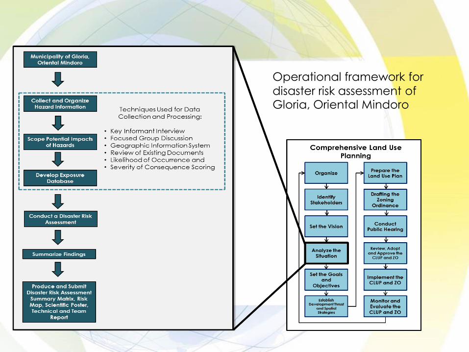
Operational framework for
disaster risk assessment of Gloria, Oriental Mindoro

System of interest covered by the vulnerability and risk assessment
1. Lifeline utilities: transportation, water distribution, drainage and power & communication distribution network
2. Critical point facilities: schools, hospitals, RHUs, LGU buildings
3. Natural Resource Based Production Areas: Agricultural Crops, Fishery, Forest
4. Urban: Built environment - residential, commercial, industrial, tourism, sanitary waste management facilities, cemeteries
5. Population: spatial location and no. of potentially affected persons
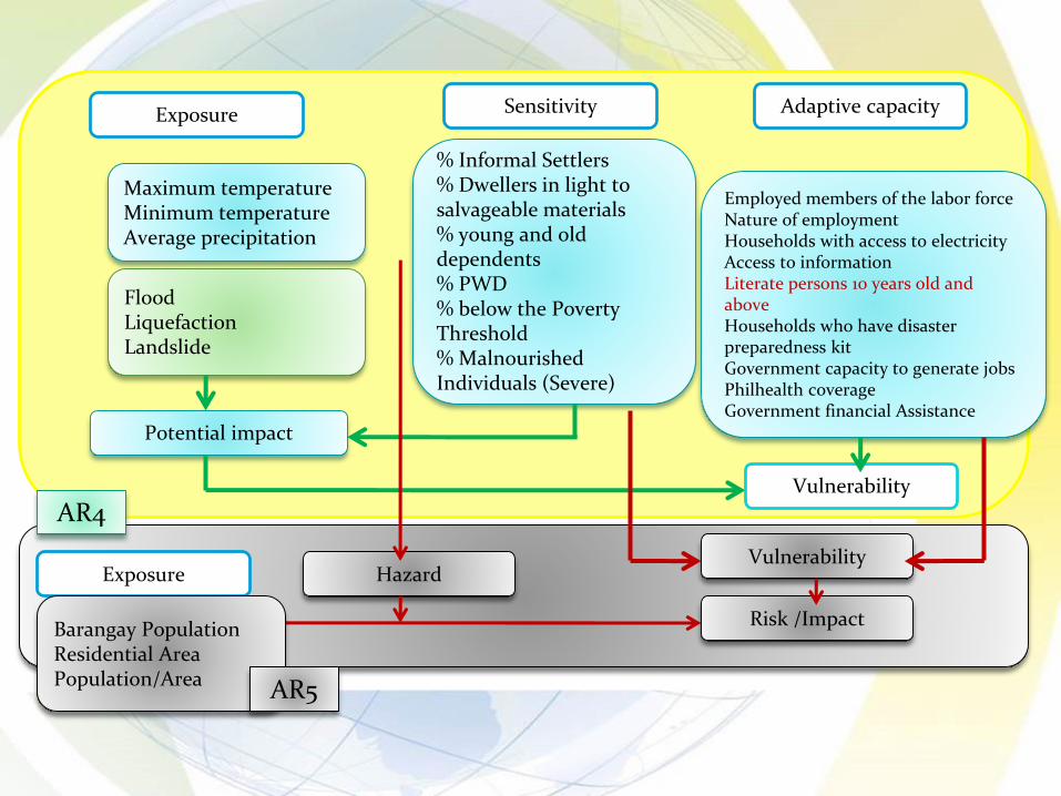
Exposure Sensitivity Adaptive capacity
Maximum temperatureMinimum temperatureAverage precipitation
FloodLiquefactionLandslide
Potential impact
% Informal Settlers% Dwellers in light to salvageable materials% young and old dependents% PWD% below the Poverty Threshold% Malnourished Individuals (Severe)
Employed members of the labor forceNature of employmentHouseholds with access to electricityAccess to informationLiterate persons 10 years old and aboveHouseholds who have disaster preparedness kitGovernment capacity to generate jobsPhilhealth coverageGovernment financial Assistance
Vulnerability
AR4
Exposure HazardVulnerability
Risk /ImpactBarangay PopulationResidential AreaPopulation/Area AR5

Hazard and Climate Information
1. Use of climate change projection from DOST-PAGASA
2. Records of Previous Disaster: Hazard events and description, affected barangays, casualties, damage to houses and properties (in PHP)
3. Projected changes in climate variables and potential affected exposure units
4. Climate Impact Chain Diagram (biophysical and socio-economic impacts included)

Exposure
Exposure of system of interest is assessed per hazard.
NATURAL RESOURCE BASED PRODUCTIONAREAS
Landslide
Susceptibility
Likelihood of
Occurrence
Score
Area by
Dominant
Crop
(Has.)
Dominant
Crop
Exposed
Area
(Hectares)
Exposure
%
Ave. Potential
Income per
Hectare per
year (PhP)
Exposed Value
(PhP)
AGRICULTURE RICE
Low 6
2554.592 Rice
2448.1198 95.83% ₱136,800.00 ₱334,902,788.64
Moderate 5 97.1111 3.80% ₱136,800.00 ₱13,284,798.48
High 5 9.3611 0.37% ₱136,800.00 ₱1,280,598.48
MIXED VEGETATION
Low 6
12988.869 Banana
7004.2474 53.92% ₱60,000.00 ₱420,254,844.00
Moderate 5 1875.3769 14.44% ₱60,000.00 ₱112,522,614.00
High 5 4109.2447 31.64% ₱60,000.00 ₱246,554,682.00
FISHERIES
Low 6
22.4431 Rice
8.7957 6.82% ₱136,800.00 ₱1,203,251.76
Moderate 5 14.0262 62.50% ₱136,800.00 ₱1,918,784.16
High 5 93.5887 417.00% ₱136,800.00 ₱12,802,934.16

Measure of Likelihood Return Period in Years Likelihood Score
Frequent Every 1-3 years 6
Moderate Every >3-10 years 5
Occasional Every >10-30 years 4
Improbable Every >30-100 years 3
Rare event Every >100-200 years 2
Very rare event Every >200 years 1
Indicative Likelihood of Occurrence Scores.Source: adapted from Reference Manual on Mainstreaming Disaster Risk Reduction and Climate Change Adaptation in the Comprehensive Land Use Plans, NEDA-HLURB-UNDP, 2012.

Conclusion of CDRA Report of Gloria, Oriental Mindoro includes recommendations on:
1. Policy interventions
2. Climate change adaptation per sector
3. Disaster risk reduction

Disaster risk assessment per system of interest
HLURB Retooling Workshop on AR531/10/2017
Example of disaster summary matrix for critical point facilities.
DECISION
AREA
NAME
TECHNICAL FINDINGS IMPLICATIONS POLICY INTERVENTION
AGOS
The multipurpose hall is not
susceptible to flooding
Prone to low susceptible to
flooding are the Health Center
and the Barangay Hall.
All critical point facilities are
susceptible to low level of
landslide
Moderate susceptibility to
flooding are the Basketball
court, Agos Elementary School,
Catholic Church, church, Day
Care center
All critical point facilities are
exposed to moderate
liquefaction.
There is an existing open court.
Multipurpose hall of
Agos is the safest area
when flooding occurs.
Critical point facilities
that are exposed to
hazards are not safe
as evacuation
centers.
Evacuation centers
are not safe in
liquefaction.
Open court can be
utilized as evacuation
site.
Establishment of
evacuation centers
on areas that are
safe from hazards.
Evacuation centers
should be fortified to
withstand
liquefaction of
underlying soils.
Convert open court
to covered court.

Example of disaster summary matrix for lifeline utilities.
DECISION
AREA NAMETECHNICAL FINDINGS IMPLICATIONS POLICY INTERVENTIONS
NATIONAL
ROAD
0.524 kilometers of National
Highway are exposed to high
susceptibility of flooding with
low risk. The estimated
likelihood of occurrence of
every 11-30 years. These are
some parts of Narra, Kawit
and Maligaya National road.
5.45 Kilometers are exposed to
moderate flooding. This is a
rare event that happens every
100-200 years. These are some
parts of Narra, Kawit and
Maligaya National road.
Major disruption
in transportation
of agricultural
produce.
Difficulty in
evacuation and
response.
Establishment of
alternate routes.
Formulation of
flood contingency
plans targeting
potentially
affected
communities.
Disaster risk assessment per system of interest

Thank you.