Embed Size (px)
Citation preview
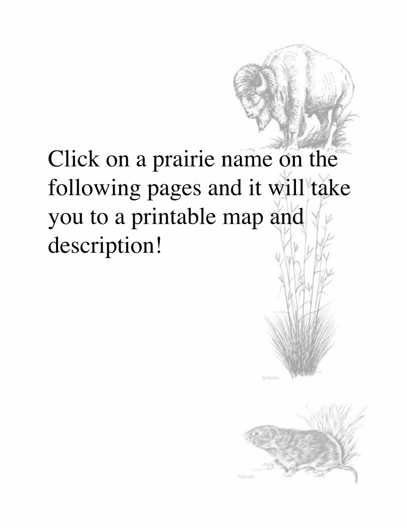
Click on a prairie name on thefollowing pages and it will takeyou to a printable map anddescription!
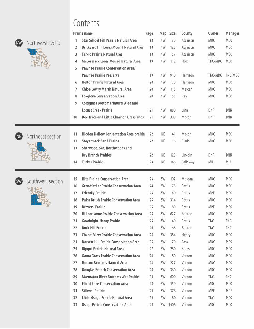
ContentsPrairie name Page Map Size County Owner Manager
1 Star School Hill Prairie Natural Area 18 NW 70 Atchison MDC MDC
2 Brickyard Hill Loess Mound Natural Area 18 NW 125 Atchison MDC MDC
3 Tarkio Prairie Natural Area 18 NW 57 Atchison MDC MDC
1
1
1
1
1
1
1
1
1
1
2
2
2
2
2
2
2
2
2
2
3
3
3
3
NE
NW
SW
Northwest section
Southwest section
Northeast section
4 McCormack Loess Mound Natural Area 19 NW 112 Holt TNC/MDC MDC
5 Pawnee Prairie Conservation Area/
Pawnee Prairie Preserve 19 NW 910 Harrison TNC/MDC TNC/MDC
6 Helton Prairie Natural Area 20 NW 30 Harrison MDC MDC
7 Chloe Lowry Marsh Natural Area 20 NW 115 Mercer MDC MDC
8 Foxglove Conservation Area 20 NW 55 Ray MDC MDC
9 Cordgrass Bottoms Natural Area and
Locust Creek Prairie 21 NW 880 Linn DNR DNR
0 Bee Trace and Little Chariton Grasslands 21 NW 300 Macon DNR DNR
1 Hidden Hollow Conservation Area prairie 22 NE 41 Macon MDC MDC
2 Steyermark Sand Prairie 22 NE 6 Clark MDC MDC
3 Sherwood, Sac, Northwoods and
Dry Branch Prairies 22 NE 123 Lincoln DNR DNR
4 Tucker Prairie 23 NE 146 Callaway MU MU
5 Hite Prairie Conservation Area 23 SW 102 Morgan MDC MDC
6 Grandfather Prairie Conservation Area 24 SW 78 Pettis MDC MDC
7 Friendly Prairie 25 SW 40 Pettis MPF MDC
8 Paint Brush Prairie Conservation Area 25 SW 314 Pettis MDC MDC
9 Drovers’ Prairie 25 SW 80 Pettis MPF MDC
0 Hi Lonesome Prairie Conservation Area 25 SW 627 Benton MDC MDC
1 Goodnight-Henry Prairie 25 SW 40 Pettis TNC TNC
2 Rock Hill Prairie 26 SW 68 Benton TNC TNC
3 Chapel View Prairie Conservation Area 26 SW 384 Henry MDC MDC
4 Dorsett Hill Prairie Conservation Area 26 SW 79 Cass MDC MDC
5 Ripgut Prairie Natural Area 27 SW 280 Bates MDC MDC
6 Gama Grass Prairie Conservation Area 28 SW 80 Vernon MDC MDC
7 Horton Bottoms Natural Area 28 SW 227 Vernon MDC MDC
8 Douglas Branch Conservation Area 28 SW 360 Vernon MDC MDC
9 Marmaton River Bottoms Wet Prairie 28 SW 609 Vernon TNC TNC
0 Flight Lake Conservation Area 28 SW 159 Vernon MDC MDC
1 Stilwell Prairie 29 SW 376 Vernon MPF MPF
2 Little Osage Prairie Natural Area 29 SW 80 Vernon TNC MDC
3 Osage Prairie Conservation Area 29 SW 1506 Vernon MDC MDC
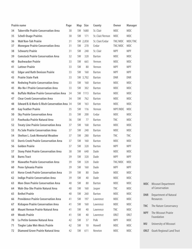
Prairie name Page Map Size County Owner Manager
34 Taberville Prairie Conservation Area 30 SW 1680 St. Clair MDC MDC
35 Schell-Osage Prairies 30 SW 171 St. Clair/Vernon MDC MDC
36 Wah’Kon-Tah Prairie 31 SW 2,858 St. Clair/Cedar TNC/MDC MDC/TNC
37 Monegaw Prairie Conservation Area 31 SW 270 Cedar TNC/MDC MDC
38 Schwartz Prairie 31 SW 240 St. Clair MPF MPF
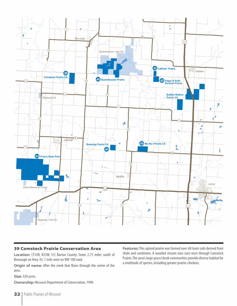
39 Comstock Prairie Conservation Area 32 SW 320 Barton MDC MDC
40 Bushwacker Prairie 33 SW 665 Vernon MDC MDC
41 Lattner Prairie 33 SW 80 Vernon MPF MPF
42 Edgar and Ruth Denison Prairie 33 SW 160 Barton MPF MPF
43 Prairie State Park 33 SW 3,702 Barton DNR DNR
44 Redwing Prairie Conservation Area 33 SW 160 Barton MDC MDC
45 Mo-No-I Prairie Conservation Area 33 SW 302 Barton MDC MDC
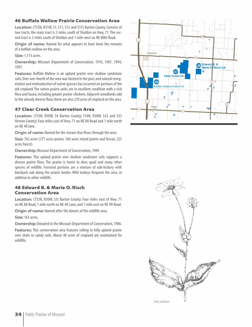
46 Buffalo Wallow Prairie Conservation Area 34 SW 1113 Barton MDC MDC
47 Clear Creek Conservation Area 34 SW 762 Barton MDC MDC
48 Edward B. & Marie O. Risch Conservation Area 34 SW 163 Barton MDC MDC
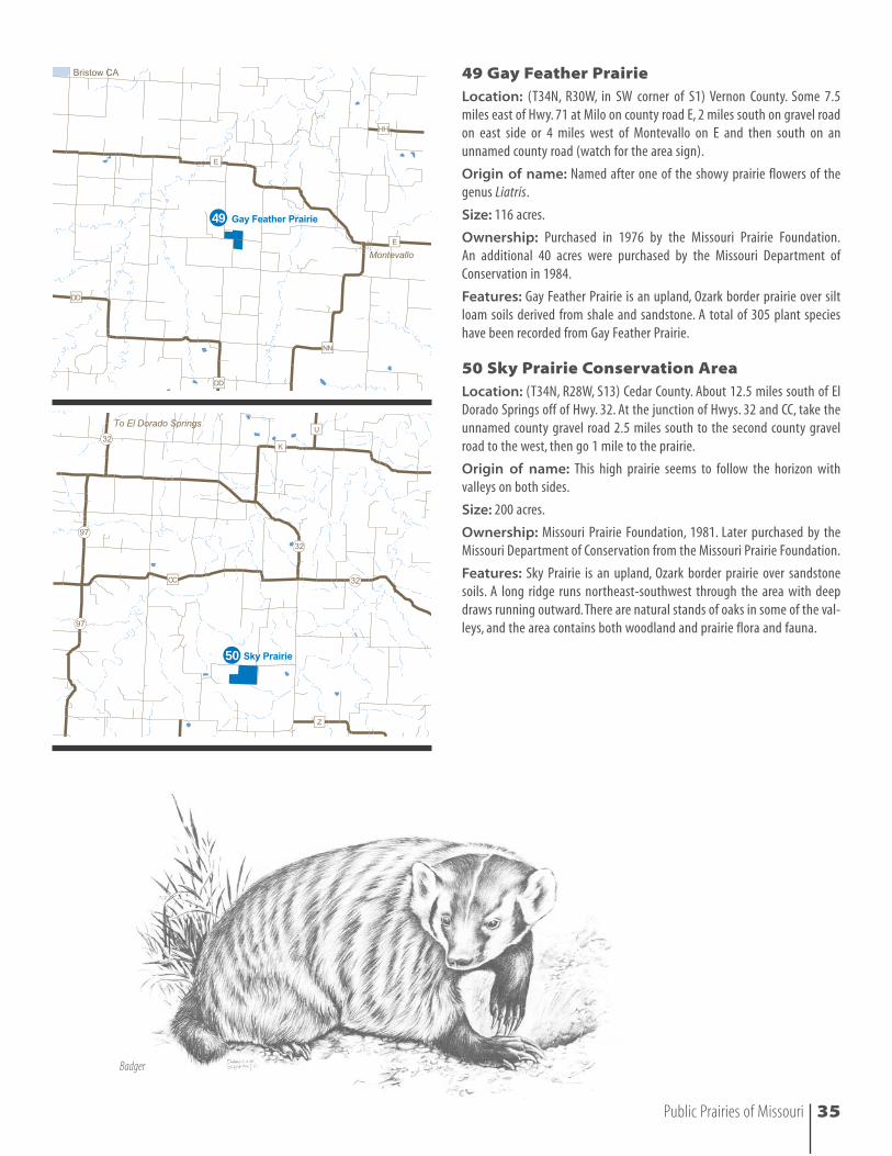
49 Gay Feather Prairie 35 SW 116 Vernon MPF/MDC MDC
50 Sky Prairie Conservation Area 35 SW 200 Cedar MDC MDC
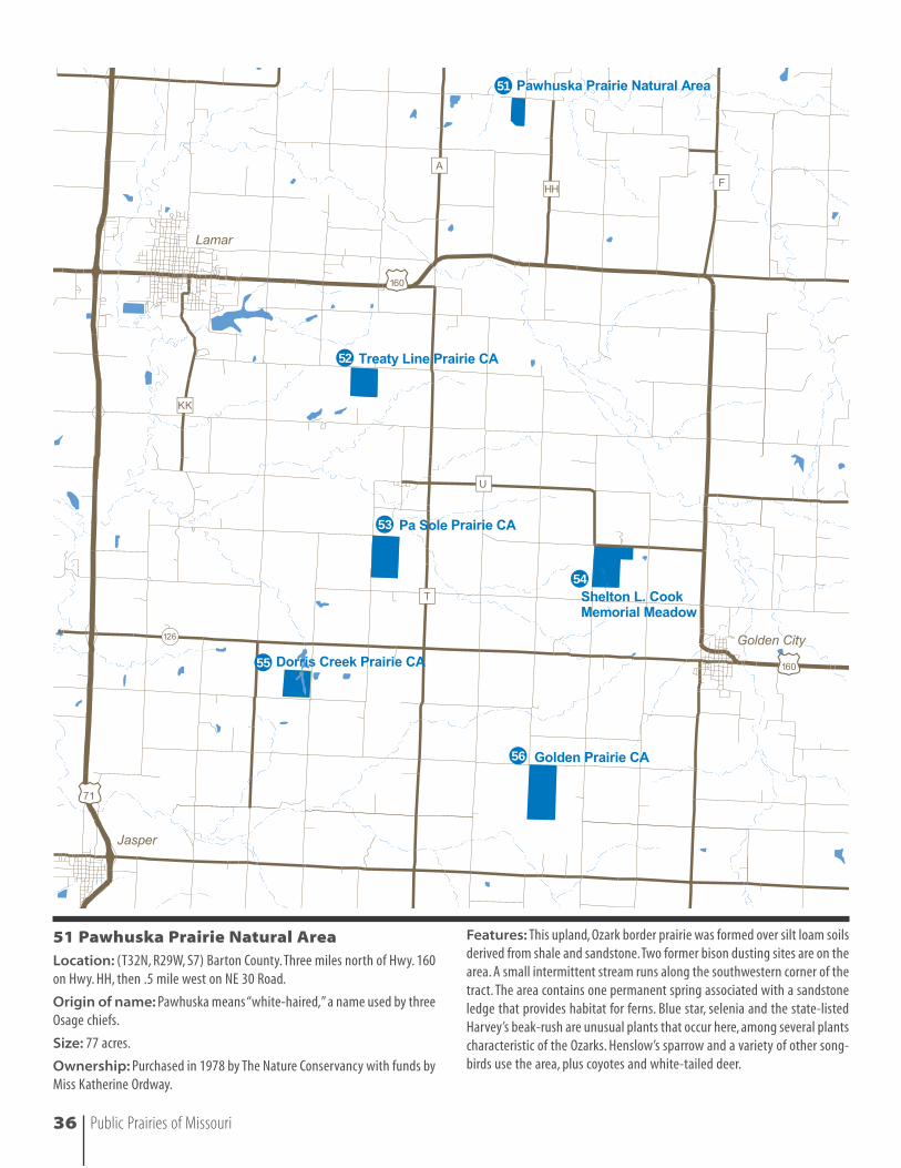
51 Pawhuska Prairie Natural Area 36 SW 77 Barton TNC MDC
52 Treaty Line Prairie Conservation Area 37 SW 168 Barton MDC MDC
53 Pa Sole Prairie Conservation Area 37 SW 240 Barton MDC MDC
54 Shelton L. Cook Memorial Meadow 37 SW 280 Barton TNC TNC
55 Dorris Creek Prairie Conservation Area 37 SW 160 Barton MDC MDC
56 Golden Prairie 37 SW 320 Barton MPF MPF
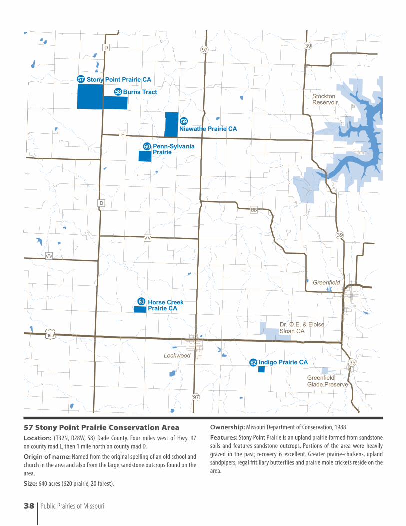
57 Stony Point Prairie Conservation Area 38 SW 640 Dade MDC MDC
58 Burns Tract 39 SW 320 Dade MPF MPF
59 Niawathe Prairie Conservation Area 39 SW 320 Dade TNC/MDC MDC
60 Penn-Sylvania Prairie 39 SW 160 Dade MPF MPF
61 Horse Creek Prairie Conservation Area 39 SW 80 Dade MDC MDC
62 Indigo Prairie Conservation Area 39 SW 40 Dade MDC MDC
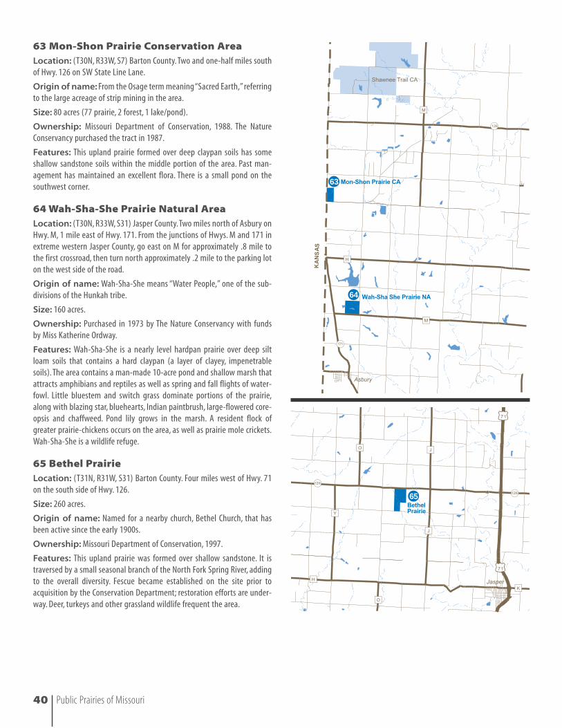
63 Mon-Shon Prairie Conservation Area 40 SW 80 Barton MDC MDC
64 Wah-Sha-She Prairie Natural Area 40 SW 160 Jasper TNC MDC
65 Bethel Prairie 40 SW 260 Barton MDC MDC
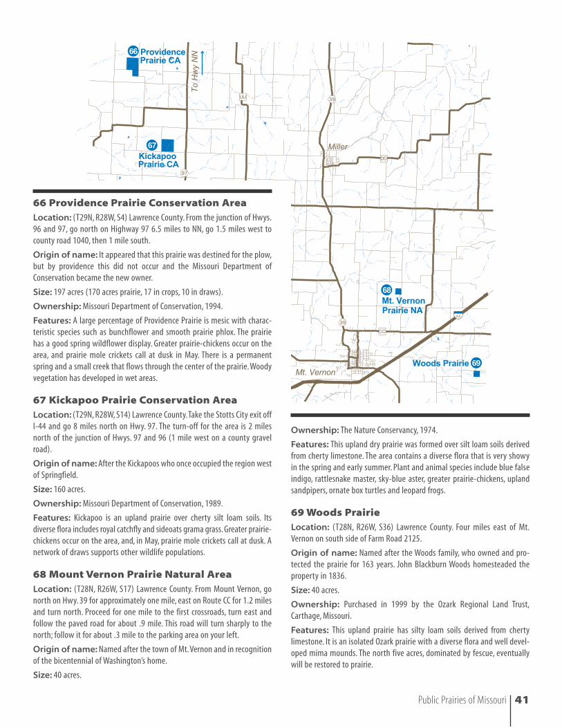
66 Providence Prairie Conservation Area 41 SW 197 Lawrence MDC MDC
67 Kickapoo Prairie Conservation Area 41 SW 160 Lawrence MDC MDC
68 Mount Vernon Prairie Natural Area 41 SW 40 Lawrence TNC MDC
69 Woods Prairie 41 SW 40 Lawrence ORLT ORLT
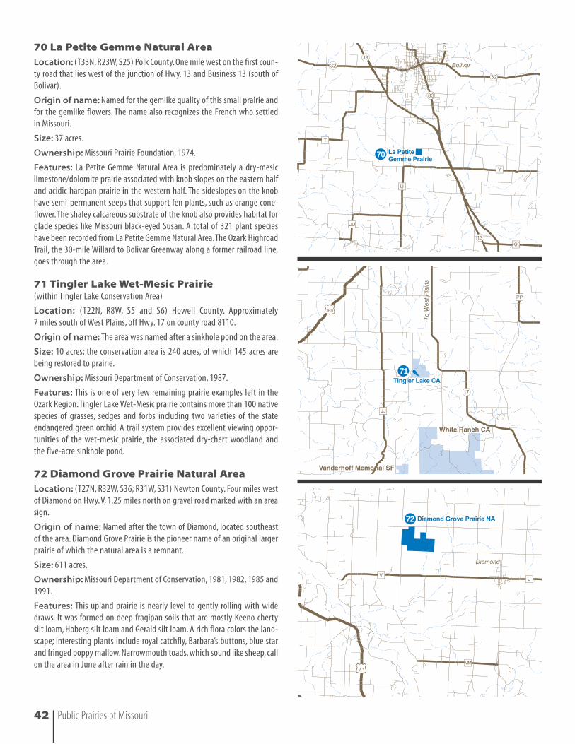
70 La Petite Gemme Natural Area 42 SW 37 Polk MPF MDC
71 Tingler Lake Wet-Mesic Prairie 42 SW 10 Howell MDC MDC
72 Diamond Grove Prairie Natural Area 42 SW 611 Newton MDC MDC
MDC Missouri Department of Conservation
DNR Department of NaturalResources
TNC The Nature Conservancy
MPF The Missouri PrairieFoundation
MU University of Missouri
ORLT Ozark Regional Land Trust
18 Public Prairies of Missouri
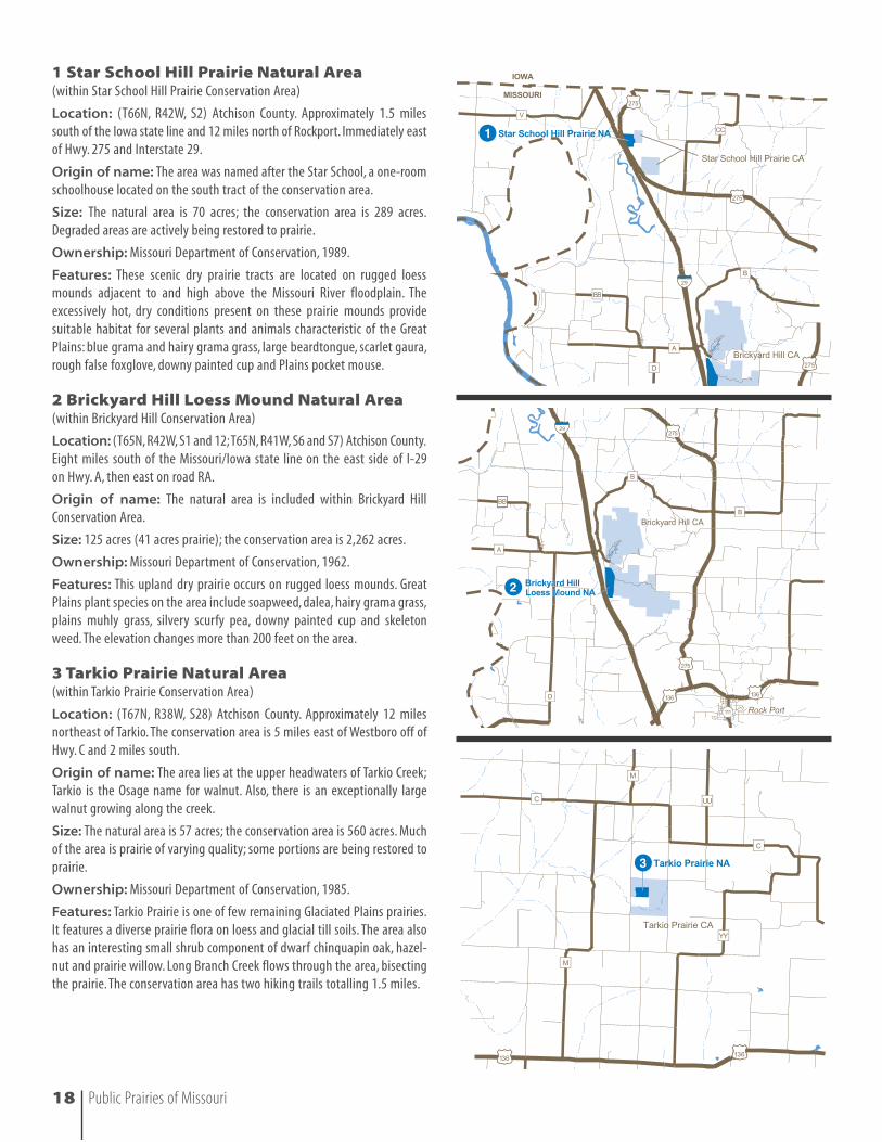
1 Star School Hill Prairie Natural Area(within Star School Hill Prairie Conservation Area)
Location: (T66N, R42W, S2) Atchison County. Approximately 1.5 milessouth of the Iowa state line and 12 miles north of Rockport. Immediately eastof Hwy. 275 and Interstate 29.
Origin of name: The area was named after the Star School, a one-roomschoolhouse located on the south tract of the conservation area.
Size: The natural area is 70 acres; the conservation area is 289 acres.Degraded areas are actively being restored to prairie.
Ownership: Missouri Department of Conservation, 1989.
Features: These scenic dry prairie tracts are located on rugged loessmounds adjacent to and high above the Missouri River floodplain. Theexcessively hot, dry conditions present on these prairie mounds providesuitable habitat for several plants and animals characteristic of the GreatPlains: blue grama and hairy grama grass, large beardtongue, scarlet gaura,rough false foxglove, downy painted cup and Plains pocket mouse.
2 Brickyard Hill Loess Mound Natural Area(within Brickyard Hill Conservation Area)
Location: (T65N, R42W, S1 and 12;T65N, R41W, S6 and S7) Atchison County.Eight miles south of the Missouri/Iowa state line on the east side of I-29 on Hwy. A, then east on road RA.
Origin of name: The natural area is included within Brickyard HillConservation Area.
Size: 125 acres (41 acres prairie); the conservation area is 2,262 acres.
Ownership: Missouri Department of Conservation, 1962.
Features: This upland dry prairie occurs on rugged loess mounds. GreatPlains plant species on the area include soapweed, dalea, hairy grama grass,plains muhly grass, silvery scurfy pea, downy painted cup and skeletonweed. The elevation changes more than 200 feet on the area.
3 Tarkio Prairie Natural Area(within Tarkio Prairie Conservation Area)
Location: (T67N, R38W, S28) Atchison County. Approximately 12 milesnortheast of Tarkio. The conservation area is 5 miles east of Westboro off ofHwy. C and 2 miles south.
Origin of name: The area lies at the upper headwaters of Tarkio Creek;Tarkio is the Osage name for walnut. Also, there is an exceptionally largewalnut growing along the creek.
Size: The natural area is 57 acres; the conservation area is 560 acres. Muchof the area is prairie of varying quality; some portions are being restored toprairie.
Ownership: Missouri Department of Conservation, 1985.
Features: Tarkio Prairie is one of few remaining Glaciated Plains prairies.It features a diverse prairie flora on loess and glacial till soils. The area alsohas an interesting small shrub component of dwarf chinquapin oak, hazel-nut and prairie willow. Long Branch Creek flows through the area, bisectingthe prairie. The conservation area has two hiking trails totalling 1.5 miles.
Public Prairies of Missouri 19
4 McCormack Loess Mound Natural Area (within McCormack Conservation Area)
Location: (T61N, R39W, S36) Holt County. On Hwy. 159 (west off of I-29,exit 79) and adjacent to Squaw Creek National Wildlife Refuge. From thejunction of Hwy. 159 and I-29 south of Mound City, head west on Hwy. 159for 3 miles. A sign for the conservation area and parking lot are on the eastside of the road here.
Origin of name: The conservation area and natural area were namedafter the donor of the area.
Size: McCormack Loess Mounds, owned by The Nature Conservancy andleased to the Conservation Department, is 158 acres.The entire McCormackConservation Area is 242 acres.The 112-acre McCormack Loess Mound NaturalArea includes parts of both The Nature Conservancy and the MissouriDepartment of Conservation land (TNC, 43 acres; MDC, 69 acres).
Ownership: The Nature Conservancy, 1968, and the Missouri Departmentof Conservation, 1976.
Features: This upland prairie is on rugged loess mounds with plains-prairie-woodland species. The prairie is on deep Napier and Hamburg soilsand harbors Great Plains plants like downy painted cup, hairy grama grass,skeleton plant and low milk vetch. Grasses, however, are the dominateplants here. The elevation changes 240 feet on the area. The loess moundsare managed by controlled fires on a three-year rotation. Mid to lateOctober is a good time to visit, when the grasses turn color and migratingwaterfowl are visible at neighboring Squaw Creek National Wildlife Refuge.
5 Pawnee Prairie Conservation Area/Pawnee Prairie PreserveLocation: (T66N R29W, S13 and S14). Harrison County. Take Hwy. 46 toHatfield, then take gravel road out of Hatfield south .5 mile.
Origin of name: Named for a small community that once existed nearthe site.The name also recognizes the Native American heritage of the area.
Size: Missouri Department of Conservation, 476 acres; The NatureConservancy, 434 acres.
Ownership: Missouri Department of Conservation, 1996; The NatureConservancy, 1996.
Features: The land is rolling upland grassland with several wetland areasand dry-mesic and mesic prairie. Major portions are undergoing restoration.On the Conservation Department portion, an unchannelized tributary ofMuddy Creek crosses the tract. Cord grass dominates the stream bottom andthe larger upland drainages. The ridgetops, 120 feet above the prairie bot-tom, support drier prairie species like little bluestem. Pawnee has the bestrepresentation of grassland birds of any public prairie in the region, includ-ing bobolinks, upland sandpipers, Henslow’s sparrows, western mead-owlarks, dickcissels and grasshopper sparrows. Sedge wrens are abundantin late July and August. Notable plant species species include Culver’s root,Michigan lily, thimbleweed, great St. John’s wort, and northern Missouri’sonly known tussock sedge population. Pawnee is also home to the regal frit-illary butterfly.
4
5
Upland sandpiper
20 Public Prairies of Missouri
6 Helton Prairie Natural Area(within Wayne Helton Memorial Wildlife Area)
Location: (T63N, R26W, S16) Harrison County. Approximately 5 milessouthwest of Mount Moriah and 9 miles east of Bethany in the extremenorthwest corner of the Wayne Helton Memorial Wildlife Area. The wildlifearea is on route CC, 3 miles south of Hwy. 136.
Origin of name: After Wayne Helton, a partial donor of the area.
Size: 30 acres (12 prairie, 18 being restored).
Ownership: Missouri Department of Conservation, 1969.
Features: Helton Prairie Natural Area is a high quality upland prairielocated in the Glaciated Plains of northern Missouri.The clay loam and siltyclay loam soils of the site are somewhat poorly drained, and much of theprairie exhibits mesic vegetation. Helton Prairie is especially showy in lateMay and through June. Bunch flower, culver’s root and Michigan lily con-tribute to the excellent plant diversity of the area. Bobolinks are especial-ly visible in June and sedge wrens in late July and August.
7 Chloe Lowry Marsh Natural Area(within Chloe Lowry Marsh Conservation Area)
Location: (T65N, R24W, S16 and S17) Mercer County. Near Princeton. Go 2 miles north on Road FF, then 2 miles on a gravel road that leads to LowryMemorial airport.
Origin of name: The conservation area and natural area were named forthe previous owner.
Size: 115 acres (15 acres wet-mesic prairie, 40 acres marsh, 10 acres wet-mesic savanna, 50 acres old field, timber and tree plantings).
Ownership: Missouri Department of Conservation, 1992.
Features: The area includes 40 acres of marsh and 15 acres of wet-mesicprairie in the Grand River section of the Glaciated Plains Natural Division.Lowry Marsh is one of the highest quality natural marshes in the state, con-taining many rare or endangered species including several sedges, marshskullcap, star duckweed, tufted loosestrife and the rare northern leopardfrog. The upland prairie portion of the area is being restored. There is a .5 mile hiking trail. Chloe Lowry Marsh Natural Area was designated in 1995.
8 Foxglove Conservation AreaLocation: (T53N, R29W, S23 and S24) Ray County. Approximately 5 miles northeast of Excelsior Springs. One-half mile east of Vibbard ongravel road 174 and .5 mile north on gravel road 235.
Origin of name: Named after the auriculate false foxglove (Agalinusauriculata), which is common on the area.
Size: 55 acres (35 prairie, 20 being restored).
Ownership: Missouri Department of Conservation, 1990.
Features: This rolling, brushy prairie formed predominately on silty clayloam and clay loam soils. The area has good plant diversity including leadplant, rattlesnake master and compass plant. Small populations of hairyparsley and prickly pear cactus are associated with small limestone outcropson the area. Periodic prescribed fires are used to help reduce invasion ofwoody species and to stimulate the native prairie grasses and forbs.
6
7
8
9 Cordgrass Bottoms Natural Area andLocust Creek Prairie (within Pershing State Park)
Location: Cordgrass Bottoms: (T57N, R21W, S11) Linn County. At thenorth end of Pershing State Park; southwest of the intersection of Hwys. 36and 130, on the east side of Locust Creek.
Size: 80 acres.
Location: Locust Creek Prairie: (T57N, R21W, S14, S15, S22 and S23;T58N,R21W, S26, S27) Linn County. A boardwalk access is 1.5 miles south of Hwy.36 from the Hwy. 130 park entrance.
Size: 800 acres.
Ownership: Missouri Department of Natural Resources, Division of StateParks.
Features: Locust Creek Prairie is the largest riverine wet prairie left in theGlaciated Plains of northern Missouri. It is associated with an unchannelizedsection of Locust Creek and features wet prairie with wet savanna borders,a mosaic of open water marshes and shrub swamp slough, all underlain byalluvial silt loam soils. Cordgrass Bottoms Natural Area has 30 acres of cordgrass prairie and marsh; other characteristic plants include many sedges,swamp milkweed, false aster, Sullivant’s milkweed, bluejoint grass, whitebeard-tongue, blue flag and sawtooth sunflower.
10 Bee Trace & Little Chariton Grasslands (within Long Branch State Park)
Location: Bee Trace: (T58N, R14W, S19, S30 and S31) Macon County. Goingnorth on Hwy. 63, turn west on the gravel road that is 5 miles north of theintersection of Hwys. 36 and 63. Go west 2 miles to the Long Branch StatePark sign (this is a peninsula in the north end of the park). Little CharitonGrasslands: (T58N, R15W, S1 and S12) Macon County. Enter the park fromHwy. 36 2 miles west of the town of Macon. The prairie borders the camp-ground and is easily accessible to visitors.
Size: Bee Trace: 200 acres total. Prairie remnants scattered within a largerestoration area; the largest remnant is 30 acres. Little Chariton Grasslands:100 acres.
Ownership: The Missouri Department of Natural Resources, Division ofState Parks.
Features: Bee Trace and Little Chariton Grasslands are rare examples ofthe prairie landscape that once dominated the glaciated plains. Many nativegrasses and forbs indicative of the original diversity of the dry-mesicprairies of northern Missouri are preserved at this site. There are also rem-nant savannas with old-growth white and bur oaks.
9
10
10
OO
Public Prairies of Missouri 21
Cord grass
11 Hidden Hollow Conservation AreaLocation: (T60N, R16W, S24) Macon County. Go 6.4 miles west of La Plataon Hwy. 156 to Rt. 3; go south to La Crosse and take Fox Road to the west tothe conservation area.
Origin of name: There is a sizable hollow on the area that is hiddenfrom the road and the river.
Size: 41 acres; the conservation area is 1,228 acres.
Ownership: Missouri Department of Conservation, 1985.
Features: These 41 acres of exceptional dry-mesic prairie are located inthe east-central part of the conservation area.The prairie occurs on the topsand sides of two parallel, northeast-southeast trending side ridges, dividedby a wooded draw.The prairie is dominated by typical prairie grasses with amoderate to high forb diversity, including conservative species like whiteprairie clover and leadplant. There are also small wet-mesic swales domi-nated by cord grass in the conservation area.
12 Steyermark Sand Prairie (within Frost Island Conservation Area)
Location: (T65N, R6W, S9) Clark County. Four miles north of Wayland onHwy. B., then east 1 mile on unnamed gravel road.
Origin of name: For the late botanist Dr. Julian Steyermark, who visitedhere in 1949.
Size: The sand prairie is 6 acres; the conservation area is 1178 acres.
Ownership: Missouri Department of Conservation, 1995.
Features: One of our extremely rare sand prairies, Steyermark SandPrairie is being restored and expanded into old crop fields adjacent to theexisting prairie. Some of the plants of this sand prairie include sanddropseed, dotted beebalm, sand milkweed and plains puccoon.
13 Sherwood, Sac, Northwoods and Dry Branch Prairies (within Cuivre River State Park)
Location: Cuivre River State Park is located 3 miles east of Troy off Hwy. 47 in central Lincoln County. Sherwood Prairie: (T49N, R01E, SW4 S4).Sac Prairie: (T49N, R01E, S5). Northwoods Prairie: (T50N, R01E, S29, S30 andS32). Dry Branch Prairie: (T49N, R01E, NE4 S5).
Size: 70 acres (Sherwood Prairie); 8 acres (Sac Prairie); 20 acres(Northwoods Prairie); 25 acres (Dry Branch Prairie).
Ownership: Missouri Department of Natural Resources, Division of StateParks.
Features: These native prairie restoration areas feature remnant andrestored upland dry-mesic prairie bordered by savanna and woodland.Many plants indicative of the original diversity of the Lincoln Hills are pre-served in these prairie tracts.
11
12
13
22 Public Prairies of Missouri
Public Prairies of Missouri 23
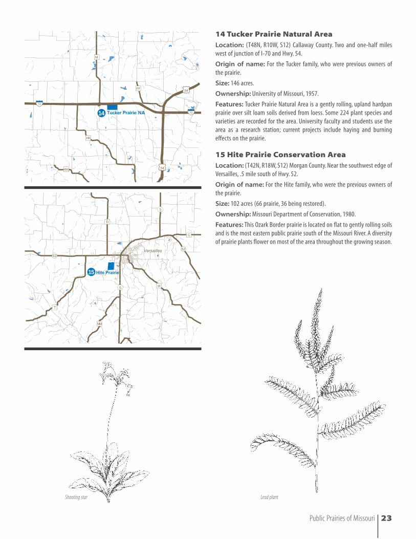
14 Tucker Prairie Natural AreaLocation: (T48N, R10W, S12) Callaway County. Two and one-half mileswest of junction of I-70 and Hwy. 54.
Origin of name: For the Tucker family, who were previous owners of the prairie.
Size: 146 acres.
Ownership: University of Missouri, 1957.
Features: Tucker Prairie Natural Area is a gently rolling, upland hardpanprairie over silt loam soils derived from loess. Some 224 plant species andvarieties are recorded for the area. University faculty and students use thearea as a research station; current projects include haying and burningeffects on the prairie.
15 Hite Prairie Conservation AreaLocation: (T42N, R18W, S12) Morgan County. Near the southwest edge ofVersailles, .5 mile south of Hwy. 52.
Origin of name: For the Hite family, who were the previous owners ofthe prairie.
Size: 102 acres (66 prairie, 36 being restored).
Ownership: Missouri Department of Conservation, 1980.
Features: This Ozark Border prairie is located on flat to gently rolling soilsand is the most eastern public prairie south of the Missouri River. A diversityof prairie plants flower on most of the area throughout the growing season.
14
15
Lead plantShooting star
19
2116
17
18
20
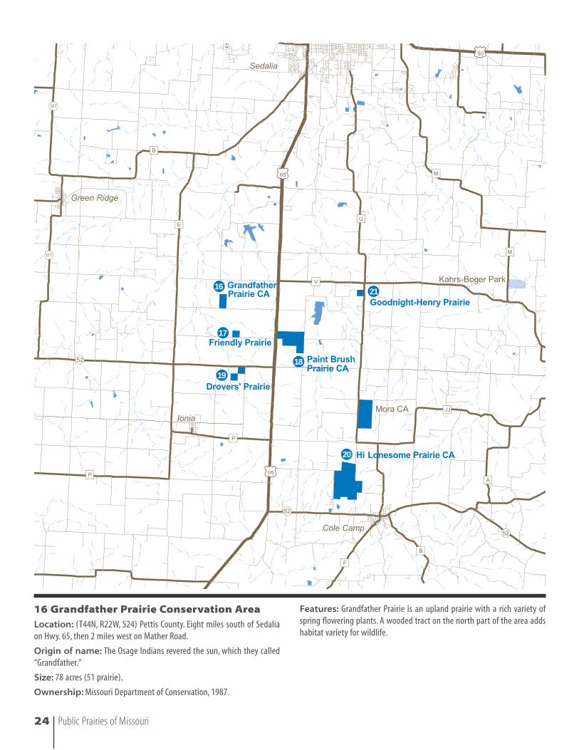
16 Grandfather Prairie Conservation AreaLocation: (T44N, R22W, S24) Pettis County. Eight miles south of Sedaliaon Hwy. 65, then 2 miles west on Mather Road.
Origin of name: The Osage Indians revered the sun, which they called“Grandfather.”
Size: 78 acres (51 prairie).
Ownership: Missouri Department of Conservation, 1987.
Features: Grandfather Prairie is an upland prairie with a rich variety ofspring flowering plants. A wooded tract on the north part of the area addshabitat variety for wildlife.
24 Public Prairies of Missouri
17 Friendly PrairieLocation: (T44N, R22W, S25) Pettis County. Nine miles south of Sedalia onHwy. 65, 1.25 miles west on Manila Road.
Origin of name: In the past, Friendly Prairie served as an informal road-side rest stop for highway travelers.
Size: 40 acres.
Ownership: Missouri Prairie Foundation, 1969.
Features: This upland prairie was formed over silt loam soils derived fromshale and cherty limestone. Over 257 plant species have been recorded fromFriendly Prairie. Fifty-two bird species have been identified, including thegreater prairie-chicken.
18 Paint Brush Prairie Conservation AreaLocation: (T44N, R21W, S29 and S32) Pettis County. Nine miles south ofSedalia on Hwy. 65, then east on Manila Road.
Origin of name: Named after the showy Indian paintbrush that occurson the prairie.
Size: 314 acres (5 cropland, 299 prairie).
Ownership: Missouri Department of Conservation, 1978, 1983 and 1991.
Features: This dry-mesic upland prairie was formed over soils derivedfrom cherty limestone and shale. Paint Brush is a very showy spring flower-ing prairie. Notable animal and plants include the prairie mole cricket, regalfritillary butterfly, Mead’s milkweed and bunchflower. A 76-acre Missouri natural area is located on the northwestern part of the area.
19 Drovers’ PrairieLocation: (T43N, R22W, S1) Pettis County. Ten miles south of Sedalia onHwy. 65, then 1 mile west on Hwy. 52 on the south side of the road.
Origin of name: After the cattle drovers that came through the region.
Size: 80 acres.
Ownership: Missouri Prairie Foundation, 1981.
Features: This prairie comprises two 40-acre tracts. The northeastern 40acres are slightly rolling and dry-mesic. The southwestern 40 acres arealmost flat and bounded on the west by a fringe of woody vegetation alongHenry Creek. It is mesic/wet-mesic, perhaps with an underlying clay pan.A total of 257 plant species have been recorded from Drovers’, includingMichigan lily, prairie hyacinth, seedbox and cord grass. Drovers’ is also hometo a flock of greater prairie-chickens.
20 Hi Lonesome Prairie Conservation AreaLocation: (T43N, R21W, S22, S23, S26 and S27) Benton County. One milewest of Cole Camp on Hwy. 52, then .5 mile north on county road NE221.
Origin of name: The previous owner named the area from the greetingthat one cowboy would give to another when they would meet on the trailor over a campfire. This name now welcomes visitors to the prairie.
Size: 627 acres.
Ownership: Missouri Department of Conservation, 1987.
Features: This is one of the largest remaining tracts of native prairie inthis part of Missouri. It provides an important year-round habitat forgreater prairie-chickens, which visitors have a good chance of seeing, espe-cially in the spring. One gets the feeling of being at the point where prairiesmeet Ozark forests when standing on the prairie ridgetops and seeingforested hills to the south.
21 Goodnight-Henry PrairieLocation: (T44N, R21W, S22) Pettis County. Seven miles south of Sedaliaon Hwy. 65, 3 miles east on Hwy. V, .25 mile south on Hwy. U on west side.
Origin of name: Named for the donor’s family name.
Size: 40 acres.
Ownership: The Nature Conservancy, 1991.
Features: This upland prairie has more than 200 native species of springand summer flowering plants. Regal fritillary butterflies also occur here.
Public Prairies of Missouri 25
Wild hyacinthPrairie racerunner
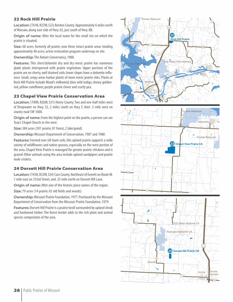
22 Rock Hill PrairieLocation: (T41N, R22W, S22) Benton County. Approximately 6 miles northof Warsaw, along east side of Hwy. 65, just south of Hwy. BB.
Origin of name: After the local name for the small rise on which theprairie is situated.
Size: 68 acres, formerly all prairie, now three intact prairie areas totalingapproximately 40 acres; active restoration program underway on site.
Ownership: The Nature Conservancy, 1988.
Features: This chert/dolomite dry and dry-mesic prairie has numerousglade plants interspersed with prairie vegetation. Upper portions of theprairie are on cherty, well drained soils; lower slopes have a dolomite influ-ence. Small, seepy areas harbor plants of more mesic prairie sites. Plants atRock Hill Prairie include Mead’s milkweed, blue wild indigo, showy golden-rod, yellow coneflower, purple prairie clover and scurfy pea.
23 Chapel View Prairie Conservation AreaLocation: (T40N, R26W, S31) Henry County. Two and one-half miles westof Deepwater on Hwy. 52, 2 miles south on Hwy. F, then .5 mile west oncounty road SW 1000.
Origin of name: From the highest point on the prairie, a person can seeTeay’s Chapel Church to the west.
Size: 384 acres (301 prairie, 81 forest, 2 lake/pond).
Ownership: Missouri Department of Conservation, 1987 and 1988.
Features: Formed over silt loam soils, this upland prairie supports a widevariety of wildflowers and native grasses, especially on the west portion ofthe area. Chapel View Prairie is managed for greater prairie-chickens and isgrazed. Other animals using the area include upland sandpipers and prairiemole crickets.
24 Dorsett Hill Prairie Conservation AreaLocation: (T43N, R32W, S24) Cass County. Northeast of Everett on Route W,1 mile east on 333rd Street, and .25 mile north on Dorsett Hill Lane.
Origin of name: After one of the historic place names of the region.
Size: 79 acres (14 prairie; 65 old fields and woods).
Ownership: Missouri Prairie Foundation, 1977. Purchased by the MissouriDepartment of Conservation from the Missouri Prairie Foundation, 1979.
Features: Dorsett Hill Prairie is a prairie knoll surrounded by upland shruband hardwood timber. The forest border adds to the rich plant and animalspecies composition of the area.
2222
23
24
26 Public Prairies of Missouri
26
27
28
29
30
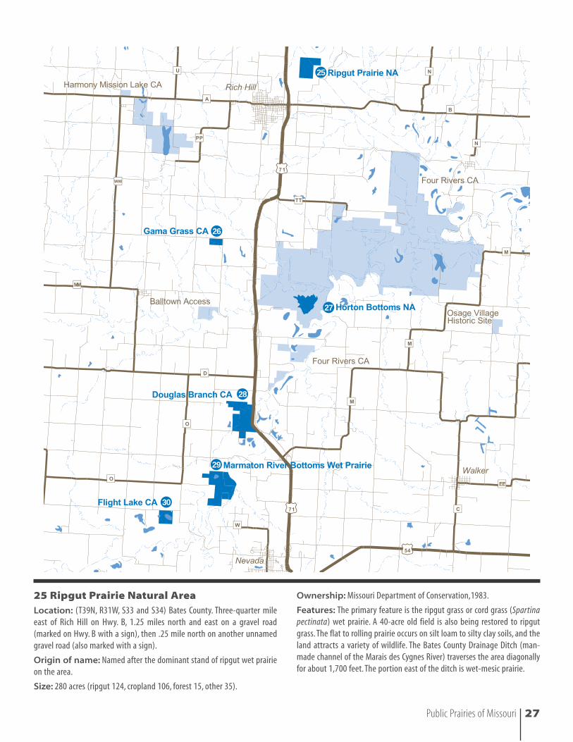
25
25 Ripgut Prairie Natural AreaLocation: (T39N, R31W, S33 and S34) Bates County. Three-quarter mileeast of Rich Hill on Hwy. B, 1.25 miles north and east on a gravel road(marked on Hwy. B with a sign), then .25 mile north on another unnamedgravel road (also marked with a sign).
Origin of name: Named after the dominant stand of ripgut wet prairieon the area.
Size: 280 acres (ripgut 124, cropland 106, forest 15, other 35).
Ownership: Missouri Department of Conservation,1983.
Features: The primary feature is the ripgut grass or cord grass (Spartinapectinata) wet prairie. A 40-acre old field is also being restored to ripgutgrass. The flat to rolling prairie occurs on silt loam to silty clay soils, and theland attracts a variety of wildlife. The Bates County Drainage Ditch (man-made channel of the Marais des Cygnes River) traverses the area diagonallyfor about 1,700 feet. The portion east of the ditch is wet-mesic prairie.
Public Prairies of Missouri 27
26 Gama Grass Prairie Conservation AreaLocation: (T37N, R32W, S1) Vernon County. Four miles south of Rich Hill on Hwy. 71, then 1 mile west on gravel road to the parking lot.
Origin of name: After the dominant stand of eastern gama grass foundon the area.
Size: 80 acres.
Ownership: The Nature Conservancy, 1984. Purchased by MissouriDepartment of Conservation from Nature Conservancy in 1991.
Features: This is a flat hardpan prairie over silt loam to silty clay soils.Thearea contains the largest stand of eastern gama grass in the state. Shrubbyand forested draws add to the wildlife diversity.
27 Horton Bottoms Natural Area (within Four Rivers Conservation Area)
Location: (T37N, R31W, S9, S10, S15 and S16) Vernon County. The mainentrance is in Vernon County, 15 miles north of Nevada on Hwy. 71,1 mile east on Hwy. TT, then 2.5 miles south on gravel road marked with a cantilever sign.
Origin of name: The area is a low bottomland located immediately eastof the small town of Horton.
Size: 227 acres (44 prairie, 38 marsh, 145 forest and savanna); the conser-vation area is 6,696 acres.
Ownership: Missouri Department of Conservation, 1986.
Features: This natural area is a high quality complex of bottomland nat-ural communities (wet prairie, wet savanna, marsh, bottomland forest andheadwaters stream) located on the floodplain between the Marmaton andLittle Osage Rivers. The silty clay soils are level or nearly so, with very slowpermeability that leads to seasonal wetness and local ponding of water.Theprairie is dominated by cord grass, sedges and smartweeds, with scatteredbuttonbush and willows. Bald eagles use the area in winter, and a heronrookery with more than 100 nests is located along the Little Osage River.
28 Douglas Branch Conservation AreaLocation: (T36N, R31W, S6 and S5; T37N R31W, S32) Vernon County.Approximately 6 miles north of Nevada just west of Hwy. 71. Access to thearea is by gravel road traveling west from the cantilever sign.Travel .33 milewest along the gravel road to the parking lot.
Origin of name: Named after Douglas Branch, which is a tributary ofthe Marmaton River that flows through the southeastern corner of thetract.
Size: 360 acres (140 prairie, 60 timber and 160 pasture).
Ownership: Missouri Department of Conservation, 1989.
Features: The outstanding feature of this area is the intact natural gradi-ent from riparian timber to wet bottomland prairie to upland prairie.This isthe only public prairie where this continuum of habitats still exists. The flatbottomland prairie occurs on silty clay soils and is dominated by cord grass.
29 Marmaton River Bottoms Wet PrairieLocation: (T36N, R32W, S13; T36N, R31W, S18, S19, S30) Vernon County.Three miles northwest of downtown Nevada. From the intersection ofBusiness Route 71 and Hwy. W in downtown Nevada, proceed north on W(Ash Street) through town. About .5 mile after passing the state hospital onyour left, W turns sharply west. Do not make this turn, but instead proceedstraight on a small road continuing north. After 1 mile, this road ends at a T junction—turn west. Follow this road through its twists and turns, overthe Marmaton River Bridge and continue west to the first road leadingsouth—proceed down this until you come to an abandoned white houseon the west. You are at the north end of the preserve.
Origin of name: Named after the major stream located on the eastboundary.
Size: 609 acres (200 ripgut prairie, 80 old cropland; the remainder is a mixof wet-mesic woodlands and bottomland forest).
Ownership: The Nature Conservancy, 1983, 1984, 1986, 1988, 1989, 1990,1998.
Features: This is the largest known tract of uplowed wet prairie in Missouri.The primary features of the area are the ripgut or cord grass wet prairie andthe wet woodlands of pecan, kingnut hickory, bur oak and pin oak. The flatprairie occurs on silty clay soils.The variety of vegetation from prairie to wetsavanna, forest to sloughs and two oxbow lakes adds greatly to the flora andwildlife; the old cropfields are also being restored to ripgut prairie. Notablespecies on the area include the double-crested cormorant, catchfly grass,swamp dock, small white aster, bur sedge, swamp sedge, Oklahoma sedge,white turtlehead and violet cress.
30 Flight Lake Conservation AreaLocation: (T36N, R32W, S26) Vernon County. Seven miles north of Nevadaon Hwy. 71, 2.5 miles west on Hwy. D, and 4 miles south on Hwy. O.Watch forthe area sign on Hwy. O, and take the gravel road near the sign 1 mile south.Turn west on the next gravel road marked with a cantilever sign.
Origin of name: Name retained after the previous owners who used thearea for waterfowl hunting.
Size: 159 acres (54 ripgut, 41 lake, 29 old field, 34 woods).
Ownership: Missouri Department of Conservation, 1983.
Features: The primary feature is the ripgut or cord grass wet prairie. Thelake attracts shorebirds and a variety of waterfowl. The wet soils are siltloam and silty clay.
28 Public Prairies of Missouri
Western chorus frog
Public Prairies of Missouri 29
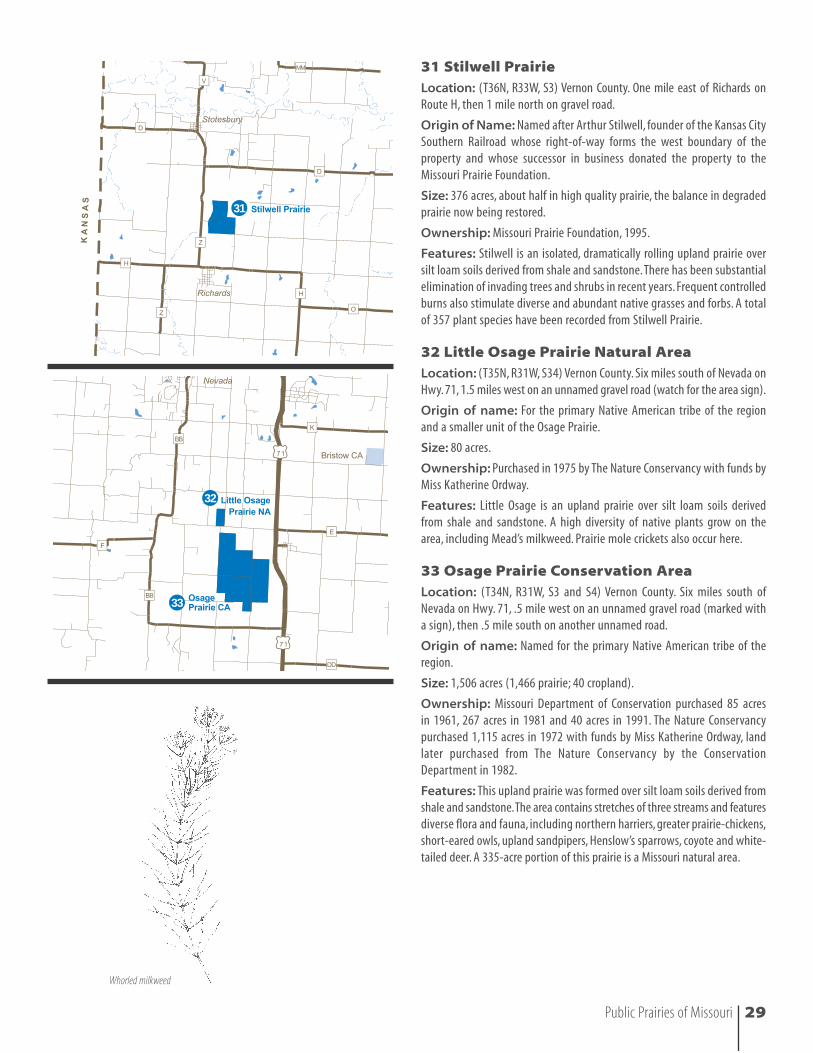
31 Stilwell PrairieLocation: (T36N, R33W, S3) Vernon County. One mile east of Richards onRoute H, then 1 mile north on gravel road.
Origin of Name: Named after Arthur Stilwell, founder of the Kansas CitySouthern Railroad whose right-of-way forms the west boundary of theproperty and whose successor in business donated the property to theMissouri Prairie Foundation.
Size: 376 acres, about half in high quality prairie, the balance in degradedprairie now being restored.
Ownership: Missouri Prairie Foundation, 1995.
Features: Stilwell is an isolated, dramatically rolling upland prairie oversilt loam soils derived from shale and sandstone.There has been substantialelimination of invading trees and shrubs in recent years. Frequent controlledburns also stimulate diverse and abundant native grasses and forbs. A totalof 357 plant species have been recorded from Stilwell Prairie.
32 Little Osage Prairie Natural AreaLocation: (T35N, R31W, S34) Vernon County. Six miles south of Nevada onHwy. 71, 1.5 miles west on an unnamed gravel road (watch for the area sign).
Origin of name: For the primary Native American tribe of the regionand a smaller unit of the Osage Prairie.
Size: 80 acres.
Ownership: Purchased in 1975 by The Nature Conservancy with funds byMiss Katherine Ordway.
Features: Little Osage is an upland prairie over silt loam soils derivedfrom shale and sandstone. A high diversity of native plants grow on thearea, including Mead’s milkweed. Prairie mole crickets also occur here.
33 Osage Prairie Conservation AreaLocation: (T34N, R31W, S3 and S4) Vernon County. Six miles south ofNevada on Hwy. 71, .5 mile west on an unnamed gravel road (marked witha sign), then .5 mile south on another unnamed road.
Origin of name: Named for the primary Native American tribe of theregion.
Size: 1,506 acres (1,466 prairie; 40 cropland).
Ownership: Missouri Department of Conservation purchased 85 acres in 1961, 267 acres in 1981 and 40 acres in 1991. The Nature Conservancypurchased 1,115 acres in 1972 with funds by Miss Katherine Ordway, landlater purchased from The Nature Conservancy by the ConservationDepartment in 1982.
Features: This upland prairie was formed over silt loam soils derived fromshale and sandstone.The area contains stretches of three streams and featuresdiverse flora and fauna, including northern harriers, greater prairie-chickens,short-eared owls, upland sandpipers, Henslow’s sparrows, coyote and white-tailed deer. A 335-acre portion of this prairie is a Missouri natural area.
31
32
33
Whorled milkweed
34
35
36
37
38
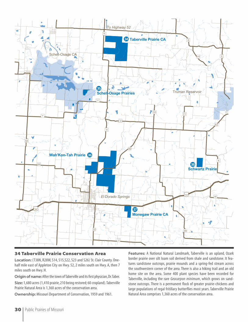
34 Taberville Prairie Conservation AreaLocation: (T38N, R28W, S14, S15,S22, S23 and S26) St. Clair County. One-half mile east of Appleton City on Hwy. 52, 2 miles south on Hwy. A, then 7miles south on Hwy. H.
Origin of name: After the town of Taberville and its first physician,Dr.Taber.
Size: 1,680 acres (1,410 prairie, 210 being restored; 60 cropland).TabervillePrairie Natural Area is 1,360 acres of the conservation area.
Ownership: Missouri Department of Conservation, 1959 and 1961.
Features: A National Natural Landmark, Taberville is an upland, Ozarkborder prairie over silt loam soil derived from shale and sandstone. It fea-tures sandstone outcrops, prairie mounds and a spring-fed stream acrossthe southwestern corner of the area. There is also a hiking trail and an oldhome site on the area. Some 400 plant species have been recorded forTaberville, including the rare Geocarpon minimum, which grows on sand-stone outcrops. There is a permanent flock of greater prairie-chickens andlarge populations of regal fritillary butterflies most years. Taberville PrairieNatural Area comprises 1,360 acres of the conservation area.
30 Public Prairies of Missouri
35 Schell-Osage Prairies(within Schell-Osage Conservation Area)
Location: (T37N, R28W, S9, S17, S18 and S19) St. Clair County and (T38N,R29W, S34, S35 and S36) Vernon County, 20 miles east of Nevada on Hwy. 54,12 miles north on county road AA, then 1 mile down county road RA.
Origin of name: After the town of Schell City and the nearby OsageRiver.
Size: 171 acres (eight separate tracts ranging from 3 to 100 acres).
Ownership: Missouri Department of Conservation, 1959.
Features: The five upland, Ozark border prairies of Schell-Osage occurover silt loam soils derived from shale sandstone and cherty limestone.Three areas contain both upland and bottomland prairies. The area attractsthousands of ducks and geese, plus numerous eagles.
36 Wah’Kon-Tah PrairieLocation: (T36N, R28W, S2, S3, S10, S11, S14, S15 and S23) St. Clair andCedar Counties. Two and one-half miles northeast of El Dorado Springs onnorth side of Hwy. 82, or 1 mile east of El Dorado Springs on Lake Hill Road.
Origin of name: Named in honor of the Osage tribe of NativeAmericans.“Wah’Kon-Tah” means “Great Spirit” or “Great Mystery.”
Size: 2,858 acres.
Ownership: The Nature Conservancy purchased a total of 2,331 acres in1973, 1976, 1981, 1993 and 1997 (includes the former Mo-Ko Prairie); theMissouri Department of Conservation purchased 527 acres in 1997.
Features: Wah’Kon-Tah is the largest, easternmost tallgrass prairie inNorth America. It is an upland, Ozark border prairie over cherty silt loamsoils derived from cherty limestone. The area contains three permanentsprings and several draws. There is a diverse flora on the area, includingMead’s milkweed and grass pink orchid. A resident flock of greater prairie-chickens lives on the area, and upland sandpipers are common. Scissor-tailed flycatchers, Henslow’s sparrows and prairie mole crickets also occuron the area. Deer and wild turkeys range on the north boundary. A smallportion of the site was used for a golf course in the early years of El DoradoSprings.
37 Monegaw Prairie Conservation AreaLocation: (T36N, R28W, S25 and S36) Cedar County. Some 2.5 miles eastof El Dorado Springs on the south side of Hwy. 54.
Origin of name: After a latter day Osage chief who allegedly lived in theMonegaw Springs area.
Size: 270 acres.
Ownership: The Nature Conservancy purchased 180 acres in 1975 withfunds by Miss Katherine Ordway. An additional 90 acres was purchased bythe Missouri Department of Conservation from The Nature Conservancy in1978.
Features: Monegaw is an upland, Ozark border prairie over silt loam soilsderived from cherty limestone and sandstone. The area contains a perma-nent spring and spring branch. A diverse flora occurs on the area, includingMead’s milkweed.
38 Schwartz PrairieLocation: (T36N, R27W, S1) St. Clair County.Two miles south of Hwy. 82 onHwy. K, then 1 mile south and .25 mile west on gravel road.
Origin of name: Dedicated to conservationist pioneers Charles W. andElizabeth R. Schwartz.
Size: 240 acres (175 prairie, 40 being restored, 25 timber).
Ownership: Missouri Prairie Foundation, 1991.
Features: This upland prairie formed over fine sandy loam soils derivedfrom sandstone. A timbered drainage runs south to north across the area. Apopulation of Geocarpon minimum occurs on the sandstone glade portion.More than 237 native plant species have been identified on the area. Prairiemole crickets also occur on Schwartz Prairie.
Public Prairies of Missouri 31
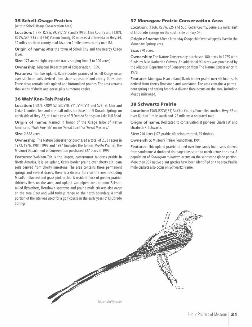
Scissor-tailed flycatcher
39
40
41
42
43
44
45
39 Comstock Prairie Conservation AreaLocation: (T33N, R33W, S1) Barton County. Some 2.75 miles south ofBronaugh on Hwy. 43, 1 mile west on NW 100 road.
Origin of name: After the creek that flows through the center of thearea.
Size: 320 acres.
Ownership: Missouri Department of Conservation, 1990.
Features: This upland prairie was formed over silt loam soils derived fromshale and sandstone. A wooded stream runs east-west through ComstockPrairie.The area’s large grass/shrub communities provide diverse habitat fora multitude of species, including greater prairie-chickens.
32 Public Prairies of Missouri
40 Bushwhacker Prairie (within Bushwhacker Lake Conservation Area)
Location: (T34N, R32W, S27, S28, S25, S33, S26, S34 and S35) VernonCounty. Some 2.75 miles south of Bronaugh on Hwy. 43, 1 mile east onBarton-Vernon county road.
Origin of name: Bushwhackers were southern partisans during the CivilWar and were active behind federal lines in west central Missouri.
Size: 665 acres in two tracts within the conservation area.
Ownership: Missouri Department of Conservation, 1979 , 1982.
Features: This upland prairie formed over silt loam soils derived fromshale and sandstone. A prairie draw and wooded stream occur on the area.The area is home to greater prairie-chickens; two man-made lakes attract adiversity of water birds.
41 Lattner PrairieLocation: (T34, R31, S32) Vernon County. Three miles west of Sheldon onHwy. N, 1.5 miles south on county road gravel road, .25 mile east on gravelroad.
Origin of name: Lattner was a financial contributor to the MissouriPrairie Foundation.
Size: 80 acres.
Ownership: Missouri Prairie Foundation, 1993.
Features: This upland prairie was formed over fine sandy loam soilsderived from sandstone. A sparse woodland draw crosses a portion of thearea, which adds to the diverse flora. Greater prairie-chickens, turkeys, deerand other animals occur in the vicinity of Lattner. A total of 320 plantspecies have been recorded from both the Lattner and Denison Prairies.
42 Edgar and Ruth Denison PrairieLocation: (T33N, R31W, S5) Barton County.Three and one-half miles westof Hwy. 71 at Sheldon on Hwy. N, 1.5 miles south on county gravel road,.25 mile east on gravel road.
Origin of name: Edgar and Ruth Denison were members of and financialcontributors to the Missouri Prairie Foundation.(Formerly the Lipscomb Tract.)
Size: 160 acres.
Ownership: Missouri Prairie Foundation, 1993.
Features: This upland prairie was formed over fine sandy loam soilsderived from sandstone. A sparse woodland draw crosses a portion of thearea adding to the diverse flora.The area provides habitat for deer and otheranimals; greater prairie-chickens and wild turkeys occur in the vicinity.
43 Prairie State ParkLocation: (T32N, R33W, S15, S16, S17, S20, S21, S22, S23, S24 and S27)Barton County. Go 2 miles west of Liberal on Hwy. K, then go 2 miles on Hwy. P. Turn south on gravel road to the main entrance to the park.
Origin of Name: The name readily distinguishes the landscape featuresfrom other state parks.There are several natural areas within the park. RegalPrairie Natural Area was named for the regal fritillary butterfly. Tzi-ShoPrairie Natural Area was named for “tzi-sho,” a Native American word for“sky people,” one of the grand divisions of the Osage tribe. East DrywoodCreek Natural Area was named for the creek along which the natural area is
situated. Hunkah Prairie Natural Area was named for “hunkah,” a NativeAmerican word for “Earth people,” one of the grand divisions of the Osagetribe.
Size: Prairie State Park is 3,702 acres, most of which is original tallgrassprairie. Included in Prairie State Park are several natural areas: Regal PrairieNatural Area (240 acres); Tzi-Sho Prairie Natural Area (240 acres); EastDrywood Creek Natural Area (50 acres); and Hunkah Prairie Natural Area(160 acres).
Ownership: Missouri Department of Natural Resources, Division of StateParks. The original purchase was made by The Nature Conservancy, andadditional private donations have enlarged the park to its present size.
Features: Prairie State Park is situated on rolling upland prairie oversandy and silt loam soils derived from shale and sandstone. Prairie head-water streams, wet depressions, sandstone outcrops and ledges are somefeatures. Prairie State Park visitor’s center features interpretive exhibits ofthe park, and staff offer interpretive programs for the public. There are anumber of hiking trails. Bison and elk roam the park, and it is also home to breeding populations of many native grassland birds. Coyotes, deer, bob-cats, burrowing crayfish, bullsnakes, regal fritillary butterflies, greaterprairie-chickens, Henslow’s sparrows, short-eared owls, upland sandpipers,scissor-tailed flycatchers, yellow-headed blackbirds, Mississippi kites, north-ern harriers and over 600 plant species have been observed at Prairie StatePark.
44 Redwing Prairie Conservation AreaLocation: (T32N, R32W, S3) Barton County. Four miles east of Liberal alongNW 30 Road.
Origin of name: After a large concentration of redwing blackbirds aroundthe pond on the area.
Size: 160 acres.
Ownership: Missouri Department of Conservation, 1987.
Features: Redwing is an upland prairie over silt loam soils derived fromshale and sandstone. The entrance to the prairie is across 23 acres of crop-land. Greater prairie-chickens occur on the area, and the shallow slopes provide habitat for a diverse spring flora.
45 Mo-No-I Prairie Conservation AreaLocation: (T32N, R31W, S6) Barton County. Two miles north of Iantha onHwy. W, .5 mile east on Hwy. DD.
Origin of name: After the Osage name for the greater prairie-chicken.
Size: 302 acres.
Ownership: The Nature Conservancy, 1990; purchased by MissouriDepartment of Conservation in August, 1990.
Features: This is a flat to rolling upland prairie on deep silt loam soilsderived from shale. The adjacent 320 acres of private prairie mark this asone of the few nearly full section prairies remaining in Missouri. Greaterprairie-chickens occur on the area.
Public Prairies of Missouri 33
34 Public Prairies of Missouri
46 Buffalo Wallow Prairie Conservation AreaLocation: (T33N, R31W, S1, S11, S12 and S15) Barton County. Consists oftwo tracts; the main tract is 3 miles south of Sheldon on Hwy. 71. The sec-ond tract is 3 miles south of Sheldon and 1 mile west on NE 80th Road.
Origin of name: Named for what appears to have been the remains of a buffalo wallow on the area.
Size: 1,113 acres.
Ownership: Missouri Department of Conservation, 1976, 1987, 1994,1997.
Features: Buffalo Wallow is an upland prairie over shallow sandstonesoils. Over one-fourth of the area was farmed in the past, and natural reveg-etation and reintroduction of native grasses has occurred on portions of theold cropland. The native prairie units are in excellent condition with a richflora and fauna, including greater prairie-chickens. Adjacent woodlands addto the already diverse flora; there are also 270 acres of cropland on the area.
47 Clear Creek Conservation AreaLocation: (T33N, R30W, S4 Barton County; T34N, R30W, S32 and S33Vernon County) Four miles east of Hwy. 71 on NE 80 Road and 1 mile northon NE 40 lane.
Origin of name: Named for the stream that flows through the area.
Size: 762 acres (377 acres prairie, 160 acres mixed prairie and fescue, 225acres forest).
Ownership: Missouri Department of Conservation, 1989.
Features: This upland prairie over shallow sandstone soils supports adiverse prairie flora. The prairie is home to deer, quail and many otherspecies of wildlife. Forested portions are a mixture of oak-hickory withblackjack oak along the prairie border. Wild turkeys frequent the area, inaddition to other wildlife.
48 Edward B. & Marie O. Risch Conservation AreaLocation: (T33N, R30W, S3) Barton County. Four miles east of Hwy. 71 on NE 80 Road, 1 mile north on NE 40 Lane, and 1 mile east on NE 90 Road.
Origin of name: Named after the donors of the wildlife area.
Size: 163 acres.
Ownership: Donated to the Missouri Department of Conservation, 1986.
Features: This conservation area features rolling to hilly upland prairieover shale to sandy soils. About 40 acres of cropland are maintained forwildlife.
46
47
48
Ashy sunflower
49 Gay Feather PrairieLocation: (T34N, R30W, in SW corner of S1) Vernon County. Some 7.5miles east of Hwy. 71 at Milo on county road E, 2 miles south on gravel roadon east side or 4 miles west of Montevallo on E and then south on anunnamed county road (watch for the area sign).
Origin of name: Named after one of the showy prairie flowers of thegenus Liatris.
Size: 116 acres.
Ownership: Purchased in 1976 by the Missouri Prairie Foundation.An additional 40 acres were purchased by the Missouri Department ofConservation in 1984.
Features: Gay Feather Prairie is an upland, Ozark border prairie over siltloam soils derived from shale and sandstone. A total of 305 plant specieshave been recorded from Gay Feather Prairie.
50 Sky Prairie Conservation AreaLocation: (T34N, R28W, S13) Cedar County. About 12.5 miles south of ElDorado Springs off of Hwy. 32. At the junction of Hwys. 32 and CC, take theunnamed county gravel road 2.5 miles south to the second county gravelroad to the west, then go 1 mile to the prairie.
Origin of name: This high prairie seems to follow the horizon with valleys on both sides.
Size: 200 acres.
Ownership: Missouri Prairie Foundation, 1981. Later purchased by theMissouri Department of Conservation from the Missouri Prairie Foundation.
Features: Sky Prairie is an upland, Ozark border prairie over sandstonesoils. A long ridge runs northeast-southwest through the area with deepdraws running outward.There are natural stands of oaks in some of the val-leys, and the area contains both woodland and prairie flora and fauna.
49
50
Badger
Public Prairies of Missouri 35
51
52
53
54
55
56
51 Pawhuska Prairie Natural AreaLocation: (T32N, R29W, S7) Barton County.Three miles north of Hwy. 160on Hwy. HH, then .5 mile west on NE 30 Road.
Origin of name: Pawhuska means “white-haired,” a name used by threeOsage chiefs.
Size: 77 acres.
Ownership: Purchased in 1978 by The Nature Conservancy with funds byMiss Katherine Ordway.
Features: This upland, Ozark border prairie was formed over silt loam soilsderived from shale and sandstone.Two former bison dusting sites are on thearea. A small intermittent stream runs along the southwestern corner of thetract. The area contains one permanent spring associated with a sandstoneledge that provides habitat for ferns. Blue star, selenia and the state-listedHarvey’s beak-rush are unusual plants that occur here, among several plantscharacteristic of the Ozarks. Henslow’s sparrow and a variety of other song-birds use the area, plus coyotes and white-tailed deer.
36 Public Prairies of Missouri
52 Treaty Line Prairie Conservation AreaLocation: (T31N, R30W, S3) Barton County. Two miles east of Lamar on160, 1.5 miles south on SE 40 Lane and .5 east on SE 20 road.
Origin of name: Named after the Treaty of 1808, in which the Osageceded all lands east of the line from Fort Osage to Fort Smith, Ark.
Size: 168 acres.
Ownership: Missouri Department of Conservation, 1988.
Features: Treaty Line Prairie is an upland prairie formed over both shal-low sandstone soils and deep claypan soils in nearly equal proportion. Adraw cuts through the center of the area, adding to both the flora and thewildlife diversity. Greater prairie-chickens occasionally use the area.
53 Pa Sole Prairie Conservation AreaLocation: (T31N, R30W, S23) Barton County. Five miles east of Hwy. 71,then 1.25 miles north on SE 50 Lane.
Origin of name: The Osage name for “Settlers-on-the-hilltops.”
Size: 240 acres (94 prairie, 48 fescue, 98 cropland).
Ownership: Missouri Department of Conservation, 1991.
Features: This upland prairie was formed over both outcrops of sandstoneand deep silt loams. The high mound on Pa Sole is an erosional feature thatowes its existence to a resistant caprock of sandstone. Quail, deer and othergrassland wildlife frequent the area.
54 Shelton L. Cook Memorial MeadowLocation: (T31N, R29W, S21) Barton County. Two miles northwest ofGolden City, south of Hwy. U.
Origin of name: Bequeathed by Mona Cook Morris and named in honorof her father, a longtime resident of the area.
Size: 280 acres, 185 of which is prairie.
Ownership: The Nature Conservancy, 1988.
Features: Cook Memorial Meadow is a diverse dry-mesic chert prairiewith portions of mesic prairie on a variety of soil types, giving rise to a dis-tinctive mosaic of plant communities. A flatwoods, uncommon in BartonCounty both in presettlement times and more so in the present, interfaceswith the prairie along the location mapped by the original land survey in1840. Upland sandpipers, regal fritillary butterflies and several species ofendangered plants occur on the tract; it is the only known Missouri site forthe field sedge (Carex conoidea). Cook Memorial Meadow may have themost diverse prairie flora in Missouri with its nearly 400 species of nativeflowering plants.
55 Dorris Creek Prairie Conservation AreaLocation: (T31N, R30W, S33) Barton County. Seven miles west of GoldenCity on Hwy. 126, then 1 mile south on gravel SE 40 Lane.
Origin of name: Named after an old school north of the area.
Size: 160 acres.
Ownership: Purchased in 1984 by The Nature Conservancy, later pur-chased by the Missouri Department of Conservation in 1985.
Features: This flat to rolling upland prairie was formed over sandy to siltloam soils.Three small lakes on Dorris Creek Prairie add to the wildlife diver-sity and attract waterfowl. A flock of greater prairie-chickens occurs on thearea.
56 Golden PrairieLocation: (T30N, R29W, S8) Barton County. Approximately 3.5 miles southand west of Golden City.
Origin of name: For the town of Golden City and the fall colors.
Size: 320 acres (301 prairie; 19 being restored).
Ownership: Missouri Prairie Foundation, 1970 and 1975.
Features: A National Natural Landmark, Golden Prairie is an upland,rolling prairie formed over silt loam soils derived from sandstone and lime-stone. The area contains draws that run south on the south half, and runnorth on the north half of the area. There is a resident flock of greaterprairie-chickens on the area. A total of 345 plant species have been record-ed from Golden Prairie.
Public Prairies of Missouri 37
Bobwhite quail
57
58
59
60
61
62
57 Stony Point Prairie Conservation AreaLocation: (T32N, R28W, S8) Dade County. Four miles west of Hwy. 97 on county road E, then 1 mile north on county road D.
Origin of name: Named from the original spelling of an old school andchurch in the area and also from the large sandstone outcrops found on thearea.
Size: 640 acres (620 prairie, 20 forest).
Ownership: Missouri Department of Conservation, 1988.
Features: Stony Point Prairie is an upland prairie formed from sandstonesoils and features sandstone outcrops. Portions of the area were heavilygrazed in the past; recovery is excellent. Greater prairie-chickens, uplandsandpipers, regal fritillary butterflies and prairie mole crickets reside on thearea.
38 Public Prairies of Missouri
58 Burns TractLocation: (T32N, R28W, S9) Dade County. Four miles east and 9 milesnorth of Golden City on Hwy. E. Immediately east of the Stony PointConservation Area owned by the Missouri Department of Conservation.
Origin of name: Named from the Clarence Burns family, from whom thetract was purchased.
Size: 320 acres.
Ownership: Missouri Prairie Foundation, 1999.
Features: The Burns Tract is rolling with both upland areas and wet-mesicdrainages. Greater prairie-chickens occur on the area.
59 Niawathe Prairie Conservation AreaLocation: (T32N, R28W, S14) Dade County. One mile west of Hwy. 97 on Hwy. E, then .5 mile north on an unmarked gravel road.
Origin of name: “Ni-Wa-The” was the Life-Giver of the Tzi-Sho (the SkyPeople of the Osage tribe).
Size: 320 acres.
Ownership: The Nature Conservancy purchased 80 acres in 1973, withfunds by Miss Katherine Ordway, and another 80 acres in 1983.The MissouriDepartment of Conservation purchased 160 acres in 1978.
Features: Niawathe Prairie is an Ozark border dry mesic upland prairiewith some mesic prairie over silt loam soils derived from shale and sand-stone. The area contains a rich flora and is very showy in spring and earlysummer. Mead’s milkweed, fringed poppy mallow, blue false indigo androyal catchfly are notable plant species on the area. Greater prairie-chickens,northern harriers and Henslow’s sparrows nest on the area; short-earedowls occur during the winter. Prairie mole crickets call in the spring, andnorthern crawfish frogs call at dusk in March. The entire area is designateda natural area and is popular with wildflower enthusiasts.
60 Penn-Sylvania PrairieLocation: (T32N, R28W, S22) Dade County. Two miles west of Hwy. 97 on Hwy. E; then south on gravel road, on west side.
Origin of name: For the town of Sylvania and the original name ofPennsylvania.
Size: 160 acres.
Ownership: Missouri Prairie Foundation, 1971.
Features: This upland prairie was formed over silt loam soils derived fromshale and sandstone. There are signs of an old trace known as theGreenfield-Sylvania road in the prairie. A flock of greater prairie-chickensoccurs on the area, as well as coyotes and other animals. The area containstwo ponds that attract migrating waterfowl. A total of 288 plant specieshave been recorded from Penn-Sylvania Prairie.
61 Horse Creek Prairie Conservation AreaLocation: (T31N, R28W, S22) Dade County. Two miles west of Lockwoodon Hwy. 160, 1 mile north on an unnamed county gravel road.
Origin of name: Named after the main stream that flows near the area.
Size: 80 acres.
Ownership: Missouri Department of Conservation, 1993.
Features: This nearly flat upland prairie occurs over silt loam soils derivedfrom sandstone and shale. A variety of songbirds, greater prairie-chickensand migrant shorebirds frequent the area.The flora is diverse with an abun-dant spring display, and, in March, northern crawfish frogs call at dusk.
62 Indigo Prairie Conservation AreaLocation: (T30N, R27W, S4) Dade County. One mile south of Lockwood onHwy. 97 and 2.5 miles east on an unnamed gravel road.
Origin of name: After the blue indigo that occurs on the prairie.
Size: 40 acres.
Ownership: Missouri Department of Conservation, 1980.
Features: Indigo prairie is an upland prairie formed over cherty silt loamsoils derived from cherty limestone. The area is about 50 percent grassland,with about 50 percent in various stages of shrub communities. The area contains a rich variety of bird species.
Public Prairies of Missouri 39
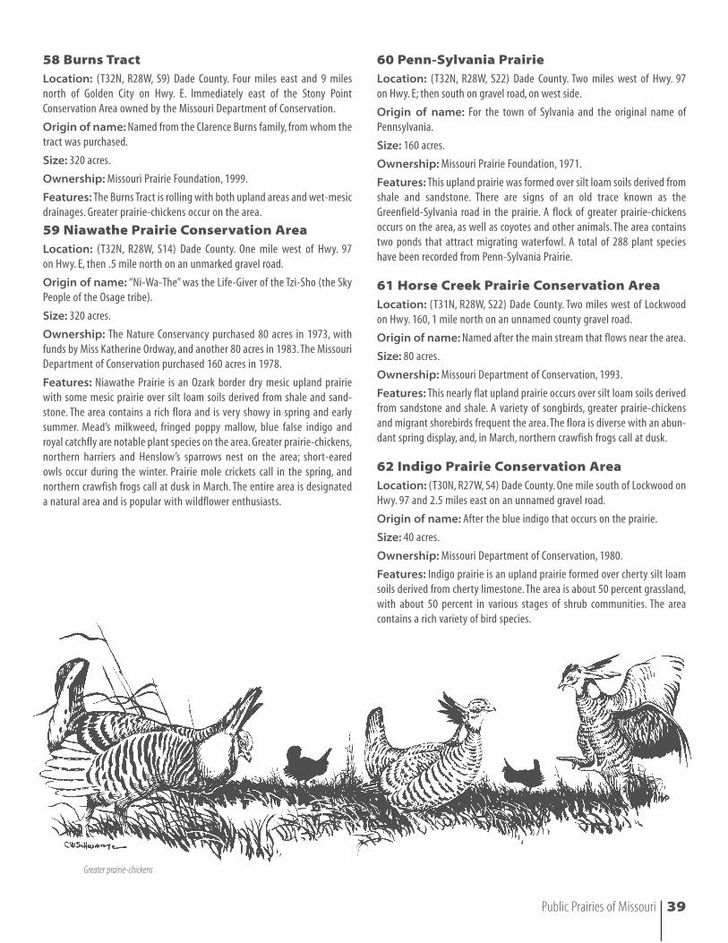
Greater prairie-chickens
40 Public Prairies of Missouri
63 Mon-Shon Prairie Conservation AreaLocation: (T30N, R33W, S7) Barton County. Two and one-half miles southof Hwy. 126 on SW State Line Lane.
Origin of name: From the Osage term meaning “Sacred Earth,” referringto the large acreage of strip mining in the area.
Size: 80 acres (77 prairie, 2 forest, 1 lake/pond).
Ownership: Missouri Department of Conservation, 1988. The NatureConservancy purchased the tract in 1987.
Features: This upland prairie formed over deep claypan soils has someshallow sandstone soils within the middle portion of the area. Past man-agement has maintained an excellent flora. There is a small pond on thesouthwest corner.
64 Wah-Sha-She Prairie Natural AreaLocation: (T30N, R33W, S31) Jasper County.Two miles north of Asbury onHwy. M, 1 mile east of Hwy. 171. From the junctions of Hwys. M and 171 inextreme western Jasper County, go east on M for approximately .8 mile tothe first crossroad, then turn north approximately .2 mile to the parking loton the west side of the road.
Origin of name: Wah-Sha-She means “Water People,” one of the sub-divisions of the Hunkah tribe.
Size: 160 acres.
Ownership: Purchased in 1973 by The Nature Conservancy with funds by Miss Katherine Ordway.
Features: Wah-Sha-She is a nearly level hardpan prairie over deep siltloam soils that contains a hard claypan (a layer of clayey, impenetrablesoils). The area contains a man-made 10-acre pond and shallow marsh thatattracts amphibians and reptiles as well as spring and fall flights of water-fowl. Little bluestem and switch grass dominate portions of the prairie,along with blazing star, bluehearts, Indian paintbrush, large-flowered core-opsis and chaffweed. Pond lily grows in the marsh. A resident flock ofgreater prairie-chickens occurs on the area, as well as prairie mole crickets.Wah-Sha-She is a wildlife refuge.
65 Bethel PrairieLocation: (T31N, R31W, S31) Barton County. Four miles west of Hwy. 71on the south side of Hwy. 126.
Size: 260 acres.
Origin of name: Named for a nearby church, Bethel Church, that hasbeen active since the early 1900s.
Ownership: Missouri Department of Conservation, 1997.
Features: This upland prairie was formed over shallow sandstone. It istraversed by a small seasonal branch of the North Fork Spring River, addingto the overall diversity. Fescue became established on the site prior toacquisition by the Conservation Department; restoration efforts are under-way. Deer, turkeys and other grassland wildlife frequent the area.
63
64
65
66
67
68
69
66 Providence Prairie Conservation AreaLocation: (T29N, R28W, S4) Lawrence County. From the junction of Hwys.96 and 97, go north on Highway 97 6.5 miles to NN, go 1.5 miles west tocounty road 1040, then 1 mile south.
Origin of name: It appeared that this prairie was destined for the plow,but by providence this did not occur and the Missouri Department ofConservation became the new owner.
Size: 197 acres (170 acres prairie, 17 in crops, 10 in draws).
Ownership: Missouri Department of Conservation, 1994.
Features: A large percentage of Providence Prairie is mesic with charac-teristic species such as bunchflower and smooth prairie phlox. The prairiehas a good spring wildflower display. Greater prairie-chickens occur on thearea, and prairie mole crickets call at dusk in May. There is a permanentspring and a small creek that flows through the center of the prairie.Woodyvegetation has developed in wet areas.
67 Kickapoo Prairie Conservation AreaLocation: (T29N, R28W, S14) Lawrence County.Take the Stotts City exit offI-44 and go 8 miles north on Hwy. 97. The turn-off for the area is 2 milesnorth of the junction of Hwys. 97 and 96 (1 mile west on a county gravelroad).
Origin of name: After the Kickapoos who once occupied the region westof Springfield.
Size: 160 acres.
Ownership: Missouri Department of Conservation, 1989.
Features: Kickapoo is an upland prairie over cherty silt loam soils. Itsdiverse flora includes royal catchfly and sideoats grama grass. Greater prairie-chickens occur on the area, and, in May, prairie mole crickets call at dusk. Anetwork of draws supports other wildlife populations.
68 Mount Vernon Prairie Natural AreaLocation: (T28N, R26W, S17) Lawrence County. From Mount Vernon, gonorth on Hwy. 39 for approximately one mile, east on Route CC for 1.2 milesand turn north. Proceed for one mile to the first crossroads, turn east andfollow the paved road for about .9 mile. This road will turn sharply to thenorth; follow it for about .3 mile to the parking area on your left.
Origin of name: Named after the town of Mt.Vernon and in recognitionof the bicentennial of Washington’s home.
Size: 40 acres.
Ownership: The Nature Conservancy, 1974.
Features: This upland dry prairie was formed over silt loam soils derivedfrom cherty limestone. The area contains a diverse flora that is very showyin the spring and early summer. Plant and animal species include blue falseindigo, rattlesnake master, sky-blue aster, greater prairie-chickens, uplandsandpipers, ornate box turtles and leopard frogs.
69 Woods PrairieLocation: (T28N, R26W, S36) Lawrence County. Four miles east of Mt.Vernon on south side of Farm Road 2125.
Origin of name: Named after the Woods family, who owned and pro-tected the prairie for 163 years. John Blackburn Woods homesteaded theproperty in 1836.
Size: 40 acres.
Ownership: Purchased in 1999 by the Ozark Regional Land Trust,Carthage, Missouri.
Features: This upland prairie has silty loam soils derived from chertylimestone. It is an isolated Ozark prairie with a diverse flora and well devel-oped mima mounds. The north five acres, dominated by fescue, eventuallywill be restored to prairie.
Public Prairies of Missouri 41
70 La Petite Gemme Natural AreaLocation: (T33N, R23W, S25) Polk County. One mile west on the first coun-ty road that lies west of the junction of Hwy. 13 and Business 13 (south ofBolivar).
Origin of name: Named for the gemlike quality of this small prairie andfor the gemlike flowers. The name also recognizes the French who settled in Missouri.
Size: 37 acres.
Ownership: Missouri Prairie Foundation, 1974.
Features: La Petite Gemme Natural Area is predominately a dry-mesiclimestone/dolomite prairie associated with knob slopes on the eastern halfand acidic hardpan prairie in the western half. The sideslopes on the knobhave semi-permanent seeps that support fen plants, such as orange cone-flower.The shaley calcareous substrate of the knob also provides habitat forglade species like Missouri black-eyed Susan. A total of 321 plant specieshave been recorded from La Petite Gemme Natural Area.The Ozark HighroadTrail, the 30-mile Willard to Bolivar Greenway along a former railroad line,goes through the area.
71 Tingler Lake Wet-Mesic Prairie (within Tingler Lake Conservation Area)
Location: (T22N, R8W, S5 and S6) Howell County. Approximately 7 miles south of West Plains, off Hwy. 17 on county road 8110.
Origin of name: The area was named after a sinkhole pond on the area.
Size: 10 acres; the conservation area is 240 acres, of which 145 acres arebeing restored to prairie.
Ownership: Missouri Department of Conservation, 1987.
Features: This is one of very few remaining prairie examples left in theOzark Region.Tingler Lake Wet-Mesic prairie contains more than 100 nativespecies of grasses, sedges and forbs including two varieties of the stateendangered green orchid. A trail system provides excellent viewing oppor-tunities of the wet-mesic prairie, the associated dry-chert woodland andthe five-acre sinkhole pond.
72 Diamond Grove Prairie Natural AreaLocation: (T27N, R32W, S36; R31W, S31) Newton County. Four miles westof Diamond on Hwy.V, 1.25 miles north on gravel road marked with an areasign.
Origin of name: Named after the town of Diamond, located southeastof the area. Diamond Grove Prairie is the pioneer name of an original largerprairie of which the natural area is a remnant.
Size: 611 acres.
Ownership: Missouri Department of Conservation, 1981, 1982, 1985 and1991.
Features: This upland prairie is nearly level to gently rolling with widedraws. It was formed on deep fragipan soils that are mostly Keeno chertysilt loam, Hoberg silt loam and Gerald silt loam. A rich flora colors the land-scape; interesting plants include royal catchfly, Barbara’s buttons, blue starand fringed poppy mallow. Narrowmouth toads, which sound like sheep, callon the area in June after rain in the day.
70
71
72
42 Public Prairies of Missouri