Embed Size (px)
Citation preview

CLICKHERETOKNOWMORE

METRO MANILA MOVING FORWARD TOWARDS A
“SMART” METROPOLIS GEOSMART ASIA 2017
Putrajaya, Malaysia/23 August 2017
Metropolitan Manila Development Authority
PHILIPPINES

Profile of Metro Manila Background on Metropolitan Manila
Development Authority (MMDA) “SMART” Metropolis Framework Application of Geospatial Analysis in Planning and
Policy Formulation in Traffic Management, Flood Control and Management and Public Safety Mandated Functions of MMDA
“Smart “Communication Conclusions


Source : 2006 METRO MANILA LAND USE FROM MMEIRS STUDY
METRO MANILA LAND USE PATTERN
Residential 44.83%
Commercial 12.22%
Open Space, Parks, and Roads 28.43%
Industrial 7.62%
Institutional 6.90%

MMDA shall perform planning, monitoring, coordinating, and implementing functions, and exercise regulatory and supervisory authority over delivery of metro-wide services Metropolitan Manila is treated as a special development and administrative region subject to the direct supervision of the President

“Smart” Metropolis Framework

MMDA Command, Control and Communications Center ( METROBASE)
423 UPGRADED TO DIGITAL PLATFORM-BASED SYSTEM OUT OF 441 ANALOG TRAFFIC SIGNAL SYSTEM BEING MONITORED AT THE METROBASE
TRAFFIC SIGNALIZATION SYSTEM HIGH DEFINITION CCTV CAMERAS
400 CCTV CAMERAS LINKED TO THE METROBASE
T R A F F I C M A N A G E M E N T C E N T E R C R I S I S M O N I T O R I N G A N D M A N A G E M E N T C E N T E R

Using geospatial analysis, eleven (11) Traffic Zones were identified:
Metro Manila Traffic Crisis
Management Protocol
Traffic is Code RED, BLUE or VIOLET - if 500 m, 1 km and 2 km radius from the incident point is affected, respectively
• areas prone to road users' conflicts
• common areas for special events/ occasions
• critical areas in times of calamity

PROJECT/POLICY TRAFFIC IMPACT EVALUATION USING VISUAL
SIMULATION SOFTWARE (VISSIM): A traffic pattern simulation tool
which shows possible traffic impact of a project or a policy in terms
of travel time, travel speed and level of service.

HAZARD MAPS GROUND SHAKING
LIQUEFACTION STORM SURGE
TSUNAMI
RAIN-INDUCED LANDSLIDE
FLOOD
OVERLAY OF HAZARD MAPS TO IDENTIFY
VULNERABILITY AND POTENTIAL DAMAGE
Road Network Critical Support Facilities
• Basis for the preparation of Operational Plans (OPLAN)
• Aids/guides decision making on the appropriate intervention in terms of identifying the required resources and their locations in the most strategic and less vulnerable sites.

PUMPING STATION Flood facilities that facilitate the draining of flood waters when the water elevation at Manila Bay or Pasig River is high due to high tide and/or excessive rains.
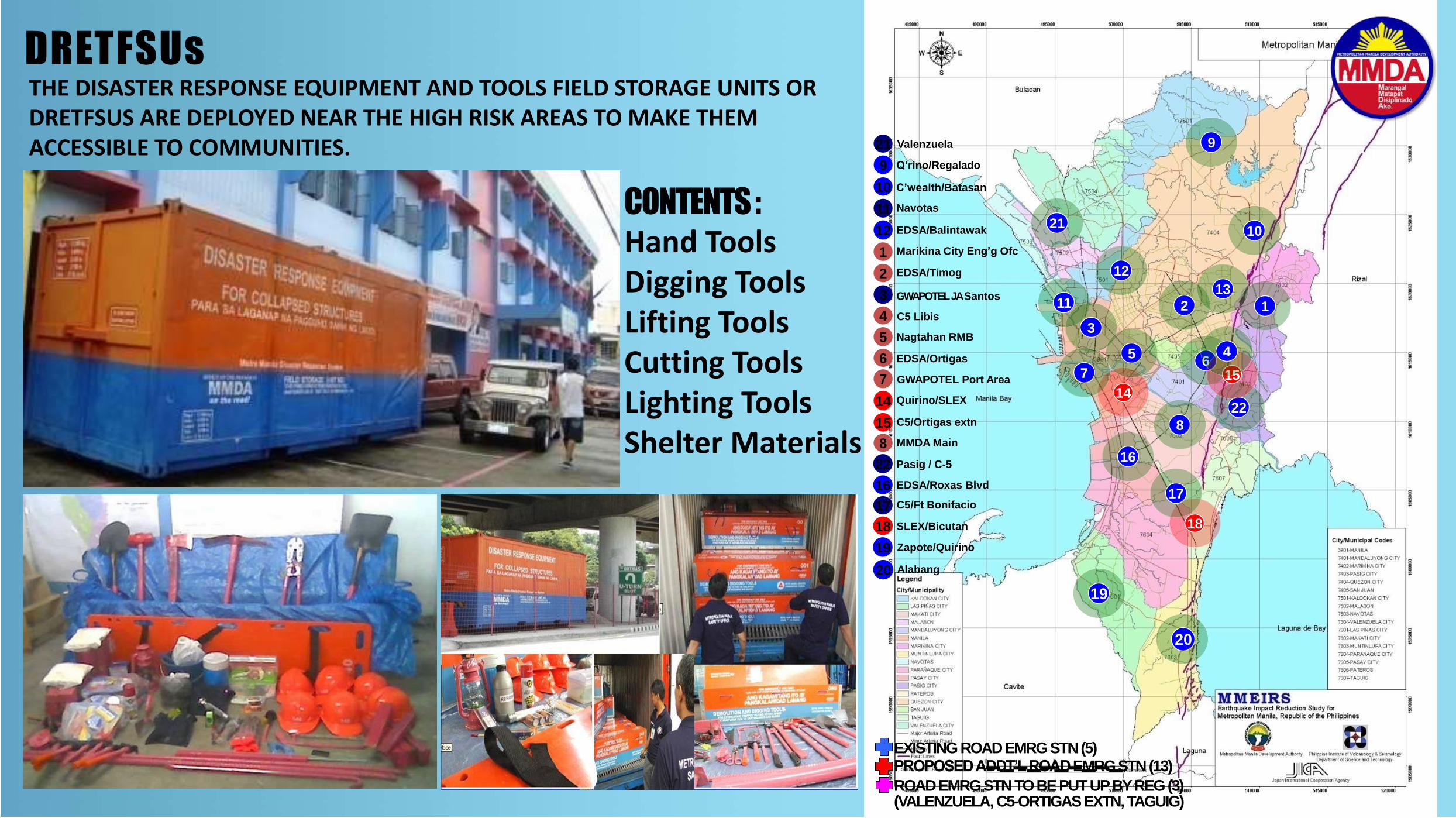
THE DISASTER RESPONSE EQUIPMENT AND TOOLS FIELD STORAGE UNITS OR DRETFSUS ARE DEPLOYED NEAR THE HIGH RISK AREAS TO MAKE THEM ACCESSIBLE TO COMMUNITIES.
EXISTING ROAD EMRG STN (5) PROPOSED ADDT’L ROAD EMRG STN (13)
ROAD EMRG STN TO BE PUT UP BY REG (3) (VALENZUELA, C5-ORTIGAS EXTN, TAGUIG)
10
11
1
2
3
4
5
6
16
17
19
20
EDSA/Timog
EDSA/Ortigas
Nagtahan RMB
MMDA Main
C’wealth/Batasan
Navotas
C5 Libis
GWAPOTEL Port Area
Quirino/SLEX
EDSA/Roxas Blvd
C5/Ft Bonifacio
Zapote/Quirino
Alabang
Marikina City Eng’g Ofc
GWAPOTEL JA Santos
C5/Ortigas extn
9 Q’rino/Regalado
18 SLEX/Bicutan
12 EDSA/Balintawak
22
21 Valenzuela
Pasig / C-5
7
14
8
15
19
18
14
17
16
8
6
2
12
21
11
3
7
5
22
15
4
1
13
10
9
20
DRETFSUs
CONTENTS :
Hand Tools Digging Tools Lifting Tools Cutting Tools Lighting Tools Shelter Materials

SOCIAL MEDIA FOR PUBLIC INTERACTION AND
ONLINE PLATFORMS TO PROMOTE PUBLIC INFORMATION DISSEMINATION
Facebook and Twitter Metro Manila Traffic Navigator + WAZE Road Accident Alert Application Pasig Ferry Applications Friendtrip Applications www.mayhuli.com (traffic apprehension check)
Metro Manila Traffic Navigator + WAZE Road Accident Alert Application Pasig Ferry Applications Friendtrip Applications www.mayhuli.com (traffic apprehension check)
Facebook and Twitter

CREATING A ‘SMART’ CITY IN A HIGHLY BUILT-UP ENVIRONMENT IS CHALLENGING BUT EVEN MORE CHALLENGING IF WE ARE TRANSFORMING THE ENTIRE METROPOLIS INVOLVING SEVERAL LOCAL GOVERNMENT UNITS, THIS IS IMPERATIVE TO SUSTAIN DEVELOPMENT GAINS.
MMDA IS GRADUALLY LEADING THE TRANSFORMATION OF METRO MANILA TOWARDS A ‘SMART’ METROPOLIS : THAT WILL ALLOW THE LINKAGES AND CONNECTION OF SMART URBAN SPACES OF 17
LOCAL GOVERNMENT UNITS THROUGH COHESIVE AND INTEGRATED INFRASTRUCTURES THAT WILL PROMOTE PROCESSING, ACCESS, AND DELIVERY OF SERVICE EXPECTED IN A ‘SMART METROPOLIS’.
THAT WILL UTILIZE GEOPATIAL ANALYSIS THAT WILL CREATE ENABLING ENVIRONMENT TO ESTABLISH AN OPEN AND INTER-OPERABLE NETWORKS THAT WILL BE ACCEPTABLE, ACCESSIBLE AND AKIN TO THE REQUIREMENTS OF MEMBER LGUS AND THE PUBLIC THROUGH INNOVATIVE SOLUTIONS THAT WILL ALLOW DATA CAPTURE, STORAGE, MANAGEMENT AND PROCESSSING WITH THE USE OF MOST APPROPRIATE AND COST-EFFECTIVE SMART TECHNOLOGY PLATFORMS FOR PLANNING, POLICY FORMULATION AND OVERALL SERVICE DELIVERY AND MANAGEMENT TO ENSURE SUSTAINABLE, INCLUSIVE AND RESILIENT TYPE OF DEVELOPMENT.
GEOSMART ASIA 2017
Putrajaya, Malaysia/23 August 2017
T
METRO MANILA MOVING FORWARD TOWARDS
A “SMART” METROPOLIS