Embed Size (px)
Citation preview
Clearing of approximately 570 hectares of native vegetation for pine and sandalwood plantation,
Lot 7778 Wannamal South Road, Shire of Gingin
Mr John Fernie
Report and recommendations of the Environmental Protection Authority
Environmental Protection Authority Perth, Western Australia
Bulletin 1084 December 2002

ISBN. 0 7307 6722 1 ISSN. 1030 - 0120 Assessment No. 1457
i
Summary and recommendations This report provides the Environmental Protection Authority’s (EPA’s) advice to the Minister for the Environment and Heritage on the proposal by Mr John Fernie to clear approximately 570 hectares (ha) of native vegetation for pine and sandalwood plantation on Lot 7778 Wannamal South Road, Wannamal. Lot 7778 has a total area of 1,750 ha and is located approximately 12 kilometres northeast of Gingin, in the Shire of Gingin. Following consideration by the Inter Agency Working Group under the Memorandum of Understanding for the protection of remnant vegetation on private land in the agricultural region of Western Australia (Agriculture WA, 1997) the proposal was referred to the EPA by the Commissioner of Soil and Land Conservation in view of possible environmental impacts. As the proposal appeared unlikely to meet the EPA’s environmental objectives, the Authority set the level of assessment for the proposal at Proposal Unlikely to be Environmentally Acceptable (PUEA) in October 2002. At that time a brief statement of the reasons for the PUEA level of assessment was made publicly available as set out in the EPA’s Administrative Procedures for Environmental Impact Assessment. No appeals were received on the level of assessment and therefore the next stage in the assessment process is this report, which is the EPA’s report to the Minister for the Environment on the proposal, pursuant to Section 44 of the Environmental Protection Act 1986.
Relevant environmental factors It is the EPA’s opinion that ‘biodiversity’ is the environmental factor relevant to the proposal, which requires detailed evaluation in this report.
Conclusion The proposal as put forward by the proponent cannot be demonstrated to meet the EPA’s objectives for biodiversity. As a consequence, the EPA considers the proposal by Mr Fernie to clear approximately 570 ha of native vegetation on Lot 7778 Wannamal South Road for a pine and sandalwood plantation is environmentally unacceptable, and on the basis of available information, should not proceed.
ii
Recommendations The EPA submits the following recommendations to the Minister for the Environment and Heritage:
1. That the Minister notes that the proposal being assessed is for the clearing of approximately 570 ha of native vegetation on Lot 7778 Wannamal South Road for a pine and sandalwood plantation.
2. That the Minister considers the report on the relevant environmental factor as set out in Section 3 of this report.
3. That the Minister notes that the EPA has concluded, based on available information, that the proposal as put forward by the proponent cannot be demonstrated to meet the EPA’s objective in relation to ‘biodiversity’.
4. That the Minister notes that the EPA has not included in this Bulletin “conditions and procedures to which the proposal should be subject, if implemented” because the EPA holds the view that the proposal should not be implemented.
Contents
Page Summary and recommendations ............................................................................. i
1. Introduction and background ......................................................................... 1
2. The proposal .................................................................................................... 2
3. Relevant environmental factor........................................................................ 5
3.1 Biodiversity ........................................................................................... 5
4. Conclusions and Recommendations................................................................ 9
Table Table 1: Summary of key proposal characteristics................................................ 2 Figures Figure 1: Location of proposal Figure 2: Proposed land use if proposal was implemented Appendices 1. References 2. Statement of Reasons for PUEA level of assessment
1
1. Introduction and background This report provides the advice and recommendations of the Environmental Protection Authority (EPA) to the Minister for the Environment and Heritage on the environmental factors relevant to the proposal by Mr John Fernie (the proponent and landowner) to clear approximately 570 hectares (ha) of native vegetation on Lot 7778 Wannamal South Road, Wannamal. Lot 7778 has a total area of 1,750 ha and is located approximately 12 kilometres (km) northeast of Gingin, in the Shire of Gingin (Figure 1). The stated purpose of the clearing is for the establishment of a pine and sandalwood plantation. Section 2 discusses the proposal further. Under the Soil and Land Conservation Act 1950, any landholder wishing to clear greater than 1 ha of native vegetation is required to notify the Commissioner of Soil and Land Conservation (the Commissioner). The Commissioner then decides whether to object to the clearing depending on whether or not land degradation is likely to occur and may issue a Soil Conservation Notice to prevent clearing taking place. The proponent notified the Commissioner of his intention to clear the subject land on 18 June 2002. Following consideration by the Level 3 Inter-Agency Working Group in accordance with the Memorandum of Understanding for the Protection of Native Vegetation on Private Land (Agriculture WA, 1997), the proposal was referred to the EPA by the Commissioner in view of potential environmental impacts of the proposal. As the proposal appeared unlikely to meet the EPA’s environmental objectives, the level of assessment was set at Proposal Unlikely to be Environmentally Acceptable (PUEA). At that time, a brief statement of the reasons for the PUEA level of assessment was made publicly available, as set out in EPA’s Administrative Procedures for Environmental Impact Assessment. The EPA’s statement of reasons is provided as Appendix 2 of this report. It should be noted that at the time the EPA’s statement of reasons was prepared, it was believed that the vegetation complexes proposed to be cleared had less than 30% of their pre-European extent remaining. Whilst the most up-to-date data now indicates that the Vegetation Complexes may have greater than 30% extent remaining, there are uncertainties associated with this data, and this is further explained in Section 3.1.c. Section 44 of the Environmental Protection Act 1986 requires the EPA to report to the Minister for the Environment and Heritage on the environmental factors relevant to the proposal and on the conditions and procedures to which the proposal should be subject, if implemented. In addition, the EPA may make recommendations as it sees fit. Accordingly, Section 3 discusses environmental factors relevant to the proposal and Section 4 presents the EPA’s conclusions and recommendations. References are listed in Appendix 1.
2
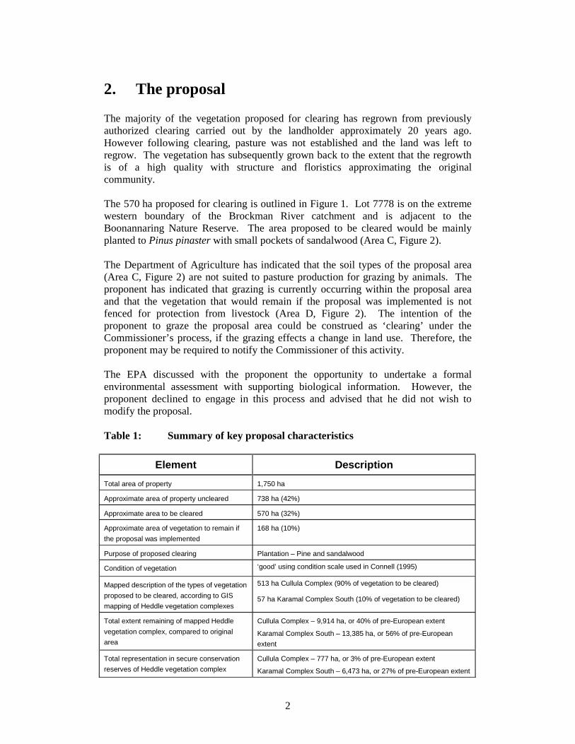
2. The proposal The majority of the vegetation proposed for clearing has regrown from previously authorized clearing carried out by the landholder approximately 20 years ago. However following clearing, pasture was not established and the land was left to regrow. The vegetation has subsequently grown back to the extent that the regrowth is of a high quality with structure and floristics approximating the original community. The 570 ha proposed for clearing is outlined in Figure 1. Lot 7778 is on the extreme western boundary of the Brockman River catchment and is adjacent to the Boonannaring Nature Reserve. The area proposed to be cleared would be mainly planted to Pinus pinaster with small pockets of sandalwood (Area C, Figure 2). The Department of Agriculture has indicated that the soil types of the proposal area (Area C, Figure 2) are not suited to pasture production for grazing by animals. The proponent has indicated that grazing is currently occurring within the proposal area and that the vegetation that would remain if the proposal was implemented is not fenced for protection from livestock (Area D, Figure 2). The intention of the proponent to graze the proposal area could be construed as ‘clearing’ under the Commissioner’s process, if the grazing effects a change in land use. Therefore, the proponent may be required to notify the Commissioner of this activity. The EPA discussed with the proponent the opportunity to undertake a formal environmental assessment with supporting biological information. However, the proponent declined to engage in this process and advised that he did not wish to modify the proposal. Table 1: Summary of key proposal characteristics
Element Description Total area of property 1,750 ha
Approximate area of property uncleared 738 ha (42%)
Approximate area to be cleared 570 ha (32%)
Approximate area of vegetation to remain if the proposal was implemented
168 ha (10%)
Purpose of proposed clearing Plantation – Pine and sandalwood
Condition of vegetation ‘good’ using condition scale used in Connell (1995)
Mapped description of the types of vegetation proposed to be cleared, according to GIS mapping of Heddle vegetation complexes
513 ha Cullula Complex (90% of vegetation to be cleared)
57 ha Karamal Complex South (10% of vegetation to be cleared)
Total extent remaining of mapped Heddle vegetation complex, compared to original area
Cullula Complex – 9,914 ha, or 40% of pre-European extent
Karamal Complex South – 13,385 ha, or 56% of pre-European extent
Total representation in secure conservation reserves of Heddle vegetation complex
Cullula Complex – 777 ha, or 3% of pre-European extent
Karamal Complex South – 6,473 ha, or 27% of pre-European extent

3
Figure 1: Location of the proposal

4
Figure 2: Proposed land use if proposal was implemented
Source: proponent Mr Fernie
5
3. Relevant environmental factor It is the EPA’s opinion that ‘biodiversity’ is the environmental factor relevant to the proposal, which requires detailed evaluation in this report.
3.1 Biodiversity
Description a) EPA Position Statement No. 2 It is now well recognised that broad-scale land clearing and consequential salinity have had a dramatic adverse effect on biodiversity in the agricultural area through the direct loss of vegetation communities and plant species, and the associated loss of mammals, birds, and other animals which depend upon large enough areas of healthy bush for food and shelter. These impacts have been reported in both the State and Commonwealth State of the Environment reporting (Government of Western Australian, 1998; Commonwealth of Australia, 1996). In response to impacts on biological diversity and nature conservation, as well as land and water degradation, the State and Commonwealth Governments have over recent years developed and implemented various policy positions and programs to provide a strategic context for the protection of remnant vegetation. A recent development in Government Policy on protection of native vegetation is the agreed document entitled National Objectives and Targets for Biodiversity Conservation Stemming from the National Strategy for the Conservation of Australia’s biodiversity 2001 - 2005 (Commonwealth of Australia, 2001). Within this document, the Commonwealth Government and the majority of the States, including Western Australia, have agreed to pursue the target of ensuring that all jurisdictions have clearing controls in place that will have the effect of reducing the net national rate of land clearance to zero. The EPA has assessed a number of land clearing proposals over recent years. Based on the issues arising from information presented during these assessments, the strategic framework provided by government policy positions and programs, and general scientific information which has become available on the potential cumulative impacts of broad-scale clearing on the environment, the EPA has developed Position Statement No. 2 regarding Environmental Protection of Native Vegetation in Western Australia (EPA, 2000).
6
Position Statement No. 2 describes the EPA’s view regarding clearing native vegetation for plantations:
Clearing of deep-rooted native vegetation for replacement with non-native deep-rooted crops is generally not regarded as acceptable environmentally and these alternative deep-rooted crops should be planted on already cleared land. (EPA, 2000, p.8)
This proposal is outside, but in close proximity to, the western boundary of the agricultural area as described in Position Statement No. 2 (EPA, 2000). Therefore, Section 4.3 of the Position Statement is relevant to this proposal. Section 4.3 addresses clearing outside the agricultural area and describes elements which will be considered by the EPA in assessing proposals. In assessing a proposal, the EPA’s consideration of biological diversity will include the following basic elements:
1. A comparison of development scenarios, or options, to evaluate protection of biodiversity at the species and ecosystem levels, and demonstration that all reasonable steps have been taken to avoid disturbing native vegetation.
2. No known species of plant or animal is caused to become extinct as a consequence of the development and the risks to threatened species are considered to be acceptable.
3. No association or community of indigenous plants or animals ceases to exist as a result of the project.
4. There would be an expectation that a proposal would demonstrate that the vegetation removal would not compromise any vegetation type by taking it below the “threshold level” of 30% of the pre-clearing extent of the vegetation type.
5. Where a proposal would result in a reduction below the 30% level, the EPA would expect alternative mechanisms to be put forward to address the protection of biodiversity.
6. There is comprehensive, adequate and secure representation of scarce or endangered habitats within the project area and/or in areas which are biologically comparable to the project area, protected in secure reserves.
7. If the project area is large (and what is meant by large will vary depending on where in the State) the project area itself should include a comprehensive and adequate network of conservation areas and linking corridors whose integrity and biodiversity is secure and protected.
8. The on-site and off-site impacts of the project are identified and the proponent demonstrates that these impacts can be managed.
The proponent was invited to provide information addressing the above elements as a part of a formal environmental impact assessment, but declined to engage in the process.
7
b) EPA Position Statement No. 3 The EPA’s Position Statement No. 3 on Terrestrial Biological Surveys as an Element of Biodiversity Protection (EPA, 2002) discusses the principles that the EPA will use when assessing proposals which may impact on biodiversity values. An overarching principle is that the EPA expects proponents to demonstrate in their proposals that all reasonable measures have been undertaken to avoid impacts on biodiversity. Where some impact on biodiversity cannot be avoided, it is for the proponent to demonstrate that the impact will not result in unacceptable loss. The proponent has not undertaken a site-specific survey on the proposed clearing area within Lot 7778. c) Vegetation and biodiversity significance No site-specific surveys of the vegetation on Lot 7778 have been carried out. However, based on Geographic Information System (GIS) analysis of Heddle et al. Vegetation Complexes, 90% of the vegetation proposed to be cleared can be described as Cullula Complex and 10% of the area proposed to be cleared can be described as Karamal Complex South. If the proposal was implemented, 513 ha of Cullula Complex would be cleared and 57 ha of Karamal Complex South would be cleared. Analysis of the estimated pre-European extent of the Cullula Complex and that currently remaining using GIS data from Land Monitor 2001, indicates that approximately 40% of the pre-European extent now supports woody vegetation, and that only 3% of Cullula Complex is retained within secure conservation reserves (being National Parks, Nature Reserves Conservation Parks and 5(g) Reserves). Similar analysis of the distribution of Karamal Complex South has estimated that 56% of the pre-European extent of this vegetation type supports woody vegetation, and 27% occurs in secure reserves. The EPA notes that the mapping of Vegetation Complexes is of a broad nature and that little information is known, at the association or plant community level, regarding the type and condition of the vegetation proposed to be cleared, or vegetation in the general region. Additionally, mapping of Vegetation Complexes has only been undertaken for the System 6 study area and as Lot 7778 occurs near the northern boundary of System 6 (as described in Department of Conservation and Environment, 1983), these estimates may suggest a greater amount of vegetation remains than is actually there. It is therefore not possible to reach a definitive conclusion as to whether or not any of plant communities occurring on Lot 7778 are adequately represented in the region.
8
Based on the available information it appears possible that the area of native vegetation proposed for clearing may contain plant communities that are poorly conserved overall, with only 3% of Cullula Complex in secure conservation reserves. This Vegetation Complex is therefore likely to be inadequately represented in secure nature conservation reserves, such that any further clearing may have irreversible consequences for the conservation of biodiversity. The uncleared areas that would remain on the property following clearing under the present proposal (Area D, Figure 2) may have limited ongoing viability as they are not proposed to be fenced and have a high perimeter to area ratio. d) Significant flora The EPA notes that no specific surveys have been carried out which would identify the presence of significant flora within the area of native vegetation proposed to be cleared. However, geographic database information made available by the Department of Conservation and Land Management indicates that 66 populations of priority flora and 28 populations of Declared Rare Flora (DRF) occur within the local area (within 15 km of the property boundaries), with one population of Priority 4 - Rare Taxa possibly on Lot 7778. It is likely that populations of significant flora occur within the vegetation proposed to be cleared and accordingly, the proposal appears to have potential to impact on significant (rare, threatened or poorly known) flora species. The EPA is unable to establish whether the proposal will impact significantly on significant flora species from available information. Given the likelihood that populations of DRF and priority flora may be present within the clearing area, the EPA is of the view that the proposal could not be judged to meet the EPA objectives for biodiversity conservation unless the presence or absence of significant flora species is established by investigations carried out or sponsored by the proponent.
Assessment The area considered for assessment of this factor is Lot 7778 Wannamal South Road, which occurs outside the agricultural clearing area as described in Position Statement No. 2 (EPA, 2000). On the basis of the information discussed above, the EPA has formed the view that the proposal has the potential to significantly affect biodiversity, as:
• the EPA has a position that native vegetation should not be cleared for replacement with non-native deep-rooted crops – non-native deep-rooted crops should be planted on already cleared land;
• the proponent intends to clear a significant portion of the intact remnant vegetation of Lot 7778 with only 10% of the property proposed to remain vegetated in isolated, unfenced remnants with a large perimeter to area ratio. Overall, it is a large area proposed to be cleared (570 ha);
• the majority of the vegetation to be cleared is Cullula Complex, which is poorly conserved with only 3% in secure conservation reserves;
9
• the proposed area for clearing is not suitable for grazing and the long-term use of the land has not been established, following harvesting of the plantations. Given that the soil types of the proposal area have a low capability for pasture production, clearing for grazing could lead to land degradation; and
• the proponent has not provided information which would demonstrate that the impact will not result in unacceptable loss of biodiversity. Specifically, it has not been established whether significant flora will be impacted, given that a number of populations of priority flora and DRF are known to occur in close proximity to, or within the locality of, the proposed clearing area. It would appear likely that clearing would impact on populations of significant flora.
Accordingly, it is the EPA’s opinion based on available information that the proposal as presented cannot be demonstrated to meet the EPA’s environmental objectives.
4. Conclusions and Recommendations The proposal as put forward by the proponent cannot be demonstrated to meet the EPA’s objectives for biodiversity. As a consequence, the EPA considers the proposal by Mr Fernie to clear approximately 570 ha of native vegetation on Lot 7778 Wannamal South Road for a pine and sandalwood plantation is environmentally unacceptable, and on the basis of available information, should not proceed. The EPA submits the following recommendations to the Minister for the Environment and Heritage:
1. That the Minister notes that the proposal being assessed is for the clearing of approximately 570 ha of native vegetation on Lot 7778 Wannamal South Road for a pine and sandalwood plantation.
2. That the Minister considers the report on the relevant environmental factor as set out in Section 3 of this report.
3. That the Minister notes that the EPA has concluded, based on available information, that the proposal as put forward by the proponent cannot be demonstrated to meet the EPA’s objective in relation to ‘biodiversity’.
4. That the Minister notes that the EPA has not included in this Bulletin “conditions and procedures to which the proposal should be subject, if implemented” because the EPA holds the view that the proposal should not be implemented.

Appendix 1
References
Agriculture Western Australia (1997) Memorandum of Understanding between the
Commissioner for Soil and Land Conservation, Environmental Protection Authority, Department of Environmental Protection, Agriculture Western Australia, Department of Conservation and Land Management and the Water and Rivers Commission for the protection of remnant vegetation on private land in the agricultural region of Western Australia. Agriculture Western Australia: Perth, WA.
Commonwealth of Australia (1996) The National Strategy for the Conservation of
Australia’s Biological Diversity. Commonwealth Department of the Environment, Sport and Territories, Canberra, Australian Capital Territory.
Commonwealth of Australia (1996) Australia: State of the Environment 1996.
Department of Environment Sport and the Territories. CSIRO Publishing. Commonwealth of Australia (2001) National Objectives and Targets for Biodiversity
Conservation (2001-2005). Environment Australia, Canberra. Connell, S (1995) Perth Environment Project-Remnant Vegetation Inventory and
Assessment. Unpublished report to the Australian Heritage Commission (National Estate Grants Programme) and the Ministry for Planning, Perth, Western Australia.
Department of Conservation and Environment (1983) Conservation Reserves for
Western Australia. The Darling System – System 6. Department of Conservation and Environment, Government of Western Australia.
Environmental Protection Authority (2000) Environmental Protection of Native
Vegetation in Western Australia, Clearing of native vegetation with particular reference to the agricultural area. Position Statement No. 2. Environmental Protection Authority, Government of Western Australia.
Environmental Protection Authority (2002) Terrestrial Biological Surveys as an
Element of Biodiversity Protection. Position Statement No. 3. Environmental Protection Authority, Government of Western Australia.
Government of Western Australia (1998) Environment Western Australia 1998 - State
of Environment Report. Western Australian Government, Perth, Western Australia.
Appendix 2
Statement of Reasons for PUEA level of assessment
Environmental Protection Authority
Statement of Reasons for Level of Assessment Proposal Unlikely to be Environmentally Acceptable
Proposal: Clearing of approximately 570 hectares of native vegetation for pine
and sandalwood plantation
Location: Lot 7778 Wannamal South Road, Wannamal, approximately 12 kilometres northeast of Gingin, Shire of Gingin
Proponent: Landowner, Mr John Fernie
Date: 10 October 2002
Description of proposal and location The proponent and landowner Mr John Fernie proposes to clear approximately 570 hectares (ha) of native vegetation on his farming property for a pine and sandalwood plantation (sharefarming with Forest Products Commission). The property, Lot 7778 Wannamal South Road, Wannamal, has a total area of 1,750 ha and is located approximately 12 kilometres northeast of the Gingin, within the Shire of Gingin. The 570 ha proposed for clearing is outlined in Figure 1 and the proposed cleared land would be mainly planted to Pinus pinaster with small pockets of sandalwood. The proposal area is not suited to pasture production for any form of grazing by animals (Area C, Figure 2). The proponent currently has cattle and goats on Lot 7778 and a large section of the vegetation that would remain if the proposal was implemented (Area D, Figure 2) is not fenced for protection from livestock. Following consideration by the Inter Agency Working Group under the ‘Memorandum of Understanding (MOU) for the protection of remnant vegetation on private land in the agricultural region of Western Australia’ (Agriculture WA, 1997) the proposal was referred to the Environmental Protection Authority (EPA) by the Commissioner of Soil and Land Conservation in view of possible environmental impacts.
EPA Position Statement No. 2 The EPA’s Position Statement No. 2: Environmental Protection of Native Vegetation in Western Australia (EPA, 2000) states that the clearing of deep-rooted native vegetation for replacement with non-native deep-rooted crops is generally not regarded as acceptable environmentally and the alternative deep-rooted crops should be planted on already cleared land. The proposed clearing is located outside the agricultural area as defined by the map presented as Figure 1 of Position Statement No. 2. In this case Section 4.3 of the
Position Statement which describes ‘Clearing in other areas of Western Australia’ is relevant. This proposal does not demonstrate that the principles for the protection of biological diversity outlined in Section 4.3 have been taken into consideration.
Vegetation description and biodiversity significance The vegetation in the proposal area was previously cleared in the early 1980’s due to the then Lands Department’s requirements on conditions of purchase. The proponent has advised that due to insufficient funds, clearing was reluctantly carried out, however the cleared area was not retained as farm area and the vegetation has regrown. A site inspection by Karen Clarke of the Department of Environment, Water and Catchment Protection on 2 August 2002 found that the regrowth was of a high quality with structure and floristics approximating the original community. No site-specific surveys have been carried out for Lot 7778. However, based on Geographic Information System (GIS) analysis of Heddle Vegetation Complexes, the area proposed to be cleared can be described as Cullula Complex and Karamal Complex. The estimates indicate that both vegetation complexes are overcleared (extent reduced to below 30% of pre-European extent) and are poorly represented in conservation reserves. EPA’s Position Statement No. 2 identified a 30% threshold level for vegetation types, beyond which species extinction is believed to occur at an exponential rate (EPA, 2000). Any further clearing may have irreversible consequences for the conservation of biodiversity.
Conclusion The EPA considers that the proposal to clear approximately 570 ha of native vegetation on Lot 7778 Wannamal South Road for a pine and sandalwood plantation cannot be made environmentally acceptable. The proposal does not meet the EPA’s objectives for conservation of biodiversity, as detailed in the EPA’s Position Statement No. 2 on Environmental Protection of Native Vegetation. It is considered that the proposal is likely to further reduce the extent of viable and intact native vegetation within affected vegetation complexes which are already below the 30% threshold, below which species loss is believed to occur at an exponential rate.
Reasons for Level of Assessment of ‘Proposal Unlikely to be Environmentally Acceptable (PUEA)’ 1. The proposal does not meet the EPA’s objectives for conservation of biodiversity
as detailed in the EPA’s Position Statement No. 2 on Environmental Protection of Native Vegetation.
2. The proposal is likely to further reduce the extent of viable and intact native
vegetation within affected vegetation types which are below the 30% threshold, below which species loss is believed to occur at an exponential rate.
References Agriculture Western Australia (1997) Memorandum of Understanding between the Commissioner for Soil and Land Conservation, Environmental Protection Authority, Department of Environmental Protection, Agriculture Western Australia, Department of Conservation and Land Management and the Water and Rivers Commission for the protection of remnant vegetation on private land in the agricultural region of Western Australia. Agriculture Western Australia: Perth, WA. Environmental Protection Authority (2000) Environmental Protection of Native Vegetation in Western Australia, Clearing of native vegetation with particular reference to the agricultural area. Position Statement No. 2. Environmental Protection Authority, Government of Western Australia.
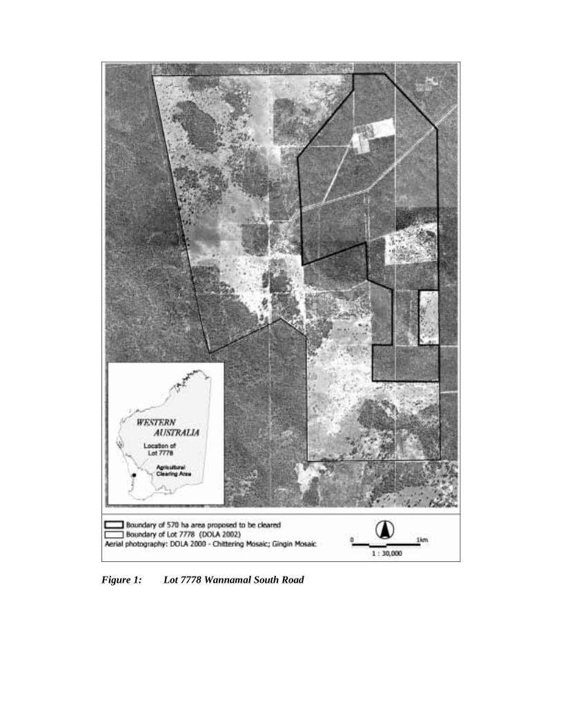
Figure 1: Lot 7778 Wannamal South Road

Figure 2: Lot 7778 Wannamal South Road
Source: proponent Mr Fernie
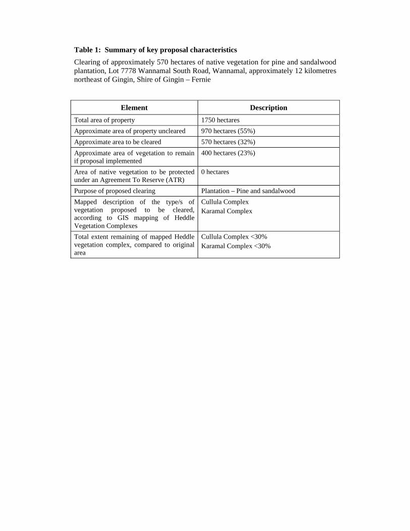
Table 1: Summary of key proposal characteristics Clearing of approximately 570 hectares of native vegetation for pine and sandalwood plantation, Lot 7778 Wannamal South Road, Wannamal, approximately 12 kilometres northeast of Gingin, Shire of Gingin – Fernie
Element Description Total area of property 1750 hectares Approximate area of property uncleared 970 hectares (55%) Approximate area to be cleared 570 hectares (32%) Approximate area of vegetation to remain if proposal implemented
400 hectares (23%)
Area of native vegetation to be protected under an Agreement To Reserve (ATR)
0 hectares
Purpose of proposed clearing Plantation – Pine and sandalwood Mapped description of the type/s of vegetation proposed to be cleared, according to GIS mapping of Heddle Vegetation Complexes
Cullula Complex Karamal Complex
Total extent remaining of mapped Heddle vegetation complex, compared to original area
Cullula Complex <30% Karamal Complex <30%