Embed Size (px)
Citation preview

AECOM City of Surrey Clayton ISMP Stage 1
Clayton ISMP Stage 1 Report V6.Docx 20
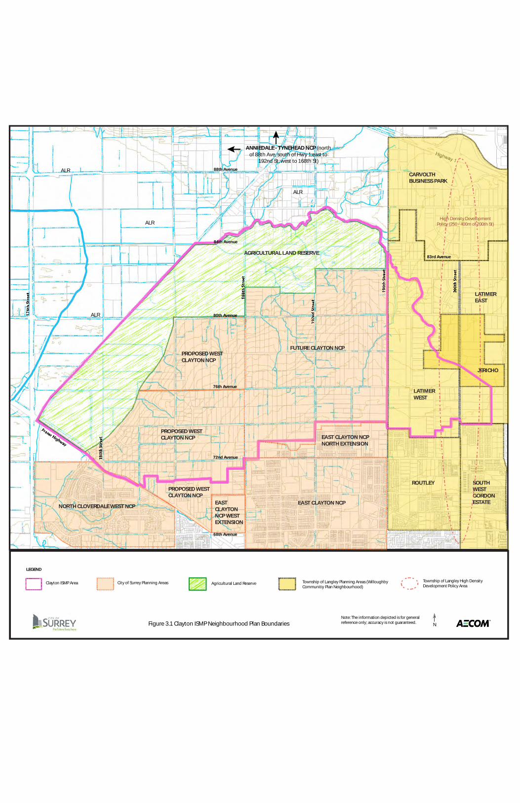
3. Planning The Clayton watershed encompasses lands within the Clayton General Land Use Plan (Surrey) and the Willoughby Community Plan (Township of Langley) as shown in Figure 3.1. The watershed itself is generally characterized by agricultural and low density residential land uses. The Clayton General Land Use Plan (GLUP) envisages Clayton to have a strong, unique community structure and identity that would be realized through the application of key sustainability principles. These principles are focussed on creating walkable neighbourhoods with a range of housing types arranged along interconnected road patterns with friendly streetscapes while preserving the natural environment. Principle No. 7 within the Clayton GLUP provides particular relevance to the ISMP process:
“Preserve the natural environment and promote natural drainage systems (in which storm water is held on the surface and permitted to seep naturally into the ground).”
The Willoughby Community Plan (1998) also has an overriding principle to achieve sustainability. The concept of accommodating flexibility while maintaining responsibility to the natural environment is an important cornerstone of the Willoughby Plan. A significant portion of General Land Use Plan area south of the Clayton watershed has undergone detailed planning and is substantially developed (East Clayton Neighbourhood Concept Plan and extension areas). Just as the East Clayton NCP was based upon the application of important sustainable development principles, future planning within the Clayton watershed area will also be guided by a vision of sustainability. Since the adoption of the General Land Use Plan, the City of Surrey has continued to advance its sustainability goals. A new (2008) Sustainability Charter solidifies the City’s commitment to place social, environmental and economic principles as the foundation for all decisions made by the City. While this section reports on the planning context in both Surrey and Langley, it acknowledges that the Township of Langley is not compelled to adhere to the findings of the Clayton ISMP. Township staff, however, are aware of this study and will be kept informed of its progress and recommendations.
3.1 Existing Zoning and Land Use
The Clayton ISMP study area is primarily a rural community with relatively large residential lots, some parks and schools, treed areas, watercourses and agricultural activities. Table 3.1 provides a summary of land use types and zoning in the watershed, for both Surrey and Langley. Within the City of Surrey, most of the watershed consists of One Acre Residential (RA) and General Agricultural (A-1) zoning, both within and outside of the Agricultural Land Reserve (ALR). The portion of the Clayton watershed within the Township of Langley consists largely of Suburban Residential (SR-2) zoning. Permitted non-residential uses within the SR-2 zone include agricultural uses, commercial greenhouses, and accessory buildings and uses. Figure 3.2 shows the zoning within the Clayton ISMP study area.
ALR
ALR
ALR
ALR
N
LEGEND
Clayton ISMP Area City of Surrey Planning Areas Township of Langley Planning Areas (WilloughbyCommunitiy Plan Neighbourhood)
Agricultural Land Reserve Township of Langley High DensityDevelopment Policy Area
Figure 3.1 Clayton ISMP Neighbourhood Plan BoundariesNote: The information depicted is for generalreference only; accuracy is not guaranteed.
PROPOSED WESTCLAYTON NCP
PROPOSED WESTCLAYTON NCP
PROPOSED WESTCLAYTON NCP
AGRICULTURAL LAND RESERVE
EASTCLAYTONNCP WESTEXTENSION
NORTH CLOVERDALE WEST NCPEAST CLAYTON NCP
EAST CLAYTON NCPNORTH EXTENSION
LATIMEREAST
LATIMERWEST
JERICHO
ROUTLEY SOUTHWESTGORDONESTATE
CARVOLTHBUSINESS PARK
High Density DevelopmentPolicy (250 - 400m of 200th St)
ANNIEDALE - TYNEHEAD NCP (northof 88th Ave, south of Hwy 1;east to
192nd St; west to 168th St)
FUTURE CLAYTON NCP
72nd Avenue
76th Avenue
80th Avenue
68th Avenue
83rd Avenue
88th Avenue
84th Avenue

AECOM City of Surrey Clayton ISMP Stage 1
Clayton ISMP Stage 1 Report V6.Docx 22
Table 3.1 Summaries of Existing Zoning and Land Use within the Clayton ISMP Study Area
Municipality Existing Zoning Percentage of Total Study Area Langley Civic Institutional Zone (P-1) 0.4%
Suburban Residential Zone (SR-2) 12.5% Surrey General Agricultural Zone (A-1) 53.3%
Intensive Agricultural Zone (A-2) 1.2% Local Commercial Zone (C-4) 0.0% Child Care Zone (CCR) 0.1% One-Acre Residential Zone (RA) 32.5%
TOTAL 100%
Municipality Land Use Type Percentage of Total Study Area Langley Civic Institutional 0.3%
Park 0.2% Suburban Residential 12.5%
Surrey Agriculture (outside of ALR) 19.4% Commercial 0.1% Institutional 0.2% Low Density Residential 32.5% Agriculture (in ALR) 34.8%
TOTAL 100%
Notes: 1. Surrey data is based on COSMOS data retrieved June 21, 2010
2. Langley Data is based on a Township base map from 2008, with zoning taken from Geosource July 27, 2010

q
FIGURE 3.2
Existing Zoning
0 200 400 600 800 1,000
Meters
80th Avenue
76th Avenue
74th Avenue
72nd Avenue
78th Avenue
84th Avenue188th
Str
eet 192nd S
treet
196th
Str
eet
184th
Str
eet
Latimer Creek South Arm
Latimer C
reek North Arm
Mag
nan
Cre
ek
Serp
entine R
iver
76th Avenue
72nd Avenue
200th
Str
eet
Har
vie
Roa
d
Fraser Highway
Highway 1
80th Avenue
Project No: Date:60158414 September 2010
Clayton ISMP
City of Surrey
North Creek
South CreekUnnamed Creek
Surrey Existing Zoning
Agriculture, A-1; A-2
Cemetary, PC
Golf, CPG
Commercial, C-15; C-4; C-8; CG-1
Commercial/Industrial, CHI
Commercial/Residential, CD
Industrial, CG-2; I-P(2); IH; IL
Institutional, CCR; PA-1; PA-2; RMS-1; RMS-1A
Business Park, IB
Low Density Residential, RA; RA-G; RH; RH-G
Med Density Residential, R-F; RF; RF-G; RF-SD; RF-SS; RM-10; RM-15; RM-23; RM-30; RM-45; RM-70; RM-D; RS
High Density Residential, RF-12; RF-12C; RF-9; RF-9C; RF-9S
Langley Existing Zoning
Park
Civic Institutional, P-1
Comprehensive Development
Carvolth Business Park, C-18
Service Commercial, C-3
Carvolth Commercial, C-17
Community Commercial
Limited Commercial, C-8
General Industrial, M-2
Service Industrial, M-1A
Service Station Zone, C-6
Residential Mobile Home Park, MH-1
Residential, R-1C
Suburban Residential, SR-2
Study Area Boundaries
External Catchments
Floodplain
ALR
City Land
Park - City Dedicated
Park - City Purchased
School
Notes:1. Surrey data is based on COSMOS data retrieved June 21, 2010�2. Langley Data is based on a Township base map from 2008, with zoning taken from Geosource July 27, 2010
CD
RA
RA
RA
A-1
A-1
C-8
A-1
SR-2
RM-15
CCR
C-4
RM-30
A-2
A-2
C-4
RF-12C
RF-9
CD
CDRM-30
CHI
ILCHI
RA
RF
RF
RM-10
IB
P-1
P-1
CD-57
P-1
C-18
SR-2
A-1
C-2D
C-17
SR-2
CD-79
MH-1P-1
M-2
M-1A
M-2
CD-29
C-3
R-1C
A-1
RA

AECOM City of Surrey Clayton ISMP Stage 1
Clayton ISMP Stage 1 Report V6.Docx 24
3.2 City of Surrey Plans and Policies Official Community Plan Surrey’s Official Community Plan (OCP) contains a range of goals related to enhancing self-sufficiency, liveability and quality of life in the City of Surrey. The Clayton ISMP study area is designated for Agricultural and Suburban uses in the OCP. The suburban lands are generally limited to densities ranging from 5 to 10 units per hectare (2-4 upa). However, the Clayton suburban lands are identified as having potential long term development subject to land use planning with area residents. Future development in the Clayton ISMP area has the potential to contribute to all OCP policy areas, including:
• Managing growth for compact communities; • Enhancing image and character; • Protecting agriculture and agricultural areas; • Protecting natural areas; and • Improving the quality of community.
The key driver in the planning and development process is growth management. The ISMP enables growth that integrates into the watershed, protects environmental values and enhances recreational opportunities. The City of Surrey’s Official Community Plan (OCP) advocates a compact and nodal development pattern.
“Efficient land use allows the City to continue growing while preserving open space and agricultural areas. A compact form of development contains future growth within planned areas, provides new opportunities for housing, business and mobility, and allows more efficient use of City utilities, amenities and finances. The City will strengthen the nodal development pattern of City Centre, Town Centres, Neighbourhood Centres and Workplace Areas as the framework for future growth.”
Planning and development have a key role in the economic sustainability of a city. Economic considerations and costs will be reflected in the ultimate vision and implementation of the Clayton ISMP. Parks and natural spaces provide numerous benefits, opportunities and value to a community including: aesthetics, recreation, play space, health, habitat, tourism, gathering places, pollution abatement, microclimate regulation, and stormwater management. The OCP recognizes the value of natural areas as noted below.
“Natural areas are to be preserved, protected and used where appropriate for park and recreational purposes. Measures are needed to reduce the impact of development on the natural environment.”
Greenhouse Gas Reduction Targets The OCP was amended earlier in 2010 to provide targets and policies related to greenhouse gas emission reductions. The City will strive to reduce greenhouse gas emissions by 33% from 2007 levels by the year 2020 and 80% from 2007 levels by the year 2050. While targets exclude emissions from agriculture (and industrial sources), future development within the Clayton watershed can be expected to contribute to realizing these targets. 2010 OCP Review A major review of the OCP has been underway since 2008 and is expected to be completed by late 2010 or early 2011. The review is focusing on a number of trends including a rapidly growing population, energy security and climate change, the use of green infrastructure, such as stormwater best management practices, and triple bottom line accounting (considering social, economic and environmental sustainability in all decisions). Other issues that will

AECOM City of Surrey Clayton ISMP Stage 1
Clayton ISMP Stage 1 Report V6.Docx 25
be addressed include reducing automobile dependence and preserving or creating a sense of place in new and developing areas. Two further areas of review that may relate more particularly to Clayton include ALR buffers and density around transit corridors. Sustainability Charter Surrey adopted a Sustainability Charter in 2008. The Charter defines “Sustainability” as:
“Meeting the needs of the present generation in terms of socio-cultural systems, the economy and the environment while promoting a high quality of life but without compromising the ability of future generations to meet their own needs.”
The Charter identifies three Pillars of Sustainability (Socio-cultural, Economic, and Environmental), three time frames for implementing sustainable actions and processes (immediate/short- , medium- , and long-term), and three spheres of influence to achieve sustainable objectives (corporate operations, municipal jurisdiction, and external organisations). The ISMP process touches on all three pillars, but is focused more on planning in the medium-term (3 to 10 year period) to long-term (10 years or more). In developing the Charter, stakeholders, including residents, employers and community groups, were asked to provide input to help define the goals and priorities. Key identified themes that are within the sphere of influence of the ISMP process include:
• Raise awareness and provide education with regard to sustainability and sustainability initiatives; • Provide incentives to the public to support “green” initiatives such as recycling and waste reduction,
rainwater collection, urban gardens, anti-idling; • Address housing affordability; • Provide sidewalks, greenways, trails, bikeways, pathways and pedestrian corridors that promote
interconnectedness in the community; • Ensure accessibility and social inclusion for all; • Protect trees, riparian areas, natural areas, and bio-diversity; • Protect and support Surrey’s agricultural land base and enhance food production; • Protect the City’s employment land base; • Plan and build a beautiful city, that has a sense of place, with complete communities; • Reduce energy and water consumption; • Reduce the City’s ecological foot print and promote and construct green buildings and building retrofit; and, • Promote the elements of a child and youth friendly city, and a city that is responsive to the needs of seniors
and people of all abilities. The Charter identifies specific goals for each of the three Pillars of Sustainability. Those within the sphere of influence of the ISMP process are shown in Table 3.2. Balancing the socio-cultural, environmental and economic needs and goals will be part of developing the Clayton ISMP.

AECOM City of Surrey Clayton ISMP Stage 1
Clayton ISMP Stage 1 Report V6.Docx 26
Table 3.2. Select Goals of the Surrey Sustainability Charter
Pillar Goal
Socio-Cultural Goals
Provide a range of accessible and affordable recreation services
Promote the development of a range of affordable and appropriate housing to meet the needs of households of varying incomes and household compositions.
Create a City that is, and is perceived as being safe and secure.
Create neighbourhoods that have distinct identities and lively public spaces that promote social connections
Incorporate high quality design and beauty in the public realm and built environment
Provide opportunities for meaningful community engagement in civic issues.
Economic Goals
Protect the integrity of the City’s ALR and industrial land base for food production, employment and agro-business services.
Respect natural areas and minimize the impacts of economic activities on the environment
Locate economic activities where they can be best serviced by a sustainable transportation network.
Work towards a revenue base that balances commercial and residential property taxes.
Environmental Goals
1. Terrestrial Habitat and Life – Create a balance between the needs of Surrey’s human population and the protection of terrestrial ecosystems, considering: a) Interconnecting Surrey and the areas outside Surrey through wildlife corridors,
parks and natural areas; b) Protecting to the extent possible, existing urban forests and natural coverage,
protecting trees and maximizing the City’s tree canopy; and, c) Maintaining ALR farmland and promoting food self-sufficiency and production
without negatively affecting existing natural areas.
2. Water Quality / Aquatic Habitat and Life – Protect Surrey’s groundwater and aquatic ecosystems for current and future generations, considering: a) Groundwater; b) Surface Water; c) Drinking water sources; d) Creeks, streams, and river systems; e) Sources of pollutants entering aquatic systems; f) Natural riparian systems; and, g) Native ocean and freshwater habitats.
3. Air Quality – Preserve clean air for current and future generations
4. The Built Environment – Establish a built environment that is balanced with the City’s role as a good steward of the environment: a) Minimize the impacts of development on the natural environment; b) Promote the use of native plant species; c) Promote permeable surfaces where possible in new developments; d) Incorporate opportunities for natural areas and urban wildlife; e) Protect unique and valuable land forms and habitats; f) Minimize liquid waste; g) Express community environmental values in new developments

AECOM City of Surrey Clayton ISMP Stage 1
Clayton ISMP Stage 1 Report V6.Docx 27
The City’s ability to achieve its vision of sustainability requires the setting of targets, and the establishment of indicators with current baseline values to monitor progress toward meeting these goals. Several of the key actions outlined in the Sustainability Charter relevant to the Clayton ISMP are listed in Appendix B.
Clayton General Land Use Plan (1999) The Clayton General Land Use Plan (GLUP) identifies Clayton as a complete community with a build-out population of between 30,000 and 35,000 people. Figure 3.3 shows the GLUP with the ISMP boundaries overlain. The General Land Use Plan provides the overall planning framework for the entire Clayton area and established the interrelationships between the various neighbourhoods within the plan area. The framework for the area is centred on a village concept (in the vicinity of 72 Avenue and 188 Street), surrounded by a range of residential, commercial, business park uses and an open space network including environmentally sensitive areas. East Clayton was to be the first neighbourhood developed, while the remainder of the area (within the current Clayton watershed study area) was to be retained in a suburban/rural condition given the (then) lack of current development interest and the desire of many residents to maintain a rural lifestyle for the medium term. Of the eight sub neighbourhoods identified in the Clayton General Land Use Plan, five are included within the Clayton ISMP area. These neighbourhoods are identified for a range of land uses and future designations:
• Suburban (adjacent to the ALR);
• Future Urban (generally between Suburban area and south to 72 Avenue) o Type and form of urban development and adequate transition area between urban and
permanent suburban areas would be addressed at future NCP stage;
• Schools and parks (on 184 Street and 72 Avenue);
• Proposed Detention Ponds (various locations);
• Environmentally Sensitive Areas and Creeks/Riparian Setbacks o Includes significant forest blocks north of 76 Avenue on both sides of 188 Street;
• Commercial
o Three quadrants of the Village Centre at the corner of 72 Avenue and 188 Street; and o Small node consisting of the existing gas station and store at 192 Street and 80 Avenue.
• Multi Family Residential/Townhouses or Apartments (in the vicinity of 184 Street and on the north
side of 72 Avenue, west of 188 Street).

! !
!
!!
!!
!! !
!
!
!
!
!
!
!!
!!
!!
! ! !
!
! ! ! ! ! ! ! !! !
!
! ! ! ! !
!!
!!
!
!!
!
!!
!
!
!
!!
!!
! ! ! !!
!
!
!
!
!
!
!!
!!
!!
!
!
!
! ! !
!
!
!
!
!
!
!
!
!
!!
!!
!!
!!
!
!
!
!
!!
!
!
!
!
!
! ! ! !
!! ! !
! ! ! !
! ! ! !
! !
! !
!
! ! ! ! !
!
!
!
! ! ! ! !!
!
!!
!!
!!
!!
! !
!!
! !
!!!
!!
!
!!
!
!!
!!
!
!!
!
!!
ú ú
k k k
k
k
k
k
k
k
&3 &3
&3&3
192ST
80 AVE
184ST
76 AVE
72 AVE
64 AVE
74 AVE
FRASERHWY
180ST
68 AVE
HARVIERD
65 AVE
67 AVE
188ST
196ST
182ST
1T
83 AVE
78 AVE
194AST
82A AVE
190ST
189ST
73 AVE
70 AVE
63B AVE
186ST
66 AVE
69 AVE
179ST
68A AVE
71 AVE
184AST
185ST
63A AVE
69AAVE
CLAY
TONHILL DR
75 AVE
64B AV
E
193ST
191ST
65A AVE
67AAVE
181ST
184BST
66A AVE
188AST
OLD YA
183ST
193BST
ENGLISH PL
68B AVE
185ASTC
LAYTONWOODCR
183AST
181AST
195BST
187AST
64A AVE
178BST
179AST
182AST
189AST
182BST
64 AVE
64 AVE
196ST
66 AVE
183ST
70 AVE
64 AVE
70 AVE
180ST
67A AVE
181ST
194ST
65A AVE
71 AVE
188ST
180ST
68A AVE
78 AVE
66AAVE
191ST
71 AVE
63AAVE
185ST
64 AVE
64A AVE
66 AVE
180ST
69 AVE
63AAVE
63B AVE63AAVE
184AST 1
85AST
63A AVE
179AST
63A AVE
192ST
69A AVE
184ST
183ST
6 5 A
VE
186ST
185AST
70 AVE
188ST
63A AVE
182ST
196ST
68 AVE
192ST
189ST
185ST
181
ST
185ST
180ST
CLAYTO
NWO ODCR
CLAYTON NEIGHBOURHOOD CONCEPT PLAN
Proposed General Land Use
DATE: Dec. 14 ,1998
! !
!
!!
!!
!! !
!
!
!
!
!
!
!!
!!
!!
! ! !
!
! ! ! ! ! ! ! !! !
!
! ! ! ! !
!!
!!
!
!!
!
!!
!
!
!
!!
!!
! ! ! !!
!
!
!
!
!
!
!!
!!
!!
!
!
!
! ! !
!
!
!
!
!
!
!
!
!
!!
!!
!!
!!
!
!
!
!
!!
!
!
!
!
!
! ! ! !
!! ! !
! ! ! !
! ! ! !
! !
! !
!
! ! ! ! !
!
!
!
! ! ! ! !!
!
!!
!!
!!
!!
! !
!!
! !
!!!
!!
!
!!
!
!!
!!
!
!!
!
!!
k k k
k
k
k
k
k
k
&3 &3
&3&3
192ST
80 AVE
184ST
76 AVE
72 AVE
64 AVE
74 AVE
FRASERHWY
180ST
68 AVE
HARVIERD
65 AVE
67 AVE
188ST
196ST
182ST
1T
83 AVE
78 AVE
194AST
82A AVE
190ST
189ST
73 AVE
70 AVE
63B AVE
186ST
66 AVE
69 AVE
179ST
68A AVE
71 AVE
184AST
185ST
63A AVE
69AAVE
CLAY
TONHILL DR
75 AVE
64B AV
E
193ST
191ST
65A AVE
67AAVE
181ST
184BST
66A AVE
188AST
OLD YA
183ST
193BST
ENGLISH PL
68B AVE
185ASTC
LAYTONWOODCR
183AST
181AST
195BST
187AST
64A AVE
178BST
179AST
182AST
189AST
182BST
64 AVE
64 AVE
196ST
66 AVE
183ST
70 AVE
64 AVE
70 AVE
180ST
67A AVE
181ST
194ST
65A AVE
71 AVE
188ST
180ST
68A AVE
78 AVE
66AAVE
191ST
71 AVE
63AAVE
185ST
64 AVE
64A AVE
66 AVE
180ST
69 AVE
63AAVE
63B AVE63AAVE
184AST 1
85AST
63A AVE
179AST
63A AVE
192ST
69A AVE
184ST
183ST
6 5 A
VE
186ST
185AST
70 AVE
188ST
63A AVE
182ST
196ST
68 AVE
192ST
189ST
185ST
181
ST
185ST
180ST
CLAYTO
NWO ODCR
NOTE: Greenways and linkages will connect
major community amenities and school / park sites.
NOTE: For proposed elementary schools and
parks, refer to map showing neighbourhood
boundaries.
NOTE: This plan is conceptual in nature and is only intended to reflect a general pattern
of land uses. Exact land use boundaries to be determined through the Neighbourhood
Concept Plan process.
·0 100 200 300 400 50050
Meters
This map is provided as general referance only. The City of Surrey makes no warrantees, express or implied,
as to the fitness of the information for any purpose, or to the results obtained by individuals using the information
and is not reponsible for any action taken in reliance on the information contained herein.
Suburban
Multi Family Residential/Townhouses or Apartments
Urban Residential (Single - Family)
Urban Residential / Transitional Density Area
Future Urban
Mixed: Commercial / Residential
Existing Schools
Existing Parks
Business Park / Work Place
Commercial
Institutional
Business Park / Live & Work Area
Greenways / Utility Right of Way
Creeks / Riparian Setbacks
Environmentally Sensitive Areas
!
! !
kProposed Detention Ponds(Precise shape, size and location
subject to further analysis)
Buffers / Linkages / Open Space
(̂ Landmark / Focal Point
ALR
ALR
ALR
ALR Agricultural Land Reserve
Clayton ISMP
boundaryFigure 3.3 Clayton Genveral Land Use Plan &
Watershed Boundary
Note: The information depicted is for
general refernce only; accuracy is not
gauranteed
!!!!!!
!!!!!!!
!!!!!!!!!!!
!!!!!!
!!!!
!
&&&&&&&&&&&&&&&&&&&&&&&&&&&&
196STTTT
HAARVVIERD
TTT

AECOM City of Surrey Clayton ISMP Stage 1
Clayton ISMP Stage 1 Report V6.Docx 29
East Clayton Neighbourhood Concept Plans (2003-2005) The following East Clayton Neighbourhood Concept Plans (NCPs) provide context for future development within the Clayton ISMP area. The NCPs noted below are located adjacent to the ISMP area (see Figure 3.1). East Clayton is substantially built out with over 5,000 dwelling units approved/developed, and 1,200 additional units under application as of December 2009.
• East Clayton NCP (adopted in 2003) o Award-winning sustainable community, east of 188 Street, south of 72 Avenue o Features a range of residential, open space, school, business park and commercial uses o Lands adjoining the ISMP area at the southeast corner of 72 Avenue and 188 Street are
designated “Commercial/residential” but are not yet developed
• East Clayton NCP North Extension (adopted in 2005) o Located north of 72 Avenue, between 188 and 196 Streets o Provides for residential densities ranging from 6 to 45 upa, public open space, multi-use
pathways and pedestrian corridors o A portion of the NCP is located within the Clayton ISMP study area; these lands, along 72
Avenue are designated for commercial and residential uses and future urban landmarks.
• East Clayton NCP West Extension (adopted in 2005) o Small NCP area (45 hectares) located west of 188 Street, south of 70 Avenue; o Much of the plan area is occupied by the Clayton Heights Secondary School, North Creek
and stormwater detention facilities o Plan also provides for high density (22-45 units per acre) residential uses and institutional
uses
Future Clayton Neighbourhood Concept Plans The ISMP area includes lands that will be subject to future planning initiatives as described below.
• Proposed West Clayton NCPs (west of 188 Street) o On July 26, 2010, Surrey Council adopted a report which recommended commencing two
NCPs in the Clayton West area. o Terms of Reference for these NCPs will be forwarded to Council in the fall of 2010; City staff
will lead these planning processes, with outside consulting assistance in specific areas. o While both NCPs will commence at the same time, the NCP situated to the north of 76
Avenue will proceed only to a Stage 1 approval (land use concept only), given servicing constraints.
o New neighbourhoods at urban densities are anticipated. o The viability of a district energy system in the NCP will be explored. o A small portion of the proposed southern NCP lies outside of the ISMP study area (south of
72 Avenue, and west of 188 Street). Recommendations arising out of the ISMP may be relevant to this area as well.
• Future Clayton NCP (remainder of Clayton GLUP area, east of 188 Street)
o While the ISMP will provide a framework for future planning in this area, an NCP process has not been authorized and is not expected to commence in the near future.

AECOM City of Surrey Clayton ISMP Stage 1
Clayton ISMP Stage 1 Report V6.Docx 30
Other Relevant Plans and Policies
• North Cloverdale West NCP (adopted in 1996) o Townhouse clusters and an open space/liner/park buffer are located across from the ISMP
on the south side of Fraser Highway
• City Policy No. O-23 “Residential Buffering Adjacent to the ALR/Agricultural Boundary” o Identifies a transition area of a minimum width of ¼ mile (400 metres) from the
ALR/agricultural boundary and defines two sub-transition areas o Permits ½ acre lots within 200 metres of the ALR/agricultural boundary (“Outer Ring
Transition area”), provided a row of one acre lots is proposed adjacent to the boundary o Permits 930 m2 (10,000 sq. ft) lots within the Inner Ring Transition Area (between the
Urban Designation boundary and the 200-metre line); o Requires a 37.5 metre (125 ft) separation distance between the ALR/agricultural boundary
and nearest wall of principal building o Requires a minimum 15 metre (50 ft) wide landscaped buffer along the edge of proposed
lots and the ALR/agricultural boundary o Requires a Restrictive Covenant registered on all lots adjacent to the boundary for the
principal building setback, and to advise of agricultural practises & ensure landscaped buffer is maintained
• Anniedale-Tynehead NCP (in progress)
o Proposes policies that would provide for urban cluster densities (e.g. 10-15 units per acre) adjacent to lands designated as agriculture
o Requires the agricultural edge to be comprehensively planned to increase open space and vegetated buffers next to the ALR
o Policies may be applicable for future planning in the Clayton ISMP area
• Grandview Heights NCP #2/Fergus Creek ISMP (in progress) o Hydraulic modelling identified the use of landscaped corridors (Low Impact Development)
rather than detention ponds in the NCP area. o Detention ponds were shown not to maintain base flows to Fergus Creek and would have
been located within the high density multi-family areas. o The ISMP called for 10% of the area to be set aside in the form of corridors ranging from 10
to 20 m in width. These corridors will be located along key existing and future roads within the NCP area.
• Grandview Heights NCP #4/Erickson ISMP (in progress)
o Suggests a possible combination of detention ponds and Low Impact Development (e.g. landscaping)
• Ecosystem Management Study (in progress)
o Provides an update to the City's environmental areas mapping as currently identified in the OCP for the purpose of identifying areas to be protected from development
o Aims to strategically manage the ecosystems throughout the City by focusing on a City-wide Green Infrastructure Network.
o Phase 2 will identify management guidelines and strategies to maximize the health and benefits of Surrey’s green infrastructure.
AECOM City of Surrey Clayton ISMP Stage 1
Clayton ISMP Stage 1 Report V6.Docx 31
3.3 Township of Langley Plans and Policies
Approximately 100 hectares (247 acres) of the Clayton watershed are located within the Willoughby Community Plan Area of the Township of Langley. While most of this area is currently characterized by suburban residential uses, it is anticipated that higher densities may be considered in the future, subject to more detailed planning. Within the 200 Street Corridor, for example, the Township is exploring densities in the range of 80 units per acre. With regards to residential densities adjacent to the ALR, Langley has generally permitted slightly higher densities than Surrey and may continue to explore further increases. Official Community Plan The Township of Langley’s Official Community Plan was adopted in 1979 and sets the framework for planning in the Township, as well as for the component community plans which provide more detailed policies for specific areas of the Township (e.g. the Willoughby Community Plan). Langley, like Surrey, is a major agricultural community in the province. Approximately three-quarters of the municipality (23,784 hectares) are within the Agricultural Land Reserve. Langley’s OCP protects agricultural lands within the designated Green Zone by identifying designated urban and industrial growth areas that are outside of the Green Zone. The Township supports agricultural activity and farming development in the Green Zone, while working to resolve conflicts between farm and non-farm uses. The OCP Land Use Plan designates the majority of the Willoughby area lands within the ISMP area as an Urban Growth area. The north western portion (i.e. Carvolth Business Park plan area) is designated as an Industrial Growth area. Both the Designated Urban Growth Areas and Designated Industrial Growth Areas of the Land Use Plan are intended to provide sufficient lands to accommodate the projected growth demands for urban and industrial purposes, and thus avoid encroachment onto ALR lands during the term of the OCP. Climate Action Planning – Green Communities The latest update to the OCP was in May 2010. This update included a Greenhouse Gas Reduction Target of 10% below 2007 levels by 2021, on a per capita basis. It also included a policy to: “implement the Water Management Plan to ensure safe and sustainable groundwater for the community for generations to come”, which the Clayton ISMP can directly support. Sustainability Charter The Township of Langley’s Sustainability Charter was adopted in 2008 and provides a high level policy framework for Council to integrate and balance competing community expectations in order to provide residents with the best quality of life. It outlines a Sustainability Vision – to build a legacy for future generations by leading and committing the community to a lifestyle that is socially, culturally, economically, and environmentally balanced – and a set of Principles, Goals and Objectives to achieve that Vision. The Charter is also considered to be an Integrated Community Sustainability Plan and emphasizes strategic planning approaches such as long-term thinking, integration, collaboration, public education, community engagement, monitoring and evaluation. Willoughby Community Plan The Clayton ISMP lands within the Township of Langley are located within the Willoughby Community Plan area (plan adopted June 11, 2001) (see previous Figure 3.1). Most of these lands are located within the Latimer West sub area and are designated for residential or greenbelt uses. A key aspect of the Willoughby Community Plan is achieving or maintaining some connectivity between critical green spaces to respect the natural setting. The

AECOM City of Surrey Clayton ISMP Stage 1
Clayton ISMP Stage 1 Report V6.Docx 32
Willoughby Community Plan also indicates that sub area plans will generally be based on storm drainage boundaries, but designed to be ultimate neighbourhoods. A new neighbourhood planning process for Latimer West and East is expected to start later in 2010. The Willoughby Community Plan notes that areas adjacent to Clayton in Surrey are to be designed to offer compatible uses. The current residential designations of lands situated within the Clayton ISMP study area are described further below.
• “Suburban Residential”: This is intended to accommodate larger country residential lots where similar housing exists or where nearby environmental constraints prevail (e.g. stream banks) or in areas of environmental sensitivity. Intended to be used as a protective measure over lands with close proximity to tributaries of Latimer Creek, this designation permits densities ranging from 2.5 to 5 units per hectare (1 -2 upa);
• “Residential Bonus 2”: This permits up to 37 units per hectare (15 upa) if 36% or more land is secured for
environmental features or open space amenities.
Other Willoughby sub-area neighbourhood plans, which are located adjacent to, or overlap with the Clayton ISMP area are described below.
• Jericho Sub-Neighbourhood Plan (in progress) o Located on both sides of 200 Street, south of 80 Avenue o Small portion of Plan located within ISMP area o Plan received 3rd reading in July 2010 o High density mixed-use development contemplated (e.g. up to 20 storeys) in some parts of the plan
area o Conforms to High Density Development Policy (2008), which is described further, below o Stormwater to be conveyed to an existing detention pond at 82 Avenue and 198 A Street o Full build-out will require detention pond to be built
• Routley Neighbourhood Plan (adopted 2001)
o Located immediately south of the ISMP area on the east side of 196 Street, south of approximately 73 A Avenue
o Permitted densities typically range from 15 to 25 units per hectare (6 - 10 upa) o Area is substantially developed
• Carvolth Business Park Plan (update in progress)
o North of Clayton ISMP area o A process to update the Plan commenced in the spring 2010 and is expected to be completed
approximately in February 2011 o Revised Plan is intended to respond to completion of the Golden Ears Bridge and a proposed new
transit exchange on 202 Street o Township is interested in developing a more complete, mixed-use node as a gateway to Langley o Plan will explore Transit Oriented Development and compact residential forms
• South West Gordon Estate (adopted 2000, last updated in 2006)
o This 103 hectare area (255 acres) is adjacent to the southeastern corner of the Clayton ISMP area and is bounded by 200th St. on the west and 74th Ave. on the north
o Land in this area is largely zoned Suburban Residential (75% of the area) and Rural (25% of the area). The neighbourhood is characterized by large estate lots

AECOM City of Surrey Clayton ISMP Stage 1
Clayton ISMP Stage 1 Report V6.Docx 33
o The landscape features (predominantly the Jefferies Brook and the Escarpment) in the area are important as a defining element of neighbourhood character
o The Jefferies Brook is an ephemeral watercourse with a main stem that runs north of 68th Ave. and is also the main focus of the natural drainage system, which is to remain protected by a riparian corridor north of 68th Ave
o South West Gordon Estate shares sewer and water services with the Routely Neighbourhood; o The northern half of this plan area (adjacent to the ISMP area) is dedicated to single-family housing,
with bonus density provisions to implement public amenities and preserve outstanding natural features
o The majority of the Plan area continues to discharge to the 200th St. storm sewer system due to low opportunities for infiltration, particularly during the winter months, the relatively high level of development densities, and the steep slopes of the Plan area
• North East Gordon Estate Neighbourhood Plan (adopted 2006.)
o Although not adjacent to the Clayton ISMP study area, the North East Gordon Estate demonstrates how the Township of Langley manages planning between urban and agricultural areas
o The Plan designates a Development Permit Area for “Agricultural Edge and Escarpment Protection”. The DP area requires or permits:
dedication of a 15 metre landscaped area adjacent to the ALR boundary (or a 7.5 metre landscaped area where a road exists along the ALR boundary;
notifications provided on new property titles within the DP areas indicating proximity to ALR lands and the potential for sound, odour and airborne impact from natural farm activities (Surrey does this also);
Agricultural awareness signage to be provided advising of farm activities (Surrey has also erected signs at the entrance to agricultural areas);
Base density of 5 units per hectare (2 upa); Densities up to 10 units per hectare (4 upa) (as per section 3.1.4C of the Willoughby
Community Plan) are permitted provided that Stream setbacks, Ecological Greenways, and Urban/ALR interfaces are protected and dedicated; and
Alternate subdivision patterns (e.g. cluster) and housing types (e.g. duplexes) may be permitted if the above conditions are met.
Other Township of Langley Plans and Policies
• Water Management Plan (2009) o Provides policies and regulations to protect local groundwater resources for community use as well
as to promote healthy habitat. Some key aspects of the WMP include: Municipal planning initiatives to ensure that new land developments do not adversely impact
groundwater availability and that new subdivisions are integrated with the WMP; and Locally enforceable agricultural practices to minimize the risk of groundwater contamination.
• High Density Development Policy (2008)
o Provision of high density development is consistent with overall Township objectives of creating a sustainable community by contributing to a greater range of housing choices and affordability, promoting compact neighbourhoods, and minimizing sprawl into agricultural areas.
o Council may consider high-rise development proposals within 250-400 metres of the 200 Street Corridor, subject to more detailed community and neighbourhood planning.
o Mid-rise residential development is considered as 5-12 storeys and 80 units per acre net. o High-rise residential development is defined as 12-20 storeys, greater than 80 units per acre net.

AECOM City of Surrey Clayton ISMP Stage 1
Clayton ISMP Stage 1 Report V6.Docx 34
o An adequate sized detention pond must be secured.
• Agricultural Edge Planning o The Township of Langley has been engaged in an Edge Planning Process with the Ministry of
Agriculture and Lands for a number of years. o In the future, higher densities adjacent to the ALR may be explored. This may facilitate maintenance
of ALR buffers by strata councils of multi-family development sites. o “Guide to Edge Planning” from the Ministry of Agriculture and Lands (June 2009 – working copy)
provides additional information regarding promoting compatibility along the urban-agricultural edge (http://www.al.gov.bc.ca/resmgmt/sf/publications/823100-2_Guide_to_Edge_Planning.pdf).
• Wildlife Habitat Conservation Strategy (2008)
o The strategy provides a framework for long term planning and management of wildlife habitat in the Township.
o At the neighbourhood planning process, this will include determining patches to be protected and/or potential corridors to be connected to patches.
• Streamside Protection Bylaw 2006 No. 448 o Amends OCP to establish streamside protection and enhancement policies, guidelines and
mandatory DP areas o Community and neighbourhood boundaries shall be consistent with watershed or drainage
catchment boundaries where feasible o New plans need to have streamside protection and enhancement DP areas
3.4 Regional Planning
Draft Metro Vancouver Regional Growth Strategy (in progress) Since 2007, Metro Vancouver has been working to prepare a Regional Growth Strategy (RGS) to replace the Livable Region Strategic Plan. The RGS is currently in a draft stage and is expected to be adopted in early 2011. Implications of the RGS on the Clayton ISMP area are summarized as follows:
• The RGS designates the Clayton watershed as a “general urban” and “agricultural” (ALR lands); o “General Urban” refers to the developed portion of the region within the Urban Containment
Boundary that will meet the region’s urban development needs to the year 2040; it excludes areas within Urban Centres, Industrial and Mixed Employment areas;
o General Urban areas include local neighbourhoods, communities, shopping areas, schools, institutions and recreation areas;
o Residential densities in the General Urban area are generally lower than in the Urban Centres; o The Agricultural designation forms the urban containment boundary and is intended for agriculture
and agricultural supporting services.
• Willoughby Town Centre (Township of Langley) is identified as a Regional City Centre o Regional City Centres are activity hubs for sub-regions within Metro Vancouver that provide large-
scale, high density commercial uses, medium and high density housing forms, institutional, community and cultural services and activities serving the sub-regions.

AECOM City of Surrey Clayton ISMP Stage 1
Clayton ISMP Stage 1 Report V6.Docx 35
TransLink - Transport 2040 (2008) Transport 2040 is the long-range planning document that identifies key transportation goals up to the year 2040 for the region and sets out strategies to achieve them. The major implications for the Clayton ISMP area are outlined as follows:
• Proposed rapid transit (bus/rail) along 200th Street, Highway 1 and Fraser Highway as part of regional Frequent Transit Network (FTN).
o The FTN aims to provide frequent, reliable service on designated corridors throughout the day, everyday.
o The Frequent Transit corridors will be developed with communities through ongoing planning and consultation processes and will require agreement between TransLink and municipalities on supportive land uses to ensure success.
3.5 Planning Challenges and Opportunities
The Stage 1 review of land use patterns, plans and policies has identified a number of potential opportunities and challenges in the Clayton ISMP area. Some of these are outlined below and may be considered further during upcoming stages of the ISMP process.
• Jurisdiction - The Clayton watershed crosses the Surrey/Township of Langley municipal boundary. Watershed health will thus be dependent on actions on both sides of 196 Street. While findings and recommendations from the Clayton ISMP may have relevance and interest to Langley, their adherence is voluntary. Consistency across municipal borders (e.g. land use, density, watershed protection) will be an important consideration for future planning processes in both jurisdictions.
• Co-ordinating ISMP and NCP boundaries o a small portion of future Clayton West NCP is situated outside the southern boundary of the Clayton
ISMP study area; it may be necessary to confirm if these lands were subject to prior stormwater management review (e.g. Clayton MDP) or if further study or updating is needed as part of the West Clayton NCP process;
o a portion of the approved East Clayton NCP North Extension (northeast corner of 188 Street and 72 Avenue) is included within the Clayton ISMP; should the ISMP identify any potential recommendations for this area, an amendment to the existing NCP may be need to be considered.
• Enabling growth that integrates into the watershed, protects environmental values and enhances
recreational opportunities; letting the landscape and environmental conditions guide land use planning.
• Protecting agricultural areas – ensuring that agriculture and agricultural activities are not negatively affected by future growth in the Clayton ISMP area. Surrey maintains a strong policy context for managing the urban/agricultural interface. Notwithstanding this, the exploration of appropriate residential densities adjacent to the ALR will need to be addressed in Clayton ISMP area, given the long boundary with the ALR. ISMP findings will help frame the details of this discussion.
• Connecting communities and providing for compatible land uses (e.g. circulation networks, land use, wildlife
corridors, place-making) o Connections to adjoining NCP areas, the Anniedale-Tynehead NCP, and the Township of Langley; o The Clayton ISMP study area includes three of the four corners of the major intersection of 72
Avenue and 188 Street; this intersection will serve as a key entry point to the neighbourhood and the

AECOM City of Surrey Clayton ISMP Stage 1
Clayton ISMP Stage 1 Report V6.Docx 36
village centre for the future Clayton NCPs. It is identified as a landmark/focal point in the Clayton General Land Use Plan.
3.6 Stakeholder Engagement
Stage 2 of the Clayton ISMP will include a stakeholder process to define a vision for the watershed. During this stage, a draft Stakeholder Consultation and Communication Strategy will be developed. It will identify a preliminary list of stakeholders and a consultation approach to ensure that the ISMP goals, objectives, and vision are created through a consensus driven process.
3.7 Additional Bylaws related to the ISMP Process
3.7.1 Surrey Tree Protection Bylaw, 2006 No.16100
This bylaw defines “Significant” and “Protected” trees, how they are to be protected and managed, and a fee structure for tree cutting permits.
3.7.2 Surrey Stormwater Drainage Regulation and Charges Bylaw, 2008, No. 16610
This bylaw is to “regulate extensions, connections, and use of the stormwater drainage system, to impose connection charges to the stormwater drainage system and to prohibit the fouling, obstructing, or impeding the flow of any stream, creek, waterway, watercourse, ditch, or stormwater drainage system.” Part 5 of the bylaw describes the on-site stormwater management requirements. These facilities are required on newly created parcels where prescribed by NCPs, Master Drainage Plans, ISMPs, Servicing Agreements or specific Service Connections. The property owner is required to maintain and ensure accessibility to the facilities. Commercial and industrial properties are required to submit maintenance and operation reports to the City with applications for new/renewed business licences. Part 7 of the bylaw includes the requirement that grease, oil and sand interceptors are to be provided on the building drains for all industrial, commercial and multi-family sites, and are required on other businesses as required by the general manager of engineering. Maintenance of these interceptors is at the owner’s expense; however specific maintenance requirements and proof of maintenance are at the discretion of the General Manager of Engineering. Part 8 of the bylaw defines prohibited waste from all parts of the drainage system as those defined in the BC Environmental Management Act, sediment or sediment-laden water as outlined in the City’s Erosion and Sediment Control bylaw, any substance of sufficient quantity to be a safety hazard to a property, person or any life form, and any item that contravenes the Fisheries Act. This part of the bylaw also prohibits discharge of stormwater to the sanitary sewerage system. Every property owner with a service connection is required to allow the General Manager of Engineering (or representative) to enter the property to inspect and test the service connection and plumbing system for quantity and nature of the water being discharged. The owner may be required to sample and analyse the discharge at their own expense. Accidental spills or discharges must be reported to the City, countermeasures and damage minimization and clean-up (as well as associated costs) are the responsibility of the property owner or responsible persons.

AECOM City of Surrey Clayton ISMP Stage 1
Clayton ISMP Stage 1 Report V6.Docx 37
Part 9 outlines charges levied for new drainage service connections, the requirement to pay a drainage parcel tax as established in the Drainage Parcel Tax bylaw.
3.7.3 Erosion and Sediment Control By-law 2006 No. 16138
The Erosion and Sediment Control By-Law “is to ensure that adequate protection of the City of Surrey drainage system is taken during any construction, by the implementation of erosion and sediment control measures.” The maximum allowable TSS level for discharge to the drainage network from a construction site is 75mg/L.
3.7.4 Drainage Parcel Tax By-law, 2001, No. 14593
The Drainage Parcel Tax By-Law establishes the per parcel rate payable by property owners.
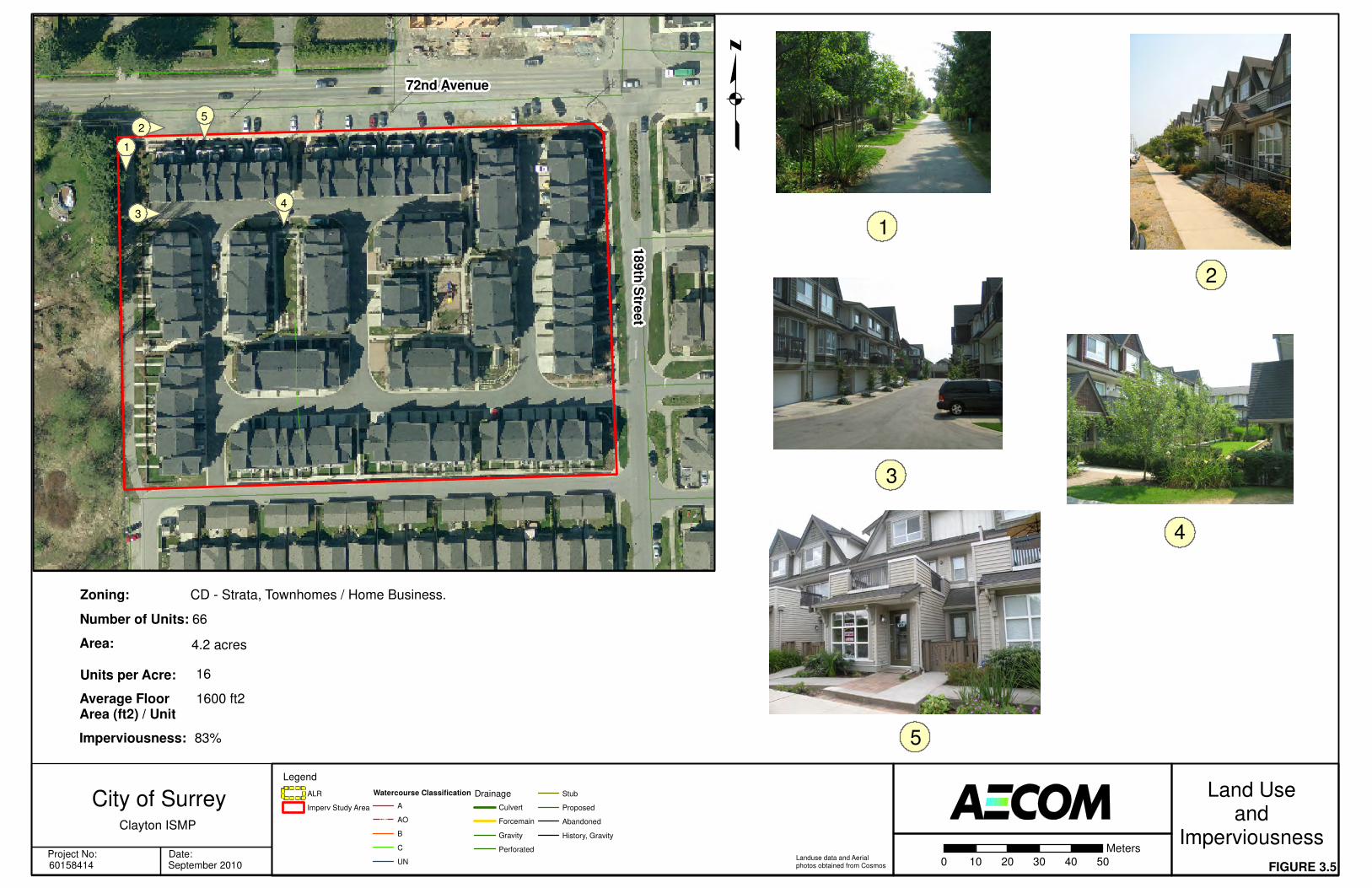
3.8 Land Use and Imperviousness
The Clayton Watershed Vision will allow the City to create a framework of rules and policies to preserve and enhance the Clayton watershed in accordance with the requirements outlined within the OCP and the future NCP. Land use type affects the level of imperviousness within a watershed, which in turn affects the volume, rate and quality of stormwater run-off. A variety of existing land use types from within or adjacent to the Clayton ISMP study area are shown in Figures 3.4 to 3.6. As we identify areas for future development, we will need to address the resulting imperviousness and its impact on stormwater run-off.

q
FIGURE 3.4
Land Useand
Imperviousness0 20 40 60 80 100
Meters
18
2n
d S
tree
t
73rd Avenue
Legend
ALR
Imperv Study Area
Watercourse Classification
A
AO
B
C
UN
Drainage
Culvert
Forcemain
Gravity
Perforated
Stub
Proposed
Abandoned
History, Gravity
1
2
181st S
treet
72nd Avenue
3
1
2
3
Zoning:
Number of Units:
Units per Acre:
Average Floor Area (ft2) / Unit
RA - Non Strata, One and Two Family Dwellings
15
0.7
4200 ft2
Imperviousness: 22%
Area: 22 acres
Landuse data and Aerial photos obtained from Cosmos
Project No: Date:60158414 September 2010
Clayton ISMP
City of Surrey
q
FIGURE 3.5
Land Useand
Imperviousness0 10 20 30 40 50
Meters
72nd Avenue
Legend
ALR
Imperv Study Area
Watercourse Classification
A
AO
B
C
UN
Drainage
Culvert
Forcemain
Gravity
Perforated
Stub
Proposed
Abandoned
History, Gravity
1
2
3
Zoning:
Number of Units:
Units per Acre:
Average Floor Area (ft2) / Unit
CD - Strata, Townhomes / Home Business.
66
16
1600 ft2
Imperviousness: 83%
Area: 4.2 acres
Landuse data and Aerial photos obtained from Cosmos
18
9th
Stre
et
1
2
3
4
4
5
5
Project No: Date:60158414 September 2010
Clayton ISMP
City of Surrey

q
FIGURE 3.6
Land Useand
Imperviousness0 10 20 30 40 50
Meters
72nd Avenue
Legend
ALR
Imperv Study Area
Watercourse Classification
A
AO
B
C
UN
Drainage
Culvert
Forcemain
Gravity
Perforated
Stub
Proposed
Abandoned
History, Gravity
1
2
3
Zoning:
Number of Units:
Units per Acre:
Average Floor Area (ft2) / Unit
RM-30 - Strata
100
21
UNKNOWN
Imperviousness: 59%
Area: 4.8 acres
Landuse data and Aerial photos obtained from Cosmos
18
9th
Stre
et
3
72A Avenue
19
0th
Stre
et
12
http://mosaichomes.com
Project No: Date:60158414 September 2010
Clayton ISMP
City of Surrey