Embed Size (px)
DESCRIPTION
Clasificación y morfología costeras
Citation preview

Coastal Classification and Morphology IV-2-i
Chapter 2 EM 1110-2-1100COASTAL CLASSIFICATION AND MORPHOLOGY (Part IV)
30 April 2002
Table of Contents
Page IV-2-1. Introduction . . . . . . . . . . . . . . . . . . . . . . . . . . . . . . . . . . . . . . . . . . . . . . . . . . . . . . . . . . IV-2-1
IV-2-2. Coastal Classification . . . . . . . . . . . . . . . . . . . . . . . . . . . . . . . . . . . . . . . . . . . . . . . . . IV-2-1a. Introduction . . . . . . . . . . . . . . . . . . . . . . . . . . . . . . . . . . . . . . . . . . . . . . . . . . . . . . . . . . IV-2-1b. Early classifications . . . . . . . . . . . . . . . . . . . . . . . . . . . . . . . . . . . . . . . . . . . . . . . . . . . . IV-2-1c. Later classifications . . . . . . . . . . . . . . . . . . . . . . . . . . . . . . . . . . . . . . . . . . . . . . . . . . . . IV-2-1d. Coastal classification of Francis Shepard . . . . . . . . . . . . . . . . . . . . . . . . . . . . . . . . . . . IV-2-1e. Classification schemes for specific environments . . . . . . . . . . . . . . . . . . . . . . . . . . . . . IV-2-3
(1) River systems . . . . . . . . . . . . . . . . . . . . . . . . . . . . . . . . . . . . . . . . . . . . . . . . . . . . . IV-2-3(2) Great Lakes of North America . . . . . . . . . . . . . . . . . . . . . . . . . . . . . . . . . . . . . . . . IV-2-3
IV-2-3. Drowned River Coasts - Estuaries . . . . . . . . . . . . . . . . . . . . . . . . . . . . . . . . . . . . . . IV-2-4a. Introduction . . . . . . . . . . . . . . . . . . . . . . . . . . . . . . . . . . . . . . . . . . . . . . . . . . . . . . . . . . IV-2-4b. Literature . . . . . . . . . . . . . . . . . . . . . . . . . . . . . . . . . . . . . . . . . . . . . . . . . . . . . . . . . . . . IV-2-4c. Classification . . . . . . . . . . . . . . . . . . . . . . . . . . . . . . . . . . . . . . . . . . . . . . . . . . . . . . . . . IV-2-4d. Definitions . . . . . . . . . . . . . . . . . . . . . . . . . . . . . . . . . . . . . . . . . . . . . . . . . . . . . . . . . . . IV-2-4e. Time relationships and evolution . . . . . . . . . . . . . . . . . . . . . . . . . . . . . . . . . . . . . . . . . . IV-2-4f. Overall geomorphic characteristics . . . . . . . . . . . . . . . . . . . . . . . . . . . . . . . . . . . . . . . . IV-2-7g. Energy factors and sedimentary structures . . . . . . . . . . . . . . . . . . . . . . . . . . . . . . . . . . IV-2-8
(1) Wave-dominated estuaries . . . . . . . . . . . . . . . . . . . . . . . . . . . . . . . . . . . . . . . . . . . IV-2-8(2) Tide-dominated estuaries . . . . . . . . . . . . . . . . . . . . . . . . . . . . . . . . . . . . . . . . . . . . IV-2-8(3) Estuarine variability . . . . . . . . . . . . . . . . . . . . . . . . . . . . . . . . . . . . . . . . . . . . . . . . IV-2-8
(a) Wave-to-tide transition . . . . . . . . . . . . . . . . . . . . . . . . . . . . . . . . . . . . . . . . . . . IV-2-8(b) Effects of tide range . . . . . . . . . . . . . . . . . . . . . . . . . . . . . . . . . . . . . . . . . . . . IV-2-10(c) Influence of valley shape . . . . . . . . . . . . . . . . . . . . . . . . . . . . . . . . . . . . . . . . IV-2-10(d) Geologic setting . . . . . . . . . . . . . . . . . . . . . . . . . . . . . . . . . . . . . . . . . . . . . . . IV-2-10
h. Estuarine sediments . . . . . . . . . . . . . . . . . . . . . . . . . . . . . . . . . . . . . . . . . . . . . . . . . . . IV-2-10
IV-2-4. Drowned Glacial Erosion Coasts . . . . . . . . . . . . . . . . . . . . . . . . . . . . . . . . . . . . . . IV-2-11a. Introduction . . . . . . . . . . . . . . . . . . . . . . . . . . . . . . . . . . . . . . . . . . . . . . . . . . . . . . . . . IV-2-11b. Erosion and sediment production . . . . . . . . . . . . . . . . . . . . . . . . . . . . . . . . . . . . . . . . IV-2-11
(1) Fjords . . . . . . . . . . . . . . . . . . . . . . . . . . . . . . . . . . . . . . . . . . . . . . . . . . . . . . . . . . IV-2-11(2) Depositional features . . . . . . . . . . . . . . . . . . . . . . . . . . . . . . . . . . . . . . . . . . . . . . . IV-2-11
c. Variability . . . . . . . . . . . . . . . . . . . . . . . . . . . . . . . . . . . . . . . . . . . . . . . . . . . . . . . . . . IV-2-11d. Atlantic coast . . . . . . . . . . . . . . . . . . . . . . . . . . . . . . . . . . . . . . . . . . . . . . . . . . . . . . . . IV-2-11e. Offshore geology . . . . . . . . . . . . . . . . . . . . . . . . . . . . . . . . . . . . . . . . . . . . . . . . . . . . . IV-2-12
IV-2-5. River Deposition Coasts - Deltas . . . . . . . . . . . . . . . . . . . . . . . . . . . . . . . . . . . . . . IV-2-12

EM 1110-2-1100 (Part IV)30 Apr 02
IV-2-ii Coastal Classification and Morphology
IV-2-6. Wind Deposition Coasts - Dunes . . . . . . . . . . . . . . . . . . . . . . . . . . . . . . . . . . . . . . IV-2-12a. Introduction . . . . . . . . . . . . . . . . . . . . . . . . . . . . . . . . . . . . . . . . . . . . . . . . . . . . . . . . . IV-2-12b. Origin of dunes . . . . . . . . . . . . . . . . . . . . . . . . . . . . . . . . . . . . . . . . . . . . . . . . . . . . . . IV-2-13c. Sediment sources . . . . . . . . . . . . . . . . . . . . . . . . . . . . . . . . . . . . . . . . . . . . . . . . . . . . . IV-2-13d. Modification and stability . . . . . . . . . . . . . . . . . . . . . . . . . . . . . . . . . . . . . . . . . . . . . . IV-2-14e. Dune vegetation . . . . . . . . . . . . . . . . . . . . . . . . . . . . . . . . . . . . . . . . . . . . . . . . . . . . . . IV-2-16f. Dune fauna . . . . . . . . . . . . . . . . . . . . . . . . . . . . . . . . . . . . . . . . . . . . . . . . . . . . . . . . . . IV-2-17g. Classification . . . . . . . . . . . . . . . . . . . . . . . . . . . . . . . . . . . . . . . . . . . . . . . . . . . . . . . . IV-2-17
(1) Foredunes . . . . . . . . . . . . . . . . . . . . . . . . . . . . . . . . . . . . . . . . . . . . . . . . . . . . . . . IV-2-17(2) Parabolic dunes . . . . . . . . . . . . . . . . . . . . . . . . . . . . . . . . . . . . . . . . . . . . . . . . . . . IV-2-17(3) Barchan dunes . . . . . . . . . . . . . . . . . . . . . . . . . . . . . . . . . . . . . . . . . . . . . . . . . . . . IV-2-17(4) Transverse dune ridges . . . . . . . . . . . . . . . . . . . . . . . . . . . . . . . . . . . . . . . . . . . . . IV-2-17(5) Longitudinal (seif) dunes . . . . . . . . . . . . . . . . . . . . . . . . . . . . . . . . . . . . . . . . . . . IV-2-17(6) Blowouts . . . . . . . . . . . . . . . . . . . . . . . . . . . . . . . . . . . . . . . . . . . . . . . . . . . . . . . . IV-2-17(7) Attached dunes . . . . . . . . . . . . . . . . . . . . . . . . . . . . . . . . . . . . . . . . . . . . . . . . . . . IV-2-17
h. Shoreline protection . . . . . . . . . . . . . . . . . . . . . . . . . . . . . . . . . . . . . . . . . . . . . . . . . . . IV-2-17i. Dune restoration . . . . . . . . . . . . . . . . . . . . . . . . . . . . . . . . . . . . . . . . . . . . . . . . . . . . . . IV-2-17
IV-2-7. Volcanic Coasts . . . . . . . . . . . . . . . . . . . . . . . . . . . . . . . . . . . . . . . . . . . . . . . . . . . . . IV-2-20a. Introduction and definitions . . . . . . . . . . . . . . . . . . . . . . . . . . . . . . . . . . . . . . . . . . . . IV-2-20b. General geology . . . . . . . . . . . . . . . . . . . . . . . . . . . . . . . . . . . . . . . . . . . . . . . . . . . . . . IV-2-20c. Composite volcanoes - coastal Alaska . . . . . . . . . . . . . . . . . . . . . . . . . . . . . . . . . . . . . IV-2-21d. Shield volcanoes - Hawaii . . . . . . . . . . . . . . . . . . . . . . . . . . . . . . . . . . . . . . . . . . . . . . IV-2-21e. Hazards posed by volcanoes . . . . . . . . . . . . . . . . . . . . . . . . . . . . . . . . . . . . . . . . . . . . IV-2-23
(1) Introduction . . . . . . . . . . . . . . . . . . . . . . . . . . . . . . . . . . . . . . . . . . . . . . . . . . . . . . IV-2-23(2) Earthquakes and tsunamis . . . . . . . . . . . . . . . . . . . . . . . . . . . . . . . . . . . . . . . . . . . IV-2-24(3) Ash and fluvial sediment . . . . . . . . . . . . . . . . . . . . . . . . . . . . . . . . . . . . . . . . . . . . IV-2-25(4) Explosive destruction . . . . . . . . . . . . . . . . . . . . . . . . . . . . . . . . . . . . . . . . . . . . . . IV-2-25
IV-2-8. Sea Cliffs - Diastrophic, Erosional, and Volcanic . . . . . . . . . . . . . . . . . . . . . . . IV-2-26
IV-2-9. Marine Deposition Coasts - Barriers . . . . . . . . . . . . . . . . . . . . . . . . . . . . . . . . . . . IV-2-32a. Introduction . . . . . . . . . . . . . . . . . . . . . . . . . . . . . . . . . . . . . . . . . . . . . . . . . . . . . . . . . IV-2-32b. Distribution of barrier coasts . . . . . . . . . . . . . . . . . . . . . . . . . . . . . . . . . . . . . . . . . . . IV-2-36c. General coastal barrier structure . . . . . . . . . . . . . . . . . . . . . . . . . . . . . . . . . . . . . . . . IV-2-36d. Origin and evolution . . . . . . . . . . . . . . . . . . . . . . . . . . . . . . . . . . . . . . . . . . . . . . . . . . IV-2-39
(1) Emergence model . . . . . . . . . . . . . . . . . . . . . . . . . . . . . . . . . . . . . . . . . . . . . . . . . IV-2-39(2) Submergence model . . . . . . . . . . . . . . . . . . . . . . . . . . . . . . . . . . . . . . . . . . . . . . . IV-2-39(3) Spit detachment model . . . . . . . . . . . . . . . . . . . . . . . . . . . . . . . . . . . . . . . . . . . . . IV-2-39(4) Combined origin model . . . . . . . . . . . . . . . . . . . . . . . . . . . . . . . . . . . . . . . . . . . . . IV-2-39
e. Barrier response to rising sea level . . . . . . . . . . . . . . . . . . . . . . . . . . . . . . . . . . . . . . . IV-2-39
IV-2-10. Marine Deposition Coasts - Beaches . . . . . . . . . . . . . . . . . . . . . . . . . . . . . . . . . . IV-2-45a. Introduction . . . . . . . . . . . . . . . . . . . . . . . . . . . . . . . . . . . . . . . . . . . . . . . . . . . . . . . . . IV-2-45b. General definition . . . . . . . . . . . . . . . . . . . . . . . . . . . . . . . . . . . . . . . . . . . . . . . . . . . . IV-2-45c. Major subdivisions . . . . . . . . . . . . . . . . . . . . . . . . . . . . . . . . . . . . . . . . . . . . . . . . . . . . IV-2-45
(1) Foreshore . . . . . . . . . . . . . . . . . . . . . . . . . . . . . . . . . . . . . . . . . . . . . . . . . . . . . . . . IV-2-45(2) Backshore . . . . . . . . . . . . . . . . . . . . . . . . . . . . . . . . . . . . . . . . . . . . . . . . . . . . . . . IV-2-46(3) Coastline . . . . . . . . . . . . . . . . . . . . . . . . . . . . . . . . . . . . . . . . . . . . . . . . . . . . . . . . IV-2-47
d. Beach material . . . . . . . . . . . . . . . . . . . . . . . . . . . . . . . . . . . . . . . . . . . . . . . . . . . . . . . IV-2-47

EM 1110-2-1100 (Part IV)30 Apr 02
Coastal Classification and Morphology IV-2-iii
(1) Sand beaches . . . . . . . . . . . . . . . . . . . . . . . . . . . . . . . . . . . . . . . . . . . . . . . . . . . . . IV-2-47(2) Coarse beaches . . . . . . . . . . . . . . . . . . . . . . . . . . . . . . . . . . . . . . . . . . . . . . . . . . . IV-2-47(3) Biogenic beaches . . . . . . . . . . . . . . . . . . . . . . . . . . . . . . . . . . . . . . . . . . . . . . . . . . IV-2-48
IV-2-11. Salt Marshes . . . . . . . . . . . . . . . . . . . . . . . . . . . . . . . . . . . . . . . . . . . . . . . . . . . . . . . . . IV-2-48a. Distribution of salt marshes . . . . . . . . . . . . . . . . . . . . . . . . . . . . . . . . . . . . . . . . . . . . . IV-2-48b. Classification of salt marshes . . . . . . . . . . . . . . . . . . . . . . . . . . . . . . . . . . . . . . . . . . . IV-2-49c. Sediment characteristics . . . . . . . . . . . . . . . . . . . . . . . . . . . . . . . . . . . . . . . . . . . . . . . IV-2-49
(1) Introduction . . . . . . . . . . . . . . . . . . . . . . . . . . . . . . . . . . . . . . . . . . . . . . . . . . . . . . IV-2-49(2) Marsh plants . . . . . . . . . . . . . . . . . . . . . . . . . . . . . . . . . . . . . . . . . . . . . . . . . . . . . IV-2-50(3) Sediment transport and processes . . . . . . . . . . . . . . . . . . . . . . . . . . . . . . . . . . . . . IV-2-50(4) Engineering problems . . . . . . . . . . . . . . . . . . . . . . . . . . . . . . . . . . . . . . . . . . . . . . IV-2-51
(a) Sediment deficits . . . . . . . . . . . . . . . . . . . . . . . . . . . . . . . . . . . . . . . . . . . . . . . IV-2-51(b) Shoreline erosion . . . . . . . . . . . . . . . . . . . . . . . . . . . . . . . . . . . . . . . . . . . . . . IV-2-51(c) Subsidence . . . . . . . . . . . . . . . . . . . . . . . . . . . . . . . . . . . . . . . . . . . . . . . . . . . IV-2-52(d) Sea level rise . . . . . . . . . . . . . . . . . . . . . . . . . . . . . . . . . . . . . . . . . . . . . . . . . . IV-2-52(e) Saltwater intrusion . . . . . . . . . . . . . . . . . . . . . . . . . . . . . . . . . . . . . . . . . . . . . IV-2-52(f) Canals . . . . . . . . . . . . . . . . . . . . . . . . . . . . . . . . . . . . . . . . . . . . . . . . . . . . . . . IV-2-52
(5) Marsh restoration . . . . . . . . . . . . . . . . . . . . . . . . . . . . . . . . . . . . . . . . . . . . . . . . . IV-2-52
IV-2-12. Biological Coasts . . . . . . . . . . . . . . . . . . . . . . . . . . . . . . . . . . . . . . . . . . . . . . . . . . . . IV-2-52a. Introduction . . . . . . . . . . . . . . . . . . . . . . . . . . . . . . . . . . . . . . . . . . . . . . . . . . . . . . . . . IV-2-52b. High wave-energy coasts . . . . . . . . . . . . . . . . . . . . . . . . . . . . . . . . . . . . . . . . . . . . . . . IV-2-53
(1) Coral reefs . . . . . . . . . . . . . . . . . . . . . . . . . . . . . . . . . . . . . . . . . . . . . . . . . . . . . . . IV-2-53(2) Worm reefs . . . . . . . . . . . . . . . . . . . . . . . . . . . . . . . . . . . . . . . . . . . . . . . . . . . . . . IV-2-55(3) Oyster reefs . . . . . . . . . . . . . . . . . . . . . . . . . . . . . . . . . . . . . . . . . . . . . . . . . . . . . . IV-2-55(4) Rocky coasts . . . . . . . . . . . . . . . . . . . . . . . . . . . . . . . . . . . . . . . . . . . . . . . . . . . . . IV-2-58
(a) Kelp beds . . . . . . . . . . . . . . . . . . . . . . . . . . . . . . . . . . . . . . . . . . . . . . . . . . . . IV-2-58(b) Kelp biological communities . . . . . . . . . . . . . . . . . . . . . . . . . . . . . . . . . . . . . IV-2-58(c) Rock reefs and shorelines . . . . . . . . . . . . . . . . . . . . . . . . . . . . . . . . . . . . . . . . IV-2-58
(5) Sandy coasts . . . . . . . . . . . . . . . . . . . . . . . . . . . . . . . . . . . . . . . . . . . . . . . . . . . . . IV-2-58c. Low wave-energy coasts . . . . . . . . . . . . . . . . . . . . . . . . . . . . . . . . . . . . . . . . . . . . . . . IV-2-59
(1) General . . . . . . . . . . . . . . . . . . . . . . . . . . . . . . . . . . . . . . . . . . . . . . . . . . . . . . . . . IV-2-59(2) Mangroves . . . . . . . . . . . . . . . . . . . . . . . . . . . . . . . . . . . . . . . . . . . . . . . . . . . . . . . IV-2-59
d. Other sources of biogenic sediment in the coastal zone . . . . . . . . . . . . . . . . . . . . . . . IV-2-60
IV-2-13. Continental Shelf Geology and Topography . . . . . . . . . . . . . . . . . . . . . . . . . . . . IV-2-60a. Introduction . . . . . . . . . . . . . . . . . . . . . . . . . . . . . . . . . . . . . . . . . . . . . . . . . . . . . . . . . IV-2-60b. Continental shelf sediment studies . . . . . . . . . . . . . . . . . . . . . . . . . . . . . . . . . . . . . . . . IV-2-60c. Continental shelf morphology . . . . . . . . . . . . . . . . . . . . . . . . . . . . . . . . . . . . . . . . . . . IV-2-62d. Examples of specific features - Atlantic seaboard . . . . . . . . . . . . . . . . . . . . . . . . . . . . IV-2-63e. Riverine influence . . . . . . . . . . . . . . . . . . . . . . . . . . . . . . . . . . . . . . . . . . . . . . . . . . . . IV-2-63
IV-2-14. References . . . . . . . . . . . . . . . . . . . . . . . . . . . . . . . . . . . . . . . . . . . . . . . . . . . . . . . . . . IV-2-65
IV-2-15. Acknowledgments . . . . . . . . . . . . . . . . . . . . . . . . . . . . . . . . . . . . . . . . . . . . . . . . . . . IV-2-77

EM 1110-2-1100 (Part IV)30 Apr 02
IV-2-iv Coastal Classification and Morphology
List of Tables
Page Table IV-2-1. Classification of Coasts . . . . . . . . . . . . . . . . . . . . . . . . . . . . . . . . . . . . . . . . . . . . . IV-2-2
Table IV-2-2. Worldwide Distribution of Barrier Island Coasts . . . . . . . . . . . . . . . . . . . . . . . . . IV-2-36
Table IV-2-3. Barrier Islands and Spits of the United States . . . . . . . . . . . . . . . . . . . . . . . . . . . IV-2-37
Table IV-2-4. Types of Beach Sediment . . . . . . . . . . . . . . . . . . . . . . . . . . . . . . . . . . . . . . . . . . . IV-2-47
Table IV-2-5. U.S. Army Corps of Engineers Inner Continental Shelf Sediment andStructure (ICONS) Reports . . . . . . . . . . . . . . . . . . . . . . . . . . . . . . . . . . . . . . . . . IV-2-62

EM 1110-2-1100 (Part IV)30 Apr 02
Coastal Classification and Morphology IV-2-v
List of Figures
Page
Figure IV-2-1. (a) Plan view of distribution of energy and physical processes in estuaries; (b) Schematic definition of estuary according to Dalrymple, Zaitlin, andBoyd (1992); (c) Time-averaged sediment transport paths . . . . . . . . . . . . . . . . . IV-2-5
Figure IV-2-2. Estuary/prograding coast evolution . . . . . . . . . . . . . . . . . . . . . . . . . . . . . . . . . . . IV-2-6
Figure IV-2-3. Estuary evolution, based on changes in wave or tidal power . . . . . . . . . . . . . . . . IV-2-7
Figure IV-2-4. Morphologic models of (a) wave-dominated and (b) tide-dominatedestuaries . . . . . . . . . . . . . . . . . . . . . . . . . . . . . . . . . . . . . . . . . . . . . . . . . . . . . . . . IV-2-9
Figure IV-2-5. Glacial fjord coast: Alaska (Lake George, with Surprise glacier inthe background) . . . . . . . . . . . . . . . . . . . . . . . . . . . . . . . . . . . . . . . . . . . . . . . . . IV-2-12
Figure IV-2-6. Drowned glacial erosion coast: Maine (Potts Point, South Harpswell,near Brunswick . . . . . . . . . . . . . . . . . . . . . . . . . . . . . . . . . . . . . . . . . . . . . . . . . . IV-2-13
Figure IV-2-7. Typical glacial depositional structures . . . . . . . . . . . . . . . . . . . . . . . . . . . . . . . . IV-2-14
Figure IV-2-8. Islands in Boston Harbor, Massachusetts . . . . . . . . . . . . . . . . . . . . . . . . . . . . . . IV-2-15
Figure IV-2-9. Glacial till bluffs just west of Montauk Point, Long Island, New York,facing the Atlantic Ocean . . . . . . . . . . . . . . . . . . . . . . . . . . . . . . . . . . . . . . . . . . IV-2-15
Figure IV-2-10. Partly vegetated coastal sand dunes . . . . . . . . . . . . . . . . . . . . . . . . . . . . . . . . . . IV-2-16
Figure IV-2-11. Variety of dune types . . . . . . . . . . . . . . . . . . . . . . . . . . . . . . . . . . . . . . . . . . . . . IV-2-18
Figure IV-2-12. Blowout in dunes . . . . . . . . . . . . . . . . . . . . . . . . . . . . . . . . . . . . . . . . . . . . . . . . IV-2-19
Figure IV-2-13. Huge dune anchored to a rock outcrop in the eastern Sinai Desert . . . . . . . . . . IV-2-19
Figure IV-2-14. Alaskan volcanoes along the Aleutian Island arc, marking the boundary between the North American and the Pacific crustal plates . . . . . . . . . . . . . . . . IV-2-22
Figure IV-2-15. Southeast coast of Hawaii, near Kalpana . . . . . . . . . . . . . . . . . . . . . . . . . . . . . . IV-2-24
Figure IV-2-16. Laupahoehoe Harbor, Island of Hawaii, Hawaii . . . . . . . . . . . . . . . . . . . . . . . . IV-2-25
Figure IV-2-17. Wave-cut platform exposed by tectonic uplift . . . . . . . . . . . . . . . . . . . . . . . . . . IV-2-28
Figure IV-2-18. Wave erosion of an indented coastline . . . . . . . . . . . . . . . . . . . . . . . . . . . . . . . . IV-2-29
Figure IV-2-19. Inundation of a mountainous area by rising sea level or land subsidence . . . . . IV-2-30

EM 1110-2-1100 (Part IV)30 Apr 02
IV-2-vi Coastal Classification and Morphology
Figure IV-4-20. Pacific Ocean coast of Olympic Peninsula, Washington . . . . . . . . . . . . . . . . . . IV-2-31
Figure IV-2-21. Poorly cemented conglomerate cliffs (near Nauplió, Greece, April 1992) . . . . IV-2-32
Figure IV-2-22. Lake Michigan shore south of St. Joseph, Michigan . . . . . . . . . . . . . . . . . . . . . IV-2-33
Figure IV-2-23. Cemented conglomerate with many pits and cavities . . . . . . . . . . . . . . . . . . . . . IV-2-34
Figure IV-2-24. A three-dimensional view of features commonly found in barrier islandsystems, including the back barrier, overwash fans, and lagoons . . . . . . . . . . . IV-2-35
Figure IV-2-25. General barrier types: bay, spit, and island . . . . . . . . . . . . . . . . . . . . . . . . . . . . IV-2-38
Figure IV-2-26. Emergence model of barrier island formation . . . . . . . . . . . . . . . . . . . . . . . . . . IV-2-40
Figure IV-2-27. Submergence model of barrier island formation . . . . . . . . . . . . . . . . . . . . . . . . IV-2-41
Figure IV-2-28. Barrier island formation from spit . . . . . . . . . . . . . . . . . . . . . . . . . . . . . . . . . . . IV-2-42
Figure IV-2-29. Three models of shoreline response to sea level rise . . . . . . . . . . . . . . . . . . . . . IV-2-43
Figure IV-2-30. Westhampton Beach, Long Island, New York . . . . . . . . . . . . . . . . . . . . . . . . . . IV-2-44
Figure IV-2-31. Ridge and runnel system, low water terrace, Charlestown Beach,Rhode Island . . . . . . . . . . . . . . . . . . . . . . . . . . . . . . . . . . . . . . . . . . . . . . . . . . . . IV-2-46
Figure IV-2-32. Shale beach and bluffs, southeast shore of Lake Erie, near Evans,New York . . . . . . . . . . . . . . . . . . . . . . . . . . . . . . . . . . . . . . . . . . . . . . . . . . . . . . IV-2-48
Figure IV-2-33. Typical New England salt marsh, with sinuous channels, estuary of theSprague River, Maine . . . . . . . . . . . . . . . . . . . . . . . . . . . . . . . . . . . . . . . . . . . . . IV-2-51
Figure IV-2-34. Evolution of a coral island . . . . . . . . . . . . . . . . . . . . . . . . . . . . . . . . . . . . . . . . . IV-2-56
Figure IV-2-35. Peat horizon exposed on the shoreface, Ditch Plains, Long Island, New York . . . . . . . . . . . . . . . . . . . . . . . . . . . . . . . . . . . . . . . . . . . . . . . . . . . . . . IV-2-61
Figure IV-2-36. Morphology of the Middle Atlantic Bight . . . . . . . . . . . . . . . . . . . . . . . . . . . . . IV-2-64

EM 1110-2-1100 (Part IV)30 Apr 02
Coastal Classification and Morphology IV-2-1
Chapter IV-2Coastal Classification and Morphology
IV-2-1. Introduction
a. Since ancient times, men have gone to sea in a variety of vessels to obtain food and to transport cargoand passengers to distant ports. To navigate safely, sailors needed an intimate knowledge of the appearanceof the coast from place to place. By the time that systematic study of coastal geology and geomorphologybegan, there already existed a large body of observational knowledge about seacoasts in many parts of theworld and a well-developed nomenclature to portray coastal landforms. Geologists in the 19th and 20thcenturies described coastal landforms, examined their origin and development as a function of geologiccharacter, history, and dynamic processes, and devised classification schemes to organize and refine theirobservations.
b. The first part of this chapter discusses the coastal classification of Francis Shepard (1973). Thesecond part describes specific coastal environments found around the United States following Shepard’soutline.
IV-2-2. Coastal Classification
a. Introduction. By its very nature, the coast is an incredibly complex and diverse environment, onethat may defy organization into neat compartments. Nevertheless, the quest for understanding how shorelinesformed and how human activities affect these processes has demanded that classification schemes be devised.Most have grouped coastal areas into classes that have similar features because of having developed in similargeological and environmental settings.
b. Early classifications. Many early geologists took a genetic approach to classification and distin-guished whether the coast had been primarily affected by rising sea level (submergence), falling sea level(emergence), or both (compound coasts) (Dana 1849; Davis 1896a; Gulliver 1899; Johnson 1919; Suess1888).
c. Later classifications. The best known of the modern classifications are those of Cotton (1952), Inmanand Nordstrom (1971), Shepard (1937), with revisions in 1948, 1971 (with Harold Wanless), 1973, and 1976,and Valentin (1952). Except for Inman and Nordstrom (1971), these classifications emphasized onshore andshoreline morphology but did not include conditions of the offshore bottom. This may be a major omissionbecause the submarine shoreface and the shelf are part of the coastal zone. Surprisingly few attempts havebeen made to classify the continental shelf. Shepard (1948; 1977) and King (1972) discussed continentalshelf types, but their classifications are not detailed and contain only a few broadly defined types.
d. Coastal classification of Francis Shepard. Possibly the most widely used coastal classificationscheme is the one introduced by Shepard in 1937 and modified in later years. It divides the world’s coastsinto primary coasts - formed mostly by non-marine agents - and secondary coasts - shaped primarily bymarine processes. Further subdivisions occur according to which specific agent, terrestrial or marine, hadthe greatest influence on coastal development. The advantage of Shepard’s classification is that it is moredetailed than others, allowing most of the world’s coasts to be incorporated. Although gradational shore typesexist, which are difficult to classify, most coasts show only one dominant influence as the cause of their majorcharacteristics (Shepard 1973). Because of its overall usefulness, Shepard’s 1973 classification is reproducedin Table IV-2-1. Specific coasts are discussed in detail in this chapter, approximately following the outlineof Shepard’s table.

EM 1110-2-1100 (Part IV)30 Apr 02
IV-2-2 Coastal Classification and Morphology
Table IV-2-1Classification of Coasts (Continued)Excerpt from SUBMARINE GEOLOGY, 3rd ed. by Francis P. Shepard. Copyright 1948, 1963, 1973 byFrancis P. Shepard. Reprinted by permission of Harper Collins Publishers.
ParagraphNo.
I. Primary coasts Configuration due to nonmarine processes.A. Land erosion coasts Shaped by subaerial erosion and partly drowned by postglacial rise of sea level
(with or without crustal sinking) or inundated by melting of an ice mass from a coastal valley. 1. Ria coasts (drowned river valleys) Usually recognized by the relatively shallow water of the
estuaries which indent the land. Commonly have V-shaped cross section and a deepening of theaxis seaward except where a barrier has built across the estuary mouth.
2. Dendritic Pattern resembling an oak leaf due to river erosion in horizontal beds or homogeneousmaterial.
3. Trellis Due to river erosion in inclined beds of unequal hardness. (a) Drowned glacial erosion coasts Recognized by being deeply indented with many islands.
Charts show deep water (commonly more than 100 m) with a U-shaped cross section of thebays and with much greater depth in the inner bays than near the entrance. Hanging valleysand sides usually parallel and relatively straight, in contrast to the sinuous rias. Almost allglaciated coasts have bays with these characteristics.
(b) Fjord coasts Comparatively narrow inlets cutting through mountainous coasts. (c) Glacial troughs Broad indentations, like Cabot Strait and the Gulf of St. Lawrence or the
Strait of Juan de Fuca. 4. Drowned karst topography Embayments with oval-shaped depressions indicative of drowned
sinkholes. This uncommon type occurs locally, as along the west side of Florida north ofTarpon Springs, the east side of the Adriatic, and along the Asturias coast of North Spain.
B. Subaerial deposition coasts1. River deposition coasts Largely due to deposition by rivers extending the shoreline since the
slowing of the postglacial sea level rise. 2. Deltaic coasts
(a) Digitate (birdfoot), the lower Mississippi Delta.(b) Lobate, western Mississippi Delta, Rhone Delta.(c) Arcuate, Nile Delta.(d) Cuspate, Tiber Delta.(e) Partly drowned deltas with remnant natural levees forming islands.
3. Compound delta coasts Where a series of deltas have built forward a large segment of thecoast, for example, the North Slope of Alaska extending east of Point Barrow to the Mackenzie.
4. Compound alluvial fan coasts straightened by wave erosion. 5. Glacial deposition coasts
(a) Partially submerged moraines Usually difficult to recognize without a field study to indicatethe glacial origin of the sediments constituting the coastal area. Usually modified by marineerosion and deposition as, for example, Long Island.
(b) Partially submerged drumlins Recognized on topographic maps by the elliptical contours onland and islands with oval shorelines, for example, Boston Harbor and West Ireland (Guilcher1965).
(c) Partially submerged drift features6. Wind deposition coasts It is usually difficult to ascertain if a coast has actually been built forward
by wind deposition, but many coasts consist of dunes with only a narrow bordering sand beach. (a) Dune prograded coasts Where the steep lee slope of the dune has transgressed over the
beach.(b) Dune coasts Where dunes are bordered by a beach. (c) Fossil dune coasts Where consolidated dunes (eolianites) form coastal cliffs.
7. Landslide coasts Recognized by the bulging earth masses at the coast and the landslidetopography on land.
C. Volcanic coasts1. Lava-flow coasts Recognized on charts either by land contours showing cones, by convexities of
shoreline, or by conical slopes continuing from land out under the water. Slopes of 10E to 30Ecommon above and below sea level. Found on many oceanic islands.
2. Tephra coasts Where the volcanic products are fragmental. Roughly convex but much morequickly modified by wave erosion than are lava-flow coasts.
3. Volcanic collapse or explosion coasts Recognized in aerial photos and on charts by theconcavities in the sides of volcanoes.
D. Shaped by diastrophic movements1. Fault coasts Recognized on charts by the continuation of relatively straight steep land slopes
beneath the sea. Angular breaks at top and bottom of slope. (a) Fault scarp coasts For example, northeast side of San Clemente Island, California. (b) Fault trough or rift coasts For example, Gulf of California and Red Sea, both being
interpreted as rifts. (c) Overthrust No examples recognized but probably exist.
(Continued)
IV-2-3
IV-2-4
IV-3-3
IV-2-6
IV-2-7

EM 1110-2-1100 (Part IV)30 Apr 02
Coastal Classification and Morphology IV-2-3
Table IV-2-1 (Concluded) Paragraph No.2. Fold coasts Difficult to recognize on maps or charts but probably exist. 3. Sedimentary extrusions
(a) Salt domes Infrequently emerge as oval-shaped islands. Example: in the Persian Gulf. (b) Mud lumps Small islands due to upthrust of mud in the vicinity of the passes of the
Mississippi Delta. E. Ice coasts Various types of glaciers form extensive coasts, especially in Antarctica.
II. Secondary coasts Shaped primarily by marine agents or by marine organisms. May or may not havebeen primary coasts before being shaped by the sea. A. Wave erosion coasts
1. Wave-straightened cliffs Bordered by a gently inclined seafloor, in contrast to the steep inclinesoff fault coasts. (a) Cut in homogeneous materials.(b) Hogback strike coasts Where hard layers of folded rocks have a strike roughly parallel to
the coast so that erosion forms a straight shoreline.(c) Fault-line coasts Where an old eroded fault brings a hard layer to the surface, allowing
wave erosion to remove the soft material from one side, leaving a straight coast. (d) Elevated wave-cut bench coasts Where the cliff and wave-cut bench have been somewhat
elevated by recent diastrophism above the level of present-day wave erosion. (e) Depressed wave-cut bench coasts Where the wave-cut bench has been somewhat
depressed by recent diastrophism so that it is largely below wave action and the wave-cutcliff plunges below sea level.
2. Made irregular by wave erosion Unlike ria coasts in that the embayments do not extend deeplyinto the land. Dip coasts Where alternating hard and soft layers intersect the coast at an angle;cannot always be distinguished from trellis coasts. (a) Heterogeneous formation coasts Where wave erosion has cut back the weaker zones,
leaving great irregularities. B. Marine deposition coasts Coasts prograded by waves and currents.
1. Barrier coasts.(a) Barrier beaches Single ridges.(b) Barrier islands Multiple ridges, dunes, and overwash flats.(c) Barrier spits Connected to mainland.(d) Bay barriers Sand spits that have completely blocked bays.(e) Overwash fans Lagoonward extension of barriers due to storm surges.
2. Cuspate forelands Large projecting points with cusp shape. Examples include Cape Hatterasand Cape Canaveral.
3. Beach plains Sand plains differing from barriers by having no lagoon inside.4. Mud flats or salt marshes Formed along deltaic or other low coasts where gradient offshore is
too small to allow breaking waves.C. Coasts built by organisms
1. Coral reef coasts Include reefs built by coral or algae. Common in tropics. Ordinarily, reefsfringing the shore and rampart beaches are found inside piled up by the waves.(a) Fringing reef coasts Reefs that have built out the coast.(b) Barrier reef coasts Reefs separated from the coast by a lagoon.(c) Atolls Coral islands surrounding a lagoon.(d) Elevated reef coasts Where the reefs form steps or plateaus directly above the coast.
2. Serpulid reef coasts Small stretches of coast may be built out by the cementing of serpulidworm tubes onto the rocks or beaches along the shore. Also found mostly in tropics.
3. Oyster reef coasts Where oyster reefs have built along the shore and the shells have beenthrown up by the waves as a rampart.
4. Mangrove coasts Where mangrove plants have rooted in the shallow water of bays, andsediments around their roots have been built up to sea level, thus extending the coast. Also atropical and subtropical development.
5. Marsh grass coasts In protected areas where salt marsh grass can grow out into the shallowsea and, like the mangroves, collect sediment that extends the land. Most of these coasts couldalso be classified as mud flats or salt marshes.
IV-2-8
IV-2-9
IV-2-11
IV-2-12
e. Classification schemes for specific environments.
(1) River systems. Coleman and Wright (1971) developed a detailed classification for rivers and deltas.
(2) Great Lakes of North America. The Great Lakes have unique characteristics that set them apart fromoceanic coastlines. One of the most comprehensive attempts to include these factors in a classificationscheme was developed by Herdendorf (1988). It was applied to the Canadian lakes by Bowes (1989). A

EM 1110-2-1100 (Part IV)30 Apr 02
1 Material in this section has been condensed from Dalrymple, Zaitlin, and Boyd (1992).
IV-2-4 Coastal Classification and Morphology
simpler scheme has been used by the International Joint Commission as a basis for studies of shorelineerosion (Stewart and Pope 1992).
IV-2-3. Drowned River Coasts - Estuaries1
a. Introduction. An enormous amount of technical literature is devoted to the chemistry and biologyof estuaries. In recent years, much research has been devoted to estuarine pollution and the resulting damageto fish and animal habitat. For example, the famous oyster harvesting in Chesapeake Bay has been almostruined in the last 30 years because of overfishing, urban runoff, and industrial pollution. As a result, theunique way of life of the Chesapeake oystermen, who still use sailing vessels, may be at an end. Possiblybecause most attention has centered on the biological and commercial aspects of estuaries, our geologicalunderstanding of them is still rudimentary (Nichols and Biggs 1985). The estuarine environment can bedefined as the complex of lagoon-bay-inlet-tidal flat and marsh that make up 80 to 90 percent of theU.S. Atlantic and Gulf coasts (Emery 1967). Clearly it is vital that we gain a better understanding of theirsedimentary characteristics and dynamics.
b. Literature. Only the briefest introduction to estuarine processes and sediments can be presented inthis chapter. The purpose of this section is to introduce estuarine classification, regional setting, and geology.The reader is referred to Nichols and Biggs (1985) for an overview of the geology and chemistry of estuariesand for an extensive bibliography. Other general works include Dyer (1979), Nelson (1972), and Russell(1967). Cohesive sediment dynamics are covered in Metha (1986), and the physics of estuaries is coveredin van de Kreeke (1986). Research from the 1950's and 1960's is reviewed in Lauff (1967).
c. Classification. Many attempts have been made to define and classify estuaries using geomorphology,hydrography, salinity, sedimentation, and ecosystem parameters (reviewed in Hume and Herdendorf (1988)).A geologically based definition, which accounts for sediment supply pathways, is used in this text.
d. Definitions. Estuaries are confined bodies of water that occupy the drowned valleys of rivers thatare not currently building open-coast deltas. The most common definition of an estuary describes it as a bodyof water where “...seawater is measurably diluted with fresh water derived from land drainage” (Pritchard1967). Therefore, estuaries would include bodies of water where salinity ranges from 0.1 ‰ (parts perthousand) to about 35 ‰ (Figure IV-2-1). However, this chemical-based definition does not adequatelyrestrict estuaries to the setting of river mouths, and allows, for example, lagoons behind barrier islands to beincluded. Dalrymple, Zaitlin, and Boyd (1992) felt that the interaction between river and marine processeswas an attribute essential to all true estuaries. Therefore, they proposed a new geologically based definitionof estuary as:
...the seaward portion of a drowned valley system which receives sediment from both fluvial andmarine sources and which contains facies influenced by tide, wave, and fluvial processes. Theestuary is considered to extend from the landward limit of tidal facies at its head to the seaward limitof coastal facies at its mouth.
These limits are schematically shown in Figure IV-2-1.
e. Time relationships and evolution.
(1) Estuaries, like other coastal systems, are ephemeral. River mouths undergo continuous geologicalevolution, of which estuaries represent one phase of a continuum (Figure IV-2-2). During a period of high

EM 1110-2-1100 (Part IV)30 Apr 02
Coastal Classification and Morphology IV-2-5
Figure IV-2-1. (a) Plan view of distribution of energy and physical processes in estuaries; (b) Schematicdefinition of estuary according to Dalyrmple, Zaitlin, and Boyd (1992); (c) Time-averaged sediment transportpaths

EM 1110-2-1100 (Part IV)30 Apr 02
IV-2-6 Coastal Classification and Morphology
Figure IV-2-2. Estuary/prograding coast evolution. Estuaries are part of a continuum of coastal landforms. With high riverine or marine sediment supply, the shore progrades (left half of figure). Later, if sedimentsupply is reduced, the river valley is drowned, resulting in an estuary (right half of figure)
sediment supply and low rate of sea level rise, an estuary is gradually filled. Three coastal forms may result,depending on the balance between riverine input and marine sediment supply:
(a) If the sediment is supplied by a river, a delta is formed, which, as it grows, progrades out into theopen sea (left side of Figure IV-2-3).
(b) If, instead, most sediment is delivered to the area by marine processes, a straight, prograding coastis formed. This might be in the form of beach ridges or strand plains if wave energy is dominant, or as open-coast tidal flats if tidal energy is dominant.
(c) Later, if sea level rises at a higher rate, then the river valley may be flooded, forming a new estuary(right side of Figure IV-2-3).
(2) Under some conditions, such as when sea level rise and sediment supply are in balance,distinguishing whether a river mouth should be classified as an estuary or as a developing delta may bedifficult. Dalrymple, Zaitlin, and Boyd (1992) suggest that the direct transport of bed material may be themost fundamental difference between estuaries and deltas. They state that the presence of tight meanders inthe channels suggests that bed-load transport is landward in the region seaward of the meanders and, as aconsequence, the system is an estuary. However, if the channels are essentially straight as far as the coast,bed load is seaward throughout the system and it can be defined as a delta.
(3) Fluvial systems are controlled by their erosional base level and the sediment supply. During periodsof lowered sea level, rivers incise the lower reaches of their valleys and discharge increasing amounts ofsediment out onto the shelf. Deltas accumulate and fluvial channels are cut, dissecting parts of the delta plain(described in greater detail in Part IV-3-3). At the lowest stands of sea level, estuaries almost disappear andare confined to river valleys (Baeteman 1994). When sea level rises again, the valleys are flooded and theestuaries reappear.

EM 1110-2-1100 (Part IV)30 Apr 02
Coastal Classification and Morphology IV-2-7
Figure IV-2-3. Estuary evolution, based on changes in wave or tidal power. The left half ofthe figure shows a prograding coast that results during times of high sediment supply. Theright side shows how estuaries develop during reduced sediment supply (also refer toFigure IV-2-2). Adapted from Boyd, Dalrymple, and Zaitlin (1992)
f. Overall geomorphic characteristics. The geologic definition of estuary implies that sediment supplydoes not keep pace with the local sea level rise; as a result, estuaries become sinks for terrestrial and marinesediment. Sedimentation is the result of the interaction of wave, tide, and riverine forces. All estuaries,regardless of whether they are wave- or tide-dominated, can be divided into three zones (Figure IV-2-1):
(1) The outer zone is dominated by marine processes (wave and tidal currents). Because of currents,coarse sediment tends to move up into the mouth of the estuary.
(2) The central zone is characterized by relatively low energy, where wave and tidal currents arebalanced over the long term by river currents. The central zone is an area of net convergence of sediment andusually contains the finest-grained bed load present in the estuary.
(3) The inner zone is river-dominated and extends upriver to the limit of tidal influence. The long-term(averaged over years) bed load transport in this region is seaward.

EM 1110-2-1100 (Part IV)30 Apr 02
IV-2-8 Coastal Classification and Morphology
g. Energy factors and sedimentary structures.
(1) Wave-dominated estuaries.
(a) This type of estuary is characterized by high wave energy compared to tidal influence. Waves causesediment to move alongshore and onshore into the mouth of the estuary, forming sandbars or subaerialbarriers and spits (Figure IV-2-4a). The barrier prevents most of the wave energy from entering the centralbasin. In areas of low tide range and small tidal prism, tidal currents may not be able to maintain the inlet,and storm breaches tend to close during fair weather, forming enclosed coastal ponds. Sediment type is well-distributed into three zones, based on the variation of total energy: coarse sediment near the mouth, fine inthe central basin, and coarse at the estuary head. A marine sand body forms in the high wave energy zoneat the mouth. This unit is composed of barrier and inlet facies, and, if there is moderate tide energy, sanddeposited in flood-tide deltas (Hayes 1980).
(b) At the head of the estuary, the river deposits sand and gravel, forming a bay-head delta. If there isan open-water lagoon in the central basin, silts and fine-grained organic muds accumulate at the toe of thebay-head delta. This results in the formation of a prodelta similar to the ones found at the base of open-coastdeltas (deltaic terms and structures are discussed in Part IV-3). Estuaries that are shallow or have nearly filledmay not have an open lagoon. Instead, they may be covered by extensive salt marshes crossed by tidalchannels.
(2) Tide-dominated estuaries.
(a) Tide current energy is greater than wave energy at the mouth of tide-dominated estuaries, resultingin the development of elongate sandbars (Figure IV-2-4b). The bars dissipate wave energy, helping protectthe inner portions of the estuary. However, in funnel-shaped estuaries, the incoming flood tide isprogressively compressed into a decreasing cross-sectional area as it moves up the bay. As a result, thevelocity of the tide increases until the effects of the amplification caused by convergence are balanced byfrictional dissipation. The velocity-amplification behavior is known as hypersynchronos (Nichols and Biggs1985). Because of friction, the tidal energy decreases beyond a certain distance in the estuary, eventuallybecoming zero.
(b) As in wave-dominated estuaries, riverine energy also decreases downriver from the river mouth. Thezone where tide and river energy are equal is sometimes called a balance point and is the location of minimumtotal energy. Because the total-energy minimum is typically not as low as the minimum found in wave-dominated estuaries, tide-dominated estuaries do not display as clear a zonation of sediment facies. Sandsare found along the tidal channels, while muddy sediments accumulate in the tidal flats and marshes alongthe sides of the estuary (Figure IV-2-4b). In the central, low-energy zone, the main tidal-fluvial channelconsistently displays a sinuous, meandering shape. Here, the channel develops alternate bars at the banksand, sometimes, in mid-channel.
(c) A bay-head delta is usually not present in the river-dominated portion of tidally dominated estuaries.Instead, the river channel merges directly into a single or a series of tidal channels that eventually reach thesea.
(3) Estuarine variability.
(a) Wave-to-tide transition. As tide energy increases relative to wave energy, the barrier system at themouth of the estuary becomes progressively more dissected by tidal inlets, and elongate sandbars form along

EM 1110-2-1100 (Part IV)30 Apr 02
Coastal Classification and Morphology IV-2-9
Figure IV-2-4. Morphologic models of (a) wave-dominated and (b) tide-dominated estuaries (adapted fromDalyrmple, Zaitlin, and Boyd (1992)). Wave-dominated estuaries are common along the mid-Atlantic coast ofthe United States. Tide-dominated estuaries are found in Maine, Massachusetts, and the mid-Atlantic Bight

EM 1110-2-1100 (Part IV)30 Apr 02
IV-2-10 Coastal Classification and Morphology
the margins of the tidal channels. As energy levels increase in the central, mixed-energy part of the estuary,marine sand is transported further up into the estuary, and the muddy central basin is replaced by sandy tidalchannels flanked by marshes.
(b) Effects of tide range. The inner end of an estuary has been defined as the limit of detectable tidalinfluence. Therefore, the gradient of the coastal zone and the tide range have a great influence on the lengthof estuaries (Dalrymple, Zaitlin, and Boyd 1992). Estuaries become longer as gradient decreases and tiderange increases.
(c) Influence of valley shape. The shape of the flooded valley and the pre-existing geology also controlthe size of the estuary and the nature of sediment deposition. This is particularly evident during the earlyphases of estuary infilling, before erosion and deposition have modified the inherited geology. For example,tidal-wave amplification is less likely to occur in irregular valleys (Nichols and Biggs 1985). The resultingestuaries are more likely to become wave-dominated. Chesapeake Bay, with its extensive system of tributaryvalleys, is an example of this type. In contrast, estuaries that initially or later have developed a funnel shapeare more likely to be tide-dominated and hypersynchronous (for example, the Gironde Estuary of France.)
(d) Geologic setting. Coastal plain gradient, part of the overall plate tectonic setting, is one factor thatdetermines estuary volume. Sea level rise over a flat coastal plain on a passive margin like the Gulf ofMexico creates long estuaries with large volume. An equivalent rise on a steep, active-margin coast like theU.S. Pacific coast will result in a much smaller estuary volume (Boyd, Dalrymple, and Zaitlin 1992).
h. Estuarine sediments.
(1) Because estuaries occupy drowned river valleys, they function as sinks for enormous volumes of sedi-ment. Estuarine sediments are derived from various sources including rivers, the continental shelf, local ero-sion, and biological activity. Sedimentation is controlled by tides, river flow, waves, and meteorology. Thelower-energy conditions of estuaries, as opposed to those found on open coasts, allow for the deposition offine-grained silts, muds, clays, and biogenic materials. Estuarine sediments are typically soft and tend to bedeposited on smooth surfaces that limit turbulence of the moving water. When allowed to accumulate, thesematerials consolidate and undergo various chemical and organic changes, eventually forming cohesivesediments.
(2) The shores of estuaries and certain open-water coasts in low-energy environments (e.g., coastalLouisiana, Surinam, Bangladesh, and Indonesia) are characterized as having smooth, low-sloping profileswith turbid water occurring along the shore and extending well offshore (Suhayda 1984). These areas usuallyexhibit low and vegetated backshores and mud flats that are exposed at low tide. These conditions are alsofound in Chesapeake and Delaware Bays.
(3) Nichols and Biggs (1985) describe the movement of estuarine sediments as consisting of fourprocesses:
(a) Erosion of bed material.
(b) Transportation.
(c) Deposition on the bed.
(d) Consolidation of deposited sediment.

EM 1110-2-1100 (Part IV)30 Apr 02
Coastal Classification and Morphology IV-2-11
These processes strongly depend on estuarine flow dynamics and sediment particle properties. The propertiesmost important for cohesive sediments are interparticle bonding and chemical behavior because these param-eters make cohesive sediment respond quite differently to hydrodynamic forces than do noncohesivesediments. Due to the cohesive bonding, consolidated materials (clays and silts) require higher forces tomobilize, making them more resistant to erosion. However, once cohesive sediment is eroded, fine-grainedclays and silts can be transported at much lower velocity than is required for the initiation of erosion.
IV-2-4. Drowned Glacial Erosion Coasts
a. Introduction. During the Pleistocene epoch, massive continental glaciers, similar to the presentAntarctic and Greenland ice caps, covered broad parts of the continents. The glaciers waxed and waned incycles, probably because of climatic variations, causing vast changes to the morphology of coastal regionsin the northern latitudes. As a result, glacially modified features dominate the northern coasts and continentalshelves, although in many areas marine processes have reworked the shore and substantially modified theglacial imprint.
b. Erosion and sediment production. Because glacial ice is studded with rock fragments plucked fromthe underlying rock, a moving glacier performs like a giant rasp that scours the underlying land surfaces. Thisprocess, driven by the great size and weight of the ice sheets, caused enormous erosion and modification tothousands of square kilometers during the Pleistocene epoch.
(1) Fjords. The most spectacular erosion forms are drowned glacial valleys known, as fjords, that indentthe coasts of Alaska, Norway, Chile, Siberia, Greenland, and Canada (Figure IV-2-5). The over-deepenedvalleys were invaded by the sea as sea level rose during the Holocene epoch. Today, fjords retain the typicalU-shaped profile that is also seen in formerly glaciated mountain valleys. Fjords and other drowned glacialerosion features give Maine a spectacular, rugged coastline (Figure IV-2-6).
(2) Depositional features. As a glacier moves, huge amounts of sediment are incorporated into the mov-ing mass. When the ice melts at the glacial front’s furthest advance, the sediment load is dropped. Althoughthe major part of the transported material is dumped in the form of a terminal moraine, some sediments arecarried further downstream by meltwater streams (Reineck and Singh 1980). The result is a number ofdistinctive geomorphic features such as drumlins, fjords, moraines, and outwash plains that may appear alongthe coast or on the submerged continental shelf (Figure IV-2-7). During submergence by the transgressingsea, the features may be modified to such a degree that their glacial origin is lost. This is especially true ofoutwash, which is easily reworked by marine processes. The original town of Boston was settled on drumlinsin the 1600’s (Figure IV-1-18), and the islands in Boston Harbor are reworked drumlins (Figure IV-2-8).Nantucket Island, Block Island, and Long Island are partially submerged moraines that have been extensivelyreworked (Figure IV-2-9).
c. Variability. Glaciated coasts typically display a greater variety of geomorphic forms than are seenin warmer latitudes. The forms include purely glacial, glacio-fluvial, and marine types (Fitzgerald and Rosen1987). Complexity is added by marine reworking, which can produce barriers, shoals, gravel shores, andsteep-cliffed shores. Because of the steep slopes of many glacial coasts, slumping and turbidity flow aremajor erosive agents. In northern latitudes, the shallow seafloor is gouged by icebergs. In summary,classification of shores in drowned glacial environments can be a major challenge because of the complicatedgeological history and the large diversity of structures.
d. Atlantic coast. A fundamental division of coastal characteristics occurs along the Atlantic coast ofNorth America due to the presence of glacial moraines. The Wisconsin terminal moraine formed a prominentseries of islands (i.e., Long Island, Block Island, Nantucket, and Martha’s Vineyard) and offshore banks

EM 1110-2-1100 (Part IV)30 Apr 02
IV-2-12 Coastal Classification and Morphology
Figure IV-2-5. Glacial fjord coast: Alaska (Lake George, with Surprise glacier in the background)
(Georges and Nova Scotian Banks). South of the moraine, the topography is flatter and more regular, exceptfor piedmont streams, which intersect the coastal plain.
e. Offshore geology. Coasts altered by glaciers usually have offshore regions that are highly dissectedby relict drainage systems. These sinuous stream channels display highly irregular and varied topographyand are composed of sediment types ranging from outwash sand and gravels to till. Note that relict streamchannels are also found on continental shelves in temperate climates, for example, off the coast of Texas(Suter and Berryhill 1985). Channels from both temperate and colder environments, and the associated shelf-margin deltas, were formed during late Quaternary lowstands of sea level and are indicators of the positionof ancient coastlines.
IV-2-5. River Deposition Coasts - Deltas
Deltas are discussed in Part IV-3. Because energy factors and deltaic structures are intimately linked,morphology and river mouth hydrodynamics are discussed together.
IV-2-6. Wind Deposition Coasts - Dunes
a. Introduction. Sand dunes are common features along sandy coastlines around the world. The onlyclimatic zone lacking extensive coastal dunes is the frozen Arctic and Antarctic (although thin dune sheetson the coast of McMurdo Sound, Antarctica, have been described by Nichols (1968)). Sediment supply isprobably the most crucial factor controlling growth of dunes; while there is rarely a lack of wind in mostcoastal areas, some lack sufficient loose sediment (Carter 1988). Dunes serve multiple valuable purposes:

EM 1110-2-1100 (Part IV)30 Apr 02
Coastal Classification and Morphology IV-2-13
Figure IV-2-6. Drowned glacial erosion coast: Maine (Potts Point, South Harpswell, near Brunswick, July1994). Rock headlands and ridges run southwest into the Gulf of Maine
as recreational areas, as habitat for various species of birds, as shore protection, and as temporary sources andsinks of sand in the coastal environment. Although dunes are found along many sandy coasts, they are finiteresources and need to be protected and preserved. The seminal work on dunes is BrigadierR.A. Bagnold’s The Physics of Blown Sand and Desert Dunes (Bagnold 1941). More than 50 years after itspublication, this book continues to be cited because of its sound basis on the laws of physics and itsreadability. Part III-4 of the Coastal Engineering Manual reviews the physics of wind-blown sedimenttransport and presents methods that can be used to estimate transport volumes.
b. Origin of dunes. Many large dune fields are believed to have originated when sea level was lowerand sediment supply was greater (Carter 1988). Many are on prograding shorelines, although shorelineadvance does not seem to be a requirement for dune formation. In northwest Europe, most of the dunesformed from shelf debris that moved onshore during the late Pleistocene and early Holocene by rising sealevel. Dune-building phases have been interrupted by periods of relative stability, marked by the formationof soils. The dunes at Plum Island, Massachusetts, may have formed after 1600 (Goldsmith 1985).
c. Sediment sources. The normally dry backshore of sandy beaches may be the most common sourceof dune sands. A flat or low-relief area inland of the coastline is needed to accommodate the dunes, and theremust be predominant onshore or alongshore winds for at least part of the year. To move sand from the beachto the dunes, wind speed must exceed a threshold velocity for the particular size of sand available. If the sandis damp or if the grains must move up a slope, the velocities required for sediment transport are greatlyincreased. The foreshore of the beach can also be a source of sand if it dries between tidal cycles. This isespecially true in areas where there is only one high tide per day (diurnal), allowing a greater amount of time

EM 1110-2-1100 (Part IV)30 Apr 02
IV-2-14 Coastal Classification and Morphology
Figure IV-2-7. Typical glacial depositional structures
for the foreshore to dry between inundations. Sand storage in dunes must be estimated as one component ofsediment budget calculations (EM 1110-2-1502).
d. Modification and stability. Most dunes show evidence of post-depositional modifications. Theseinclude:
(1) Physical changes - slumping, compaction. Sand grains become rounded, frosted, and better sorted.
(2) Chemical alterations - oxidation, leaching, calcification. (The latter can solidify a dune, making itmuch more resistant to erosion.)
(3) Biological effects - reactivation, humification, soil formation.
The stability of dunes varies greatly, usually depending on vegetation cover. Dunes in arid climates are oftennot vegetated and are mobile. However, coastal dunes are normally vegetated by plant species adapted to theharsh coastal environment (Figure IV-2-10). Many dune grasses have long roots, rhizomes, and runners thathelp hold sand in place. In addition, dense vegetation displaces the aerodynamic boundary of the windvelocity profile upwards. This process produces a net downward momentum flux, promoting sediment trap-ping (Carter 1988).

EM 1110-2-1100 (Part IV)30 Apr 02
Coastal Classification and Morphology IV-2-15
Figure IV-2-8. Islands in Boston Harbor, Massachusetts (August 1988 - view looking south). Theseare glacial drumlins that have been extensively reworked by contemporary marine processes. Thetown of Winthrop (with a tall water tower) is on the drumlin in the center. Deer Island, in the harbor,is attached to Winthrop with a causeway
Figure IV-2-9. Glacial till bluffs just west of Montauk Point, Long Island, New York, facing theAtlantic Ocean (March 1998). As the bluffs erode, the fine material is carried away by waves, leavinga lag of boulders and cobble on the shoreface. In this area, the seafloor offshore is also coveredwith gravel, cobble, and coarse sand. Sand from the Montauk bluffs is carried by littoral currents tothe west, where it nourishes the barrier beaches of Long Island’s south shore
EM 1110-2-1100 (Part IV)30 Apr 02
IV-2-16 Coastal Classification and Morphology
Figure IV-2-10. Partly vegetated coastal sand dunes. Rhizomes help hold sand in place and colonize thedune grasses. Eastern Alabama on the Morgan peninsula east of the mouth of Mobile Bay (March 1991). This area was devastated by Hurricane Frederic in 1979 and is slowly recovering. Commercial constructionnow threatens these dunes
e. Dune vegetation. American beach grass (Ammophilia breviligulata) is the most common dune plantin the United States northeast and on the west coast. Along the Gulf coast and the southeast, sea oats (Uniolapaniculata) is the most abundant species on the dunes. Both plants are remarkably adapted to thisenvironment and are essential to dune stability. They are tolerant of salt spray and occasional inundation bysalt water. Growth is stimulated by sand burial, which occurs frequently on the dune. The plant leaves helptrap sand on the dune by raising the laminar boundary layer of the wind velocity profile and causing eoliandeposition. Regrowth occurs even after rapid deposition of sand up to 1 m thick. Plant growth is by seed andby rhizome extension. Rhizome extension allows rapid plant distribution to help stabilize the surface of the

EM 1110-2-1100 (Part IV)30 Apr 02
Coastal Classification and Morphology IV-2-17
dune, and allows upward growth of the plant to keep pace with sand deposition. Vehicle and foot traffic thatdamage the vegetation can greatly diminish dune stability.
f. Dune fauna. Dunes may appear to be harsh and inhospitable environments, but they are hosts tomany species of animals. A wide variety of invertebrates are present, including species as large as crabs.Numerous shorebirds and upland birds use the dune zone for foraging and nesting. Other vertebrates, suchas rabbit, fox, deer, etc., frequent the dune in search of food.
g. Classification. Dunes can be described or classified on the basis of physical description (externalform and internal bedding) or genetic origin (mode of formation). Smith (1954) devised a descriptiveclassification system that has been widely used. It established the following types (Figure IV-2-11):
(1) Foredunes. Mounds or ridges directly by the beach. Serve as storm buffer.
(2) Parabolic dunes. Arcuate sand ridges with the concave portion facing the beach. Rare; often formdownwind of pools or damp areas.
(3) Barchan dunes. Crescent-shaped dunes with the extremities (horns) extending downwind (causedby the horns migrating more rapidly than the central portions). Sometimes show incomplete sand covermoving over a nonerodible pavement.
(4) Transverse dune ridges. Ridges oriented perpendicular or oblique to the dominant winds. Their formis asymmetrical with steep lee and gentle upwind slopes.
(5) Longitudinal (seif) dunes. Dune ridges elongated parallel to the wind direction and symmetrical inprofile. Occur in groups over wide areas; feature sinuous crestlines.
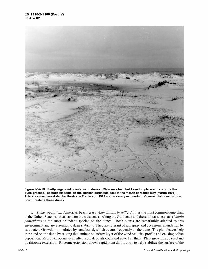
(6) Blowouts. Hollows or troughs cut into dunes; may be caused when vehicles or pedestrians damagevegetation (Figure IV-2-12).
(7) Attached dunes. Formations of sand that have accumulated around obstacles such as rocks(Figure IV-2-13).
h. Shoreline protection. In many areas, dunes serve a vital role in protecting inland areas from stormsurges and wave attack. As a result, many communities require that buildings be erected behind the dunesor beyond a certain distance (a setback) from an established coastline. Unfortunately, the protection isephemeral because severe storms can overtop and erode the dunes, and changes in sediment supply or localwind patterns (sometimes caused by structures and urban development) can leave them sand-starved. If dunesare cut for roads or for walkways, they become particularly vulnerable to erosion. However, compared withhard structures like seawalls, many communities prefer the protection provided by dunes because of aestheticconsiderations.
i. Dune restoration. Historically, sand dunes have suffered from human pressure, and many dunesystems have been irreversibly altered by man, both by accident or design. Many coastal areas in Europe,North America, Australia, and South Africa, which had once-stable forested dunes, have been deforested.The early settlers to New England in the 1600's severely damaged the dune vegetation almost immediatelyupon their arrival by overgrazing and farming. Dune rebuilding and revegetation have had a long history,mostly unsuccessful (Goldsmith 1985). Recent restoration practices have been more effective (Knutson 1976,1978; Woodhouse 1978). The two main methods for rebuilding or creating coastal dunes are artificial plant-ing and erecting sand fences. Hotta, Kraus, and Horikawa (1991) review sand fence performance.

EM 1110-2-1100 (Part IV)30 Apr 02
IV-2-18 Coastal Classification and Morphology
Figure IV-2-11. Variety of dune types (adapted from Carter (1988), Reading (1986), and Flint (1971))
EM 1110-2-1100 (Part IV)30 Apr 02
Coastal Classification and Morphology IV-2-19
Figure IV-2-12. Blowout in dunes. Eastern Alabama on the Morgan peninsula east of the mouth of MobileBay (April 1995)
Figure IV-2-13. Huge dune anchored to a rock outcrop in the eastern Sinai Desert (January 1979). The duneis more than 15 m high. Most of valley floor is hard-packed sand, although there are pockets of loose sandthat impede vehicle traffic. As of 1979, many of the bedouins in this area were already using pickup trucksinstead of camels

EM 1110-2-1100 (Part IV)30 Apr 02
IV-2-20 Coastal Classification and Morphology
Coastal dune management and conservation practices are reviewed in Carter, Curtis, and Sheehy-Skeffington(1992).
IV-2-7. Volcanic Coasts
a. Introduction and definitions. Volcanoes are vents in the earth’s surface through which magma andassociated gases and ash erupt (Bates and Jackson 1984). Often, conical mountains are formed around thevents as repeated eruptions deposit layer upon layer of rock and ash. Therefore, the definition is extendedto include the hill or mountain built up around the opening by the accumulation of rock materials.
(1) The fundamental importance of volcanism to mankind has been clearly documented around the world.The entire west coast of the Unites States is highly active tectonically and most of the continent’s volcanoesare within 200 km of the coast. There are more than 260 distinct volcanoes younger than five million yearsin the Unites States and Canada, most of which are in Alaska and the Hawaiian Islands (Wood and Kienle1990). Fifty-four have erupted in historic times, and distant memories of others are recounted in NativeAmerican legends.
(2) Volcanoes are important to coastal studies for many reasons:
(a) They provide sediment to the littoral environment. Material may reach the coast directly via ash fall-out and lava flows or may be transported by rivers from an inland source (e.g., Mount St. Helens).
(b) Vulcanism affects coastal tectonics (e.g., west coasts of North and South America).
(c) Shoreline geometry is affected by the formation of volcanic islands (Aleutians) and by lava that flowsinto the sea (Hawaiian Islands).
(d) Shoreline erodability ranges from very erodable for ash and unconsolidated pyroclastic rubble to veryresistant for basalt.
(e) Volcanoes can pose a serious threat to coastal communities.
(f) Volcanic debris can choke rivers and harbors.
(3) This section briefly discusses general concepts of volcanism and describes features unique to volcanicshores. Examples from Alaska and the Hawaiian Islands illustrate the differences between composite andshield volcanoes and their associated coastlines. For the general reader, Exploring our Living Planet,published by the National Geographic Society (Ballard 1983), is a readable and interesting introduction toplate tectonics, hotspots, and volcanism.
b. General geology. Two classes of volcanoes can be identified, based on the explosiveness of theireruptions and composition of their lava. The ones in the Aleutians and along the west coasts of North andSouth America are known as composite volcanoes and are renowned for their violent eruptions. Theparoxysmal explosion of Mount St. Helens on May 18, 1980, which triggered devastating mudflows andfloods, killing 64 people, serves as a remarkable example. Composite eruptions produce large amounts ofexplosive gas and ash and build classic, high-pointed, conic mountains. In contrast, the Hawaiian Islands areshield volcanoes: broad, low, basalt masses of enormous volume. Shield eruptions are typically

EM 1110-2-1100 (Part IV)30 Apr 02
1 Lava is the term used for molten rock (and gasses within the liquid) that have erupted onto the earth’s surface. Magma refers to molten rock that is still underground.
Coastal Classification and Morphology IV-2-21
nonexplosive, and the highly liquid nature of their lava1 accounts for the wide, low shape of the mountains.Volcanism affects the shore on two levels:
(1) The large-scale geologic setting of the continental margin affects sedimentation and overall coastalgeology. Margins subject to active tectonism (and volcanism) are typically steep, with deep water occurringclose to shore. Rocks are often young. High mountains close to shore provide a large supply of coarse sedi-ments, and muddy shores are rare. Much sediment may be lost to deep water, particularly if it is funneleddown submarine canyons. This is a one-way process, and the sediment is permanently lost to the coastalzone.
(2) Small-scale structures on volcanic shores may differ from those on clastic passive margins. Sedimentsupply may be frequently renewed from recent eruptions and may range greatly in size. Ash may be quicklydestroyed in the sea, while basalt boulders may be tremendously resistant. Hardened shores at the sites ofrecent lava flows are difficult settings for harbor construction.
c. Composite volcanoes - coastal Alaska. The coastal geology of Alaska is incredibly complex, havingbeen shaped by fault tectonics, volcanism, glaciation, fluvial processes, sea level changes, and annual sea ice.More than 80 volcanoes have been named in the Aleutian arc, which extends for 2,500 km along the southernedge of the Bering Sea and the Alaskan mainland (Wood and Kienle 1990). Over 44 have erupted, somerepeatedly, since 1741, when written records began. Aleutian arc volcanism is the result of the activesubduction of the Pacific Plate beneath the North America Plate (Figure IV-2-14).
(1) Volcanoes have influenced the Aleutian Arc in two ways. First, they have been constructive agents,creating islands as eruption after eruption has vented rock and ash. In some places, fresh lava or mudflowsaccompanying eruptions have buried the existing coast, extending the shore seaward. The eruptions of Mts.Katmai and Novarupta in 1912 produced ash layers 3 to 15 m thick. The Katmai River and Soluka Creekcarried vast amounts of loose ash to the sea, filling a narrow bay and burying a series of old beach ridges(Shepard and Wanless 1971). Usually, loose mudflow and ash deposits are reworked rapidly by waves,providing sediment for beach development. In addition, for years after an eruption, streams may carry rockand ash to the coast, allowing the coast to locally prograde. The second effect has been destructive, and smallislands have been largely destroyed by volcanic explosions. Bogoslof, in the eastern Aleutians, is an examplein which both rapid construction and destruction have influenced the island’s shape over time (Shepard andWanless 1971).
(2) Clearly, a history of volcanic instability would be a major consideration for a coastal engineerplanning a harbor or project. Most new volcanic islands are uninhabited, but harbors may be needed forrefuge, military, or commercial purposes. During World War II, air fields and harbors were built quickly onformerly uninhabited Aleutian Islands. Some islands can supply stone for construction at other locations,requiring loading facilities for boats or barges.
d. Shield volcanoes - Hawaii. Each of the Hawaiian islands is made up of one or more huge shieldvolcanoes rising from the ocean floor. The islands are at the southern end of a chain of seamounts thatextends 3,400 km to the northwest and then turns north and extends another 2,300 km toward Kamchatka asthe Emperor Seamounts. More than 100 volcanoes, representing a volume of greater than one million cubickilometers, make the Hawaiian-Emperor chain the most massive single source of volcanic eruption on earth(Wood and Kienle 1990). The submerged seamounts become successively older away from Hawaii.

EM 1110-2-1100 (Part IV)30 Apr 02
IV-2-22 Coastal Classification and Morphology
Figu
re IV
-2-1
4. A
lask
an v
olca
noes
alo
ng th
e A
leut
ian
Isla
nd a
rc, m
arki
ng th
e bo
unda
ry b
etw
een
the
Nor
th A
mer
ican
and
the
Paci
fic c
rust
al p
late
s.
Arr
ows
indi
cate
sub
duct
ion
of th
e Pa
cific
Pla
te in
cm
/yea
r

EM 1110-2-1100 (Part IV)30 Apr 02
Coastal Classification and Morphology IV-2-23
Meiji Seamount, about to be subducted beneath Kamchatka, is 75-80 million years (my) old, Kilauea is only0.4 my, while Loihi Seamount, south of the big island of Hawaii, is the newest member of the chain and hasnot yet emerged from the sea. The islands are found over a semipermanent “hot spot,” a site where it isbelieved that a plume of hot, geochemically primitive material rises convectively through the mantle, interactswith the lithosphere, and vents on the seafloor (Dalrymple, Silver, and Jackson 1973). The Pacific plate ispostulated to be moving over the hot spot at a rate of about 13 cm/yr, based on ages of the major vents onHawaii (Moore and Clague 1992).
(1) Although the coastlines of the Hawaiian Islands are geologically young, wave erosion and the growthof coral reefs have modified most of the shores. Coastal plains have formed around the base of some volca-noes and between others (for example, the intermontaine plateau between Koolau and Waianae on Oahu).The plains are partly alluvial and partly raised reefs (Shepard and Wanless 1971). The greater parts of theHawaiian coasts are sea cliffs, some as high as 1,000 m on the windward sides of the islands. There are alsoextensive beaches, the best of which tend to be on the western sides of the islands, protected from wavesgenerated by the northeast trade winds. On southwestern Kauai near Kekaha, there are prograding beachridges. Surprisingly, most of the beaches are composed not of volcanic debris but primarily of biogenic sedi-ment. The rare volcanic sand beaches are found at the mouths of the larger rivers or along coasts whererecent lava flows have killed the coral reefs (Shepard and Wanless 1971). Many beaches are undergoing seri-ous erosion, and finding suitable sources of sand for renourishment has been difficult. This is a critical prob-lem because tourism is a major part of the Hawaiian economy, and the beaches are among the greatattractions.
(2) An example from the island of Hawaii helps illustrate the rugged nature of these volcanic shores.Hawaii, at the southeast end of the island chain, has been built up from at least seven independent volcanoes(Moore and Clague 1992). Mauna Loa, a huge dome at the southern end of the island, rises to 4,100 m abovethe sea (8,500 m above the seafloor). Kilauea, a low dome that rises out of the southeast side of Mauna Loa,has had a remarkable history of eruptions since 1800. Because of the porosity of the lavas, few permanentstreams flow down the island, although rainfall on the windward side is heavy. The southeast coast of theisland is a barren, rugged rock shore built up from hundreds of Kilauea lava flows (Figure IV-2-15). InFigure IV-2-15, the foreground is cracked, barren basalt, while the plateau in the background supports a coverof grass. The vertical cliffs are about 10 m high and in areas have been notched or undercut by the surf.Small steep pocket beaches consisting of black volcanic sands have developed in some notches. Because ofthe harsh wave climate and tectonic instability, coastal engineering in the Hawaiian Islands is particularlychallenging (Figure IV-2-16).
e. Hazards posed by volcanoes.
(1) Introduction. Coastal projects and communities are subject to four general types of hazards causedby volcanic eruptions:
(a) Explosion-generated tsunamis that can flood coastal areas.
(b) Direct burial by lava or ash (recently experienced in Hawaii, Iceland, and Sicily).
(c) Burial or disruption by mudflows and fluvial sediment from inland eruptions, and changes in streamdrainage and coastal sediment-discharge patterns.
(d) Loss of life and destruction from explosions.

EM 1110-2-1100 (Part IV)30 Apr 02
IV-2-24 Coastal Classification and Morphology
Figure IV-2-15. Southeast coast of Hawaii, near Kalpana. Rugged cliffs are built up of many lava flows. Small pocket beaches form between headlands when the cliffs are undermined and loose sedimentaccumulates
Volcanoes seem a remote hazard to most people, but the danger is imminent and real to those who livein certain parts of the earth, especially along the boundaries of the earth’s tectonic plates. Fortunately, fewerthan 100 people have been killed by eruptions in Hawaii, where the volcanism is less explosive (Tilling,Heliker, and Wright 1987).
(2) Earthquakes and tsunamis.
(a) Tsunamis are waves created by ocean-bottom earthquakes, submarine landslides, and volcanic explo-sions. These long-period waves can travel across entire oceans at speeds exceeding 800 km/hr, causingextensive damage to coastal areas. The cataclysmic explosion of Krakatau on August 27, 1883, generatedwaves 30 m high that swept across the Sunda Strait, killing 36,000 coastal villagers on Java and Sumatra.One explosion produced one of the loudest noises in history, which was heard at a distance of 4800 km. TheHawaiian islands are particularly vulnerable to tsunamis caused by disturbances around the Pacific rim. Thetsunami of April 1, 1946, generated towering walls of water that swept inland, damaging many coastalstructures on the islands. In areas, the water rose to 16 m above the normal sea level. Photographs of thewaves and the resulting damage are printed in Shepard and Wanless (1971) (Francis Shepard was living onOahu at the time and vividly describes how the waves smashed his bungalow, forcing him and his wife to fleefor their lives). On July 17, 1998, a wall of water 7 m high hit the northwest coast of Papua, New Guineawithout warning, following a 7.0 magnitude earthquake about 30 km off the coast in the Pacific Ocean. Some6,000 villagers perished in this tragedy.

EM 1110-2-1100 (Part IV)30 Apr 02
Coastal Classification and Morphology IV-2-25
Figure IV-2-16. Laupahoehoe Harbor, Island of Hawaii, Hawaii. Found on the steep and rugged northeastcoast of Hawaii, this harbor provides the only access to the fertile Hamakua coast fishing grounds. This is ahostile environment, as shown by the basalt boulders tossed onto the boat ramp by storm waves
(b) Clearly, there is little that can be done to protect against the random and unpredictable tsunamis. Awarning network has been established to notify people around the Pacific of earthquakes and the possibilitythat destructive waves may follow. Coastal residents are urged to heed these warnings!
(3) Ash and fluvial sediment. When Mount St. Helens exploded on May 18, 1980, 390 m of the top ofthe mountain was blown off, spewing a cloud of dust and ash high into the stratosphere. From its north flank,an avalanche of hot debris and scalding gasses created immense mudflows, burying the upper 24 km of theNorth Toutle valley to a depth of 50 m. Lahars, formed from dewatering of the debris avalanche, blockedthe shipping channel of the Columbia River. This created an enormous dredging task for the U.S. ArmyCorps of Engineers, and ultimately much of the dredged material had to be disposed at sea. Dredging relatedto the explosion continues 18 years after the eruption, as material continues to move downstream frommountain watersheds.
(4) Explosive destruction. Communities close to volcanoes may be destroyed by the explosion and theinhabitants killed by poisonous gasses and superheated steam.
(a) The coastal example frequently cited is the destruction of St. Pierre on Martinique by the violentexplosion of Montagne Pelée on May 8, 1902. A glowing cloud overran St. Pierre and spread fan-like overthe harbor. Practically instantly, the population of more than 30,000 was smothered with toxic gas andincinerated (Bullard 1962).

EM 1110-2-1100 (Part IV)30 Apr 02
IV-2-26 Coastal Classification and Morphology
(b) The cloud that destroyed St. Pierre consisted of superheated steam filled with even hotter dustparticles, traveling more than 160 km/hr. The term nuée ardente is now used to describe this type of swiftlyflowing, gaseous, dense, incandescent emulsion. It is also used as a synonym for the Peléan type of eruption.
IV-2-8. Sea Cliffs - Diastrophic, Erosional, and Volcanic
a. Sea cliffs are the most spectacular geomorphic features found along the world’s coastlines. Thissection concentrates on bedrock cliffs, with bedrock defined as “the solid rock that underlies gravel, soil, orother superficial material” (Bates and Jackson 1984). Bedrock cliffs are found along most of the U.S. andCanadian Pacific coast, in Hawaii, along the Great Lakes shores, and in Maine. South of Maine along theAtlantic coast, cliffs are rare except for some examples in New Hampshire, Massachusetts, and Rhode Island.The eastern end of Long Island, Montauk Point, consists of rapidly eroding till bluffs (Figure IV-2-9). Cliffsconstitute portions of the coastlines of Spain, Italy, Greece, Turkey, Iceland, and the South American nationsfacing the Pacific Ocean. Shorelines with cliffs may be both emergent or submergent. For more information,Trenhaile’s (1987) The Geomorphology of Rock Coasts presents a comprehensive and global review of cliffs,shore platforms, and erosion and weathering processes.
b. Bedrock cliffs are composed of all three major rock types: igneous, sedimentary, and metamorphic.
(1) Intrusive igneous rock, such as granite, cools and solidifies beneath the earth’s surface, whileextrusive igneous rock, such as basalt, is formed by lava above ground (it may erupt underwater or on land).Usually, igneous rocks are highly resistant; however, two properties affect their susceptibility to weatheringand erosion (de Blij and Muller 1993):
(a) Jointing is the tendency of rocks to develop parallel sets of fractures without obvious externalmovement like faulting.
(b) Exfoliation, caused by the release of confining pressure, is a type of jointing which occurs inconcentric shells around a rock mass.
(2) Sedimentary rock results from the deposition and lithification (compaction and cementation) ofmineral grains derived from other rocks (de Blij and Muller 1993). This category also includes rock createdby precipitation (usually limestone).
(a) The particles (clasts) that make up clastic sedimentary rock can range in size from windblown dustto waterborne cobbles and boulders. The vast majority of sedimentary rocks are clastic. Common examplesinclude sandstone, composed of lithified sand (usually consisting mostly of quartz), and shale, made fromcompacted mud (clay minerals). Many cliffs along the south shore of Lake Erie are shale.
(b) Nonclastic sedimentary rocks are formed by precipitation of chemical elements from solution inmarine and freshwater bodies because of evaporation and other physical and biological processes. The mostcommon nonclastic rock is limestone, composed of calcium carbonate (CaCO3) precipitated from seawaterby marine organisms (and sometimes also incorporating marine shell fragments). Many of the Mediterraneancliffs are limestone and are very vulnerable to dissolution.
(3) Metamorphic rocks are preexisting rocks changed by heat and pressure during burial or by contactwith hot rock masses. Common examples include:

EM 1110-2-1100 (Part IV)30 Apr 02
Coastal Classification and Morphology IV-2-27
(a) Quartzite, a very hard, weathering-resistant rock, formed from quartz grains and silica cement.
(b) Marble, a fine-grained, usually light-colored rock formed from limestone.
(c) Slate, a rock that breaks along parallel planes, metamorphosed from shale.
c. Sea cliffs are formed by three general processes:
(1) Volcanic eruptions and uplift caused by local volcanism (discussed in paragraph IV-2-7).
(2) Diastrophic activity that produces vertical movement of blocks of the crust.
(3) Erosional shorelines - partial drowning of steep slopes in hilly and mountainous terrain and resultingerosion and removal of sediment.
d. Sea cliffs, often found on tectonically active coasts, may be created by two mechanisms. First, if ablock of the coast drops, a newly exposed fault plane may be exposed to the sea. The opposite processmay occur: a block may be uplifted along a fault plane, exposing a formerly exposed portion of the shorefaceto marine erosion. Older cliffs may be raised above sea level and be temporarily protected from furthererosion. Earlier shorelines, sometimes tens of meters above the present sea level, are marked by notches orwave-cut platforms (sometimes termed uplifted marine terraces) (Figure IV-2-17). Terraces marking thehighstand of eustatic (absolute) sea level have been traced around the world. Deep water is often foundimmediately offshore of faulted coasts. Cliffs that extend steeply into deep water are known as plungingcliffs.
e. Erosional coasts may be straight or may be irregular, with deeply indented bays. The way the shorereacts to inundation and subsequent marine erosion depends on both the wave climate and the rock type.
(1) Wave-straightened coasts. Cliffs are often found along shores where wave erosion rather thandeposition is the dominant coastal process. Exposed bedrock, high relief, steep slopes, and deep water aretypical features of erosional shorelines (de Blij and Muller 1993). When islands are present, they are likelyto be remnants of the retreating coast rather than sandy accumulations being deposited in shallow water. Thesequence of events that create a straightened coast are illustrated in Figure IV-2-18. The original coastlineincludes headlands and embayments (a). As waves attack the shore, the headlands are eroded, producingsteep sea cliffs (b). The waves vigorously attack the portion of the cliff near sea level, where joints, fissures,and softer strata are especially vulnerable. The cliffs are undermined and caves are formed. Pocket beachesmay accumulate between headlands from sediment carried by longshore currents. Especially durablepinnacles of rock may survive offshore as stacks or arches. Over time, the coast is straightened as the head-lands are eroded back (c).
(a) Beaches. Beaches may form at the base of cliffs if the rubble that has fallen from the cliff face(known as talus) is unconsolidated or friable and breaks down rapidly under wave attack (Figures IV-2-9 andIV-2-15). If the rock debris is durable, it may serve to armor the shore, protecting it from further wave attackexcept during the most severe storms.
(b) Wave-cut platforms. At the base of cliffs that have been progressively cut back by waves, near-horizontal platforms may form just below sea level. These rocky platforms may be of substantial width,depending on lithology and the time that sea level has been at that height (Figure IV-2-17). The platformsmay be clean or may be covered with rubble fallen from the adjacent cliffs.

EM 1110-2-1100 (Part IV)30 Apr 02
IV-2-28 Coastal Classification and Morphology
Figure IV-2-17. Wave-cut platform exposed by tectonicuplift. Sediment that accumulated on the platform maytemporarily protect the cliff from further erosion
(2) Creation of irregular shorelines. In some mountainous terrains, rising sea level results in deeplyincised coastlines. This process is illustrated in Figure IV-2-19. As the sea rises, a river valley is inundated.Once exposed to the sea, the new shoreline is subject to dissolution and biological attack. In southern France,Italy, Greece, and Turkey, thousands of deep embayments are found in the coastal limestone hills. The factthat the wave climate in the Mediterranean is relatively calm (compared with the open oceans) suggests thaterosional processes other than wave attack have been instrumental in creating these steep, indented shores.An irregular shore may also be formed when differing rock types outcrop at the coast. Massive rocks,especially igneous and metamorphic ones, withstand erosion better than most sedimentary rocks, which areusually friable and contain bedding planes and fractures. The Pacific coast of Washington off the OlympicPeninsula is irregular because of the complex geology and variety of exposed rock formations (Figure IV-2-20).
e. Marine cliffs are degraded by many physical and biological factors.
(1) Wave attack is most likely the primary mechanism that causes cliffs to erode (Komar 1976). Thehydraulic pressure exerted by wave impact reaches values sufficient to fracture the rock. Sand and rockfragments hurled at the cliff by waves grind away at the surface. Komar (1976) states that wave erosionoccurs chiefly during storms, but admits that little quantitative research has been conducted. Once a cliff hasbeen undercut at its base, the overlying rock, left unsupported, may collapse and slide down to the shoreline(Figures III-5-21, IV-2-21, and IV-2-22). Temporarily, the talus protects the cliff, but over time the rubbleis reduced and carried away, leaving the fresh cliff face exposed to renewed wave attack.

EM 1110-2-1100 (Part IV)30 Apr 02
Coastal Classification and Morphology IV-2-29
Figure IV-2-18. Wave erosion of an indented coastline produces a straightened, cliff-bound coast. Wave-cutplatforms and isolated stacks and arches may remain offshore. Many such features are found along theWashington, Oregon, and California coast (adapted from de Blij and Muller (1993))
EM 1110-2-1100 (Part IV)30 Apr 02
IV-2-30 Coastal Classification and Morphology
Figure IV-2-19. Inundation of a mountainous area by rising sea level or land subsidence produces a deeplyindented shoreline

EM 1110-2-1100 (Part IV)30 Apr 02
Coastal Classification and Morphology IV-2-31
Figure IV-2-20. Pacific Ocean coast of Olympic Peninsula, Washington, near Jefferson Cove (September1971). Rugged shore consists of resistant rock headlands with pocket beaches. Much of the beachsediment is cobble and coarse clasts derived from the adjacent cliffs. The beaches are often covered withlogs and driftwood
(2) In addition to waves, weathering processes weaken and crumble sea cliffs. Ice wedging in cold cli-mates progressively weakens the rock. Plant roots grow and expand in cracks. Lichens secrete acids that etchthe rock surface. Groundwater can lubricate impermeable rock surfaces, upon which large masses ofoverlying rock can slip. This process is responsible for large slumps in the shale bluffs in Lakes Erie andOntario (Figure III-5-21).
(3) Mollusks and burrowing animals can weaken otherwise resistant massive rocks. Komar (1976)lists burrowing mollusks such as Pholadidae and Lithophaga, and periwinkles, worms, barnacles,sponges, and sea urchins as having been observed to erode rock. Boring algae can also weaken rock(Figure IV-2-23).
(4) Under normal circumstances, surface seawater is saturated with calcium carbonate (CaCO3), thereforeminimizing dissolution of limestone or CaCO3-cemented sediments. Marine organisms can locally increasethe acidity of the water in high-tide rock basins and other protected locations. Small pockets found

EM 1110-2-1100 (Part IV)30 Apr 02
IV-2-32 Coastal Classification and Morphology
Figure IV-2-21. A section of cliff, projecting out from the shore, is likely to collapse soon. To the left, rubbleat sea level marks the location of a previous slump. The lower cliffs are poorly cemented conglomerate whilethe higher, vertical cliffs (above the trees), are limestone (near Nauplió, Greece, April 1992)
at water’s edge, often housing periwinkles and other animals, may have been caused by biochemical leaching.
(5) Salt weathering is caused by the pressure exerted by NaCl and other salts in the capillaries of rocks.The weathering is caused by:
(a) Changes of volume induced by hydration.
(b) Expansion of salt crystals caused by temperature changes.
(c) Crystal growth from solution.
The main factor in determining the efficacy of chemical weathering is the amount of water available forchemical reactions and the removal of soluble products. This suggests, but does not necessarily restrict, thatthe greatest chemical weathering will occur in hot, humid climates (Trenhaile 1987).
IV-2-9. Marine Deposition Coasts - Barriers
a. Introduction.
(1) Barriers are narrow, elongate sand ridges rising slightly above the high tide level and extendinggenerally parallel with the coast, but separated from the mainland by a lagoon or marsh (Bates and Jackson

EM 1110-2-1100 (Part IV)30 Apr 02
Coastal Classification and Morphology IV-2-33
Figure IV-2-22. Lake Michigan shore south of St. Joseph, Michigan (November 1993). A triangle-shapedwedge of the bluff has recently slumped. The bluffs in this area have suffered rapid retreat, and many homeshave been destroyed. At least three factors account for the erosion: (a) offshore downcutting of the till lakebottom; (b) wave attack on the bluffs; (c) ice expansion and lubrication of bedding planes caused bygroundwater
1984). The term barrier identifies the sand ridges as ones that protect parts of the coast from direct waveattack of the open ocean. In this manual, barrier will refer to the overall structure (sometimes called a barriercomplex), which includes the beach, submerged nearshore features, underlying sediments, and the lagoonbetween the barrier and the mainland (Figure IV-2-24). Inlets and channels can also be considered part ofa barrier system.
(2) The term beach is sometimes used as a synonym for barrier, but this can lead to confusion becausea beach is a geomorphic shore type found throughout the world, even on volcanic or coralline coastlineswhere barriers are rare. Whereas all barriers include beaches, not all beaches are barriers.
(3) The following sections describe general barrier island morphology, history, and formation, subjectsthat have fascinated geologists for more than 100 years. The emphasis will be on long-term changes,covering periods of years or centuries. The purpose is to explain factors that lead to barrier migration orevolution. Longshore sediment transport, details on the morphology of sandy shorefaces, and the normaleffects of waves and tides will be covered in Part IV-3, “Coastal Morphodynamics.” This distinction isarbitrary because, clearly, the day-to-day processes that affect beaches also influence barrier development.In addition, the evolution of barriers during the Holocene Epoch is intimately related to sea level changes (seePart IV-1). These factors underscore the complex interrelationships that exist throughout the coastal zoneand the difficulty of separating the constituent elements.

EM 1110-2-1100 (Part IV)30 Apr 02
IV-2-34 Coastal Classification and Morphology
Figure IV-2-23. Cemented conglomerate with many pits and cavities shows evidence of dissolution. Therock mass has been undercut over 1 m (near Nauplió, Greece). Note that the conglomerate is distinctlygraded, with fine grains near the bottom and cobble near the top

EM 1110-2-1100 (Part IV)30 Apr 02
Coastal Classification and Morphology IV-2-35
Figure IV-2-24. A three-dimensional view of features commonly found in barrier island systems, includingthe back barrier, overwash fans, and lagoons. The lagoons often become estuaries, particularly if sedimentis supplied by both rivers and inlets
(4) The long-term and widespread interest in barrier islands is largely due to their great economicimportance. Ancient buried barriers are important petroleum reservoirs. Contemporary barriers protectlagoons and estuaries, which are the breeding grounds for many marine species and birds. In addition, barrierislands are among the most important recreational and residential regions. In recent years, man’s adverseimpact on these fragile ecological and geological environments has led to increased need to study their originsand development to improve coastal management and preserve these critical resources for the future.
(5) An enormous literature on barrier islands exists. Nummedal (1983) provides a readable and conciseoverview. Leatherman’s (1979) book is a compilation of papers on U.S. east coast and Gulf of Mexicobarriers. Many seminal papers on barrier island evolution have been reprinted in Schwartz (1973).Textbooks by Carter (1988), Davis (1985), King (1972a), and Komar (1976) discuss barriers and includevoluminous reference lists. Classic papers on beach processes have been reprinted in Fisher and Dolan(1977).

EM 1110-2-1100 (Part IV)30 Apr 02
1 The trailing edge of a continent is moving away from an active spreading center. For example, the Atlantic coastof the United States is a trailing edge because new seafloor is being formed along the mid-Atlantic ridge, causingthe Atlantic Ocean to grow wider (Figure IV-1-2). The Pacific coast is a leading edge because the oceanic platesare being subducted (consumed) at various trenches and are therefore becoming smaller.
IV-2-36 Coastal Classification and Morphology
b. Distribution of barrier coasts. Barrier islands are found around the world (Table IV-2-2). They aremost common on the trailing edges of the migrating continental plates (Inman and Nordstrom 1971)1. Thistype of plate boundary is usually non-mountainous, with wide continental shelves and coastal plains. Over17 percent of the North American coastline is barrier, most of it along the eastern seaboard facing the AtlanticOcean and the Gulf of Mexico. Table IV-2-3 lists the lengths of barriers and spits in the United States. Ofthe Atlantic states, Maine and New Hampshire have the fewest barriers because their coasts are largelycomposed of igneous rock. Massachusetts, with mostly glacial moraines and outwash along the coast, hasthe surprising total of 184 km of spits and barriers. Of the continental states, Florida has the most barriersand spits, totaling over 1,000 km for both the Atlantic and the Gulf of Mexico. Most of the shorelines facingthe Gulf of Mexico consist of barrier islands. A portion of Florida’s west coast, where wave energy is low,is mangrove swamp, but the Panhandle is famous for its glistening white barriers.
Table IV-2-2Worldwide Distribution of Barrier Island Coasts
Continent Barrier Length (km) % of World Total Barriers% of Continent’s Coastlinethat is Barrier
N. America
Europe
S. America
Africa
Australia
Asia
Total
10,765
2,693
3,302
5,984
2,168
7,126
32,038
33.6
8.4
10.3
18.7
6.8
22.2
100.0
17.6
5.3
12.2
17.9
11.4
13.8
From Cromwell (1971)
Almost the entire shore of Texas consists of long barriers, which continue south into Mexico. Extensivebarriers are also found on the Gulf of Alaska north of Bering Strait. Including numerous spits in the Aleutiansand the Gulf of Alaska, the state of Alaska has almost 1,300 km of barrier in total, exceeding Florida. TheUnited States total shown in Table IV-2-3 is 4,882 km, about half the North American total computed byCromwell (1971). For more information, the most extensive survey of United States barriers was documentedin the Report to Congress: Coastal Barrier Resources System (Coastal Barriers Study Group 1988).
c. General coastal barrier structure. The barrier shore type covers a broad range of sizes andvariations. Three general classes of barrier structures can be identified (Figure IV-2-25):
(1) Bay barriers - connected to headlands at both ends and enclosing a bay or wetland.
(2) Spits - attached to a sediment source and growing downdrift. May be converted to a barrier islandif a storm cuts an inlet across the spit. May evolve into bay barriers if they attach to another headland andcompletely enclose a lagoon.

EM 1110-2-1100 (Part IV)30 Apr 02
Coastal Classification and Morphology IV-2-37
Table IV-2-3Barrier Islands and Spits of the United States
Ocean or Sea State Total Length (km)1
Atlantic Maine 11.4
New Hampshire 2.5
Massachusetts 2 184.4
Rhode Island 3 17.6
New York 4 152.2
New Jersey 106.0
Delaware 5 33.7
Maryland 5 49.2
Virginia 5 126.0
North Carolina 380.7
South Carolina 234.2
Georgia 159.0
Florida 533.3
Atlantic coast total 1990
Gulf of Mexico Florida 478.5
Alabama 92.7
Mississippi 59.5
Louisiana 151.9
Texas 498.0
Gulf of Mexico total 1281
Pacific - Continental USA Washington 6 63.9
Oregon 91.9
California 65.4
Pacific total 221
Beaufort, Chukchi, Bering Seas, Gulfof Alaska, Bristol Bay
Alaska total (incl. Aleutians) 1266
Lakes Superior, Huron, Michigan,Ontario, Erie
Combined Great Lakes states 124
United States total 2,3,4,5,6 4882
Source: Unpublished data generated during the Corps of Engineers’ Barrier Island Sediment Study (BISS), 1989. 1 Length of barriers measured from U.S. Geological Survey topographic maps. Includes barriers and spits enclosing a body ofwater or marsh, not the total length of beaches in the United States. No data available for Puerto Rico, Virgin Islands, PacificTrust Territories.2 Includes Nantucket and Martha’s Vineyard Islands.3 Does not include Narragansett Bay.4 Atlantic Ocean only; does not include spits in Long Island Sound or Great Peconic Bay.5 Does not include Chesapeake Bay.6 Includes spits in Strait of Juan de Fuca. Does not include Long Beach Peninsula, enclosing Willapa Bay.

EM 1110-2-1100 (Part IV)30 Apr 02
IV-2-38 Coastal Classification and Morphology
Figu
re IV
-2-2
5. G
ener
al b
arrie
r typ
es:
bay,
spi
t, an
d is
land

EM 1110-2-1100 (Part IV)30 Apr 02
Coastal Classification and Morphology IV-2-39
(3) Barrier islands - linear islands that are not attached to the mainland but that enclose a bay, pond, ormarsh/wetland. A series of these islands extending along the coast are defined as a barrier chain.
d. Origin and evolution. The origin of barrier islands has been a topic of debate among geologists forover a century (Schwartz 1973). The differing theories suggest that there are probably several types ofbarriers, each undergoing its own form of development due to unique physical and geologic factors. Threemain theories have evolved, all of which have fierce supporters and critics.
(1) Emergence model. De Beaumont in 1845 was the first naturalist formally to present a theory ofbarrier island formation. It was supported and modified by the influential Johnson (1919). These researcherstheorized that barrier emergence began with the formation of an offshore sand shoal, which consisted of mate-rial reworked from the seafloor by waves. Over time, the shoal would accumulate ever more sand and growvertically, eventually emerging above the sea surface (Figure IV-2-26). Wave swash and wind depositionwould continue to contribute sand to the shoal, allowing it to grow larger and larger. Hoyt (1967) objectedto this hypothesis because he was unaware of any examples of bars emerging above water and surviving waveaction, although the growth of submerged bars was well-recorded. Otvos (1970) reported evidence from theGulf coast supporting the emergence of submarine shoals (he conveniently noted that subsequent migrationof barriers might completely obscure the conditions of formation of the original barrier).
(2) Submergence model. The submergence concept was refined by Hoyt (1967) and has received muchsupport. In this model, the initial physical setting is a mainland beach-and-dune complex with a marshseparating the beach from higher terrain inland. Rising sea level floods the marsh, creating a lagoon thatseparates the beach from the mainland (Figure IV-2-27). Presumably, usually the sea level rise is part of aworldwide pattern (eustatic), but it may be caused in part by local submergence. Once formed, maintenanceof the barrier becomes a balance of sediment supply, rate of submergence, and hydrodynamic factors.
(3) Spit detachment model. The third major model calls for the growth of sandspits due to erosion ofheadlands and longshore sediment transport (Figure IV-2-28). Periodically, the spit may be breached duringstorms. The furthest portion of the spit then becomes a detached barrier island, separated by a tidal inlet fromthe portion that is still attached to the mainland. Gilbert (1885) may have been the first geologist to suggestthe spit hypothesis, based on his studies of ancient Lake Bonneville, but the hypothesis lay dormant for manyyears because of Johnson’s (1919) objections. In recent years, it has received renewed support because thecycle of spit growth and breaching can be seen in many locations (for example, at Cape Cod, Massachusetts(Giese 1988)).
(4) Combined origin model. Schwartz (1971) concluded that barrier island formation is most probablya combination of all of the above mechanisms. He felt that only a few examples of barriers could be citedas having been formed by only one method. Most systems were much more complex, as demonstrated bythe barriers of southern Louisiana, which were formed by a combination of submergence and spit detachment(Penland and Boyd 1981).
e. Barrier response to rising sea level.
(1) Many of the barriers in the United States, particularly along the Atlantic coast, are eroding, causingserious economic and management challenges. What is responsible for this erosion?
(2) Sea level and sediment availability are probably the major factors that determine barrier evolution(Carter 1988). Three sea level conditions are possible: rising, falling, and stationary. Rising and falling sea
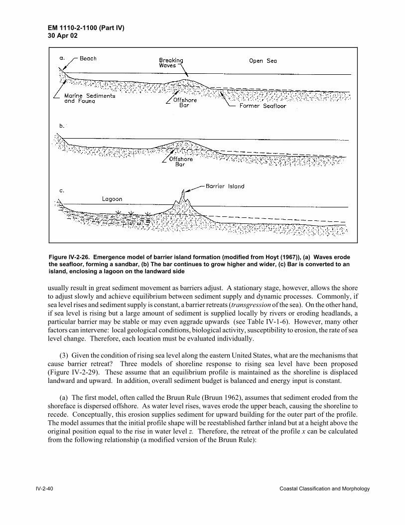
EM 1110-2-1100 (Part IV)30 Apr 02
IV-2-40 Coastal Classification and Morphology
Figure IV-2-26. Emergence model of barrier island formation (modified from Hoyt (1967)), (a) Waves erodethe seafloor, forming a sandbar, (b) The bar continues to grow higher and wider, (c) Bar is converted to anisland, enclosing a lagoon on the landward side
usually result in great sediment movement as barriers adjust. A stationary stage, however, allows the shoreto adjust slowly and achieve equilibrium between sediment supply and dynamic processes. Commonly, ifsea level rises and sediment supply is constant, a barrier retreats (transgression of the sea). On the other hand,if sea level is rising but a large amount of sediment is supplied locally by rivers or eroding headlands, aparticular barrier may be stable or may even aggrade upwards (see Table IV-1-6). However, many otherfactors can intervene: local geological conditions, biological activity, susceptibility to erosion, the rate of sealevel change. Therefore, each location must be evaluated individually.
(3) Given the condition of rising sea level along the eastern United States, what are the mechanisms thatcause barrier retreat? Three models of shoreline response to rising sea level have been proposed(Figure IV-2-29). These assume that an equilibrium profile is maintained as the shoreline is displacedlandward and upward. In addition, overall sediment budget is balanced and energy input is constant.
(a) The first model, often called the Bruun Rule (Bruun 1962), assumes that sediment eroded from theshoreface is dispersed offshore. As water level rises, waves erode the upper beach, causing the shoreline torecede. Conceptually, this erosion supplies sediment for upward building for the outer part of the profile.The model assumes that the initial profile shape will be reestablished farther inland but at a height above theoriginal position equal to the rise in water level z. Therefore, the retreat of the profile x can be calculatedfrom the following relationship (a modified version of the Bruun Rule):

EM 1110-2-1100 (Part IV)30 Apr 02
Coastal Classification and Morphology IV-2-41
Figure IV-2-27. Submergence model of barrier island formation (modified from Hoyt (1967)), (a) Beach orsand dune ridges form near the shoreline, (b) Rising sea level floods the area landward of the ridge, forminga barrier island and lagoon. Sediment must be available to allow the island to grow vertically as sea levelrises
(IV-2-1)x 'zXZ
where the terms x, z, X, and Z are shown in Figure IV-2-29a. Attempts to verify the Bruun rule have beenambiguous, and modifications to the model have been proposed (Dolan and Hayden 1983). The mostsuccessful studies required long-term data sets, such as the profiles from Lake Michigan examined by Hands(1983). His research showed that the shoreface profile requires a considerable time (years or decades) toadjust to water level changes. It is unclear whether the Bruun Rule would apply if an ample supply ofsediment were available during rising sea level. Would the barrier essentially remain in place while sanderoded from the shoreface or newly supplied sand was dispersed offshore to maintain the profile? The BruunRule and some of its underlying assumptions are discussed in greater detail in Part IV-3.
(b) Landward migration of a barrier by the rollover model applies to coasts where washover processesare important. As sea level rises, material is progressively stripped from the beach and shoreface and carriedover the barrier crest by waves. The sand is deposited in the lagoon or marsh behind the barrier(Figure IV-2-30). Dillon (1970) documented this process along the southern Rhode Island coast. As thebarrier moves landward (rolls over itself), lagoonal sediments may eventually be exposed on open shoreface.Evidence of this can be seen in Rhode Island during winter storms, when large pieces of peat are thrown upon the beach. Dingler, Reiss, and Plant (1993) have described a model of beach erosion and overwashdeposition on the Isles Dernieres, off southern Louisiana. They attributed a net annual beach retreat of

EM 1110-2-1100 (Part IV)30 Apr 02
IV-2-42 Coastal Classification and Morphology
Figure IV-2-28. Barrier island formation from spit (modified from Hoyt (1967)), (a) Spit grows in direction oflongshore drift, supplied from a headland, (b) Spit continues to grow downdrift, marsh begins to fill semi-protected bay, (c) Part of spit is breached, converting it to a barrier island
greater than 10 m/yr to winter cold-front-driven storms that removed sediment from the beach face andinfrequent hurricanes that shifted a substantial quantity of sediment to the backshore. For the most part,rollover is a one-way process because little of the sand carried over the barrier into the lagoon is returned tothe open shoreface.
(c) The barrier overstepping model suggests that a barrier may be drowned, remaining in place as sealevel rises above it. Several hypotheses have been proposed to explain how this process might occur:
! If the rate of sea level rise accelerates, the barrier may be unable to respond quickly by means of roll-over or other mechanisms. Carter (1988) cites research that suggests that gravel or boulder barriersare the most likely to be stranded.

EM 1110-2-1100 (Part IV)30 Apr 02
Coastal Classification and Morphology IV-2-43
Figure IV-2-29. Three models of shoreline response to sea levelrise: (a) Erosional response model/Bruun Rule assumes offshoredispersal of eroded shoreline materials; (b) Island rollover modelassumes that barriers migrate landward according to the rate ofsea level rise; (c) Overstepping model assumes submergence inplace (adapted from Carter (1988))
! A modest influx of sediment may retard barrier migration enough to allow overstepping. If a con-stant volume of sediment is available, the new material must be distributed over a wider and widerbase as sea level rises. The result is that vertical growth per unit time decreases. Eventually, thebarrier is overtopped and the surf zone jumps forward to the bay shoreline that was formerlyprotected.
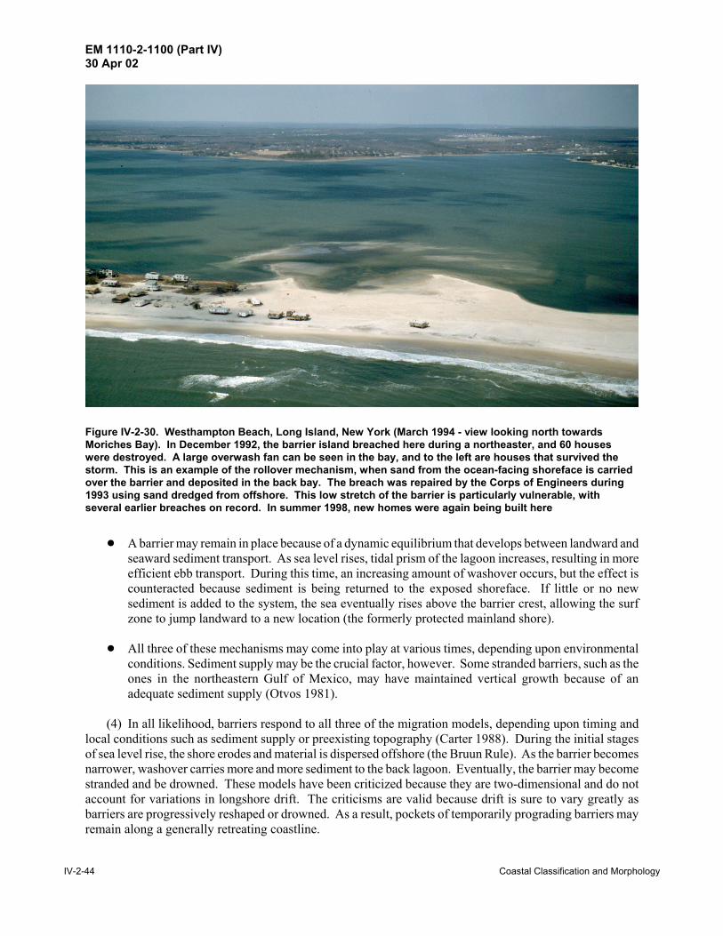
EM 1110-2-1100 (Part IV)30 Apr 02
IV-2-44 Coastal Classification and Morphology
Figure IV-2-30. Westhampton Beach, Long Island, New York (March 1994 - view looking north towardsMoriches Bay). In December 1992, the barrier island breached here during a northeaster, and 60 houseswere destroyed. A large overwash fan can be seen in the bay, and to the left are houses that survived thestorm. This is an example of the rollover mechanism, when sand from the ocean-facing shoreface is carriedover the barrier and deposited in the back bay. The breach was repaired by the Corps of Engineers during1993 using sand dredged from offshore. This low stretch of the barrier is particularly vulnerable, withseveral earlier breaches on record. In summer 1998, new homes were again being built here
! A barrier may remain in place because of a dynamic equilibrium that develops between landward andseaward sediment transport. As sea level rises, tidal prism of the lagoon increases, resulting in moreefficient ebb transport. During this time, an increasing amount of washover occurs, but the effect iscounteracted because sediment is being returned to the exposed shoreface. If little or no newsediment is added to the system, the sea eventually rises above the barrier crest, allowing the surfzone to jump landward to a new location (the formerly protected mainland shore).
! All three of these mechanisms may come into play at various times, depending upon environmentalconditions. Sediment supply may be the crucial factor, however. Some stranded barriers, such as theones in the northeastern Gulf of Mexico, may have maintained vertical growth because of anadequate sediment supply (Otvos 1981).
(4) In all likelihood, barriers respond to all three of the migration models, depending upon timing andlocal conditions such as sediment supply or preexisting topography (Carter 1988). During the initial stagesof sea level rise, the shore erodes and material is dispersed offshore (the Bruun Rule). As the barrier becomesnarrower, washover carries more and more sediment to the back lagoon. Eventually, the barrier may becomestranded and be drowned. These models have been criticized because they are two-dimensional and do notaccount for variations in longshore drift. The criticisms are valid because drift is sure to vary greatly asbarriers are progressively reshaped or drowned. As a result, pockets of temporarily prograding barriers mayremain along a generally retreating coastline.

EM 1110-2-1100 (Part IV)30 Apr 02
Coastal Classification and Morphology IV-2-45
(5) In summary, several models have been advanced to explain how barrier islands respond to rising sealevel. However, because the interactions in the coastal zone are so complex, trying to reduce barrier evolutionto a series of simple scenarios is unrealistic. Much more research is needed to define the many factors thatcontribute to barrier evolution.
IV-2-10. Marine Deposition Coasts - Beaches
a. Introduction. Marine and lacustrine beaches comprise one of the most widely distributed coastalgeomorphic forms around the world. Their importance as a buffer zone between land and sea and as arecreational and economic resource has stimulated studies by earth scientists for well over a century.Although much has been learned about how beaches form and how they are modified, the coastalenvironment is incredibly complex, and each location responds to unique geologic conditions and physicalprocesses. Some of these variable factors include:
(1) Seasonal cycles.
(2) Long-term trends.
(3) Changes in relative sea level.
(4) Variations in sediment supply.
(5) Meteorological cycles.
As a result, it is difficult to characterize beaches and predict future developments without the benefit of long-term studies and observations. The following sections describe the morphology and sediments of beachesand define terms (also see Table IV-1-1). For additional information and extensive bibliographies, the readeris referred to Carter (1988), Davis (1985), Komar (1976, 1983), and Schwartz (1973, 1982).
b. General definition. Beach is defined as a gently sloping accumulation of unconsolidated sedimentat the edge of a sea or other large body of water (including lakes and rivers). The landward limit may bemarked by an abrupt change in slope where the beach meets another geomorphic feature such as a cliff ordune. Although this landward boundary has been consistently accepted in the literature, the seaward limithas been more broadly interpreted. Some authors have included the surf zone and the bar and troughtopography in their definition because the processes that occur in the surf zone directly affect the exposedportion of the beach. The length of beaches varies greatly. Some stretch for hundreds of kilometers, suchas those on the Carolina Outer Banks. Others, called pocket beaches, are restricted by headlands and maybe only a few tens of meters long.
c. Major subdivisions. Beaches are part of the littoral zone, the dynamic interface between the oceanand the land. The littoral zone is bounded on one side by the landward limit of the beach and extends tensor hundreds of meters seaward to beyond the zone of wave breaking (EM 1110-2-1502). Beaches can bedivided into two major zones: the foreshore and the backshore.
(1) Foreshore.
(a) The foreshore extends from the low-water line to the limit of wave uprush at high water (Figure IV-1-2). The upper portion of the foreshore is a steep slope where the high water uprush occurs. The seaward,lower, portion of the foreshore is sometimes called the low-water or low-tide terrace. This terrace often fea-tures low, broad ridges separated by shallow troughs, known as ridges and runnels (Figure IV-2-31).

EM 1110-2-1100 (Part IV)30 Apr 02
IV-2-46 Coastal Classification and Morphology
Figure IV-2-31. Ridge and runnel system, low water terrace, Charlestown Beach, Rhode Island. Sea grassdebris in the foreground marks the height of the wave runup during the previous high tide. Where shouldthe “shoreline” be defined on this beach?
Because the foreshore is frequently subject to wave swash, it usually has a smoother surface than thebackshore. There may be a minor step near the low-water mark, called the plunge step. Often, shell or gravelis concentrated at the base of this step, while the sediments to either side are much finer.
(b) The foreshore is sometimes called the beachface. However, beachface is also used in a morerestricted sense to designate the steepened portion of the upper foreshore where the high-water wave uprushoccurs. Therefore, it is recommended that foreshore and beachface not be used synonymously and thatbeachface be restricted to its upper foreshore definition.
(2) Backshore.
(a) The backshore extends from the limit of high water uprush to the normal landward limit of stormwave effects, usually marked by a foredune, cliff, structure, or seaward extent of permanent vegetation. Thebackshore is not affected by waves regularly, but only during storms, when high waves and storm surgesallow reworking of backshore sediments. Between inundations, the backshore develops a rough surfacebecause of vehicle or animal traffic and the development of wind-blown bed forms. On eroding beaches, thebackshore may be missing, and the normal high-water uprush may impinge directly on cliffs or structures.
(b) Alternate terms for backshore are backbeach and berm. “Berm” is a common term because backshoreareas are sometimes horizontal and resemble man-made berms. However, many beaches have a slopingbackshore that does not resemble a berm, and some have more than one berm, representing the effects ofseveral storms. Thus, berm is not synonymous with backshore, but may be a suitable description for selectedareas. The term is sometimes used in beachfill and beach erosion control design.
EM 1110-2-1100 (Part IV)30 Apr 02
Coastal Classification and Morphology IV-2-47
(3) Coastline (or shoreline). The boundary between the foreshore and backshore, the high water line(hwl), is often defined to be the coastline. This is a practical definition because this land-water interface canbe easily recognized in the field and can be approximated on aerial photographs by a change in color or shadeof the beach sand (Crowell, Leatherman, and Buckley 1991). In addition, the coastline marked on thetopographic sheets (“T-sheets”) typically represents this same hwl, allowing a direct comparison betweenhistoric maps and aerial photographs. Some researchers have equated the coastline with the low-water line,but this boundary is not always marked by any evident feature or change in sand color. In various studies,one can find shoreline defined by almost any level datum. These inconsistencies make it difficult to compareshoreline maps prepared by different surveyors or agencies. Definition of “shoreline” often is controversialbecause it affects the legal definition of setback lines and other constraints placed on development in thecoastal zone. A more detailed discussion of hwl identification is presented in Anders and Byrnes (1991);Crowell, Leatherman, and Buckley (1991); and Gorman, Morang, and Larson (1998).
d. Beach material.
(1) Sand beaches. On most of the coasts of the United States, the predominant beach material is sand(between 0.0625 and 2.0 mm, as defined by the Wentworth classification). Most sand beaches are composedmostly of quartz, with lesser percentages of feldspars, other minerals, and lithic (rock) fragments. Table IV-2-4 lists beach sediment types and common locations.
Table IV-2-4Types of Beach Sediment
Type Typical Locations
Quartz sand East Coast of U.S. between Rhode Island and North Florida, Gulf Coast between WestFlorida and Mexico, portions of West Coast of U.S. and Great Lakes
Calcite shell debris South Florida, Hawaii
Volcanic sand Hawaii, Aleutians, Iceland
Coral sand South Florida, Bahamas, Virgin Islands, Pacific Trust Territory
Rock fragments Maine, Washington, Oregon, California, Great Lakes
Clay balls Great Lakes, Louisiana
(2) Coarse beaches. Coarse beaches contain large amounts of granule-, pebble-, cobble-, and boulder-sized material (larger than 2.0 in the Wentworth classification). These beaches, found in the northeast, in theGreat Lakes, and in mountainous reaches of the Pacific coast, occur under conditions where:
(a) Local streams flow with enough velocity to carry large particles to the shore.
(b) Coarse material underlies the beach (often found in areas influenced by glaciation or on metamorphiccoasts).
(c) Coarse material is exposed in cliffs behind the beach (Figure IV-2-9).
The constituent material may be primarily angular rock fragments, especially if the source area, such as acliff, is nearby (Figure IV-2-32). If the source area is far away, the most common rock types are likely to bequartzite or igneous rock fragments because these hard materials have a relatively long life in the turbulentbeach environment. Softer rocks, such as limestone or shale, are reduced more readily to sand-sized particles

EM 1110-2-1100 (Part IV)30 Apr 02
IV-2-48 Coastal Classification and Morphology
Figure IV-2-32. Shale beach and bluffs, southeast shore of Lake Erie, near Evans, New York. Bedding planesin the shale are lubricated by groundwater, and freeze-thaw cycles split the rock along the planes. Therubble on the beach breaks down quickly, leaving a grey sand with plate-shaped grains
by abrasion and breakage during their movement to the coast and by subsequent beach processes. Coarsebeaches usually have a steeper foreshore than sand beaches.
(3) Biogenic beaches. In tropical areas, organically produced (biogenic) calcium carbonate in the formof skeletal parts of marine plants and animals can be an important or dominant constituent. The morecommon particles are derived from mollusks, barnacles, calcareous algae, Bryozoa, echinoids, coral,Foraminifera, and ostacods. The percentage of biogenic material in a beach varies with the rate of organicproduction and the amount of terrigenous material being contributed to the shore.
IV-2-11. Salt Marshes
Coastal salt marshes are low-lying meadows of herbaceous plants subject to periodic inundations. Duringthe constructional phase of a coastline, a marsh develops when sediment deposition exceeds sediment removalby waves. Three critical conditions are required for marsh formation: abundant sediment supply, low waveenergy, and a low surface gradient. Once sediment accumulation reaches a critical height, the mud flats arecolonized by halophytic plants that aid in trapping sediment when flooding occurs and add organic materialto the substrate.
a. Distribution of salt marshes. Marshes occur in low-energy coastal locations, and the bay side of mostbarriers is fringed by tidal marsh or tidal flats. Likewise, mainland shorelines adjacent to bays are alsotypically fringed by marsh. Along the mainland of the United States, three regional marsh types have beenrecognized: (1) New England marsh; (2) Atlantic and Gulf Coastal Plain marsh; and (3) Pacific coast marsh

EM 1110-2-1100 (Part IV)30 Apr 02
Coastal Classification and Morphology IV-2-49
(Frey and Basan 1985). As much as 80 to 90 percent of the Atlantic and Gulf coasts have been borderingmarsh around lagoons, estuaries, and deltaic environments (Inman and Nordstrom 1971). However, alongthe West Coast, less than 20 percent of the coastline has marsh because Pacific marshes are usually restrictedto protected locations in river mouth lagoons or tectonically controlled bays. Morphologically andsedimentologically, Pacific marshes are similar to Atlantic and Gulf coast types, although they do differ inflora species and in the unequal semidiurnal range of tides.
New England marshes are adapted to high tide ranges, high wave energy, and cold winters. AtlanticCoastal Plain marshes are abundant and almost continuous from New York to northern Florida. The warmweather, low tide range, and low wave energy coastline of both the Atlantic and Gulf coastal areas of southernFlorida gives rise to mangrove marshes. The deltaic plain of Louisiana supports a unique type of marsh called“flotant,” which is marsh flora sitting atop organic rich ooze. The ooze is a soft substrate that may be severalmeters thick over harder substrates. The rest of the Gulf Coast has fringing marsh behind its barriers.
b. Classification of salt marshes.
(1) Regional conditions such as temperature, sediment distribution, pH, Eh, and salinity contribute to thezonation of a marsh area. Plant successions, sediment accumulation, and marsh expansion vary but mostmarshes can be divided into two fundamental zones: low and high. Low marshes are younger, lowertopographically, and usually subjected to the adjacent estuarine and marine processes. High marshes areolder, occupy a higher topographic position, are more influenced by upland conditions, and are subjected tosubstantially fewer tidal submersions per year. The boundaries for these zones and their relationship to agiven datum may differ from one coast to another. Differences in marsh boundaries might be related to tidalregularity and substrate composition. On the Atlantic coast, the tides are generally regular and near equal insemidiurnal range, whereas those on the Pacific coast are markedly unequal in semidiurnal range. Gulf Coastmarshes are subjected to irregular and small-amplitude tides. Consequently, the demarcation of high and lowmarshes is not well-defined.
(2) Plant structures and animals are significant contributors to sediment accumulation in salt marshes(Howard and Frey 1977). Grasses dampen wind-generated waves. Stems and levees impede current flow,which helps trap suspended sediment (Deery and Howard 1977). The most obvious mechanism of sedimententrapment is the plant root system. Plant roots may extend more than a meter in depth along Georgia stream-side marshes and up to 50 cm in some adjacent habitats (Edwards and Frey 1977).
c. Sediment characteristics.
(1) Introduction.
(a) Salt marshes generally contain finer, better-sorted sediment than other intertidal environments.However, marsh substrates reflect the local and regional sediment sources. Along the Atlantic coast and shelfof the United States, Hathaway (1972) recognized two distinct clay mineral facies. The northern clay-mineralfacies, extending from Maine to Chesapeake Bay, is primarily composed of illite, chlorite, and traces offeldspar and hornblende. The southern clay-mineral facies, which extends from Chesapeake to the South,is composed of chiefly kaolinite and montmorillonite.
(b) In New England and along many northern coasts overseas, peat is an important soil component ofmarsh substrate. Peat forms from the degradation of roots, stems, or leaves of marsh plants, particularlySpartina (Kerwin and Pedigo 1971). In contrast, peat is not a significant component of the southern coastalmarshes except in Louisiana and Florida (Kolb and van Lopik 1966). The southern marsh substrate generallyconsists of silt- and clay-size sediment with a large percentage of carbon material. The major sources oforganic carbon in most coastal marshes are in-situ plants and animal remains.

EM 1110-2-1100 (Part IV)30 Apr 02
IV-2-50 Coastal Classification and Morphology
(c) Southern marshes can have up to 60 percent silt and up to 55 percent clay. Rapid biological decayand constant flushing prevent the accumulation of thick organic deposits. The exception to this is the“flotant” marshes, which may have over 50 percent organics. In the Unified Soil Classification, the substratewould be considered a fine-grained soil, and the field engineer could anticipate silt, clay, or organic-dominantmaterial with low to high plasticity. Much of the organics present in marshes are incompletely oxidized,which if released into the lagoon/bay by excavation, can profoundly affect the water chemistry.
(2) Marsh plants.
(a) Marsh plants are typically tall, salt-tolerant grasses. About 20 genera of salt marsh plants are foundworldwide, with the most important in North America being Spartina, Juncus, and Salicornia (Chapman1974). Salt marshes are the temperate (and arctic) counterparts of tropical mangrove forests. They generallydevelop in shallow, low-energy environments where fine-grained sediments are deposited over sandy or tillsubstrates (Figure IV-2-33). As the fine sediments build upward, the marsh plants can take root and becomeestablished. The established vegetation increases sediment trapping and leads to more rapid upward andoutward building of marsh hummocks, which form the foundation of the marsh. The vegetation also createslower energy conditions by absorbing wave energy and reducing current velocities, thus allowing acceleratedsediment deposition.
(b) Like mangrove forests, many species of invertebrates, fish, birds, and mammals inhabit salt marshesand the adjacent tidal creeks during all or part of their life cycles. Thus, marshes are important to commercialand sport fishermen and hunters. In addition, several marsh species are considered endangered.
(c) Also like mangrove forests, man’s main detrimental impact on these marshes has been dredge-and-filloperations for land reclamation and mosquito control. Air and water pollution are also serious problems.Although extensive areas of salt marsh remain on the east and Gulf coasts of North America, significant areashave been lost to development. The situation is much worse on the west coast, where most of the coastalmarsh lands have been filled and perhaps permanently destroyed. Efforts to restore degraded coastal marsheshave not generally been successful.
(3) Sediment transport and processes.
(a) Typically, most marshes have very slow rates of sediment accumulation, amounting to only a fewmillimeters per year (Pethick 1984). Natural and man-induced changes can have deleterious effects on marshgrowth. For example, building levees or altering the drainage pattern can result in erosion and permanentmarsh loss. Not only is suspended sediment important to vertical growth of the marsh, but biologiccomponents, particularly organic detritus suspended in the water column, are critical to marsh health. Theexchange of sediment and nutrients is dependent on the exchange between the local bodies of water.
(b) A marsh sediment budget usually includes consideration of the following factors (Davis 1985):
! Riverine sources.
! Offshore or longshore transport.

EM 1110-2-1100 (Part IV)30 Apr 02
Coastal Classification and Morphology IV-2-51
Figure IV-2-33. Estuary of the Sprague River, Maine (a small river facing the Gulf of Maine west of PophamBeach State Park). This is a typical New England salt marsh, with sinuous channels that alternately floodand drain depending on the stage of the tide. In the past, straight channels were often dug in such marshesto allow more efficient draining to reduce mosquito infestation
! Barrier washover.
! Headlands.
! Eolian transport.
! In situ organic material (i.e., peat, plant detritus, and feces).
! Other terrestrial sources.
(4) Engineering problems. In light of growing concerns to preserve natural coastal marshes and the needto implement the national policy of “no net wetland losses,” many agencies are researching ways to manageand implement wetland technology. Studies have identified numerous man-made and natural causes ofwetland loss in the coastal zone:
(a) Sediment deficits. Man-made modifications of natural fluvial systems interfere with natural delta-building processes.
(b) Shoreline erosion. Along many marsh shorelines, the rates of retreat have increased because of hurri-canes and other storms, engineering activities along the coast, and boating.

EM 1110-2-1100 (Part IV)30 Apr 02
IV-2-52 Coastal Classification and Morphology
(c) Subsidence. Sinking of the land due to natural compaction of estuarine, lagoonal, and deltaicsediments results in large-scale disappearance of wetlands. This effect is exacerbated in some areas (e.g.,Galveston Bay) by subsidence caused by groundwater and oil withdrawal.
(d) Sea level rise. Eustatic sea level rise is partially responsible for increased rates of erosion and wet-land loss.
(e) Saltwater intrusion. Increased salinities in wetlands harm vegetation, which makes the wetlands morevulnerable to erosion.
(f) Canals. Canals increase saltwater intrusion and disrupt the natural water flow and sediment transportprocesses.
(5) Marsh restoration. Many agencies, including the U.S. Army Corps of Engineers, are conductingresearch in the building and restoration of marshes, are developing marsh management techniques, and aredeveloping regulatory guidelines to minimize land loss. Under the Wetlands Research Program sponsoredby the USACE, new technology in a multidisciplined approach is being developed. A useful publication isthe “Wetlands Research Notebook” (U.S. Army Engineer Waterways Experiment Station 1992), which is acollection of technical notes covering eight field problem areas focusing on wetlands activities in support ofUSACE civil works projects.
IV-2-12. Biological Coasts
a. Introduction.
(1) On many coasts, such as open wetlands, coral reef, and mangrove forest, biological organisms andprocesses are of primary importance in shaping the morphology. In contrast, on many other coasts, such astypical sandy beaches, biological activities do not appear to be of major significance when compared to thephysical processes at work. Nevertheless, it is important to realize that biological processes are occurring onall shores; all man-made shoreline modifications must address the impact of the modification on the bio-logical community.
(2) The types of organisms that can exist on a coast are ultimately controlled by interrelated physicalfactors. These include wave climate, temperature, salinity, frequency of storms, light penetration, substrate,tidal range, and the amounts of sediments and nutrients available to the system. Of these, the most importantmay be wave climate. The amount of wave energy dissipated at a shoreline per unit time ultimately has adominant influence on whether the substrate is rock, sand, or silt; on the water clarity; on the delivery ofnutrients; and, most importantly, on an organism’s physical design and lifestyle. The physical forces exertedby a large breaking wave are several orders of magnitude greater than the typical lateral forces affectingorganisms in most other environments. For example, mangroves and salt marshes require low wave-energyclimates to provide suitable substrate and to keep from being physically destroyed. On the other hand, reef-building corals require reasonably high wave-energy environments to maintain the water clarity, to delivernutrients, to disperse larvae, to remove sediment, and to limit competition and predation.
(3) Another first-order physical condition controlling biological organisms is temperature. For example,this is the primary factor that restricts mangroves and coral reefs to the tropics. Also, the formation of ice incoastal waters has a major impact on Arctic communities.
(4) Unlike many physical processes on coastlines, biological processes are generally progradational innature, extending shorelines seaward. Reef-building organisms produce hard substrate and sediments, inaddition to sheltering areas behind the reefs. Some mollusks, calcareous algae (Hallemeda sp., etc.),barnacles, echinoids, bryozoa, and worms produce significant amounts of sediment. Under low-energy

EM 1110-2-1100 (Part IV)30 Apr 02
Coastal Classification and Morphology IV-2-53
conditions in the deep sea and sheltered waters, diatoms and radiolaria produce sediments. Mangroves, saltmarsh, and dune vegetation trap and stabilize sediments. The erosional effect of organisms that burrow intosediments or that bore into rocks is usually of lesser importance.
b. High wave-energy coasts. Higher plants have not evolved mechanisms to enable them to physicallywithstand high wave-energy environments. Thus, simple plants, mainly algaes, form the bases of the foodchains for these marine coastal communities.
(1) Coral reefs. Coral reefs are massive calcareous rock structures that are slowly secreted by simplecolonial animals that live as a thin layer on the rock surface. The living organisms continually build newstructures on top of old, extending the reefs seaward toward deeper water and upward toward the surface.Reef-building corals have algae living within their tissues in a symbiotic relationship. The algae suppliesfood to the coral and the coral supplies shelter and metabolic wastes as nutrients to the algae. Shallow coralreefs worldwide occupy some 284,300 km2, about 1.2 percent of the world's continental shelf area (Spalding,Ravilious, and Green 2001). While some corals are found in temperate and Arctic waters, reef-building coralsare limited by water temperature to the tropics, mainly between the latitudes of 30 deg north and south.Bermuda, in the North Atlantic, warmed by the Gulf Stream, is the highest latitude location where active coralreefs are presently found. In the United States, coral reefs are found throughout the Florida Keys and the eastand west coasts of Florida, in the Hawaiian Islands, the Pacific Trust Territories, Puerto Rico, and the VirginIslands.
(a) Reef-building corals require clear water. The corals need to be free of sediments in order to trap foodparticles, and their algae require sufficient light for photosynthesis. While corals can remove a certain amountof sediment from their upper surfaces, heavy siltation will bury and kill them. Light penetration limits thedepth of most reef-building corals to the upper 30-50 m, though some corals grow much deeper. The upperlimit of reef growth is controlled by the level of low tide. Corals cannot stand more than brief exposures outof the water (for example, during the occasional passage of a deep wave trough).
(b) While coral reefs produce rock structure, they also produce calcareous sediments. Waves andcurrents pulverize coral skeletons into sand-size particles. However, on many reefs, calcareous algae(Hallemeda sp.) produce a majority of the sediments. The crushed calcareous shells of other animals, suchas mollusks, sea urchins, and sand dollars, also provide sediment.
(c) Coral reefs rival tropical rain forests as being among the most complex communities on earth, androck-producing reef communities are among the most ancient life forms found in the fossil record. Becauseof their complexity, the dynamics of coral reefs are not yet well understood. At least 100,000 species havebeen named and described, but the total number inhabiting the world's reefs may exceed one million species.Scientific knowledge of the ecology of reefs has almost entirely accumulated over the last 50 years, since thedevelopment of underwater scuba breathing apparatus in the 1940's.
(d) One of the critical ecological issues of our times is the rapid degradation of coral reefs around theworld by various natural and human activities. Corals are highly sensitive to increases in temperature,exhibiting a stress response known as coral bleaching. In 1998, a global mass bleaching caused massmortalities in many areas. Worldwide, however, humans are driving more profound changes to reefs thanare natural phenomena. The most widespread impacts are water pollution, dredge and fill operations, over-harvesting of fish and shellfish, and the harvesting of some corals for jewelry. For example, in Indonesia,the world's largest coral nation, 82 percent of the corals are at risk from the illegal practice of dynamitefishing (which is also devastating to fish populations). Even far from the coast, deforestation, urbansprawl, and sloppy agriculture produce vast quantities of sediment and pollution that enter the sea and degradereefs in the vicinity of river mouths.

EM 1110-2-1100 (Part IV)30 Apr 02
IV-2-54 Coastal Classification and Morphology
(e) Controlled dredging around reefs is possible and is done routinely, causing minimal impact to reefcommunities. Mechanical damage (from cutter heads, chains, anchors, and pipelines) is often of equal orgreater concern than suspended sediment production. Improvements in navigation and positioning have madedredging near reefs more viable. Nevertheless, careful monitoring is mandated in most cases.
(f) Reefs are of major economic importance to the communities along which they are located. Formillenia, coastal peoples relied on coral reefs as a source of food. Spurgeon (1992) classifies their economicbenefits as:
* Direct extractive uses - fisheries, building material.
* Direct non-extractive uses - tourism.
* Indirect uses - biological support for a variety of other ecosystems.
Reef tourism is now a major global industry. Diving tourism is ubiquitous and now occurs in 91 countriesand states (Spalding, Ravilious, and Green 2001). One major benefit of mass tourism is that it had broughtto public consiousness the issues of the fragility of reef ecosystems and the need to preserve the world'sremaining reefs. Marine protected areas are becoming a critical tool in the preservation of remaining reefs,and some 660 protected areas worldwide incorporate reefs. Tourist income is helping some remotecommunities police and protect their reefs. The downside of mass tourism is the haphazard growth ofinfrastructure along the shore. Many vacation communities are built on remote coasts where resources, suchas fresh water, are scarce and where trash and sewage effluent are not properly managed.
(g) An additional benefit of reefs is the shelter from waves that they provide to adjacent shores. As anexample, the south and southwestern coast of Sri Lanka is battered by waves that travel unhindered acrossthe Indian Ocean. In the past, the coral reefs that surrounded the coast served as buffers against the intensewave energy. But illegal reef breaking and coral mining, combined with negative impacts of tourism anddevelopment (sewage, agricultural pollution, physical damage) have greatly reduced the effectiveness of thereef barriers. As a result, much of the Sri Lankan south coast is now experiencing severe erosion (Young andHale 1998).
(h) Stoddard (1969) has identified four major forms of large-scale coral reef types: fringing reefs, barrierreefs, table reefs, and atolls.
(i) Fringing reefs generally consist of three parts: a fore reef, a reef crest, and a back reef. The fore reefusually rises steeply from deep water. It may have spur and groove formations of coral ridges interspersedwith sand and rubble channels. The reef crest usually forms a continuous wall rising to the low tide level.This usually occurs within a few hundred meters from shore. The seaward side of this area, called thebuttress zone, receives the brunt of the wave action. Between the reef crest (or flat) and the shoreline, the reefusually deepens somewhat in the back reef area. This area typically contains much dead coral as well as rock,rubble, sand, and/or silt. It also contains live coral heads, algae, eel grass, etc. Fringing reefs form as thebeginning stages in the evolution of atolls and possibly barrier reefs.
(j) Barrier reefs grow on the continental shelf where suitable solid substrate exists to serve as a founda-tion. Their form is typically a long coral embankment separated from the mainland by a lagoon that may beseveral kilometers wide. The lagoon is usually flat-floored and may be as much as 16 km wide and 35 to75 m in depth. Although similar to fringing reefs, barrier reefs are much more massive, the reef crests aremuch further from shore, and the back reef areas are deeper. Protected shorelines behind barrier reefs arecharacterized by mangrove swamps and are usually progradational. The seafloor on the seaward side slopessteeply away into deeper water and is covered by coral rubble.

EM 1110-2-1100 (Part IV)30 Apr 02
Coastal Classification and Morphology IV-2-55
(k) Table reefs grow from shallow banks on the seafloor that have been capped with reef-forming organ-isms. They cover extensive areas but do not form barriers or enclose lagoons.
(l) Atolls are ring-shaped reefs that grow around the edges of extinct volcanic islands, enclosing lagoonsof open water. The shallow lagoons may contain patch reefs. Atolls are primarily found in isolated groupsin the western Pacific Ocean. Small low islands composed of coral sand may form on these reefs. Theseislands may hold enough of a fresh water lens to support human life, but the islands are quite vulnerable toinundation and to tropical storms. The first theory concerning the development of atolls, the subsidencetheory proposed by Charles Darwin in 1842, has been shown to be basically correct (Strahler 1971).Figure IV-2-34 illustrates the evolution of an atoll.
(m) The development of atolls begins with an active volcano rising from the ocean floor and forming avolcanic island. As the volcano ceases activity, a fringing reef forms along the shore. Over geologic time,erosion of the volcanic island and subsidence due to general aging of the ocean basin cause the island to dropbelow sea level. The actively growing fringing reef keeps pace with the subsidence, building itself upwarduntil a barrier reef and lagoon are formed. As the center of the island becomes submerged, the reef continuesits upward growth, forming a lagoon. During the development, the lagoon floor behind the reef accumulatescoral rubble and other carbonate sediments, which eventually completely cover the subsiding volcanic island.
(2) Worm reefs. A type of biogenic reef that is not related to coral reefs is that produced by colonies oftubeworms. Serpulid worms and Sabellariid worms are two types known to form significant reef structuresby constructing external tubes in which they live. The Serpulids build their tubes from calcareous secretionsand the Sabellariids by cementing particles of sand and shell fragments around their bodies. Colonies of theseworms are capable of constructing massive structures by cementing their tubular structures together. As newtubes are continually produced over old ones, a reef is formed. These reefs typically originate from a solidrocky bottom, which acts as an anchoring substrate. Worm reefs are most commonly found in sub-tropicaland tropical climates (e.g., east coast of Florida). Reefs of this nature can play an important role in coastalstabilization and the prevention of coastal erosion.
(3) Oyster reefs. Oysters flourish under brackish water conditions in lagoons, bays, and estuaries. Theoysters cement their shells to a hard stable substrata including other oyster shells. As new individuals set ontoolder ones, a reef is formed. These reefs can form in temperate as well as tropic waters.
(a) Oysters found around the United States are part of the family Ostreidae. The Eastern, or Americanoyster (Crassostrea virginica) is distributed along the entire east coast of North America from the Gulf of St.Lawrence through the Gulf of Mexico to the Yucatan and the West Indies. The other major North Americanspecies is Ostrea lurida, which ranges along the Pacific coast from Alaska to Baja California (Bahr andLanier 1981).
(b) Intertidal oyster reefs range in size from isolated scattered clumps a meter high to massive solidmounds of living oysters anchored to a dead shell substrate a kilometer across and 100 m thick (Pettijohn1975). Reefs are limited to the middle portion of the intertidal zone, with maximum elevation based on aminimum inundation time. The uppermost portion of a reef is level, with individual oysters pointing upwards.At the turn of the century, vast oyster flats were found along the Atlantic coast in estuaries and bays. In SouthCarolina, the flats covered acres and sometimes square miles (cited in Bahr and Lanier (1981)).

EM 1110-2-1100 (Part IV)30 Apr 02
IV-2-56 Coastal Classification and Morphology
Figure IV-2-34. Evolution of a coral island: (a) Active volcano rising from theseafloor, (b) Extinct volcanic island with fringing reef, (c) Subsiding island; reefbuilds upward and seaward, forming barrier reef, (d) Continued subsidence causingremnant volcanic island to be completely submerged. Growth continues upwardand seaward until remnant volcano is covered (adapted from Press and Siever(1986))

EM 1110-2-1100 (Part IV)30 Apr 02
Coastal Classification and Morphology IV-2-57
(c) Oyster reefs serve an important biological role in the coastal environment. The reefs are a crucialhabitat for numerous species of microfauna and macrofauna. The rough surface of a reef flat provides a hugesurface area for habitation by epifauna, especially vital in the marsh-estuarine ecosystem that is often devoidof other hard substrate. The high biological productivity of reef environments underscores one of the reasonswhy reefs must be protected and preserved.
(d) Oyster reefs play important physical and geological roles in coastal dynamics because they are wave-resistant structures that can biologically adapt to rising sea level. Reefs affect the hydrologic regime of saltmarsh estuaries in three ways: by modifying current velocities, by passively changing sedimentation patterns,and by actively augmenting sedimentation by biodeposition. (Biological aggradation increases the size ofsuspended particles and increases their settling rates.) As reefs grow upward and laterally, modify energyfluxes by damping waves and currents, and increase sedimentation, they ultimately produce majorphysiographic changes to their basins. These changes can occur on short time scales, on the order ofhundreds of years (Bahr and Lanier 1981). During geologic history, massive reefs have accumulated in manyareas, some of which became reservoirs for oil and gas.
(e) Although oysters are adapted to a wide range of temperature, turbidity, and salinity conditions, theyare highly susceptible to man-made stresses. These stresses on oyster communities can be classified into eightcategories (Bahr and Lanier 1981):
! Physical sedimentation, especially from dredging or boat traffic.
! Salinity changes due to freshwater diversion or local hydrologic alterations.
! Eutrophication (oxygen depletion) due to algae growth in water that is over-enriched with organicmatter.
! Toxins from industrial and urban runoff.
! Physical impairment of feeding structures by oil.
! Thermal loading, primarily from power plants.
! Overharvesting.
! Loss of wetlands.
There has been a recorded significant decline in the health and extent of living United States east coast oysterreefs since the 1880's, although the data are sometimes conflicting because ground-level surveys are difficultto conduct (Bahr and Lanier 1981). It is easy to account for the declines of reefs near population andindustrial centers, but the declines are more difficult to explain in more pristine areas of the coast (e.g. theGeorgia coast near Sapelo Island). Population changes may be due, in part, to natural cycles of temperatureand salinity or fecundity.
(f) Because oyster reefs are susceptible to fouling and silting, it is important that geologists andengineers consider sediment pathways during the planning phases of coastal construction and dredgingprojects or stream diversion and other watershed changes. As discussed earlier, dredging near reefs istechnically feasible as long as careful technique is observed and environmental conditions are monitored.
(g) In summary, oyster reefs serve critical biological and physical purposes in the estuarine and coastalmarsh environment. They enhance biological productivity, provide stable islands of hard substrate in
EM 1110-2-1100 (Part IV)30 Apr 02
IV-2-58 Coastal Classification and Morphology
otherwise unstable soft muddy bottoms, modify hydrodynamic flows and energy fluxes. With respect toshore protection, reefs are a biological wave damper that can accommodate rising sea level as long as theyare alive. It is essential that reefs be protected from wanton destruction by pollution and other stressesimposed by human development.
(4) Rocky coasts.
(a) Kelp beds. Kelp forests are formed by various species of algae that attach to hard substrate with aroot-like system called a holdfast. Some (prominently Macrosistus sp.) can grow many tens of meters inlength up to the water surface, where their tops float and continue to grow. The plants are quite rubbery andcan withstand significant wave action. Kelp beds are found along rocky shorelines having cool clear water.In North America, they occur along much of the Pacific coast and, to a lesser extent, along the North Atlanticcoast. Kelp beds are, to some extent, the functional temperate latitude counterpart of coral reefs (Carter1988).
(b) Kelp biological communities. Kelp beds harbor extensive biological communities that include fish,sea otters, lobster, starfish, mollusks, abalones, and many other invertebrates. In addition, kelp beds absorbwave energy, helping to shelter beaches. Man’s main impact has been the commercial harvesting of variousportions of this community, including the kelp. In the past, hunting sea otters for their pelts allowed seaurchins to multiply, and the overpopulation of sea urchins grazed and destroyed many beds. Today, thereestablishment of some sea otter populations has led to conflicts with shell fishermen. Water pollution isalso a problem in some areas.
(c) Rock reefs and shorelines. Submerged rock reefs provide substantial habitat for organisms. Theyprovide a place of attachment for sessile organisms, and the crevices provide living spaces and havens ofrefuge for mobile organisms such as fish and lobsters. These structures are a boon to sports fishermen, andmany artificial reefs have been built on sandy seafloors out of a wide array of materials. Rocky shorelineshave communities of organisms living in the intertidal and subtidal zones. These may or may not beassociated with offshore kelp bed or coral reef communities.
(5) Sandy coasts. Much of the biological activity on sandy coasts is confined to algae, various inverte-brates, and fish living within the water column. Of these, fish, shrimp, and crabs have the greatest economicimportance. In addition, there are infaunal filter feeders, mainly mollusks and sand dollars, that live justbeneath the sand surface.
(a) One important and often overlooked biological activity on some sandy beaches is their use as nestingareas by a variety of migratory animals. These include sea turtles, birds, marine mammals, and fish. In NorthAmerica, many of these species are threatened or endangered, including all five species of sea turtles andsome birds such as the piping plover, the snowy plover, and the least tern. For most of these species, theirproblems are directly related to conflicts with man’s recreational use of beaches and the animals’ inabilityto use alternate nesting sites. Fortunately, some states have implemented serious ecological programs to helpsave these threatened species. For example, Florida has rigorous laws preventing disruption of nesting turtles,and many Florida municipalities have found that maintaining healthy natural biological communities is anexcellent way to lure tourists.
(b) Plants occupying sand dunes are characterized by high salt tolerance and long root systems that arecapable of extending down to the freshwater table (Goldsmith 1985). Generally, these plants also generaterhizomes that grow parallel to the beach surface. Beach plants grow mainly in the back beach and dune areasbeyond the zone of normal wave uprush. The plants trap sand by producing low energy conditions near theground where the wind velocity is reduced. The plants continue to grow upward to keep pace with theaccumulation of sand, although their growth is eventually limited by the inability of the roots to reach

EM 1110-2-1100 (Part IV)30 Apr 02
Coastal Classification and Morphology IV-2-59
dependable water. The roots also spread and extend downward, producing a thick anchoring system thatstabilizes the back beach and dune areas. This stabilization is valuable for the formation of dunes, whichprovide storm protection for the entire beach. The most common of these plants are typically marram grass,saltwort, American sea grass, and sea oats. With time, mature dunes may accumulate enough organicnutrients to support shrub and forest vegetation. The barrier islands of the U.S. Atlantic coast and the GreatLakes shores support various species of Pinus, sometimes almost to the water’s edge.
c. Low wave-energy coasts. In locations where the wave climate is sufficiently low, emergentvegetation may grow out into the water. Protection from wave action is typically afforded by local structures,such as headlands, spits, reefs, and barrier islands. Thus, the vegetation is usually confined to the marginsof bays, lagoons, and estuaries. However, in some cases, the protection may be more regional in extent.Some of the mangrove forests in the Everglades (south Florida) and some of the salt marshes in northwestFlorida and Louisiana grow straight into the open sea. The same is true for freshwater marshes in bays andriver mouths in the Great Lakes.
(1) General.
(a) Only a few higher plants possess a physiology that allows them to grow with their roots in soils thatare continuously saturated with salt water. These are the mangroves of the tropics and the salt marsh grassesof the higher latitudes. The inability of other plants to compete or survive in this environment allows smallgroups of species or single species to cover vast tracts of some coastal areas. These communities typicallyshow zonations with different species dominant at slightly different elevations, which correspond to differentamounts of tidal flooding. The seaward limit of these plants is controlled by the need for young plants tohave their leaves and branches above water. To this end, some mangroves have seedlings that germinate andbegin growing before they drop from the parent tree. Upland from these communities, a somewhat largernumber of other plants, such as coconuts and dune grasses, are adapted to live in areas near, but not in,seawater.
(b) Understanding and appreciation of the importance of these types of coastal areas are growing.Former attitudes that these areas were mosquito-infested wastelands imminently suitable for dredge- and-filldevelopment are being replaced by an appreciation of their great economic importance as nursery groundsfor many species of fish and shellfish, of their ability to remove pollutants, of their ability to protect uplandcommercial development from storms, of their fragility, and of their beauty.
(2) Mangroves.
(a) Mangroves include several species of low trees and shrubs that thrive in the warm, shallow, saltwaterenvironments of the lower latitudes. Worldwide, there are over 20 species of mangroves in at least 7 majorfamilies (Waisel 1972). Of these, the red, white, and black mangroves are dominant in south Florida and theCaribbean. They favor conditions of tidal submergence, low coastal relief, saline or brackish water, abundantfine sediment supply, and low wave energy. Mangroves have the ability to form unique intertidal forests thatare characterized by dense entangled networks of arched roots that facilitate trapping of fine sediments,thereby promoting accretion and the development of marshlands. The prop roots and pneumatophores alsoallow the plants to withstand occasional wave action and allow oxygen to reach the roots in anaerobic soils.The prime example in the United States is the southwest shore of Florida, in the Everglades National Park.
(b) Mangrove coasts are crucial biological habitats to a wide variety of invertebrates, fish, birds, andmammals. In the past, the primary cause of their destruction has been dredge-and-fill operations for thereclamation of land and for mosquito control.

EM 1110-2-1100 (Part IV)30 Apr 02
IV-2-60 Coastal Classification and Morphology
d. Other sources of biogenic sediment in the coastal zone. In areas of high biological activity,organically derived sediments may account for a significant proportion of the sediment composition, espe-cially where terrigenous sediment supplies are low. These biogenic materials, consisting of remains of plantsand animals and mineral matter produced by plants and animals, accumulate at beaches, estuaries, andmarshlands.
(1) The most familiar types of biogenic sediments are hard calcareous skeletal parts and shell fragmentsleft behind by clams, oysters, mussels, corals, and other organisms that produce calcareous tests. In tropicalclimates, the sediment commonly consists of coral fragments and calcareous algal remains. Siliceous testsare produced by most diatoms and radiolaria. Sediments predominately containing carbonate or calcareousmaterial are generally referred to as calcarenites, while sediments composed predominantly of siliceousmatter are referred to as diatomites or radiolarites, depending upon which organism is most responsible forthe sediment (Shepard 1973). In the Great Lakes and some inland U.S. waterways, the zebra mussel hasproliferated since the mid-1980's, and now some shorefaces are covered with mussel shell fragments to adepth of over 10 cm. The mussels are a serious economic burden because they choke the inlets of municipalwater systems and coolant pipes.
(2) In some areas, wood and other vegetation may be introduced into the sediments in large quantities.This is especially common near large river mouths and estuaries. This organic material may becomeconcentrated in low energy environments such as lakes and salt marshes, eventually producing an earthy,woody composition known as peat (Shepard 1973). Peat exposed on the shoreface has been used as anindicator of marine transgression and barrier island retreat (Figure IV-2-35) (Dillon 1970). In Ireland andScotland, peat is dried and used as a fuel.
IV-2-13. Continental Shelf Geology and Topography
a. Introduction. The geology of the world’s continental shelves is of direct significance to coastalengineers and managers in two broad areas. First, the topography of the shelf affects coastal currents andwave climatology. Wave refraction and circulation models must incorporate shelf bathymetry. Bathymetrywas incorporated in the wave hindcast models developed by the USACE Wave Information Study (Seereferences in Part II-8). Second, offshore topography and sediment characteristics are of economicimportance when offshore sand is mined for beach renourishment or dredged material is disposed offshore.
b. Continental shelf sediment studies.
(1) The Inner Continental Shelf Sediment and Structure (ICONS) study was initiated by the Corps ofEngineers in the early 1960's to map the morphology of the shallow shelf and find sand bodies suitable forbeach nourishment. This program led to a greater understanding of shelf characteristics pertaining to thesupply of sand for beaches, changes in coastal and shelf morphology, longshore sediment transport, inletmigration and stabilization, and led to a better understanding of the Quaternary shelf history. ICONS reportsare listed in Table IV-2-5.

EM 1110-2-1100 (Part IV)30 Apr 02
Coastal Classification and Morphology IV-2-61
Figure IV-2-35. Peat horizon exposed on the shoreface, Ditch Plains, Long Island, New York (March 1998). The peat is in-situ, indicating that lagoonal sediments accumulated here before the barrier beach retreatedover the marsh. The peat layer was about 1 m above the ocean water level at the time the photograph wastaken. The dune resting on the peat is about 2 m thick
(2) Since the 1970's, the Minerals Management Service (MMS), a bureau of the U.S. Department of theInterior, has been tasked with managing the mineral resources of the Outer Continental Shelf. In conductingits mission, the MMS has sponsored many surveys and studies of mineral resources on the continental shelf.These studies can be accessed via the MMS’ Environmental Studies Program Information System (ESPIS)at:
http://mmspub.mms.gov/espis/
(3) For beach renourishment projects, U.S. Army Corps of Engineers Districts typically obtaininformation on sand resources near the proposed project area from various sources:
(a) In-house studies, typically from vibracoring or rotary borings.
(b) Contracts with marine geophysics/geotechnical surveyors.
(c) The U.S. Geological Survey.

EM 1110-2-1100 (Part IV)30 Apr 02
IV-2-62 Coastal Classification and Morphology
Table IV-2-5U.S. Army Corps of Engineers Inner Continental Shelf Sediment and Structure (ICONS) ReportsLocation References1
Atlantic CoastMassachusetts Bay Meisburger 1976New York - Long Island Sound Williams 1981New York - Long Island shelf Williams 1976New York Bight Williams and Duane 1974New Jersey - central Meisburger and Williams 1982New Jersey - Cape May Meisburger and Williams 1980Delaware, Maryland, Virginia Field 1979Chesapeake Bay entrance Meisburger 1972North Carolina - Cape Fear Meisburger 1977; Meisburger 1979Southeastern U.S. shelf Pilkey and Field 1972Florida - Cape Canaveral to Georgia Meisburger and Field 1975Florida - Cape Canaveral Field and Duane 1974Florida - Palm Beach to Cape Kennedy Meisburger and Duane 1971Florida - Miami to Palm Beach Duane and Meisburger 1969
Gulf of MexicoTexas - Galveston County Williams, Prins, and Meisburger 1979
Lake EriePennsylvania Williams and Meisburger 1982Ohio Williams et al. 1980; Carter et al. 1982
Lake MichiganSoutheast shore Meisburger, Williams, and Prins 1979
Sampling tools and methodsPneumatic coring device Fuller and Meisburger 1982Vibratory samplers Meisburger and Williams 1981Data collection methods Prins 19801 Complete citations are listed in Appendix A
(d) U.S. Army Engineer Research and Development Center, Waterways Experiment Station.
(e) State and local agencies.
New geographic data collected by the Federal Government is documented with Metadata that can be accessedfrom various computer servers. Unfortunately, there is no consistent method of cataloging historical data orreports. Users who need information on sand resources near the coast must contact the Corps Districtresponsible for that particular area.
c. Continental shelf morphology. Surficial sediment on the continental shelves is largely dependentupon the type of coast (i.e. collision, or leading, versus trailing) and the presence of rivers that supply materialto the coast.
(1) Leading edge shelves, such as the Pacific coasts of North and South America, are typically narrowand steep. Submarine canyons, which sometimes cut across the shelves almost to the shore (Shepard 1973),serve as funnels that carry sediment down to the abyssal plain. Normally, very little sand is availableoffshore.

EM 1110-2-1100 (Part IV)30 Apr 02
Coastal Classification and Morphology IV-2-63
(2) Trailing edge shelves are, in contrast, usually wide and flat, and the heads of canyons usually arelocated a considerable distance from shore. Nevertheless, a large amount of sediment is believed to movedown these canyons (Emery 1968). Off the United States Atlantic coast, the broad continental shelf containsa vast amount of sand. Unfortunately, much of this sand is not available for beach renourishment becauseit is either too far from shore or its composition is incompatible with the beaches where it is to be placed (i.e.,contains too much rock, shell fragment, mud, or organic material or the grain size is different than the sizeof the native material where it is to be placed).
d. Examples of specific features - Atlantic seaboard.
(1) The continental shelf of the Middle Atlantic Bight of North America, which is covered by a broadsand sheet, is south of the region directly influenced by Pleistocene glacial scouring and outwash. This sandsheet is divided into broad, flat, plateau-like compartments dissected by shelf valleys that were excavatedduring the Quaternary lowstands of the sea. Geomorphic features on the shelf include low-stand deltas(cuspate deltas), shoal and cape retreat massifs (bodies of sand that formed during a transgressive period),terraces and scarps, cuestas (asymmetric ridges formed by the outcrop of resistant beds), and sand ridges(Figure IV-2-36) (Swift 1976; Duane et al. 1972).
(2) The larger geomorphic features of the Middle Atlantic Bight are constructional features molded intothe Holocene sand sheet and altered in response to storm flows. Off the coasts of Delaware, Maryland, andVirginia, shoreface-connected shoals appear to have formed in response to the interaction of south-trending,shore-parallel, wind-generated currents with wave- and storm-generated bottom currents during winterstorms. Storm waves aggrade crests, while fair-weather conditions degrade them. A second shoal area furtheroffshore at the 15-m depth is indicative of a stabilized sea level at that elevation. These shoals may besuitable sources of sand for beach renourishment. However, the often harsh wave conditions off the mid-Atlantic seaboard may limit the economic viability of mining these shoals. The origin and distribution ofAtlantic inner shelf sand ridges are discussed in McBride and Moslow (1991).
(3) Linear shoals of the Middle Atlantic Bight tend to trend northeast (mean azimuth of 32 deg) andextend from the shoreline at an angle between 5 and 25 deg. Individual ridges range from 30 to 300 m inlength, are about 10 m high, and have side slopes of a few degrees. The shoal regions extend for tens of kilo-meters. The crests are composed of fine-medium sand, while the ridge flanks and troughs are composed ofvery fine-fine sand. The mineralogy of shoals reflects that of the adjacent beaches.
e. Riverine influence.
(1) Rivers provide vast amounts of sediment to the coast. The 28 largest rivers of the world, in termsof drainage area (combined size of upland drainage area and subaerial extent of deltas), discharge acrosstrailing-edge and marginal sea coasts (Inman and Nordstrom 1971). Because the larger rivers drain ontotrailing edge coasts, these shores tend to have larger amounts of available sediment, which is deposited acrossa wide continental shelf. The sediment tends to remain on the shelf and is only lost to the abyssal plains whendeltas prograde out across the continental rise (e.g., the Mississippi and Nile Deltas) or when submarinecanyons are incised across the shelf (e.g., Hudson River sediment funnels down the Hudson Canyon).
(2) The Columbia River, which is the 29th largest river in the world, is the largest one to drain acrossa collision coast. Until dams were built during the mid-20th century, the Columbia carried a major sedimentload, which was deposited on the ebb shoal off its mouth. This shoal provided the sand that formed the LongBeach peninsula and fed the beaches as far north as the Olympic Peninsula. The Columbia appears to be anexception - on most collision coasts, canyons frequently cut across the shelf almost to the shore (Shepard1973), therefore resulting in the direct loss of sediment from the coastal zone.

EM 1110-2-1100 (Part IV)30 Apr 02
IV-2-64 Coastal Classification and Morphology
Figure IV-2-36. Morphology of the Middle Atlantic Bight (from Swift (1976)). Sand ridges close to shore maybe suitable sources of sand for beach renourishment

EM 1110-2-1100 (Part IV)30 Apr 02
Coastal Classification and Morphology IV-2-65
IV-2-14. References
EM 1110-2-1502Coastal Littoral Transport
Anders and Byrnes 1991Anders, F. J., and Byrnes, M. R. 1991. Accuracy of shoreline change rates as determined from maps andaerial photographs, Shore and Beach, Vol 51, No. 1, pp. 17-26.
Baeteman 1994Baeteman, C. 1994. Subsidence in coastal lowlands due to groundwater withdrawal: the geologicalapproach, “Coastal Hazards, Perception, Susceptibility and Mitigation,” Finkl, C. W., Jr., (ed.), Journal ofCoastal Research Special Issue No. 12, pp 61-75.
Bagnold 1941Bagnold, R. A. 1941. The Physics of Windblown Sand and Desert Dunes, Methuen, London, UK.
Bahr and Lanier 1981Bahr, L. M., and Lanier, W. P. 1981. “The Ecology of Intertidal Oyster Reefs of the South Atlantic Coast: ACommunity Profile,” Report FWS/OBS-81/15, U.S. Fish and Wildlife Service, Office of Biological Services,Washington, DC.
Ballard 1983Ballard, R. D. 1983. Exploring our Living Planet, National Geographic Society, Washington, DC.
Bates and Jackson 1984Bates, R. L., and Jackson, J. A. 1984. Dictionary of Geologic Terms, 3rd ed., Anchor Press/Doubleday,Garden City, NY.
Bowes 1989Bowes, M. A. 1989. “Review of the Geomorphic Diversity of the Great Lakes Shore Zone in Canada,”Heritage Resources Centre, University of Waterloo, Waterloo, Canada.
Boyd, Dalrymple, and Zaitlin 1992Boyd, R., Dalrymple, R., and Zaitlin, B. A. 1992. “Classification of Elastic Coastal Depositional Environ-ments,” Sedimentary Geology, Vol 80, pp 139-150.
Bruun 1962Bruun, P. M. 1962. “Sea-level Rise as a Cause of Shore Erosion,” Proceedings, Journal of the Waterwaysand Harbor Division, American Society of Civil Engineers, Vol 88, No. WW1, pp 117-130.
Bullard 1962Bullard, F. M. 1962. Volcanoes in History, in Theory, in Eruption, University of Texas Press, Austin, TX.
Carter 1988Carter, R. W. G. 1988. Coastal Environments: An Introduction to the Physical, Ecological, and CulturalSystems of Coastlines, Academic Press, London, UK.

EM 1110-2-1100 (Part IV)30 Apr 02
IV-2-66 Coastal Classification and Morphology
Carter, Curtis, and Sheehy-Skeffington 1992Carter, R. W. G., Curtis, T. G. F., and Sheehy-Skeffington, M. J. 1992. Coastal Dunes, Geomorphology,Ecology, and Management for Conservation, A. A. Balkema, Rotterdam, The Netherlands.
Carter, Williams, Fuller, and Meisburger 1982Carter, C. H., Williams, S. J., Fuller, J. A., and Meisburger, E. P. 1982. “Regional Geology of the SouthernLake Erie (Ohio) Bottom: A Seismic Reflection and Vibracore Study,” Miscellaneous Report No 82-15,Coastal Engineering Research Center, U.S. Army Engineer Waterways Experiment Station, Vicksburg, MS.
Chapman 1974Chapman, V. J. 1974. “Salt Marshes and Salt Deserts of the World,” Ecology of Halophytes, R. J. Reimoldand W. H. Queen, eds., Academic Press, NY, pp 3-19.
Coastal Barriers Study Group 1988Coastal Barriers Study Group. 1988. Report to Congress: Coastal Barrier Resources System,Recommendations for Additions to or Deletions from the Coastal Barrier Resources System, (in 22 Volumescovering the United States and territories), U.S. Department of the Interior, Washington, DC.
Coleman and Wright 1971Coleman, J. M., and Wright, L. D. 1971. “Analysis of Major River Systems and Their Deltas: Proceduresand Rationale, with Two Examples,” Technical Report No. 95, Coastal Studies Institute, Louisiana StateUniversity, Baton Rouge, LA.
Cotton 1952Cotton, C. A. 1952. “Criteria for the Classification of Coasts,” Abstract of papers, 17th Congress of Interna-tional Geographers, Washington, DC, p 15.
Cromwell 1971Cromwell. 1971. Barrier Coast Distribution: A World-wide Survey,“ Abstracts, Second Coastal andShallow Water Research Conference, U.S. Office of Naval Research Geography Program, University Press,University of Southern California, Los Angeles, CA, p 50.
Crowell, Leatherman, and Buckley 1991Crowell, M., Leatherman, S. P., and Buckley, M. K. 1991. “Historical Shoreline Change: Error Analysisand Mapping Accuracy,” Journal of Coastal Research, Vol 7, No. 3, pp 839-852.
Dalrymple, Silver, and Jackson 1973Dalrymple, G. B., Silver, E. I., and Jackson, E. D. 1973. “Origin of the Hawaiian Islands,” AmericanScientist, Vol 61, No. 3, pp 294-308.
Dalrymple, Zaitlin, and Boyd 1992Dalrymple, R. W., Zaitlin, B. A., and Boyd, R. 1992. “Estuarine Facies Models: Conceptual Basis andStratigraphic Implications,” Journal of Sedimentary Petrology, Vol 62, No. 6, pp 1130-1146.
Dana 1849Dana, J. D. 1849. “Geology,” Report of the U.S. Exploring Expedition, 1838-1842, C. Sherman, Phila-delphia, PA.

EM 1110-2-1100 (Part IV)30 Apr 02
Coastal Classification and Morphology IV-2-67
Davis 1896aDavis, W. M. 1896a. “Shoreline Topography,” reprinted in: Geographical Essays, Dover Publications, NewYork, NY (1954 reprint).
Davis 1985Davis, R. A., Jr., ed. 1985. Coastal Sedimentary Environments, 2nd ed., Springer-Verlag, New York, NY.
de Blij and Muller 1993de Blij, H. J., and Muller, P. O. 1993. Physical Geography of the Global Environment, John Wiley & Sons,New York, NY.
Deery and Howard 1977Deery, J. R., and Howard, J. D. 1977. “Origin and Character of Washover Fans on the Georgia Coast, USA,”Gulf Coast Association Geologic Society Transactions, Vol 27, pp 259-271.
Dillon 1970Dillon, W. P. 1970. “Submergence Effects on a Rhode Island Barrier and Lagoon and Inferences onMigration of Barriers,” Journal of Geology, Vol 78, pp 94-106.
Dingler, Reiss, and Plant 1993Dingler, J. R., Reiss, T. E., and Plant, N. G. 1993. “Erosional Patterns of the Isles Dernieres, Louisiana, inRelation to Meteorological Influences,” Journal of Coastal Research, Vol 9, No. 1, pp 112-125.
Dolan and Hayden 1983Dolan, R., and Hayden, B. 1983. “Patterns and Prediction of Shoreline Change,” CRC Handbook of CoastalProcesses, P. D. Komar, ed., CRC Press, Boca Raton, FL, pp 123-165.
Duane and Meisburger 1969Duane, D. B., and Meisburger, E. P. 1969. “Geomorphology and Sediments of the Nearshore ContinentalShelf, Miami to Palm Beach, Florida,” Technical Memorandum No. 29, Coastal Engineering ResearchCenter, USAE Waterways Experiment Station, Vicksburg, MS.
Duane, Field, Meisburger, Swift, and Williams 1972Duane, D. B., Field, M. E., Meisburger, E. P., Swift, D. J. P., and Williams, S. J. 1972. “Linear Shoals onthe Atlantic Inner Continental Shelf, Florida to Long Island,” Shelf Sediment Transport, D. J. P. Swift,D. B. Duane, and O. H. Pilkey, eds., Dowd, Hutchinson, and Ross, Stroudsburg, PA.
Dyer 1979Dyer, K. R., ed. 1979. Estuarine Hydrography and Sedimentation, a Handbook, Cambridge UniversityPress, Cambridge, UK.
Edwards and Frey 1977Edwards, J. M., and Frey, R. W. 1977. “Substrate Characteristics Within a Holocene Salt Marsh, SapeloIsland, Georgia,” Senckenberg. Marit., Vol 9, pp 215-259.
Emery 1967Emery, K. O. 1967. “Estuaries and Lagoons in Relation to Continental Shelves,” Estuaries, Publication 83,G. H. Lauff, ed., American Association for the Advancement of Science, Washington, DC, pp 9-11.

EM 1110-2-1100 (Part IV)30 Apr 02
IV-2-68 Coastal Classification and Morphology
Emery 1968Emery, K. O. 1968. “Relict Sediments on Continental Shelves of the World,” American Association ofPetroleum Geologists Bulletin, Vol 52, No. 3, pp 445-464.
Field 1979Field, M. E. 1979. “Sediments, Shallow Subbottom Structure, and Sand Resources of the Inner ContinentalShelf, Central Delmarva Peninsula,” Technical Paper No. 79-2, Coastal Engineering Research Center,U.S. Army Engineer Waterways Experiment Station, Vicksburg, MS.
Field and Duane 1974Field, M. E., and Duane, D. B. 1974. “Geomorphology and Sediments of the Inner Continental Shelf, CapeCanaveral, Florida,” Technical Memorandum No. 42, Coastal Engineering Research Center, USAEWaterways Experiment Station, Vicksburg, MS.
Fisher and Dolan 1977Fisher, J. S., and Dolan, R. 1977. “Beach Processes and Coastal Hydrodynamics,” Benchmark Papers inGeology, Vol 39, Dowden, Hutchinson & Ross, Stroudsburg, PA.
FitzGerald and Rosen 1987FitzGerald, D. M., and Rosen, P. S., eds. 1987. Glaciated Coasts, Academic Press, San Diego, CA.
Flint 1971Flint, R. F. 1971. Glacial and Quaternary Geology, John Wiley and Sons, New York, NY.
Frey and Basan 1985Frey, R. W., and Basan, P. B. 1985. Coastal Salt Marshes, Coastal Sedimentary Environments, 2nd ed.,R. A. Davis, Jr., ed., Springer-Verlag, New York, pp 225-303.
Fuller and Meisburger 1982Fuller, J. A., and Meisburger, E. P. 1982. “A Lightweight Pneumatic Coring Device: Design and FieldTest,” Miscellaneous Report No. 82-8, Coastal Engineering Research Center, U.S. Army EngineerWaterways Experiment Station, Vicksburg, MS.
Giese 1988Giese, G. S. 1988. “Cyclical Behavior of the Tidal Inlet at Nauset Beach, Chatham, Massachusetts,”Hydrodynamics and Sediment Dynamics of Tidal Inlets, Lecture Notes on Coastal and Estuarine Studies, Vol29, D. G. Aubrey and L. Weishar, eds., Springer-Verlag, New York, NY, pp 269-283.
Gilbert 1885Gilbert, G. K. 1885. 5th Annual Report, U.S. Geological Survey, Washington, DC, pp 87-88 (reprinted inSchwartz (1973)).
Goldsmith 1985Goldsmith, V. 1985. “Coastal Dunes,” Coastal Sedimentary Environments, 2nd ed., R. A. Davis, Jr., ed.,Springer-Verlag, New York, NY, pp 303-378.
Gorman, Morang, and Larson 1998Gorman, L. T., Morang, A., and Larson, R. L. 1998. Monitoring the Coastal Environment; Part IV:Mapping, Shoreline Change, and Bathymetric Analysis, Journal of Coastal Research, Vol 14, No. 1,pp 61-92.

EM 1110-2-1100 (Part IV)30 Apr 02
Coastal Classification and Morphology IV-2-69
Guilcher 1965Guilcher, A. 1965. “Drumlin and Spit Structures in the Kenmare River, Southwest Ireland,” IrishGeography, Vol 5, No. 2, pp 7-19.
Gulliver 1899Gulliver, F. P. 1899. “Shoreline Topography,” Proceedings of the American Academy of Arts and Science,Vol 34, pp 149-258.
Hands 1983Hands, E. B. 1983. “The Great Lakes as a Test Model for Profile Response to Sea Level Changes,”Chapter 8 in Handbook of Coastal Processes and Erosion, P. D. Komar, ed., CRC Press, Inc., Boca Raton,FL. (Reprinted in Miscellaneous Paper CERC-84-14, Coastal Engineering Research Center, U.S. ArmyEngineer Waterways Experiment Station, Vicksburg, MS.)
Hathaway 1972Hathaway, J. C. 1972. “Regional Clay Mineral Facies in Estuaries and Continental Margin of the UnitedStates and East Coast,” Environmental Framework of Coastal Plain Estuaries, B. W. Nelson, ed., GeologicSociety of America Memoir 133, Boulder, CO, pp 293-316.
Hayes 1980Hayes, M. O. 1980. “General Morphology and Sediment Patterns in Tidal Inlets,” Sedimentary Geology,Vol 26, pp 139-156.
Herdendorf 1988Herdendorf, C. E. 1988. “Classification of Geologic Features in Great Lakes Nearshore and Coastal Areas,”Committee report prepared for: Protecting Great Lakes Nearshore and Coastal Diversity Project, InternationalJoint Commission, Windsor, Ontario.
Hotta, Kraus, and Horikawa 1991Hotta, S., Kraus, N. C., and Horikawa, K. 1991. “Functioning of Multi-row Sand Fences in FormingForedunes,” Proceedings of Coastal Sediments '91, American Society of Civil Engineers, New York,pp 261-275.
Howard and Frey 1977Howard, J. D., and Frey, R. W. 1977. “Characteristic Physical and Biogenic Sedimentary Structures inGeorgia Estuaries,” American Association of Petroleum Geologist Bulletin, Vol 57, pp 1169-1184.
Hoyt 1967Hoyt, J. H. 1967. “Barrier Island Formation,” Bulletin of the Geological Society of America, Vol 78,pp 1125-1136.
Hume and Herdendorf 1988Hume, T. M., and Herdendorf, C. E. 1988. “A Geomorphic Classification of Estuaries and Its Applicationto Coastal Resource Management - a New Zealand Example,” Journal of Ocean and Shoreline Management,Vol 11, pp 249-274.
Inman and Nordstrom 1971Inman, D. L., and Nordstrom, C. E. 1971. “On the Tectonic and Morphological Classification of Coasts,”Journal of Geology, Vol 79, pp 1-21.

EM 1110-2-1100 (Part IV)30 Apr 02
IV-2-70 Coastal Classification and Morphology
Johnson 1919Johnson, D. 1919. Shore Processes and Shoreline Development, John Wiley & Sons, New York, NY.
Kerwin and Pedigo 1971Kerwin, J. A., and Pedigo, R. A. 1971. “Synecology of a Virginia Salt Marsh,” Chesapeake Science, Vol 12,pp 125-130.
King 1972King, C. A. M. 1972. Beaches and Coasts, 2nd ed., Edward Arnold, London, UK.
Knutson 1976Knutson, P. L. 1976. “Summary of CERC Research on Uses of Vegetation for Erosion Control,”Proceedings of Great Lakes Vegetation Workshop, Great Lakes Basin Commission and USDA SoilConservation Service, pp 31-36.
Knutson 1978Knutson, P. L. 1978. “Planting Guidelines for Dune Creation and Stabilization,” Proceedings of Symposiumon Technical, Environmental, Socioeconomic and Regulatory Aspects of Coastal Zone Planning andManagement, American Society of Civil Engineers, Vol 2, pp 762-779.
Kolb and van Lopik 1966Kolb, C. R., and van Lopik, J. R. 1966. “Depositional Environments of the Mississippi River Deltaic Plain-Southeastern Louisiana,” In: Deltas in Their Geologic Framework, Houston Geological Society, Houston,TX, pp 17-61.
Komar 1976Komar, P. D. 1976. Beach Processes and Sedimentation, Prentice-Hall, Englewood Cliffs, NJ.
Komar 1983Komar, P. D. 1983. “Computer Models of Shoreline Changes,” CRC Handbook of Coastal Processes andErosion, P. D. Komar, ed., CRC Press, Inc., Boca Raton, FL, pp 205-216.
Lauff 1967Lauff, G. H., ed. 1967. Estuaries, American Association for the Advancement of Science, Pub. No. 83,Washington, DC.
Leatherman 1979Leatherman, S. P., ed. 1979. Barrier Islands from the Gulf of St. Lawrence to the Gulf of Mexico, AcademicPress, New York, NY.
McBride and Moslow 1991McBride, R. A., and Moslow, T. F. 1991. “Origin, Evolution, and Distribution of Shoreface Sand Ridges,Atlantic Inner Shelf, U.S.A.,” Marine Geology, Vol 97, pp 57-85.
Meisburger 1972Meisburger, E. P. 1972. “Geomorphology and Sediments of the Chesapeake Bay Entrance,” TechnicalMemorandum No. 38, Coastal Engineering Research Center, U.S. Army Engineer Waterways ExperimentStation, Vicksburg, MS.

EM 1110-2-1100 (Part IV)30 Apr 02
Coastal Classification and Morphology IV-2-71
Meisburger 1976Meisburger, E. P. 1976. “Geomorphology and Sediments of Western Massachusetts Bay,” Technical PaperNo. 76-3, Coastal Engineering Research Center, U.S. Army Engineer Waterways Experiment Station,Vicksburg, MS.
Meisburger 1977Meisburger, E. P. 1977. “Sand Resources on the Inner Continental Shelf of the Cape Fear Region,” Miscella-neous Report No. 77-11, Coastal Engineering Research Center, U.S. Army Engineer Waterways ExperimentStation, Vicksburg, MS.
Meisburger 1979Meisburger, E. P. 1979. “Reconnaissance Geology of the Inner Continental Shelf, Cape Fear Region, NorthCarolina,” Technical Report No. 79-3, Coastal Engineering Research Center, U.S. Army Engineer WaterwaysExperiment Station, Vicksburg, MS.
Meisburger and Field 1975Meisburger, E. P., and Field, M. E. 1975. “Geomorphology, Shallow Structure, and Sediments of the FloridaInner Continental Shelf, Cape Canaveral to Georgia,” Technical Memorandum No. 54, Coastal EngineeringResearch Center, U.S. Army Engineer Waterways Experiment Station, Vicksburg, MS.
Meisburger and Williams 1980Meisburger, E. P., and Williams, S. J. 1980. “Sand Resources on the Inner Continental Shelf of the CapeMay Region, New Jersey,” Miscellaneous Report 80-4, Coastal Engineering Research Center, U.S. ArmyEngineer Waterways Experiment Station, Vicksburg, MS.
Meisburger and Williams 1981Meisburger, E. P., and Williams, S. J. 1981. “Use of Vibratory Coring Samplers for Sediment Surveys,”Coastal Engineering Technical Aid No. 81-9, Coastal Engineering Research Center, U.S. Army EngineerWaterways Experiment Station, Vicksburg, MS.
Meisburger and Williams 1982Meisburger, E. P., and Williams, S. J. 1982. “Sand Resources on the Inner Continental Shelf Off the CentralNew Jersey Coast,” Miscellaneous Report No. 82-10, Coastal Engineering Research Center, U.S. Army Engi-neer Waterways Experiment Station, Vicksburg, MS.
Meisburger, Williams, and Prins 1979 Meisburger, E. P., Williams, S. J., and Prins, D. A. 1979. “Sand Resources of Southeastern Lake Michigan,”Miscellaneous Report No. 79-3, Coastal Engineering Research Center, U.S. Army Engineer WaterwaysExperiment Station, Vicksburg, MS.
Metha 1986Metha, A. J., ed. 1986. Estuarine Cohesive Sediment Dynamics, Lecture Notes on Coastal and EstuarineStudies, Vol 14, Springer-Verlag, New York, NY.
Moore and Clague 1992Moore, J. G., and Clague, D. A. 1992. “Volcano Growth and Evolution of the Island of Hawaii,” GeologicalSociety of America Bulletin, Vol 104, No. 11, pp 1471-1484.

EM 1110-2-1100 (Part IV)30 Apr 02
IV-2-72 Coastal Classification and Morphology
Nelson 1972Nelson, B. W., ed. 1972. Environmental Framework of Coastal Plain Estuaries, Geological Society ofAmerica Memoir 133, Boulder, CO.
Nichols 1968Nichols, R. L. 1968. “Coastal Geomorphology, McMurdo Sound, Antarctica,” Journal of Glaciology,Vol 51, pp 694-708.
Nichols and Biggs 1985Nichols, M. M., and Biggs, R. B. 1985. “Estuaries,” Coastal Sedimentary Environments, R. A. Davis, Jr.,ed., 2nd ed., Springer-Verlag, New York, NY, pp 77-186.
Nummedal 1983Nummedal, D. 1983. “Barrier Islands,” CRC Handbook of Coastal Processes and Erosion, P. D. Komar,ed., CRC Press, Inc., Boca Raton, FL, pp 77-121.
Otvos 1970Otvos, E. G., Jr. 1970. “Development and Migration of Barrier Islands, Northern Gulf of Mexico,” Bulletinof the Geological Society of America, Vol 81, pp 241-246.
Otvos 1981Otvos, E. G., Jr. 1981. “Barrier Island Formation Through Nearshore Aggradation - Stratigraphic and FieldEvidence,” Marine Geology, Vol 43, pp 195-243.
Penland and Boyd 1981Penland, S., and Boyd, R. 1981. “Shoreline Changes on the Louisiana Barrier Coast,” Proceedings of theOceans '81 Conference, Boston, Massachusetts, September 16-18, pp 209-219.
Pethick 1984Pethick, J. 1984. An Introduction to Coastal Geomorphology, Edward Arnold Publishers, London, UK.
Pettijohn 1975Pettijohn, F. J. 1975. Sedimentary Rocks, Harper and Row, New York, NY.
Pilkey and Field 1972Pilkey, O. H., and Field, M. E. 1972. “Onshore Transportation of Continental Shelf Sediment: AtlanticSoutheastern United States,” Shelf Sediment Transport, D. J. Swift, D. B. Duane, and O. H. Pilkey, eds.,Dowden, Hutchinson, & Ross, Stroudsburg, PA.
Press and Siever 1986Press, F., and Siever, R. 1986. Earth, 4th. ed., W. H. Freeman and Company, New York, NY.
Prins 1980Prins, D. A. 1980. “Data Collection Methods for Sand Inventory-Type Surveys,” Coastal EngineeringTechnical Aid No. 80-4, Coastal Engineering Research Center, U.S. Army Engineer Waterways ExperimentStation, Vicksburg, MS.
Pritchard 1967Pritchard, D. W. 1967. “What is an Estuary? Physical Viewpoint,” Estuaries, Publication 83, G. H. Lauff,ed., American Association for the Advancement of Science, Washington, DC, pp 3-5.

EM 1110-2-1100 (Part IV)30 Apr 02
Coastal Classification and Morphology IV-2-73
Reading 1986Reading, H. G., ed. 1986. Sedimentary Environments and Facies, 2nd ed., Blackwell Scientific Publications,Oxford, UK.
Reineck and Singh 1980Reineck, H. E., and Singh, I. B. 1980. Depositional Sedimentary Environments, 2nd ed., Springer-Verlag,Berlin, Germany.
Russell 1967Russell, R. 1967. Origin of estuaries, Estuaries, G. H. Lauff, (ed.), American Association for theAdvancement of Science, Publication 83, Washington, D.C., pp 93-99.
Schwartz 1971Schwartz, M. L. 1971. “The Multiple Casualty of Barrier Islands,” Journal of Geology, Vol 79, pp 91-94.
Schwartz 1973Schwartz, M. L., ed. 1973. Barrier Islands, Dowden, Hutchinson & Ross, Stroudsburg, PA.
Schwartz 1982Schwartz, M. L., ed. 1982. The Encyclopedia of Beaches and Coastal Environments, Encyclopedia of EarthSciences, Volume XV, Hutchinson Ross Publishing Company, Stroudsburg, PA.
Shepard 1937Shepard, F. P. 1937. “Revised Classification of Marine Shorelines,” Journal of Geology, Vol 45, pp 602-624.
Shepard 1948Shepard, F. P. 1948. Submarine Geology, Harper & Row, New York, NY.
Shepard 1973Shepard, F. P. 1973. Submarine Geology, 3rd ed., Harper & Row, New York, NY.
Shepard 1976Shepard, F. P. 1976. “Coastal Classification and Changing Coastlines,” Geoscience and Man, Vol 13, pp 53-64.
Shepard 1977Shepard, F. P. 1977. Geological Oceanography, Crane, Russak & Co., New York, NY.
Shepard and Wanless 1971Shepard, F. P., and Wanless, H. R. 1971. Our Changing Coastlines, McGraw-Hill Book Company, NewYork, NY.
Smith 1954Smith, H. T. U. 1954. “Coastal Dunes,” Proceedings of the Coastal Geography Conference, Office of NavalResearch, Department of the Navy, Washington, DC, pp 51-56.
Spalding, Ravilious, and Green 2001Spalding, M. D., Ravilious, C., and Green, E. P. 2001. World Atlas of Coral Reefs, The University ofCalifornia Press, Berkeley, CA.

EM 1110-2-1100 (Part IV)30 Apr 02
IV-2-74 Coastal Classification and Morphology
Spurgeon 1992Spurgeon, J. P. G. 1992. “The Economic Valuation of Coral Reefs,” Marine Pollution Bulletin, Vol 24,No. II, pp 529-536.
Stewart and Pope 1992Stewart, C. J., and Pope, J. 1992. “Erosion Processes Task Group Report,” Open file report prepared for theInternational Joint Commission Water Level Reference Study, International Joint Commission, Canada andU.S.A.
Stoddard 1969Stoddard, D. R. 1969. “Ecology and Morphology of Recent Coral Reefs,” Biological Reviews, Vol 44,pp 433-498.
Strahler 1971Strahler, A. N. 1971. The Earth Sciences, 2nd ed., Harper & Row Publishers, New York, NY.
Suess 1888Suess, E. 1888. The Faces of the Earth, Vol 2 (English translation by H. B. Sollas in 1906), OxfordUniversity Press, London, UK (in 5 vols).
Suhayda 1984Suhayda, J. N. 1984. “Interaction Between Surface Waves and Muddy Bottom Sediments,” Estuarine Cohe-sive Sediment Dynamics, Lecture Notes on Coastal and Estuarine Studies, A. J. Mehta, ed., Springer-Verlag,Berlin, pp 401-428.
Suter and Berryhill 1985Suter, J. R., and Berryhill, H. L., Jr. 1985. “Late Quaternary Shelf-Margin Deltas, Northwest Gulf ofMexico,” Bulletin of the American Association of Petroleum Geologists, Vol 69, No. 1, pp 77-91.
Swift 1976Swift, D. J. P. 1976. “Coastal Sedimentation,” Marine Sediment Transport and Environmental Management,D. J. Stanley and D. J. P. Swift, eds., John Wiley and Sons, New York, NY, pp 255-310.
Tilling, Heliker, and Wright 1987Tilling, R. I., Heliker, C., and Wright, T. L. 1987. “Eruptions of Hawaiian Volcanoes: Past, Present, andFuture,” U.S. Geological Survey, Denver, CO.
Trenhaile 1987Trenhaile, A. S. 1987. The Geomorphology of Rock Coasts, Clarendon Press, Oxford, UK.
U.S. Army Engineer Waterways Experiment Station 1992 U.S. Army Engineer Waterways Experiment Station. 1992. “The Wetlands Research Program Notebook,”Technical Notes, U.S. Army Engineer Waterways Experiment Station, Vicksburg, MS.
Valentin 1952Valentin, H. 1952. Die Kusten der Erde, Petermanns Geog. Mitt. Erg. 246, Justus Perthes Gotha, Berlin,Germany.

EM 1110-2-1100 (Part IV)30 Apr 02
Coastal Classification and Morphology IV-2-75
Van de Kreeke 1986Van de Kreeke, J., ed. 1986. Physics of Shallow Estuaries and Bays, Lecture Notes on Coastal and EstuarineStudies, Vol 16, Springer-Verlag, New York, NY.
Waisel 1972Waisel, Y. 1972. Biology of Halophytes, Academic Press, NY.
Williams 1976Williams, S. J. 1976. “Geomorphology, Shallow Subbottom Structure, and Sediments of the Atlantic InnerContinental Shelf Off Long Island, New York,” Technical Paper No. 76-2, Coastal Engineering ResearchCenter, U.S. Army Engineer Waterways Experiment Station, Vicksburg, MS.
Williams 1981Williams, S. J. 1981. “Sand Resources and Geological Character of Long Island Sound,” Technical PaperNo. 81-3, Coastal Engineering Research Center, U.S. Army Engineer Waterways Experiment Station,Vicksburg, MS.
Williams and Duane 1974Williams, S. J., and Duane, D. B. 1974. “Geomorphology and Sediments of the Inner New York BightContinental Shelf,” Technical Memorandum No. 45, Coastal Engineering Research Center, U.S. Army Engi-neer Waterways Experiment Station, Vicksburg, MS.
Williams and Meisburger 1982Williams, S. J., and Meisburger, E. P. 1982. “Geological Character and Mineral Resources of South CentralLake Erie,” Miscellaneous Report No. 82-9, Coastal Engineering Research Center, U.S. Army EngineerWaterways Experiment Station, Vicksburg, MS.
Williams, Carter, Meisburger, and Fuller 1980Williams, S. J., Carter, C. H., Meisburger, E. P., and Fuller, J. A. 1980. “Sand Resources of Southern LakeErie, Conneaut to Toledo, Ohio - a Seismic Reflection and Vibracore Study,” Miscellaneous Report No. 80-10, Coastal Engineering Research Center, U.S. Army Engineer Waterways Experiment Station, Vicksburg,MS.
Williams, Prins, and Meisburger 1979Williams, S. J., Prins, D. A., and Meisburger, E. P. 1979. “Sediment Distribution Sand Resources, andGeologic Character of the Inner Continental Shelf Off Galveston County Texas,” Miscellaneous ReportNo. 79-4, Coastal Engineering Research Center, U.S. Army Engineer Waterways Experiment Station,Vicksburg, MS.
Wood and Kienle 1990Wood, C. A., and Kienle, J., eds. 1990. Volcanoes of North America: United States and Canada, CambridgeUniversity Press, Cambridge, UK.
Woodhouse 1978Woodhouse, W. W., Jr. 1978. “Dune Building and Stabilization with Vegetation,” SR-3, CoastalEngineering Research Center, U.S. Army Engineer Waterways Experiment Station, Vicksburg, MS.

EM 1110-2-1100 (Part IV)30 Apr 02
IV-2-76 Coastal Classification and Morphology
Young and Hale 1998Young, C., and Hale, L. 1998. “Coastal Management: Insurance for the Coastal Zone,” Maritimes, Vol 40m,No. 1, pp.17-19.

EM 1110-2-1100 (Part IV)30 Apr 02
Coastal Classification and Morphology IV-2-77
IV-2-15. Acknowledgments
Authors of Chapter IV-2, “Coastal Classification and Morphology:”
Andrew Morang, Ph.D., Coastal and Hydraulics Laboratory (CHL), Engineer Research and DevelopmentCenter, Vicksburg, Mississippi.
Laurel T. Gorman, Information Technology Laboratory, Engineer Research and Development Center,Vicksburg, Mississippi.
David B. King, Ph.D., CHL.Edward Meisburger, CHL (retired).
Reviewers:
Stephan A. Chesser, U.S. Army Engineer District, Portland, Portland, Oregon.Ronald L. Erickson, U.S. Army Engineer District, Detroit, Detroit, Michigan.Joan Pope, CHL.John F. C. Sanda, Headquarters, U.S. Army Corps of Engineers, Washington, DC., (retired).Orson P. Smith, Ph.D., U.S. Army Engineer District, Alaska, Anchorage, Alaska, (retired).
![Morfodinámica costera en la playa Bailén, costa sur del occidente … · 2019. 9. 30. · Investigaciones Geográficas, Boletín 91, 2016][57 Morfodinámica costera en la playa](https://img.pdfslide.us/doc/110x75/60e3d809c701eb5082469985/morfodinmica-costera-en-la-playa-bailn-costa-sur-del-occidente-2019-9-30.jpg)