Embed Size (px)
Citation preview

SEGMENTATION AND RECENT RUPTURE HISTORY OF THE XIANSHUIHE FAULT, SOUTHWESTERN CHINA
Clarence R. Allenl, Luo Zhuoli2, Qian Hong2 Wen Xueze2, Zhou Huaweil, and Huang Weishi~
lseismological Laboratory, California Institute of Technology, Pasadena, California 91125, USA
2seismological Bureau of Sichuan Province, Chengdu, China 3state Seismological Bureau, Beijing, China
ABSTRACT
The left-lateral Xianshuihe fault, which traverses the eastern margin of the Tibetan Plateau in western Sichuan Province, China, is one of the world's most active faults, having produced at least 8 earthquakes of M ~ 7 since 1725 on a 350-km-long segment of the fault. In the more limited 150-kmlong northern segment including Luhuo and Daofu, 5 earthquakes of M ~ 6.9 have occurred during the past 100 years alone, with well documented overlapping surface ruptures. Some of these events were remarkably similar in magnitude and location to earlier historic events, suggesting that the characteristic earthquake model may apply here. No obvious geometric segmentation characterizes the smoothly curving Luhuo-Daofu sector, although its ends are marked by major left-stepping en echelon offsets that have also been the terminating points of individual earthquake ruptures. Minor en echelon offsets and bends within this segment are associated with local vertical relief, and one 9° bend is located close to the epicenter of the 1973 Luhuo earthquake (M = 7.6).
In the southern sector of the Xianshuihe fault, south of Qianning, the faults splits into several branches, one of which broke over its entire 27-km length during the 1955 Kangding earthquake (M = 7.5). The main fault near Kangding is characterized by a series of restraining and releasing bends, associated with corresponding topography, and these bends may be related to the fact that this southern segment of the fault seems to be characterized by infrequent great earthquakes (e.g., M = 7-3/4 in 1786) rather than by more frequent moderate earthquakes (M = ± 7) such as those that characterize the straighter and more continuous Luhuo-Daofu sector to the north.
Continuing creep has been documented along some segments of the fault, and this, together with its high degree of activity, superb high-altitude exposures, and other unique attributes, make the Xianshuihe fault one of the most promising sites in the world for earthquake-prediction, hazard-evaluation, and segmentation studies.
INTRODUCTION
The Xianshuihe fault of southwestern China (Fig. 1) is one of the world's most active faults, and it is particularly suitable for studies of segmentation because of (1) the superb high-altitude exposures along the eastern margin of the Tibetan Plateau, and (2) the occurrence of numerous historic large earthquakes, many associated with well-documented overlapping
10
100 km
< 'I.
"', E3 A A I
J O i 1000 km . ./..:..
'- -,\ ~ ~--/./ - ./. 0
Urumqi -·-·'- ..,,,-.-./
'-./ Beijing Allyn fault - ~ o
~ .......... I ;;_ -...__ ; j Tanlu Lonzho0\ fault
Arnimaqin~ 0 ~i~~ Ganzi-Yushu -- -
fault Longmenshon Lhasa 0 Xianshuihe °Chengdu fault
~- ~ fault ' I( ., , ~ '·" \ '- ~ - - -1... ~ Anninyllf
; "'L _ /fault/ ,I/ \ _> i r
I L? I \~ 1"'
x
4021
I-'
Fig. 1.--Map of Xianshuihe fault in area of this study. Boxes within map indicate areas of more detailed sketch maps herein. Inset at lower left shows location of study area and regional relationship between Xianshuihe fault and some other major active faults of China and adjacent areas. All elevations are in meters.
11
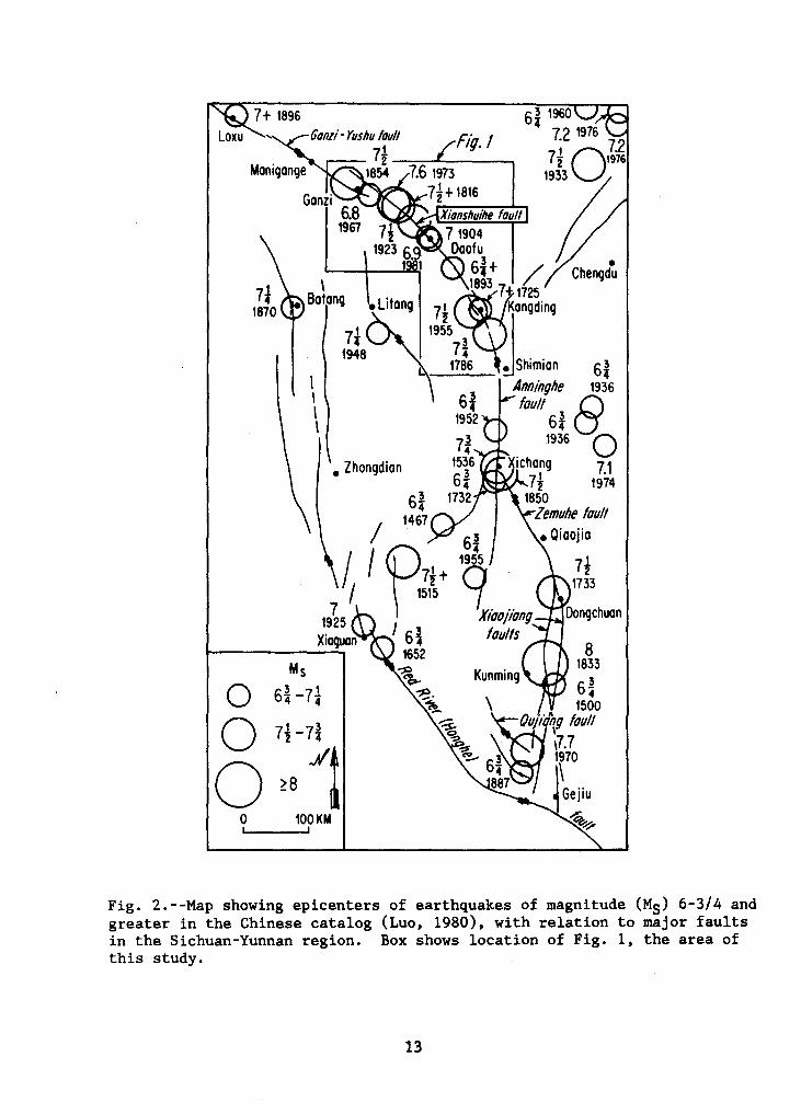
surface ruptures. During the present century, four earthquakes of magnitude 7 or greater have occurred along a 350-km segment of the fault, and at least eight such events have occurred here since 1725 (Fig. 2; Table 1). Five events exceeding magnitude 6.8 have occurred during the past 100 years along a single 150-km-long segment of the fault. Field study of this fault by the authors in 1986 were directed primarily toward slip-rate and seismic-hazard determinations, but segmentation was also a subject of interest. These wider studies have been reported in Wen et al. (in press) and Allen et al. (1988; in press); this paper sununarizes some of the conclusions given therein.
The Xianshuihe fault zone is part of a much more extensive leftlateral fault system of at least 1,400-km length, extending from southern Yunnan Province northwest through Sichuan into Qinghai Province (Fig. 1, insert)(Ding, 1984). Almost all segments of the system have been the loci of major earthquakes within the historic record (Fig.2), and it currently constitutes probably the most active fault system within China. It clearly deserves comparison with other highly active strike-slip fault systems worldwide, such as the San Andreas fault of California, the North Anatolian fault of Turkey, and the Alpine fault of New Zealand.
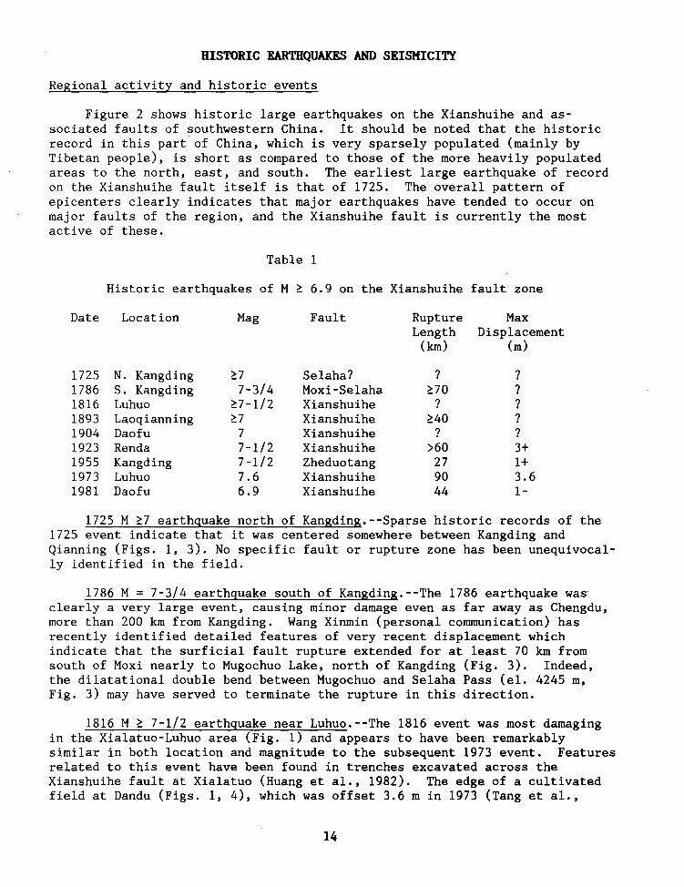
Following recent Chinese practice, we differentiate herein between the Xianshuihe fault ~· extending some 350 km northwest from near Shimian to Kasu (Fig. 1), and the more restricted Xianshuihe fault itself, which is only one of five individual segments within the overall zone. These five segments (Fig. 3) are the Moxi fault, Selaha (Kangding) fault, Zheduotang fault, Yalahe fault, and the restricted Xianshuihe fault, extending northwest from Laoqianning. The type area of the restricted Xianshuihe fault is the 150-km-long segment between Songlinkou Pass and Kasu (Fig. 1), where its trace is relatively simple and continuous, and where it controls the course of the Xianshui River and its tributaries.
At its northwestern end, the Xianshuihe fault overlaps the southeastern end of the Ganzi-Yushu fault, with a left en echelon stepover of about 40 km. At its southeastern extremity, the Xianshuihe fault zone connects with the Anninghe fault in a complex and little-studied area near Shimian. Still farther southeast, a significant en echelon offset occurs between the Anninghe and Xiaojiang fault (Fig. 2), with the very active Zemuhe fault in the transition area. All of these individual fault zones, on the other hand, must be considered parts of the same overall left-lateral fault system. The entire system lies along the northeast boundary of a large rhomb-shaped block, or miniplate, that is bounded on the opposite southwest side by the rightlateral Red River fault system (Allen et al., 1984), and the apparent southeastward movement of this relatively stable block relative to its neighbors has been the subject of much tectonic discussion (e.g., Li and Wang, 1975; Kan et al., 1977). It is admittedly somewhat surprising that two major fault systems that are almost parallel and only 200 km apart should have opposing current senses of lateral slip, although this has been explained, at least in principle, by the mechanics of the impingement of India into Eurasia and the consequent block rotations (Molnar and Tapponnier, 1975; Tapponnier and Molnar, 1976, 1977; Tapponnier et al., 1986).
12
\ Batang • Litang
I I \ I
7t 1948
• Zhongdian
Ms
Q Gi-7~
0 11-~~ 0 ~8 ~
0 100KM
611960 4 72 1976
7; 07.2 2 1976
19~
Chengdu
ichang 7t
1850 Zemuhe foul/
7t 1733
8 1833
Fig. 2.--Map showing epicenters of earthquakes of magnitude (Mg) 6-3/4 and greater in the Chinese catalog (Luo, 1980), with relation to major faults in the Sichuan-Yunnan region. Box shows location of Fig. 1, the area of this study.
13
HISTORIC EARTHQUAKES AND SEISMICITY
Regional activity and historic events
Figure 2 shows historic large earthquakes on the Xianshuihe and associated faults of southwestern China. It should be noted that the historic record in this part' of China, which is very sparsely populated (mainly by Tibetan people), is short as compared to those of the more heavily populated areas to the north, east, and south. The earliest large earthquake of record on the Xianshuihe fault itself is that of 1725. The overall pattern of epicenters clearly indicates that major earthquakes have tended to occur on major faults of the region, and the Xianshuihe fault is currently the most active of these.
Table 1
Historic earthquakes of M ~ 6.9 on the Xianshuihe fault zone
Date Location Mag Fault Rupture Max Length Displacement
(km) (m)
1725 N. Kangding ~7 Selaha? ? ? 1786 s. Kangding 7-3/4 Moxi-Selaha ~70 ? 1816 Luhuo ~7-1/2 Xianshuihe ? ? 1893 Laoqianning ~7 Xianshuihe ~40 ? 1904 Daofu 7 Xianshuihe ? ? 1923 Renda 7-1/2 Xianshuihe >60 3+ 1955 Kangding 7-1/2 Zheduotang 27 1+ 1973 Luhuo 7.6 Xianshuihe 90 3.6 1981 Daofu 6.9 Xianshuihe 44 1-
1725 M ~7 earthquake north of Kangding.--Sparse historic records of the 1725 event indicate that it was centered somewhere between Kangding and Qianning (Figs. 1, 3). No specific fault or rupture zone has been unequivocally identified in the field.
1786 M = 7-3/4 earthquake south of Kangding.--The 1786 earthquake was clearly a very large event, causing minor damage even as far away as Chengdu, more than 200 km from Kangding. Wang Xinmin (personal communication) has recently identified detailed features of very recent displacement which indicate that the surficial fault rupture extended for at least 70 km from south of Maxi nearly to Mugochuo Lake, north of Kangding (Fig. 3). Indeed, the dilatational double bend between Mugochuo and Selaha Pass (el. 4245 m, Fig. 3) may have served to terminate the rupture in this direction.
1816 M ~ 7-1/2 earthquake near Luhuo.--The 1816 event was most damaging in the Xialatuo-Luhuo area (Fig. 1) and appears to have been remarkably similar in both location and magnitude to the subsequent 1973 event. Features related to this event have been found in trenches excavated across the Xianshuihe fault at Xialatuo (Huang et al., 1982). The edge of a cultivated field at Dandu (Figs. 1, 4), which was offset 3.6 min 1973 (Tang et al.,
14
OEHCEHCEHiCEHil::liAa:::J10==========32°KM
x 5506
Fig. 3.--Sketch map of Xianshuihe fault zone in Laoqianning-Kangding area. Heavy solid line indicates fault where clearly represented by Holocene scarps. Heavy dotted line indicates segment where Holocene displacements are probably continuous but are not obvious on aerial photographs due to active river erosion or other causes. Dashed lines are major roads. Localities A-D are places where fault offsets of latest Pleistocene glacial moraines have been measured.
15
1976), has a total offset of 7.2 m, suggesting similar displacements during the two events.
1893 M ~ 7 earthquake near Qianning.--Heavy damage in the Qianning area (Fig. 1) suggests that this event was centered along the segment of the Xianshuihe fault extending from Laoqianning northwest to Daofu. Indistinct right-stepping en echelon fissures could still be identified in 1986 along the fault 10 km northwest of Laoqianning, probably resulting from the 1893 rupture (Allen et al., in press). A trench excavated across the fault at Songlinkou Pass likewise revealed offset features probably of 1893 origin. It is noteworthy that this segment of the Qianning-Kasu sector of the Xianshuihe fault is currently the longest-lasting one without a major earthquake, and it has been identified as a temporal seismic gap (Han and Huang, 1983).
1904 M = 7 earthquake near Daofu.--This earthquake, previously thought to be of magnitude 6, has recently been reinvestigated and assigned a higher magnitude of 7 (Huang, 1985), partly on the basis of Gutenberg's unpublished notes filed in Pasadena. And recently Abe (1988) suggested a magnitude of 6.9 based on Milne seismograph records. The intensity and felt area of the 1904 event seem to have been very similar to those of the 1981 Daofu earthquake, and a very old resident of a village near Daofu reported to us in 1986 that the Xianshuihe fault ruptured along exactly the same line in both 1904 and 1981.
1923 M = 7-1/2 earthquake near Renda.--The faulting associated with the 1923 earthquake was documented by Heim (1934), although he surprisingly failed to recognize its strike-slip nature. The fissures photographed by Heim at Changcu Pass (Fig. 4) are still clearly recognizable today (Allen et al., in press). A few hundred meters southeast of the photo locality, a cultural berm or retaining wall crossing the fault at right angles is clearly offset 3 m, although it is not known whether this offset results solely from the 1923 event. Two old people living near Renda reported that their mothers had spoken of an earlier earthquake similar in destruction to that of 1923, possible referring to the 1816 event.
Heim's map shows the rupture extending as far northwest as Xialatuo, but the fault leaves the valley floor (and main trail) at this point and may not have been searched for by Heim and his local informants. Strangely, Heim concentrated his attention not on the principal fault within the valley, but instead on the many linear ravines on the adjacent mountain sides, which he thought were eroded "earthquake cracks." We doubt his interpretation. Southeast of Changcu Pass, Heim's map is not clear with regard to possible 1923 fault rupture, and his traverse was along the main trail on the opposite (north) side of the river from that of the fault trace in this area. We identified en echelon cracks similar to those at the Changcu Pass 20 km farther southeast near Mazi (Fig. 4). And at the same place, the edge of a cultivated field is left laterally offset about 2 m along the line of the cracks, presumably resulting from the 1923 event. We conclude that the 1923 earthquake was associated with a maximum left slip of about 3 m, which is consistent with strike-slip earthquakes of this magnitude (Bonilla et al., 1984), and that the rupture extended at least 36 km from Xialatuo to Mazi. But because the displacement was 2 m at Mazi, the rupture must have extended a considerable distance still farther southeast, and it is not clear that anyone at that time looked for the fault trace either here or northwest of Xialatuo.
16
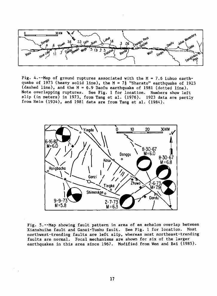
Fig. 4.--Map of ground ruptures associated with the M = 7.6 Luhuo earthquake of 1973 (heavy solid line), the M = 7! "Sharato" earthquake of 1923 (dashed line), and the M = 6.9 Daofu earthquake of 1981 (dotted line). Note overlapping ruptures. See Fig. 1 for location. Numbers show left slip (in meters) in 1973, from Tang et al. (1976). 1923 data are partly from Heim (1934), and 1981 data are from Tang et al. (1984).
0 10 20 30KMH
' ' t \,
8-30-67 M=6.8
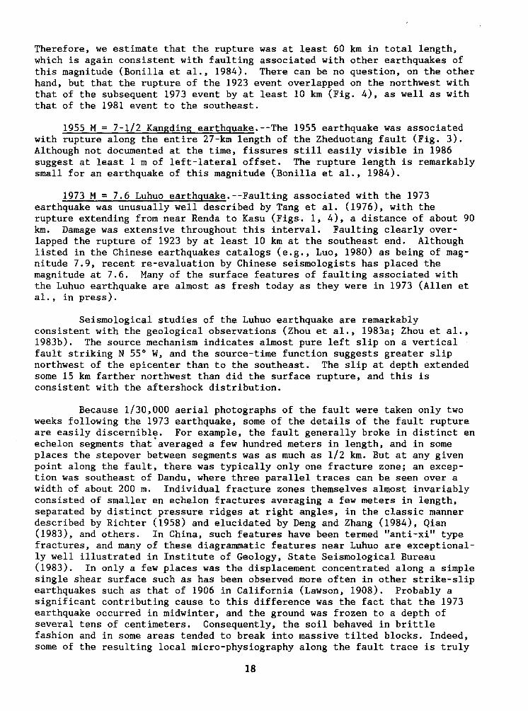
Fig. 5.--Map showing fault pattern in area of en echelon overlap between Xianshuihe fault and Ganzi-Yushu fault. See Fig. 1 for location. Most northwest-trending faults are left slip, whereas most northeast-trending faults are normal. Focal mechanisms are shown for six of the larger earthquakes in this area since 1967. Modified from Wen and Bai (1985).
17
Therefore, we estimate that the rupture was at least 60 km in total length, which is again consistent with faulting associated with other earthquakes of this magnitude (Bonilla et al., 1984). There can be no question, on the other hand, but that the rupture of the 1923 event overlapped on the northwest with that of the subsequent 1973 event by at least 10 km (Fig. 4), as well as with that of the 1981 event to the southeast.
1955 M = 7-1/2 Kangding earthguake.--The 1955 earthquake was associated with rupture along the entire 27-km length of the Zheduotang fault (Fig. 3). Although not documented at the time, fissures still easily visible in 1986 suggest at least 1 m of left-lateral offset. The rupture length is remarkably small for an earthquake of this magnitude (Bonilla et al., 1984).
1973 M = 7.6 Luhuo earthguake.--Faulting associated with the 1973 earthquake was unusually well described by Tang et al. (1976), with the rupture extending from near Renda to Kasu (Figs. 1, 4), a distance of about 90 km. Damage was extensive throughout this interval. Faulting clearly overlapped the rupture of 1923 by at least 10 km at the southeast end. Although listed in the Chinese earthquakes catalogs (e.g., Luo, 1980) as being of magnitude 7.9, recent re-evaluation by Chinese seismologists has placed the magnitude at 7.6. Many of the surface features of faulting associated with the Luhuo earthquake are almost as fresh today as they were in 1973 (Allen et al. , in press).
Seismological studies of the Luhuo earthquake are remarkably consistent with the geological observations (Zhou et al., 1983a; Zhou et al., 1983b). The source mechanism indicates almost pure left slip on a vertical fault striking N 55° W, and the source-time function suggests greater slip northwest of the epicenter than to the southeast. The slip at depth extended some 15 km farther northwest than did the surface rupture, and this is consistent with the aftershock distribution.
Because 1/30,000 aerial photographs of the fault were taken only two weeks following the 1973 earthquake, some of the details of the fault rupture are easily discernible. For example, the fault generally broke in distinct en echelon segments that.averaged a few hundred meters in length, and in some places the stepover between segments was as much as 1/2 km. But at any given point along the fault, there was typically only one fracture zone; an exception was southeast of Dandu, where three parallel traces can be seen over a width of about 200 m. Individual fracture zones themselves almost invariably consisted of smaller en echelon fractures averaging a few meters in length, separated by distinct pressure ridges at right angles, in the classic manner described by Richter (1958) and elucidated by Deng and Zhang (1984), Qian (1983), and others. In China, such features have been termed "anti-xi" type fractures, and many of these diagrammatic features near Luhuo are exceptionally well illustrated in Institute of Geology, State Seismological Bureau (1983). In only a few places was the displacement concentrated along a simple single shear surface such as has been observed more often in other strike-slip earthquakes such as that of 1906 in California (Lawson, 1908). Probably a significant contributing cause to this difference was the fact that the 1973 earthquake occurred in midwinter, and the ground was frozen to a depth of several tens of centimeters. Consequently, the soil behaved in brittle fashion and in some areas tended to break into massive tilted blocks. Indeed, some of the resulting local micro-physiography along the fault trace is truly
18
spectacular and is quite unlike that seen along most other major strike-slip faults. It is interesting to note that not only did the 1973 earthquake occur in midwinter, but also the last similar event here in 1816, thus serving to amplify the local topography.
1981 M = 6.9 Daofu earthguake.--The most recent significant earthquake on the Xianshuihe fault was that of 1981, centered near Daofu, which suffered considerable damage. Ms (China) was 6.9, and Ms (USGS) was 6.8. Zhou et al. (1983b) determined from surface-wave inversion that the earthquake was caused by pure left-lateral displacement on a vertical fault striking N 41° W, which agrees well with the local trend of the fault as observed in the field. Surface ruptures were much less obvious for this earthquake than for the 1923 and 1973 events, which is consistent with its lower magnitude. Scattered fissures occurred in many places in the alluviated valley floor near Daofu, but the most consistent en echelon cracks occurred squarely along the trace of the Xianshuihe fault near Goupu (Fig. 4) and clearly indicated left-lateral displacement (Deng and Zhang, 1984). En echelon cracks were observed intermittently along the fault from Songlinkou Pass northwest to Mazi, a distance of some 44 km (Tang et al., 1984). Worldwide fault rupture lengths for strike-slip earthquakes of Ms = 6.9 average about 27 km, with associated· displacements of about 1 m (Bonilla et al., 1984).
CHARACTERISTIC EARmQU.AKES?
The fact that a number of large earthquakes along the Xianshuihe fault appear to have been remarkably similar to earlier events lends support to the concept of the "characteristic earthquake" (Aki, 1984; Schwartz and Coppersmith, 1984). This hypothesis holds that a given segment of a fault may break repeatedly with earthquakes of essentially the same size and fault parameters, perhaps controlled by permanent asperities on the fault plane. Thus the 1816 and 1973 events along the Xianshuihe fault are perhaps characteristic earthquakes, as well as the 1904 and 1981 events. And the projected earthquake within the Daofu-Qianning seismic gap would presumable be similar to the one which ruptured much of this same segment in 1893.
SLIP-RATE DETERMINATIONS
Slip-rate determinations represented a primary objective of our field effort and are discussed at length in Allen et al. (in press); they are only summarized herein. Along the restricted Xianshuihe fault, from Songlinkou Pass to Kasu, several lines of evidence suggest that the long-term slip rate is 15 ± 5 mm/yr. This figure is based on offset terrace risers, stream channels, and valley walls, for some of which Carbon 14 dates were obtained. For the southern sector of the fault zone, south of Qianning, four offset glacial moraines of latest Pleistocene age (Fig. 3) yield an average slip rate of about 5 mm/yr. It is interesting that Molnar and Deng (1984) obtained a slip rate of 15 mm/yr simply using assumed moments of earthquakes during the past 80 years. On a somewhat similar basis, Tang et al. (1984) suggested 9 mm/yr. A principal conclusion is that the high seismicity of the historical record is typical of the fault's long-term late Quaternary behavior, and we are not witnessing a temporal burst of activity such as that seen since 1939 along the North Anatolian fault of Turkey (Allen, 1975). It should be noted that a long-term slip rate of 15 mm/yr is very high by worldwide standards, being exceeded only by such faults as the San Andreas fault of California, the
19
Alpine fault of New Zealand, the Fairweather fault of Alaska, and a few other faults in China (Ding, 1984; Molnar et al., 1987). Slip rates of 1-5 mm/yr are perhaps more typical of earthquake-producing faults the world over, and very infrequent large earthquakes have sometimes occurred on faults with slip rates as low as .02 mm/yr (Cluff et al., 1982).
FAULT SEGMENTATION
Regional fault geometry
The Xianshuihe fault is only part of a much longer left-lateral fault system extending at least 1,400 km from southern Yunnan northwest through western Sichuan into southern Qinghai Province (Fig. 1, insert). The two most obvious points of segmentation along this entire system are (1) the en echelon stepover between the Xianshuihe fault and the Ganzi-Yushu fault (Wen et al., 1985; Wen and Bai, 1985), and (2) the branching point between the Anninghe and Zemuhe-Xiaojiang faults near Xichang (Huang and Tang, 1982). Both areas have been the locus of considerable historic earthquake activity (Fig. 2). The dilatational nature of the stepover between Ganzi and Zhuwo is demonstrated by the presence of northeast-trending normal faults, as well as by normal-fault focal mechanisms of recent earthquakes within the stepover (Fig. 5), and, as predicted by Sibson (1985, 1986), the zone appears to have marked the terminations of ruptures both on the Xianshuihe fault to the southeast (e.g., in 1973) and on the Ganzi-Yushu fault to the northwest (e.g., in 1854).
The very uniform curvature of the Xianshuihe fault between Kasu and Shimian (Fig. 2) is intriguing, suggesting block rotation about a pole somewhere near the Burmese border. And the gentle curvature of the Xiaojiang fault, farther south, suggests rotation about the same pole but with a larger radius. This geometry is surprisingly similar to that of members of the San Andreas fault system in southern California, where Weldon and Humphreys (1986) recently pointed out the remarkable concentric arcs of different segments of the fault, again emphasizing the rotation of mini-blocks caught within the plate boundary structure. Departures from the smooth arcs, not departures from linearity, repres~nt the principal asperities.
En echelon off sets
The most obvious interruption in the continuity of the Xianshuihe fault itself in the region of this study is the abrupt termination of active strike-slip faulting near Laoqianning, together with the commencement farther south of normal faulting of different strike (Figs. 1, 3). No detailed geologic mapping has been done in this area, but it is clear from aerial photographs that active strike-slip faulting along the restricted Xianshuihe fault does not extend more than a few kilometers southwest of Huiyuan Monastery, at least as a single well-defined rupture similar to that to the northeast. And the Yalahe fault, as traced southeastward from the Laoqianning area, initially trends east as a normal fault before it gradually returns to the regional southwest strike; where a glacial moraine is cut by the easttrending fault at Gedalianzi Pass (A, Fig. 3), the ratio of Holocene vertical to horizontal slip is about 2:1. The broad valley of Laoqianning is itself a very unusual feature in this otherwise mountainous area and presumably owes its existence to the dilatational fault jog, analogous to those represented by many other sedimentary basins along dominantly strike-slip faults (e.g.,
20
Crowell, 1974; Rodgers, 1980; Sibson, 1985, 1986). Other features marking this first-order segmentation point are (1) the much higher relief to the south than to the north, (2) the current seismic gap along the Xianshuihe fault whose southern termination is near Laoqianning (Han and Huang, 1983), and (3) the much more distributed, net-like fault pattern to the south. Although little is known about historic large earthquakes in this area, strike-slip rupture associated with the M ~ 7 event of 1893 apparently terminated on the south within a few kilometers of Laoqianning.
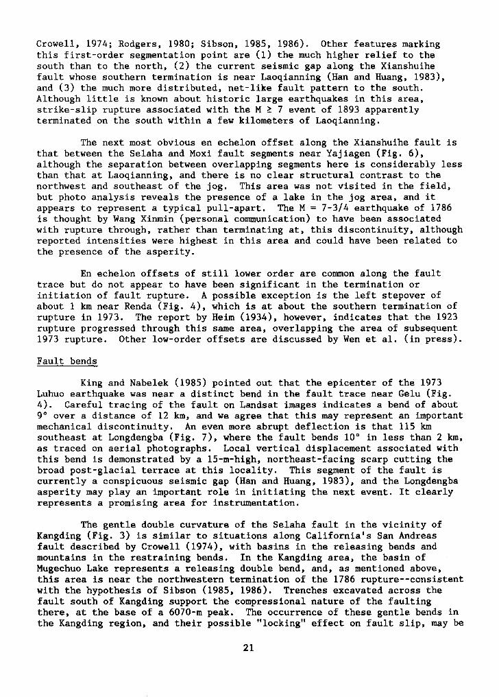
The next most obvious en echelon off set along the Xianshuihe fault is that between the Selaha and Moxi fault segments near Yajiagen (Fig. 6), although the separation between overlapping segments here is considerably less than that at Laoqianning, and there is no clear structural contrast to the northwest and southeast of the jog. This area was not visited in the field, but photo analysis reveals the presence of a lake in the jog area, and it appears to represent a typical pull-apart. The M = 7-3/4 earthquake of 1786 is thought by Wang Xinmin (personal conununication) to have been associated with rupture through, rather than terminating at, this discontinuity, although reported intensities were highest in this area and could have been related to the presence of the asperity.
En echelon off sets of still lower order are conunon along the fault trace but do not appear to have been significant in the termination or initiation of fault rupture. A possible exception is the left stepover of about 1 km near Renda (Fig. 4), which is at about the southern termination of rupture in 1973. The report by Heim (1934), however, indicates that the 1923 rupture progressed through this same area, overlapping the area of subsequent 1973 rupture. Other low-order offsets are discussed by Wen et al. (in press).
Fault bends
King and Nabelek (1985) pointed out that the epicenter of the 1973 Luhuo earthquake was near a distinct bend in the fault trace near Gelu (Fig. 4). Careful tracing of the fault on Landsat images indicates a bend of about 9° over a distance of 12 km, and we agree that this may represent an important mechanical discontinuity. An even more abrupt deflection is that 115 km southeast at Longdengba (Fig. 7), where the fault bends 10° in less than 2 km, as traced on aerial photographs. Local vertical displacement associated with this bend is demonstrated by a 15-m-high, northeast-facing scarp cutting the broad post-glacial terrace at this locality. This segment of the fault is currently a conspicuous seismic gap (Han and Huang, 1983), and the Longdengba asperity may play an important role in initiating the next event. It clearly represents a promising area for instrumentation.
The gentle double curvature of the Selaha fault in the vicinity of Kangding (Fig. 3) is similar to situations along California's San Andreas fault described by Crowell (1974), with basins in the releasing bends and mountains in the restraining bends. In the Kangding area, the basin of Mugechuo Lake represents a releasing double bend, and, as mentioned above, this area is near the northwestern termination of the 1786 rupture--consistent with the hypothesis of Sibson (1985, 1986). Trenches excavated across the fault south of Kangding support the compressional nature of the faulting there, at the base of a 6070-m peak. The occurrence of these gentle bends in the Kangding region, and their possible "locking" effect on fault slip, may be
21
Fig. 6.--Map of area of en echelon offset between Selaha (Kangding) and Moxi members of the Xianshui fault zone, 15 km northwest of Moxi. For location, see Fig. 1.
22
related to the fact that this segment of the Xianshuihe fault seems to be characterized by infrequent large earthquakes rather than more frequent moderate ones. Similarly, the great earthquakes on the San Andreas fault in 1906 and 1857 have been related to major bends in those specific areas (Allen, 1967).
Surface rupture during the 1955 Kangding earthquake (M = 7-1/2) was limited, insofar as is known, to the gently curving Zheduotang fault (Fig. 3), although the entire fault segment apparently broke during this one event. Since the Selaha and Zheduotang branches of the Xianshuihe fault system are, at most, only 10 km apart in this area, and they converge toward their ends, it is possible that they dip steeply toward each other and merge at depth. This might help explain the unusually short surf ace rupture length of 27 km in 1955 for an earthquake of magnitude 7-1/2; fault rupture at depth may have been more complicated, with accompanying slip on the Selaha or other branches that either did not reach the ground surface or went unnoticed in this remote, mountainous region.
Other localities
Other than the few examples mentioned in the preceding sections, it is difficult to identify asperities associated with the terminations of ruptures during historic earthquakes on the relatively continuous restricted Xianshuihe fault between Qianning and Yingda (Fig. 1). Indeed, the continuity of the fault in this region is so great that, in the absence of the historical record, one could not preclude a single large earthquake rupturing the entire 220-km-long segment. Yet this has not happened in several hundred years, and the historic record instead suggests that earthquakes of shorter rupture length occur repeatedly as smaller "characteristic" events (Schwartz and Coppersmith, 1984). While it is tempting to identify more obscure geologic features such as alleged cross structures, small basins, and minor bends as asperities controlling these events, we hesitate to do so in the absence of more detailed geologic mapping and more detailed seismographic coverage. This does, however, remain a very promising area of field investigation.
FAlil.T CREEP
Background
Continuous or episodic surf icial slip on a fault, known as fault creep, was first recognized on the San Andreas fault in California (Steinbrugge and Zacher, 1960). This behavior is now known to characterize several segments of the San Andreas fault at average rates varying from < 1 mm/yr to as much as about 30 mm/yr, and the highest rate effectively represents the total local long-term strain-accumulation rate (Savage and Burford, 1973; Thatcher, 1979). But despite intensive searches along active faults elsewhere in the world, fault creep was until recently recognized only at a single locality on the North Anatolian fault of Turkey, discovered in 1969 (Aytun, 1982). Thus the recent documentation of creep on the Xianshuihe fault is of particular scientific interest.
23

Fig. 7.--Sketch map of most active trace of Xianshuihe fault in Songlinkou-Longdengba area (Fig. 1). Dashed line represents KangdingLhasa highway. Four conspicuous sag ponds are indicated by "SP". Numerals indicate road maintenance stations. Note sharp 10° bend in fault at Longdengba, associated locally with a 15-m-high northeast-facing fault scarp.
50
40
E 30 cu E -"'
0 :::>
""' CT <J :t: = 0
<J 20 cu
0 :::> = :::>
_J
<O
10 ,...:
"
Fig. 8.--Creep measurements across the Xianshuihe fault at Xialatuo (Fig. 1). Solid circles on uppermost line (horizontal slip) represent times of individual measurements; readings were generally more frequent on the other lines (vertical slip). Inset shows arrangement of monuments. Line A'-B' is 133 m long and comprises 8 monuments. Modified from Ge (1985).
24

Observations
Following the 1973 Luhuo earthquake, geodetic resurveys indicated that both horizontal and vertical displacements were continuing to occur within a few hundred meters of the fault trace at several localities. These changes were particularly well documented at Xialatuo, where vertical uplift of the southwest block averaged 4.4 mm/yr between 1973 and 1975 but has subsequently decreased markedly (Ge, 1985). Probably more tectonically significant is the horizontal motion at this site, surveyed some 26 times since 1976 along a 133~m-long line of 9 monuments. These surveys (Fig. 8) show an almost steady left-lateral creep of about 6 nun/yr, most of which is concentrated within a few meters of the fault trace. From the measurements of Figure 8, one could argue either that the horizontal creep rate is relatively constant with time, or that a very long and gentle decay is following the 1973 earthquake, which was associated with 10 cm of left slip at this locality (Tang et al., 1976). Thirteen years is admittedly a long time for post-seismic creep to persist at such a high rate, and there are few other earthquakes of this magnitude for which data exist with which to compare. Exponential decay of creep following recent California earthquakes has been much faster, but the earthquakes have also been much smaller (e.g., Smith and Wyss, 1968; Cohn et al., 1982; Louie et al., 1985). It is significant, nevertheless, that post-seismic creep in California has occurred only on faults that also display continuing or episodic slip between major events. An earthquake more comparable in magnitude to that of the Luhuo event was the Ms= 7.5 Guatemala earthquake of 1976, where left afterslip on the Motagua fault continued at least through 1977 (Bucknam et al., 1978), but at a very rapidly decaying rate--quite unlike that at Xialatuo. Both in Guatemala and at Xialatuo, alluvial thicknesses at the measurement sites are small (± 10 mat Xialatuo), suggesting that whatever creep is occurring cannot be attributed solely to delay in upward propagation of slip through thick alluvium, as has been proposed for some California sites (e.g., Burford, 1972). On neither the Motagua or Xianshuihe faults is there good evidence indicating whether or not significant creep was occurring in the years before the recent earthquakes.
At other locations along the Xianshuihe fault, only sparse data of horizontal slip are available, and for much shorter time periods than that of the Xialatuo record (Ge, 1985). The survey site near the northwest end of the 1973 rupture at Zhuwo (Fig. 4), showed consistent left-lateral slip of about 1.5 mm/yr in 12 resurveys from mid-1980 through 1984. The next survey site southeast, at Dandu, showed essentially no horizontal displacement during the same period. The site at Shawan (Fig. 4) showed questionable right-lateral slip of about 1 mm/yr, but other nearby sites at Geluohazi and Xuxu showed no significant horizontal slip. No other survey sites exist along the fault except near Daofu, where some post-seismic creep following the 1981 earthquake is suggested, and near Laoqianning (Fig. 3), where no significant horizontal slip has occurred during the 1979-1984 period. Similarly, no discernible slip has occurred across the Zheduotang fault during the 1975-1984 period.
There is a strong suggestion in California that the distribution of the creeping and "locked" segments of the San Andreas fault is related to basement rock types, with creep occurring primarily in areas of abundant serpentinite and Franciscan basement on at least one side of the fault (Allen, 1967; Irwin and Barnes, 1975). We are not aware of any such relationship
25
along the Xianshuihe fault, although detailed geologic mapping has yet to be carried out in most of this region.
At many of the survey sites along the Xianshuihe fault, continuing vertical displacements have taken place following the Luhuo earthquake, but their tectonic significance is more debatable than that of the horizontal movements owing to the topographic relief along the fault trace, ground water changes, etc.
Summary of Creep Observations
There is no question but that significant horizontal creep has occurred along some segments of the Xianshuihe fault during the 1976-1986 time period, but not along other segments. The highest creep rate measured, about 6 mm/yr at Xialatuo, may be post-seismic creep related to the 1973 Luhuo earthquake, but the fact that it still continues at a high rate 13 years following the event suggests that other processes are also involved.· Too little is known about the spatial distribution of creep along the fault, and its relationship to microseismicity, to draw conclusions of a predictive nature, but the analogy to the Parkfield, California, situation is intriguing (Bakun and Lindh, 1985). The repetition of seemingly "characteristic" historic earthquakes along the Xianshuihe fault, taken together with spatial and temporal discontinuities in creep rates, surely indicate that this is a feature worthy of further detailed studies in connection with earthquakeprediction efforts and segmentation studies.
ACKNOWLKDGHENTS
This study was carried out under the protocol for scientific and technical cooperation in earthquake studies between the State Seismological Bureau of the People's Republic of China and the U.S. Geological Survey and the National Science Foundation. The field study was sponsored by the Seismological Bureau of Sichuan Province. American participation was supported by U.S. Geological Survey Grant No. 14-08-0001-Gl088. Contribution No. 4612, Division of Geological and Planetary Sciences, California Institute of Technology.
REFERENCES
Abe, K., 1988, Magnitudes and origin times from Milne seismographic data: Earthquakes in China and California, 1898-1912: p. 37-50 in Lee, W. H., Meyers, H., and Shimazaki, K., eds., Historical seismograms and earthquakes of the world, London, --Academic Press.
Aki, K., 1984, Asperities, barriers, characteristic earthquakes, and strong motion prediction: Jour. Geophys. Research, v. 89, p. 5867-5872.
Allen, C. R., 1967, The tectonic environments of seismically active and inactive areas along the San Andreas fault system: Stanford Univ. Pubs. Geol. Sciences, v. 11, p. 70-82.
Allen,-C. R., 1975, Geological criteria for evaluating seismicity: Geol. Soc. America Bull., v. 86, p. 1041-1057.
26
Allen, C. R., Gillespie, A. R., Han Yuan, Sieh, K. E., Zhang Buchun, and Zhu Chengnan, 1984, Red River and associated faults, Yunnan Province, China: Quaternary geology, slip rates, and seismic hazard: Geol. Soc. America Bull., v. 95, p. 686-700.
Allen, C.R., Luo Zhuoli, Qian Hong, Wen Xueze, Zhou Huawei, and Huang Weishi, in press, Field study of a highly active fault zone: The Xianshuihe fault of southwestern China.
Allen, C. R., Luo Zhuoli, Qian Hong, Wen Zueze, Zhou Huawei, and Huang Weishi, 1988, Seismic hazard evaluation of a highly active fault--The Xianshuihe fault of southwestern China: Proc. Internatl. Seminar on Seismic Zonation, Guangzhou, China, 6-10 Dec. 1987.
Aytun, A., 1982, Creep measurements in the Ismetpasa region of the North Anatolian fault zone, p. 279-292 in Isakara, A. M., and Vogel, A., eds., Multidisciplinary approach to earthquake prediction, v. 2: Braunschweig/Wiesbaden, Friedr. Vieweg & Sohn, 578 p.
Bakun, W. H., and Lindh, A. G., 1985, The Parkfield, California, earthquake prediction experiment: Science, v. 229, p. 619-624.
Bonilla, M. G., Mark, R. K., and Lienkaemper, J. J., 1984, Statistical relations among earthquake magnitude, surface rupture length, and surface fault displacement: Seismal. Soc. America Bull., v. 74, p. 2379-2411.
Bucknam, R. C., Plafker, G., and Sharp, R. V., 1978, Fault movement (afterslip) following the Guatemala earthquake of February 4, 1976: Geology, v. 6, p. 170-173.
Burford, R. 0., 1972, Continued slip on the Coyote Creek fault after the Borrego Mountain earthquake: U.S. Geol. Survey Prof. Paper 787, p. 105-111.
Cluff, L. S., Coppersmith, K. J., and Kneupfer, P. J., 1982, Assessing degrees of fault activity for seismic zonation: Proc. 3rd Internatl. Microzonation Conf., v. 1, p. 113-118.
Cohn, S. N., Allen, C. R., Gilman, R., and Goulty, N. R., 1982, Preearthquake and postearthquake creep on the Imperial fault and the Brawley fault zone: U.S. Geol. Survey Prof. Paper 1254, p. 161-167.
Crowell, J. C., 1974, Origin of late Cenozoic basins in southern California: Soc. Econ. Paleontologists and Mineralogists Spec. Pub. 22, p. 190-204.
Deng Qidong, and Zhang Peizhen, 1984, Research on the geometry of shear fracture zones: Jour. Geophys. Research, v. 89, p. 5699-5710.
Ding Guoyu, 1984, Active faults of China, p.225-242 in A Collection of Papers of International Symposium on Continental Seismicity and Earthquake Prediction: Beijing, Seismological Press, 867 p.
27
Ge Peiji, 1985, Analysis of the geodetic measurements across the Xianshuihe rupture zone [in Chinese], p. 158-165 in Sichuan Seismological Bureau, Proceedings of the conference on the Xianshuihe fault zone: Beijing, Seismological Press, 254 p.
~Han Weibin, and Huang Shengmu, 1983, A seismic gap on the Xianshuihe fault, Sichuan Province [in Chinese]: Acta Seismologica Sinica, v. 5 (3), p. 280-286.
Heim, A., 1934, Earthquake region of Taofu: Geol. Soc. America Bull., v. 45, p. 1035-1049.
Huang Shengmu, 1985, A preliminary discussion on seismic episodes of the Xianshuihe seismic zone, p. 88-93 in Sichuan Seismological Bureau, Proceedings of the conference on the Xianshuihe fault zone: Beijing, Seismological Press, 254 p.
Huang Shengmu, Liu Benpei, Jiang Zaixiong, and Li Dinfu, 1982, Seismic faults of Xialatuo, Luhuo County, Sichuan Province [in Chinese]: Seismology and Geology, v. 4 (1), p. 67-71.
Huang Zuzhi and Tang Rongchang, 1982, A preliminary study of the seismogeological characteristics of the Zemuhe fault [in Chinese], p. 251-261 in The active faults of China: Beijing, Seismological Press, 337 p.
Institute of Geology, State Seismological Bureau, 1983, The photo album of eight strong earthquake disasters in China: Beijing, Seismological Press, 434 figs.
Irwin, W. P., and Barnes, I, 1975, Effect of geologic structure and metamorphic fluids on seismic behavior of the San Andreas fault system in central and northern California: Geology, v. 3, p.713-716.
Kan Rongju, Zhang Sichang, Yan Fengtong, and Yu Linsheng, 1977, Present tectonic stress field and its relation to the characteristics of recent tectonic activity in southwestern China [in Chinese]: Acta Geophysica Sinica, v. 20 (2), p. 96-109.
King, G., and Nabelek, J., 1985, Role of fault bends in the initiation and termination of earthquake rupture: Science, v. 228, p. 984-987.
Lawson, A. C., ed., 1908, The California earthquake of April 18, 1906: Carnegie Inst. Washington Pub. 87, 3 vols.
Li Ping, and Wang Liangmou, 1975, Exploration of the seismo-geological features of the Yunnan-West Sichuan region [in Chinese]: Scientia Geologica Sinica, 1975 (4), p. 308-326.
Louie, J. N., Allen, C. R., Johnson, D. C., Haase, P. C., and Cohn, S. N., 1985, Fault slip in southern California: Seismol. Soc. America Bull., v. 75, p. 811-833.
28
Luo Zhuoli, ed., 1980, Seismic History of Sichuan Province [in Chinese]: Chengdu, People's Press, 2 vols.
Molnar, P., Burchfiel. B. C., Liang K'uangyi, and Zhao Ziyun, 1987, Geomorphic evidence for active faulting in the Altyn Tagh and northern Tibet and qualitative estimates of its contribution to the convergence of India and Eurasia: Geology, v. 15, p. 249-253.
Molnar, P., and Deng Qidong, 1984, Faulting associated with large earthquakes and the average rate of deformation in central and eastern Asia: Jour. Geophys. Research, v. 89, p. 6203-6227.
Molnar, P., and Tapponnier, P., 1975, Cenozoic tectonics of Asia: Effects of a continental collision: Science, v. 189, p. 419-426.
Qian Hong, 1983, On the mechanism of the formation of anti xi-type ground crack zones along the Xianshuihe fault [in Chinese]: Seismology and Geology, v. 5 (3), p.75-79.
Richter, C. F., 1958, Elementary seismology: San Francisco, W. H. Freeman, 768 p.
Rodgers, D. A., 1980, Analysis of pull-apart basin development produced by en echelon strike-slip faults: Internatl. Assoc. Sedimentologists Spec. Pub. 4, p. 27-41.
Savage, J. C., and Burford, R. 0., 1973, Geodetic determination of the relative plate motion in California: Jour. Geophysical Research, v. 78, p. 832-845.
Schwartz, D. P., and Coppersmith, K. J., 1984, Fault behavior and characteristic earthquakes: Examples from the Wasatch and San Andreas fault zones: Jour. Geophys. Research, v. 89, p. 5681-5696.
Sibson, R. H., 1985, Stopping of earthquake ruptures at dilatational fault jogs: Nature, v. 316, p. 248-251.
Sibson, R. H., 1986, Rupture interaction with fault jogs: Am. Geophys. Union Geophys. Mon. 37, p. 157-167.
Smith, S. W., and Wyss, M., 1968, Displacement on the San Andreas fault subsequent to the 1966 Parkfield earthquake: Seismal. Soc. America Bull., v. 58, p. 1955-1973.
Steinbrugge, K. V., and Zacher, E. G., 1960, Creep on the San Andreas fault-fault creep and property damage: Seismal. Soc. America Bull., v. 50, p. 389-396.
Tang Rongchan, Qian Hong, Chang Wenfu, Chang Chengqui, Cao Yangguo, and Liu Shengli, 1984, On the seismogeological setting and conditions of seismogenic structures of 1981 Daofu earthquake [in Chinese]: Seismology and Geology, v. 6 (2), p. 33-40.
29
Tang Rongchang, Wen Dehua, Deng Tiangang, and Huang Shengmu, 1976, A preliminary study of the characteristics of the ground fractures during the Luhuo M = 7.9 earthquake, 1973 and the origin of the earthquake [in Chinese]: Acta Geophysica Sinica, v. 19 (1), p. 19-27.
Tapponnier, P., and Molnar, P., 1976, Slip line field theory and large-scale continental tectonics: Nature, v. 264, p. 319-324.
Tapponnier, P., and Molnar, P., 1977, Active faulting and tectonics in China: Jour. Geophys. Research, v. 82, p. 2905-2930.
Tapponnier, P., Peltzer, G., and Armijo, R., 1986, On the mechanics of the collision between India and Asia, p. 115-157 in Coward, M. P., and Ries, A. C., eds., Collision tectonics: Geol. Soc. Spec. Pub. 19.
Thatcher, W., 1979, Systematic inversion of geodetic data in central California: Jour. Geophys. Research, v. 84, p. 2283-2295.
Weldon, R., and Humphreys, E., 1986, A kinematic model of southern California: Tectonics, v. 5, p. 33-48.
Wen Xueze, and Bai Lianxiang, 1985, The crustal fracture pattern and seismogenic structure of the northwestern segment of the Xianshuihe fault zone [in Chinese], p. 33-40 in Sichuan Seismological Bureau, Proceedings of conference on Xianshuihe fault zone: Beijing, Seismological Press, 254 p.
Wen Xueze, Huang Shengmu, and Jiang Zaixiong, 1985, Neotectonic features of the Ganzi-Yushu fault zone and assessment of its earthquake risk [in Chinese]: Seismology and Geology, v. 7 (3), p. 23-34.
Wen Xueze, Luo Zhuoli, Qian Hong, Zhou Huawei, Huang Weishi, and Allen, C.R., in press, Segmentation, geometric features, and their seismotectonic implications for the Holocene Xianshuihe fault zone [in Chinese]: Seismologica Sinica.
Zhou Huilan, Allen, C.R., and Kanamori, H., 1983a, Rupture complexity of the 1970 Tonghai and 1973 Luhuo earthquakes, China, from P-wave inversion, and relationship to surface faulting: Seismal. Soc. America Bull., v. 73, p. 1585-1597.
Zhou Huilan, Liu, H.-L., and Kanamori, H., 1983b, Source processes of large earthquakes along the Xianshuihe fault in southwestern China: Seismal. Soc. America Bull., v. 73, p. 537-551.
30