Embed Size (px)
Citation preview

1 | US DOE Geothermal Office eere.energy.gov
Public Service of Colorado Ponnequin Wind Farm
Geothermal Technologies Office 2015 Peer Review
Play Fairway Analysis (PFA): Structurally Controlled Geothermal Systems in the Central Cascades
Arc-Backarc Regime, Oregon
Philip E. Wannamaker, P.I. University of Utah/EGI
423 Wakara Way, Ste 300
Salt Lake City, UT 84108 U.S.A.
Ph. 801-581-3547
Track: Exploration Validation/PFA Project Officer: Mark Zeigenbein; Total Project Funding: $537,482 May 12, 2015
This presentation does not contain any proprietary
confidential, or otherwise restricted information.
NB
3S JF/BB KL
CL
KN
_____________ 50 km
DP
McL
Co-I’s: Andrew Meigs (OSU); B.Mack Kennedy, Eric Sonnenthal (LBNL); Joseph Moore, (U Utah)
_____ > N
WR

2 | US DOE Geothermal Office eere.energy.gov
Relevance/Impact of Research
• Principal Objective: Accelerate Near-Term Hydrothermal Growth
– Lower risks and costs of development and exploration
– Lower levelized cost of electricity (LCOE) to 6 cents/kWh by 2020
– Accelerate development of 30 GWe undiscovered hydrothermal resources
• Challenges/Knowledge Gaps: Develop a Play Fairway Analysis
(PFA) model for Central Cascades, Oregon; overcome dense
vegetative cover, rain curtain masking, sparse geoscientific data.
• Cost Impact: Improved geothermal costs through new
methodologies, new geothermal play model, economies of scale.
• Innovative Aspects: Combines MT, structure, geochem; new 3D
MT inversion method; new LiDAR-based structure imaging; new
subsurface X-T modeling with ToughReact and Geo-T.
• Meeting GTO goals: Intended to open an underdeveloped U.S.
geothermal province; identify new plays and play types.

3 | US DOE Geothermal Office eere.energy.gov
Scientific/Technical Approach
• Central Cascades Rationale: Superposition of andesitic subduction flux
and bimodal rifting tectono-magmatism; extensional stress permeability

4 | US DOE Geothermal Office eere.energy.gov
Scientific/Technical Approach
• PFA Approach Summary: Need to identify heat source, access to fluids,
pathways to heat up and concentrate fluids, high permeability reservoir, caprock.
• Use MT to image high-T, fluidized upwellings; Use LiDAR and high-res DEM for
structural modeling through forest cover; Use Geo-T and ToughReact for
subsurface and fluid X-T state. O&G Source CRS Reservoir Q CRS
Seal Q CRS Cumulative CRS
O&G CRS Analogs (Saudi Pen.)
Oil & Gas Exploration Process Triangle
(A. Fraser, Geol. Soc. London, 2010)
XX
Pr
Inj
Mn
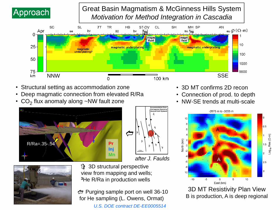
U.S. DOE contract DE-EE0005514
R/Ra=.35-.54
3D MT Resistivity Plan View B is production, A is deep regional
d
after J. Faulds
Purging sample port on well 36-10
for He sampling (L. Owens, Ormat)
c
3D structural perspective
view from mapping and wells; 3He R/Ra in production wells
d
Great Basin Magmatism & McGinness Hills System
Motivation for Method Integration in Cascadia
• 3D MT confirms 2D recon
• Connection of prod. to depth
• NW-SE trends at multi-scale
• Structural setting as accommodation zone
• Deep magmatic connection from elevated R/Ra
• CO2 flux anomaly along ~NW fault zone
NNW SSE
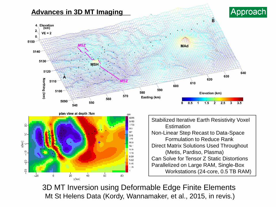
3D MT Inversion using Deformable Edge Finite Elements Mt St Helens Data (Kordy, Wannamaker, et al., 2015, in revis.)
Stabilized Iterative Earth Resistivity Voxel
Estimation
Non-Linear Step Recast to Data-Space
Formulation to Reduce Rank
Direct Matrix Solutions Used Throughout
(Metis, Pardiso, Plasma)
Can Solve for Tensor Z Static Distortions
Parallelized on Large RAM, Single-Box
Workstations (24-core, 0.5 TB RAM)
Advances in 3D MT Imaging

Faulds et al. (2013)
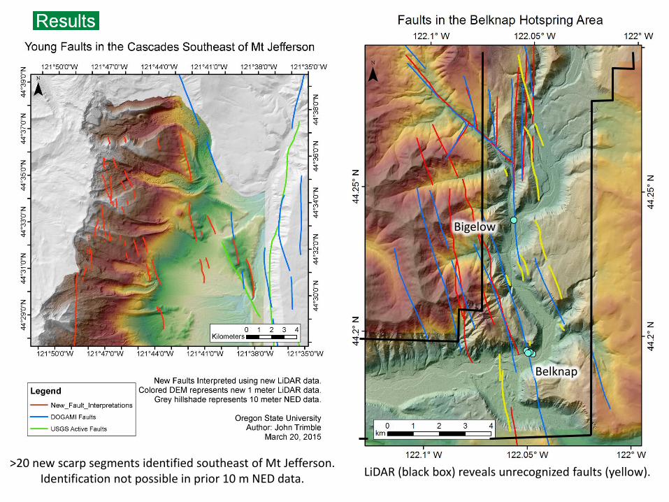
Dilatent Structure Examples in Central Cascades from LiDAR Data
- LiDAR reveals lineaments not perceptible previously
- New coverage (orange) includes north-central Cascades graben
Advances in Structural Geology Analysis
Central Oregon
LiDAR Coverage
Green Ridge-Black Butte
Fault Intersections

Initial Focus Area for Geochemical
Evaluation
Improve Cascades Geochemical System Understanding Through New Tools
Geo-T and ToughReact: Apply First to Data-Rich Three Sisters Region
Advances in Major Element
And Isotope Geochemistry
9 | US DOE Geothermal Office eere.energy.gov
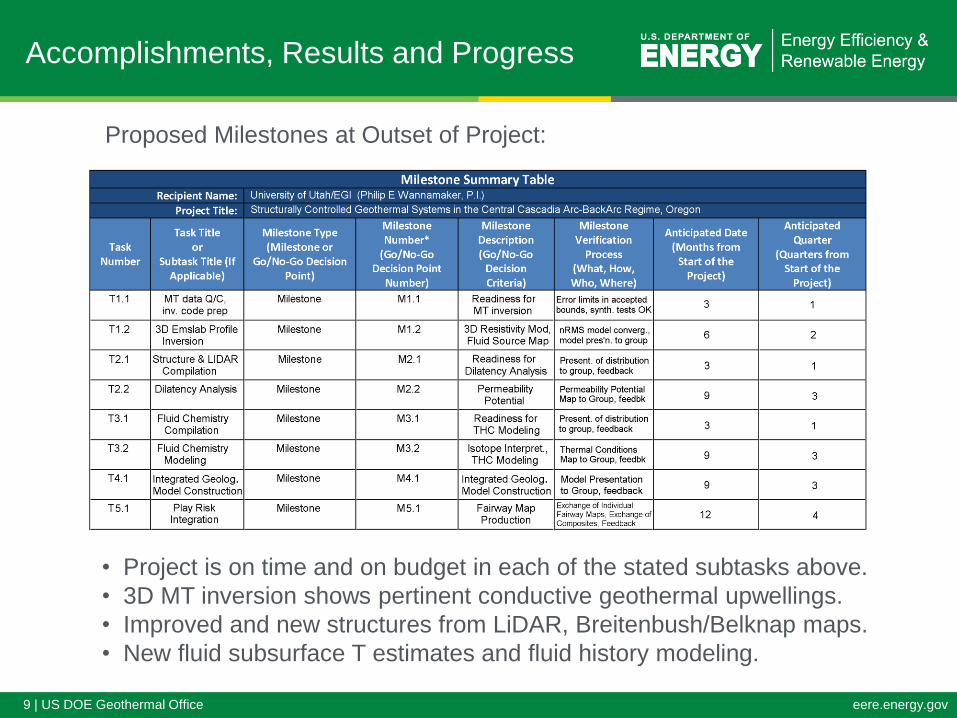
Accomplishments, Results and Progress
Proposed Milestones at Outset of Project:
• Project is on time and on budget in each of the stated subtasks above.
• 3D MT inversion shows pertinent conductive geothermal upwellings.
• Improved and new structures from LiDAR, Breitenbush/Belknap maps.
• New fluid subsurface T estimates and fluid history modeling.

3D MT Inversion Edge Finite Element Mesh (EMSLAB + Earthscope sites)
- 60 MT stations (28 EMSLAB, 32 Earthscope)
- 31 periods (0.11 to 2560 s)
- Sub Rx: min cell = 1.5 km w, max cell 5 km w
- FE mesh: 145 (n) x 231 (e) x 59 (z) cells (10 air)
- Inversion domain: 133 x 214 x 42 = 1,170,134 parameters
- Error floors: 3.5% max{ |Zij| ; |Zxy-Zyx|/2 }, 0.03 tipper
- 33 ohm-m starting model, nRMS = 1.7 after 9 iters
- 31 hours/iter on 24-core w/s with 0.5 TB RAM
Convergence
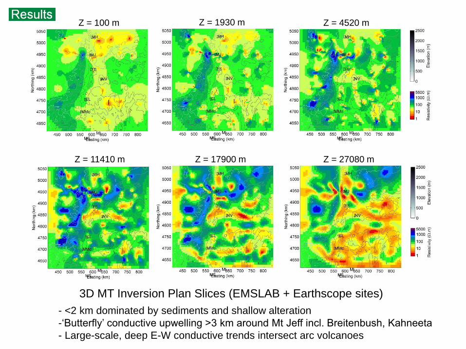
Z = 100 m Z = 1930 m Z = 4520 m
Z = 11410 m Z = 17900 m Z = 27080 m
3D MT Inversion Plan Slices (EMSLAB + Earthscope sites)
- <2 km dominated by sediments and shallow alteration
-‘Butterfly’ conductive upwelling >3 km around Mt Jeff incl. Breitenbush, Kahneeta
- Large-scale, deep E-W conductive trends intersect arc volcanoes
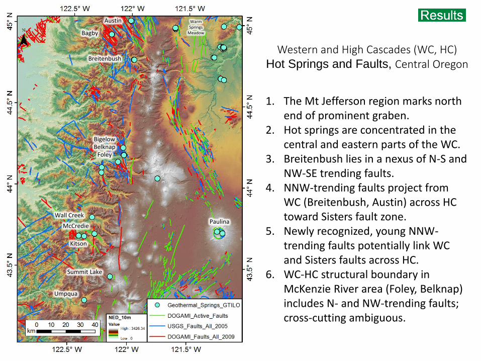
1. The Mt Jefferson region marks north end of prominent graben.
2. Hot springs are concentrated in the central and eastern parts of the WC.
3. Breitenbush lies in a nexus of N-S and NW-SE trending faults.
4. NNW-trending faults project from WC (Breitenbush, Austin) across HC toward Sisters fault zone.
5. Newly recognized, young NNW-trending faults potentially link WC and Sisters faults across HC.
6. WC-HC structural boundary in McKenzie River area (Foley, Belknap) includes N- and NW-trending faults; cross-cutting ambiguous.
Breitenbush
Bagby
Austin
Bigelow Belknap
Paulina
Summit Lake
Umpqua
Foley
McCredie
Wall Creek
Kitson
Warm Springs
Meadow
Western and High Cascades (WC, HC) Hot Springs and Faults, Central Oregon
Belknap
Bigelow
LiDAR (black box) reveals unrecognized faults (yellow). >20 new scarp segments identified southeast of Mt Jefferson.
Identification not possible in prior 10 m NED data.
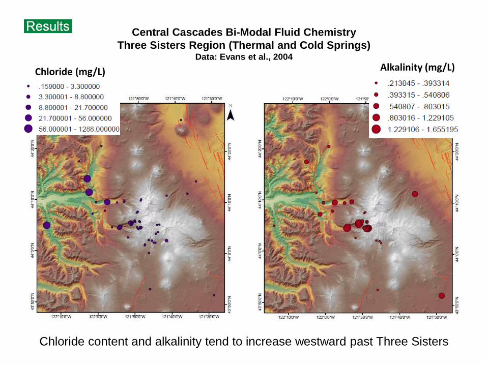
Chloride (mg/L) Alkalinity (mg/L)
Central Cascades Bi-Modal Fluid Chemistry
Three Sisters Region (Thermal and Cold Springs) Data: Evans et al., 2004
Chloride content and alkalinity tend to increase westward past Three Sisters

-2.0
-1.5
-1.0
-0.5
0.0
0.5
1.0
1.5
2.0
100 120 140 160 180 200 220 240 260 280 300
Log(Q
/K)
Temperature (°C)
calcitewairakitalbit-lopyritemicroclianhydritmontm-kquartz
Reconstructed pH, Al, HS-
0.0
0.1
0.2
0.3
0.4
0.5
0.6
0.7
0.8
0.9
1.0
100 120 140 160 180 200 220 240 260 280 300
Log(Q
/K)
Sta
tistics
Temperature (°C)
RMED
RMSE
SDEV
MEAN
Computed T
132 C
Na-K-Ca 54
Na-K 126
K-Mg 110
Chalcedony 79
Quartz 109
-2.0
-1.5
-1.0
-0.5
0.0
0.5
1.0
1.5
2.0
100 120 140 160 180 200 220 240 260 280 300
Log(Q
/K)
Temperature (°C)
anhydritmicroclimontm-kalbit-lowairakitcalcitepyritequartz
Reconstructed pH, Al, HS-
0.0
0.1
0.2
0.3
0.4
0.5
0.6
0.7
0.8
0.9
1.0
100 120 140 160 180 200 220 240 260 280 300
Log(Q
/K)
Sta
tistics
Temperature (°C)
RMED
RMSE
SDEV
MEAN
Computed T
142 C
Na-K-Ca 79
Na-K 140
K-Mg 90
Chalcedony 100
Quartz 128
-2.0
-1.5
-1.0
-0.5
0.0
0.5
1.0
1.5
2.0
100 120 140 160 180 200 220 240 260 280 300
Log(Q
/K)
Temperature (°C)
calcitepyriteanhydritmontm-kquartzwairakitmicroclialbit-lo
Reconstructed pH, Al, HS-
0.0
0.1
0.2
0.3
0.4
0.5
0.6
0.7
0.8
0.9
1.0
100 120 140 160 180 200 220 240 260 280 300
Log(Q
/K)
Sta
tistics
Temperature (°C)
RMED
RMSE
SDEV
MEAN
Computed T
144 C
Na-K-Ca 84
Na-K 140
K-Mg 122
Chalcedony 116
Quartz 142
Belknap
(no dilution) Bigelow
(1% dilution) Terwilliger
(26% dilution)
Simultaneous regression Solve for Al and dilution factor HS set with pyrite equilibrium
Three Sisters Region: Thermal Springs (high chloride) Multi-Component Geothermometry (Geo-T)
Convergence at T ~ 130-140 C
Geo-T: http://esd.lbl.gov/research/projects/geot/

Helium – Chloride Co-Variations: Oregon Cascade Thermal Springs and Three Sisters Area Cold springs
Strong correlation between concentration of magmatic 3He and Chloride
Lack of similar correlation with 3He/4He ratios suggests Cl-rich fluids, which
contain more 4He, are more evolved or passed through different lithology

17 | US DOE Geothermal Office eere.energy.gov
Future Directions
• Our strategy is intended to provide focus for followup exploration and development in this area
of possible high geothermal potential. Table presents project year plan going forward.
• Future activities for FY2015:
– Complete cataloging of possible geothermally-relevant low-resistivity upwellings.
– ID of new faulting esp. to south in area, dilatency analysis for permeability potential.
– Spring chemistry modeling esp. to south in area, interp. of ultimate fluid sources.
– Derivation of characteristic geothermal model(s) for Central Cascadia.
– Presentation of possible play areas for followup assessment.
– Identification of data needs and next steps in this region of sparse knowledge.

18 | US DOE Geothermal Office eere.energy.gov
• Central Cascades should have high geothermal potential given
confluence of subduction arc and extensional magmatism.
• Integration of MT resistivity, structural analysis and fluid geochemistry
constitutes methodology for prioritizing exploration and play ranking.
• Low-resistivity upwellings resolved using new MT inversion capability
may point toward shallower high temperatures and fluids.
• New LiDAR and high-res DEM data are allowing identification of
hidden recent faulting, NW cross-arc trends, and structural setting for
dilatency assessment.
• State-of-the-art geochemical modeling allows equilibrium or reaction-
based subsurface fluid temperature estimates with rigor beyond
standard geothermometry.
• PFA will move southward from Mt Jefferson-Three Sisters area as
project progresses.
• Central Cascades suffers from data sparseness which needs to be
addressed going forward.
Summary

![750824 Nepalese 1NedM...BROTHER / bfHobbffHHoobfHo\ \\\ jf jjff jf EffO{ SISTER / lbbL jf alxgL GRANDFATHER / afh] afh] GRANDMOTHER/ aHo}aHo} CHILDREN / afnaflnsfafnaflnsfafnaflnsf](https://img.pdfslide.us/doc/110x75/60a55d6948a28404f924d965/750824-nepalese-brother-bfhobbffhhoobfho-jf-jjff-jf-effo-sister-lbbl.jpg)