Embed Size (px)
Citation preview

(:>·c'J) R~fr
At-0· i rEI ., UIII'l'ZD ftA'l'BS DBPAR'l'MD'l' ar '!HE Dft'ERIOR .,,
GEOLOGICAL stJRVZY
. APRIL 13, 1973, BAit LAGORA lZ ADRAL, C08B ltiCA
GeorcJ• Pl&fker
Open-file report
1973
rn -3"7/
'ftlia report i• pre1iainary aD4 ba• not been ec1ite4 or reviewed for conforaity with Geological SUrvey •taDdarda
I I

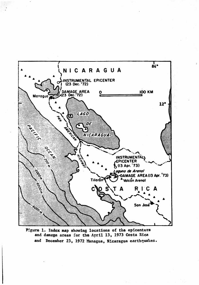
At about 3:34 a.a. on April 13, 1973, a .aderate-aized, but widely
felt, earthquake caused extensive d...age with loaa of 23 lives in a rural
area of about 150 ka2 centered just south of LaC)\Ula de Arenal in northweatem
Costa Rica (fig. 1).
Figure 1 near here
According to the National Oceanic an4 At.oapherlc MainlatraUOft the
main shock, "'ith surface wave J189Ditude of 6.5, occurrec! at 08•33&56.9 Gill'
at latitude 10.675 N., longitude 84.871 w. (personal~., May 10, 1973).
The epicenter, which is roughly 18 km due north of the east en4 of Laguna
de Arenal, is well outside the area of aoat intense surface daaag'e (fig. 1).
This relationship suggests that the instrumentally-located epicenter is
biased to the nor~heast just aa ·it vas for the Managua, Nicaragua, earthquake
of December 23, 1972 (Brown, Ward, and Plafker, 1973). 'l'he hypocentral
depth is qi ven as 29 km !. 10 km, but is poorly constrained because the
closest recording station is in San salvador.
Eyewitness accounts indicate that the .. in shock began without vaming
foreshocks and that the shaking vas so vlolent within the -izoaeiDAl area
that it was difficult or impossible to atand ·during the earth~e. Reliable
evaluations of the duration and nature of ground J~Ution naturally could not
be lllade by people who were suddenly awakened by the shaking while it vaa
atill dark. Residents were in complete agreement that, although felt
earthquake• are not unc0111110n, this was by far the .ast severe earthquake
to affect the Laguna de Arenal area during their lifetilaes. Available
historic data on Costa Rican aeisaicity, which date back to the 17th
century, do not contain references to destructive earthquakes in northem
2
NICARAGUA
F~gure 1. Indox map showing locations of the epicenters and damage areas for the A~ril 13, 1973 Costa Rica and December 23. 1972 lhnagua, Nicaragua earth~uakes.

Costa Rica (Sieber<), 1932).
Based on the kind and amount of shaking dallage to man-.ade structures
whose foundations did not fail, the maxima intensity is judged to be
about 'lliU.. on the Modified Mercalli Scale. However, if other criteria of
the Mercalli Scale are used, such as «)round effects, pipeline breaks, and
the reaction of the populace, the intensity could be rated as high as"%.
A large number of felt aftershocks were experienced during tbe ..eke
following the earthquake. As many as !»3 aftershocks per day were counted
by the local police during the first 3 days throughout the Mizoaeiaal
area. Sev'lral earthquakes were being felt daily at Tilarln even 18 days
after the Jll.ain shock (Edwin Olivares A9Uilar, per801Ull ca.un., Apr. 30,
l973). Some of the aftershocks were strong enough to topple objects frca
shelves or rattle windows and walls, but none is known to have caused
additional d~~ge. Nevertheless, the continuous aftershock activity and
the fear of another destructive earthquake, or even a volcanic eruption,
were so ~nerving to many of the local residents that they abandoned homes
and property to flee the area. some of them had not yet returned at the ·
time of my visit ~re than 2 weeks after the event.
This report summarizes the results of the writer's reconnaissance
investigation of the area that was affected by the earthquake of April 13,
1973. A 4-day field study of the meizoseismal area was carried out during
the period from April 28 through May 1 under the auspices of the U. s.
Geological Survey. The primary objective of this study was to evaluate ·
geologic factors that contributed to the damage and loss of life. The
earthquake was also of special interest because of the possibility that it
vas accompanied by surface faulting cosaparable to that which occurred at
Managua, Nicaragua, during the disastrous earthquake of Decesaber 23, 1972
3

(Brown, ward, and Plafker, 1973:. such earthquake-related surface faultincJ
c~ provide scientifically valuable info~tion on active tectonic p~eases
at shallow depths within the Middle Alllez:ica arc. Also, identification of
active faults in this area is of considerable practical iaportance because
of the planned construction of a major hydroelectric facility within the
meizoseismal area by the Instituto Costarricense de Electricidad (!.C.Z.).
The project would involve creation of a storage reservoir within the Laguna
de Arenal basin and part of the Rfo Arena.l valley with a 75 a-high earthfill
dam across R!o Aroal at a point about 10 Jca east of the outlet of Laguna
de Arenal.
I am indebted to numerous people in Costa Rica whose assistance and
cooperation greatly facilitated this study. !ng. Jorge u.&Ka, Chief
Geologist of I.C.E., generously provided infomation obtained by hia and
the I.C.E. staff shortly after the earthquake and greatly expedited the
field work by making a jeep and driver available for 2 days. Dr. Jelle
de Boer of Wesleyan College, who is in Costa Rica on a United Nations grant,
shared with me the detailed observations he made in the earthquake-affected
area shortly after the event as well as his interpretations of the regional
structure as derived from a broad synthesis of geologic and geophysical data.
Mr. Robert Senter, Interaaerican Geodetic Survey representative in Costa
Rica, kindly assisted with logistic arrangements and furnished base maps
for use in the field. Dr. Tosimata Matumoto, of the University of Texas,
furnished preliminary results obtained from a 3-station seismograph array
that he deployed to monitor the aftershock sequence. Finally, I wish to
express my appreciation to my good friends Gabriel Dengo and Gregorio
Escalante who freely gave me the benefit of their intimate knowledge of
Costa Rica and its geology and who helped make ay ·stay in that country a
4

pleasant experience.
GEOGRAPHIC AND GEOLOGIC SE'l'TIHG
As indicated on figure 2, the principal area affected by the eartbquake
Figure 2 near here
of April 13, 1973, is crudely circular in shape, about 14 Jca in di._ter,
and is centered just south of Laguna de Arenal • . It includes the towns of
Tilarln, 'l'ronadora, and Arenal as well as a large number of amal.l villages
and scattered farm houses, total population is estimated to be several
thousand persons.
Most of the land has been cleared for cattle grazing, the principal
industry in the area. There is also a IIOC!est amoUnt of coffee, sugar, an4
vegetable fam.ing along the lftargins of Laguna de Arenal and in aaDe of the
stream valleys. Remnants of the denae forest growth that originally coverecJ
the area are now largely restricted to ridge to,ps, some relatively inacces
sible valleys, and steeper slopes.
The communities and larger fa~ are connected by a fairly dense network
of roads which are shown by very short dashes on figure 2. Highway 19, which
extends northwestward from Tilarb to the Interamerican ~gbway, is the
only paved road in the .ap area, all others are dirt or are surfaced with
crushed rock. All roads shown on the .ap were traversed during this stu4y.
The topography within the earthquake-affected area is characteristically
hilly to mountainous with local relief of 200-300 .. ters and extrema
elevations ranging between 512 a and 1380 a. The basin including the flat
floored Laguna de Arenal and the valley of Rlo Arenal are the only sizeable
areas of gentle topography. Slopes along the larger valleys average 15•-Jo•
although locally they .ay be up to 45• where undercut by stre... Road cuts
5

igure 2. Damage area of the April 13. 1973 earthquake. Long dashed line outlines maia zone of structural damage. landslides. and ground cracks. Short dashed line outltnas zone characterized by severe ground effects and destructive landslides; crosses indicate larger landslides. Letters indicate locations referred to in text. Lineaments shown are from Dengo (1968) and unpublished .. p of I. c. E. (1972).

are caaaonly near-vertical where cut in the thick layer of lateritic soil
and pyroclastic deposits which llalltles aost of the area. Rainfall is
normally around 250 cm{year, with almost all the precipitation from late
April ~~rough October. Because of abnormally sparse precipitation during
the 1972 rainfall year, Laguna de Arenal was essentially dry and most
streams contained little or no water at the tt.e of the earthquake.
The earthquake-affected area is situated along the Middle America chain
of active volcanoes that extends discontinuously frca Guat..ala to northern
Panama (fig. 1). Bedrock consists of andesitic or basaltic andesitic flows
with subordinate agglomerate of late 'l'ertiary age (Dengo, 1968). 'l'hese
rocks are rarely well-~sed because they are mantled by a thick lateritic
soil commonly 3-7 a thick and ash in layers generally a few tens of centimete~
thick. ,
Quaternary andesitic volcanic rocks underlie .Tilaran and the area.
to the north and west (I.C.E., unpublished geologic map of Proyecto Annal
y Santa Rosa), and an andesitic volcanic cone, Vole"' Arenal, lies just , .
south of Rio Arenal about 15 kill east of the eastern end of Laguna de Annal
(fig. 1). :n 1968, an explosive glowing avalanche eruption from Volcb
Arenal killed 78 ~le and devastated 12 square kilometers in a period of
3 days (Melson and saenz, 1968). A flank eruption of lava, which first
e:nitted frOll\ Arenal in 1968, is still continuing to advance slowly.
It appears likely that the anomalously broad and flat-floored valley,
in which the Rl.o Arenal and Laguna de Arenal are situated, is a fundamental
tectonic feature that is controlled by faulting, probably by aovement on the
two major faults shown on figure 2 that bound part of the basin. The thick
sedtment fill in this basin developed between natural daas of Quaternary
volcanics that are located in the Tilaru area and north of Vole&.. Arenal
(fig. 1). It should be eaphasized, however, that these faults were inferred
6

entirely on the baaia of topography, and their existence baa yet to be
~atrated conclusively fraa geologic relationships across thea or by
seiaaic activity along th• (Gabriel Dengo, 1973, pers. ~un.). In addition
to the two major inferred faults shown on figure 2, there are a nWiber of
crudely linear atreaa valleys in the area that were mapped u faults on an
unpublished 111ap of the I.c.z. (1972). Dr. Jelle de Boer (oral ccw•wt.,
April 1973) has pointed out that these lineuenta and ll&llY other topocJrapbic
features throughout .uch of this area fall into two fairly well-defined aeta
trending northwest and northeast. Because of the prevailing deep surficial
weathered zone, it is not kDown if any of the line.-nts are fault controlled
and, if ao, if any of the faults are presently active.
Damage fr011 the earthquake of April 13, 1973, reaultecl fraaa 1) direct
seismic shaking of structures, 2) a variety of earthquake-tri99ered land-
slides, and 3) earthquake~induced lateral spreading and cracking of
~co:1solidated deposita. All of the significant damage observed appeared
to be confined to the area of about 150 a 2 that is outlined by the l0ft9
dashed line on figure 2. The deaths and injuries resulted entirely f~
burial by l~~dslides, the larger of which were concentrated within an area
2 of about 20 Jan which is outlined by a abort dashed line on figure 2.
No evidence was found for movement on surface faults during the ea~.
All of the ground cracks that were seen during ay reconnaissance appeared to
be readily related to gravitational mo~ta of surficial deposits and to
failure of roadway fills. llone of the cracks could be traced aa continuous
linear zones for 110re than a few tens of •ters cross-country. Because
IIY field investigation was begun more than 2 · weeks after the earthquake,
llany of the cracks in roads and in tbe towns ha4 been obliterated or subdue4
by traffic and by repair work. Nevertheless, because of the fairly
7

dense road network, intensive land use, and a large rural population, it
..- illprobable that a aurface fault several kilometers or 110re in length
could go undetected. Judging from a coapadson with aeimaic events of the
same magnitude elsewhere in the world, aurface faulting on the ozder of
20-30 ka is a reasonable posaibility for ~ ehallow 6.5 magnitude eartbqaake
(Bonilla and Buchanan, 1970). For example, during the December 23, 1972,
Managua earthquake (M8 • 6.2) sinistral displaca.eot of about 60 ca occurred
on two subparallel faults about 15 ka long, an4 displac.ants of. a few
centimeters occurred on two other faulta 1.6 an4 2. 7 Jaa in length (Brown,
Ward, and Plafker, 1973).
Structural dulage
With few exceptions, 110st of the atructurea in the daaage area are
reasonably well built for resistance to lateral forces ~sed by aei .. ic
shaking. The majority of thea are small single-story wood fr_. hoMa on
post or concrete foundativns and with corrugated aheet metal roofs, although
there are some two-story wood frame houses in 'filar&.. Perhaps 20 to 30
percent of the homes are of concrete block, usually with Jlliniaal reinforcing
steel rods on slab or perimeter foundations of concrete an4 with corrugated
sheet metal roofs. Because of the equitable climate, heating is not required
and there are no fireplaces or chimneys. Cooking stoves are usually vented
with metal stovepipes. Larger cOIIIID8rcial and public buildings in the towns
are mainly of aingle-story frame construction. Exceptions are the churchea
which are all built of reinforced concrete, and a schoolhouse at Tronadora
which ia made of a steel fr ... with unreinforced concrete block end and
partition walls. '!'be few road bridges are amall and built of reinforced
concrete except for one across Rlo Arenal near Arenal, which is a steel
Bailey br~dge about 40 • long.
8
Ule earthquake was severe enough to cause extensive damage to the
contents of buildings, aainly through objects falling from abel ves, an4
to cause considerable window breakage in flexible wood frame houses.
However, only a small percentage of buildings IIUStained significant dulage
solely by shaking. Most of the duage to structures involved varying
degrees of collapse of unreinforce4 concrete block walls in ~s an4 at
the Tronadora school. A few fr ... houses were either partly or entirely
shiftecl off their foundations. None of these failures involved total
collapse of the buildings or caused injuy to ~ts.
Churches are the largest buildings in the area. Of these, the large
mcC.~~istic cathedral at 'l'ilarh sustained superficial damage involving
cracking of walls, breakage of windows, and falling of decorative tile. A
moderate-sized church at Arenai and another 81Dall one at Quebrada Grande
were not visibly eamaqed by the earthquake. The only non-dwelling structure
seen that was seriously damaged is the small church at Trona4ora where the
bell tower collapsed and fell through the church roof. However, as is
discussed in a later section, the 'l'ronadora church damage ~~ay have been,
in part at least, the result of foundation failure. No bridges in the area
showed damage either to the abutments or spans.
Landalic!es
Horizontal an4 vertical accelerations during the earthquake triggered
numerous landslides an4 created uny incipient slides throughout the area
outlined on figure 2. As usee! herein, •landslide• denotes downward and ·
outward IIOVement of slope-foming materials composed of natural rock, soils,
artificial fills, or combinations thereof. This definition and other ter.i
noloqy for landsliding generally follows Varnes (1958). All of tt. ?.3 deaths
fraa the earthquake were due to burial beneath laudslides. In addition,
9
lancSslides caused extensive dulaqe to roads resultinq in the t.emporary
isolation of some communities. The landslides included a wide variety of
debris falls, slides, and flows primarily involvinq the regolith of unconaoli-
4ate4 lateritic soil. and volcanic ash that everywhere aantles· the older
volcanic rocks of the area. Landslides involvinq be4rock were rare. 11o
slUIIIP block r rotational slumps of large Msses of coherent Mterial wen
seen in the earthquake-affected area although aome of the debris fl~ and
falls may have been initiated in this way.
Debris slides an4 flows
'l'he largest and 110st destructive lanc!alides involved poorly cOJWOlidatec!
soil and debris alonq steep slopes, some of which developed into fluid, ·
high-velocity debris flows. one of these, near the villa9e of alo Oliquito
(location "A" on fiq. 2), buried the fam hc.e of Mr. L1n4or Chavez. Mr.
Chavez was rescued with severe injuries but .13 -'-rs of bls faaily who were
also in the house perished. The landslide, which developed at the hu4 of
a small tributary of R!o Chiquito, involved an estimated 75,00D-125,000 a3
of debris consistinCJ mainly of lateritic aoil with .tnor air-fall ash near
the surface. 'l'he debris flow is rouqbly 500 • lonCJ with about 200 a vertical
drop from the crown to the toe, which reaches alaost to rcf.o Chiquito. Rapid
movement of the Mss is indicated by the fact that at a bene! alonCJ its
course, the debris was banked up 10 to 15 a hiqher on the outside of the
turn than it vas on the inside. 'l'be lobe averaqes 3-5 a thick, and its
steep-sided, leveed ..rqins suq9est that the debris had considerable vi.OO.ity
in the lower part of its course where it spreact out ewer the flood plain of
Rfo Chiquito.
Many other large 4ebris slides and flows, several of which are probably
larqer than the a!o Chiquito debris flow, oriqinated al0119 ateep Yalley
10

walla an4 ridge slopes, Minly in the area outlined by short dashes on
figure 2. Most of these occurred in. the heac!vaters of Rlo Oliquito and
rJ.o "l"ronadorar one large slide is locatec! along Quebrac!a Grande. Approxiat:e
positions of ac.. of the larger slides ere abowD by crosses on figure 2.
Debris slides or flows along rJ.o Tronadora in the area SCNth of Silencio
(near •a• on figure 2) caused the 10 other deaths attributable to the
earthquake. Because I did not visit the site of the buried houes near
Silencio, I do not know exactly which of the -.DY slides burie4 thea and
the location shown on figure 2 indicates the ~ral area where cuualtiea
oecurred.
In addition to the casualties, the debris slides and flows locally
ca.uud major damage to roads either by taJdng out sections of roac!a that
crossed the landslide areas or by covering roa4a with debris. SO.. of these
roads had not yet been reopened for traffic .ore than 2 weeJcs after the
earthquake.
Debris slides an4 flowa have blocked the natural drainage in the
headwaters of a!o Tronadora and Rlo Chiquito. During periods of heavy rains
lakes may form behind these natural 4UI8 ucl could overtop an4 rapidly erode
the debris, thereby causing sudden inun<ion of c!ownstre• areu by flooda
or mud flows. 'l'he JDOst critical period will be during the 1973 rainy season
(April through October) • '1'be hazard is especially great to 'l'l:onadora because
the ah&l.l.ov channel of the alo Tronadora through the town has little carrying
capacity and 110st of the buildings in town are on the alluvial fan of the
river where they are vulnerable to floodiDg. '!he hazard is less severe in
the village of Rio Chiquito but there ere a n\lllber of fua houses· in that
area locatec! on lov grouncl that ia susceptible to flooding or in the path of
debris flows.
11

Failures of man-.ade cuts and fills
'!be oveJ:WhelllinCJ majority of landslides tri99ered by the earthquake
are 8111&11 falls or slides of poorly-consolidated debris alonCJ roadcuta.
'l'bese occur thrOUC)hout the area outlined on fiCJUre 2 and, leas coaaonly,
beyond the limits of the area shown. Roadcuta throu9h the air-fall ash and
deep lateritic soil in this area are CcaiOI'llY cut to anc)les between 45• an4
near-vertical. Because the zoadcuta have a1ch steeper inclinations thaD the
natural slopes, it is not surprising that roadcut failures are .aze widely
distributed than natural slo.pe failures. Within the ~e area outlined
on figure 2, almost every larC)e roadcut abowa 110M sign of failure and uny
o: them were completely collapsed. The C)reatest nu.ber and extent of such
failues are in the area between Tronadora, Quebrada Grande, and a!o Chiquito
where some of the roads were virtually buried by debris slides and falls frc.
roadcuta. In adeition to daD&CJa ·to the roads, these roadcut failures resulted
in incidental costly da.a9e to many kila.eters of barbed wire range fencing
as well as to telephone and electric transmission linea alonCJ the riCJht-of-way.
Slumping L~d crackinCJ of roadway fills on the downhill shoulders were
also common occurrences throughout the earthquake-affected area outlined on
figure 2 but nona of these slu-.ps caused significant damage. The moat
extensive roadway fill failures seen were alon9 a new segaent of road just
south of San Ram&n at location •c• near the southem edc)e of fiC)ure 2 when
exceptionally larC)e fills were required because of the rugged nature of the
terrain.
Rock falls
'!be one landslide tnvolVinCJ rock that was seen in the earthquake-affected
area is situated about 1 Ita vest of Tilarln (location •o• on fiCJ. 2). 'Ibis
was a fall of several thousand cubic meters of Quaternary andesite that is
12

exposed on a steep, undercut valley wall. '1'he locality is uni~ited and
the rockfall caused no daluge. Similar rockfalls may have occurred elsewhere,
but were not observed during ay brief reconnaissance study.
Soil slips and incipient landslides
Shallow soil slips of unconsolidated materials were observed throughout
t.'le area but were especially COIIIOft on the steeper slopes. Typically theae
slips and incipient slides are manifested as a series of closely-spaced
open cracks in the· regolith that tend to parallel slope contours. '!'his
type of cracking was especially pervasive on the slope north of the alo
Chiquito debris flow where open cracks were spaced a few meters apart over
~he entire hillside with as auch as 15 ca separation of the valls. All
gradations probably occur between ground cracks related to shallow soil slips
~~d those that result froa incipient sliding of larger relatively coherent
r.-.asses. Such features, where situated above inhabited areas or roads, are
potential hazards because they could develop into destructive debris slides
or flows when they beccae water-saturated during the rainy season. In a
few places, such as at Silencio, an incipient slide along a small creek bank
has resulted in cracking of the foundation of the adjacent schoolhouse and
slight rotational tilting of part cf the structure.
S\trficial effects in unconsolidated deposits
In areas of gentle slope vibratory loading of noncohesive granular
deposits resulted in local .. ss downslope mov..ent, lateral spreading, and
differential coapaction. Ground cracking and surficial subsidence were ·
surfaee .anifestations of such IDO\'.-nts. At a few places where the water
table is near the surface, lateral spreading and subsidence were accompanied
by ejection of water or water-sand aixtures.
Most of the surficial effects were concentrated around the margins of
13

the cSry Laguna de kenal and alone) the flood plains of strea. and riven.
The resulting ~g• incluc!ecl l) breakage of und~E'9round water distribution
pipes' 2) failure of fOUJidations beneath structures at Tronadora, and 3)
cracking of roadfills resulting from coapaction of unconsolidated deposits
beneath the fills at stre• and BWUIP crossings.
In all the localities where uncleE'CJround water pipe breakage occurred,
the ruptures involved pulling ~ of galvanizecl pipe at the joints. SUch
pull-aparts, which occurred at Tilarln, Tronadora, and kenal, are clearly
the result of lateral spreading of the surficial sedt.enta in a doWillllope
direction with resultant extension within the apEeading ..... Mhere a 2-inch
water pipe crosses the Jtlo kenal l/2 Jaa east of kenal, lateral spreacling
of alluvium towards the river causecS the pipe to fail in extension where it
was buried on the east bank of the river, and caused alight cc.pressive
buckling of the pipe where it crossed the river above the ground on the bridge.
At this locality, and at Tronadora, some degree of liquefactiOD within the
sediment mass is suggested by the ejection of ~ water and the for~~ation of
small sand-boils towards the lower parts of the mobilized sec1t..ent mass.
Mass downslope movement of unconsolidated deposita was locally accom
panied by ground cracking, .oat notably in the central part of Tronadora.
Here discontinuous cracks extenc!e4 about 75 m from Rlo Tronac!ora through the
church grounds on the upslope side of the church, beneath a small wood fr
houae, across a road, and through a concrete home. Within a few meters of
the church entrance, there are three cracks across which the awregate ·
extension is 5 c:a and the downslope side is stepped down about 2 ca. The
location of the church on the slide Mss close to these fractures may 'have
been a contributing factor that resulted in toppling of the steeple with
extensive c!auge to the church.
14

1.
r
I
Throughout the area road fills are com.only cracked and displaced
downslope where they cross saturated alluvial deposita or swampy areas along
the streaaa and rivera. SUch failures .. y have resulted from lateral epreadincJ
and (or) cor.'paction .of the ~tural . materials beneath the road ~nta.
Near the ford that crosses a!o Chiquito about 1 1/2 Jal southeast of Arenal,
c:acking in the roadway extenda 75 a back from the river with l&r9e ateuional
1. and vertical displacements, stepped clown t:owarda the river. Aa in all of the i
road systems of the area, however, the crack displac.-lt CO\ll4 not be
.easured because traffic an4 road construction bad greatly .adifie4 these
features by the time of ~ field investigation.
COnclusions
1) Damage distribution related to the earthquake of April 13, 1973,
suggests that the epicenter was situated south of La9Ufta de Arenal at
least 19 Ja:l south of the inatruMntally located epicenter.
2) The earthquake apparently waa not accompanied by mov8111eftt on surface
faults. If any faulting did occur, the surface trace auet have been --.ked
by the thick mantle of loose surficial aaterial and by pervasive gravitational
anovement of near-surface aateriala on slopes.
3) Both the location of the epicentral region and the decay characteris-
tics of the aftershock sequence suggest that the earthquake was of tectonic,
rather than volcanic, origin.
4) 'l'he liaitecl extent of the dulage area indicates that the earthquake
ao•uce was shallow. However, the dulage distribution, the extensive felt
area, and the apparent absence of surface faultin9 are all suggestive of
a source at least several kitc.etera in depth.
5) '1'he .. tn cause of cJa.a9e and losa of life was widespread landalidin9
and lateral spreading inclu4ing .,.. high-velocity debris flows in areas of
steep UDstable alo,pea. Hi.

6) !here is a potential ba&ard during the 1973 rainy season that
destructive debris flows or floods could develop along 110M stre... that are
partially or wholly blocked by landslides or that have incipient slides.
the 110st serious threat of this type to inhabited areas is at Trcma4ora and,
to a lesser extent, at alo Chiquito.
7) As is often the case, general fear an4 panic, with abllndon.ent of
the area by many people, were a1110ng the 110re serious consequences of the
April 13, 1973, earthquake. '1'he numerous felt aftersbocks and the ...-ory
of a disastrous 1968 eruption of nearby Volc4A Arenal kept people in a
constant state of agitation and apprehenaion. lD such circ-.tancea, ~t
and thorough coor4inate4 CJeOloCJic and sei..ologic investigations can be
invalua!:>le !or the following illp)rtant reasons• a) to recover 4atl" m the
aftershocks and surface defoz.ation critical to understanding of ~.
earthquake znechani• and assessment of earthquake-related geologic huards1
and b) to use these data to provide professional ac!vice to the populace
and governmental officials in a realistic evaluation of the hazards of
additional damage frolll aftershocks, landslides, flooding, volcanic eruptions
and related phenCIIIIeNl in the earthquaJce-affecte4 area.
8) To ensure the safety of the planned Arenal byctroeleetric develo~t
it is essential to detemine Whether active faults occur within the project
area and to consider the possibility that filling of the storage reservoir
could trigger potentially destructive ear~•• by raising pore water
pressures in fault zones (Rotb4, 1968).
16

REPERENCES CITED
Bonilla, M. G., and Buchanan, J. M., 1970, Interim report on world-wide
historic surface faulting: u.s. Gaol. survey open-file report, 32 p.
Brown, R. D. , Jr. , Ward, P. L. , and Plafker, George, 1973, Geologic and
seiamologic aspects of the Managua, Nicaragua, eartbqua.~s of
December 23, 1972a u.s. Geol. SUrvey Prof. Paper 838, 34 p.
Oengo, Gabriel, 1962, 'l'ectonic-igneous sequence in Costa R.icaa Geol. Soc.
America Buddington Volume, p. 133-161.
Melson, w. G., and Saenz R., Rodrigo, 1968, The 1968 eruption of Volca
Arenal, Costa Rica a Pre1iadnary su.ary of fie1c1 u4 laboratory
studies: Smithaonian Institution for Short-Livecl Phena.ena Report
Oct. 7, 1968, 35 p.
!-!olnar, Peter, and Sykes, L. R., 1969, Tectonics of the caribbean aDd Middle
;u,.~rica regions froa focal mechanisms and seisadcity: Gaol. Soc.
America Bull., v. 80, p. 1639-].684.
Si cberg, A. , 1932, Ez:dbebengeographie: Handbuch der Geo,£1hysik, band lV,
Lieferung 3, p. 45-1005.
Varnes, D. J., 1958, Landslide types and processes, i!l, Eckel, E. B., ed.,
Landslides and engineering: Nat1. Acad. Sci.--Nat1. Research Council
Pub. 544, ~~~~hway Research Board Spec. Rept. 29, p. 20-47.
PDth.;, J. P., 1968, Pill a lake, start an earthquake: NttW Scientist, v. 11,
p. 75-78.
~Gt"otoGiCA£Su~ .. /~· ;,. ltr'"
MF.NLO PARK '
JUN2 61973
17