Embed Size (px)
Citation preview
Civil Engineering and Development Department (CEDD)
Assignment No. HKI2/4/54 RM(A) (1/15)
Preliminary Archaeological Impact Assessment for Wan Chai Development
Phase II
FINAL REPORT
SEPTEMBER 2015
2
1. Assignment Background
Dredging works have been undertaken to support the Wan Chai Development Phase II to provide
land for a proposed trunk road along the northern shore of Hong Kong island. The roughly 12.7
hectares of reclaimed land incidental to the construction of the trunk road will be put to public use.
During the dredging works in the vicinity of the ex-Wan Chai ferry pier, an unknown metal Object
was discovered on the seabed at about 12m below Hong Kong Principal Datum (PD) and about 6.5
metres below the seabed. The assignment was issued to SDA Marine Limited to undertake a
preliminary archaeological impact assessment of the metal Object.
2. Scope of work for the Preliminary Archaeological Impact Assessment (PAIA)
This preliminary archaeological impact assessment (PAIA) is intended to determine the nature and
archaeological value of the metal Object. The PAIA also includes a number of recommended options
that might be considered as appropriate follow-up measures as part of a Marine Archaeological
Action Plan (MAAP).
The PAIA has been implemented according to the requirements specified in the latest Antiquities and
Monuments Office (AMO) Guidelines for Marine Archaeological Investigation, Guidelines for
Archaeological Report and Guidelines for Handling of Archaeological Finds and Archives, where
applicable.
3. Assignment Objective
a) Review relevant information, inspect and study the nature of the Object.
b) Assess the archaeological potential of the Object.
c) Recommend appropriate follow up actions, including MAAP if necessary.
4. Methodology of the PAIA
a) Desk based assessment comprising: review of previous marine archaeological investigations
in the study area (see 6.1), historical background and development of Wan Chai (see 6.2), and
review of marine charts and UK Hydrographic Office records (see 6.3);
b) Review of progress (see 7.1) and preliminary results (artefacts, photographs and video) of
investigation of the Object (see 7.2 and 7.3);
c) Assessment of 2EMHFW¶V�archaeological potential and possible identification (see 8);
d) Assessment of potential impacts caused by the project (see 9);
e) Provision of Marine Archaeological Action Plan including technical advice on the air lifting
works and subsequent procedures for the Object (see 10);
f) Submit a draft and final report on the PAIA containing all findings as above.
3
5. Deliverables
This Final Preliminary Archaeological Impact Assessment Report is the only deliverable under the
agreement.
6. Desk Based Assessment
At this stage the research included unpublished papers, charts, records, archival and historical
documents held in local libraries and other government departments. The aim was to examine all
possible options for the identification of the object.
6.1 Previous Marine Archaeological Investigations
In 2001, the AMO commissioned SDA Marine to carry out Marine Archaeological Investigation
(MAI) for Wan Chai Reclamation Phase II and Central Reclamation Phase III. The metal Object is
located within the study area for Wan Chai Reclamation Phase II and so the results are relevant to the
current study. In accordance with AMO Guidelines the MAI comprised a Baseline Review,
Geophysical Survey and Underwater Inspection. The Baseline Review established high
archaeological potential based on historical activity in Wan Chai. The geophysical survey located six
seabed anomalies and these were inspected and found to be modern debris. There was a very
significant volume of construction debris and other waste on the seabed that negatively impacted the
geophysical survey as they masked the sediments beneath. NB: An extract of the 1960 chart BA
1459, reproduced in part in Figure 4a below, was included in the 2001 report where it was
PLVWDNHQO\� GDWHG� WR� ������ ZKLFK� LV� WKH� GDWH� RI� FUHDWLRQ� RI� WKH� FKDUW¶V� RULJLQDO� µFRSSHU¶� PDVWHU��whereas the chart revision date was in fact 1960.
6.2 Historical Background and Development of Wan Chai
6.2.1 General Background
The presence of an excellent natural harbour in Hong Kong is the main reason the British colonial
authorities were so keen to acquire it for use as a regional trading base and it has remained a
commercial shipping hub ever since. Victoria Harbour has been the focus of intense shipping activity
and the concentration of reclamation and development along the foreshore is probably unparalleled
anywhere else in the world.
In pre-colonial times, Wan Chai (meaning ³small bay´ in Cantonese) began as a small Chinese
ILVKLQJ�VHWWOHPHQW�DURXQG�WKH�SUHVHQW�7DL�:RQJ�7HPSOH�RQ�4XHHQ¶V�5RDG�(DVW��For generations, it
was also known as Ha Wan, or Lower Bay. The development of modern Wan Chai began in the
1840s with the intention of creating a high-class residential and commercial centre. The major
foreign firms all had substantial commercial buildings in the area facing the sea, and included
godowns and wharves. The waterfront would have been a crowded anchorage for trading vessels and
busy with local junks and sampans. This area, known as Spring Gardens, was located around the
present-day Spring Garden Lane.
4
Due to a sharp population rise in the 1850s, demand for land increased. The Government responded
by developing the Wan Chai area around Stone Nullah Lane and the southern side of Hospital Hill
for Chinese residence. This area is now Wan Chai Road and the eastern side of Spring Gardens. The
first formal praya reclamation scheme was partly carried out in 1851, when a creek in the Bonham
Strand area was in-filled. By 1886 an 8km long near continuous strip of land²the only major break
being the section adjacent to the naval and military areas²averaging 100m wide was formed
between Kennedy Town and North Point. The associated seawalls provided much needed access for
handling marine cargo. In 1887, further reclamation was recommended to alleviate the overcrowding
in the city (Guilford, 1998).
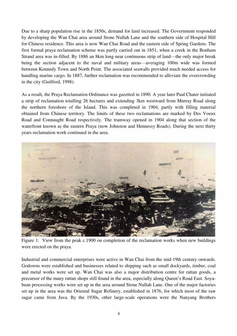
As a result, the Praya Reclamation Ordinance was gazetted in 1890. A year later Paul Chater initiated
a strip of reclamation totalling 26 hectares and extending 3km westward from Murray Road along
the northern foreshore of the Island. This was completed in 1904, partly with filling material
obtained from Chinese territory. The limits of these two reclamations are marked by Des Voeux
Road and Connaught Road respectively. The tramway opened in 1904 along that section of the
waterfront known as the eastern Praya (now Johnston and Hennessy Roads). During the next thirty
years reclamation work continued in the area.
Figure 1: View from the peak c.1900 on completion of the reclamation works when new buildings
were erected on the praya.
Industrial and commercial enterprises were active in Wan Chai from the mid-19th century onwards.
Godowns were established and businesses related to shipping such as small dockyards, timber, coal
and metal works were set up. Wan Chai was also a major distribution centre for rattan goods, a
SUHFXUVRU�RI�WKH�PDQ\�UDWWDQ�VKRSV�VWLOO�IRXQG�LQ�WKH�DUHD��HVSHFLDOO\�DORQJ�4XHHQ¶V�5RDG�(DVW��6R\a-
bean processing works were set up in the area around Stone Nullah Lane. One of the major factories
set up in the area was the Oriental Sugar Refinery, established in 1876, for which most of the raw
sugar came from Java. By the 1930s, other large-scale operations were the Nanyang Brothers
5
Tobacco Co. Ltd. factory near Canal Road and the British-American Tobacco Co. Ltd. works at
Gloucester Road.
Following the Pacific War a further phase of reclamation in the 1950s-1970s pushed the Wan Chai
coastline to the line shown in the 1990 map in Figure 8.
6.2.2 Naval History
In addition to the busy commercial maritime scene, there would have been many European,
American and Japanese naval vessels anchored nearby due to the proximity of the naval dockyard. A
foundation stone for the new Royal Naval Dockyard was laid on 15th January 1902, and the dockyard
was finally completed in 1905. There was an extensive British Royal Navy presence in the
surrounding area from 1841 until 1994, when the remaining naval contingent moved to new purpose-
EXLOW�IDFLOLWLHV�DW�6WRQHFXWWHU¶V�,VODQG��
The Commander-in-Chief, China was a senior officer position of the British Royal Navy. The officer
in this position was in charge of the Navy's vessels and shore establishments in China from 1865 to
1941. He thus directed a naval formation, which was often known, even in official documents, as
the China Station. From 1831-1865, the East Indies Station and the China Station were a single
command known as the East Indies and China Station. The China Station, established in 1865, had as
its area of responsibility the coasts of China and its navigable rivers, the western part of the Pacific
Ocean, and the waters around the Dutch East Indies.
The formation had bases at Singapore (Singapore Naval Base), Hong Kong (HMS Tamar 1865±1941 and 1945±1997) and Wei Hai (1898±1930). The China Station complement usually consisted
of several older light cruisers and destroyers, and a flotilla of shallow-draught gunboats for river
patrol. Vessels on this station usually had a distinctive livery of white hull and superstructure and
dark funnels. The presence of naval shipping would have been particularly dense during WW1
(1914-18) and WW2 (1939-1945), during which in December 1941 in response to increased
Japanese threats, the China Station was merged with the East Indies Station to form the Eastern
Fleet. $QRWKHU�EXV\�SHULRG�LQ�+RQJ�.RQJ¶V�QDYDO�KLVWRU\�RFFXUUHG during the Korean War.
Prior to the invasion of Hong Kong in December 1941 it is estimated that approximately 60 vessels,
including HMS Tamar, were deliberately sunk (scuttled) to prevent their capture by the enemy. The
dockyard was extensively damaged by the Japanese during their December 1941 invasion of Hong
Kong, and was further damaged during American air-raids over Hong Kong in 1944 and 1945. An
especially heavy raid on 16th January 1945 by US Navy carrier borne aircraft largely incapacitated
the dockyard until the end of the Pacific War and damaged and sank Japanese shipping. In total
around 230 British, Japanese and other vessels had been sunk in Hong Kong waters during the
Pacific War, with 50-60 of them in Victoria Harbour and 19 of that number being large vessels.
The wreck at the centre of this report is thought to be one of the above, but there now follows a
review of pre- and post-1941 charts and other information sources in order to establish whether there
are any earlier or later records of shipwrecks in the area of interest to the north of Wan Chai.
6
6.3 Marine Chart and UK Hydrographic Office data review
6.3.1 Marine Charts
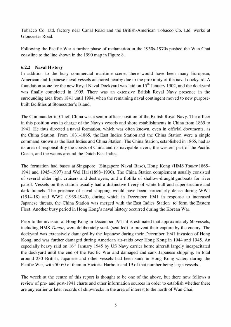
According to British Admiralty Chart number 1459, Hong Kong Harbour dated 1888 there was no
wreck in the general area of interest at that date.
Figure 2: Detail from BA1459 Hong Kong Harbour year 1888. No wreck present at Object location.
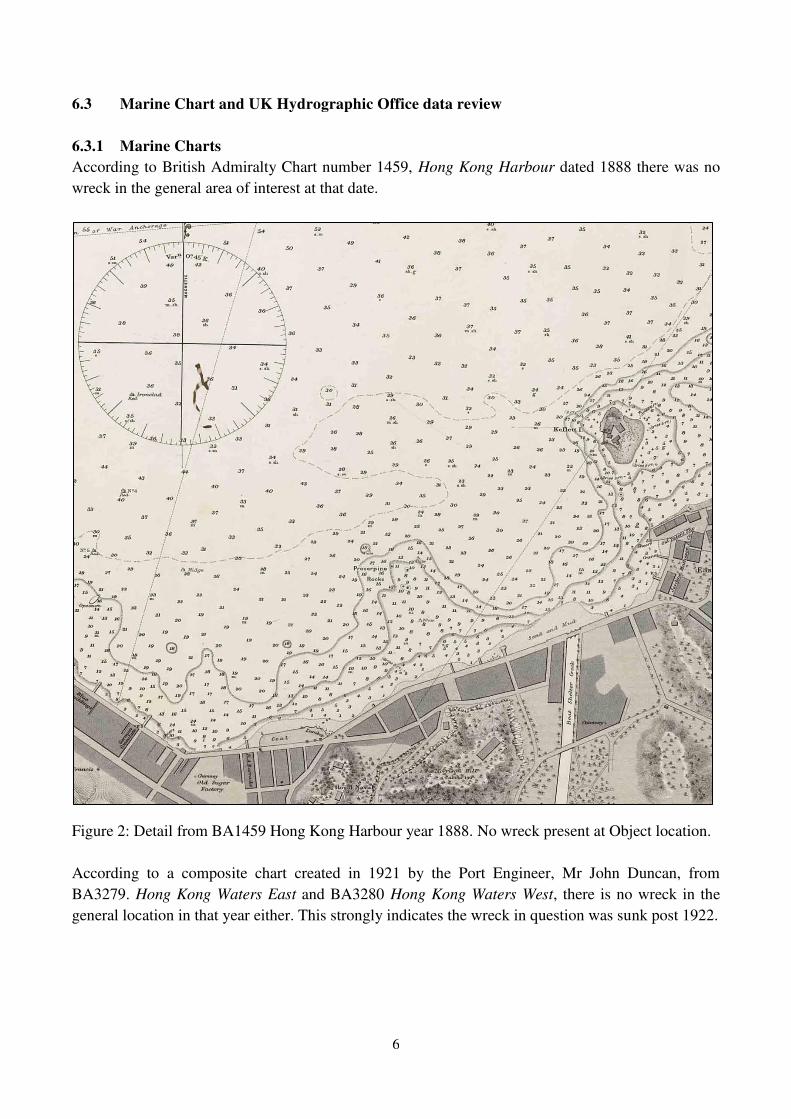
According to a composite chart created in 1921 by the Port Engineer, Mr John Duncan, from
BA3279. Hong Kong Waters East and BA3280 Hong Kong Waters West, there is no wreck in the
general location in that year either. This strongly indicates the wreck in question was sunk post 1922.
7
Figure 3: 1921 Chart: Detail from BA3279 Hong Kong Waters. No wreck shown but line of
moorings is indicated to the East
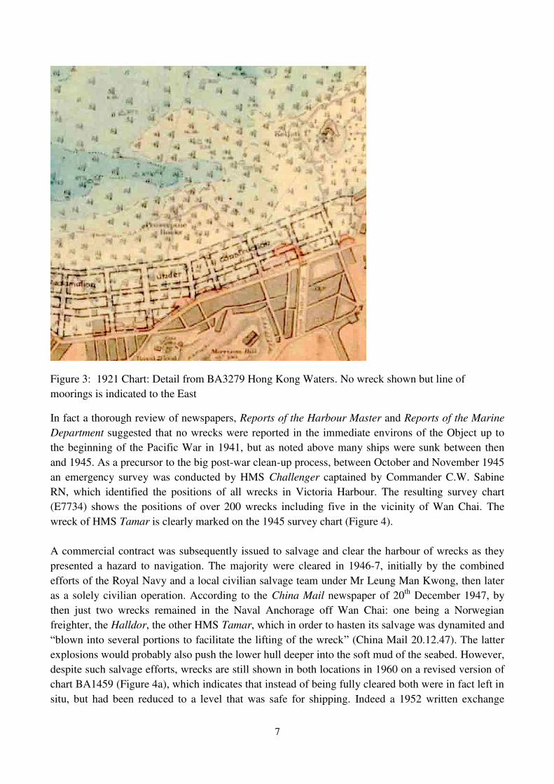
In fact a thorough review of newspapers, Reports of the Harbour Master and Reports of the Marine
Department suggested that no wrecks were reported in the immediate environs of the Object up to
the beginning of the Pacific War in 1941, but as noted above many ships were sunk between then
and 1945. As a precursor to the big post-war clean-up process, between October and November 1945
an emergency survey was conducted by HMS Challenger captained by Commander C.W. Sabine
RN, which identified the positions of all wrecks in Victoria Harbour. The resulting survey chart
(E7734) shows the positions of over 200 wrecks including five in the vicinity of Wan Chai. The
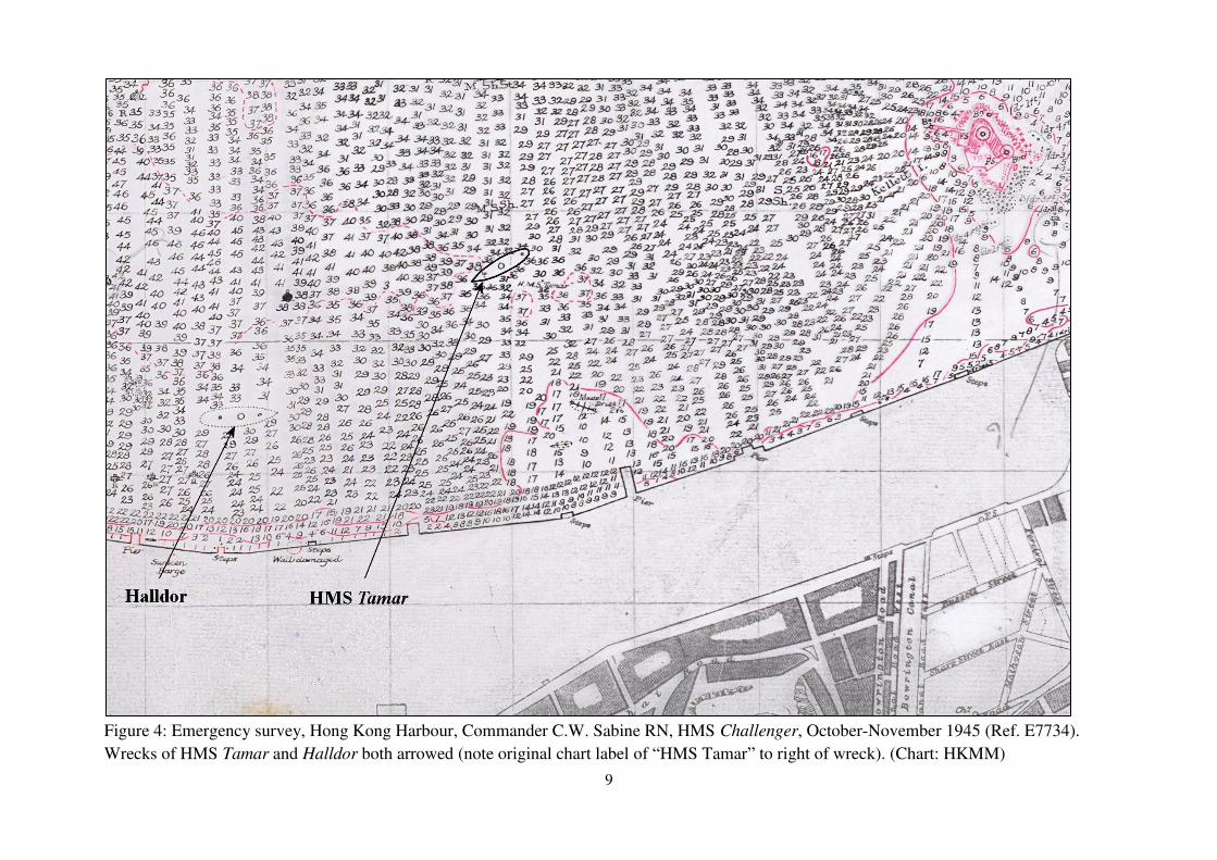
wreck of HMS Tamar is clearly marked on the 1945 survey chart (Figure 4).
A commercial contract was subsequently issued to salvage and clear the harbour of wrecks as they
presented a hazard to navigation. The majority were cleared in 1946-7, initially by the combined
efforts of the Royal Navy and a local civilian salvage team under Mr Leung Man Kwong, then later
as a solely civilian operation. According to the China Mail newspaper of 20th December 1947, by
then just two wrecks remained in the Naval Anchorage off Wan Chai: one being a Norwegian
freighter, the Halldor, the other HMS Tamar, which in order to hasten its salvage was dynamited and
³blown into several portions to facilitate the lifting of the wreck´ (China Mail 20.12.47). The latter
explosions would probably also push the lower hull deeper into the soft mud of the seabed. However,
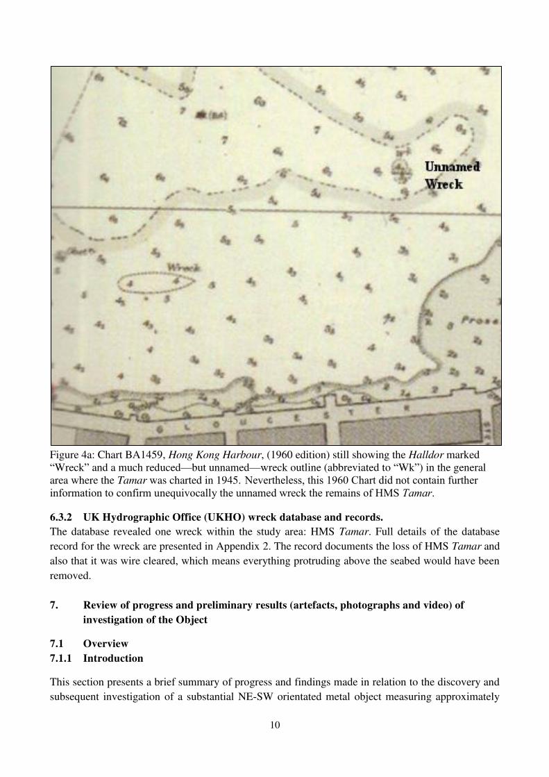
despite such salvage efforts, wrecks are still shown in both locations in 1960 on a revised version of
chart BA1459 (Figure 4a), which indicates that instead of being fully cleared both were in fact left in
situ, but had been reduced to a level that was safe for shipping. Indeed a 1952 written exchange
8
between the Hong Kong Director of Marine and the UK Hydrographic Office (UKHO), which
discussed the need for the above revision of chart BA1459, led to a minute from the UKHO stating
that that for Tamar the swept wire depth and wreck symbol ³should remain as it was obtained by a
survey by ³Dampier´ this year´ (HKHO 1952). HMS Dampier ZDV�WKH�5R\DO�1DY\¶V�3DFLILF�)OHHW�survey vessel. In the case of Tamar, that significant reduction in height was also reflected in an
apparently dramatic shrinkage in the area²or footprint²of the wreck as a result of the 1946-7
salvage operation and subsequent wire sweep. Shortly afterwards, the Halldor was buried within the
1960s-70s North Wan Chai Reclamation, leaving HMS Tamar as the only recorded wreck in the
current study area of interest.
9
Figure 4: Emergency survey, Hong Kong Harbour, Commander C.W. Sabine RN, HMS Challenger, October-November 1945 (Ref. E7734).
Wrecks of HMS Tamar and Halldor both arrowed (note original chart label of ³HMS Tamar´ to right of wreck). (Chart: HKMM)
10
Figure 4a: Chart BA1459, Hong Kong Harbour, (1960 edition) still showing the Halldor marked ³Wreck´ and a much reduced²but unnamed²wreck outline (abbreviated to ³Wk´) in the general area where the Tamar was charted in 1945. Nevertheless, this 1960 Chart did not contain further information to confirm unequivocally the unnamed wreck the remains of HMS Tamar.
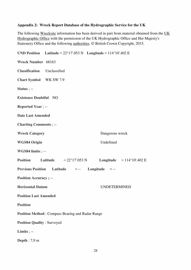
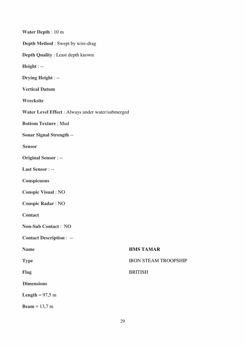
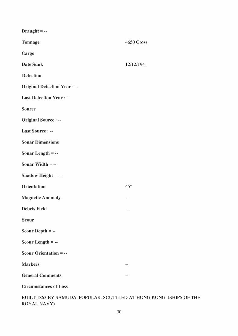
6.3.2 UK Hydrographic Office (UKHO) wreck database and records.
The database revealed one wreck within the study area: HMS Tamar. Full details of the database
record for the wreck are presented in Appendix 2. The record documents the loss of HMS Tamar and
also that it was wire cleared, which means everything protruding above the seabed would have been
removed.
7. Review of progress and preliminary results (artefacts, photographs and video) of
investigation of the Object
7.1 Overview
7.1.1 Introduction
This section presents a brief summary of progress and findings made in relation to the discovery and
subsequent investigation of a substantial NE-SW orientated metal object measuring approximately

11
40m long by 11m wide²clearly the remains of large sunken ship²initially identified during recent
dredging works immediately west of Wan Chai New Ferry Pier (Figure 5).
Information contained in this section has been obtained from the CEDD dive team plus a one day
inspection by an SDA Marine dive team who confirmed and validated the results of the original team
who continue to work on site.
Figure 5: General arrangement for air lifting works on site (reproduced by kind permission of
AECOM)
7.1.2 Progress to Date
During removal of up to 8m of marine sediment by dredger, to a level of -14mPD, eleven large
fragments of riveted wrought ironwork were recovered, one with large wooden beams attached. Then
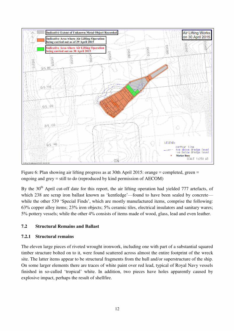
since 25th 'HFHPEHU� ����� D� WHDP� RI� GLYHUV� KDV� EHHQ� ZRUNLQJ� ZLWK� DQ� µDLU� OLIW¶� WR� V\VWHPDWLFDOO\�remove the remaining sedimeQW�IURP�RYHU�WKH�µERWWOH-VKDSHG¶�VWUXFWXUH�O\LQJ�RQ�WKH�VHDEHG�DW�DURXQG�-13 to -14m PD (Figure 6).
As Figure 6 shows, as at 30th April air lifting work had so far investigated the entire periphery of the
site, fourteen linear transects across the width of the site, and a rectangular block at the north-eastern
end. In the roughly 17 weeks of air lifting work so far conducted an estimated 60% of the total site
area has thus far been investigated down the level of the hull or iron kentledge-concrete ballast.
12
Figure 6: Plan showing air lifting progress as at 30th April 2015: orange = completed, green =
ongoing and grey = still to do (reproduced by kind permission of AECOM)
By the 30th April cut-off date for this report, the air lifting operation had yielded 777 artefacts, of
ZKLFK����� DUH� VFUDS� LURQ�EDOODVW� NQRZQ�DV� µNHQWOHGJH¶²found to have been sealed by concrete²while the other ����µ6SHFLDO�)LQGV¶��ZKLFK�DUH�PRVWO\�PDQXIDFWXUHG�LWHPV��comprise the following:
63% copper alloy items; 23% iron objects; 5% ceramic tiles, electrical insulators and sanitary wares;
5% pottery vessels; while the other 4% consists of items made of wood, glass, lead and even leather.
7.2 Structural Remains and Ballast
7.2.1 Structural remains
The eleven large pieces of riveted wrought ironwork, including one with part of a substantial squared
timber structure bolted on to it, were found scattered across almost the entire footprint of the wreck
site. The latter items appear to be structural fragments from the hull and/or superstructure of the ship.
On some larger elements there are traces of white paint over red lead, typical of Royal Navy vessels
finished in so-FDOOHG� µWURSLFDO¶� ZKLWH� In addition, two pieces have holes apparently caused by
explosive impact, perhaps the result of shellfire.
13
7.2.2 Ballast
Further investigation in the area near what is presumed to be the µGHDGZRRG¶²the housing for the
propeller shaft at the stern (back) of the ship²produced the aforementioned collection of 238 pieces
of iron kentledge ballast together with fragments of concrete capping. Kentledge is the term used for
VFUDS�LURQ�XVHG�DV�EDOODVW�DW�WKH�EDVH�RI�D�VKLS¶V�KXOO�LQ�WKH�ELOJHV��,Q�DGGLWLRQ��FRQFUHWH�RU�FHPHQW�ZDV�sometimes poured over the kentledge to prevent it shifting in heavy seas. In addition, several blocks
of granite were found with cement-concrete attached, which may also indicate their use as ballast.
7.3 Special Finds
7.3.1 Wooden Objects
Several pieces of wood have been recovered including four with brass fittings still in place: one of
which appears to be a desk or bureau lid with a brass hinge attached, while the other has a brass knob
and plate attached with four screws and may be a cupboard door.
7.3.2 Pottery & Glass
As yet pottery has been a relatively minor category of finds (5%), with a few fragments of thick-
walled white or cream salt-glazed sherds probably from jars of tankards. The lower wall and base of
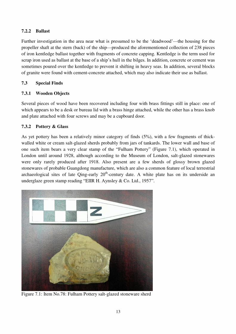
one such item bears a very clear stamp of the ³Fulham Pottery´ (Figure 7.1), which operated in
London until around 1928, although according to the Museum of London, salt-glazed stonewares
were only rarely produced after 1918. Also present are a few sherds of glossy brown glazed
stonewares of probable Guangdong manufacture, which are also a common feature of local terrestrial
archaeological sites of late Qing-early 20th-century date. A white plate has on its underside an
underglaze green stamp reading ³EIIR H. Aynsley & Co. Ltd., 1957´.
Figure 7.1: Item No.78: Fulham Pottery salt-glazed stoneware sherd
14
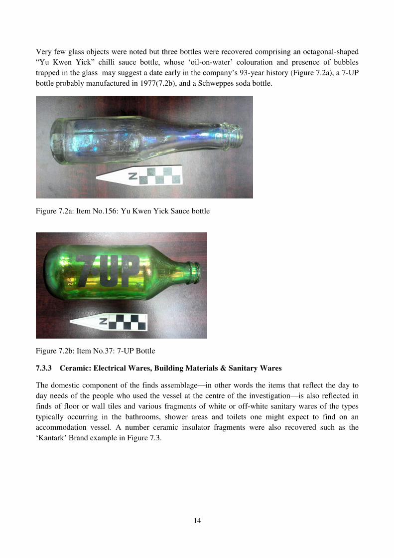
Very few glass objects were noted but three bottles were recovered comprising an octagonal-shaped
³Yu Kwen Yick´ FKLOOL� VDXFH� ERWWOH�� ZKRVH� µRLO-on-ZDWHU¶� FRORXUDWLRQ� DQG� SUHVHQFH� RI� EXEEOHV�WUDSSHG�LQ�WKH�JODVV��PD\�VXJJHVW�D�GDWH�HDUO\�LQ�WKH�FRPSDQ\¶V���-year history (Figure 7.2a), a 7-UP
bottle probably manufactured in 1977(7.2b), and a Schweppes soda bottle.
Figure 7.2a: Item No.156: Yu Kwen Yick Sauce bottle
Figure 7.2b: Item No.37: 7-UP Bottle
7.3.3 Ceramic: Electrical Wares, Building Materials & Sanitary Wares
The domestic component of the finds assemblage²in other words the items that reflect the day to
day needs of the people who used the vessel at the centre of the investigation²is also reflected in
finds of floor or wall tiles and various fragments of white or off-white sanitary wares of the types
typically occurring in the bathrooms, shower areas and toilets one might expect to find on an
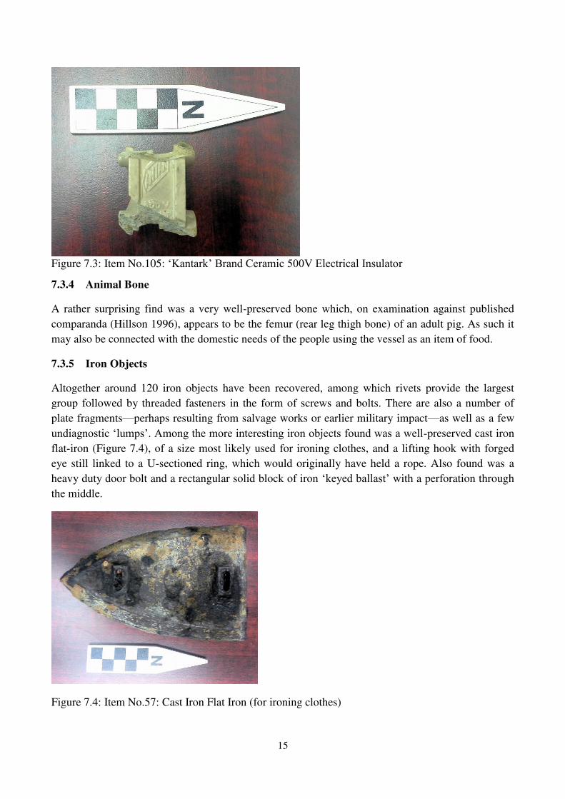
accommodation vessel. A number ceramic insulator fragments were also recovered such as the
µ.DQWDUN¶�%UDQG example in Figure 7.3.
15
Figure 7.3: Item No.105: µ.DQWDUN¶�%UDQG�&HUDPLF����9�(OHFWULFDO�,QVXODWRU
7.3.4 Animal Bone
A rather surprising find was a very well-preserved bone which, on examination against published
comparanda (Hillson 1996), appears to be the femur (rear leg thigh bone) of an adult pig. As such it
may also be connected with the domestic needs of the people using the vessel as an item of food.
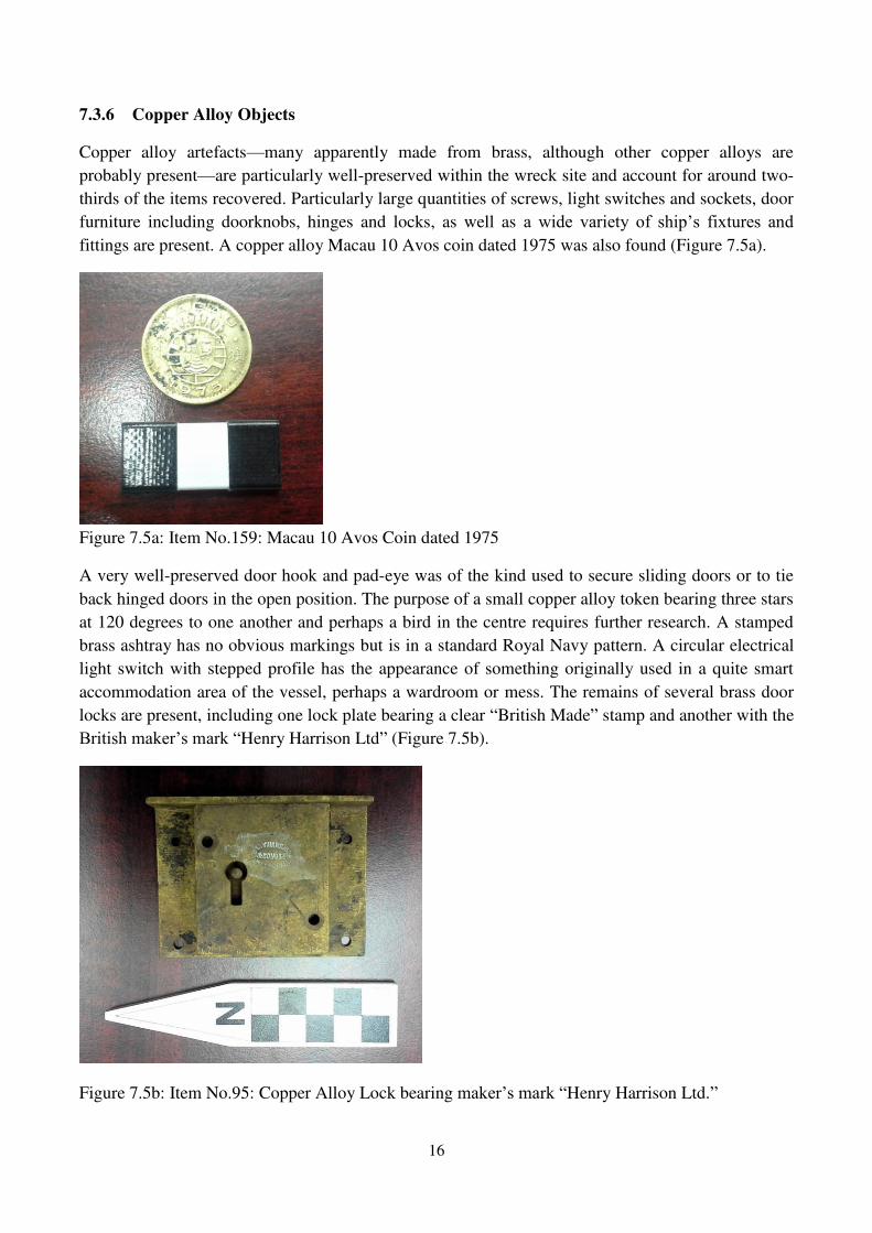
7.3.5 Iron Objects
Altogether around 120 iron objects have been recovered, among which rivets provide the largest
group followed by threaded fasteners in the form of screws and bolts. There are also a number of
plate fragments²perhaps resulting from salvage works or earlier military impact²as well as a few
XQGLDJQRVWLF�µOXPSV¶��$PRQJ�WKH�PRUH�LQWHUHVWLQJ�LURQ�REMHFWV�IRXQG�ZDV�D�ZHOO-preserved cast iron
flat-iron (Figure 7.4), of a size most likely used for ironing clothes, and a lifting hook with forged
eye still linked to a U-sectioned ring, which would originally have held a rope. Also found was a
heavy duty door bolt and a rectangular solid block of iron µNH\HG�EDOODVW¶�with a perforation through
the middle.
Figure 7.4: Item No.57: Cast Iron Flat Iron (for ironing clothes)
16
7.3.6 Copper Alloy Objects
Copper alloy artefacts²many apparently made from brass, although other copper alloys are
probably present²are particularly well-preserved within the wreck site and account for around two-
thirds of the items recovered. Particularly large quantities of screws, light switches and sockets, door
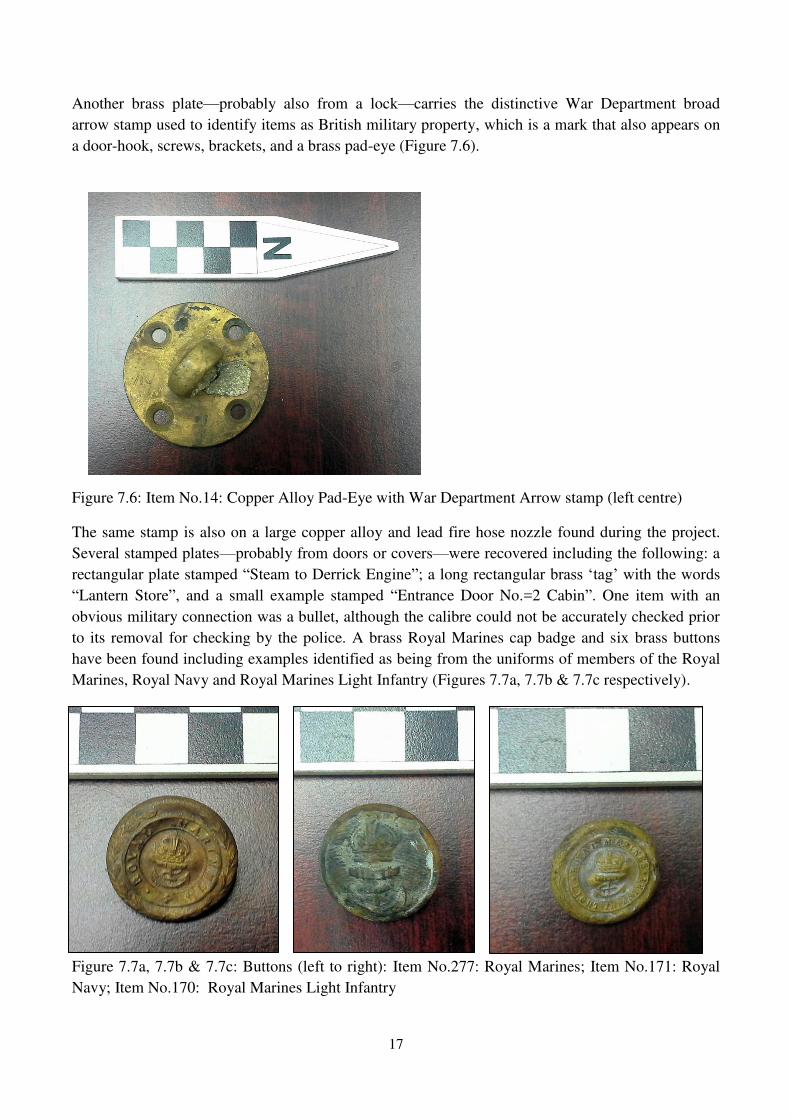
furniture including doorknobs, hinges and locks, as well as D� ZLGH� YDULHW\� RI� VKLS¶V� IL[WXUHV� DQG�fittings are present. A copper alloy Macau 10 Avos coin dated 1975 was also found (Figure 7.5a).
Figure 7.5a: Item No.159: Macau 10 Avos Coin dated 1975
A very well-preserved door hook and pad-eye was of the kind used to secure sliding doors or to tie
back hinged doors in the open position. The purpose of a small copper alloy token bearing three stars
at 120 degrees to one another and perhaps a bird in the centre requires further research. A stamped
brass ashtray has no obvious markings but is in a standard Royal Navy pattern. A circular electrical
light switch with stepped profile has the appearance of something originally used in a quite smart
accommodation area of the vessel, perhaps a wardroom or mess. The remains of several brass door
locks are present, including one lock plate bearing a clear ³British Made´ stamp and another with the
%ULWLVK�PDNHU¶V�PDUN�³Henry Harrison Ltd´ (Figure 7.5b).
Figure 7.5b: Item No.95: Copper Alloy Lock bearing PDNHU¶V�PDUN�³Henry Harrison Ltd.´
17
Another brass plate²probably also from a lock²carries the distinctive War Department broad
arrow stamp used to identify items as British military property, which is a mark that also appears on
a door-hook, screws, brackets, and a brass pad-eye (Figure 7.6).
Figure 7.6: Item No.14: Copper Alloy Pad-Eye with War Department Arrow stamp (left centre)
The same stamp is also on a large copper alloy and lead fire hose nozzle found during the project.
Several stamped plates²probably from doors or covers²were recovered including the following: a
rectangular plate stamped ³Steam to Derrick Engine´; a long rectangular EUDVV�µWDJ¶�with the words
³Lantern Store´, and a small example stamped ³Entrance Door No.=2 Cabin´. One item with an
obvious military connection was a bullet, although the calibre could not be accurately checked prior
to its removal for checking by the police. A brass Royal Marines cap badge and six brass buttons
have been found including examples identified as being from the uniforms of members of the Royal
Marines, Royal Navy and Royal Marines Light Infantry (Figures 7.7a, 7.7b & 7.7c respectively).
Figure 7.7a, 7.7b & 7.7c: Buttons (left to right): Item No.277: Royal Marines; Item No.171: Royal
Navy; Item No.170: Royal Marines Light Infantry
18
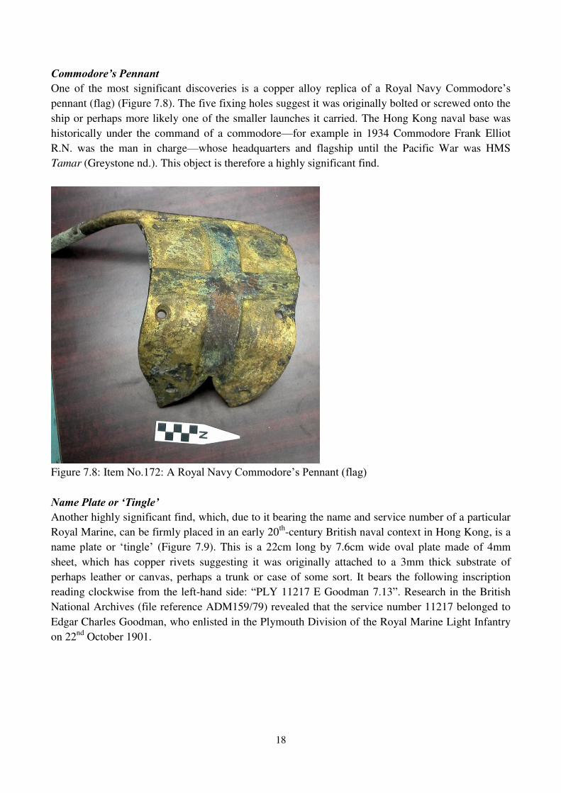
&RPPRGRUH¶V�3HQQDQW One of the most significant discoveries is a copper alloy UHSOLFD� RI� D� 5R\DO� 1DY\� &RPPRGRUH¶V�pennant (flag) (Figure 7.8). The five fixing holes suggest it was originally bolted or screwed onto the
ship or perhaps more likely one of the smaller launches it carried. The Hong Kong naval base was
historically under the command of a commodore²for example in 1934 Commodore Frank Elliot
R.N. was the man in charge²whose headquarters and flagship until the Pacific War was HMS
Tamar (Greystone nd.). This object is therefore a highly significant find.
Figure 7.8: Item No.172: A 5R\DO�1DY\�&RPPRGRUH¶V�3HQQDQW��IODJ��
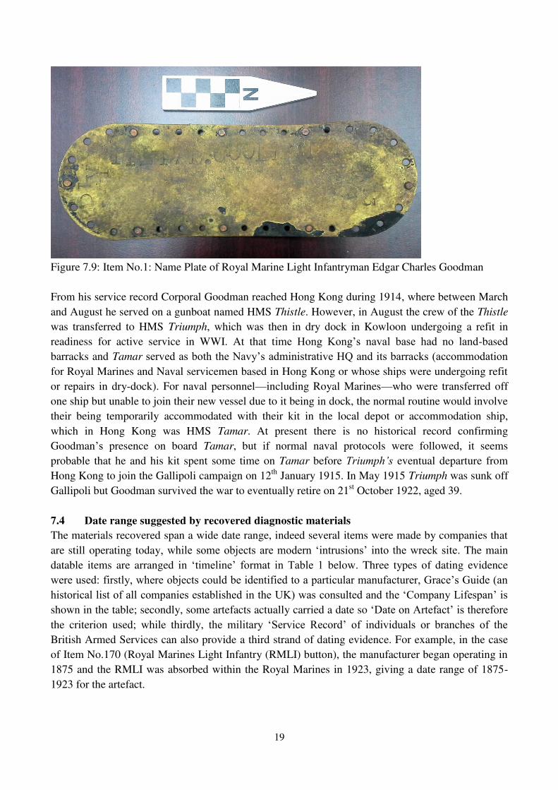
1DPH�3ODWH�RU�µ7LQJOH¶ Another highly significant find, which, due to it bearing the name and service number of a particular
Royal Marine, can be firmly placed in an early 20th-century British naval context in Hong Kong, is a
QDPH�SODWH� RU� µWLQJOH¶ (Figure 7.9). This is a 22cm long by 7.6cm wide oval plate made of 4mm
sheet, which has copper rivets suggesting it was originally attached to a 3mm thick substrate of
perhaps leather or canvas, perhaps a trunk or case of some sort. It bears the following inscription
reading clockwise from the left-hand side: ³PLY 11217 E Goodman 7.13´. Research in the British
National Archives (file reference ADM159/79) revealed that the service number 11217 belonged to
Edgar Charles Goodman, who enlisted in the Plymouth Division of the Royal Marine Light Infantry
on 22nd October 1901.
19
Figure 7.9: Item No.1: Name Plate of Royal Marine Light Infantryman Edgar Charles Goodman
From his service record Corporal Goodman reached Hong Kong during 1914, where between March
and August he served on a gunboat named HMS Thistle. However, in August the crew of the Thistle
was transferred to HMS Triumph, which was then in dry dock in Kowloon undergoing a refit in
readiness for active service in WWI. At that tLPH� +RQJ� .RQJ¶V� QDYDO� EDVH� KDG� QR� ODQG-based
barracks and Tamar VHUYHG�DV�ERWK�WKH�1DY\¶V�DGPLQLVWUDWLYH�+4�DQG�LWV�EDUUDFNV��DFFRPPRGDWLRQ�for Royal Marines and Naval servicemen based in Hong Kong or whose ships were undergoing refit
or repairs in dry-dock). For naval personnel²including Royal Marines²who were transferred off
one ship but unable to join their new vessel due to it being in dock, the normal routine would involve
their being temporarily accommodated with their kit in the local depot or accommodation ship,
which in Hong Kong was HMS Tamar. At present there is no historical record confirming
Goodman¶V� presence on board Tamar, but if normal naval protocols were followed, it seems
probable that he and his kit spent some time on Tamar before 7ULXPSK¶V eventual departure from
Hong Kong to join the Gallipoli campaign on 12th January 1915. In May 1915 Triumph was sunk off
Gallipoli but Goodman survived the war to eventually retire on 21st October 1922, aged 39.
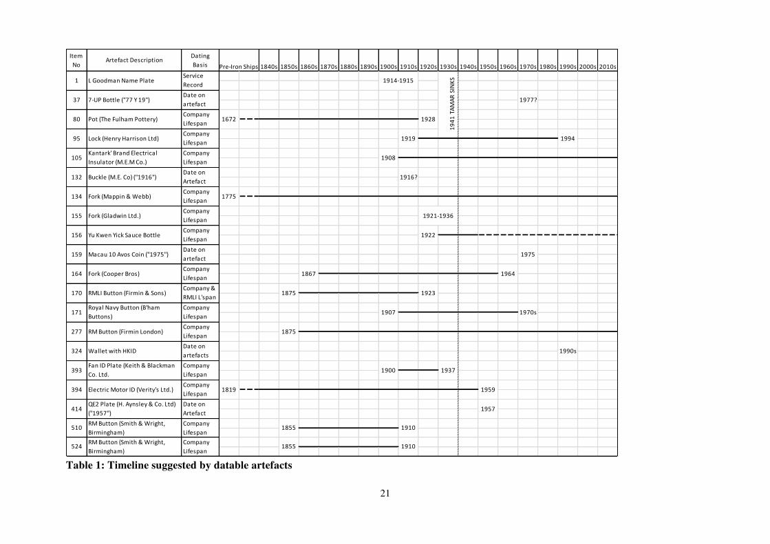
7.4 Date range suggested by recovered diagnostic materials
The materials recovered span a wide date range, indeed several items were made by companies that
are still operating today��ZKLOH�VRPH�REMHFWV�DUH�PRGHUQ�µLQWUXVLRQV¶� LQWR� WKH�ZUHFN�VLWH. The main
datable items are arranged iQ� µWLPHOLQH¶� IRUPDW� LQ� 7DEOH� � below. Three types of dating evidence
ZHUH�XVHG��ILUVWO\��ZKHUH�REMHFWV�FRXOG�EH�LGHQWLILHG�WR�D�SDUWLFXODU�PDQXIDFWXUHU��*UDFH¶V�*XLGH��DQ�KLVWRULFDO�OLVW�RI�DOO�FRPSDQLHV�HVWDEOLVKHG�LQ�WKH�8.��ZDV�FRQVXOWHG�DQG�WKH�µ&RPSDQ\�/LIHVSDQ¶�LV�shown in the table; secondly, some artefacts actually carried a date so µ'DWH�RQ�$UWHIDFW¶�LV�WKHUHIRUH�the criterion used; while thirdly, WKH� PLOLWDU\� µ6HUYLFH� 5HFRUG¶� RI� LQGLYLGXDOV� RU� EUDQFKHV� RI� WKH�British Armed Services can also provide a third strand of dating evidence. For example, in the case
of Item No.170 (Royal Marines Light Infantry (RMLI) button), the manufacturer began operating in
1875 and the RMLI was absorbed within the Royal Marines in 1923, giving a date range of 1875-
1923 for the artefact.
20
There is a particularly significant clustering of manufactured objects made by companies that ceased
production in the pre-Pacific War era, most notably: Item No.78 WKH�µ)XOKDP�3RW¶ (manufactured no
ODWHU�WKDQ��������,WHP�1R�����WKH�µ*ODGZLQ�/WG���)RUN¶��PDQXIDFWXUHG�QR later than 1936); and Item
1R�����WKH�µ.HLWK��%ODFNPDQ�&R��/WG���)DQ¶��PDGH�EHWZHHQ������DQG������. In addition there are
several British military artefacts that can also be more closely dated to that same pre-war period,
PRVW� QRWDEO\� ,WHP� 1R��� µ*RRGPDQ� 1DPH� 3ODWH¶ (1914-1915), Item No.132 µ0�(�� &R�� %uckle¶ (stamped ³1916´), Item No.170 the µRoyal Marines Light Infantry Button¶� �IURP a branch of the
British Armed Services that ceased to exist in 1923), and Item No.520²another µ5R\DO� 0DULQHV�%XWWRQ¶²that can be dated from its manufacturer to between the 1840s and 1910.
There are also some items of much more recent date which, given the much older character of the
majority of materials coming from the wreck, from an archaeological perspective can reasonably be
FRQVLGHUHG�PRGHUQ� µLQWUXVLRQV¶��7KHVH� LQFOXGH� ,WHP�1R���� µ�-83�%RWWOH¶� �FDUULHV� D�PRXOGHG� ³77´,
ZKLFK� SUREDEO\� LQGLFDWHV� ������� ,WHP� 1R����� µ0DFDX� ��� $YRV� &RLQ� �ZLWK� ����� GDWH��� DQG� ,WHP�No.324 µ:DOOHW�ZLWK�+.,'¶�GDWLQJ�WR�WKH�HDUO\�����V��,W�LV�VRPHZhat surprising that such items were
found at a depth similar to that of the older materials, but then there is a strong possibility of
disturbance of more modern materials from higher levels in the marine sediment sequence during
dredging works.
Despite such modern intrusions, the overall finds assemblage is dominated by a copper alloy artefact
assemblage reflecting the range of equipment, machinery, fixtures and fittings, and personal kit one
might expect to recover from the shipwreck of an earlier 20th-century British Royal Navy vessel.
21
Table 1: Timeline suggested by datable artefacts
Item No
Artefact DescriptionDating Basis 1840s 1850s 1860s 1870s 1880s 1890s 1900s 1910s 1920s 1930s 1940s 1950s 1960s 1970s 1980s 1990s 2000s 2010s
510RM Button (Smith & Wright, Birmingham)
Company Lifespan
1855 1910
414QE2 Plate (H. Aynsley & Co. Ltd) ("1957")
Date on Artefact
1957
1941
TAM
AR S
INKS
1775
1914-1915
1921-1936
1922
1875 1923
Company Lifespan
Fan ID Plate (Keith & Blackman Co. Ltd.
Company Lifespan
Company Lifespan
394
1990s
1900
1819 1959
1937
1975
1867 1964
Electric Motor ID (Verity's Ltd.)
1907 1970s
1875
1994
1916?
L Goodman Name Plate
7-UP Bottle ("77 Y 19")
Pot (The Fulham Pottery)
Lock (Henry Harrison Ltd)
Buckle (M.E. Co) ("1916")
Company Lifespan
Service Record
1977?
1919
1672 1928
Kantark' Brand Electrical Insulator (M.E.M Co.)
Company Lifespan
1908
Pre-Iron Ships
Fork (Mappin & Webb)
Fork (Gladwin Ltd.)
Yu Kwen Yick Sauce Bottle
Macau 10 Avos Coin ("1975")
277Company Lifespan
324Date on artefactsCompany Lifespan
393
RM Button (Firmin London)
Wallet with HKID
164
170Company & RMLI L'span
171Company Lifespan
Fork (Cooper Bros)
RMLI Button (Firmin & Sons)
Royal Navy Button (B'ham Buttons)
155
Company Lifespan
156
Date on artefact
159
95
132Date on ArtefactCompany Lifespan
134
105
1
37Date on artefactCompany Lifespan
80
524RM Button (Smith & Wright, Birmingham)
Company Lifespan
1855 1910
22
8. $VVHVVPHQW�RI�WKH�2EMHFW¶V�DUFKDHRORJLFDO�SRWHQWLDO�DQG�SRVVLEOH�LGHQWLILFDWLRQ�
This assessment of archaeological potential draws on a wide range of historical and archaeological evidence.
This has included the detailed study of historical documents, maps and charts held both locally in Hong Kong
DQG�LQ�WKH�8.¶V�1DWLRQDO�$UFKLYHV��UK Hydrographic Office and various military archives, as well as study of
WKH�ZUHFN¶V�VWUXFWXUDO�DQG�DUWHIDFWXDO�UHPDLQV��
A number of features of the wreck site suggest a clear connection with the Royal Navy and support a tentative
identification as the Hong Kong Depot Ship HMS Tamar. Firstly there is the location of the Object which,
based on a comprehensive review of the charts, closely matches the position of the only recorded wreck in that
precise position, namely HMS Tamar (Chart E7734 1945). Secondly, there are the structural remains of the
vessel itself: its sheer size, riveted wrought iron construction with large timber elements bolted on, white over
red lead paint finish, and possible evidence for artillery or explosives damage, which all fit with Tamar¶V design specification, recorded sinking and partial salvage (see Appendix 1). Thirdly, there are the
diagnostically British and military artefacts, some bearing War Department broad arrow stamps, one in fact
connected to a particular Royal Marine based in Hong Kong, who in August 1914 probably spent some time
living on HMS Tamar. More generally, with reference to Table 1, the artefacts with more closely defined date
ranges cluster before WWII and suggest a main period of use for the vessel in the later 19th and earlier 20th
century.
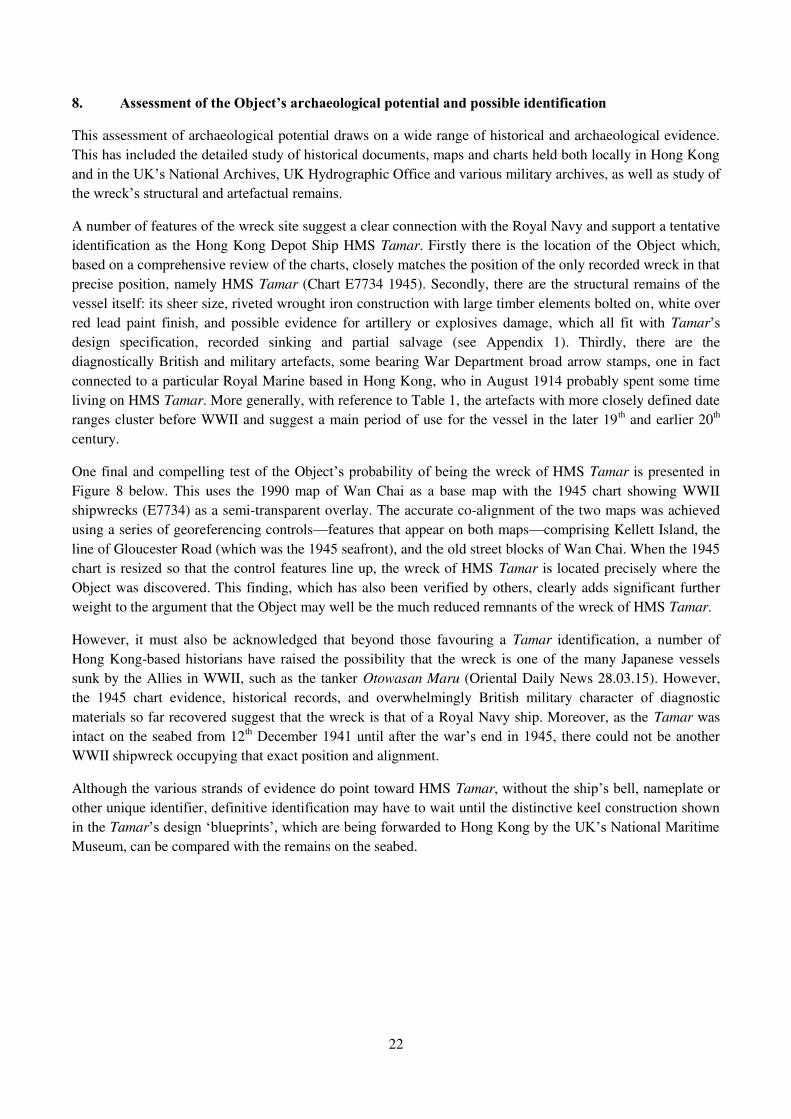
One final and compelling test of the Object¶V�SUREDELOLW\�RI�EHLQJ the wreck of HMS Tamar is presented in
Figure 8 below. This uses the 1990 map of Wan Chai as a base map with the 1945 chart showing WWII
shipwrecks (E7734) as a semi-transparent overlay. The accurate co-alignment of the two maps was achieved
using a series of georeferencing controls²features that appear on both maps²comprising Kellett Island, the
line of Gloucester Road (which was the 1945 seafront), and the old street blocks of Wan Chai. When the 1945
chart is resized so that the control features line up, the wreck of HMS Tamar is located precisely where the
Object was discovered. This finding, which has also been verified by others, clearly adds significant further
weight to the argument that the Object may well be the much reduced remnants of the wreck of HMS Tamar.
However, it must also be acknowledged that beyond those favouring a Tamar identification, a number of
Hong Kong-based historians have raised the possibility that the wreck is one of the many Japanese vessels
sunk by the Allies in WWII, such as the tanker Otowasan Maru (Oriental Daily News 28.03.15). However,
the 1945 chart evidence, historical records, and overwhelmingly British military character of diagnostic
materials so far recovered suggest that the wreck is that of a Royal Navy ship. Moreover, as the Tamar was
intact on the seabed from 12th 'HFHPEHU������XQWLO�DIWHU�WKH�ZDU¶V�HQG�LQ������� WKHUH�FRXOG�QRW�EH�DQRWKHU�WWII shipwreck occupying that exact position and alignment.
Although the various strands of evidence do point toward HMS Tamar��ZLWKRXW�WKH�VKLS¶V�EHOO��QDPHSODWH�RU�other unique identifier, definitive identification may have to wait until the distinctive keel construction shown
in the Tamar¶V�GHVLJQ�µEOXHSULQWV¶��ZKLFK�DUH�EHLQJ�IRUZDUGHG�WR�+RQJ�.RQJ�E\�WKH�8.¶V�1DWLRQDO�0DULWLPH�Museum, can be compared with the remains on the seabed.
23
Figure 8: 1990 1:5000 (HP5C) map (Empson 1992, 172-3) with 1945 chart E7734 overlay ± note coincidence of Wan Chai (Old) Ferry Pier in
1990 map with surveyed position of wreck of HMS Tamar in 1945.
24
9. Assessment of potential impacts caused by the project. The engineering requirements of Wan Chai Development Phase II require the wreck is removed from the seabed as it lies in the only section of the coastal reclamation still outstanding. It therefore affects the progress of the entire project. The divers are continuing to provide information about the condition of the wreck. This data will be used to develop options such as safely moving the wreck in one piece to an adjacent location for continued excavation. 10. Marine Archaeological Action Plan (MAAP) The current situation is exceptional as the metal object was an unplanned discovery during a dredging operation. Emergency practical measures were taken to remove some loose fragments of WKH� ZUHFN¶V� VWUXFWXUH�� 6LQFH� 'HFHPEHU� ��th 2014, a team of divers was employed to complete a preliminary assessment and remove sediment from the site in order to gain a better understanding of the nature and condition of the wreck. Marine mud has been removed down to -14mPD in the area surrounding the wreck while, as detailed in Section 7 above, while as of 30th April air lifting works had removed around 60% of sediment within the hull and recovered a total of 777 artefacts. $OWKRXJK�FDUULHG�RXW� LQ�D�µUHVFXH¶�FRQWH[W�� WKH�ZRUN�KDV�EHHQ�PHWKRGLFDO��a high recovery rate has been demonstrated, and the 3D coordinates of artefacts have been systematically recorded. Elementary on site conservation has also been carried out. The emergency measures so far completed have been carried out to a good standard and no damage to the object has resulted. The UNESCO 2001 Convention sets out guidelines for Underwater Cultural Heritage. They have been used as the basis for the MAAP to ensure that work complies with international standards. While the MAAP provides a general framework for action while current work is in progress it is anticipated that a Methodology for Marine Archaeological Investigation (MAI) will be prepared by a marine archaeologist in consultation with the AMO for the complete investigation of the shipwreck. The MAI will comply with all relevant AMO Guidelines as set out in Appendix 4. With respect to the MAAP, the following general actions are recommended: 1. Application for Licence to Excavate and Search for Antiquities to ensure all site work is
conducted with the approval of AMO. Developing the methodology for the MAI. 2. Continue research and air lift excavation with the purpose of adequately exposing the wreck
to facilitate accurate condition and establish extent of the wreck to provide data upon which other key decisions can then be made. Such work has thus far been conducted at a steady rate and objects are being retrieved undamaged. It is therefore proposed that work continues using this method. Underwater video has been used for additional information and recording.
3. In the course of air lifting, should any items of interest be retrieved these will be recorded in
detail on site and a conservation plan suggested. Since air lifting began the equipment has been modified with the addition of a wire mesh which ensures a high rate of artefact retention.
4. The air lifting is being carried out by divers under contract to CEDD. Their work has been consistently to a good standard. Since April 1st an archaeologist has been on site to monitor the objects being raised, identify, record them and log them into a project database.
5. It is recommended that a High Resolution Multi-Beam Survey is completed to delineate the
dimensions and form of the object. The resulting 3-D visialisation would provide very useful data for communicating to the public the nature of the wreck site.

25
6. Temporary conservation has been carried out but there is a need to develop a practical long term solution. A part time conservator has been on site since April 1st who is providing temporary protection and storage.
7. Documentation and archive programme. All artefact recording and reporting must comply
with AMO standards and guidelines. On completion of the fieldwork, post-excavation processing, analysis and report writing, the final report will be placed at the Heritage Discovery Centre and made available for public consultation, while all relevant paper, digital and material archives will be deposited with the AMO Repository.
26
Appendix 1: HMS Tamar summary 1. Specification HMS Tamar was built as a barque-rigged, three-masted sail and steam powered troopship by Samuda Brothers of Cubitt Town, London in 1863. Her displacement (weight) was 4,650 tons and she measured 320 ft (98 m) long and had a beam (width) of 45 ft (14 m). Her propulsion consisted of a 500 hp steam plant (engine) driving a single propeller, which gave her a maximum speed of 12 knots or 22km/h. As a troopship her armament was light, consisting as it did of just three guns. 2. History The HMS Tamar visited Hong Kong twice (1878, 1886) during her days as a troopship, carrying troops and supplies to Hong Kong. She arrived for the last time on 6th September 1895 and was taken to Kowloon Docks to be converted to an accommodation ship for the Royal Navy in Hong Kong. The reason for this was Section 67 of the Naval Discipline Act 1866, which stated that all shore HVWDEOLVKPHQWV�RI�WKH�5R\DO�1DY\�PXVW�KDYH�ZKDW�ZDV�FDOOHG�D�µQRPLQDO�GHSRW�VKLS¶�WKDW�VHUYHG�DV�the commissioned vessel to which all personnel were attached. Soon after her conversion to that new role, re-ballasting was necessary to reduce her excessive roll, and the Tamar was finally FRPPLVVLRQHG�DV�WKH�5R\DO�1DY\¶V�QRPLQDO�GHSRW�VKLS�RQ��VW�2FWREHU������ Until 1913 the Tamar was moored to a buoy off the Naval Dockyard, but five years after the dockyard extension was completed (1902-1908), she was moved from her buoy to a permanent berth on the west wall of the new basin. She remained there, with an occasional move to Kowloon Dockyard for docking and painting, until the moment the Japanese invaded Hong Kong on 8th December 1941. Almost immediately she was moved from the West Wall out to a mooring off the Wan Chai waterfront. When it was clear that the battle had swung decisively against the British with the fall of the Shing Mun Redoubt on 11th December, and the decision to evacuate the New Territories was taken, it was decided to scuttle (sink) all ships not of use in the battle. Accordingly a small team was sent onto the Tamar to open her seacocks to let in seawater. Although she settled, she did not sink because air was trapped under the upper deck and, above all, under the large, fixed metal awning covering her. Accordingly the Royal Artillery manning guns ashore were called upon to shell the upper works until she sank (Steemson nd.). In 1947 the wreck was demolished by explosives allowing the salvage of all elements then protruding above the seabed (China Mail 20th Dec 1947). There were further clearance operations to ensure that the area was clear for navigation. 3. Historical Significance When attempting to assess the historical significance of the wreck of HMS Tamar one has to take into account the fact that there is Tamar the ship and Tamar the onshore naval base, which like µ$GPLUDOW\¶� HYHQWXDOO\� JDYH� LWV� QDPH� WR� DQ� DUHD� RI� +RQJ� .RQJ�� :KLOH� WKH� QDPH� µ7DPDU¶� KDV� D�deeper non-military significance as a result of its perpetuation in the post-colonial era as an area of Admiralty now associated with the governance of the SAR.
7KH�6KLS�µ7DPDU¶ The ship itself has historical significance as a WHFKQRORJLFDOO\�LQWHUHVWLQJ�µK\EULG¶�YHVVHO�EXLOW�LQ�DQ�era of multiple technological transitions, namely: the shift from sail to steam (Tamar was one of a class of vessels which had both), the move from paddle to propeller propulsion (Tamar is a quite early example of propeller use), and from ironclad wooden warships to vessels like Tamar with hulls constructed entirely of riveted wrought iron. The heyday of wrought iron hulled vessels was short-lived as before the end of the 19th century steel became the shipbuilding material of choice. So Tamar has broader historical significance in terms of global developments in shipbuilding and maritime technology, and more local significance in terms of the late 19th-mid-20th-century operation
27
RI�WKH�5R\DO�1DY\¶V�VR-called China Station, and its role in the colonial history of Hong Kong up to WWII. Moreover, although the vessel was explosively dismantled and salvaged, the surviving remains can reveal important structural details of late 19th-century wrought iron shipbuilding, while the artefactual remains can provide rich socio-KLVWRULFDO�LQVLJKWV�LQWR�WKH�VKLS¶V�LQWHULRU�ILWWLQJV�DQG�appearance, and the life of the men on board. 7KH�1DPH�µ7DPDU
7KH�QDPH�µ7DPDU¶�UHVRQDWHV�LQ�+RQJ�.RQJ¶V�KLVWRU\��7KH�VKLS�DSSHDUV�LQ�Hvery photograph of the Central harbour area taken during the early years of photography in Hong Kong. As Tamar had VHUYHG� VR� ORQJ� DV� +RQJ� .RQJ¶V� QRPLQDO� GHSRW� VKLS²44 years in total²the name became synonymous with the naval base. With Tamar sunk, when the Royal Navy returned in 1945 they decided to keep the name, and for the first 8 months renamed the River Class frigate HMS Aire as HMS Tamar. When in 1946 the Royal Navy acquired Wellington Barracks from the Army, they made it what in naval language is termHG� D� µVWRQH� IULJDWH¶� �D� EULFNV� DQG� PRUWDU� VKLS�� ZKLFK� ZDV�promptly named HMS Tamar. The site of stone frigate, which was the 6th naval establishment to bear the name, now lies beneath the headquarters buildings of both the Hong Kong SAR Government and the 3HRSOH¶V� /LEHUDWLRQ�Army.
The name Tamar (Tim Ma (ῧ㤿) in Cantonese) has also left its mark in popular speech and in local place-names such as Tamar Park and Tamar Street in Admiralty, and it is also punned on in Tim Mei and Tim Wah Avenues. Today we alsR�UHIHU�WR�WKH�µ7DPDU�'HYHORSPHQW¶�DQG�WKH�µ7DPDU�6LWH¶�DV�WKH�ORFDWLRQV�IRU�WKH�QHZ�&HQWUDO�*RYHUQPHQW�2IILFHV�DQG�WKH�/HJLVODWLYH�&RXQFLO��7KH�µ7DPDU¶�QDPH�LV�therefore very familiar to Hong Kong people²whether Chinese or foreigners²and reflects a unique SDUW�RI�+RQJ�.RQJ¶V�FRORQLDO�and post-colonial history.
28
Appendix 2: Wreck Report Database of the Hydrographic Service for the UK
The following Wrecksite information has been derived in part from material obtained from the UK
Hydrographic Office with the permission of the UK Hydrographic Office and Her Majesty's
Stationery Office and the following authorities. © British Crown Copyright, 2015.
UND Position Latitude = 22°17'.053 N Longitude = 114°10'.402 E
Wreck Number 68163
Classification Unclassified
Chart Symbol WK SW 7.9
Status ; --
Existence Doubtful NO
Reported Year ; --
Date Last Amended
Charting Comments ; --
Wreck Category Dangerous wreck
WGS84 Origin Undefined
WGS84 limits ; --
Position Latitude = 22°17'.053 N Longitude = 114°10'.402 E
Previous Position Latitude = -- Longitude = --
Position Accuracy ; --
Horizontal Datum UNDETERMINED
Position Last Amended
Position
Position Method : Compass Bearing and Radar Range
Position Quality : Surveyed
Limits ; --
Depth : 7,9 m
29
Water Depth : 10 m
Depth Method : Swept by wire-drag
Depth Quality : Least depth known
Height : --
Drying Height : --
Vertical Datum
Wrecksite
Water Level Effect : Always under water/submerged
Bottom Texture : Mud
Sonar Signal Strength --
Sensor
Original Sensor : --
Last Sensor : --
Conspicuous
Conspic Visual : NO
Conspic Radar : NO
Contact
Non-Sub Contact : NO
Contact Description : --
Name HMS TAMAR
Type IRON STEAM TROOPSHIP
Flag BRITISH
Dimensions
Length = 97,5 m
Beam = 13,7 m
30
Draught = --
Tonnage 4650 Gross
Cargo
Date Sunk 12/12/1941
Detection
Original Detection Year : --
Last Detection Year : --
Source
Original Source : --
Last Source : --
Sonar Dimensions
Sonar Length = --
Sonar Width = --
Shadow Height = --
Orientation 45°
Magnetic Anomaly --
Debris Field --
Scour
Scour Depth = --
Scour Length = --
Scour Orientation = --
Markers --
General Comments --
Circumstances of Loss BUILT 1863 BY SAMUDA, POPULAR. SCUTTLED AT HONG KONG. (SHIPS OF THE
ROYAL NAVY)
31
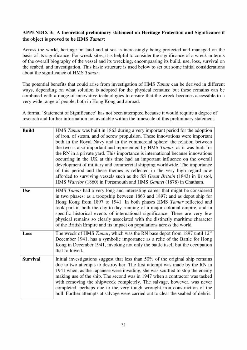
APPENDIX 3: A theoretical preliminary statement on Heritage Protection and Significance if
the object is proved to be HMS Tamar:
Across the world, heritage on land and at sea is increasingly being protected and managed on the basis of its significance. For wreck sites, it is helpful to consider the significance of a wreck in terms of the overall biography of the vessel and its wrecking, encompassing its build, use, loss, survival on the seabed, and investigation. This basic structure is used below to set out some initial considerations about the significance of HMS Tamar. The potential benefits that could arise from investigation of HMS Tamar can be derived in different ways, depending on what solution is adopted for the physical remains; but these remains can be combined with a range of innovative technologies to ensure that the wreck becomes accessible to a very wide range of people, both in Hong Kong and abroad. $�IRUPDO�µ6WDWHPHQW�RI�6LJQLILFDQFH¶�KDV�QRW�EHHQ�DWWHPSWHG�EHFDXVH�LW�ZRXOG�UHTXLUH�D�GHJUHH�RI�research and further information not available within the timescale of this preliminary statement.
Build HMS Tamar was built in 1863 during a very important period for the adoption of iron, of steam, and of screw propulsion. These innovations were important both in the Royal Navy and in the commercial sphere; the relation between the two is also important and represented by HMS Tamar, as it was built for the RN in a private yard. This importance is international because innovations occurring in the UK at this time had an important influence on the overall development of military and commercial shipping worldwide. The importance of this period and these themes is reflected in the very high regard now afforded to surviving vessels such as the SS Great Britain (1843) in Bristol, HMS Warrior (1860) in Portsmouth and HMS Gannet (1878) in Chatham.
Use HMS Tamar had a very long and interesting career that might be considered in two phases: as a troopship between 1863 and 1897; and as depot ship for Hong Kong from 1897 to 1941. In both phases HMS Tamar reflected and took part in both the day-to-day running of a major colonial empire, and in specific historical events of international significance. There are very few physical remains so clearly associated with the distinctly maritime character of the British Empire and its impact on populations across the world.
Loss The wreck of HMS Tamar, which was the RN base depot from 1897 until 12th December 1941, has a symbolic importance as a relic of the Battle for Hong Kong in December 1941, invoking not only the battle itself but the occupation that followed.
Survival Initial investigations suggest that less than 50% of the original ship remains due to two attempts to destroy her. The first attempt was made by the RN in 1941 when, as the Japanese were invading, she was scuttled to stop the enemy making use of the ship. The second was in 1947 when a contractor was tasked with removing the shipwreck completely. The salvage, however, was never completed, perhaps due to the very tough wrought iron construction of the hull. Further attempts at salvage were carried out to clear the seabed of debris.
32
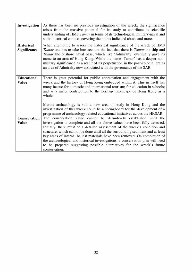
Investigation As there has been no previous investigation of the wreck, the significance arises from the massive potential for its study to contribute to scientific understanding of HMS Tamar in terms of its technological, military-naval and socio-historical context, covering the points indicated above and more.
Historical Significance
When attempting to assess the historical significance of the wreck of HMS Tamar one has to take into account the fact that there is Tamar the ship and Tamar WKH� RQVKRUH� QDYDO� EDVH�� ZKLFK� OLNH� µ$GPLUDOW\¶� HYHQWXDOO\� JDYH� LWV�QDPH� WR�DQ�DUHD�RI�+RQJ�.RQJ��:KLOH� WKH�QDPH� µ7DPDU¶�KDV�D�GHHSHU�QRQ-military significance as a result of its perpetuation in the post-colonial era as an area of Admiralty now associated with the governance of the SAR.
Educational Value
There is great potential for public appreciation and engagement with the wreck and the history of Hong Kong embedded within it. This in itself has many facets: for domestic and international tourism; for education in schools; and as a major contribution to the heritage landscape of Hong Kong as a whole. Marine archaeology is still a new area of study in Hong Kong and the investigation of this wreck could be a springboard for the development of a programme of archaeology-related educational initiatives across the HKSAR.
Conservation Value
The conservation value cannot be definitively established until the investigation is complete and all the above values have been fully assessed. Initially, there must be a detailed DVVHVVPHQW� RI� WKH� ZUHFN¶V� FRQGLWLRQ� DQG�structure, which cannot be done until all the surrounding sediment and at least key areas of internal ballast materials have been removed. On completion of the archaeological and historical investigations, a conservation plan will need to be prepared suggesting possiEOH� DOWHUQDWLYHV� IRU� WKH� ZUHFN¶s future conservation.
33
Appendix 4: Standards and Guidelines The excavation will generally be conducted in line with internationally accepted standards of archaeological practice and specifically in accordance with relevant AMO guidelines governing site work and the preparation of archaeological sites and archives. NB: The AMO should be informed immediately if significant archaeological deposit is identified. A brief report on the discoveries with preliminary assessment, plans, photographs and drawings should be prepared upon request by the AMO.
Appendix 4.1: Guidelines for Archaeological Reports (as at April 2011)
I. General
1. All reports should be written in a clear, concise and logical style. 2. All the constituent parts (text, figures, photos and specialist reports (if any) should
provide full cross-reference. Readers should be able to find their way around the report without difficulty.
3. The reports should be submitted in A4 size and accompanying drawings of convenient sizes.
4. Draft reports should be submitted to the Antiquities and Monuments Office (AMO) for comments within t w o months after completion of archaeological work unless otherwise approved by AMO.
5. The draft reports should be revised as required by AMO and relevant parties. The revised reports should be submitted to AMO within three weeks after receiving comments from AMO and relevant parties.
6. At least 5 hard copies of the final reports should be submitted to AMO for record purpose.
7. At least 2 digital copies of the final reports in both Microsoft Word format and Acrobat (.PDF) format without loss of data and change of appearance compared with the corresponding hard copy should be submitted to AMO. The digital copies should be saved in a convenient medium, such as compact discs with clear label on the surface and kept in protective pockets.
8. Errors are the responsibilities of the author(s) and should so far as possible be identified and rectified before submission to AMO.
9. The guidelines which will be revised by the AMO of the Leisure and Cultural Services Department from time to time, where appropriate, and when required should be followed in the interest of professional practice.
II. Suggested Format of Reports
1. Front page: - Project/Site name - Nature of the report e.g.
(Draft/Final) Archaeological Investigation/Survey Report Archaeological Impact Assessment Report Watching Brief Report Rescue Excavation R eport Post-excavation Report
34
- Organization - Date of report
2. Contents list Page number of each section should be given.
3. Non-technical summary (both in English and Chinese with approximate 150 ± 300
words each) This should outline in plain, non-technical language, the principal reasons for the archaeological work, its aims and main results, and should include reference to authorship and commissioning body.
4. Introduction
This should set out background leading to the commission of the reports. The location, area, scope and date of conducting the archaeological work must be given. The location of archaeological work should be shown on maps in appropriate scales and with proper legends.
5. Aims of archaeological work These should reflect the aims set in the project design. 6. Archaeological, historical, geological and topographical background of the site
Supporting aerial photos and maps (both old and present) in appropriate scales, with proper legends and with the site locations clearly marked on should be provided.
7. Methodology
The methods used including any variation to the agreed project design should be set out clearly and explained as appropriate.
8. Results
�� The results should outline the findings, known and potential archaeological interests by period and/or type. Their significance and value with reference/inclusion of supporting evidence should be indicated. If more than one interpretation is possible, the alternatives should also be presented, at least in summary.
���� The results should be amplified by the use of drawings and photographs. �� Tables summarizing features and artefacts by trench/grid/test pit together with
their interpretation should be included. � The method, sampling details, results and interpretation as well as
appropriate supporting data of the analysis for the environmental materials, e.g. ecofacts identified and/or collected during the fieldwork should be included.
� For impact assessment, the likely effect of the proposed development on the known or potential archaeological resource should be outlined.
9. Conclusion This should include summarization and interpretation of the result. 10. Recommendation
35
Recommendations on further work and the responsible party as well as a brief planning framework should be outlined.
11. Reference and bibliography A list of all primary and secondary sources including electronic sources used should be given in full detail, including the title of the relevant material, its author(s), publisher, publication place and date.
12. Archaeological team
The director and members of the archaeological team and the author(s) of the report should be clearly specified.
13. Copyright and dissemination
The copyright of the· report should be clearly identified. To facilitate future research studies, please specify that the report can be made available to the public in the Reference Library of the Heritage Discovery Centre.
14. Supporting illustrations
They should be clearly numbered and easily referenced to the text. They should be scanned and saved in TIFF or JPEG formats.
A. Maps
A location plan of the project site should be included. Archaeological work locations, such as auger hole and test pit locations (with relevant coordinates certified by a qualified land surveyor), should be clearly shown on maps in appropriate scales, with proper legends, grid references (in 8 digits) and captions.
B. Drawings of test pits, archaeological features, special finds1
, selected representative samples from general finds Drawings of all excavated test pits (at least one cross section of each test pit), all excavated archaeological features (both plan and cross section of each archaeological feature), all special finds identified in the excavation and selected representative samples from general finds (at least front view and section of each finds) should be included. All drawings should be clearly numbered and easily referenced to the text. The drawing scales stipulated below should be followed:
Cross section and profile drawings of test pits 1:20 Archaeological feature drawings 1:10 Finds drawings 1:1
If drawings of the above stated scales are not appropriate to be incorporated into the report under certain occasions, reduced copy of the drawings with the same scales are acceptable. Proper captions, legends and indication of reduced size should be given.

36
1 Special finds are sometimes known as small finds (⮷ẞ) in Chinese or registered finds. Drawings and
photos of the special/small/registered finds should be included in the archaeological report.
C. Photos of project site and the surrounding area, test pits,
archaeological features, special finds, selected representative samples from general finds
Photos of project site and the surrounding area, all excavated test pits (at least one cross section of each test pit), all excavated archaeological features (both plan and cross section of each archaeological feature), all special finds identified in the excavation and selected representative samples from general finds (at least front view of each of the finds) should be included. All photos should be at least in 3R size with proper captions and scales. They should be clearly numbered and easily referenced to the text. They should be scanned and saved in TIFF or JPEG formats.
15. Supporting data in appendices
These should consist of essential technical details to support the result. These may include stratigraphic record of test pits and auger holes, records of general and special finds as well as ecofacts discovered with description, quantity and context number/stratigraphic sequence, result of laboratory testing, index of field archives.
16. Other professional views/comments This can reflect any issues/ difficulties regarding the archaeological project
observed/ encountered by the archaeological team. 17. Comment and response All comments and responses from AMO and relevant parties should be attached in full.
III Green Measures
1. All reports should be of single line spacing and printed on both sides of the paper.
2. Excessive page margins should be avoided. A top/bottom margin of 2 cm and left/right margin of 2.5 cm are sufficient.
3. Use of blank paper should be avoided as far as possible.
4. Suitable font type of font size 12 should be used generally in balancing legibility and
waste reduction objective.
37
Appendix 4.2: Guidelines for Handling of Archaeological Finds and Archives (as at 28th November 2011)
I. General Remark
1. The guidelines which will be revised by the Antiquities and Monuments Office (AMO) of the Leisure and Cultural Services Department from time to time, where appropriate, and when required should be followed in the interest of professional practice.
2. Please use the site code ( )** for the archaeological project, namely
. Licensee must use this unique site code for the whole project.
** If an archaeological project covers more than one archaeological site/location, licensee should contact the Central Archaeological Repository (CAR) at 2384 5446 or [email protected] to obtain relevant site codes.
3. Licensee should contact the CAR at 2384 5446 or [email protected] regarding the
handover of archaeological finds and archives when post-excavation research and excavation report have been completed and accepted by the AMO.
4. If a huge quantity of similar general finds was discovered from a single archaeological project, licensee is advised to consult the AMO regarding the collecting strategy as early as possible.
5. For the preparation of archaeological finds and archives for long-term curation by the
CAR, the guidelines as set out below should be followed.
6. If the licensee does not handle the finds and archives in accordance with this guidelines, the AMO may inform the project proponent to revise the relevant data. The arrangement of handover may subsequently be deferred.
II. Archaeological Finds
7. Cleaning The excavated finds should be properly cleaned with water, except: (i) the finds are identified for scientific analysis; (ii) metal & organic objects (e.g. bone, wood, leather, textile objects and etc.) should not be cleaned with water. Licensee is advised to consult the AMO if in doubt.
8. Marking - The excavated finds should be cleaned before marking object number. - ³Sandwich´ technique1 should be adopted for marking permanent object number.
1 Steps for ͞Sandwich͟ technique
1. First of all, the find number should be marked in appropriate area and size that does not impact important diagnostic or aesthetic parts of the find.
2. Clean the area to be marked. 3. Apply a thin coat of clear reversible lacquer on the area. Use white lacquer if the object is dark in colour. Let the base coat dry completely. 4. Use a permanent water-based ink to write the find number on top of the base coat. Let ink dry completely.
38
- Each special find should be marked with site code, context number and SF number, etc.
- Any representative samples selected from the general finds for discussion on the excavation report should be marked with site code, context number, sample number and bagged separately.
- The general finds should be marked with site code and context number. - For the finds which are too small, organic objects (e.g. bone, wood, leather, textile
objects and etc.) or have unstable surface, object number should not be marked on the object directly. These finds should be bagged separately and attached with a label containing information about the site code, context number, find number and description of find.
9. Labelling and bagging
- Two labels should be provided for each bag which contains finds, one is adhered on the surface of the bag while the other is kept inside the bag for easy reference.
- The label inside the bag should be kept separately with a smaller plastic bag so that the label can be kept much longer.
- Information about the site code, context number, test-pit number, object number (or bag number) and description of finds should be written clearly on the label.
- Finds under the same context should be bagged together. If those finds, however, have been categorized according to their typology, materials or characteristics, separate bagging is required.
10. Conservation
- To refit and reconstruct pottery vessels with appropriate adhesive. A heat and waterproof adhesive, e.g. product of H. Marcel Guest Ltd., is recommended.
- Any adhesives which are not reversible or would damage the finds should not be applied on the finds. Archaeologist is advised to consult the AMO if in doubt.
11. Finds register
A standard finds register, for both special finds and general finds, with information DERXW�WKH�ILQG¶V�QXPEHU��QDPH��GHVFULSWLRQ��TXDQWLW\��W\SH��ZHLJKW��GLPHQVLRQV�DQG�ILHOG�data should be duly filled in. Licensee should contact the CAR at 2384 5446 or [email protected] to obtain the standard finds register (in Excel format). Special finds and general finds should be inputted in individual register. Both hard & soft copies (in Excel format) of the duly completed register should be handed over.
12. Sample register of eco-facts
A clear sample register with information about the description of the sample, quantity, type and weight should be prepared for handover.
III. Field Records and Finds Processing Records
13. Field records include field diary, site record for individual test pit/trench/square, context recording sheet, special finds recording sheet, soil sample & eco-facts sample recording sheet, map, survey sheet, photograph/ audio-visual records, etc.
5. Apply a top coat of clear varnish. 6. Let the clear varnish dry completely before packing.
39
14. Finds processing records include conservation record, measured drawings and photographs, laboratory reports, etc.
15. Measured drawing, both hard & soft copies (in pdf format), and photograph (in jpg
format) of each special find should be handed over.
16. All the aforesaid records stated in paragraphs 12 to 14 should be handed over to the CAR when post-excavation research and excavation report have been completed. Please note:
- all the field records should be submitted together with indexes. - the video footage should be submitted together with index describing the content of
the video footage. - all the slides, colour/ black & white negatives or digital photographs should be
submitted together with photo register. IV. Handover of Finds
17. Packing - Each special find should be packed and protected with tissue paper, bubble sheet or
P.E. foam to avoid shocking when transporting to the repository. No packing material other than the aforesaid items should be used.
- The general finds should be protected with bubble sheet or P.E. foam and packed in heavy duty plastic container.
- The heavy duty plastic container, e.g. product of the Star Industrial Co., Ltd. (No. 1849 or 1852), is recommended.
- For oversized finds, prior advice on packing method should be sought from the AMO.
18. Handover procedure
- The licensee should make an appointment with the CAR for the handover and arrange to transport the finds and archives to the repository.
- Prior to handover, licensee is required to supply with the aforesaid finds register, field records register and associated records to the CAR for checking at least three working days in advance. Exact date of handover will be arranged subsequently.
- Handover forms for finds and archives should be signed by the representatives of the licensee and the AMO.
40
References
Banham, T. 2005. Not the slightest chance: the defence of Hong Kong, 1941, Hong Kong: Hong
Kong University Press
http://www.royalnavyresearcharchive.org.uk/HMS_Tamar.htm#.VRJYwEIVrzI (accessed on
24.03.2015)
China Underwater Cultural Heritage (CUCH) nd. China National Conservation Center for Underwater Cultural Heritage. Beijing: CUCH.
http://www.unesco.org/new/fileadmin/MULTIMEDIA/HQ/CLT/pdf/CUCH_brochure_en%20(2)_02.pdf
Coates, A. 1977. A Mountain of Light. Hong Kong: Heinemann Educational Books (Asia) Ltd.
Coates, A. 1980.Whampoa: Ships on the Shore. Hong Kong: South China Morning Post Ltd.
Collis, M. 1946. Foreign Mud. An Account of the Opium War. London: Faber and Faber Ltd.
de Rome F.J. & Evans, N. 1921. Notes on the Harbour of Hong Kong, Hong Kong: The Printerie.
Dromgoole, S. 2013. Underwater Cultural Heritage and International Law. Cambridge: Cambridge University Press.
Empson, H.1992. Mapping Hong Kong: A Historical Atlas, Hong Kong: Government Information Services.
Endacott, G. B. 1964.Government and People in Hong Kong, 1841-1962: A Constitutional History, Hong Kong. Hong Kong: Hong Kong University Press.
Endacott, G.B. 1993. A History of Hong Kong. Hong Kong: Oxford University Press.
England, V. 1998. 7KH�4XHVW�RI�1RHO�&URXFKHU��+RQJ�.RQJ¶V�4XLHW Philanthropist. Hong Kong: Hong Kong University Press.
*DOODJKHU��6��QG��µ3URWHFWLQJ�WKH�8QGHUZDWHU�&XOWXUDO�+HULWDJH�LQ�WKH�ZDWHUV�VXUURXQGLQJ�+RQJ�.RQJ¶� The Museum of Underwater Archaeology
http://www.themua.org/collections/files/original/dbb657c349cdd196d7dbdc8be4e03ea1.pdf.
GrDFH¶V�*XLGH��QG����%ULWLVK�,QGXVWULDO�+LVWRU\��ZHEVLWH�� (http://www.gracesguide.co.uk/Main_Page)
*UD\VWRQH��5��QG���µ+06�7DPDU�DQG�WKH�&KLQD�)OHHW�&OXE¶��RQ�The Gun Plot: Royal Australian Navy
website. http://www.gunplot.net/chinafleetclub/chinafleetclub.html
Guildford, C.M. 1998. µA Look Back: Civil Engineering in Hong Kong, 1841-1941¶. Journal of the
Hong Kong Branch of the Royal Asiatic Society, 37: 81-103.
Hillson, Simon. 1996. Mammal Bones and Teeth: An Introductory Guide to Methods of
Identification. London: UCL
Hoe, S. & Roebuck, D. 1999. The Taking of Hong Kong. Charles and Clara Elliot in China Waters. Richmond: Curzon Press.
41
British Academy/ Honor Frost Foundation. 2014. Key facts about the 2001 UNESCO Convention on
the Protection of the Underwater Cultural Heritage.
(http://honorfrostfoundation.org/wp/wp-content/uploads/2015/02/Key-Facts-about-the-2001-
UNESCO-Convention-February-2015.pdf.)
Langford, R.L., James, J.W.C., Shaw, R., Campbell, S.D.G., Kirk, P.A. and Sewell, R.J. 1995.
Geology of Lantau Island. Hong Kong Geological Survey Memoir No.6. Hong Kong:
Government Printer.
Melson, P.J. (ed). 1997. White Ensign - Red Dragon. The History of the Royal Navy in Hong Kong 1841-1997. Hong Kong: Edinburgh Financial Publishing (Asia) Ltd.
MoD/DCMS, 2014. Protection and Management of Historic Military Wrecks outside UK Territorial
Waters. April 2014. London: Department for Culture, Media and Sport & Ministry of
Defence.
https://www.gov.uk/government/uploads/system/uploads/attachment_data/file/307962/Protec
tion_and_Management_of_Historic_Military_Wrecks_outside_UK_Territorial_Waters_April
_2014.docx
0XVHXP�RI�/RQGRQ��QG����µ&HUDPLFV�DQG�*ODVV��)XOKDP (1672-�����¶���ZHEVLWH�DFFHVVHG�����������http://archive.museumoflondon.org.uk/ceramics/pages/subsubcategory.asp?subsubcat_id=71
6&subsubcat_name=Fulham&page=1
Sayer, G. R. 1980. Hong Kong 1841-1862. Birth, Adolescence and Coming of Age. Hong Kong: Hong Kong University Press.
Sayer, G. R. 1975. Hong Kong 1862-1919. Hong Kong: Hong Kong University Press.
6WHHPVRQ��0LFKDHO��QG����µ+�0�6��7DPDU�5�1��%DVH�+RQJ�.RQJ¶��)URP�WKH�5R\DO�1DY\�5HVHDUFK�Archive (accessed 02.04.15)
http://www.royalnavyresearcharchive.org.uk/HMS_Tamar.htm#.VR1ibOF5JtF
Strange, P.J. & Shaw, R. 1986. Geology of Hong Kong Island and Kowloon. Hong Kong Geological
Survey Memoir, No. 2. Hong Kong: Geotechnical Control Office
UK Hydrographic Office. 1952. H5215 Minute Sheet
UN 1982. UN Convention on the Law of the Sea. New York: UN.
UNESCO 2001. Convention on the Protection of the Underwater Cultural Heritage. Paris:
UNESCO.
United States Department of the Interior, Minerals Management Service, Gulf of Mexico OCS
Region. 1991. Requirements for Archaeological Resource Field Surveys.
Wright, A.(ed.).1990. Twentieth Century Impressions of Hong Kong, Shanghai and the Treaty Ports. (first published 1908) Singapore: Graham Brash (Pte) Ltd.