Embed Size (px)
Citation preview
City of Talent
Subdivision Code General Ordinances, Title 8, Chapter 2 Adopted by Ordinance No. 692 on 3 October 2001 Reformatted version adopted by Ordinance No. 818 on 1 November 2006
Article
Sec. Description Page
Article 1. Introduction
110 Purpose ...................................................................................................... 2
Article 2. Development and Design Standards
210 Open Space................................................................................................ 4 220 Public Facilities Design Standards and Improvements ................................. 5 230 Pedestrian Access and Circulation............................................................... 5 240 Street Trees................................................................................................. 7 250 Transportation Facility Standards................................................................. 8 260 Vehicular Access and Circulation.............................................................. 18 270 Sanitary Sewer and Water Service Improvements ...................................... 24 280 Storm Drainage and Surface Water Management....................................... 24 290 Utilities..................................................................................................... 25
Article 3. Application Requirements and Approval Criteria
310 Review Procedures and Approvals Process................................................ 26 320 Preliminary Plat Submission Requirements................................................ 28 330 Approval Criteria: Preliminary Plat ............................................................ 31 340 Variances Authorized................................................................................ 34
Article 4. Final Plat Procedures
410 Final Plat Submission Requirements and Approval Criteria........................ 35 420 Public Improvements ................................................................................ 36 430 Easements................................................................................................. 36 440 Construction Plan Approval and Assurances.............................................. 37 450 Installation................................................................................................ 37 460 Performance Guarantees........................................................................... 38 470 Filing and Recording................................................................................. 39 480 Replatting and Vacation of Plats................................................................ 39
b r o u g h t t o y o u b y C O R EV i e w m e t a d a t a , c i t a t i o n a n d s i m i l a r p a p e r s a t c o r e . a c . u k
p r o v i d e d b y U n i v e r s i t y o f O r e g o n S c h o l a r s ' B a n k
8-2 .110
Article 5. Lot Line Adjustments
510 Lot Line Adjustments ................................................................................ 40
Article 6. Special Partitions and Subdivisions
610 Planned Unit Developments ..................................................................... 42 620 Re-establishment of Platted Property Lines in the Original Town Plat Area 42 630 Flag Lot Partitions ..................................................................................... 42
8-2. Article 1.
INTRODUCTION
8-2.110 PURPOSE
A. Provide rules, regulations and standards governing the approval of land divisions and lot reconfiguration including the following:
1. Subdivisions creating four or more lots from one parent lot, parcel or tract, within one calendar year;
2. Planned Communities, Mixed-Use Developments and Multi-family Developments, comprising subdivisions in conjunction with applicable design standards from the Talent Zoning Code;
3. Partitions creating three or fewer lots within one calendar year;
4. Reestablishment of platted lot lines in the neighborhoods created by the Original Town Plat and Wagner Addition, under certain circumstances; and
5. Lot line adjustments to modify lot lines or parcel boundaries that do not result in the creation of new lots, and that may result in consolidation of lots.
B. Encourage neighborhood design that creates attractive transitions and efficient connections between neighborhoods, parks, business and civic areas, as envisioned by the Comprehensive Plan.
C. Encourage efficient use of land resources, carefully balancing needs for adequate land for individual housing preferences and urban open spaces with a long-term commitment to maintaining a compact town form to preserve open space and farmland on the perimeter.
D. Develop public facilities and service capability that will minimize public subsidies of new development costs, continue to improve facilities and services for current residents, and minimize ongoing maintenance and operations costs for all citizens.
E. Further develop a local transportation system that promotes walking, cycling and transit use in addition to an adequate street system that will minimize traffic
Introduction Page 2 Subdivision Code
8 -2 .110
congestion and provide safe ingress and egress in a variety of everyday and emergency situations.
F. Design stormwater management systems and protect wetlands, riparian areas and open water in Wagner and Bear Creeks to maintain high water quality standards and conserve natural systems.
G. Provide a healthy environment for all residents by encouraging designs that provide adequate light, air, sunshine, open space and recreational opportunities and by preventing overcrowding.
H. Build capacity for energy conservation by optimizing transportation choices and recognizing opportunities for solar and other energy conserving applications.
Subdivision Code Page 3 Introduction
8-2 .210
8-2. Article 2.
DEVELOPMENT AND DESIGN STANDARDS
8-2.210 OPEN SPACE
A. Purpose. To preserve the character of the City and to conserve natural resources by encouraging development that incorporates open space and the natural features of the land into neighborhood design, and by allowing density distribution within the development project so that there is no penalty for creative design.
B. Open Space Standard. Designated Locally Significant Wetland and Riparian areas and a fifty-foot “safe harbor” setback from these areas shall be maintained as permanent open space, pursuant to 8-3H.2. Additional open space may also be required by the City or dedicated by the developer of a subdivision or Planned Unit Development (PUD), in conformance with the Comprehensive Plan and the provisions of 8-2.220(D). The open space shall be shown on the preliminary plat (for a subdivision) or the conceptual and detailed development plans (for a PUD), and recorded with the final plat or separate instrument in accordance with one of the following methods:
1. By dedication to the City as publicly owned open space. Open space proposed for dedication to the City must be acceptable to the City Council with regard to the size, shape, location, improvement, environmental condition (i.e., the applicant may be required to provide a level-one environmental assessment), and budgetary and maintenance terms; or
2. As private open space, by leasing or conveying title (including beneficial ownership) to a corporation, homeowners association or other legal entity, with the City retaining the development rights to the property. The terms of such lease or other instrument of conveyance must include provisions (e.g., maintenance, property tax payment, etc.) acceptable to the City, and shall establish that the subject property may not be developed for any purpose other than that specified in the approved plan. (Note: This section is intended to ensure that open space is used for open space or recreational purposes only.)
C. Uses of Required Open Space. Subject to review and approval by the City Council, an open space dedication may be used to comply with the City’s wetland and riparian protection codes and ordinances (8-3H.2 and 8-5) and/or mitigate parks and recreation impacts related to the subject development.
D. Open Space for Public Park Use. If determined by the Planning Commission to be in the public interest in accordance with the adopted Comprehensive Plan, the City may require the dedication or reservation of areas within the subdivision of a character, extent and location suitable for the development of parks and other public uses.
E. Additional Open Space. If the developer is required to reserve additional land area in excess of conservation areas prescribed in Subsections B-D, above, for a park, playground, or other public use, the land shall be acquired by the appropriate public
Development & Design Standards Page 4 Subdivision Code
8 -2 .230
agency within 24 months following final plat approval, at a price agreed upon prior to approval of the plat, or the reservation shall be released to the property owner.
(Note: When the developer is required to reserve additional land area in excess of conservation areas, Dolan v. City of Tigard findings should be in the staff report and decision to justify the exaction.)
F. System Development Charge Credit. Dedication of land to the City for public use areas shall be eligible as a credit toward any required system development charge for parks.
8-2.220 PUBLIC FACILITIES STANDARDS AND IMPROVEMENTS
A. Purpose. The purpose of this Section is to provide planning and design standards for public and private transportation facilities and utilities.
B. When Standards Apply. All development shall comply with the City’s public facilities standards and construction specifications. When a new subdivision uses existing streets and other public facilities, those facilities shall be improved to current standards.
C. Standard Specifications. The Public Works Director and City Engineer shall establish written standard construction specifications and standard construction drawings consistent with the design standards of this Section and application of engineering principles. They are incorporated in this code by reference.
D. Conditions of Development Approval. No development may occur unless required public facilities are in place or guaranteed, in conformance with the provisions of this Code. Improvements required as a condition of development approval, when not voluntarily accepted by the applicant, shall be roughly proportional to the impact of development. Findings in the development approval shall indicate how the required improvements are roughly proportional to the impact.
8-2.230 PEDESTRIAN ACCESS AND CIRCULATION
A. Safe, Direct, and Convenient Pathways. Pathways within developments shall provide safe, reasonably direct and convenient connections between primary building entrances and all adjacent streets, based on the following definitions:
1. Reasonably direct. A route that does not deviate unnecessarily from a straight line or a route that does not involve a significant amount of out-of-direction travel for likely users.
2. Safe and convenient. Bicycle and pedestrian routes that are reasonably free from hazards and provide a reasonably direct route of travel between destinations.
3. For commercial, industrial, mixed use, as well as public and institutional buildings, the primary entrance is the main public entrance to the building. In the case where no public entrance exists, street connections shall be provided to the main employee entrance.
Subdivision Code Page 5 Development & Design Standards
8-2 .230
4. For residential buildings, the primary entrance is the front door (i.e., facing the street). For multifamily buildings in which each unit does not have its own exterior entrance, the primary entrance may be a lobby, courtyard, or breezeway, which serves as a common entrance for more than one dwelling.
B. Street Connectivity. Pathways (for pedestrians and bicycles) shall be provided at or near mid-block where the block length exceeds the length required by Section 250(J)(5). Pathways shall also be provided where cul-de-sacs or permanent dead-end streets are planned, to connect the ends of the streets together, to other streets, and/or to other existing or future developments. Pathways used to comply with these standards shall conform to all of the following criteria:
1. All pathways shall be located within not less than 10 feet and not more than a 20-foot-wide right-of-way or easement that allows access for emergency vehicles;
2. Pathways within subdivisions shall be lighted;
3. Stairs or switchback paths using a narrower right-of-way/easement may be required in lieu of a multi-use pathway where grades are steep;
4. The City may require landscaping and/or fencing within the pathway easement/right-of-way for screening and the privacy of adjoining properties;
5. The Planning Commission may determine, based upon facts in the record, that a pathway is impracticable due to: physical or topographic conditions (e.g., freeways, railroads, extremely steep slopes, sensitive lands, and similar physical constraints); buildings or other existing development on adjacent properties that physically prevent a connection now or in the future, considering the potential for redevelopment; and sites where the provisions of recorded leases, easements, covenants, restrictions, or other agreements recorded prior to the effective date of this Code prohibit the pathway connection.
C. Design and Construction. Pathways shall conform to all of the standards in 1–5 below:
1. Vehicle/Pathway Separation. Where pathways are parallel and adjacent to a driveway or street (public or private), they shall be raised 6 inches and curbed, or separated from the driveway/street by a 5-foot minimum strip with bollards, a landscape berm, or other physical barrier. If a raised path is used, the ends of the raised portions must be equipped with curb ramps that comply with the federal Americans with Disabilities Act (ADA).
2. Housing/Pathway Separation. Pedestrian pathways for public use shall be separated a minimum of 5 feet from all residential living areas on the ground floor, except at building entrances. Separation is measured from the pathway edge to the closest dwelling unit. The separation area shall be landscaped in conformance with the provisions of 8-3J.4. No pathway/building separation is required for commercial, industrial, public, or institutional uses, except required for mixed uses when residential use is on the ground floor.
Development & Design Standards Page 6 Subdivision Code
8 -2 .240
3. Crosswalks. Where pathways cross a parking area, driveway, or street (“crosswalk”), they shall be clearly marked with contrasting paving materials, humps/raised crossings, or painted striping. An example of contrasting paving material is the use of a concrete crosswalk through an asphalt driveway. If painted striping is used, it shall consist of thermo-plastic striping or similar type of durable application. Striping, because of on-going maintenance costs, is not the City’s preferred alternative.
4. Pathway Surface. Pathway surfaces shall be concrete, asphalt, brick/masonry pavers, or other surface as approved by the City, at least 6 feet wide or as approved by the City, and shall conform to ADA requirements. Multi-use paths (i.e., for bicycles and pedestrians) shall be the same materials, at least 12 feet wide. (See also, Section 250—Transportation Standards for public, multi-use pathway standard.) Pathway right-of-way shall be no less than 15 feet to provide emergency vehicle access. Right-of-way of less than 15 feet may be used where a path could not otherwise be provided, but in no case may a right-of-way less than 12 feet be approved for a public path.
5. Accessible routes. Pathways shall comply with the ADA, which requires accessible routes of travel.
8-2.240 STREET TREES
A. Purpose. This section is intended to improve the comfort, safety and appearance of streets through the appropriate use of street trees. The standards in this section supplement, but do not replace the provisions of Article 8-3J.4.
B. Plantings. Street trees shall be planted in planter strips on all arterial and collector streets, for all developments that are subject to Land Division or Site Design Review, except that street trees may be planted in planter wells as provided in subsection 4 below. Street trees are encouraged, but not required, for local streets. When provided on local streets, street trees shall be in planter strips. Additional requirements for tree planting are provided in Section 8-3J.422. Planting on unimproved streets shall be deferred until the construction of curbs and sidewalks.
C. Growth Characteristics. Trees shall be selected based on growth characteristics and site conditions, including available space, overhead clearance, soil conditions, exposure, and desired color and appearance. The following should guide tree selection:
1. Provide a broad canopy where shade is desired.
2. Use low-growing trees for spaces under utility wires.
3. Select trees, which can be “limbed-up” where vision clearance is a concern.
4. Use narrow or “columnar” trees where awnings or other building features limit growth, or where greater visibility is desired between buildings and the street.
Subdivision Code Page 7 Development & Design Standards
8-2 .250
5. Use species with similar growth characteristics on the same block for design continuity.
6. Avoid using trees that are susceptible to insect damage, and avoid using trees that produce excessive seeds or fruit.
7. Select trees that are well adapted to the environment, including soil, wind, sun exposure, and exhaust. Drought-resistant trees should be used in areas with sandy or rocky soil.
8. Select trees for their seasonal color, as desired.
9. Use deciduous trees for summer shade and winter sun.
D. Caliper Size. The minimum caliper size at planting shall be 1½ inches diameter at breast height (dbh), based on the American Association of Nurserymen Standards.
E. Spacing and Location. If a planter strip is provided, street trees shall be planted within the planting strip. If a planter strip is not provided, trees shall be planted behind the sidewalk or in sidewalk tree wells (e.g., downtown area) when determined in the review process to be a reasonable accommodation. Street tree spacing shall be based upon the type of tree(s) selected and the canopy size at maturity. In general, trees shall be spaced no more than 30 feet apart, except where planting a tree would conflict with sight distance requirements, or existing trees, retaining walls, utilities and similar physical barriers.
F. Soil Preparations, Planting and Care. The developer shall be responsible for planting street trees, including soil preparation, ground cover material, staking, and temporary irrigation for two years after planting. The developer shall also be responsible for tree care (pruning, watering, fertilization, and replacement as necessary) during the first year after planting and individual homeowners or established homeowner’s association will be responsible thereafter.
G. Street Tree List. Only trees included on the City of Talent’s approved tree list shall be planted as street trees. The Pacific Power approved tree list where overhead power lines are a factor, or other native tree lists acceptable to the Parks and Recreation Commission and Tree Subcommittee will be acceptable as well.
8-2.250 TRANSPORTATION FACILITY STANDARDS
A. Purpose. The purpose of this chapter is to ensure that developments provide a safe and efficient public street system for pedestrians and vehicles, in conformance with the City’s Transportation System Plan and applicable ordinances
B. Development Standards. No development shall occur unless the development has frontage or approved access to a public street, in conformance with the provisions of Section 260—Access and Circulation, as well as Article 8-3J.6, and the following standards are met:
Development & Design Standards Page 8 Subdivision Code
8 -2 .250
1. Streets within or adjacent to a development shall be improved in accordance with the Transportation System Plan Standards;
2. Development of new streets, and additional street width or improvements planned as a portion of an existing street, shall be improved in accordance with this Section, and public streets shall be dedicated to the applicable City, county or state jurisdiction;
3. The City may accept a future improvement guarantee [e.g., owner agrees not to remonstrate (object) against the formation of a local improvement district in the future] in lieu of street improvements if one or more of the following conditions exist:
a. A partial improvement may create a potential safety hazard to motorists or pedestrians;
b. Due to the developed condition of adjacent properties it is unlikely that street improvements would be extended in the foreseeable future and the improvement associated with the project under review does not, by itself, provide increased street safety or capacity, or improved pedestrian circulation;
c. The improvement would be in conflict with an adopted capital improvement plan; or
d. The improvement is associated with an approved land partition on property zoned residential and the proposed land partition does not create any new streets.
C. Variances. A variance to the transportation design standards in this Section may be granted pursuant to Article 8-3L.4.
D. Creation of Rights-of-Way for Streets and Related Purposes. Streets, sidewalks and walkways shall be created through the approval and recording of a final subdivision or partition plat; except the City may approve the creation of a street, sidewalk or walkway by acceptance of a deed, provided that the street is deemed essential by the City Council for the purpose of implementing the Transportation System Plan, and the deeded right-of-way conforms to the standards of this Code. All deeds of dedication shall be in a form prescribed by the City Administrator and shall name "the public" as grantee.
E. Creation of Access Easements. The City may approve an access easement established by deed when the easement is necessary to provide for access and circulation in conformance with Section 260—Vehicular Access and Circulation. Access easements shall be created and maintained in accordance with the Uniform Fire Code Section 10.207.
F. Street Location, Width, and Grade. Except as noted below, the location, width and grade of all streets shall conform to the Transportation System Plan, as applicable, and an approved street plan or subdivision plat. Street location, width and grade shall be
Subdivision Code Page 9 Development & Design Standards
8-2 .250
determined in relation to existing and planned streets, topographic conditions, public convenience and safety, and in appropriate relation to the proposed use of the land to be served by such streets:
1. Street grades shall be approved by the Public Works Director or designee in accordance with the design standards in Section 250(O), below; and
2. Where the location of a street is not shown in an existing street plan (See Section 250(I)), the location of streets in a development shall either:
a. Provide for the continuation and connection of existing streets in the surrounding areas, conforming to the street standards of this Section, or
b. Conform to a street plan adopted by the Planning Commission, if it is impractical to connect with existing street patterns because of particular topographical or other existing conditions of the land. Such a plan shall be based on the type of land use to be served, the volume of traffic, the capacity of adjoining streets and the need for public convenience and safety.
G. Minimum Rights-of-Way and Street Sections. Street rights-of-way and improvements shall be within the range of appropriate widths adopted in the Transportation System Plan. A variance shall be required to vary the standards in the Transportation System Plan. Where a range of width is indicated, the width shall be determined by the decision-making authority based upon the following factors:
1. Street classification in the Transportation System Plan;
2. Anticipated traffic generation;
3. On-street parking needs;
4. Sidewalk and bikeway requirements based on anticipated level of use;
5. Requirements for placement of utilities;
6. Street lighting;
7. Proposed traffic calming devices;
8. Minimize drainage, slope, and sensitive lands impacts, as identified by the Comprehensive Plan;
9. Street tree location, as provided for in Section 240—Street Trees;
10. Protection of significant vegetation (i.e., trees with a caliper of 4 inches (dbh) or greater)
11. Safety and comfort for motorists, bicyclists, and pedestrians;
12. Street furnishings (e.g., benches, lighting, bus shelters, etc.), when provided;
13. Access needs for emergency vehicles; and
14. Transition between different street widths (i.e., existing streets and new streets) where applicable.
Development & Design Standards Page 10 Subdivision Code
8 -2 .250
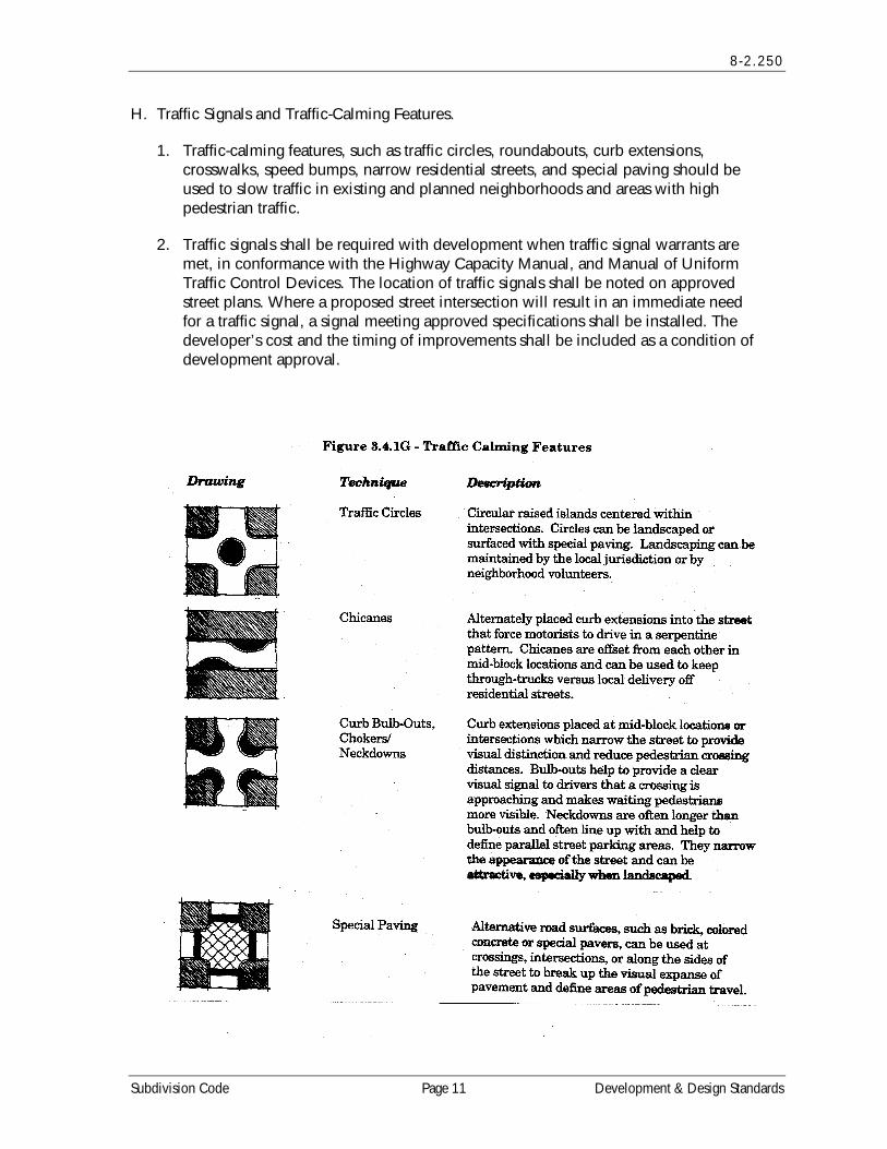
H. Traffic Signals and Traffic-Calming Features.
1. Traffic-calming features, such as traffic circles, roundabouts, curb extensions, crosswalks, speed bumps, narrow residential streets, and special paving should be used to slow traffic in existing and planned neighborhoods and areas with high pedestrian traffic.
2. Traffic signals shall be required with development when traffic signal warrants are met, in conformance with the Highway Capacity Manual, and Manual of Uniform Traffic Control Devices. The location of traffic signals shall be noted on approved street plans. Where a proposed street intersection will result in an immediate need for a traffic signal, a signal meeting approved specifications shall be installed. The developer’s cost and the timing of improvements shall be included as a condition of development approval.
Subdivision Code Page 11 Development & Design Standards
8-2 .250
I. Future Street Plan and Extension of Streets.
1. A future street plan shall be filed by the applicant in conjunction with an application for a subdivision in order to facilitate orderly development of the street system. The plan shall show the pattern of existing and proposed future streets from the boundaries of the proposed land division and shall include other dividable parcels within 600 feet surrounding and adjacent to the proposed land division. The street plan is not binding; rather it is intended to show potential future street extensions to serve future development.
2. Streets shall be extended to the boundary lines of the parcel or tract to be developed, when the Planning Commission determines that the extension is necessary to give street access to, or permit a satisfactory future division of, adjoining land. The point where the streets temporarily end shall conform to a-c, below:
a. These extended streets or street stubs to adjoining properties are not considered to be cul-de-sacs or permanent dead-end streets since they are intended to continue as through streets when the adjoining property is developed.
b. A barricade (e.g., fence, bollards, boulders or similar vehicle barrier) shall be constructed at the end of the street by the subdivider and shall not be removed until authorized by the City or other applicable agency with jurisdiction over the street. The cost of the barricade shall be included in the street construction cost.
c. Temporary turnarounds (e.g., hammerhead or bulb-shaped configuration) shall be constructed for stub streets over 150 feet in length.
J. Street Alignment and Connections.
1. Staggering of streets making "T" intersections at collectors and arterials shall not be designed so that jogs of less than 300 feet on such streets are created, as measured from the centerline of the street.
2. Spacing between local street intersections shall have a minimum separation of 125 feet, except where more closely spaced intersections are designed to provide an open space, pocket park, common area or similar neighborhood amenity. This standard applies to four-way and three-way (off-set) intersections.
3. All local and collector streets that abut a development site shall be extended within the site to provide through circulation unless prevented by environmental or topographical constraints, existing development patterns or compliance with other standards in this code. This exception applies when it is not possible to redesign or reconfigure the street pattern to provide required extensions. Land is considered topographically constrained if the slope is greater than 15 percent for a distance of 250 feet or more. In the case of environmental or topographical constraints, the mere presence of a constraint is not sufficient to show that a street connection is not possible. The applicant must show why the environmental or topographic constraint precludes some reasonable street connection.
Development & Design Standards Page 12 Subdivision Code
8 -2 .250
4. Proposed streets or street extensions shall be located to provide direct access to existing or planned commercial services and other neighborhood facilities, such as schools, shopping areas and parks and transit facilities wherever possible.
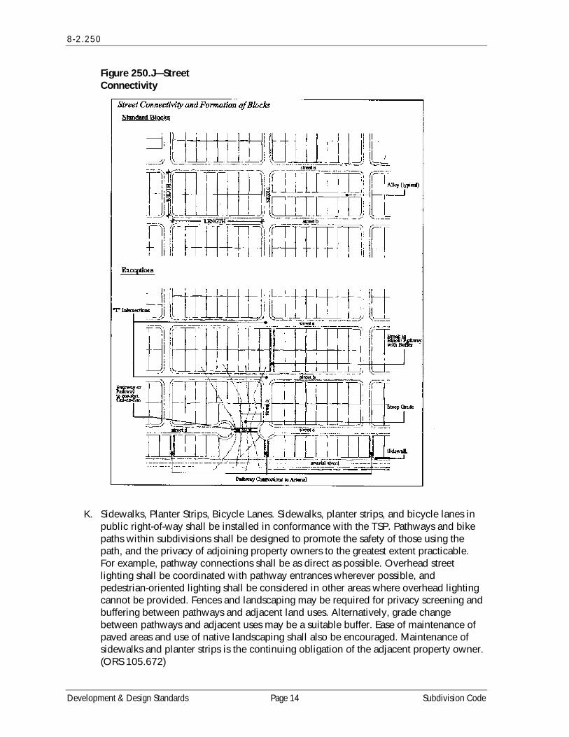
5. In order to promote efficient vehicular and pedestrian circulation throughout the City, the design of subdivisions and alignment of new streets shall conform to the standards in 260—Vehicular Access and Circulation, and block length shall not exceed the dimensions in a-b below:
a. 400 foot maximum block length, and 1,200-foot maximum perimeter in the Residential zones;
b. 400 foot maximum block length and 1,200-foot maximum perimeter in the Central Business District Zone;
c. 800 foot maximum block length and 2,400-foot maximum perimeter in the Light Industrial District;
Exceptions to the above standards may be granted when the developer can clearly demonstrate that compliance is not feasible, or when a non-vehicle access way is provided at or near mid-block, in conformance with the provisions of Section 230—Pedestrian Access and Circulation. (See examples in Figure 250.J.)
Subdivision Code Page 13 Development & Design Standards
8-2 .250
Figure 250.J—Street Connectivity
K. Sidewalks, Planter Strips, Bicycle Lanes. Sidewalks, planter strips, and bicycle lanes in public right-of-way shall be installed in conformance with the TSP. Pathways and bike paths within subdivisions shall be designed to promote the safety of those using the path, and the privacy of adjoining property owners to the greatest extent practicable. For example, pathway connections shall be as direct as possible. Overhead street lighting shall be coordinated with pathway entrances wherever possible, and pedestrian-oriented lighting shall be considered in other areas where overhead lighting cannot be provided. Fences and landscaping may be required for privacy screening and buffering between pathways and adjacent land uses. Alternatively, grade change between pathways and adjacent uses may be a suitable buffer. Ease of maintenance of paved areas and use of native landscaping shall also be encouraged. Maintenance of sidewalks and planter strips is the continuing obligation of the adjacent property owner. (ORS 105.672)
Development & Design Standards Page 14 Subdivision Code
8 -2 .250
L. Intersection Angles. Streets shall be laid out to intersect at an angle as near to a right angle as practicable, except where topography requires a lesser angle or where a reduced angle is necessary to provide an open space, pocket park, common area or similar neighborhood amenity. In addition, the following standards shall apply:
1. No street intersection may be created within 25 feet of a street curve, and no street curve may be created within 25 feet of a street intersection (on the same street). Such intersections and curves shall have at least 25 feet of tangent between them unless topography requires a lesser distance;
2. Intersections that are not at right angles shall have a minimum corner radius of 20 feet along the right-of-way lines of the acute angle; and
3. Right-of-way lines at intersections with arterial streets shall have a corner radius of not less than 20 feet.
M. Existing Rights-of-Way. Whenever existing rights-of-way adjacent to or within a tract are of less than standard width, additional rights-of-way shall be provided at the time of subdivision or development, in conformance with the standards in the Transportation System Plan.
N. Cul-de-sacs. A permanent dead-end street shall be no more than 250 feet long, shall not provide access to more than 12 dwelling units, and shall only be used when environmental or topographical constraints, existing development patterns, or compliance with other standards in this code preclude street extension and through circulation:
1. All cul-de-sacs shall terminate with a circular or hammerhead turnaround. Circular turnarounds shall have a radius of not less than 30 feet, and not more than a radius of 40 feet (i.e., from center to edge of pavement); except that turnarounds may be larger when they contain a landscaped island or parking bay in their center. When an island or parking bay is provided, there shall be a fire apparatus lane of 20 feet in width; and
2. The length of the cul-de-sac shall be measured along the centerline of the roadway from the near side of the intersecting street to the farthest point of the cul-de-sac pavement.
3. Pathways shall be provided to connect cul-de-sacs in conformance with Section 230(B).
O. Grades and Curves. Grades shall not exceed 10 percent on arterials, 12% on collector streets, or 12% on any other street (except that local or residential access streets may have segments with grades up to 15% for distances of no greater than 250 feet), and:
1. Centerline curve radii shall not be less than 700 feet on arterials, 500 feet on major collectors, 350 feet on minor collectors, or 100 feet on other streets; and
2. Streets intersecting with a minor collector or greater functional classification street, or streets intended to be posted with a stop sign or signalization, shall provide a
Subdivision Code Page 15 Development & Design Standards
8-2 .250
landing averaging five percent slope or less. Landings are that portion of the street within 20 feet of the edge of the intersecting street at full improvement.
P. Curbs, Curb Cuts, Ramps, and Driveway approaches. Concrete curbs, curb cuts, wheelchair and bicycle ramps and driveway approaches shall be constructed in accordance with standards specified in Section 260—Vehicular Access and Circulation and Americans with Disabilities Act (ADA) standards.
Q. Streets Adjacent to Railroad Right-of-Way. Wherever a proposed residential subdivision is adjacent to a railroad right-of-way, a street approximately parallel to such right-of-way at a distance suitable for the appropriate use of the land shall be created. Exception: This standard shall not apply where physical constraints (e.g. wetlands, slopes, etc.) make development of a road impracticable. In this situation, the subdivision shall contain adequate buffering and additional setbacks may be required, as determined by the Planning Commission. New railroad crossings and modifications to existing crossings are subject to review and approval by the Oregon Department of Transportation.
R. Development Adjoining Arterial Streets. Where a development adjoins or is crossed by an existing or proposed arterial street, the development design shall separate residential access and through traffic, and shall minimize traffic conflicts. To satisfy this requirement, the design shall include one or more of the following:
1. A parallel access street along the arterial with a landscape buffer separating the two streets;
2. Deep lots abutting the arterial or major collector to provide adequate buffering with frontage along another street. Double-frontage lots shall conform to the buffering standards in Section 260(F)—Access Options;
3. Screen planting at the rear or side property line to be contained in a non-access reservation (e.g., public easement or tract) along the arterial; or
4. Other treatment suitable to meet the objectives of this subsection;
S. If a lot has access to two streets with different classifications, primary access shall be from the lower classification street, in conformance with Section 260—Vehicular Access and Circulation.
T. Alleys, Public or Private. Alleys shall conform to the standards in the Transportation System Plan. While alley intersections and sharp changes in alignment shall be avoided, the corners of necessary alley intersections shall have a radius of not less than 12 feet.
U. Private Streets. A private street shall not provide access to more than two single-family residential lots. A private street shall not be used to avoid connections with public streets. Gated communities and private street systems (i.e., where a gate limits access to a development from a public street) are prohibited. Design and construction standards for grading, base rock, compaction, paving and drainage of private streets shall be the same as for public streets, except as modified through a PUD.
Development & Design Standards Page 16 Subdivision Code
8 -2 .250
V. Street Names. No street name shall be used which will duplicate or be confused with the names of existing streets in Jackson County except for extensions of existing streets. Street names, signs and numbers shall conform to the established pattern in the surrounding area, except as requested by emergency service providers.
W. Survey Monuments. Upon completion of a street improvement and prior to acceptance by the City, it shall be the responsibility of the developer's registered professional land surveyor to provide certification to the City that all boundary and interior monuments shall be reestablished and protected. The certification shall be a signed statement submitted with the final plat.
X. Street Signs. The City, county or state with jurisdiction shall install all signs for traffic control and street names. The cost of signs required for new development shall be the responsibility of the developer. Street name signs shall be installed at all street intersections. Stop signs and other signs may be required.
Y. Mail Boxes. Plans for mailboxes to be used shall be approved by the United States Postal Service.
Z. Street Light Standards. Streetlights shall be installed in accordance with City standards. Street lighting shall be designed to provide necessary lighting only, with all fixtures hooded and all resulting lights projected downward, and with no light projected on to adjoining property.
AA. Street Cross-Sections. The final lift of asphalt or concrete pavement shall be placed on all new constructed public roadways prior to final City acceptance of the roadway and within one year of the conditional acceptance of the roadway unless otherwise approved by the City Engineer. The final lift shall also be placed no later than when 50% of the structures in the new development are completed or 3 years from the commencement of initial construction of the development, whichever is less.
1. Sub-base and leveling course shall be of select crushed rock;
2. Surface material shall be of Class C or B asphaltic concrete;
3. The final lift shall be Class C asphaltic concrete as defined by A.P.W.A. standard specifications; and
4. No lift shall be less than 1-1/2 inches in thickness.
Subdivision Code Page 17 Development & Design Standards
8-2 .260
8-2.260 VEHICULAR ACCESS AND CIRCULATION
A. Intent and Purpose. The intent of this Section is to manage vehicle access to development through a connected street system, while preserving the flow of traffic in terms of safety, roadway capacity, and efficiency. Access shall be managed to maintain an adequate “level of service” and to maintain the “functional classification” of roadways as required by the City’s Transportation System Plan. This Section attempts to balance the right of reasonable access to private property with the right of the citizens of the City and the State of Oregon to safe and efficient travel. It also requires all developments to construct planned streets (arterials and collectors) and to extend local streets.
These regulations also further the orderly layout and use of land, protect community character, and conserve natural resources by promoting well-designed road and access systems and discouraging the unplanned subdivision of land.
B. Applicability. This ordinance shall apply to all public streets within the City and to all properties that abut these streets.
C. Access Permit Required. A new or modified connection to a public street requires an Access Permit in accordance with the following procedures:
1. Permits for access to City streets shall be subject to review and approval by the Public Works Director based on the standards contained in this Section and the provisions of Section 250—Transportation Facility Standards. An access permit may be in the form of a letter to the applicant, or it may be attached to a land use decision notice as a condition of approval.
2. Permits for access to State highways shall be subject to review and approval by the Oregon Department of Transportation (ODOT), except when ODOT has delegated this responsibility to the City or Jackson County. In that case, the City or County shall determine whether access is granted based on its adopted standards.
3. Permits for access to County highways shall be subject to review and approval by Jackson County, except where the County has delegated this responsibility to the City, in which case the City shall determine whether access is granted based on adopted County standards.
Development & Design Standards Page 18 Subdivision Code
8 -2 .260
D. Traffic Study Requirements. The City or other agency with access jurisdiction may require a traffic impact study (TIS) prepared by a certified professional transportation engineer acceptable to the City. The engineer must be currently licensed and otherwise qualified to perform the work under applicable professional and community standards and must have no financial interest in the project whatsoever and no past or current pecuniary association of any kind with the developer other than occasional work as an independent contractor performing traffic impact studies. The TIS shall determine the impact of the proposed development on existing and proposed transportation facilities and assess the applicant’s plans to mitigate such impacts. (See also Section 250—Transportation Facility Standards). [Subsection D amended by Ord. 796; 01/04/2006]
E. Conditions of Approval. The City or other agency with access permit jurisdiction may require the closing or consolidation of existing curb cuts or other vehicle access points, recording of reciprocal access easements (i.e., for shared driveways), development of a frontage street, installation of traffic control devices, and/or other mitigation as a condition of granting an access permit, to ensure the safe and efficient operation of the street and highway system. Access to and from off-street parking areas shall not permit backing onto a public or private street.
F. Access Options. When vehicle access is required for development, access shall be provided by one of the following methods (a minimum of 10 feet per lane is required). These methods are “options” to the developer/subdivider.
1. Option 1. Access is from an existing or proposed alley or mid-block lane. If a property has access to an alley or lane, direct access to a public street is not permitted.
2. Option 2. Access is from a private street or driveway connected to an adjoining property that has direct access to a public street (i.e., “shared driveway”). A public access easement covering the driveway shall be recorded in this case to assure access to the closest public street for all users of the private street/drive.
3. Option 3. Access is from a public street adjacent to the development parcel. If practicable, the owner/developer may be required to close or consolidate an existing access point as a condition of approving a new access. Street accesses shall comply with the access spacing standards in Subsection G, below.
4. Subdivisions Fronting Onto an Arterial Street. New residential land divisions fronting onto an arterial street shall be required to provide alleys or secondary (local or collector) streets for access to individual lots.
5. Double-Frontage Lots. When a lot has frontage onto two or more streets, access shall be provided first from the street with the lowest classification. For example, access shall be provided from a local street before a collector or arterial street. Except for corner lots, the creation of new double-frontage lots shall be prohibited in the Residential District, unless topographic or physical constraints require the formation of such lots. When double-frontage lots are permitted in the Residential District, a landscape buffer with trees and/or shrubs and ground cover not less than 10 feet wide shall be provided between the back yard fence/wall and the sidewalk
Subdivision Code Page 19 Development & Design Standards
8-2 .260
or street; and maintenance shall be assured by the owner (i.e., through homeowner’s association, etc.).
G. Access Spacing. Driveway access shall be separated from other driveways and public and private street intersections in accordance with the following standards and procedures:
1. Local Streets. A minimum of 10 feet separation (as measured from the sides of the driveway/street) shall be required on local streets (i.e., streets not designated as collectors or arterials), except as provided in Subsection 3, below.
2. Arterial and Collector Streets. Access spacing on collector and arterial streets shall be determined by the Public Works Director. Access to State Highway 99 shall be subject to review and approved by the Oregon Department of Transportation (ODOT), based on the applicable standards contained in the City’s Transportation System Plan and policies contained in the 1999 Oregon Highway Plan.
3. Special Provisions for All Streets. Direct street access may be restricted for some land uses. For example, access consolidation, shared access, and/or access separation greater than that specified by Subsections 1-2, may be required by the City, County or ODOT for the purpose of protecting the function, safety, and operation of the street for all users. (See Subsection I, below.) Where no other alternatives exist, the permitting agency may allow construction of an access connection along the property line farthest from an intersection. In such cases, directional connections (i.e., right in/out, right in only, or right out only) may be required.
H. Number of Access Points. For single-family (detached and attached), two-family, and three-family housing types, one street access point is permitted per lot. Alley access is strongly encouraged before other access points are considered; except that two access points may be permitted for two-family and three-family housing on corner lots (i.e., no more than one access per street), and subject to the access spacing standards in Section G, above. The number of street access points for multiple family, commercial, industrial, and public/institutional developments shall be minimized to protect the function, safety and operation of the street(s) and sidewalk(s) for all users. Shared access may be required, in conformance with Subsection I, below, in order to maintain the required access spacing, and minimize the number of access points.
I. Shared Driveways. The number of driveway and private street intersections with public streets may be minimized by the use of shared driveways with adjoining lots where feasible. The City shall require shared driveways as a condition of land division or site design review, as applicable, for traffic safety and access management purposes in accordance with the following standards:
1. Shared driveways and frontage streets may be required to consolidate access onto a collector or arterial street. When shared driveways or frontage streets are required, they may be stubbed to adjacent developable parcels to indicate future extension. “Stub” means that a driveway or street temporarily ends at the property line, but may be extended in the future as the adjacent parcel develops. “Developable”
Development & Design Standards Page 20 Subdivision Code
8 -2 .260
means that a parcel is either vacant or it is likely to receive additional development (i.e., due to infill or redevelopment potential).
2. Access easements (i.e., for the benefit of affected properties) shall be recorded for all shared driveways, including pathways, at the time of final plat approval or as a condition of site development approval.
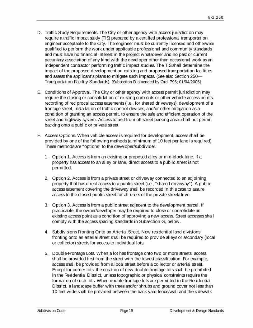
Figure 260.I—Examples of Acceptable Driveway Openings Next to Sidewalks/Pathways
J. Driveway Openings/Curb Cuts. Driveway openings or curb cuts shall be the minimum width necessary to provide the required number of vehicle travel lanes (10 feet for each travel lane). The following standards (i.e., as measured where the front property line meets the sidewalk or right-of-way) are required to provide adequate site access, minimize surface water runoff, and avoid conflicts between vehicles and pedestrians:
1. Single family, two-family, and three-family uses shall have a minimum driveway opening/curb cut width of 10 feet, and a maximum width of 24 feet.
2. Multiple family uses with between 4 and 7 dwelling units shall have a minimum driveway opening/curb cut width of 20 feet, and a maximum width of 24 feet.
Subdivision Code Page 21 Development & Design Standards
8-2 .260
3. Multiple family uses with more than 8 dwelling units, and off-street parking areas with 16 or more parking spaces, shall have a minimum driveway opening/curb cut width of 24 feet, and a maximum width of 30 feet. These dimensions may be increased if the Public Works Director determines that more than two lanes are required based on the number of trips generated or the need for turning lanes.
4. Access widths for all other uses shall be based on 10 feet of width for every travel lane, except that driveways providing direct access to parking spaces shall conform to the parking area standards in 8-3J.5;
5. Driveway Aprons. Driveway aprons (when required) shall be constructed of concrete and shall be installed between the street right-of-way and the private drive, as shown above. Driveway aprons shall conform to ADA standards for sidewalks and pathways, which require a continuous accessible route of travel, with a cross slope not exceeding 2 percent.
K. Fire Access and Parking Area Turn-arounds. A fire equipment access drive shall be provided for any portion of an exterior wall of the first story of a building that is located more than 150 feet from an existing public street or approved fire equipment access drive. Parking areas shall provide adequate aisles or turn-around areas for service and delivery vehicles so that all vehicles may enter the street in a forward manner. For requirements related to cul-de-sacs, please refer to Section 250—Transportation Facility Standards.
L. Vertical Clearances. Driveways, private streets, aisles, turn-around areas and ramps shall have a minimum vertical clearance of 13' 6 “ for their entire length and width.
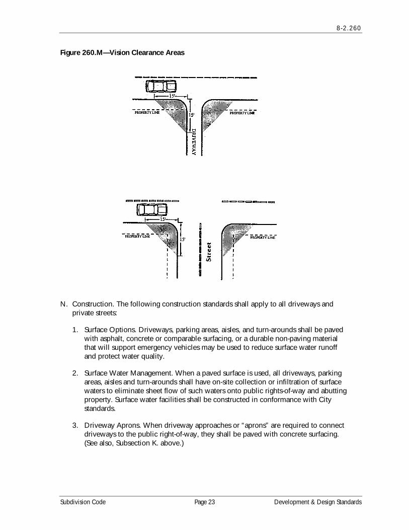
M. Vision Clearance. No signs, structures or vegetation in excess of three feet in height shall be placed in “vision clearance areas”, as shown below. The minimum vision clearance area may be increased by the City Engineer upon finding that more sight distance is required (i.e., due to traffic speeds, roadway alignment, etc.).
Development & Design Standards Page 22 Subdivision Code
8 -2 .260
Figure 260.M—Vision Clearance Areas
N. Construction. The following construction standards shall apply to all driveways and private streets:
1. Surface Options. Driveways, parking areas, aisles, and turn-arounds shall be paved with asphalt, concrete or comparable surfacing, or a durable non-paving material that will support emergency vehicles may be used to reduce surface water runoff and protect water quality.
2. Surface Water Management. When a paved surface is used, all driveways, parking areas, aisles and turn-arounds shall have on-site collection or infiltration of surface waters to eliminate sheet flow of such waters onto public rights-of-way and abutting property. Surface water facilities shall be constructed in conformance with City standards.
3. Driveway Aprons. When driveway approaches or “aprons” are required to connect driveways to the public right-of-way, they shall be paved with concrete surfacing. (See also, Subsection K. above.)
Subdivision Code Page 23 Development & Design Standards
8-2 .270 — 8-2 .280
8-2.270 SANITARY SEWER AND WATER SERVICE IMPROVEMENTS
A. Sewers and Water Mains Required. Sanitary sewers and water mains shall be installed to serve each new development and to connect developments to existing mains in accordance with the City’s construction specifications and the applicable Comprehensive Plan policies.
B. Sewer and Water Plan approval. Development permits for sewer and water improvements shall not be issued until the City Engineer has approved all sanitary sewer and water plans in conformance with City standards.
C. Over-sizing. Proposed sewer and water systems shall be sized to accommodate additional development within the area as projected by the Comprehensive Plan. The developer shall be entitled to system development charge credits for the over-sizing. (Note: Dolan versus City of Tigard findings should accompany any decision to require over-sizing.)
D. Permits Denied. Development permits may be restricted by the City where a deficiency exists in the existing water or sewer system which cannot be rectified by the development and which if not rectified will result in a threat to public health or safety, surcharging of existing mains, or violations of state or federal standards pertaining to operation of domestic water and sewerage treatment systems. Building or development moratoriums shall conform to the criteria and procedures contained in ORS 197.505.
8-2.280 STORM DRAINAGE AND SURFACE WATER MANAGEMENT
A. General Provisions. The City shall issue a development permit only where adequate provisions for storm water and surface water runoff have been made pursuant to Resolution 517, Stormwater Design Standards.
B. Accommodation of Upstream Drainage. Culverts and other drainage facilities shall be large enough to accommodate potential runoff from the entire upstream drainage area, as designated in the City of Talent Stormwater Master Plan, whether inside or outside the development. Such facilities shall be subject to review and approval by the Public Works Director or City Engineer.
C. Effect on Downstream Drainage. Where it is anticipated by the Public Works Director or designee that the additional runoff resulting from the development will overload an existing drainage facility, the City shall withhold permits of the development until provisions have been made for improvement of the potential condition or until provisions have been made for storage of additional runoff caused by the development in accordance with City standards. Any applicable procedures in state development moratorium statutes shall be followed.
D. Easements. Where a watercourse, drainage way, channel, or stream traverses a development, there shall be provided a storm water easement or drainage right-of-way conforming substantially with the lines of such watercourse and such further width as will be adequate for conveyance and maintenance. Development within designated
Development & Design Standards Page 24 Subdivision Code
8 -2 .290
Locally Significant Wetland and Riparian areas shall be in conformance with the requirements in 8-3H.2, Natural Areas, Parks and Floodplains.
8-2.290 UTILITIES
A. Underground Utilities. All utility lines including, but not limited to, those required for electric, communication, lighting and cable television services and related facilities shall be placed underground and shall provide for future expansion of services, except for surface mounted transformers, surface mounted connection boxes and meter cabinets which may be placed above ground, temporary utility service facilities during construction, and high capacity electric lines operating at 50,000 volts or higher. The following additional standards apply to all new subdivisions, in order to facilitate underground placement of utilities:
1. The developer shall make all necessary arrangements with the serving utility to provide the underground services. All above ground equipment shall not obstruct vision clearance areas for vehicular traffic (8-3J.6);
2. The City reserves the right to approve the location of all surface mounted facilities;
3. All underground utilities, including sanitary sewers and storm drains installed in streets by the developer, shall be constructed prior to the surfacing of the streets; and
4. Stubs for service connections shall be long enough to avoid disturbing the street improvements when service connections are made.
5. Adequate capacity for communications services shall be provided. Underground conduit for communications lines, or oversized conduit for phone or other compatible utilities, shall be installed whether or not provision of such services is planned at the time of development.
B. Easements. Recorded easements shall be provided for all underground utility facilities.
C. Exception to Under-Grounding Requirement. The standard applies only to proposed subdivisions. An exception to the under-grounding requirement may be granted due to physical constraints, such as steep topography, or existing development conditions, when demonstrated by the applicant.
Subdivision Code Page 25 Development & Design Standards
8-2 .310
8-2. Article 3.
APPLICATION REQUIREMENTS AND APPROVAL CRITERIA
8-2.310 REVIEW PROCEDURES AND APPROVALS PROCESS
A. Subdivision and Partition Approval Through Three-step Process. Applications for subdivision or partition approval shall be processed through a three-step process: the pre-application conference, the preliminary plat, and the final plat.
1. A pre-application conference is required for all partitions and subdivisions.
2. The preliminary plat for a partition and subdivision shall be approved by the Planning Commission before the final plat can be submitted for approval consideration.
3. The final plat shall include all conditions of approval of the preliminary plat.
B. The preliminary plat for a partition shall be an administrative review with public notice. The preliminary plat for a subdivision shall be a quasi-judicial hearing with public notice.
C. All preliminary plats shall be reviewed using approval criteria contained in Section 330—Approval Criteria: Preliminary Plat. An application for subdivision may be reviewed concurrently with an application for a Planned Unit Development under Article 22 of the TZO.
D. Review of Final Plat. Review of a final plat for a subdivision or partition shall be processed as a ministerial review, using the approval criteria in Section 410—Final Plat Submission Requirements.
E. Preliminary Plat Approval Period. Preliminary plat approval shall be effective for a period of 3 years from the date of approval. The preliminary plat approval shall lapse if a final plat has not been submitted within 3 years of the preliminary plat approval.
F. Modifications and Extensions. The applicant may request changes to the approved preliminary plat or conditions of approval.
1. To change the design or conditions of approval of a preliminary plat approval, the applicant must file for an amendment. The process for approval of an amendment is the same as for the original application, subject to the following:
a. Only the conditions, details, or features proposed to be changed will be considered in the review of the amendment application;
b. The applicant shall demonstrate that the proposed amendment will not create conflicts with other conditions of the original approval; and
Application Reqs. & Approval Criteria Page 26 Subdivision Code
8 -2 .310
c. The amendment application complies with all applicable City ordinances and standards (i.e., those that are in effect when the application is accepted by the City).
2. The applicant may apply for an extension of time for submittal of the final plat. The applicant must submit a written request for an extension of time within one-year of preliminary approval. The City Planner shall, upon written request by the applicant and payment of the required fee, grant one extension of the approval period not to exceed one year; if all of the following criteria are satisfied:
a. An extension of time will not prevent the lawful development of abutting properties;
b. There have been no changes to the applicable code provisions on which the approval was based. If such changes have occurred, a new preliminary plat application shall be required; and
c. The extension request is made before expiration of the original approved plan.
3. Failure to file a final plat within the one-year extension period will result in the preliminary approval becoming void.
G. Phased Development.
1. The City may approve a time schedule for developing a subdivision in phases, but in no case shall the actual construction time period (i.e., for required public improvements, utilities, streets) for any partition or subdivision phase be greater than 3 years without reapplying for a preliminary plat;
2. The criteria for approving a phased land division proposal are:
a. Public facilities shall be constructed in conjunction with or prior to each phase;
b. The development and occupancy of any phase dependent on the use of temporary public facilities shall require City Council approval. Temporary facilities shall be approved only upon City receipt of bonding or other assurances to cover the cost of required permanent public improvements, in accordance with Section 460—Performance Guarantees. A temporary public facility is any facility not constructed to the applicable City or district standard;
c. The phased development shall not result in requiring the City or a third party (e.g., owners of lots) to construct public facilities that were required as part of the approved development proposal; and
d. The application for phased development approval shall be reviewed concurrently with the preliminary plat application and the decision may be appealed in the same manner as the preliminary plat.
Subdivision Code Page 27 Application Reqs. & Approval Criteria
8-2 .320
H. Compliance With ORS Chapter 92. All subdivision and partition proposals shall be in conformance to state regulations set forth in Oregon Revised Statute (ORS) Chapter 92, Subdivisions and Partitions.
8-2.320 PRELIMINARY PLAT SUBMISSION REQUIREMENTS
A. Preliminary Plat Information. The preliminary plat application shall consist of drawings and supplementary written material (i.e., on forms and/or in a written narrative) adequate to provide the following information:
1. General information:
a. Name of subdivision (not required for partitions). This name must not duplicate the name of another subdivision in the county in which it is located (please check with County surveyor);
b. Date, north arrow, and scale of drawing;
c. Location of the development sufficient to define its location in the City, boundaries, and a legal description of the site, including vicinity;
d. Names, addresses and telephone numbers of the owners, designer, and engineer or surveyor, and the date of the survey; and
e. Identification of the drawing as a “preliminary plat.”
2. Site analysis:
a. Streets: Location, name, present width of all existing streets, alleys and rights-of-way on and abutting the site;
b. Easements: Width, location and purpose of all existing easements of record on and abutting the site;
c. Utilities: Location and identity of all utilities on and abutting the site. If water mains and sewers are not on or abutting the site, indicate the direction and distance to the nearest ones;
d. Ground elevations shown by contour lines at 5-foot vertical intervals for ground slopes exceeding 10 percent and at 2-foot intervals for ground slopes of less than 10 percent. Such ground elevations shall be related to some established bench- mark or other datum approved by the County Surveyor. This requirement may be waived for partitions of one (1) acre or less with grades, on average, less than 5 percent;
e. The location and elevation of the closest benchmark(s) within or adjacent to the site (i.e., for surveying purposes);
Application Reqs. & Approval Criteria Page 28 Subdivision Code
8 -2 .320
f. Potential natural hazard areas, including any flood plains, areas subject to high water table, landslide areas, and areas having substantial erosion potential;
g. Sensitive lands, including wetland areas, streams, wildlife habitat, greenways, and other areas identified by the City or natural resource regulatory agencies as requiring protection. (See 8-3H.2);
h. Site features, including existing structures, pavement, large rock outcroppings, areas having unique views, and drainage ways, canals and ditches;
i. Designated historic and cultural resources on the site and adjacent parcels or lots. Note that documentation of pre-settlement cultural resources may not be made a part of the public record as a matter of law, and shall be submitted in a sealed envelope addressed to the City Planner for the subject application;
j. The location, size and species of trees having a caliper (diameter) of 4 inches (dbh) or greater at four feet above grade;
k. Lighting plan, mailbox plan; and
l. Other information, as deemed appropriate by the City Planner or City Administrator. The City may require studies or exhibits prepared by qualified professionals, such as a traffic study, anticipated water use and conservation study, cultural resource study, tree report and preservation study, wetland delineation, or similar study, to address specific site features and code requirements.
3. Proposed improvements:
a. Public and private streets, tracts, driveways, open space and park land; location, names, right-of-way dimensions, approximate radius of street curves; and approximate finished street center line grades. All streets and tracts that are being held for private use and all reservations and restrictions relating to such private tracts shall be identified;
b. Easements: location, width and purpose of all easements;
c. Lots and private tracts (e.g., private open space, common area, or street): approximate dimensions, area calculation (e.g., in square feet), and identification numbers for all lots and tracts (e.g., “Lot 1,” Tract 1”);
d. Proposed uses of the property, including all areas proposed to be dedicated to the public or reserved as open space for the purpose of surface water management, recreation, or other use;
e. Proposed improvements, as required by Sections 2-10 (Development and Design Standards), and timing of improvements (e.g., in the case of streets, sidewalks, street trees, utilities, etc.);
f. The proposed source of domestic water;
Subdivision Code Page 29 Application Reqs. & Approval Criteria
8-2 .320
g. The proposed method of sewage disposal, and method of surface water drainage and treatment if required;
h. The approximate location and identity of other utilities, including the locations of street lighting fixtures;
i. Proposed railroad crossing or modifications to an existing crossing, if any, and evidence of contact with Oregon Department of Transportation and the Public Utility Commission related to proposed changes to railroad crossing(s);
j. Proposed changes to navigable streams or other watercourses. The only changes that will be considered within the bed and banks of Bear Creek and Wagner Creek will be new or modified stormwater outfalls designed to reduce the adverse impacts of stormwater flows and protect water quality in conformance with applicable laws. Modifications to these areas, including provision or closure of public access, shall be shown on the preliminary plat and evidence of contact with the Division of State Lands and Army Corps of Engineers shall be provided, as applicable;
k. Identification of the base flood elevation for development in floodplains. Evidence of contact with National Flood Insurance Program to initiate a flood plain map amendment shall be required when development is proposed to modify a designated 100-year flood plain. Elevation certificates are required for all construction in floodplains prior to occupancy;
l. Evidence of contact with Oregon Department of Transportation (ODOT) for any development requiring access to a highway under the State’s jurisdiction;
m. Evidence of contact with the applicable natural resource regulatory agency (s) for any development within or adjacent to jurisdictional wetlands and other sensitive lands, as identified in 8-3H.2;
n. A future street plan that conforms to the provisions of Section 6.H. The plan shall show the pattern of existing and proposed future streets from the boundaries of the proposed land division and shall include other parcels within 600 feet surrounding and adjacent to the proposed land division; and
o. Proposed irrigation ditch crossings, if any, and evidence of contact with the Talent Irrigation District related to existing or proposed irrigation ditch crossings.
Application Reqs. & Approval Criteria Page 30 Subdivision Code
8 -2 .330
8-2.330 APPROVAL CRITERIA: PRELIMINARY PLAT
A. General Approval Criteria. The City may approve, approve with conditions or deny a preliminary plat based on the following approval criteria:
1. The proposed preliminary plat complies with all of the applicable code sections and other applicable ordinances and regulations. At a minimum, the provisions of this Chapter, the provisions of the underlying zoning district and the provisions of the Planned Unit Development Section, when applicable, shall apply. Where a variance is necessary to receive preliminary plat approval, the application shall also comply with the relevant sections of 8-3L.4—Variances;
2. The proposed plat name is not already recorded for another subdivision, and satisfies the provisions of ORS Chapter 92;
3. The proposed streets, roads, sidewalks, bicycle lanes, pathways, utilities, and surface water management facilities are laid out so as to conform or transition to the plats of subdivisions and maps of major partitions already approved for adjoining property as to width, general direction, and in all other respects; and are consistent with the City’s Transportation System Plan. All proposed public improvements and dedications are identified on the preliminary plat; and
4. All proposed private common areas and improvements (e.g., home owner association property) are identified on the preliminary plat.
B. Residential Density
1. Minimum and Maximum Density Requirements. When lots are created through a planned unit development or subdivision, the development shall achieve a minimum of forty percent (40%) and a maximum of one hundred percent (100%) of the dwelling unit density permitted by the applicable zoning district. The minimum density provision shall not apply to parcels that are smaller than one (1) acre. For purposes of this section, the minimum number of dwelling units required shall be determined by multiplying the maximum density by 0.4. The result shall be rounded up for any product with a factor of 0.5 or greater and rounded down for any product with a fraction of less than 0.5.
2. Residential Density Calculation Procedure. The number of dwelling units permitted on a parcel of land is calculated after determining how much of the area is unconstrained. Constraints include undevelopable lands, area devoted to street rights-of-way and other infrastructure, and area devoted to non-residential uses. Dedicated parkland (when accepted by the City) is not considered constrained land for the purposes of calculating density. The Zoning Ordinance permits limited density transfers in the case of steep slopes (8-3J.140) and wetlands and riparian setbacks (8-3H.240), subject to conditions described in those Articles. The following steps describe how to calculate density (For density calculation in the R2 zone, refer to Zoning Code, 8-3C.460. Do not use the method below for the RM-22 zone):
Subdivision Code Page 31 Application Reqs. & Approval Criteria
8-2 .330
Step 1. Determine the amount of land, in acres, intended for development.
Step 2. Subtract areas either devoted to or to be developed as commercial and other non-residential developed uses.
Step 3. Subtract undevelopable lands (as defined in the Zoning Code, 8-3B.1).
Step 4. Multiply the result of Step 3 by 0.76 to account for a 24-percent standard deduction for infrastructure.
Step 5. Multiply the result of Step 4 by the gross base density, which is determined by dividing 43,560 (one acre) by the minimum lot size of the zone in question (e.g., in the RS-5 zone, gross base density is 5.445; in the RS-7 and RS-MH zones it is 7.26).
Step 6. Round the result of Step 5 to nearest whole number.
The preceding steps may expressed by the following formula:
D = (A – N – U)RB,
where
D = density permitted (in nos. of dwelling units)
A = total site area (in acres)
N = area devoted to non-residential uses (not including parks, open space, infrastructure or undevelopable lands)
U = undevelopable lands
R = 0.76 standard deduction for right-of-way and other infrastructure
B = base density (43,560 ÷ min. lot size of the zone)
The resulting density (D) is the number of units that may be distributed on the developable portions of the site.
[Subsection B amended by Ord. no. 777; 12/01/2004 and Ord. 793; 11/02/2005]
C. Block and Lot Standards. All proposed blocks (i.e., one or more lots bound by public streets), lots, and parcels conform to the specific requirements below:
1. All lots shall comply with the lot area, setback, and dimensional requirements of the applicable zone district, and the standards of Section 250(J)—Street Connectivity and Formation of Blocks.
a. Single-family residential lot sizes may be averaged to allow lots less than the minimum lot size in the RS-5 and RS-7 residential districts, as long as the average area for all lots is not less than allowed by the district. In order to prevent exceeding the maximum allowable densities, no lot shall be created that can be divisible in the future unless a re-division plan is filed for the subject lot, pursuant to Section 330(F). No lot created under this provision shall be less than eighty-five (85%) percent of the minimum lot size allowed in the
Application Reqs. & Approval Criteria Page 32 Subdivision Code
8 -2 .330
zone. For example, in the RS-5 zone the following three lots could be created from a 24,000-square-foot tract: 6,800 square feet; 8,000 square feet; and 9,200 square feet.
[amended by Ord. no. 777; 12/01/2004]
b. In the High-Density S&MF Residential (RM-22) zoning district, individual lots may not be created that are too small to provide a residential building footprint, adequate access, any required undeveloped or landscaped areas, and covered off-street parking for at least two dwelling units.
2. Setbacks shall be as required by the applicable zoning district, unless a PUD is approved with different setbacks.
3. Each lot shall conform to the standards of Section 260—Vehicular Access and Circulation.
4. Landscape or other screening may be required to maintain privacy for abutting uses and buffering for pathways, through lots abutting an arterial or collector street, grade changes and retaining walls, development on flag lots, and similar situations, consistent with the provisions of the Zoning Code, Subdivision Code, and 8-3J.4.
5. In conformance with the Uniform Fire Code, a 20-foot width fire apparatus access drive shall be provided to serve all portions of a building that are located more than 150 feet from a public right-of-way or approved access drive. See also, Section 260—Vehicular Access and Circulation.
6. Where a common drive is to be provided to serve more than one lot, a reciprocal easement, which will ensure access and maintenance rights shall be recorded with the approved subdivision or partition plat.
D. Conditions of Approval. City staff, Planning Commission, or City Council may attach such conditions as are necessary to carry out provisions of this Code, and other applicable ordinances and regulations. When not voluntarily accepted by the applicant, conditions shall be roughly proportional to the impact of development, and the written findings and decision shall include findings of proportionality.
E. The City may require reserve strips be granted to the City for the purpose of controlling access to adjoining undeveloped properties.
F. Future Re-division Plan. When subdividing or partitioning tracts into large lots (i.e., greater than two times or 200 percent the minimum lot size allowed by the underlying land use district), the City shall require that the lots be of such size, shape, and orientation as to facilitate future re-division in accordance with the requirements of the zoning district and this Code. A re-division plan shall be submitted that identifies:
1. Potential future lot division(s) in conformance with the housing and density standards of the underlying zoning district;
Subdivision Code Page 33 Application Reqs. & Approval Criteria
8-2 .330
2. Potential street right-of-way alignments to serve future development of the property and connect to adjacent properties, including existing or planned rights-of-way.
3. A disclaimer that the plan is a conceptual plan intended to show potential future development. It shall not be binding on the City or property owners, except as may be required through conditions of land division approval. Development activities that prevent implementation of the re-division plan shall not be permitted unless they achieve the housing densities and street connections required by the applicable zoning district and this ordinance. The City may require dedication and improvement of rights-of-way within the future plan area to provide needed secondary access and circulation.
G. Compliance. All submittals shall demonstrate compliance with Article 2, Development and Design Standards, and 8-3H.2 of the Talent Zoning Code.
8-2.340 VARIANCES AUTHORIZED
Adjustments to the standards of this Chapter shall be processed in accordance with 8-3L.4—Variances of the Talent Zoning Code. Applications for variances shall be submitted prior to or at the same time as an application for land division, PUD, or lot line adjustment is submitted.
Application Reqs. & Approval Criteria Page 34 Subdivision Code
8 -2 .410
8-2. Article 4.
FINAL PLAT PROCEDURES
8-2.410 FINAL PLAT SUBMISSION REQUIREMENTS AND APPROVAL CRITERIA
A. Submission Requirements. Final plats shall be reviewed and approved by the City prior to recording with Jackson County. The applicant shall submit the final plat to the City within three years of the approval of the preliminary plat as provided by Section 310—Review Procedures and Approval Process. Specific information about the format and size of the plat, number of copies and other detailed information can be obtained from the City Planner.
B. Approval Criteria. Unless Planning Commission review is included as a condition of approval, the City Planner shall conduct an administrative review of the final plat and shall approve or deny the final plat based on findings regarding compliance with the following criteria:
1. The final plat complies with the approved preliminary plat, and all conditions of approval have been satisfied;
2. All public improvements required by the preliminary plat have been installed and approved by the Public Works Director. Alternatively, the developer has provided a performance guarantee in accordance with Section 460—Performance Guarantees.
3. The streets and roads for public use are dedicated without reservation or restriction other than reversionary rights upon vacation of any such street or road and easements for public utilities;
4. The streets and roads held for private use have been approved by the City as conforming to the preliminary plat;
5. The plat contains a dedication to the public of all public improvements, including but not limited to streets, public pathways and trails, access reserve strips, parks, sewage disposal, storm drainage, riparian areas and water supply systems, as applicable;
6. The applicant has provided copies of all recorded homeowners association Codes, Covenants, and Restrictions (CC&Rs); deed restrictions; private easements and agreements (e.g., for access, common areas, parking, etc.); and other recorded documents pertaining to common improvements recorded and referenced on the plat;
7. The plat and subject property comply with the applicable Sections of this code;
8. Certification by the City or Bear Creek Valley Sanitary Authority that water and sanitary sewer service is available to each and every lot or parcel depicted on the plat; or bond, contract or other assurance has been provided by the subdivider or
Subdivision Code Page 35 Final Plat
8-2 .410 — 430
partitioner to the City that such services will be installed in accordance with Section 220—Public Facilities, and the bond requirements of Section 440—Construction Plan Approval and Assurances. The amount of the bond, contract or other assurance by the subdivider/partitioner shall be determined by a registered professional engineer, subject to review and approval by the City;
9. The plat contains an affidavit by the surveyor who surveyed the land, represented on the plat to the effect the land was correctly surveyed and marked with proper monuments as provided by ORS Chapter 92, and indicating the initial point of the survey, and giving the dimensions and kind of such monument, and its reference to some corner established by the U.S. Geological Survey or giving two or more permanent objects for identifying its location.
10. All subdivisions and partitions shall be designed based on the need to minimize the risk of flood damage. All new lots are buildable without requiring any structural development or storage of vehicles or equipment, construction materials, within 35 feet of the floodway. Development in a 100-year flood plain shall comply with National Flood Insurance Program and Talent Flood Plain Management Ordinance requirements. Structural measures are preferred to filling to elevate structures above the base flood elevation.
11. Where a development site is located in or near areas prone to inundation, and the base flood elevation has not been provided or is not available from another authoritative source, it has been prepared by a qualified professional, as determined by the City Engineer.
12. All lots or parcels created through land division have adequate public utilities and facilities such as sewer, gas, electrical, and water systems located and constructed to prevent or minimize flood damage to the extent practicable.
13. All subdivision and partition proposals have adequate surface water drainage provided to reduce exposure to flood damage. Water quality or quantity control improvements may be required per Stormwater Design Standards; and
14. Compliance with 8-3H.2—Talent Zoning Code.
8-2.420 PUBLIC IMPROVEMENTS
Before City approval is certified on the final plat, all required public improvements shall be installed, inspected, and approved. Alternatively, the subdivider shall provide a performance guarantee, in accordance with Section 460—Performance Guarantees.
8-2.430 EASEMENTS
Easements for sewers, storm drainage and water quality facilities, water mains, electric lines or other public utilities shall be dedicated on a final plat, or provided for in the recorded deed restrictions. The developer or applicant shall make arrangements with the City, the applicable district and each utility franchise for the provision and dedication of utility
Final Plat Page 36 Subdivision Code
8 -2 .440 — 450
easements necessary to provide full services to the development. The City's standard width for public main line utility easements shall be as specified by the City Engineer.
8-2.440 CONSTRUCTION PLAN APPROVAL AND ASSURANCES
No public improvements, including sanitary sewers, storm sewers, streets, sidewalks, curbs, lighting, parks, or other requirements shall be undertaken except after the plans have been approved by the City, permit fee paid, and permit issued. The permit fee is required to defray the cost and expenses incurred by the City for construction and other services in connection with the improvement. The permit fee shall be set by City Council. The City may require the developer or subdivider to provide bonding or other performance guarantees to ensure completion of required public improvements.
8-2.450 INSTALLATION
A. Conformance Required. Improvements installed by the developer either as a requirement of these regulations or at his/her own option, shall conform to the requirements of this chapter, approved construction plans, and to improvement standards and specifications adopted by the City.
B. Adopted Installation Standards. The Standard Specifications for Public Works Construction, Oregon Chapter A.P.W.A., Talent Public Works Standard Drawings, and Talent Stormwater Design Standards are adopted herein as the City’s installation standard(s). Other standards may also be required upon recommendation of the City Engineer.
C. Commencement. Work shall not begin until the City has been notified in advance.
D. Resumption. If work is discontinued for more than one month, it shall not be resumed until the City is notified.
E. City Inspection. Improvements shall be constructed under the inspection and to the satisfaction of the City. The City may require minor changes in typical sections and details if unusual conditions arising during construction warrant such changes in the public interest. Modifications requested by the developer shall be subject to land use review under Section 11 above. Any monuments that are disturbed before all improvements are completed by the subdivider shall be replaced prior to final acceptance of the improvements.
F. Engineer’s Certification and As-Built Plans. A registered civil engineer shall provide written certification in a form required by the City that all improvements, workmanship, and materials are in accord with current and standard engineering and construction practices, conform to approved plans and conditions of approval, and are of high grade, prior to City acceptance of the public improvements, or any portion thereof, for operation and maintenance. The developer’s engineer shall also provide three sets of “as-built” plans, in conformance with the City Engineer’s specifications, for permanent filing with the City Planning, Public Works, and Engineering departments.
Subdivision Code Page 37 Development & Design Standards
8-2 .460
8-2.460 PERFORMANCE GUARANTEE
A. Performance Guarantee Required. When a performance guarantee is required by the City, the subdivider shall file an assurance of performance with the City supported by one of the following:
1. An irrevocable letter of credit executed by a financial institution authorized to transact business in the state of Oregon;
2. A surety bond executed by a surety company authorized to transact business in the state of Oregon which remains in force until the surety company is notified by the City in writing that it may be terminated; or
3. Cash.
B. Determination of Sum. The assurance of performance shall be for a sum determined by the City as required to cover the cost of the improvements and repairs, including related engineering and incidental expenses.
C. Itemized Improvement Estimate. The developer shall furnish to the City an itemized improvement estimate, certified by a registered civil engineer, to assist the City in calculating the amount of the performance assurance contingency.
D. Agreement. An agreement between the City and developer shall be recorded with the final plat that stipulates all of the following:
1. Specifies the period within which all required improvements and repairs shall be completed;
2. A provision that if work is not completed within the period specified, the City may complete the work and recover the full cost and expenses from the applicant;
3. Stipulates the improvement fees and deposits that are required.
4. May provide for the construction of the improvements in stages and for an extension of time under specific conditions therein stated in the contract.
The agreement may be prepared by the City, or in a letter prepared by the applicant. It shall not be valid until it is signed and dated by both the applicant and City Administrator.
E. When Developer Fails to Perform. In the event the developer fails to carry out all provisions of the agreement and the City has un-reimbursed costs or expenses resulting from such failure, the City shall call on the bond, cash deposit or letter of credit for reimbursement.
F. Termination of Performance Guarantee. The developer shall not cause termination of nor allow expiration of the guarantee without having first secured written authorization from the City.
Final Plat Page 38 Subdivision Code
8 -2 .470 — 480
8-2.470 FILING AND RECORDING
A. Filing plat with County. Within 60 days of the City approval of the final plat, the applicant shall submit the final plat to Jackson County for signatures of County officials as required by ORS Chapter 92.
B. Proof of recording. Upon final recording with the County, the applicant shall submit to the City a Mylar copy and three paper copies of all sheets of the recorded final plat. This shall occur prior to the issuance of building permits for the newly created lots.
C. Prerequisites to recording the plat.
1. No plat shall be recorded unless all ad valorem taxes and all special assessments, fees, or other charges required by law to be placed on the tax roll have been paid in the manner provided by ORS Chapter 92;
2. No plat shall be recorded until it is approved by the County surveyor in the manner provided by ORS Chapter 92.
8-2.480 REPLATTING AND VACATION OF PLATS
A. Replatting and Vacations. Any plat or portion thereof may be replatted or vacated upon receiving an application signed by all of the owners as appearing on the deed.
B. Procedure. All applications for a replat or vacation shall be processed in accordance with the procedures and standards for a subdivision or partition (i.e., the same process used to create the plat shall be used to replat or vacate the plat). The same appeal rights provided through the subdivision and partition process shall be afforded to the plat vacation process.
C. Basis for denial. A replat or vacation application may be denied if it abridges or destroys any public right in any of its public uses, improvements, streets or alleys; or if it fails to meet any applicable criteria, including but not limited to setbacks and conflicts with existing easements.
D. Recording of vacations. All approved plat vacations shall be recorded in accordance with Section 470—Filing and Recording, and the following procedures:
1. Once recorded, a replat or vacation shall operate to eliminate the force and effect of the plat prior to vacation; and
2. Vacations shall also divest all public rights in the streets, alleys and public grounds, and all dedications identified or described on the plat.
E. After sale of lots or parcels. When lots or parcels have been sold, the plat may be vacated only in the manner herein, and provided that all of the owners of lots or parcels within the platted area consent in writing to the plat vacation.
F. Vacation of streets. All street vacations shall comply with the procedures and standards set forth in ORS Chapter 271.
Subdivision Code Page 39 Final Plat
8-2 .510
8-2. Article 5.
LOT LINE ADJUSTMENTS
8-2.510 LOT LINE ADJUSTMENTS
Lot Line Adjustments include the consolidation of lots, and the modification of lot boundaries, when no new lots are created. The application submission and approvals process is as follows:
A. Approval Through a Two-Step Process.
Applications for lot line adjustment approval shall be processed through a two-step process: (1) pre-application conference and (2) recordation of lot line adjustment.
B. Submission Requirements.
1. The application shall include a preliminary lot line map identifying all existing and proposed lot lines and dimensions; footprints and dimensions of existing structures (including accessory structures); location and dimensions of driveways and public and private streets within or abutting the subject lots; location of significant vegetation as defined; existing fences and walls; and any other information deemed necessary by the City Planner for ensuring compliance with City codes.
2. A letter naming all affected property owners, including all owner signatures authorizing the lot line adjustment.
3. Verification that all property tax payments are current for all affected properties by the Jackson County Assessor’s Office.
C. Approval Process.
1. Decision-making process. Lot line adjustments are subject to administrative staff review and the approval criteria contained in Subsection D, below.
2. Time limit on approval. The lot line adjustment approval shall be effective for a period of 60 days from the date of approval, during which time it must be recorded.
3. Lapsing of approval. The lot line adjustment approval shall lapse if:
a. The lot line adjustment is not recorded within the time limit in Paragraph 2;
b. The lot line adjustment has been improperly recorded with Jackson County without the satisfactory completion of all conditions attached to the approval; or
c. The final recording is a departure from the approved plan.
D. Approval Criteria. The City Planner shall approve or deny a request for a lot line adjustment in writing based on findings that all of the following criteria are satisfied:
Lot Line Adjustments Page 40 Subdivision Code
8 -2 .510
1. No additional parcel or lot is created by the lot line adjustment, however the number of lots or parcels may be reduced;
2. Lot standards. All lots and parcels comply with the applicable lot standards of the underlying zoning district including lot area and dimensions.
3. Access. All lots and parcels comply with the standards or requirements of Section 260—Vehicular Access and Circulation;
4. Setbacks. The resulting lots, parcels, tracts, and building locations comply with the standards of the land use district; and
5. Exemptions from Dedications and Improvements. A lot line adjustment is not considered a development action for purposes of determining whether right-of-way dedication or improvement is required.
E. Recording Lot Line Adjustments.
1. Recording. Upon the City’s approval of the proposed lot line adjustment, the applicant shall record the lot line adjustment with Jackson County within 60 days of approval (or the decision expires), and submit a copy of the recorded survey map to the City, to be filed with the approved application.
2. Time limit. The applicant shall submit the copy of the recorded lot line adjustment survey map to the City within 15 days of recording and prior to the issuance of any building permits on the re-configured lots.
F. Extension. The City shall, upon written request by the applicant and payment of the required fee, grant an extension of the approval period not to exceed 60 days provided that:
1. No changes are made on the original plan as approved by the City;
2. The applicant can show intent of recording the approved partition or lot line adjustment within the extension period;
3. There have been no changes in the applicable Code or plan provisions on which the approval was based. In the case where the lot line adjustment conflicts with a code change, the extension shall be denied; and
4. The extension request is made in writing before expiration of the original approved plan.
Subdivision Code Page 41 Lot Line Adjustments
8-2 .610 — 630
8-2. Article 6.
SPECIAL PARTITIONS AND SUBDIVISIONS
8-2.610 PLANNED UNIT DEVELOPMENTS
Refer to 8-3L.3.
8-2.620 RE-ESTABLISHMENT OF PLATTED PROPERTY LINES IN THE ORIGINAL TOWN PLAT AREA
Pre-existing lots (i.e., lots existing prior to adoption of the Zoning Code) in the Wagner Butte Addition, Original Town Addition, and Gibson Street Historic District areas may be re-established through an administrative staff review, subject to the following criteria:
1. Vehicle access shall be via a public way (street or alley).
2. Existing structures must meet setbacks for newly created property lines.
3. Public services shall be available to serve the/all new lot(s) created.
4. Minimum lot width of 30 feet.
5. Minimum lot area of 4,500 square feet.
8-2.630 FLAG LOT PARTITIONS
The following standards apply to flag lots in all residential zones:
A. Purpose. These standards allow the creation of a single flag lot out of a parent lot in limited circumstances. The limitations minimize the negative impacts of flag lots on an area while allowing land to be divided when other options are not achievable.
B. When a flag lot is allowed. A flag lot is allowed only when the following are met:
1. An existing dwelling unit on the site is located so that it precludes a land division that meets the minimum lot width standard of its zoning district.
2. Only one flag lot is proposed;
3. There will be only one residence on the flag lot (except in RM-22 zone);
4. Minimum density, minimum lot size and maximum building coverage requirements of the zone will be met; and
5. In the interest of protecting existing neighborhood context, structures taller than 18 feet will not be allowed if more than 50 percent of the lots sharing common lot
Special Partitions & Subdivisions Page 42 Subdivision Code
8 -2 .630
lines, not including the parent lot, have houses on them that are less than 18 feet tall. Lots without houses on them will not be considered.
C. Flag lot access pole. The pole portion of the flag lot must meet the following standards. Adjustments are prohibited:
1. The pole must connect to a street and must be at least 13 feet wide at the street and for its entire length, or 24 feet if the length from the centerline of the street right-of-way to the flag portion is more than 150 feet or if there will be more than one residence on the flag lot;
2. The pole portion must be part of the flag lot and must be under the same ownership as the flag portion.
3. The access drive must be at least 12 feet wide (or 24 feet; see paragraph 1, above) and paved with concrete or asphalt. The drive must be designed so that stormwater run-off is directed toward an appropriate location and not onto neighboring properties.
4. The flag lot and the existing lot will share the flag lot access pole for common access to the two lots unless the City Planner finds such a set-up physically impractical.
D. Minimum lot dimensions. No dimension of a flag lot may be less than 40 feet, excepting the pole portion. For the purposes of this subsection width and depth are measured at the midpoint of the opposite lot lines. All other lot dimension standards must be met.
E. Flag lot development standards. The following standards apply to development on flag lots:
1. Setbacks (See Figure 630–1). Flag lots have required building setbacks that are the same along all lot lines, except that the setback on the pole portion side shall be at least 13 or 24 feet, as appropriate, plus an additional 20 feet for garage entrances, or more if there is a possibility the pole may someday become part of a larger public right-of-way. The City reserves the right to require greater setbacks in such cases for garages and/or entire structures. The required setbacks for primary structures, including houses and garages, are:
Zone Setback RS-5 15 feet
RS-7 10 feet
RS-MH 10 feet
RM-22 10 feet
Subdivision Code Page 43 Special Partitions & Subdivisions
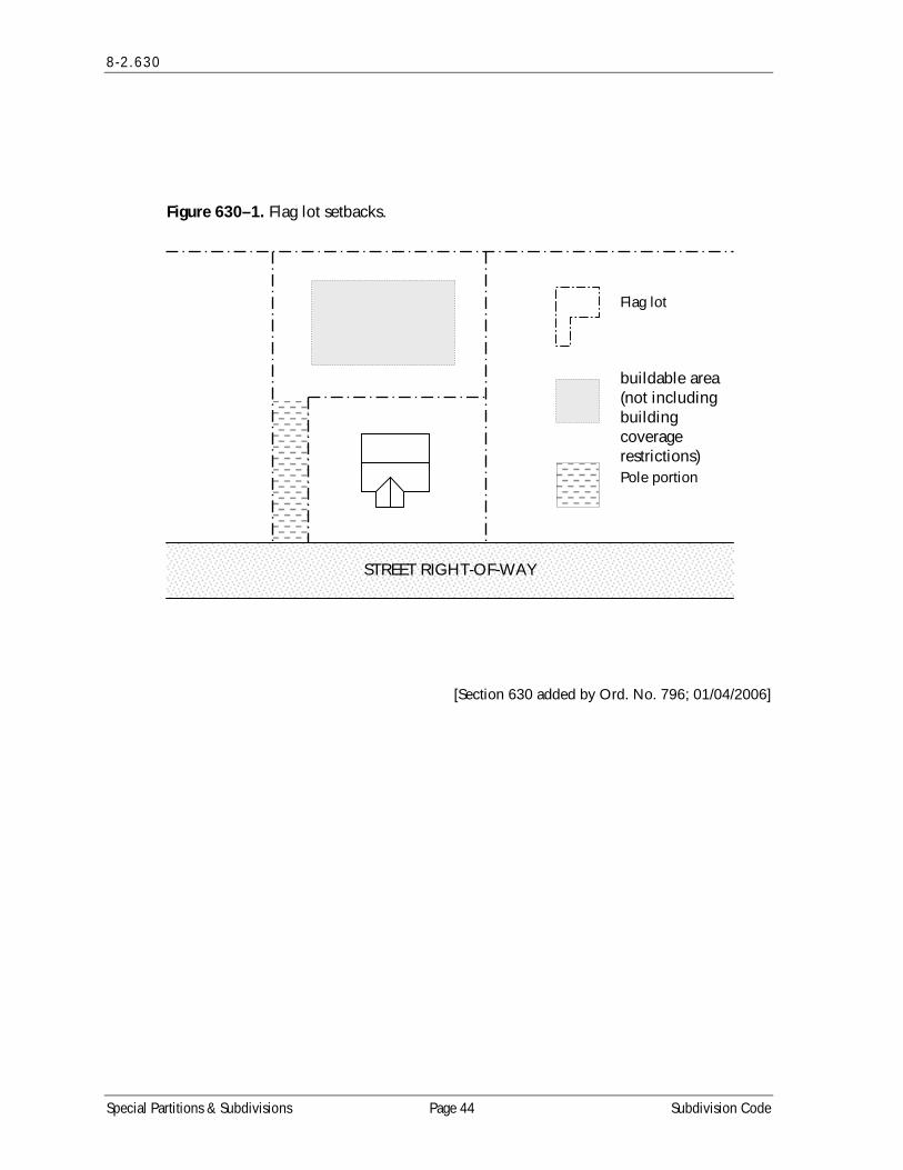
8-2 .630
Figure 630–1. Flag lot setbacks.
STREET RIGHT-OF-WAY
buildable area (not including building coverage restrictions) Pole portion
Flag lot
[Section 630 added by Ord. No. 796; 01/04/2006]
Special Partitions & Subdivisions Page 44 Subdivision Code