Embed Size (px)
Citation preview

1
City of Royalton
Comprehensive Land Use Plan
2018 – 2028
August 9, 2018
2
PART ONE: INTRODUCTION TO THE COMPREHENSIVE PLAN
1.0 PURPOSE AND INTRODUCTION
The Comprehensive Land Use Plan provides a vision and ‘blueprint’ for the city through the year
2027. The Plan calls for a review every three to five years and revisions at least every five years. The
revisions allow the city to celebrate the goals attained, set objectives to reach current goals and
incorporate the vision of the community into the plan.
Part One: Introduction to the Comprehensive Plan
Part Two: Community Assessment
Part Three: Strategic Policy Framework & Implementation
2.0 FOUNDATIONS OF THE CITY OF ROYALTON COMPREHENSIVE PLAN
Developed through strong public participation and involvement, the foundation of the City of
Royalton Comprehensive Plan lies within the many residents, landowners, individual business
owners and businesses associations, civic and community organizations and associations, and all
other aspects of the community. Continued public participation and involvement is also the key to
maximizing the potential of the plan. The benefits of developing and implementing this plan include,
but are not limited to the following:
The plan provides a legal basis for land use related decision-making within the City by
establishing land use consistency, changes to official land use controls, and land use policies
and recommendations.
The plan provides clear direction and vision which promotes a sustainable community through
the proactive management of community growth and development through the proactive
management of community growth and development.
The plan identifies clear needs and desires for the community related to use of lands,
community facilities, community infrastructure, and other important aspects of the
community.
The plan provides valuable information which may be used in securing funding from public
and private sources to fulfill community project needs.
Citizen involvement and participation is the foundation of the Comprehensive Plan. Citizens met to
guide the vision for city growth and development in 2005, 2009 and again in 2016. The focus for
2005 was community facilities, infrastructure and services. In 2009 the focus was parks,
beautification of the Hwy 10 corridor and establishing a restaurant for the city and 2016 looked more
broadly at economic competiveness, foundational assets, community resources and human capital.
Economic Competitiveness
Strengths – opportunities to work on: City utilities Solar panels over city hall
City Parks School/Community outreach
Industrial Park Core group of businesses
National Joint Powers Alliance Weaknesses – threats to work on:
Land available but not developed Farmers market/Community Garden
Expand our solar power Healthcare
Activities for youth/families Community revenue as a whole

3
Community Center Café
Volunteerism No defined business area
Industrial park
Foundational Assets
Strengths – opportunities to work on: City utilities Cable provider
Oil drop site Compost site
Hwy 10 Broadband helped with falls.net Wellhead Protection Plan Comprehensive land use plan
Safe Routes to School Compost/brush site
Broadband (Midco/FallsNet)
Weaknesses – threats to work on: Public transportation Broadband in rural areas
Housing – rental/apartment/town home Signage for parks and trails
Sidewalks – not wide enough/not complete Riding bikes safely across the railroad tracks
Unsightly scrap/recycling facilities Traffic on Hwy 10
Community Resources Strengths – opportunities to work on Woman’s Study Club Small school district
American Legion Highway 10
Parks –splash, skate, Memorial, McGonagle Lions club
Nature road –national bike route Platte River day
Art in the park Christmas on the Platte tree lighting
Ride for Alzheimer’s Strong involvement
High School Cross Country track High School tennis court
Weaknesses – threats to work on: Lack of medical resources Hwy 10
Family café Sidewalks
Bike trails Community recreation center
Farmers market Walking-along river
Art awareness Need community place for students to gather
Human Capital
Strengths – opportunities to work on: Ramp-Up for readiness program Young labor force
Technology –Chromebook, iPad Adult college classes
Community education Part time employee availability (students)
Pre-K-12 school Post-secondary options
Parks School Fitness Center
Weaknesses – threats to work on: Community/rec center (especially in winter) Lack of local food co-op
Child care option Post-secondary options/Job shadowing
Lighting at night in parks
Opportunities for teens to work in a safe environment & others
Safe places for bikers, walkers (jogs), roller bladders, (long distance)
Family restaurant vs DQ or bars “basic needs” –healthy alternatives, food, toiletries
Adult workflow travels out of town Tourist attractions, job opportunities –mini golf course

4
3.0 PAST LAND USE PLANNING
The first City of Royalton Comprehensive Plan was developed about 1985. Focusing primarily on
land use, facilities, and transportation the plan served the city through the year 2003. Prior to the
adoption of the first comprehensive plan, the City of Royalton administered a zoning ordinance. This
ordinance was subsequently updated in 1998. The following include significant milestones in
municipal planning:
1939 – Township Planning & Zoning Established
1959 – County Planning Enabling Act (Authorized counties to adopt planning tools and land use
controls)
1965 – Municipal Planning Enabling Act (Authorized cities to adopt planning tools and land use
controls)
1969 – Regional Development Act (Authorized the creation of regional development commissions in
12 areas outside of the Twin Cities metropolitan area)
1973 – State provides Shoreland and Flood Plan Rules
1980 – City of Royalton adopts Zoning Ordinance
1982 – Township Planning Authority (Expanded with revisions to the Municipal Planning Act)
1985 – City of Royalton adopts first Comprehensive Plan
1996 – Sustainable Development for Local Governments (Required the State to develop and
periodically update a sustainable development guide and model ordinance)
1997 – Community-based Planning was established by MS 462.3531 where communities were
encouraged to establish a comprehensive municipal plan. (Although repealed effectively July 1, 2001
the goals presented in this policy are still found to be useful in future local planning)
1997 – City of Royalton gains Tree City USA status
1998 – City of Royalton Zoning Ordinance revised
2004 – City of Royalton Comprehensive Plan is revised.
2006 – Orderly annexation of 160 acre parcel from Langola Township
2007 – Wellhead Protection Plan adopted
2009 – City of Royalton Zoning Ordinance Revised
2009 – Healthy Community Partnership Program/Community based planning (Initiative Foundation
helped city pursue a community visioning session)

5
2010 – Comprehensive Water Management Plan 2010-2020 Adopted
2011 – City of Royalton GreenStep City designation adopted
2013 – Zoning Ordinance updated to include Alternative Energy ordinance
2013 – Master Sidewalk & Trails Plan adopted
2015 – Orderly annexation of 9 acre parcel from Langola Township
2016 – Water Treatment Plant and Well #4 completed
2016 – Stormwater Ordinance completed
2017 – Safe Routes to School project completed
2017 – Infrastructure extended to the Royalton Industrial Park
4.0 GENERAL CHARACTERTISTICS OF THE CITY OF ROYALTON The City of Royalton is located near the center of the state of Minnesota approximately 90 miles
north of the Twin Cities Metropolitan area and less than 25 miles north of St. Cloud, Minnesota. Less
than 10 miles to the north of Royalton is the City of Little Falls, the county seat of Morrison County.
Some of the most attractive physical features of the City of Royalton include the many trees and open
spaces surrounding the community and the scenic Platte River which runs in the north and south
direction dividing the City at its center. Royalton is comprised of 1.66 square miles or approximately
1,062 acres of land. In 2000 the U.S. Census Bureau reported Royalton’s population at 816 however
the Minnesota State Demographer’s Office estimated the City’s population in 2003 at 868. In 2010
the U.S. Census Bureau showed the population at 1242. Projections from 2010 to 2016 indicate a
slight decrease in population to 1216.
5.0 GENERAL HISTORY OF ROYALTON
The City of Royalton was settled in the mid-19th century along a transportation route used to connect
Fort Ripley, what is currently known as Camp Ripley, to the St. Paul and Minneapolis areas. First
established as a post office, the City was given its name by R.D. Kinney who named the City after
his hometown in Vermont. Later the City saw the expansion of the railroad through the City, a rail
corridor which remains today as one of the largest traveled in the State. Through the 20th century the
City experienced considerable residential growth and commercial growth and development with the
majority of its growth occurring between 1970 and 1990. In the ten year period of 1997 to 2007 a
total of 105 new homes were added to the city and in the period of 2007 to 2016 the city added two
new homes per year on average. In 2016 the City annexed 9 acres on the southern part of the city
from Langola Township. Through the years Royalton has maintained its “small town” character and
feel; however area development pressures will continue to reshape Royalton well into the future.

6
6.0 THE CITY OF ROYALTON PLANNING PROCESS AND PUBLIC PARTICIPATION
OVERVIEW
Overview
As mentioned in Section 2.0, the City of Royalton planning process was built upon a strong
foundation of public participation and involvement. This section outlines the public participation
used in gathering the information necessary to formulate community goals, objectives, policies, and
recommendations as well as information crucial to the successful implementation of the plan. Upon
the collection of this data through a community visioning sessions the Planning & Zoning
Commission/City Council fine-tuned these goals, objectives, policies, and recommendations as
presented within this plan. These visioning sessions guided the City’s decision making from 2018 to
2028.
6.1 The Community Visioning Sessions
Over the years the City of Royalton held visioning sessions to gather input from community
members within the City on issues related to economic competitiveness, foundational assets,
community resources and human capital. Business owners, residents, members of civic organizations
and students were among the people who participated in the sessions. Results from community input
were used as discussion points and in the formulation of the goals, objectives, policies, and
recommendations within this plan; however the results did not serve the sole basis of the plans
development.
6.2 Review and Adoption
In progress
6.3 Key Players
Public
The role of the public is extremely important in the formulation of future land use goals, objectives
and policies for the City of Royalton. Throughout the planning process, the public played a vital role
through participation in a community visioning sessions as outlined in section 7.0.
City Council
The City Council provides the oversight of every aspect of the City of Royalton Comprehensive
Plan. Throughout the planning process the City Council secured all necessary planning-related
technical assistance and was responsible for conducting the public input process prior to the final
adoption of the plan.

7
Planning and Zoning Commission
The Planning and Zoning Commission is responsible for the solid administration of the City of
Royalton Comprehensive Plan. The role of the Planning and Zoning Commission throughout the
planning process was to provide clarification of individual plan components and make a final
recommendation of the adoption of the City of Royalton Comprehensive Plan to the City Council.
Region Five Development Commission
The Region Five Development Commission is one of 11 regional development organizations
statewide providing professional planning assistance and guidance to local governments within their
respective jurisdictions. In 2016, the Royalton City Council contracted with the Commission to
provide a framework for visioning sessions to be used in the development of the City’s
comprehensive plan.
7.0 PUBLIC PARTICIPATION PLAN; ONGOING PUBLIC INVOLVEMENT
Continued public participation is crucial in the successful implementation of the City of Royalton
Comprehensive Plan. Participation by the public becomes increasingly important in the consideration
of amendments or revisions to the short and long-term goals of the City, or the revision, amendment,
or creation of the City of Royalton Zoning Ordinance. Public participation shall be utilized in the
following ways including, but not limited to the following:
Public participation in public hearings related to amendments to this plan, the City of
Royalton Zoning and Subdivision Ordinances, and on all considered subdivisions, plats,
variances, conditional use permits, or similar required public hearings.
Public participation in the creation of new plans such as: downtown revitalization,
streetscape, infrastructure, parks and trails, or similar plans for the City.
Public participation in the implementation of energy efficiency, renewable energy, and
conservation measures for the City.
8.0 PLAN IMPLEMENTATION AND MAINTENANCE
Although this plan is intended to serve the City vision and “blueprint” through the year 2027, the
plan must be reviewed and revised as necessary to reflect the current state of the City and the goals,
objectives and desires of the community. To ensure proper maintenance of the City of Royalton
Comprehensive Plan the plan should be reviewed at least every three to five years and revised at least
every five years.
Like any other comprehensive plan, this plan is intended to be amended to reflect the most accurate
information possible as well as the true goals and desires of the community. All amendments to this
plan shall be made in the same manner as amendments made to the Morrison County Land Use
Ordinance with the exception of corrections of grammatical and typographical errors and the regular
updating of community profile information contained within Section Two of this plan.
The previous Land Use Plans are not to be the last revision, but a guide in future revisions in the
overall land use planning for the City of Royalton. The City Council will continue to update the plan
as the city makes changes and improvements.
8
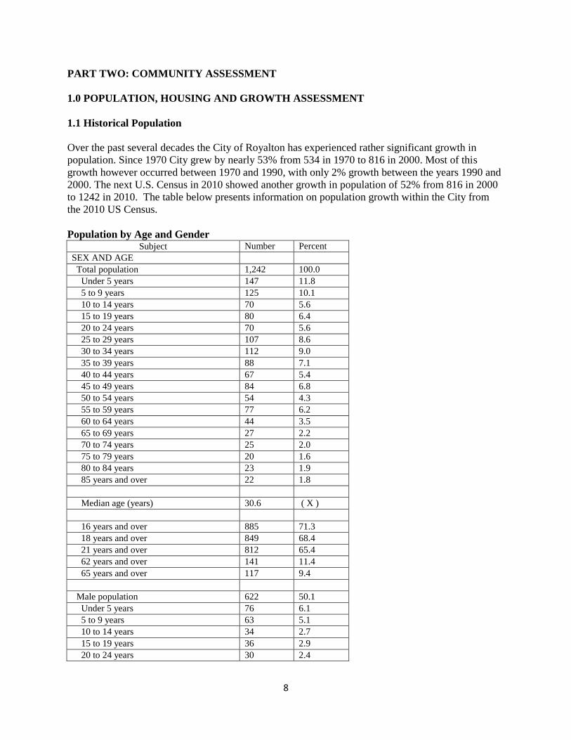
PART TWO: COMMUNITY ASSESSMENT
1.0 POPULATION, HOUSING AND GROWTH ASSESSMENT
1.1 Historical Population
Over the past several decades the City of Royalton has experienced rather significant growth in
population. Since 1970 City grew by nearly 53% from 534 in 1970 to 816 in 2000. Most of this
growth however occurred between 1970 and 1990, with only 2% growth between the years 1990 and
2000. The next U.S. Census in 2010 showed another growth in population of 52% from 816 in 2000
to 1242 in 2010. The table below presents information on population growth within the City from
the 2010 US Census.
Population by Age and Gender Subject Number Percent
SEX AND AGE
Total population 1,242 100.0
Under 5 years 147 11.8
5 to 9 years 125 10.1
10 to 14 years 70 5.6
15 to 19 years 80 6.4
20 to 24 years 70 5.6
25 to 29 years 107 8.6
30 to 34 years 112 9.0
35 to 39 years 88 7.1
40 to 44 years 67 5.4
45 to 49 years 84 6.8
50 to 54 years 54 4.3
55 to 59 years 77 6.2
60 to 64 years 44 3.5
65 to 69 years 27 2.2
70 to 74 years 25 2.0
75 to 79 years 20 1.6
80 to 84 years 23 1.9
85 years and over 22 1.8
Median age (years) 30.6 ( X )
16 years and over 885 71.3
18 years and over 849 68.4
21 years and over 812 65.4
62 years and over 141 11.4
65 years and over 117 9.4
Male population 622 50.1
Under 5 years 76 6.1
5 to 9 years 63 5.1
10 to 14 years 34 2.7
15 to 19 years 36 2.9
20 to 24 years 30 2.4

9
25 to 29 years 58 4.7
30 to 34 years 55 4.4
35 to 39 years 49 3.9
40 to 44 years 30 2.4
45 to 49 years 48 3.9
50 to 54 years 27 2.2
55 to 59 years 44 3.5
60 to 64 years 24 1.9
65 to 69 years 12 1.0
70 to 74 years 11 0.9
75 to 79 years 7 0.6
80 to 84 years 8 0.6
85 years and over 10 0.8
Median age (years) 30.7 ( X )
16 years and over 442 35.6
18 years and over 425 34.2
21 years and over 410 33.0
62 years and over 60 4.8
65 years and over 48 3.9
Female population 620 49.9
Under 5 years 71 5.7
5 to 9 years 62 5.0
10 to 14 years 36 2.9
15 to 19 years 44 3.5
20 to 24 years 40 3.2
25 to 29 years 49 3.9
30 to 34 years 57 4.6
35 to 39 years 39 3.1
40 to 44 years 37 3.0
45 to 49 years 36 2.9
50 to 54 years 27 2.2
55 to 59 years 33 2.7
60 to 64 years 20 1.6
65 to 69 years 15 1.2
70 to 74 years 14 1.1
75 to 79 years 13 1.0
80 to 84 years 15 1.2
85 years and over 12 1.0
Median age (years) 30.5 ( X )
16 years and over 443 35.7
18 years and over 424 34.1
21 years and over 402 32.4
62 years and over 81 6.5
65 years and over 69 5.6

10
Housing (housing units)
Subject
Royalton city, Minnesota
Occupied housing units
Owner-occupied housing units
Renter-occupied housing units
Estimate Margin of
Error Estimate Margin of
Error Estimate Margin of
Error
Occupied housing units 481 +/-58 354 +/-47 127 +/-45
HOUSEHOLD SIZE
1-person household 26.80% +/-6.9 24.30% +/-6.4 33.90% +/-19.2
2-person household 33.50% +/-7.0 40.10% +/-9.3 15.00% +/-10.0
3-person household 15.00% +/-6.1 13.00% +/-5.8 20.50% +/-17.5
4-or-more-person household 24.70% +/-6.6 22.60% +/-5.9 30.70% +/-18.8
OCCUPANTS PER ROOM
1.00 or less occupants per room 96.50% +/-2.9 98.60% +/-2.1 90.60% +/-9.0
1.01 to 1.50 occupants per room 2.90% +/-2.6 1.40% +/-2.1 7.10% +/-8.0
1.51 or more occupants per room
0.60% +/-1.2 0.00% +/-4.8 2.40% +/-4.5
HOUSEHOLD TYPE (INCLUDING LIVING ALONE) AND AGE OF HOUSEHOLDER
Family households 70.10% +/-7.0 74.30% +/-6.7 58.30% +/-20.4
Married-couple family 50.90% +/-8.6 59.00% +/-9.0 28.30% +/-18.0
Householder 15 to 34 years
15.60% +/-6.7 15.80% +/-6.7 15.00% +/-16.1
Householder 35 to 64 years
24.90% +/-6.1 30.80% +/-7.0 8.70% +/-10.6
Householder 65 years and over
10.40% +/-4.3 12.40% +/-5.6 4.70% +/-5.1
Other family 19.10% +/-8.3 15.30% +/-9.0 29.90% +/-20.2
Male householder, no wife present
10.00% +/-6.8 9.60% +/-7.3 11.00% +/-15.6
Householder 15 to 34 years
8.10% +/-6.6 7.10% +/-7.0 11.00% +/-15.6
Householder 35 to 64 years
1.90% +/-1.9 2.50% +/-2.7 0.00% +/-12.8
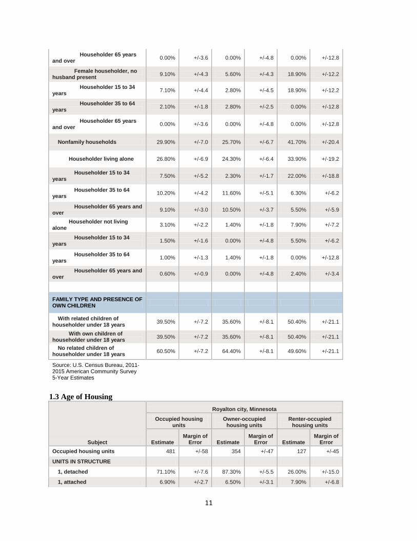
11
Householder 65 years and over
0.00% +/-3.6 0.00% +/-4.8 0.00% +/-12.8
Female householder, no husband present
9.10% +/-4.3 5.60% +/-4.3 18.90% +/-12.2
Householder 15 to 34 years
7.10% +/-4.4 2.80% +/-4.5 18.90% +/-12.2
Householder 35 to 64 years
2.10% +/-1.8 2.80% +/-2.5 0.00% +/-12.8
Householder 65 years and over
0.00% +/-3.6 0.00% +/-4.8 0.00% +/-12.8
Nonfamily households 29.90% +/-7.0 25.70% +/-6.7 41.70% +/-20.4
Householder living alone 26.80% +/-6.9 24.30% +/-6.4 33.90% +/-19.2
Householder 15 to 34 years
7.50% +/-5.2 2.30% +/-1.7 22.00% +/-18.8
Householder 35 to 64 years
10.20% +/-4.2 11.60% +/-5.1 6.30% +/-6.2
Householder 65 years and over
9.10% +/-3.0 10.50% +/-3.7 5.50% +/-5.9
Householder not living alone
3.10% +/-2.2 1.40% +/-1.8 7.90% +/-7.2
Householder 15 to 34 years
1.50% +/-1.6 0.00% +/-4.8 5.50% +/-6.2
Householder 35 to 64 years
1.00% +/-1.3 1.40% +/-1.8 0.00% +/-12.8
Householder 65 years and over
0.60% +/-0.9 0.00% +/-4.8 2.40% +/-3.4
FAMILY TYPE AND PRESENCE OF OWN CHILDREN
With related children of householder under 18 years
39.50% +/-7.2 35.60% +/-8.1 50.40% +/-21.1
With own children of householder under 18 years
39.50% +/-7.2 35.60% +/-8.1 50.40% +/-21.1
No related children of householder under 18 years
60.50% +/-7.2 64.40% +/-8.1 49.60% +/-21.1
Source: U.S. Census Bureau, 2011-2015 American Community Survey 5-Year Estimates
1.3 Age of Housing
Subject
Royalton city, Minnesota
Occupied housing units
Owner-occupied housing units
Renter-occupied housing units
Estimate Margin of
Error Estimate Margin of
Error Estimate Margin of
Error
Occupied housing units 481 +/-58 354 +/-47 127 +/-45
UNITS IN STRUCTURE
1, detached 71.10% +/-7.6 87.30% +/-5.5 26.00% +/-15.0
1, attached 6.90% +/-2.7 6.50% +/-3.1 7.90% +/-6.8
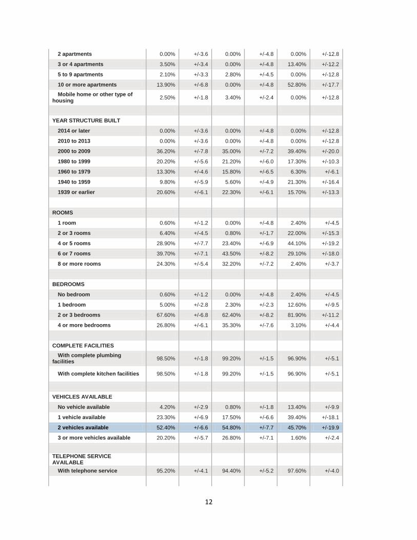
12
2 apartments 0.00% +/-3.6 0.00% +/-4.8 0.00% +/-12.8
3 or 4 apartments 3.50% +/-3.4 0.00% +/-4.8 13.40% +/-12.2
5 to 9 apartments 2.10% +/-3.3 2.80% +/-4.5 0.00% +/-12.8
10 or more apartments 13.90% +/-6.8 0.00% +/-4.8 52.80% +/-17.7
Mobile home or other type of housing
2.50% +/-1.8 3.40% +/-2.4 0.00% +/-12.8
YEAR STRUCTURE BUILT
2014 or later 0.00% +/-3.6 0.00% +/-4.8 0.00% +/-12.8
2010 to 2013 0.00% +/-3.6 0.00% +/-4.8 0.00% +/-12.8
2000 to 2009 36.20% +/-7.8 35.00% +/-7.2 39.40% +/-20.0
1980 to 1999 20.20% +/-5.6 21.20% +/-6.0 17.30% +/-10.3
1960 to 1979 13.30% +/-4.6 15.80% +/-6.5 6.30% +/-6.1
1940 to 1959 9.80% +/-5.9 5.60% +/-4.9 21.30% +/-16.4
1939 or earlier 20.60% +/-6.1 22.30% +/-6.1 15.70% +/-13.3
ROOMS
1 room 0.60% +/-1.2 0.00% +/-4.8 2.40% +/-4.5
2 or 3 rooms 6.40% +/-4.5 0.80% +/-1.7 22.00% +/-15.3
4 or 5 rooms 28.90% +/-7.7 23.40% +/-6.9 44.10% +/-19.2
6 or 7 rooms 39.70% +/-7.1 43.50% +/-8.2 29.10% +/-18.0
8 or more rooms 24.30% +/-5.4 32.20% +/-7.2 2.40% +/-3.7
BEDROOMS
No bedroom 0.60% +/-1.2 0.00% +/-4.8 2.40% +/-4.5
1 bedroom 5.00% +/-2.8 2.30% +/-2.3 12.60% +/-9.5
2 or 3 bedrooms 67.60% +/-6.8 62.40% +/-8.2 81.90% +/-11.2
4 or more bedrooms 26.80% +/-6.1 35.30% +/-7.6 3.10% +/-4.4
COMPLETE FACILITIES
With complete plumbing facilities
98.50% +/-1.8 99.20% +/-1.5 96.90% +/-5.1
With complete kitchen facilities 98.50% +/-1.8 99.20% +/-1.5 96.90% +/-5.1
VEHICLES AVAILABLE
No vehicle available 4.20% +/-2.9 0.80% +/-1.8 13.40% +/-9.9
1 vehicle available 23.30% +/-6.9 17.50% +/-6.6 39.40% +/-18.1
2 vehicles available 52.40% +/-6.6 54.80% +/-7.7 45.70% +/-19.9
3 or more vehicles available 20.20% +/-5.7 26.80% +/-7.1 1.60% +/-2.4
TELEPHONE SERVICE AVAILABLE
With telephone service 95.20% +/-4.1 94.40% +/-5.2 97.60% +/-4.0

13
HOUSE HEATING FUEL
Utility gas 61.50% +/-7.6 77.70% +/-7.9 16.50% +/-12.9
Bottled, tank, or LP gas 5.00% +/-2.6 5.90% +/-3.3 2.40% +/-3.7
Electricity 23.10% +/-7.1 9.30% +/-5.6 61.40% +/-18.9
Fuel oil, kerosene, etc. 5.20% +/-4.8 0.80% +/-1.1 17.30% +/-16.9
Coal or coke 0.00% +/-3.6 0.00% +/-4.8 0.00% +/-12.8
All other fuels 5.20% +/-4.3 6.20% +/-5.6 2.40% +/-3.4
No fuel used 0.00% +/-3.6 0.00% +/-4.8 0.00% +/-12.8
Source: U.S. Census Bureau, 2011-2015 American Community Survey 5-Year Estimates
Home ownership within the City of Royalton was at a rate of 74%, or 354 of the 481 occupied
housing units reported in 2015, versus the 26%, or 127 units that were rented by families and
individuals. Gross rent figures reported by American FactFiner/ U.S. Census Bureau for 2015, show
the average gross monthly rent due fell within two primary price ranges with the first being $500 to
$999 and the second larger group being less than $500.
GROSS RENT
Occupied units paying rent 127 +/-45 127 (X)
Less than $500 23 +/-11 18.10% +/-10.9
$500 to $999 90 +/-43 70.90% +/-14.3
$1,000 to $1,499 14 +/-12 11.00% +/-8.9
$1,500 to $1,999 0 +/-9 0.00% +/-12.8
$2,000 to $2,499 0 +/-9 0.00% +/-12.8
$2,500 to $2,999 0 +/-9 0.00% +/-12.8
$3,000 or more 0 +/-9 0.00% +/-12.8
Median (dollars) 621 +/-127 (X) (X)
No rent paid 0 +/-9 (X) (X)
According to American FactFinder/U.S. Census Bureau in 2015, the average value of owner-
occupied housing units within the City of Royalton was between $100,000 and $149,999 with nearly
84% of units valued within that price range. The second largest value group of housing unit values
reported in 2010 was between $50,000 and $99,999.
VALUE
Owner-occupied units 354 +/-47 354 (X)
Less than $50,000 22 +/-17 6.20% +/-4.8
$50,000 to $99,999 76 +/-26 21.50% +/-6.1
$100,000 to $149,999 143 +/-36 40.40% +/-8.8
$150,000 to $199,999 56 +/-17 15.80% +/-5.3
$200,000 to $299,999 44 +/-23 12.40% +/-6.3
14
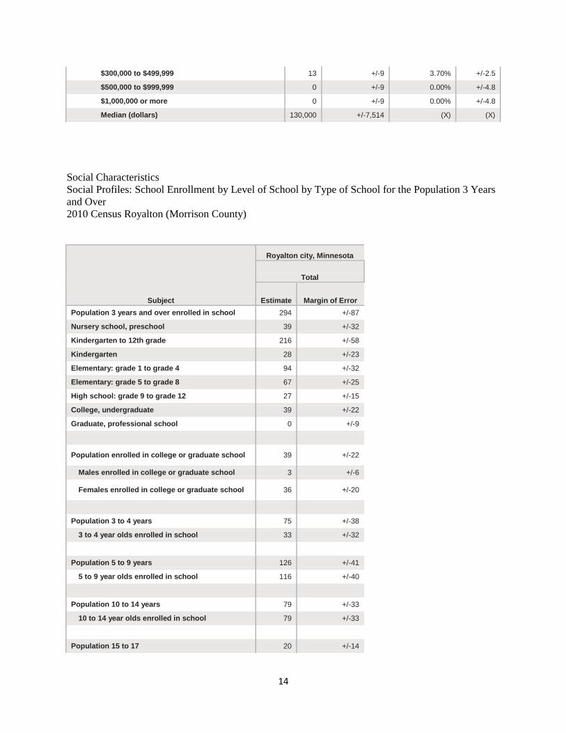
$300,000 to $499,999 13 +/-9 3.70% +/-2.5
$500,000 to $999,999 0 +/-9 0.00% +/-4.8
$1,000,000 or more 0 +/-9 0.00% +/-4.8
Median (dollars) 130,000 +/-7,514 (X) (X)
Social Characteristics
Social Profiles: School Enrollment by Level of School by Type of School for the Population 3 Years
and Over
2010 Census Royalton (Morrison County)
Subject
Royalton city, Minnesota
Total
Estimate Margin of Error
Population 3 years and over enrolled in school 294 +/-87
Nursery school, preschool 39 +/-32
Kindergarten to 12th grade 216 +/-58
Kindergarten 28 +/-23
Elementary: grade 1 to grade 4 94 +/-32
Elementary: grade 5 to grade 8 67 +/-25
High school: grade 9 to grade 12 27 +/-15
College, undergraduate 39 +/-22
Graduate, professional school 0 +/-9
Population enrolled in college or graduate school 39 +/-22
Males enrolled in college or graduate school 3 +/-6
Females enrolled in college or graduate school 36 +/-20
Population 3 to 4 years 75 +/-38
3 to 4 year olds enrolled in school 33 +/-32
Population 5 to 9 years 126 +/-41
5 to 9 year olds enrolled in school 116 +/-40
Population 10 to 14 years 79 +/-33
10 to 14 year olds enrolled in school 79 +/-33
Population 15 to 17 20 +/-14
15
15 to 17 year olds enrolled in school 20 +/-14
Population 18 to 19 years 7 +/-7
18 and 19 year olds enrolled in school 7 +/-7
Population 20 to 24 years 85 +/-56
20 to 24 year olds enrolled in school 17 +/-12
Population 25 to 34 years 232 +/-71
25 to 34 year olds enrolled in school 7 +/-8
Population 35 years and over 535 +/-74
35 years and over enrolled in school 15 +/-15
Population 18 to 24 years 92 +/-57
Enrolled in college or graduate school 17 +/-12
Males 18 to 24 years 43 +/-33
Enrolled in college or graduate school 0 +/-9
Females 18 to 24 years 49 +/-33
Enrolled in college or graduate school 17 +/-12
Source: U.S. Census Bureau, 2011-2015 American Community Survey 5-Year Estimates
Economic Assessment
Income Profile
2010 Median household income $44,125
2010 Median family income $52,845
Population below poverty level 129
Percent of population below poverty level 11.5
2015 Median household income $47,841
2015 Median family income $51,938
Population below poverty level 208
Percent of population below poverty level 16.9
2.0 LAND USE ASSESSMENT & FUTURE LAND USE RECOMMENDATIONS
2.1 Existing Land Use and Zoning
Over the past century the City of Royalton has become a community of a variety of land uses
including residential, commercial, industrial, public, agricultural and semi-public uses. Generally, the
development of the City has occurred in a traditional grid pattern similar to many other communities
of the same size and general character of Royalton. The development of land within Royalton has

16
been guided through the implementation of the City of Royalton Zoning Ordinance since 1980 with
revisions of the Ordinance in 1998 and 2009. This Ordinance has, for the most part, effectively
established consistency among the use of lands within the city, especially in the city’s 1980 to 1990
growth period as well as the growth period of 1998 through 2007. Below is a general description of
land use districts through the city of Royalton Zoning Ordinance as well as land use districts defined
through the City of Royalton Zoning Ordinance as well as a generalized summary of the actual use of
land within each district.
2.1.1 Residential Land Use
Overview
Residential land use accounts for approximately 50% of all land use within the City of Royalton.
Individual designations exist for accommodating single, two and multiple family residential
development as well as a provision for agricultural/rural residences. Residential land use districts are
categorized as follows within the City of Royalton Zoning Ordinance:
R-1 Single Family Residential District
R1-A Townhouse District
R-2 Single and Two-Family Residential District
R-3 Multiple Family Residential District
A Agricultural/Rural Residence
R-1 Single Family Residential District
Purpose and Intent (from the City of Royalton Zoning Ordinance)
“It is the intent of this district to permit the development of single family dwellings in the community
where adequate municipal utilities exist or are to be extended, to provide for reasonable standards for
such development, to avoid overcrowding, and to prohibit the use of land which would be
incompatible with or detrimental to the essential character of such district”
General Character and Uses:
This district is intended to provide for the organization of single family dwellings, public parks and
playgrounds, government and public utility buildings and structures necessary for health, safety and
general welfare of the community.
Recommendations:
1. Review and revise lot requirements for the R-1 district
2. Look to the development of single-family dwellings as indicated by the land use map.
3. Limit residential growth and development according to the following schedule:
2018-2022 2-5 homes per year
2022 and beyond To be determined by future developments
17
R-1A Townhouse District
Purpose and Intent (from the City of Royalton Zoning Ordinance)
It is the intent of this district to permit the development of townhouses in the community where
adequate municipal utilities exist or are to be extended, to provide for reasonable standards for such
development, to avoid overcrowding, and to prohibit the use of land which would be incompatible
with or detrimental to the essential residential character of such district”
General Character and Uses:
Each dwelling unit must have a separate entrance to front and rear yards. Units may be clustered, but
no more than six units connected in a cluster.
Recommendations:
1. Review and revise lot requirements for Townhouse District
2. Look for development of townhome dwellings as indicated on the land use map
R-2 Single and Two-Family Residential District
Purpose and Intent (from the City of Royalton Zoning Ordinance):
“It is the intent of this district to provide for single-family and two-family dwellings in the
community where adequate municipal utilities exist or are to be extended, to provide for reasonable
standards for such development, to avoid overcrowding, and to prohibit the use of land which would
be incompatible with or detrimental to the essential residential character of such district.”
General Character and Uses:
This district is intended to provide for the organization of single and two-family dwellings, group
homes, parks and playgrounds, essential public services, solar energy systems, government and
public utility buildings and structures necessary for the health, safety and general welfare of the
community.
Recommendations:
1. Review and revise lot sizes for single and two-family homes
2. Look to the development of single-family dwellings as indicated by the land use map.
R-3 Multiple Family Residential District
Purpose and Intent (from the City of Royalton Zoning Ordinance):
“It is the intent of this district to provide for multiple-family dwelling unit structure and directly
related complementary uses.”
General Character and Uses:
This district is intended for multiple-family dwellings units, governmental and utility buildings and
structures necessary for the health, safety and general welfare of the community.

18
Recommendations:
1. Review and revise lot sizes for multiple family dwelling units
2. Look to the development of multiple family dwellings as indicated by the land use map.
R-4 Planned Unit Development
Purpose and Intent (from the City of Royalton Zoning Ordinance):
“The purpose of this Subdivision is to provide for the grouping of land parcels for development as an
integrated, coordinated unit in a manner which emphasizes flexibility of design of land under single
or unified ownership, developed with community or public sewer and water systems, and through
clustering of buildings and activities. It is further intended that Planned Unit Developments are to be
characterized by Central Management, integrated planning and architecture, joint or common use of
parking, maintenance of open space, and other similar facilities, and a harmonious selection and
efficient distribution of uses. Planned Unit Developments regulated under this section may be applied
to Residential uses when keeping with the regulations provided in the Zoning Ordinance.”
General Character and Uses:
The minimum area of land to be included in a Planned Unit Development shall be two (2) acres.
Recommendations:
1. Review and revise the number of dwelling units allowed within the district
2. Review and revise setbacks for front, side and shore land restrictions
A Agricultural/Rural Residential District
Purpose and Intent (from the City of Royalton Zoning Ordinance):
“To establish and preserve areas for low density residential without permitting intensified
development which would require the provision of municipal facilities and services, and further
allow agricultural uses in this district.”
General Character and Uses:
This district is intended to provide for not only low-density development within the City, but also the
preservation of agricultural land. Such preservation is increasingly becoming inconsistent with the
growth of the City and the economic feasibility of providing municipal services, infrastructure, and
maintaining a housing supply to support the residential needs of the City and the region which the
City is located within.
Recommendations:
1. Review need for, and alternatives to the Agricultural/Rural Residential District
2. Encourage the in-fill of agricultural land use areas adjacent to existing development as
indicated on the land use map.

19
2.1.2 Commercial Land Use
C-1 Commercial District
Purpose and Intent (from the City of Royalton Zoning Ordinance):
“It is the intent of this district to provide for the establishment of commercial and service activities
which draw from and serve customers from the community and its surrounding areas.”
General Character and Uses:
This district is intended to provide for the organization of traditional community-related businesses
such as small retail shops, service stations, grocery stores, personal services, and a variety of similar
businesses intended to serve the community and communities immediately adjacent to the City.
Recommendations:
1. Specify lot requirements for the C-1 district
2. Review and revise uses permitted within the C-1 district
3. Review and revise need for conditional use permits within C-1 district
C-2 Community Commercial District
Purpose and Intent (from the City of Royalton Zoning Ordinance):
“It is the intent of this district to provide for the establishment of commercial and service activities
which draw from and serve customers from the community and its surrounding area.”
General Character and Uses:
This district provides for the organization of business services such as banks, laundry establishments,
food services such as grocery stores, drug stores, hardware stores, beauty shops, public utility
buildings, recreational services such as theaters and bowling lanes and health clinics.
Recommendations:
1. Review and revise lot size for C-2 district
2. Review and revise uses permitted in C-2 district
3. Review and revise need for conditional use permits within C-2 district.
C-3 Regional Commercial District
Purpose and Intent (from the City of Royalton Zoning Ordinance):
“It is the intent of this district to provide for and limit the establishment of automobile oriented or
dependent commercial and service activities.”
20
General Character and Uses:
This district is for the organization of businesses such as auto accessory stores, new and used auto
sales and service, implement sales and service and motels and other tourist oriented businesses.
Recommendations:
1. Review and revise lot size for C-3 district.
2. Review and revise uses permitted in C-3 district.
3. Review and revise need for conditional use permits within C-3 district.
2.1.3 Industrial Land Use
I-1 General Industrial District
Purpose and Intent (from the City of Royalton Zoning Ordinance):
“It is the intent of this district to provide for and allow a wide range of industrial, warehousing and
bulk commercial activities in location which will not conflict with other uses.”
General Character and Uses:
This district provides for any branch of trade or industry employing labor and capital activities not
allowed in commercial districts, activities which do not require steam, diesel or gasoline engines as a
prime mover excepting that no industry or use noxious by reason of odor, dust, smoke, noise or gas
shall be included which interferes with other permitted uses.
Recommendations:
1. Review and revise lot requirements as necessary to protect adjacent land uses, especially
residential uses.
2. Review and further define lot coverage requirements within the I-1 district
3. Review and revise need for conditional use permits within the I-1 district
I-2 Heavy Industrial District
Purpose and Intent (from the City of Royalton Zoning Ordinance):
Essentially, the I-2 district is intended to provide for public protection against land uses which may
impose the greatest impact on adjacent land use within the City.
General Character and Uses:
Some of these include management or manufacturing of chemicals and substances which could be
considered a threat to health and public safety or uses which may create significant noise, vibration,
pollution, or similar effects.
Recommendations:
1. Review and revise “intent” for the I-2 district
2. Review and revise lot requirements for I-2 district
3. Review and revise uses permitted within the I-2 district

21
R-D Railroad Industrial The purpose of the Railroad Industrial Use is to provide for a set of guidelines for building in and
around the rail system in the City of Royalton
2.2 Additional Future Land Use Recommendations and Discussion on Growth & Development
To better provide for the organization of the City’s land resources, the following zoning districts are
recommended to be incorporated within the revision of the City of Royalton Zoning Ordinance.
2.2.1 I-PU Public Use District
Purpose and Intent:
To provide for the organization of lands or structures used for public purpose.
General Character and Uses:
Uses that should be permitted within a PU district include schools, parks, municipal facilities,
infrastructure and essential services facilities, golf courses, rest areas, public playgrounds, ball fields,
or similar public uses.
Recommendations:
1. Incorporate the PU district within the City of Royalton Zoning Ordinance
2. Provide for the designation of public lands as indicated on the land use map.
2.2.2 TR Transitional District
Purpose and Intent:
To provide for the designation of areas of the City of Royalton which are currently vacant or
currently being used for agricultural purposes such designation reserves such land for future
consideration of future growth and development.
Recommendations:
1. Incorporate the TR district within the City of Royalton Zoning Ordinance
2. Provide for the designation of transitional land as indicated on the land use map
Areas to be designated as “Transitional” include all areas within the incorporated limits of the city,
but without the necessary sewer and water infrastructure to support future growth and development.
These areas also lack sufficient roadway access to Highway 10 and the remaining portions of the
City due to the division of the City by railroad. As long-term solutions are presented to the City areas
currently designated as Transitional by this plan may be converted to other land use designations as
the changes are consistent with adjacent land uses and the City of Royalton comprehensive plan and
zoning ordinance.

22
2.2.3 SF Shoreland/Floodplain Overlay District
Purpose and Intent:
To provide for the protection of the Platte River and the protection of landowners against erosion,
flooding or other impacts associated with the River.
General Character and Uses:
An “overlay” district is not a zoning district unto itself, but is used to designate areas within the City
which meet the intent and purpose of the district. Because the Platte River was identified as a critical
natural resource within the City of Royalton all areas immediately adjacent to the River should be
included within a newly created SF overlay district.
Recommendations:
1. Develop SF overlay district
2. Develop all requirements including building restrictions, setbacks, and similar requirements
for the SF overlay district
3. Designate all areas adjacent to the Platte River with the SF overlay district as indicated
within the future land use map
4. Incorporate all goals, objectives, and policies specified by the Morrison County Hazard
Mitigation Plan within requirements for the SF overlay district.
2.2.4 Vacant or Unused Lands
Opportunity for Growth and Development:
1. Undeveloped land in northeast and southwest portions of the City
2. Undeveloped land along the borders of the City
3. Community infrastructure improvements
Barriers to Growth and Development:
1. Division of the community by a high-traffic railroad corridor.
2. Preservation of existing way of life
3. Limited community infrastructure
3.0 PUBLIC FACILITIES AND SERVICES ASSESSMENT
3.1 Facilities and Services Assessment
Royalton Area Community/Senior Center
205 East Centre Street
Royalton, MN 56373
Royalton City Hall
Hospital:
Saint Gabriel’s Hospital
815 Second Street SE
Little Falls, MN 56345

23
Schools:
Royalton Secondary School (6-12)
120 Hawthorn Street
Royalton, MN 56373
Royalton Elementary School (pre-K- 5)
Box 138
Royalton, MN 56373
Emergency Services:
Police:
Royalton Police Department
Morrison County Sheriff’s Department
Fire and Rescue:
Royalton Fire Department
Royalton Emergency Squad
Ambulance:
Gold Cross Ambulance
Saint Gabriel’s Hospital
Little Falls, MN 56345
3.2 Infrastructure Assessment
3.2.1 Transportation (Roads, Trails, Sidewalks, Air Travel)
The City of Royalton currently enjoys a well-maintained transportation system that provides access
throughout the City.
Royalton Roadways
Local Roads:
Willow St N. Cedar St S. Driftwood St
Maple St N. Ivy St Centre St
N. Birch St N. Driftwood St S. 5th St
N. Maple St N. Elm St S. 6th St
N. Evergreen St S. Chestnut St S. 7th St
N. Aspen St S. Redwood St S. Elm St
N. 5th St S. Birch St N. Hickory St
N. 4th St S. Cedar St Linden St
N. 3rd St S. 1st St Pine St.
N. 2nd St S. 2nd St N. Oak St

24
N. 1st St S. 3rd St Juniper St
N. Redwood St S. 4th St SE 2nd St
Ironwood Dr Pear St Walnut St
Cherry Ln SE 7th St Nature Rd
N. Hawthorn St S Hawthorn St Prairie View Dr
8th St NW Plattewood Dr Pine Court
Acorn Road
County State Aid Highways and County Roads:
County Road
CSAH 26 234
CSAH 27 County Road 54
Trunk Highways
US TH 10
Railroads
Burlington Northern Santa Fe Inc
3.2.2 Trunk Highway 10 (TH 10)
US TH 10 is an integrated corridor that supports Minnesota’s economic health by connecting people
with jobs, distributors with manufacturers, shoppers with retailers, and tourists with recreational
opportunities. With the exception of 6 miles through Wadena and 2.5 miles through Staples, TH 10 is
a four land divided US Highway that traverses the State of Minnesota from Moorhead to Hastings. It
serves as a link from Royalton to the Primary Trade Centers of Fargo/Moorhead, St. Cloud and the
Twin Cities metro; the Secondary Trade Centers of Brainerd and Elk River as well as the level three
Trade Center of Little Falls. It serves as an important link to those areas for those that live in
Royalton as well as a connection between those Trade Centers.
In the city of Royalton TH 10 runs from the Northwestern corner of the City on through the Southern
portion of the City. The main access point along TH 10 is CSAH 26 where a traffic signal is located.
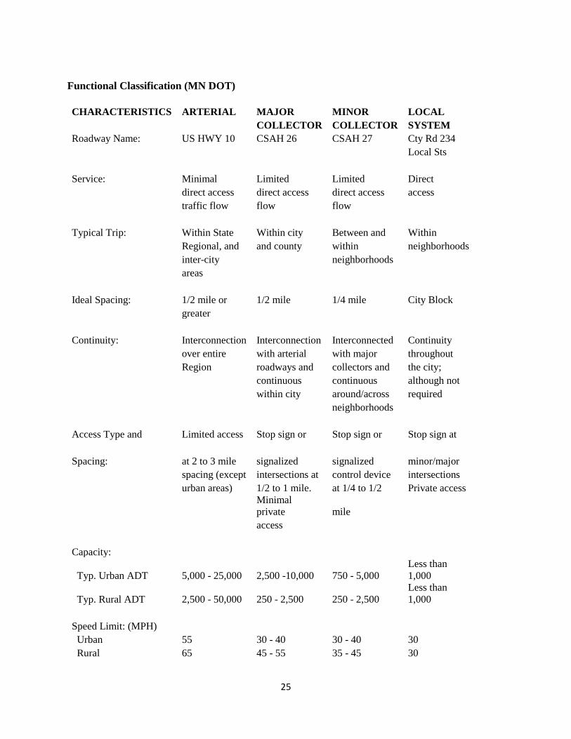
Functional Classification
Roadways are designed to serve different purposes within the ultimate goal of providing surface for
vehicle travel. Classifying these roadways as to the function they serve for travelers provides an
understanding of current traffic flow conditions. Functions used in classifying these roadways
include traffic flow (Average Daily Traffic or ADT), access, continuity, spacing, speed limits, and
other similar characteristics. Roadways are classified according to their purpose as Arterial, Major
Collector, and Local Streets.
Functional classification also serves as a tool in planning as the categorized roadways can be
correlated to identify access to areas of the community in relation to different types of land use. This
practice can be helpful in determining land areas that will better serve land use types that require
greater amounts of access as well as those with limited traffic flow for residential areas.
25
Functional Classification (MN DOT)
CHARACTERISTICS ARTERIAL MAJOR MINOR LOCAL
COLLECTOR COLLECTOR SYSTEM
Roadway Name: US HWY 10 CSAH 26 CSAH 27 Cty Rd 234
Local Sts
Service: Minimal Limited Limited Direct
direct access direct access direct access access
traffic flow flow flow
Typical Trip: Within State Within city Between and Within
Regional, and and county within neighborhoods
inter-city
neighborhoods
areas
Ideal Spacing: 1/2 mile or 1/2 mile 1/4 mile City Block
greater
Continuity: Interconnection Interconnection Interconnected Continuity
over entire with arterial with major throughout
Region roadways and collectors and the city;
continuous continuous although not
within city around/across required
neighborhoods
Access Type and Limited access Stop sign or Stop sign or Stop sign at
Spacing: at 2 to 3 mile signalized signalized minor/major
spacing (except intersections at control device intersections
urban areas) 1/2 to 1 mile. at 1/4 to 1/2 Private access
Minimal
private mile
access
Capacity:
Typ. Urban ADT 5,000 - 25,000 2,500 -10,000 750 - 5,000
Less than
1,000
Typ. Rural ADT 2,500 - 50,000 250 - 2,500 250 - 2,500
Less than
1,000
Speed Limit: (MPH)
Urban 55 30 - 40 30 - 40 30
Rural 65 45 - 55 35 - 45 30

26
Parking:
Urban None Restrictions Restrictions Unrestricted
Rural none None None Unrestricted
Sidewalks
Urban Both sides Both Sides Both Sides Local
Rural None Local Local None
3.2.3 Average Daily Traffic Counts
Average daily traffic counts or ADT counts are important in determining needs of future
transportation along roads within an area. Existing inventories of ADT counts within the city of
Royalton exist for CSAH 26, CSAH 27, County Road 234, County Road 54, and TH 10 in various
segments throughout the City of Royalton.
Average daily traffic counts for the City of Royalton is from the Minnesota Department of
Transportation’s Office of Transportation Data and Analysis. The Trunk Highway count was
conducted in 2002 and the County Road counts were conducted in 2001. All projections are for year
2025.
TH 10 Average Daily Traffic Count (ADT)
Current Traffic Count (ADT) 2009
NW of N 3rd Street in Royalton 20,900
Current Traffic Count (ADT) 2011
NW of N 3rd Street in Royalton 20,900
Projected Traffic Count (ADT) 2030 41,340
NW of 3rd Street in Royalton
CSAH & County Road Average Daily Traffic Counts (ADT)
Current Traffic Count (ADT) 2009:
CSAH 26:
West of TH 10 (Nature Road) 2150
Between TH 10 & Centre St 2200
East of Hawthorn St (Nature Road) 1200
CSAH 27:
North of N 5th St (N Evergreen) 450
County 54:
North of Centre St (N Hawthorn St) 530
Projected Traffic Count (ADT) 2027:
CSAH 26:
West of TH 10 (Nature Rd) 3010
Between TH 10 & Centre St 3080

27
CSAH 27:
North of 5th St (N Evergreen) 630
County Road 234:
North of Centre St (N. Hawthorn St) 507
County Road 54:
South of Centre St (S. Hawthorn St) 742
3.2.4 Master Sidewalk & Trails Plan:
The purpose and intent of this plan is to identify gaps in current sidewalks and where sidewalks can
be added to make it easier for community members to walk or bike to school, church, parks, and
local business district. The plan also outlines possible bike trails that connect to the regional Soo Line
Trail.
The City of Royalton currently enjoys a well-maintained transportation system that provides access
throughout the City. With more emphasis on active living the City’s transportation goals for 2018 to
2028 include:
Identifying walking/biking trails within the City
Grooming walking trails in McGonagle Park
Walking/biking path from N. Birch to Soo Line Trailhead
ADA compliant sidewalks (pedestrian ramps)
3.3 Other Infrastructure
Water and Wastewater Facilities
Royalton Public Works
(320) 584-5900
Water Information
Water Source: Wells
Storage Capacity: 65,000 gallons
Pumping Capacity: 260 gal/minute – Well #2
570 gal/minute – Well #3
300 gal/minute – Well #4
Average Demand: 81,000 gal/day
Peak Demand: 240,000 gal/day
Wastewater Information
Treatment Type: Stabilization Pond System
Capacity of Plant: 1 – 8 acre pond; 1 – 4 acre pond; 3 – 1.65 acre ponds
Average Demand: 84,000 gal/day
Peak Demand: 142,000 gal/day
Water Usage Charge: Base chg. $25.50/2,500 gal; $5/thousand above that usage
Sewer Usage Charge: Base chg. $42.00/base; excess over 10,000 gal water usage $5/1000

28
In 2007 the City of Royalton adopted a Wellhead Protection Plan as its guide to maintain the health
and safety of the City water supply. The next plan update will be 2018.
PART THREE: THE CITY OF ROYALTON ACTION PLAN
Goals, Objectives and Policies
SECTION 1.0 INTRODUCTION
The City of Royalton Comprehensive Plan presents a series of plans developed to carry out the
foundations listed in section 2.0 of Part One of the plan. In doing so, this plan focuses on the
following:
GENERAL LAND USE & ZONING OPERATIONS PLAN
HOUSING & RESIDENTIAL LAND USE PLAN
COMMERCIAL & INDUSTRIAL LAND USE PLAN
NATURAL RESOURCES & ENVIRONMENTAL PLAN
TRANSPORTATION, COMMUNITY FACILTIES & SERVICES PLAN
Other plans may also be added to the City of Royalton Comprehensive Plan as needed in the future.
1.1 How to use this plan
Each plan included within the overall comprehensive plan presents goals, objectives, and policies
designed to guide each particular component of the City into the future. Supporting these goals,
objectives, and policies is the vast public and technical information obtained through the planning
process. This data and information includes, but is not limited to the following:
Public Participation Information
City of Royalton Comprehensive Plan (2005-2015 and updates 2011 and 2014)
Current Zoning Ordinance
Current Zoning Map (Land Use Map) and Data
Demographic and Economic Data
In order to effectively carry out the actions items presented for each goal it is necessary to identify
who will be responsible for each action as well as potential costs, potential resources, and a specified
timeline for anticipated completion. It is important to draw upon this information throughout the
implementation of this comprehensive plan to ensure a successful future for the City of Royalton and
achieve the desired level of consistency the plan provides. Generally, implementation of this plan
should occur in the following manner:
1. All action items must be carried out by those who have assumed the responsibility for the
action or as otherwise delegated by the City Council
2. This plan is also intended to serve as a reference document. For all questions, or as required
by local ordinance or state law, this document should be referenced and interpreted by the
City Council and Planning and Zoning Commission to serve as a basis for decision-making.
29
1.2 Goals, Objectives, Policies & Recommendations
The goals, objectives, and policies presented within this comprehensive plan are designated to carry
out the community vision. For the purposes of this plan, goals, objectives and policies are defined as
follows:
Goal: A statement expressing the general effect or outcome that is desired by the community. A goal
is carried out through the completion of a series of objectives and/or policies and recommendations.
Objectives: A specific action or task that is to be performed to carry out or complete the goal which
the objective is part of.
Policies and Recommendations: A specific official action, encouraged action, or recommended
change in, or continuation of process which will be taken by the Council to achieve the desired effect
of a corresponding goal. Policy statements may also define parameters of conduct or process that will
carry out or complete the goal which the policy is a part of.
1.3 Asset Mapping for Implementation
The identification of resources, task leaders, and time needed for the completion of each goal,
objective, and policy is crucial to the successful implementation of this plan. Because of the strong
need to provide this information, each plan addressed within this section is divided into four parts as
defined below:
1. Purpose and Identification
2. Existing Plans, Programs, and Policies
3. Goals, Objectives, and Policies
4. Implementation Schedule (Task Leaders, Estimated Costs, Resources, Timeline)
Task Leaders: Each objective listed under each goal within this plan is accompanied by an individual
identified Task Leader or a collection of Task Leaders and Partners. Task Leaders are the persons,
agencies, departments, or similar entities that will provide for the coordination of the specific
objective for which the Task Leader are assigned. This also includes any identified partners who may
assist in the implementation of the objective.
Estimated Costs: To better prepare for the implementation of each objective presented within this
plan, costs, associated with the particular objective are identified. These costs represent the best
possible cost estimate using similar projects undertaken by counties, local governments, community
organizations, and other groups.
Resources: To assist in the successful implementation of the objectives presented within this plan, the
City must to draw upon assistance and funding from a variety of resources. Many of these resources
are already located within the City. These resources are identified for each goal listed within this
plan.
Timeline: A timeline for completion accompanies all objectives presented within this plan. Since this
plan focuses on the City of Royalton up to the year 2028 many of these objectives are simply
identified as “ongoing” with the exception of specific projects which a timeline may be more clearly
defined.
30
Definitions of certain actions and action words used in Part Three of the City of Royalton
Comprehensive Plan:
1. Changes in Process: Includes the addition or revision of Zoning Administration including all
aspects such as Planning & Zoning Commission, and/or the City Council routine activities,
development review, permitting processes or similar activities.
2. “Continue”: Refers to a practice or action that is currently utilized or in effect. This statement
calls for the continuation of the particular practice or action with or without additional actions
3. “Develop”: A specific action or series of actions needed to develop, implement, or otherwise
effectuate a program, policy, task, or other specific action.
4. “Encourage”, “Promote”, and “Recommend”: Identifies, promotes and advocates a particular
desired outcome or desired effect.
5. “Monitoring”: Includes the ongoing analysis of reports, studies and other data; the
monitoring of programs, service, and funding opportunities; or similar monitoring activities.
6. Revision of Ordinance/Policy/Official Controls: Includes the revision of the City’s official
land use controls or other City policies, ordinances, or similar codes and regulations.
SECTION 2.0 GENERAL LAND USE, ZONING OPERATIONS & NATURAL RESOURCES
PLAN
2.1 Land Use & Zoning Operations Goal:
Promote and maintain a sustainable community through the revision and implementation of official
land use controls and process and through the cooperation and coordination with Bellevue Township
(Morrison County) and Langola Township (Benton County).
Objectives:
1. Update and implement a revised City of Royalton Zoning Ordinance using the
recommendations provided in Section 2.0 of Part Two of this plan.
a. Creation of Transitional zoning district
b. Organize zoning districts
c. Revise lot requirements as necessary
2. Make zoning district changes based upon the future land use map and information obtained
through the comprehensive planning process.
3. Develop a Comprehensive Improvement Plan process to avoid spot zoning
4. Rezone industrial parcels on Hwy 10 to Community Commercial or Residential when the
property is sold

31
5. Adopt development plan or processes that protect natural systems and valued community
assets
Task Leaders: City Council, Planning and Zoning Commission
Estimated Costs: $10,000 to $20,000
Resources: Initial: General Levy; Ongoing; Permit Fees
Timeline: 2018 to 2028 and beyond
The City of Royalton Zoning Ordinance was adopted as a result of the Comprehensive Land Use
Plan 2005-2015. It was last updated in 2015.
Policies and Recommendations:
1. Focus on filling in empty lots in neighborhoods and “redevelopment” as well as the
development potential of vacant land within the current boundaries rather than expansion
beyond the current boundaries of the City.
2. Ensure all planning commission members and City staff receives ongoing training and
education necessary to carry out the goals and objectives presented within this plan and to
remain abreast of planning related topics, concepts, and ideas.
2.2 Natural Resources and Environment Goal:
Provide for the protection of the many natural resources within the City of Royalton.
Objectives
1. Support actions which preserve the natural beauty and water quality of the Platte River.
2. Protect natural wetlands and encourage the creation of additional wetland areas as needed for
the collection of runoff.
3. Incorporate “environmentally friendly” landscaping requirements into the City of Royalton
Zoning Ordinance.
4. Develop a Shoreland Ordinance to include a 50’ buffer for properties along the Platte River
5. Improve local water bodies to sustain their long-term ecological function and community
benefit
6. Support renewable energy projects such as solar/wind
Task Leaders: City Council, Planning and Zoning Commission, Developers and
Citizens
32
Estimated Costs: Minimal
Resources: Minnesota Pollution Control Agency
Minnesota Department of Natural Resources
Minnesota Board on Soils and Water Resources
Morrison County Soil & Water Conservation District
Morrison County Planning & Zoning
Minnesota Department of Commerce
Timeline: Ongoing
The City of Royalton passed a resolution to become a GreenStep City in 2010. The GreenStep City
program is a voluntary challenge, assistance, and recognition program to help cities achieve their
sustainability goals. It is administered by the Minnesota Pollution Control Agency. There are 29 Best
Practices in five areas: building & lighting, land use, transportation, environmental management, and
economic development. The GreenStep City Report is available on the City website
http://www.royaltonmn.com/vertical/sites/%7BF29AE369-80CF-4CFB-BE87-
851B6F04B18E%7D/uploads/City_of_Royalton_GreenStep_Cities_Report__Jan_2012_PDF(1).pdf
3.0 SECTION 3.0 RESIDENTIAL LAND USE & HOUSING PLAN
3.1 Residential Land Use & Housing Goal:
Promote quality housing for all residents.
Objectives:
1. Encourage a mixture of variety of housing options within new residential subdivision housing
development including affordable housing and a blend or variety of housing styles.
2. Maintain the older community integrity and character while encouraging new single-family
housing development. The older community integrity and character should be maintained
through housing redevelopment programs, “fix-up” funding, or similar programs as well as
through the initiatives of individual homeowners.
3. Work to attract and encourage the development of high-quality senior housing and assisted
living facilities located near City services and downtown related commercial business.
4. Work to attract and encourage the development of more day care facilities located near City
parks and playgrounds.
5. Incorporate home occupation related permitting within the zoning ordinance to minimize the
impacts of home occupations and businesses on residential areas of the community.
6. Work to attract more workforce housing to meet the needs of the area.
Task Leaders: City Council, Planning and Zoning Commission, Developers and
Citizens
Estimated Costs: Minimal
Resources: Minnesota Housing Finance Agency
Greater Minnesota Housing Fund
Central Minnesota Council on Aging

33
Assisted Living Providers
Home-based Business Owners
Timeline: 2018 to 2028 and Ongoing
3.2 Residential Land Use & Housing Performance Measures and Standards Goals:
Provide for performance measures and standards that promote an aesthetically pleasing community
and the orderly and consistent development of residential neighborhoods.
Objectives:
1. Require the use of light coverings and lighting that is controlled and directed in such a way as
to remain only on the property or areas in which the lighting is intended, except lighting
necessary to protect the general health, welfare and safety of the community.
2. To protect “old growth” trees by including regulation within the zoning and subdivision that
limits the cutting of trees that do not need to be disturbed except for the normal construction
of structures.
3. Promote the planting of trees, shrubs, and other foliage to enhance the natural beauty of
residential neighborhoods.
4. Require the exterior of all accessory structures be consistent with the exterior of the principal
structure in general color tones, materials, etc.
5. To regulate signage within the city including limiting billboards, flashing or revolving signs,
or signage that is considered to contain offensive language or content.
Task Leaders: City Council, Planning and Zoning Commission, Developers
Estimated Costs: $10,000 to $20,000
Resources: Initial: General Levy; Ongoing: Permit Fees
Timeline: 2018 to 2028 and beyond
SECTION 4.0 COMMERCIAL & INDUSTRIAL LAND USE PLAN
4.1 Commercial & Industrial Land Use Goal:
To provide for commercial and industrial development to add to the “sustainability” of the City of
Royalton and minimize the impacts of commercial and industrial development on residential areas of
the City; and provide for sufficient access to commercial and industrial business by residents and
inter-regional motorists.
Objectives:
1. Organize commercial land throughout the City to reflect future and existing commercial uses.
This includes the creation of “Community Commercial” and “Highway Commercial” zoning
districts.

34
2. “COMMUNITY” COMMERCIAL. Provide for commercial development of a traditional
“downtown” character and feel along the existing Highway 10 route and along CSAH 26 as
indicated on the future land use map.
Community Commercial Uses: Small retail shops, service stations, restaurants, professional
offices, banks, convenience stores, or similar uses.
“HIGHWAY” COMMERCIAL. After incorporating Minnesota Department of
Transportation access management guidelines, provide for highway commercial development
along areas of Highway 10 most unlikely to be affected as a result of a future bypass of the
City of Royalton by Highway 10.
Highway Commercial Uses: Service stations, retail such as larger grocery stores, retail stores,
“fast food” restaurants, department stores, industrial parks, or similar uses.
3. Minimize the impacts of industrial development on the community by focusing industrial
business development in areas in which negative effects on existing residential or commercial
development and all other existing development can be minimized or eliminated.
4. Industrial zoned areas along the Hwy 10 corridor rezoned Community Commercial or
Highway Commercial when the current property is sold.
5. Maintain the community character and atmosphere of the City of Royalton through the
attraction and retention of small businesses consistent with objective #2 in the areas specified
Task Leaders: City Council, Planning and Zoning Commission,
Morrison County Community Development, Morrison County Soil & Water
Conservation
Estimated Costs:
Resources: Morrison County Community Development, Minnesota
Minnesota Department of Employment & Economic Development
Region Five Development Commission
Timeline: 2018 to 2028 and beyond
SECTION 5.0 GROWTH & ANNEXATION
5.1 Community Growth Goal:
A strong potential for growth and development of the City of Royalton exists due to the proximity of
the City to St. Cloud area as well as the City’s location along U.S. Highway 10. It is the intent of this
plan to ensure growth and development with the City occurs in an orderly fashion.
Objectives:
Limit the addition of single and two-family dwelling units according to the
following schedule:
2018 to 2028 5 Homes/Year
2028 and beyond To be determined

35
Encourage the development of existing vacant land within the City of
Royalton before development outside the City’s existing boundaries unless
development of land outside the boundaries would be in the best interest of
the City
Maintain communication between potential developers and public regarding
projects which will provide for the future growth and development of the
City.
Provide for the future growth and development according to the City of
Royalton Future Land Use Map and all plans within the overall City of
Royalton Comprehensive Plan. Plan for future growth in the northeast area of
the City by extending water infrastructure from Maple Street under the Platte
River to Pine Street
Plan for future growth in the northwest area of the City by extending
infrastructure north on Birch Street
Plan for future annexation to the south of the City along the Hwy 10 corridor
Plan for future annexation to the north along Birch Street/CSAH 27 to Royal
Oaks
If MN DOT moves Hwy 10 to the west, plan for annexation of property to
establish a Highway Commercial or Residential District
If MN DOT moves Hwy 10 to the east, plan for annexation of property for
Highway Commercial or Residential District
5.2 Annexation Goal:
To ensure the orderly annexation of land within the City of Royalton
Objectives:
1. Coordinate all future plans for annexation with all concerned members of the public,
developers, local government officials, and the Minnesota Municipal Boundary Adjustments
office.
2. Consider only the lands specified within the Growth and Annexation Map for future
annexation according to the schedule provided within the map.
Task Leaders: City Council, Planning and Zoning Commission
Estimated Costs:
Resources: Ongoing: Permit Fees, Developer Fees
Timeline: 2018 to 2028 and beyond
36
SECTION 6.0 TRANSPORTATION, COMMUNITY FACILITIES & SERVICES PLAN
6.1 General Transportation Goal:
Provide for a multi-modal transportation system that addresses community transportation concerns,
promotes smooth internal circulation, improves safety, promotes management of highway access,
and sound pedestrian travel.
Objectives:
1. Incorporate Minnesota Department of Transportation Access Management Guidelines in all
new development along Highway 10.
http://www.dot.state.mn.us/accessmanagement/resources.html
2. Respond quickly and efficiently to community safety concerns along existing roadways
within the city including the placement of additional signage, lighting, etc.
3. Incorporate the required construction of American With Disabilities Act (ADA) compliant
sidewalks, or bicycle trails, or similar trails in all proposed development within the city.
4. Support design features in all new development that contributes to a healthy, active lifestyle
such as parks, trails, sidewalks, curb and gutter, etc
5. Work to provide a link between the City of Royalton and interregional trails development
within Morrison and Benton Counties.
Task Leaders: City Council, Planning and Zoning Commission
Estimated Costs: $10,000 to $100,000 (Depending on scope of project)
Resources: Initial: Developer Fees; Ongoing: General Levy
Timeline: 2018 to 2028 and beyond
6.2 Highway 10 Transportation Goal:
While it is not necessary for the City of Royalton to determine the future route of Highway 10 in the
immediate future, the City believes that early steps and actions must be taken to ensure the lowest
possible impact on all aspects of the community whether residential, business, or otherwise. As of
2015 the Commissioner of Transportation stated that Royalton was not on the 20-year plan for
bypass or other major changes to Hwy 10. In 2018 the Legislature bonded for the Corridors of
Commerce program by providing $400 million dollars to fund road and bridge projects. Royalton
was placed on the list to remove the traffic light and have either an interchange or bypass. The
process for major change is a multi-year process and the city and Department of Transportation will
ensure to include public meetings to keep residents updated on any possible decisions. It is for this
reason that the following recommendations are being made based upon four potential scenarios for
Highway 10 addressed by the Minnesota Department of Transportation:
1. Alternative #1: Future west bypass of the City of Royalton
2. Alternative #2: Future east bypass of the City of Royalton

37
3. Alternative #3: Highway 10 remains in current location indefinitely
4. Alternative #4: Highway 10 Interchange
Alternative #1: West bypass of the City of Royalton:
What would likely happen?
Changes in use of land on the existing Highway 10 route
Most likely change in land use would include a transition of the current use of land along the existing
Highway 10 route from community commercial use to highway commercial or residential use.
Would reduce or eliminate congestion along new Highway 10 route.
Interchanges provide good ingress and egress from the city much like a “pit stop” within the
racetrack.
Positives:
Potential for a “pit stop” design provides a wide variety of options for the city
Potential to move residents and motorists in and out of the city quickly
If motorists can move into and out of the city quickly there would likely be minimal impacts on
business and even potential increase in business.
Provides a link to the west portion of the city for future commercial and industrial business
development and expansion
Negatives:
Impacts of bypass on agricultural land adjacent to the city
Potential for increased traffic in town
Potential for increased noise, pollution, traffic, etc
Recommendations:
The following recommendations by the City of Royalton are intended to lessen the impacts of a west
bypass of Highway 10 assuming this project would be further explored by the Minnesota Department
of Transportation.
1. The City of Royalton expresses a desire to realign Highway along the south and west
portions of the City as indicated in the attached “Future Highway 10 Alignment Map”.
2. Explore every alternative possible to minimize the impacts of a Highway 10 bypass on the
natural environment within, and adjacent to the city.
3. Provide assistance to businesses during the construction of a Highway 10 bypass through
partnerships with other state, federal, private and local agencies.
4. Provide at least two access points to the city, preferably one north and one south.

38
Alternative 2: East bypass of the City of Royalton
What would likely happen?
Changes in use of land on the existing Highway 10 route
Most likely change in land use would include a transition of the current use of land along the existing
Highway 10 route from highway commercial use to community commercial or residential use
Would reduce or eliminate congestion along new Highway 10 route
Interchanges could potentially provide difficult ingress and egress from the city
Positives:
Design would move the larger capacity of motorists expected in the future more quickly and provide
less congestion than the existing Highway 10 route.
Potential for a “pit stop” design provides a wide variety of options for the city
Potential to move residents and motorists in and out of the city quickly
If motorists can move into and out of the city quickly there would likely be minimal impacts on
business and even potential increase in business.
Provides a link to the east portion of the city for future commercial and industrial business
development and expansion
Negatives:
Potential degradation of the Platte River and other environmental features of the city
Significantly longer route than other bypass options and existing route
Significant negative impacts on existing landowners within the east portion of the city
Provides no link to the west portion of the city for future commercial and industrial business
expansion and development
Recommendations:
The following recommendations by the City of Royalton are intended to lessen the impacts of an east
bypass of Highway 10 assuming this project would be further explored by Minnesota Department of
Transportation.
1. Due to the potential impacts on the human and physical resources of the City of Royalton, a
future east bypass of the city is not preferred.
Alternative 3: Remain in current location, widening of highway, potential grade separation of
County State Aid Highway 26 and Highway 10
What would likely happen?
Widening and improvements may result in total redesign of existing Highway 10 route
Changes in use of land on the existing Highway 10 route
Change in land use may include the removal of existing business along the existing Highway 10
route
Positives:
May provide short-term preservation of existing land use within and adjacent to the city.

39
Negatives:
Potential significant loss of commercial land use along existing Highway 10 route
Significant future traffic congestion:
Provides no link to the west portion of the city for future commercial and industrial business
expansion and development
Recommendations:
The following recommendations by the City of Royalton are intended to lessen the impacts of
Highway 10 remaining in its current location into the future.
1. While this is a viable short-term option up to 20-25 years into the future, keeping Highway
10 in its current location is not viewed as a viable long-term option.
2. Improve access management along the existing Highway 10 route through the reduction of
ingresses and egresses to and from individual businesses.
3. Explore options to widen the existing Highway 10 route with minimal impact on existing
businesses.
4. Explore grade separation options with Highway 10 and CSAH 26.
Alternative 4: Highway 10 Interchange
What would likely happen?
Traffic light would be removed and a bridge would be constructed over County Road 26 and the
railroad tracks.
Current Highway 10 West (north bound) would become a frontage road
Positives:
Eliminate traffic congestion on holiday/summer weekends
Possibility to pave Chestnut Street
Negatives:
Potential significant loss of commercial land use along existing Highway 10 route
Increased noise and possible barrier erected to buffer sound
Recommendations:
The following recommendations of the City Council are to reduce traffic congestion and provide a
solution that will have minimal impact on residents and businesses.
1. Explore every alternative possible to minimize the impacts of a Highway 10 interchange on
the natural environment within, and adjacent to the city.
2. Provide assistance to businesses during the construction of a Highway 10 interchange
through partnerships with other state, federal, private and local agencies.
Provide at least two access points to the city, preferably one north and one south.
Task Leaders: City Council, Planning and Zoning Commission, Citizens
Estimated Costs: To be determined
Resources: Minnesota Department of Transportation

40
Timeline: 2018 to 2030
Map of Minnesota Department of Transportation projects for 2013 to 2030 will be attached.
http://www.dot.state.mn.us/roadwork/future.html#one
6.3 Community Facilities & Services Goal:
Provide the following facilities to the residents and visitors to the City of Royalton as needs arise:
Facilities:
Public Works/Police Facility/Fire Hall
Parks – splash pad/skateboard/McGonagle Nature/Memorial
Infrastructure (Drinking water, Wastewater, Stormwater, Shoreland, Streets)
Objectives:
1. The City Public Works, Police and Fire Departments have added equipment and need more
space. In 2018 the City purchased an existing property or for the Public Works and Police
Department. This will allow the Police Department to move from the existing garage space
by the Fire Hall and allow the Fire Department to either utilize that space for office/training
area or raze the building and expand to the north of the existing building.
2. City parks are a focal part of the community. As plans become available to add to the existing
parks, the City will work with local non-profits and volunteers to make the upgrades.
3. Expand infrastructure throughout the City of Royalton, especially to the industrial park and
in the northeast portion of the city to support new growth development and install a sidewalk
from Centre Street north on Hawthorn Street
4. Extend water line from Maple Street across the Platte River to Pine Street to provide better
water quality and provide infrastructure for future expansion east of the Platte River.
5. Work with MN Department of Transportation on ingress/egress issues along Hwy 10 as part
of the South Cedar Street infrastructure project to replace aging water lines.
Task Leaders: City Council
Estimated Costs: Infrastructure:
Fire Hall:
Other Improvements:
Resources: Infrastructure: USDA, Connection Fees (SAC & WAC), User Fees,
Developer Fees
Timeline: 2018 to 2028
1. The City of Royalton completed the platting and installing infrastructure to the industrial
park in 2017. The City of Royalton agreed to be placed on the five-year plan for Morrison
County to extend infrastructure north on Hawthorn Street to the city limits and to install a
sidewalk from Centre Street north along Hawthorn. Cost estimates for extending water
service from Maple Street across the Platte River have been provided by the city engineer.
Issues of ingress/egress from city streets to Hwy 10 have been included in the discussions of
possible changes to Hwy 10.

41