Embed Size (px)
Citation preview
SECTION 1: LAND USE TABLE OF CONTENTS |PAGE i
City of Pasadena General Plan
LAND USE ELEMENT
Adopted by City Council on August 18, 2015 (Resolution #9452)
Amended: January 25, 2016 (Resolution #9480)

SECTION 1: LAND USE TABLE OF CONTENTS |PAGE i
City of Pasadena General Plan
Land Use Element
Table of Contents
Section 1: Land Use Element Goals and Policies
Guiding Principles ............................................................................................................................................... 1
Land Use Diagram ............................................................................................................................................... 2
Development Density/Intensity Standards .................................................................................................. 2
Land Use Classifications .............................................................................................................................. 3
Land Use Goals and Policies ............................................................................................................................... 7
Growth ......................................................................................................................................................... 7
Land Use Mix ............................................................................................................................................... 8
Compatible Land Uses ............................................................................................................................... 10
Urban Form and Placemaking ................................................................................................................... 10
Sense of Place ............................................................................................................................................ 12
Historic Preservation ................................................................................................................................. 13
Arts and Culture ......................................................................................................................................... 14
Sustainable Environment ........................................................................................................................... 15
Sustainable Economy ................................................................................................................................. 17
Community Services .................................................................................................................................. 18
Education ................................................................................................................................................... 19
Correlation of Land Use with Mobility ....................................................................................................... 20
Parking ...................................................................................................................................................... 20
Public Involvement and Participation ........................................................................................................ 21
Land Use Categories ......................................................................................................................................... 23
Residential Neighborhoods........................................................................................................................ 23
Commercial Corridors and Districts ........................................................................................................... 25
Mixed Use Corridors and Villages .............................................................................................................. 26
Community Places ............................................................................................................................................ 29
Central District .......................................................................................................................................... 29
East Colorado ............................................................................................................................................ 31
East Pasadena .......................................................................................................................................... 32
Fair Oaks and Orange Grove ..................................................................................................................... 34

SECTION 1: LAND USE ELEMENT GOALS AND POLICIES |PAGE ii
Lincoln Avenue ........................................................................................................................................... 35
North Lake ................................................................................................................................................. 36
South Fair Oaks.......................................................................................................................................... 37
Washington and Allen ............................................................................................................................... 38
West Gateway ........................................................................................................................................... 38
Northwest .................................................................................................................................................. 39
Section 2: Land Use Element Implementation Program
Implementation Plan ........................................................................................................................................ 40
Section 3: Land Use Element Glossary
Land Use Element Glossary ............................................................................................................................... 66
Section 4: Land Use Element Development Capacity Appendix
Land Use Element Development Capacity Appendix ......................................................................................... 70
Tables and Figures
Table 1. Development Capacities ............................................................................................................................. 8 Figure 1. Land Use Diagram ...................................................................................................................................... 2 Figure 2. Map of Community Places ....................................................................................................................... 29 Figure 3. Central District ......................................................................................................................................... 30 Figure 4. East Colorado ........................................................................................................................................... 31 Figure 5. East Pasadena .......................................................................................................................................... 32 Figure 6. Fair Oaks and Orange Grove .................................................................................................................... 34 Figure 7. Lincoln Avenue ......................................................................................................................................... 35 Figure 8. North Lake ................................................................................................................................................ 36 Figure 9. South Fair Oaks ........................................................................................................................................ 37 Figure 10. Washington and Allen ............................................................................................................................ 38 Figure 11. West Gateway ........................................................................................................................................ 38 Figure 12. Northwest .............................................................................................................................................. 39

SECTION 1: LAND USE ELEMENT GOALS AND POLICIES |PAGE 1
City of Pasadena General Plan
SECTION 1: LAND USE ELEMENT GOALS AND POLICIES August 18, 2015
G U I D I N G P R I N C I P L E S
Pasadena’s General Plan Land Use Element is grounded by the following Guiding Principles that cumulatively represent the
community’s vision for the future. The Guiding Principles were developed through an extensive program of community
outreach and input conducted over a six year period.
1. Growth will be targeted to serve community needs and enhance the quality of life. Higher density development will
be directed away from residential neighborhoods and into the Central District, Transit Villages, and Neighborhood
Villages. These areas will have a diverse housing stock, job opportunities, exciting districts with commercial and
recreational uses, and transit opportunities. New development will build upon Pasadena’s tradition of strong sense of
place, great neighborhoods, gardens, plazas, parks, and trees.
2. Pasadena’s historic resources will be preserved. Citywide, new development will be in harmony with and enhance
Pasadena’s unique character and sense of place. New construction that could affect the integrity of historic resources
will be compatible with, and differentiated from, the existing resource.
3. Pasadena will be an economically vital city by providing jobs, services, revenues, and opportunities. A diverse
economic base with jobs for Pasadena residents will be fostered; existing businesses will be encouraged to stay or
expand; affordable housing will be provided for the labor pool; the continued fiscal health of the city will be ensured.
4. Pasadena will be a socially, economically, and environmentally sustainable community. Safe, well designed, accessible
and human-scale residential and commercial areas will be provided where people of all ages can live, work and play.
These areas will include neighborhood parks, urban open spaces and the equitable distribution of public and private
recreational facilities; new public spaces will be acquired. Human services will be coordinated and made accessible to
those who need them.
5. Pasadena will be a city where people can circulate without cars. Specific plans in targeted development areas will
emphasize a mix of uses, pedestrian activity, and transit; public and private transit will be made more available;
neighborhood villages and transit villages will reduce the need for auto use.
6. Pasadena will be a cultural, scientific, corporate, entertainment and education center for the region. Long-term
growth opportunities will be provided for existing institutions; a healthy economy will be fostered to attract new
cultural, scientific, corporate, entertainment and educational institutions.
7. Community Participation will be a permanent part of achieving a greater city. Citizens will be provided with timely and
understandable information on planning issues and projects; citizens will directly participate in shaping plans and
policies for Pasadena’s future.
8. Pasadena is committed to public education and a diverse educational system responsive to the broad needs of the
community.
SECTION 1: LAND USE ELEMENT GOALS AND POLICIES |PAGE 2
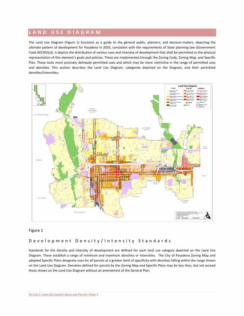
L A N D U S E D I A G R A M
The Land Use Diagram (Figure 1) functions as a guide to the general public, planners, and decision-makers, depicting the
ultimate pattern of development for Pasadena in 2035, consistent with the requirements of State planning law (Government
Code §65302(a)). It depicts the distribution of various uses and intensity of development that shall be permitted as the physical
representation of this element’s goals and policies. These are implemented through the Zoning Code, Zoning Map, and Specific
Plan. These tools more precisely delineate permitted uses and which may be more restrictive in the range of permitted uses
and densities. This section describes the Land Use Diagram, categories depicted on the Diagram, and their permitted
densities/intensities.
Figure 1
D e v e l o p m e n t D e n s i t y / I n t e n s i t y S t a n d a r d s
Standards for the density and intensity of development are defined for each land use category depicted on the Land Use
Diagram. These establish a range of minimum and maximum densities or intensities. The City of Pasadena Zoning Map and
adopted Specific Plans designate uses for all parcels at a greater level of specificity with densities falling within the range shown
on the Land Use Diagram. Densities defined for parcels by the Zoning Map and Specific Plans may be less than, but not exceed
those shown on the Land Use Diagram without an amendment of the General Plan.
SECTION 1: LAND USE ELEMENT GOALS AND POLICIES |PAGE 3
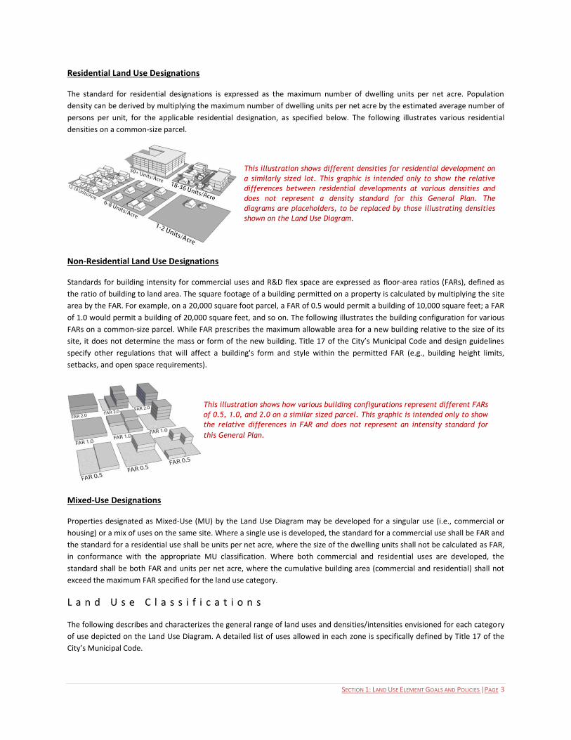
Residential Land Use Designations
The standard for residential designations is expressed as the maximum number of dwelling units per net acre. Population
density can be derived by multiplying the maximum number of dwelling units per net acre by the estimated average number of
persons per unit, for the applicable residential designation, as specified below. The following illustrates various residential
densities on a common-size parcel.
Non-Residential Land Use Designations
Standards for building intensity for commercial uses and R&D flex space are expressed as floor-area ratios (FARs), defined as
the ratio of building to land area. The square footage of a building permitted on a property is calculated by multiplying the site
area by the FAR. For example, on a 20,000 square foot parcel, a FAR of 0.5 would permit a building of 10,000 square feet; a FAR
of 1.0 would permit a building of 20,000 square feet, and so on. The following illustrates the building configuration for various
FARs on a common-size parcel. While FAR prescribes the maximum allowable area for a new building relative to the size of its
site, it does not determine the mass or form of the new building. Title 17 of the City’s Municipal Code and design guidelines
specify other regulations that will affect a building's form and style within the permitted FAR (e.g., building height limits,
setbacks, and open space requirements).
Mixed-Use Designations
Properties designated as Mixed-Use (MU) by the Land Use Diagram may be developed for a singular use (i.e., commercial or
housing) or a mix of uses on the same site. Where a single use is developed, the standard for a commercial use shall be FAR and
the standard for a residential use shall be units per net acre, where the size of the dwelling units shall not be calculated as FAR,
in conformance with the appropriate MU classification. Where both commercial and residential uses are developed, the
standard shall be both FAR and units per net acre, where the cumulative building area (commercial and residential) shall not
exceed the maximum FAR specified for the land use category.
L a n d U s e C l a s s i f i c a t i o n s
The following describes and characterizes the general range of land uses and densities/intensities envisioned for each category
of use depicted on the Land Use Diagram. A detailed list of uses allowed in each zone is specifically defined by Title 17 of the
City’s Municipal Code.
This illustration shows different densities for residential development on
a similarly sized lot. This graphic is intended only to show the relative
differences between residential developments at various densities and
does not represent a density standard for this General Plan. The
diagrams are placeholders, to be replaced by those illustrating densities
shown on the Land Use Diagram.
This illustration shows how various building configurations represent different FARs
of 0.5, 1.0, and 2.0 on a similar sized parcel. This graphic is intended only to show
the relative differences in FAR and does not represent an intensity standard for
this General Plan.
SECTION 1: LAND USE ELEMENT GOALS AND POLICIES |PAGE 4
Housing
The housing land use categories are intended to provide a diversity of living environments and choices, both ownership and
rental, for Pasadena’s residents. These categories are correlated with the goals and policies for affordability defined by the
Housing Element. A minimum and maximum density is defined for each land use category. Affordable housing density bonuses
defined by State law and the Housing Element may exceed the maximum densities.
Low Density Residential. 0-6 dwelling units per acre. Characterized by single-family residential development with lot sizes
ranging from 7,200 square feet to 40,000 square feet and one to two story buildings. These lots are characterized by a variety
of single-family dwellings, ample open space, extensive landscaping, and separations between single-family dwellings and/or
accessory buildings. Single-family dwellings are typically some distance from the street, with large front, side, and rear yard
setbacks.
Low-Medium Density Residential. 0-12 dwelling units per acre. Characterized by a mixture of duplexes and single-family
residential developments in neighborhoods with lot sizes ranging from 7,200 square feet to 40,000 square feet and one to two
story buildings. These lots are characterized by open space, extensive landscaping, and separations between dwellings and/or
permitted accessory buildings. Dwellings are typically some distance to the street, with front, side and rear yard setbacks.
Medium Density Residential. 0-16 dwelling units per acre. Characterized by lower density multi-family complexes in
neighborhoods with densities of up to 16 dwelling units per acre and one to three story buildings. Though not exclusively, many
of these buildings are characterized as “City of Gardens” projects. Their main feature is a centrally located and usable courtyard
or garden court. Units are encouraged to have an entrance toward the street. Parking is not visible from the street and
driveways are minimized. There are minimal setbacks at the rear of the property.
Medium-High Density Residential. 0-32 dwelling units per acre. Characterized by medium-high density multi-family complexes
in neighborhoods with densities of up to 32 dwelling units per acre and one to three story buildings. Though not exclusively,
many of these buildings are characterized as “City of Gardens” projects. Their main feature is a centrally located courtyard or
garden court that is visible from the street. They may have front yards, and if so, they are landscaped and should be similar in
size to the rest of properties in the area. Units are encouraged to have an entrance toward the street. Parking is not visible
from the street and driveways are minimized. There are minimal setbacks at the rear of the property.
High Density Residential. 0-48 dwelling units per acre. Characterized by higher density multi-family complexes in
neighborhoods with densities of up to 48 dwelling units per acre and two to three story buildings. Though not exclusively, many
of these buildings are characterized as “City of Gardens” projects. Their main feature is a centrally located courtyard or garden
court that is visible from the street. Units are encouraged to have an entrance toward the street. Parking is not visible from
the street and driveways are minimized. There are minimal setbacks at the rear of the property.
Urban Housing. 0-87 dwelling units per acre. Characterized by a variety of development types including high-density multi-
family complexes in neighborhoods with densities of up to 87 dwelling units per acre and four to seven story buildings. These
lots are characterized by landscaped courtyards and minimal separations between buildings. Parking is not visible from the
street and driveways are minimized. Units adjacent to the street have direct entries to the street. These buildings are typically
closer to the street, with small sized or no front, side, and rear yard setbacks.
Mixed-Use
The mixed-use land use classifications are intended to afford the intermixing of housing with non-residential uses. This may
consist of a mix of housing types horizontally distributed within a district, block, or parcel, or with housing built above non-
residential uses. Mixed-use development is an important strategy enabling residents to live close to where they work, shop, and
recreate. This can result in less vehicle trips, energy consumption, pollution, noise and greenhouse gas (GHG) emissions and
increases in walking, bicycling, and transit use. It also expands the customer base supporting nearby businesses, enhancing
their economic viability and vitality. Finally, a mix of housing and non-residential uses enhances social interactions and, through
walking and bicycling, human health.
SECTION 1: LAND USE ELEMENT GOALS AND POLICIES |PAGE 5
Low Mixed Use. 0.0-1.0 FAR, 0-32 dwelling units per acre. Intended to support the development of properties and/or buildings
with a mix of compatible uses, including work/live units or ground floor retail and restaurant uses with office and/or residential
uses above. Mixed use buildings may be horizontally or vertically oriented. Sites shall be primarily commercial, but may be
residential in areas specified by Specific Plans.
Low-Medium Mixed Use. 0.0-1.75 FAR, 0-48 dwelling units per acre. Intended to support the development of properties and/or
buildings with a mix of compatible uses, including work/live units, and ground floor retail and restaurant uses with office and/or
residential uses above. Non-mixed use sites shall be primarily commercial, but may be residential in specific areas specified by
Specific Plans. Mixed-use development projects containing housing shall incorporate amenities contributing to a quality living
environment for residents including courtyards, recreation facilities, and similar elements. Where buildings face the street
frontage, they shall be designed to enhance pedestrian activity with transparent facades for retail uses and distinctive entries
for housing. Parking shall be located below or to the rear of the street.
Medium Mixed Use. 0.0-2.25 FAR, 0-87 dwelling units per acre. Intended to support the development of multi-story buildings
with a variety of compatible commercial (retail and office) and residential uses. Development is characterized by shared open
spaces, extensive landscaping, small to medium separations between buildings, and shared driveways and parking. Sites may be
exclusively commercial or exclusively residential, or with buildings vertically integrating housing with non-residential uses.
Mixed-use development projects containing housing shall incorporate amenities contributing to a quality living environment for
residents including courtyards, recreation facilities, and similar elements. Where buildings face the street frontage, they shall
be designed to enhance pedestrian activity with transparent facades for retail uses and distinctive entries for housing. Parking
shall be located below or to the rear of the street. Projects constructed at Medium Mixed Use densities may be required to
develop pedestrian-oriented streetscape amenities along their primary street frontages, consistent with the improvement
concepts and plans defined by the City.
High Mixed Use. 0.0-3.0 FAR, 0-87 dwelling units per acre. Intended to support the development of multi-story mixed use
buildings with a variety of compatible commercial (retail and office) and residential uses. Development is characterized by
shared open spaces, landscaping, and small to minimal separations between buildings, and shared driveways and parking. Sites
may be exclusively commercial, but not exclusively residential. Mixed-use development projects containing housing shall
incorporate amenities contributing to a quality living environment for residents including courtyards, recreation facilities, and
similar elements. Where buildings face the street frontage, they shall be designed to enhance pedestrian activity with
transparent facades for retail uses and distinctive entries for housing. Parking shall be located below or to the rear of the street.
Projects constructed at High Mixed Use densities may be required to develop pedestrian-oriented streetscape amenities along
their primary street frontages, consistent with the improvement concepts and plans defined by the City.
Commercial
Commercial land use classifications accommodate a diversity of uses offering opportunities including retail shopping, personal
and financial services, offices, research and development industries, dining, entertainment, cultural enrichment, and similar
uses. Generally, these are located along or close to Pasadena’s arterial corridors and are accessible to and transition with
adjoining residential neighborhoods.
Low Commercial. 0.0-1.0 FAR. Characterized by a limited range of retail and service uses. These uses are located and designed
to foster pedestrian use, primarily serve the needs of adjacent neighborhoods and maintain compatibility with residential uses
in the immediate area.
Medium Commercial. 0.0-2.0 FAR. Characterized by a wide range of neighborhood-serving commercial uses in Neighborhood
Villages and along major corridors. These uses are designed to foster pedestrian activity and are compatible with residential
uses in the immediate area.
High Commercial. 0.0-3.0 FAR. Characterized by a wide range of regional commercial uses fostering regional office and
incidental retail uses primarily located along Lake Avenue south of the 210 freeway.
SECTION 1: LAND USE ELEMENT GOALS AND POLICIES |PAGE 6
R&D Flex Space. 0.0-1.25 FAR. Characterized by a wide range of industrial uses such as light manufacturing, research and
development, creative office and incubator industries, and limited ancillary commercial and office uses.
Institutional. Characterized by facilities owned and operated by the City or by other public and/or private institutions such as
corporate yards, schools, libraries, and hospitals.
Open Space
The Open Space classification is intended to provide active and passive recreational opportunities for Pasadena’s residents, as
well as the preservation and maintenance of undeveloped lands and natural areas.
Open Space. Characterized by a variety of public and private natural and developed open spaces including City-owned open
space facilities, private golf courses, natural open spaces and areas which have been designated as environmentally and
ecologically significant, and land which is publicly owned though in some instances public access may be restricted.

SECTION 1: LAND USE ELEMENT GOALS AND POLICIES |PAGE 7
L A N D U S E G O A L S A N D P O L I C I E S
The following text presents the goals and policies for land use in the City of Pasadena. They are divided into three sections
including those applicable: (a) globally to all uses and locations in the City, (b) to each principal land use category depicted on
the Land Use Diagram, and (c) to sub-areas of the City including adopted specific plan areas.
Goals are defined as general direction-setters, as an ideal future related to expressions of community values and may be
abstract in nature. Policies are specific statements guiding decision-making indicating commitments to a particular course of
action that carry-out one or more goals.
C i t y w i d e G o a l s a n d P o l i c i e s
Goals and policies in this section globally apply to all land uses and geographic locations in the City.
Growth
Goals and policies provide for community conservation and strategic growth, preserving existing neighborhoods and targeting
new development to infill areas that are vacant or underutilized, and are scaled and designed to complement existing uses.
Changes are grounded by the eight Guiding Principles and emphasize maintaining the quality of life of Pasadena’s residents
with decreased automobile trips, increased walkability, improve connectivity, and create cohesive and vigorous districts and
places.
GOAL 1. Sustainable Growth. Sustainable growth and change in orderly and well-planned developments within targeted areas
that allow for higher density development in an urban core setting and in close proximity to transit that provides for the needs
of existing and future residents and businesses, ensures the effective provision of public services, and makes efficient use of
land, energy, and infrastructure.
Policies
1.1 Basic Growth Policy. Accommodate growth that is consistent with community values and that complements the scale
and character of Pasadena’s unique residential neighborhoods, business districts, and open spaces.
1.2 Targeted Growth. Target growth and new construction in infill areas and away from Pasadena’s residential
neighborhoods and open spaces by redeveloping underutilized commercial and industrial properties, especially within
the Central District, Transit Villages, Neighborhood Villages, and along selected corridors.
SECTION 1: LAND USE ELEMENT GOALS AND POLICIES |PAGE 8
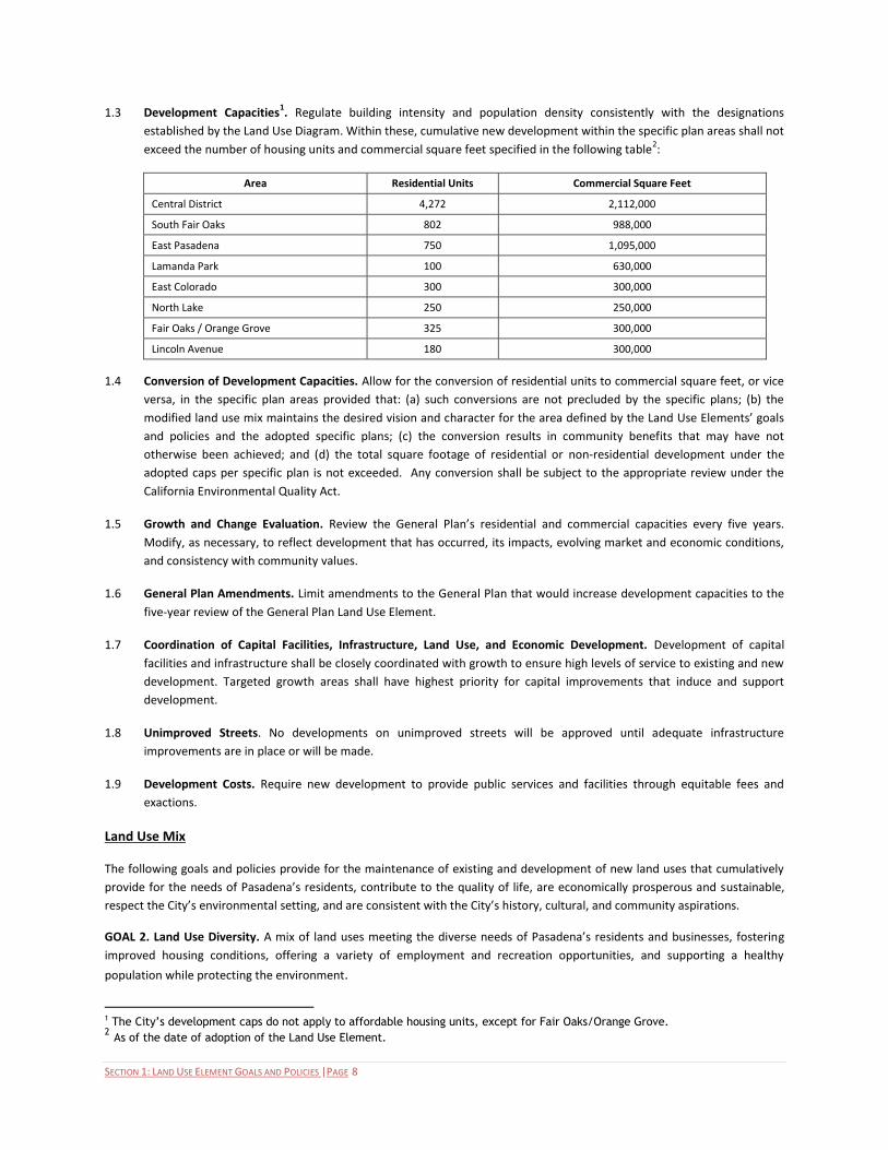
1.3 Development Capacities1. Regulate building intensity and population density consistently with the designations
established by the Land Use Diagram. Within these, cumulative new development within the specific plan areas shall not
exceed the number of housing units and commercial square feet specified in the following table2:
Area Residential Units Commercial Square Feet
Central District 4,272 2,112,000
South Fair Oaks 802 988,000
East Pasadena 750 1,095,000
Lamanda Park 100 630,000
East Colorado 300 300,000
North Lake 250 250,000
Fair Oaks / Orange Grove 325 300,000
Lincoln Avenue 180 300,000
1.4 Conversion of Development Capacities. Allow for the conversion of residential units to commercial square feet, or vice
versa, in the specific plan areas provided that: (a) such conversions are not precluded by the specific plans; (b) the
modified land use mix maintains the desired vision and character for the area defined by the Land Use Elements’ goals
and policies and the adopted specific plans; (c) the conversion results in community benefits that may have not
otherwise been achieved; and (d) the total square footage of residential or non-residential development under the
adopted caps per specific plan is not exceeded. Any conversion shall be subject to the appropriate review under the
California Environmental Quality Act.
1.5 Growth and Change Evaluation. Review the General Plan’s residential and commercial capacities every five years.
Modify, as necessary, to reflect development that has occurred, its impacts, evolving market and economic conditions,
and consistency with community values.
1.6 General Plan Amendments. Limit amendments to the General Plan that would increase development capacities to the
five-year review of the General Plan Land Use Element.
1.7 Coordination of Capital Facilities, Infrastructure, Land Use, and Economic Development. Development of capital
facilities and infrastructure shall be closely coordinated with growth to ensure high levels of service to existing and new
development. Targeted growth areas shall have highest priority for capital improvements that induce and support
development.
1.8 Unimproved Streets. No developments on unimproved streets will be approved until adequate infrastructure
improvements are in place or will be made.
1.9 Development Costs. Require new development to provide public services and facilities through equitable fees and
exactions.
Land Use Mix
The following goals and policies provide for the maintenance of existing and development of new land uses that cumulatively
provide for the needs of Pasadena’s residents, contribute to the quality of life, are economically prosperous and sustainable,
respect the City’s environmental setting, and are consistent with the City’s history, cultural, and community aspirations.
GOAL 2. Land Use Diversity. A mix of land uses meeting the diverse needs of Pasadena’s residents and businesses, fostering
improved housing conditions, offering a variety of employment and recreation opportunities, and supporting a healthy
population while protecting the environment.
1 The City’s development caps do not apply to affordable housing units, except for Fair Oaks/Orange Grove. 2 As of the date of adoption of the Land Use Element.
SECTION 1: LAND USE ELEMENT GOALS AND POLICIES |PAGE 9
Policies
2.1 Housing Choices. Provide opportunities for a full range of housing types, densities, locations, and affordability levels to
address the community’s fair share of regional, senior, and workforce housing needs and provide a strong customer
base sustaining the economic vitality of Pasadena’s commercial land uses. The types, densities, and location of housing
shall be determined by the Land Use Diagram and reflect the projected needs specified in the Housing Element.
2.2 Senior Housing. Encourage the development of senior housing that has access to commercial services, health care
facilities, community facilities, and public transit.
2.3 Commercial Businesses. Designate sufficient land to enable a broad range of viable commercial uses in Pasadena’s
Central District, Transit and Neighborhood Villages, and commercial corridors. These uses will serve both local and
regional needs, reducing the need for residents to travel to adjoining communities, capturing a greater share of local
spending, and offering a diversity of employment opportunities.
2.4 Job Choices. Provide opportunities for the development of a broad range of land uses that offer job opportunities for
Pasadena’s residents, including professional and creative office, institutional and research and development (R&D) flex
space.
2.5 Mixed Use. Create opportunities for development projects that mix housing with commercial uses to enable Pasadena’s
residents to live close to businesses and employment, increasing non-auto travel, and interact socially.
2.6 Transit-Related Land Uses. Promote the development of uses that support and capture the economic value induced by
the presence of transit corridors and stations.
2.7 Civic and Community Services. Provide diverse uses and services supporting Pasadena’s residents such as facilities for
civic governance and administration, public safety (police and fire), seniors and youth, community gatherings, and
comparable activities.
2.8 Equitable Distribution of Community Devices and Amenities. Ensure that parks and recreation facilities, community
services, and amenities are equitably distributed and accessible throughout the City.
2.9 Institutional Uses. Accommodate the development of educational, religious, cultural, and similar facilities that enrich
the lives of Pasadena’s residents.
2.10 Healthy Foods. Promote the development of uses providing healthy and locally-grown food choices for Pasadena’s
residents (i.e., brick and mortar facilities, community gardens, and farmers markets).
2.11 Health Facilities. Accommodate a wide range of healthcare and mental health facilities that are transit-accessible and
pedestrian-friendly.
2.12 Health and Wellness. Adopt a framework of policies that characterize and encourage the connections between access
to locally grown foods, nutritional education, the encouragement of physical activity, and an overall commitment to
health and wellness of Pasadena’s youth, adults, and seniors.
2.13 Parks. Maintain existing and develop new parks and recreational facilities within walking distance of residents,
supporting healthy lifestyles.
2.14 Natural Areas. Maintain existing and acquire additional natural areas to protect watersheds, natural resources, and
afford recreational opportunities for Pasadena’s residents.

SECTION 1: LAND USE ELEMENT GOALS AND POLICIES |PAGE 10
Compatible Land Uses
All communities contain uses and functions necessary for the support and welfare of the population that have characteristics
that could negatively impact their setting. The following goals and policies are intended to manage the distribution and
operations of such uses to assure compatibility with Pasadena’s neighborhoods and districts.
GOAL 3. Compatible Land Uses. A mix and distribution of land uses characterized by their compatibility.
Policies
3.1 High-Impact Uses. Avoid the concentration of uses and facilities in any neighborhood or district where their
intensities, operations, and/or traffic could adversely impact the character, safety, health, and quality of life.
3.2 Care Facilities. Allow for the development of senior daycare facilities, assisted living facilities, hospice, child care, and
other care facilities where they can be located, designed, and managed to ensure compatibility with and the safety of
adjoining uses, consistent with adopted specific plans, Community Places policies and in accordance with state
legislation.
3.3 Assembly Facilities. Require that assembly facilities for social, cultural, educational, and religious organizations be
located, designed, and managed to ensure compatibility and avoid traffic, noise, and other negative impacts with
adjoining uses.
3.4 Filming Locations. Facilitate the use of sites for motion picture and television filming activities while protecting
residential neighborhoods.
3.5 Hazardous Uses. Prohibit or control land uses which pose potential health and environmental hazards to Pasadena’s
neighborhoods and districts.
3.6 Non-Conforming Uses. Encourage the replacement of non-conforming uses to achieve groupings of compatible uses
that conform to the current zoning standards.
3.7 Alcohol and Drug Abuse. Reduce the impact of alcohol and other drug related problems through the regulation and
monitoring of establishments that sell alcohol and drugs. Develop regulations for the location and management of
alcohol and drug related care facilities. Ensure compatibility with and the safety of adjoining uses, in accordance with
state legislation.
Urban Form and Placemaking
"Urban form" is often defined as (a) the "general pattern of building height and development intensity" and (b) the "structural
elements" that define the City physically, such as natural features, transportation corridors, open space, public facilities, as well
as activity centers and focal elements. It envisions the community in three dimensions; 1) how buildings are located on parcels,
2) how buildings relate to one another and 3) how buildings relate to the street – including sidewalks and open spaces. The
following goals and policies guide these elements contributing to distinct and quality places for living, working, shopping,
entertainment, and recreation that contribute to Pasadena’s quality of life, economic vitality, and character.
GOAL 4. Elements Contributing to Urban Form. A safe, well-designed, accessible City with a diversity of uses and forms. These
diverse forms include distinct, walkable districts, corridors, and transit and neighborhood villages and cohesive, unique single
and multi-family residential neighborhoods and open spaces where people of all ages can live, work, shop and recreate.
[Definition of Context: Context refers to external elements that influence an object. These elements can be physical (existing
structures, streetscapes, and natural forms) and non-physical (climactic, cultural identity, or economic imperatives).]

SECTION 1: LAND USE ELEMENT GOALS AND POLICIES |PAGE 11
Policies
4.1 Sustainable Urban Form. Provide an overall pattern of land uses and densities that encourages sustainable
development; offers convenient alternatives to auto travel; ensures compatibility among uses; enhances livability and
public health; sustains economic vitality; and reduces air pollution, greenhouse gas emissions, and energy consumption.
4.2 A Diversity of Places. Maintain and enhance the City’s urban form with distinct, compact, and walkable areas with a
diversity of uses, densities, and characters. Offer choices for living, working, shopping, and recreation consistent with
community values, needs, and demographics.
4.3 An Active Central District. Continue and reinforce the Central District as a vital, pedestrian-oriented place, linked to
local and regional transit designed for all ages and serving as the focal point of community identity, business activity,
employment, living, governance, and culture.
4.4 Transit Villages. Accommodate and intensify a mix of local and regional commercial, residential, and public uses close to
the Metro Gold Line stations. Design these areas to accommodate safe and convenient walking, bicycling, and transit
use. Include gathering places and amenities to enhance their quality and livability.
4.5 Transit Villages in Context. Differentiate the mix and development intensities of the Transit Villages to reflect their
setting, with the highest intensities at Fillmore, Del Mar, Memorial Park and Lake Metro Gold Line stations, moderate
intensities at Sierra Madre Villa station and lowest intensities at the Allen Avenue station.
4.6 Neighborhood Villages. Support neighborhoods through the intensification of development at major intersections to
serve as centers of neighborhood identity and activity. Encourage the clustering of community-oriented commercial
services, housing, and community gathering places with pedestrian-oriented amenities that are accessible and walkable.
4.7 Strengthen Major Corridors. Encourage the economic improvement of underused parcels along Pasadena’s corridors by
clustering more intense uses at major intersections and lower intensity mixed-use or commercial development between
major intersections.
4.8 Complete and Livable Neighborhoods. Maintain the pattern of distinct residential neighborhoods oriented around
parks, schools, and community meeting facilities that are connected to and walkable from neighborhood-serving
businesses and public transit.
4.9 Gateways. Define prominent points of entry to the city with high quality, distinctive architecture or engineering
(consider entry points like the intersection of South Orange Grove Boulevard and West Colorado Boulevard, the
Colorado Street Bridge, or North Fair Oaks at Woodbury). Other elements, including art installations, landscaping, and
light elements are also encouraged.
4.10 Architecture that Enhances. Locate and design buildings to relate to and frame major public streets, open spaces, and
cityscape. New development at intersections should consider any number of corner treatments, and should balance
safety and accessibility concerns with the vision of the area and the need for buildings to engage the street and create a
distinct urban edge.
4.11 Development that is Compatible. Require that development demonstrates a contextual relationship with neighboring
structures and sites addressing such elements as building scale, massing, orientation, setbacks, buffering, the
arrangement of shared and private open spaces, visibility, privacy, automobile and truck access, impacts of noise and
lighting, landscape quality, infrastructure, and aesthetics.
4.12 Transitions in Scale. Require that the scale and massing of new development in higher-density centers and corridors
provide appropriate transitions in building height and bulk and are sensitive to the physical and visual character of
adjoining lower-density neighborhoods.

SECTION 1: LAND USE ELEMENT GOALS AND POLICIES |PAGE 12
4.13 Planned Developments. Incentivize high-quality, contextual, architectural design in Planned Developments through a
discretionary process by allowing for an increase in the allowable Floor Area Ratio for a project, not to exceed a total of
3.0 , and an increase in the allowable residential density not to exceed 87 dwelling units per acre.
GOAL 5. Pedestrian-Oriented Places. Development that contributes to pedestrian vitality and facilitates bicycle use in the
Central District, Transit Villages, Neighborhood Villages, and community corridors.
Policies
5.1 Walkable City. Maintain and improve sidewalks and pedestrian paths in Pasadena’s neighborhoods and business
districts by incorporating street trees, landscaping, and pedestrian-oriented amenities.
5.2 Pedestrian-Oriented Development. Require buildings in the Central District, Transit Villages, Neighborhood Villages, and
along corridors specified by the adopted specific plans to be located along the street/sidewalk and designed to promote
pedestrian activity. This can be accomplished by incorporating transparent facades, small plazas, and dining areas; while
locating parking to the rear or underground and placing primary entries on the street.
5.3 Community Greenways. Improve Pasadena’s public sidewalks as “greenway” corridors with extensive tree canopies,
connecting its neighborhoods, Transit Villages, Neighborhood Villages, neighborhoods, parks, schools, and open spaces.
5.4 Community Connectivity. Improve corridors crossing the 210 Freeway to accommodate safe and convenient walking
and bicycling with landscape, trees, street furniture, and other amenities. This will improve the visual and physical
connectivity of neighborhoods to the north and south. Consider the feasibility for constructing a landscaped deck over
the freeway as an open space amenity and as a means of improving the connections between neighborhoods on either
side of the 210 freeway.
5.5 Civic Center Open Space. Continue to protect the character of the Civic Center as defined by its landscaped open spaces
and tree canopy. Locate and design new civic structures to respect this urban form, character, design, functionality, and
concepts in the Bennett Plan.
5.6 Property Access. Discourage vehicle driveways on streets with higher pedestrian volumes within the Central District,
Transit Villages, and Neighborhood Villages.
5.7 Pedestrian Connections. Support and enhance the pedestrian experience along public and private pedestrian passages,
pathways, courtyards, paseos, alleys, and public walkways with increased connectivity and infrastructure, as well as
businesses located along these pedestrian corridors.
Sense of Place
A diversity of land use strategies contribute to a community’s sense of place and character including the form, scale, and design
of development; its recognition of history and culture; the presence of active public places enabling residents to engage and
socialize with one another; and the ease of access without using the automobile. The quality and character of design of
buildings, places, and infrastructure have distinguished Pasadena’s identity and character throughout its history. The following
goals and policies are intended to preserve and enrich Pasadena’s sense of place and unique character and ensure that new
development is designed to respect these contextual elements.
GOAL 6. Character and Scale of Pasadena. A built environment that evolves while maintaining Pasadena’s unique sense of place, character, and the urban fabric.
Policies
6.1 Sense of Place and History. Require new development and changes to existing development to be located and designed
to respect the defining elements of Pasadena’s character and history such as its grid street pattern, block scale, public

SECTION 1: LAND USE ELEMENT GOALS AND POLICIES |PAGE 13
realm, courtyards, paseos, alleys, neighborhoods and districts, building massing and heights, significant architecture,
and relationship to the mountains and Arroyo Seco.
6.2 Established Neighborhoods. Preserve, protect, and enhance established residential neighborhoods by providing
appropriate transitions between these and adjoining areas. Require new development to complement and respond to
the existing physical characteristics that contribute to the overall character and livability of the neighborhood.
6.3 Form-Based Code. Establish standards regulating the form and scale of development to assure that new construction is
sensitive to the massing, scale, architectural character, landscape design, and relationships to street frontages of
existing uses.
[Definition of Form Based Code: Form-based codes are an alternative to traditional zoning and begin by a addressing
the relationship between building facades and the public realm, the form and mass of buildings in relation to one
another, and the scale and types of streets and blocks. The regulations and standards in form-based codes are
presented in both words and clearly drawn diagrams and other visuals. They are regulations, not mere guidelines,
adopted into city or county law.]
6.4 View sheds. Recognize and protect significant views of the San Gabriel Mountains, the Arroyo Seco, open spaces along
with views of significant structures such as the City Hall cupola, Central Library, and the Civic Auditorium.
6.5 Public Art. Integrate public art in private projects and in public spaces, including streetscapes, parks, and civic spaces.
6.6 Community Maintenance. Eliminate and prevent deteriorating conditions in areas of the City with buildings that are not
properly maintained through private and public conservation and rehabilitation programs.
6.7 Public Safety and Community Design. Require that neighborhoods, centers, streets, and public spaces be designed to
enhance public safety and discourage crime by providing street-fronting uses (“eyes on the street”), adequate lighting
and sight lines, and features that cultivate a sense of community ownership.
GOAL 7. Architectural Design and Quality. Encourage an architecturally distinguished city with a diversity of building styles.
New development will recognize this by supporting a variety of materials, forms, and construction techniques while
demonstrating contextual relationship to its surroundings through traditional physical concepts (orientation, scale, materials)
and non-physical concepts (cultural, climactic, economic).
Policies
7.1 Architectural Quality. Design each building as a high-quality, long term addition to the City’s urban fabric; exterior
design and buildings material shall exhibit permanence and quality, minimize maintenance concerns, and extend the life
of the building.
7.2 Architectural Diversity & Creativity. Allow for the development of a diversity of buildings styles. Support innovative and
creative design solutions to issues related to context and environmental sustainability.
7.3 Compatibility. Require that new and adaptively re-used buildings are designed to respect and complement the defining
built form, massing, scale, modulation, and architectural detailing of their contextual setting.
7.4 Design Review. Require design review for new and redeveloped projects to assure compatibility with community
character, while promoting creativity, innovation, and design quality.
Historic Preservation
Pasadena’s identity and character are significantly influenced by historic buildings, properties, districts, landscapes, and civic
places. The following goals and policies provide for their continued protection and maintenance.

SECTION 1: LAND USE ELEMENT GOALS AND POLICIES |PAGE 14
GOAL 8. Historic Preservation. Preservation and enhancement of Pasadena’s cultural and historic buildings, landscapes, streets
and districts as valued assets and important representations of its past and a source of community identity, and social,
ecological, and economic vitality.
[Definition of a Historic Resource: A district, landscape, object, sign, site, or structure significant in American archeology,
architecture, culture, engineering, or history that is either designated or eligible for designation under City, State, or national
significance criteria.]
Policies
8.1 Identify and Protect Historic Resources. Identify and protect historic resources that represent significant examples of
the City’s history.
8.2 Historic Designation Support. Provide assistance and support for applicants applying for designation of a historic
resource through a clear, thorough, and equitable process that identifies if monuments, individual or landmark districts,
historic signs or landmark trees are eligible for designation based on adopted evaluation criteria.
8.3 Preservation Efforts. Support preservation and restoration efforts through education, facilitation, and incentive
programs.
8.4 Adaptive Reuse. Encourage sensitive adaptive re-use including continuing the historic use of historic resources to
achieve their preservation, sensitive rehabilitation, and continued economic and environmental value.
8.5 Scale and Character of New Construction in a Designated Landmark and Historic Districts. Promote an architecturally
sensitive approach to new construction in Landmark and Historic districts. Demonstrate the proposed project’s
contextual relationship with land uses and patterns, spatial organization, visual relationships, cultural and historic
values, and relationships in height, massing, modulation, and materials.
8.6 Infrastructure and Street Design Compatibility. Encourage street design, public improvements, and utility infrastructure
that preserves and is compatible with historic resources.
8.7 Preservation of Historic Landscapes. Identify, protect, and maintain cultural and natural resources associated with a
historic event, activity, or person or exhibiting other cultural or aesthetic values.
8.8 Evolving Preservation Practices. Continue to implement practices for historic preservation consistent with community
values and conformance with the Secretary of the Interior’s Standards for the Treatment of Historic Properties,
California Historical Building Code, State laws, and best practices.
8.9 Maintenance. Support and encourage maintenance and upkeep of historic resources to avoid the need for major
rehabilitation and to reduce the risk of demolition, loss through fire, deterioration by neglect, or impacts from natural
disasters.
8.10 Enforcement. Ensure that City enforcement procedures and activities comply with local, State, and Federal historic
preservation requirements and fosters the preservation of historic resources.
Arts and Culture
The integration of public art into the built environment contributes to the identity of Pasadena and the cultural life of its
residents. The following goals and policies build upon existing programs to enhance these opportunities.
GOAL 9. Public Art. Pasadena’s public art is an integral part of the City, reinforcing its visual character, reflecting the strength of
its cultural and educational institutions, responding to its urban design initiatives and promoting dialogue across ethnic and
generational lines. Public art in Pasadena reinforces neighborhood character and contributes to a beautiful, sustainable and
livable Pasadena.

SECTION 1: LAND USE ELEMENT GOALS AND POLICIES |PAGE 15
Policies
9.1 Art as Identity. Use public art to reinforce Pasadena’s identity, blending culture, people, neighborhoods, and ideas to
create a memorable urban landscape that respects the past and creates a legacy for the future.
9.2 Urban Beautification. Embrace public arts as a citywide urban beautification effort. Build a collection of art in public
places. Facilitate public art and public art partnerships with City Departments, private developers, and arts and cultural
organizations.
9.3 Gateway Improvements. Incorporate works of artists as components of public improvements at the City’s unique
gateways.
9.4 Arts Contributions to a More Walkable City. Implement artist-designed crosswalks, murals, free-standing artworks, and
environments in pedestrian-oriented retail and entertainment districts.
9.5 Public Art Reflecting Parks and Neighborhoods. Commission public art that reinforces the identity of parks and
neighborhoods, highlights neighborhood amenities through pedestrian-oriented artworks, and connects people with the
natural environment through environmental-based artworks.
9.6 Public Art in Private Development Program. Refine the Public Art in Private Development Program to more actively
contribute to Pasadena’s cultural identity and reinforce the City’s Urban Design principles.
9.7 Support Cultural Activities. Encourage individuals, organizations, educational institutions, and other entities to provide
and support cultural activities, directly and cooperatively with the City, which are of interest and benefit to the public.
9.8 Arts Resources. Promote expanded access to all available arts resources.
A Sustainable Environment
Pasadena maintains a robust program of actions designed to meet the underlying objectives for conserving and reducing the
consumption of and impacts on natural resources such as water, energy, and other non-renewable resources. The following
goals and policies describe contributing land use and development strategies.
GOAL 10. City Sustained and Renewed. Development and infrastructure practices that sustain natural environmental resources
for the use of future generations and, at the same time, contribute to the reduction of greenhouse gas emissions and impacts
on climate change.
General Policies
10.1 Environmental Quality and Conservation. Establish Pasadena as a leader on environmental stewardship efforts,
including air quality protection, energy and water efficiency, renewable energy standards, natural resource
conservation, and greenhouse gas emission standards in the areas of energy, water, air and land.
Land Use Development Policies
10.2 Land Uses Supporting Sustainability. Encourage land uses and improvements that reduce energy and water
consumption, waste and noise generation, air quality impacts and support other comparable resource strategies for a
sustainable Pasadena; including alternative energy generation, electric vehicle parking and charging, recycling, and
similar facilities.
SECTION 1: LAND USE ELEMENT GOALS AND POLICIES |PAGE 16
10.3 Best Practices for Sustainability. Monitor evolving sustainable development practices and technologies and implement
those deemed appropriate and feasible in Pasadena.
10.4 Sustainable Building Practices. Foster sustainable building practices and processes specified by the City’s Green Building
Code by incorporating energy and water savings, toxic and solid waste reduction strategies into the building of new
structures and remodeling of existing structures.
10.5 Greenhouse Gas Reduction Plans. Require major development projects3 to prepare greenhouse gas reduction plans.
10.6 Adaptive Reuse. Encourage adaptive reuse of structures, including non-historic structures, as a means of supporting
environmental sustainability.
10.7 Landscape. Encourage sustainable practices for landscape materials, landscape design, and land development.
10.8 Cool Pavement. Study the feasibility of implementing cool pavement strategies – pavement technologies that reflect
more solar energy and enhance water evaporation – in an effort to reduce the urban heat island effect.
Natural Environment Policies
10.9 Natural Open Space. Protect natural open spaces, hillsides, watersheds, and critical habitats to safeguard the health,
safety, and beauty of the City for the benefit of present and future generations.
10.10 Expanded Natural Areas. Expand the City’s inventory of natural open spaces through reclamation, restoration, and
acquisition, in partnership with local and regional agencies and private institutions.
10.11 Eaton Canyon Corridor and the Arroyo Seco. Preserve and maintain the natural character of the Eaton Canyon Corridor
and the Arroyo Seco as self-sustaining healthy ecosystems of plants and animals, in balance with the integration of
recreational facilities and flood control improvements.
10.12 Urban Open Spaces. Preserve and develop urban open spaces such as landscaped parklets, paseos, courtyards, and
community gardens. Ensure adequate public access to these opens spaces.
10.13 Urban Forest. Maintain and plant additional trees along the City’s sidewalks, civic places, parks, and in private
developments to support the health and diversity of wildlife, sequester GHG emissions, and contribute to the reduction
of the urban heat-island.
10.14 Native Plants. Maintain and, where appropriate, restore, areas of the city with native plants.
10.15 Open Space Connectivity. Maintain and, where possible, restore wildlife corridors and habitat linkages.
Sustainable Energy & Infrastructure Policies
10.16 Infrastructure. Design, construct, maintain, and improve Pasadena’s infrastructure to conserve and reduce impacts to
the natural environment.
10.17 Greenstreets. Transform impervious street surfaces into landscaped green spaces, in appropriate and reasonable
locations, to capture stormwater runoff and let water soak into the ground so that plants and soils can filter pollutants.
This will contribute to the protection of water quality in the Arroyo Seco watershed and reduction of pollution/trash
entering Los Angeles and San Gabriel Rivers and the ocean.
10.18 Water Quality. Encourage the use of natural processes to capture, treat, and infiltrate urban runoff throughout the
watershed. In appropriate and feasible locations, construct stormwater curb extensions and street planters to transform
3 Includes commercial projects 75,000 square feet or greater, multi-family projects with 100 units or more, and mixed use project 50 units or more as required by the Trip Reduction Ordinance
SECTION 1: LAND USE ELEMENT GOALS AND POLICIES |PAGE 17
impervious street surfaces into landscaped green spaces that capture stormwater runoff and let water soak into the
ground as plants and soil filter pollutants.
10.19 Sustainable Transportation Network. Implement an integrated network of transit, bike facilities, and pedestrian
improvements as specified by the Mobility Element to reduce automobile trips and commute lengths, with
corresponding reductions in energy consumption, pollution, and GHG emissions.
10.20 Alternative Fuel. Provide locations for alternative fuel facilities, such as charging stations for electric vehicles.
10.21 Sustainable Energy. Reduce the use of coal generated power by new development through building design and
sustainable practices.
A Sustainable Economy
A vital and healthy economy is considered an essential element of a sustainable community. Without economic prosperity, the
resources needed for conserving the natural environment and achieving the health and well-being of Pasadena’s residents
would be compromised. The following goals and polices provide the foundation for and are directly correlated with the types,
densities, and capacities of land use specified in earlier sections of this Element.
GOAL 11. Job Opportunities. Provide land use capacities that accommodate a diversity of job opportunities for Pasadena’s
residents.
Policies
11.1 Business Expansion and Growth. Support the growth and success of businesses that create new job opportunities and
productive and satisfying employment for Pasadena residents.
11.2 Workforce Development. Align workforce development strategies with job skills needed to support Pasadena’s key
business clusters. Keep the local workforce trained and employed by allowing for a broad range of job training
opportunities. Focus on creating jobs and providing training to create individual and family economic self-sufficiency.
11.3 New and Complementary Businesses. Identify opportunity sites for expansion of successful Pasadena companies and
attraction of new establishments that are complementary with Pasadena’s Central District, neighborhood and transit
villages, and commercial corridors.
11.4 Barriers. Reduce barriers to gainful employment such as lack of public transportation, training, job information, and
child care.
GOAL 12. Shopping and Dining. Diversity of shopping opportunities enabling Pasadena’s residents to acquire desired goods and
services in the City, as well as attracting customers from surrounding communities.
Policies
12.1 Vital Commercial Districts. Enhance commercial districts to create quality shopping and dining experiences.
12.2 Business Attraction. Actively market Pasadena to increase demand for storefront space.
12.3 Adequate Parking. Coordinate public/private parking improvements and policies to support local business.
12.4 Revitalization of Commercial Areas. Encourage the revitalization of commercial and industrial areas by attracting
private investment.
12.5 Small Businesses. Encourage the retention and expansion of small businesses through incentives, by providing adequate
infrastructure and street beautification. Promote locating of small businesses as integral to the identity of the
neighborhood villages.

SECTION 1: LAND USE ELEMENT GOALS AND POLICIES |PAGE 18
12.6 Local Businesses. Support the development of Pasadena-grown and based retail businesses as an alternative to national
chain brands.
GOAL 13. Innovation. An environment fostering innovation and creativity enabling Pasadena to be on the “cutting-edge” of
business development and jobs generation.
Policies
13.1 Environment. Cultivate an entrepreneurial and academic environment that fosters innovation.
13.2 Business Sectors. Strengthen Pasadena’s technology and innovation sectors.
13.3 Adaptation to Evolving Market Demands. Advance policies and practices that encourage the creation and preservation
of flexible commercial and light industrial space.
13.4 New Businesses. Create incentives for the development of laboratory and research and development businesses.
Promote the spinoff of new businesses from existing institutions, such as The California Institute of Technology, Jet
Propulsion Laboratory, Huntington Memorial Hospital, and others.
13.5 Creative/Innovation Employment Centers. Provide for the clustering of creative, research, and incubator/“start-up”
industries. Leverage the intellectual capital of Pasadena’s educational institutions creating distinct and cohesive centers
offering new employment opportunities for its residents.
GOAL 14. Visitors. Pasadena is a major destination for tourists from throughout the world to celebrate its events, culture,
history, and setting.
Policies
14.1 Tourism and Hospitality. Encourage the growth of cultural assets and entertainment activities that attract visitors and
conventioneers.
14.2 Conventions and Lodging. Grow a variety of lodging options and attract more lucrative conventions.
14.3 Community Events. Promote positive exposure of local assets and events.
GOAL 15. Sound Local Economy. A sound local economy which attracts investment, increases the tax base, creates
employment for Pasadena residents and generates public revenues.
Policies
15.1 Local Investment. Advance local investment to support a robust and consistent resource for municipal revenues and
opportunities that support community services and improvements.
15.2 Education. Develop a well-educated work force that will fuel a healthy economy by expanding collaborative efforts
between the City of Pasadena and Pasadena Unified School District (e.g., joint-use agreements, grant funding, and
planning efforts).
Community Services
In the broadest sense, the City of Pasadena is committed to implementing policies supporting human development and the
quality of life for infants, children, youth, families and senior citizens, and recognizes that the well-being of its residents is linked
to the City’s own health and well-being. The City of Pasadena has a Policy on Children, Youth and Family developed in 1989 that
ensures a family focus on quality of life, an Early Child Development Policy adopted in 2015 that emphasizes access to quality
early education, a 2013-16 School/City/Community Work Plan that ensures the Human Development and Educational needs are
met of students so they graduate college and career ready, and a Senior Strategic Plan approved in 1995 that ensures successful
SECTION 1: LAND USE ELEMENT GOALS AND POLICIES |PAGE 19
aging around key areas such as transportation and housing. One aspect of these efforts is the Healthy Cities project,
implemented by multiple departments within the City. The following goals and policies maintain and build on these programs.
GOAL 16. Superior Services. A superior level of services meeting the needs of Pasadena’s diverse residents including schools,
hospitals, parks, child and senior facilities and programs, libraries, shelters, public auditoriums, health facilities, social clubs and
recreation centers.
16.1 Commitment. Provide human and community services to all sectors of the City’s population in an equitable manner.
16.2 Service Adequacy. Periodically review the impacts of major physical, environmental, economic and social changes
identifying their implications in meeting the service needs of Pasadena’s residents.
16.3 Anticipated Needs. Ensure that the land use planning process anticipates the future human services needs of the
community by utilizing the data compiled by the new evaluation methods identifying the type(s) and ideal location(s) for
these services.
16.4 Support Organizations. Provide support to public, private, and voluntary organizations and associations that provide
services for Pasadena’s diverse communities.
16.5 Child Care. Provide adequate child care facilities, encouraging locating facilities at or near work sites and public
transportation.
16.6 Accessible Services. Locate human services close to those who need them and encourage broad community
participation in the planning, resource allocation, and evaluation of all programs.
16.7 Shared Facilities. Encourage the sharing of facilities between various public service providers, as well as those offered
by private entities, such as the joint use of school play areas for recreation, school facilities for child and after school day
care, and libraries for civic and cultural events.
16.8 Coordination of Human Services. Prioritize coordination of facilities and programs between public and private agencies
and between various levels of government involved in the human service field. Aim to eliminate overlapping efforts in
the human service field.
Education
Pasadena’s commitment to public education and a diverse educational system responsive to the needs of the community is a
fundamental principle framing the General Plan and Land Use Element. The following goals and policies express a variety of
strategies supporting a quality education for all residents and life-long learning opportunities.
GOAL 17. Educational System. A strong and diverse educational system that is responsive to the life-long needs of the
community and related to maintaining a high quality of life and a strong economy.
Policies
17.1 Joint-Use. Partner with public schools, and when appropriate, private schools, colleges and universities by sharing
facilities, information and resources including parks and playgrounds, libraries, community centers, and day care
facilities.
17.2 Career Exposure. Leverage the presence of the California Institute of Technology, Fuller Theological Seminary, and the
Arts Center College of Design. Encourage coordination between these institutions and the local educational system to
promote a range of mentorship and career planning opportunities from not-for-profit and charitable sectors, to creative
and artistic endeavors, to scientific and mathematic fields. Support vocational training and school-to-career programs
that help students gain early exposure to careers and mentors.
SECTION 1: LAND USE ELEMENT GOALS AND POLICIES |PAGE 20
17.3 Long-Range Planning for Public Schools. Encourage the Pasadena Unified School District to continue to participate in
the City’s planning process and collaborate with the City on site selection, site design, traffic control, circulation and site
acquisition to ensure compatibility with the neighborhoods or districts in which they are located.
17.4 Long-Range Planning for Private Schools. Require private schools to collaborate with the City on site selection, site
design, traffic control, circulation and site acquisition to ensure compatibility with the neighborhoods or districts in
which they are located.
17.5 Funding. Collaborate with the Pasadena Unified School District and other public institutions to pursue funding, such as
grants, to improve both public schools and community facilities, to gather information, and to leverage existing
resources.
17.6 Supporting Uses. Encourage uses that support educational institutions, such as afterschool day care, tutoring centers,
bookstores, dance schools, art classes, and karate studios, to cluster around schools located in commercial areas.
Correlation of Land Use with Mobility
By statute, the types and intensities of development permitted by the Land Use Plan must be correlated with the ability to
provide adequate mobility to residents and visitors consistent with community values for acceptable levels of congestion. A
primary principle defined by General Plan and Land Use Element is that Pasadena will be a city where people can circulate
without a car. Implementation of the mix and densities of uses depicted on the Land Use Diagram and urban form policies will
promote walking, bicycling, and transit use achieving this objective. The following goals and policies express the relationship
between land use development and mobility.
GOAL 18. Land Use/Transportation Relationship. Pasadena will be a City where there are effective and convenient alternatives
to using cars and the relationship of land use and transportation is acknowledged through transit-oriented development, multi-
modal design features, and pedestrian and bicycle amenities in coordination with and accordance with the Mobility Element.
Policies
18.1 Development Mix and Densities. Accommodate the mix and density of land uses and urban form that induce walking,
bicycling, and transit use as an alternative to the automobile, as specified by the Land Use Diagram.
18.2 Mobility. Correlate land use development intensities with adequate infrastructure improvements and transportation
strategies to ensure mobility in all areas of Pasadena.
18.3 Modal Choices. Promote the development of infrastructure supporting walking, bicycling, and transit use and complete
streets as specified by the Mobility Element.
18.4 Transit-Pedestrian Coordination. Implement physical improvements facilitating pedestrian access from development
projects to the street, bus stops, and/or transit stations.
18.5 Land Use-Mobility Compatibility. Manage vehicle traffic volumes and speeds to improve their compatibility with the
character of the adjacent land uses, the function of the street(s), and bicycle and pedestrian traffic.
18.6 Relationship of Buildings to Transit Stops. Require that building entrances or accessways be oriented toward transit
stops when located adjacent to these facilities.
Parking
Parking standards for Pasadena’s residential neighborhoods and commercial districts and corridors vary according to land use
type, density, and proximity to transit stations. Areas with higher density, mixed-use development projects in proximity to
transit stations require fewer parking spaces than other areas in recognition of the increased potential for transit ridership and
local walkability. These standards are established and periodically reviewed and adjusted through the City’s Zoning Ordinance.

SECTION 1: LAND USE ELEMENT GOALS AND POLICIES |PAGE 21
The following goals and policies define a strategy to provide sufficient parking consistent with the vision, land use mix,
densities, and access to alternative transportation modes.
GOAL 19. Parking Availability. The supply of parking will reflect Pasadena’s objective to protect residential neighborhoods;
create a vital, healthy, and sustainable economy; establish Pasadena as a leader in environmental stewardship; encourage
physical activity and a commitment to health and wellness; and encourage walking, biking, and transit. The supply of parking in
an area will also reflect the type, mix, and density of uses; the availability of shared facilities; and the proximity to transit.
Policies
19.1 Parking Standards. Establish, periodically review, and adjust as necessary parking standards to ensure an adequate
supply of parking commensurate with the vision, uses, densities, availability of alternative modes, and proximity to
transit stations in the area.
19.2 Parking Limits. Establish limits on the amount of parking that may be developed for projects in the Central District
and Transit Villages to promote walking, bicycling, and use of transit as an alternative to the automobile.
19.3 Parking Management. Manage parking to reduce the amount of land devoted to frequently vacant parking lots
through parking management tools.
19.4 Park Once. Provide the opportunity for residents, patrons and visitors to park once and visit many destinations in the
Central District, Transit Villages, and Neighborhood Villages through centrally located shared parking while providing
additional flexibility for businesses to provide parking off-site or participate in other alternative parking funding
mechanisms.
19.5 Bicycle Parking. Accommodate the development of bicycle parking centers in the Central District, Transit Villages, and
Neighborhood Villages and require larger development projects to incorporate secured and convenient bicycle
parking facilities.
19.6 Unbundled Parking. Encourage practices that separate the cost of parking from commercial lease rates, the costs of
housing, and – where feasible – the price of goods and services to ensure that non-car owners do not pay for parking
they do not need and help people weigh the true cost of driving in lieu of transit.
19.7 Reduced Demand for Parking. Reduce the demand for parking by encouraging businesses and residential
development to incentivize walking, biking, and use of transit through practices such as subsidized Metro passes,
exchanging parking for Metro passes, and other creative incentives.
Public Involvement and Participation
Pasadena’s residents are actively engaged in the discussion and deliberations for community policies and land use decision-
making. The following goals and policies build on this history and provide for continued opportunities as projects and
improvements are considered implementing the goals and policies of this element.
GOAL 20. Information and Participation. All Pasadena communities will be uniformly aware and participate in land use
planning, entitlement processes, and decision-making processes through the communication of clear and understandable
information and engagement opportunities.
Policies
20.1 Neighborhood Meetings. Encourage broad representation and community participation at all steps of the planning
process.
20.2 Brochures and Notices. Provide notices and information regarding the review and entitlement process for proposed
development projects enabling the public to provide input in decision-making. Ensure supporting documents, such as

SECTION 1: LAND USE ELEMENT GOALS AND POLICIES |PAGE 22
staff reports dealing with land use matters, are easily accessible on the City website and are provided in a timely
manner.
20.3 Public Involvement and Proposed Projects. Improve neighborhood participation in current planning and land use
decisions by affording adequate opportunity to review and comment on plans, programs, activities and reports covering
the City’s land use projects.
20.4 Neighborhood Connections. Utilize the Neighborhood Connections office to send notices of neighborhood meetings
and public hearings to neighborhood associations within a reasonable radius of a proposed project and to the Pasadena
Neighborhood Coalition.
20.5 Public Discussion. Increase public discussion through the use of new technology, providing multiple locations, times,
communication avenues for public involvement and discussion of long range planning initiatives.

SECTION 1: LAND USE ELEMENT GOALS AND POLICIES |PAGE 23
L A N D U S E C A T E G O R I E S
The following presents the goals and policies for each principal category of permitted land uses depicted on the Land Use
Diagram and described earlier in this element.
Residential Neighborhoods
Pasadena’s residential neighborhoods are principal contributors to the City’s history, identity, character, and quality of life. The
goals and policies in this section provide for their conservation and maintenance regardless of density and assurance that
changes and new development complement their distinguishing qualities.
GOAL 21. Desirable Neighborhoods. A City composed of neighborhoods with a variety of housing types that are desirable
places to live, contribute to the quality of life, and are well maintained.
Policies
21.1 Adequate and Affordable Housing. Provide a variety of housing types (i.e. small subdivisions, row housing, and
condominiums), styles, densities, and affordability levels that are accessible to and meet preferences for different
neighborhood types (e.g., mixed use pedestrian environments and traditional suburban neighborhoods), physical
abilities and income levels, pursuant to the Housing Element.
21.2 Equitable Distribution of Affordable Housing. Providing for the equitable distribution of affordable housing throughout
the City, as defined by Housing Element goals and policies, capitalizing on opportunities for new development allowed
by the densities permitted in the Central District and Transit Villages.
21.3 Neighborhood Character. Maintain elements of residential streets that unify and enhance the character of the
neighborhood, including parkways, street trees, and compatible setbacks.
21.4 New Residential Development. Attract new residential development that is well-conceived, constructed, and
maintained in a variety of types, densities, locations and costs.
21.5 Housing Character and Design. Encourage the renovation of existing housing stock in single- and multi-family
neighborhoods. When additions or replacement housing is proposed, these should reflect the unique neighborhood
character and qualities, including lot sizes; building form, scale, massing, and relationship to street frontages;
architectural design and landscaped setbacks.
21.6 Walkable Neighborhoods. Manage vehicle speeds and maintain sidewalks, parkways, street tree canopies, and
landscaping throughout residential neighborhoods. Encourage walking as an enjoyable and healthy activity and
alternative to automobile use.
21.7 Safety. Require residential developments to facilitate and enhance neighborhood safety by including design features
such as front porches or large front windows.
21.8 Housing Maintenance. Encourage the maintenance and improvement of existing residential units through community
cleanups and other organized events, to assure high quality and healthy living environment for residents.
21.9 Hillside Housing. Maintain appropriate scale, massing and access to residential structures located in hillside areas.
21.10 Neighborhood Parks and Open Space Amenities. Ensure that existing neighborhoods contain a diverse mix of parks and
open spaces that are connected by trails, pathways, and bikeways and are within easy walking distance of residents.
21.11 Neighborhood-Oriented Schools. Encourage a mutually beneficial relationship between public schools and their
surrounding neighborhoods so that schools contribute to neighborhood identity by allowing facilities to be used by
community groups, making open space available, and creating community volunteer work days.
SECTION 1: LAND USE ELEMENT GOALS AND POLICIES |PAGE 24
GOAL 22.0. Single-Family Neighborhoods. Distinct and quality single-family residential neighborhoods distinguished by their
identity, scale, and character.
Policies
22.1 Appropriate Scale and Massing. Discourage mansionization by requiring building scale and massing that is compatible
with existing development in single-family residential neighborhoods.
22.2 Garages and Accessory Structures. Locate and design garages and accessory structures so that they do not dominate
the appearance of the dwelling from the street.
GOAL 23. Multi-Family Neighborhoods. Multi-family residential neighborhoods that provide ownership and rental
opportunities, exhibit a high quality of architectural design, and incorporate amenities for their residents.
Policies
23.1 Character and Design. Design and modulate buildings to avoid the sense of “blocky” and undifferentiated building mass,
incorporate well-defined entries, and use building materials, colors, and architectural details complementing the
neighborhood, while allowing flexibility for distinguished design solutions.
23.2 Parking Areas and Garages. Minimize the visibility of parking areas and garages.
23.3 Landscaped Setbacks and Walkways. Provide appropriate setbacks, consistent with the surrounding neighborhood,
along the street frontage and, where there are setbacks, ensure adequate landscaping is provided.
23.4 Development Transitions. Ensure sensitive transitions in building scale between buildings in multi-family residential
areas and lower-scale buildings in adjoining residential areas.
23.5 Streetscapes. Provide ample public spaces and tree-lined sidewalks furnished with pedestrian amenities that contribute
to comfortable and attractive settings for pedestrian activity.
23.6 Open Space Amenities. Require that open space is provided on-site, is accessible, and of sufficient size to be usable by
residents, in common areas and/or with individual units pursuant to the Zoning Code.
GOAL 24. Supporting Uses in Residential Neighborhoods. Supporting uses that meet the needs of residents located and
designed to be subordinate to, and compatible with, the function and quality of the residential environment.
Policies
24.1 Home Occupations. Allow home-based businesses in residential districts, subject to rules that reduce potential negative
impacts.
24.2 Compatible Non-Residential Uses. Allow for the continuation of existing and development of new child and adult day
care, religious, and educational facilities in any land use zone where they are compatible with adjacent uses.
24.3 Access to Amenities. Encourage residential developments to be designed to provide safe and convenient pedestrian and
bicycle access to nearby commercial centers, community facilities, parks, open space, transit facilities, bikeways, trails
and other amenities, as applicable.
SECTION 1: LAND USE ELEMENT GOALS AND POLICIES |PAGE 25
Commercial Corridors and Districts
Pasadena contains a diversity of commercial corridors and districts providing opportunities for shopping, working, dining,
entertainment, services, and similar activities. These constitute places for commerce and gathering where residents and visitors
come together in their daily lives. Many of the corridors and centers at arterial intersections exhibit characteristics supportive
of automobile access and parking, with buildings setback from the street and unrelated to their neighbors. In contrast,
development in the Central District concentrates buildings along the street frontages with parking located to the rear or in
shared facilities, fostering active pedestrian use of the street front. The goals and policies in this section accommodate
additional development implementing goals and policies defined for a sustainable economy (Goals 11 through 15).
GOAL 25. Vital Districts and Corridors. Diverse, active, prosperous, and well-designed commercial corridors and districts that
provide a diversity of goods, services, and entertainment and contribute to a positive experience for residents and visitors.
25.1 Diversity of Uses. Encourage the development of a broad range of commercial uses that reduce the need to travel to
adjoining communities, while capturing a greater share of local spending.
25.2 Compact Infill Development. Encourage commercial uses along major corridors, in Neighborhood Villages, and as infill
development adjacent to existing commercial uses and on surface parking lots to improve commercial services,
maximize revenue generation, and leverage concentrating commercial uses.
25.3 Cohesive Development. Encourage the cohesive development and/or master planning of large commercial sites and
corridors.
25.4 Architecture and Site Design. Require that new development protect community character by providing architecture,
landscaping, and urban design of equal or greater quality than existing and by respecting the architectural character and
scale of adjacent buildings.
25.5 Connectivity to Neighborhoods. Link commercial areas to adjoining residential neighborhoods and other districts by
well-designed and attractive streetscapes with pedestrian sidewalks and street amenities.
25.6 Multi-Use of Public Alleys. Consider alleys as multi-use public spaces that buffer commercial uses from residential areas
and serve circulation, parking, utilities, loading areas and trash receptacles. They may also provide access to paseos, rear
commercial entries, multiple storefronts and public use areas.
25.7 Buffering Adjoining Residential Areas. Ensure commercial uses adjoining residential neighborhoods or mixed residential
and commercial uses are designed to be compatible with each other.
25.8 Pedestrian, Bicycle and Transit Access. Require commercial projects to be designed to promote convenient pedestrian
and bicycle access to and from nearby neighborhoods, transit facilities, bikeways, and other amenities.
25.9 Maintenance. Require proper maintenance of commercial areas to ensure they reflect community expectations for a
quality environment and remain competitive with commercial facilities located outside of the City.
25.10 Retail. Designate land and develop guidelines for the development of pedestrian friendly commercial areas, each with
their own unique identity.
25.11 Retail Streetscapes. Maintain and, where deficient, increase street trees, plantings, furniture, signage, public art and
other amenities that encourage pedestrian activity in retail districts and corridors.
25.12 Retail Parking. Develop alternative parking management strategies for businesses in areas with limited parking (such as
East Washington Boulevard) while protecting nearby residential neighborhoods implementing such techniques as park
once and shared lots and structures.
SECTION 1: LAND USE ELEMENT GOALS AND POLICIES |PAGE 26
GOAL 26. Offices. A diversity of professional, creative, medical, research, and other offices offering attractive job opportunities
for residents, and serving as a centerpiece of Pasadena’s economy.
Policies
26.1 Office. Encourage the orderly development and expansion of office uses based upon current conditions and future
projects to improve the relationship of jobs and housing in certain areas of the City.
26.2 Creative Office. Allow additional flexibility for creative office spaces to locate and grow in non-traditional areas and
areas with desirable amenities for employees.
GOAL 27. R&D Flex Space. A wide range of moderate to low-intensity industrial uses such as light manufacturing, research and
development, creative office and incubator industries encouraging the development of new industries induced by the presence
of Pasadena’s educational institutions and medical facilities.
Policies
27.1 Diversity of Uses. Provide for a variety of industrial and commercial-industrial uses that offer job opportunities for
Pasadena’s residents and revenues to the City without compromising environmental quality.
27.2 Business Attraction. Allow sufficient densities that enable development of technology, digital, research and
development, and creative industries offering new job opportunities for residence.
27.3 Supporting Uses. Maintain a predominant industrial character, while allowing the integration of compatible uses in
industrial areas that serve the needs of employees and reduce the need to travel off-site during the workday, including
such uses as financial services, business services, restaurants, and health and recreational facilities.
27.4 Buffering from Adjacent Properties. Ensure that industrial developments incorporate adequate landscape buffers to
minimize any negative impacts to surrounding neighborhoods and development, and controlling on-site lighting, noise,
odors, vibrations, toxic materials, truck access, and other elements that may impact adjoining uses.
27.5 Impact Mitigation. Cooperate with those agencies concerned with monitoring and controlling the emissions of smoke,
particulate matter, noise, and odor associated with industrial uses.
27.6 Adaptive Reuse. Encourage the adaptive reuse of buildings (especially mid-century structures) for research and
development and flex space by providing additional flexibility in parking standards.
Mixed-Use Corridors and Villages
Mixed-use corridors and villages provide for the intermixing of housing with commercial uses, enabling residents to live close to
where they shop, work, recreate, enjoy entertainment and culture, and participate in civic events. Research indicates that
Pasadena’s Central District enjoys a lower per capita trip generation and increased pedestrian activity due to the mix and
density of these uses, as well as proximity to Metro Gold Line stations. The Land Use Diagram provides opportunities for new
mixed-use development in the Central District, adjoining transit stations in a series of “Transit Villages,” as central gathering
places for surrounding residential neighborhoods in “Neighborhood Villages,” and in designated areas along the City’s arterial
streets. These may occur in the form of buildings with housing above lower level retail or office uses, or horizontally distributed
on a property or larger area. The goals and policies in this section implement these opportunities.
GOAL 28. Places to Live, Work, Shop, and Recreate. A diversity of well-designed corridors and villages containing an integrated
mix of commercial uses and/or housing that enable Pasadena’s residents to live close to businesses, services, and employment,
reduce automobile use, and actively engage and enhance pedestrian activity.
SECTION 1: LAND USE ELEMENT GOALS AND POLICIES |PAGE 27
Policies
28.1 Land Use Mix. Allow for the development of properties and buildings in areas designated as “Mixed Use” for a mix of
compatible commercial and residential uses.
28.2 Development Scale. Establish standards to assure that an adequate scale and footprint of any single use is achieved in
mixed-use areas to establish a cohesive environment that minimizes impacts attributable to the adjacency of different
uses. This may define minimum parcel and building size, number of housing units, and/or nonresidential square
footage, as well as relationships and setbacks.
28.3 On-site Amenities. Require that residential/nonresidential mixed-use projects provide on-site amenities that contribute
to the living environment of residents such as courtyards, outdoor barbecues, and recreation facilities.
28.4 Design Integration. Require residential and nonresidential portions of mixed-use buildings and sites to be integrated
through architectural design, development of pedestrian walkways and landscaping.
GOAL 29. Transit Villages. Moderate to high density mixed-use clusters of residential and commercial uses developed in an
integrated “village-like” environment with buildings clustered on common plazas and open spaces in proximity to Metro Gold
Line stations capitalizing on their induced market demands and land values, facilitating ridership, and reducing automobile use
while increasing walkability.
Policies
29.1 Mix of Uses. Accommodate mixed-use development permitted by the applicable land use classification on the Land Use
Diagram, whether it is horizontally or vertically integrated, as an essential component to the creation and
implementation of the Transit Village vision.
29.2 Neighborhood Identity. Design Transit Villages to be distinct, cohesive, and pedestrian-oriented places that are linked
with and walkable from adjoining neighborhoods.
29.3 Pedestrian Orientation. Require the inclusion of improvements and amenities to create a safe and comfortable
environment for sitting, meeting neighbors and friends, walking and providing easy access to Metro Gold Line station
areas and a mix of uses in close proximity to the station.
29.4 Bicycle Facilities. Provide adequate bicycle facilities within one mile of Metro Gold Line station areas and throughout
Transit Villages.
GOAL 30. Neighborhood Villages. Lower density mixed-use clusters of residential and commercial uses developed in an
integrated “village-like” environment with buildings clustered on common plazas and open spaces designed as communal
places that are walkable from surrounding neighborhoods.
Policies
30.1 Mix of Uses. Accommodate mixed-use development permitted by the applicable land use classification shown on the
Land Use Diagram, whether it is horizontally or vertically integrated, as an essential component to the creation and
implementation of the Neighborhood Village vision.
30.2 Development at Key Nodes. Encourage development at key intersections and on surface parking lots within
neighborhood villages that result in additional neighborhood-serving amenities and intensified economic vitality.
30.3 Neighborhood Identity. Design neighborhood villages to be distinct, cohesive, and pedestrian-oriented places that are
linked with and walkable from nearby residential neighborhoods.
SECTION 1: LAND USE ELEMENT GOALS AND POLICIES |PAGE 28
30.4 Community Activity. Foster neighborhood villages to be the center of community activity by assisting uses and services
desired by the community to locate in these areas (restaurants; coffee shops; community theaters; yoga, dance, or
karate studios; etc.)
30.5 Connectivity to Neighborhoods. Link neighborhood villages to adjoining residential neighborhoods through safe,
convenient, well-designed pedestrian sidewalks and bicycle facilities.
30.6 Pedestrian Orientation. Encourage neighborhood serving land uses to provide access to services and goods by walking
or bicycle.
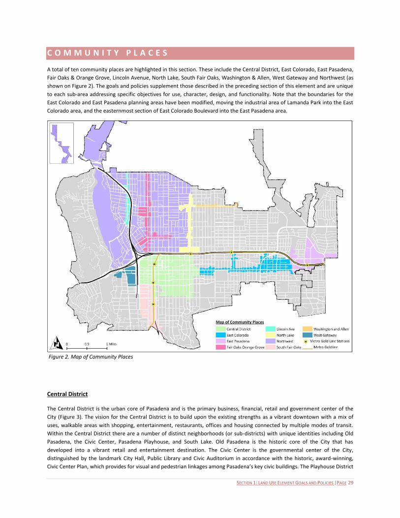
SECTION 1: LAND USE ELEMENT GOALS AND POLICIES |PAGE 29
C O M M U N I T Y P L A C E S
A total of ten community places are highlighted in this section. These include the Central District, East Colorado, East Pasadena,
Fair Oaks & Orange Grove, Lincoln Avenue, North Lake, South Fair Oaks, Washington & Allen, West Gateway and Northwest (as
shown on Figure 2). The goals and policies supplement those described in the preceding section of this element and are unique
to each sub-area addressing specific objectives for use, character, design, and functionality. Note that the boundaries for the
East Colorado and East Pasadena planning areas have been modified, moving the industrial area of Lamanda Park into the East
Colorado area, and the easternmost section of East Colorado Boulevard into the East Pasadena area.
Central District
The Central District is the urban core of Pasadena and is the primary business, financial, retail and government center of the
City (Figure 3). The vision for the Central District is to build upon the existing strengths as a vibrant downtown with a mix of
uses, walkable areas with shopping, entertainment, restaurants, offices and housing connected by multiple modes of transit.
Within the Central District there are a number of distinct neighborhoods (or sub-districts) with unique identities including Old
Pasadena, the Civic Center, Pasadena Playhouse, and South Lake. Old Pasadena is the historic core of the City that has
developed into a vibrant retail and entertainment destination. The Civic Center is the governmental center of the City,
distinguished by the landmark City Hall, Public Library and Civic Auditorium in accordance with the historic, award-winning,
Civic Center Plan, which provides for visual and pedestrian linkages among Pasadena’s key civic buildings. The Playhouse District
Figure 2. Map of Community Places
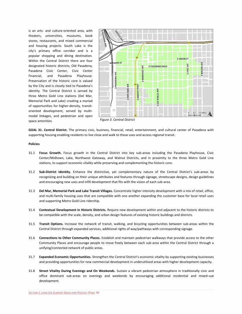
SECTION 1: LAND USE ELEMENT GOALS AND POLICIES |PAGE 30
is an arts- and culture-oriented area, with
theaters, universities, museums, book
stores, restaurants, and mixed commercial
and housing projects. South Lake is the
city’s primary office corridor and is a
popular shopping and dining destination.
Within the Central District there are four
designated historic districts; Old Pasadena,
Pasadena Civic Center, Civic Center
Financial, and Pasadena Playhouse.
Preservation of the historic core is valued
by the City and is closely tied to Pasadena’s
identity. The Central District is served by
three Metro Gold Line stations (Del Mar,
Memorial Park and Lake) creating a myriad
of opportunities for higher-density, transit-
oriented development, served by multi-
modal linkages, and pedestrian and open
space amenities.
GOAL 31. Central District. The primary civic, business, financial, retail, entertainment, and cultural center of Pasadena with
supporting housing enabling residents to live close and walk to these uses and access regional transit.
Policies
31.1 Focus Growth. Focus growth in the Central District into key sub-areas including the Pasadena Playhouse, Civic
Center/Midtown, Lake, Northwest Gateway, and Walnut Districts, and in proximity to the three Metro Gold Line
stations, to support economic vitality while preserving and complementing the historic core.
31.2 Sub-District Identity. Enhance the distinctive, yet complementary nature of the Central District’s sub-areas by
recognizing and building on their unique attributes and features through signage, streetscape designs, design guidelines
and encouraging new uses and infill development that fits with the vision of each sub-area.
31.3 Del Mar, Memorial Park and Lake Transit Villages. Concentrate higher intensity development with a mix of retail, office,
and multi-family housing uses that are compatible with one another expanding the customer base for local retail uses
and supporting Metro Gold Line ridership.
31.4 Contextual Development in Historic Districts. Require new development within and adjacent to the historic districts to
be compatible with the scale, density, and urban design features of existing historic buildings and districts.
31.5 Transit Options. Increase the network of transit, walking, and bicycling opportunities between sub-areas within the
Central District through expanded services, additional rights of way/pathways with corresponding signage.
31.6 Connections to Other Community Places. Establish and maintain pedestrian walkways that provide access to the other
Community Places and encourage people to move freely between each sub-area within the Central District through a
unifying/connected network of public areas.
31.7 Expanded Economic Opportunities. Strengthen the Central District’s economic vitality by supporting existing businesses
and providing opportunities for new commercial development in underutilized areas with higher development capacity.
31.8 Street Vitality During Evenings and On Weekends. Sustain a vibrant pedestrian atmosphere in traditionally civic and
office dominant sub-areas on evenings and weekends by encouraging additional residential and mixed-use
development.
Figure 3. Central District

SECTION 1: LAND USE ELEMENT GOALS AND POLICIES |PAGE 31
31.9 Housing Choice. Provide a wide variety of housing options in the Central District in terms of the type, location, size and
price.
31.10 Building Orientation. Require businesses to be oriented primarily to pedestrian streets and urban spaces and
secondarily to parking lots and to provide visibility and accessibility to customers arriving on foot, by bicycle, and by
automobile.
31.11 Public Art Overlay Zone. Create a Public Art Overlay Zone to preserve and enhance existing art in the Civic Center area.
East Colorado
The East Colorado sub-area extends easterly
from the Central District (Catalina Avenue to
Kinneloa Avenue). It is an irregularly shaped
area incorporating properties fronting
Colorado Boulevard and Allen Avenue
between Colorado and the Metro Gold Line
station, and larger districts extending south
to Green Street in the west and northeast
towards the 210 freeway (Lamanda Park,
formerly part of the East Pasadena Specific
Plan area) (Figure 4). The vision for this area
is its transformation from largely auto-
oriented strip uses into a series of
pedestrian-oriented villages and districts
with unique identities, bolstered by their
vibrant mix of uses, amenities and
streetscapes improving their walkability and
appearance.
The overall objective for the planning area is
to break up long stretches of strip commercial with residential uses and cluster commercial uses in nodes. Potential residential
development may be converted to non-residential floor area, but nonresidential area may not be converted to allow additional
residential units. Neighborhood Villages would be established along Colorado Boulevard in the vicinity of Hill Street and Sierra
Madre Boulevard containing a mix of commercial and residential uses with pedestrian-oriented amenities and plazas. Their mix
of uses and design would serve as a gathering place and be walkable from adjoining neighborhoods. The Village near Pasadena
City College would offer unique opportunities to serve and provide new housing opportunities for students and faculty. The
Allen Transit Village capitalizes on its proximity to the Metro Gold Line station by accommodating medium-density commercial
and residential development, served by multi-modal linkages, and pedestrian and open space amenities. Mechanisms would be
employed to protect the single-family residential area north of the freeway on Allen from the impacts of the light rail station.
The Lamanda Park sub-area offers the opportunity to serve as an incubator for creative technology, and medical start-up
industries, capitalizing on their proximity to Pasadena’s esteemed academic institutions. Directly connected to the Colorado
Boulevard commercial corridor, this district will provide new jobs for Pasadena’s residents and customers to invigorate existing
retail businesses.
GOAL 32. East Colorado. A series of pedestrian-oriented villages and districts with unique identities, bolstered by their vibrant
mix of uses, amenities and streetscapes improving their walkability and appearance.
Figure 4. East Colorado
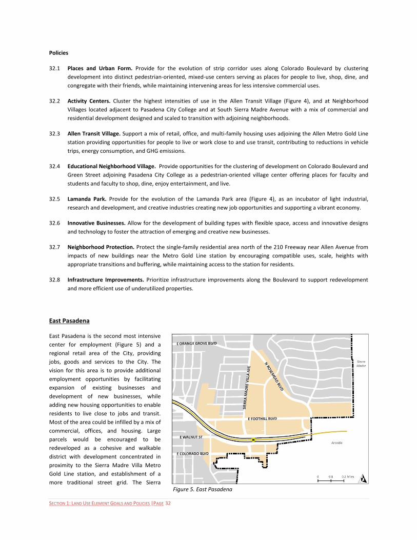
SECTION 1: LAND USE ELEMENT GOALS AND POLICIES |PAGE 32
Policies
32.1 Places and Urban Form. Provide for the evolution of strip corridor uses along Colorado Boulevard by clustering
development into distinct pedestrian-oriented, mixed-use centers serving as places for people to live, shop, dine, and
congregate with their friends, while maintaining intervening areas for less intensive commercial uses.
32.2 Activity Centers. Cluster the highest intensities of use in the Allen Transit Village (Figure 4), and at Neighborhood
Villages located adjacent to Pasadena City College and at South Sierra Madre Avenue with a mix of commercial and
residential development designed and scaled to transition with adjoining neighborhoods.
32.3 Allen Transit Village. Support a mix of retail, office, and multi-family housing uses adjoining the Allen Metro Gold Line
station providing opportunities for people to live or work close to and use transit, contributing to reductions in vehicle
trips, energy consumption, and GHG emissions.
32.4 Educational Neighborhood Village. Provide opportunities for the clustering of development on Colorado Boulevard and
Green Street adjoining Pasadena City College as a pedestrian-oriented village center offering places for faculty and
students and faculty to shop, dine, enjoy entertainment, and live.
32.5 Lamanda Park. Provide for the evolution of the Lamanda Park area (Figure 4), as an incubator of light industrial,
research and development, and creative industries creating new job opportunities and supporting a vibrant economy.
32.6 Innovative Businesses. Allow for the development of building types with flexible space, access and innovative designs
and technology to foster the attraction of emerging and creative new businesses.
32.7 Neighborhood Protection. Protect the single-family residential area north of the 210 Freeway near Allen Avenue from
impacts of new buildings near the Metro Gold Line station by encouraging compatible uses, scale, heights with
appropriate transitions and buffering, while maintaining access to the station for residents.
32.8 Infrastructure Improvements. Prioritize infrastructure improvements along the Boulevard to support redevelopment
and more efficient use of underutilized properties.
East Pasadena
East Pasadena is the second most intensive
center for employment (Figure 5) and a
regional retail area of the City, providing
jobs, goods and services to the City. The
vision for this area is to provide additional
employment opportunities by facilitating
expansion of existing businesses and
development of new businesses, while
adding new housing opportunities to enable
residents to live close to jobs and transit.
Most of the area could be infilled by a mix of
commercial, offices, and housing. Large
parcels would be encouraged to be
redeveloped as a cohesive and walkable
district with development concentrated in
proximity to the Sierra Madre Villa Metro
Gold Line station, and establishment of a
more traditional street grid. The Sierra Figure 5. East Pasadena
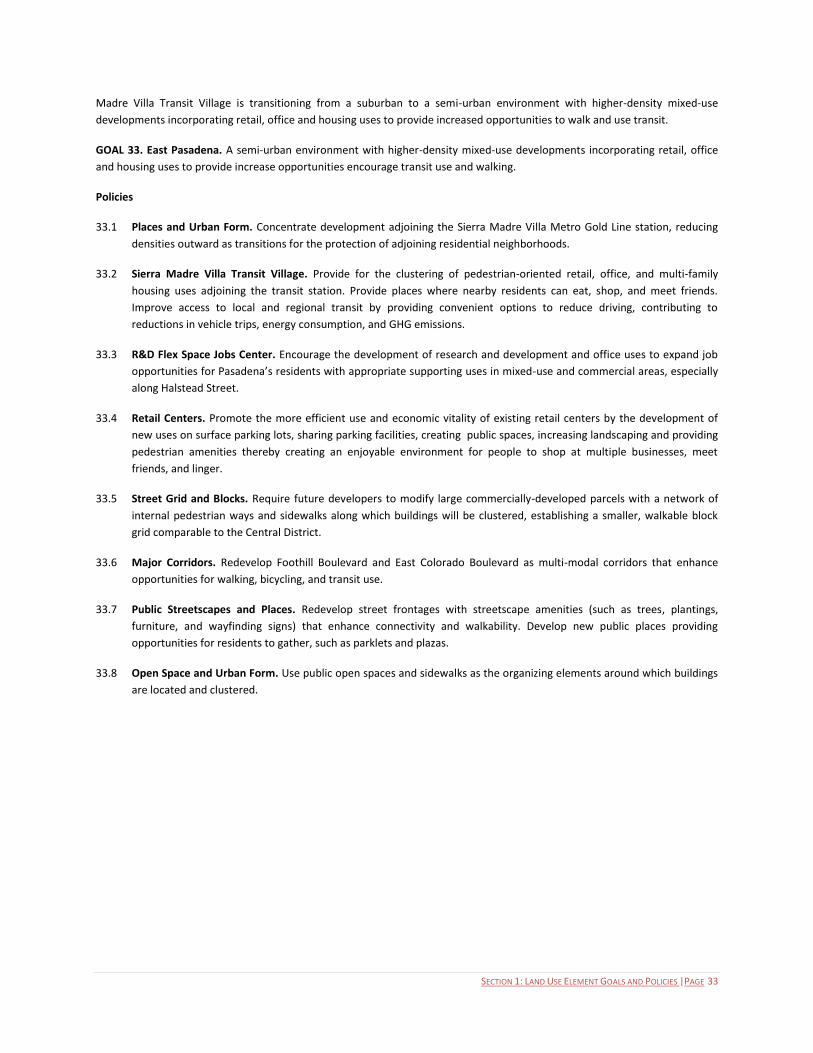
SECTION 1: LAND USE ELEMENT GOALS AND POLICIES |PAGE 33
Madre Villa Transit Village is transitioning from a suburban to a semi-urban environment with higher-density mixed-use
developments incorporating retail, office and housing uses to provide increased opportunities to walk and use transit.
GOAL 33. East Pasadena. A semi-urban environment with higher-density mixed-use developments incorporating retail, office
and housing uses to provide increase opportunities encourage transit use and walking.
Policies
33.1 Places and Urban Form. Concentrate development adjoining the Sierra Madre Villa Metro Gold Line station, reducing
densities outward as transitions for the protection of adjoining residential neighborhoods.
33.2 Sierra Madre Villa Transit Village. Provide for the clustering of pedestrian-oriented retail, office, and multi-family
housing uses adjoining the transit station. Provide places where nearby residents can eat, shop, and meet friends.
Improve access to local and regional transit by providing convenient options to reduce driving, contributing to
reductions in vehicle trips, energy consumption, and GHG emissions.
33.3 R&D Flex Space Jobs Center. Encourage the development of research and development and office uses to expand job
opportunities for Pasadena’s residents with appropriate supporting uses in mixed-use and commercial areas, especially
along Halstead Street.
33.4 Retail Centers. Promote the more efficient use and economic vitality of existing retail centers by the development of
new uses on surface parking lots, sharing parking facilities, creating public spaces, increasing landscaping and providing
pedestrian amenities thereby creating an enjoyable environment for people to shop at multiple businesses, meet
friends, and linger.
33.5 Street Grid and Blocks. Require future developers to modify large commercially-developed parcels with a network of
internal pedestrian ways and sidewalks along which buildings will be clustered, establishing a smaller, walkable block
grid comparable to the Central District.
33.6 Major Corridors. Redevelop Foothill Boulevard and East Colorado Boulevard as multi-modal corridors that enhance
opportunities for walking, bicycling, and transit use.
33.7 Public Streetscapes and Places. Redevelop street frontages with streetscape amenities (such as trees, plantings,
furniture, and wayfinding signs) that enhance connectivity and walkability. Develop new public places providing
opportunities for residents to gather, such as parklets and plazas.
33.8 Open Space and Urban Form. Use public open spaces and sidewalks as the organizing elements around which buildings
are located and clustered.
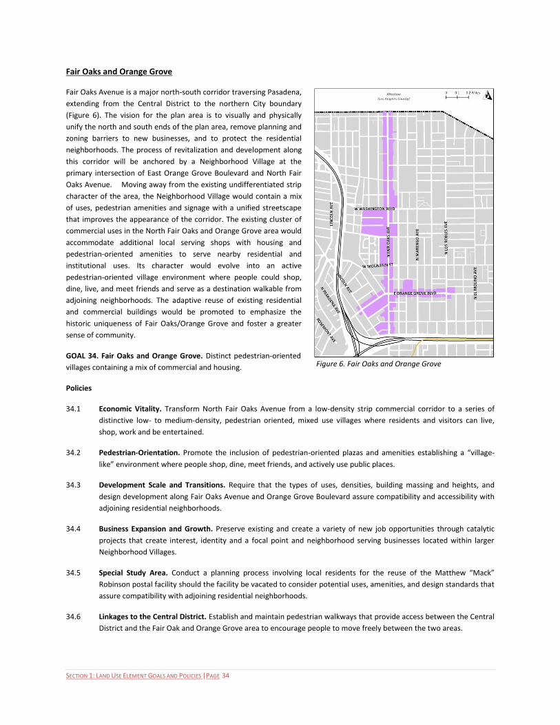
SECTION 1: LAND USE ELEMENT GOALS AND POLICIES |PAGE 34
Fair Oaks and Orange Grove
Fair Oaks Avenue is a major north-south corridor traversing Pasadena,
extending from the Central District to the northern City boundary
(Figure 6). The vision for the plan area is to visually and physically
unify the north and south ends of the plan area, remove planning and
zoning barriers to new businesses, and to protect the residential
neighborhoods. The process of revitalization and development along
this corridor will be anchored by a Neighborhood Village at the
primary intersection of East Orange Grove Boulevard and North Fair
Oaks Avenue. Moving away from the existing undifferentiated strip
character of the area, the Neighborhood Village would contain a mix
of uses, pedestrian amenities and signage with a unified streetscape
that improves the appearance of the corridor. The existing cluster of
commercial uses in the North Fair Oaks and Orange Grove area would
accommodate additional local serving shops with housing and
pedestrian-oriented amenities to serve nearby residential and
institutional uses. Its character would evolve into an active
pedestrian-oriented village environment where people could shop,
dine, live, and meet friends and serve as a destination walkable from
adjoining neighborhoods. The adaptive reuse of existing residential
and commercial buildings would be promoted to emphasize the
historic uniqueness of Fair Oaks/Orange Grove and foster a greater
sense of community.
GOAL 34. Fair Oaks and Orange Grove. Distinct pedestrian-oriented
villages containing a mix of commercial and housing.
Policies
34.1 Economic Vitality. Transform North Fair Oaks Avenue from a low-density strip commercial corridor to a series of
distinctive low- to medium-density, pedestrian oriented, mixed use villages where residents and visitors can live,
shop, work and be entertained.
34.2 Pedestrian-Orientation. Promote the inclusion of pedestrian-oriented plazas and amenities establishing a “village-
like” environment where people shop, dine, meet friends, and actively use public places.
34.3 Development Scale and Transitions. Require that the types of uses, densities, building massing and heights, and
design development along Fair Oaks Avenue and Orange Grove Boulevard assure compatibility and accessibility with
adjoining residential neighborhoods.
34.4 Business Expansion and Growth. Preserve existing and create a variety of new job opportunities through catalytic
projects that create interest, identity and a focal point and neighborhood serving businesses located within larger
Neighborhood Villages.
34.5 Special Study Area. Conduct a planning process involving local residents for the reuse of the Matthew “Mack”
Robinson postal facility should the facility be vacated to consider potential uses, amenities, and design standards that
assure compatibility with adjoining residential neighborhoods.
34.6 Linkages to the Central District. Establish and maintain pedestrian walkways that provide access between the Central
District and the Fair Oak and Orange Grove area to encourage people to move freely between the two areas.
Figure 6. Fair Oaks and Orange Grove
SECTION 1: LAND USE ELEMENT GOALS AND POLICIES |PAGE 35
Lincoln Avenue
Lincoln Avenue is a commercial corridor near the 210 Freeway in Northwest
Pasadena (Figure 7). For decades, it has been the location of small‐scale industrial
businesses, many with outdoor operations. While Pasadena certainly supports a
vibrant local industrial sector, districts in the City other than the Lincoln Avenue
corridor are better suited and have been designated for such purposes. Lincoln
Avenue is a western gateway that serves many distinctive residential
neighborhoods and brings visitors to the Rose Bowl and Brookside Park. The
corridor merits a new life based on the important local and citywide functions it is
well‐positioned to serve. The vision for Lincoln Avenue is to repurpose the Lincoln
Avenue corridor from an industrial and limited commercial area into a vibrant
neighborhood‐oriented district, with new housing options and a complement of
local‐serving retail and service businesses, office spaces, and community uses, all
tied together with public improvements that create a vibrant and enjoyable
pedestrian environment.
GOAL 35. Lincoln Avenue. A vibrant neighborhood‐oriented district, with new
housing options and a complement of local‐serving retail and service businesses,
office spaces, and community uses, all tied together with public improvements that
create a vibrant and enjoyable pedestrian environment.
Policies
35.1 Neighborhood Core. Create a neighborhood “main street” that will serve as
the focal point for the neighborhoods surrounding Lincoln Avenue.
35.2 Residential Neighborhoods. Preserve and enhance existing residential
areas.
35.3 New Housing. Provide new opportunities for all types of housing along the corridor including multi-family housing and
mixed-use residential-commercial developments in its core that are located, scaled, and designed to assure
compatibility with and preserve neighboring single-family residential uses.
35.4 Catalytic Projects. Facilitate opportunities for catalytic developments that provide desired neighborhood‐oriented retail
and service businesses, local employment opportunities, and a link to the community.
35.5 Re-Use of Industrial Properties. Provide for the gradual phasing out of industrial uses that create conflicts with
surrounding neighborhoods.
35.6 Quality Design. Support design that contributes to the enhanced character of the City and Northwest Pasadena in
particular.
35.7 Pedestrian Environment. Enrich the pedestrian environment along Lincoln Avenue through well designed and
appropriately scaled projects and pleasing streetscapes with wide sidewalks, street trees and signage that helps to
establish the Lincoln Avenue identity.
35.8 Investment. Encourage investment, maintenance, and pride in the Lincoln Avenue Specific Plan area.
35.9 A Safe Neighborhood. Enhance public safety.
35.10 Mobility Choices. Redesign Lincoln Avenue to accommodate a mix of mobility choices including walking, bicycling, and
transit in addition to the automobile.
Figure 7. Lincoln Avenue

SECTION 1: LAND USE ELEMENT GOALS AND POLICIES |PAGE 36
North Lake
North Lake Avenue is a major north-south commercial corridor traversing Pasadena
extending from the Central District to Elizabeth Street (Figure 8). The vision for
North Lake is to transform its automobile-oriented character with pockets of
commercial and residential uses into a well-designed and attractive corridor
supporting multiple travel modes including transit, bicycling, and walking with
clusters of distinctive places for shopping, dining, and living. These will serve and be
accessible to residents of adjoining neighborhoods, with the types of uses limited
and buildings located and designed to transition to and assure compatibility. Areas
around the Lake Metro Gold Line station will accommodate a mix of higher density
office, commercial, and residential uses fostering transit ridership and access to and
from the region. Existing commercial properties at the intersection with
Washington Boulevard would accommodate additional commercial and residential
uses with public open spaces and amenities in a “village-like” environment as a
destination for neighborhood shopping, dining, and gathering for local residents.
GOAL 36. North Lake. A well-designed and attractive corridor supporting multiple
travel modes including transit, bicycling, and walking with clusters of distinctive
places for shopping, dining, and living.
Policies
36.1. Economic Vitality of the Avenue. Transform North Lake Avenue from a
low-density strip commercial corridor to series of distinctive low- to
medium-density, pedestrian oriented, mixed use villages designed and
scaled to transition with adjoining residential neighborhoods where
residents and visitors can live, shop, work and be entertained.
36.2 Lake Transit Village. Provide for the development of higher intensity mix of retail, office, and multi-family housing
uses in proximity to the Metro Gold Line station that expand the customer base for local businesses and support
Metro Gold Line ridership contributing to the reduction of vehicle trips, energy consumption, and GHG emissions.
36.3 Lake-Washington Neighborhood Village. Promote the development of additional commercial uses with housing and
pedestrian-oriented plazas and amenities to establish a “village-like” environment where people shop, dine, meet
friends, linger, and actively use public places.
36.4 Neighborhood Compatibility. Require that the types of use and location, scale, and design of development buffer
commercial and mixed-use development on Lake Avenue from adjoining lower density residential neighborhoods.
36.5 Transitional Heights and Setbacks. Protect adjacent Low Density Residential and Low-Medium Density Residential
areas north of Orange Grove Boulevard, which contain a number of locally and nationally recognized historic
properties and districts, from the development of mixed use or residential projects by requiring appropriate
transitional heights. Mixed use or residential projects proposed in these locations shall be limited to no more than
three stories in height for those portions of the project abutting commercial streets, stepping down to no more than
two stories in height abutting the Low and Low-Medium residential areas. Appropriate setbacks shall also be
established in order to provide further protection.
36.6 Accessibility. Design Lake Avenue and Washington Boulevard as complete streets that accommodate transit, bicycle,
and pedestrian use. Include wider sidewalks, public plazas, parks and parklets, bike lanes, and bicycle parking.
Figure 8. North Lake
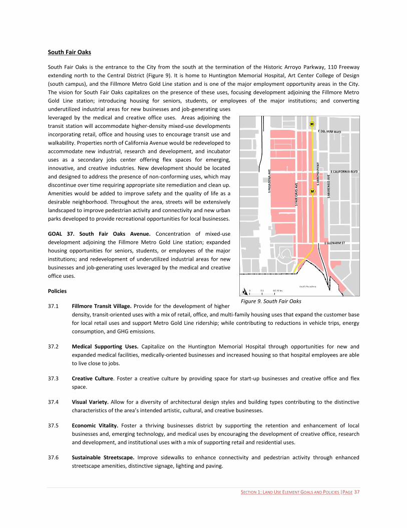
SECTION 1: LAND USE ELEMENT GOALS AND POLICIES |PAGE 37
South Fair Oaks
South Fair Oaks is the entrance to the City from the south at the termination of the Historic Arroyo Parkway, 110 Freeway
extending north to the Central District (Figure 9). It is home to Huntington Memorial Hospital, Art Center College of Design
(south campus), and the Fillmore Metro Gold Line station and is one of the major employment opportunity areas in the City.
The vision for South Fair Oaks capitalizes on the presence of these uses, focusing development adjoining the Fillmore Metro
Gold Line station; introducing housing for seniors, students, or employees of the major institutions; and converting
underutilized industrial areas for new businesses and job-generating uses
leveraged by the medical and creative office uses. Areas adjoining the
transit station will accommodate higher-density mixed-use developments
incorporating retail, office and housing uses to encourage transit use and
walkability. Properties north of California Avenue would be redeveloped to
accommodate new industrial, research and development, and incubator
uses as a secondary jobs center offering flex spaces for emerging,
innovative, and creative industries. New development should be located
and designed to address the presence of non-conforming uses, which may
discontinue over time requiring appropriate site remediation and clean up.
Amenities would be added to improve safety and the quality of life as a
desirable neighborhood. Throughout the area, streets will be extensively
landscaped to improve pedestrian activity and connectivity and new urban
parks developed to provide recreational opportunities for local businesses.
GOAL 37. South Fair Oaks Avenue. Concentration of mixed-use
development adjoining the Fillmore Metro Gold Line station; expanded
housing opportunities for seniors, students, or employees of the major
institutions; and redevelopment of underutilized industrial areas for new
businesses and job-generating uses leveraged by the medical and creative
office uses.
Policies
37.1 Fillmore Transit Village. Provide for the development of higher
density, transit-oriented uses with a mix of retail, office, and multi-family housing uses that expand the customer base
for local retail uses and support Metro Gold Line ridership; while contributing to reductions in vehicle trips, energy
consumption, and GHG emissions.
37.2 Medical Supporting Uses. Capitalize on the Huntington Memorial Hospital through opportunities for new and
expanded medical facilities, medically-oriented businesses and increased housing so that hospital employees are able
to live close to jobs.
37.3 Creative Culture. Foster a creative culture by providing space for start-up businesses and creative office and flex
space.
37.4 Visual Variety. Allow for a diversity of architectural design styles and building types contributing to the distinctive
characteristics of the area’s intended artistic, cultural, and creative businesses.
37.5 Economic Vitality. Foster a thriving businesses district by supporting the retention and enhancement of local
businesses and, emerging technology, and medical uses by encouraging the development of creative office, research
and development, and institutional uses with a mix of supporting retail and residential uses.
37.6 Sustainable Streetscape. Improve sidewalks to enhance connectivity and pedestrian activity through enhanced
streetscape amenities, distinctive signage, lighting and paving.
Figure 9. South Fair Oaks
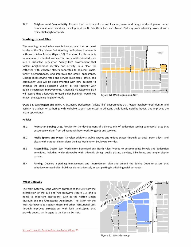
SECTION 1: LAND USE ELEMENT GOALS AND POLICIES |PAGE 38
37.7 Neighborhood Compatibility. Require that the types of use and location, scale, and design of development buffer
commercial and mixed-use development on N. Fair Oaks Ave. and Arroyo Parkway from adjoining lower density
residential neighborhoods.
Washington and Allen
The Washington and Allen area is located near the northeast
border of the City, where East Washington Boulevard intersects
with North Allen Avenue (Figure 10). The vision for this area is
to revitalize its limited commercial automobile-oriented uses
into a distinctive pedestrian “village-like” environment that
fosters neighborhood identity and activity, is a place for
gathering with walkable streets connected to adjacent single-
family neighborhoods, and improves the area’s appearance.
Existing local-serving retail and service businesses, office, and
community uses will be supplemented with new business to
enhance the area’s economic vitality; all tied together with
public streetscape improvements. A parking management plan
will assure that adaptively re-used older buildings would not
impact the adjoining neighborhoods.
GOAL 38. Washington and Allen. A distinctive pedestrian “village-like” environment that fosters neighborhood identity and
activity, is a place for gathering with walkable streets connected to adjacent single-family neighborhoods, and improves the
area’s appearance.
Policies
38.1 Pedestrian-Serving Uses. Provide for the development of a diverse mix of pedestrian-serving commercial uses that
encourage walking from adjacent neighborhoods for goods and services.
38.2 Public Spaces and Places. Develop additional public spaces and unique places through parklets, green alleys, and
plazas with outdoor dining along the East Washington Boulevard corridor.
38.3 Accessibility. Design East Washington Boulevard and North Allen Avenue to accommodate bicycle and pedestrian
amenities, including wider sidewalks with sidewalk dining, public plazas, parklets, bike lanes, and ample bicycle
parking.
38.4 Parking. Develop a parking management and improvement plan and amend the Zoning Code to assure that
adaptively re-used older buildings do not adversely impact parking in adjoining neighborhoods.
West Gateway
The West Gateway is the western entrance to the City from the
intersection of the 134 and 710 Freeways (Figure 11), and is
home to important institutions, such as the Norton Simon
Museum and the Ambassador Auditorium. The vision for the
West Gateway is to support these and other institutional uses
through improved streetscapes with lush landscaping that
provide pedestrian linkages to the Central District.
Figure 10. Washington and Allen
Figure 11. West Gateway

SECTION 1: LAND USE ELEMENT GOALS AND POLICIES |PAGE 39
GOAL 39. West Gateway. Attractive streetscapes with lush landscaping that provide pedestrian linkages to the Central District.
Policies
39.1 South Orange Grove Landscaping. Preserve, replace and enhance historic gardens and landscaping along South
Orange Grove Boulevard.
39.2 Linkages to Old Pasadena. Establish and maintain pedestrian walkways that provide access to Old Pasadena that
encourage people to move freely between the two areas.
Northwest
The Northwest is the gateway to the City from the north,
located east of the Rose Bowl Drive and extending to Lake
Avenue, from the City’s northern boundary to the 210
freeway (Figure 12) and includes Robinson Park, Jackie
Robinson Community Center, and historic neighborhoods. It
overlaps and encompasses the North Lincoln and North Lake
areas previously discussed. The vision for this area is
primarily for low– and low-medium residential land uses,
including small lot single family developments, and duplexes
supported by adequate parks and institutional uses. The
following policies are specific to this sub-area (excluding and
complementing the North Fair Oaks-Orange Grove, Lincoln
Avenue, and North Lake areas).
GOAL 40. Northwest. Economically vigorous and well-
maintained development.
Policies
40.1 Community Revitalization. Implement pro-active programs to foster business retention and attraction providing jobs
for the local community and enhancing the economic vitality of the Northwest area.
40.2 Institutional Uses Overconcentration. Prohibit new development of but allow for the improvement of: Single-Room
Occupancy, Adult Day Care, General, Medical Services – Extended Care (i.e., Convalescent Facilities), Detention
Facilities, Hospitals, Maintenance and Service Facilities, Residential Care, General, or a use classification that includes
a use listed here with another use.
40.3 Community Services and Infrastructure. Assure that adequate community services and infrastructure are provided to
local businesses and residents commensurate with needs.
Figure 12. Northwest
SECTION 2: LAND USE ELEMENT IMPLEMENTATION PROGRAM |PAGE 40
City of Pasadena General Plan
SECTION 2: LAND USE IMPLEMENTATION PROGRAM
Introduction
If the City’s General Plan is to serve its purpose effectively, it must be reviewed, maintained, and implemented in a systematic
and consistent manner. The Implementation Plan outlines the process for reviewing and updating the 2014 General Plan Land
Use Element and for monitoring its implementation. The Implementation program provides an overview of the type of actions
or tools the City will use to implement the General Plan Land Use Element policies. At a minimum, a comprehensive update of
the General Plan should occur every 10 years to reflect prevailing and long term fiscal resources, community needs, and
priorities. Revisions to this Implementation Plan shall not constitute an amendment to the General Plan provided that they are
consistent with and carryout out its goals and policies and therefore, would not necessitate environmental review to conform
to California Environmental Quality Act (CEQA) requirements.
In terms of timing, the implementation program classifies these actions or tools into three categories: 1) based on the horizon
for their completion (near term or mid-long term) 2) those that are implemented continuously and 3) those that require
periodic update. High priority programs that are most effective in achieving Pasadena’s vision are anticipated to be completed
within three years of adoption (near term). Other timeframes include mid- term to long-term programs that are anticipated to
be implemented three to ten years from adoption, continuous updates and periodic updates (annually unless otherwise noted).
As the City implements programs on this priority list, the list will be adjusted to address new challenges facing Pasadena. The
timeline for the initiation or completion of a program is only an estimate and is ultimately dependent on the availability of
funding resources.

L A N D U S E E L E M E N T I M P L E M E N T A T I O N P L A N
SECTION 2: LAND USE ELEMENT IMPLEMENTATION PROGRAM |PAGE 41
Program Program Description Policy Near Term
Mid -Long Term
Continuous
Periodic Update4
Responsible Departments
A. General Plan Maintenance and Monitoring: The City is committed to reviewing its programs in implementing the goals and policies of the General Plan through a comprehensive maintenance and monitoring program. 1. General Plan Monitoring a. General Plan Monitoring
System
b. Annual General Plan Report
Establish a system to monitor the achievement of goals and policies in the General Plan. Prepare an annual report of the progress of implementation of goals and policies in the General Plan, including statutory requirements such as housing performance and reduction of greenhouse gases. The annual report should be reviewed by the Transportation Advisory Committee, Planning Commission and the City Council.
1.1 Basic Growth Policies 1.2 Targeted Growth 1.3 Development Capacities 1.4 Transfer of Dev. Capacities 1.6 General Plan Amendments 2.1 Housing Choices 2.2 Senior Housing 16.3 Anticipated Needs 21.1 Adequate and Affordable Housing 21.2 Equitable Distribution of Affordable Housing 25.7 Buffering Adjoining Residential Areas
X
X
All Departments
5
2. Update of General Plan Elements
Update and amend the General Plan elements to reflect changing community values and best practices. This includes the four year review of the Housing Element, the five year review of the Land Use Element (focused on the caps), an eight year update of the Housing Element and ten year update of all other elements.
1.5 Growth and Change Evaluation 1.6 General Plan Amendments 2.6 Transit-Related Land Use 4.1 Sustainable Urban Form 4.2 A Diversity of Places 4.3 An Active Central District 10.2 Land Use Supporting Sustainability 18.1 Development Mix and Densities 18.2 Mobility 18.5 Land Use-Mobility Compatibility
X
Planning & Community Development, Transportation
B. Policy and Regulatory Documents: Many General Plan policies are implemented through regulations adopted by the City based on the City’s “police power” to protect the public health, safety, and welfare. 1. Zoning Ordinance Review and amend the Zoning Code
(Municipal Code, Title 17) standards and regulations to achieve consistency with the General Plan’s Land Use Diagram, goals and policies, particularly those related to the inclusion of form based codes.
1.1 Basic Growth Policies 1.2 Targeted Growth 1.3 Development Capacities 1.4 Transfer of Dev. Capacities 2.1 Housing Choices 2.2 Senior Housing 2.3 Commercial Businesses 2.4 Job Choices
X
Planning & Community Development
4 Annual unless stated otherwise
5 All Departments include City Clerk, City Manager, City Attorney/City Prosecutor, Finance, Fire, Housing, Human Resource, Human Service and Recreation, Information and Technology,
Libraries and Information Services, Planning & Community Development, Police, Public Health, Public Works, Transportation and Water and Power.

SECTION 2: LAND USE ELEMENT IMPLEMENTATION PROGRAM |PAGE 42
Program Program Description Policy Near Term
Mid -Long Term
Continuous
Periodic Update4
Responsible Departments
2.5 Mixed Use 2.6 Transit-Related Land Use 2.7 Civic and Community Services 2.8 Equitable Distribution of Community Devices and Amenities 2.9 Institutional Use 2.10 Healthy Foods 2.11 Health Facilities 2.14 Natural Areas 3.1 High-Impact Uses 3.2 Care Facilities 3.3 Assembly Facilities 3.4 Filming Locations 3.5 Hazardous Uses 3.6 Non-conforming Uses 3.7 Alcohol and Drug Abuse 4.1 Sustainable Urban Form 4.2 A Diversity of Places 4.3 An Active Central District 4.4 Transit Villages 4.5 Transit Villages in Context 4.6 Neighborhood Villages 4.7 Strengthen Major Corridors 4.9 Gateways 4.10 Architecture that Enhances 4.11 Development that is Compatible 4.12 Transitions in Scale 4.13 Planned Developments 5.2 Pedestrian-Oriented Development 5.5 Civic Open Space 5.6 Property Access 6.1 Sense of Place and History 6.3 Form-based Code 6.7 Public Safety and Community Design 10.1 Environmental Quality and Conservation 10.3 Best Practices for Sustainability 10.7 Landscape 10.9 Natural Open Space 10.12 Urban Open Spaces 10.15 Open Space Connectivity 10.20 Alternative Fuel 10.21 Sustainable Energy 13.3 Adaptation to Evolving Market Demands 13.5 Creative/Innovation Employment Centers

L A N D U S E E L E M E N T I M P L E M E N T A T I O N P L A N
SECTION 2: LAND USE ELEMENT IMPLEMENTATION PROGRAM |PAGE 43
Program Program Description Policy Near Term
Mid -Long Term
Continuous
Periodic Update4
Responsible Departments
14.1 Tourism and Hospitality 14.2 Conventions and Lodging 17.4 Long-Range Planning for Private Schools 18.1 Development Mix and Densities 18.2 Mobility 18.4 Transit-Pedestrian Coordination 18.6 Relationship of Buildings to Transit Portals 19.1 Parking Standards 19.2 Parking Limits 19.5 Bicycle Parking 21.3 Neighborhood Character 21.4 New Residential Development 21.5 Housing Character and Design 21.7 Safety 21.9 Hillside Housing 22.1 Appropriate Scale and Massing 22.2 Garage and Accessory Structures 23.1 Character and Design 23.2 Parking Areas and Garages 23.3 Landscaped Setbacks and Walkways 23.4 Development Transitions 23.6 Open Space Amenities 24.1 Home Occupations 24.2 Compatible Non-Residential Uses 24.3 Access to Amenities 25.1 Diversity of Uses 25.2 Compact Infill Development 25.3 Cohesive Development 25.7 Buffering Adjoining Residential Areas 25.8 Pedestrian, Bicycle and Transit Access 25.10 Retail 26.1 Office 26.2 Creative Office 27.1 Diversity of Use 27.2 Business Attraction 27.4 Buffering from Adjacent Properties 27.6 Adaptive Reuse 28.1 Land Use Mix 28.2 Development Scale 28.3 On-site Amenities 28.4 Design Integration
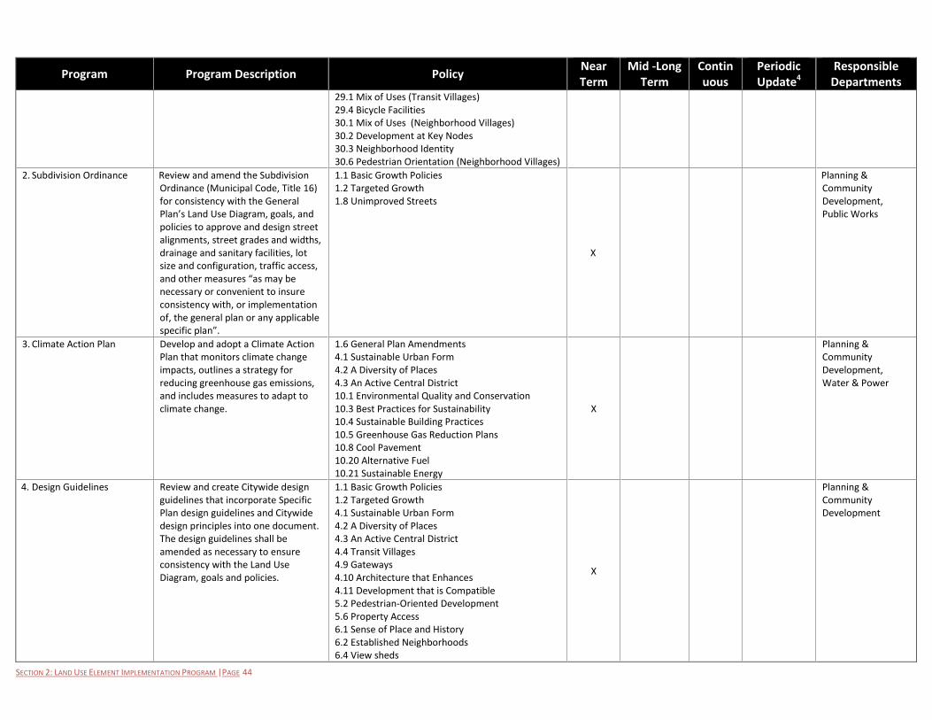
SECTION 2: LAND USE ELEMENT IMPLEMENTATION PROGRAM |PAGE 44
Program Program Description Policy Near Term
Mid -Long Term
Continuous
Periodic Update4
Responsible Departments
29.1 Mix of Uses (Transit Villages) 29.4 Bicycle Facilities 30.1 Mix of Uses (Neighborhood Villages) 30.2 Development at Key Nodes 30.3 Neighborhood Identity 30.6 Pedestrian Orientation (Neighborhood Villages)
2. Subdivision Ordinance Review and amend the Subdivision Ordinance (Municipal Code, Title 16) for consistency with the General Plan’s Land Use Diagram, goals, and policies to approve and design street alignments, street grades and widths, drainage and sanitary facilities, lot size and configuration, traffic access, and other measures “as may be necessary or convenient to insure consistency with, or implementation of, the general plan or any applicable specific plan”.
1.1 Basic Growth Policies 1.2 Targeted Growth 1.8 Unimproved Streets
X
Planning & Community Development, Public Works
3. Climate Action Plan Develop and adopt a Climate Action Plan that monitors climate change impacts, outlines a strategy for reducing greenhouse gas emissions, and includes measures to adapt to climate change.
1.6 General Plan Amendments 4.1 Sustainable Urban Form 4.2 A Diversity of Places 4.3 An Active Central District 10.1 Environmental Quality and Conservation 10.3 Best Practices for Sustainability 10.4 Sustainable Building Practices 10.5 Greenhouse Gas Reduction Plans 10.8 Cool Pavement 10.20 Alternative Fuel 10.21 Sustainable Energy
X
Planning & Community Development, Water & Power
4. Design Guidelines Review and create Citywide design guidelines that incorporate Specific Plan design guidelines and Citywide design principles into one document. The design guidelines shall be amended as necessary to ensure consistency with the Land Use Diagram, goals and policies.
1.1 Basic Growth Policies 1.2 Targeted Growth 4.1 Sustainable Urban Form 4.2 A Diversity of Places 4.3 An Active Central District 4.4 Transit Villages 4.9 Gateways 4.10 Architecture that Enhances 4.11 Development that is Compatible 5.2 Pedestrian-Oriented Development 5.6 Property Access 6.1 Sense of Place and History 6.2 Established Neighborhoods 6.4 View sheds
X
Planning & Community Development

L A N D U S E E L E M E N T I M P L E M E N T A T I O N P L A N
SECTION 2: LAND USE ELEMENT IMPLEMENTATION PROGRAM |PAGE 45
Program Program Description Policy Near Term
Mid -Long Term
Continuous
Periodic Update4
Responsible Departments
7.1 Architectural Quality 7.2 Diversity & Creativity 7.3 Compatible Re-use 7.4 Design Review 8.4 Adaptive Reuse 8.6 Infrastructure and Street Design Compatibility 10.6 Adaptive Reuse 10.7 Landscape 18.6 Relationship of Buildings to Transit Portals 21.3 Neighborhood Character 21.4 New Residential Development 21.5 Housing Character and Design 21.7 Safety 21.8 Housing Maintenance 21.9 Hillside Housing 22.1 Appropriate Scale and Massing 23.1 Character and Design 23.3 Landscaped Setbacks and Walkways 23.4 Development Transitions 25.4 Architecture and Site Design 25.7 Buffering Adjoining Residential Areas 25.8 Pedestrian, Bicycle and Transit Access 27.4 Buffering from Adjacent Properties 28.2 Development Scale 28.3 On-site Amenities 28.4 Design Integration 29.2 Neighborhood Identity (Transit Villages) 29.3 Pedestrian Orientation (Transit Villages) 30.3 Neighborhood Identity (Neighborhood Villages) 31.10 Building Orientation
5. Historic resource surveys Continue to actively identify and evaluate eligible and potentially eligible historical resources through reconnaissance and intensive level survey.
4.11 Development that is Compatible 8.1 Identify and Protect Historic Resources 8.2 Historic Designation Support 8.3 Preservation Efforts 8.4 Adaptive Reuse 8.5 Scale and Character of New Construction in a Designated Landmark and Historic Districts 8.7 Preservation of Historic Landscapes 8.8 Evolving Preservation Practices 8.9 Maintenance
X
Planning & Community Development
6. Transportation Demand Review TDM which currently requires 2.6 Transit-Related Land Use X Transportation,
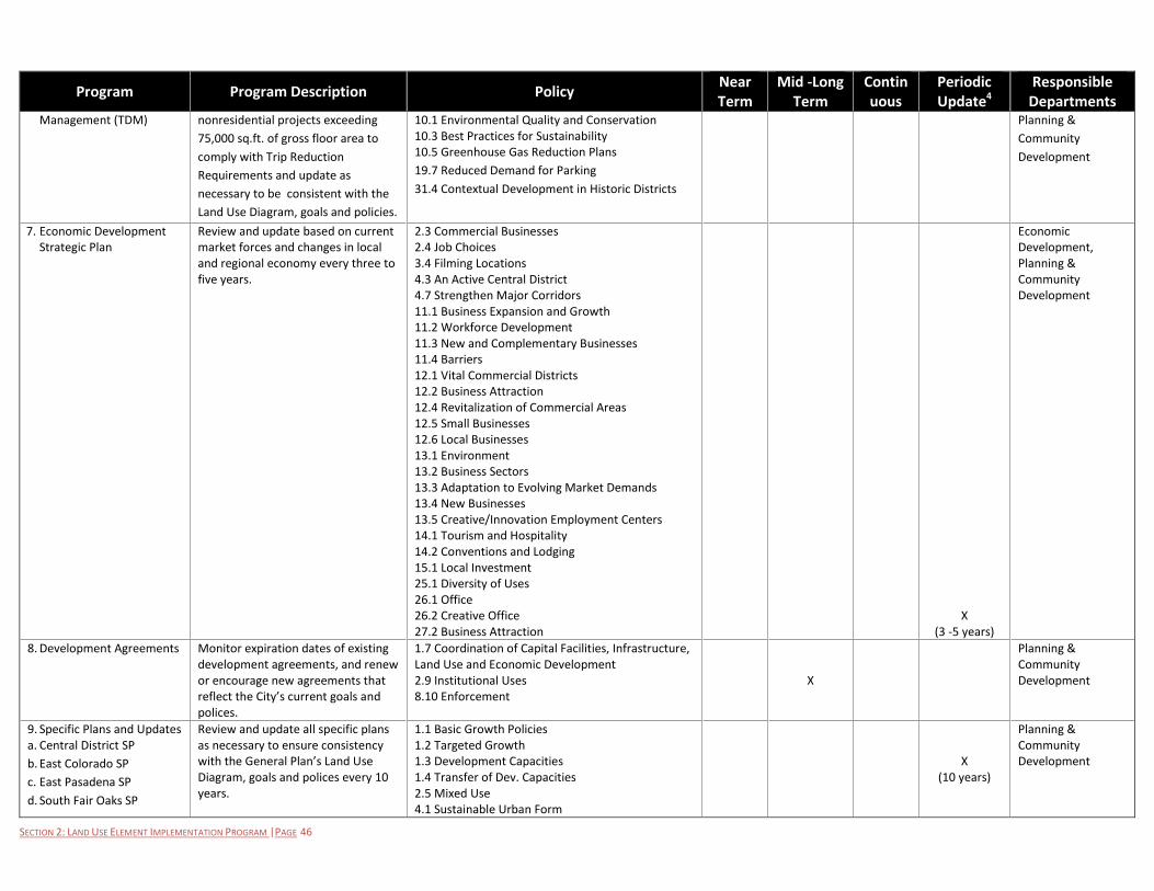
SECTION 2: LAND USE ELEMENT IMPLEMENTATION PROGRAM |PAGE 46
Program Program Description Policy Near Term
Mid -Long Term
Continuous
Periodic Update4
Responsible Departments
Management (TDM) nonresidential projects exceeding
75,000 sq.ft. of gross floor area to
comply with Trip Reduction
Requirements and update as
necessary to be consistent with the
Land Use Diagram, goals and policies.
10.1 Environmental Quality and Conservation 10.3 Best Practices for Sustainability 10.5 Greenhouse Gas Reduction Plans
19.7 Reduced Demand for Parking
31.4 Contextual Development in Historic Districts
Planning &
Community
Development
7. Economic Development Strategic Plan
Review and update based on current market forces and changes in local and regional economy every three to five years.
2.3 Commercial Businesses 2.4 Job Choices 3.4 Filming Locations 4.3 An Active Central District 4.7 Strengthen Major Corridors 11.1 Business Expansion and Growth 11.2 Workforce Development 11.3 New and Complementary Businesses 11.4 Barriers 12.1 Vital Commercial Districts 12.2 Business Attraction 12.4 Revitalization of Commercial Areas 12.5 Small Businesses 12.6 Local Businesses 13.1 Environment 13.2 Business Sectors 13.3 Adaptation to Evolving Market Demands 13.4 New Businesses 13.5 Creative/Innovation Employment Centers 14.1 Tourism and Hospitality 14.2 Conventions and Lodging 15.1 Local Investment 25.1 Diversity of Uses 26.1 Office 26.2 Creative Office 27.2 Business Attraction
X (3 -5 years)
Economic Development, Planning & Community Development
8. Development Agreements Monitor expiration dates of existing development agreements, and renew or encourage new agreements that reflect the City’s current goals and polices.
1.7 Coordination of Capital Facilities, Infrastructure, Land Use and Economic Development 2.9 Institutional Uses 8.10 Enforcement
X
Planning & Community Development
9. Specific Plans and Updates a. Central District SP
b. East Colorado SP
c. East Pasadena SP
d. South Fair Oaks SP
Review and update all specific plans as necessary to ensure consistency with the General Plan’s Land Use Diagram, goals and polices every 10 years.
1.1 Basic Growth Policies 1.2 Targeted Growth 1.3 Development Capacities 1.4 Transfer of Dev. Capacities 2.5 Mixed Use 4.1 Sustainable Urban Form
X
(10 years)
Planning & Community Development

L A N D U S E E L E M E N T I M P L E M E N T A T I O N P L A N
SECTION 2: LAND USE ELEMENT IMPLEMENTATION PROGRAM |PAGE 47
Program Program Description Policy Near Term
Mid -Long Term
Continuous
Periodic Update4
Responsible Departments
e. West Gateway SP
f. Fair Oaks/Orange Grove
g. North Lake SP
h. Lincoln SP
The review of specific plans and update should incorporate form-based code that establishes standard regulations of form and scale of development. The City shall also prepare new specific plans as necessary to further goals and policies of the General Plan.
4.2 A Diversity of Places 4.3 An Active Central District 4.4 Transit Villages 4.5 Transit Villages in Context 4.6 Neighborhood Villages 4.7 Strengthen Major Corridors 4.8 Complete and Livable Neighborhoods 4.9 Gateways 4.10 Architecture that Enhances 4.12 Transition in Scale 4.13 Planned Developments 5.2 Pedestrian-Oriented Development 5.4 Community Connectivity 5.6 Property Access 6.1 Sense of Place and History 6.2 Established Neighborhoods 6.3 Form-based Code 6.4 View sheds 10.2 Land Use Supporting Sustainability 25.2 Compact Infill Development 25.10 Retail 29.1 Mix of Uses (Transit Villages) 29.2 Neighborhood Identity 29.4 Bicycle Facilities 30.1 Mix of Uses (Neighborhood Villages) 30.2 Development at Key Nodes 31.1 – 31.11 Central District 32.1 – 32.8 East Colorado 33-.1 -33.8 East Pasadena 34.1-34.6 Fair Oaks and Orange Grove 35.1-35.10 Lincoln 36.1 -36.6 North Lake 37.1.-37.7 South Fair Oaks 38.1-38.4 Washington and Allen 39.1-39.2 West Gateway 40.1-40.3 Northwest
X
10. Building and Construction Code Revisions
a. Green Building Ordinance 2010
Update Building and Construction Code to establish additional standards to ensure consistency with the General Plan goals and policies. Such standards shall be incorporated
10.1 Environmental Quality and Conservation 10.3 Best Practices for Sustainability 10.4 Sustainable Building Practices 10.6 Adaptive Reuse 10.16 Infrastructure
X
(As required by State)
Planning & Community Development

SECTION 2: LAND USE ELEMENT IMPLEMENTATION PROGRAM |PAGE 48
Program Program Description Policy Near Term
Mid -Long Term
Continuous
Periodic Update4
Responsible Departments
in the Climate Action Plan and Green Building Ordinance.
10.21 Sustainable Energy 27.6 Adaptive Reuse
11. Inclusionary Housing Program
Review and update the Inclusionary Housing requirements, which generally require a percentage of units to be set aside for affordable housing, as necessary to be consistent with the General Plan goals and polices.
2.1 Housing Choices 2.2 Senior Housing 21.1 Adequate and Affordable Housing 21.2 Equitable Distribution of Affordable Housing
X
Housing, Planning & Community Development
C. Development Review and Entitlement: City ordinances also create a development review process that provides for City review of individual project proposals and authorizes the City to approve, deny, or condition projects based on their consistency with the Land Use Element.
1. Development Review and Entitlement
Continue to review projects for consistency with the General Plan goals and policies.
All Policies
X
Planning & Community Development, Fire, Public Works, Health, Transportation and Utilities
2. Process of Development Review and Entitlement
Analyze the efficiency of the development review and entitlement process and identify the City’s expectations for planning, designing, and reviewing development proposals every 5 years.
20.1 Neighborhood Meetings 20.2 Brochures and Notices 20.3 Public Involvement and Proposed Projects 20.4 Neighborhood Connections 20.5 Public Discussion
X
(5 years)
Planning & Community Development
3. CEQA Update a. Environmental Policy
Guidelines b. Environmental
Administrative Procedures
Review and update the environmental guidelines for administering CEQA as necessary, including thresholds of significance to reflect the General Plan goals, policies and best practices.
3.5 Hazardous Uses 8.10 Enforcement 10.1 Environmental Quality and Conservation 10.3 Best Practices for Sustainability 10.9 Natural Open Space 20.1 Neighborhood Meetings 20.2 Brochures and Notices 20.3 Public Involvement and Proposed Projects 20.4 Neighborhood Connections 20.5 Public Discussion 27.5 Impact Mitigation
X (As required
by State)
Planning & Community Development
4. Application of CEQA Continue to review projects for consistency with CEQA.
X
Planning & Community Development
5. Affordable Housing Entitlement Process
Analyze the efficiency of the entitlement process for affordable housing projects and modify as necessary to reduce barriers and ensure consistency with the General
2.1 Housing Choices 2.2 Senior Housing 21.1 Adequate and Affordable Housing 21.2 Equitable Distribution of Affordable Housing
X
Planning & Community Development, Housing
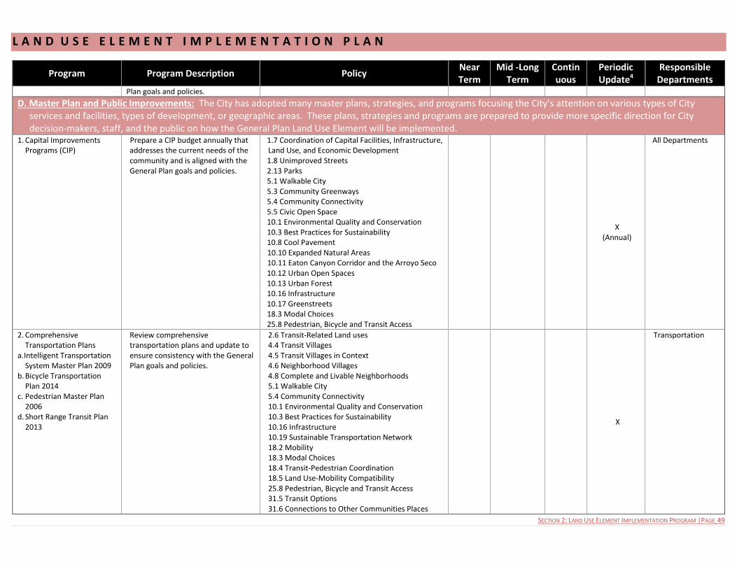
L A N D U S E E L E M E N T I M P L E M E N T A T I O N P L A N
SECTION 2: LAND USE ELEMENT IMPLEMENTATION PROGRAM |PAGE 49
Program Program Description Policy Near Term
Mid -Long Term
Continuous
Periodic Update4
Responsible Departments
Plan goals and policies.
D. Master Plan and Public Improvements: The City has adopted many master plans, strategies, and programs focusing the City’s attention on various types of City services and facilities, types of development, or geographic areas. These plans, strategies and programs are prepared to provide more specific direction for City decision-makers, staff, and the public on how the General Plan Land Use Element will be implemented.
1. Capital Improvements Programs (CIP)
Prepare a CIP budget annually that addresses the current needs of the community and is aligned with the General Plan goals and policies.
1.7 Coordination of Capital Facilities, Infrastructure, Land Use, and Economic Development 1.8 Unimproved Streets 2.13 Parks 5.1 Walkable City 5.3 Community Greenways 5.4 Community Connectivity 5.5 Civic Open Space 10.1 Environmental Quality and Conservation 10.3 Best Practices for Sustainability 10.8 Cool Pavement 10.10 Expanded Natural Areas 10.11 Eaton Canyon Corridor and the Arroyo Seco 10.12 Urban Open Spaces 10.13 Urban Forest 10.16 Infrastructure 10.17 Greenstreets 18.3 Modal Choices 25.8 Pedestrian, Bicycle and Transit Access
X
(Annual)
All Departments
2. Comprehensive Transportation Plans
a. Intelligent Transportation System Master Plan 2009
b. Bicycle Transportation Plan 2014
c. Pedestrian Master Plan 2006
d. Short Range Transit Plan 2013
Review comprehensive transportation plans and update to ensure consistency with the General Plan goals and policies.
2.6 Transit-Related Land uses 4.4 Transit Villages 4.5 Transit Villages in Context 4.6 Neighborhood Villages 4.8 Complete and Livable Neighborhoods 5.1 Walkable City 5.4 Community Connectivity 10.1 Environmental Quality and Conservation 10.3 Best Practices for Sustainability 10.16 Infrastructure 10.19 Sustainable Transportation Network 18.2 Mobility 18.3 Modal Choices 18.4 Transit-Pedestrian Coordination 18.5 Land Use-Mobility Compatibility 25.8 Pedestrian, Bicycle and Transit Access 31.5 Transit Options 31.6 Connections to Other Communities Places
X
Transportation
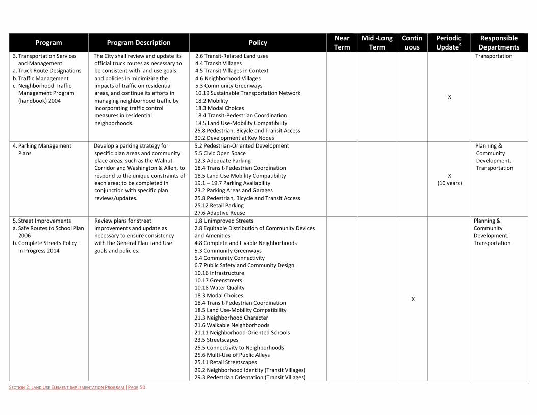
SECTION 2: LAND USE ELEMENT IMPLEMENTATION PROGRAM |PAGE 50
Program Program Description Policy Near Term
Mid -Long Term
Continuous
Periodic Update4
Responsible Departments
3. Transportation Services and Management
a. Truck Route Designations b. Traffic Management c. Neighborhood Traffic
Management Program (handbook) 2004
The City shall review and update its official truck routes as necessary to be consistent with land use goals and policies in minimizing the impacts of traffic on residential areas, and continue its efforts in managing neighborhood traffic by incorporating traffic control measures in residential neighborhoods.
2.6 Transit-Related Land uses 4.4 Transit Villages 4.5 Transit Villages in Context 4.6 Neighborhood Villages 5.3 Community Greenways 10.19 Sustainable Transportation Network 18.2 Mobility 18.3 Modal Choices 18.4 Transit-Pedestrian Coordination 18.5 Land Use-Mobility Compatibility 25.8 Pedestrian, Bicycle and Transit Access 30.2 Development at Key Nodes
X
Transportation
4. Parking Management Plans
Develop a parking strategy for specific plan areas and community place areas, such as the Walnut Corridor and Washington & Allen, to respond to the unique constraints of each area; to be completed in conjunction with specific plan reviews/updates.
5.2 Pedestrian-Oriented Development 5.5 Civic Open Space 12.3 Adequate Parking 18.4 Transit-Pedestrian Coordination 18.5 Land Use Mobility Compatibility 19.1 – 19.7 Parking Availability 23.2 Parking Areas and Garages 25.8 Pedestrian, Bicycle and Transit Access 25.12 Retail Parking 27.6 Adaptive Reuse
X
(10 years)
Planning & Community Development, Transportation
5. Street Improvements a. Safe Routes to School Plan
2006 b. Complete Streets Policy –
In Progress 2014
Review plans for street improvements and update as necessary to ensure consistency with the General Plan Land Use goals and policies.
1.8 Unimproved Streets 2.8 Equitable Distribution of Community Devices and Amenities 4.8 Complete and Livable Neighborhoods 5.3 Community Greenways 5.4 Community Connectivity 6.7 Public Safety and Community Design 10.16 Infrastructure 10.17 Greenstreets 10.18 Water Quality 18.3 Modal Choices 18.4 Transit-Pedestrian Coordination 18.5 Land Use-Mobility Compatibility 21.3 Neighborhood Character 21.6 Walkable Neighborhoods 21.11 Neighborhood-Oriented Schools 23.5 Streetscapes 25.5 Connectivity to Neighborhoods 25.6 Multi-Use of Public Alleys 25.11 Retail Streetscapes 29.2 Neighborhood Identity (Transit Villages) 29.3 Pedestrian Orientation (Transit Villages)
X
Planning & Community Development, Transportation
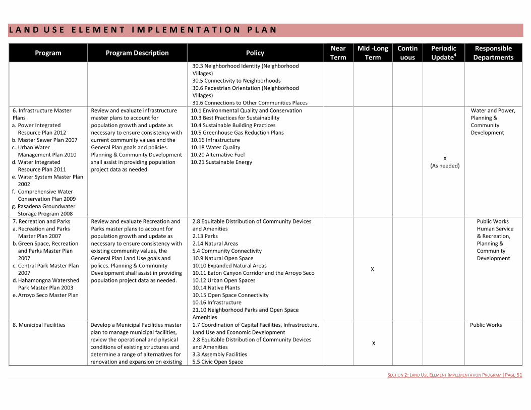
L A N D U S E E L E M E N T I M P L E M E N T A T I O N P L A N
SECTION 2: LAND USE ELEMENT IMPLEMENTATION PROGRAM |PAGE 51
Program Program Description Policy Near Term
Mid -Long Term
Continuous
Periodic Update4
Responsible Departments
30.3 Neighborhood Identity (Neighborhood Villages) 30.5 Connectivity to Neighborhoods 30.6 Pedestrian Orientation (Neighborhood Villages) 31.6 Connections to Other Communities Places
6. Infrastructure Master Plans a. Power Integrated
Resource Plan 2012 b. Master Sewer Plan 2007 c. Urban Water
Management Plan 2010 d. Water Integrated
Resource Plan 2011 e. Water System Master Plan
2002 f. Comprehensive Water
Conservation Plan 2009 g. Pasadena Groundwater
Storage Program 2008
Review and evaluate infrastructure master plans to account for population growth and update as necessary to ensure consistency with current community values and the General Plan goals and policies. Planning & Community Development shall assist in providing population project data as needed.
10.1 Environmental Quality and Conservation 10.3 Best Practices for Sustainability 10.4 Sustainable Building Practices 10.5 Greenhouse Gas Reduction Plans 10.16 Infrastructure 10.18 Water Quality 10.20 Alternative Fuel 10.21 Sustainable Energy
X (As needed)
Water and Power, Planning & Community Development
7. Recreation and Parks a. Recreation and Parks
Master Plan 2007 b. Green Space, Recreation
and Parks Master Plan 2007
c. Central Park Master Plan 2007
d. Hahamongna Watershed Park Master Plan 2003
e. Arroyo Seco Master Plan
Review and evaluate Recreation and Parks master plans to account for population growth and update as necessary to ensure consistency with existing community values, the General Plan Land Use goals and polices. Planning & Community Development shall assist in providing population project data as needed.
2.8 Equitable Distribution of Community Devices and Amenities 2.13 Parks 2.14 Natural Areas 5.4 Community Connectivity 10.9 Natural Open Space 10.10 Expanded Natural Areas 10.11 Eaton Canyon Corridor and the Arroyo Seco 10.12 Urban Open Spaces 10.14 Native Plants 10.15 Open Space Connectivity 10.16 Infrastructure 21.10 Neighborhood Parks and Open Space Amenities
X
Public Works Human Service & Recreation, Planning & Community Development
8. Municipal Facilities Develop a Municipal Facilities master plan to manage municipal facilities, review the operational and physical conditions of existing structures and determine a range of alternatives for renovation and expansion on existing
1.7 Coordination of Capital Facilities, Infrastructure, Land Use and Economic Development 2.8 Equitable Distribution of Community Devices and Amenities 3.3 Assembly Facilities 5.5 Civic Open Space
X
Public Works
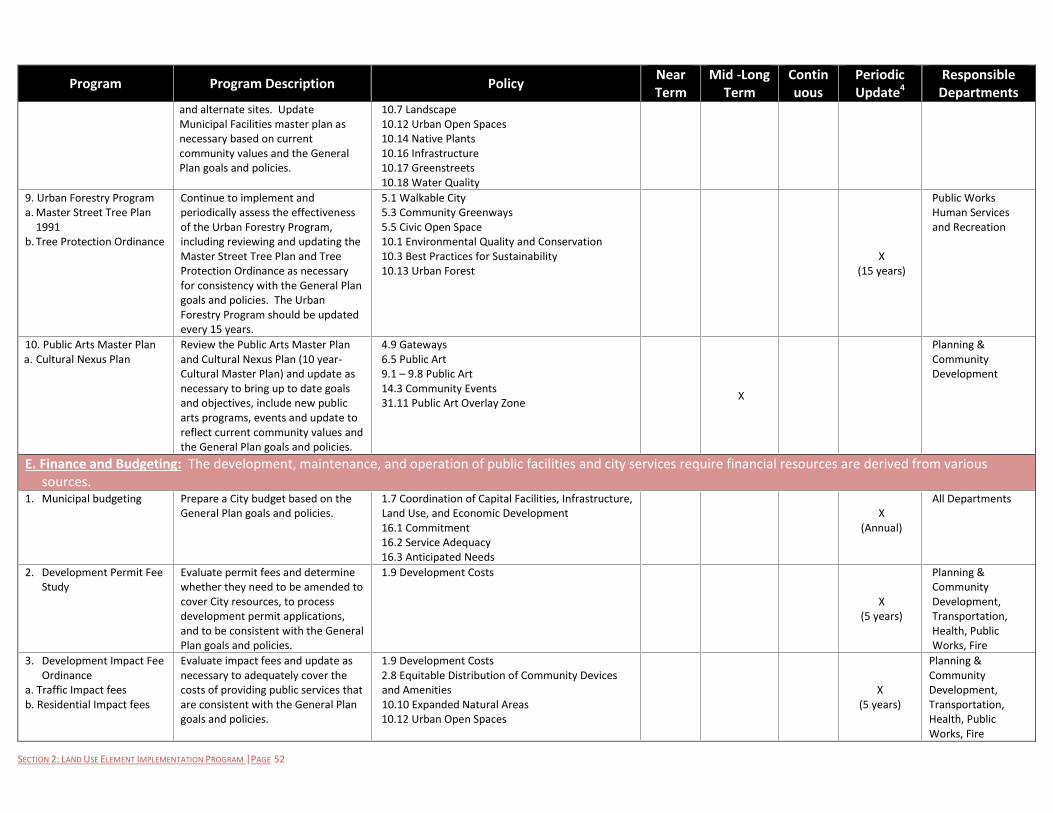
SECTION 2: LAND USE ELEMENT IMPLEMENTATION PROGRAM |PAGE 52
Program Program Description Policy Near Term
Mid -Long Term
Continuous
Periodic Update4
Responsible Departments
and alternate sites. Update Municipal Facilities master plan as necessary based on current community values and the General Plan goals and policies.
10.7 Landscape 10.12 Urban Open Spaces 10.14 Native Plants 10.16 Infrastructure 10.17 Greenstreets 10.18 Water Quality
9. Urban Forestry Program a. Master Street Tree Plan
1991 b. Tree Protection Ordinance
Continue to implement and periodically assess the effectiveness of the Urban Forestry Program, including reviewing and updating the Master Street Tree Plan and Tree Protection Ordinance as necessary for consistency with the General Plan goals and policies. The Urban Forestry Program should be updated every 15 years.
5.1 Walkable City 5.3 Community Greenways 5.5 Civic Open Space 10.1 Environmental Quality and Conservation 10.3 Best Practices for Sustainability 10.13 Urban Forest
X
(15 years)
Public Works Human Services and Recreation
10. Public Arts Master Plan a. Cultural Nexus Plan
Review the Public Arts Master Plan and Cultural Nexus Plan (10 year- Cultural Master Plan) and update as necessary to bring up to date goals and objectives, include new public arts programs, events and update to reflect current community values and the General Plan goals and policies.
4.9 Gateways 6.5 Public Art 9.1 – 9.8 Public Art 14.3 Community Events 31.11 Public Art Overlay Zone
X
Planning & Community Development
E. Finance and Budgeting: The development, maintenance, and operation of public facilities and city services require financial resources are derived from various sources.
1. Municipal budgeting Prepare a City budget based on the General Plan goals and policies.
1.7 Coordination of Capital Facilities, Infrastructure, Land Use, and Economic Development 16.1 Commitment 16.2 Service Adequacy 16.3 Anticipated Needs
X
(Annual)
All Departments
2. Development Permit Fee Study
Evaluate permit fees and determine whether they need to be amended to cover City resources, to process development permit applications, and to be consistent with the General Plan goals and policies.
1.9 Development Costs
X
(5 years)
Planning & Community Development, Transportation, Health, Public Works, Fire
3. Development Impact Fee Ordinance
a. Traffic Impact fees b. Residential Impact fees
Evaluate impact fees and update as necessary to adequately cover the costs of providing public services that are consistent with the General Plan goals and policies.
1.9 Development Costs 2.8 Equitable Distribution of Community Devices and Amenities 10.10 Expanded Natural Areas 10.12 Urban Open Spaces
X
(5 years)
Planning & Community Development, Transportation, Health, Public Works, Fire

L A N D U S E E L E M E N T I M P L E M E N T A T I O N P L A N
SECTION 2: LAND USE ELEMENT IMPLEMENTATION PROGRAM |PAGE 53
Program Program Description Policy Near Term
Mid -Long Term
Continuous
Periodic Update4
Responsible Departments
4. Affordable Housing Fund a. Homeless Prevention and
Rapid Re-Housing Program funds.
b. Inclusionary Housing In-Lieu Fees
Evaluate funding sources for affordable housing programs and update as necessary to adequately provide for housing choices that are consistent with the General Plan goals and policies.
2.1 Housing Choices 2.2 Senior Housing 21.1 Adequate and Affordable Housing 21.2 Equitable Distribution of Affordable Housing
X
(5 years)
Planning & Community Development, Housing
F. Community Services and Operations: The City provides a broad range of services to its residents, businesses, and visitors and manages and operates its facilities to meet community needs. How the City provides services and carries out its operation makes a significant difference in how effectively the General Plan Land Use Element is implemented.
1. Economic Development Programs
Continue to provide, expand and modify programs that further the goals of the Economic Development Strategic Plan and the General Plan Goals and Policies, such as retail recruitment, business outreach promoting the City’s innovation and technology companies, identification of opportunity sites and utilities incentives.
2.3 Commercial Businesses 2.4 Job Choices 3.4 Filming Locations 4.3 An Active Central District 4.7 Strengthen Major Corridors 11.1 – 11.4 Job Opportunities 12.1 Vital Commercial Districts 12.2 Business Attraction 12.4 Revitalization of Commercial Areas 12.5 Small Businesses 12.6 Local Businesses 13.1 -13.5 Innovation 15.1 Local Investment 25.10 Retail 26.1 Office 26.2 Creative Office 27.1 Diversity of Use 27.2 Business Attraction 27.3 Supporting Uses 30.4 Community Activity 31.7 Expanded Economic Opportunities
X
Economic Development
2. Job training programs a. Maintenance Assistance
and Services to Homeowners
b. First Source Local Hiring
Continue to provide job training programs and local job opportunities and promote City economic vitality
2.4 Job choices 11.4 Barriers 15.1 Local Investment 17.2 Career Exposure
X
Economic Development, Finance, Housing
3. Human Services and Recreation Program
a. Human Services and Recreation Work/City/Community Work Plan (Draft 2013-
Review work plan and align services to current community values, land use policies and goals. The work plan shall be amended every three years.
2.7 Civic and Community Services 2.8 Equitable Distribution of Community Devices and Amenities 2.12 Health and Wellness 2.13 Parks 16.1 – 16.8 Superior Services
X
(3 years)
Human Services and Recreation
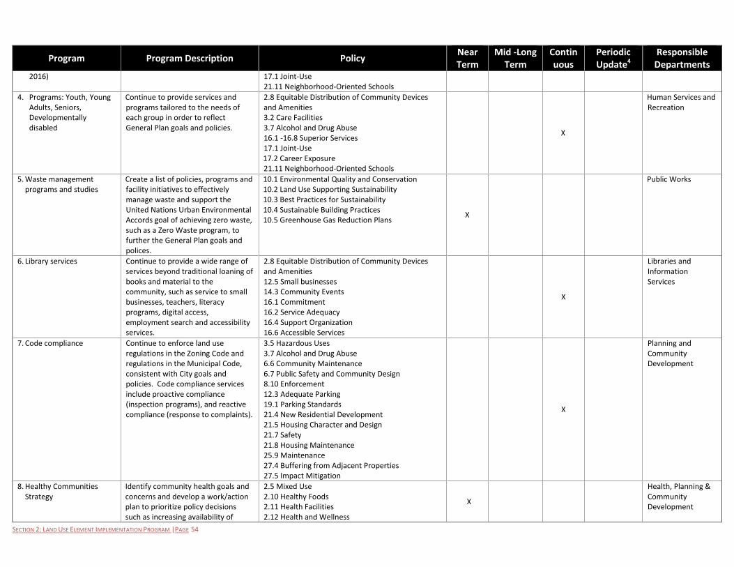
SECTION 2: LAND USE ELEMENT IMPLEMENTATION PROGRAM |PAGE 54
Program Program Description Policy Near Term
Mid -Long Term
Continuous
Periodic Update4
Responsible Departments
2016) 17.1 Joint-Use 21.11 Neighborhood-Oriented Schools
4. Programs: Youth, Young Adults, Seniors, Developmentally disabled
Continue to provide services and programs tailored to the needs of each group in order to reflect General Plan goals and policies.
2.8 Equitable Distribution of Community Devices and Amenities 3.2 Care Facilities 3.7 Alcohol and Drug Abuse 16.1 -16.8 Superior Services 17.1 Joint-Use 17.2 Career Exposure 21.11 Neighborhood-Oriented Schools
X
Human Services and Recreation
5. Waste management programs and studies
Create a list of policies, programs and facility initiatives to effectively manage waste and support the United Nations Urban Environmental Accords goal of achieving zero waste, such as a Zero Waste program, to further the General Plan goals and polices.
10.1 Environmental Quality and Conservation 10.2 Land Use Supporting Sustainability 10.3 Best Practices for Sustainability 10.4 Sustainable Building Practices 10.5 Greenhouse Gas Reduction Plans
X
Public Works
6. Library services
Continue to provide a wide range of services beyond traditional loaning of books and material to the community, such as service to small businesses, teachers, literacy programs, digital access, employment search and accessibility services.
2.8 Equitable Distribution of Community Devices and Amenities 12.5 Small businesses 14.3 Community Events 16.1 Commitment 16.2 Service Adequacy 16.4 Support Organization 16.6 Accessible Services
X
Libraries and Information Services
7. Code compliance Continue to enforce land use regulations in the Zoning Code and regulations in the Municipal Code, consistent with City goals and policies. Code compliance services include proactive compliance (inspection programs), and reactive compliance (response to complaints).
3.5 Hazardous Uses 3.7 Alcohol and Drug Abuse 6.6 Community Maintenance 6.7 Public Safety and Community Design 8.10 Enforcement 12.3 Adequate Parking 19.1 Parking Standards 21.4 New Residential Development 21.5 Housing Character and Design 21.7 Safety 21.8 Housing Maintenance 25.9 Maintenance 27.4 Buffering from Adjacent Properties 27.5 Impact Mitigation
X
Planning and Community Development
8. Healthy Communities Strategy
Identify community health goals and concerns and develop a work/action plan to prioritize policy decisions such as increasing availability of
2.5 Mixed Use 2.10 Healthy Foods 2.11 Health Facilities 2.12 Health and Wellness
X
Health, Planning & Community Development

L A N D U S E E L E M E N T I M P L E M E N T A T I O N P L A N
SECTION 2: LAND USE ELEMENT IMPLEMENTATION PROGRAM |PAGE 55
Program Program Description Policy Near Term
Mid -Long Term
Continuous
Periodic Update4
Responsible Departments
healthier foods and beverage choices, promoting exercise by expanding pedestrian friendly environment, and increasing the accessibility of health care facilities.
2.13 Parks 3.2 Care Facilities 3.7 Alcohol and Drug Abuse 4.1 Sustainable Urban Form 4.2 A Diversity of Places 4.3 An Active Central District 4.8 Complete and Livable Neighborhoods 5.2 Pedestrian-Oriented Development 16.1 -16.8 Superior Services 17.6 Supporting Uses 18.2 Mobility 18.4 Transit-Pedestrian Coordination 18.5 Land Use-Mobility Compatibility 19.5 Bicycle Parking 21.6 Walkable Neighborhoods 21.10 Neighborhood Parks and Open Space Amenities 29.4 Bicycle Facilities 30.3 Neighborhood Identity 30.5 Connectivity to Neighborhoods 30.6 Pedestrian Orientation
9. Public Health Programs a. Tobacco Control Program b. Public Health
Preparedness Program c. Minority Immunization
Program d. Food Inspection Program
Continue to implement health programs such as education, wellness programs, and regulatory programs to prevent and eliminate known agents and unsanitary conditions, including the enforcement of California Health and Safety Codes and Municipal Codes. Programs should be expanded or modified as necessary to be consistent with the General Plan goals and policies.
2.8 Equitable Distribution of Community Devices and Amenities 2.9 Institutional Use 2.10 Healthy Foods 2.11 Health Facilities 2.12 Health and Wellness 3.2 Care Facilities 3.5 Hazardous Uses 3.7 Alcohol and Drug Abuse 4.1 Sustainable Urban Form 4.2 A Diversity of Places 4.3 An Active Central District
X
Health
10. Housing Programs a. Housing Department
Administrative Plan (rental assistance) Annual Plan 2013
b. Tenant Protection Ordinance
c. Inclusion Housing Receipts
Continue to implement housing
programs such as rental assistance,
tenant protection, maintenance, and
affordable housing. Programs should
be expanded or modified as
necessary to be consistent with the
General Plan goals and policies.
2.1 Housing Choices 2.2 Senior Housing 21.1 Adequate and Affordable Housing 21.2 Equitable Distribution of Affordable Housing
21.8 Housing Maintenance X
Housing
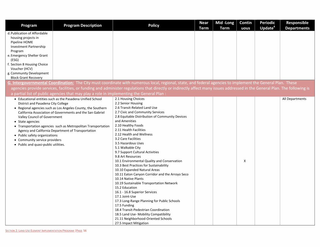
SECTION 2: LAND USE ELEMENT IMPLEMENTATION PROGRAM |PAGE 56
Program Program Description Policy Near Term
Mid -Long Term
Continuous
Periodic Update4
Responsible Departments
d. Publication of Affordable housing projects in Pipeline HOME Investment Partnership Program
e. Emergency Shelter Grant (ESG)
f. Section 8 Housing Choice Voucher (HCV)
g. Community Development Block Grant Recovery
G. Intergovernmental Coordination: The City must coordinate with numerous local, regional, state, and federal agencies to implement the General Plan. These agencies provide services, facilities, or funding and administer regulations that directly or indirectly affect many issues addressed in the General Plan. The following is a partial list of public agencies that may play a role in implementing the General Plan : Educational entities such as the Pasadena Unified School
District and Pasadena City College
Regional agencies such as Los Angeles County, the Southern California Association of Governments and the San Gabriel Valley Council of Government
State agencies
Transportation agencies such as Metropolitan Transportation Agency and California Department of Transportation
Public safety organizations
Community service providers
Public and quasi-public utilities.
2.1 Housing Choices 2.2 Senior Housing 2.6 Transit-Related Land Use 2.7 Civic and Community Services 2.8 Equitable Distribution of Community Devices and Amenities 2.10 Healthy Foods 2.11 Health Facilities 2.12 Health and Wellness 3.2 Care Facilities 3.5 Hazardous Uses 5.1 Walkable City 9.7 Support Cultural Activities 9.8 Art Resources 10.1 Environmental Quality and Conservation 10.3 Best Practices for Sustainability 10.10 Expanded Natural Areas 10.11 Eaton Canyon Corridor and the Arroyo Seco 10.14 Native Plants 10.19 Sustainable Transportation Network 15.2 Education 16.1 - 16.8 Superior Services 17.1 Joint-Use 17.3 Long-Range Planning for Public Schools 17.5 Funding 18.4 Transit-Pedestrian Coordination 18.5 Land Use- Mobility Compatibility 21.11 Neighborhood-Oriented Schools 27.5 Impact Mitigation
X
All Departments
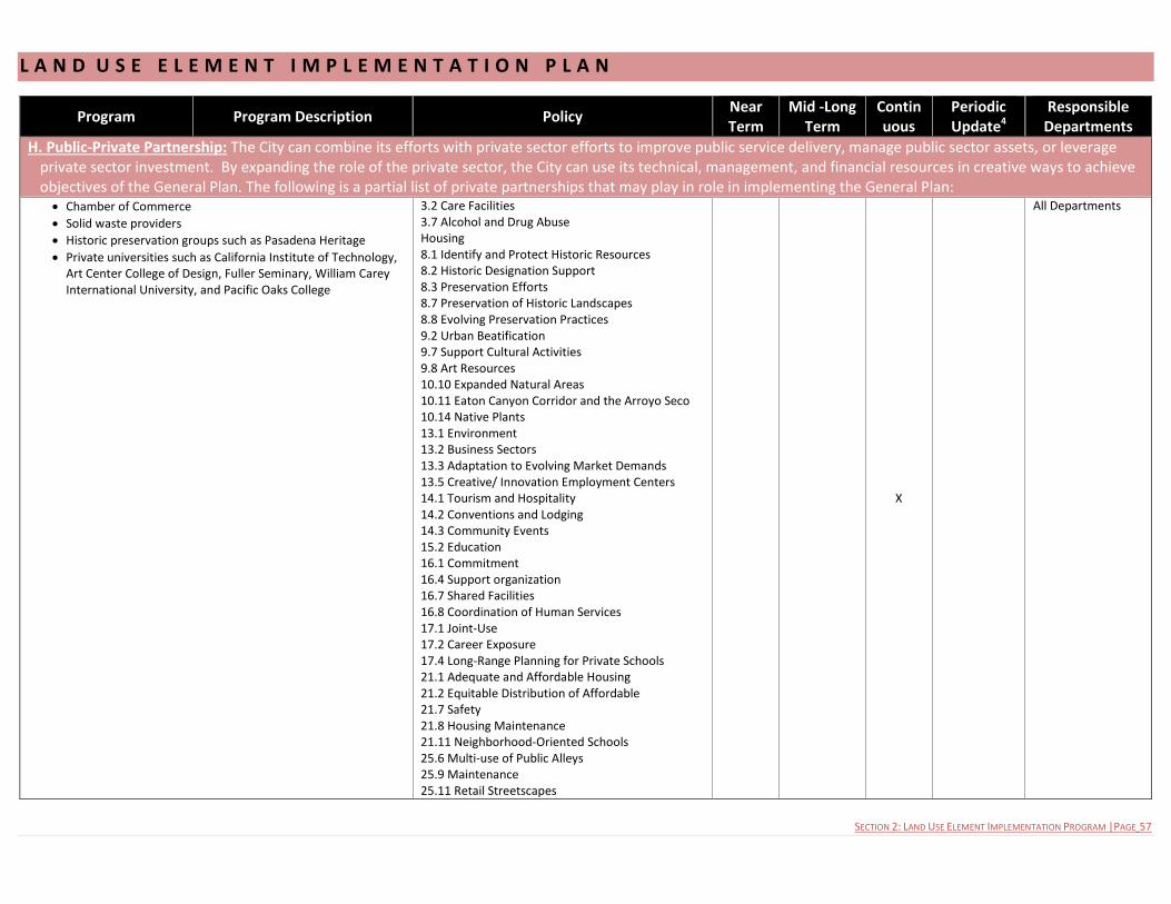
L A N D U S E E L E M E N T I M P L E M E N T A T I O N P L A N
SECTION 2: LAND USE ELEMENT IMPLEMENTATION PROGRAM |PAGE 57
Program Program Description Policy Near Term
Mid -Long Term
Continuous
Periodic Update4
Responsible Departments
H. Public-Private Partnership: The City can combine its efforts with private sector efforts to improve public service delivery, manage public sector assets, or leverage private sector investment. By expanding the role of the private sector, the City can use its technical, management, and financial resources in creative ways to achieve objectives of the General Plan. The following is a partial list of private partnerships that may play in role in implementing the General Plan: Chamber of Commerce
Solid waste providers
Historic preservation groups such as Pasadena Heritage
Private universities such as California Institute of Technology, Art Center College of Design, Fuller Seminary, William Carey International University, and Pacific Oaks College
3.2 Care Facilities 3.7 Alcohol and Drug Abuse Housing 8.1 Identify and Protect Historic Resources 8.2 Historic Designation Support 8.3 Preservation Efforts 8.7 Preservation of Historic Landscapes 8.8 Evolving Preservation Practices 9.2 Urban Beatification 9.7 Support Cultural Activities 9.8 Art Resources 10.10 Expanded Natural Areas 10.11 Eaton Canyon Corridor and the Arroyo Seco 10.14 Native Plants 13.1 Environment 13.2 Business Sectors 13.3 Adaptation to Evolving Market Demands 13.5 Creative/ Innovation Employment Centers 14.1 Tourism and Hospitality 14.2 Conventions and Lodging 14.3 Community Events 15.2 Education 16.1 Commitment 16.4 Support organization 16.7 Shared Facilities 16.8 Coordination of Human Services 17.1 Joint-Use 17.2 Career Exposure 17.4 Long-Range Planning for Private Schools 21.1 Adequate and Affordable Housing 21.2 Equitable Distribution of Affordable 21.7 Safety 21.8 Housing Maintenance 21.11 Neighborhood-Oriented Schools 25.6 Multi-use of Public Alleys 25.9 Maintenance 25.11 Retail Streetscapes
X
All Departments
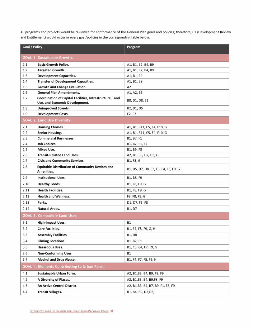
SECTION 2: LAND USE ELEMENT IMPLEMENTATION PROGRAM |PAGE 58
All programs and projects would be reviewed for conformance of the General Plan goals and policies; therefore, C1 (Development Review
and Entitlement) would occur in every goal/policies in the corresponding table below.
Goal / Policy Program
GOAL 1. Sustainable Growth.
1.1 Basic Growth Policy. A1, B1, B2, B4, B9
1.2 Targeted Growth. A1, B1, B2, B4, B9
1.3 Development Capacities. A1, B1, B9
1.4 Transfer of Development Capacities. A1, B1, B9
1.5 Growth and Change Evaluation. A2
1.6 General Plan Amendments. A1, A2, B3
1.7 Coordination of Capital Facilities, Infrastructure, Land Use, and Economic Development.
B8, D1, D8, E1
1.8 Unimproved Streets. B2, D1, D5
1.9 Development Costs. E2, E3
GOAL 2. Land Use Diversity.
2.1 Housing Choices. A1, B1, B11, C5, E4, F10, G
2.2 Senior Housing. A1, B1, B11, C5, E4, F10, G
2.3 Commercial Businesses. B1, B7, F1
2.4 Job Choices. B1, B7, F1, F2
2.5 Mixed Use. B1, B9, F8
2.6 Transit-Related Land Uses. A2, B1, B6, D2, D3, G
2.7 Civic and Community Services. B1, F3, G
2.8 Equitable Distribution of Community Devices and Amenities.
B1, D5, D7, D8, E3, F3, F4, F6, F9, G
2.9 Institutional Uses. B1, B8, F9
2.10 Healthy Foods. B1, F8, F9, G
2.11 Health Facilities. B1, F8, F9, G
2.12 Health and Wellness. F3, F8, F9, G
2.13 Parks. D1, D7, F3, F8
2.14 Natural Areas. B1, D7
GOAL 3. Compatible Land Uses.
3.1 High-Impact Uses. B1
3.2 Care Facilities. B1, F4, F8, F9, G, H
3.3 Assembly Facilities. B1, D8
3.4 Filming Locations. B1, B7, F1
3.5 Hazardous Uses. B1, C3, C4, F7, F9, G
3.6 Non-Conforming Uses. B1
3.7 Alcohol and Drug Abuse. B1, F4, F7, F8, F9, H
GOAL 4. Elements Contributing to Urban Form.
4.1 Sustainable Urban Form. A2, B1,B3, B4, B9, F8, F9
4.2 A Diversity of Places. A2, B1,B3, B4, B9,F8, F9
4.3 An Active Central District. A2, B1,B3, B4, B7, B9, F1, F8, F9
4.4 Transit Villages. B1, B4, B9, D2,D3,
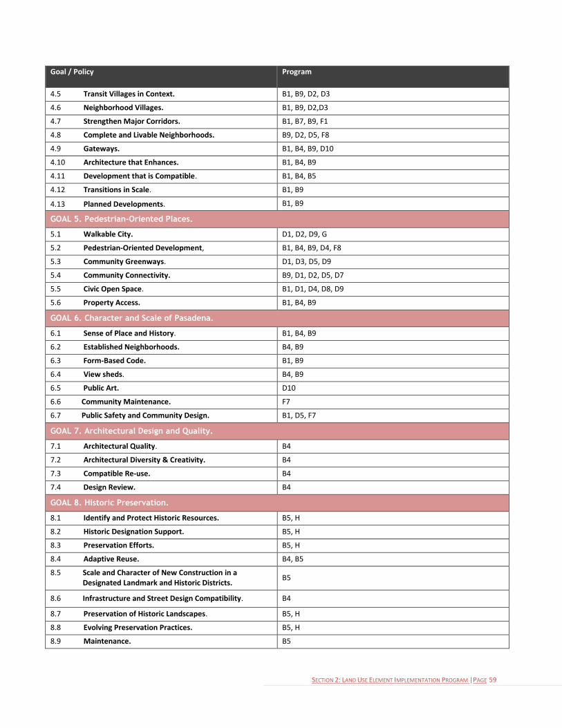
SECTION 2: LAND USE ELEMENT IMPLEMENTATION PROGRAM |PAGE 59
Goal / Policy Program
4.5 Transit Villages in Context. B1, B9, D2, D3
4.6 Neighborhood Villages. B1, B9, D2,D3
4.7 Strengthen Major Corridors. B1, B7, B9, F1
4.8 Complete and Livable Neighborhoods. B9, D2, D5, F8
4.9 Gateways. B1, B4, B9, D10
4.10 Architecture that Enhances. B1, B4, B9
4.11 Development that is Compatible. B1, B4, B5
4.12 Transitions in Scale. B1, B9
4.13 Planned Developments. B1, B9
GOAL 5. Pedestrian-Oriented Places.
5.1 Walkable City. D1, D2, D9, G
5.2 Pedestrian-Oriented Development, B1, B4, B9, D4, F8
5.3 Community Greenways. D1, D3, D5, D9
5.4 Community Connectivity. B9, D1, D2, D5, D7
5.5 Civic Open Space. B1, D1, D4, D8, D9
5.6 Property Access. B1, B4, B9
GOAL 6. Character and Scale of Pasadena.
6.1 Sense of Place and History. B1, B4, B9
6.2 Established Neighborhoods. B4, B9
6.3 Form-Based Code. B1, B9
6.4 View sheds. B4, B9
6.5 Public Art. D10
6.6 Community Maintenance. F7
6.7 Public Safety and Community Design. B1, D5, F7
GOAL 7. Architectural Design and Quality.
7.1 Architectural Quality. B4
7.2 Architectural Diversity & Creativity. B4
7.3 Compatible Re-use. B4
7.4 Design Review. B4
GOAL 8. Historic Preservation.
8.1 Identify and Protect Historic Resources. B5, H
8.2 Historic Designation Support. B5, H
8.3 Preservation Efforts. B5, H
8.4 Adaptive Reuse. B4, B5
8.5 Scale and Character of New Construction in a Designated Landmark and Historic Districts.
B5
8.6 Infrastructure and Street Design Compatibility. B4
8.7 Preservation of Historic Landscapes. B5, H
8.8 Evolving Preservation Practices. B5, H
8.9 Maintenance. B5
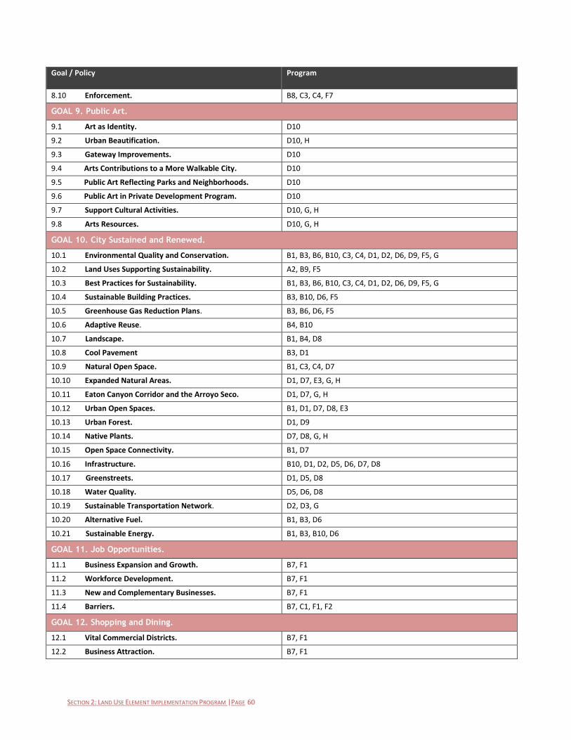
SECTION 2: LAND USE ELEMENT IMPLEMENTATION PROGRAM |PAGE 60
Goal / Policy Program
8.10 Enforcement. B8, C3, C4, F7
GOAL 9. Public Art.
9.1 Art as Identity. D10
9.2 Urban Beautification. D10, H
9.3 Gateway Improvements. D10
9.4 Arts Contributions to a More Walkable City. D10
9.5 Public Art Reflecting Parks and Neighborhoods. D10
9.6 Public Art in Private Development Program. D10
9.7 Support Cultural Activities. D10, G, H
9.8 Arts Resources. D10, G, H
GOAL 10. City Sustained and Renewed.
10.1 Environmental Quality and Conservation. B1, B3, B6, B10, C3, C4, D1, D2, D6, D9, F5, G
10.2 Land Uses Supporting Sustainability. A2, B9, F5
10.3 Best Practices for Sustainability. B1, B3, B6, B10, C3, C4, D1, D2, D6, D9, F5, G
10.4 Sustainable Building Practices. B3, B10, D6, F5
10.5 Greenhouse Gas Reduction Plans. B3, B6, D6, F5
10.6 Adaptive Reuse. B4, B10
10.7 Landscape. B1, B4, D8
10.8 Cool Pavement B3, D1
10.9 Natural Open Space. B1, C3, C4, D7
10.10 Expanded Natural Areas. D1, D7, E3, G, H
10.11 Eaton Canyon Corridor and the Arroyo Seco. D1, D7, G, H
10.12 Urban Open Spaces. B1, D1, D7, D8, E3
10.13 Urban Forest. D1, D9
10.14 Native Plants. D7, D8, G, H
10.15 Open Space Connectivity. B1, D7
10.16 Infrastructure. B10, D1, D2, D5, D6, D7, D8
10.17 Greenstreets. D1, D5, D8
10.18 Water Quality. D5, D6, D8
10.19 Sustainable Transportation Network. D2, D3, G
10.20 Alternative Fuel. B1, B3, D6
10.21 Sustainable Energy. B1, B3, B10, D6
GOAL 11. Job Opportunities.
11.1 Business Expansion and Growth. B7, F1
11.2 Workforce Development. B7, F1
11.3 New and Complementary Businesses. B7, F1
11.4 Barriers. B7, C1, F1, F2
GOAL 12. Shopping and Dining.
12.1 Vital Commercial Districts. B7, F1
12.2 Business Attraction. B7, F1
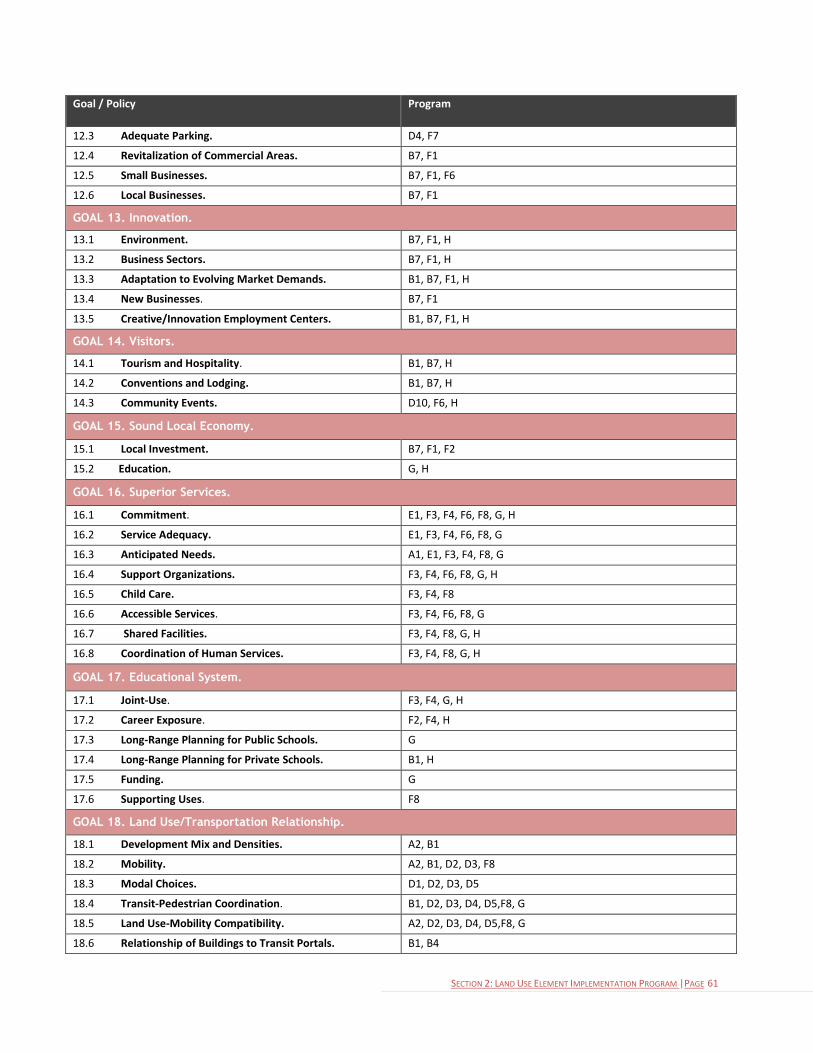
SECTION 2: LAND USE ELEMENT IMPLEMENTATION PROGRAM |PAGE 61
Goal / Policy Program
12.3 Adequate Parking. D4, F7
12.4 Revitalization of Commercial Areas. B7, F1
12.5 Small Businesses. B7, F1, F6
12.6 Local Businesses. B7, F1
GOAL 13. Innovation.
13.1 Environment. B7, F1, H
13.2 Business Sectors. B7, F1, H
13.3 Adaptation to Evolving Market Demands. B1, B7, F1, H
13.4 New Businesses. B7, F1
13.5 Creative/Innovation Employment Centers. B1, B7, F1, H
GOAL 14. Visitors.
14.1 Tourism and Hospitality. B1, B7, H
14.2 Conventions and Lodging. B1, B7, H
14.3 Community Events. D10, F6, H
GOAL 15. Sound Local Economy.
15.1 Local Investment. B7, F1, F2
15.2 Education. G, H
GOAL 16. Superior Services.
16.1 Commitment. E1, F3, F4, F6, F8, G, H
16.2 Service Adequacy. E1, F3, F4, F6, F8, G
16.3 Anticipated Needs. A1, E1, F3, F4, F8, G
16.4 Support Organizations. F3, F4, F6, F8, G, H
16.5 Child Care. F3, F4, F8
16.6 Accessible Services. F3, F4, F6, F8, G
16.7 Shared Facilities. F3, F4, F8, G, H
16.8 Coordination of Human Services. F3, F4, F8, G, H
GOAL 17. Educational System.
17.1 Joint-Use. F3, F4, G, H
17.2 Career Exposure. F2, F4, H
17.3 Long-Range Planning for Public Schools. G
17.4 Long-Range Planning for Private Schools. B1, H
17.5 Funding. G
17.6 Supporting Uses. F8
GOAL 18. Land Use/Transportation Relationship.
18.1 Development Mix and Densities. A2, B1
18.2 Mobility. A2, B1, D2, D3, F8
18.3 Modal Choices. D1, D2, D3, D5
18.4 Transit-Pedestrian Coordination. B1, D2, D3, D4, D5,F8, G
18.5 Land Use-Mobility Compatibility. A2, D2, D3, D4, D5,F8, G
18.6 Relationship of Buildings to Transit Portals. B1, B4
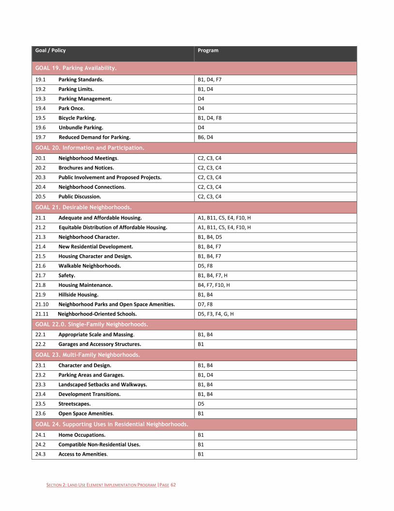
SECTION 2: LAND USE ELEMENT IMPLEMENTATION PROGRAM |PAGE 62
Goal / Policy Program
GOAL 19. Parking Availability.
19.1 Parking Standards. B1, D4, F7
19.2 Parking Limits. B1, D4
19.3 Parking Management. D4
19.4 Park Once. D4
19.5 Bicycle Parking. B1, D4, F8
19.6 Unbundle Parking. D4
19.7 Reduced Demand for Parking. B6, D4
GOAL 20. Information and Participation.
20.1 Neighborhood Meetings. C2, C3, C4
20.2 Brochures and Notices. C2, C3, C4
20.3 Public Involvement and Proposed Projects. C2, C3, C4
20.4 Neighborhood Connections. C2, C3, C4
20.5 Public Discussion. C2, C3, C4
GOAL 21. Desirable Neighborhoods.
21.1 Adequate and Affordable Housing. A1, B11, C5, E4, F10, H
21.2 Equitable Distribution of Affordable Housing. A1, B11, C5, E4, F10, H
21.3 Neighborhood Character. B1, B4, D5
21.4 New Residential Development. B1, B4, F7
21.5 Housing Character and Design. B1, B4, F7
21.6 Walkable Neighborhoods. D5, F8
21.7 Safety. B1, B4, F7, H
21.8 Housing Maintenance. B4, F7, F10, H
21.9 Hillside Housing. B1, B4
21.10 Neighborhood Parks and Open Space Amenities. D7, F8
21.11 Neighborhood-Oriented Schools. D5, F3, F4, G, H
GOAL 22.0. Single-Family Neighborhoods.
22.1 Appropriate Scale and Massing. B1, B4
22.2 Garages and Accessory Structures. B1
GOAL 23. Multi-Family Neighborhoods.
23.1 Character and Design. B1, B4
23.2 Parking Areas and Garages. B1, D4
23.3 Landscaped Setbacks and Walkways. B1, B4
23.4 Development Transitions. B1, B4
23.5 Streetscapes. D5
23.6 Open Space Amenities. B1
GOAL 24. Supporting Uses in Residential Neighborhoods.
24.1 Home Occupations. B1
24.2 Compatible Non-Residential Uses. B1
24.3 Access to Amenities. B1

SECTION 2: LAND USE ELEMENT IMPLEMENTATION PROGRAM |PAGE 63
Goal / Policy Program
GOAL 25. Vital Districts and Corridors.
25.1 Diversity of Uses. B1, B7
25.2 Compact Infill Development. B1, B9
25.3 Cohesive Development. B1
25.4 Architecture and Site Design. B4
25.5 Connectivity to Neighborhoods. D5
25.6 Multi-Use of Public Alleys. D5, H
25.7 Buffering Adjoining Residential Areas. A1,B1, B4
25.8 Pedestrian, Bicycle and Transit Access. B1, B4, D1, D2, D3, D4
25.9 Maintenance. F7, H
25.10 Retail. B1, B9, F1
25.11 Retail Streetscapes. D5, H
25.12 Retail Parking. D4
GOAL 26. Offices.
26.1 Office. B1, B7, F1
26.2 Creative Office. B1, B7, F1
GOAL 27. R&D Flex Space.
27.1 Diversity of Uses. B1, F1
27.2 Business Attraction. B1, B7, F1
27.3 Supporting Uses. F1
27.4 Buffering from Adjacent Properties. B1, B4, F7
27.5 Impact Mitigation. C3, C4, F7, G
27.6 Adaptive Reuse. B1, B10, D4
GOAL 28. Places to Live, Work, Shop, and Recreate.
28.1 Land Use Mix. B1
28.2 Development Scale. B1, B4
28.3 On-site Amenities. B1, B4
28.4 Design Integration. B1, B4
GOAL 29. Transit Villages.
29.1 Mix of Uses. B1, B9
29.2 Neighborhood Identity. B4, B9, D5
29.3 Pedestrian Orientation. B4, D5
29.4 Bicycle Facilities. B1, B9, F8
GOAL 30. Neighborhood Villages.
30.1 Mix of Uses. B1, B9
30.2 Development at Key Nodes. B1, B9, D3
30.3 Neighborhood Identity. B1, B4, D5, F8
30.4 Community Activity. F1
30.5 Connectivity to Neighborhoods. D5, F8
30.6 Pedestrian Orientation. B1, D5, F8
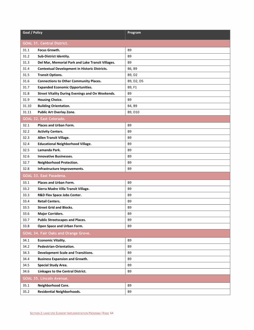
SECTION 2: LAND USE ELEMENT IMPLEMENTATION PROGRAM |PAGE 64
Goal / Policy Program
GOAL 31. Central District.
31.1 Focus Growth. B9
31.2 Sub-District Identity. B9
31.3 Del Mar, Memorial Park and Lake Transit Villages. B9
31.4 Contextual Development in Historic Districts. B6, B9
31.5 Transit Options. B9, D2
31.6 Connections to Other Community Places. B9, D2, D5
31.7 Expanded Economic Opportunities. B9, F1
31.8 Street Vitality During Evenings and On Weekends. B9
31.9 Housing Choice. B9
31.10 Building Orientation. B4, B9
31.11 Public Art Overlay Zone. B9, D10
GOAL 32. East Colorado.
32.1 Places and Urban Form. B9
32.2 Activity Centers. B9
32.3 Allen Transit Village. B9
32.4 Educational Neighborhood Village. B9
32.5 Lamanda Park. B9
32.6 Innovative Businesses. B9
32.7 Neighborhood Protection. B9
32.8 Infrastructure Improvements. B9
GOAL 33. East Pasadena.
33.1 Places and Urban Form. B9
33.2 Sierra Madre Villa Transit Village. B9
33.3 R&D Flex Space Jobs Center. B9
33.4 Retail Centers. B9
33.5 Street Grid and Blocks. B9
33.6 Major Corridors. B9
33.7 Public Streetscapes and Places. B9
33.8 Open Space and Urban Form. B9
GOAL 34. Fair Oaks and Orange Grove.
34.1 Economic Vitality. B9
34.2 Pedestrian-Orientation. B9
34.3 Development Scale and Transitions. B9
34.4 Business Expansion and Growth. B9
34.5 Special Study Area. B9
34.6 Linkages to the Central District. B9
GOAL 35. Lincoln Avenue.
35.1 Neighborhood Core. B9
35.2 Residential Neighborhoods. B9
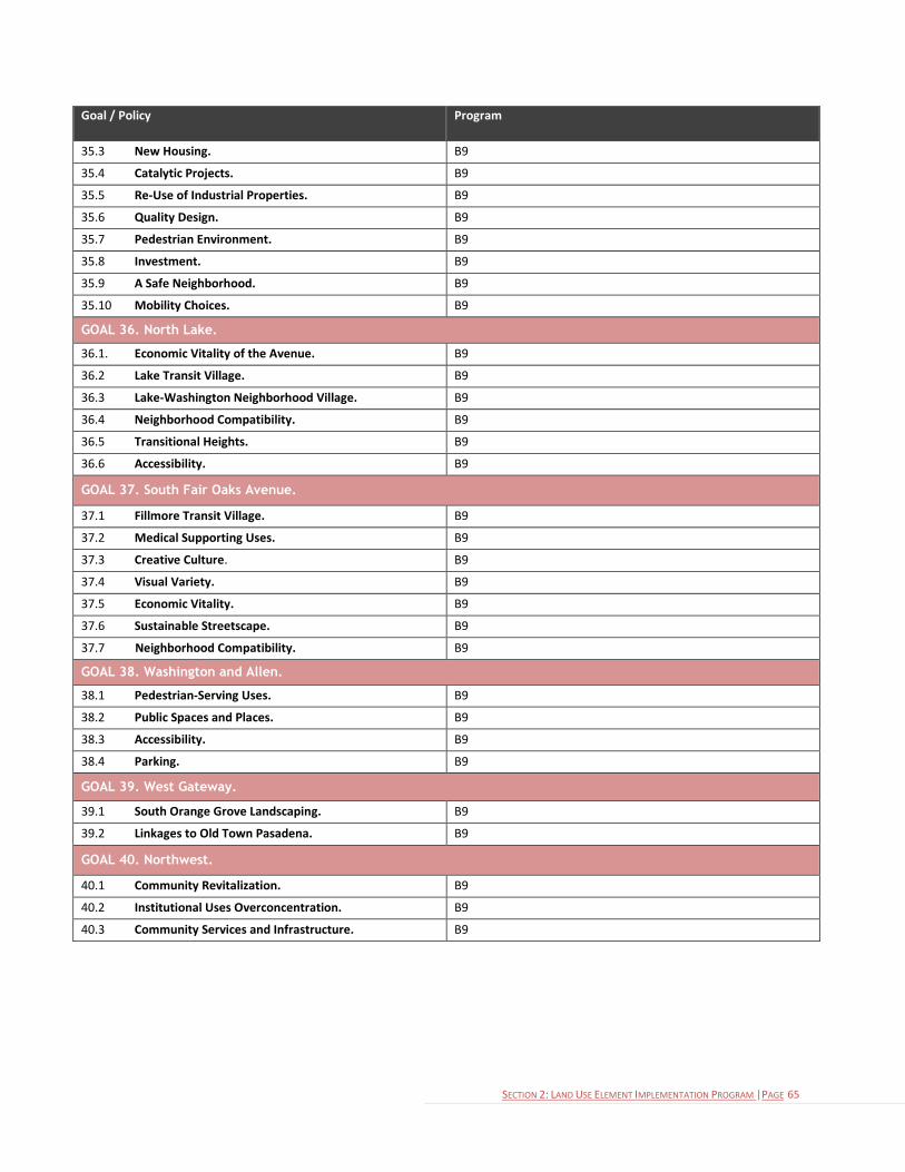
SECTION 2: LAND USE ELEMENT IMPLEMENTATION PROGRAM |PAGE 65
Goal / Policy Program
35.3 New Housing. B9
35.4 Catalytic Projects. B9
35.5 Re-Use of Industrial Properties. B9
35.6 Quality Design. B9
35.7 Pedestrian Environment. B9
35.8 Investment. B9
35.9 A Safe Neighborhood. B9
35.10 Mobility Choices. B9
GOAL 36. North Lake.
36.1. Economic Vitality of the Avenue. B9
36.2 Lake Transit Village. B9
36.3 Lake-Washington Neighborhood Village. B9
36.4 Neighborhood Compatibility. B9
36.5 Transitional Heights. B9
36.6 Accessibility. B9
GOAL 37. South Fair Oaks Avenue.
37.1 Fillmore Transit Village. B9
37.2 Medical Supporting Uses. B9
37.3 Creative Culture. B9
37.4 Visual Variety. B9
37.5 Economic Vitality. B9
37.6 Sustainable Streetscape. B9
37.7 Neighborhood Compatibility. B9
GOAL 38. Washington and Allen.
38.1 Pedestrian-Serving Uses. B9
38.2 Public Spaces and Places. B9
38.3 Accessibility. B9
38.4 Parking. B9
GOAL 39. West Gateway.
39.1 South Orange Grove Landscaping. B9
39.2 Linkages to Old Town Pasadena. B9
GOAL 40. Northwest.
40.1 Community Revitalization. B9
40.2 Institutional Uses Overconcentration. B9
40.3 Community Services and Infrastructure. B9

SECTION 3: LAND USE ELEMENT GLOSSARY |PAGE 66
City of Pasadena General Plan
SECTION 3: LAND USE ELEMENT GLOSSARY
Accessibility: The degree to which a site, location, or activity is connected to another site and the ability to move between the
sites. [Policy 4.10]
Adaptive Reuse: Changing obsolete or historic buildings from their original or most recent use to a new use. For example,
changing a former hospital or school building to housing, or changing an historic single-family house to an office. [Policy 10.6]
Affordable Housing: Affordable Housing shall be defined by the Zoning Code’s definition of affordable housing. [Land Use
Classifications, Housing]
Alternative Energy: Any energy source that is an alternative to fossil fuels (fossil fuels include coal, petroleum, and natural gas).
[Policy 10.2]
Alternative Transportation Modes: Commuting in any way other than driving alone. Examples include biking, walking,
carpooling, and taking transit. [Goal 19]
Brick and Mortar Facilities: Businesses that have a physical presence and offer face-to-face customer experiences. [Policy 2.10]
Capital Facilities: The basic services that the public sector provides to support the community as it currently exists, such as
roadways, parking facilities, utilities, landscaping, bridges, athletic and recreational facilities, etc. [Policy 1.7]
City of Gardens: The City of Gardens Standards are an innovative set of zoning regulations aimed at creating more livable multi-
family housing projects, encouraging designs that typify the garden character of earlier apartments and bungalow courts in
Pasadena. These standards are also an integral way of encouraging the production of multi-family apartments and
condominium projects of lasting quality. [Land Use Classifications, Housing]
Community Garden: A kind of urban open space that can contain passive features such as paths, benches and landscaping or
could include plots for residents to grow fruits and vegetables. A pocket park (also known as a vest pocket or mini-park) is
typically much the same as a community garden, except the emphasis would tend to be less on horticulture and more on site
amenities such as picnic facilities and small playgrounds. [Policy 2.10]
Community Places: A group of defined geographic areas where the City has specific development goals and policies.
Density: The number of dwelling units on a lot divided by the size of the lot (i.e., units per acre). [Development
Density/Intensity Standards]
Development Capacity: The maximum number of new housing units or new non-residential square footage that is permitted
within a planning area. The 1994 General Plan set a cap on development in the City’s planning areas. [Policy 31.7]
Design Review: The comprehensive evaluation of a development and its impact on neighboring properties and the community
as a whole, from the standpoint of site and landscape design, architecture, materials, colors, lighting, and signs, in accordance
with a set of adopted criteria and standards. Design Review usually refers to a system set up outside of the zoning ordinance,
whereby projects are reviewed against certain standards and criteria by a specially established design review board or
committee. [Policy 7.4]
Entitlement: In land development, approvals for the right to develop property for a desired purpose or use. [Goal 20]
Flex Space: A multi-tenant space allowing both commercial (i.e., office, showroom, warehouse space) and industrial uses to
coexist in the same building or on the same property. [Land Use Classifications, Commercial]
Floor Area Ratio (FAR): The gross floor area permitted on a site divided by the total net area of the site, expressed in decimals
to one or two places. For example, on a site with 10,000 net sq. ft. of land area, a Floor Area Ratio of 1.0 will allow a maximum
of 10,000 gross sq. ft. of building floor area to be built. On the same site, an FAR of 1.5 would allow 15,000 sq. ft. of floor area;
an FAR of 2.0 would allow 20,000 sq. ft.; and an FAR of 0.5 would allow only 5,000 sq. ft. [Development Density/Intensity
Standards]

SECTION 3: LAND USE ELEMENT GLOSSARY |PAGE 67
General Plan: A legal document with a City’s policies to guide its long-term development in the form of maps accompanied by
text. State law requires a General Plan to contain certain chapters, or elements, including land use and circulation (or mobility).
Greenhouse Gases (GHG): Gases that are believed to contribute to climate change, in the form of changes in temperature,
rainfall, snow or wind patterns. Vehicle emissions are a major source of greenhouse gases. [Policy 4.1]
Historic Preservation: The preservation of historically significant structures and neighborhoods in order to facilitate restoration
and rehabilitation of the building(s) to a former condition. [Goal 8]
Home Occupation: A business conducted in a dwelling unit or accessory structure and is accessory to a residential use. [Policy
24.1]
Human Services: Services with the objective of meeting human needs through an interdisciplinary knowledge base, focusing on
prevention as well as remediation of problems, and maintaining a commitment to improving the overall quality of life of service
populations. [Policy 16.3]
Infill Development: Development of vacant or underutilized land (usually individual lots or left-over properties) within areas
that are already largely developed. [Policy 25.2]
Intensity, Building: For residential uses, the actual number or the allowable range of dwelling units per net acre. For non-
residential uses, the actual or the maximum permitted floor area ratios (FARs). [Development Density/Intensity Standards]
Land Use Classification: A system for classifying and designating the appropriate use of properties, as shown on the Land Use
Diagram.
Mansionization: New construction or additions on residentially zoned lots that are out-of-scale with the surrounding
neighborhood, but which comply with the current City zoning regulations. [Policy 22.1]
Massing: In architecture, massing refers to the general shape and size of a building. [Policy 4.11]
Mixed-Use: When non-residential uses (such as offices, shops, or restaurants) are combined with housing in a building or on
the same property. [Land Use Classifications]
Multi-modal: Involves using two or more modes of transportation, such as driving, taking public transit, walking, and biking, in a
journey. [Goal 18]
Multi-family Residential: Two or more dwelling units on a lot.
Neighborhood Park: Generally, neighborhood parks provide informal, general-use areas developed with children’s play areas,
multi-purpose open turf areas, and other amenities used for smaller social gatherings. Some larger neighborhood parks may
include active recreation elements such as ball fields. Neighborhood parks play an important role in providing neighborhood
focus and identity. [Policy 21.10]
Neighborhood Villages: Lower density mixed-use clusters of residential and commercial uses developed in an integrated
“village-like” environment with buildings clustered on common plazas and open spaces designed as communal places that are
walkable from surrounding neighborhoods. [Goal 30]
Non-conforming Use: A use of a structure (either conforming or nonconforming) or land that was legally established and
maintained before the adoption of the Zoning Code and which does not conform to current Code provisions governing
allowable land uses for the zoning district in which the use is located. This includes uses that do not conform to the land use
regulations for the district in which they are located and were established prior to July 1, 1985, under a use of property
variance. [Policy 3.6]
Open Space: A Land Use Element category that includes natural open spaces as well as active and passive recreational facilities.
The designation applies to lands owned by the City.
Parklets: A parklet is a small space serving as an extension of the sidewalk to provide amenities and green space for people
using the street. It is typically the size of several parking spaces and extends out from the sidewalk at the level of the sidewalk
to the width of the adjacent parking space. [Policy 10.12]
SECTION 3: LAND USE ELEMENT GLOSSARY |PAGE 68
Paseos: Public places or paths designed for walking, like promenades. [Policy 10.12]
Pedestrian-Oriented Development: A development that includes a mixture of land uses, shorter distances between likely
origins and destinations, and design improvements to the pedestrian environment. [Policy 5.2]
Per capita: A citywide value or number – such as water use – divided by the number of people who live and work in the city.
Personal Services: A business providing non-medical services to individuals as a primary use. Examples include barber shops,
beauty salons, shoe repair shops, tailors, etc. [Land Use Classifications, Commercial]
Placemaking: A multi-faceted approach to the planning, design and management of public spaces. Placemaking capitalizes on a
local community’s assets, inspiration, and potential, ultimately creating good public spaces that promote people’s health,
happiness, and well-being. [Goal 4]
Planned Development: A comprehensively planned project on a site of at least two acres in size where an applicant proposes
and the City desires to achieve a particular mix of uses, appearance, land use compatibility, or special sensitivity to
neighborhood character. An increase in the allowable Floor Area Ratio for such projects, not to exceed a total of 3.0, can be
allowed through a discretionary process for projects of high-quality, architectural design that is in context with the existing
surrounding development. [Policy 4.13]
Public Art: Art in any media that has been planned and executed with the intention of being staged in the physical public
domain, usually outside and accessible to all. [Policy 6.5]
Research and Development (R&D): An industrial use that involves the study, testing, design, analysis or experimental
development of products, processes or services. [Land Use Classifications, Commercial]
Setback: The distance by which a structure, parking area or other development feature must be separated from a lot line
easement, other structure or development feature. [Land Use Classifications, Housing]
Single-family Residential: A building containing one dwelling unit located on a single lot, but may include a second residential
unit in compliance with Section 17 of the Zoning Code.
Specific Plan: A planning document governing a particular area within the City that serves as a tool to implement the policies
stated in the General Plan, and which contains specific criteria and standards applying to the plan area.
Streetscape: Roadway characteristics that include its physical design (width, grade or slope), amenities (street furniture, bus
stop shelters), landscaping, lighting, etc., that affect street users and nearby residents. [Goal 4]
Sustainability: Meeting the needs of the present without compromising the ability of future generations to meet their own
needs. Further defined as balancing the three E’s: environment, economy and equity. For example, a decision or action aimed
at promoting economic development should be balanced with issues involving environmental quality and social inequity. [Goal
10]
Transit-Oriented Development (TOD): A development located within walking distance of a light rail station or other transit
node and that encourages non-auto travel. [Goal 18]
Transit: A system of regularly-scheduled buses and/or trains available to the public on a fee-per ride basis. Also called mass
transit.
Transit Villages: Moderate to high density mixed-use clusters of residential and commercial uses developed in an integrated
“village-like” environment with buildings clustered on common plazas and open spaces in proximity to Metro Gold Line stations
capitalizing on their induced market demands and land values, facilitating ridership, and reducing automobile use while
increasing walkabilty. [Goal 29]
Trip Generation: The dynamics that account for people making trips in automobiles or by means of public transportation. Trip
generation is the basis for estimating the level of use for a transportation system and the impact of additional development or
transportation facilities on an existing, local transportation system. Trip generations of households are correlated with
destinations that attract household members for specific purposes. [Land Use Categories, Mixed-Use Corridors and Villages]
SECTION 3: LAND USE ELEMENT GLOSSARY |PAGE 69
Urban Design: The attempt to give form, in terms of both beauty and function, to selected urban areas or to whole cities.
Urban design is concerned with the location, mass, and design of various urban components and combines elements of urban
planning, architecture, and landscape architecture. [Goal 9]
Urban Form: The general pattern of building height and development intensity and the structural elements that define the City
physically, such as natural features, transportation, open space, public facilities, as well as activity centers and focal elements.
[Goal 4]
Urban Forest: The total collection of trees and associated plants growing in a city or town. It includes trees in parks and yards,
along roadways and paths, and in other areas. [Policy 10.13]
Urban Housing: In Pasadena, refers to a high-density multi-family project in the Central District, in a commercial zoning district,
or a part of a transit-oriented development around a light rail station. [Land Use Classifications, Housing]
Urban Open Space: Pasadena has a large variety of public outdoor open spaces that cannot be classified as parks but these
spaces do fulfill many of the same functions as public parks. These urban open spaces and special facilities can be either city-
owned or privately-owned. Public plazas, paseos, golf courses and the grounds of museums and historic sites are all examples
of this type of open space. Another good example of this form of land use is a community garden. These are public spaces that
can contain passive features such as paths, benches and landscaping or could include plots for residents to grow fruits and
vegetables. A pocket park (also known as a vest pocket or mini-park) is typically much the same as a community garden, except
the emphasis would tend to be less on horticulture and more on site amenities such as picnic facilities and small playgrounds.
[Policy 10.12]
Vehicle Trips: A trip by a single privately operated vehicle regardless of the number of persons in the vehicle. [Land Use
Classifications, Mixed-Use]
View Shed: The area within view from a defined observation point. [Policy 6.4]
Walkability: A measure of how friendly the built environment is to walking.
Watershed: The land area that drains into a stream; the watershed for a major river may encompass a number of smaller
watersheds that ultimately combine at a common point. [Policy 2.14]
Work/Live: Buildings or spaces that are used for both housing and commercial purposes (such as an artist’s studio, or a home-
based business) for the same occupant. [Land Use Classifications, Mixed-Use]
Zoning: The division of a city or county by legislative regulations into areas, or zones, which specify allowable uses for real
property and size restrictions for buildings within these areas; a program that implements policies of the General Plan.

SECTION 4: LAND USE DEVELOPMENT CAPACITY APPENDIX |PAGE 70
City of Pasadena General Plan
SECTION 4: LAND USE ELEMENT DEVELOPMENT CAPACITY APPENDIX The 1994 General Plan Land Use Element established a system of development caps for each of the proposed specific plans.
The General Plan Update of 2014 carries forward a system of development caps. The following is a description of the
mechanics and practices of the City will use in governing the development caps.
Upon adoption of the General Plan update and the final certification of the General Plan Environmental Impact Report, the
system of caps from the 1994 General Plan Land Use Element (including the 2004 update) will be retired. The new
development caps established by the 2014 General Plan Update will be in place. The caps included in the 1994 Land Use
Element will be zeroed out and the new caps will take effect; the 2014 caps are not in addition to the 1994 caps.
Development Caps: As described in Policy 1.3, the General Plan designates the intensity of development and the mix of
allowed uses within each specific plan area. A shift of development cap from one specific plan to a different specific plan is not
permitted.
Net -New: The development caps provide for a certain quantity of net-new development. If an existing building is demolished
and a new building is constructed on the same site, the square footage of the existing building is subtracted from the square
footage of the new building in determining the total “new” square footage on the site regardless of use.
Regardless of Use: Unless modified by a specific plan, the non-residential development caps are provided irrespective of the
type of commercial use. The caps in the Land Use Element are not sub-divided between different types of non-residential or
residential development. If a retail building is demolished and replaced with an office building of the same square footage,
there is withdrawal from the development caps.
Reuse: The reuse of an existing building without the addition of square footage does not result in “new” square footage on the
site.
Parking Structures: Parking structures are exempt from the development caps, unless the specific plan establishes otherwise.
Gross Floor Area: The square footage of a structure shall be calculated using the Zoning Code’s definition of gross floor area.
Housing Unit: A housing unit shall be defined by the Zoning Code’s definition of a dwelling unit.
Affordable Housing: Affordable housing units are not toward the development caps, unless the specific plan determines
otherwise. Because of this net-new residential development may exceed the development caps in a specific plan area.
Allocation of Capacity: The practice of the City is to allocated development capacity at the time of building permit issuance.
Educational Institutions: The development caps do not apply to educational institutions as their impact on the community is
more closely tied to enrollment than building square footage.
As a charter city, Pasadena is not currently required to meet the State law requirement for consistency between the general
plan and the zoning ordinance. However, it is the policy of the City to maintain such land use consistency.