Embed Size (px)
Citation preview

CITY OF NICHOLSON, GEORGIA COMPREHENSIVE PLAN
COMMUNITY AGENDA
Adopted September 10, 2010
Prepared Under Contract By:
Jerry Weitz & Associates, Inc. Planning & Development Consultants
GIS Mapping and Support By:
Jackson County GIS Department

ii
CONTENTS CHAPTER 1: INTRODUCTION 1 ABOUT NICHOLSON 1 OVERVIEW OF PLANNING DOCUMENTS 2 PURPOSES OF THE COMPREHENSIVE PLAN 2 ORGANIZATION OF THE COMMUNITY AGENDA 2 AMENDMENT AND UPDATE OF THE COMPREHENSIVE PLAN 3 A POSSIBLE VIEW OF NICHOLSON IN 2030 3 CHAPTER 2: ISSUES AND OPPORTUNITIES 5 OPEN SPACE AND ENVIRONMENT 5 Environmental Protection Regulations 5 Long-Term Acquisition or Protection of Open Space 5 HOUSING AND COMMUNITY DEVELOPMENT 5 Reconsideration of Housing Unit Minimum Floor Area Requirements 5 Pace Drive Community Improvement 5 ECONOMIC DEVELOPMENT 6 Heightened Efforts With Regard to Economic Development 6 Downtown Place Making 6 GROWTH PREPAREDNESS AND LAND USE REGULATION 7 Annexation 7 Revision of Land Use Regulations 7 Arrangement for Administration of Land Use Regulations 7 Improve Understanding of Land Development Processes 7 Aesthetic Controls and Guidelines 7 COMMUNITY FACILITIES AND SERVICES 8 Sanitary Sewer Service 8 Planning for Future Water Supplies 8 Cemetery Maintenance 8 County Service Facilities 8 TRANSPORTATION 9 Existing Road Conditions 9 Sidewalk Improvements 9 Future Bike Route 10 CHAPTER 3: CHARACTER AND LAND USE 11 UNDERSTANDING CHARACTER AND LAND USE AND DEVELOPMENT MAPS 11 Official Zoning Map 11 Existing Land Use 11 2030 Character 11 2030 Future Land Use 11 CHARACTER AREAS 11 The Agricultural Character Area 14 The Large Lot – Rural Residential Character Area 16 The In-Town / Suburban Residential Character Area 18 The Government Institutional Character Area 20 The Town Center Character Area 22

iii
The Highway Commercial Character Area 25 SUMMARY MATRIX OF CHARACTER, LAND USE, AND ZONING CATEGORIES 28 FUTURE LAND USE 28 Park/Recreation/Conservation 28 Agricultural/Forestry 28 Residential Subcategories 29 Public/Institutional 29 Commercial 29 Transportation/ Communications/ Utilities 29 LAND USE POLICIES 31 CHAPTER 4: POLICIES 33 ENVIRONMENT AND NATURAL RESOURCES 33 HISTORIC AND CULTURAL RESOURCES 35 HOUSING AND COMMUNITY DEVELOPMENT 35 ECONOMIC DEVELOPMENT 36 COMMUNITY FACILITIES AND SERVICES 37 TRANSPORTATION 37 INTERGOVERNMENTAL COORDINATION 38 CHAPTER 5: IMPLEMENTATION 39 NATURAL RESOURCES PROTECTION 39 Environmental Planning Criteria 39 Other Environmental Regulations 39 Tree City USA 39 HISTORIC AND CULTURAL RESOURCES 40 Historic Resources Inventory 40 National Register of Historic Places 40 Local Historic Preservation Ordinance 40 HOUSING AND COMMUNITY DEVELOPMENT 40 Public Housing Program 40 Property Maintenance and Housing Code Enforcement 40 Code Enforcement Board 41 Community Development Block Grant 41 Community Development Corporations 41 ECONOMIC DEVELOPMENT AND REDEVELOPMENT 41 Countywide Economic Development Master Plan 41 Downtown Development Authority 41 LAND USE 42 Zoning Ordinance 42 Subdivision and Land Development Regulations 42 Overlay Districts 42 New Urbanism 42 Specific, Small Area, or Refinement Plans 42 Jobs-Housing Balance 42 URBAN DESIGN 43 Design Guidelines 43 Gateway Improvements and Beautification 43 Leadership in Energy and Environmental Design (LEED) 43
iv
COMMUNITY FACILITIES AND SERVICES 43 Parks and Recreation Master Plan 43 Water and Sewer Master Planning 43 Nicholson Library Improvement 44 Capital Improvement Programming 45 Special Local Option Sales Tax (SPLOST) 45 Development Impact Fees 45 ISO Rating 45 Drought Preparedness and Water Conservation 45 Solid Waste Management 45 Emergency Management and Emergency Preparedness 45 TRANSPORTATION 46 INTERGOVERNMENTAL COORDINATION 46 Annexation of Unincorporated Islands 46 Intergovernmental Agreements 46 SHORT-TERM WORK PROGRAM 46 APPENDIX A: GLOSSARY OF TERMS 49 APPENDIX B: NICHOLSON QUESTIONNAIRE RESULTS 54 APPENDIX C: REPORT OF PLAN ACCOMPLISHMENTS 59

v
LIST OF TABLES
1.1 Population Estimates, July 1, 2000-2008
City of Nicholson and Jackson County 1
1.2 Population and Housing Unit Projections, 2010-2030
City of Nicholson and Jackson County 1
3.1 Character, Future Land Use, and Proposed Zoning District Compatibility 28 3.2 Land Use Acreage by Land Use Category, 2009 and 2030, City of Nicholson 29 5.1 Short-Term Work Program, City of Nicholson, 2010 to 2015 47
LIST OF MAPS Aerial View of Pace Drive Neighborhood 6 Downtown Place Making Base Map 6 Sidewalks Needed to Support Town Center Development 9 Commerce-Nicholson Bicycle Loop 10 Character Areas 2030, City of Nicholson 13 Future Land Use Plan 2030, City of Nicholson 30 Generalized Area of Current Public Water Service, Nicholson Water Authority 44

City of Nicholson Comprehensive Plan, Community Agenda (Adopted September 10, 2010)
1
CHAPTER 1 INTRODUCTION
This chapter introduces the comprehensive plan. First, the city is described in summary fashion, including its location, growth trends, and projections. An overview of the comprehensive plan is provided, and the organization of this community agenda document is summarized. A visionary outlook for the city as a whole provides a foundation for the comprehensive plan. ABOUT NICHOLSON Nicholson was initially established as the town of ―Cooper,‖ named after the owner of a large farm in the area. Cooper was named ―Nicholson‖ in 1882. The city was incorporated in 1907. Nicholson is located within Jackson County northeast of the metropolitan Atlanta Region, just northwest of the Athens-Clarke County metropolitan region, and east of the Gainesville urbanized area. U.S. Highway 441, which runs through the center of the city in a north-south direction, links Nicholson to Athens and Commerce as well as the north Georgia Mountains to the north. Nicholson is about 10 miles from the county seat of Jefferson. A railroad track generally parallels U.S. Highway 441. The city limits were initially laid out in a rectangular shape, along old Highway 441. Nicholson annexed approximately 491 acres of land between 2003 and 2008, according to annexation records of the Georgia Department of Community Affairs. As of today, it consists of almost 3,000 acres in area (about 4.6 square miles). Nicholson is a relatively small and rural city, with a population of just over 2,000 persons. Jackson County is still mostly rural but rapidly suburbanizing. Nicholson and southeast Jackson County are witnessing growth pressures from the Athens-Clarke County region to the southeast.
Table 1.1 Population Estimates, July 1, 2000-2008 City of Nicholson and Jackson County
Total Population 2000 2001 2002 2003 2004 2005 2006 2007 2008
City of Nicholson 1,345 1,349 1,356 1,342 1,388 1,523 1,707 1,892 2,060
Jackson County 41,894 43,631 45,486 46,929 49,347 51,999 55,542 59,254 61,620
Source: Population Division, U.S. Census Bureau. ―Annual Estimates of the Population for Incorporated Places in Georgia: April 1, 2000 to July 1, 2008‖. Release Date: July 1, 2009; and ―Annual Estimates of the Resident Population for Counties of Georgia: April 1, 2000 to July 1, 2008.‖ Release Date: March 19, 2009.
Table 1.2
Population and Housing Unit Projections, 2010-2030 City of Nicholson and Jackson County
Projection 2010 2015 2020 2025 2030
City of Nicholson Population 2,200 2,373 2,560 2,617 3,048
Jackson County Population 64,564 72,531 81,409 90,287 99,165
City of Nicholson Housing Units 767 827 892 912 1,062
Jackson County Housing Units 23,824 26,764 30,040 33,316 36,592 Source: Jerry Weitz & Associates, Inc. 2010.
City of Nicholson Comprehensive Plan, Community Agenda (Adopted September 10, 2010)
2
In 2000 the city had a labor force of 539 workers. The Nicholson Zip Code (30565), which is much larger than the city limits, in 2006 had a total of 46 establishments (all types), with employment totaling 174 persons. Employment opportunities are generally lacking in the city, though there a few significant employers such as Benton Elementary School. With a growing population, it appears that the city is on the cusp of meeting minimum market area conditions to support some retail trade and perhaps some services and restaurants. The city does not have any sanitary sewer service at this time, however. There are some streams but no major rivers that run through the city limits of Nicholson. The western part of the city drains into the North Oconee River basin. The eastern half of the city limits of Nicholson lies within the Sandy Creek watershed. OVERVIEW OF PLANNING DOCUMENTS The first phase of the comprehensive planning process consisted of preparation of three reports: (1) a ―Community Assessment,‖ (2) a ―Technical Appendix to the Community Assessment, and (3) a ―Community Participation Program.‖ The Community Assessment and Community Participation Program were accepted by the region and state in early 2010. This ―Community Agenda‖ is the ―plan‖ portion of the City of Nicholson’s comprehensive plan. Topics covered in the plan include population, housing, economic development, natural resources, historic resources, character and land use, community facilities and services, and transportation. PURPOSES OF THE COMPREHENSIVE PLAN The Community Agenda is first, a physical plan intended to guide the physical development and redevelopment of the city by describing how, why, when, and where to build, rebuild, or preserve aspects of the community. Second, the Community Agenda covers a long-range planning horizon of 20 years (i.e., to the year 2030). Third, the Community Agenda is ―comprehensive‖ in the sense that it covers the entire city limits, plus it encompasses all the functions that make a community work and considers the interrelatedness of functions. The Community Agenda is based on the foundation that if the city knows where it wants to go, it possesses better prospects of getting there. The Community Agenda is intended to serve numerous purposes. It provides a primary basis for evaluating all future development proposals, whether they are requests for rezoning, applications for special use permit or subdivision plat approval, and others. The Community Agenda is also intended to provide guidance for operating and capital improvement budgets. Business persons, investors, real estate brokers, and developers can learn from the plan what the future vision of the community is, as well as the overall direction and intensity of new growth. Market analysts and researchers can draw on the data provided in the Community Assessment (a separate precursor document) for their own specific needs. Other local governments, regional entities, and state agencies also look at the contents of the Community Agenda as the best available statement of city policy and intent. The ultimate client, however, for the Community Agenda is the Nicholson Mayor and City Council. By adopting the Community Agenda, the Mayor and City Council have made an extremely important expression of their consent and support for the policies and work program contained in the Community Agenda. Completion of the comprehensive planning process according to state rules allows a local government to maintain its Qualified Local Government (QLG) status and, thus, maintain its eligibility to receive certain state grants and loans.

City of Nicholson Comprehensive Plan, Community Agenda (Adopted September 10, 2010)
3
ORGANIZATION OF THE COMMUNITY AGENDA This Community Agenda is organized into five chapters and three appendices. The first chapter introduces the Community Agenda document. Chapter 2 describes all of the ―issues and opportunities which were identified during the Community Assessment process and refined in the Community Participation process. The third chapter addresses character areas and land use. The fourth chapter provides a consolidated set of policies for all subject matters except for character areas and land use. Chapter 5 focuses on implementation and includes a short-term (five-year) work program. A glossary of planning terms is provided in Appendix A. Results of the community questionnaire are summarized in Appendix B. A report of plan accomplishments since the partial plan update was adopted in 2010 is provided in Appendix C. AMENDMENT AND UPDATE OF THE COMPREHENSIVE PLAN As an adopted expression of the city’s policy, the Community Agenda must be maintained in a manner that still reflects the desires of the current Mayor and City Council. Developers, the general public, and other agencies have a right to rely on the adopted Comprehensive Plan as an expression of current policy. In cases where it is determined that a particular policy, goal, program, or statement is no longer a valid expression of the city’s policy, then the plan needs to be amended. Otherwise, the validity of the plan is weakened, and those that have relied on the Community Agenda when it is not a reflection of current policy have then been, in effect, misled. Local governments are required to update the Comprehensive Plan every five years, and at that time, they are encouraged to provide major rewrites of the Comprehensive Plan. Regardless, the Comprehensive Plan must be comprehensively revised every 10 years. Amendments may be considered by the Nicholson City Council any time it believes it is productive to do so. When there is a significant change in policy by the City Council, for instance a decision to drop a major capital improvement project that is described in the adopted plan, the plan should be amended. A POSSIBLE VIEW OF NICHOLSON IN 2030 Time is heading into a spring weekend in the year 2030. Nicholson is abuzz, with the start of another of its annual biking and running events. Hundreds of biking enthusiasts will descend upon Nicholson to take part in the annual bike ride and running event from Nicholson to Commerce and back again, which began in 2021. In addition to the bikers, associations promoting health and exercise have organized walking events for this same weekend along the same routes. Bikers and long-range runners will complete a marathon-length journey from Nicholson to Commerce and back again. The bike riders and runners start at East Jackson Park and travel on an officially designated bike route (the ―Eastern Jackson Scenic Byway‖) designated as a scenic route by Jackson County in 2010, which follows State Route 334. This route boasts scenic views of rural and agricultural resource lands. The bike route extends into the City of Commerce. The bikers and runners, after a rest or an overnight stay in Commerce, return south along the North Oconee River Greenway, which was established by Jackson County in 2020, then along State Route 335 into downtown Nicholson, where they began. This regional event is heavily promoted to bicycle and pedestrian enthusiasts in the Athens-Clarke County region and state. While some participants will ride up from Athens just for this one annual event, there is a growing local club of bicyclists who ride the loop between Nicholson and Commerce on a

City of Nicholson Comprehensive Plan, Community Agenda (Adopted September 10, 2010)
4
regular basis, going up SR 334 to Commerce and then back down to Nicholson via the North Oconee River Greenway. What gets some of the bicyclists and runners to stay in Nicholson is its small, but quaint town center. Nicholson has a city center that was developed in 2020. The downtown consists of restaurants, small lodging facilities, and retail and service shops which specifically include merchants serving the needs of bikers, runners, and outdoor enthusiasts who come to the area to enjoy the quality of Nicholson’s small downtown and the rural ambiance surrounding the city. They love Nicholson, because it is a launching off point to cleaner air, rural and environmental scenic views, and essential services just outside the bustling congestion of Athens. The Nicholson area is a clean, open environment in part because many of the surrounding farms and rural lands have been conserved as active rural and agricultural landscapes, free from suburbanization.

City of Nicholson Comprehensive Plan, Community Agenda (Adopted September 10, 2010)
5
CHAPTER 2 ISSUES AND OPPORTUNITIES
Per the state’s local planning requirements, the list of issues and opportunities provided in the Community Assessment (phase one of the planning process) has been refined as necessary during the community participation process and is presented in this chapter. This chapter provides the final listing of issues and opportunities and also describes how each issue or opportunity so identified is followed up with policies and/or implementation measures. OPEN SPACE AND ENVIRONMENT Environmental Protection Regulations While Nicholson has put into place some significant regulations that will help ensure the environment is protected, there are some protection measures that are lacking or which need updating. Nicholson needs to adopt regulations implementing the state’s environmental planning criteria. It is also suggested that Nicholson adopt a floodplain management ordinance incorporating new flood plain maps which will go into effect September 2010. Also, unless Nicholson becomes a ―local issuing authority‖ under the state’s soil erosion and sedimentation control act, or joins an existing local issuing authority, soil erosion reviews will continue to be left to the soil and water conservation district and the Environmental Protection Division of the Georgia Department of Natural Resources. Long-Term Acquisition or Protection of Open Space It was recommended in the partial plan update that Nicholson identify key areas that it should acquire for municipal and/or regional open space, or establish a program that will encourage donation of open spaces or land set-asides for open space, such as within conservation subdivisions. This comprehensive plan does not formally recommend acquisition of specific lands for open space, but the process of revising the city’s land use regulations will consider the role of regulation in terms of encouraging land set-asides during the development process. HOUSING AND COMMUNITY DEVELOPMENT Reconsideration of Housing Unit Minimum Floor Area Requirements As a part of revising the city’s land use regulations, Nicholson is reconsidering how future housing choices may be affected by the requirement that new homes be built to a minimum of 1,600 square feet or larger. This requirement prevents the building of smaller homes and the installation of single-wide manufactured homes in certain zoning districts. Discussion during the citizen participation process revealed that this provision of the zoning ordinance needed to be clarified if not amended. Pace Drive Community Improvement The Pace Drive neighborhood (see aerial photograph below) has been identified as an area requiring improvement, due to poor road accessibility and deteriorating housing conditions. The short-term work program calls for Nicholson to seek community development block grant funds to help improve the housing, road, and community conditions in this neighborhood.

City of Nicholson Comprehensive Plan, Community Agenda (Adopted September 10, 2010)
6
Aerial View of Pace Drive Neighborhood
ECONOMIC DEVELOPMENT Heightened Efforts With Regard to Economic Development There is an immediate need to secure sanitary sewer service as a precursor to economic development efforts. Nicholson should begin discussions now with the Jackson County Area Chamber of Commerce, in order to be included in its economic development planning efforts and to see what types of interim activities can be conducted to spur economic development in Nicholson. Nicholson will also reconsider its official zoning map with an eye toward providing additional commercial development opportunities, which are quite limited presently. Downtown Place Making As already noted, Nicholson needs to develop more detailed conceptual plans for building and constructing a central place – a downtown. The planning process for this comprehensive plan included a visioning process for the future city center. However, more detailed planning efforts in the form of a subarea plan for the Town Center character area is included in the city’s short-term work program.
Downtown place-making base map used during public participation process.

City of Nicholson Comprehensive Plan, Community Agenda (Adopted September 10, 2010)
7
GROWTH PREPAREDNESS AND LAND USE REGULATION Annexation Nicholson’s comprehensive plan establishes some policies for annexation, and the short-term work program calls for the annexation of unincorporated islands. Annexation was discussed during the public participation process; according to the community survey respondents (see appendix B), residents support additional annexation and as a result a restrictive policy concerning future annexation was deleted from the plan. Revision of Land Use Regulations Nicholson is in the process of revising its land use regulations. The city cannot be adequately prepared for growth unless the zoning and other regulations are reviewed and revised. Revised regulations are expected to be prepared and adopted in 2010. Arrangement for Administration of Land Use Regulations Nicholson has a temporary arrangement for a consulting city planner to assist with administration of the zoning and land use regulations. A longer term solution is needed. Options that may be considered include relying on the city clerk, joining with another city, asking Jackson County or the Northeast Georgia Regional Commission to administer regulations for the city, hiring a staff planner, or seeking a contractual arrangement with a consulting city planner. Improve Understanding of Land Development Processes There needs to be some additional training of elected officials in the area of zoning and land use regulations. This plan also calls for establishment of a City Planning Commission, in order to elevate understanding in the community about zoning and land development requirements. Aesthetic Controls and Guidelines Nicholson’s zoning ordinance contains some aesthetic controls, and the city has adopted a sign ordinance, but those regulations need to be more rewritten and closely integrated and tied to citywide policies for what types of quality development Nicholson would like to attract. In addition to regulations, during the citizen participation process it was acknowledged there is great potential to increase the image of the city through beautification efforts such as installing additional landscaping along the railroad right of way and specific ―gateway‖ improvements.
Landscaping along the railroad right of way
and restrictions on billboards could improve the aesthetics of the city.

City of Nicholson Comprehensive Plan, Community Agenda (Adopted September 10, 2010)
8
In preparing the character map and future land use plan for the city, the planning consultant identified a number of properties owned by the Georgia Department of Transportation for the now-completed expansion of U.S. Highway 441; these properties are now ―surplus‖ and are prime candidates for gateway improvements. This opportunity is included in the city’s short-term work program. COMMUNITY FACILITIES AND SERVICES Sanitary Sewer Service Nicholson needs to begin immediately to plan for providing sanitary sewer service to part of the city limits, in order to facilitate economic development and downtown place making. Planning for Future Water Supplies Nicholson should participate in discussions with the Jackson County Water and Sewerage Authority with regard to early planning of a new reservoir in Jackson County. Nicholson’s Water Authority will need to take the lead in that regard. During the participation process, residents agreed that the city should begin to pursue long-range alternatives to the city’s current reliance on well water for potable water supply. Cemetery Maintenance Nicholson owns a small cemetery in the city. It needs to anticipate future maintenance needs and may need to budget for maintenance and upkeep of the cemetery. This item is included in the city’s short-term work program.
Nicholson City Cemetery
County Service Facilities Nicholson should discuss future prospects for Jackson County locating a government service center in Nicholson. This idea may not be feasible in the short-term, but discussions should begin in the short-term. The highest identified priority for future county government facilities in Nicholson is a health center. The city should consider teaming with the county to construct a building in the downtown area, once more specific plans for the downtown are prepared.

City of Nicholson Comprehensive Plan, Community Agenda (Adopted September 10, 2010)
9
TRANSPORTATION Existing Road Conditions During the citizen participation process, citizens expressed some concern that the roadway network in the city was too narrow to facilitate additional development. While road improvements are desired where the travel widths do not facilitate safe two-way travel, participants also recognized that the city has limited right of way on some narrow city streets which prevents improvement without acquisition of additional right of way. Residents also expressed support for improvement to street lighting in the city. These concerns are reflected in the city’s short-term work program. Sidewalk Improvements The partial plan update recommended a sidewalk project in the downtown. However, right of way is a limiting factor, and a sidewalk-only project would not be consistent with the bike path project suggested in this plan. Therefore, that initial suggestion may need to be a multi-use trail incorporating a bike lane. During the planning horizon, Nicholson needs to put in place a sidewalk extension program to improve pedestrian movement in the evolving downtown area. The graphic to the right indicates some priority areas for sidewalks. Nicholson should continuously pursue grants in order to secure funds to construct sidewalk improvements consistent with this comprehensive plan.
Sidewalks needed to support Town Center development.

City of Nicholson Comprehensive Plan, Community Agenda (Adopted September 10, 2010)
10
Future Bike Route This comprehensive plan identifies a future regional bicycle loop from the North Oconee River along SR 335, into the downtown area and to East Jackson Park, then northeast connecting with SR 334, which is designated as a scenic highway corridor in Jackson County’s comprehensive plan. That regional bike project, illustrated on the following page, is incorporated into Nicholson’s comprehensive plan as well as the plans for the City of Commerce and Jackson County.

City of Nicholson Comprehensive Plan, Community Agenda (Adopted September 10, 2010)
11
CHAPTER 3 CHARACTER AND LAND USE
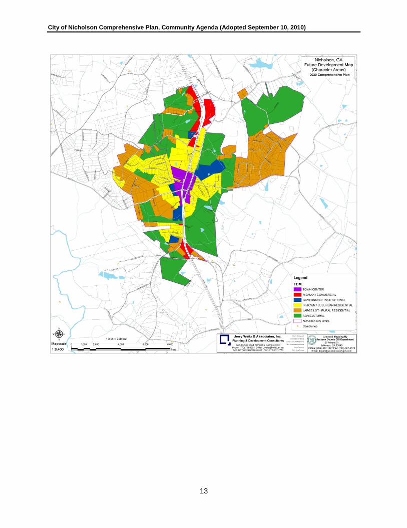
This chapter of the Community Agenda provides descriptions and maps designed to help the City of Nicholson manage future development in a way that protects resources, maintains existing and desired character, ensures compatibility with existing development, and establishes efficient growth patterns. UNDERSTANDING CHARACTER AND LAND USE MAPS It is important that the reader understand the meaning and intentions of each of the major maps associated with land use. This section is intended to ease that understanding. More detailed descriptions of these maps are provided later in this chapter. Official Zoning Map The Official Zoning Map was adopted as a part of the city’s zoning ordinance in 2008. It divides Nicholson into agricultural, residential, and commercial districts. This map is the most important in terms of regulations – it describes what land uses are permitted ―as of right‖ and what other uses may be possible if an application is filed and approved by the Nicholson City Council. Consulting the zoning map and permissions is the first step, because if the proposed land use and development is consistent with the zoning district shown on the Official Zoning Map (and as described in the city’s zoning ordinance), that land use and/or development is allowable regardless of what the other maps summarized in this section suggest. The Official Zoning Map is a regulatory map and is not produced in this Chapter or provided in this Community Agenda document. Existing Land Use This map shows how land is used currently (2009). It has no regulatory significance. It divides the city into land use classifications simply to describe how each property is being used now. It does not reflect character, future land use, or zoning. It is provided in the community assessment document only and does not appear here in this chapter. 2030 Character This map shows the desirable (generalized) development pattern in the year 2030. The 2030 map has significance because it is intended to be used as a guide in rezoning requests, special use approvals, variances, major subdivision plats, and municipal annexations. This comprehensive plan does not require consistency with the Character 2030 map, however. 2030 Future Land Use This map is intended to provide more detailed recommendations and guidance with regard to land use than is shown on the Character 2030 map. CHARACTER AREAS Nicholson is divided into the following character areas as shown on the 2030 character area (future development) map. Consistent with local planning requirements of the state, an initial character area map was prepared by the city’s planning consultant and presented at a

City of Nicholson Comprehensive Plan, Community Agenda (Adopted September 10, 2010)
12
community workshop. That first draft of the future development map (i.e., preliminary character areas) emphasized residential and commercial development and provided for the eventual conversion of farmlands within the city to residential and commercial uses. There were significant concerns voiced about the preliminary character map, especially the amount of agricultural land that would be converted, a more-or-less continuous commercial corridor throughout the city along U.S. Highway 441, and a substantial amount of additional residential development. Given those concerns and community input, the future development map was substantially redrawn. The revised future development map proposes to limit commercial uses along U.S. Highway 441 to three areas, within the proposed Town Center character area at the center of the city and two highway commercial areas, one on the north side and one on the south side of the city. Much more agricultural land is retained, and this also means significantly less future residential development. A narrative for each of the character areas is provided in the pages that follow. For all character areas, the principle implementation technique is the city’s zoning ordinance, which as noted elsewhere it in the process of being revised. Nicholson has also adopted subdivision and land development regulations, but those too are in the process of revision. As amendments to the city’s zoning and subdivision and land development regulations are prepared, attention will be given to how those regulations implement this comprehensive plan. Also, the community assessment provides numerous maps which will be used to evaluate future development proposals with regard to their impact on the environment.
City of Nicholson Comprehensive Plan, Community Agenda (Adopted September 10, 2010)
13
City of Nicholson Comprehensive Plan, Community Agenda (Adopted September 10, 2010)
14
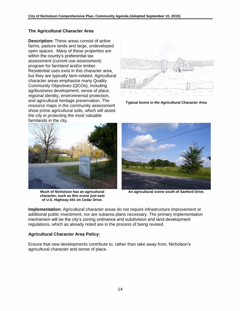
The Agricultural Character Area Description: These areas consist of active farms, pasture lands and large, undeveloped open spaces. Many of these properties are within the county’s preferential tax assessment (current use assessment) program for farmland and/or timber. Residential uses exist in this character area, but they are typically farm-related. Agricultural character areas emphasize many Quality Community Objectives (QCOs), including agribusiness development, sense of place, regional identity, environmental protection, and agricultural heritage preservation. The resource maps in the community assessment show prime agricultural soils, which will assist the city in protecting the most valuable farmlands in the city.
Typical Scene in the Agricultural Character Area
Much of Nicholson has an agricultural character, such as this scene just east
of U.S. Highway 441 on Cedar Drive.
An agricultural scene south of Sanford Drive.
Implementation: Agricultural character areas do not require infrastructure improvement or additional public investment, nor are subarea plans necessary. The primary implementation mechanism will be the city’s zoning ordinance and subdivision and land development regulations, which as already noted are in the process of being revised. Agricultural Character Area Policy:
Ensure that new developments contribute to, rather than take away from, Nicholson’s agricultural character and sense of place.

City of Nicholson Comprehensive Plan, Community Agenda (Adopted September 10, 2010)
15
Summary of the Agricultural Character Area
PRINCIPLE(S) AND QUALITY COMMUNITY
OBJECTIVES (QCOs) GENERAL LAND USE FRAMEWORK
Overarching Principle(s) Resource Protection Overarching Land Use(s) Predominantly agriculture and agriculture
homesteads
Environmental Protection Focus on agricultural best management practices
General Intensity of Development
Very low
Open Space Protection Farmland as private open space
SPECIFIC LAND USE PERMISSIONS (see also Table 3.1)
Growth preparedness Mostly inapplicable Land Subdivision Permissions
Restricted to minor lot platting
Appropriate Business Agribusiness Agriculture and Forestry Permitted and encouraged
Employment Options Agribusiness Residential Density ―Target‖
1 unit per 10 acres
Educational Opportunities Inapplicable Residential Density Maximum
1 unit per 8 acres with additional allowances
Housing Opportunities Mostly inapplicable Manufactured Housing Permitted with fewest restrictions
Traditional Neighborhood Inapplicable Multi-Family Housing None unless farm-worker housing is permitted by
special use
Infill Development Inapplicable Institutional (Churches, Schools, etc.)
Discouraged except for existing
Heritage Preservation Leading role of character area
Commercial Limited to farm-related activities only
Regional identity Contributing role Industrial Restricted; generally prohibited
Sense of Place Leading role of character area
Semi-Public Uses Discouraged
Regional Cooperation Leading role (economy and resource protection)
PRIMARY LAND USE REGULATORY IMPLEMENTATION MEASURES
Transportation Alternatives Not feasible/ not provided except rural public transit
Existing Base Zoning District(s)
ARR-1, Agricultural-Rural Residential
Jobs-Housing Relationship Relatively balanced and self-sustaining
New/Modified Base Zoning District(s)
AG, Agricultural
Existing Overlay District(s) None identified
WATER AND SEWER SERVICE AVAILABILITY New Overlay District(s) SR 334 Scenic Corridor Sanitary Sewer Available? No Special Tool(s): Land
Acquisition for Open Space
Conservation easements; large lot zoning
Public Water Available? No DESIGN-RELATED CONSIDERATIONS
(BUILT ENVIRONMENT) TRANSPORTATION-RELATED CONSIDERATIONS
Overall Building Form/Pattern
Farmstead Primary Mobility Option Automobile
Building Setback from Road; Orientation
Usually very large (100’+) and variable
Road Service and Surfacing
Unimproved, mostly private; some paved
county roads and state routes
Desired Design Principles Agrarian -- rural Road Design Features (Improvements)
Irregular, lack standards except for fire accessibility
Special Design Features Not applicable except those related to farmland
protection
Access Management Mostly inapplicable
Stormwater Management Unimproved sheet flow to watershed lakes
Connectivity Not necessary
Parking Areas Not regulated Sidewalks Not feasible/ not provided

City of Nicholson Comprehensive Plan, Community Agenda (Adopted September 10, 2010)
16
The Large Lot – Rural Residential Character Area Description: These areas are primarily platted and developed for detached, single-family (conventional/site built) and manufactured homes on larger lots (i.e., more than one acre), mostly on the periphery of the Nicholson city limits. There is a large subdivision consisting mostly of manufactured homes, north of Sanford Road, which is designated as large lot-rural residential. Another significant concentration is located west of the town center, north and south of Jefferson Road (SR 335).
Representative rural scene
(SR 334 in unincorporated Jackson County)
Manufactured housing is common in rural residential areas of Nicholson.
Representative street conditions in large lot-rural character area.
Implementation: Large lot-rural character areas do not require infrastructure improvement or additional public investment, nor are subarea plans necessary. The primary implementation mechanism will be the city’s zoning ordinance and subdivision and land development regulations, which again are in the process of being revised.
Large Lot – Rural Residential Character Area Policy:
Ensure that new developments contribute to, rather than take away from, Nicholson’s low-density, rural residential character and sense of place.

City of Nicholson Comprehensive Plan, Community Agenda (Adopted September 10, 2010)
17
Summary of the Large Lot – Rural Character Area
PRINCIPLE(S) AND QUALITY COMMUNITY
OBJECTIVES (QCOs) GENERAL LAND USE FRAMEWORK
Overarching Principle(s) Maintenance of Identity Overarching Land Use(s) Predominantly residences
Environmental Protection Achieve through low intensities
General Intensity of Development
Low
Open Space Protection Rural areas as private open space
SPECIFIC LAND USE PERMISSIONS (see also Table 3.1)
Growth preparedness Mostly inapplicable Land Subdivision Permissions
Permitted
Appropriate Business Mostly inapplicable or negligible
Agriculture and Forestry Permitted but uncommon
Employment Options Mostly inapplicable or negligible
Residential Density ―Target‖
1 unit per 3 acres
Educational Opportunities Mostly inapplicable or negligible
Residential Density Maximum
1 unit per 2 acres
Housing Opportunities Leading role of character area
Manufactured Housing Permitted with set up standards and restrictions
Traditional Neighborhood Mostly inapplicable Multi-Family Housing Inapplicable – lack of sewer
Infill Development Prospects exist and are identified
Institutional (Churches, Schools, etc.)
Mostly inapplicable but not precluded
Heritage Preservation Leading role of character area
Commercial Disallowed
Regional identity Contributing role Industrial Disallowed
Sense of Place Leading role of area
Regional Cooperation Leading role of area PRIMARY LAND USE REGULATORY IMPLEMENTATION MEASURES
Transportation Alternatives Not feasible/ not provided except rural public transit
Existing Base Zoning District(s)
ARR-1, Agricultural-Rural Residential; R-2
Residential
Jobs-Housing Relationship Imbalanced in favor of housing; limited
employment
New/Modified Base Zoning District(s)
RR, Rural Residential
Existing Overlay District(s) None
WATER AND SEWER SERVICE AVAILABILITY New Overlay District(s) None Sanitary Sewer Available? No Special Tool(s): Land
Acquisition for Open Space
Conservation easements may apply
Public Water Available? Yes, connection encouraged/required
DESIGN-RELATED CONSIDERATIONS (BUILT ENVIRONMENT)
TRANSPORTATION-RELATED CONSIDERATIONS
Overall Building Form/Pattern
Some irregular but mostly predictable/repetitive
Primary Mobility Option Automobile
Building Setback from Road; Orientation
30’-60’+; predictable/ repetitive; some variations
Road Service and Surfacing
Mostly paved public roads
Desired Design Principles Rural – conservation subdivisions
Road Design Features (Improvements)
Rural cross-section standard
(no curb and gutter)
Special Design Features None, but use of natural materials (stone, wood)
encouraged
Access Management Mostly inapplicable
Stormwater Management Mostly sheet flow; limited structures
Connectivity Encouraged but not required
Parking Areas Paved or unpaved; garages not required
Sidewalks Not required; natural trail systems encouraged

City of Nicholson Comprehensive Plan, Community Agenda (Adopted September 10, 2010)
18
The In-Town / Suburban Residential Character Area Description: These areas are mostly located surrounding the Nicholson Town Center character area and are, for the most part, geographically close enough to the Town Center character area to promote walking. There is a combination of detached, single-family (conventional/site built) and manufactured homes in this character area. Lots are smaller than that found in the large lot-rural residential character area (generally less than one acre). Some of the road patterns are curvilinear with cul-de-sacs (i.e., suburban), while others are more linear, with lots fronting on existing roads and highways.
Conventional suburban subdivisions need better site planning to connect subdivision
streets and connect the subdivision as a whole with greenspaces.
The “in-town” neighborhoods of Nicholson are built at higher densities than the suburban parts and are
within walking distance of the Town Center.
More expensive housing is desirable
in Nicholson to balance market supplies that now favor more modest income housing.
Representative dwelling desirable for in-town neighborhoods in Nicholson.
Implementation: These residential neighborhoods deserve infrastructure improvement or additional public investment, especially in terms of sidewalks. Street lighting are also desirable, and road improvements may also be needed in selected places. The primary implementation mechanism will be the city’s zoning ordinance and subdivision and land development regulations. No subarea plans are required to implement this character area.

City of Nicholson Comprehensive Plan, Community Agenda (Adopted September 10, 2010)
19
Summary of the In-Town/ Suburban Residential Character Area PRINCIPLE(S) AND QUALITY COMMUNITY
OBJECTIVES (QCOs) GENERAL LAND USE FRAMEWORK
Overarching Principle(s) Neighborhood Protection Overarching Land Use(s) Predominantly residential
Environmental Protection
Achieve through regulation of the built environment
General Intensity of Development
Moderate
Open Space Protection Set-aside; opportunities exist SPECIFIC LAND USE PERMISSIONS (see also Table 3.1)
Growth Preparedness Leading role of area Land Subdivision Permissions
Permitted
Appropriate Business Applicable in limited contexts Agriculture and Forestry Permitted but uncommon
Employment Options Applicable in limited contexts (retail/service)
Residential Density ―Target‖
1 unit per 0.6 acres
Educational Opportunities
Applicable in limited contexts Residential Density Maximum
1 unit per 0.33 acres (with sewer)
Housing Opportunities Leading role of area Manufactured Housing Prohibited
Traditional Neighborhood
Some neighborhoods have these characteristics
Multi-Family Housing Permitted only if sewer exists and then only at low
densities
Infill Development Leading role of character area
Institutional (Churches, Schools, etc.)
Mostly inapplicable but not precluded
Heritage Preservation Mostly inapplicable Commercial Disallowed
Regional identity Mostly inapplicable Industrial Disallowed
Sense of Place Mostly inapplicable
Regional Cooperation Mostly inapplicable PRIMARY LAND USE REGULATORY IMPLEMENTATION MEASURES
Transportation Alternatives
Feasible and encouraged if not required
Existing Base Zoning District(s)
R-1, Residential
Jobs-Housing Relationship
Imbalanced with housing; some employment
New/Modified Base Zoning District(s)
SR, Suburban Residential
Existing Overlay District(s) None
WATER AND SEWER SERVICE AVAILABILITY New Overlay District(s) None Sanitary Sewer Available? No Special Tool(s): Land
Acquisition for Open Space
Set-asides with development
Public Water Available? Yes, connection required
DESIGN-RELATED CONSIDERATIONS (BUILT ENVIRONMENT)
TRANSPORTATION-RELATED CONSIDERATIONS
Overall Building Form/Pattern
Predictable and repetitive Primary Mobility Option Automobile
Building Setback from Road; Orientation
25-40’ predictable and repetitive; facing street
Road Service and Surfacing
Mostly paved public roads
Desired Design Principles Conservation subdivisions and new urbanism
Road Design Features (Improvements)
Curb and gutter; suburban standard; mostly
curvilinear with cul-de-sacs
Special Design Features None required; some monuments at entrances
Access Management Regulated
Stormwater Management Engineered/ required Connectivity Encouraged
Parking Areas Paved off-street parking required; garages typical
Sidewalks Required and provided as development occurs
In-Town / Suburban Residential Character Policy:
1. Ensure that new developments within or near suburban residential areas contribute to, rather than take away from, Nicholson’s character and sense of place.
2. Upon the provision of sanitary sewer service to central Nicholson, encourage a pattern of more dense housing surrounding the city’s downtown, connected with pedestrian access to the downtown.

City of Nicholson Comprehensive Plan, Community Agenda (Adopted September 10, 2010)
20
The Government Institutional Character Area Description: This category corresponds with public schools, cemeteries, the city and county civic/park complex, the county public school and city facility complex south of the Town Center on U.S. Highway 441, a church property further south, and a cemetery on the north side of the city west of U.S. Highway 441. These properties are all developed or improved for government and institutional-type land uses.
Aerial view of Benton Elementary School and city park, a government and
institutional complex on the south side of the Nicholson Town Center
East Jackson Park
Nicholson’s community center, along with city hall, form a government institutional complex on the
north side of the Nicholson Town Center.
The monument in front of the Nicholson community center is representative of the types of civic
improvement that bring character to the area.
Implementation: Presently, there is not a governmental or institutional zoning district in the City of Nicholson’s zoning ordinance, and so it is anticipated a new zoning district will be created to match this character area. Since these character areas are already developed and for the most part adequately served with infrastructure and public investment, no additional measures are needed to implement the vision for them. However, as is noted below for the highway commercial character areas, over the long term the city’s second phase of sewer expansion should plan to extend sewer service to government institutional districts.

City of Nicholson Comprehensive Plan, Community Agenda (Adopted September 10, 2010)
21
Summary of the Government-Institutional Character Area
PRINCIPLE(S) AND QUALITY COMMUNITY
OBJECTIVES (QCOs) GENERAL LAND USE FRAMEWORK
Overarching Principle(s) Community facilities Overarching Land Use(s) Schools, Parks and Civic Uses
Environmental Protection
Contributes to open space and environment
General Intensity of Development
Moderate
Open Space Protection Parks exists in area SPECIFIC LAND USE PERMISSIONS (see also Table 3.1)
Growth preparedness Contributing role Land Subdivision Permissions
Mostly developed/ inapplicable
Appropriate Business Contributing role Agriculture and Forestry Developed; inapplicable
Employment Options Contributing role Residential Density ―Target‖
Inapplicable
Educational Opportunities
Leading role of character area
Residential Density Maximum
Inapplicable
Housing Opportunities Mostly inapplicable Manufactured Housing Inapplicable
Traditional Neighborhood
Mostly inapplicable Multi-Family Housing Inapplicable
Infill Development Mostly developed/ limited applicability
Institutional (Churches, Schools, etc.)
Permitted and encouraged
Heritage Preservation Contributing role Commercial None except existing
Regional identity Contributing role Industrial Inapplicable
Sense of Place Mostly inapplicable
Regional Cooperation Leading role of character area (service delivery)
PRIMARY LAND USE REGULATORY IMPLEMENTATION MEASURES
Transportation Alternatives
Feasible and encouraged if not required
Existing Base Zoning District(s)
None
Jobs-Housing Relationship
Imbalanced in favor of employment
New/Modified Base Zoning District(s)
INST, Institutional
Existing Overlay District(s) None
WATER AND SEWER SERVICE AVAILABILITY New Overlay District(s) None
Sanitary Sewer Available? No – maybe long range Special Tool(s): Land Acquisition for Open Space
Open space exists
Public Water Available? Yes, connection required
DESIGN-RELATED CONSIDERATIONS (BUILT ENVIRONMENT)
TRANSPORTATION-RELATED CONSIDERATIONS
Overall Building Form/Pattern
Campus layout Primary Mobility Option Automobile; bus (schools)
Building Setback from Road; Orientation
Campus layout (significant setbacks)
Road Service and Surfacing
Paved
Desired Design Principles Campus planning principles
Road Design Features (Improvements)
As built
Special Design Features None; special identifying features encouraged
Access Management As built
Stormwater Management Engineered/ required Connectivity Encouraged
Parking Areas Paved off-street Sidewalks Encouraged; some existing
Government Institutional Character Area Policy: Ensure that new developments within or near government-institutional character areas contribute to, rather than take away from, Nicholson’s character and sense of place.

City of Nicholson Comprehensive Plan, Community Agenda (Adopted September 10, 2010)
22
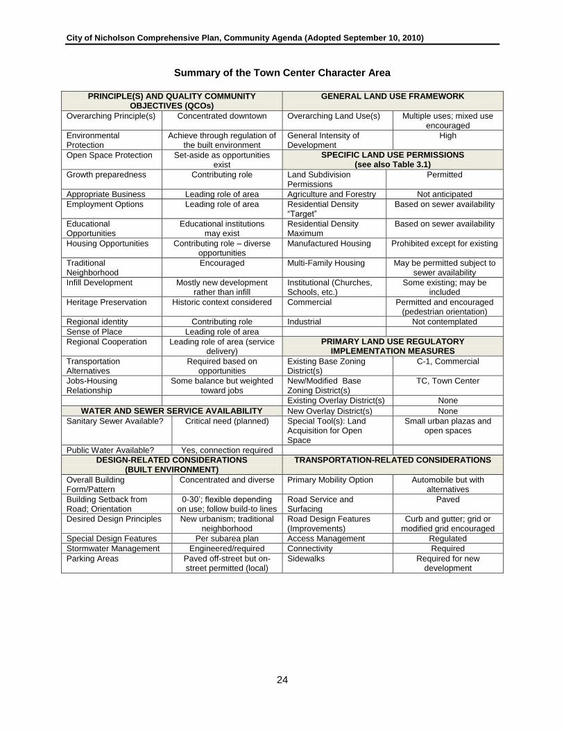
The Town Center Character Area Description: This character area encompasses a relatively compact (about 75 acres) area in central Nicholson centered on U.S. Highway 441 and Jefferson Road (SR 335). Currently, this character is a mixture of some commercial uses with churches and residences, and it is rather sparsely developed. The Town Center is envisioned to develop eventually into a more intense but still a small-town central place. Commercial development is anticipated to take place in a pedestrian-friendly manner, with small shops, restaurants, and some mixed use development. Highway oriented commercial uses are not encouraged. The Town Center character area will implement a number of different Quality Community Objectives (QCOs).
Existing Conditions – Intersection of
U.S. Highway 441 and SR 335. Churches provide a major institutional presence in the evolving Town Center.
Nicholson’s Town Center Area, Existing Conditions, Viewed from U.S. Highway 441
Desired Scale and Character Nicholson’s Future Town Center
Implementation: The city’s zoning ordinance does not have a separate Town Center zoning district that is tailored to the vision for the character area. It will, however, be included in the rewrite of the city’s zoning ordinance. Public investment and facility improvements are clearly needed to implement the Town Center character area. In particular, sanitary sewer will be needed in some form, whether publicly or privately provided. Additional sidewalks improvements will be needed to connect adjacent in-town/suburban neighborhoods to the Town Center. And, on the east side of the railroad, a parallel road will be needed to facilitate commercial development. Although some preferences were articulated during the ―downtown place making‖ process of the community participation program, that process did not result in a

City of Nicholson Comprehensive Plan, Community Agenda (Adopted September 10, 2010)
23
detailed plan for downtown. Accordingly, a subarea plan is needed to refine the Town Center character area, and the short-term work program includes that as an action item.
The south end of the Town Center is served by sidewalks.
Town Center Character Area Policies:
1. Enhance the City of Nicholson’s image as a unique community and retain that image in attractive and orderly development that preserves existing character of a historic railroad community.
2. Cultivate distinctiveness so that the City of Nicholson remains unique among Jackson County and communities in the northeast Georgia region.
3. Encourage the creation and development of a downtown in central Nicholson which is a
compact, vibrant, mixed use, pedestrian-friendly center of the community.
4. Promote high quality nonresidential development. Establish and maintain architectural and site design standards as appropriate in nonresidential areas to encourage increased quality of site development, architectural appearance, and building materials.
5. Require new development to respect the scale and character of nearby structures and
minimize or mitigate abrupt and excessive differences.
6. Ensure that development in the downtown area has a human/pedestrian scale and a building scale appropriate for a small town.
7. Provide guidelines and/or regulations to ensure the desired character of downtown is
met.
City of Nicholson Comprehensive Plan, Community Agenda (Adopted September 10, 2010)
24
Summary of the Town Center Character Area
PRINCIPLE(S) AND QUALITY COMMUNITY
OBJECTIVES (QCOs) GENERAL LAND USE FRAMEWORK
Overarching Principle(s) Concentrated downtown Overarching Land Use(s) Multiple uses; mixed use encouraged
Environmental Protection
Achieve through regulation of the built environment
General Intensity of Development
High
Open Space Protection Set-aside as opportunities exist
SPECIFIC LAND USE PERMISSIONS (see also Table 3.1)
Growth preparedness Contributing role Land Subdivision Permissions
Permitted
Appropriate Business Leading role of area Agriculture and Forestry Not anticipated
Employment Options Leading role of area Residential Density ―Target‖
Based on sewer availability
Educational Opportunities
Educational institutions may exist
Residential Density Maximum
Based on sewer availability
Housing Opportunities Contributing role – diverse opportunities
Manufactured Housing Prohibited except for existing
Traditional Neighborhood
Encouraged Multi-Family Housing May be permitted subject to sewer availability
Infill Development Mostly new development rather than infill
Institutional (Churches, Schools, etc.)
Some existing; may be included
Heritage Preservation Historic context considered Commercial Permitted and encouraged (pedestrian orientation)
Regional identity Contributing role Industrial Not contemplated
Sense of Place Leading role of area
Regional Cooperation Leading role of area (service delivery)
PRIMARY LAND USE REGULATORY IMPLEMENTATION MEASURES
Transportation Alternatives
Required based on opportunities
Existing Base Zoning District(s)
C-1, Commercial
Jobs-Housing Relationship
Some balance but weighted toward jobs
New/Modified Base Zoning District(s)
TC, Town Center
Existing Overlay District(s) None
WATER AND SEWER SERVICE AVAILABILITY New Overlay District(s) None
Sanitary Sewer Available? Critical need (planned) Special Tool(s): Land Acquisition for Open Space
Small urban plazas and open spaces
Public Water Available? Yes, connection required
DESIGN-RELATED CONSIDERATIONS (BUILT ENVIRONMENT)
TRANSPORTATION-RELATED CONSIDERATIONS
Overall Building Form/Pattern
Concentrated and diverse Primary Mobility Option Automobile but with alternatives
Building Setback from Road; Orientation
0-30’; flexible depending on use; follow build-to lines
Road Service and Surfacing
Paved
Desired Design Principles New urbanism; traditional neighborhood
Road Design Features (Improvements)
Curb and gutter; grid or modified grid encouraged
Special Design Features Per subarea plan Access Management Regulated
Stormwater Management Engineered/required Connectivity Required
Parking Areas Paved off-street but on-street permitted (local)
Sidewalks Required for new development

City of Nicholson Comprehensive Plan, Community Agenda (Adopted September 10, 2010)
25
The Highway Commercial Character Area Description: The 2030 character map envisions that Nicholson will have two primary highway commercial areas, one well north of the Town Center (at the north end of the city limits along U.S. Highway 441), and at the south end of the city limits where Old Kings Bridge Road and Dogwood Drive intersect with U.S. Highway 441. The primary uses in these areas, which are mostly undeveloped but contain some sparse development, will be commercial uses oriented toward the highway traveler, such as automobile service establishments, convenience stores and shopping centers.
Cabin Creek BBQ, is within the highway commercial character area and is representative of the scale and architectural materials that are consistent with the
desired architectural characteristics of this character area.
Much-needed retail is celebrated in Nicholson, with the recent construction of a Dollar General
Store (located in the Town Center character area). In this case, Nicholson desires better
architectural treatment than provided by this store, and the lighting does not meet
desired community standards.
Implementation: The highway commercial character areas are served with highway capacity (U.S. Highway 441) which also has sidewalks along most of its length through Nicholson. The character areas are not served by sanitary sewer, however. It is anticipated that a good deal of commercial development in the future in the highway commercial character areas will occur without connect to sewer. However, over the long term, the city should consider a second phase of sewer expansion that will extend initial sewer provision in the Town Center north and south to these outlying highway commercial districts. The city’s zoning ordinance establishes a single commercial district. In the process of revision, a Town Center zoning district will be added and the existing commercial district will be rewritten to closely match the needs of the highway commercial character area.
Many existing commercial developments in Nicholson lie below the grade of U.S. Highway 441;
attention will be given to the aesthetic impact of parking areas and outdoor storage of commercial
uses along U.S. Highway 441.

City of Nicholson Comprehensive Plan, Community Agenda (Adopted September 10, 2010)
26
Highway Commercial Character Area Policies:
1. Improve community identity. Create civic gateways to the City that produce a sense of arrival. These entryways should incorporate streetscape elements, signage, and landscaping that enhance the image and function of the City. Encourage the provision of public green spaces in gateway areas as private development occurs. Support and encourage private and public efforts to install signage and unique gateway features that identify the city, particularly its focal point(s).
2. Promote high quality nonresidential development. Establish and maintain architectural and site design standards as appropriate in nonresidential areas to encourage increased quality of site development, architectural appearance, and building materials.
3. Initiate community-based streetscape beautification partnerships. Encourage the
greening of Nicholson’s railroad right of way and U.S. Highway 441 corridor through the planting and maintenance of street yards and the provision of street trees along major corridors.
4. Avoid unattractive and inefficient strip development along U.S. Highway 441. Regulate
and promote commercial development with designs, landscaping, lighting, signage, and scale that add value to the community, consistent with regulations proposed by Jackson County for the U.S. Highway 441 corridor. Discourage patterns of ―strip‖ commercial development. Encourage building designs which do locate all of the off-street parking provided on the commercial lot between the road and the building.
Permanent storage facilities along U.S. 441 should be screened from
view with a fence and/or landscaping.
Building sales and other open air business establishments should also at least partially screen the highway right of way from a full view into the lot.

City of Nicholson Comprehensive Plan, Community Agenda (Adopted September 10, 2010)
27
Summary of the Highway Commercial Character Area
PRINCIPLE(S) AND QUALITY COMMUNITY
OBJECTIVES (QCOs) GENERAL LAND USE FRAMEWORK
Overarching Principle(s) Employment and services Overarching Land Use(s) Mostly highway commercial uses
Environmental Protection
Achieve through regulation of the built environment
General Intensity of Development
Moderate to high
Open Space Protection Set-aside as opportunities exist
SPECIFIC LAND USE PERMISSIONS (see also Table 3.1)
Growth preparedness Contributing role Land Subdivision Permissions
Permitted
Appropriate Business Leading role of area Agriculture and Forestry Not anticipated
Employment Options Leading role of area Residential Density ―Target‖
Inapplicable
Educational Opportunities
Educational institutions may exist
Residential Density Maximum
Inapplicable
Housing Opportunities Mostly inapplicable Manufactured Housing Inapplicable
Traditional Neighborhood
Mostly inapplicable Multi-Family Housing Inapplicable
Infill Development Mostly new development rather than infill
Institutional (Churches, Schools, etc.)
Mostly inapplicable but not precluded
Heritage Preservation Mostly inapplicable Commercial Permitted and encouraged
Regional identity Not yet developed Industrial Not planned but most appropriate location
Sense of Place Can play contributing role
Regional Cooperation Coordinate standards with county for quality
development
PRIMARY LAND USE REGULATORY IMPLEMENTATION MEASURES
Transportation Alternatives
Not feasible except for sidewalk along US 441
Existing Base Zoning District(s)
C-1, Commercial
Jobs-Housing Relationship
Imbalanced in favor of employment
New/Modified Base Zoning District(s)
HB, Highway Business
Existing Overlay District(s) None
WATER AND SEWER SERVICE AVAILABILITY New Overlay District(s) Follow county with regard to quality development
regulations
Sanitary Sewer Available? No – maybe long range Special Tool(s): Land Acquisition for Open Space
Minimum open space requirements
Public Water Available? Yes, connection required
DESIGN-RELATED CONSIDERATIONS (BUILT ENVIRONMENT)
TRANSPORTATION-RELATED CONSIDERATIONS
Overall Building Form/Pattern
Linear (highway serving); nodes encouraged
Primary Mobility Option Automobile
Building Setback from Road; Orientation
30’ or more from highway Road Service and Surfacing
Paved highway access
Desired Design Principles Conventional but with quality development
standards
Road Design Features (Improvements)
Curb and gutter
Special Design Features Quality development standards
Access Management Regulated
Stormwater Management Engineered/required Connectivity Required
Parking Areas Paved off-street Sidewalks Existing along highway; connections needed

City of Nicholson Comprehensive Plan, Community Agenda (Adopted September 10, 2010)
28
SUMMARY MATRIX OF CHARACTER, LAND USE, AND ZONING CATEGORIES To aid the reader in the use of this community agenda, Table 3.1 has been prepared to show how each character area, future land use district category (discussed in the next section of this chapter), and proposed zoning districts related to one another.
Table 3.1 Character, Future Land Use, and Proposed Zoning District Compatibility
Character Area (See Future Development
Map)
Future Land Use Categories (See Future Land Use Plan
Map)
Future Zoning Districts (as shown on Official Zoning Map – to be revised/readopted)
Agricultural Agricultural/Forestry Agricultural
Large Lot – Rural Residential Residential, single-family, manufactured
RR, Rural Residential
In-Town/ Suburban Residential
Residential, single-family, stick-built
SR, Suburban Residential
Government-Institutional Public-institutional; Transportation/communication/ utilities; and parks/recreation/ conservation
INST, Institutional
Town Center Commercial; Public-institutional
TC, Town Center
Highway Commercial Commercial HB, Highway Business
FUTURE LAND USE The character area map, described in the previous section, provides an overarching policy framework for character but does not provide sufficient policy guidance for specific, individual land uses. A future land use plan map is ―optional‖ under the local planning requirements. This Community Agenda includes a future land use plan map in addition to the character area map described and presented in the prior section. The future land use plan map divides the city into one of the categories described below. Park/Recreation/Conservation This category includes lands dedicated to both active and passive recreational uses. These lands may be either publicly or privately owned, and they may include playgrounds, public parks, nature preserves, wildlife management areas, forest preserves, golf courses, recreation centers, or similar uses. In Nicholson, these include the East Jackson Park and flood plains in the city. Agricultural/Forestry Much of the land in this category is simply vacant or undeveloped, but other tracts are forested and there is also some raising of livestock in this future land use category. Residential land uses are allowed but they are limited to single-family, stick-built homes on individual lots and

City of Nicholson Comprehensive Plan, Community Agenda (Adopted September 10, 2010)
29
manufactured homes on individual lots. Residential uses by definition are included but they primarily relate to the larger agricultural or forestry tract. Residential Subcategories Nicholson’s future land use plan divides residential land uses into three residential categories: conventionally constructed (stick/site built) detached, single-family homes, areas appropriate for manufactured homes, and multi-family areas. The treatment of manufactured homes differently from site-built homes reflects community preferences (see Appendix) that manufactured homes should not be permitted in all residential zoning districts. The multi-family designation reflects existing duplexes and in one case a small apartment building; expansion of multi-family residential is not contemplated in the future land use plan, given the current lack of sanitary sewer service. Public/Institutional This category includes federal, state, or local government uses, and a wide variety of institutional land uses. Government uses include county-owned facilities, fire stations, post offices, and schools. Private institutional uses include schools, colleges, churches, cemeteries, and private non-profit meeting halls, among others. Commercial This category applies to lands dedicated to non-industrial business uses, including retail sales, offices, services and entertainment facilities. Transportation/ Communications/ Utilities This category applies primarily to electricity facilities like power substations and major transmission lines and cell towers. One new substation in Nicholson is planned and is reflected on the future land use plan map, along the east side of U.S. Highway 441. Nicholson will add almost 120 acres of commercial development during the planning horizon (see Table 3.2). No industrial land will be added.
Power Substation on SR 334
Parks, recreation, and conservation lands will increase by 25 acres due to the inclusion of flood plains shown on the future land use plan map. Agricultural and forestry uses will increase, but that is primarily because vacant/undeveloped lands are shown on the future land use plan map as agricultural/forestry. Single-family residential uses and manufactured homes on individual lots will both increase modestly during the planning horizon in terms of acreage. The plan also provides for an additional 30 acres of public-institutional development, which may include additional churches, public facilities, and non-profit institutions.

City of Nicholson Comprehensive Plan, Community Agenda (Adopted September 10, 2010)
30

City of Nicholson Comprehensive Plan, Community Agenda (Adopted September 10, 2010)
31
Table 3.2 Land Use Acreage by Land Use Category, 2009 and 2030
City of Nicholson
Land Use Category 2009 Acres
% Total City
2030 Acres
% Total City
2009-2030 Change in
Acres
Agricultural/Forestry 1,146 45% 1,541 52% +395
Residential, single-family, site/stick built
493 19% 545 19% +52
Residential, single-family, manufactured
470 19% 561 19% +91
Residential, duplex, apartment, manufactured home park
8 -- 6 -- --
Public/Institutional 41 2% 71 2% +30
Transportation/ Communication/ Utilities
0 -- 4 -- +4
Commercial 22 1% 141 5% +119
Industrial 0 -- 0 -- --
Parks, Recreation, and Conservation
50 2% 75 3% +25
Vacant/Undeveloped 172 7% 0 -- -172
Right of ways 133 5% nc nc nc
Total, City of Nicholson 2,537 100% 2,944 100% --
Source: Jackson County GIS Department (May 2010) nc = not classified
LAND USE POLICIES
1. Prevailing Land Use Patterns. Respect and maintain prevailing land use patterns, unless the future land use plan clearly suggests changes are appropriate.
2. Protect Residences from Incompatible Land Uses and Nuisances. Where designated residential on the future land use plan map, maintain and preserve quiet, stable neighborhoods of residences at current densities. Preserve and enhance the stability of existing residential neighborhoods. Protect residential areas (whether rural, suburban, or urban) from nuisances (e.g., excessive noise, odor, traffic and lighting) and from encroachment by incompatible land uses.
3. Preservation of Residential Neighborhoods. The consideration of the preservation of
the integrity of residential neighborhoods shall be considered to carry great weight in all rezoning decisions.

City of Nicholson Comprehensive Plan, Community Agenda (Adopted September 10, 2010)
32
4. Transitional Properties and their Impacts on Residential Neighbor-hoods. In those instances in which property proposed for rezoning from residential to nonresidential use fronts on a major thoroughfare and also adjoins an established residential neighborhood, the factor of preservation of the residential area shall be considered to carry great weight in all rezoning decisions.
Commercial parking lot abuts residential in the evolving town center. Screening/
separation should be provided.
5. Natural Areas, Open Space and Recreation. New residential development should
preserve the natural amenities of the land through maintenance of conservation areas and open spaces. When new major residential subdivisions are developed, there should be a minimum of 20 percent of the total development area set aside for green space, open space, and active or passive recreational opportunities.
6. Creativity and Flexibility. Encourage creativity in development design and provide for
design flexibility. The city is open to considering land planning and development concepts that may be new to the city but have been implemented successfully in other places.
7. Sustainable Development Practices. Communities and individual land developments
which are developed consistent with generally accepted principles of sustainable development should receive priority consideration over developments relying on conventional designs and features. Any available incentives should be used to reward development which meets generally accepted sustainable development principles.
8. Intergovernmental Coordination. Coordinate land use decisions between the city and
county. Land use decisions made by Nicholson at the time of annexation should respect and be consistent with the character and future land use plans previously approved by Jackson County.

City of Nicholson Comprehensive Plan, Community Agenda (Adopted September 10, 2010)
33
CHAPTER 4 POLICIES
Local planning requirements of the state specify that local governments must include any policies the local government will adopt to provide ongoing guidance and direction to local government officials for making decisions consistent with addressing the identified issues and opportunities. The state’s standards also suggest that local governments refer to recommended policies listed in the State Planning Recommendations for suggestions. Such state-recommended policies have been consulted and integrated/modified as appropriate here. The list of policies in this chapter is a refinement and expansion of those policies adopted in Nicholson’s partial plan update. See also Chapter 3 for character area and land use-related policies. ENVIRONMENT AND NATURAL RESOURCES
1. Environmental and Resource Protection. Encourage new development to locate in suitable locations in order to protect natural resources, environmentally sensitive areas, or valuable historic, archaeological or cultural resources from encroachment.
2. Wetlands – Preservation and Mitigation. Preserve wetlands where they exist, or as a
last resort if they cannot be preserved on-site, mitigate wetland loss by increasing ecologically equivalent wetlands on other appropriate sites (i.e., wetland mitigation through wetland banking).
3. Wetlands – Review for Development Impacts. Any proposal for development involving the alteration of, or an impact on, wetlands should be evaluated according to the following (based on Ga. DNR Rule 391-3-16-.03):
Whether impacts to an area would adversely affect the public health, safety, welfare, or the property of others.
Whether the area is unique or significant in the conservation of flora and fauna including threatened, rare, or endangered species.
Whether alteration or impacts to wetlands will adversely affect the function, including the flow or quality of water, cause erosion or shoaling, or impact navigation.
Whether impacts or modification by a project would adversely affect fishing or recreational use of wetlands.
Whether an alteration or impact would be temporary in nature.
Whether the project contains significant State historical and archaeological resources, defined as ―Properties On or Eligible for the National Register of Historic Places.
Whether alteration of wetlands would have measurable adverse impacts on adjacent sensitive natural areas.
Where wetlands have been created for mitigation purposes under Section 404 of the Clean Water Act, such wetlands shall be considered for protection.
4. Wetlands – Uses. Uses of wetlands may include: Timber production and harvesting;
wildlife and fisheries management; wastewater treatment; recreation; natural water quality treatment or purification; and other uses permitted under Section 404 of the

City of Nicholson Comprehensive Plan, Community Agenda (Adopted September 10, 2010)
34
Clean Water Act. Unacceptable uses may include: receiving areas for toxic or hazardous waste or other contaminants; and hazardous or sanitary waste landfills.
5. Water Supply Watersheds. Maintain in the city zoning ordinance regulations that
implement the Georgia Department of Natural Resources’ Rules for Environmental Planning Criteria for Water Supply Watersheds (391-3-16-.01, ―Criteria for Water Supply Watersheds‖).
6. Floodways and Floodplains. Prohibit development within floodways and restrict or
prohibit development in flood plains. If development within flood plains is allowed, flood plain storage should not be decreased from its present state. In no event should development be permitted that inhibits the flow of floodwaters.
7. National Flood Insurance Program. Continue to participate in the National Flood
Insurance Program. Periodically amend the flood damage prevention/floodplain management ordinance to comply with changes to ordinances specified by the Federal Emergency Management Agency.
8. Floodways and Floodplains – Observed But Not Mapped. Extend floodplain
management, flood hazard area prevention, and floodway prohibitions to areas of flooding which are not officially mapped but are known through additional study or observation to experience flooding. Maintain and share data on such additional floodways and floodplains with the public and development applicants.
9. Soils with Severe Limitations. Avoid development using septic tanks in those areas
with severe limitations on septic tank absorption fields (see map below).
10. Tree Protection. Promote the protection and preservation of trees and green open spaces in all new developments.
11. Open Space Conservation.
Conservation. When subdivision or land development involves land designated on the future land use plan map as conservation, such subdivision or land development should protect all (or at least the vast majority) of the land designated as conservation as permanent open space.
Land Development Impacts. If land development within a conservation area is permitted, it needs to minimize the impact on water quality and the environment. Acceptable mitigation practices for land development in conservation areas may include limiting pavement and impervious surfaces, natural buffers, and low impact development designs which feature naturalized designs for stormwater management.
Annexation. If Nicholson annexes land designated as conservation, it should provide for the permanent protection of the land designated as conservation by appropriate means in a manner consistent with county policies for the conservation character area.
Access to Abutting Conservation Lands. Subdivisions and land developments are strongly encouraged, if not required, to provide pedestrian easements or fee-

City of Nicholson Comprehensive Plan, Community Agenda (Adopted September 10, 2010)
35
simple land dedications to public open spaces and/or publicly designated conservation lands on all abutting properties.
12. Habitat Protection. Consider habitat information in review of land developments,
including but not limited to the database of the DNR Natural Heritage Program, USFWS County Listing of Threatened and Endangered Species and the DNR Listing of Locations of Special Concern Animals, Plants, and Natural Communities.
13. Stormwater Management.
Design man-made lakes and stormwater ponds for maximum habitat value and to be amenities for the development.
Sites should be designed where possible to drain to the rear or side, where detention ponds are more appropriately located. Fenced detention ponds in front yards are strongly discouraged if not prohibited altogether.
When stormwater detention or drainage is placed adjacent to the right-of-way, slopes should be gentle enough to avoid fencing requirements, and the area should be attractively landscaped.
New, major residential subdivisions should be required to ensure that adequate funding is available for maintenance of any on-site stormwater detention facilities.
14. Low Impact Development. Promote low impact development that preserves the
natural topography and existing vegetation of development sites, and utilizes natural drainage patterns as much as possible.
HISTORIC AND CULTURAL RESOURCES
1. Compatible Character. The traditional character of the community should be maintained through preserving and revitalizing historic areas of the community, encouraging new development that is compatible with the traditional features of the community, and protecting other scenic or natural features that are important to defining the community’s character (Quality Community Objective, Historic Preservation).
2. Historic Resources Generally. Identify, preserve and protect historic resources.
3. Historic Resources Survey. Compile and consult a survey of historic resources in the development review process.
4. National Register Listings. Encourage property owners to add eligible properties to
the National Register of Historic Places. HOUSING AND COMMUNITY DEVELOPMENT
1. Housing Options. Provide for and encourage new land uses that enhance housing options in the community. These include an openness to single-wide manufactured homes, estate-style subdivisions, institutionalized living and care arrangements, and housing for the disabled.

City of Nicholson Comprehensive Plan, Community Agenda (Adopted September 10, 2010)
36
2. Substandard Housing. Eliminate or mitigate substandard or dilapidated housing in the
community.
3. Housing for Persons with Disabilities. Avoid regulations and practices that would discourage the provision of housing for persons with disabilities.
4. Avoid Regulatory Barriers. In amending zoning and development regulations, the city
should consider the potential impact of such amendments on housing affordability, in order to possibly avoid creating or sustaining ―regulatory barriers.‖
5. Community Development. Pursue grants, such as the Community Development Block
Grant (CDBG) program, to upgrade the Pace Drive neighborhood and any other neighborhoods with poor, deteriorating, or substandard housing conditions, and to eliminate or mitigate pockets of poverty.
6. Nonprofit Housing Organizations. Encourage the creation of, and cooperate with,
community-based housing organizations in the pursuit of affordable workforce housing. ECONOMIC DEVELOPMENT
1. Economic Development Generally. Expand the economic base and increase employment opportunities while protecting environmental, historic, and community character.
2. Appropriate Businesses. The businesses and industries encouraged to develop or
expand in Nicholson should be suitable in terms of job skills required, linkages to other economic activities in the county or region, impact on the resources of the area, and future prospects for expansion and creation of higher-skill job opportunities (Quality Community Objective, Appropriate Business).
3. Business Recruitment. Increase the supply of jobs in the community. Develop support,
and participate with the Jackson County Area Chamber of Commerce in programs for retention, expansion and creation of businesses that are a good fit for Nicholson’s economy in terms of job skill requirements and linkages to existing businesses.
4. Range of Jobs Available. A range of job types should be provided in each community
to meet the diverse needs of the local workforce (Quality Community Objective, Employment Options).
5. Industry and Manufacturing. Nicholson does not have an industrial park, has not set
aside land areas for industry and manufacturing, and presently does not have sanitary sewer to serve such development. Therefore, industry should be limited, if developed at all in Nicholson, to the U.S. 441 corridor and should consist of low-impact storage, warehousing, and cottage-type industrial establishments that are small in nature and consistent with the city’s small town character.
6. Infrastructure. Provide and maintain sanitary sewer capacity in order to attract new
commercial and service activities along U.S. Highway 441 and in the proposed Town Center.

City of Nicholson Comprehensive Plan, Community Agenda (Adopted September 10, 2010)
37
7. Positive Business Climate. Create and maintain a positive climate for business in the city.
8. Balanced Regulation. Balance the need to regulate the design and appearance of
commercial and other properties with a positive regulatory environment that is sensitive to the need for businesses to be competitive in the marketplace.
9. Education and Training. Educational and training opportunities should be readily
available in the city to permit residents to improve their job skills, adapt to technological advances, or to pursue entrepreneurial ambitions (Quality Community Objective, Educational Opportunities). Increase skill levels of the resident labor force, in order to attract higher paying employers.
COMMUNITY FACILITIES AND SERVICES
1. Watershed Protection. Ensure safe and adequate supplies of water through protection of ground and surface water sources.
2. Future Water Supply. Participate in broader efforts at the county level to secure additional surface water supplies to meet future, long-term needs.
3. Water System Contingencies. Contingency plans should be prepared for dealing with major water line breaks, loss of water sources during drought, and other possible damages to the water system such as flooding.
4. Sewer Service. Aggressively and immediately review options and provide for sanitary
sewer service for central Nicholson. TRANSPORTATION
1. Local Street Improvements. Subject to budget limitations, improve existing city streets by widening substandard roads (where sufficient right of way exists or can be acquired), improving intersections where they pose traffic safety problems, and installing street lighting.
2. Access Management. Adopt adequate access management standards to control the
connections and access points of driveways and roads to other roadways.
3. Inter-parcel Access. Minimize unnecessary vehicular trips on roadways by implementing techniques such as requiring non-residential uses to provide cross-access (inter-parcel) easements during the site plan review and approval process to ensure that drivers can directly access abutting non-residential uses without having to use the abutting road or street.
4. Traffic Calming. Consider future needs for traffic calming (raised speed humps, raised
tables, etc.) to slow speeding and/or discourage cut-through traffic.
5. Sidewalk Improvements. Implement a program to build new sidewalks in the downtown area of Nicholson, in support of downtown place-making.

City of Nicholson Comprehensive Plan, Community Agenda (Adopted September 10, 2010)
38
6. SR 335. This highway into Nicholson from the west should eventually incorporate multiple travel modes, including pedestrian facilities (sidewalks, bike paths, and/or multi-use trail), as well as local vehicular circulation.
7. Regional Bicycle Loop. One or more local roads from East Jackson Park connecting
to State Route 334 should be improved with a bike lane or multi-use trail/path.
8. Railroad and Road Grade Separation. Maintain safe railroad crossings for drivers, bicyclists, and pedestrians by installing gates, lights, and warning signage.
INTERGOVERNMENTAL COORDINATION
1. Regional Cooperation. Regional cooperation should be encouraged in setting priorities, identifying shared needs, and finding collaborative solutions, particularly where it is critical to success of a venture, such as protection of shared natural resources (Quality Community Objective, Regional Cooperation).
2. Regional Solutions. Regional solutions to needs shared by more than one local
jurisdiction are preferable to separate local approaches, particularly where this will result in greater efficiency and less cost to the taxpayer (Quality Community Objective, Regional Solutions).
3. Support for Regional Policies. Coordinate local policies and regulations to support
regional policies. Ensure that goals and implementation programs of the city’s comprehensive plan are consistent with adopted coordination mechanisms and consistent with applicable regional and state programs.
4. Consultation. Consult other public entities in the area when making decisions that are
likely to impact them.
5. Resource Sharing. Seek and pursue opportunities to share services and facilities with Jackson County and other municipalities, when mutually beneficial.
6. Conflict Resolution. Resolve conflicts with other local governments through established
mediation processes or other informal or formal means.
7. Annexation. Annex unincorporated islands.

City of Nicholson Comprehensive Plan, Community Agenda (Adopted September 10, 2010)
39
CHAPTER 5 IMPLEMENTATION
This chapter describes the initiatives, programs, regulations, and other efforts needed by the City of Nicholson to implement its comprehensive plan during the next five years. This chapter also describes additional techniques that are most likely to be used by the City of Nicholson to implement its comprehensive plan. This chapter is therefore a useful reference source for identifying additional ways to implement the comprehensive plan, but which may not be used in the short-term. Discussion of these implementation techniques does not necessarily suggest that the City of Nicholson will utilize each and every one of these techniques, whether in the short-term or during the twenty-year planning horizon. However, the Short-term Work Program provides specificity with regard to what Nicholson intends to achieve during the next five years to implement its plan. NATURAL RESOURCES PROTECTION Environmental Planning Criteria These rules of the Georgia Department of Natural Resources call for protection of water supply watersheds, wetlands, groundwater recharge areas, protected river corridors, and protected mountains. Nicholson is in the process of complying with these criteria applicable in Nicholson by adopting appropriate ordinances. The short-term work program calls for Nicholson to rewrite the city’s zoning ordinance to include applicable environmental planning criteria. Other Environmental Regulations Nicholson does not have soil erosion and flood damage prevention ordinances. A flood damage prevention ordinance is included in the city’s short-term work program. Tree City USA The Tree City USA program, sponsored by the Arbor Day Foundation in cooperation with the U.S. Department of Agriculture’s Forest Service and the National Association of State Foresters, provides direction, technical assistance, public attention, and national recognition for urban and community forestry programs. Tree City USA recognition can contribute to a community's pride. Tree City USA can serve as a blueprint for planting and maintaining the community's trees. The Tree City USA signs installed at community entrances can signal to visitors that the city cares about its environment. Preference is sometimes given to Tree City USA communities over other communities when allocations of grant money are made for trees or forestry programs. To qualify as a Tree City USA community, a city must meet four standards: designate a tree board or department; adopt a tree care ordinance; adopt a community forestry program with an annual budget of at least $2 per capita; and observe Arbor Day with a proclamation. Nicholson has not initiated efforts to become a Tree City USA participant, but it may wish to do so during the 20-year planning horizon.

City of Nicholson Comprehensive Plan, Community Agenda (Adopted September 10, 2010)
40
HISTORIC AND CULTURAL RESOURCES Historic Resources Inventory Nicholson has some, but not an abundance of, historic resources. Nicholson should participate in any countywide opportunities to update inventories of historic resources. The community agenda supports participation in future countywide historic resources surveys.
One of Nicholson’s most well known
historic structures.
National Register of Historic Places This is the federal government’s official list of cultural resources worthy of preservation, documented and evaluated according to uniform standards established by the National Park Service, which administers the program. Upon completion of the historic resources inventory the city should specifically encourage the listing of worthy historic structures on the National Register of Historic Places. Local Historic Preservation Ordinance This is an ordinance that identifies procedures for creating local historic districts and administering the review of building renovations or alterations to properties located within the district. It typically establishes a historic preservation commission that is charged with the review of development proposals within historic districts. This comprehensive plan does not suggest that Nicholson adopt a local historic preservation ordinance since it has few historic resources and fewer of which have a discernible concentration that might be established as a local historic district. However, the designation of historic landmarks might be considered during the planning horizon once a more detailed inventory of historic resources is accomplished. HOUSING AND COMMUNITY DEVELOPMENT Public Housing Program Nicholson does not have a public housing authority that owns and operates a public housing program. It is not realistic to believe Nicholson will establish one during the planning horizon. Property Maintenance and Housing Code Enforcement City officials should monitor housing conditions to ensure there is no increase in the levels of substandard housing conditions. Where existing housing units or residential neighborhoods have visible signs of disrepair or initial signs of neighborhood instability due to housing conditions, Nicholson should pursue the enforcement of housing codes and property maintenance standards. At this point, this is not a routine function of city code enforcement,

City of Nicholson Comprehensive Plan, Community Agenda (Adopted September 10, 2010)
41
hence it will take extra resources and efforts if Nicholson is to pursue residential property maintenance and housing code enforcement. Code Enforcement Board Cities and counties in Georgia are authorized to establish code enforcement boards pursuant to Chapter 74 of Title 36, the ―Local Government Code Enforcement Boards Act (O.C.G.A. 36-74-1 et seq.). Such boards, if established, have the power to conduct hearings, and issue orders having the force of law to command whatever steps are needed to bring code violators into compliance. Presently, there does not appear to be a need for a separate code enforcement board, and so the community agenda does not call for establishment of such a board. Community Development Block Grant The nation’s Community Development Block Grant (CDBG) is a grant program administered by the U.S. Department of Housing and Urban Development on a formula basis for entitlement communities, and by the state Department of Community Affairs for non-entitled jurisdictions. This grant allots money to cities and counties for housing rehabilitation and community development, including public facilities and economic development. There is much discretion on how CDBG funds can be used (within some constraints), as long as they benefit low- and moderate-income households. For instance, funds can be targeted to provide infrastructure or be directed at upgrading and expanding the affordable housing stock. The short-term work program calls for Nicholson to pursue CDBG funds to improve the Pace Drive neighborhood. Community Development Corporations Local governments can form community development corporations to gather resources from public and private sectors to build affordable housing. Or, community development corporations can be formed entirely by the non-profit sector. A community development corporation is not specifically called for in the short-term work program, but Nicholson should encourage a non-profit, community-based housing corporation be established in order to provide programs that will upgrade existing housing where necessary. ECONOMIC DEVELOPMENT AND REDEVELOPMENT Countywide Economic Development Master Plan Jackson County’s comprehensive plan calls for a countywide strategic economic development master plan. Nicholson should participate in that effort and contribute a pro-rated share of funding so that municipal considerations can be fully integrated into that effort. The work program calls for Nicholson to participate in that upcoming planning effort. Downtown Development Authority A municipality may establish a downtown development authority pursuant to the Downtown Development Authorities Law (O.C.G.A. Title 36, Chapter 42, O.C.G.A. 36-42-1 et seq.), to revitalize and redevelop central business districts. Such authorities have a number of powers that can aid in their objectives, including the acquisition of real property, issuance of revenue bonds, and to serve as an urban redevelopment agency pursuant to Chapter 61 of Title 36 of the Georgia Code. Nicholson has not established a DDA and the short-term work program does not call for establishment of one at this point, since the nature of Nicholson’s downtown planning

City of Nicholson Comprehensive Plan, Community Agenda (Adopted September 10, 2010)
42
needs are better described as ―place making anew‖ rather than redevelopment of existing businesses and obsolete properties. LAND USE Zoning Ordinance Nicholson has adopted a zoning ordinance, but at the time of this writing the city is in the process of rewriting the zoning ordinance (included in work program). Subdivision and Land Development Regulations Nicholson has adopted subdivision and land development regulations. Like the zoning ordinance, however, the regulations need rewriting (included in work program). Overlay Districts An overlay district is a defined geographic area that encompasses one or more underlying zoning districts and that imposes additional requirements above those required by the underlying zoning district. An overlay district can be coterminous with existing zoning districts or contain only parts of one or more such districts. Nicholson should consider adopting the same regulations for the U.S. Highway 441 corridor as called for in Jackson County’s comprehensive plan, in order to manage access and ensure quality development. New Urbanism New urbanism is a set of principles or school of thought that suggest neighborhoods should be built like those that existed before the advent of the automobile. Characteristics of new urbanism or new urban developments include a street network that forms a connected grid, houses built close to the street (i.e., little or no setback) with front porches, alleys (where appropriate) and garages located at the rear of the lot, and on-street parking, among others. Nicholson’s plan embraces these principles in the Town Center character area, but sanitary sewer is needed in order to achieve that vision. Specific, Small Area, or Refinement Plans Specific plans describe in more detail the type of development planned for a particular area than found in the comprehensive plan, combining the planning objectives for an area and the implementation techniques to achieve them. Specific area plans typically focus on some unique feature of the geographic area that they encompass, and can relate to local conditions that cannot be fully addressed by conventional zoning. Although particularly suited to application for large, undeveloped land areas, the specific plan may be used to guide the buildout of partially developed areas with potential for infill and redevelopment. In Nicholson, the only area that is currently identified as needing more detailed planning is the Nicholson Town Center character area. Jobs-Housing Balance This involves an examination of the relationship between jobs and housing, and between where jobs are or will be located and where housing is or will be available. Jobs/housing balance is often expressed in terms of a ratio between jobs and the number of housing units. The higher

City of Nicholson Comprehensive Plan, Community Agenda (Adopted September 10, 2010)
43
the jobs/housing ratio, the more jobs the area has relative to housing. A high ratio may indicate to a community that it is not meeting the housing needs (in terms of either affordability or actual physical units) of people working in the community. In Nicholson, as noted in the community assessment, there is a clear imbalance in Nicholson because it contains many housing units but few jobs. Clearly, Nicholson will strive for additional employment opportunities to begin correcting the imbalance of housing units to jobs. URBAN DESIGN Design Guidelines Design guidelines are statements and illustrations that are intended to convey the preferred quality for a place. This comprehensive plan calls for additional design guidance to be provided for commercial developments in the U.S. Highway 441 corridor, as a part of the rewrite of the city’s zoning ordinance. Gateway Improvements and Beautification Communities can seek aesthetic improvement and better identification of sense of place by instituting gateway improvements and beautification programs. Nicholson’s short-term work program includes actions in these regards. Leadership in Energy and Environmental Design (LEED) The Leadership in Energy and Environmental Design (LEED) Green Building Rating System™, developed by the U.S. Green Building Council (USGBC), is a voluntary, consensus-based, national standard for developing high performance, environmentally sustainable buildings and communities. The Rating System addresses six major areas, which include: Sustainable sites; Water efficiency; Energy and atmosphere; Materials and resources; Indoor environmental quality; and Innovation and design process. LEED certification is granted solely by the U.S. Green Building Council. To earn certification, a building project must meet certain prerequisites and performance benchmarks (―credits‖) within various categories. Projects are awarded Certified, Silver, Gold, or Platinum certification depending on the number of credits they achieve. Nicholson’s policies in this comprehensive plan encourage LEED certifications for buildings. COMMUNITY FACILITIES AND SERVICES Parks and Recreation Master Plan Nicholson, though it has some park space, has not prepared and adopted a parks and recreation master plan. Because the major active park space in Nicholson is provided by Jackson County, there is not a need for Nicholson to adopt its own parks and recreation master plan. However, it should actively participate in future county park and recreation system master planning efforts once commenced. Water and Sewer Master Planning The Nicholson Water Authority operates a water system. Though the authority has planned and continues to identify necessary improvements, it has not formalized its long-range planning efforts when it comes to its water system. The short-term work program does not call for the

City of Nicholson Comprehensive Plan, Community Agenda (Adopted September 10, 2010)
44
city to prepare a long-range water master plan, since it is not the city’s responsibility; however, such long-range planning is certainly encouraged by the Nicholson Water Authority. While it is the Authority’s responsibility to plan for water line extensions and improvements, the short-term work program includes extension of water lines to areas unserved within the city limits, as new development occurs, to be funded by developers and subdividers (see map below).
Sanitary sewer provision to the Town Center of Nicholson is the highest priority of this comprehensive plan. An engineering report is called for in the short-term work program to establish short-range and long-range alternatives for sewer service provision. Nicholson Library Improvement Nicholson’s library consists of 4,500 square feet. During the last year, the City Council has authorized funding for the purchase of additional library materials. None of the existing libraries in Jackson County is sized for the next 15 years of county growth, according to the Regional Library Director, Alan Harkness. And there is no county‐wide library strategic plan to address
those future growth needs. The short-term work program does not call for any library expansion during the next five years; however, the city should monitor library use trends and consider expansion needs, particularly if Jackson County adopts policies and budgets for expansion of municipal libraries (including Nicholson’s) to accommodate unincorporated population growth which is not served by a separate county library system.

City of Nicholson Comprehensive Plan, Community Agenda (Adopted September 10, 2010)
45
Capital Improvement Programming Nicholson given its lack of property taxes is unlikely to have sufficient capital fund that would suggest it should implement a capital improvement program. This community agenda therefore does not call for the city to prepare a capital improvement program. Special Local Option Sales Tax (SPLOST) SPLOST has been used in Jackson County as a major source of capital funding. At the time of this writing, Jackson County is planning with municipalities to seek an extension of the SPLOST. Nicholson has identified projects that would be funded if the citizenry passes another SPLOST referendum. Development Impact Fees Cities and counties in Georgia are authorized to prepare and adopt development impact fee programs pursuant to O.C.G.A. 36-71-1 et seq., the Development Impact Fee Act, which can be used to fund system improvements (roads, water and sewer, parks and recreation, public safety, and libraries) needed to serve new development. Nicholson’s comprehensive plan does not call for adoption of development impact fees. ISO Rating ISO (Insurance Services Office) ratings are used for insurance companies to set premiums within a geographic area for fire insurance. This rating system has been used since 1995. The ratings are from the 1 (best) to 10 (worst). A higher ISO rating results in higher insurance premiums. Nicholson will seek to reduce its ISO ratings where possible to reduce the costs of fire insurance to private individuals and businesses. Drought Preparedness and Water Conservation Some communities have responded to the threat of drought with drought preparedness programs. A drought preparedness program can and should address the receipt, storage, and distribution of emergency water supplies, general water demand management, restrictions on outdoor water use for landscaping and swimming pools, watering lawns, and washing vehicles, and water conservation education programs. If such efforts are initiated, they are the responsibility of the Nicholson Water Authority rather than the City of Nicholson. Solid Waste Management The Comprehensive Solid Waste Management Act of 1990 requires local governments to develop a plan for reducing the amount of solid waste going into landfills and other disposal facilities. Such reductions may be accomplished by many techniques, including recycling materials such as plastic, aluminum, and newspaper and the diversion of yard waste from disposal facilities into backyard and other composting operations. The City, through participation in countywide and regional plans, is currently in compliance with that mandate. Emergency Management and Emergency Preparedness The likelihood is good that disaster will strike any community within the 20-year planning horizon of a comprehensive plan. Disaster mitigation, preparedness, response, and recovery long have
City of Nicholson Comprehensive Plan, Community Agenda (Adopted September 10, 2010)
46
been parts of local government planning, though not very often that emergency management is integrated into the local government’s comprehensive plan. Policies in this comprehensive plan support active participation by Nicholson in countywide emergency management and emergency preparedness plans and programs. TRANSPORTATION A variety of implementation techniques exist in the arena of transportation, including systematic road resurfacing programs, road improvements, signalization, improvement of and safety improvements at railroad crossings, sidewalk extension and improvements, street lighting, traffic calming, and the provision of public transportation. Nicholson’s short-term work program identifies calls for a road resurfacing program, selected road improvements (where right of way can be acquired to mitigate narrow road widths, a sidewalk extension plan for the Town Center area, and a long-range bike route (loop) in conjunction with Jackson County and Commerce. Nicholson should also implement applicable access management principles and policies of the countywide major roads plan; that is included in the short-term work program. INTERGOVERNMENTAL COORDINATION Annexation of Unincorporated Islands Nicholson may have some small areas that meet the definition of ―unincorporated islands‖ in state annexation statutes. Nicholson should, after appropriate legal review and legal counsel, initiate applications to annex unincorporated islands if they were lawfully created prior to 1991. Intergovernmental Agreements There is an opportunity to formalize many of the service arrangements with formal agreements that will avoid potential conflicts later. This Community Agenda calls for formal approval of various intergovernmental agreements. SHORT-TERM WORK PROGRAM City leaders believe all of these projects and initiatives are worthy, if funding is available. However, this is a time of great uncertainty with regard to municipal revenues for capital projects and new program initiatives. Similarly, some of the work program initiatives may only be feasible if outside funding is obtained, such as a grant, or technical assistance is obtained. The current economic recession significantly limits, and will most likely continue to constrain, the city’s spending with regard to funding capital improvements and initiating new projects as suggested in the work program. Therefore, implementation of the short-term work program is not guaranteed. The public must keep these points in mind and cannot cite this suggested work program as a financial commitment by the City of Nicholson. Given the city’s current revenue limitations, and uncertainty about its future revenue streams, the projects and activities listed in the short-term work program may be: (a) deferred for one or more years; (b) moved to long-range; (c) reduced in scope if possible; and/or (d) deleted from the work program altogether.

City of Nicholson Comprehensive Plan, Community Agenda (Adopted September 10, 2010)
47
Table 5.1 Short-Term Work Program
2010 to 2015 City of Nicholson
Description Year(s) To Be
Implemented
Estimated Cost ($)
Responsible Party
Possible Funding Sources
NATURAL RESOURCES
Adopt a floodplain management ordinance 2010-2011 $500 City Council General Fund
Amended regulations to implement small water supply watershed protection for the Sandy Creek watershed and other applicable environmental planning criteria
Underway $1,000 City Council Comprehensive plan contract
HISTORIC RESOURCES
Participate in a countywide inventory of historic resources
2011-2012 $2,500 (city share)
Jackson County Public
Development
General Fund; possible grant
from DNR
Encourage the nomination of worthy historic structures to the National Register of Historic Places
2013-2015 $2,500 per nomination
Planning Commission
Private property owners; private
donations
ADMINISTRATION
Arrange for part-time professional assistance for city administration
2010-2011 Per Proposal Mayor and City Council
General fund -- personnel
ECONOMIC DEVELOPMENT
Initiate discussions with the Jackson County Area Chamber of Commerce to see what specific assistance can be provided with regard to business recruitment in the city
Ongoing (2010-2014)
n/a Mayor General fund -- personnel
Participate in countywide strategic master policy plan for economic development
2011-2012 $5,000 (city share)
Jackson County Area Chamber of
Commerce
General Fund; possible grant
LAND USE
Arrange for professional assistance for zoning administration and development plan review
Ongoing (2010-2015)
Varies per application received
Mayor and City Council
Reimburse via zoning and
other application fees
Establish a Local Planning Commission; and provide for initial training
2010 $1,000 Mayor and City Council
General fund (training fees)
Produce web-accessible pdf files of all existing regulations and maps related to land use management; post on city website
2011 Staff function
City Clerk; Webmaster
General fund -- personnel
Produce rezoning and land use application forms and make available via city website
2011 $500 City Planner; Webmaster
General fund
Comprehensively review and rewrite city zoning ordinance, development regulations, sign ordinance, and related codes
Underway (2010)
$7,500 City Planner (by arrangement)
Comprehensive plan contract
Prepare a subarea plan for the Nicholson Town Center Character Area
2011-2012 $15,000 Planning Commission
General fund – possible grant
Prepare update to short-term work program of community agenda and report of plan accomplishments
2015 Commission function
Planning Commission
Regional Commission
technical assistance
COMMUNITY FACILITIES
Upgrade/replace water lines as needed Ongoing (multiple years)
Per capital program
Nicholson Water Authority
Water Authority Proprietary
Fund
Extend water lines to areas not presently covered, as development occurs
2011-2015 TBD Developers/ Subdividers
Private development

City of Nicholson Comprehensive Plan, Community Agenda (Adopted September 10, 2010)
48
Description Year(s) To Be
Implemented
Estimated Cost ($)
Responsible Party
Possible Funding Sources
Investigate engineering feasibility of initial (interim) sewer service and longer range sewer service to Nicholson Town Center
2010-2011 $20,000 Mayor and City Council; City
Engineer
Nicholson Water Authority; City General Fund; JCWSA; GEFA
Cemetery maintenance 20102015 Unknown Public Works General Fund
Participate with Jackson County and the Northeast Ga. Regional Commission in county and regional solid waste management planning
Per recertification
schedule
Unknown Mayor and City Council
General Fund (if costs apply)
Participate in discussions with Jackson County about joining planning efforts for increasing water supplies in the long term
Ongoing (multiple years)
Authority staff function
Nicholson Water Authority
Water Authority Proprietary
Fund
TRANSPORTATION
Resurface city and county streets based on pre-determined prioritization program
2012-2013 to 2014-2015
Per capital program
Public Works or Jackson County
General Fund; Local
Assistance Road Program
Institute beautification efforts including tree planting, landscaping, and gateway improvements along U.S. Highway 441, RR right of way, and entrances to city
2011 to 2015 $15,000 annually
Mayor and City Council
General Fund; Keep Jackson
County Beautiful
Include access management controls in revised zoning regulations per countywide major roads plan
Ongoing $500 Mayor and City Council
Funded per comprehensive plan contract
Install railroad crossing safety improvements 2011-2015 TBD Railroad Private
Construct sidewalks along Broad St. and Lakeview Drive to connect US Highway 441 sidewalks to city hall, post office, and county park entrance (per illustration in this plan)
2014-2015 $125,000 Administration No capital funds available; seek
grant(s)
Regional bike route through Nicholson (per illustration in plan)
Long Range TBD Mayor and City Council
Intergovern-mental
partnership
INTERGOVERNMENTAL COORDINATION
Reconsider and revise intergovernmental agreements, as appropriate
2010-2015 Staff Function
Administration General Fund
Revise/seek agreement of countywide service delivery strategy
Ongoing Staff Function
Administration General Fund
Initiate petitions to annex unincorporated islands
2010 Staff Function
City Attorney; Mayor and City
Council
General Fund

City of Nicholson Comprehensive Plan, Community Agenda (Adopted September 10, 2010)
49
APPENDIX A
GLOSSARY OF TERMS The following terms have been defined to increase reader understanding of this document. With regard to some terms, there is not a consensus in the planning profession on how they can be defined. Character Area: A specific geographic area within the community that: has unique or special characteristics to be preserved or enhanced (such as a downtown, a historic district, a neighborhood, or a transportation corridor; has potential to evolve into a unique area with more intentional guidance of future development through adequate planning and implementation (such as a strip commercial corridor that could be revitalized into a more attractive village development pattern); or requires special attention due to unique development issues (rapid change of development patterns, economic decline, etc.). Each character area is a planning sub-area within the community where more detailed, small-area planning and implementation of certain policies, investments, incentives, or regulations may be applied in order to preserve, improve, or otherwise influence its future development patterns in a manner consistent with the community vision. Community Agenda: The portion of the comprehensive plan that provides guidance for future decision-making about the community, prepared with adequate input from stakeholders and the general public. It includes: (1) a community vision for the future physical development of the community, expressed in the form of a map indicating unique character areas, each with its own strategy for guiding future development patterns; (2) a list of issues and opportunities identified by the community for further action; and (3) an implementation program that will help the community realize its vision for the future and address the identified issues and opportunities. Community Assessment: The portion of the comprehensive plan that is an objective and professional assessment of data and information about the community prepared without extensive direct public participation. It includes: (1) a list of potential issues and opportunities the community may which to take action to address, (2) evaluation of community policies, activities, and development patterns for consistency with Quality Community Objectives; (3) analysis of existing development patterns, including a map of recommended character areas for consideration in developing an overall vision for future development of the community; and (4) data and information to substantiate these evaluations and the potential issues and opportunities. The product of the Community Assessment must be a concise and informative report (such as an executive summary), to be used to inform decision-making by stakeholders during development of the Community Agenda portion of the plan. Community Development Block Grant (CDBG): The nation’s Community Development Block Grant (CDBG) is a grant program administered by the U.S. Department of Housing and Urban Development on a formula basis for entitlement communities, and by the state Department of Community Affairs for non-entitled jurisdictions. This grant allots money to cities and counties for housing rehabilitation and community development, including public facilities and economic development. There is much discretion on how CDBG funds can be used (within some constraints), as long as they benefit low- and moderate-income households. For instance, funds can be targeted to provide infrastructure or be directed at upgrading and expanding the affordable housing stock.
City of Nicholson Comprehensive Plan, Community Agenda (Adopted September 10, 2010)
50
Community Participation Program: The portion of the comprehensive plan that describes the local government’s program for ensuring adequate public and stakeholder involvement in the preparation of the Community Agenda portion of the plan. Comprehensive Plan: A 20-year plan by a county or municipality covering such county or municipality and including three components: a Community Assessment, a Community Participation Program, and a Community Agenda. The comprehensive plan must be prepared pursuant to the local planning requirements for preparation of comprehensive plans and for implementation of comprehensive plans, established by the Georgia Department of Community Affairs in accordance with O.C.G.A 50-8-7.1(b) and 50-8-7.2. Connectivity: A term that refers to the existing or future, desired state of connections that enable mobility between and among various uses and activities. Connectivity can refer to the street network, in terms of whether it provides connections (e.g., through streets), or is ―disconnected‖ in terms of dead-end streets with cul-de-sacs. Conservation: The management of natural resources to prevent waste, destruction, or degradation. Conservation Area: Any land set aside for conservation of the land in its natural state. Conservation Subdivision: A subdivision where open space is the central organizing element of the subdivision design and that identifies and permanently protects all primary and all or some of the secondary conservation areas within the boundaries of the subdivision. Corridor: An area of land, typically along a linear route, containing land uses and transportation systems influenced by the existence of that route. Density: The quantity of building per unit of lot area; for example, the number of dwellings per lot area (gross square foot or per acre). Design Guidelines: Statements and illustrations that are intended to convey the preferred quality for a place. Future Land Use Plan Map: A map showing long-term future land uses desired in the community. Such a map is ―optional‖ in the local planning requirements. A future land use plan has been prepared and is made a part of the Community Agenda. The future land use plan map is different from the character area map, in that it provides specific recommendations for future land uses and generally provides detail at the parcel level. Goal: A statement that describes, usually in general terms, a desired future condition. Greenspace: Open, undeveloped land, either in public or private ownership. Usually used in connection with property that has the potential of being developed for park or other public usage. Infill: Development that occurs on vacant, skipped-over, bypassed, or underused lots in otherwise built-up sites or areas. Jobs/Housing Balance: An examination of the relationship between jobs and housing, and between where jobs are or will be located and where housing is or will be available.

City of Nicholson Comprehensive Plan, Community Agenda (Adopted September 10, 2010)
51
Jobs/housing balance is often expressed in terms of a ratio between jobs and the number of housing units. The higher the jobs/housing ratio, the more jobs the area has relative to housing. A high ratio may indicate to a community that it is not meeting the housing needs (in terms of either affordability or actual physical units) of people working in the community. Leadership in Energy and Environmental Design (LEED): The Leadership in Energy and Environmental Design (LEED) Green Building Rating System™, developed by the U.S. Green Building Council (USGBC), is a voluntary, consensus-based, national standard for developing high performance, environmentally sustainable buildings and communities. LEED was created to: define ―green building‖ by establishing a common standard of measurement; promote integrated, whole-building design practices; recognize environmental leadership in the building industry; stimulate green competition; raise consumer awareness of green building benefits; and transform the building market. The Rating System addresses six major areas, which include: sustainable sites; water efficiency; energy and atmosphere; materials and resources; indoor environmental quality; and Innovation and design process. LEED certification is granted solely by the U.S. Green Building Council. Level of Service: A measure of the relationship between service capacity and service demand for public facilities in terms of demand to capacity ratios or the comfort and convenience of use or service of public facilities, or both. Local Planning Requirements: The standards and procedures for local government planning that shall be followed in preparation of local comprehensive plans, for implementation of local comprehensive plans, and for participation in the comprehensive planning process. Mixed-Use Development: A single building containing more than one type of land use; or a single development of more than one building and use, where the different types of land uses are in close proximity, planned as a unified, complementary whole. National Register of Historic Places: The federal government’s official list of cultural resources worthy of preservation, documented and evaluated according to uniform standards established by the National Park Service, which administers the program. New Urbanism: A set of principles or school of thought that suggest neighborhoods should be built like those that existed before the advent of the automobile. Characteristics of new urbanism or new urban developments include a street network that forms a connected grid, houses built close to the street (i.e., little or no setback) with front porches, alleys (where appropriate) and garages located at the rear of the lot, and on-street parking, among others. For more information see the Charter for the New Urbanism. Objective: A statement that describes a specific future condition to be attained within a stated period of time. Typically, objectives are more numerous than goals, and they are typically organized according to the topics in the goals statements. Overlay District: A defined geographic area that encompasses one or more underlying zoning districts and that imposes additional requirements above those required by the underlying zoning district. An overlay district can be coterminous with existing zoning districts or contain only parts of one or more such districts.

City of Nicholson Comprehensive Plan, Community Agenda (Adopted September 10, 2010)
52
Pedestrian-Friendly: Physical attributes, characteristics, and designs that are intended to be more accommodating to pedestrian traffic than what is typically achieved by conventional designs. Projection: A prediction of future conditions that will occur if the assumptions inherent in the projection technique prove true. Qualified Local Government: A county or municipality that: adopts and maintains a comprehensive plan in conformity with the local planning requirements; establishes regulations consistent with its comprehensive plan and with the local planning requirements; and does not fail to participate in the Georgia Department of Community Affairs’ mediation or other means of resolving conflicts in a manner in which, in the judgment of the Department, reflects a good faith effort to resolve any conflict. Rules for Environmental Planning Criteria: Those standards and procedures with respect to natural resources, the environment, and vital areas of the state established and administered by the Georgia Department of Natural Resources pursuant to O.C.G.A. 12-2-8, including, but not limited to, criteria for the protection of water supply watersheds, groundwater recharge areas, wetlands, protected mountains and protected river corridors. Service Area: A geographic area defined by a municipality, county or intergovernmental agreement in which a defined set of public facilities provides service to development within the area. Service areas shall be designated on the basis of sound planning or engineering principles, or both. Service Delivery Strategy: The intergovernmental arrangement among city governments, the county government, and other affected entities within the same county for delivery of community services, developed in accordance with the Service Delivery Strategy Law. A local government’s existing Strategy must be updated concurrent with the comprehensive plan update. To ensure consistency between the comprehensive plan and the agreed upon Strategy: (1) the services to be provided by the local government, as identified in the comprehensive plan, cannot exceed those identified in the agreed upon strategy and (2) the service areas identified for individual services that will be provided by the local government must be consistent between the plan and Strategy. Stakeholder: Someone (or any agency or group) with a ―stake,‖ or interest, in the issues being addressed. State Planning Recommendations: The supplemental guidance provided by the Georgia Department of Community Affairs to assist communities in preparing plans and addressing the local planning requirements. The plan preparers and the community must review these recommendations where referenced in the planning requirements in order to determine their applicability or helpfulness to the community’s plan. Short-Term Work Program: That portion of the Implementation Program that lists the specific actions to be undertaken annually by the local government over the upcoming five years to implement the comprehensive plan. Vision: A written statement that is intended to paint a picture of what the community desires to become, providing a complete description of the development patterns to be encouraged within the jurisdiction.

City of Nicholson Comprehensive Plan, Community Agenda (Adopted September 10, 2010)
53
Visioning: A planning process through which a community creates a shared vision for its future. Walkable or Walkability: The broad range of community design features that support walking. Workforce Housing: Housing that is affordable to workforce households. Source: Compiled by Jerry Weitz & Associates, Inc., from various sources, including but not limited to regulations prepared by the same firm, Rules of the Georgia Department of Community Affairs, Model Land Use Management Code of the Georgia Department of Community Affairs, A Planners Dictionary (Michael Davidson and Fay Dolnick, Planning Advisory Service Report No. 521/522, 2004), and Planning and Urban Design Standards, 2006, by American Planning Association and John Wiley & Sons, Inc.

City of Nicholson Comprehensive Plan, Community Agenda (Adopted September 10, 2010)
54
APPENDIX B TABULATION OF RESPONSES
COMPREHENSIVE PLAN QUESTIONNAIRE CITY OF NICHOLSON, GA
Responses Received: 13 CONSULTANT’S COMMENTS IN ITALICS
This is a tabulation of 13 responses received at the community workshop in Nicholson on May 13, 2010 in support of preparation of the city’s comprehensive plan. Questions and contents have been reorganized around themes, and some of the responses have been presented in order of most frequent responses. Positive Community Assets: Things People Like About Nicholson: Q-5. List the top three things that YOU LIKE MOST about the City of Nicholson. (These have shown in the priority (1, 2, 3) given in the questionnaire): 1. Family; People; Quiet; Small (2); Open for development; Friendliness; City easy to work with 2. Churches; Church/school; People; Well located; Community feel; Community; Cooperative environment; Sports complex 3. Most people are friendly; Quiet; No taxes; Spiritual people; Sports complex and civic center; Daisy festival Conclusions: Residents value Nicholson’s characteristics of community, particularly their friendliness, cooperative nature, and their spiritual qualities via connection to churches. The recreational facilities and community center are prized assets. Negative Community Assets: Things People Don’t Like About Nicholson: Q-6. List the top three things that YOU DO NOT LIKE about the City of Nicholson. (These have shown in the priority (1, 2, 3) given in the questionnaire): 1. No bank; Narrow streets; No sewer; Very limited retail; Limited restaurants; Build nice stores 2. No grocery; Control mobile homes, clean up with code enforcement; Need RR crossings, gates, and lights; No cultural or educational draw; Limited shopping; Beautify 3. No restaurant; Lack of restaurant and entertainment; Street lights and crossing lights needed Conclusions: Residents clearly desire more retail, restaurants, and services. There is concern about the street network and its safety in relation to the railroad tracks, as well as lighting. The aesthetic image of Nicholson deserves improvement with beautification initiatives and improved code enforcement. The need for more attention to aesthetics is supported by responses to Q-9 (substantial disagreement that aesthetic regulations were not needed) and Q-10 (substantial disagreement that Nicholson should regulate the appearance of buildings). Q-9. There is no need in the City of Nicholson to have regulations which dictate how properties look (e.g. visual considerations like junk in yard, parking of vehicles, etc.). (circle one)
6 3 2 1 1
Strongly Disagree Disagree Neutral/No opinion Agree Strongly Agree Q-10. There is no need in the City of Nicholson to have regulations which dictate how buildings look (e.g. review and
approval of architecture of buildings).
7 4 1 1 0
Strongly Disagree Disagree Neutral/No opinion Agree Strongly Agree Vision Statement from Partial Plan Update: Q-4. The preliminary vision statement presented at the May 13, 2010, community workshop is appropriate and applicable for Nicholson.

City of Nicholson Comprehensive Plan, Community Agenda (Adopted September 10, 2010)
55
1 1 2 5 3
Strongly Disagree Disagree Neutral/No opinion Agree Strongly Agree Conclusion: Generally accepted with specifics noted during discussions. Character Area Map and Land Use Q-2. The descriptions of ―preliminary character areas‖ presented during the community workshop on May 13, 2010, are complete in my opinion.
1 1 6 4 1 Strongly Disagree Disagree Neutral/No opinion Agree Strongly Agree
If you strongly disagree or disagree, please describe the additional type of area (character) you would like to
see addressed in the City of Nicholson’s comprehensive plan.
Apartments/duplexes – multi-family
Conclusions: It is evident that the character area map and descriptions need to be revisited. Q-7. During the next 20 years, Nicholson should strive to include which of the following? (check all that apply; multiple answers are permitted) In order of priority based on frequency of responses:
9 Mixed-use pedestrian downtown 3 Manufactured home communities
7 Protected farming 3 Part of the Athens region
7 Stick-built housing subdivisions 3 Home to major institution(s)
6 Senior communities 2 Some proportion of all of these is appropriate
6 Rural development 1 Other (specify): Athens-type shops, restaurants
5 Outlet malls/large retailers 0 Distribution center (trucking)
5 Light Industry work place/industrial parks
0 Auto dealerships
4 Tourism economy 0 Commercial recreation (e.g., race track)
Conclusions: Folks want a downtown place, they want to keep farms in the city, protect rural character, emphasize stick-built housing over manufactured homes, and add senior communities. Light industry is not being provided in the land use plan/character map due to no sewer presently, though there is considerable support. Q-12. The U.S. Highway 441 corridor in Nicholson should be planned for commercial development along its entire length in the city.
4 2 0 5 2
Strongly Disagree Disagree Neutral/No opinion Agree Strongly Agree Conclusions: Inconclusive. There is mixed opinion about commercializing all of U.S. Highway 441. These results appear to be mixed based on the statement “entire length.” In other words, it appears that a plan showing some, but not all of the corridor as being commercial would be acceptable.
Q-8. Manufactured homes should be allowed without restriction throughout the City of Nicholson.
7 4 0 1 0
Strongly Disagree Disagree Neutral/No opinion Agree Strongly Agree
Conclusions: There is consensus to restrict manufactured homes. This means that the character map’s distinction between manufactured home neighborhoods and those which are exclusively stick built is appropriate and should be maintained. Issues and Opportunities

City of Nicholson Comprehensive Plan, Community Agenda (Adopted September 10, 2010)
56
Q-1. The list of ―issues and opportunities‖ presented during the community workshop on May 13, 2010, is complete in my opinion.
2 1 1 7 2 Strongly Disagree Disagree Neutral/No opinion Agree Strongly Agree
If you strongly disagree or disagree, please specify what additional issues and/or opportunities you would like to see addressed in the City of Nicholson’s comprehensive plan. Themed downtown area marketing; Targeted growth areas; Plan to capitalize on U.S. Highway 441 opportunities
Conclusions: The list of issues and opportunities was generally considered complete and adequate. Concentrate on central town development with lots getting larger as they go out (1 acre, 2 acre, mini farms) to preserve rural feel.
Q-11. In Nicholson, there is a lack of adequate job/employment opportunities.
0 0 0 9 3
Strongly Disagree Disagree Neutral/No opinion Agree Strongly Agree
If you agree or strongly agree, which of the following are needed in your opinion? (circle all that apply) a. Retail and commercial (7) d. Services (professional, health, education, etc.) (8) b. Industry/manufacturing/warehousing (2) e. All of the above (0) c. Government (0) f. Other (explain): keep old school (1) Conclusions: There is clear consensus the residents support a downtown with more retail, commercial, and services, and that such emphasis is needed also because of a lack of employment opportunities. Q-13. Nicholson has annexed enough land in the past and should not make the city limits any larger.
3 6 1 0 3
Strongly Disagree Disagree Neutral/No opinion Agree Strongly Agree Conclusions: It is clear that residents envision further annexation by Nicholson. The policy suggesting limitations on future annexations should be modified accordingly, based on these stated preferences. Community Facilities and Services These responses have been re-ordered based on highest satisfaction levels: Fire protection, public water, and park facilities received overwhelmingly positive ratings. Law enforcement, government offices, and the library received almost unanimously positive satisfaction ratings. While still positive, there is some dissatisfaction with code enforcement and zoning and development review. The greatest area of dissatisfaction is with regard to city roads and streets. Q-16. Please rate your satisfaction with the following specific city facilities:
Fire Protection 0 0 0 3 10
Very Dissatisfied Somewhat Dissatisfied
Neutral/No opinion Somewhat Satisfied Very Satisfied
Public Water
0 0 0 4 9
Very Dissatisfied Somewhat Dissatisfied
Neutral/No opinion Somewhat Satisfied Very Satisfied
Park, Recreation, and Open Space Facilities and Properties
0 0 0 6 6
Very Dissatisfied Somewhat Neutral/No opinion Somewhat Satisfied Very Satisfied

City of Nicholson Comprehensive Plan, Community Agenda (Adopted September 10, 2010)
57
Dissatisfied
Law Enforcement 1 1 0 4 6
Very Dissatisfied Somewhat Dissatisfied
Neutral/No opinion Somewhat Satisfied Very Satisfied
Cultural Facilities (Community Center) 0 1 2 8 2
Very Dissatisfied Somewhat Dissatisfied
Neutral/No opinion Somewhat Satisfied Very Satisfied
Government Offices (City Hall) 1 1 2 7 2
Very Dissatisfied Somewhat Dissatisfied
Neutral/No opinion Somewhat Satisfied Very Satisfied
Library 0 1 2 6 4
Very Dissatisfied Somewhat Dissatisfied
Neutral/No opinion Somewhat Satisfied Very Satisfied
Code Enforcement
2 3 2 6 0
Very Dissatisfied Somewhat Dissatisfied
Neutral/No opinion Somewhat Satisfied Very Satisfied
Zoning and Development Review
2 2 4 4 1
Very Dissatisfied Somewhat Dissatisfied
Neutral/No opinion Somewhat Satisfied Very Satisfied
Cemeteries
0 0 5 4 4
Very Dissatisfied Somewhat Dissatisfied
Neutral/No opinion Somewhat Satisfied Very Satisfied
Roads and Streets
1 6 2 4 0
Very Dissatisfied Somewhat Dissatisfied
Neutral/No opinion Somewhat Satisfied Very Satisfied
Conclusion: There is a mix of sentiment overall when responding to the general adequacy of all city facilities and services, per Q-14 below. Q-14. Overall, I am satisfied with the services and facilities that Nicholson provides.
2 1 6 3 1
Strongly Disagree Disagree Neutral/No opinion Agree Strongly Agree Priorities for the Comprehensive Plan Q-15. Gaining public sanitary sewer service should be a priority for the City of Nicholson.
1 0 0 7 5
Strongly Disagree Disagree Neutral/No opinion Agree Strongly Agree Conclusions: Sewer is important and residents confirm it should be a high priority.
Q-17. What, in your opinion, should be the three highest priorities for improvements in the city?

City of Nicholson Comprehensive Plan, Community Agenda (Adopted September 10, 2010)
58
(These have shown in the priority (1, 2, 3) given in the questionnaire):
1. Street lights and benches; Street lights, underground wiring; Downtown all stick built; People need to clean up; Streets; Retail development (small shops, bank branches); Water/sewerage; Sewer; Keep city clean around homes and stores
2. Need more red lights; Stick build buildings, better library; Control of lighting; change sign in Nicholson street sign; Sewage; Expand youth recreation facilities as needed; Develop a downtown that people want to patronize; Shopping; Need street lights
3. Fix all roads that have not been paved; Bank and grocery store, larger post office (2); Bank and more stores and restaurants; Revenue; Market downtown;
(Optional): Please submit any additional comments you would like the city to consider in planning for its future.
We are a very well liked city; just about everybody gets along with each other.
I’d like to see a creative/unique city development. Something different from Maysville and Commerce. 2-3 story with apartments above. Capitalize on proximity to Athens. ―Gateway to UGA.‖ Maybe try for a UGA annex. Give 441 traffic a reason to stop and spend money. Something cultural – Jefferson has Crawford Long, just beyond Maysville is Hewell’s Pottery. There are two racetracks, what about other entertainment centers? Development must be accompanied by a comprehensive marketing plan.
Beautify homes and yards.

City of Nicholson Comprehensive Plan, Community Agenda (Adopted September 10, 2010)
59
APPENDIX C CITY OF NICHOLSON
REPORT OF ACCOMPLISHMENTS 2010 PARTIAL PLAN UPDATE
Note: The City of Nicholson’s most recent adopted plan is the partial plan update (adopted in 2010) to the comprehensive plan prepared in conjunction with Jackson County in the 1990s. Since the partial plan update was only adopted this year, this report covers only those items in the work program that were scheduled to be completed in 2010, and all work program items for later years (2011 to 2015) are not discussed here since are not expected to be completed until a later year.
Status of Short-Term Work Program Activities 2009-10 to 2014-15 City of Nicholson
Description Year(s) To Be Implemented
Estimated Cost ($)
Responsible Party
Status
NATURAL RESOURCES
Revise floodplain management or flood hazard prevention ordinance as appropriate to refer to new (revised) flood plain maps
2010-2011 $500 City Planner (by arrangement) City Council
To be completed by 2011 as originally stated in work
program
Review existing regulations and/or prepare and adopt amended regulations to implement small water supply watershed protection for the Sandy Creek watershed
2009-2010 $2,000 City Planner (by arrangement) City Council
Underway – projected to be completed by August
2010
Arrange for part-time professional assistance for city administration
2010-2011 Per Proposal
Mayor and City Council
Incomplete – the city given relatively slow
economic activity has not yet pursued this but it is
maintained in the revised work program
Initiate discussions with the Jackson County Area Chamber of Commerce to see what specific assistance can be provided with regard to business recruitment in the city
2009-2010 n/a Mayor Ongoing – Mayor participate in economic development meetings; this is included in the
revised work program; some of this will depend
on the outcome of a countywide strategic
economic development master plan which is
included in the city and county work programs
Arrange for professional assistance for zoning administration and development plan review
2009-2010 Depends on number
of applications
received
Mayor and City Council
Currently, assistance is provided by consulting city planner; however, no firm,
long-term arrangement has been made; this is included in the city’s
revised work program

City of Nicholson Comprehensive Plan, Community Agenda (Adopted September 10, 2010)
60
Description Year(s) To Be Implemented
Estimated Cost ($)
Responsible Party
Status
Produce web-accessible pdf files of all existing regulations and maps related to land use management; post on city website
2009-2010 Staff function
City Clerk; Webmaster
Incomplete—this item is deferred pending rewrite of city’s zoning and land
use regulations; it is included in the revised
work program
Produce rezoning and land use application forms and make available via city website
2009-2010 $500 City Planner (by arrangement)
Incomplete—this item is deferred pending rewrite of city’s zoning and land
use regulations; it is included in the revised
work program
Amend official zoning map (city initiated) to recognize existing commercial uses and provide for economic development
2010-2011 To be Determined
City Planner (by arrangement)
Underway – projected to be completed by August
2010
Comprehensively review and rewrite city zoning ordinance, development regulations, sign ordinance, and related codes
2010-2011 $10,000 City Planner (by arrangement)
Underway – projected to be completed by August
2010
Upgrade/replace water lines as needed
Ongoing (multiple years)
Per capital program
Nicholson Water Authority
Improvements scheduled to be completed have
been installed; the revised work program includes
this item for future years
Investigate feasibility of small land application system for initial (interim) sewer service
2009-2010 Staff function
Nicholson Water Authority; Mayor and City
Council; Jackson County
Water and Sewerage Authority
Incomplete but this remains a high priority; the
revised work program calls for an engineering feasibility report for both
short-range and long-term options; in the interim, a storage system may be
feasible
Participate in discussions with Jackson County about joining planning efforts for increasing water supplies in the long term
Ongoing (multiple years)
Authority staff
function
Nicholson Water Authority
Discussions have concluded without
Nicholson’s participation; the county does not have
funds to pursue an alternative for a new
reservoir; however, this item is retained in the city’s work program
Reconsider and revise intergov-ernmental agreements, as appropriate
2010-11 to 2014-15
Staff Function
Administration Incomplete; some of the implementation status depends on the final
service delivery strategy; this item is included in the
city’s revised work program
Revise/seek agreement of countywide service delivery strategy
2010-11 to 2011-12
Staff Function
Administration Ongoing; nearly complete; Nicholson has participated in the county’s negotiation process which is nearing completion at the time of
this report

CITY OF NICHOLSONCOUNTY OF JACKSONSTATE OF GEORGIA
RESOLUTION
A RESOLUTION OF THEMAYOR AND CITY COUNCIL OF THE CITY OF NICHOLSON
AUTHORIZING THE TRANSMITTAL OFTHE DRAFT COMPREHENSIVE PLAN COMMUNITY AGENDA
TO THE NORTHEAST GEORGIA REGIONAL COMMISSIONFOR REVIEW AND COMMENT
PURSUANT TO REQUIREMENTS OF THEGEORGIA DEPARTMENT OF COMMUNITY AFFAIRS
WHEREAS, A comprehensive plan is required for the city to maintain its Qualified LocalGovernment Status; and
WHEREAS; The City of Nicholson has prepared a comprehensive plan under the May 1,2005minimum planning standards of the Georgia Department of Community Affairs;and
WHEREAS, Rules of the Georgia Department of Community Affairs require that theComprehensive Plan Community Agenda be submitted for regional and statereview; and
WHEREAS; To authorize such review, a resolution of the Governing Body is required; and
WHEREAS; The city held an advertised public hearing on July 5, 2010, the purpose of whichwas to inform the public of the contents of the community agenda and to receivesuggestions and comments;
Now, therefore, BE IT RESOLVED by the Mayor and City Council of the City of Nicholson,Georgia, and IT IS HEREBY RESOLVED as follows:
1.
It is hereby authorized that the draft Community Agenda of the Comprehensive Plan shall besubmitted for regional and state review in accordance with Requirements for Local GovernmentComprehensive Plans of the Georgia Department of Community Affairs.
2.
The City of Nicholson hereby submits the draft Community Agenda to the Northeast GeorgiaRegional Development Commission in order for it conduct a completeness check and to
1

complete its review and a report of fmdings and recommendations, and respectfully requests itsfavorable determination.
3.
The City of Nicholson respectfully requests that the Georgia Department of Community Affairscomplete a compliance review of the draft Community Agenda and respectfully requests itsfavorable determination.
Adopted, this the 8th day of July, 2010.
~~~
Ronnie Maxwell, MayorCity of Nicholson
Attest:
Wendy Carter, City ClerkCity of Nicholson
2