Embed Size (px)
Citation preview

City of Neosho Green Infrastructure Design Handbook
Integrating Stormwater Management into Sustainable Urban Design
2012 GREEN INFRASTRUCTURE TECHNICAL ASSISTANCE PROGRAM City of Neosho
Neosho, Missouri
Image credit: Buddy SalleeMarch 2013
EPA 800-R-13-002

About the Green Infrastructure Technical Assistance Program Stormwater runoff is a major cause of water pollution in urban areas. When rain falls in undeveloped areas, the water is absorbed and filtered by soil and plants. When rain falls on our roofs, streets, and parking lots, however, the water cannot soak into the ground. In most urban areas, stormwater is drained through engineered collection systems and discharged into nearby waterbodies. The stormwater carries trash, bacteria, heavy metals, and other pollutants from the urban landscape, polluting the receiving waters. Higher flows also can cause erosion and flooding in urban streams, damaging habitat, property, and infrastructure.
Green infrastructure uses vegetation, soils, and natural processes to manage water and create healthier urban environments. At the scale of a city or county, green infrastructure refers to the patchwork of natural areas that provides habitat, flood protection, cleaner air, and cleaner water. At the scale of a neighborhood or site, green infrastructure refers to stormwater management systems that mimic nature by soaking up and storing water. These neighborhood or site-scale green infrastructure approaches are often referred to as low impact development.
EPA encourages the use of green infrastructure to help manage stormwater runoff. In April 2011, EPA renewed its commitment to green infrastructure with the release of the Strategic Agenda to Protect Waters and Build More Livable Communities through Green Infrastructure. The agenda identifies technical assistance as a key activity that EPA will pursue to accelerate the implementation of green infrastructure. In February 2012, EPA announced the availability of $950,000 in technical assistance to communities working to overcome common barriers to green infrastructure. EPA received letters of interest from over 150 communities across the country, and selected 17 of these communities to receive technical assistance. Selected communities received assistance with a range of projects aimed at addressing common barriers to green infrastructure, including code review, green infrastructure design, and cost-benefit assessments. The City of Neosho was selected to receive assistance identifying green infrastructure barriers and opportunities and design guidance.
For more information, visit http://water.epa.gov/infrastructure/greeninfrastructure/gi_support.cfm.
ii
Acknowledgements City of Neosho John Harrington, City of Neosho Dana Daniel, City of Neosho
EPA / State Tamara Mittman, USEPA Christopher Kloss, USEPA Dan Latham, USEPA Kerry Herndon, EPA Region VII Mandy Whitsitt, EPA Region VII Ruth Wallace, MoDNR
Consultant Team Neil Weinstein, LID Center Emily Clifton, LID Center Doug Davies, LID Center Martina Frey, Tetra Tech John Kosco, Tetra Tech
Technical Assistance This report was developed under EPA Contract No. EP-C-11-009 as part of the 2012 EPA Green Infrastructure Technical Assistance Program.
The Low Impact Development Center 5000 Sunnyside Avenue, Suite 100 Beltsville, MD 20705 Phone: 301-982-5559 Email: [email protected]
Tetra Tech 10306 Eaton Place, Suite 340 Fairfax, VA 22030-2201
iii
iv
Project Summary
The purpose of this design handbook is to provide a primer of some of the many green infrastructure techniques available to the City of Neosho, as well as present three scenarios specific to Neosho of how these techniques can be implemented in new development, redevelopment, and retrofit context in Neosho.
The City of Neosho, Missouri, with a population of more than 11,800, is located on the western edge of the Missouri Ozarks. Its name, which is of Native American origin, means “clear or abundant water,” and was given due to the great amount of natural, freshwater springs within the area. Clear springs still flow freely through Neosho today, providing the area with drinking water, a source of water for industrial activities, and recreational, trout fishing, and tourism opportunities.
Over the years, construction and development have had an impact on Neosho’s springs and streams, leading to more flash flooding, streambank erosion, increased pollution, decreased ground moisture, and fluctuations of water temperatures and levels. Key to protecting the integrity of its natural resources is better stormwater management, and green infrastructure can play an important role. According to the Missouri Guide to Green Infrastructure: “At the scale of a city or county, green infrastructure refers to the patchwork of natural areas that provides habitat, flood protection, cleaner air, and cleaner water. At the scale of a neighborhood or site, green infrastructure refers to stormwater management systems designed to mimic nature by soaking up and storing water” (MdDNR, 2012). By slowing, filtering, and soaking up runoff, green infrastructure practices minimize stormwater volumes, velocities, and pollutant loads. This, in turn, leads to fewer flood events, less erosion, and other stream-related benefits. By adding vegetation and natural areas to the built environment, these practices also provide many other community and environmental benefits.
The handbook is broken down as follows. Section One defines green infrastructure and identifies the multiple benefits it provides, while Section Two provides examples of green stormwater infrastructure management tools - from the rooftop to the street - that are applicable to Neosho. Section Three serves to pull it all together by showing how these tools can be used within new development and retrofit projects within the City.
v
ContentsAcknowledgements .............................................................................................................iiiProject Summary ................................................................................................................. iv
PRINCIPLES OF GREEN INFRASTRUCTURE ....................................................................1definition of green infrastructure and low impact development .....................................................................1green infrastructure and stormwater management ..........................................................................................1multiple benefits of green infrastructure ...........................................................................................................1
STORMWATER TOOLBOX ...................................................................................................5green roof ............................................................................................................................................................................... 6living wall ............................................................................................................................................................................... 7downspout disconnection .................................................................................................................................................... 8cisterns/rain barrel ................................................................................................................................................................ 9soil amendment ................................................................................................................................................................... 10rain garden ........................................................................................................................................................................... 11bioswale ............................................................................................................................................................................... 12vegetated curb extension ................................................................................................................................................... 13stormwater planters ............................................................................................................................................................ 14street trees + reforestation ................................................................................................................................................. 15permeable pavement ........................................................................................................................................................... 16
TURNING GREEN INFRASTRUCTURE INTO A REALITY:CONCEPT DESIGNS ...........................................................................................................17
Neosho High School Branch + Hickory Run Trail ............................................................................................................ 18lot at West Main Street & South Jefferson Street ............................................................................................................. 23
References ..........................................................................................................................27Photo Credits ......................................................................................................................28

1 Green Infrastructure Design Handbook
Principles of Green InfrastructureDefinition of Green Infrastructure and Low Impact DevelopmentGreen infrastructure refers to the natural and constructed stormwater controls that mimic the natural hydrologic cycle by capturing, treating, and/or using stormwater runoff from public and private properties. These practices are incorporated into the planning, site design and construction phases of development projects. Green infrastructure practices are very flexible and can be integrated into many different development contexts, including new development, redevelopment, and retrofit of public and private properties, streets, trails, and schools. Site design techniques can include minimizing hard impervious surfaces such as disconnecting roofs and parking lots from the storm sewer system and connecting multiple on-site practices to each other.
When applied at the site development level, green infrastructure is often referred to as Low Impact Development (LID). Green infrastructure practices include, but are not limited to: rain gardens, permeable pavements, and green roofs.
Green Infrastructure and Stormwater ManagementGreen infrastructure can be designed to function as part of a sustainable stormwater strategy that meets regulatory requirements for stormwater management while providing other community benefits. The City of Neosho is one of approximately 164 communities within Missouri which has been designated by the US Environmental Protection Agency (USEPA) and the Missouri Department of Natural Resources (MoDNR) as a regulated small Municipal Separate Storm Sewer System (MS4) community that must meet and comply with Missouri’s MS4 permit requirements. The permit requires regulated MS4s to have had a stormwater management program in place by March 10, 2008.
Recently, Neosho underwent a voluntary review of the regulations and standards relevant to the implementation
of stormwater best management practices in order to identify regulatory updates needed to comply with its MS4 permit. The purpose of this guide is to provide information on green infrastructure that can be used in new development, redevelopment, and retrofit projects to affordably achieve better stormwater management, protect water quality, reduce flooding, and provide other environmental, social, and economic benefits.
Multiple Benefits of Green InfrastructureThe benefits of green infrastructure extend beyond improved stormwater management. Green infrastructure helps to protect and restore local watersheds, to enhance and facilitate the experience of walking, biking, and other community activities, and to create sustainable and attractive community gateways. Trees, for example, can provide shade and cooling, improve local air quality, and create improved perceptions of a street or neighborhood (Pataki et al., 2011). Some benefits have a direct monetary value, such as reduced capital costs for stormwater infrastructure, reduced long-term O&M costs, and increased property values.
One approach for evaluating the effect and overall value of the multiple benefits is the Triple Bottom Line (TBL) approach (Elkington, 1994). This approach aides decision makers and stakeholders by considering the social, economic, and environmental benefits of projects rather than just the construction life-cycle costs.The TBL approach can identify opportunities to ingegrate green technologies into public and private development and redevelopment projects as well as planned and ongoing improvements to the transportation infrastructure.
Expected Environmental Benefits
Air QualityLandscape features such as trees and other vegetation that are common to green infrastructure help to reduce ground level ozone by reducing summer temperatures, reducing the amount of electricity used for air conditioning, and reducing power plant emissions. Trees and vegetation also reduce particulate matter within the air by absorbing and filtering pollutants which,

2
Prin
cipl
es o
f Gr
een
Infra
stru
ctur
e
left unabated, can enter into the lungs and cause serious health problems (USEPA, 2011). Green infrastructure’s air quality benefits are of special importance to Neosho, which is situated in one of four areas within the state facing the biggest air quality challenges (MoDNR, 2011).
Climate ChangedClimate change is considered a critical threat to our social well being and economic future (IPCC, 2007). In the Midwest, average annual temperatures have increased over the last several decades, heat waves have become more frequent, and cold periods have become rarer. Snow and ice are arriving later and melting earlier, and heavy downpours occur twice as frequently as they did a century ago. Future precipitation events in the Midwest are expected to become more intense, with longer periods without precipitation in between (USGCRP, 2009).
Strategically locating green infrastructure and adding green spaces into urban environments has the potential to help cities to adapt through the provision of cooler microclimates and reduced runoff (Gill et al. 2007). Green roofs, for example, have the ability to retain large amounts of stormwater, reduce roof surface and ambient air temperatures, and sequester carbon. Planting trees in a manner that optimizes cooling and wind break effects has been shown to indirectly impact climate change through reducing the amount of energy needed for heating and cooling, as well as reducing stormwater requiring treatment off-site.
Urban Heat IslandAnnual mean temperatures in urban areas can average 2-5°F higher than suburban temperatures. On a clear night, the difference can be as much as 22°F. This difference is due to the large amount of hard, reflective surfaces in developed areas that absorb solar radiation and re-radiate it as heat (USEPA, 2008). By substituting soils and vegetation for hard, heat-absorbing pavement and pervious surfaces (Gill et al., 2007), green infrastructure can help reduce the urban heat island effect. Water vapor
emitted by trees and other plant materials also acts to cool ambient temperatures because heat energy is used by vegetation to evaporate water.
Flash Flood AlleviationImpervious surfaces come in many types – roofs, driveways, streets, parking lots, and compact soils – but the one thing they all have in common is that water runs off of them and not through them. Because runoff from an acre of pavement is 10-20 times greater than runoff from an acre of vegetation, such hard, impermeable surfaces can quickly trigger flash floods. With limited ability to seep into the ground and not enough plant mass to slow it down, water rushes too quickly into nearby streams. If water happens to overflow the streambank, roadways often serve as the least path of resistance (Frazer, 2005).
As a result, many cities across the U.S., including Kansas City and St. Louis MO, Chattanooga, TN, and Milwaukee, MN, are adding more natural or green spaces back into their community, reducing impervious surfaces where they can. While green infrastructure cannot stop flooding completely, it can lessen the impact of heavy rains on sanitary and storm sewer systems and urban waterways.
Above: An extensive green roof application on a multifamily development
and Sustainable Stormwater Design

3
Water Quality and HabitatWater bodies are significantly influenced by urban environments. Many streams and rivers listed as impaired in the National Water Quality Inventory are affected by urban stormwater runoff. Green infrastructure can help to reduce the amount of pollution entering these water bodies and can protect channel stability. By capturing the first inch or so of rainwater on site, green infrastructure helps to reduce runoff volumes, high flows, and pollutant loads. These functions, in turn, improve channel stability, water quality, and aquatic habitat. In addition, the first flush of runoff carries with it a higher concentration of pollutants (MoDNR, 2012). By capturing the first flush, green infrastructure can manage a large proportion of the pollutant load.
Groundwater RechargeWhile the primary focus of green infrastructure is typically to slow and clean stormwater runoff, green infrastructure practices that direct runoff to vegetation or areas with porous materials can help recharge groundwater supplies – particularly where deep-rooting native grasses, shrubs, and trees are incorporated into the design. Such plants are also more drought tolerant.
Expected Social Benefits
Community Reference PointThe phrase community reference point refers to the ability of a feature to serve as a signature or destination for community residents or visitors, and/or serve as a model for development or redevelopment (DC OP, 2011). Green infrastructure features can contribute to a community reference point, enhancing the attractiveness of a site or neighborhood and serving as a source of pride for the community. The benefits of a community reference point are difficult to quantify, but may include an increase in visitors to the project location, an increase in ceremonies held at the location, and/or an increase in sales by nearby merchants.
Pedestrian SafetyAll too often, roads are built without sidewalks or
proper crosswalks. Where they do exist, they are often inadequate, with crosswalks spaced too far apart or sidewalks not connected (TFA, 2011). Green infrastructure in the form of curb extensions helps to slow down traffic and reduce crossing distances while increasing awareness of places where people cross. Adding sidewalks and bike lanes can further add to public safety.
Recreational OpportunitiesBy adding vegetation, green spaces, and even wooded areas, green infrastructure can increase publicly available recreation and gathering areas. Recognizing this connection, the City of Lenexa, KS, developed an award-winning “Rain to Recreation” program in 2000 to reduce flooding and protect water while preserving natural habitat and providing educational and recreational opportunities for residents. Similar opportunities are available for Neosho to build upon the Neosho High School Branch + Hickory Run Trail and to link its beautification efforts with low impact development practices.
Expected Economic Benefits
Avoided Capital CostsGreen infrastructure often costs less than gray stormwater infrastructure to install, which is a benefit to developers (USEPA, 2007). Development projects that incorporate green infrastructure may have lower costs for site grading and preparation, stormwater infrastructure, site paving, and landscaping. When properly placed, such features can also reduce inflow and infiltration into sewer lines otherwise burdened by increase wear, tear, and repair. Over time, these practices can reduce pressures to increase storm drain capacity.
Increased Property ValuesGreen infrastructure features such as increased plantings and street trees lead to more attractive neighborhoods, which serve to increase nearby property values. A study in Portland, Oregon, for example, found that street trees added an average of $7,020 to the price of nearby houses (Donovana and

4
Prin
cipl
es o
f Gr
een
Infra
stru
ctur
e
Conventional Design
Green DesignConventional (top image) versus green design (bottom). Greener approaches serve to treat a greater amount of stormwater on-site, providing multiple benefits along the way.
Butry, 2010). In addition, studies have shown that access to green spaces and parks can inflate the value of property in a three-block radius, while also providing valuable recreation opportunities that boost
communities (TPL, 2009). Such benefits can also translate into increased annual property tax revenue for local communities.

5
Stormwater Design ToolboxThe City of Neosho was founded in 1833, incorporated in 1878, and is the county seat of Newton County. At approximately 9,500 acres in size, it is located in southwest Missouri and sits on the western edge of the Missouri Ozarks.
The City’s overall population density is low. However, its location within the fast-growing, four-state region of southwest Missouri, excellent park system, and revitalizing downtown area, combined with a well-educated population and higher median household income make it an attractive area for growth (City of Neosho, 2006). Census data shows that the population has steadily increased over time, with a 12.7% population growth between 2000 and 2010.
Its downtown, which is the center of municipal and county government, contains historical buildings that are signatures of the community. Land uses in this area include a mixture of government, retail, office, service, and residential land use. Its primary retail shopping areas are commercial strips along Neosho Boulevard and a large shopping area in the City’s southern end. Areas north, west, and south of downtown are generally residential. Areas to the east of downtown are primarily unimproved lands (MHDC, 2008).
Flooding has long been a problem for the City. Since the flooding of 1993, the City has spent more than $10 million of primarily federal grant money to buy properties within flood prone areas adjacent to the downtown. While this has been successful, it is more difficult and costly to correct stormwater problems resulting from development than it is to address them when new development occurs. The City’s most recent comprehensive plan identifies the need to understand and address stormwater conditions as part of the construction process in order to ensure the safety of both structures and residents (City of Neosho, 2006). G
Green Infrastructure ToolboxGreen infrastructure, when incorporated into new construction, can be designed to handle significant amounts of runoff. When incorporated into retrofit
designs, they can successfully handle the more common small storm events, while allowing water from larger storms to overflow into the storm sewer system.
From green roofs to permeable pavements, the tools identified in this chapter showcase some of the many green infrastructure practices available within the development, redevelopment, and retrofit process. Additional information on these and other sustainable site design, development plan, land use planning tools, and design manuals are available in the Missouri Guide to Green Infrastructure (MoDNR, 2012), which can be downloaded from the Missouri Department of Natural Resource’s website at http://www.dnr.mo.gov/env/wpp/stormwater/mo-gi-guide.htm. For information on technical design requirements, the reader is urged to see the 2008 Manual of Best Management Practices for Stormwater Quality developed by the Kansas City Mid-America Regional Council (MARC) and the Kansas City Metro Chapter of the American Public Works Association (APWA) http://marc.org/environment/water/bmp_manual.htm.

6
Green RoofGreen Roofs provide economic, environmental, and social benefits and work with many building types. In addition to water quality benefits, green roofs reduce the life cycle costs of roofs, save on energy costs, create wildlife habitat, provide space for food production, and creates usable green space that would otherwise go under utilized as empty space.
Green roofs come in two general types: extensive and intensive. Extensive green roofs typically have a growing medium of 3-4”, are usually planted with sedum, require less irrigation, and have low maintenance requirements. Intensive green roofs have up to 12” of growing medium and can support shrubs and trees. The ability to maintain larger plant material also introduces a need for constant irrigation and a more regular maintenance schedule. Both types require additional attention to structural integrity, waterproofing and plant sustainability.
Research conducted on green roof installations in the Midwest indicates that they can retaining an average of 75% of annual rainfall, with winter absorption averaging 40-50% (MacDonagh 2005). Green roofs also have the capability to sequester large amounts of carbon. Replacing conventional roofing materials in an urban area of about one million people, for example, would capture more than 55,000 tons of carbon -- the same effect as removing more than 10,000 mid-sized SUVs or trucks off the road a year (Getter et al. 2009).
Top: Extensive green roof technology is showcased at Wildwood Community College, Wildwood, MO. Stormwater flows through the growing medium,excess water is then collected and transported to the storm drain. Bottom: St. Louis Children’s Hospital Rooftop Garden in St. Louis, MO, showcases an intensive green roof designed expressly for children and families who want a place for privacy, solace and healing.
Stor
mwa
ter D
esig
n To
olbo
x

7
Living WallGreen infrastructure technologies are continuously evolving as engineers, designers, and landscape architects find new, creative ways to integrate the concepts of ‘green’ into urban landscapes. Living walls, or green walls, on commercial and public buildings are one such example.
While the idea of having greenery growing up a building or retaining wall is not new, coupling it with ways to ensure improved stormwater uptake and community benefits is. Researchers such as those at the University of Washington (see image below) are experimenting with ways to improve their utility and ease of maintenance.
Living walls can be designed to help slow down and absorb stormwater, modify micro-climates, and add beauty to a garden or living space. When designed without soil, cisterns placed above the growing medium can help provide a constant supply of water.
There are several examples of where living walls have been designed for their artistic, aesthetic appeal in urban spaces. The potential for incorporating living walls into the flower box city seems especially appealing, and an excellent opportunity to provide an outdoor education experience for local schools.
Above: A living wall installation designed by botanist Patrick Blanc. Left: A project under way at the University of Washington’s College of Built Environments.

8
Stor
mwa
ter D
esig
n To
olbo
x
Downspout DisconnectionA downspout is a pipe that carries rainwater off of rooftops. Some downspouts drain into yards or other vegetated surface. Other downspouts drain directly onto pavement or are piped into stormwater inlets. Even during very short rains, increased volume and velocity often contribute to overloading the separate storm sewer system and adding wear and tear to aging sanitary sewer lines along the way. Inflow and infiltration can lead to sanitary sewer overflows.
Discouraging or eliminating direct connections of impervious areas to stormdrains is a simple yet effective green infrastructure practice that is applicable to a wide variety of site conditions and development designs. Redirecting downspouts and sump pumps into rain gardens or other pervious surfaces will increase infiltration and reduce volume runoff. In some cases, the downspout disconnection requires repitching gutters to direct flow to another corner of the roof or relocating downspouts in order to drain into an appropriate receiving area. To be most effective and to minimize possible problems such as building or street flooding, this measure requires close attention to site drainage patterns (MARC, 2008).
Above: A disconnected downspout flows into a stormwater planter. Left: Due to the relative ease in which a downspout disconnection program can be developed, several cities like Gresham, OR, have encouraged downspout disconnections as part of a community outreach campaign to promote better on-site stormwater management.

9
Cistern/Rain BarrelRain barrels are cost efficient, easy to maintain features that have applications in residential, commercial and industrial buildings. Rain Barrels capture stormwater from the roofs of buildings and store it on site. These systems help reduce runoff volumes and velocity, and protect delicate watersheds and aquatic life. To be most effective, they should be completely dewatered between rain events.
Rain barrels and cisterns hold water that is free of most sediment and dissolved salts, making it perfect for landscape irrigation. These systems help reduce a buildings overall potable water usage while capturing rain water for reuse. Covers and screens are placed at the entrance to keep out mosquitoes.
Cisterns are typically used in more commercial applications, can hold as much as 10,000 gallons of rainwater, and can be stored either above or below grade. Cisterns can help reduce pollution runoff by capturing water and storing potentially contaminated water and filtering it before further use. As their use has increased, some residential builders have begun offering them as well.
Above: Rendering of a rain barrel designed to direct overflow into the lawn. Left: In Raleigh, NC, an area custom home builder now offers cisterns as an option in all new homes for sale.

10
Soil Amendments
Stor
mwa
ter D
esig
n To
olbo
x
Standard site preparation procedures prior to the construction of residential or nonresidential units typically involves removing or stock piling the existing vegetation and topsoil. This has an immediate hydrologic impact because of the reduction in soil structure, pore space, organic content and biological activity. After construction, a thin layer of topsoil is usually spread on the now very compacted subsoil and then the area is seeded or sodded.
The combination of soil compaction and loss of organic matter has several undesirable consequences, including reductions in the soil’s infiltration capacity, groundwater recharge, and the availability of subsurface water to plants, and an increase in the volume and frequency of stormwater runoff.
Soil additives – or amendments – can be used to minimize development or redevelopment impacts on native soils by restoring their pre development infiltration capacity and chemical characteristics, which typically have better drainage and are better for plant growth. Amendments can include topsoil, compost, lime and gypsum. Mostly these additives try to combat soil acidity and nutrient deficiencies in soils. Soil amendments in conjunction with vegetation can vastly improve both animal and human habitat. Often this green infrastructure technique is used in conjunction with other practices.
Above: Compost amended soils in a downtown planter. Below: Soil amending process used to minimize development impacts.

11
Rain GardenRain gardens – also known as bioretention cells – are depressed basins designed to slow down, collect, and clean stormwater runoff, giving it time to infiltrate into the ground or evapotranspirate into the air. Rain gardens are typically designed to completely drain within a 12-24 hour period. Between period of rain, they remain dry, eliminating the chance of mosquitos to lay and hatch eggs. Because of their relatively small footprint, they can easily fit into an urban landscape or other areas where space is limited.
In areas where infiltration is not desired due to a high water table or where adjacent soils are contaminated, rain gardens can be designed with an underdrain to move excess water into a conventional storm sewer pipe.
Other benefits include reduced urban heat island effect, reduced downstream erosion and sedimentation, and improved community aesthetics. Many other green infrastructure techniques, such as vegetated curb extensions and stormwater planters, are based off of this structural best management practice.
Rain gardens can easily be retrofitted in a variety of street applications. Strategically placing them near sidewalks, roads, alleys and within parking lots can make them effective choices for reducing urban runoff.
Above: Rain gardens allow rain and snowmelt to seep naturally into the ground while also providing visually appealing landscaping. Below left: Rain gardens work equally well in residential areas. Below right: A bioretention cell filters rainwater in a shopping center parking lot.

12
Bioswale
Stor
mwa
ter D
esig
n To
olbo
x
Bioretention swales, or bioswales, are modified swales that use bioretention media beneath the swale to improve water quality, reduce the runoff volume, and modulate the peak runoff rate. Bioswales are designed to collect sheet flow of runoff from small lengths of drainage to help absorb water and then convey the excess runoff from storms.
Bioswales, differ from bioretention cells in that they are designed to be conveyance treatment devices, not storage devices. Bioswales may or may not require underdrains, even in areas of high clay content due to the slope of the swale.
Bioswales are often designed as rural roadside filters and parking lot filters. More and more, however, bioswales are being integrated into roadsides and landscape features within urban environments. Within a street application, bioswales can be added in stretches of unused right-of-way,
or where lane widths can be reduced by 2 feet or more to accommodate their presence.
Above right: Diagram of a bioswale.Right: Bioswale in an urban park setting.

13
Curb extensions are a type of traffic calming device that serve to narrow the roadway width. When modified to incorporate stormwater treatment into their design, they are capable of filtering and infiltrating all of the stormwater from the street on which they are located. Stormwater flowing down the street is directed towards the curb extension, where it is filtered and infiltrated in a vegetated area that resembles that of a biortetention cell. Vegetated curb extensions are ideal retrofits for low to medium density residential or commercial areas where some loss of on-street parking is tolerable. These same principles can be applied to roundabouts that are now replacing many four-way stops in residential subdivisions and mixed-use communities.
In addition to providing stormwater treatment and traffic calming, vegetated curb extensions also help
Vegetated Curb Extension
to reduce the urban heat island effect, improved air quality, and improve community aesthetics. They can also be combined with mid-block crossings to further increase pedestrian safety when crossing streets.
Low-density residential streets, in particular, can provide good opportunities to convert a portion of available on-street parking into vegetated curb extensions with little to no impact on parking for residents. In areas where on-street parking is at a premium, smaller vegetated curb extensions that are spaced more frequently can minimize parking loss to any individual property.
Above: A rain garden in a roundabout designed to capture andinfiltrate stormwater in Milwaukee, WI. Left: Rendering of a curb bumpout along a residential street. Below: Cut-away of a curb bumpout with permeable pavers on sidewalk.
14City of Neosho
Stormwater Planters
Stor
mwa
ter D
esig
n To
olbo
x
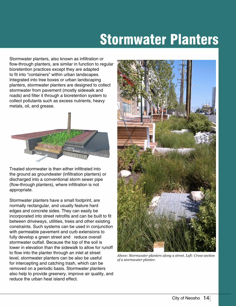
Stormwater planters, also known as infiltration or flow-through planters, are similar in function to regular bioretention practices except they are adapted to fit into “containers” within urban landscapes. Integrated into tree boxes or urban landscaping planters, stormwater planters are designed to collect stormwater from pavement (mostly sidewalk and roads) and filter it through a bioretention system to collect pollutants such as excess nutrients, heavy metals, oil, and grease.
Treated stormwater is then either infiltrated into the ground as groundwater (infiltration planters) or discharged into a conventional storm sewer pipe (flow-through planters), where infiltration is not appropriate.
Stormwater planters have a small footprint, are normally rectangular, and usually feature hard edges and concrete sides. They can easily be incorporated into street retrofits and can be built to fit between driveways, utilities, trees and other existing constraints. Such systems can be used in conjunction with permeable pavement and curb extensions to fully develop a green street and reduce overall stormwater outfall. Because the top of the soil is lower in elevation than the sidewalk to allow for runoff to flow into the planter through an inlet at street level, stormwater planters can be also be useful for intercepting and catching trash, which can be removed on a periodic basis. Stormwater planters also help to provide greenery, improve air quality, and reduce the urban heat island effect.
Above: Stormwater planters along a street. Left: Cross-section of a stormwater planter.

15
Street Trees and ReforestationTrees are one of the most economical stormwater BMPs available. Trees intercept stormwater via their canopies, improve air quality, reduce the urban heat island effect, improve neighborhood aesthetic, and reduce stormwater runoff through evapotranspiration and root uptake.
More important than the number of trees is the size and composition of the soil area to allow for proper growth. Dense, compact soil and a small soil area can dramatically reduce a tree’s size potential, and as a consequence, reduce potential stormwater benefits. In more suburban or rural settings, reforestation and afforestation can provide more benefits than street trees alone. Typically defined as reforestation or afforestation areas of contiguous
woodland greater than or equal to 5,000 square feet, additional benefits provided include the creation of habitat, noise abatement, and stream bank stabilization, in addition to root uptake of stormwater.
Above: As the potential growing medium increases (soil volume), the tree size over time can be greatly enhanced. (Casey Trees, 2008)Mussilicaet Catusci ex nu consuam issenterena
1980 2007
Above: Trees on the left side of this sidewalk were planted with significantly smaller root growth area vs. the right. Even after almost 30 years, these trees still show a significant size differential. Trees along the street have roughly 300 cubic feet of growth area vs. the right with large green space. Pennsylvania Avenue Northwest, Washington, DC. (Casey Trees, 2008)

16
Permeable Paving
Stor
mwa
ter D
esig
n To
olbo
x
Permeable pavement comes in many varieties, but the most common include open grid and interlocking pavers, porous concrete, and asphalt. They provide the same load-bearing support that conventional pavement does and are good for walking, biking, and parking areas, and for driving on low- to moderately-trafficked streets. However, permeable pavement is specially designed to allow stormwater to infiltrate through the pavement to an underground storage basin or exfiltrate into the ground and recharge the water table.
Permeable pavement is ideal for planting trees in a paved environment while not still permitting full use of the pavement because their porous nature allows adjacent trees to receive more air and water. Because they are light in color and have an open-cell structure, they also help to reduce the urban heat-island effect. From a safety perspective, permeable pavements are beneficial for reducing hydroplaning. Due to this, they have recently been gaining popularity for use on highways and other high-traffic areas.
Above: System Components of Permeable Interlocking Concrete Pavement (PICP). The base layers of a permeable pavement system are similar for permeable pavers, porous asphalt, and pervious concrete. Each system has some variations which are important for structural integrity. Below: Pervious pavement in Portland, OR.

17
High School
Church Prayer Garden
Dog Park
North Trail Connection(to Shoal Creek)
Floodplain + Wetland Boardwalk
Morse Park
Concept Designs
Focus Areas
Trail Feature
The tools identified in the previous chapter showcase some of the many green infrastructure practices applicable to development and redevelopment projects. To help visualize how these practices could be implemented in Neosho, two concept plans were prepared.
Two areas were selected in cooperation with the City of Neosho’s Stormwater Management Department: a future trail system within Neohso’s existing park system, and city-owned property within Neosho’s historic downtown. These sites were selected due to their ability to serve as strong demonstration projects that meet the city’s stated themes of increasing city-wide beautification efforts, improving stormwater management, engaging youth, allowing for increased cultural exchanges, and providing a system of
linkages between the City’s existing parks (City of Neosho, 2006).
The first design focuses on integrating green infrastructure and LID concepts into the proposed hickory creek + high school branch trail system as a means to showcase the many ways it can be implemented and to provide environmental education opportunities. Two sites along the trail were selected as primary reference points: 1) near the high school, and 2) a wetland + prairie boardwalk.
The second focuses on how green infrastructure retrofits can be incorporated within the City’s downtown area. This concept design focuses on the Neosho Auditorium Lot and South Wood Street Parking Lot.

18
Turn
ing
Gree
n In
frast
ruct
ure
into
a R
ealit
y
High School Branch + Hickory Run TrailNeosho High School Branch + Hickory Run Trail
Location
High School Branch is an ephemeral stream that flows north through the City of Neosho and into Hickory Run. The City has proposed a 3 mile greenway along High School Branch and Hickory Run including a biking and hiking trail. The greenway would link Neosho Junior High School in the south to the Morse Park Baseball Fields in the North.
Project Description
The City of Neosho’s park system encompasses nearly 400 acres of land, including three large parks and a network of trails. The City of Neosho currently has plans to develop a hickory creek / high school branch trail, shown on page 17, to promote connectivity between its existing trail and park system and the downtown area.
The intent of the Neosho High School Branch + Hickory Run Trail design concept presented here is to showcase the many ways that LID and green infrastructure can be incorporated within and along the City’s currently proposed trail route to provide a natural trail experience within an urban setting. Doing so would allow for improved stormwater management along the City’s waterways while providing an enjoyable trail experience and environmental education opportunities to the City’s youth. The concepts are intended to be implemented incrementally as funds become available.
Developing a trail that goes through both urban and natural landscapes allows for a wide variety of green infrastructure practices to be implemented. The trail itself is an integral part of green infrastructure; connecting residential communities, commercial districts and educational institutions with the natural environment reduces stormwater impacts while also providing alternate modes of transportation, enriching student environmental education, providing safe routes to school, and improving a number of other
19
social, economic, and environmental factors (including traffic, air pollution, and urban heat island effects). The trail also allows the community improved access to the high school branch stream.
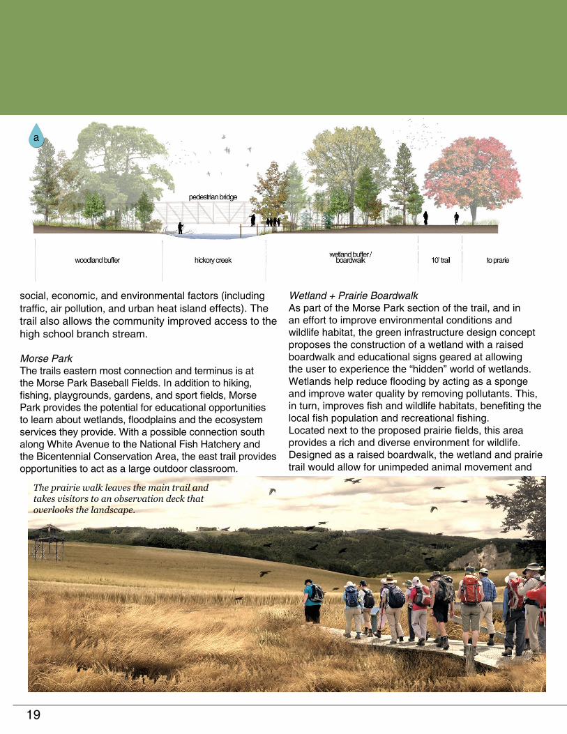
Morse ParkThe trails eastern most connection and terminus is at the Morse Park Baseball Fields. In addition to hiking, fishing, playgrounds, gardens, and sport fields, Morse Park provides the potential for educational opportunities to learn about wetlands, floodplains and the ecosystem services they provide. With a possible connection south along White Avenue to the National Fish Hatchery and the Bicentennial Conservation Area, the east trail provides opportunities to act as a large outdoor classroom.
Wetland + Prairie BoardwalkAs part of the Morse Park section of the trail, and in an effort to improve environmental conditions and wildlife habitat, the green infrastructure design concept proposes the construction of a wetland with a raised boardwalk and educational signs geared at allowing the user to experience the “hidden” world of wetlands. Wetlands help reduce flooding by acting as a sponge and improve water quality by removing pollutants. This, in turn, improves fish and wildlife habitats, benefiting the local fish population and recreational fishing. Located next to the proposed prairie fields, this area provides a rich and diverse environment for wildlife. Designed as a raised boardwalk, the wetland and prairie trail would allow for unimpeded animal movement and
The prairie walk leaves the main trail and takes visitors to an observation deck that overlooks the landscape.

20
would provide walkers with a better visual access than a ground level trail. Educational plaques along the trail would provide information about the many interesting aspects of the ecosystem.
In the prairie boardwalk, visitors would traverse a loop that takes them from the edge of the wetlands to an outlook tower that overviews the prairie landscape. From the outlook tower, visitors would be able to use a wide swathe of the prairie land and the tower will serve as a vantage point to view birds and wildlife.
The wetland boardwalk would feature a dock reaching out onto Hickory Creek. From this dock, observers will be able to see first hand the happenings within the stream and students can conduct experiments to measure the stream’s health and vitality. Camouflaged blinds along the waters edge in the wetlands could provide areas that mask visitors from wildlife and provide excellent bird watching opportunities.
WayfindingA useful, informative wayfinding system is integral to a trail’s success. The concept design presented here recommends that signs be installed near trail entrances to provide directions to trail heads and parking areas. Trail markers installed along the trail would provide information on distances to landmarks and trail features. Runners and cyclists rely on trail
markers for navigation and distance, and marked trails are more easily adapted to running and cycling events.
Potential North Trail Connection At the northern most point of the trail, there is a potential to connect to a larger regional trail system by connecting north to Joplin, following Shoal Creek.
Train Track LightingJust west of Morse Park, the proposed greenway crosses a train track. As a potential showcase project of alternative energy and sustainability, new technology is available that converts train vibrations into usable energy. This technology could be installed where the greenway crosses the train
Turn
ing
Gree
n In
frast
ruct
ure
into
a R
ealit
y This small motor produces electricity from passing trains and could potentially power lights or signs.
Terracing a channelized stream, like the church grounds, can provide a more inviting atmosphere.
Dog parks bring together communities and can fit in small vacant lots.

21
track to both light the trail or act as an early warning signal (SBU, 2013).
Church Prayer GardenLocated at the corner of Young and Grant Street are two churches -- Second Baptist Church and Bible Holiness Assembly of God -- separated by an empty lot and a channelized stream. The site is currently occupied by unorganized parking on one side and lawn on the other. The concept design visualizes restructuring parking along the street and replacing the channel wall with streamside terraced gardens. The gardens, which would be designed and constructed in flood plain conditions with native plants typically associated with the riparian zone. This would improve filtration capacity and allow the stream to expand and contract as water levels fluctuate. The plantings would also improve the visual appeal of the riparian area while serving as a physical barrier.
Dog Park / Big Spring ParkAt the end of Adams Street between North Valley Street and North Lincoln Street lies two triangular spaces. Both spaces are bordered on two sides by streets, and the stream on the remaining side. These triangular spaces present an opportunity to open the trail up and provide public open space within the neighborhood. A dog park and playground can help increase property values, improve safety, and provide a community focal point. For the dog park, the upfront consideration and periodic review of pet waste management would be necessary to ensure that pet waste remains out of the stream system.
High SchoolAt the southern end of the trail, the Neosho High School property sits at the beginning of the high school branch stream. Currently, the stream is highly eroded. Applying multiple green infrastructure practices throughout the

22
property would improve stream health and reduce runoff.
The most prominent feature in this design is the stream restoration along the school campus. The entire length of the stream would be widened and planted with vegetation that can survive both wet and dry periods. Eroded stream banks would be stabilized and adjacent areas gently sloped. Since this stream is ephemeral, it is important to provide space for the stream to expand and contrast. In sections where other uses begin to interrupt the streams boundaries, such as the various parking lots, encroachments would be pushed back and reconstructed to allow the stream corridor to better handle the high flow conditions. Underutilized lawn spaces within the campus can be converted to prairie or forest to reduce mowing and maintenance costs.
In addition to reconfiguring the area to allow the stream to expand, the concept design envisions retrofitting the campus’ central parking lots with tree islands, rain gardens, bioswales, and permeable pavements as necessary. All parking facilities on the campus would be fitted with the most appropriate LID features to reduce runoff.
The main building of the high school can also be retrofitted with green roofs or cisterns, depending on the structural capacity of the existing roof. The green roof would provide an outdoor classroom space for students, and cisterns would provide water for gardens, landscaping, or other non potable uses within the facility.
Turn
ing
Gree
n In
frast
ruct
ure
into
a R
ealit
y Above: Current conditions between the parking lots at the high school.
Left: Potential stream buffer and permeable parking lot.

23
Lot at West Main Street & South Jefferson Street / S. Wood Street Parking Lot
Location
This concept plan applies green infrastructure principles and practices to visualize how two downtown lots: the Cityof Neosho Municipal Auditorium lot and the S. Wood Street parking lot could be redeveloped to privde not just parking lot but open space to accommodate public events, performances, gatherings, and celebrations in an outdoor setting.
Lot at West Main Street and South
Plaza + Stage
Tree Grove
Flow
er B
ox W
all
Additional Parking
Reverse Angle Parking
Green Parking Lot
Project Description
Just behind the City of Neosho’s Municipal Auditorium lies an unused grass lot that was formally the site of an old church. Initially intended to be used for parking,
View from West Main Street of the plaza, stage and flower box wall.

24
Jefferson Street
Turn
ing
Gree
n In
frast
ruct
ure
into
a R
ealit
y
this lot is re-envisioned as an outdoor performance space for the municipal auditorium, with parking along the edge. The parking lot on South Wood Street is retrofitted as a green parking lot, utilizing permeable pavement. The performance space created is designed to be used as a space where it could function as a movie lawn in the summer and a place for lunch during the week. Other events such as weddings or concerts could also take place within the space.
Park FeaturesThe green infrastructure concept design envisions creating a new public park consisting of a flower box planter wall, stage, movable tables and chairs, and a row of additional parking. The current lot would be leveled and a retaining wall added to provide a flat surface. This will provide a backdrop for the stage and rise above the sidewalk to enclose the space.
The planter wall, as envisioned, would pay tribute to Neosho’s title as the flower box city by holding over 20 flower boxes that can be maintained by City staff
or through community volunteers. These boxes can be used for flowers, herbs, or can be planted for events taking place in the plaza. As part of the design, a cistern would be used to collect stormwater from the auditorium so the flower boxes can be watered without drawing from potable sources. While there does not appear to be much runoff coming off this lot, the design could easlity be altered to allow for underground storage if future engineering studies identify volume control as an issue.
View from the corner of South Jefferson + West Main Street of the infiltration
planters and municipal sign.
Infiltration PlanterInfiltra
tion Planter

25
Central to the design are a stage and main plaza area to be used for outdoor concerts, weddings, and auditorium performances. Seating would be constructed using permeable pavers with a light color to reduce runoff and the urban heat island effect. Adding a tree grove at the back of the plaza would buffer the stage and seating area from the rear parking lot while providing a shaded area for tables and chairs for residents and visitors to stop for lunch.
StreetscapeThe proposed design calls for the existing sidewalk
to be widened in order to allow for tree box filters and a planter bed to be placed around the edge of the retaining wall to level the plaza. Integrated with the wall will be an entrance sign signifying that you have entered downtown Neosho.
Cross-section showing the leveled plaza and flower box wall, and how it connects to the existing sidewalk.
Flower Box Wall
Existing Sidewalk
Plaza Level
The tree grove at the south of the plaza provides space for gathering and access to parking.

26
Turn
ing
Gree
n In
frast
ruct
ure
into
a R
ealit
y
Reverse Angled ParkingTo provide additional parking, the design proposes re-striping the green parking lot to allow for reverse angled parking. Reverse angled parking, which is already utilized for street parking within Neosho’s downtown area, has been proven to increase parking by roughly 25% and reduce accidents by 43%.

27
ReferencesCasey Trees (2008) Tree Space Design: Growing the Tree Out of the Box.
City of Neosho (2006) Neosho, MO Comprehensive Plan.
District of Columbia Office of Planning (DC OP) (2011) New York Avenue Green Infrastructure Assessment.
Elkington, J. (1994) Towards the Sustainable Corporation: Win-Win-Win Business Strategies for Sustainable Develop-ment. California Management Review. Vol. 36, Iss. 2.
Frazer, L. (2005) Paving Paradise: The peril of impervious surfaces. Environmental Health Perspective, Vol. 113, Iss. 7.
Getter, K.L, D.B. Rowe, G.P. Robertson, B.M. Cregg and J.A. Andresen (2009) Carbon Sequestration Potential of Extensive Green Roofs. Environmental Science & Technology, Vol 43, Iss. 19.
Gill, S.E., J.F. Handley, A.R. Ennos and S. Pauleit (2007) Adapting Cities for Climate Change: The Role of the Green Infrastructure. Built Environment, Vol. 33, No. 1.
Intergovernmental Panel on Climate Change (IPCC) (2007) Climate Change 2007: Synthesis Report. www.ipcc.ch/pdf/assessment-report/ar4/syr/ar4_syr.pdf.
MacDonagh, L. Peter (2005) Benefits of Green Roofs. Implications, Vol. 4, Iss. 8.
Mid-America Regional Council (MARC) (2008) Manual of Best Management Practices for Stormwater Quality.
Missouri Dept. of Natural Resources (MoDNR) (2012) Missouri Guide to Green Infrastructure. Retrieved from: www.dnr.mo.gov/env/wpp/stormwater/mo-gi-guide.htm.
Missouri Dept. of Natural Resources (MoDNR) (2011) Air Pollution Control Program: 2011 Missouri Clean Diesel Program. Retrieved from: www.dnr.mo.gov/gatewayvip/2011mocleandieselprogram.htm.
Missouri Housing Development Commission (MHDC) (2008) Residential Demand Analysis: Neosho Downtown Market Area.
Pataki, D.E., M.M Carreiro, J. Cherrier, N.E. Grulke, V. Jennings, S. Pincetl, et al. (2011). Coupling biogeo-chemical cycles in urban environments: Ecosystem services, green solutions, and Misconceptions. Frontiers in Ecology and the Environment. Vol. 9, Iss. 8.
Stony Brook University (SBU)(2012v ) Press Release: SBU Team Wins National Award for Rail Road Energy Harvesting. (Retrieved from: http://commcgi.cc.stonybrook.edu/am2/publish/General_University_News_2/Stony_Brook_Team_Wins_National_Award_for_Technology_that_Harvests_Energy_from_Railroad_Train_Vibrations.shtml)
Transportation for America (TFA). 2011. Dangerous by Design: Solving the Epidemic of Preventable Pedestrian Deaths. Transportation for America: Washington, DC. Retrieved from http://t4america. org/docs/dbd2011/Dangerous-by-Design-2011.pdf.
Trust for Public Lands (TPL) (2009) Measuring the Economic Value of a City Park System.
United States Environmental Protection Agency (USEPA) (2011) Why Green Infrastructure? Last updated on Friday, January 11, 2013. water.epa.gov/infrastructure/greeninfrastructure/gi_why.cfm.
United States Environmental Protection Agency (USEPA) (2008) Reducing Urban Heat Islands: Compendium of Strategies.
United States Environmental Protection Agency (USEPA) (2007) Reducing Stormwater Costs through Low Impact Development (LID) Strategies and Practices.
United States Global Change Research Program (USGCRP) (2009) Global Climate Change Impacts in the United States . Karl, T.R., J. M. Melillo, and T. C. Peterson (eds.). http://globalchange.gov/publications/reports/scientific-assessments/us-impacts.
Kansas City Mid-America Regional Council (MARC) and the Kansas City Metro Chapter of the American Public Works Association (APWA) (2008) Manual of Best Management Practices for Storm-water Quality.

28
Refe
renc
es a
nd P
hoto
Cre
dits
Photo CreditsWe gratefully acknowledge the following people and organizations for the use of their images. Every effort has been made to trace and contact the original copyright holders. If there are any inadvertent omissions, we apologize to those concerned and ask that you contact us so that we can correct any oversight as soon as possible. Any such inquiries should be directed to the Low Impact Development Center. Contact information is provided at the front this handbook. All other photos or images on these pages are copyright © The Low Impact Development Center.
P a g e C r e d i t
Cover Courtesy of Buddy Sallee6 Top image courtesy of Kelly Luckett, Green
Roof Blocks; bottom image courtesy of Robert Boston, Washington U. School or Med.
7 Top image courtesy of Patric Blanc; bottom image courtesy of Green Futures Lab, University of Washington
8 Top image from the US EPA; bottom image from the City of Gresham, OR.
9 Top image courtesy of Sanitation District No. 1, bottom image courtesy of Stanton Homes - Home Builder.
10 Bottom image from US EPA.11 Bottom left image courtesy of the City of
Maplewood, Minnesota.12 Top image courtesy of GreenWorks PC,
Portland, Oregon; bottom image courtesy of LPA Inc./Costea Photography, Inc.
13 Top image courtesy of Bob Newport, US EPA Region V
15 Renderings and images courtesy of Casey Trees
16 Top image courtesy of the Interlocking Concrete Pavement Institute
17 Background map data copyright Google Earth. Trail location added by LID Center.
18 Background map data copyright Google Earth. Trail location added by LID Center.
20 Top photo courtesy of Matt Lanza; middle image courtesy of Lei Zuo, The Research Foundation for the State University of New York; bottom image courtesy of Jim’s Photos 1 under a Creative Commons license.
21 Background map data copyright Google Earth. High School retrofit options added by LID Center.
C r e d i tP a g e
22 Middle image copyright Google Earth.23 Background map data copyright Google
Earth. Green infrastructure features added by LID Center.
24 Bottom right photo courtesy of Neosho Area Chamber of Commerce.


![Vegetating Green Infrastructure - michigan.gov€¦Vegetating Green Infrastructure. Outline [ green infrastructure vegetation needs to ... [ bioswales ] the myth of sheet flow protecting](https://img.pdfslide.us/doc/110x75/5af1d6177f8b9a572b9143f3/vegetating-green-infrastructure-vegetating-green-infrastructure-outline-green.jpg)