Embed Size (px)
Citation preview

City of Mountain BrookSUBDIVISION REGULATIONS
Adopted: March 4, 2013


ROSTERMAYOR
Lawrence T. "Terry" Oden
CITY MANAGER:
Sam S. Gaston
CITY COUNCIL
Virginia C. Smith, PresidentWilliam S. "Billy" Pritchard, III, President Pro-Tem
Jack CarlLloyd SheltonAlice Womack
PLANNING COMMISSION:
Frederick W. Murray, Jr., Chairman Susan Swalger, Vice-Chairman
Phillip E. BlackAlice Williams, Secretary
Cay AlbyJamie Gregory
Jack Carl, Council LiaisonDana Hazen, Advisory Member
STAFF
Dana Hazen, Director of Planning, Building & SustainabilityGlen Merchant, Building Official
Ronald Vaughn, Public Works DirectorTammy Graham, Administrative Assistant
Whit Colvin, City Attorney

MOUNTAIN BROOK SUBDIVISION REGULATIONS
TABLE OF CONTENTS
ARTICLE 1 GENERAL PROVISIONS...................................................................................1-1
§1.1. Enactment and Authority......................................................................................1-1§1.2. Jurisdiction...........................................................................................................1-1§1.3. Purpose.................................................................................................................1-1§1.4. Enforcement, Violations, and Penalties...............................................................1-2§1.5. Effect of Preliminary Plat Approval.....................................................................1-2§1.6. Effect of Final Plat Approval...............................................................................1-2§1.7. Variance and Exceptions......................................................................................1-3§1.8. Conflicts of Interest Prohibited............................................................................1-3
ARTICLE 2 DEFINITIONS.....................................................................................................2-1
§2.1. Usage....................................................................................................................2-1§2.2. Definitions............................................................................................................2-1§2.3. Abbreviations.......................................................................................................2-6
ARTICLE 3 SUBMISSION, APPROVAL PROCEDURE, PLAT REQUIREMENTS..........3-1
§3.1. Pre Design Conference.........................................................................................3-1§3.2. Overall Procedures...............................................................................................3-1§3.3. Preliminary Plat....................................................................................................3-1§3.4. Improvements Construction Plans........................................................................3-4§3.5. Construction and Inspection of Improvements, Bonding.....................................3-4§3.6. Final Plat...............................................................................................................3-6§3.7. Small Subdivisions...............................................................................................3-8
ARTICLE 4 SUBDIVISION DESIGN PRINCIPLES, STANDARDS...................................4-1
§4.1. General Suitability of Land..................................................................................4-1§4.2. Conformity to Comprehensive Plan.....................................................................4-1§4.3. Name of Subdivision and Streets.........................................................................4-1§4.4. Subdivisions to Have Public Access....................................................................4-1§4.5. Reserve Strips.......................................................................................................4-1§4.6. Easements.............................................................................................................4-1§4.7. Design Standards for Blocks and Lots.................................................................4-2§4.8. Non-residential Subdivisions...............................................................................4-3
ARTICLE 5 DESIGN STANDARDS FOR STREETS, RIGHTS-OF-WAY..........................5-1
§5.1. General Standards.................................................................................................5-1§5.2. Minimum Design Requirements for Streets.........................................................5-5
i

ARTICLE 6 DESIGN REQUIREMENTS FOR PUBLIC DRAINAGE AND STORM SEWERS..............................................................................................................6-1
§6.1. General Design Criteria........................................................................................6-1§6.2. Gutters and Open Channels..................................................................................6-2§6.3. Culverts................................................................................................................6-2§6.4. Drainage Structures..............................................................................................6-2§6.5. Erosion and Sediment Control.............................................................................6-3
ARTICLE 7 SANITARY SEWER AND WATER FACILITIES............................................7-1
§7.1. Sanitary Sewer......................................................................................................7-1§7.2. Water Facilities.....................................................................................................7-1
ARTICLE 8 REQUIREMENTS FOR SUBDIVISIONS SUBJECT TO FLOODING............8-1
§8.1. General.................................................................................................................8-1§8.2. Streams Depicted on Flood Boundary and Floodway Map.................................8-1§8.3. Channelization by Variance.................................................................................8-1
ARTICLE 9 AMENDMENTS AND LEGAL CONSIDERATIONS......................................9-1
§9.1. Amendments.........................................................................................................9-1§9.2. Saving Clause.......................................................................................................9-1§9.3. Interpretation by the Planning Commission.........................................................9-1§9.4. Regulations to be Minimum Standards................................................................9-1§9.5. Separability...........................................................................................................9-1§9.6. Effective Date and Repealer.................................................................................9-1
ii
ARTICLE 1 GENERAL PROVISIONS
§1.1. Enactment and Authority.
Under the provisions of Title 11, Chapter 52 of the Code of Alabama of 1975, which provisions are hereby made a part thereof, these regulations governing the subdivisions of land are hereby adopted by the Mountain Brook City Planning Commission, hereafter referred to as the “Commission”. A copy of these regulations shall have been certified to the Office of the Probate Judge of Jefferson County, hereinafter referred to as the “Probate Office,” and copies are available from the City Clerk and the City Manager.
§1.2. Jurisdiction.
On and after their effective date, these regulations shall govern each and every subdivision of land within the corporate limits and within the jurisdiction of the Commission as the same now exists or may hereafter be altered.
§1.3. Purpose.
The regulations are adopted for the following purposes:
1.3.1. To protect and provide for the public health, safety, and general welfare of the City and its environs.
1.3.2. To guide the future growth and development of the City in accordance with plans and policies adopted pursuant to the comprehensive planning process.
1.3.3. To provide for adequate light, air and privacy, to secure safety from fire, flood, and other dangers, and to prevent overcrowding of the land and undue congestion of population.
1.3.4. To encourage the orderly and beneficial development of the City and its environs,
1.3.5. To preserve the unique qualities of the community and to protect and conserve the value of land throughout the City and its environs and the value of buildings and improvements upon the land.
1.3.6. To guide public and private policy and action in order to provide adequate and efficient transportation, utilities, schools, parks, playgrounds, recreation, and other public services and facilities.
1.3.7. To provide the most beneficial relationship between the uses of land and buildings and the circulation of traffic throughout the city, having particular regard to the avoidance of congestion in the streets and highways, and the pedestrian traffic movements appropriate to the various uses of land, and to provide for the proper location and width of streets.
1.3.8. To establish reasonable standards of design and procedures for subdivisions and resubdivisions, in order to further the orderly layout and use of land; and to ensure proper legal descriptions and monumentation of subdivided land.
1
General Provisions
1.3.9. To ensure that public utilities and facilities are available and will have sufficient capacity to serve the proposed subdivision.
1.3.10. To prevent the pollution of air, streams, and ponds; to assure the adequacy of drainage facilities; to safeguard water tables; and to encourage the wise use and management of natural resources throughout the community.
1.3.11. To preserve the natural beauty and topography of the Mountain Brook area and to ensure appropriate development with regard to these natural features.
1.3.12. To provide for open spaces through the most efficient design and layout of the land, including the use of average density in providing for minimum width and area of lots, while preserving the density of land as established in the Zoning Ordinance of the City of Mountain Brook.
§1.4. Enforcement, Violations, and Penalties.
1.4.1. Enforcement. It shall be the duty of the Subdivision Official to enforce these regulations by bringing to the attention of the City Manager and City Attorney any violations, or lack of compliance herewith.
1.4.2. Violations and Penalties. Whoever, being the owner or agent of the owner, of any land located within a subdivision as defined herein, transfers or sells such land without first recording an approved plat in the Probate Office until such subdivision plat shall have been approved by the Commission and such approval entered in writing on the face of the final plat as evidenced by the signature of the Chairman and the Secretary of the Commission, shall forfeit and pay a penalty of one hundred dollars ($100.00) for each lot or parcel so transferred or sold.
The City may also enjoin such transfer or sale or agreement by action for injunction brought in any court of equity jurisdiction or may recover the same penalty by a civil action in any court of competent jurisdiction.
§1.5. Effect of Preliminary Plat Approval.
Receipt of the approved copy of the preliminary plat by the subdivider is authorization, subject to the taking of proper permits, to proceed with the construction of any improvements to the subdivision under the direction and supervision of the Subdivision Official, and/or other supervisory personnel required by the City and subject to the approved plans and profiles, and to proceed with the staking of streets and lots in preparation for the final plat.
§1.6. Effect of Final Plat Approval.
Receipt of the approved copy of the final plat by the subdivider is authorization to record the plat in the Probate Office, to transfer lots in the subdivision, and to seek a building permit for structures to be erected on any lot. No building permit shall be issued for any structure in any subdivision that has not received final approval and been recorded in the Probate Office. Further, No building permit shall be issued for any structure in any subdivision, other than a legally nonconforming subdivision, that does not fully comply with these regulations.
2
§1.7. Variance and Exceptions.
Whenever the shape or topography of a parcel to be subdivided is so unusual that the strict application of these regulations would result in substantial and unreasonable hardship to the developer, the Commission may vary or modify the requirements of these regulations so that the developer is allowed to develop the parcel in a reasonable manner; provided, that any such variance must not be contrary to the public welfare or the public interest of the City, and the parcel must be developed in a manner which is consistent with the general intent and spirit of these regulations. The Commission may make any such variance subject to such conditions as will, in its judgment, substantially secure the objectives of the standards or requirements so varied. Any variance thus authorized, and the reason(s) therefore, must be entered, in writing, in the minutes of the Commission.
§1.8. Conflicts of Interest Prohibited.
Any member of the Commission, or its secretary, or any other employees of, or technical consultants to the Commission shall, in no case, review or enter into deliberations or vote on any matter in which they may have any conflict of interest whatsoever in regard to these regulations.
3
General Provisions
This page intentionally left blank.
4
ARTICLE 2 DEFINITIONS
§2.1. Usage.
2.1.1. Certain terms used in these Regulations shall have the meanings provided herein. Terms not defined herein shall have the meaning provided in the Zoning Ordinance, the City Code, or Sections 11-52-30 through 11-52-36 of the 1975 Code of Alabama, as amended. Otherwise, the conventional meaning of such term shall apply.
2.1.2. Words used or defined in one tense or form shall include other tenses and derivative forms. Words in the singular shall include the plural; and words in the plural shall include the singular. The masculine gender shall include the feminine; and the feminine gender shall include the masculine. The word "shall" is mandatory. The word "may" is permissive. A "person" includes an individual, a corporation, a partnership, a limited liability company, and an incorporated association of persons such as a club; a "building" includes a "structure"; a "building" or "structure" includes any part thereof; "used" or "occupied" as applied to any land or building shall be construed to include the words "intended, arranged, or designed to be used or occupied."
2.1.3. In case of any conflict between the text of these Regulations and any caption, illustration, figure, or other graphic material, the text shall govern.
§2.2. Definitions.
2.2.1. Adjoining Property Owner or Owners. The person owning property adjoining the tract of land proposed for subdivision development. If the owner of such adjoining property is a corporation, the term shall apply to the officers and agents of such corporation who shall be identified on preliminary plats as adjoining property owners. Owners of property located across streets, alleys, water courses, drainage easements and other rights-of-way adjoining the proposed subdivision are, for the purposes of this regulation, adjoining property owners and shall be so identified on all preliminary plats.
2.2.2. Alley. A public right-of-way designed to provide access to the side or rear of properties.
2.2.3. Approved Plat. A plat conforming to the requirements of these regulations which has received the approval of the Commission and has the signature of those officials authorized to sign the plat under the requirements of these regulations.
2.2.4. Base Flood Elevation. The water surface elevation corresponding to a flood having a one percent probability of being equaled or exceeded in a given year and as shown on the applicable Flood Insurance Rate Map (FIRM).
2.2.5. Block. A unit of land bounded by streets or a combination of streets, public land (excluding alleys), public parks, cemeteries, railroad rights-of-way, watercourses, or any other barrier to the continuity of development.
1

Definitions
2.2.6. Building. A roofed structure built for the shelter, housing, or enclosure of persons or property.
2.2.7. Building Official. The head of the Building Inspections Division of the Department of Planning, Building & Sustainability of the City of Mountain Brook.
2.2.8. City. The City of Mountain Brook, Alabama.
2.2.9. City Engineer. A professional engineer registered with the State of Alabama Board of Registration for Professional Engineers and Surveyors, whether on staff or contract, designated by the City of Mountain Brook to administer the applicable provisions of these regulations.
2.2.10. City Manager. The City Manager of the City of Mountain Brook.
2.2.11. Developer. The person, firm, or corporation who owns or controls a tract of land proposed for subdivision, and at whose direction plans and surveys for such subdivisions are prepared. The term developer also means "subdivider".
2.2.12. Developer's Engineer. The engineer or engineering firm responsible for preparing plans and surveys of a proposed subdivision on behalf of the developer.
2.2.13. Development. A subdivision, including land-lease developments and condominiums, whether or not plats or deeds are to be recorded; the construction, reconstruction, conversion, structural alteration, relocation, or enlargement of any buildings; any condominium development; any use or change in use of any buildings or land; any extension of any use of land or any clearing, grading, or other movement of land, for which an approved development plan is required pursuant to these Regulations or other codes and ordinances of the City. Excluded from this definition are areas to be cleared of trees and other vegetation not exceeding one (1) acre in size, provided that no more than one such area is created on any lot of record.
2.2.14. Easement. Authorization by a property owner of the use by another and for a specified purpose of any designated part of that owner’s property. These Regulations recognize only those easements created through valid legal instruments and recorded in the Office of the Probate Judge and those established by the City through continuous and historic use.
2.2.15. Engineer. A Registered Professional Engineer in good standing with the State Board of Registration in Alabama.
2.2.16. Final Plat. A finished drawing of all or a portion of a subdivision, and any accompanying materials, compiled in accordance with and presented for final approval as required in these regulations.
2.2.17. Fire Code. The latest version of the International Fire Code as adopted by the City of Mountain Brook.
2

2.2.18. Flood Boundary and Floodway Map. That certain map of the City of Mountain Brook and environs entitled "Flood Insurance Rate Map" issued by the Federal Emergency Management Agency and as adopted by the City of Mountain Brook, as amended.
2.2.19. Floodway Fringe. That area of the floodplain lying outside the floodway, but still subject to inundation by waters of the base flood.
2.2.20. Half Street. An existing street that does not meet the right-of-way or pavement width requirements in these Regulations.
2.2.21. Lot. A parcel of land designated as a separate piece of land (lot) by a map or plat recorded in the Probate Office. The term "lot" shall also include condominium units when such units are laid out, delineated, subdivided, and sold or intended to be sold as the functional equivalent of a typical or traditional subdivision lot.
2.2.22. Lot, Corner. A lot abutting upon two or more streets at their intersection.
2.2.23. Lot, Through. A lot other than a corner lot, abutting upon two or more streets.
2.2.24. Major Street Plan. The official plan of the Commission showing the location of existing and planned roadways designed to service the City of Mountain Brook and its environs.
2.2.25. Master Plan. The comprehensive plan of the City of Mountain Brook and environs and any amendment thereto duly adopted by the Commission.
2.2.26. Open Space. Any parcel or area of land or water, either publicly or privately owned, set aside, dedicated, designated, or reserved for the private use or enjoyment of owners or occupants of land adjoining such open space, or for the public at large.
2.2.27. Parcel. Any piece of land, including, but not limited to, a lot.
2.2.28. Planning Commission. The City of Mountain Brook Planning Commission.
2.2.29. Preliminary Plat or Proposed Development Plan. A drawing of the proposed design of a subdivision compiled in accordance with all of the requirements of these regulations.
2.2.30. Probate Office. The Office of the Judge of Probate of Jefferson County, Alabama.
2.2.31. Reserve Strip. A parcel of land located usually at the edge of a subdivision for the purpose of restricting access from the end or side of a street.
2.2.32. Resubdivision. A combination, recombination, or splitting of previously recorded lots or tracts of contiguous land for the purpose of creating additional lots or enlarging existing ones.
2.2.33. Right-of-way. A strip of land used or intended to be used for passage of the general public, and occupied or intended to be occupied by a street, road, pedestrian passage,
3
Definitions
bicycle path, crosswalk, utilities, railroad or similar facility; and dedicated to the City in fee simple, or by other legal means such as prescription.
2.2.34. Setback. The distance between a building or other structure and the property lines of a parcel upon which such building or structure is located as are required by these regulations or the Zoning Ordinance.
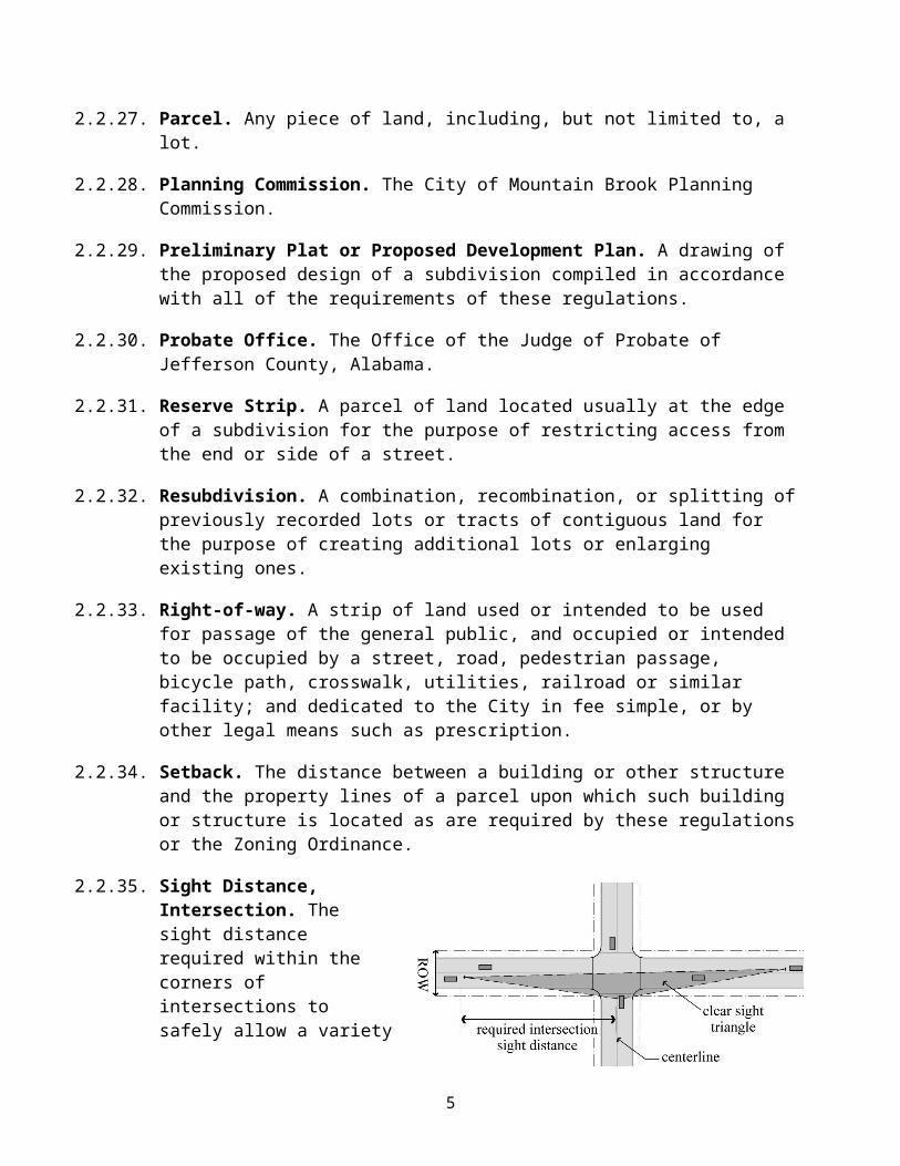
2.2.35. Sight Distance, Intersection. The sight distance required within the corners of intersections to safely allow a variety of vehicular maneuvers based on the type of traffic control at the intersection. Required intersection sight distances are based on factors including design speed, topography, and similar conditions in accordance with AASHTO standards. See also “Sight Triangle, Clear”.
2.2.36. Sight Triangle, Clear. An area of unobstructed vision at an intersection defined by a line of sight between points at a given distance from the intersection of the street centerlines. See also “Intersection Sight Distance”.
2.2.37. Small Subdivision. Any one of the following:
1. the subdivision or the resubdivision of one or more existing lots into no more than two lots;
2. the consolidation of two or more existing lots into fewer lots; or
3. the relocation or reconfiguration of one or more boundaries of existing lots on a map or plat intended or required to be filed for record (also known as a “resurvey”) provided said relocation or reconfiguration does not result in the creation of a greater number of lots than previously existed.
2.2.38. Stopping Sight Distance. The distance required by a motorist to stop a vehicle traveling at or near the design speed of a thoroughfare before reaching a traffic-controlled intersection or stationary object in their path. Required stopping sight distances are based on AASHTO standards.
2.2.39. Street. The entire platted or proposed public way for vehicular and pedestrian traffic, whether designated as an arterial, collector street, minor street, or however otherwise designated by the City, excepting, however, an alley. For the purposes of these regulations, streets are classified as follows:
1. Arterial, Minor. A major street intended to mainly carry through traffic and to connect major activity centers in the City.
2. Arterial, Principal. An expressway, freeway or highway intended to mainly carry regional traffic between communities at higher speeds.
4
3. Collector Street. A street that primarily serves as a means of moving traffic between arterials and minor streets. Direct access to abutting properties is a secondary function.
4. Cul-de-Sac Street. A minor street permanently having no outlet at one end.
5. Major Street. Any arterial or collector street.
6. Marginal Access Street or Frontage Street. A street that runs parallel to a major street, generally an arterial; its purpose being to separate through traffic from local traffic and to provide access to abutting properties.
7. Minor Street. A street primarily for access to abutting properties and as interconnection between abutting properties and other streets.
2.2.40. Subdivision. The division of a lot, tract, or other parcel of land into two (2) or more lots, plats, sites or other divisions of land, whether described by metes and bounds or by any other description, for the purpose, whether immediate or future, of sale or of building development. It includes resubdivision and, when appropriate to the context, relates to the process of subdividing or to the land or territory subdivided. For the purposes of these Regulations, all Subdivisions are considered Developments, see “Development.” See also “Small Subdivision.”
2.2.41. Subdivision Official. The Director of Planning, Building & Sustainability, Building Official, or other official designated by the City Council to administer these regulations including his/her designee.
2.2.42. Subdivision Regulations or These Regulations. The Subdivision Regulations of the City of Mountain Brook, Alabama together with all applicable design and construction standards promulgated by the City Public Works Department.
2.2.43. Submission. The presentation of a plat or plan, prepared in strict conformity to these regulations, on or before the date required by these regulations.
2.2.44. Surveyor. A qualified Registered Land Surveyor in good standing with the State Board of Registration of Alabama.
2.2.45. Swale. A constructed watercourse shaped or graded in earth materials and stabilized with vegetation, for the conveyance and water quality improvement of storm runoff.
2.2.46. Temporary Cul-De-Sac. A cul-de-sac to give access to future subdivisions adjoining the subdivision property.
2.2.47. Tier. In reference to blocks and lots, a row of lots along the same block frontage. A double-tiered block contains two tiers of lots, with each tier fronting on opposite streets. A single-tiered block contains one tier of through lots.
2.2.48. Variance. A modification of the strict application of the provisions of these regulations which may be granted by the Commission in accordance with the provisions of §1.7 of these regulations.
5
Definitions
2.2.49. Watercourse. A permanent or intermittent stream, river, brook, run, creek, channel, swale, pond, lake or other body of surface water, carrying or holding surface water, whether natural or manmade.
2.2.50. Zoning Officer. The Director of Planning, Building & Sustainability, or his/her designee, for the City of Mountain Brook.
2.2.51. Zoning Ordinance. The duly adopted comprehensive zoning ordinance and all amendments thereto as officially adopted by the City Council of Mountain Brook.
§2.3. Abbreviations.
2.3.1. AASHTO – American Association of State Highway and Transportation Officials.
2.3.2. ALDOT – Alabama Department of Transportation.
2.3.3. FIRM – Flood Insurance Rate Map.
2.3.4. MSL – Mean Sea Level.
2.3.5. SCS – Soil Conservation Service.
2.3.6. USGS – United States Geological Survey.
6
ARTICLE 3 SUBMISSION, APPROVAL PROCEDURE, PLAT REQUIREMENTS
§3.1. Pre Design Conference.
Before commencing the design of a subdivision, the developer's engineer shall confer with the Subdivision Official to ascertain the existence of any plans, policies or projects which would affect the design of the subdivision. Representatives of other departments of the City may participate in such conference if the Subdivision Official considers it appropriate.
§3.2. Overall Procedures.
3.2.1. To obtain approval of a proposed subdivision, the developer shall submit to the Commission a preliminary and final plat prepared by a Registered Land Surveyor and plans and profiles of proposed improvements prepared by a Registered Engineer, and documents required by §3.3.2, §3.4, and §3.6.2, as appropriate, of these regulations. No developer may sell, contract for the sale of, or convey, a portion of a parcel until the final plat for such parcel has been approved by the Commission and recorded in the Probate Office. No developer may commence the construction of subdivision improvements or other improvements upon any parcel until he has obtained preliminary plat approval and the necessary permits from the City. However, proposed subdivisions involving no public improvements shall require Final Plat submission and approval only.
3.2.2. In order to promote compliance with these regulations and facilitate enforcement thereof, the Commission may condition the approval of any preliminary or final plat on the applicant's executing or entering into such agreements, covenants, bonds, or like undertakings as would, in the judgment of the Commission, be sufficient to assure compliance with requirements or conditions that may be imposed by these regulations, municipal ordinances, other legal mandates, and/or by the Commission; provided, however, that the precise nature, scope, and temporal duration of any condition, requirement, or obligation shall be:
1. within the Commission's statutory authority,
2. of a type that is customarily applied by governing bodies under similar circumstances,
3. clearly specified and/or described by the Commission, and
4. only imposed or required after first affording the applicant an opportunity to propose for the Commission's consideration reasonable alternatives for satisfying the objectives of the Commission.
§3.3. Preliminary Plat.
3.3.1. Procedure.
1. The subdivider shall submit four (4) copies of the preliminary plat to the Subdivision Official at least twenty-four (24) days prior to a regularly scheduled meeting of the Commission in order for the plat to be considered at said meeting. For resubdivisions and small subdivisions submitted under §3.7, the plat must also be submitted twenty-four (24) days prior to the next meeting of the Commission. Revised plats for cases
1
Submission, Approval, Procedure, Plat Requirements
which are heard by the Commission and then carried-over to the next regular meeting of the Commission, whether at the request of the Commission or the applicant, must be submitted at least seventeen (17) days before the date of the hearing at which the Commission is requested to hear the revised case. An electronic version of the preliminary plat shall be provided to the Subdivision Official if so requested.
2. Variances. The subdivider shall submit seventeen (17) copies of any requests for variance(s) from any article or section of these regulations along with material to support the claim for relief from appropriate sections or articles.
3. Fee. To help defray the cost of processing subdivision applications, reviewing plans, and otherwise administering the subdivision regulations, the applicants shall pay to the City a fee, the amount of which shall be determined by the City Council from time to time. The fee shall be due upon the filing of the application. In addition, at the time of filing such application, the applicant shall pay to the City an amount equal to the cost of the postage for sending notices to the parties who are entitled to notice of the application.
4. Notice. The subdivider and the owners of the land immediately adjoining the proposed subdivision shall be given prior notice by mail at least ten (10) days before the hearing on the preliminary plat, in accordance with the provisions of Section 11-52-32 of Title 11, 1975 Code of Alabama.
5. Commission action. The Commission shall approve, approve conditionally or disapprove such preliminary plat within thirty (30) days after the submission thereof at its regular meeting, unless the subdivider consents to an extension of this period. If approved conditionally, the conditions and reasons therefore shall be stated in the minutes of the Commission. If any of the requirements are modified or waived, the reasons for such shall be specified in the minutes of the Commission. If the Commission should disapprove the preliminary plat, the reasons for such action shall be stated in the minutes, and if possible, recommendations made on the basis of which the proposed subdivision may be approved.
6. Disapproval. A preliminary plat that has been disapproved shall not be reconsidered by the Commission for a period of one (1) year from the time of the ruling disapproving the plat, unless all such reasons for disapproval, as recorded, have been properly resolved, as determined by the Subdivision Official.
7. Effect of approval. The approval of a preliminary plat shall not be deemed as final acceptance, but rather an expression of approval of the layout as submitted on the preliminary plat, and shall allow the developer to proceed according to §1.5. Preliminary approval of a proposed subdivision shall lapse at the end of one (1) year, unless an extension, not to exceed sixty (60) days, is granted by the Commission prior to the expiration of said one-year period. An extension of approval shall require demonstration by the subdivider of good cause.
3.3.2. Requirements. All preliminary plats presented to the Commission shall contain, at a minimum:
1. Name and address of owners and the designer of the plat. Said designer shall be a Land Surveyor registered to practice in the State of Alabama.
2
2. Names and addresses of current record (as per the Tax Assessor's records) of adjoining property owners.
3. Date of the plat, north arrow, scale of not less than one (1) inch equals one hundred (100) feet amount of acreage contained in the plat and a statement as to the remaining adjoining acreage the developer or subdivider owns, has an option on or leases.
4. Contours shown at an interval of not more than five (5) feet for slopes over fifteen (15)% and for slopes less than fifteen (15)% contours shall be shown at an interval of not more than two (2) feet. All contours shall be based on the USGS-MSL datum. No assumed datum will be accepted. A note on the plat shall indicate which Benchmark (B.M.) was used.
5. Proposed lot layout showing the following:
a) Lot dimensions, building lines, front, rear and side setback lines, lot and block numbers, and proposed street names.
b) Location and width of proposed rights-of-way, easements, and alleys.
c) Proposed subdivision boundaries, with dimensions and tie to nearest corner of the United States government survey and the section, township and range within which the property is located.
d) Any pertinent topographic features existing on the site.
e) Proposed size and location of all storm drains, storm water detention facilities, and sanitary sewers.
f) Location and dimensions of existing storm and sanitary sewers.
6. A statement as to the current and proposed zoning (if applicable); or a statement of the allowable use of each lot.
7. A vicinity sketch showing location of proposed site in relation to existing streets and their rights-of-way and all existing parcels and subdivisions abutting the site.
8. Width of all proposed paving from back to back of curb.
9. Evidence that every lot has frontage on a public street, or where permitted in accordance with §4.4 and the Zoning Ordinance, a private street.
10. The names, locations, widths, and other dimensions of existing or proposed parks, playgrounds, open spaces or other public property.
11. The locations of existing and proposed property lines and existing buildings, water courses, railroads, power lines, bridges, culverts, and drainpipes on the land to be subdivided and abutting land.
12. Street cross-section(s), showing proposed construction and statements concerning type of material to be used in construction.
13. Location of proposed sidewalks.
14. If any portion of the land included in, or immediately adjacent to, the proposed subdivision is located within the floodway or the 100-year flood boundary of a stream or river, as depicted on the Flood Boundary and Floodway Map, or is located in a
3
Submission, Approval, Procedure, Plat Requirements
"Special Flood Hazard Area", as depicted on a Flood Hazard Boundary Map, then such floodway, boundary, or flood hazard area shall be indicated on the preliminary plat as accurately as possible.
§3.4. Improvements Construction Plans.
3.4.1. Two (2) sets of the plans and profiles of proposed improvements shall be presented to the Subdivision Official and to the Commission, if so requested for review and approval prior to commencement of construction on the proposed subdivision.
The Subdivision Official shall review all plans and profiles of subdivisions granted preliminary approval by the Commission within twenty (20) days of the receipt of the plans and notify the developer's engineer of any discrepancies requiring correction. In the event the Commission requests a copy of the plans and profiles for review and approval, a reasonable extension of the approval date shall be established by the Commission.
3.4.2. The plans and profiles shall conform to all applicable requirements of these regulations except those expressly waived by the Commission.
Construction drawings of proposed improvements shall be prepared by a Registered Professional Engineer and shall include plans and profiles of streets, drainage and storm water detention structures and facilities, and erosion control measures to be used during construction of the subdivision as required by City regulations regarding erosion and sedimentation control and any other drawings and information as may be necessary to determine compliance with these regulations.
Construction drawings shall also include the location of all proposed traffic control signs and devices. Where the proposed subdivision abuts an existing street, the location of any intersecting streets on the other side of the abutting street shall be depicted and any existing traffic control signs and devices along said streets.
Street design shall conform to the provisions of these regulations and such other specifications as may be promulgated by the City. The plans and profiles of drainage and storm water detention facilities and features shall contain sufficient data, including calculations of pipe diameters, runoff velocity in open gutters, and down stream erosion to permit the City to verify the design's conformity to these regulations and applicable city ordinances.
3.4.3. Plans and profiles of sanitary sewer shall be approved by the Jefferson County Department of Environmental Services. Permits and/or other evidence of approval shall be submitted to the Subdivision Official prior to construction. Copies of such approved plans and profiles shall be provided to the Subdivision Official upon request.
§3.5. Construction and Inspection of Improvements, Bonding.
3.5.1. Construction of Improvements.
1. Subdivision improvements shall be constructed under the supervision of a Registered Professional Engineer employed by the developer. Construction of subdivision
4
improvements may begin only after the plans and profiles have been approved, and the developer has purchased construction permits from the City. The fees for such permits shall be as prescribed by ordinance. Quality control during construction shall be maintained as follows:
a) The developer shall employ a qualified testing laboratory to perform compaction tests on street subbase and base before placement of the mat. The results of these tests may be transmitted to the Subdivision Official by any convenient means. The plans and profiles shall be submitted in a form acceptable to the Subdivision Official.
b) The developer's engineer shall ensure that a qualified inspector, experienced in water, street and sewer construction, conducts an inspection not less frequently than once daily during construction of improvements. The inspector shall maintain a logbook of all inspections, which shall be furnished to the Subdivision Official for review upon completion of construction.
2. The developer's engineer or representative shall notify the Subdivision Official before work begins on each of the following steps at least twenty-four (24) hours in advance:
a) Clearing and grading;
b) Placing of subbase;
c) Laying of sanitary, storm pipe or water pipe;
d) Pouring curb and gutter;
e) Placing of base;
f) Putting down mat; and
g) Putting down asphalt.
3. Upon completion of construction, a set of "as built" construction plans shall be delivered to the Subdivision Official. These plans shall show all public improvements as constructed. "As-built" plans shall be referenced to subdivision corners, the Public Land System, or State Plane Coordinates. The developer's engineer shall ensure that the developer furnishes and places electronic location markers of a type approved by the Subdivision Official over all sewer stubs and wyes.
3.5.2. Improvements, Bonding. Approval of the final plat will not be given until the Commission is notified by the Subdivision Official that either:
1. All required and approved improvements have been installed and completed by the subdivider and all as-built plans submitted as required by these rules; OR
2. A bond in an amount equal to one and one-half (1-1/2) times the estimated cost of all such subdivision improvements and approved by the Subdivision Official and the City Attorney has been filed with the City Clerk. The bond shall be issued by a surety company duly licensed in, and authorized to issue surety bonds by, the State of Alabama. As an alternative, the developer may file with the City Clerk an irrevocable letter of credit, in the aforesaid amount, issued by a bank which is authorized to do
5
Submission, Approval, Procedure, Plat Requirements
business in the State of Alabama and which letter of credit shall be subject to the approval of the Subdivision Official and the City Attorney.
3.5.3. No streets, drainage structures, or other improvements will be accepted for maintenance by the City until the same shall have been approved by the Subdivision Official and the acceptance thereof authorized by the City Council in the form of a resolution.
3.5.4. Maintenance Bond. The subdivider or contractor undertaking the construction work for the subdivider, shall file a bond with the City in an amount equal to ten (10) percent of the construction costs of the subdivision improvements. Payment of the proceeds of such bond or any portion thereof shall be to the order of the City as directed by the Subdivision Official for reimbursements of all costs incurred by or on behalf of the City necessary to maintain the streets, sanitary sewers, drainage structures and other improvements for a period of one (1) year following the completion and acceptance of all the improvements in the subdivision by the City.
Not less than thirty (30) days before the expiration of the one year period referred to in the above paragraph, the City shall inspect the improvements covered by the ten (10) percent bond. If the inspection reveals deficiencies beyond normal wear and tear, the Subdivision Official shall notify the developer or the contractor and shall afford them reasonable opportunity to correct the deficiencies before releasing the bond.
The term "bond" as used in this Section shall be deemed to include the deposit of cash with the City Clerk in the appropriate amount required under this Section; the delivery of a standby letter of credit in favor of the City issued by a financial institution licensed to do business in the State of Alabama. Said bond shall also include such other forms of cash collateral or obligations of insurance companies as may be approved as to form and substance by the City Attorney, City Manager and approved by the Commission from time to time.
§3.6. Final Plat.
3.6.1. Procedure.
1. A final plat will be considered by the Commission once approval to all segments of the preliminary plat have been certified by appropriate agencies. The subdivider shall file four (4) copies of the final plat with the zoning officer at least twenty-four (24) days prior to the date of the meeting of the Commission at which it is to be submitted and considered. Twenty-four (24) days are also required for resubdivisions and small subdivisions. Revised plats for cases which are heard by the Commission and then carried-over to the next regular meeting, whether at the request of the Commission or the applicant, must be submitted at least seventeen (17) days before the date of the hearing at which the Commission is requested to hear the revised case.
2. Approval or disapproval of the final plat shall take place within thirty (30) days after the date of its submission to the Commission at its regular meeting unless the subdivider agrees to an extension at that time. If the final plat is disapproved, the grounds for refusal shall be stated in the minutes of the Commission.
6

3. The Commission may approve the final plat at any of its meetings, provided the pertinent requirements of these regulations have been complied with. Final approval of the plat shall be evidenced by the signatures of the Chairman and the Secretary of the Commission on the final plat, which shall not be placed on the plat until all other necessary parties have signed the plat.
4. When application is made for final plat approval, the subdivider shall pay an additional fee to defray the expenses of investigation, hearing, and acting upon the final plat. Said fee shall be established by City Council.
5. In any case where a proposed final plat differs substantially, as determined by the Commission, from the previously approved preliminary plat, in street layout, in the handling of surface water drainage, or in lot size, then the Commission may require an additional preliminary submission either before or as a condition to approval of the final plat.
6. Within sixty (60) days of final approval, the final plat shall be filed for record in the Probate Office along with any restrictive covenants which the developer agreed to place upon the land being subdivided. The Subdivision Official shall be furnished with two (2) copies of the final plat showing the Probate Judge's recording stamp and the plat book and page number where the final plat is recorded.
3.6.2. Final Plat Requirements. The final plat shall be an original drawing on mylar or other high quality reproducible material and shall be tied to an accepted corner based on the U.S. Government Survey. An electronic version shall be provided to the Subdivision Official. This plat shall also show the following:
1. Tract boundary lines; rights-of -way; property lines with accurate dimensions, bearings, or deflection angles, radii, arcs, central angles of all curves; and front building lines and front, rear and side setback lines.
2. Name/number and right-of-way of each street and other rights-of-way.
3. Locations, dimensions, and purposes of any easements.
4. Number to identify each lot or building site, approved street name(s) and street address of each lot.
5. Purpose for which sites, other than residential lots, are dedicated or reserved.
6. Location of monuments.
7. Reference to recorded subdivision plats of adjoining platted land by Plat Book and Page Number.
8. Title, graphic scale, north arrow, name and registration number of subdivision engineer, and date, together with the quarter section(s) in which the subdivision is located and the total acreage for the subdivision, as well as the area in square feet for the platted lots.
9. Space for the approval of the Chairman and the Secretary of the Commission, County Environmental Services, the County Health Department, and any other official or agency whose approval of the plat is appropriate.
7
Submission, Approval, Procedure, Plat Requirements
10. Certificates and acknowledgments for designer and owner as required in Section 35-2-51, Title 11, Code of Alabama, 1975. The designer shall further execute the following certification: "I hereby certify that all parts of this survey and drawing have been completed in accordance with the requirements of the Minimum Technical Standards for the Practice of Land Surveying in Alabama".
11. Final plat drawn to a scale acceptable to the Subdivision Official appropriate to the size and complexity of the subdivision, such that it will be suitable for recording in the Probate Office.
12. A statement to the fact that the plat designer has closed each lot or parcel and that each lot or parcel mathematically closes to a closure of not less than one (1) to five thousand (5000).
13. Proper identification and notations of any areas subject to flood as required by Article 9 of these regulations. The developer's engineer shall include a statement on the plat if none of the development is located in a flood hazard area.
14. If applicable, the following statement included upon the final plat and executed by the Director of Environmental Services of Jefferson County: “Jefferson County Environmental Services hereby approves this record map for sanitary sewer purposes only. Any change in any right-of-way or easement boundaries after this date may void this approval.”
3.6.3. Submission of Final Recorded Plat. Upon recording of the Final Plat in the Probate Office, an electronic copy of the Final Plat, as recorded, shall be provided to the Subdivision Official.
§3.7. Small Subdivisions.
If the proposed small subdivision meets the requirements of the Zoning Ordinance and no subdivision improvements are required, and the proposed small subdivision presents no other design or engineering problems in the opinion of the Commission and the Subdivision Official, the preliminary plat procedure may be omitted, and the final plat procedure shall take effect.
If, in accordance with Section 129-312 of the Zoning Ordinance, two or more lots-of-record or combination of such lots and portions thereof with continuous frontage in single ownership are used to satisfy area and dimensional requirements for the purposes of development, said lots and any portions thereof shall be resurveyed so as to create one conforming lot as a requirement to final plat approval.
8
ARTICLE 4 SUBDIVISION DESIGN PRINCIPLES, STANDARDS
§4.1. General Suitability of Land.
Land subject to flooding, improper drainage, or severe erosion, or that is for topographical or other reasons unsuitable for development, and where such problems cannot be solved by sound engineering design shall not be platted for development of any use that will continue or increase the danger to health, safety, or property destruction.
§4.2. Conformity to Comprehensive Plan.
4.2.1. All proposed subdivisions shall conform to any city, county, or regional plan and to the City Zoning Ordinance. Whenever a tract to be subdivided embraces any part of a highway, major street or minor street, so designated on any city, county, or regional plan, such part of such proposed public way shall be platted by the subdivider in the same location and at the same or greater width as indicated on such city, county, or regional plan.
4.2.2. Whenever a plat proposes the dedication of land to public use that the Commission finds not suitable for such public use, the Commission may disapprove the plat.
§4.3. Name of Subdivision and Streets.
The names of subdivision and streets shall be subject to the approval of the Commission, which shall have the sole authority over such names. Subdivision names, or the names of streets in subdivisions, shall not duplicate or closely approximate the name of any other existing subdivision or street in the city. Streets, which are continuations of existing streets, shall bear the same name as the existing street.
§4.4. Subdivisions to Have Public Access.
Access to every lot in a subdivision shall be provided by means of a public street which has been dedicated to the public and has been accepted for maintenance by resolution of the City Council. However, upon review and approval by the Commission, private streets may be used to provide access to lots only in Cluster, RID, PUD, Residence D, F and G and Estate Zoning Districts. For approved private streets, gates or barriers shall be in accordance with the Fire Code. Private streets shall conform to the design standards for public streets established in these Regulations.
§4.5. Reserve Strips.
Reserve strips controlling access to street, alleys, and public grounds shall not be permitted unless their control is placed in the hands of the governing body under conditions approved by the governing body.
§4.6. Easements.
Easements having a minimum width of twenty (20) feet (ten (10) feet off of each adjoining lot), and located along lot lines shall be provided, as determined necessary by the City for utility lines, underground mains and cables, or for municipal purposes. In addition, storm drainage easements,
1
Subdivision Design Principles, Standards
including offsite easements, will be required when determined necessary by the City for the control of surface drainage. Each final plat shall contain the following marginal note:
"NOTE: ALL EASEMENTS SHOWN ON THIS PLAT ARE FOR PUBLIC UTILITIES, SANITARY SEWERS, STORM SEWERS, AND STORM DITCHES AND MAY BE USED FOR SUCH PURPOSES TO SERVE PROPERTY BOTH WITHIN AND WITHOUT THIS SUBDIVISION. NO PERMANENT STRUCTURE OR OTHER OBSTRUCTION SHALL BE LOCATED, EXCEPT BY THE PUBLIC WORKS DEPARTMENT, WITHIN THE LIMITS OF A DEDICATED EASEMENT."
Where a subdivision is traversed by a water course, drainage way, channel or stream, there shall be provided a storm water, drainage and/or access easement of adequate width. Parallel streets or walkways may be required by the Commission in connection therewith.
Where the subdivider owns land adjacent to the site, drainage or other easements crossing said adjacent lands, necessary to serve the site, shall be indicated on the preliminary plat and the Commission may require dedication of such easements at the time of approval of the final plat.
§4.7. Design Standards for Blocks and Lots.
4.7.1. Block Length and Widths. Block lengths and widths shall be as follows:
1. Blocks shall be no greater than 1,200 feet nor less than 400 feet in length.
2. Blocks shall be wide enough to provide two tiers of lots of adequate depth to meet zoning requirements.
3. Where deemed necessary by the Commission to provide pedestrian access, one or more improved pedestrian passages, not less than ten (10) feet in clear width, shall be provided and shall entirely cross blocks that are more than 800 feet long. The location of such passages shall be as approved by the Commission.
4.7.2. Lot sizes and configurations shall be made with due regard to topographic conditions, contemplated use, and the surrounding area. A resubdivision shall be compatible in size and lot configuration with the surrounding neighborhood or as may be otherwise recommended in a plan adopted by the City. In all cases, lot area and widths shall meet or exceed minimum zoning and Health Department requirements for the area in which the property is located.
4.7.3. Through Lots in New Subdivisions. Through lots shall be avoided in new subdivisions except where essential to provide separation of a residential development from principal arterials or to overcome specific disadvantages of topography. For residential development abutting other arterials, the Commission may approve through lots as needed for access management purposes. This §4.7.3 shall not apply to Small Subdivisions.
A reserve strip in the form of a vegetative buffer at least ten (10) feet in depth and extending across the width of the lot, and across which there shall be no right of access, shall be provided along the line of lots abutting such arterial or other disadvantageous
2
condition. The buffer shall be planted and maintained according to the instructions of a licensed landscape architect or other qualified person in the field to constitute, at maturity, an effective physical and visual vegetative buffer between the lot and the arterial to which there is to be no access. Adequate covenants shall be executed by the owner and recorded in the Probate Office to ensure that access will be prohibited across said buffer.
4.7.4. Monuments and Markers.
1. Each subdivision shall have as a minimum, all corners of platted lots marked by 1/2 inch diameter pipe eighteen (18) inches long, which may not extend above finished grade. Location of Points of Curvature (P.C.s) and Points of Tangency (P.T.s) for street centerlines shall be marked with a monument pipe identical with those used to identify lot corners. P.C. and P.T. Markers shall be placed on each boundary of the right-of-way.
2. Permanent concrete monuments, approved by a Registered Land Surveyor, meeting the following minimum standards may be used in lieu of pipes. Such concrete monuments shall be at least four (4) inches square or five (5) inches in diameter and at least two (2) feet in length. Said monuments shall extend no higher than six (6) inches above the finished grade and shall be marked on top with a cross, brass plug, iron rod, or other durable material securely embedded.
§4.8. Non-residential Subdivisions
If a proposed subdivision is zoned for non-residential uses, the layout of the subdivision shall be designed to suit the anticipated building types, vehicular traffic, parking demand and other characteristics.
In addition to the principles and standards in these regulations, which are appropriate to the planning of all subdivisions, the applicant shall demonstrate to the satisfaction of the Commission that the street, parcel, and block pattern proposed is specifically adapted to the uses anticipated and takes into account other uses in the vicinity. Non-residential subdivisions shall be consistent with good land planning practices, including but not limited to the following:
4.8.1. Parcels shall be suitable in area and dimensions to the types of uses anticipated.
4.8.2. Street rights-of-way and pavement shall be adequate to accommodate the type and volume of traffic anticipated to be generated thereupon.
4.8.3. Special requirements may be imposed by the Commission with respect to street, curb, gutter, and sidewalk design and construction.
4.8.4. Special requirements may be imposed by the Commission with respect to the installation of public utilities, including water, sewer, and storm water drainage.
4.8.5. Every effort shall be made to protect adjacent residential areas from potential nuisance from proposed commercial or industrial subdivision, including the provision of extra depth in parcels backing up on existing or potential residential development and
3
Subdivision Design Principles, Standards
provisions for a permanently landscaped buffer strip when deemed necessary by the Commission.
4.8.6. Extensions of streets carrying nonresidential traffic, especially truck traffic, to the boundaries of adjacent existing or potential residential areas shall be avoided. Where such extensions are deemed appropriate by the Commission, a transition to a lesser street classification, in accordance with the design standards in Article 5, may be required.
4.8.7. Site Plan application shall be required for all nonresidential developments within the planning jurisdiction for approval of all City and County agencies as appropriate prior to the issuing of building permits.
4.8.8. Site plans shall meet the applicable requirements of these regulations, the Zoning Ordinance, and Building Permit and Site Plan requirements issued by the Building Official.
4
ARTICLE 5 DESIGN STANDARDS FOR STREETS, RIGHTS-OF-WAY
§5.1. General Standards.
5.1.1. Continuation of Existing Street. Existing streets shall be continued at the same width unless such continuation is approved by the City for a lesser classification, but in no case less than the required width of right-of-way and pavement specified in these regulations.
5.1.2. Topography. All streets shall be platted along contour elevations to provide minimum grades and greater visibility wherever practical, with consideration given to the anticipated use of the land.
5.1.3. Intersections.
1. There shall be a minimum spacing, from centerline to centerline, of 150 feet between adjacent street intersections.
2. Street intersections shall be as nearly at right angles as possible. No street intersections shall be at an angle of less than 70 degrees, unless required by unusual circumstances and approved by the Commission. Intersections of minor streets with principal arterials shall be minimized.
5.1.4. Dead End Streets.
1. Except by variance where topographic or other conditions make a greater length unavoidable, dead end streets shall not be greater in length than 1,000 feet and no less in length than 200 feet. Length shall be measured from the centerline of the intersecting street to the center of the cul-de-sac.
2. For all approved, permanent dead end streets longer than 150 ft, cul-de-sacs shall be provided at the closed end with a turn-around having a property line radius of at least 55 feet with an outside pavement radius of at least 48 feet. See Figure 5-1. Alternatives, such as hammerheads, may be approved by the Commission after a recommendation by the Fire Marshal.
3. To encourage a decrease in stormwater runoff, a planted circle may be installed with a mountable curb and low maintenance plants at the center of the cul-de-sac. Where a planted circle is provided, the cul-de-sac shall be designed to accommodate a 20 ft wide driving surface at the front (open end) of the cul-de-sac and a 25 ft wide driving surface at the back (closed end). See Figure 5-1.
1
Figure 5-1 Cul-de-sac
Design Standards for Streets, Rights-of-Way
5.1.5. Development Along Principal Arterials and Limited-Access Highways. Where a subdivision abuts or contains a principal arterial or a limited-access highway, the Commission may require a street approximately parallel to and on each side of such right-of- way either as a marginal access street or, at a suitable distance, for an appropriate use of the intervening land. Due regard should be given to requirements for approach grades and future grade separations in determining distances. Lots shall have no direct access to principal arterials or limited access highways. Reserve strips may be required by the Commission to prohibit direct access to said arterial and ensured by adequate covenants.
5.1.6. Alleys. Alleys may be required at the rear of all lots used for medium-density and high-density residential (as described in §5.2), commercial or mixed-use developments but shall not be provided in low density residential developments unless the subdivider provides evidence satisfactory to the Commission of the need for alleys. All alleys shall have a minimum right-of-way of twenty (20) feet in width, and shall be paved to a minimum width of fifteen (15) feet. Where an alley is designated as a fire apparatus access road by the Fire Marshal, the minimum pavement width shall be twenty (20) ft.
5.1.7. Half Streets. Half-streets shall be prohibited, except where essential to the reasonable development of the subdivision in conformity with other requirements of these regulations; and where the Commission finds it will be practical to require dedications of the other half when the adjoining property is subdivided. Whenever such is the case a half street shall be platted within such tract.
5.1.8. Access Management. The purposes of this subsection are to promote the overall safety of motorists, bicyclists, and pedestrians; to reduce interference with through traffic by vehicles entering, leaving, and crossing streets; to assure safe access to and from streets by emergency vehicles; and to preserve traffic capacity of streets. For all developments and changes in use, the City Engineer shall make a recommendation to the Commission regarding requests for access using the guidelines herein. See also Figure 5-2.
Discouraged Recommended
Figure 5-2 Access Management Patterns
1. Access to streets shall be provided to lots either by means of shared access (alleys or shared driveways), frontage roads, or direct, unshared access and shall be separated
2
from other access points as required in Table 5-1. No curbs or rights-of-way shall be cut, paved, or otherwise altered until approval for the access has been secured from the City and/or any other governmental agency controlling the street right-of-way.
2. Accesses existing, as of the effective date of these Regulations, are approved for the existing use only. Accesses approved under this Subsection shall be approved for the proposed use only.
Except for shared driveways, existing driveways that do not comply with this Subsection shall be closed and a new, conforming means of access shall be approved when either of the following two circumstances occurs: 1) an application for a change of use requires a zoning change, or 2) a site plan requiring approval is submitted. A closed driveway shall be graded and landscaped to conform to adjacent land, and any curb cut shall be filled in with curb and gutter per the standards of the City and the Alabama Department of Transportation (ALDOT), as applicable.
3. Notwithstanding any other provisions of this Subsection, any access that demonstrates a potential threat or danger to the public and/or could affect the safe, efficient flow of traffic, may be denied following a recommendation from the City Engineer, based on commonly accepted and applied traffic engineering principles.
4. Access to a corner lot should be provided along the street of lesser classification or lower average daily traffic, unless otherwise specified herein.
5. Minimum recommended separation distance, as shown in Table 5-1, may be reduced when the following conditions exist: shared access is not possible; exceptional topographic or site conditions exist at the driveway location (such as in-place utility or drainage features), which would make compliance exceptionally and/or practically difficult or unduly harsh; or application of this subsection would conflict with other provisions of these regulations; and where, in the opinion of the Commission, a reduction would not constitute a threat or danger to the safe and efficient flow of traffic.
6. For a subdivision, change in use or redevelopment of property, the Commission may require shared access easements or other conditions that require multiple lots to have shared access to higher classed major streets such as through the use of alleys, cross-access and shared driveways, or frontage or access roads.
a) Shared access easements should be provided wherever it is possible to construct a continuous access drive or alley connecting one street to another. In such cases, the access drive or alley shall be constructed by the developer and may be considered for maintenance by the City. Where it is not feasible to create such an easement, the Commission may require a private access easement as described below.
b) Where private access easements are used, the subdivision plat shall state that the easements run with the land and that transfer of lots shall be subject to the provision of such easements, which shall provide for a guaranteed, unrestricted, right of access to all other owners providing such easements and that the owners of lots subject to private access easements shall execute an agreement acceptable to the City specifying responsibility for construction and maintenance of the
3
Design Standards for Streets, Rights-of-Way
drive(s). The agreement shall specify that the parties thereto shall hold the City harmless from liabilities resulting from unsafe conditions on private access easements. Copies of the agreements shall be filed with the City Clerk. Construction on private access easements shall not commence until all agreements are filed. Copies of all subsequent amendments to the agreements shall be filed with the City Clerk.
Figure 5-3 Throat Length
7. For non-residential and multi-family developments, there shall be 150 feet minimum throat length for entering and exiting vehicles at the intersection of a driveway and a principal arterial, as measured from the pavement edge (see Figure 5-3). The required length may be modified by the Commission, if in the opinion of the City Engineer the impact to traffic safety and movement will be acceptable. In areas where significant pedestrian/bicycle travel is expected, as determined by either the City or the ALDOT, the ingress and egress lanes shall be separated by a 4 ft to 10 ft wide median with a pedestrian refuge area.
8. Access to major streets. Approval of access to major streets may be conditioned upon the provision of left- or right-turn storage lanes and/or acceleration/deceleration lanes. The requirement and design of such lanes shall be determined based on commonly accepted and applied traffic engineering principles and/or from a traffic study, all as approved by the City Engineer.
a) Provision of turn lanes may require the dedication of additional right-of-way on existing streets or proposed streets.
b) Continuous two-way left-turn lanes are discouraged. Where practicable, medians should be provided to control access between intersections. Minimum spacing between median openings shall be determined by the City Engineer. Medians shall be a minimum of 5 ft wide, as measured from back of curb to back of curb, or from edge-of-pavement to edge-of-pavement, as applicable.
4
Table 5-1 Access Management Criteria
Use and Street Type No. of accesses permitted 1
Minimum required spacing
from intersections
between driveways
on same lot on separate lots
Principal ArterialsAll Uses 1 per lot if
frontage < 600 ft 250 ft 250 ft 250 ft
Minor ArterialsNonresidential, Multifamily and Attached residential
1 per lot if frontage < 300 ft2 200 ft 150 ft 150 ft
Single-family and Duplex residential
1 per lot if frontage < 50 ft 100 ft3 50 ft4 50 ft
CollectorsNonresidential, Multifamily and Attached residential
1 per lot if frontage < 200 ft2 150 ft 100 ft 100 ft
Single-family and Duplex residential
1 per lot if frontage < 50 ft 75 ft3 50 ft4 50 ft
Minor StreetsNonresidential and Multifamily residential
1 per lot if frontage < 125 ft 100 ft 75 ft 75 ft
Attached and Detached Single-family and Duplex residential 1 access per lot 75 ft3 50 ft 10 ft
1 Lots with frontages as indicated in column 2 may have a second driveway, provided that the Commission approves such additional driveway based on trip generation or topography, and it is determined by the City Engineer that the impact to traffic safety and movement on the street will be acceptable. For Nonresidential and Multifamily subdivisions with greater frontage than indicated, additional driveways shall be permitted provided they meet the minimum spacing requirements.2 Attached residential lots shall not have individual, direct access to a major street. For attached residential subdivisions, access to a major street shall be limited to shared access, which shall be in accordance with the spacing requirements herein. 3 A corner lot may have a driveway with less than the above required distance from the intersecting street, if, in the opinion of the City Engineer, the driveway will not adversely affect traffic safety and movement on the streets. Where the lot fronts on streets of different classification (i.e., an arterial and a minor street), access shall be provided along the street of lesser classification.4 Requires review and approval by the Subdivision Official.
§5.2. Minimum Design Requirements for Streets
The street design requirements herein are based on the use context and the design speed of the street to be developed. For the purposes of this §5.2, residential subdivisions, or portions thereof, shall be categorized in accordance with the densities established in the City Zoning Ordinance as follows: 1) low density – Estate and Residence A Districts; 2) medium density – Residence B and Residence C Districts; 3) high density – Residence D and Residence E Districts.
5.2.1. Street Right-of-Way Widths.
5
Design Standards for Streets, Rights-of-Way
1. Right-of-way width shall be the distance across a street from property line to property line. Minimum street right-of-way widths shall be as provided in Table 5-2.
2. Rights-of-way shall be graded to their full width so as to produce proper drainage, a pleasing appearance, reasonable grades for driveways, and a sidewalk grade that conforms to these regulations. The minimum slope shall be 1/4" per foot.
3. Where the periphery of a proposed subdivision abuts an existing street which is not improved substantially in accordance with these regulations, the developer shall install curb and gutter and shall perform all grading and drainage work otherwise required on that half of said street which directly abuts his subdivision, provided however that such half-street improvement shall produce a street with a total paving width of not less than 21 feet.
5.2.2. Travelway Width. Travelway widths shall be in accordance with Table 5-2. Generally, narrower travelway widths are recommended to support traffic calming; however, wider travelway widths may be approved or required along street segments with horizontal curves.
5.2.3. Sidewalks.
1. The subdivider shall install sidewalks as required in Table 5-2. However, in the case of cul-de-sacs the Commission may lessen or waive sidewalk requirements but may require a fee-in-lieu for sidewalk improvements on existing streets in the area surrounding the proposed subdivision. Such fee-in-lieu shall be equal to the cost of sidewalk improvements that would otherwise have been required. The Commission may employ this process for other proposed minor streets where it finds that sidewalks on said streets would be of less benefit than sidewalk improvements within the surrounding area.
2. Except where greater widths are required by the Zoning Ordinance, all sidewalks shall be a minimum of five (5) feet in width, four (4) inches in thickness, of three thousand pound (3,000 lb.) concrete, and conforming to the concrete specifications of the Subdivision Official. Each sidewalk shall have a minimum cross drainage slope of 1/4 inch per foot and shall meet ADA requirements. Curb ramps shall be provided at all intersections to meet ADA requirements. A planting strip, as specified in Table 5-2 shall separate all sidewalks from adjacent curbs.
5.2.4. Curb and Gutter; Valley Gutter. All streets shall be provided with concrete or granite curb and gutters or a concrete valley gutter as provided in Table 5-2 and as follows.
1. Curb and gutter shall be designed in accordance with Specification #1.
2. Valley gutters may be used by right along low density residential streets and, with specific approval of the Commission, along medium density residential streets. Valley gutters shall be designed in accordance with Specification #2.
3. All curbs and gutters constructed of concrete shall have a twenty-eight (28) day strength of not less than 3,000 psi. Strength tests shall be performed by a testing agency and a copy of the lab report shall be submitted to the Subdivision Official.
6

Table 5-2 Street Design StandardsSpecifications are based on two-lane road sections. The Commission, upon a recommendation by the City Engineer, may require a median, turn lanes, acceleration and deceleration lanes, or additional travel lanes where trips generated by anticipated uses or where City, County, or regional plans require increased design improvements (see also Figure 5-6).
Street Type Low Density Residential Medium Density Residential
Minor Collector/Minor Arterial
Minor Collector
Design Speed 20-35 mph 30-40 mph 20-35 mph 25-40 mph
Curb Type/Width 30”; valley gutter 1 30”; valley gutter 1 18"; curb/gutter 18"; curb/gutter
Min. Planting Strip 4 ft 1 4 ft 1 4 ft 5 ft
Min. Sidewalk Width 5 ft 2; one side 5 ft 2; one side 5 ft; both sides 5 ft; both sides
Parking Lane Width 2 none none 7 ft 7 ft
Travel Lane Width 10-11 ft 11-12 ft 10-11 ft 11-12 ft
Actual Curb Radius 20-24 ft 20-24 ft 15-18 ft 18-21 ft
Effective Turning Radius 3 20-24 ft 20-24 ft 22-25 ft 25-28 ft
Travelway Width 4 22.5-24.5 ft 24.5-26.5 ft 22-24 ft 24-26 ft
Min. ROW 5 45 ft 45 ft 50 ft 50 ft
Street Type High Density Residential, Mixed-Use or Non-ResidentialFrontage Road
Minor Collector/Minor Arterial
Design Speed 25-35 mph 30-40 mph 25-40 mph
Curb Type/Width 18”; curb/gutter 18”; curb/gutter 18”; curb/gutter
Min. Planting Strip/Tree Well 4 ft; both sides 4 ft; both sides 4 ft; developed side
Min. Sidewalk Width 6 ft; both sides 6 ft; both sides 6 ft; developed side
Parking Lane Width 2 7 ft 7 ft n/a
Travel Lane Width 10-11 ft 11-12 ft 11-12 ft
Actual Curb Radius 12-15 ft 15-18 ft 18-21 ft
Effective Turning Radius 3 19-22 ft 22-25 ft 25-28 ft
Min. Travelway 4 23-25 ft 25-27 ft 25-27 ft
Min. ROW 5 50 ft 55 ft 45 ft1 If specifically approved by the Commission, a vegetative swale with a minimum width of sixty-six (66) inches may be substituted for a valley gutter and planting strip.2 On-street parking, where required or approved by the Commission, shall be parallel and may be placed on one or both sides. If placed on both sides of medium density residential streets, ROW width should be increased accordingly. Angled parking may be permitted by the Commission on mixed-use and non-residential streets. In such cases, minimum parking lane width shall be 18 ft and the travelway and ROW widths increased accordingly.3 Effective turning radius is determined by adding the width of an adjacent parking lane, if present, to the corner curb radius. Where a bulb-out is provided, the effective turning radius is the same as the actual curb radius of the bulb-out.4 Travelway width is measured: 1) where swales are used, from edge-of-pavement to edge-of-pavement, 2) where valley gutters are used, from centerline of valley to centerline of valley, and 3) where vertical curb/gutter is used, from face-of-curb to face-of-curb. Widths shown do not include on-street parking. Where on-street parking, medians or additional travel lanes (including turn, acceleration, and deceleration lanes) are approved or required by the Commission, travelway widths shall be adjusted by adding such additional widths.5 Additional ROW width may be required when swales, parking lanes, or medians are used, additional lanes are included, or when other design elements require a greater width.
7
Design Standards for Streets, Rights-of-Way
Figure 5-4 Street Assemblies
8
5.2.5. Curb Radius. The curb radius at street intersections shall be in accordance with Table 5-2. Larger radii shall be required along streets with higher design speeds and at intersections where frequent turns by large vehicles are expected. On minor streets, the smallest curb radius should be used to slow vehicular turning movements (while still accommodating turning movements by emergency vehicles) and provide short crossing distances for pedestrians.
1. For streets with on-street parking, an “Effective Turning Radius,” should govern rather than a long “Actual Curb Radius”. In the absence of on-street parking, the Actual Curb Radius shall be in the range specified for the Effective Turning Radius. See Figure 5-5.
2. Where the angle of street intersections is less than 90 degrees, a longer radius may be required by the Subdivision Official.
5.2.6. Medians. Medians shall have a minimum width of five (5) ft to allow for planting.
5.2.7. Parking Lanes. Lanes for on-street parking shall be provided on streets as required or as approved by the Commission in accordance with the requirements in Table 5-2 and the following.
1. Generally, on-street parking is recommended on streets serving non-residential, mixed-use, and high density residential streets.
2. Vertical curb and gutter should be used wherever on-street parking is provided. However, other designs may be permitted with specific approval of the Commission.
3. Parking lane width shall be measured from the face of curb. Where adjacent to a valley gutter, parking lane width shall be measured from the center of the valley gutter. When adjacent to a swale, parking lane width shall be measured from the edge of pavement.
5.2.8. Planting Strips. Planting strips shall be provided between the curb and sidewalk, or in the absence of sidewalk, between the curb and right-of-way line. Along residential streets, the planting strip shall be grassed or otherwise vegetative. Along mixed-use and non-residential streets, the planting strip shall include regularly spaced street tree wells and an extension of the sidewalk to the curb. See Figure 5-4. With specific approval of the Commission, a grassed or vegetative planting strip may be used on mixed-use and non-residential streets, such as where minimal pedestrian traffic is expected.
9
Figure 5-5 Effective Turning Radius
Design Standards for Streets, Rights-of-Way
5.2.9. Street Grades. Maximum street grades shall be: 7.0% on arterials, 12.0% on collectors, and 16.0% on minor streets and alleys, with no grades exceeding the maximum for any length of street. Grades of dead end streets shall not exceed 5.0 % for the cul-de-sac bulb or hammerhead. To allow for proper drainage, no tangent street grade shall be less than
one (1) percent.
Table 5-3 Sight Distance and Street CurvatureStreet Design Speed
(mph)Minimum centerline
radius (ft)Stopping Sight Distance (ft)
Intersection Sight Distance (ft)
15 125 75 17020 150 195 22525 175 240 28030 250 290 33535 375 335 39040 550 385 445
Distances are intended as a minimum guideline. Site conditions such as grades, traffic volumes, signalization types, etc. may warrant increases in desired sight distances.
Figure 5-6 Stopping Sight Distance and Street Curvature
5.2.10. Driveway Grades. Driveway grades shall be subject to the limitations as shown in Figure 5-7 and in Table 5-4. Any driveway grade which exceeds recommended grades shall require approval of the Fire Marshal. Within ten (10) feet of the curb line, or in the absence of a curb, the edge of pavement, the driveway grade shall not exceed six (6) percent.
10
Figure 5-7 Driveway Grade at Street Edge
Table 5-4 Driveway Grades at Street EdgeDriveway Grade (D) G1 G2
Desirable Maximum Maximum MaximumIndustrial <1% 3% 6% 15%Other Non-residential <3% 6% 6% 5-8%Residential <6% 15% 6% 5-8%
5.2.11. Horizontal Curvature. The minimum radii of centerline curvature shall be as provided in Table 5-3 and as necessary to meet the applicable minimum sight distance. See also Figure 5-6.
5.2.12. Vertical Alignment. Vertical alignment shall be such that the minimum stopping and corner sight distances in Table 5-3 are met. Stopping sight distance shall be determined using a height of eye of 3.5 feet and 0.5 feet object height. The corner sight distance shall be determined using a height of eye of 3.5 feet and 4.25 feet object height. See also Figure 5-6.
5.2.13. Cross Section. All streets shall be paved and improved in accordance with the applicable cross-section in the Appendix.
5.2.14. Subgrade. All subgrade shall be cut to the grade as shown on the plan and profile. Subgrade shall be compacted to 95% Standard Proctor Density and a test shall be made on all fill sections by a testing agency satisfactory to the Subdivision Official. Additional tests shall be performed at the rate of not less than one test per 500 linear feet of street. A copy of the lab report shall be submitted to the City.
5.2.15. Base Material.
1. All major streets shall have a minimum of ten (10) inches of dense grade base or other material meeting the approval of the Subdivision Official. All minor streets, cul-de-sacs and alleys shall have a minimum of eight (8) inches of sand clay gravel base or other material meeting the approval of the Subdivision Official.
2. Sand clay gravel base course material shall meet the requirements of AHD 823 Type A with the following exceptions: the maximum percent clay may be twenty-eight (28)% and the maximum plastic index may be nine (9)%. The base shall be
11
Design Standards for Streets, Rights-of-Way
compacted to 100% Standard Proctor Density with a moisture content of plus or minus two (2)% optimum moisture. Compaction test shall be made by a testing agency satisfactory to the Subdivision Official at a rate of not less than one test per street plus one test per 500 linear feet of street. Prime coat meeting the requirements of AD 401 shall be immediately placed upon the base course to protect from drying or inclement weather. A copy of the lab report shall be submitted to the Subdivision Official.
5.2.16. Paving. All streets and alleys shall be paved with two courses of asphalt plant mix binder at the rate of 200 lb. per square yard first course and 125 lb. per square yard seal course. All minor streets, cul-de-sacs and alleys shall be paved with two courses of asphalt at a minimum rate of two (2) inches of binder with a one and one-half (1 ½) inch seal course. On all roadways the seal course shall not be applied until after one (1) year after the binder has been properly installed. Before the seal is applied, all required previous work shall be repaired. Pavement build-up shall be uniform throughout the entire width of the street, cul-de-sac or alley.
5.2.17. Fire Apparatus Access Roads. Any street, alley or other access designated by the Fire Marshal as a fire apparatus access road shall meet the load requirements of the Fire Code. Such shall be certified by the developer’s engineer.
5.2.18. Traffic and Street Signs. The developer shall install, at his cost, all necessary traffic control signs and devices as shown on the approved preliminary plat, which shall be in compliance with the Manual on Uniform Traffic Control Devices as adopted by the State of Alabama.
5.2.19. Underground Utilities.
1. When installed underground, electrical cables may be direct-buried or installed in conduit, provided that any such cable placed under the pavement of a public street shall be installed in conduit. Underground electrical cable shall be stubbed out at each street intersection to facilitate provision of street lights.
2. Trenches shall be backfilled with crushed stone for water, sewer, drainage, irrigation and similar uses.
5.2.20. Culverts and Bridges.
1. Culverts, bridges and all materials shall be designed and constructed in accordance with the latest edition of “Standards and Specifications for Road and Bridge Construction” of the ALDOT.
2. All bridges and culverts shall have guardrails and guardrail end treatment in accordance with current state standards.
3. Culvert and bridge designs shall be reviewed by the Design Review Committee.
12

ARTICLE 6 DESIGN REQUIREMENTS FOR PUBLIC DRAINAGE AND STORM SEWERS
§6.1. General Design Criteria.
The Commission shall not approve any plat or subdivision which does not make adequate provision for storm water runoff. The drainage plan shall be subject to the approval of the Subdivision Official in accordance with the following:
6.1.1. The storm water drainage system shall be designed by a professional engineer and shall be approved by the City Engineer.
6.1.2. The storm water drainage system shall be separate and independent of any sanitary sewer system.
6.1.3. The drainage system shall be designed so that storm water will flow away from buildings without ponding and permit storm water to run off without damage to the subdivision itself, and shall not cause or contribute to downstream flooding by the increased speed or concentration of storm water runoff.
6.1.4. Any culverts or other drainage facilities, which are a part of the system to handle storm water runoff, must be large enough to accommodate potential runoff from the subdivision's entire upstream drainage area, whether inside or outside of the subdivision.
6.1.5. The drainage plans shall be designed to provide for the proper drainage of the fully developed subdivision.
6.1.6. The developer's engineer shall also study the effect of the subdivision on existing downstream drainage facilities outside of the subdivision. Any drainage studies of the area near the subdivision prepared by, or on behalf of, a governmental entity, shall serve as a guide to needed improvements. Where it is anticipated that the additional runoff resulting from the development of the subdivision will overload an existing downstream drainage facility, the Commission may withhold approval of the subdivision until provision has been made for the correction of such situation.
6.1.7. The drainage system shall be designed to minimize erosion and maintenance requirements.
6.1.8. Where possible, particularly in low density subdivisions, properly designed swales, detention basins, and other design features which attenuate peak runoff and assist the return of water to the earth shall be used. Developers are encouraged to plat lots around functional, erosion resistant natural channels, so as to minimize the devegetation and channelization of such features. Extensive use of swales and ditches in subdivisions without proper engineering analysis, for the primary purpose of reducing development costs, shall not be approved.
1
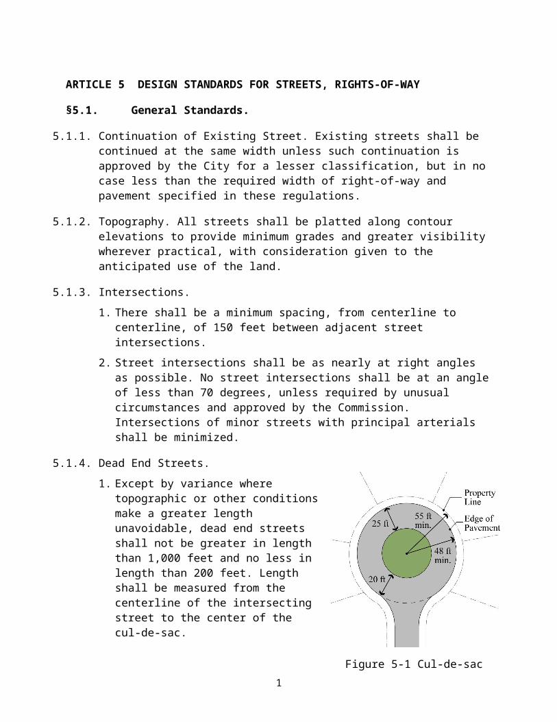
Design Requirements for Drainage and Storm Sewers
§6.2. Gutters and Open Channels.
Street gutters and other open channels shall be so designed that the velocity in the deepest part of the gutter or channel shall not exceed ten (10) feet per second. The velocity shall be computed by the Manning Equation using the depth at a point six (6) inches from the face of the curb as the hydraulic radius. Inlets shall be provided so that surface water is not carried across or around any street intersection, nor for a distance of more than 400 feet in the gutter. When calculations indicate that gutter capacity is exceeded or that gutter runoff velocity exceeds ten (10) feet per second, catch basins shall be used to intercept flow at that point. Cross section of ditches and flumes and all calculations of runoff velocity and gutter capacity shall be set forth on the plans and profiles. No ditch or flume section shall be constructed which, in the opinion of the Subdivision Official, lacks the capacity, structural strength, or erosion resistance to discharge runoff from the design storm without suffering damage or requiring more than routine maintenance.
§6.3. Culverts.
The inside diameter or cross sectional area of culverts or pipes to be provided shall be determined by the Rational Method or SCS method using a proper coefficient C dependent upon the variations of the surface condition. Allowance for future development shall be included in the determination of the coefficient C. The 25-year frequency storm event shall be used. In no case shall a pipe be used with an inside diameter less than eighteen (18) inches. All calculations of culvert size shall be set forth on the plans and profiles. Types of culverting shall be reinforced concrete pipe or reinforced concrete box culverts designed and constructed according to the latest edition of the “Standards and Specifications for Road and Bridge Construction” of the ALDOT.
Concrete headwalls or special flared end sections shall be provided on the upstream and downstream ends of all culverts sufficient to mitigate erosion.
§6.4. Drainage Structures.
All drainage structures, including but not limited to, curb inlets, yard inlets, catch basins, and junction boxes shall be constructed of reinforced concrete. The interior walls and bottom shall be grouted and plastered as necessary to seal holes and provide for a smooth interior surface. Exceptions for low volume drainage may be approved by the Subdivision Official.
6.4.1. The size of all junction boxes shall be as necessary to accommodate the pipes entering and exiting the structure, but in no case shall have inside dimensions less than 3-1/2 ft by 3-1/2 ft.
6.4.2. The top of the structure shall cover the full opening and shall be securely supported and stabilized. The top of the curb inlet shall be flush with the face and top of the curb and shall join the curb at each side. Curb inlets shall be ALDOT Type S or Type E inlets or alternate as approved by the Subdivision Official.
6.4.3. Manhole rings and covers, meeting Vulcan Foundry No. VM-25 or equal shall be placed in all solid tops to allow for ease of inspection and cleaning.
2
6.4.4. HPDE and ASD may be used in special circumstances outside of right-of-way as approved by the Subdivision Official.
§6.5. Erosion and Sediment Control.
All subdivisions and developments shall meet the requirements of the City of Mountain Brook Erosion and Sedimentation Control Ordinance, Ord. No. 1041.
3
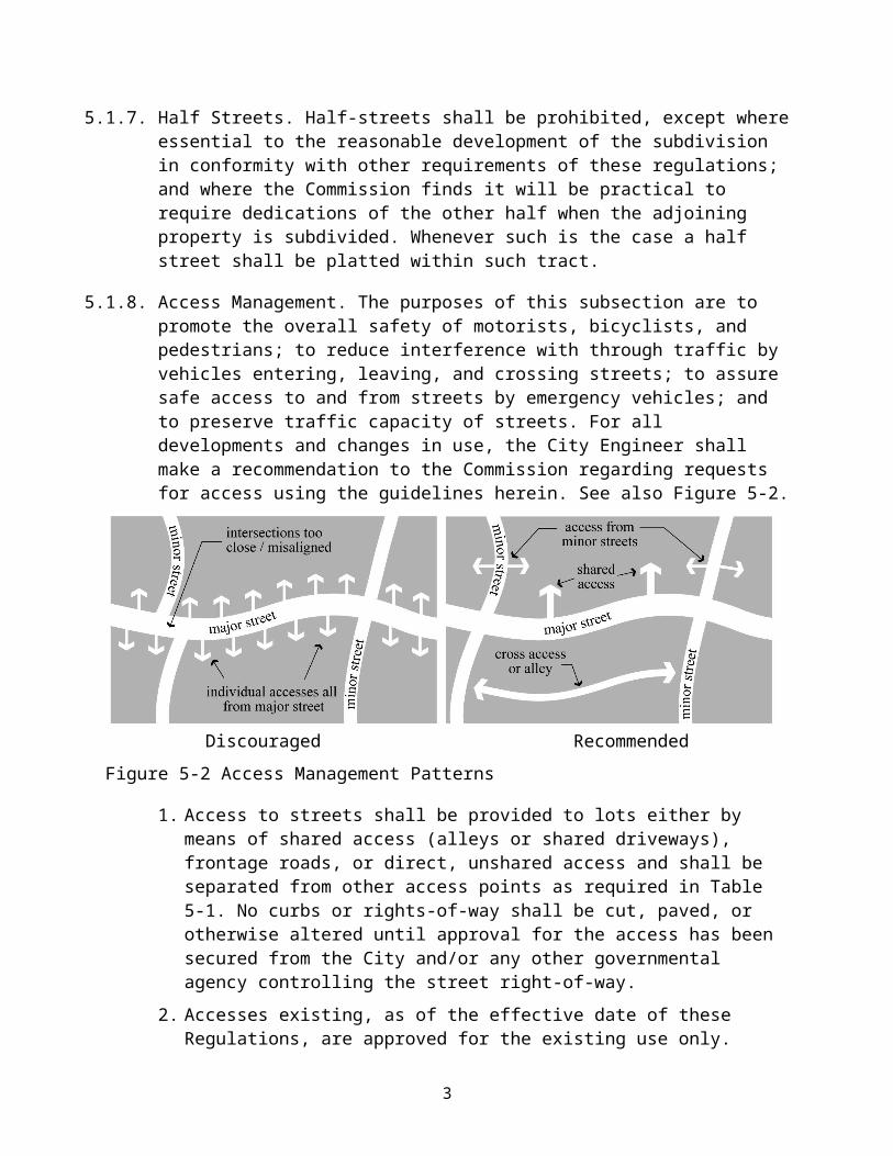
Design Requirements for Drainage and Storm Sewers
This page intentionally left blank.
4
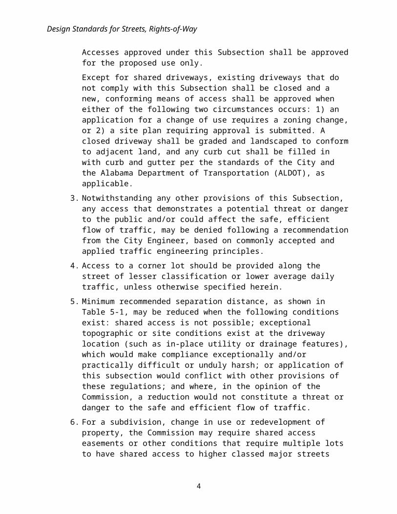
ARTICLE 7 SANITARY SEWER AND WATER FACILITIES
§7.1. Sanitary Sewer
7.1.1. General Criteria. Where required, sanitary sewers shall be designed and constructed in accordance with the requirements of Jefferson County, Alabama. Sanitary sewers shall be constructed within the streets or platted easements, so that the same can connect to existing sanitary sewer trunk lines or will connect to future sanitary sewer trunk lines. It is the intention of this paragraph that sanitary sewers, sanitary sewer laterals and appurtenances shall be constructed in all subdivisions to prevent future street cuts or expensive yard cuts involved in the construction of the sewer following completion of the subdivision.
7.1.2. Oversized Facilities to Serve Adjoining Land. When a tract lying downstream from other vacant land is subdivided, the subdivider's engineer shall determine (a) the size and cost of the sewer system required to serve this subdivision only and (b) the size and cost of the sewer system which would be required within his subdivision if all land lying upstream were developed in accordance with the Comprehensive Plan. Unless upstream property owners privately agree with the subdivider to pay the additional cost of the larger system, the developer's engineer shall present his calculations to the Subdivision Official, who shall forward them to the Council with a request that the City pay the difference in cost between the smaller and larger diameter sewers. If the Council has not agreed within 30 days to pay the difference in cost, the Subdivision Official shall authorize the developer to commence construction on a sewer system adequate to serve his subdivision only. Whenever the owner or owners of land lying upstream from a subdivision with oversized sewers wishes to tap into such sewers, they shall be required to reimburse the City on a pro-rata basis for any payment made pursuant to this Section in proportion to their respective shares of the total acreage served by such sewers.
§7.2. Water Facilities.
7.2.1. The developer shall install adequate water facilities meeting the requirements of the Birmingham Water Works Board (BWWB), as designed by the developer's engineer, and including fire hydrants and mains at least six (6) inches in diameter.
7.2.2. All water mains shall be constructed of ductile iron pipe.
7.2.3. Fire flows and fire hydrant spacing shall in accordance with the Fire Code or as otherwise approved by the Commission following a recommendation by the Fire Marshal.
7.2.4. All underground utilities for fire hydrants, together with the fire hydrants themselves and all other supply improvements shall be installed before any final paving of a street shown on the subdivision plat.
1
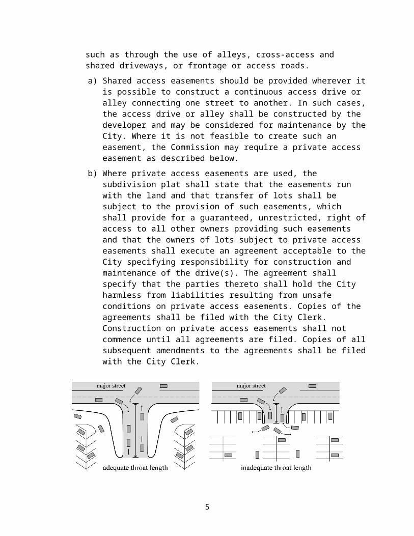
Sanitary Sewer and Water Facilities
This page intentionally left blank.
2
ARTICLE 8 REQUIREMENTS FOR SUBDIVISIONS SUBJECT TO FLOODING
§8.1. General.
All subdivisions shall conform to the regulations set forth in Chapter 117 Floods of the Code of Mountain Brook and to the following provisions. Where there is any conflict between said Chapter 117 and the provisions herein, the provisions of Chapter 117 shall govern.
§8.2. Streams Depicted on Flood Boundary and Floodway Map.
Land located within the subdivision jurisdiction of the City, which abuts on or is bisected by a stream, segment of a stream, or other water body for which the 100 year floodway fringe is depicted on the Flood Boundary and Floodway Map, shall be subdivided in accordance with the following regulations:
8.2.1. Except as provided in §8.3 below, any portion of a proposed subdivision lot that lies within a floodway shall be designated as a drainage easement on the final plat and shall be further identified by the word "FLOODWAY". The portion of the lot lying outside the floodway shall be of such size and configuration as will permit construction of a residence without encroaching upon the floodway easement. The following note shall be set forth on the margin of the final plat in fourteen (14) point type or larger.
"NOTE: NO FILLING OR CONSTRUCTION SHALL BE ALLOWED IN THE PORTION OF THIS SUBDIVISION DESIGNATED AS"FLOODWAY" WITHOUT THE WRITTEN PERMISSION OF THE CITY OF MOUNTAIN BROOK PLANNING COMMISSION"
8.2.2. Land lying outside the floodway but within the floodway fringe shall be depicted on the preliminary and final plat by means of hatching or shading. There shall be a note on the margin of the final plat indicating that land so hatched or shaded is located in the floodway fringe, and is subject to the applicable regulations of Chapter 117 Floods.
§8.3. Channelization by Variance.
In the event that a developer requests a variance, according to §1.7 of these regulations, to channelize, straighten, narrow, or relocate a floodway, the following procedure shall be employed:
8.3.1. The developer's engineer shall submit to the Subdivision Official designs of the proposed change to the floodway channel, together with supporting data such as cross sections, profiles, engineering calculations, and the like, demonstrating that the proposed change will accommodate the base flood and will not have the cumulative effect, when combined with all other existing and anticipated development, of increasing the water surface elevation along any significant reach of the stream by more than one (1) foot, or of causing other adverse effects upon any part of the drainage system on account of increased stream velocity, eddy action or other phenomena. The developer's engineering report and design shall be submitted to the Subdivision Official, who shall submit written comments upon it to the Commission prior to the Commission's action on the variance
1
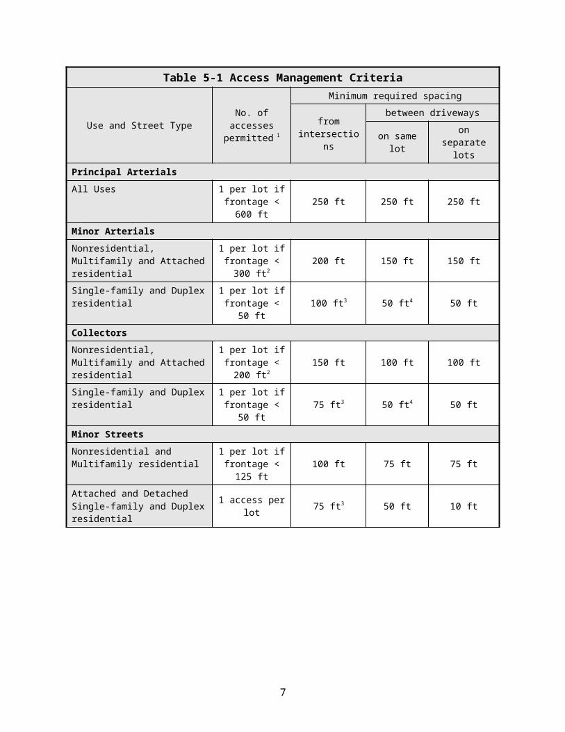
Requirements for Subdivisions Subject to Flooding
concurring with, or taking exception to, the said engineering report and design. After verifying the accuracy of the plans, profiles, and calculations, the Subdivision Official shall forward them to the Federal Emergency Management Agency with a request that the Flood Boundary and Floodway Map be amended if and when the proposed channel improvements are constructed.
.
2
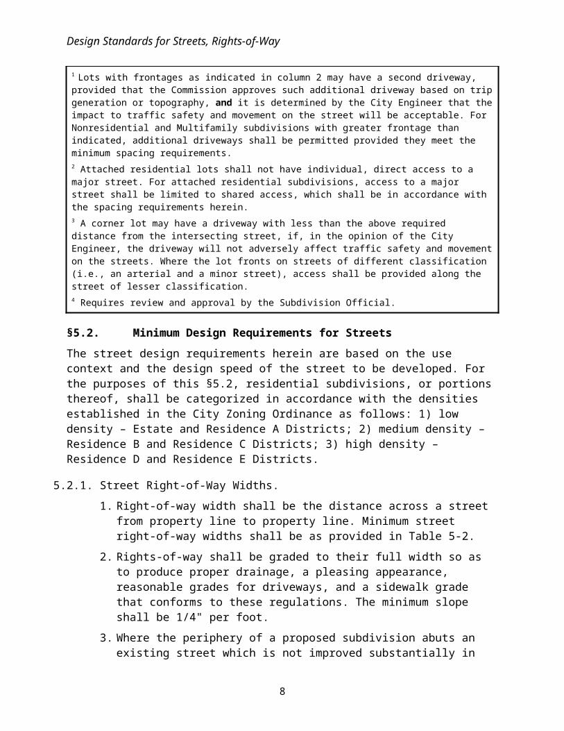
ARTICLE 9 AMENDMENTS AND LEGAL CONSIDERATIONS
§9.1. Amendments.
The Planning Commission may amend these regulations from time to time after publication and a public hearing as required by law.
§9.2. Saving Clause.
These regulations shall not be construed as abating any action now pending under, or by virtue of, or as affecting the liability of any person or as waiving any right of the City under any Section or provision existing at the time of adoption of these regulations, or as vacating or annulling any rights obtained by any person by lawful action of the City, except as shall be expressly provided for in these regulations.
§9.3. Interpretation by the Planning Commission.
Whenever a subdivider, City official or aggrieved person affected by the administration and enforcement of these regulations finds uncertainty in the interpretation of these regulations, that person shall submit the same in writing to the Commission, which shall be the sole authority for interpretation of these regulations.
§9.4. Regulations to be Minimum Standards.
These regulations are considered as minimum standards. Whenever these regulations and other regulations of the City, which apply to the same subject matter are inconsistent, the provision which requires the highest or strictest standard shall govern.
§9.5. Separability.
If any part or provision of these regulations or application thereof to any person or circumstances is adjudged invalid by any court of competent jurisdiction, such judgment shall be confined in its operation to the part, provision, or application directly involved in the controversy in which such judgment shall have been rendered, and shall not affect or impair the validity of the remainder of these regulations or the application thereof to other persons or circumstances. The Commission hereby declares that it would have enacted the remainder of these regulations even without any such part, provision, or application.
§9.6. Effective Date and Repealer.
These regulations shall become effective upon their adoption in accordance with applicable law and their being recorded in the Probate Court. The subdivision regulations adopted by the Mountain Brook Planning Commission on June, 1997, as amended, ("1997 Subdivision Regulations") shall be repealed upon these regulations becoming effective, except to the extent that the 1997 Subdivision Regulations shall govern applications for subdivisions filed prior to the effective date of these regulations. Preliminary approval and final approval of proposed subdivisions for which applications were filed with the City prior to the effective date of these regulations shall be subject to the provisions and requirements of the 1997 Subdivision Regulations and not the provisions and requirements of these regulations.
1
This page intentionally left blank.
2