Embed Size (px)
Citation preview

City of Mississauga
Agenda
Find it online http://www.mississauga.ca/portal/cityhall/councilcommittees
Meetings of Council streamed live and archived at Mississauga.ca/videos
Council Date 2019/09/11
Time 9:00 AM
Location Civic Centre, Council Chamber, 300 City Centre Drive, Mississauga, Ontario, L5B 3C1
Members Present Mayor Bonnie Crombie Councillor Stephen Dasko Ward 1 Councillor Karen Ras Ward 2 Councillor Chris Fonseca Ward 3 Councillor John Kovac Ward 4 Councillor Carolyn Parrish Ward 5 Councillor Ron Starr Ward 6 Councillor Dipika Damerla Ward 7 Councillor Matt Mahoney Ward 8 Councillor Pat Saito Ward 9 Councillor Sue McFadden Ward 10 Councillor George Carlson Ward 11
Contact Krystal Christopher, Legislative Coordinator, Legislative Services 905-615-3200 ext. 5411 [email protected]

Council 2019/09/11 2
1. CALL TO ORDER
2. INDIGENOUS LAND STATEMENT
"Welcome to the City of Mississauga Council meeting. We would like to acknowledgethat we are gathering here today on the Treaty Lands and Territory of the Mississaugasof the Credit, and the territory of the Anishinaabe, Haudenosaunee, Wyndot and Huronpeople. We also acknowledge the many Indigenous, Inuit, Metis and other globalpeoples who call Mississauga home. We welcome everyone."
3. APPROVAL OF AGENDA
4. DECLARATION OF CONFLICT OF INTEREST
5. MINUTES OF PREVIOUS COUNCIL MEETING
5.1 Council Minutes - July 3, 2019
6. PRESENTATIONS – Nil.
7. DEPUTATIONS
7.1. Rattray Marsh Conservation Area
Karen Allin, resident, to speak regarding the Rattary Marsh Conservation Area petition.
Item 13.2.
7.2. Mayor Crombie's Thanksgiving Food Drive
Meghan Nicholls, Executive Director, Mississauga Food Bank, to speak regarding the launch of Mayor Crombie's Thanksgiving Food Drive
7.3. Mississauga Fire and Emergency Services Facility Dog
Tim Beckett, Fire Chief, to introduce the accredited facility dog, Ajax, who was donated by the National Service Dogs.

Council 2019/09/11 3
8. PUBLIC QUESTION PERIOD - 15 Minute Limit (5 Minutes per Speaker)
Pursuant to Section 42 of the Council Procedure By-law 0139-2013, as amended:Council may grant permission to a member of the public to ask a question ofCouncil, with the following provisions:
1. The question must pertain to a specific item on the current agenda and the speakerwill state which item the question is related to.
2. A person asking a question shall limit any background explanation to two (2)statements, followed by the question.
3. The total speaking time shall be five (5) minutes maximum, per speaker.
9. CONSENT AGENDA
10. INTRODUCTION AND CONSIDERATION OF CORPORATE REPORTS
10.1. Report dated August 19, 2019 from the Commissioner of Planning and Building: RECOMENDATION REPORT (WARD 6) Applications to permit 75 townhomes on a private condominium road 1707-1725 Barbertown Road, north side of Barbertown Road, east of Creditview Rd. Owner: Barbertown Ventures Inc. Files: OZ 17/002 W6 & T-M17001 W6 Pre-Bill 139
Recommendation
1. That notwithstanding that subsequent to the public meeting, changes to theapplications have been proposed, Council considers that the changes do not requirefurther notice and, therefore, pursuant to the provisions of subsection 34(17) of thePlanning Act, any further notice regarding the proposed amendment is herebywaived.
2. That the applications under File OZ 17/002 W6, Barbertown Ventures Inc., 1707-1725 Barbertown Road to amend Mississauga Official Plan to Residential MediumDensity and Greenlands; to change the zoning to H-RM6-Exception (Townhouseson a CEC – Road) and G1 (Greenlands) to permit 75 townhomes on a commonelement condominium road in conformity with the provisions outlined in Appendix 1,Information Report and that the draft plan of subdivision under File T-M17001 W6,be approved subject to the conditions referenced in the staff report dated August 19,2019 from the Commissioner of Planning and Building.
3. That prior to the passing of the by-law to adopt the official plan amendment andamending zoning by-law, that the need for a Class 4 designation as determined by apeer review of the applicant’s noise assessment be addressed and if necessary beso classified.

Council 2019/09/11 4
4. That the applicant agree to satisfy all the requirements of the City and any otherexternal agency concerned with the development.
5. That the decision of Council for approval of the rezoning application be considerednull and void, and a new development application be required unless a zoning by-law is passed within 36 months of the Council decision.
6. That the “H” holding symbol is to be removed from the RM6-Exception (Townhouseson a CEC – Road) zoning applicable to the subject lands, by further amendmentupon the execution of a Section 37 (Community Benefits) agreement to thesatisfaction of the City.
7. That notwithstanding subsection 45.1.3 of the Planning Act, subsequent to Councilapproval of the development application, the applicant can apply for a minorvariance application.
10.2. Report dated August 19, 2019 from the Commissioner of Corporate Services and Chief Financial Officer : Tax Adjustments pursuant to Section 357 and 358 of the Municipal Act.
Recommendation
1. That the report of the Commissioner of Corporate Services and Chief FinancialOfficer dated August 19, 2019 entitled Tax Adjustments pursuant to Section 357 and358 of the Municipal Act be received.
2. That the tax adjustments outlined in Appendix 1 attached to this report forapplications for cancellation or refund of taxes pursuant to Sections 357 and 358 ofthe Municipal Act, be adopted.
10.3. Report dated August 15, 2019 from the Commissioner of Community Services: Use of Indigenous Images / Themes in City Sports Facilities Policy
Recommendation
That the Corporate Report dated August 15, 2019 entitled “Use of Indigenous Images / Themes in City Sports and Recreation Facilities Policy” from the Commissioner of Community Services be endorsed.

Council 2019/09/11 5
11. PRESENTATION OF COMMITTEE REPORTS
11.1. General Committee Report 14 – 2019 dated September 4, 2019
12. UNFINISHED BUSINESS
13. PETITIONS
13.1. Petition received in the Clerk's Office on July 16, 2019 regarding the blocking of construction of a new apartment building and townhouse at 1750 Bloor Street and 3315 Fieldgate Drive (Ward 3)
13.2. Petition received in the Clerk's Office on August 19, 2019 regarding Rattray Marsh Conservation Area (Ward 2)
14. CORRESPONDENCE
14.1. Information Items
14.1.1. Letter dated July 30, 2019 from the Streetsville Business Improvement Area (BIA) requesting to have the Streetsville Christmas in the Village Festival deemed of municipal significance for the purpose of obtaining a Special Occasion Permit.
14.2. Direction Items
14.2.1. Letter dated June 28, 2019 from Canadian National Railway (CN) requesting the City of Mississauga to support National Road Safety Week from September 23 to 29, 2019.
15. NOTICE OF MOTION
15.1. To waive all fees associated with the Boulevard Gardens permit for all applicants proposing to plant pollinator boulevard gardens in the City of Mississauga.
16. MOTIONS
16.1. To close to the public a portion of the Council meeting to be held on September 11, 2019 to deal with various matters. (See Item 21 Closed Session)
16.2. To express sincere condolences to the family of City employee, Tara Viveiros, who passed away on July 22, 2019
16.3. To express sincere condolences to the family of City employee, Christopher Arnold, who passed away on August 31, 2019

Council 2019/09/11 6
17. INTRODUCTION AND CONSIDERATION OF BY-LAWS
17.1. A by-law to amend Traffic By-law No. 555-2000, regarding Old Derry Road and Historic Trail
17.2. A by-law to amend Traffic By-law No. 555-2000, regarding Molly Avenue and Meadows Boulevard
17.3. A by-law to authorize the execution of a project agreement between the City of Mississauga and Alectra Utilities Corporation
18. MATTERS PERTAINING TO REGION OF PEEL COUNCIL
19. ENQUIRIES
20. OTHER BUSINESS/ANNOUNCEMENTS
21. CLOSED SESSION
22. CONFIRMATORY BILL
A by-law to confirm the proceedings of the Council of The Corporation of the City ofMississauga at its meeting held on September 11, 2019.
23. ADJOURNMENT

Date: 2019/08/19
To: Mayor and Members of Council
From: Andrew Whittemore, M.U.R.P., Commissioner of Planning and Building
Originator’s file: OZ 17/002 W6 & T-M17001 W6
Meeting date: 2019/09/11
Subject RECOMMENDATION REPORT (WARD 6)
Official plan amendment, rezoning and plan of subdivision applications to permit 75
townhomes on a common element condominium road
1707-1725 Barbertown Road, north side of Barbertown Road, west of Creditview Road
Owner: Barbertown Ventures Inc.
Files: OZ 17/002 W6 & T-M17001 W6
Bill 139
Recommendation 1. That notwithstanding that subsequent to the public meeting, changes to the applications
have been proposed, Council considers that the changes do not require further notice and,
therefore, pursuant to the provisions of subsection 34(17) of the Planning Act, any further
notice regarding the proposed amendment is hereby waived.
2. That the applications under File OZ 17/002 W6, Barbertown Ventures Inc., 1707-1725
Barbertown Road to amend Mississauga Official Plan to Residential Medium Density and
Greenlands; to change the zoning to H-RM6-Exception (Townhouses on a CEC – Road)
and G1 (Greenlands) to permit 75 townhomes on a common element condominium road in
conformity with the provisions outlined in Appendix 1, Information Report and that the draft
plan of subdivision under File T-M17001 W6, be approved subject to the conditions
referenced in the staff report dated August 19, 2019 from the Commissioner of Planning
and Building.
3. That prior to the passing of the by-law to adopt the official plan amendment and amending
zoning by-law, that the need for a Class 4 designation as determined by a peer review of
the applicant’s noise assessment be addressed and if necessary be so classified.
10.1-1
Council 2019/08/19 2
Originator's f iles: OZ 17/002 W6 and T-M17001 W6
4. That the applicant agree to satisfy all the requirements of the City and any other external
agency concerned with the development.
5. That the decision of Council for approval of the rezoning application be considered null andvoid, and a new development application be required unless a zoning by-law is passedwithin 36 months of the Council decision.
6. That the “H” holding symbol is to be removed from the RM6-Exception (Townhouses on a
CEC – Road) zoning applicable to the subject lands, by further amendment upon theexecution of a Section 37 (Community Benefits) agreement to the satisfaction of the City.
7. Notwithstanding subsection 45.1.3 of the Planning Act, subsequent to Council approval ofthe development application, the applicant can apply for a minor variance application.
Report Highlights The applications are to amend the policies of the official plan and change the zoning by-
law to allow 75 townhomes on a common element condominium road
The applicant has made minor revisions to the proposal to address issues raised at thePublic Meeting and by staff, including encroachments into buffer lands, noise from
adjacent land uses and flood free access
Staff are satisfied with the changes to the proposal and find it to be acceptable from aplanning standpoint, and recommend that the applications be approved subject to a “H”holding provision to address a Section 37 agreement
A peer review of the noise assessment is outstanding and may recommend that theproperty be designated a Class 4 development as per the Environmental NoiseGuideline – Stationary and Transportation Sources – Approval and Planning (NPC-300)
Background A public meeting was held by the Planning and Development Committee on February 19, 2019,
at which time an Information Report was received for information (the following link to a digital
copy (Item 4.4):
https://www7.mississauga.ca/documents/committees/pdc/2019/2019_02_19_Evening_PDC_Ag
enda.pdf). Recommendation PDC-0013-2019 was then adopted by Council on March 6, 2019.
1. That the report dated January 25, 2019, from the Commissioner of Planning and
Building regarding the applications by Barbertown Ventures Inc. to permit 83 townhomes
on a private condominium road, under Files OZ 17/002 W6 and T-M17001 W6,
1707-1725 Barbertown Road, be received for information, and notwithstanding planning
protocol, that the Recommendation Report be brought directly to a future Council
meeting.
2. That two oral submissions made to the Planning and Development Committee at its
meeting dated February 19, 2019, be received.
10.1-2

Council 2019/08/19 3
Originator's f iles: OZ 17/002 W6 and T-M17001 W6
Comments REVISED DEVELOPMENT PROPOSAL
The applicant has made some minor modifications to the proposed concept plan including:
Reduction to the number of townhomes from 83 to 75
Realignment of the road network
Inclusion of a central amenity area for the subdivision
Reduction of encroachments into G1 buffer lands
COMMUNITY ENGAGEMENT
Notice signs were placed on the subject lands advising of the proposed official plan and zoning
change. All property owners within 120 m (393 ft.) were notified of the applications on
February 24, 2017. A community meeting was held on July 17, 2018. Approximately 25
members of the public attended the Community Meeting. Less than 10 written comments and
phone calls were also received by the Planning and Building Department.
The public meeting was held on February 19, 2019. Two members of the public made
deputations regarding the applications. Responses to the issues raised at the public meeting
and from correspondence received can be found in Appendix 2.
PLANNING ANALYSIS SUMMARY
A detailed Planning Analysis is found in Appendix 2. The applications are consistent with the
Provincial Policy Statement and conform to the Growth Plan for the Greater Golden Horseshoe,
the Region of Peel Official Plan and Mississauga Official Plan. An official plan amendment is
required to change the designation from Greenlands to Residential Medium Density.
The proposed development will consist of 75 townhomes, communal outdoor amenity areas,
and a common element condominium road. There are floodplain or greenbelt lands that will be
gratuitously dedicated to the City and incorporated into the City’s greenlands system. Other
parts of the property are flood prone and not suitable for development will remain in applicant’s
ownership. These lands are described as “Adjacent Lands owned by Applicant” on the draft plan
of subdivision (see Appendix 3). Due to the nature of these lands, the City has requested that
the applicant also gratuitously dedicate the hazard lands but this request has been declined.
The subject property is located in proximity to the ADM Agri-Industries flour mill (ADM Mill),
which produces wheat flour and by-products such as wheat germ, bran and animal feed
ingredients. The applicant has submitted a revised noise and vibration feasibility study (dated
May 7, 2018) to address the impact of noise and vibration from adjacent noise sources such as
the ADM Mill located to the south (municipally known as 1770 Barbertown Road). The study
concluded that that the impacts of noise meet the applicable guidelines, subject to the inclusion
10.1-3

Council 2019/08/19 4
Originator's f iles: OZ 17/002 W6 and T-M17001 W6
of a noise warning clause in all purchase and sale and lease agreements for the applicant’s
land.
Given concerns from ADM Mill, the noise and vibration feasibility study is being peer reviewed
by the Jade Acoustics on behalf of the City. As of the writing of this report, the peer review has
not been completed. A condition in the draft plan of subdivision will ensure that all
recommendations and mitigation measures required through the revised noise and vibration
study and the peer review opinions will be implemented in the subdivision agreement. Further,
the implementing by-law will not be brought forward until the noise issue is resolved. If there
continues to be issues that cannot be addressed or require significant modifications, staff will
bring an additional report forward for Council approval.
The proposed development maintains the neighbourhood character, is compatible with the East
Credit Neighbourhood and maintains the City Structure policies related to intensification and
protection of the natural system. The development is sensitive to the existing context and
provides for the development of underutilized lands within the City.
Strategic Plan The applications are consistent with the Connect pillar of the Strategic Plan by contributing a
choice of housing type to residents that supports the principle of building complete communities
to accommodate growth.
Financial Impact All fees paid by developers are strictly governed by legislation, regulation and City by-laws.
Fees are required to be paid prior to application approval, except where otherwise may be
prescribed. These include those due to the City of Mississauga as well as any other external
agency.
Conclusion In summary, the proposed development has been designed to be sensitive to the existing and
planned character of the neighbourhood and provides an appropriate transition to adjacent
residential uses. The proposed official plan amendment, rezoning and draft plan of subdivision
are acceptable from a planning standpoint and should be approved.
Should the applications be approved by Council, the implementing official plan amendment and
zoning by-law will be brought forward to Council at a future date subject to resolving any issues
from ADM with respect to noise. In addition, prior to the implementing official plan amendment
and zoning by-law by Council, the applicant will be required to execute a Section 37 agreement
to the satisfaction of the City.
10.1-4

Council 2019/08/19 5
Originator's f iles: OZ 17/002 W6 and T-M17001 W6
Attachments Appendix 1: Information Report
Appendix 2: Detailed Planning Analysis
Appendix 3: Draft Plan of Subdivision
Appendix 4: City Conditions of Draft Approval
Andrew Whittemore, M.U.R.P., Commissioner of Planning and Building
Prepared by: Adam Lucas, Development Planner
10.1-5

10.1-6 Appendix 1

10.1-7

10.1-8

Appendix 1, Page 1
Files: OZ 17/002 W6 & T-M17001 W6
Detailed Information and Preliminary Planning Analysis
Owner: Barbertown Ventures Inc.
Table of Contents
1. Site History .......................................................................................................................... 2
2. Site Context ........................................................................................................................ 2
3. Neighbourhood Context ...................................................................................................... 4
Other Development Applications ......................................................................................... 4
Community Services ........................................................................................................... 5
4. Project Details ..................................................................................................................... 5
Draft Plan of Subdivision, Concept Plan and Elevations ...................................................... 6
5. Community Comments ........................................................................................................ 8
6. Land Use Policies and Regulations ..................................................................................... 9
Excerpt of East Credit Neighbourhood Character Area - Existing Land Use ........................ 9
Excerpt of East Credit Neighbourhood Character Area Proposed Land Use ...................10
Existing Zoning and General Context .................................................................................11
Proposed Zoning and General Context ..............................................................................11
Summary of Applicable Policies .........................................................................................12
Existing and Proposed Mississauga Official Plan Designation for the Subject Site .............13
Existing Designation ......................................................................................................13
Proposed Designation ...................................................................................................13
Provincial Policy Statement (PPS) and Growth Plan Analysis ............................................13
Consistency with Provincial Policy Statement 2014 .......................................................13
Conformity with Growth Plan 2017 .................................................................................19
Region of Peel Official Plan ................................................................................................26
Relevant Mississauga Official Plan Policies .......................................................................26
Existing and Proposed Zoning ............................................................................................32
7. Section 37 Community Benefits (Bonus Zoning) ................................................................33
8. School Accommodation ......................................................................................................34
9. Development Issues ...........................................................................................................35
Development Requirements ...............................................................................................39
Other Information ...............................................................................................................39
10.1-9

Appendix 1, Page 2
Files: OZ 17/002 W6 & T-M17001 W6
1. Site History
1960-1990 The lands were historically used as an apple orchard and farm residence
1975-1976 Two additional detached dwellings were built on the property
June 20, 2007 Zoning By-law 0225-2007 came into force. The subject lands are zoned
G1-6 (Greenlands Natural Hazards) which permits food control, conservation uses and
the three existing detached dwellings
December 7, 2011 General Committee discussed the potential acquisition of the property
in closed session. The land was not acquired by the City
August 13, 2012 Two severance applications ('B' 57-12 and 'B' 58-12) were filed and
withdrawn
November 14, 2012 Mississauga Official Plan came into force except for those
site/policies which have been appealed. The subject lands are designated Greenlands
Exempt Site 4 in the East Credit Neighbourhood Character Area
2. Site Context
The property is located southeast of Streetsville between the Credit River to the west and
Carolyn Creek to the east. There are townhomes and detached homes built within the last 15
years on Barbertown Road. The tree-lined road continues north down a hill, becomes less
travelled and ends in a pedestrian bridge across the Credit River. The immediate area is park-
like with trees, manicured lawns and creeks. The property is located on the north side of
Barbertown Road across from Koliba Park (a private park owned by the Slovak Canadian
Culture Society). The site is within the East Credit Neighbourhood Character Area and is
currently occupied by three detached homes. The property slopes up towards the CP rail line/
Milton Go Line which runs along the northeast boundary of the site and separates it from the
residential neighbourhoods to the north.
The property is regulated by Credit Valley Conservation due to the location between the Credit
River and Carolyn Creek and their associated valley systems. The property contains floodplain
and erosion hazards and Regional Core Greenlands. The site is wit
Heritage System and a portion of the lands contains a Significant Natural Area.
10.1-10

Appendix 1, Page 3
Files: OZ 17/002 W6 & T-M17001 W6
Aerial Image of 1707-1725 Barbertown Road
Property Size and Use
Frontages:
Barbertown Road
135.5 m (444.5 ft.)
Depth: 284.7 m (934.1 ft.)
Gross Lot Area: 4.58 ha (11.3 ac.)
Existing Uses: Three detached homes
The surrounding land uses are:
North and East: CP Rail Line, detached homes, Carolyn Creek
South: Barbertown Road, Koliba Park
West: Credit River, ADM Mill
The site is served by MiWay transit routes along Eglinton Avenue West (Routes 35, 35A and 9)
with service to Square One transit terminal and Islington Subway Station.
10.1-11

Appendix 1, Page 4
Files: OZ 17/002 W6 & T-M17001 W6
Image of existing conditions facing northeast from Barbertown Road
3. Neighbourhood Context
The subject property is located within the East Credit Neighbourhood Character area. The
neighbourhood is an established residential area generally characterized by large, detached
homes built in the 1980s.
Demographics
Based on the 2011 census, the existing population of the neighbourhood is 65,850 with a
72.4% of the neighbourhood population
are of working age (15 to 64 years of age), with 18% children (0-14 years) and 12% seniors (65
years and over). By 2031 and 2041, the population for this character area is forecasted to be
70,900 and 71,600 respectively. The average household size is 4 persons with 60 % of people
living in detached homes (higher than age of 39.09%). Housing tenure for the
neighbourhood is a mix of 89.99% owned (15,485 units) and 10.98 % rented (1,910 units) with
an apartment vacancy rate of approximately 0.8% according to data from Canada Mortgage and
Housing Corporation.
Other Development Applications
There is some development activity in Streestville to the northwest of the site, as well as the
following applications in the immediate area which have been approved in principle but have not
yet received final approval:
6727 Melody Drive, northeast quadrant of Mississauga Road and Melody Drive: proposal
for five commercial buildings and ten detached homes
10.1-12

Appendix 1, Page 5
Files: OZ 17/002 W6 & T-M17001 W6
5155 Mississauga Road, northeast corner of Mississauga Road and Barbertown Road:
proposal for detached, semi-detached and townhomes and conversion of the Old
Barberhouse into residential units
Another application for 34 townhomes is being processed by staff at 1745-1775 Thornybrae
Place at the southeast corner of Mississauga Road and Eglinton Avenue West.
Community Facilities and Services
The proposal is served by major City of Mississauga facilities in the Streetsville and Erin Mills
Neighbourhoods. Streetsville Library and Vic Johnston Community Centre and Arena are 3 km
(1.9 mi.) to the north. Erin Meadows Library is approximately 4 km (2.5 mi.) to the west. The site
is also served by nearby Barberton Park to the east. Additional comments from Community
Services regarding city parks and facilities can be reviewed within Section 9 of this Appendix.
4. Project Details
The applications are to permit 83 townhouses on a common element condominium private road
and a greenlands block through a plan of subdivision. The land is in the flood plain as identified
by Mississauga Official Plan and Credit Valley Conservation authority mapping. The area of
land proposed for development is the only portion of the site that is not subject to significant
environmental constraints, particularly flooding as demonstrated by supporting studies and
drawings. If the subdivision is approved as proposed, two additional lots will also be created
through the registration of the plan. The future of the potential retained lots is to be determined
as they would not have flood free access to a public road and they are identified as being in the
floodplain. The proposal will require the reconfiguration of the driveway in order to achieve flood
free access to the site; a noise and crash wall adjacent to the rail line and rezoning of the
undevelopable lands for environmental buffers, conservation and naturalization. The limits of
potential development remain under consideration.
It is recommended that all hazard lands, natural features and buffers be dedicated to the City
and zoned appropriately for their long term conservation and management.
Development Proposal
Applications
submitted:
Received: January 27, 2017
Deemed complete: February 24, 2017
Revised: May 16, 2018
Developer/
Owner: Barbertown Ventures Inc.
Applicant: Glen Schnarr and Associates Inc. / Sterling Group
Number of units: 83 townhomes
Height: 3 storeys
Lot Coverage: 7.9 %
Landscaped Area: 1 357 m2 (14,606.1 ft2)
Road Type: Common element condominium private road (CEC)
Anticipated Population: 252*
10.1-13

Appendix 1, Page 6
Files: OZ 17/002 W6 & T-M17001 W6
Development Proposal
*Average household sizes for all units (by type) based on
the 2016 Census
Parking:
resident spaces
visitor spaces
Total
Required
166
21
187
Proposed
166
21
187
Green Initiatives: Restoration and extent of natural areas to be
determined
Permeable paving and bio-retention island around
parking spaces
Draft Plan of Subdivision, Concept Plan and Elevations
Draft Plan of Subdivision
10.1-14

Appendix 1, Page 7
Files: OZ 17/002 W6 & T-M17001 W6
Site Plan
10.1-15

Appendix 1, Page 8
Files: OZ 17/002 W6 & T-M17001 W6
Elevations
5. Community Comments
A community meeting was held by Ward 6 Councillor, Ron Starr on July 17, 2018. Written
comments and phone calls were also received by the Planning and Building Department. The
following, summarized comments made by the community as well as any others raised at the
public meeting will be addressed in the Recommendation Report, which will come at a later
date:
The area should remain in the Greenlands designation and should not be intensified
Too many units are proposed
Any increase in units will result in negative traffic impacts to Barbertown Road and the
intersection of Barbertown Road and Eglinton Avenue West
The development will cause environmental impacts to the Credit River and natural areas
Additional residential development may impact the operations of the existing ADM mill
10.1-16

Appendix 1, Page 9
Files: OZ 17/002 W6 & T-M17001 W6
6. Land Use Policies and Regulations
Excerpt of East Credit Neighbourhood Character Area - Existing Land Use
10.1-17

Appendix 1, Page 10
Files: OZ 17/002 W6 & T-M17001 W6
Excerpt of East Credit Neighbourhood Character Area Proposed Land Use
10.1-18

Appendix 1, Page 11
Files: OZ 17/002 W6 & T-M17001 W6
Existing Zoning and General Context
Proposed Zoning and General Context
10.1-19

Appendix 1, Page 12
Files: OZ 17/002 W6 & T-M17001 W6
Summary of Applicable Policies
The following table summarizes the applicable policy and regulation documents that affect these applications:
Policy Mississauga Official Plan (MOP) Policies Proposal
Provincial Policy Statement (PPS)
The existing policies of MOP consistent with the PPS.
The proposed development is being reviewed for consistency with the PPS.
Growth Plan for the Greater Golden Horseshoe (Growth Plan)
The relevant existing policies of the MOP conform with the Growth Plan. Mississauga Official Plan must conform with a hierarchy of policy and legislation at the federal, provincial, regional and municipal levels.
The proposed development is being reviewed for conformity with the Growth Plan.
Greenbelt Plan n/a Only public lands are subject to the Urban River Valley policies in the Greenbelt Plan. Since this proposal is on privately owned lands, it is not subject to these policies.
Parkway Belt Plan n/a n/a
Region of Peel Official Plan
The existing policies of MOP are consistent with the ROP.
The lands are identified as a Core Area of the Greenland System. The proposed application is exempt from Regional approval and its consistency is being considered during the review of this application.
Mississauga Official Plan
The lands are located within the East Credit Neighbourhood Character Area and are designated Greenlands Exempt Site 4 which permits flood
control and/or erosion management, conservation uses and the existing detached dwellings. Neighbourhoods will not be the focus for intensification and should be regarded as stable residential areas where the existing character is to be preserved. Neighbourhoods will accommodate the lowest densities and building heights, will focus on residential uses and associated services. Neighbourhoods are intended to preserve the character, cultural heritage and livability of the community and provide a range of housing types.
The applicant is proposing to change the designation of a portion of the site to Residential Medium Density. The applicant will need to demonstrate consistency with the intent of MOP with regard to environmental, servicing and built form policies outlined in the development issues section below.
10.1-20

Appendix 1, Page 13
Files: OZ 17/002 W6 & T-M17001 W6
Policy Mississauga Official Plan (MOP) Policies Proposal
Zoning By-law 225-2007
The lands are zoned G1-6
(Greenlands Natural Hazards)
which permits flood control,
stormwater management, erosion
management, natural heritage
features, conservation and the
existing detached dwellings.
A rezoning is proposed to RM6 - Exception (Townhouse Dwellings on a CEC private road) to permit townhouses on a common element condominium (private) road.
Existing and Proposed Mississauga Official Plan Designation for the Subject Site
Existing Designation
Greenlands Exempt Site 4 which permits conservation, bridges, stormwater management,
flood control, erosion management, passive recreation activities, parkland, accessory uses and
the existing dwellings.
Proposed Designation
A portion of the site is proposed to be designated Residential Medium Density which permits
all forms of townhouse dwellings. The remainder of the lands will retain the Greenlands
designation.
Provincial Policy Statement (PPS) and Growth Plan Analysis
Consistency with Provincial Policy Statement 2014
The Provincial Policy Statement 2014 (PPS) is issued under Section 3 of the Planning Act and
all decisions affecting land use planning matters "shall be consistent" with the Provincial Policy
Statement.
The following table has been prepared to demonstrate how MOP policies are consistent with the
relevant PPS policies (i.e. "Mississauga Official Plan Policies" column). In addition, the table
provides a preliminary assessment as to how the proposed development is consistent with PPS
and MOP policies (i.e. "OZ 17/002 W6 and T-M17001 W6 Consistency" column). Only key
policies relevant to the application have been included, and the table should be considered a
general summary of the intent of the policies.
Official Plan Amendment No. 47 to MOP added and amended policies in the Official Plan so
that it is consistent with the PPS. This amendment came into force on May 18, 2016.
10.1-21

Appendix 1, Page 14
Files: OZ 17/002 W6 & T-M17001 W6
Consistency Analysis
Provincial Policy Statement (PPS)
Mississauga Official Plan Policies (MOP)
OZ File17/002 W6 and T-M17001 W6 Consistency
1.0 Building Strong Healthy Communities
General Statement of Intent: Promoting efficient land use and development patterns are important to sustainable, liveable, healthy, resilient communities, protecting the environment, public health and safety and facilitating economic growth.
The development of Neighbourhoods (as defined in MOP) supports the general intent of the PPS with respect to building strong, healthy communities.
Residential intensification promotes the efficient use of lands and additional population facilitates economic growth. As part of the next staff report, the applications will be assessed with regard to whether the proposal represents appropriate infill.
1.1.1 (b) accommodating an appropriate range and mix of residential (including second units, affordable housing and housing for older persons), employment (including industrial and commercial), institutional (including places of worship, cemeteries and long-term care homes), recreation, park and open space, and other uses to meet long-term needs (c) avoiding development and land use patterns which may cause environmental or public health and safety concerns (h) promoting development and land use patterns that conserve biodiversity and consider the impact of a changing climate
The East Credit Neighbourhood is identified as a Neighbourhood which is
urban structure that is not targeted for intensification. Intensification within neighbourhoods may be considered where the proposed development is compatible in built form and scale to surrounding development. As the City continues to grow, it is imperative that growth does not compromise the natural environment.
The area contains a mix of low-rise housing types. Condominium townhomes are proposed to be located on a private road. Development within Neighbourhoods can occur subject to meeting MOP policies with respect to appropriate design and sensitivity to the surrounding context. The remaining portion of the subject property will retain the Greenlands designation and is recommended to be rezoned from G1-6 (Greenlands - Natural Hazards) to G1 (Greenlands Natural Hazards) to retain and protect natural features.
1.1.3.2 Land use patterns within settlement areas shall be based on:
a) Densities and a mix of land uses which: 1. efficiently use land
and resources 2. are appropriate for
and efficiently use infrastructure and public service
The East Credit Neighbourhood is identified as a Neighbourhood which is
urban structure that is not targeted for intensification. Intensification within neighbourhoods may be considered where the proposed development is compatible in built form and
The area contains a mix of detached, semi-detached and street townhomes. Condominium townhomes are proposed to be located on a private road. The built form will be evaluated within the context of the MOP policies.
10.1-22

Appendix 1, Page 15
Files: OZ 17/002 W6 & T-M17001 W6
Provincial Policy Statement (PPS)
Mississauga Official Plan Policies (MOP)
OZ File17/002 W6 and T-M17001 W6 Consistency
facilities 3. minimize negative
impacts to air quality and climate change and promote energy efficiency
4. support active transportation
5. are transit supportive
b) A range of uses and opportunities for intensification and redevelopment in accordance with criteria in 1.1.3.3
scale to surrounding development.
1.1.3.3 Planning authorities shall identify appropriate locations for intensification and redevelopment where it can be accommodated taking into account building stock, brownfields, availability of infrastructure and public service facilities required to accommodate projected needs.
The East Credit Neighbourhood is an area not considered for intensification. MOP policy 5.3.5.1 states that neighbourhoods will not be the focus for intensification and should be regarded as stable residential areas where the existing character is to be preserved.
The applications will be evaluated to ensure development is in accordance with the Direct Growth policies of MOP.
1.1.3.4 Appropriate development standards should facilitate intensification, redevelopment and compact form, while mitigating risks to public health and safety.
Policies in MOP ensure development is in accordance with the wise management and resource of protecting health and safety.
The subject property is located within an established neighbourhood and represents intensification. Flood-free access to the site is required and the proposed solution is under review.
1.2.6.1 Major facilities and sensitive land uses should be planned to ensure they are appropriately designed, buffered and/or separated from each other to prevent or mitigate adverse effects from odour, noise and other contaminants, minimize risk to public health and safety, and to ensure the long-term viability of major facilities.
In order to discourage the encroachment of sensitive land uses on existing industrial noise sources, a feasibility and/or detailed noise impact study will be submitted prior to approval of development in proximity to an existing industrial noise source. This will identify options for mitigation at the source and at the proposed development site.
A Noise and Vibration Feasibility Study has been submitted for review to address noise from the railway as well as from the ADM mill.
10.1-23

Appendix 1, Page 16
Files: OZ 17/002 W6 & T-M17001 W6
Provincial Policy Statement (PPS)
Mississauga Official Plan Policies (MOP)
OZ File17/002 W6 and T-M17001 W6 Consistency
Railways in urban areas require particular consideration not only because of the high levels of noise they generate, but also because of ground borne vibration. Safety is also a concern as intensification occurs in the vicinity of railway tracks. In addition, the encouragement of active modes of transportation will require consideration of cyclist and pedestrian safety in conjunction with railway operations.
1.4 Housing 1.4.1 Planning Authorities shall provide for an appropriate range and mix of housing that is affordable
Mississauga will provide opportunities for the development of a range of housing choices in terms of type, tenure and price.
These applications could contribute to the diversity of housing choices by providing an additional townhouse form of development.
1.5.1 Healthy, active communities should be promoted by: (d) recognizing provincial parks, conservation reserves, and other protect areas, and minimizing negative impacts on these areas.
Mississauga will promote and protect green infrastructures. Buffers which are vegetated protected areas will provide a physical separation of development and maintain the green system (6.3.7)
Only a portion of the site is proposed to be developed for residential uses. The remainder of the lands is proposed to stay zoned as G1-6 which will provide for the long term protection and conservation of a woodlot and valley lands.
2.0 Wise Use and Management of Resources
General Statement of Intent: Ontario's long-term prosperity, environmental health, and social well-being depend on conserving biodiversity, protecting the health of the Great Lakes, and protecting natural heritage, water, agricultural, mineral and cultural heritage and archaeological resources for their economic, environmental and social benefits.
Mississauga will establish strategies that protect, enhance and expand the Green System and will include a target for lands within the City that will be included in the Green System. The City's strategy for protecting, enhancing and restoring the Green System consists of initiatives including some of the following: (d) land securement; (e) stewardship; (g) naturalization/restoration
A portion of the lands will remain designated Greenlands. However, the future use of a portion of these lands has not been identified and are proposed to remain in private ownership.
2.1.1 Natural features and areas shall be protected for the
The policies in Section 6.3.12 speak to the long
The applicant has submitted an Environmental Impact
10.1-24

Appendix 1, Page 17
Files: OZ 17/002 W6 & T-M17001 W6
Provincial Policy Statement (PPS)
Mississauga Official Plan Policies (MOP)
OZ File17/002 W6 and T-M17001 W6 Consistency
long term. 2.1.2 The diversity and connectivity of natural features in an area, and the long-term ecological function and biodiversity of natural heritage systems, should be maintained, restored or, where possible, improved, recognizing linkages between and among natural heritage features and areas, surface water features and ground water features. 2.1.8 Development and site alteration shall not be permitted on adjacent lands to the natural heritage features and areas identified in policies 2.1.4, 2.1.5, and 2.1.6 unless the ecological function of the adjacent lands has been evaluated and it has been demonstrated that there will be no negative impacts on the natural features or on their ecological functions.
term protection of Significant Natural Areas. In addition to MOP policies, Mississauga undertakes a Natural Areas Survey (NAS) which contains an inventory of natural heritage features. The NAS was last updated in 2018.
Study in support of the application. A portion of the subject property is located within the Natural Heritage System. The applicant is currently working with the Credit valley Conservation to determine the limits of development.
3.0 Protecting Public Health and Safety
Statement of Intent: Development shall be directed away from areas of natural or human-made hazards where there is an unacceptable risk to public health or safety or of property damage, and not create new or aggravate existing hazards.
Access for development to or within the floodplain will be subject to appropriate conservation authority policies and the policies of the City.
The applicant has submitted an environmental impact study to delineate the floodplain boundaries and the exact limits of development.
10.1-25

Appendix 1, Page 18
Files: OZ 17/002 W6 & T-M17001 W6
Provincial Policy Statement (PPS)
Mississauga Official Plan Policies (MOP)
OZ File17/002 W6 and T-M17001 W6 Consistency
3.0 Development shall be directed away from areas of natural or human-made hazards where there is an unacceptable risk to public health or safety or of property damage, and not create new or aggravate existing hazards. 3.1.1 Development shall
generally be directed to areas
outside of:
hazardous lands adjacent
to river, stream and small inland
lake systems which are
impacted by flooding
hazards and/or erosion
hazards; and hazardous sites.
3.1.7 Development and site
alteration may be permitted in
those portions of hazardous
lands and hazardous
sites where the effects and risk
to public safety are minor, could
be mitigated in accordance with
provincial standards, and where
all of the following are
demonstrated and
achieved: Development and site
alteration is carried out in
accordance with floodproofing
standards, protection works
standards, and access
standards;
a. Vehicles and people have a
way of safely entering and
exiting the area during times of
flooding, erosion and other
emergencies;
b. New hazards are not created
and existing hazards are not
aggravated; and c. No adverse
environmental impacts will
result.
Development adjacent to valleylands and watercourse features must incorporate measures to ensure public health and safety; protection of life and property; as well as enhancement and restoration of the Natural Heritage System.
The applicant has submitted the required environmental reports which is currently under review and will be addressed.
10.1-26

Appendix 1, Page 19
Files: OZ 17/002 W6 & T-M17001 W6
Provincial Policy Statement (PPS)
Mississauga Official Plan Policies (MOP)
OZ File17/002 W6 and T-M17001 W6 Consistency
4.0 Implementation and Interpretation
General Statement of Intent: Provides direction on how the Provincial Policy Statement is to be implemented and interpreted. 4.2 Decisions of the council of a municipality shall be consistent with the Provincial Policy Statement 4.7 The Official Plan is the most important vehicle for implementation of the Provincial Policy Statement
The applications for townhouses are being further evaluated under MOP policies with respect to environmental impact, traffic, servicing capacity, context and built form.
Conformity with Growth Plan 2017
The Growth Plan for the Greater Golden Horseshoe (Growth Plan) (2017) was issued under
Section 7 of the Places to Grow Act and all decisions affecting lands within this area will
conform with this Plan.
The following table has been prepared to demonstrate how MOP policies conform with the
relevant Growth Plan policies (i.e. "Mississauga Official Plan Policies" column). In addition, the
table provides a preliminary assessment as to how the proposed development conforms with
Growth Plan and MOP policies (i.e. "(i.e. "OZ 17/002 W6 and T-M17001 W6 Conformity"
column). Only key policies relevant to the application(s) have been included, and that table
should be considered a general summary of the intent of the policies.
MOP was prepared and approved in accordance with the Growth Plan 2006. Mississauga is in
the process of reviewing MOP policies to ensure conformity with the new Growth Plan 2017.
The development application has been reviewed against Growth Plan 2017 policy direction to
ensure conformity.
Conformity Analysis
Growth Plan for the Greater Golden Horseshoe
Mississauga Official Plan Policies (MOP)
OZ File17/002 W6 and T-M17001 W6 Conformity
1.1 The Greater Golden Horseshoe
General Statement of Intent: The Greater Golden Horseshoe plays an
People of diverse backgrounds, ages and abilities are choosing to live, work and invest in
The development applications represent intensification within the existing urban boundary.
10.1-27
Appendix 1, Page 20
Files: OZ 17/002 W6 & T-M17001 W6
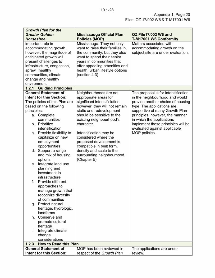
Growth Plan for the Greater Golden Horseshoe
Mississauga Official Plan Policies (MOP)
OZ File17/002 W6 and T-M17001 W6 Conformity
important role in accommodating growth, however, the magnitude of anticipated growth will present challenges to infrastructure, congestion, sprawl, healthy communities, climate change and healthy environment
Mississauga. They not only want to raise their families in the community, but they also want to spend their senior years in communities that offer appealing amenities and health, urban lifestyle options (section 4.3)
Matters associated with accommodating growth on the subject site are under evaluation.
1.2.1 Guiding Principles
General Statement of Intent for this Section: The policies of this Plan are based on the following principles:
a. Complete communities
b. Prioritize intensification
c. Provide flexibility to capitalize on new employment opportunities
d. Support a range and mix of housing options
e. Integrate land use planning and investment in infrastructure
f. Provide different approaches to manage growth that recognize diversity of communities
g. Protect natural heritage, hydrologic, landforms
h. Conserve and promote cultural heritage
i. Integrate climate change considerations
Neighbourhoods are not appropriate areas for significant intensificiation, however, they will not remain static and redevelopment should be sensitive to the existing neighbourhood's character. Intensification may be considered where the proposed development is compatible in built form, density and scale to the surrounding neighbourhood. (Chapter 5)
The proposal is for intensification in the neighbourhood and would provide another choice of housing type. The applications are supportive of many Growth Plan principles, however, the manner in which the applications implement those principles will be evaluated against applicable MOP policies.
1.2.3 How to Read this Plan
General Statement of Intent for this Section:
MOP has been reviewed in respect of the Growth Plan
The applications are under review.
10.1-28

Appendix 1, Page 21
Files: OZ 17/002 W6 & T-M17001 W6
Growth Plan for the Greater Golden Horseshoe
Mississauga Official Plan Policies (MOP)
OZ File17/002 W6 and T-M17001 W6 Conformity
Outlines the relationship between the Growth Plan and other planning documents, and how to read the plan
and other applicable Provincial planning documents.
2. Where and How to Grow
2.1 Context
General Statement of Intent: This Plan is about building compact and complete communities. Better use of land and infrastructure can be made by prioritizing intensification, building compact and complete communities, and increasing the modal share for transit and active transportation.
Complete communities should meet the day-to-day needs of people throughout all stages of their life. The housing mix should accommodate people with diverse housing preferences and socioeconomic characteristics and needs while making use of existing infrastructure and services.
The applications are for an infill development. It is important to ensure that the manner in which these uses are planned and designed are appropriate. The applications are subject to further analysis.
2.2 Policies For Where and How To Grow
2.2.1 Managing Growth
General Statement of Intent for this Section: Growth will be primarily directed to appropriate locations that support complete communities and infrastructure, as directed by the upper tier municipality.
Neighbourhoods are non-intensification areas which will have lower densities and lower building heights. Neighbourhoods are stable areas where limited growth is anticipated. (Section 9) Mississauga will provide a wide assortment of housing choices, employment opportunities and numerous commercial, social and institutional venues allowing its inhabitants to experience the benefits of city living. (Section 7)
The subject lands are within a Neighbourhood Character Area, which allows for limited intensification in accordance with applicable MOP policies.
Relevant Policies: a. Growth should be
primarily directed to settlement areas that:
i. Are within the built boundary and have planned municipal water and wastewater systems
employment growth will be encouraged in areas with existing and proposed service and infrastructure capacity, particularly transit and community infrastructure. Housing and job growth will be balanced and phased to
The appropriateness of the applications is being evaluated against the MOP policies.
10.1-29

Appendix 1, Page 22
Files: OZ 17/002 W6 & T-M17001 W6
Growth Plan for the Greater Golden Horseshoe
Mississauga Official Plan Policies (MOP)
OZ File17/002 W6 and T-M17001 W6 Conformity
and support complete communities (2.2.1.2 a i, ii, iii)
ii. that are in delineated built-up areas, strategic growth areas, locations with existing or planned transit and public service facilities (2.2.1.2. c i, ii, iii, iv),
iii. that is generally away from hazardous lands (2.2.1.2. e)
b. Integrated planning to manage forecasted growth will:
i. Be supported by planning for infrastructure and public service facilities that consider the full life cycle cost and payment (2.2.1.3.b)
ii. Provide direction for an urban form that will optimize infrastructure (2.2.1.3.c)
iii. Support the environment (2.2.1.3.d)
iv. Be implemented through a municipal comprehensive review (2.2.1.3.e)
c. The Growth Plan will support the achievement of complete communities that
i. Features a diverse
ensure that required services and amenities keep pace with development.
10.1-30

Appendix 1, Page 23
Files: OZ 17/002 W6 & T-M17001 W6
Growth Plan for the Greater Golden Horseshoe
Mississauga Official Plan Policies (MOP)
OZ File17/002 W6 and T-M17001 W6 Conformity
mix of land uses ii. Improves social
equity iii. Provides mix of
housing options iv. Expands convenient
access to transportation, public service facilities, open space, healthy food options
v. Ensures high quality compact built form, attractive public realm, including open spaces, through site design and urban design
vi. Mitigates climate change
vii. Integrates green infrastructure
2.2.2 Delineated Built-up Areas
Statement of Intent: The majority of growth is directed to lands within the delineated built-up area (i.e. limits of the developed urban area identified by the Minister of Municipal Affairs and Housing).
MOP provides the framework for the City to achieve a sustainable urban form which includes intensification and non-intensification areas. Neighbourhoods are physically stable and new development should be sensitive to the existing and planned character of the neighbourhood. Development should be compatible with built form and scale.
The subject property is located within a Neighbourhood which is considered to be within the built-up area. The proposal and how growth is accommodated will be further evaluated.
2.2.6 Housing
General Statement of Intent: A range and mix of housing is to be provided, including affordable housing. A housing strategy prepared by the Region is an important tool that can be
Mississauga Council has recently approved a citywide affordable housing strategy that is currently being implemented. The strategy can be accessed at: http://www7.mississauga.ca/documents/pb/planreports/2017/Affordable_Housing_Strategy_Appendix1&2-Web.pdf
The application proposes medium density residential development. How the proposal addresses this strategy will be further evaluated.
10.1-31

Appendix 1, Page 24
Files: OZ 17/002 W6 & T-M17001 W6
Growth Plan for the Greater Golden Horseshoe
Mississauga Official Plan Policies (MOP)
OZ File17/002 W6 and T-M17001 W6 Conformity
used.
Relevant Policies: a. The Region is
responsible for preparing a housing strategy (2.2.6.1)
b. Municipalities will support complete communities by accommodating growth forecasts, achieve minimum intensification targets, consider a range of housing options, and planning to diversify the housing stock. (2.2.6.2)
MOP policies provide opportunities for the development of a range of housing choices in terms of type, tenure and price
This development proposal proposes additional townhome units.
3.2.2 Transportation - General
The transportation system within the GGH will be planned and managed to:
a. provide connectivity among transportation modes for moving people and for moving goods;
b. offer a balance of transportation choices that reduces reliance upon the automobile and promotes transit and active transportation;
c. be sustainable and reduce greenhouse gas emissions by encouraging the most financially and environmentally appropriate mode for trip-making and supporting the use of zero- and low-emission vehicles;
MOP contains policies that encourage the development of a multi-modal transportation system that includes all modes of travel. In addition, policies look to encourage redevelopment to support multi-modal transportation. (MOP Policy 8.1.1., 8.1.4., 8.1.7.)
The site is served by MiWay transit routes along Eglinton Avenue West.
10.1-32

Appendix 1, Page 25
Files: OZ 17/002 W6 & T-M17001 W6
Growth Plan for the Greater Golden Horseshoe
Mississauga Official Plan Policies (MOP)
OZ File17/002 W6 and T-M17001 W6 Conformity
d. offer multimodal access to jobs, housing, schools, cultural and recreational opportunities, and goods and services;
e. accommodate agricultural vehicles and equipment, as appropriate; and
provide for the safety of system users.
4.2 Policies for Protecting What is Valuable
General Statement of Intent: Natural Heritage Assets must be protected and managed as part of planning for future growth. Beyond the Natural Heritage System, including within settlement areas, the municipality will continue to protect any other natural heritage features in a manner that is consistent with the PPS. (4.2.2.6)
MOP contains policies (Section 6.3) that provide for the protection of natural heritage features.
The applicant has submitted an Environmental Impact Study in support of the application. A portion of the subject property is located within the Natural Heritage System. The applicant is currently working with the Credit valley Conservation to determine the limits of development.
5 Implementation
Statement of Intent: Comprehensive municipal implementation is required to implement the Growth Plan. Where a municipality must decide on planning matters before its official plan has been updated it must still consider impact of decision as it relates to the policy of the plan. The policies of this section address implementation matters such as: how to interpret the plan, supplementary direction on how the Province will
Not directly applicable, as these policies speak to interpretation and how to read the plan and are contained in Section 1.0 of MOP.
Applications will have regard to the Growth Plan and Mississauga Official Plan.
10.1-33

Appendix 1, Page 26
Files: OZ 17/002 W6 & T-M17001 W6
Growth Plan for the Greater Golden Horseshoe
Mississauga Official Plan Policies (MOP)
OZ File17/002 W6 and T-M17001 W6 Conformity
implement, co-ordination of the implementation, use of growth forecasts and targets, performance indicators and monitoring, interpretation of schedules and appendices.
Region of Peel Official Plan
The Region of Peel approved MOP on September 22, 2011. The proposed development
applications were circulated to the Region who has advised that in its current state, the
application meets the requirements for exemption from Regional approval. The property is
identified as a Core Area within the Greenlands System as governed by the Region of Peel
Official Plan. The Region of Peel relies on the expertise of the Credit Valley Conservation
Authority to determine the exact limits of the Greenlands system. Local official plan
amendments are generally exempt from approval where they have had regard for the Provincial
Policy Statement and applicable Provincial Plans, where the City Clerk has certified that
processing was completed in accordance with the Planning Act and where the Region has
advised that no Regional official plan amendment is required to accommodate the local official
plan amendment.
The Region provided additional comments which are discussed in Section 9 of this report.
Relevant Mississauga Official Plan Policies
There are other policies in Mississauga Official Plan (MOP) that are also applicable in the
review of this/these applications, some of which are found below.
Specific
Policies
General Intent
Chapter 4
Vision
Section 4.4.2
Section 4.4.5
Section 4.5
Mississauga will provide the guiding principles that are to assist in
implementing the long-term land use, growth and development
plan for Mississauga and sets out how the City will achieve these
guiding principles
10.1-34

Appendix 1, Page 27
Files: OZ 17/002 W6 & T-M17001 W6
Specific
Policies
General Intent
Chapter 5
Direct
Growth
Section 5.1.2
Section 5.1.3
(a) (c)
Section 5.1.5
Section 5.1.7
Section 5.1.9
Mississauga will ensure that there is adequate land capacity to
accommodate population and employment growth.
Forecast growth will be directed to appropriate locations to ensure
that resources and assets are managed in a sustainable manner
to: (a) project ecological functions, public health and safety; (c)
minimize environmental and social impacts
Mississauga will ensure that the City's natural, environmental, and
cultural resources are maintained for present and future
generations.
Section 5.2
Section 5.2.1
Green System
Mississauga will establish strategies that protect, enhance and
expand the Green System and will include a target for lands within
the City that will be included in the Green System. The City's
strategy for protecting, enhancing and restoring the Green System
consists of initiatives including some of the following: (d) land
securement; (e) stewardship; (g) naturalization/restoration
Section 5.3.5
Section 5.3.5.1
Section 5.3.5.5
Section 5.3.5.6
Neighbourhoods
Mississauga will protect and conserve the character of stable
residential neighbourhoods.
Neighbourhoods will not be the focus for intensification and
should be regarded as stable residential areas where the existing
character is to be preserved.
Intensification within neighbourhoods may be considered where
the proposed development is compatible in built form and scale to
surrounding development, enhances the existing or planned
development and is consistent with the policies of this Plan.
Development will be sensitive to the existing and planned context
and will include appropriate transitions in use, built form, density
and scale
10.1-35

Appendix 1, Page 28
Files: OZ 17/002 W6 & T-M17001 W6
Specific
Policies
General Intent
Chapter 6
Value the
Environ-
ment
Section 6.1
Section 6.1.1
Section 6.1.2
Section 6.1.5
Section 6.1.11
Section 6.1.12
Section 6.2.6
Section 6.3
Section 6.3.1
Section 6.3.2
Section 6.3.3
Section 6.3.4
Section 6.3.5
Section 6.3.6
Section 6.3.9
Section 6.3.12
Section 6.3.23
Section 6.3.30
Section 6.3.51
Section 6.3.53
Section 6.3.54
Mississauga will: (a) protect, enhance and expand the Natural
Heritage System; (b) encourage the stewardship and
enhancement of other areas within the Green System, particularly
where it contributes to the function and linkage of the Natural
Heritage System; (c) protect life and property from natural and
human made hazards
Mississauga will promote an ecosystem approach to planning.
Mississauga will encourage naturalized landscaped areas using
native, non-invasive species, especially on lands within the Green
System.
Access for development to or within the floodplain will be subject
to appropriate conservation authority policies and the policies of
the City.
The loss of any portion of the Natural Heritage System diminishes
the entire system. The exact limits and potential refinements to
the boundaries of the Natural Heritage System will be determined
through specific studies such as an Environmental Impact Study.
Significant Natural Areas are areas which contain significant life
science areas of natural and scientific interest (ANSI),
environmentally sensitive or significant areas, habitats, significant
woodlands and significant wetlands.
The Natural Heritage System will be protected, enhanced,
restored and expanded. New lots that will have the effect of
fragmenting the ownership of Significant Natural Areas, Natural
Green Spaces, Residential Woodlands and buffers will generally
be discouraged and will be supported by an Environmental Impact
Study.
Lands identified as or meeting the criteria of a Significant Natural
Area, as well as their associated buffers will be designated
Greenlands and zoned to ensure their long term protection. Uses
will be limited to conservation, flood and/or erosion control,
essential infrastructure and passive recreation.
10.1-36

Appendix 1, Page 29
Files: OZ 17/002 W6 & T-M17001 W6
Specific
Policies
General Intent
Chapter 6
Value the
Environ-
ment
(cont'd)
Section 6.10.1
Section 6.10.4
Development adjacent to valleylands and watercourse features
must incorporate measures to ensure public health and safety;
protection of life and property; as well as enhancement and
restoration of the Natural Heritage System.
In order to discourage the encroachment of sensitive land uses on
existing industrial noise sources, a feasibility and/or detailed noise
impact study will be submitted prior to approval of development in
proximity to an existing industrial noise source. This will identify
options for mitigation at the source and at the proposed
development site.
Railways in urban areas require particular consideration not only
because of the high levels of noise they generate, but also
because of ground borne vibration. Safety is also a concern as
intensification occurs in the vicinity of railway tracks. In addition,
the encouragement of active modes of transportation will require
consideration of cyclist and pedestrian safety in conjunction with
railway operations.
Development and site alterations are generally prohibited on
lands subject to flooding.
The construction of buildings or structures permitted in or adjacent
to the flood plain will be protected to the elevation of the
Regulatory Flood and will not impact upstream or downstream
properties. Access for development adjacent to the flood plain and
additional flood protection measures to be implemented relative to
individual development applications will be determined by the City
and the conservation authority.
10.1-37

Appendix 1, Page 30
Files: OZ 17/002 W6 & T-M17001 W6
Specific
Policies
General Intent
Chapter 7
Complete
Commu-
nities
Section 7.1
Section 7.1.1
Section 7.1.6
Section 7.2
Section 7.2.1
Section 7.2.2
MOP supports the creation of complete communities that meet
the day-to-day needs of people through all stages of their life
offering a wide assortment of housing options and employment
opportunities as well as numerous commercial and social venues.
The provision of suitable housing is important to ensure that
youth, older adults and immigrants thrive.
Mississauga will ensure that housing is provided in a manner that
maximizes the use of community infrastructure and engineering
services, while meeting the housing needs and preferences of
Mississauga residents.
Mississauga will provide for opportunities for:
a. The development of a range of housing choices in terms of
type, tenure and price;
b. The production of a variety of affordable dwelling types for
both the ownership and rental markets; and,
c. The production of housing for those with special needs,
such as housing for the elderly and shelters.
Design solutions that support housing affordability while
maintaining appropriate functional and aesthetic quality will be
encouraged.
10.1-38

Appendix 1, Page 31
Files: OZ 17/002 W6 & T-M17001 W6
Specific
Policies
General Intent
Chapter 9
Build a
Desirable
Form
Section 9.1
Section 9.1.1
Section 9.1.3
Section 9.1.6
Section 9.1.10
Section 9.2
Section 9.2.2
Section 9.2.2.3
Section 9.2.3.1
Section 9.3
Section 9.3.1.1
Section 9.3.1.4
Section 9.3.5
Section 9.3.5.3
Section 9.3.5.6
Section 9.4
Section 9.5
Section 9.5.1.1
Section 9.5.1.2
Section 9.5.2
Section 9.5.2.7
MOP will ensure that non-intensification area (Neighbourhoods)
will experience limited growth and change, limit height to 4 storeys
and will generally not allow for tall buildings. New development in
neighbourhoods will respect existing lotting patterns, setbacks,
minimize overshadowing and overlook on adjacent neighbours,
incorporate stormwater best management practice, preserve
existing tree canopy and design the buildings to represent the
existing scale, massing, character and grades of the surrounding
area.
Appropriate infill in non-intensification areas will help to revitalize
existing communities by developing vacant or underutilized lots
and by adding to the variety of building forms and tenures. It is
important that the infill fits within the existing urban context and
minimizes undue impacts on the adjacent properties.
Site development should respect and maintain the existing grades
on-site.
Chapter 11
General
Land Use
Designation
Section 11.2
Section 11.2.3
Section 11.2.5
Greenlands are associated with natural hazards and/or natural
areas where development is restricted to protect people and
property from damage and to provide for the protection,
enhancement and restoration of the Natural Heritage System.
Residential uses are permitted within the Low Density Residential
and Medium Density Residential designation.
Section 16
Neighbour-
hood
Section 16.1.1
Section 16.1.2
Section
16.17.1
Section
16.17.3.1
Section
16.17.3.2
Residential neighbourhoods will maintain their existing character.
Infill development should be consistent with the density and scale
of the existing developments within the area.
10.1-39

Appendix 1, Page 32
Files: OZ 17/002 W6 & T-M17001 W6
Specific
Policies
General Intent
Section 19
Implemen-
tation
Section 19.5.1
Section 19.18
This section contains criteria which requires an applicant to
submit satisfactory planning reports to demonstrate the rationale
for the proposed amendment as follows:
The proposal would not adversely impact or destabilize the
following: the overall intent, goals and objectives of the
Official Plan; and the development and functioning of the
remaining lands which have the same designation, or
neighbouring lands;
The lands are suitable for the proposed uses, and
compatible with existing and future uses of surrounding
lands;
There are adequate engineering services, community
infrastructure and multi-modal transportation systems to
support the proposed application;
A planning rationale with reference to Mississauga Official
Pan policies, other relevant policies, good planning
principles and the merits of the proposed amendment in
comparison with the existing designation has been
provided by the applicant
As a condition of development approval, Natural Hazard Lands
may be placed in public ownership for their long term protection.
Existing and Proposed Zoning
Existing Zone G1-6 (Greenlands Natural Hazards) which permits flood control, stormwater
management, erosion management, natural heritage features, conservation uses and the
existing detached dwellings
Proposed Zone: RM6 (Townhouse Dwellings on a CEC Private Road) and G1-6 (Greenlands
Natural Hazards)
Proposed Zoning Regulations RM6 (Townhouse Dwellings on a CEC Private Road)
Zone Regulations RM6 Zone Regulations
Proposed RM6-Excpetion
Zone Regulations
The minimum setback for all
buildings, structures,
parking areas and
swimming pools in
Residential Zones to all lands
zoned G1 or G2 Base Zone
7.5 m ( 24.6 ft.) 0 m (0 ft.)
10.1-40

Appendix 1, Page 33
Files: OZ 17/002 W6 & T-M17001 W6
Zone Regulations RM6 Zone Regulations
Proposed RM6-Excpetion
Zone Regulations
Minimum exterior side yard
for a lot with an exterior lot
line abutting a CEC- private
road
4.5 m (14.8 ft.) 3.2m (10.5 ft.)
Minimum interior side yard,
unattached side
1.5 m (4.9 ft.)
1.2 m (3.9 ft.)
Minimum rear yard 7.5 m (24.6 ft.)
7.0 m (23.0 ft.)
Maximum height 10.7 m (35.1 ft.)
13.0 m (42.7 ft.)
Maximum encroachment of a
porch or deck inclusive of
stairs located at and
accessible from the first
storey or below the first
storey into the required front
yards
1.6 m (5.2 ft.)
2.5 m (8.2 ft.)
Minimum setback of a
townhouse dwelling to a
CEC visitor parking space
3.3 m (10.8 ft.) 2.0 m (6.6 ft.)
Minimum width of a sidewalk 2.0 m (6.6 ft.) 1.5 m (4.9 ft.)
Maximum width of a driveway 3.0 m (9.8 ft.) 6.0 m (19.7 ft.)
Minimum setback of a
dwelling to a railway right-of-
way
30.0 m (98.4 ft.) 25.0 m (82.0 ft.)
Note: The provisions listed are based on information provided by the applicant, which is
subject to revisions as the applications are further refined.
7. Section 37 Community Benefits (Bonus Zoning)
Should these applications be approved by Council, staff will report back to Planning and
Development Committee on the provision of community benefits as a condition of approval.
4.4. - 36

Appendix 1, Page 34
Files: OZ 17/002 W6 & T-M17001 W6
8. School Accommodation
The Peel District School Board The Dufferin-Peel Catholic District School
Board
Student Yield:
15 Kindergarten to Grade 6
7 Grade 7 to Grade 8
8 Grade 9 to Grade 12
School Accommodation:
Ray Underhill Public School
Enrolment: 279
Capacity: 364
Portables: 1
Dolphin Senior Public School
Enrolment: 505
Capacity: 625
Portables: 0
Streetsville Secondary School
Enrolment: 842
Capacity: 1,008
Portables: 0
Student Yield:
7 Junior Kindergarten to Grade 8
5 Grade 9 to Grade 12
School Accommodation:
St. Herbert
Enrolment: 230
Capacity: 533
Portables: 0
St. Joseph Catholic Secondary School
Enrolment: 1,369
Capacity: 1,265
Portables: 22
10.1-41

Appendix 1, Page 35
Files: OZ 17/002 W6 & T-M17001 W6
9. Development Issues
The following is a summary of comments from agencies and departments regarding the
applications:
Agency / Comment Date
Comment
Region of Peel
(December 4, 2018)
The Region relies on the environmental expertise of the Credit
Valley Conservation Authority (CVC) Staff for the review of
development applications located within or adjacent to Core
Areas of the Greenlands Systems in Peel and their potential
impacts on the natural environment. Regional Planning staff
therefore, request that City staff consider comments from the
CVC and incorporate their conditions of approval
appropriately.
Policy 2.1.6 of the Provincial Policy Statement (2005) states
that development and site alterations shall not be permitted on
adjacent lands to the natural heritage features and areas
identified in polices 2.1.3, 2.1.4 and 2.1.5 unless the
ecological function of the adjacent lands have been evaluated
and it has been demonstrated that there will be no negative
impacts on the natural feature or on their ecological functions.
The applicant has previously submitted an Environmental
Impact Study which has been reviewed by the Region and
CVC Staff. Prior to receiving Regional Clearance, all
outstanding CVC requirements must be satisfied.
There is a 150 mm (5.9 in) diameter watermain and a 675 mm
(26.6 in) diameter sanitary trunk sewer on Barbertown Road.
The watermain will be replaced at the same time as the
proposed watermain extension by the developer. The sanitary
sewer must be upsized to 250 mm (9.8 in).
Additional hydrant flow will be required to be arranged for
emergency fire flow.
External and construction easements will be required.
Dufferin-Peel Catholic
District School Board and
the Peel District School
Board
(May, 2018)
The Peel District School Board and the Dufferin-Peel Catholic
District School Board responded that they are satisfied with
the current provision of educational facilities for the catchment
area and, as such, the school accommodation condition as
required by City of Mississauga Council Resolution 152-98
pertaining to satisfactory arrangements regarding the
adequate provision and distribution of educational facilities
need not be applied for this development application.
10.1-42

Appendix 1, Page 36
Files: OZ 17/002 W6 & T-M17001 W6
Agency / Comment Date
Comment
In addition, if approved, the Peel District School Board and the
Dufferin-Peel Catholic District School Board also require
certain conditions be added to the applicable Development
Agreements and to any purchase and sale agreements.
Credit Valley Conservation
(September 17, 2018)
The property is regulated due to the presence of Carolyn
Creek and the Credit River and their associated valley
systems. The property also contains floodplain and erosion
hazards associated with Carolyn Creek. The property contains
Regional Core Greenlands. A portion of the site is within the
City of Mississauga's Natural Heritage System and is
designated Significant Natural Site.
Limits of development and associated grading should be
established to adhere to required setbacks from environmental
constraints. It is recommended that all hazard lands, natural
features and buffers be dedicated to the City and zoned
appropriately for their long term conservation and
management.
Additional information is required on the detailed design of the
relief culvert.
Updates are required to the Hydraulic Report, Safe Access
Assessment, Environmental Impact Statement, Stormwater
Management Report, Functional Servicing Report, grading
plan and HEC-RAS flood modelling.
City Community Services
Department Parks and
Forestry Division/Park
Planning Section
(December 6, 2018)
Barberton Park (P-311) is located approximately 500 m
(1,640 ft.) to the east of the site which contains a play site. In
addition, the Greenlands associated with Carolyn Creek are
located to the northeast and south of the site. In consultation
with CVC, all lands below the established top-of bank,
including natural features and associated buffer is
recommended to be dedicated to the City. This Department is
also requesting a 10 meter (32.9 ft.) buffer setback to be
maintained from the staked woodland dripline without any
encroachments, grading or structures. The addition of the
Greenlands and buffer within the subject property will serve to
provide an uninterrupted connection between the existing
Carolyn Creek Greenlands and contribute directly to long term
conservation and preservation of natural areas.
10.1-43

Appendix 1, Page 37
Files: OZ 17/002 W6 & T-M17001 W6
Agency / Comment Date
Comment
A satisfactory Environmental Impact Statement, Tree
Inventory and Preservation Plan including a Buffer Restoration
and Enhancement Plan are still outstanding. All associated
requirements and securities related to Greenlands and
associated buffers will be reviewed through the Development
Engineering Submission review process.
Prior to the issuance of building permits, for each lot or block,
cash-in-lieu for park or other public recreational purposes is
required.
City Transportation and
Works Department
(December 7, 2018)
Noise Study
The report is to provide additional clarification regarding
nearby noise sources as well as noise fence/berm
requirements. All calculations are to be provided in the report.
If required, noise mitigation measures will be secured for
through the Subdivision Agreement. Approval from CP Rail
will be required.
Functional Servicing Report
The report is to provide additional clarification regarding a
storm sewer outlet, capacity and quality control issues. Credit
Valley Conservation Authority approval is also required with
regards to the flood free access and any proposed fill works.
Grading Servicing Plan
The engineering drawings are to show that necessary
municipal services can be provided for the proposed
development, in particular a safe access for the site must be
determined, as well as the storm water outlet. Additional
grading information, including cross-sections and any noise
fences/berms, are to be shown on the drawings. The site
Condominium standards.
Municipal Works
Municipal Works will be required to support this development
and these works shall form part of the Subdivision Agreement.
The extent of the works will be determined prior to the
Recommendation Report. Detailed design, securities and
insurance will be addressed through the Subdivision
Agreement.
10.1-44

Appendix 1, Page 38
Files: OZ 17/002 W6 & T-M17001 W6
Agency / Comment Date
Comment
Traffic
The Traffic Impact Study (TIS) is to be revised to provide more
information regarding signals timing in the vicinity of the
subject property and any recommended Transportation
Demand Management (TDM) measures. Provision of a new
sidewalk will be required and will be determined through
subsequent circulations. Approvals from Fire and Peel Waste
Collection are required.
Environmental
Additional information is required to confirm how potential
environmental constraints identified in the Phase I
Environmental Site Assessment will be managed. Further, as
lands will be dedicated to the City for Greenbelt purposes, the
owner is to confirm the presence and quality of fill material on
those lands.
CP Rail
(June 11, 2018) additional review. The concept plan shows an insufficient
setback to the CP rail line.
Other City Departments
and External Agencies
The following City Departments and external agencies offered
no objection to these applications provided that all technical
matters are addressed in a satisfactory manner:
City Community Services Department Culture Division
City Community Services Department Fire and Emergency
City Planning and Building Department Development
Services
Economic Development Office
Go Transit/Metrolinx
Mississauga Transit
Services Division
Bell Canada
Rogers Cable
Canada Post
Alectra
Greater Toronto Airport Authority
The following City Departments and external agencies were
circulated the applications but provided no comments:
Trillium Health Partners
Conseil Scolaire Viamonde
City Realty Services Division
10.1 - 45

Appendix 1, Page 39
Files: OZ 17/002 W6 & T-M17001 W6
Based on the comments received and the applicable Mississauga Official Plan policies, the
following matters will have to be addressed:
Are the policies and principles of Mississauga Official Plan maintained by this project?
Is the table land identified for development able to be protected against natural hazards to
ensure safe access if a flood should occur
Are site constraints related to natural features, natural hazards, noise, servicing, grading
and access identified and resolved
Are there environmental impacts to the natural heritage features
Is the proposal compatible with the character of the area given the project's land use,
density, setbacks, grading and building configuration
Are the proposed zoning by-law exception standards appropriate
What are the expected traffic impacts
Should the applications apply to is it appropriate to create
two flood-prone parcels of retained land if the subdivision proceeds
Provision of a satisfactory Servicing Report to determine if there is capacity and resolution of
all servicing and utility issues
Development Requirements
In conjunction with the proposed development, there are other engineering and conservation
matters including: grading, engineering, servicing and stormwater management that will require
the applicant to enter into agreements with the City, the details of which will be dealt with during
the processing of the plan of subdivision. Prior to any development proceeding on-site, the City
will require the submission and review of an application for site plan approval.
Other Information
The applicant has submitted the following information in support of the applications:
Site Plan and Context Plan
Draft Plan of Subdivision
Survey and Draft R-Plan
Building Elevations
Site Servicing and Grading Plans
Composite Constraint Plan
Barbertown Road Plan and Profile
Pre and Post-Development Drainage Plans
Tree Inventory and Preservation Plan
Photometric Plan
Planning Justification Report
Environmental Impact Study
Transportation Study
Phase One Environmental Site Assessment
Phase Two Environmental Site Assessment
Slope Stability Study Letter
Functional Servicing and Preliminary
Stormwater Management Report
Stage 1 and 2 Archaeological Assessment
Shadow Study
Noise and Vibration Feasibility Study
Safe Access Assessment
Restrictions on Title
Public Consultation Strategy
Green Building and Site Initiatives
Draft Zoning By-law
Draft Official Plan Amendment
10.1-46

Appendix 2, Page 1 File: OZ 17/002 & T-M17001 W6
Recommendation Report
Detailed Planning Analysis
Owner: Barbertown Ventures Inc.
Table of Contents
1. Community Comments .............................................................................................................................................................. 2
2. Updated Agency and City Department Comments .................................................................................................................... 3
3. Provincial Policy Statement, 2014 (PPS) and the Growth Plan for the Greater Golden Horseshoe (Growth Plan) 2017 ............ 5
4. Consistency with PPS ............................................................................................................................................................... 5
5. Conformity with Growth Plan ..................................................................................................................................................... 8
6. Region of Peel Official Plan ....................................................................................................................................................... 8
7. Mississauga Official Plan (MOP) ............................................................................................................................................... 9
8. Bonus Zoning .......................................................................................................................................................................... 11
9. Zoning ..................................................................................................................................................................................... 12
11. “H” Holding Symbol ................................................................................................................................................................. 13
12. Site Plan ................................................................................................................................................................................. 13
13. Draft Plan of Subdivision ......................................................................................................................................................... 13
14. Conclusions ............................................................................................................................................................................ 13
10.1-47

Appendix 2, Page 2 File: OZ 17/002 & T-M17001 W6
1. Community Comments
Through the community and public meetings held, comments
from the public were generally directed towards traffic,
environmental, both loss of trees and potential for flooding,
and compatibility of new homes with the ADM Mill. Below is a
summary and response to the specific comments heard.
Comment
The proposal will cause traffic issues on Barbertown Road.
Response
A traffic impact study (TIS) was submitted which, among other
matters, analyzed the traffic volumes on Barbertown Road
resulting from the proposed development. The TIS has been
reviewed by the Transportation and Works Department and it
has been determined that the traffic volumes on Barbertown
Road are acceptable.
Comment
The proposal will result in a loss of green space and trees.
Response
The applicant is proposing to gratuitously dedicate Block 2 of
the draft plan of the subdivision to the City for the long term
protection of the lands. Further, the applicant is proposing to
restore vegetation on portions of Block 2 and on adjacent
lands that are owned by the applicant that are not part of the
plan of subdivision. The proposed restoration will be secured
through the subdivision agreement. The development of the
blocks on the draft plan will be subject to site plan approval. As
part of the site plan process, the applicant will be required to
provide a landscape plan to meet the requirements of the
zoning bylaw.
Comment
The property is susceptible to flooding and new housing
should not be sited on the property.
Response
The applicants have submitted a functional servicing report,
stormwater management report, and hydraulic assessment, all
of which to demonstrate that flood free access can be provided
to the development. Credit Valley Conservation and the
Transportation and Works Department have reviewed the
reports/assessment and have indicated no concerns with the
applications from a flood free access perspective.
Comment
The proposal will have land use compatibility issues
associated with an adjacent industrial use (existing flour mill)
pertaining to noise.
Response
The applicant has submitted an updated noise and vibration
feasibility study (dated May 7, 2018) to address the impact of
noise and vibration from adjacent noise sources such as the
Canadian Pacific railway corridor to the north and the ADM
Agri-Industries flour mill (ADM Mill) located to the south
(municipally known as 1770 Barbertown Road). Further detail
is provided in the Mississauga Official Plan section.
10.1-48

Appendix 2, Page 3 File: OZ 17/002 & T-M17001 W6
Comment
The development may hinder ADM Mill’s ability to undertake
future expansions or modifications to their current operation if
the changes result in increased noise impacts.
Response
It is difficult to quantify what the noise impacts will be to ADM
Mill’s future expansion rights or changes to their current
operation in the absence of knowing what the future
expansions / operational changes would involve. Further
mitigation measures to address the impact of noise to
sensitive land uses surrounding the use may be required.
The applicant’s updated noise and vibration feasibility study is
being peer reviewed by Jade Acoustics on behalf of the City.
Any recommendations arising from the peer review will be
implemented as part of the subdivision agreement.
With respect to ADM’s specific concern regarding future
expansions or modification to their current operation, the City’s
peer review consultant may recommend that the proposed
townhome development be classified as a Class 4 area under
the Environmental Noise Guideline – Stationary and
Transportation Sources – Approval and Planning (NPC-300).
A Class 4 area is applied to new developments that would
otherwise be classified as Class 1 or 2 areas. This would allow
for higher sound level limits, being 5 decibels (dBA) higher in
outdoor areas and 10 dBA at window panes (plane of window).
Warning clauses would be required in all purchase and sale
and lease agreements for the applicant’s land. In addition, an
agreement would also be required to be entered into between
the applicant and ADM Mill for noise mitigation and
maintenance requirements. Should a Class 4 classification be
recommended, Council approval will be required.
2. Updated Agency and City Department
Comments
The applications were circulated to all City departments and
commenting agencies on February 28, 2017. A summary of
the comments are contained in the Information Report
attached as Appendix 1. Below are updated comments.
Transportation and Works
Comments updated June 13, 2019, state that the
Transportation and Works Department has no objection to the
proposal subject to the following engineering matters being
addressed in the subdivision agreement.
Noise and Vibration Study
The report has not been updated to analyze the acoustical
feasibility of the development to reflect the updated subdivision
layout.
The Transportation and Works Department staff have retained
an acoustical engineering consultant (Jade Acoustics) to
conduct a peer review of the noise and vibration study on
behalf of the City. The peer review has not been completed to
date. All mitigation measures identified in the noise and
vibration study and the peer review comments will need to be
implemented to the satisfaction of the City.
10.1-49

Appendix 2, Page 4 File: OZ 17/002 & T-M17001 W6
Land Dedication and Conveyances
All lands dedicated to the City must be subject to an
Environmental Site Assessment. The Transportation and
Works Department has requested a Land Schedule be
provided with an appropriate survey plan to delineate and
determine the environmental suitability of these lands.
Stormwater Management
The Geomorphic study indicates some of the gabion baskets
will need to be replaced. This will be dealt with during the
detailed design for the municipal infrastructure.
Clarification of the hydraulic assessment is required for the
increase in the existing culvert velocity in the post-
development scenario.
Environmental
Additional information is required to confirm how potential
environmental constraints in relation to the decommissioning
of two domestic wells and five monitoring wells, three septic
systems, and one aboveground storage tank (AST) on the
property and identified in the Phase I Environmental Site
Assessment will be managed. Written documentation must be
provided to the satisfaction of the Transportation and Works
Department.
Municipal Works
Municipal Works will be required to support this development
and these works shall form part of the Subdivision Agreement.
These works include but are not limited to:
Construction of an appropriate storm sewer outlet to
service these lands;
Reconstruction of Barbertown Road, including
boulevard works and sidewalks;
Slope stability, greenbelt lands and creek works;
Site grading and drainage plans; and,
Land dedication and easements.
Detailed engineering design, securities and insurance will be
addressed through the subdivision agreement.
Community Services
Comments updated June 13, 2019, state that Barberton Park
(P-311) is located approximately 500 m (1,640 ft.) to the west
of the site, which contains a play site. In addition, the natural
areas associated with the Credit River are to the west the site
and identified as a Significant Natural Area in the Natural
Heritage System. Natural areas associated with Carolyn Creek
are to the east of the proposed development. In consultation
with Credit Valley Conservation (CVC), all lands below the
established top-of bank, including natural features and
associated buffer are to be deeded gratuitously to the City. A
10 m (32.8 ft.) buffer setback is to be maintained from the
staked woodland dripline without any encroachments, grading
or structures. The applicant has proposed minor
10.1-50

Appendix 2, Page 5 File: OZ 17/002 & T-M17001 W6
encroachments into the buffer to facilitate the private road and
a berm adjacent to the Canadian Pacific Railway. The
encroachments are acceptable. The addition of the natural
area and buffer within the subject property will serve to provide
an uninterrupted connection between the existing Credit River
and Carolyn Creek system and contribute directly to the long
term conservation and preservation of Natural Heritage
System.
All associated requirements and securities related to
Greenlands and associated buffers will be reviewed through
the Development Engineering Submission review process.
Furthermore, prior to the issuance of building permits, for each
lot or block, cash-in-lieu for park or other public recreational
purposes is required pursuant to Section 42 of the Planning
Act and in accordance with City Policies and By-laws.
Credit Valley Conversation (CVC)
Comments updated June 13, 2019, state that CVC provides
planning and technical clearance services to the City of
Mississauga and Region of Peel as it relates to natural
heritage protection and natural hazard management. The
development limits have been finalized through the most
recent submission. Through the detailed design process,
clarification regarding safe access, the stormwater
management strategy as well as the restoration and
enhancement of the valleylands (to be placed in public
ownership) will be finalized.
Canadian Pacific Railway (CPR)
Comments updated August 7, 2019 state that CPR does not
have concerns with the applications as the crash wall heights
have been determined. Final review and approval of the crash
wall design can be completed prior to final approval of the plan
of subdivision.
3. Provincial Policy Statement, 2014 (PPS)and the Growth Plan for the GreaterGolden Horseshoe (Growth Plan) 2017
The Provincial Policy Statement (PPS) and the Growth Plan
for the Greater Golden Horseshoe (Growth Plan) provide
policy direction on matters of provincial interest related to land
use planning and development and directs the provincial
government's plan for growth and development that supports
economic prosperity, protects the environment and helps
communities achieve a high quality of life.
Both the PPS and the Growth Plan recognize that the official
plan is the most important vehicle for implementation of these
policies as "comprehensive, integrated and long-term planning
is best achieved through official plans".
Under the Planning Act, all planning decisions must be
consistent with the PPS and conform to the Growth Plan.
4. Consistency with PPS
The following addresses the proposal in the context of the
PPS and MOP conformity.
10.1-51

Appendix 2, Page 6 File: OZ 17/002 & T-M17001 W6
Intensification
Section 1.1.3.3 of the PPS states that “planning authorities
shall identify and promote opportunities for intensification and
redevelopment where this can be accommodated taking into
account existing building stock” and Section 1.1.3.4 of the PPS
states that “appropriate development standards should be
promoted which facilitate intensification, redevelopment, and
compact form, while avoiding or mitigating risks to public
health and safety.”
The PPS is implemented through the City's official plan
policies. Specifically as it relates to this proposal, Section
5.3.5.6 of MOP (Neighbourhoods) states that development will
be sensitive to the existing and planned context and will
include appropriate transitions in use, built form, density and
scale.
Section 9.2.2 of MOP (Non-intensification Areas) indicates that
neighbourhoods are stable areas where limited growth is
anticipated. Development in Neighbourhoods will be required
to be context sensitive and respect the existing or planned
character and scale of development.
The applications seek to permit 75 townhomes on a common
element condominium road. The proposal represents a
compact form that is appropriate for the area, while avoiding
risk to public health and safety.
Compatibility of Sensitive Land Uses with Major Facilities
Section 1.2.6 of the PPS states that “major facilities and
sensitive land uses should be planned to ensure they are
appropriately designed, buffered and/or separated from each
other to prevent or mitigate adverse effects from odour, noise
and other contaminants, minimize risk to public health and
safety, and to ensure the long-term viability of major facilities.”
Section 6.5.5 of MOP states that when determining land use
compatibility, regard will be given to odours, air particulates,
noise and other contaminants, which may impact adjacent or
nearby land uses and that incompatible land uses such as
sensitive land uses and those uses that are sources of noise,
odour and dust will be separated and/or the nuisances will be
mitigated, so they do not interfere with each other.
To assess the compatibility of sensitive land uses with
industrial uses municipalities rely on the D-6 Compatibility
between Industrial Facilities guidelines from the Ministry of
Environment, Conservation and Parks. Further, noise and
vibration studies are required to address the guidelines and
potential conflicts.
Based on the D-6 guidelines, the subject lands fall within the
area of influence of the ADM Agri-Industries flour mill (ADM
Mill) located to the south (municipally known as 1770
Barbertown Road.
In support of the proposal an updated noise and vibration
study (dated May 7, 2018) was submitted. The study
concluded that that the impacts of noise meet the applicable
guidelines, subject to the inclusion of a noise warning clause in
all purchase and sale and lease agreements for the applicant’s
land. The noise and vibration feasibility study is being peer
10.1-52

Appendix 2, Page 7 File: OZ 17/002 & T-M17001 W6
reviewed by the Jade Acoustics on behalf of the City. As of the
writing of this report, the peer review has not been completed.
All recommendations and mitigation measures required
through the revised noise and vibration study and the peer
review opinions will be implemented in the subdivision
agreement.
Natural Heritage / Flood Free Access
Section 2.1.1 of the PPS states that “natural features and
areas shall be protected for the long term” and Section 2.1.8 of
the PPS states that “development and site alteration shall not
be permitted on adjacent lands to the natural heritage features
and areas identified in policies 2.1.4, 2.1.5 and 2.1.6 unless
the ecological function of the adjacent lands has been
evaluated and it has been demonstrated that there will be no
negative impacts on the natural features or their ecological
function.
Section 3.1 b) of the PPS a states that “development shall
generally be directed to areas outside of hazardous lands
adjacent to river, stream and small inland lake systems which
are impacted by flooding hazards and/or erosion hazards.”
Section 3.1.2 c) of the PPS states that “development and site
alteration shall not be permitted within areas that would be
rendered inaccessible to people and vehicles during times of
flooding hazards, erosion hazards and/or dynamic beach
hazards, unless it can be demonstrated that the site has safe
access appropriate for the nature of the development and the
natural hazard.”
The subject property is currently designated Greenlands on
Schedule 10 of MOP, and contain significant natural areas and
natural green spaces, and natural hazards (floodplain) as
identified on Schedule 3 of MOP. Section 6.3.32 of MOP
indicates that development and site alteration will not be
permitted within or adjacent to Natural Green Spaces,
Linkages and Special Management Areas unless it has been
demonstrated that there will be no negative impact to the
natural heritage features and their ecological functions and
opportunities for their protection, restoration, enhancement
and expansion have been identified.
The applicant submitted an Environmental Impact Study (EIS)
by Beacon Environmental demonstrating that there will be no
negative impacts on the natural features or their ecological
function and the proposed development would be located
outside the floodplain. Further, the EIS is proposing restoration
of vegetation within portions of Block 2 and adjacent lands that
are owned by the applicant that are not part of the plan of
subdivision. The applicants have submitted a functional
servicing report, stormwater management report, and
hydraulic assessment, all of which to demonstrate that flood
free access can be provided to the development. The
Transportation and Works Department, Community Services
Department and the Credit Valley Conservation have indicated
no concerns with the applications from a flood free access
perspective, no objection to the proposed findings of the EIS
and development proceeding subject to the dedication of Block
2 on the draft plan and the mitigation measures provided in the
EIS; both of which will be secured in the subdivision
agreement.
10.1-53

Appendix 2, Page 8 File: OZ 17/002 & T-M17001 W6
5. Conformity with Growth Plan
Section 2.2.2.3 c) of the Growth Plan directs municipalities to
"encourage intensification generally throughout the delineated
built up area". The PPS and Growth Plan indicate that
development must be governed by appropriate standards
including density and scale.
Section 4.2.2 of the Growth Plan states that “a Natural
Heritage System for the Growth Plan has been mapped by the
Province to support a comprehensive, integrated, and long
term approach to planning for the protection of the region’s
natural heritage and biodiversity. The Natural Heritage System
for the Growth Plan excludes land within settlement area
boundaries that were approved and in effect as of July 1,
2017.” Given the lands are within a settlement boundary that
has been approved prior to July 1, 2017, the Natural Heritage
System for the growth plan does not apply to the subject
property.
Section 5.3.5.2 of MOP states that residential intensification
within Neighbourhoods will generally occur through infilling.
Section 5.3.5.5 of MOP states that intensification within
Neigbourhoods may be considered where the proposed
development is compatible in built form and scale to
surrounding development, enhances the existing or planned
development and is consistence with the polices of this plan.
Section 9.2.2 Non-intensification Areas of MOP states that
while new development need not mirror existing development,
new development in Neighbourhoods will: respect existing
lotting patterns, respect the continuity of front, year and side
yard setbacks, respect the scale and character of the
surrounding area, minimize overshadowing and overlook on
adjacent neighbours, incorporate stormwater best
management practices, preserve mature high quality trees and
ensure replacement of the tree canopy, and be designed to
respect the existing scale, massing, character and grades of
the surrounding area.
The relevant MOP policies in this report conform to the Growth
Plan for the Greater Golden Horseshoe.
The policies of the Greenbelt Plan and the Parkway Belt Plan
are not applicable to these applications.
6. Region of Peel Official Plan
The subject property is located within the Urban System and
more specifically within a Core Area within the Greenlands
System within the Region of Peel. General Objectives in
Section 5.3.1 and General Policies in Section 5.3.2 direct
development and redevelopment to the Urban System to
achieve and urban structure, form and densities which are
pedestrian oriented, transit supportive and context appropriate.
General Policies in Section 2.1.3 seek to identify, protect and
support the restoration and rehabilitation of the Greenlands
System.
Section 9.1 of MOP (Introduction – Build a Desirable Urban
Form) states that urban form refers to the physical layout and
design of the city. It addresses the natural and built
10.1-54

Appendix 2, Page 9 File: OZ 17/002 & T-M17001 W6
environments and influences that lead to successful cities.
This section emphasizes where growth will be directed and
other areas where limited growth will occur. It envisions that
limited growth will be directed to Non-Intensification Areas
comprised of Neighbourhoods (among others) that will be
context sensitive and respect the existing or planned character
and scale of development.
The relevant MOP policies in this report are in conformity with
the Region of Peel Official Plan.
Comments were provided by the Region of Peel indicating that
the Official Plan Amendment has been exempted from
Regional Approval.
7. Mississauga Official Plan (MOP)
The proposal requires an amendment to the Mississauga
Official Plan Policies for the East Credit Neighbourhood
Character Area, to permit 75 townhomes on a common
element condominium road. Section 19.5.1 of Mississauga
Official Plan provides the following criteria for evaluating site
specific official plan amendments:
Will the proposal adversely impact or destabilize the
overall intent, goals and objectives of the Official Plan;
and the development or functioning of the remaining
lands which have the same designation, or
neighbouring lands?
Are the lands suitable for the proposed uses, and are
the proposed land uses compatible with existing and
future uses of the surrounding lands?
Are there adequate engineering services, community
infrastructure and multi-modal transportation systems
to support the proposed application?
Has a planning rationale with reference to Mississauga
Official Plan policies, other relevant policies, good
planning principles and the merits of the proposed
amendment in comparison with the existing
designation been provided by the applicant?
Planning staff have undertaken an evaluation of the criteria
against this proposed development application.
Directing Growth
The subject site is located in the East Credit Neighbourhood
Character Area and more specifically within the Natural
Heritage System of MOP. The anticipated population of 252
people is well within the forecasted growth for the
neighbourhood.
The subject site is designated Greenlands, containing
significant natural areas and natural green space, and natural
hazards (floodplain). Permitted uses in this designation include
conservation, passive recreational activity, parkland, and
municipal infrastructure.
The proposal seeks to permit 75 townhomes on a
condominium road. Through the submission and review of
supporting studies, it has been determined that there are lands
10.1-55

Appendix 2, Page 10 File: OZ 17/002 & T-M17001 W6
that are suitable for residential development (Block 1) and
portions of the property that are to be protected and left in their
natural state (Block 2). Block 2 lands are proposed to be
gratuitously dedicated to the City. Further, a portion of the
property is not subject to the planning applications. No
development is proposed on these lands except for the
restoration of vegetation along the Carolyn Creek as
recommended in the EIS. These works will be secured for
through the subdivision agreement.
Compatibility with the Neighbourhood
Intensification within Neighbourhoods is to be compatible in
built form and scale to surrounding development and will be
sensitive to the existing and planned context. The site is
located within the East Credit Neighbourhod Character Area.
Permitted uses include a range of residential uses. The
subject land is bounded by the Canadian Pacific railway
corridor to the north, the Credit River to the west and Carolyn
Creek to the east. Protected Greenlands surround the
proposed residential lands on this property. The proposed
amendment would result in the construction of 75 townhomes
on a common element condominium road. Subject to
satisfying the conditions of draft plan approval, the proposed
development is compatible with the surrounding residential
neighbourhood. Through the peer review of the noise study,
and implementation of any recommendations, compatibility
with the flour mill to the west will be addressed.
Natural Heritage
The applicant submitted an Environmental Impact Study (EIS)
by Beacon Environmental demonstrating that there will be no
negative impacts on the natural features or their ecological
function and the proposed development would be located
outside of the floodplain. The Community Services Department
and the Credit Valley Conservation have indicated no
objection to the proposed findings of the EIS and development
proceeding, subject to the dedication of Block 2 on the draft
plan and the mitigation measures provided in the EIS; both of
which will be secured in the subdivision agreement.
Flood Free Access
The applicants have submitted a functional servicing report,
stormwater management report, and hydraulic assessment,
which demonstrate that flood free access can be provided to
the development. Credit Valley Conservation and the
Transportation and Works Department have reviewed the
reports/assessment and have indicated no concerns with the
application from a flood free access perspective. Detailed
design addressing flood free access will be undertaken
through the subdivision agreement.
Noise and Vibration
With the original application, the applicant submitted a noise
and vibration feasibility study to address the impact of noise
and vibration from adjacent noise sources such as the
Canadian Pacific railway corridor to the north and the ADM
Agri-Industries flour mill (ADM Mill) located to the south
10.1-56

Appendix 2, Page 11 File: OZ 17/002 & T-M17001 W6
(municipally known as 1770 Barbertown Road). The study was
peer reviewed by Valcoustics Canada Ltd. on behalf of an
adjacent property owner, ADM Agri-Industries, and the peer
review comments were forwarded to the applicant. In response
to the peer review, the applicant submitted an updated noise
and vibration feasibility study. The study concluded that the
impacts of noise meet the applicable guidelines, subject to the
inclusion of a noise warning clause in all purchase and sale
and lease agreements for the applicant’s land. The noise and
vibration feasibility study is being peer reviewed by the Jade
Acoustics on behalf of the City. As of the writing of this report,
the peer review has not yet been completed. All
recommendations and mitigation measures required through
the revised noise and vibration study and the peer review
opinions will be implemented through the subdivision
agreement.
Services and Infrastructure
Based on the comments received from the applicable City
Departments and external agencies, the existing infrastructure
is adequate to support the proposed development.
The Region of Peel has advised that there is adequate water
and sanitary sewer capacity to service this site.
The site is currently serviced by the following MiWay Transit
routes:
Routes 35, 35A and 9 on Eglinton Avenue West having
direct access to the Square One transit terminal and
Islington Subway Station.
There is a transit stop on Eglinton Avenue West within
approximately 550 m (1,804 ft.) of the site.
The proposal is served by major City of Mississauga facilities
in the Streetsville and Erin Mills Neighbourhoods. Streetsville
Library and Vic Johnston Community Centre and Arena are 3
km (1.9 mi.) to the north. Erin Meadows Library is
approximately 4 km (2.5 mi.) to the west. The site is also
served by nearby Barberton Park to the east.
For these reasons, these applications are consistent with
MOP, the Region of Peel Official Plan, the Growth Plan for the
Greater Horseshoe and the PPS.
8. Bonus Zoning
Council adopted Corporate Policy and Procedure 07-03-01 –
Bonus Zoning on September 26, 2012. In accordance with
Section 37 of the Planning Act and policies contained in the
Official Plan, this policy enables the City to secure community
benefits when increases in permitted height and/or density are
deemed to be good planning by Council through the approval
of a development application.
The subject lands are currently zoned G1-6 (Greenlands),
which permits three detached dwellings legally existing on the
date of the passing of this By-law. The applicant is seeking to
permit 75 townhomes on a common element condominium
road. As the project is of a greater density than what is
10.1-57

Appendix 2, Page 12 File: OZ 17/002 & T-M17001 W6
currently permitted, it meets the minimum threshold for a
Section 37 contribution.
9. Zoning
The proposed H-RM6-Exception (Townhouses on a CEC –
Road) is appropriate to accommodate the proposed proposal.
Below is an updated summary of the proposed site specific
zoning provisions:
Proposed Zoning Regulations
Zone Regulations RM6 Zone Regulations
Proposed RM-6-
Exception Zone
Regulations
Minimum Interior
Side Yard –
unattached side
1.5 m (4.9 ft.) 1.2 m (3.9 ft.)
Maximum Rear
Yard
7.5 m (24.6 ft.) 7.0 m (23.0 ft.)
6.0 m (19.7 ft.)*
Maximum Height 10.7 m (35.1 ft.) and 3
storeys
14.0 m (45.9 ft.) and 3
storeys
Maximum
encroachment of a
porch or deck
inclusive of stairs
located at and
accessible from the
first storey or
below the first
1.5 m (4.9 ft.) 2.5 m (8.2 ft.)
Zone Regulations RM6 Zone Regulations
Proposed RM-6-
Exception Zone
Regulations
storey into a
required front yard
Maximum
encroachment of a
balcony beyond the
garage face
N/A 1.5 m (4.92 ft.)
Maximum
encroachment of
stairs with a
maximum of three
risers into a required
side yard
N/A 0.6 m (2.0 ft.)
Minimum setback of
a townhouse
dwelling to a CEC
– visitor parking
space
3.3 m (10.8 ft.) 2.0 m (6.6 ft.)
Maximum width of a
driveway providing
access to a garage
having a minimum
width of 6.0 metres
N/A 6.0 m (19.6 ft.)
Minimum setback of
a dwelling to a
railway right-of-way
30.0 m (98.4 ft.) 25.0 m (82.0 ft.)
Maximum area
occupied by a
pergola within the
10.0 m2 (107.6 ft
2) 20 m
2 (215.3 ft
2)
10.1-58

Appendix 2, Page 13 File: OZ 17/002 & T-M17001 W6
Zone Regulations RM6 Zone Regulations
Proposed RM-6-
Exception Zone
Regulations
amenity area
* for one lot only
11. “H” Holding Symbol
Should this application be approved by Council, staff will request an “H” Symbol which can be lifted upon:
The execution of a Section 37 (Community Benefits)
Agreement to the satisfaction of the City
12. Site Plan
Prior to development of the lands for townhomes, the applicant
will be required to obtain site plan approval. A site plan
application has not been submitted to date for the proposed
development.
While the applicant has worked with City departments to
address many site plan related issues through review of the
rezoning concept plan, further revisions will be needed to
address matters such as block design, landscaping and
amenity area design.
13. Draft Plan of Subdivision
The lands are the subject of a draft plan of subdivision. The
proposed plan of subdivision was reviewed by City
Departments and agencies and is acceptable subject to
certain conditions (attached as Appendix 4).
Development will be subject to the completion of services and
registration of the plan.
14. Conclusions
In conclusion, City staff have evaluated the applications to
permit 75 townhomes on a common element condominium
road against the Provincial Policy Statement, the Growth Plan
for the Greater Golden Horseshoe, Region of Peel Official
Plan and Mississauga Official Plan.
The proposed development is compatible with the
neighbourhood and maintains the existing and planned
character of the surrounding area. The natural features have
been evaluated and will remain in a protected zoning. Portions
of these lands will be dedicated gratuitously to the City.
Adjacent lands owned by the applicant will remain designated
and zoned Greenlands.
As the applicant has addressed the relevant provincial and
City policies and the technical requirements of the City, staff
recommend approval of the official plan amendment, rezoning
and draft plan of subdivision subject to the conditions in the
staff report dated August 19, 2019.
10.1-59

Appendix 3 10.1-60

Appendix 4 – Page 1
SCHEDULE A CONDITIONS OF APPROVAL
FILE: T-M17001 W6
SUBJECT: Draft Plan of Subdivision 1707 – 1725 Barbertown Road Part of Lot 1, Concession 4, West of Hurontario Street City of Mississauga Barbertown Ventures Inc.
Approval of a draft plan of subdivision granted under Section 51 of the Planning Act, R.S.O. 1990, c.P.13, as amended, will be valid until approval is either withdrawn or the plan is registered. Approval may be withdrawn by the Commissioner, Planning and Building Department if approval of the final plan has not been given three (3) years after the date of approval of the draft plan.
NOTE: City is "The Corporation of the City of Mississauga" Region is "The Regional Municipality of Peel"
The City has not required either the dedication of land for park or other public recreational purposes, or a payment of money in lieu of such conveyance as a condition of subdivision draft approval authorized by Section 51.1 of the Planning Act, R.S.O. 1990, c.P13 as amended. The City will require payment of cash-in-lieu for park or other public recreational purposes as a condition of development for each lot and block, prior to the issuance of building permits pursuant to Section 42(6) of the Planning Act, R.S.O. 1990, c.P13, as amended, and in accordance with the City's policies and by-laws.
1.0 Approval of the draft plan applies to the plan dated June 5, 2019.
2.0 That the owner agree, in writing, to satisfy all the requirements, financial and otherwise of the City and the Region.
3.0 That the applicant/owner shall enter into a Subdivision and any other necessary agreements, satisfactory to the City, Region or any other appropriate authority, prior to ANY development within the plan. These agreements may deal with matters including, but not limited to, the following: engineering matters such as municipal services, road widenings, construction and reconstruction, signals, grading, fencing, noise mitigation, and warning clauses; financial issues, such as cash contributions, levies (development charges), land dedications or reserves, securities, or letters of credit; planning matters such as residential reserve blocks, buffer blocks, site development plan and landscape plan approvals and conservation. THE
DETAILS OF THESE REQUIREMENTS ARE CONTAINED IN COMMENTS IN RESPONSE TO THE
CIRCULATION OF THE PLAN FROM AUTHORITIES, AGENCIES, AND DEPARTMENTS OF THE CITY AND
REGION WHICH HAVE BEEN FORWARDED TO THE APPLICANT OR HIS CONSULTANTS, AND WHICH
COMMENTS FORM PART OF THESE CONDITIONS.
4.0 All processing and administrative fees shall be paid prior to the registration of the plan. Such fees will be charged at prevailing rates of approved City and Regional Policies and By-laws on the day of payment.
10.1-61

Appendix 4 – Page 2 Conditions of Approval
T-M17001 W6 Page 2
5.0 The applicant/owner shall agree to convey/dedicate, gratuitously, any required road or highway widenings, 0.3 m (1 ft.) reserves, walkways, sight triangles, buffer blocks and utility or drainage easements to the satisfaction of the City, Region or other authority.
6.0 The applicant/owner shall provide all outstanding reports, plans or studies required by agency and departmental comments.
7.0 That a Zoning By-law for the development of these lands shall have been passed under Section 34 of the Planning Act, R.S.O. 1990, c.P.13, as amended, and be in full force and effect prior to registration of the plan.
8.0 The proposed streets shall be named to the satisfaction of the City and the Region. In this regard, a list of street names shall be submitted to the City Transportation and Works Department as soon as possible after draft plan approval has been received and prior to any servicing submissions. The owner is advised to refer to the Region of Peel Street Names Index to avoid proposing street names which conflict with the approved or existing street names on the basis of duplication, spelling, pronunciation, and similar sounding.
9.0 Prior to final approval, the Engineer is required to submit, to the satisfaction of the Region, all engineering drawings in Micro-Station format as set out in the latest version of the Region of Peel "Development Procedure Manual".
10.0 Provisions shall be made in the subdivision agreement that satisfactory arrangements will be made with the Region of Peel Waste Collection Staff to provide Regional collection of material.
11.0 Prior to final approval, the City shall be advised by the School Boards that satisfactory arrangements regarding the adequate provision and distribution of educational facilities have been made between the developer/applicant and the School Boards for this plan.
12.0 Prior to execution of the Subdivision Agreement, the developer shall name to the satisfaction of the City Transportation and Works Department the telecommunications provider.
13.0 Prior to execution of the Subdivision Agreement, the developer must submit in writing, evidence to the Commissioner of the City Transportation and Works Department, that satisfactory arrangements have been made with the telecommunications provider, Cable TV and Hydro for the installation of their plant in a common trench, within the prescribed location on the road allowance.
14.0 That prior to signing of the final plan, the Commissioner of Planning and Building is to be advised that all of the above noted conditions have been carried out to the satisfaction of the appropriate agencies and the City.
THE REQUIREMENTS OF THE CITY WILL BE EFFECTIVE FOR THIRTY-SIX (36) MONTHS FROM THE DATE THE CONDITIONS ARE APPROVED BY THE COMMISSIONER, PLANNING AND BUILDING DEPARTMENT. AFTER THIS DATE REVISED CONDITIONS WILL BE REQUIRED. NOTWITHSTANDING THE SERVICING REQUIREMENTS MENTIONED IN SCHEDULE A, CONDITIONS OF APPROVAL, THE STANDARDS IN EFFECT AT THE TIME OF REGISTRATION OF THE PLAN WILL APPLY.
http://teamsites.mississauga.ca/sites/18/conditions of approval/t-m17001 w6 - city conditions of approval.docx
10.1-62


Date: 8/19/2019
To: Mayor and Members of Council
From: Gary Kent, CPA, CGA, ICD.D, Commissioner of Corporate Services and Chief Financial Officer
Originator’s files:
Meeting date: 9/11/2019
Subject Tax Adjustments pursuant to Section 357 and 358 of the Municipal Act.
Recommendation 1. That the report of the Commissioner of Corporate Services and Chief Financial Officer dated
August 19, 2019 entitled Tax Adjustments pursuant to Section 357 and 358 of the Municipal
Act be received.
2. That the tax adjustments outlined in Appendix 1 attached to this report for applications for
cancellation or refund of taxes pursuant to Sections 357 and 358 of the Municipal Act, be
adopted.
Background Sections 357 and 358 of the Municipal Act, 2001, S.O. 2001, c.25 allow a property owner or the
Treasurer to make an application for the cancellation, reduction or refund of taxes for a number
of specific reasons. Taxes may be adjusted when a building has been demolished or razed by
fire or if a property has become exempt, changed class or has been overcharged by reason of
gross or manifest error.
Comments A total of 68 applications for tax adjustments have been prepared for Council's consideration.
The total cancellation or refund of taxes as recommended is $ 345,978.02. Appendix 1 outlines
the tax cancellations being recommended by property and summarizes by reason the number of
applications and tax dollars recommended for reduction.
Following Council’s decision, a Notice of Decision will be mailed to all applicants and their taxes
will be adjusted accordingly. With the exception of Section 358 applications, if the applicant
disagrees with the amount of the tax adjustment, they have 35 days from the date of the Notice
of Decision to appeal Council’s decision to the Assessment Review Board. Council’s decision
with respect to Section 358 tax adjustments is final.
10.2-1
Council 2019/08/19 2
Financial Impact
The City’s portion of the cancellations resulting from the Section 357 and 358 tax adjustments is
$74,144.38.
Conclusion
Tax adjustments for 2017, 2018 and 2019 taxation years are listed in Appendix 1. The Municipal
Act requires Council to approve the tax adjustments.
Attachments
Appendix 1: Tax Adjustments Pursuant to the Municipal Act for the Meeting on September 11,
2019.
Gary Kent, CPA, CGA, ICD.D, Commissioner of Corporate Services and Chief Financial Officer
Prepared by: Louise Cooke, Manager, Revenue and Taxation
10.2-2

TXR3516
Tax Adjustments Pursuant to the Municipal ActFor Meeting On September 11, 2019
Aug 19, 2019 11:50Corporate Services
Appendix 1
103651032310314103541033910338103441034210341103401030710304103101032910222102771033410355103731029910300
1037410363103121029610418
05-04-0-096-05550-000005-04-0-098-22108-000005-04-0-116-21922-000005-04-0-116-26700-000005-05-0-113-16229-000005-05-0-113-16250-000005-05-0-113-16322-000005-05-0-113-60104-000005-05-0-113-60121-000005-05-0-113-60148-000005-05-0-117-09003-000005-05-0-117-09023-000005-05-0-117-09070-000005-05-0-118-08605-000005-06-0-130-16834-000005-06-0-154-11800-000005-06-0-155-00600-000005-07-0-054-14300-000005-09-0-006-12300-000005-15-0-080-12200-000005-15-0-080-12300-0000
05-01-0-008-02400-000005-01-0-068-03400-000005-02-0-025-17850-000005-02-0-025-17900-000005-02-0-026-15000-0000
Became exemptUnusable minimum 3 monthsGross/manifest errorGross/manifest errorGross/manifest errorBecame exemptBecame exemptBecame exemptBecame exemptBecame exemptGross/manifest errorGross/manifest errorGross/manifest errorDemolished/razed-fireBecame exemptDemolished/razed-fireUnusable minimum 3 monthsGross/manifest errorBecame exemptDemolished/razed-fireDemolished/razed-fire
Demolished/razed-unusableBecame exemptBecame exemptBecame exemptDemolished/razed-fire
-31,416.42-3,778.69-6,001.73
-18,344.21-13,551.01
0.00 0.00 0.00
-1,565.28 0.00 0.00 0.00 0.00
-61,429.56-46.01
-961.92-5,934.67
0.00 0.00
-890.54-666.13
-250.25-4,773.43
-87.45-122.01
-2,406.46
-144,586.17Section Sub-total
Appeal No Roll No Reason for Adjustment
Tax Adjustment Totals
Section 357 : 2018
Section 357 : 2019
Location
25 CAPSTON DR 6990 CREDITVIEW RD 5484 TOMKEN RD 3100 BRITANNIA RD E 0 AIRPORT RD 0 AIRPORT RD 0 AIRPORT RD 0 AIRPORT RD 0 AIRPORT RD 0 AIRPORT RD 5099 CREEKBANK RD 5025 CREEKBANK RD 5115 CREEKBANK RD 6439 NORTHAM DR 2630 MISSISSAUGA RD 3163 WINSTON CHURCHILL2145 DUNWIN DR 2360 DIXIE RD 280 LAKESHORE RD W 6496 WINSTON CHURCHILL6508 WINSTON CHURCHILL
1162 CANTERBURY RD 90 PAISLEY BLVD E 1222 MISSISSAUGA RD 1216 MISSISSAUGA RD 1357 NOCTURNE CRT
5115555555555558881199
17222
Ward
-6,527.24-807.12
-1,281.95-3,918.27-2,894.46
0.00 0.00 0.00
-334.34 0.00 0.00 0.00 0.00
-13,292.58-16.03
-205.46-1,267.62
0.00 0.00
-310.25-232.07
-88.49-1,687.90
-30.92-43.14
-850.93
-8,340.74-1,031.36-1,638.13-5,006.91-3,698.64
0.00 0.00 0.00
-427.23 0.00 0.00 0.00 0.00
-16,985.75-20.48
-262.55-1,619.83
0.00 0.00
-396.45-296.54
-111.49-2,126.61
-38.96-54.36
-1,072.10
-16,548.44-1,940.21-3,081.65-9,419.03-6,957.91
0.00 0.00 0.00
-803.71 0.00 0.00 0.00 0.00
-31,151.23-9.50
-493.91-3,047.22
0.00 0.00
-183.84-137.52
-50.27-958.92
-17.57-24.51
-483.43
-31,087.39 -39,724.61 -73,774.17
Region Education
0.00 0.00 0.00 0.00 0.00 0.00 0.00 0.00 0.00 0.00 0.00 0.00 0.00 0.00 0.00 0.00 0.00 0.00 0.00 0.00 0.00
0.00 0.00 0.00 0.00 0.00
BIA
0.00
0.00 0.00 0.00 0.00 0.00 0.00 0.00 0.00 0.00 0.00 0.00 0.00 0.00 0.00 0.00 0.00 0.00 0.00 0.00 0.00 0.00
0.00 0.00 0.00 0.00 0.00
0.00
LICity
Page 1 of 9
10.2-3

TXR3516
Tax Adjustments Pursuant to the Municipal ActFor Meeting On September 11, 2019
Aug 19, 2019 11:50Corporate Services
Appendix 1
102891041710251103671032710280104431033210250103301041210419103451032610346103081030510311104081025310440104411044210356102951041510261104161035710294102831036810431
05-02-0-027-12800-000005-02-0-028-20800-000005-02-0-032-00300-000005-02-0-048-14400-000005-04-0-093-12800-000005-04-0-097-24209-000005-04-0-098-02674-000005-04-0-142-13700-000005-04-0-143-24082-000005-04-0-152-39217-000005-05-0-107-12800-000005-05-0-112-14700-000005-05-0-115-04501-000005-05-0-116-07400-000005-05-0-116-13200-000005-05-0-117-09003-000005-05-0-117-09023-000005-05-0-117-09070-000005-06-0-127-07600-000005-06-0-129-02500-000005-06-0-130-16832-000005-06-0-130-16833-000005-06-0-131-13100-000005-06-0-137-01900-000005-06-0-141-30611-000005-06-0-155-13100-000005-06-0-155-50011-000005-07-0-159-23802-000005-07-0-162-09000-000005-07-0-164-15800-000005-09-0-004-02400-000005-09-0-005-01700-000005-09-0-008-01800-0000
Demolished/razed-fireDemolished/razed-fireDemolished/razed-unusableBecame exemptBecame exemptBecame exemptGross/manifest errorDemolished/razed-fireBecame exemptDemolished/razed-unusableDemolished/razed-fireDemolished/razed-unusableUnusable minimum 3 monthsGross/manifest errorGross/manifest errorGross/manifest errorGross/manifest errorGross/manifest errorGross/manifest errorDemolished/razed-fireGross/manifest errorGross/manifest errorGross/manifest errorDemolished/razed-fireGross/manifest errorGross/manifest errorBecame exemptGross/manifest errorDemolished/razed-fireDemolished/razed-fireDemolished/razed-unusableDemolished/razed-fireDemolished/razed-fire
-2,597.23-1,804.09-1,076.48
-85.99-4,070.43
-20,457.30-7,776.34
0.00 0.00 0.00
-9,234.39-622.70
0.00-11,147.37
0.00 0.00 0.00 0.00
-34,328.06 0.00
-446.66-159.77
-78.27 0.00
-3,094.67 0.00 0.00 0.00
-686.65-122.29-157.18
-2,003.24-459.72
Appeal No Roll No Reason for Adjustment
Tax Adjustment Totals Location
629 SEQUIN CRES 1112 CALDWELL AVE 1015 LORNE PARK RD 2370 SOUTH SHERIDAN WAY855 WINCHESTER DR 6699 CAMPOBELLO RD 2585 MEADOWPINE BLVD 3311 JOAN DR 3395 TESTIMONY SQ 725 GALLOWAY CRES 7355 GOREWAY DR 3155 BONAVENTURE DR 9 SCARBORO ST 5965 DIXIE RD 0 DIXIE RD W/S5099 CREEKBANK RD 5025 CREEKBANK RD 5115 CREEKBANK RD 89 QUEENSWAY W 2476 SHARON CRES 0 MISSISSAUGA RD 0 MISSISSAUGA RD 2130 MISSISSAUGA RD 2574 LIRUMA RD 250 DUNDAS ST W 2062312 COUNCIL RING RD 2277 SOUTH MILLWAY 1295 HAIG BLVD 941 HALLIDAY AVE 1048 WESTMOUNT AVE 43 ELMWOOD AVE N 21 PARK ST E 47 BROADVIEW AVE
22223
11977655555555778882788111111
Ward
-918.39-637.93-380.65
-16.99-782.31
-4,478.48-1,702.39
0.00 0.00 0.00
-2,377.40-220.19
0.00-3,049.46
0.00 0.00 0.00 0.00
-7,515.05 0.00
-157.94-56.50-27.68
0.00-392.01
0.00 0.00 0.00
-242.80-43.24-55.58
-556.08-162.56
-1,157.09-803.74-479.58
-21.40-985.64
-5,642.49-2,144.85
0.00 0.00 0.00
-2,995.31-277.42
0.00-3,842.04
0.00 0.00 0.00 0.00
-9,468.29 0.00
-198.99-71.18-34.87
0.00-493.89
0.00 0.00 0.00
-305.91-54.48-70.03
-700.61-204.81
-521.75-362.42-216.25
-47.60-2,302.48
-10,336.33-3,929.10
0.00 0.00 0.00
-3,601.09-125.09
0.00-4,255.87
0.00 0.00 0.00 0.00
-17,344.72 0.00
-89.73-32.09-15.72
0.00-2,208.77
0.00 0.00 0.00
-137.94-24.57-31.57
-746.55-92.35
Region Education
0.00 0.00 0.00 0.00 0.00 0.00 0.00 0.00 0.00 0.00
-260.59 0.00 0.00 0.00 0.00 0.00 0.00 0.00 0.00 0.00 0.00 0.00 0.00 0.00 0.00 0.00 0.00 0.00 0.00 0.00 0.00 0.00 0.00
BIA
0.00 0.00 0.00 0.00 0.00 0.00 0.00 0.00 0.00 0.00 0.00 0.00 0.00 0.00 0.00 0.00 0.00 0.00 0.00 0.00 0.00 0.00 0.00 0.00 0.00 0.00 0.00 0.00 0.00 0.00 0.00 0.00 0.00
LICity
Page 2 of 9
10.2-4

TXR3516
Tax Adjustments Pursuant to the Municipal ActFor Meeting On September 11, 2019
Aug 19, 2019 11:50Corporate Services
Appendix 1
10265
10313104261042210424
10409104131042310425
05-12-0-005-17300-0000
05-04-0-116-21922-000005-05-0-113-16545-000005-12-0-004-13600-000005-12-0-004-13700-0000
05-04-0-093-19600-000005-04-0-175-54791-000005-12-0-004-13600-000005-12-0-004-13700-0000
Demolished/razed-unusable
Gross/manifest errorGross/manifest errorGross/manifest errorGross/manifest error
Gross/manifest errorGross/manifest errorGross/manifest errorGross/manifest error
0.00
-5,902.27-36,441.84-1,137.55
-775.82
-44,799.76-2,335.80-1,160.71
-789.67
-108,048.43
-44,257.48
-49,085.94
Section Sub-total
Section Sub-total
Section Sub-total
-252,634.60
-93,343.42
Section Total
Section Total
Appeal No Roll No Reason for Adjustment
Tax Adjustment Totals
Section 358 : 2017
Section 358 : 2018
Location
5 EARL ST
5484 TOMKEN RD 36120 MIDFIELD RD 10 QUEEN ST S 12 QUEEN ST S
4300 CAWTHRA RD 6292 DONWAY DR 10 QUEEN ST S 12 QUEEN ST S
11
55
1111
4111111
Ward
0.00
-1,239.51-7,653.01
-390.61-266.40
-5,539.22-813.75-404.37-275.11
0.00
-1,609.53-9,937.56
-507.21-345.92
-7,078.25-1,039.84
-516.72-351.54
0.00
-3,053.23-18,851.27
-239.73-163.50
-32,182.29-482.21-239.62-163.02
-26,475.01
-9,549.53
-7,032.45
-33,356.14
-12,400.22
-8,986.35
-47,956.69
-22,307.73
-33,067.14
-57,562.40
-16,581.98
-73,080.75
-21,386.57
-121,730.86
-55,374.87
Region Education
0.00
0.00 0.00 0.00 0.00
0.00 0.00 0.00 0.00
BIA
-260.59
0.00
0.00
-260.59
0.00
0.00
0.00 0.00 0.00 0.00
0.00 0.00 0.00 0.00
0.00
0.00
0.00
0.00
0.00
LI
Grand Total -345,978.02 -74,144.38 -94,467.32 -177,105.73 -260.59 0.00
City
Page 3 of 9
10.2-5

TXR3516
Tax Adjustments Pursuant to the Municipal ActFor Meeting On September 11, 2019
Aug 19, 2019 11:50Corporate Services
Appendix 1
Tax Adjustment Totals
Section
Section
357
358
2018201920172018
-144,586.17-108,048.43-44,257.48-49,085.94
Grand Total -345,978.02
Page 4 of 9
10.2-6

TXR3516
Tax Adjustments Pursuant to the Municipal ActFor Meeting On September 11, 2019
Aug 19, 2019 11:50Corporate Services
Appendix 1
Summary of Tax Adjustment by Type
16
15
28
6
3
Became exempt
Demolished/razed-fire
Gross/manifest error
Demolished/razed-unusable
Unusable minimum 3 months
- 62,624.32
- 83,262.22
- 188,271.51
- 2,106.61
- 9,713.36
Count Description Total
Total - 345,978.02
-13,917.35
-19,829.69
-37,577.69
-744.91
-2,074.74
-17,657.91
-25,235.34
-47,984.36
-938.52
-2,651.19
-31,049.06
-37,936.60
-102,709.46
-423.18
-4,987.43
City Region Education
- 177,105.73 - 94,467.32 - 74,144.38
0.00
- 260.59
0.00
0.00
0.00
0.00
0.00
0.00
0.00
0.00
BIA LI
- 260.59 0.00
Page 5 of 9
10.2-7

TXR3516
Tax Adjustments Pursuant to the Municipal ActFor Meeting On September 11, 2019
Aug 19, 2019 11:50Corporate Services
Appendix 1
Section 357 : 2018
Section 357 : 2019
103651032310314103541033910338103441034210341103401030710304103101032910222102771033410355103731029910300
103741036310312
05-04-0-096-05550-000005-04-0-098-22108-000005-04-0-116-21922-000005-04-0-116-26700-000005-05-0-113-16229-000005-05-0-113-16250-000005-05-0-113-16322-000005-05-0-113-60104-000005-05-0-113-60121-000005-05-0-113-60148-000005-05-0-117-09003-000005-05-0-117-09023-000005-05-0-117-09070-000005-05-0-118-08605-000005-06-0-130-16834-000005-06-0-154-11800-000005-06-0-155-00600-000005-07-0-054-14300-000005-09-0-006-12300-000005-15-0-080-12200-000005-15-0-080-12300-0000
05-01-0-008-02400-000005-01-0-068-03400-000005-02-0-025-17850-0000
5115555555555558881199
172
25 CAPSTON DR 6990 CREDITVIEW RD 5484 TOMKEN RD 3100 BRITANNIA RD E 0 AIRPORT RD 0 AIRPORT RD 0 AIRPORT RD 0 AIRPORT RD 0 AIRPORT RD 0 AIRPORT RD 5099 CREEKBANK RD 5025 CREEKBANK RD 5115 CREEKBANK RD 6439 NORTHAM DR 2630 MISSISSAUGA RD 3163 WINSTON CHURCHILL BLVD 2145 DUNWIN DR 2360 DIXIE RD 280 LAKESHORE RD W 6496 WINSTON CHURCHILL BLVD 6508 WINSTON CHURCHILL BLVD
1162 CANTERBURY RD 90 PAISLEY BLVD E 1222 MISSISSAUGA RD
-31,416.42-3,778.69-6,001.73
-18,344.21-13,551.01
0.00 0.00 0.00
-1,565.28 0.00 0.00 0.00 0.00
-61,429.56-46.01
-961.92-5,934.67
0.00 0.00
-890.54-666.13
-250.25-4,773.43
-87.45
-144,586.17
AppealNo Roll No Ward Location Reason for Adjustment
Tax AdjustmentTotals
Section Sub-total
Became exemptUnusable minimum 3 monthsGross/manifest errorGross/manifest errorGross/manifest errorBecame exemptBecame exemptBecame exemptBecame exemptBecame exemptGross/manifest errorGross/manifest errorGross/manifest errorDemolished/razed-fireBecame exemptDemolished/razed-fireUnusable minimum 3 monthsGross/manifest errorBecame exemptDemolished/razed-fireDemolished/razed-fire
Demolished/razed-unusableBecame exemptBecame exempt
Page 6 of 9
10.2-8

TXR3516
Tax Adjustments Pursuant to the Municipal ActFor Meeting On September 11, 2019
Aug 19, 2019 11:50Corporate Services
Appendix 1
102961041810289104171025110367103271028010443103321025010330104121041910345103261034610308103051031110408102531044010441104421035610295
05-02-0-025-17900-000005-02-0-026-15000-000005-02-0-027-12800-000005-02-0-028-20800-000005-02-0-032-00300-000005-02-0-048-14400-000005-04-0-093-12800-000005-04-0-097-24209-000005-04-0-098-02674-000005-04-0-142-13700-000005-04-0-143-24082-000005-04-0-152-39217-000005-05-0-107-12800-000005-05-0-112-14700-000005-05-0-115-04501-000005-05-0-116-07400-000005-05-0-116-13200-000005-05-0-117-09003-000005-05-0-117-09023-000005-05-0-117-09070-000005-06-0-127-07600-000005-06-0-129-02500-000005-06-0-130-16832-000005-06-0-130-16833-000005-06-0-131-13100-000005-06-0-137-01900-000005-06-0-141-30611-0000
2222223
119776555555557788827
1216 MISSISSAUGA RD 1357 NOCTURNE CRT 629 SEQUIN CRES 1112 CALDWELL AVE 1015 LORNE PARK RD 2370 SOUTH SHERIDAN WAY 855 WINCHESTER DR 6699 CAMPOBELLO RD 2585 MEADOWPINE BLVD 3311 JOAN DR 3395 TESTIMONY SQ 725 GALLOWAY CRES 7355 GOREWAY DR 3155 BONAVENTURE DR 9 SCARBORO ST 5965 DIXIE RD 0 DIXIE RD W/S5099 CREEKBANK RD 5025 CREEKBANK RD 5115 CREEKBANK RD 89 QUEENSWAY W 2476 SHARON CRES 0 MISSISSAUGA RD 0 MISSISSAUGA RD 2130 MISSISSAUGA RD 2574 LIRUMA RD 250 DUNDAS ST W 206
-122.01-2,406.46-2,597.23-1,804.09-1,076.48
-85.99-4,070.43
-20,457.30-7,776.34
0.00 0.00 0.00
-9,234.39-622.70
0.00-11,147.37
0.00 0.00 0.00 0.00
-34,328.06 0.00
-446.66-159.77-78.27
0.00-3,094.67
AppealNo Roll No Ward Location Reason for Adjustment
Tax AdjustmentTotals
Became exemptDemolished/razed-fireDemolished/razed-fireDemolished/razed-fireDemolished/razed-unusableBecame exemptBecame exemptBecame exemptGross/manifest errorDemolished/razed-fireBecame exemptDemolished/razed-unusableDemolished/razed-fireDemolished/razed-unusableUnusable minimum 3 monthsGross/manifest errorGross/manifest errorGross/manifest errorGross/manifest errorGross/manifest errorGross/manifest errorDemolished/razed-fireGross/manifest errorGross/manifest errorGross/manifest errorDemolished/razed-fireGross/manifest error
Page 7 of 9
10.2-9

TXR3516
Tax Adjustments Pursuant to the Municipal ActFor Meeting On September 11, 2019
Aug 19, 2019 11:50Corporate Services
Appendix 1
Section 358 : 2017
Section 358 : 2018
104151026110416103571029410283103681043110265
10313104261042210424
10409104131042310425
05-06-0-155-13100-000005-06-0-155-50011-000005-07-0-159-23802-000005-07-0-162-09000-000005-07-0-164-15800-000005-09-0-004-02400-000005-09-0-005-01700-000005-09-0-008-01800-000005-12-0-005-17300-0000
05-04-0-116-21922-000005-05-0-113-16545-000005-12-0-004-13600-000005-12-0-004-13700-0000
05-04-0-093-19600-000005-04-0-175-54791-000005-12-0-004-13600-000005-12-0-004-13700-0000
88111111
11
55
1111
4111111
2312 COUNCIL RING RD 2277 SOUTH MILLWAY 1295 HAIG BLVD 941 HALLIDAY AVE 1048 WESTMOUNT AVE 43 ELMWOOD AVE N 21 PARK ST E 47 BROADVIEW AVE 5 EARL ST
5484 TOMKEN RD 36120 MIDFIELD RD 10 QUEEN ST S 12 QUEEN ST S
4300 CAWTHRA RD 6292 DONWAY DR 10 QUEEN ST S 12 QUEEN ST S
0.00 0.00 0.00
-686.65-122.29-157.18
-2,003.24-459.72
0.00
-5,902.27-36,441.84-1,137.55
-775.82
-44,799.76-2,335.80-1,160.71
-789.67
-108,048.43
-44,257.48
-49,085.94
-252,634.60
AppealNo Roll No Ward Location Reason for Adjustment
Tax AdjustmentTotals
Section Total
Section Sub-total
Section Sub-total
Section Sub-total
Gross/manifest errorBecame exemptGross/manifest errorDemolished/razed-fireDemolished/razed-fireDemolished/razed-unusableDemolished/razed-fireDemolished/razed-fireDemolished/razed-unusable
Gross/manifest errorGross/manifest errorGross/manifest errorGross/manifest error
Gross/manifest errorGross/manifest errorGross/manifest errorGross/manifest error
Page 8 of 9
10.2-10

TXR3516
Tax Adjustments Pursuant to the Municipal ActFor Meeting On September 11, 2019
Aug 19, 2019 11:50Corporate Services
Appendix 1
-93,343.42
-345,978.02
AppealNo Roll No Ward Location Reason for Adjustment
Tax AdjustmentTotals
Section Total
Grand Total
Page 9 of 9
10.2-11


Date: 2019/08/15
To: Mayor and Members of Council
From: Paul Mitcham, P. Eng, MBA, Commissioner of Community Services
Originator’s files:
Meeting date: 2019/09/11
Subject Use of Indigenous Images / Themes in City Sports and Recreation Facilities Policy
Recommendation That the Corporate Report dated August 15, 2019 entitled “Use of Indigenous Images / Themes
in City Sports and Recreation Facilities Policy” from the Commissioner of Community Services
be endorsed
Report Highlights The Ontario Human Rights Commission (OHRC) and the City of Mississauga reached a
settlement to remove Indigenous-themed imagery related to non-Indigenous sports
organizations in their sports and recreation facilities and additionally to develop and
implement a policy related to this use.
The policy has been drafted in consultation with Indigenous groups and stakeholders
identified throughout the consultation process.
The policy has general consensus from staff, stakeholders and groups as a good starting
point to address the concerns identified by the OHRC, although not without some
differences of opinion from consultation.
Endorsement of the policy will assist in ensuring City of Mississauga is compliant with the
settlement and will be the positive step to promote a positive and inclusive experience in
its sports facilities to ensure equality and protect the dignity and well-being of the
Indigenous community.
Background The City of Mississauga reached a settlement with the Ontario Human Rights Commission
(OHRC) to remove from Mississauga sports and recreational facilities Indigenous-themed
mascots, symbols, names and imagery related to non-Indigenous sports organizations.
10.3-1

Council 2019/08/15 2
Present Status The City has permanently removed Indigenous-themed images from all sports facilities and has
consulted with key stakeholders in the Indigenous community on development of the policy.
Comments As part of the settlement with the OHRC the City will:
Develop a policy related to the use of Indigenous images and themes at its sports facilities,
and develop that policy by working with Indigenous groups, including the Mississaugas of
the Credit First Nation, the Peel Aboriginal Network, the Indigenous Youth Council of the
Ontario Federation of Indigenous Friendship Centres, and other groups such as the
Indigenous Sport & Wellness Ontario (formerly the Aboriginal Sport and Wellness Council of
Ontario).
Supplement its Diversity and Inclusion training with expanded material addressing
reconciliation and Indigenous peoples.
Staff undertook a significant consultation process in drafting the policy. Stakeholder groups
identified in the OHRC settlement; such as Mississauga of the Credit First Nation, the
Indigenous Network, the Indigenous Youth Council of the Ontario Federation of Friendship
Centres and Indigenous Sport & Wellness Ontario, various community sport groups/ users of
the City’s sport and recreation facilities were engaged. Additional organizations and agencies
identified by staff and partners during the consultation process including the Little Native Hockey
League and the newly formed Provincial Territorial Sport Body were also contacted in order to
solicit to relevant feedback and comments.
The consultation process identified differing opinions on the direction to remove all indigenous
names and imagery for non-indigenous sport organizations within City sport and recreation
facilities. Mississaugas of the Credit First Nation communicated that the OHRC settlement is
not specifically supported as they would have preferred a relationship with the non-indigenous
organization and themselves, rather than adding further controversy by imposing the removal of
the indigenous imagery and names.
A summary of all comments received is attached as Appendix 2 for community stakeholders
and Appendix 3 for internal departments. In some cases no specific comments were
documented, however consensus is that the policy is a good starting point and is recommended
to be implemented.
The Use of Indigenous Images/Themes in City Sports Facilities policy responds in full to the
OHRC agreement. Staff recommends the policy be endorsed and revisited after 1 year from
implementation to assess effectiveness and gather further feedback from identified
stakeholders.
10.3-2

Council 2019/08/15 3
In an effort to promote a positive and inclusive experience in its sports facilities, ensure equality
and protect the dignity and well-being of the Indigenous community, the policy supports that the
display of Indigenous-themed images will no longer be permitted in City sports facilities. It is not
within the City’s jurisdiction to mandate non-Indigenous sports groups to discontinue use of
names, mascots, or logos if their teams have adopted Indigenous themes however, the City has
committed to continue to educate non-Indigenous sports organizations and clubs in the use of
Indigenous images/themes.
At the time of the OHRC settlement, the City identified 5 groups that were actively using
indigenous names and imagery in their team names and logos. To date there are only 2 groups
that continue to do so - however they are aware of the policy and accepting of the removal of
displayed names and imagery for their use in City facilities. All other organizations and groups
will be made aware of the policy to ensure adherence to the requirements.
Financial Impact There are no financial impacts resulting from the recommendations in this report.
Conclusion The City will not permit the display of any Indigenous images in the City’s sport and recreation
facilities that are related to non-Indigenous sports organizations and will work with Indigenous
and community sports groups to proactively build awareness of this policy through open
communication and education.
Attachments Appendix 1: Draft Use of Indigenouse Images / Themes in City Sports Facilities Policy
Appendix 2: Summary of Comments
Paul Mitcham, P. Eng, MBA, Commissioner of Community Services
Prepared by: Kelly Reichheld, Manager, Sport, Recreation Division
10.3-3

10.3-4
Policy Number: 39T39T Effective Date: 39T39T
Policy Title: Use of Indigenous Images/Themes in
City Sports Facilities
Last Review Date: 39T39T 2 of 2
“Sport Facility” means the interior and exterior of all buildings and all outdoor fields owned and
operated by the City for the purpose of engaging in individual and/or team sports. Sport
Facilities include but are not limited to arenas, pools, basketball courts, soccer and cricket
pitches, football fields and baseball diamonds.
Objectives The City will not permit the display of any Indigenous Images in the City’s Sport Facilities that
are related to non-Indigenous sports organizations and teams, including during events.
The City will work with Indigenous groups as well as community sport groups to proactively build
awareness of this Policy through open communication and education. Staff in the Recreation
Division, Community Services Department, will coordinate all engagement with Indigenous and
community sport organizations.
Process The City will:
• Ensure that all sport organizations and clubs with contracts for the use of Sport Facilities are
aware of this Policy by including language in all applicable customer contracts that
references and reflects the objectives of this Policy
• Use reasonable efforts to work with non-Indigenous sport organizations who continue to use
Indigenous Images to find other solutions to recognize the City’s Sport Facilities as their
home facilities
• Continue to educate non-Indigenous sports organizations and clubs in the use of Indigenous
Images, and
• Supplement its Diversity and Inclusion staff training with expanded material, including
addressing the Truth and Reconciliation Calls to Action #57, 87 and 91
Note: Non-Indigenous teams and members of the general public who display Indigenous
Images on their designated team uniforms and personal belongings are outside of the
City’s jurisdiction.
Revision History
Reference Description
39T 39T
10.3-5

1
Appendix 2 Summary of Feedback – Use of Indigenous Images/Themes in City Sports Facilities
1. Comment – Mississauga of the Credit First Nation Representative:Chief R Stacey Laforme / Council; July 5th
Response
Removing images, names and symbols – not in support of the
ruling to remove the displaying of these in COM recreational
facilities
Reference the displaying only – personal belongings and naming
should remain as a choice for persons, support the proposal to
find ways to have the organizations still use and provide an
alternative to show facility as their ‘home’.
Escalates the potential conflict over historical ownership for some
groups, subjective to what is considered stereotypical and
inappropriate imaging.
MCFN will continue to support relationships and understanding
with non-indigenous organizations that use indigenous imagery,
symbols and names to reach agreements vs. being in conflict.
This was a required action; policy supports the position of the
HRC.
Represented in the NOTE in the policy
2. Comment – Indigenous Network formerly Peel Aboriginal NetworkJairus Skye; July 23rd
Response
Overall good start to support this change and awareness of
indigenous imagery / names. Difficult to address all groups
perspectives however can continue to gather feedback and
update as the policy and practise takes effect.
3. Comment – Indigenous Sport & Wellness Centre Representative:Stephen Kwinter & Marc Laliberte; July 8th
Response
Have requested to include language of ‘prohibited use’, and use
of indigenous imagery for non-indigenous groups not be permitted COM does not govern groups, and therefore prohibiting and not
10.3-6

2
Did not specifically think the policy went far enough to make
change and support non-indigenous sport groups from using the
imagery and names.
permitting use of the imagery is not realistic to impose,
displaying in facilities is in complete control and jurisdiction of
the COM
4. Comment – Little Native Hockey League Representative:Marion Jacko, Board President; July 16
Response
Consultation should include the newly formed Provincial Territorial
Sport Body (PTSB) as the agency included for consultation in the
HRC (ISWCO) is not supported the Chiefs of Ontario. Recent
passing of a resolution by the Chiefs in Assembly has support for
the new agency (PTSB) from Metis and Ontario Federation of
Indigenous Friendship Centres. Draft has been forwarded to this
group for review.
Suggested edit to “indigenous” definition as definition provided is
a breach of charter, No reference should be made to ”status or
non-status”
Include reference to the Calls to Action 87 & 91 of the Truth and
Reconciliation Commission under training.
Added the newly created Provincial Territorial Sports Body to
the consultation process.
Changes made.
Added.
5. Comment -Provincial Territorial Sport Body Representative:Acting ED Marcia Trudeau;
Response
10.3-7


General Committee 2019/09/04
REPORT 14 - 2019
To: MAYOR AND MEMBERS OF COUNCIL
The General Committee presents its fourteenth report for 2019 and recommends:
GC-0463-2019 That the deputation by Warren Edwards, Resident regarding MiWay accessibility be received.
GC-0464-2019 1. That a by-law be enacted authorizing the establishment of a public highway to be known
as Eglinton Road East on those lands described as: In the City of Mississauga, Regional Municipality of Peel, (Geographic Township of Toronto, County of Peel), Province of Ontario, and being composed of Part 1, Plan 43R-25882 and Parts 2 and 3, Plan 43R-18254, as outlined in the report from the Commissioner of Transportation and Works, dated August 19, 2019 and entitled “Road Establishing By-law for Eglinton Avenue East (Ward 5)”.
2. That City staff be authorized to register the by-law on title against the subject lands inthe appropriate Land Registry Office.
(Ward 5)
GC-0465-2019 That a by-law be enacted to authorize the Commissioner of Transportation and Works and the City Clerk to enter into a Project Agreement with Alectra Utilities Corporation on behalf of The Corporation of the City of Mississauga to implement the Alectra Drive for the Workplace Project at the City, including such ancillary documents and amending agreements that may be required to give further effect to the intended relationship of the parties herein, in a form satisfactory to Legal Services, as outlined in the report from the Commissioner of Transportation and Works, dated August 7, 2019, and entitled “Alectra Drive for the Workplace Project – Electric Vehicle Charging Stations at the Central Library Parking Garage (Ward 4).” (Ward 4)
GC-0466-2019 That the report dated July 4, 2019 from the Commissioner of Corporate Services and Chief Financial Officer entitled, “Delegation of Authority - Acquisition, Disposal, Administration and Lease of Land and Property – January 1, 2019 to June 30, 2019”, be received for information.
GC-0467-2019
11.1-1

General Committee - 2 - September 4, 2019
That the deputation by Sarah Piett, Acting Supervisor, Woodlands & Natural Areas to present
on Pollinator Initiatives be received. (EAC-0025-2019)
GC-0468-2019 That the deputation and associated presentation by Leya Barry, Climate Change Coordinator to present on The Climate Change Action Plan be received. (EAC-0026-2019)
GC-0469-2019 That the Environmental Action Committee Work Plan be approved as discussed at the July 9, 2019 meeting of the Environmental Action Committee. (EAC-0027-2019)
GC-0470-2019 That the Committees of Council Procedure be received. (EAC-0028-2019)
GC-0471-2019 That the deputation by Raymond Lau, Project Leader Engineering and Jakub Kilis, Credit Valley Conservation regarding the Culham Trail be received. (MCAC-0051-2019)
GC-0472-2019 That staff bring back a report on how cycling collisions get reported and how the information is communicated to committees or to staff. (MCAC-0052-2019)
GC-0473-2019 That the Tour de Mississauga Update be deferred to the August Mississauga Cycling Advisory Committee meeting. (MCAC-0053-2019)
GC-0474-2019 That the verbal update from the Network and Technical Subcommittee be received. (MCAC-0054-2019)
GC-0475-2019 That the verbal updated from the Promotions and Communications Subcommittee be received. (MCAC-0055-2019)
11.1-2

General Committee - 3 - September 4, 2019
GC-0476-2019 That the Bicycle Friendly Communities Workshop Summary be received. (MCAC-0056-2019)
GC-0477-2019 That staff be directed to bring back a report to the Mississauga Cycling Advisory Committee regarding the Bike Lanes Tenth Line before going to General Committee. (MCAC-0057-2019)
GC-0478-2019 1. That the deputation from Warren Edwards, resident on June 18, 2018 in regards to
accessibility within the taxi industry be received; 2. That Warren Edwards be requested to make a deputation at the next General
Committee meeting in regards to MiWay accessibility. (PVAC- 0013-2019)
GC-0479-2019 That Councillor Ron Starr be appointed Chair of the Public Vehicle Advisory Committee for the term ending November 14, 2022, or until a successor is appointed. (PVAC-0014-2019)
GC-0480-2019 That Councillor John Kovac be appointed Vice-Chair of the Public Vehicle Advisory Committee for the term ending November 14, 2022, or until a successor is appointed. (PVAC-0015-2019)
GC-0481-2019 1. That the Line-by-Line Review of the Public Vehicle Licensing By-law 420-04, as
amended, be received; 2. That the Public Vehicle Advisory Committee (PVAC) continue the Line-by-Line Review
at their next meeting; 3. That staff incorporate comments from PVAC regarding the Line-By-Line Review into a
future report to General Committee, upon completion of the review. (PVAC-0016-2019)
GC-0482-2019 That the 2018-2022 Public Vehicle Advisory Committee Work Plan be approved. (PVAC-0017-2019)
GC-0483-2019
11.1-3

General Committee - 4 - September 4, 2019
That the Corporate Report dated May 28, 2019 from the Commissioner of Transportation and Works entitled “Taxicab Licence Fees, Ontario Wide Licensing and Owners Compensation” be received for information. (PVAC-0018-2019)
GC-0484-2019 That the email dated May 14, 2019 from Sami Khairalla, Peel Taxi Alliance, in regards to TNC pilot project report, be received for information. (PVAC-0019-2019)
GC-0485-2019 That the deputation by Peter Westbrook (Chair) and Louise Goegan (Vice-Chair) of Traffic Safety Council regarding a Collaboration between Mississauga Cycling Advisory Committee and Traffic Safety Council on a Bike to School Day be received. (MCAC-0058-2019)
GC-0486-2019 That Active Transportation staff bring back a report to the Mississauga Cycling Advisory Committee (MCAC) following the 2019 Tour de Mississauga outlining the 2019 Tour de Mississauga financials and that if there is a funding shortfall from the 2019 Tour de Mississauga that staff request a subsidise from MCAC. (MCAC-0059-2019)
GC-0487-2019 That the Network and Technical Subcommittee Update be received. (MCAC-0060-2019)
GC-0488-2019 That the 2019 Mississauga Cycling Advisory Committee Work Plan be approved as amended. (MCAC-0061-2019)
GC-0489-2019 That the memorandum dated August 2, 2019 from Fred Sandoval entitled the Collision Reporting to Active Transportation be received. (MCAC-0062-2019)
GC-0490-2019 That the emailed dated July 11, 2019 from Guy Winchester regarding his resignation as Chair from the Mississauga Cycling Advisory Committee Network and Technical Subcommittee be received. (MCAC-0063-2019)
11.1-4

General Committee - 5 - September 4, 2019
GC-0491-2019 That a by-law be enacted to amend The Traffic By-law 555-00, as amended, to implement an all-way stop control at the intersection of Old Derry Road and Historic Trail as outlined in the report from the Commissioner of Transportation and Works, dated August 13, 2019 and entitled “All-way Stop - Old Derry Road and Historic Trail (Ward 11)”. (Ward 11) GC-0492-2019 That a by-law be enacted to amend The Traffic By-law 555-00, as amended, to implement an all-way stop control at the intersection of Molly Avenue and Meadows Boulevard, as outlined in the report from the Commissioner of Transportation and Works, dated August 13, 2019 and entitled “All-way Stop – Molly Avenue and Meadows Boulevard (Ward 4)”. (Ward 4)
GC-0493-2019 1. That the report entitled “MiWay 2020 Bus Procurement” dated August 22, 2019 from the
Commissioner of Transportation and Works be received.
2. That General Committee authorize the purchase of eleven (11) 60-ft express growthbuses with 2nd Generation Hybrid-Electric technology by competitive tender in 2019 fordelivery in 2020 and pre-approval of $13,200,000 in the 2020 Capital Budget in advanceof the 2020-2023 Budget and Business Plan.
3. That the remaining 2020 bus purchases will be deferred to 2021 to pursue funding viathe Investing in Canada Infrastructure (ICIP) program.
11.1-5

This page is left blank
13.1-1

13.1-2
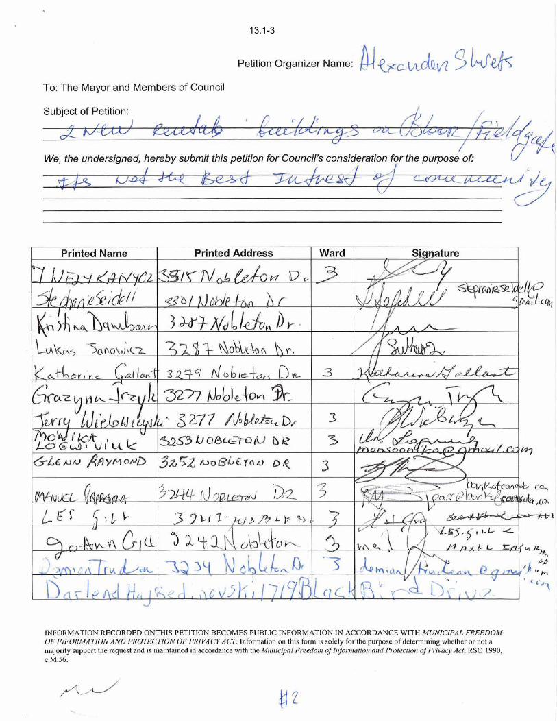
13.1-3

13.1-4
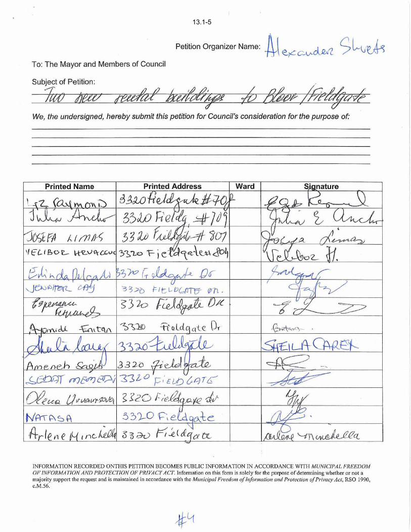
13.1-5
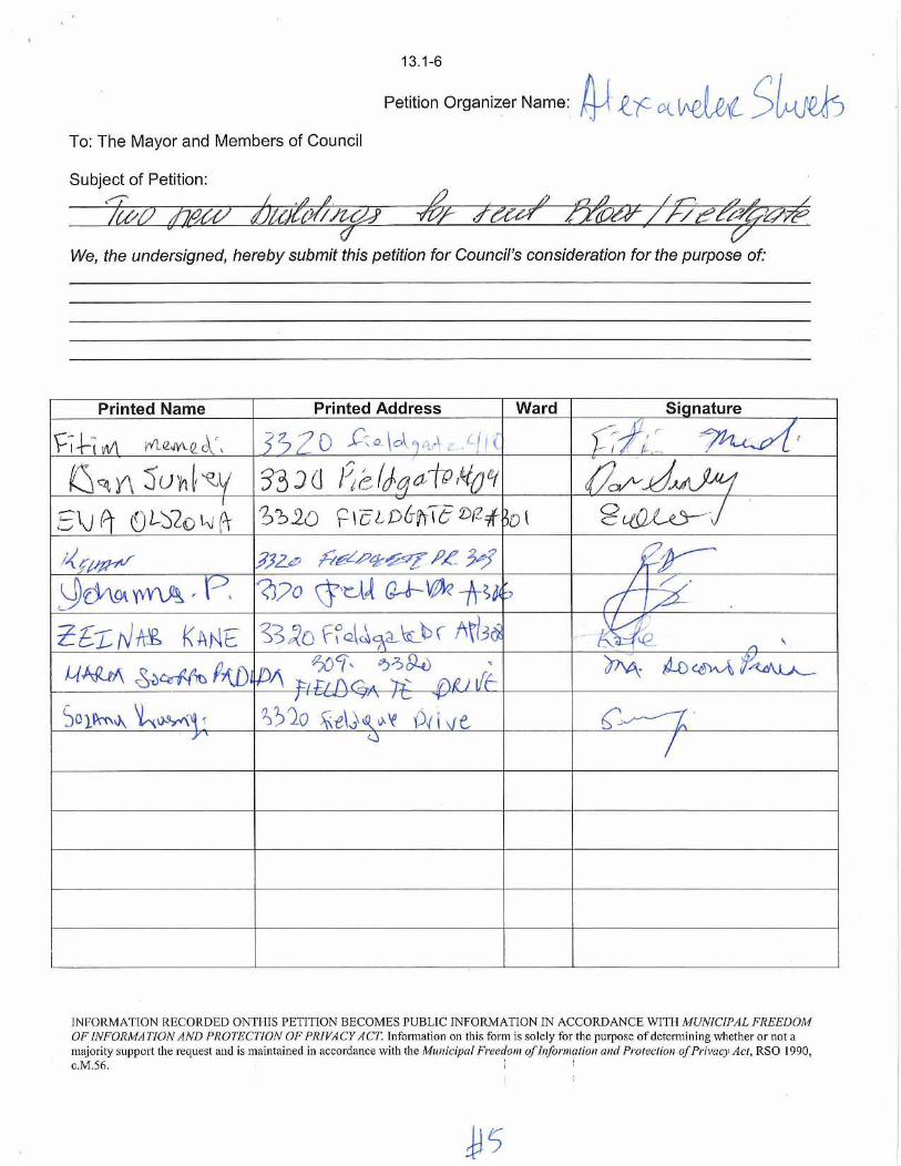
13.1-6

13.2-1
This page is left blank

13.2-2

13.2-3

13.2-4

13.2-5

13.2-6

13.2-7

13.2-8

13.2-9

13.2-10
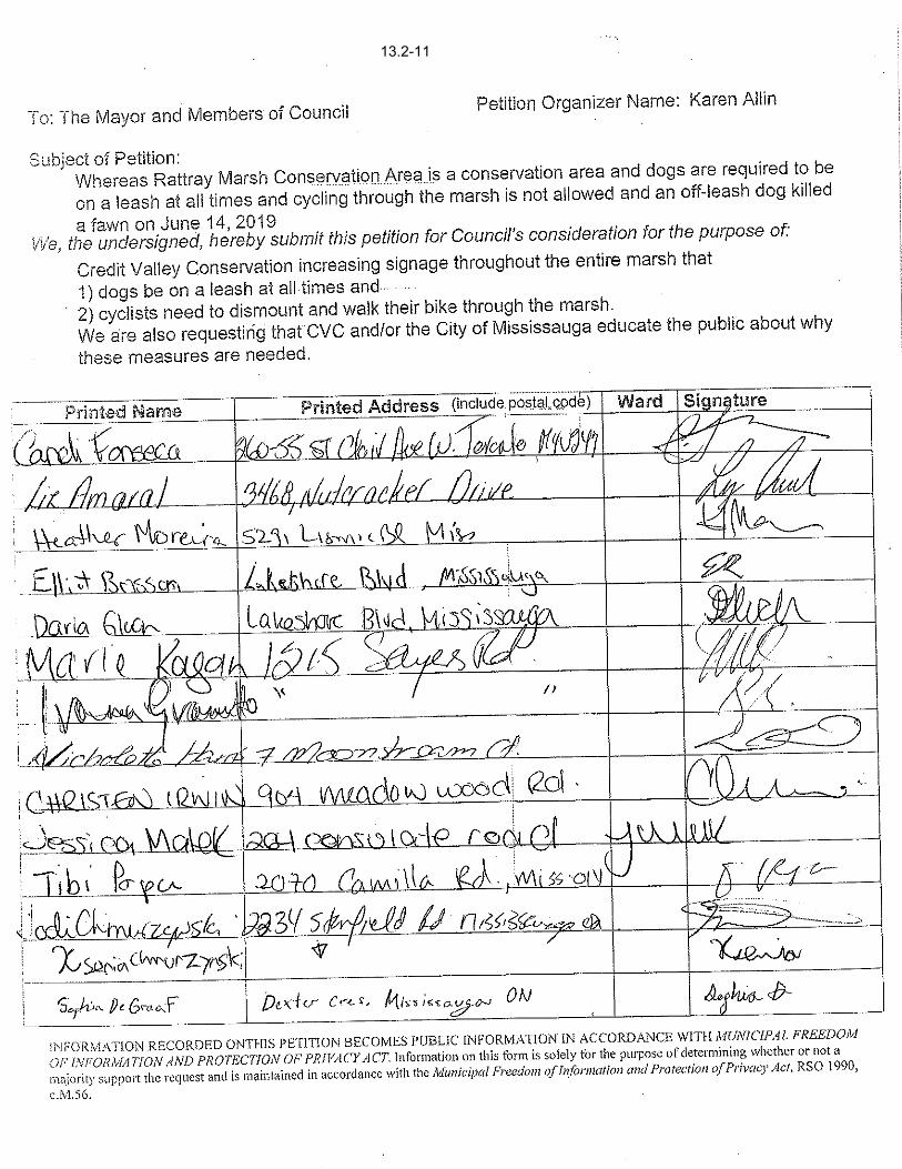
13.2-11

13.2-12

13.2-13
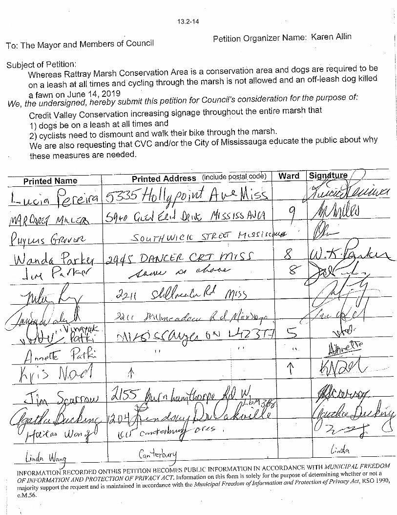
13.2-14

13.2-15

13.2-16

13.2-17

13.2-18

13.2-19

13.2-19

13.2-20

13.2-21

13.2-22

13.2-23

13.2-24

13.2-25

13.2-26

13.2-27

13.2-28

13.2-29

13.2-30

13.2-31

13.2-32

13.2-33

13.2-34

13.2-35

13.2-36

13.2-37

13.2-38

13.2-39

13.2-40

13.2-41

13.2-42

13.2-43

13.2-44

13.2-45

13.2-46

13.2-47

13.2-50

13.2-51

13.2-52

13.2-53

13.2-54

13.2-55

13.2-56

13.2-57

13.2-58

13.2-59

13.2-60


STREETSVILLE BUS INES S IMPROVEMENT AS S O CIATION (B IA)
info @villageofstreetsville.com . www.villageofstreetsville.com
280 Queen Street South, Streetsville, Ontario L5M lMlTel: (905) 858-5974. Fax: (905) 858-2366
Wednesda.v. Jull 30h. 20 l9
Office of the City Clerk
City of Mississauga
300 City Centre Dr.
Mississauga, ON LSB 3Cl
Madame Clerk. Mavor Crombie- and Membcrs of Council.
I am nriting to requcst that a resolution be passed b1, Citl' Council to declare the Streetsville Business
lmprovemcnt Association's fourth annual 'strectsvillc Christmas in the Village Festival' an event of'Municipal Significance' again in 20 19.
The Strectsvillc Business Improvcmerrt Arca (BIA) u'ill be hosting thc Christmas in the Village Festival
on Novemb er 22"t and 23'd - 2019. Thc ovent n'ill featurc a Christmas Market that rvill include the salc of
alcol.rol on the Streetsville Villagc Square (213 Quecn St. South, Mississauga). The entire Square u'ill be
licensed and fenced in. Thc sale of alcohol l'ill bc on Fridal'. November 22"d- 6 p.m. to l0 p.m. and on
Saturdar'. Novembcr 23"t- 12:00 p.m. to l0:00 p.n.
We s,ill requirc an AGCO pcrmit for a -Public Event' in order to sell thcsc bevcragcs in an open-air space
and to promote thc festival. Thc AGCO rcquires all evcnt organizers that are not deemed 'non-profit' by
AGCO standards to obtain a municipal resolution declaring thc tbstival an event of municipal
significance. BIAs. by the AGCO's definition. do not constitute non-profit organizations. Therefore- a
Council resolution is required in order to successflllll' obtain the required permit and to deliver this
festival.
The Strcetsville BIA strives to promote the Village of Streetsvillc as a destination n'ithin Mississauga and
u'ithin the province of Ontario. Thc Christmas in the Villagc Festival rvas dcsigned to create a scnse ofplace rvithin thc communitl.. a place rvhcrc residents of Mississauga and visitors to our Citl' could come
togcther to enjo,v the holidai' scasorl n,ith artists- artisans- and frce activities an'longst thc Citl''s largest
numbor of historical buildings. In 2018, \\'c tvere proud to nclcomc ovcr 1,5.000 attendees to the festival.
Our 2019 fcstival cndeavours to build upon this succcss. r.vith ncrv and improved programming. an
enhanced tree lighting ceremon\'. and this voar \\'c n ill be partncring n'ith the Santa Claus Parade to have
mffimm#'ffiffimffimmeffiemffi m
14.1.1.-1

our artisan market vendors to continue to sell on-site parade day. This partnership allows our market to
stay open an additional day. The Streetsville Christmas in the Villagc Festival is thrilled to have been
funded in part from 2A16 to 2019 by the Ci6"t Grants Office. and is looking fornard to continuing to
partner ri'ith the City in manv ways moving fonvard.
We believe this festival is integral to maintaining the vibrancy of the City of Mississauga year-round. The
festival, located on both MiWay and GO Transit lines, strives to be accessible to all residents of the City,
both geographically and economically. The festival is operated at no cost to attendees, with free
admission, activities, and entertainment for all who attend. Further- the Streetsville BIA has endeavoured
to design a festival that appeals broadly to residents ofsurrounding areas, and create a destination for
tourism over the course ofthe trvo-day event. It is our beliefthat Streetsville's ease ofaccess from three
major thoroughfares. the 401, 403, and 407 makes our community ideally positioned to market to and
rvelcome guests to the Cit_v of Mississauga.
Should I'ou have any questions or concems, please do not hesitate to reach out to me.
Kind regards,
ffi,rt">Amber Pajtasz
General Manager
Streetsville BIA
T: 905-858-5974
F: 905-858-2366
14.1.1-2

14.2.1-1

14.2-1-2

15.1-1