Embed Size (px)
Citation preview
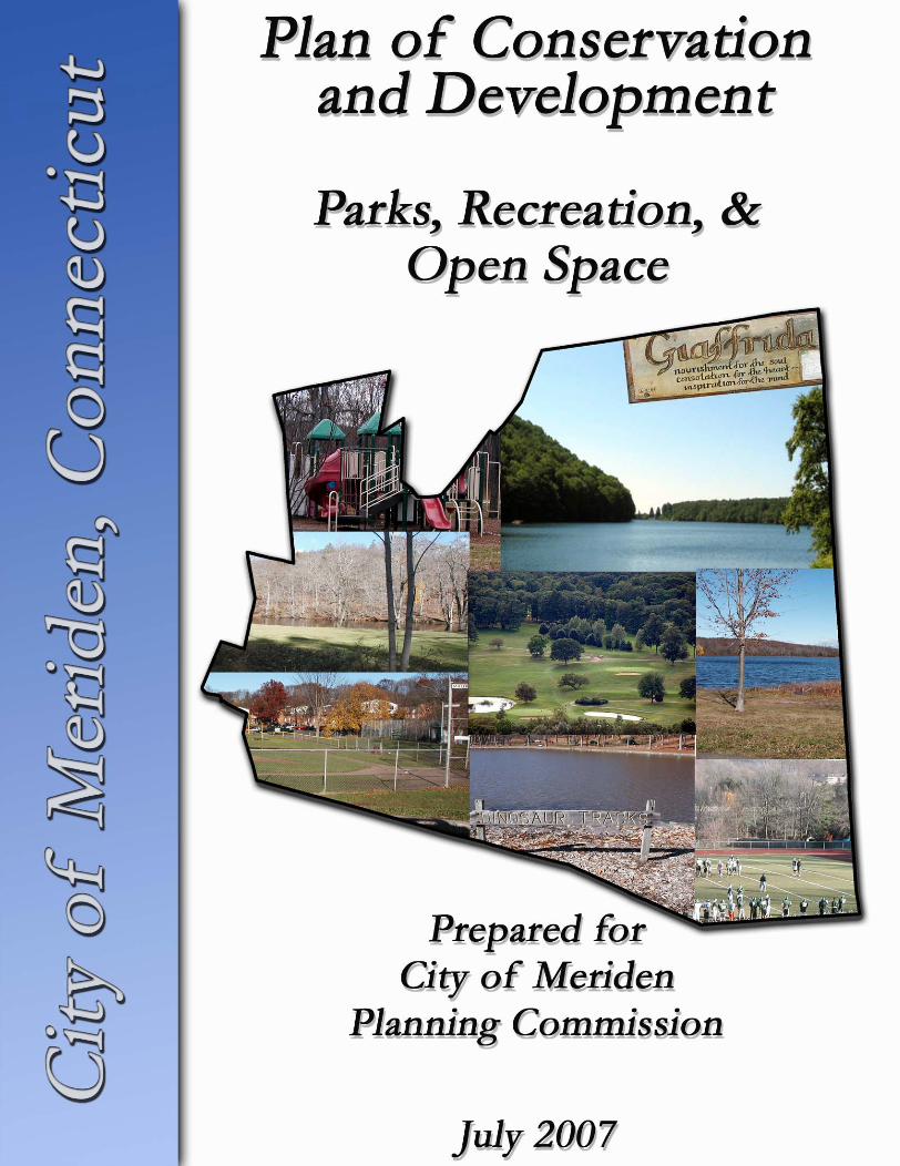
CITY OF MERIDEN
PLAN OF CONSERVATION &
DEVELOPMENT
Parks, Recreation, & Open Space
July 2007
Prepared For: City of Meriden
Planning Commission
Prepared By: Harrall-Michalowski Associates, Inc.
Hamden, Connecticut

TABLE OF CONTENTS
I. Introduction................................................................................................................... 1 II. Existing Parks and Open Space.................................................................................... 2
A. Active Recreation Facility Overview.............................................................. 5 B. Passive Recreation and Open Space............................................................... 6
III. Future Parks and Open Space..................................................................................... 9 IV. Implementation Tools and Techniques ....................................................................... 12 V. Policy, Goals, and Strategies ......................................................................................... 14
MAPS Follows Page
Existing Parks, Recreation, and Open Space .............................................................3 P.A. 490 Land ...........................................................................................................9 Proposed Parks and Open Space Plan.....................................................................10
Appendix Follows Page
Annotated Aerial Photographs of Facilities .............................................................15
2007 Plan of Conservation and Development Update Parks, Recreation, & Open Space City of Meriden Page 1
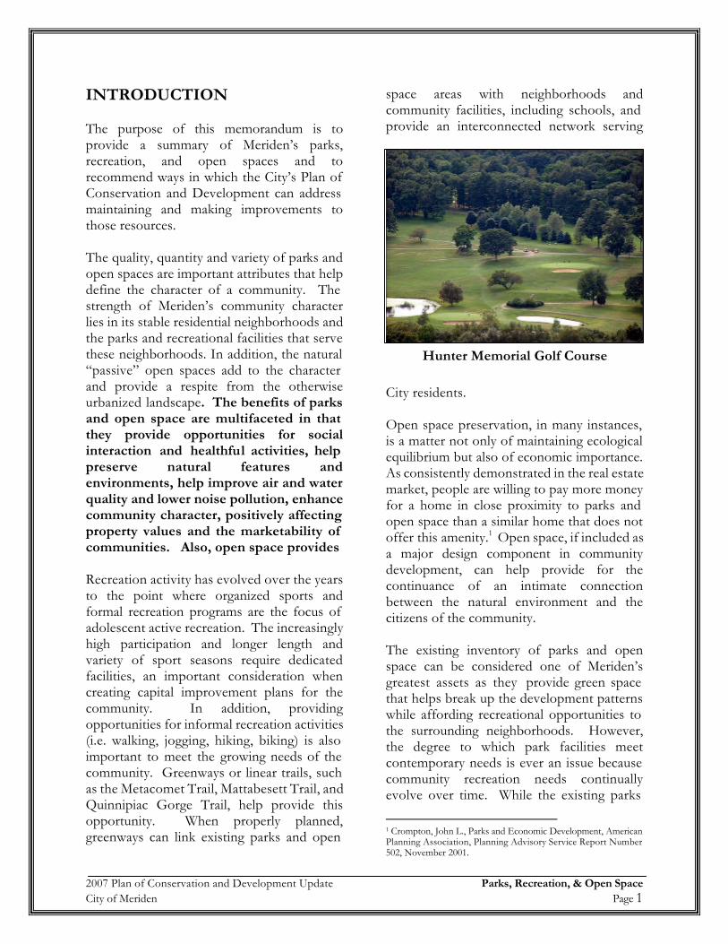
INTRODUCTION The purpose of this memorandum is to provide a summary of Meriden’s parks, recreation, and open spaces and to recommend ways in which the City’s Plan of Conservation and Development can address maintaining and making improvements to those resources. The quality, quantity and variety of parks and open spaces are important attributes that help define the character of a community. The strength of Meriden’s community character lies in its stable residential neighborhoods and the parks and recreational facilities that serve these neighborhoods. In addition, the natural “passive” open spaces add to the character and provide a respite from the otherwise urbanized landscape. The benefits of parks and open space are multifaceted in that they provide opportunities for social interaction and healthful activities, help preserve natural features and environments, help improve air and water quality and lower noise pollution, enhance community character, positively affecting property values and the marketability of communities. Also, open space provides Recreation activity has evolved over the years to the point where organized sports and formal recreation programs are the focus of adolescent active recreation. The increasingly high participation and longer length and variety of sport seasons require dedicated facilities, an important consideration when creating capital improvement plans for the community. In addition, providing opportunities for informal recreation activities (i.e. walking, jogging, hiking, biking) is also important to meet the growing needs of the community. Greenways or linear trails, such as the Metacomet Trail, Mattabesett Trail, and Quinnipiac Gorge Trail, help provide this opportunity. When properly planned, greenways can link existing parks and open
space areas with neighborhoods and community facilities, including schools, and provide an interconnected network serving
City residents. Open space preservation, in many instances, is a matter not only of maintaining ecological equilibrium but also of economic importance. As consistently demonstrated in the real estate market, people are willing to pay more money for a home in close proximity to parks and open space than a similar home that does not offer this amenity.1 Open space, if included as a major design component in community development, can help provide for the continuance of an intimate connection between the natural environment and the citizens of the community. The existing inventory of parks and open space can be considered one of Meriden’s greatest assets as they provide green space that helps break up the development patterns while affording recreational opportunities to the surrounding neighborhoods. However, the degree to which park facilities meet contemporary needs is ever an issue because community recreation needs continually evolve over time. While the existing parks
1 Crompton, John L., Parks and Economic Development, American Planning Association, Planning Advisory Service Report Number 502, November 2001.
Hunter Memorial Golf Course
2007 Plan of Conservation and Development Update Parks, Recreation, & Open Space City of Meriden Page 2
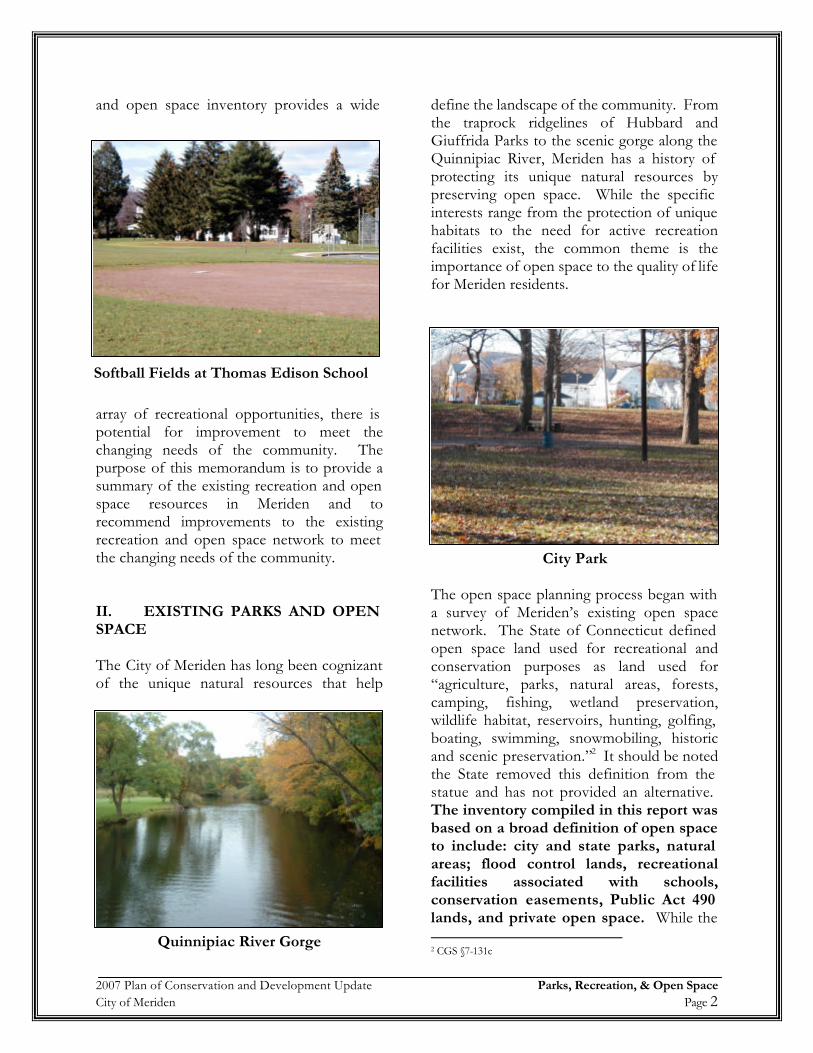
and open space inventory provides a wide
array of recreational opportunities, there is potential for improvement to meet the changing needs of the community. The purpose of this memorandum is to provide a summary of the existing recreation and open space resources in Meriden and to recommend improvements to the existing recreation and open space network to meet the changing needs of the community. II. EXISTING PARKS AND OPEN SPACE The City of Meriden has long been cognizant of the unique natural resources that help
define the landscape of the community. From the traprock ridgelines of Hubbard and Giuffrida Parks to the scenic gorge along the Quinnipiac River, Meriden has a history of protecting its unique natural resources by preserving open space. While the specific interests range from the protection of unique habitats to the need for active recreation facilities exist, the common theme is the importance of open space to the quality of life for Meriden residents.
The open space planning process began with a survey of Meriden’s existing open space network. The State of Connecticut defined open space land used for recreational and conservation purposes as land used for “agriculture, parks, natural areas, forests, camping, fishing, wetland preservation, wildlife habitat, reservoirs, hunting, golfing, boating, swimming, snowmobiling, historic and scenic preservation.”2 It should be noted the State removed this definition from the statue and has not provided an alternative. The inventory compiled in this report was based on a broad definition of open space to include: city and state parks, natural areas; flood control lands, recreational facilities associated with schools, conservation easements, Public Act 490 lands, and private open space. While the 2 CGS §7-131c
Quinnipiac River Gorge
Softball Fields at Thomas Edison School
City Park
2007 Plan of Conservation and Development Update Parks, Recreation, & Open Space City of Meriden Page 3
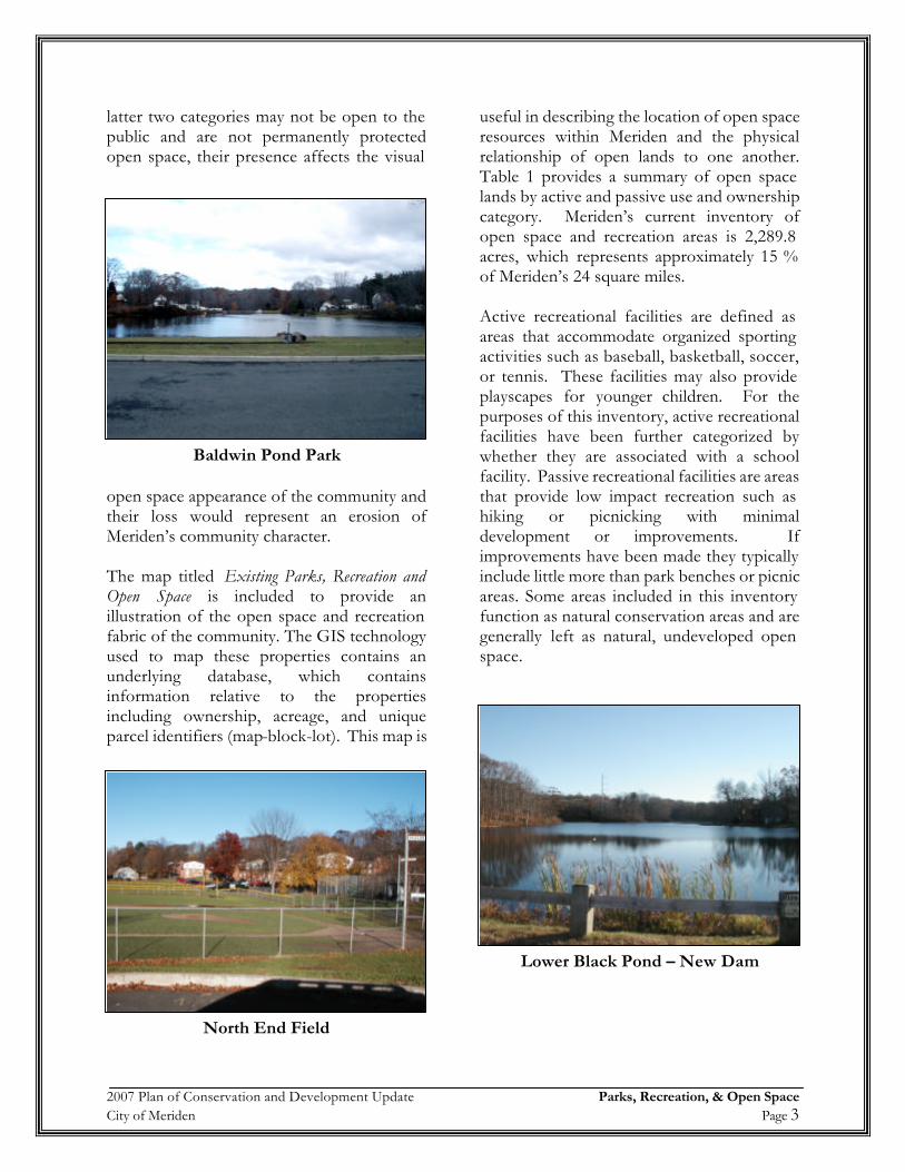
latter two categories may not be open to the public and are not permanently protected open space, their presence affects the visual
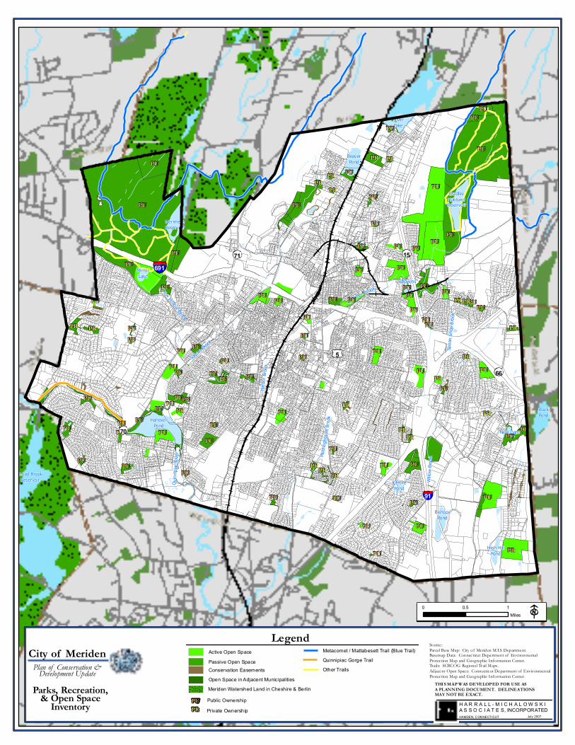
open space appearance of the community and their loss would represent an erosion of Meriden’s community character. The map titled Existing Parks, Recreation and Open Space is included to provide an illustration of the open space and recreation fabric of the community. The GIS technology used to map these properties contains an underlying database, which contains information relative to the properties including ownership, acreage, and unique parcel identifiers (map-block-lot). This map is
useful in describing the location of open space resources within Meriden and the physical relationship of open lands to one another. Table 1 provides a summary of open space lands by active and passive use and ownership category. Meriden’s current inventory of open space and recreation areas is 2,289.8 acres, which represents approximately 15 % of Meriden’s 24 square miles. Active recreational facilities are defined as areas that accommodate organized sporting activities such as baseball, basketball, soccer, or tennis. These facilities may also provide playscapes for younger children. For the purposes of this inventory, active recreational facilities have been further categorized by whether they are associated with a school facility. Passive recreational facilities are areas that provide low impact recreation such as hiking or picnicking with minimal development or improvements. If improvements have been made they typically include little more than park benches or picnic areas. Some areas included in this inventory function as natural conservation areas and are generally left as natural, undeveloped open space.
North End Field
Baldwin Pond Park
Lower Black Pond – New Dam
Sodom Bro
ok
Willo
w Bro
ok
Harbo
r Broo
k
Spoo
n Sho
p Broo
k
Harbor Brook
Meeti
ngho
use B
rookHanover
Pond
BeaverPond
SilverLake
MerimereReservoir
BradleyHubbardReservoir
BishopsPond
High HillPond
MirrorLake
BaldwinsPond
New Dam
KifmirePond
Crow Hollow Brook
Quinn
ipiac
Rive
r
BlackPond
Broad BrookReservoir
PU
PU
PU
PU
PU
PU
PU
PU
PU
PU
PU
PU
PU PU
PU
PU
PUPU
PR
PU
PU
PR
PU
PU
PU
PU
PUPU
PU
PU
PUPU PU
PU
PU
PU
PU
PUPR
PU
PU
PUPU
PU
PU
PU
PU
PU
PU
PU
PU
PU
PU
PU
PU
PU
PU
PU
PU
PU
PU
PU
PU
PU
PUPU
PU PU
PU
PU
PU
PU
PU
PU
PU
PU
PU
PU
PU
PU
PU
PU
PU
PR
PR
PR PR PR
PR
PR
PR
PR
PR
PR
PRPR
PR
PR
PR
PR
PR
91
691
5
70
66
1571
THIS MAP WAS DEVELOPED FOR USE ASA PLANNING DOCUMENT. DELINEATIONSMAY NOT BE EXACT.
Source:Parcel Base Map: City of Meriden M.I.S Department.Basemap Data: Connecticut Department of EnvironmentalProtection Map and Geographic Information Center.Trails: SCRCOG Regional Trail Maps.Adjacent Open Space: Connecticut Department of EnvironmentalProtection Map and Geographic Information Center.
0 0.5 1Miles
H A R R A L L - M I C H A L O W S K IA S S O C I A T E S, INCORPORATEDHAMDEN, CONNECTICUT July 2007
Open Space in Adjacent Municipalities
Active Open SpacePassive Open Space
PU Public OwnershipPrivate OwnershipPR
LegendQuinnipiac Gorge TrailMetacomet / Mattabesett Trail (Blue Trail)
Other TrailsConservation Easements
Parks, Recreation,& Open SpaceInventory
City of MeridenPlan of Conservation &Development Update
Meriden Watershed Land in Cheshire & Berlin
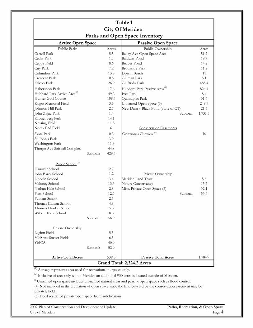
2007 Plan of Conservation and Development Update Parks, Recreation, & Open Space City of Meriden Page 4
Table 1City Of Meriden
Parks and Open Space InventoryActive Open Space Passive Open SpacePublic Parks Acres Public Ownership Acres
Carroll Park 5.5 Bailey Ave Open Space Area 51.2Cedar Park 1.7 Baldwin Pond 18.7Ceppa Field 8.6 Beaver Pond 14.2City Park 7.2 Brookside Park 11.2Columbus Park 13.8 Dossin Beach 11Crescent Park 0.8 Gillman Park 5.1Falcon Park 26.9 Giuffrida Park 485.4Habershon Park 17.6 Hubbard Park Passive Area (2) 824.4Hubbard Park Active Area(2) 49.2 Ives Park 8.4Hunter Golf Course 198.4 Quinnipiac Park 31.4Kogut Memorial Field 3.5 Unnamed Open Space (3) 248.9Johnson Hill Park 2.7 New Dam / Black Pond (State of CT) 21.6John Zajac Park 1.4 Subtotal: 1,731.5Kronenberg Park 14.1Nessing Field 11.8North End Field 6 Conservation EasementsSkate Park 0.3 Conservation Easements(4) 36St. John's Park 3.9Washington Park 11.3Thorpe Ave Softball Complex 44.8
Subtotal: 429.5
Public School (1)
Hanover School 2.7John Barry School 1.2 Private OwnershipLincoln School 3.4 Meriden Land Trust 5.6Maloney School 13.3 Nature Conservancy 15.7Nathan Hale School 2.8 Misc. Private Open Space (5) 32.1Platt School 12.6 Subtotal: 53.4Putnam School 2.5Thomas Edison School 4.8Thomas Hooker School 5.3Wilcox Tech. School 8.3
Subtotal: 56.9
Private OwnershipLegion Field 5.5MidState Soccer Fields 6.5YMCA 40.9
Subtotal: 52.9
Active Total Acres 539.3 Passive Total Acres 1,784.9Grand Total: 2,324.2 Acres
(1) Acreage represents area used for recreational purposes only.(2) Inclusive of area only within Meriden an additional 930 acres is located outside of Meriden.(3)Unnamed open space includes un-named natural areas and passive open space such as flood control.
(5) Deed restricted private open space from subdivisions.
(4) Not included in the tabulation of open space since the land covered by the conservation easement may be privately held.
2007 Plan of Conservation and Development Update Parks, Recreation, & Open Space City of Meriden Page 5
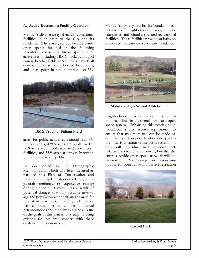
A. Active Recreation Facility Overview Meriden’s diverse array of active recreational facilities is an asset to the City and its residents. The parks, school facilities, and open spaces included in the following inventory represent a broad spectrum of active uses, including a BMX track, public golf course, baseball fields, soccer fields, basketball courts, and playscapes. These parks, schools, and open spaces in total comprise over 539
acres for public active recreational use. Of the 539 acres, 429.5 acres are public parks, 56.9 acres are school associated recreational facilities, and 52.9 acres are privately owned but available to the public. As documented in the Demographic Memorandum, which has been prepared as part of this Plan of Conservation and Development Update, Meriden’s demographic portrait continued to experience change during the past 10 years. As a result of potential changes that may occur relative to age and population composition, the need for recreational facilities, activities, and services has continued to evolve for individual neighborhoods and the City as a whole. One of the goals of this plan is to attempt to bring existing facilities into concert with these evolving recreation needs.
Meriden’s parks system has its foundation as a network of neighborhood parks, athletic complexes, and school-associated recreational facilities. These facilities provide an infusion of needed recreational space into residential
neighborhoods, while also serving as important links in the overall parks and open space system. Enhancing this existing solid foundation should receive top priority to ensure that maximum use can be made of each facility. If proper attention is not paid to the local foundation of the parks system, not only will individual neighborhoods lack sufficient recreational resources, but also the entire citywide open space network will be weakened. Maintaining and improving options for both active and passive recreation
BMX Track at Falcon Field
Maloney High School Athletic Field
Carroll Park
2007 Plan of Conservation and Development Update Parks, Recreation, & Open Space City of Meriden Page 6
is an important component of this parks and open space plan. One of the greatest assets of the City is the Hunter Memorial Golf Course. The course is located adjacent to Giuffrida Park in the northeast corner of the city and is a key recreational asset for Meriden. This 18-hole golf course was opened in 1987 and was recently named the number seven public golf course in the state by Pub Links magazine, and also has been named a top ten course by the Connecticut Golf Magazine. The course played host to the 2001 CT Women's State Amateur Championship and the Senior New England Public Links Championship. In addition to the numerous recreation facilities and open spaces owned and
maintained by the City of Meriden, a few privately held facilities such as the Midstate soccer fields and Legion ballfields also are open to the public. Although the City exercises no direct control over the use of these facilities, the properties are integral parts of the overall recreation and open space fabric in Meriden. Thus, these properties should be factored into parks policy and planning, as their existence and use acknowledged in City’s parks system. Table 2 provides a summary matrix of Meriden's freestanding parks, open space, and recreational facilities. Table 3 summarizes Meriden's recreational facilities associated with schools. In Appendices A the reader will find annotated aerial photographs of the facilities located at each park. B. Passive Recreation and Open Space Passive recreational facilities are areas that provide low impact recreation such as hiking or picnicking with minimal development or improvements. If improvements have been made they typically include little more than park benches or picnic areas. In general, passive recreation encompasses the less intensive range of outdoor activities that are compatible with preserving natural resource functions such as wildlife habitat, watershed or floodplain protection. In Meriden, passive recreation and open space areas total approximately 1,784.9 acres or 11.6% of the Meriden’s total land area. Much of the land within this inventory is located within Hubbard Park (824.4acres) and (485.4 acres) Giuffrida Park. The combined land holdings of these two parks account for over 59% of the acreage in Meriden’s parks and open space inventory. These two parks are considered two of the showpieces of Meriden’s parks and open space system. In addition to the 1,784.9 passive acres within Meriden, the city owns 1,163.9 acres in Cheshire and 1,013.8 acres in Berlin.
Playscape at Nathan Hale School
Fairway at Hunter Memorial Golf Course
2007 Plan of Conservation and Development Update Parks, Recreation, & Open Space City of Meriden Page 7
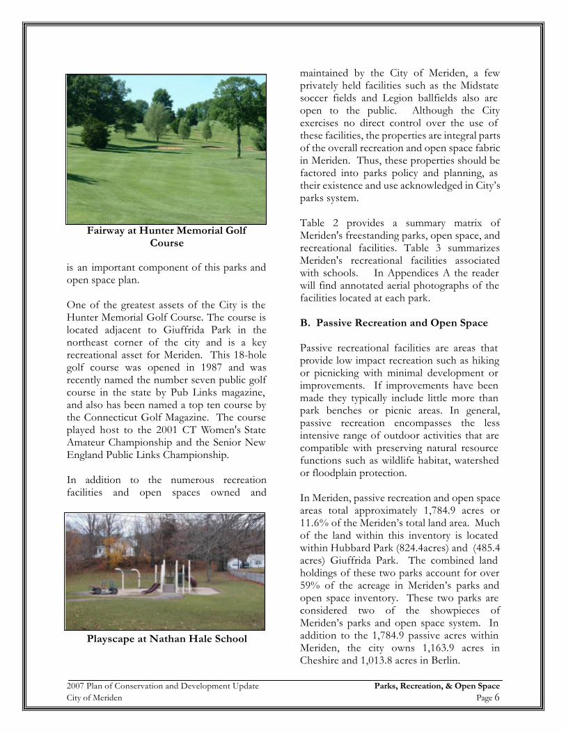
Table 2Matrix of Meriden's Free Standing Parks, Open Space, & Recreational Facilities
Facility Name
Acreage Playscape PavilionPicnic Area
Benches
Tennis Court
Basketball Court
Baseball Field
Little League /
T-Ball
Softball Field
Soccer Field
Football Field
Water Park
Golf Course
Skate Park
BMX Track Trails Undeveloped
Open Space Restrooms
Bailey Ave Open Space 51.2 XBaldwin Pond 18.7 1 1 XBeaver Pond 14.2 1 XBrookside Park 11.2 XCarroll Park 5.5 1 1 XCedar Park 1.7 1 1Ceppa Field 16.3 1 1 1 1 XCity Park 7.2 1 1Columbus Park 13.8 1 4 3 1 X XCrescent Park 0.8 1Falcon Park 26.9 2 1 X X XGillman Park 5.1 X XGiuffrida Park 485.4 X X X XHabershon Park 17.6 2 X X 2 1 1 3 XHubbard Park 864.4 1 X X 2 X X XHunter Golf Course 198.4 XIves Park 8.4 1 1 XKogut Memorial Field 3.9 2Johnson Hill Park 2.7 1 XJohn Zajac Park 1.4 1 1Kronenberg Park 14.1 2 XLegion Field 5.5 1Midstate Soccer Fields 6.4 2Nessing Field 11.8 2 X XNorth End Field 6 1 3 XQuinnipiac Park 31.4 X X XSkate Park 0.3 XSt. John's Park 3.9 1 1 3 1Thorpe Ave Softball Complex 44.8 2 5 XWashington Park 11.3 1 2 1 3 1Source: HMA Survey
Table 3Matrix of Meriden's Recreational Facilities Associated With Schools
Facility Name
Parcel Area
(Acres)
Rec. Area (Acres)
Playscape Tennis Court
Basketball Court
Baseball Field
Little League / T-Ball
Softball Field
Soccer Field
Football Field
Track & Field
Restrooms / Field House
Hanover School 6.6 2.7 2John Barry School 6.2 1.2 1Lincoln School 12.2 3.4 2Maloney School 26.6 13.3 4 1 1 1 XNathan Hale School 8.4 2.8 2 1Platt School 25 12.6 4 1 1 1 1 XPutnam School 5.5 2.5 1Thomas Edison School 18.4 4.8 2 1Thomas Hooker School 24.3 5.3 1 1 2Wilcox School 31.2 8.3 4 1 1Source: HMA Survey
2007 Plan of Conservation and Development Update Parks, Recreation, & Open Space City of Meriden Page 8
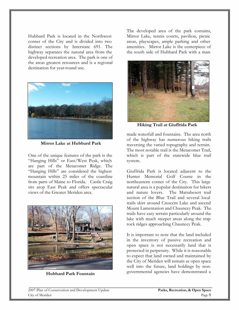
Hubbard Park is located in the Northwest corner of the City and is divided into two distinct sections by Interstate 691. The highway separates the natural area from the developed recreation area. The park is one of the areas greatest resources and is a regional destination for year-round use.
One of the unique features of the park is the “Hanging Hills” or East/West Peak, which are part of the Metacomet Ridge. The “Hanging Hills” are considered the highest mountain within 25 miles of the coastline from parts of Maine to Florida. Castle Craig sits atop East Peak and offers spectacular views of the Greater Meriden area.
The developed area of the park contains, Mirror Lake, tennis courts, pavilion, picnic areas, playscapes, ample parking and other amenities. Mirror Lake is the centerpiece of the south side of Hubbard Park with a man-
made waterfall and fountains. The area north of the highway has numerous hiking trails traversing the varied topography and terrain. The most notable trail is the Metacomet Trail, which is part of the statewide blue trail system. Giuffrida Park is located adjacent to the Hunter Memorial Golf Course in the northeastern corner of the City. This large natural area is a popular destination for hikers and nature lovers. The Mattabesett trail section of the Blue Trail and several local trails skirt around Crescent Lake and ascend Mount Lamentation and Chauncey Peak. The trails have easy terrain particularly around the lake with much steeper areas along the trap rock ridges approaching Chauncey Peak. It is important to note that the land included in the inventory of passive recreation and open space is not necessarily land that is protected in perpetuity. While it is reasonable to expect that land owned and maintained by the City of Meriden will remain as open space well into the future, land holdings by non-governmental agencies have demonstrated a
Mirror Lake at Hubbard Park
Hiking Trail at Giuffrida Park
Hubbard Park Fountain
2007 Plan of Conservation and Development Update Parks, Recreation, & Open Space City of Meriden Page 9
propensity to divest themselves of excess lands.
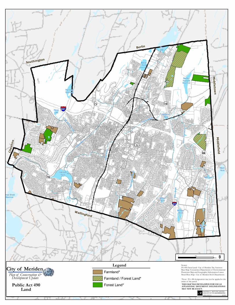
C. Public Act 490 Lands
In 1963 the Connecticut General Assembly passed what is commonly referred to as Public Act 490. In the Declaration of Policy it is stated "(a) that it is in the public interest to encourage the preservation of farm land, forest land and open space land . . .(b) that it is in the public interest to prevent the forced conversion of farm land, forest land and open space land to more intensive uses as the result of economic pressures caused by the assessment there of for purposes of property taxation at values incompatible with their preservation as such farm land, forest land and open space land…" This program allows qualifying parcels containing farms, forests or open space to receive favorable local property taxation based on the land’s current use and not on its market value. 3 The beneficial tax assessments are gained differently depending on the type of land to be preserved; farm land designation is obtained by written application to the municipalities assessor, forest land designation is obtained by written application to the State Forester, and open space land is designated by the planning commission as part of preparing a plan of conservation and development. In all cases the value of such land is decreased thereby making the property
3 See CONN. GEN. STAT., §§12-107a to 12-107e, inclusive (1999). “(a) The term "farm land" means any tract or tracts of land, including woodland and wasteland, constituting a farm unit; (b) The term "forest land" means any tract or tracts of land aggregating twenty-five acres or more in area bearing tree growth in such quantity and so spaced as to constitute in the opinion of the State Forester a forest area and maintained in the opinion of the State Forester in a state of proper forest condition and such land consists of (1) one tract of land of twenty-five or more contiguous acres, which acres may be in contiguous municipalities, (2) two or more tracts of land aggregating twenty-five acres or more in which no single component tract shall consist of less than ten acres or (3) any tract of land a tract owned by the same owner which has been designated as forest land by the State Forester, provided land designated by the State Forester as forest land in accordance with section 12-107d prior to July 1, 1976, shall not be subject to the provisions of subdivisions (1) to (3), inclusive, of this subsection; (c) The term "open space land" means any area of land, including forest land, land designated as wetland under section 22a -30 and not excluding farm land, the preservation or restriction of the use of which would (1) maintain and enhance the conservation of natural or scenic resources, (2) protect natural streams or water supply, (3) promote conservation of soils, wetlands, beaches or tidal marshes, (4) enhance the value to the public of abutting or neighboring parks, forests, wildlife preserves, nature reservations or sanctuaries or other open spaces, (5) enhance public recreation opportunities, (6) preserve historic sites or (7) promote orderly urban or su burban development[.] See id. at §12-107b.
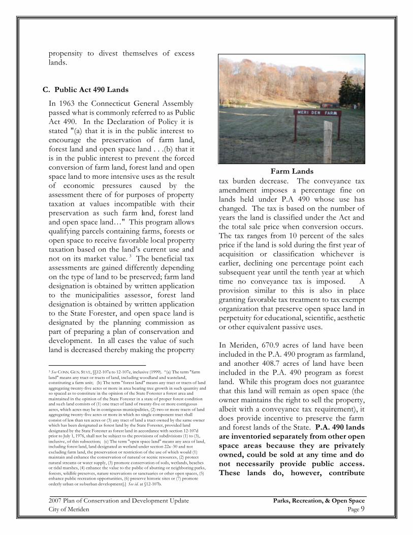
tax burden decrease. The conveyance tax amendment imposes a percentage fine on lands held under P.A 490 whose use has changed. The tax is based on the number of years the land is classified under the Act and the total sale price when conversion occurs. The tax ranges from 10 percent of the sales price if the land is sold during the first year of acquisition or classification whichever is earlier, declining one percentage point each subsequent year until the tenth year at which time no conveyance tax is imposed. A provision similar to this is also in place granting favorable tax treatment to tax exempt organization that preserve open space land in perpetuity for educational, scientific, aesthetic or other equivalent passive uses. In Meriden, 670.9 acres of land have been included in the P.A. 490 program as farmland, and another 408.7 acres of land have been included in the P.A. 490 program as forest land. While this program does not guarantee that this land will remain as open space (the owner maintains the right to sell the property, albeit with a conveyance tax requirement), it does provide incentive to preserve the farm and forest lands of the State. P.A. 490 lands are inventoried separately from other open space areas because they are privately owned, could be sold at any time and do not necessarily provide public access. These lands do, however, contribute
Farm Lands
Sodom Bro
ok
Willo
w Br
ook
Harbo
r Broo
k
Spoo
n Sho
p Broo
k
Harbor Brook
Meeti
ngho
use Br
ookHanover
Pond
BeaverPond
SilverLake
MerimereReservoir
BradleyHubbardReservoir
BishopsPond
High HillPond
MirrorLake
BaldwinsPond
New Dam
KifmirePond
Crow Hollow Brook
Quinn
ipiac
Rive
r
BlackPond
Broad BrookReservoir
Berlin
Ches
hire
Wallingford
MiddlefieldMiddletown
Southington
91
691
5
70
66
1571
0 0.5 1Miles
Public Act 490Land
City of MeridenPlan of Conservation &Development Update
THIS MAP WAS DEVELOPED FOR USE ASA PLANNING DOCUMENT. DELINEATIONSMAY NOT BE EXACT.
Source:PA 490 Farm Land: City of Meriden Tax Assessor.Base Map: Connecticut Department of EnvironmentalProtection Map and Geographic Information Center.Parcel Base Map: City of Meriden M.I.S Department.*Note: P.A. 490 designations may not be applied to theentire of the parcel.
Legend
H A R R A L L - M I C H A L O W S K IA S S O C I A T E S, INCORPORATEDHAMDEN, CONNECTICUT March 2007
Farmland / Forest Land*Farmland*
Forest Land*
2007 Plan of Conservation and Development Update Parks, Recreation, & Open Space City of Meriden Page 10
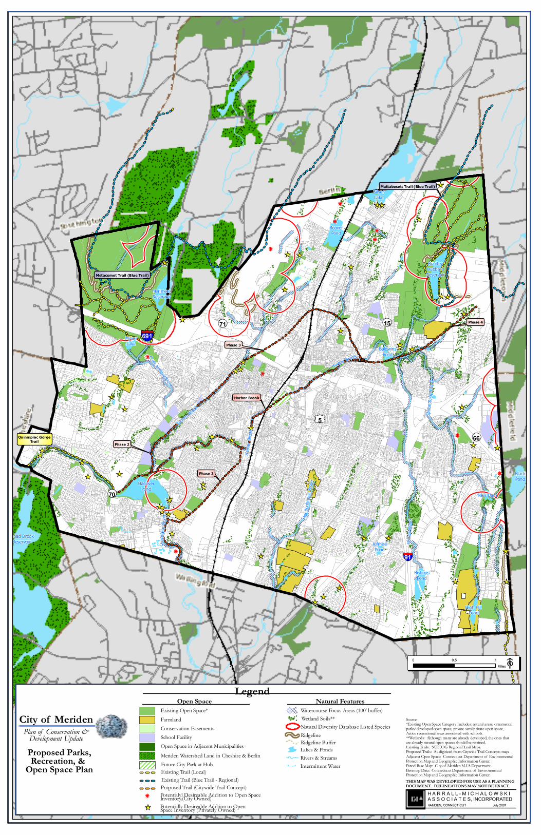
significantly to the overall open space network by protecting natural resources and contributing to the City’s overall community character. These lands should be considered as candidates for more permanent forms of protection in the future. The distribution of property participating in the P.A. 490 program is illustrated on the map titled Public Act 490 Land. III. Future Open Space System The City of Meriden is fortunate to have an existing park and open space system that is in relatively good condition, well distributed geographically, and diverse in the types of uses accommodated. In looking to the future, it will be important to maintain parks and open spaces that are adequate in extent, strategic in location and equitable in distribution in order to meet the unique active and passive needs of the City’s population. The future of existing parks and open space will depend in part on the efficient use of the existing facilities as well as the maintenance and rehabilitation of facilities requiring improvements. An important component of the open space plan is identifying locations within the City to focus future open space protection efforts. In order to become proactive in implementing such a policy, it is necessary to develop criteria from which to identify whether a site that becomes available for acquisition possesses unique characteristics that will enhance the City’s overall open space network or will provide a significant benefit to City residents in the provision of needed recreational resources. The map titled Proposed Parks & Open Space Plan follows this page. The following is a list of objectives that can be utilized in focusing future open space protection efforts:
• Links existing parks and open spaces together to form interconnected
greenways within the city or on a larger regional open space network.
• Adjacent to and complementary to
existing parks and/or open space owned by the City of Meriden, neighboring municipalities, the State of Connecticut or a private entity.
• Preserves natural drainage areas including
waterways and surrounding wetlands and floodplains
• Protects existing and potential public
drinking water supplies, including groundwater supplies.
• Protects unique and significant natural
features including critical or threatened habitats
• Preserves agricultural land
• Preserves and protects ridgelines
• Has multiple recreational or open space
values (i.e., can be used for several different passive and/or active recreational uses).
A municipal open space planning publication has outlined factors that a community should consider in order to maximize its funding opportunities.4 These include the following:
• Invest resources to develop a natural
resource inventory of the City and assemble key parcel data for priority sites;
• Work with neighboring municipalities to
advance joint preservation projects; • Develop a clear and accurate map that
shows public and private protected open space, and proposed open space
4 Techniques, Report #28 Municipal Open Space Planning, Capitol Region Council of Governments, Spring 2000.
91
691
5
70
66
1571
HanoverPond
BeaverPond
SilverLake
MerimereReservoir
BradleyHubbardReservoir
BishopsPond
High HillPond
MirrorLake
BaldwinsPond
New Dam
KifmirePond
Crow Hollow Brook
Quinn
ipiac
Rive
r
BlackPond
Broad BrookReservoir
Sodom
Brook
Willo
w Br
ook
Harbo
r Broo
k
Spoo
n Sho
p Broo
k
Harbor Brook
Meeti
ngho
use B
rook
Phase 3
Harbor Brook
Phase 3
Phase 2
Phase 4
Metacomet Trail (Blue Trail)
Mattabesett Trail (Blue Trail)
Quinnipiac GorgeTrail
THIS MAP WAS DEVELOPED FOR USE AS A PLANNING DOCUMENT. DELINEATIONS MAY NOT BE EXACT.
Source:*Existing Open Space Category Includes: natural areas, ornamental parks/developed open space, private-semi private open space, Active recreational areas associated with schools.**Wetlands: Although many are already developed, the ones thatare already natural open spaces should be retained.Existing Trails: SCRCOG Regional Trail Maps.Proposed Trails: As digitized from Citywide Trail Concepts map.Adjacent Open Space: Connecticut Department of EnvironmentalProtection Map and Geographic Information Center.Parcel Base Map: City of Meriden M.I.S Department.Basemap Data: Connecticut Department of EnvironmentalProtection Map and Geographic Information Center.
0 0.5 1Miles
H A R R A L L - M I C H A L O W S K IA S S O C I A T E S, INCORPORATEDHAMDEN, CONNECTICUT July 2007
Proposed Parks,Recreation, & Open Space Plan
City of MeridenPlan of Conservation &Development Update
LegendOpen Space Natural Features
Natural Diversity Database Listed Species
Watercourse Focus Areas (100' buffer)
RidgelineRidgeline BufferLakes & Ponds
Intermittent WaterRivers & Streams
Wetland Soils**
Open Space in Adjacent Municipalities
Existing Open Space*Farmland
Existing Trail (Local)
Conservation EasementsSchool Facility
Potentialyl Desireable Addition to Open SpaceInventory.(City Owned)Potentially Desireable Addtion to OpenSpace Inventory (Privately Owned)
Future City Park at Hub
Existing Trail (Blue Trail - Regional)Proposed Trail (Citywide Trail Concept)
Meriden Watershed Land in Cheshire & Berlin
2007 Plan of Conservation and Development Update Parks, Recreation, & Open Space City of Meriden Page 11
acquisition areas and corridors. Include the map with any funding applications;
• Study the goals of the potential funding
organizations and assess which goals overlap with those of the City. Also, identify specific sites or areas that may meet a particular organization’s goals. For example, the Connecticut Department of Environmental Protection considers, among other factors, whether a parcel is: significant in size, regionally accessible, contiguous to other state holdings, unprotected by regulation or adjacent to water;
• Creatively integrate volunteer, corporate
and non-profit assistance to advance open space protection goals and objectives.
Expanding and Linking Existing Open Space through Greenways and Trails While the current City parks and recreation facilities offer residents numerous opportunities for active and passive recreation, Meriden should look towards the future by identifying and prioritizing potential expansion of these existing open spaces, while also looking to create linkages that provide desirable connections amongst them. These trail networks coupled with other local trails and sidewalks provide a solid foundation toward achieving an interconnected and accessible greenways and trail system. When properly planned, greenways can link existing parks and open space areas with neighborhoods and community facilities such as schools, and provide a pedestrian friendly environment to serve residents. Greenways greatly influence the natural landscape by providing a natural or open space edge to an otherwise developed area. It is at this edge that open space contrasts with development and is so much more inviting by virtue of this contrast. Open space edges and borders can serve to enclose and define development and
prevent a continuous unattractive sprawl. The maintenance of vegetative buffers along roads and stream corridors are particularly useful in this regard. Riparian Corridor Focus Areas: As described in the previously issued Natural Resources Inventory Memorandum, several rivers and streams and their associated wetlands and flood plains are located within the City of Meriden. They include: the Quinnipiac River, Harbor Brook, Spoon Shop Brook, Sodom Brook, Crow Hollow Brook, Meetinghouse Brook, and Willow Brook. The watersheds of these rivers drain most of the land area of the City.
The protection of land directly adjacent to the City’s watercourses, including wetlands and floodplains, is an important focus of the City’s future open space plan. Continued implementation of the wetland and floodplain regulations to ensure that the watercourses are properly protected from development and storm water runoff is recommended. In addition, protection or acquisition of parcels adjacent to watercourses susceptible to flooding or parcels that contain important natural resources will help preserve the City’s riparian habitats and water quality.
The protection of riparian corridors is an important component to the implementation
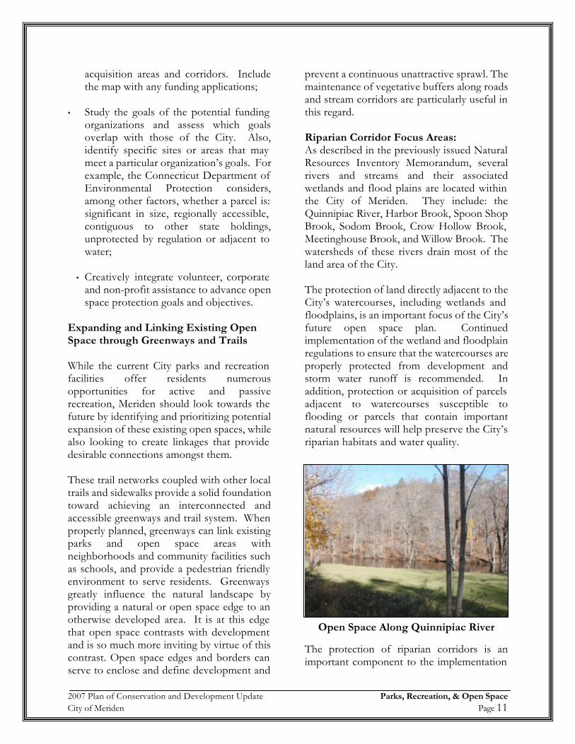
Open Space Along Quinnipiac River
2007 Plan of Conservation and Development Update Parks, Recreation, & Open Space City of Meriden Page 12
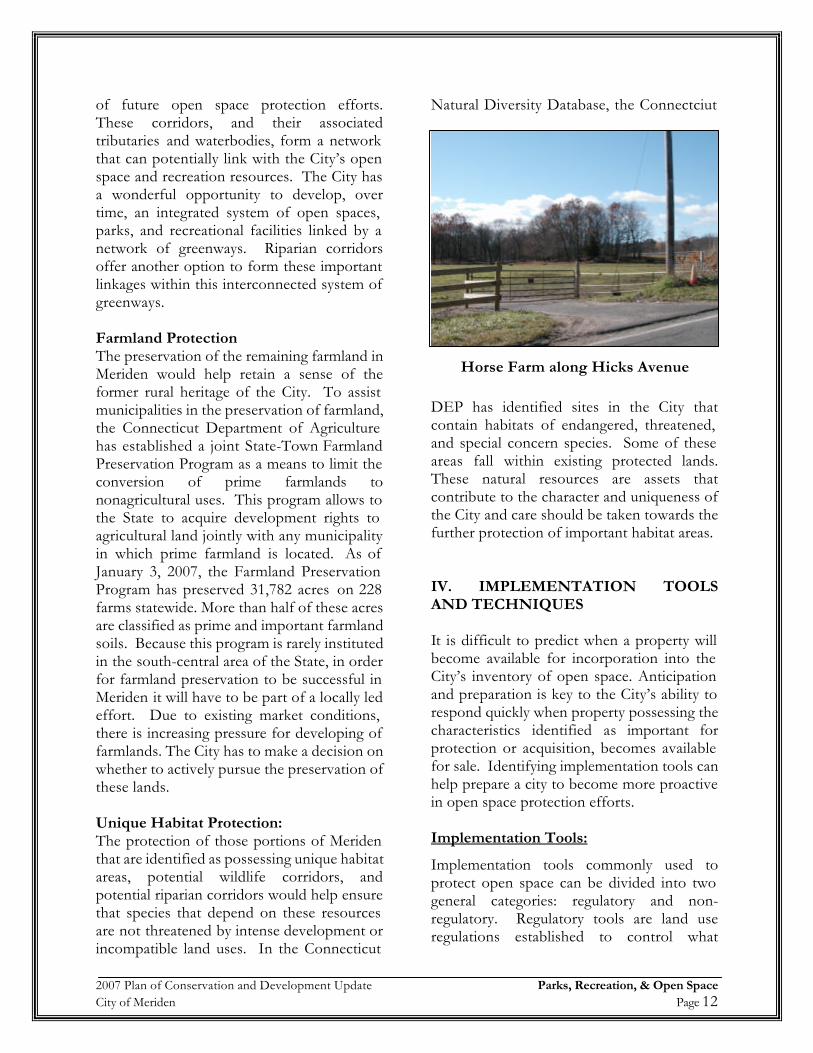
of future open space protection efforts. These corridors, and their associated tributaries and waterbodies, form a network that can potentially link with the City’s open space and recreation resources. The City has a wonderful opportunity to develop, over time, an integrated system of open spaces, parks, and recreational facilities linked by a network of greenways. Riparian corridors offer another option to form these important linkages within this interconnected system of greenways. Farmland Protection The preservation of the remaining farmland in Meriden would help retain a sense of the former rural heritage of the City. To assist municipalities in the preservation of farmland, the Connecticut Department of Agriculture has established a joint State-Town Farmland Preservation Program as a means to limit the conversion of prime farmlands to nonagricultural uses. This program allows to the State to acquire development rights to agricultural land jointly with any municipality in which prime farmland is located. As of January 3, 2007, the Farmland Preservation Program has preserved 31,782 acres on 228 farms statewide. More than half of these acres are classified as prime and important farmland soils. Because this program is rarely instituted in the south-central area of the State, in order for farmland preservation to be successful in Meriden it will have to be part of a locally led effort. Due to existing market conditions, there is increasing pressure for developing of farmlands. The City has to make a decision on whether to actively pursue the preservation of these lands. Unique Habitat Protection: The protection of those portions of Meriden that are identified as possessing unique habitat areas, potential wildlife corridors, and potential riparian corridors would help ensure that species that depend on these resources are not threatened by intense development or incompatible land uses. In the Connecticut
Natural Diversity Database, the Connectciut
DEP has identified sites in the City that contain habitats of endangered, threatened, and special concern species. Some of these areas fall within existing protected lands. These natural resources are assets that contribute to the character and uniqueness of the City and care should be taken towards the further protection of important habitat areas. IV. IMPLEMENTATION TOOLS AND TECHNIQUES It is difficult to predict when a property will become available for incorporation into the City’s inventory of open space. Anticipation and preparation is key to the City’s ability to respond quickly when property possessing the characteristics identified as important for protection or acquisition, becomes available for sale. Identifying implementation tools can help prepare a city to become more proactive in open space protection efforts. Implementation Tools:
Implementation tools commonly used to protect open space can be divided into two general categories: regulatory and non-regulatory. Regulatory tools are land use regulations established to control what
Horse Farm along Hicks Avenue
2007 Plan of Conservation and Development Update Parks, Recreation, & Open Space City of Meriden Page 13
activities a landowner can conduct on their property. The City of Meriden has an opportunity during the development process to implement regulatory controls to protect natural features or to establish open space. Examples of regulatory tools include the following:
Inland Wetland Regulations- The City’s Inland Wetlands Commission currently regulates wetland soils in Meriden.
Zoning- Special districts zones and regulations can be established to allow for more control over the types of use and site plan design within sensitive natural resource areas. Examples include overlay districts for sensitive natural resource, open space subdivision regulations, and creating open space zoning districts. Subdivision Regulations- Open space dedication requirements can be incorporated into these regulations that define what percentage of development must be dedicated as open space. In addition, the Commission may require the subdivider to submit additional documentation including an environmental impact statement prepared by the applicant and approved by the Conservation Commission, evaluating the significant environmental effects expected as a result of the construction project. Non-regulatory tools used to protect open space usually involve some type of ownership status. The following are examples of some of the more common techniques: Fee Simple Purchase – Involves the outright purchase of land whereas the City or designated non-profit (i.e. land trust) has full control over the land title. This method allows for permanent protection, however, the land is removed from the tax rolls. The City may use grants, general appropriation funds,
fees collected in lieu of open space dedication, or may bond for the land purchase. Purchase of Development Rights – Purchase of development rights (PDR) programs are one viable approach that state and local governments are using to preserve farmland and open space. PDR programs provide a means to financially compensate participating landowners for not developing their land. When buying development rights, the community obtains a legal easement, sometimes referred to as a conservation easement, that permanently restricts development on the land. The landowner, however, still owns the land and can use or sell it for purposes specified in the easement, such as farming. PDR programs are increasing in popularity because they offer substantial benefits to both communities and landowners. By selling only development rights, owners can convert some of the wealth tied up in their land into cash, without relinquishing ownership of the land or use of its productive capacity. For the landowner, the restricted use of the land provides a lower tax rate and may lower the resale value of the property. For communities, PDR programs are an avenue to manage growth and provide the benefits of open space without the expense of purchasing, maintaining, and policing publicly owned land. Land preservation can also save communities in the long run, since residential development often costs more in public infrastructure and community services than the tax revenue generated from development. Easement – Easements are defined as a partial interest in property conveyed by the landowner to the city or a non-profit such as a land trust with specific restrictions on land development or access privileges. Typically easements are less expensive than fee simple purchase because the landowner retains ownership and property remains on the tax rolls however, at a lower rate because of restricted use. This technique can prove
2007 Plan of Conservation and Development Update Parks, Recreation, & Open Space City of Meriden Page 14
useful in establishing walking trails or greenways. Land Trust – Private, non-profit organizations that acquire land for recreation or conservation. A land trust may work cooperatively with the City by sharing costs and maintenance of the property. Land trusts often enter real estate market more quickly and easily than government agencies. Funding Sources: Fees-In-Lieu of open space dedication requirement – In lieu of the land dedication requirement, the City may require a fee not to exceed 10% of the value of the subdivided land, or a combination of fee and land. This fee can be used to purchase priority open space elsewhere in the community that may have higher open space value. Open space exactions are a cost efficient and rather straightforward means of ensuring that pockets of undeveloped land will remain in their natural condition. Donations, Gifts, and Estate Planning – Donations of all or partial interest in land allows permanent protections at no public cost to the community while providing a tax benefit to the donor. If land is given for conservation purposes the receiving organization is required to maintain the land in its natural state in perpetuity. However, the donor may make specific stipulations as to the use of the land such as "forever wild" or for passive recreational use only. The tax benefits of gifting land are numerous and donors are entitled to an income tax deduction of the value of the property. The deduction is allowed to be up to 30% of the donor's taxable income each year for a period of five years, up to the value of the donation. In addition, both property taxes and estate taxes on the land are eliminated. Land donation is a simple and highly effective means of conserving land. Receiving agency must be willing and capable of managing the land.
Also, a landowner can convey land to a community or land trust in their will. A deduction from the value of one's taxable estate is allowed for land bequeathed for public purposes The Connecticut Department of Environmental Protection’s Open Space and Watershed Land Acquisition Grant Program (CGS § 7-131d to 7-131k) – This grant provides financial assistance to municipalities or non-profit land conservation organizations to acquire land for open space. Grants may be for the purchase of land that is: 1) valuable for recreation, forestry, fishing, conservation of wildlife or natural resources; 2) a prime natural feature of the state's landscape; 3) habitat for native plant or animal species listed as threatened, endangered or of special concern; 4) a relatively undisturbed outstanding example of a native ecological community which is uncommon; 5) important for enhancing and conserving water quality; 6) valuable for preserving local agricultural heritage; or 7) eligible to be classified as Class I or Class II watershed land. This grant program provides matching grants to communities like Meriden for up to 65% of the properties fair market value. It is recommended that the City submit applications to this grant program to acquire future open space. V. Policy, Goals, and Strategies Policy: Maximize Existing Recreational and Open Space Resources Encourage enhancements, improved use, maintenance, and rehabilitation of the existing park and open space system to ensure they are adequate in extent; strategic in location and equitable in distribution in order to meet the unique active and passive needs of the Meriden’s residents as well as the protection of important natural resources.
2007 Plan of Conservation and Development Update Parks, Recreation, & Open Space City of Meriden Page 15
Goal: • Maximize the value and utility of the
existing system of parks, recreational facilities and open space resources throughout Meriden and add to the open space and recreation system as resources and opportunities permit.
• Provide a system of linking public and
private open space throughout Meriden and for the region. Open space should provide passive and active recreation opportunities and preserve environmentally sensitive areas.
• Promote open space to maximize the
amenity value of Meriden’s extensive open space/recreation system – Hunter Memorial Golf Course, Hubbard Park, Giuffrida Park, Blue Blazed Trails, Quinnipiac Gorge, etc…
Implementation Strategies:
• To continue the efficient utilization of existing parks and recreation facilities, including extended hours and creative scheduling;
• To strengthen the existing cooperative
relationship between the Parks Department and the Board of Education to maximize the use of all school associated recreational resources to the benefit of Meriden’s residents;
• Parcels for open space and or recreational
use should be acquired in neighborhoods presently lacking such facilities;
• Wherever possible, existing parks and
open space should be linked together to form interconnected greenways;
• To encourage greenways linking
neighborhoods, public facilities and employment areas to existing open space areas as a focus for recreational activity;
• Maximize accessibility to all open space
resources;
• Establish a fund dedicated to the acquisition and protection of open space;
• Continue to provide a variety of municipal
protections for open space resources
• Market Meriden’s open space system and recreation programs as a major quality of life amenity.
• Examine all parcels acquired by the City
through tax foreclosure, donation, etc. for its potential to be added to the open space and parks inventory.
• Conduct a fiscal impact analysis to
determine the fiscal consequences of balancing open space preservation with residential development for Meriden.
• Consider creating Open Space zoning
districts to protect the open tracts of land in the City.
• Consider forming a study team to work
with the State for potentially utilizing part of the Undercliff property as a park or for open space.
• Consider forming a study committee to
look at the potential re-use of part of the landfill for open space.
• Consider a local based fee associated with
property transfers to be used for open space protection.
2007 Plan of Conservation and Development Update Parks, Recreation, & Open Space City of Meriden Page 16
Appendix A

2007 Plan of Conservation and Development Update Parks, Recreation, & Open Space City of Meriden Page 17