Embed Size (px)
Citation preview

CITY OF LOMA LINDA
CITY COUNCIL AGENDA
REGULAR MEETING OF JUNE 13, 2017
A regular meeting of the City Council of the City of Loma Linda is scheduled to be held Tuesday, June 13,
2017 in the City Council Chamber, 25541 Barton Road, Loma Linda, California. Pursuant to Municipal
Code Section 2.08.010, study session or closed session items may begin at 5:30 p.m. or as soon thereafter as
possible. The public meeting begins at 7:00 p.m.
Reports and Documents relating to each agenda item are on file in the Office of the City Clerk and are
available for public inspection during normal business hours. The Loma Linda Branch Library is also
provided an agenda packet for your convenience. The agenda and reports are also located on the City’s
Website at www.lomalinda-ca.gov.
Materials related to an item on this Agenda submitted to the City Council after distribution of the agenda
packet are available for public inspection in the City Clerk’s Office, 25541 Barton Road, Loma Linda, CA
during normal business hours. Such documents are also available on the City’s website at
www.lomalinda-ca.gov subject to staff’s ability to post the documents before the meeting.
Persons wishing to speak on an agenda item, including any closed session items, are asked to complete an
information card and present it to the City Clerk prior to consideration of the item. When the item is to be
considered, please step forward to the podium, the Chair will recognize you and you may offer your
comments. The City Council meeting is recorded to assist in the preparation of the Minutes, and you are
therefore asked to give your name and address prior to offering testimony.
The Oral Reports/Public Participation portion of the agenda pertains to items NOT on the agenda and is
limited to 30 minutes; 3 minutes allotted for each speaker. Pursuant to the Brown Act, no action may be
taken by the City Council at this time; however, the City Council may refer your comments/concerns to staff
or request that the item be placed on a future agenda.
In compliance with the Americans with Disabilities Act, if you need special assistance to participate in
this meeting, please contact the City Clerk at (909) 799-2819. Notification 48 hours prior to the meeting
will enable the City to make reasonable arrangements to ensure accessibility to this meeting. Later
requests will be accommodated to the extent feasible.
A recess may be called at the discretion of the City Council.
Agenda item requests for the July 11, 2017 meeting must be submitted in writing to the City Clerk no
later than NOON, TUESDAY, June 26. 2017
A. Call To Order
B. Roll Call
C. Closed Session – 6:00 p.m.
Conference with Labor Negotiator - (Government Code Section 54957.6)
Agency Representative - City Manager Jarb Thaipejr, Assistant City Manager Konrad Bolowich
and Negotiator Jay Trinnaman
Employee Organizations - Loma Linda Public Works Employees Association, Loma Linda
Professional Firefighters Local 935, Professional and
Administrative Employees Association, Fire Management, and
unrepresented employees
D. Invocation and Pledge of Allegiance – Mayor Rigsby (In keeping with long-standing traditions
of legislative invocations, this City Council meeting may include a brief, non-
sectarian invocation. Such invocations are not intended to proselytize or advance any one, or to
disparage any other, faith or belief. Neither the City nor the City Council endorses any particular
religious belief or form of invocation.)
E. Items To Be Added Or Deleted
F. Oral Reports/Public Participation - Non-Agenda Items (Limited to 30 minutes; 3 minutes
allotted for each speaker)
G. Conflict of Interest Disclosure - Note agenda item that may require member abstentions due to
possible conflicts of interest
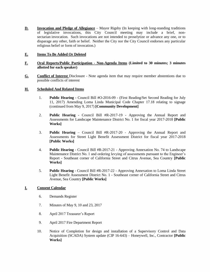
H. Scheduled And Related Items
1. Public Hearing - Council Bill #O-2016-09 - (First Reading/Set Second Reading for July
11, 2017) Amending Loma Linda Municipal Code Chapter 17.18 relating to signage
(continued from May 9, 2017) [Community Development]
2. Public Hearing - Council Bill #R-2017-19 - Approving the Annual Report and
Assessments for Landscape Maintenance District No. 1 for fiscal year 2017-2018 [Public
Works]
3. Public Hearing – Council Bill #R-2017-20 - Approving the Annual Report and
Assessments for Street Light Benefit Assessment District for fiscal year 2017-2018
[Public Works]
4. Public Hearing - Council Bill #R-2017-21 - Approving Annexation No. 74 to Landscape
Maintenance District No. 1 and ordering levying of assessments pursuant to the Engineer’s Report - Southeast corner of California Street and Citrus Avenue, Sea Country [Public Works]
5. Public Hearing - Council Bill #R-2017-22 - Approving Annexation to Loma Linda Street
Light Benefit Assessment District No. 1 - Southeast corner of California Street and Citrus Avenue, Sea Country [Public Works]
I. Consent Calendar
6. Demands Register
7. Minutes of May 9, 10 and 23, 2017
8. April 2017 Treasurer’s Report
9. April 2017 Fire Department Report
10. Notice of Completion for design and installation of a Supervisory Control and Data
Acquisition (SCADA) System update (CIP 16-643) – Honeywell, Inc., Contractor [Public
Works]

11. Accept offer of Right-of-Way dedication on south side of Redlands Boulevard between
Anderson Street and Ohio Street (APN: 283-082-43) and authorize City Manager to sign
the acceptance document [Public Works]
12 . Approve Appropriation of $5,000 from General Fund Balance to 1-4200-1300, Parks
Expenditure Account for repairs and maintenance [Public Works]
J. Old Business
13. Council Bill #O-2016-10 (Second Reading/Roll Call Vote) - Amending Title 17 of the
Loma Linda Municipal Code pertaining to the Development Code [Community
Development]
K. New Business
14. Designate voting delegate and alternate for League of California Cities Annual Conference,
September13 -15, Sacramento
15. Presentation re: Spring/Summer Weed Removal [Community Development]
L. Reports of Councilmen (This portion of the agenda provides City Council Members an
opportunity to provide information relating to other boards/commissions/committees to which City
Council Members have been appointed).
M. Reports Of Officers (This portion of the agenda provides Staff the opportunity to provide
informational items that are of general interest as well as information that has been requested by the
City Council).
N. Adjournment
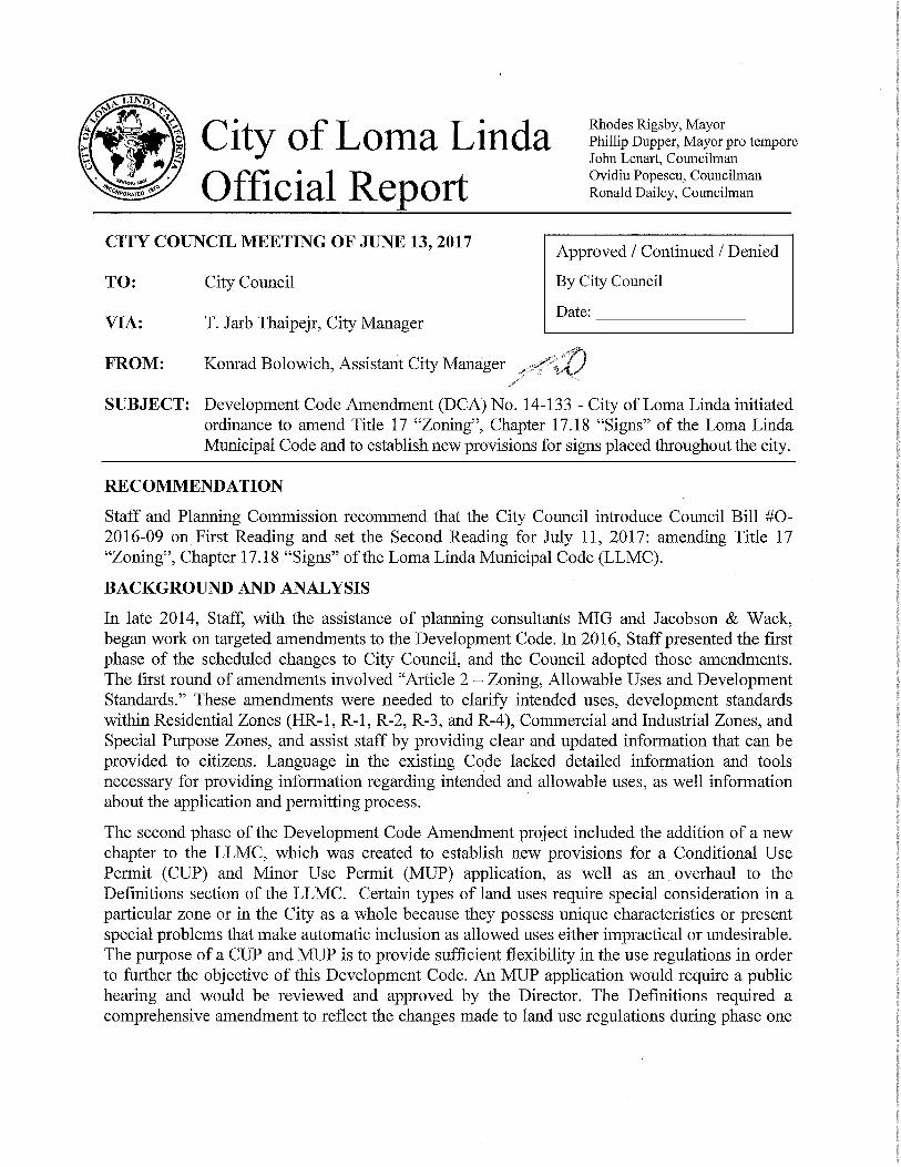


Public Review Draft May, 2017
LOMA LINDA SIGN CODE UPDATE
CITY COUNCIL PUBLIC HEARING DRAFT
May, 2017

CC Public Hearing Draft May, 2017

May, 2017 Loma Linda Municipal Code – Signs
CONTENTS
17.18.010 Purpose ................................................................................................................................................ 1
17.18.020 Applicability ........................................................................................................................................ 1
17.18.030 General Provisions .............................................................................................................................. 2
17.18.040 Procedures for Sign Permits, Exemptions, and Revocations ......................................................... 3
17.18.050 Comprehensive Sign Program .......................................................................................................... 4
17.18.060 Exempt Signs ...................................................................................................................................... 7
17.18.070 Prohibited Signs ................................................................................................................................. 8
17.18.080 Standards For All Types Of Signs ................................................................................................... 10
17.18.090 Permanent Signs by Zone - Locations and Design Requirements .............................................. 14
17.18.100 Specific Types of Permanent Signs ................................................................................................. 24
17.18.110 Wayfinding Signs within Public Right-of-way ................................................................................. 32
17.18.120 Signs for Specific Uses ..................................................................................................................... 33
17.18.130 Temporary Signs ............................................................................................................................... 35
17.18.140 Sign Maintenance ............................................................................................................................. 37
17.18.150 Enforcement ...................................................................................................................................... 38
17.18.160 Nonconforming Signs ...................................................................................................................... 38
17.18.170 Abandoned Signs ............................................................................................................................. 39
17.18.180 Illegal Signs ....................................................................................................................................... 40
17.18.190 Definitions ......................................................................................................................................... 41

CC Public Hearing Draft May, 2017
This page intentionally left blank.

May, 2017 Loma Linda Municipal Code – Signs 1
17.18.010 PURPOSE
A. The purposes of these regulations are to protect and enhance the aesthetic qualities that define and distinguish the City of Loma Linda, to protect the City’s public safety and general welfare, to assist property owners and business tenants to benefit from their investments, and to promote economic development and local investment through enhanced aesthetic appeal.
B. The regulations in this Chapter are established to achieve the following:
1. To provide each sign user the opportunity for adequate business or other identification and information while guarding against the potentially excessive and confusing proliferation of signs by appropriately regulating the time, place, and manner under which signs may be displayed.
2. To preserve and enhance the community’s appearance by regulating the type, number, size, location, quality, design, character, scale, illumination, and maintenance of signs.
3. To encourage the creation and maintenance of well-designed signs that attract and invite rather than demand the public’s attention.
4. To encourage the design of signs that complement the structures and uses to which they relate.
5. To ensure freedom of expression for sign uses for both commercial and noncommercial speech by maintaining a content-neutral approach to sign regulation.
17.18.020 APPLICABILITY
A. Regulatory Scope. The provisions of this Chapter shall regulate signs, as defined by this Chapter, that are placed on private property, in the public right-of-way, and on property owned by public agencies other than the City and over which the City has zoning authority.
B. Applicability
1. The regulations in this Chapter shall apply to all signs in all zones that come within the regulatory scope as defined in Subsection A, above, unless specifically exempted by this Chapter.
2. Sign Permits shall be required for specific sign types in compliance with Section 17.18.040 (Procedures for Sign Permits, Exemptions, and Revocations). In addition, the provisions of Municipal Code Title 15 (Buildings and Construction) relating to building and electrical codes, fees, penalties, and a method of enforcement shall also apply.
3. Applications for Sign Permits that comply with all applicable requirements of this Chapter and other applicable laws shall be granted. Signs approved in conjunction with any other application shall be consistent with this Chapter, unless otherwise approved by the City.

2 Public Hearing Draft May, 2017
C. Nonconforming Signs. An existing legally established sign that does not conform to the requirements of this Chapter shall be deemed a nonconforming sign and shall be subject to the requirements of Section 17.18.160 (Nonconforming Signs).
D. Specific Plans. Sign regulations contained in a City-adopted specific plan may vary from the regulations in this Chapter. If the adopted specific plan does not provided regulations for sign types or circumstances, the requirements of this Chapter shall apply.
17.18.030 GENERAL PROVISIONS
A. Applicability. The rules and regulations stated in this Section apply to all signs subject to compliance with this Chapter.
B. Compliance Required. No person shall erect, re-erect, construct, maintain, enlarge, alter, change copy, repair, move, improve, remove, convert, or equip any sign or sign structure, or cause or permit the same to be done, contrary to, or in violation of, any provision of this Chapter.
C. Interpretations by Director. Interpretations of the requirements of this Chapter shall be exercised in light of the City’s content neutrality policy. Where a particular sign type is proposed in a permit application and the type is neither expressly allowed nor prohibited by this Chapter, or whenever a sign does not qualify as a “structure” as defined in the California Building Code, then the Director of Community Development or designee shall approve, conditionally approve, or deny the application based on the most similar sign type expressly regulated by this Chapter.
D. Content Neutrality. It is the City’s policy to regulate signs in a constitutional manner that does not favor commercial speech over noncommercial speech and is content neutral without consideration of the content of the sign message. Except to the extent that a sign is required to be reviewed to determine whether it is an on-site sign versus an off-site sign (billboard) as defined by this Chapter, the sign content of both a noncommercial and commercial message shall not be considered in any manner when a required Sign Permit or Comprehensive Sign Program application is reviewed. This Chapter regulates signs based on “time, place, or manner” standards, where signs are regulated based on the duration they may be displayed, the location where they are placed, their size (area), frequency of placement, lighting, and design. See Section 17.18.040 (Procedures for Sign Permits, Exemptions, and Revocations).
E. Message Substitution. Signs authorized by this Chapter are allowed to carry noncommercial messages in lieu of any other commercial or noncommercial messages. Substitution of messages may be made without an additional permitting process. This provision prevails over any more specific provision to the contrary within this Chapter. The purpose of this provision is to prevent an inadvertent favoring of commercial speech over noncommercial speech, or favoring of any particular noncommercial message over any other noncommercial message. This provision does not create a right to increase the total number of signs or allowable sign area on a parcel, nor does it affect the requirement that a sign structure or mounting device be properly constructed.
F. Property Owner’s Consent Required. Signs shall not be displayed without the expressed written consent of the legal owner of the property or authorized representative of the property on which the sign is mounted or displayed. For purposes of this regulation, “owner” means the holder of the

May, 2017 Loma Linda Municipal Code – Signs 3
legal title to the property and all parties and persons holding a present right to possession, control, or use of the property.
G. Nuisance Abatement. In addition to the penalties provided for violation of this Chapter, any condition caused or allowed to exist in violation of any of the provisions of this Chapter shall be deemed a public nuisance and may be abated.
H. Severability. If any part, section, subsection, paragraph, subparagraph, sentence, phrase, clause, term, or word in this Chapter is declared invalid, the invalidity shall not affect the validity or enforceability of the remaining portions of this Chapter.
17.18.040 PROCEDURES FOR SIGN PERMITS, EXEMPTIONS, AND REVOCATIONS
A. Sign Permits – When Required. To ensure compliance with the regulations contained in this Chapter, a Sign Permit shall be required to erect, move, alter, change copy on, or reconstruct any permanent sign or sign structure, except for signs exempt from permits in compliance with Section 17.18.060 or signage that has been approved via a Comprehensive Sign Program.
B. All Permits Required Prior to Establishment. No sign shall be erected or otherwise established on a property until all required permits and approvals have been issued by the Community Development Director or designee and all building, electrical permits and, where applicable, encroachment permits issued by the Building Division. For all Sign Permits, an application for a Sign Permit shall be made in writing on forms provided by the City.
C. Sign Permits – Approving Authority. The Director of Community Development or designee shall review all Sign Permit applications for conformance with the provisions of this Chapter in accordance with the following.
1. The Director shall act to approve or deny the permit applications within 30 days from the receipt of a complete application and the applicable fees.
2. If the application is denied, the Director shall notify the applicant with the reason(s) stated for denial. Notification shall be sent via method guaranteeing receipt of delivery to the address provided on the application, which shall be considered the correct address.
3. In the event an application is denied, the applicant may appeal the Director’s decision to the Planning Commission in compliance with Section 17.30.400 (Appeals) et seq. of the Municipal Code.
D. Planning Commission Authority – Comprehensive Sign Programs. The Planning Commission shall have the authority to review and act upon Comprehensive Sign Programs. The process for such review shall be as set forth in Section 17.18.050 (Comprehensive Sign Program).
E. Exemptions to Sign Permit Requirements. Sign Permits shall not be required for the signs listed as exempt in this Chapter. Exempt signs shall not be included in the determination of the total allowable number of signs or total allowable sign area for a site or project. However, exempt signs
4 Public Hearing Draft May, 2017
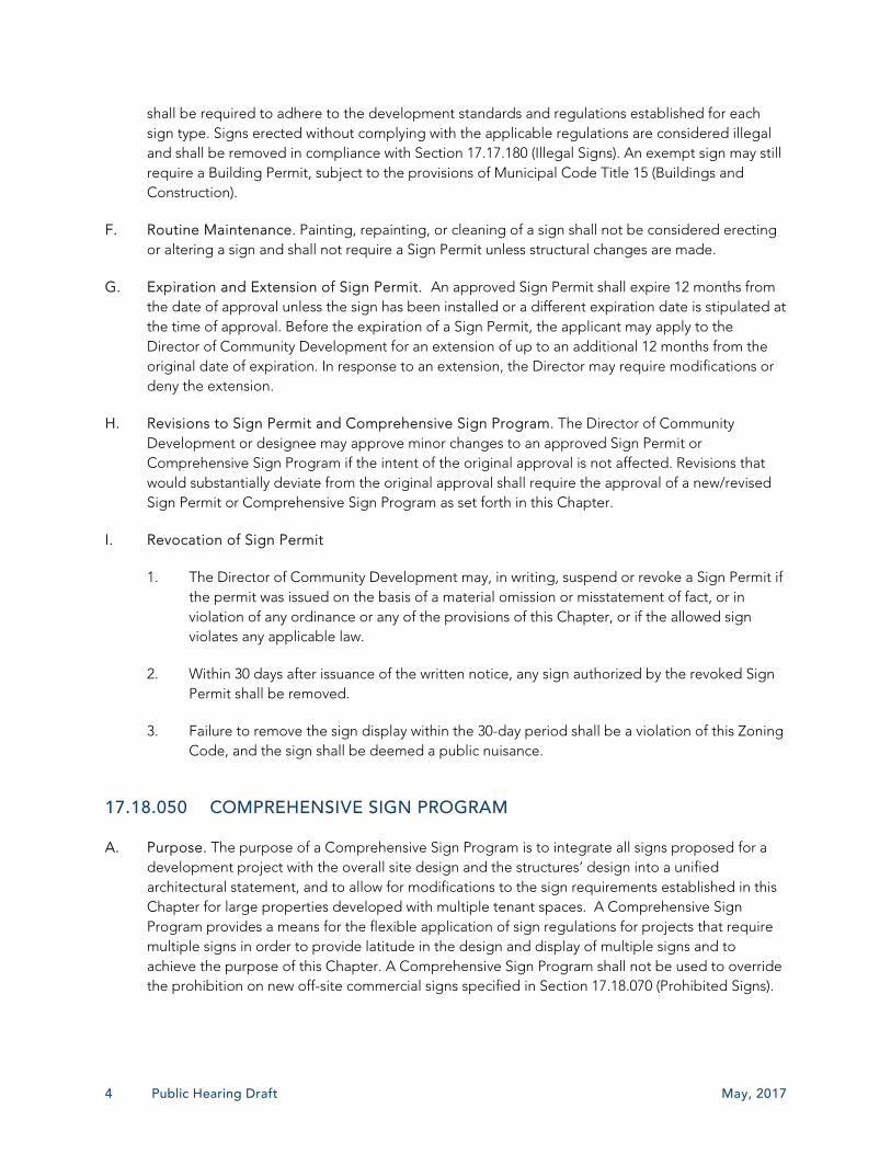
shall be required to adhere to the development standards and regulations established for each sign type. Signs erected without complying with the applicable regulations are considered illegal and shall be removed in compliance with Section 17.17.180 (Illegal Signs). An exempt sign may still require a Building Permit, subject to the provisions of Municipal Code Title 15 (Buildings and Construction).
F. Routine Maintenance. Painting, repainting, or cleaning of a sign shall not be considered erecting or altering a sign and shall not require a Sign Permit unless structural changes are made.
G. Expiration and Extension of Sign Permit. An approved Sign Permit shall expire 12 months from the date of approval unless the sign has been installed or a different expiration date is stipulated at the time of approval. Before the expiration of a Sign Permit, the applicant may apply to the Director of Community Development for an extension of up to an additional 12 months from the original date of expiration. In response to an extension, the Director may require modifications or deny the extension.
H. Revisions to Sign Permit and Comprehensive Sign Program. The Director of Community Development or designee may approve minor changes to an approved Sign Permit or Comprehensive Sign Program if the intent of the original approval is not affected. Revisions that would substantially deviate from the original approval shall require the approval of a new/revised Sign Permit or Comprehensive Sign Program as set forth in this Chapter.
I. Revocation of Sign Permit
1. The Director of Community Development may, in writing, suspend or revoke a Sign Permit if the permit was issued on the basis of a material omission or misstatement of fact, or in violation of any ordinance or any of the provisions of this Chapter, or if the allowed sign violates any applicable law.
2. Within 30 days after issuance of the written notice, any sign authorized by the revoked Sign Permit shall be removed.
3. Failure to remove the sign display within the 30-day period shall be a violation of this Zoning Code, and the sign shall be deemed a public nuisance.
17.18.050 COMPREHENSIVE SIGN PROGRAM
A. Purpose. The purpose of a Comprehensive Sign Program is to integrate all signs proposed for a development project with the overall site design and the structures’ design into a unified architectural statement, and to allow for modifications to the sign requirements established in this Chapter for large properties developed with multiple tenant spaces. A Comprehensive Sign Program provides a means for the flexible application of sign regulations for projects that require multiple signs in order to provide latitude in the design and display of multiple signs and to achieve the purpose of this Chapter. A Comprehensive Sign Program shall not be used to override the prohibition on new off-site commercial signs specified in Section 17.18.070 (Prohibited Signs).
May, 2017 Loma Linda Municipal Code – Signs 5
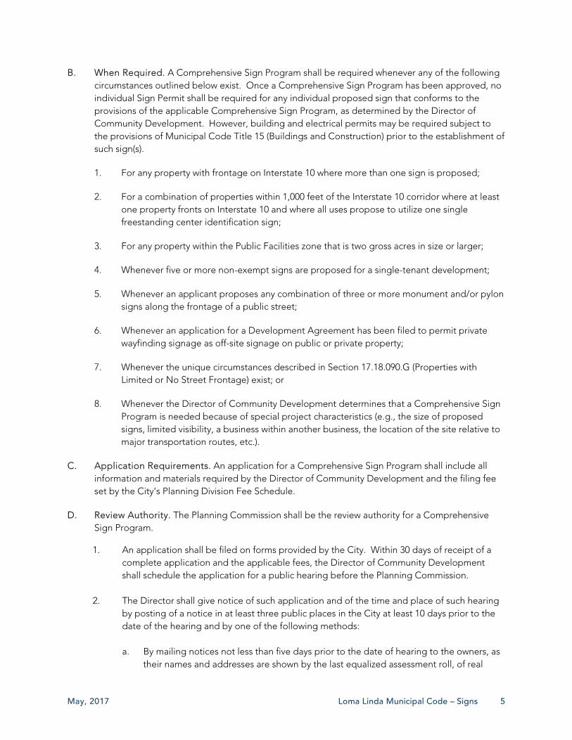
B. When Required. A Comprehensive Sign Program shall be required whenever any of the following circumstances outlined below exist. Once a Comprehensive Sign Program has been approved, no individual Sign Permit shall be required for any individual proposed sign that conforms to the provisions of the applicable Comprehensive Sign Program, as determined by the Director of Community Development. However, building and electrical permits may be required subject to the provisions of Municipal Code Title 15 (Buildings and Construction) prior to the establishment of such sign(s).
1. For any property with frontage on Interstate 10 where more than one sign is proposed;
2. For a combination of properties within 1,000 feet of the Interstate 10 corridor where at least one property fronts on Interstate 10 and where all uses propose to utilize one single freestanding center identification sign;
3. For any property within the Public Facilities zone that is two gross acres in size or larger;
4. Whenever five or more non-exempt signs are proposed for a single-tenant development;
5. Whenever an applicant proposes any combination of three or more monument and/or pylon signs along the frontage of a public street;
6. Whenever an application for a Development Agreement has been filed to permit private wayfinding signage as off-site signage on public or private property;
7. Whenever the unique circumstances described in Section 17.18.090.G (Properties with Limited or No Street Frontage) exist; or
8. Whenever the Director of Community Development determines that a Comprehensive Sign Program is needed because of special project characteristics (e.g., the size of proposed signs, limited visibility, a business within another business, the location of the site relative to major transportation routes, etc.).
C. Application Requirements. An application for a Comprehensive Sign Program shall include all information and materials required by the Director of Community Development and the filing fee set by the City’s Planning Division Fee Schedule.
D. Review Authority. The Planning Commission shall be the review authority for a Comprehensive Sign Program.
1. An application shall be filed on forms provided by the City. Within 30 days of receipt of a complete application and the applicable fees, the Director of Community Development shall schedule the application for a public hearing before the Planning Commission.
2. The Director shall give notice of such application and of the time and place of such hearing by posting of a notice in at least three public places in the City at least 10 days prior to the date of the hearing and by one of the following methods: a. By mailing notices not less than five days prior to the date of hearing to the owners, as
their names and addresses are shown by the last equalized assessment roll, of real

6 Public Hearing Draft May, 2017
property owners within 300 feet of the external boundaries of property under consideration; or
b. By posting said notice in conspicuous places close to the property affected, not less
than ten days prior to the date of such hearing, a notice consisting of the words: “NOTICE OF PROPOSED COMPREHENSIVE SIGN PROGRAM” printed in plain type letters not less than one inch in height and containing a statement in legible print setting forth a description of the property, the nature of the proposed Comprehensive Sign Program, and time and place of public hearing; or
c. By placing a legal advertisement in a newspaper of local circulation at least 10 days
prior to the date of the hearing.
3. The Planning Commission shall act to approve, approve with conditions, or deny the application. In acting to approve or conditionally approve a Comprehensive Sign Program, the Commission shall be required to make the following findings: a. That the Comprehensive Sign Program provides for the coordinated arrangement and
placement of signage on the property appropriate to advertise the businesses on the property;
b. That the Comprehensive Sign Program provides for the integration of the project's
signs with the design of the structures to achieve a unified architectural statement; c. That the site is adequate in size and shape to accommodate all proposed signs; d. That the Comprehensive Sign Program accommodates future revisions that may be
required due to changes in uses or tenants; and e. That the Comprehensive Sign Program complies with the standards of this Chapter,
except that flexibility is allowed regarding sign area, number, location, and/or height to the extent that the Comprehensive Sign Program will enhance the overall development and will more fully accomplish the purposes of this Chapter.
4. In the event an application is denied, the applicant may appeal the Planning Commission’s decision in compliance with Section 17.30.430 (Appeals) of the Municipal Code.
E. Standards. A Comprehensive Sign Program shall comply with the following standards:
1. The proposed sign program shall comply with the purpose and intent of this Chapter and any sign design guidelines by the City Council or Planning Commission.
2. The proposed signs shall enhance the overall development, be in harmony with, and relate visually to other signs included in the Comprehensive Sign Program, to the structures and developments they identify, and to surrounding development when applicable.
3. The sign program shall include all signs, including permanent, temporary, and exempt signs.

May, 2017 Loma Linda Municipal Code – Signs 7
4. The sign programs shall accommodate future revisions that may be required because of changes in use or tenants.
5. The sign program shall comply with the standards of this Chapter, except that deviations are allowed regarding sign area, total number, location, and height of signs to the extent that the Comprehensive Sign Program will enhance the overall development and will more fully accomplish the purposes and intent of this Chapter. Any such deviations shall consider the context in which a proposed sign or signs are to be located, with consideration to be given, for example, to the height and sign area of existing signs on surrounding properties, location relative to residential neighborhoods, and the City’s aesthetic goals established in the General Plan.
17.18.060 EXEMPT SIGNS
The signs identified in this Section are exempt from Sign Permit requirements and do not count toward the total allowable sign area limit otherwise applicable. However, the signs described in this Section are still subject to applicable building and electrical codes, safety codes, and all other applicable laws and regulations.
A. Address Signs. Address signs that are required by and conform with the Building Code for the valid purpose of identifying the location of a property for public safety and postal delivery purposes do not count toward the maximum allowable sign area.
B. Portable Temporary Signs, A-Frame Signs, Feather Flag Signs, and Wind Dancers in Commercial Zones. Portable temporary signs in the form of an A-frame, feather flag, wind dancer, and similar that are placed directly in front of an establishment, located on private property, removed from display at the end of every business day, and comply with all applicable provisions in this Chapter regarding temporary signs.
C. Change of Copy. Changing the copy in an approved changeable copy sign where the sign is in existence as of the adoption date of this Chapter.
D. Directional Signs. Monument directional signs erected for the sole purpose of providing directions to specific areas, including but not limited to, entrances, parking facilities, and on-site facilities may be displayed. Such signs shall have a maximum area of six square feet in area per face and four feet in overall height. Permitted locations shall be limited to one such sign per each public entrance or exit from the parking area and within parking areas. Building-mounted directional signs shall also be allowed as necessary to direct persons to specific functions of a business with separate exterior entrances. Building-mounted directional signs shall not exceed six square feet in area and shall be situated directly above or to the side of the entrance being identified.
E. Incidental Noncommercial Signs. Incidental signs individually not exceeding four square feet that are located near entrances, exits, parking areas, and restrooms.
F. Commemorative Tables, Permanent Memorial, Historical Signs (with limitations), and Building Name Signs. Names of buildings, commemorative tables, and the like when carved into stone, set

8 Public Hearing Draft May, 2017
in concrete or similar material, or constructed out of bronze, aluminum, or other durable material, provided any such individual sign is not more than four square feet in area.
G. Public Notices and Warnings. Signs displayed by a public body or officer in the performance of a public duty or by any person in compliance with a governmental requirement or legal duty or function. This Section applies to and includes signs whose function is to provide legal notice or functional information such as traffic signs, public transit signs, utility company signs, public restroom signs, warning signs, and signs placed by a public agency for the purpose of guiding persons to emergency centers and places of public interest.
H. Flags. Non-commercial message flags that conform to the following regulations shall be allowed in all zones and shall not require a sign permit.
1. Flags mounted on a building shall allow for a minimum clearance of seven feet over a pedestrian right-of-way and 15 feet over a vehicular way.
2. A maximum of three flags shall be allowed.
3. The maximum area of any one flag shall not exceed 15 square feet.
4. The maximum height of a flagpole shall be 15 feet in all residential zones and 30 feet in nonresidential zones.
I. Public Signs within a Public Right-of-Way.
1. Public signs posted by or for government agencies to provide public information, identify public property, post legal notices, or direct or regulate traffic of any kind.
2. Bus or train stop signs posted by public transit agencies.
3. Public utility signs that convey information about its lines, pipes, poles, or other facilities.
4. Emergency warning signs posted by a governmental agency, public utility, or contractor doing authorized work in the public right-of-way.
J. Temporary Signs. Signs that meet the definition of temporary signs established in this Chapter and comply with all applicable requirements of this Chapter.
K. Window Signs. Signs that meet the definition of window signs established in this Chapter and comply with all applicable requirements of this Chapter.
17.18.070 PROHIBITED SIGNS
The following signs and sign types shall be prohibited in all zones in the City.
A. Flashing Signs. Any sign that displays an intermittent or sequential flashing light source, exclusive of electronic changeable message signs that meet the standards in the Chapter.
May, 2017 Loma Linda Municipal Code – Signs 9
B. Hazardous Location. No sign shall be located in any manner where the sign, or a portion of the sign or sign supports, interferes with the free use of a fire escape, exit, or standpipe; obstructs a required door, stairway, ventilator, or window; encroaches into a public right-of-way without a proper City-issued encroachment permit; blocks doors, windows, or otherwise prevent ingress and egress to or from any window or door; blocks the view of traffic control devices; constitutes a traffic hazard or detriment to traffic safety by obstructing the vision of drivers, or by directing or tending to direct the attention of the drivers of moving vehicles from the traffic movement on the public street and highways; or is otherwise hazardous.
C. Animated Sign and Moving Signs. Any sign that blinks, flashes, shimmers, glitters, rotates, oscillates, is projected, or which gives the appearance of blinking, flashing, shimmering, glittering, rotating, oscillating, or moving, uses lighting, or special materials to depict action or create a special effect or scene. This classification includes wind-actuated and other elements (e.g., bunting, pennants, streamers, whirligigs) or other similar devices, except for feather flags and wind dancers permitted as temporary signs. For the purposes of this Chapter, time and temperature displays, flags, banners, traditional barber poles, and approved electronic changeable message signs that comply with the provisions of Section 17.18.100.B (Electronic Changeable Message Signs) are not considered animated signs.
D. Off-Site Commercial Signs. The City prohibits the construction, erection, or use of off-site signs displaying off-site commercial messages (i.e., billboards), other than those that legally exist in the City, or for which a valid permit has been issued and has not yet expired, as of the date on which this provision was first adopted. The City adopts this regulation to the extent allowed by the law and in compliance with California Government Code Section 65850, California Business and Professions Code Sections 5354(a) and 5408.3 (both effective January 1, 2003), or as subsequently amended. Permits shall not be issued for off-site signs displaying off-site commercial messages that violate this regulation, and the City will take immediate abatement action against signs constructed or maintained in violation of this regulation. This City intends for this off-site sign regulation to be severable and separately enforceable even if other provisions of this Chapter may be declared, by a court of competent jurisdiction, to be unconstitutional, invalid, or unenforceable. This provision does not prohibit agreements to relocate existing, legal off-site signs, as encouraged by California Business and Professions Code Section 5412.
E. Pole Signs. Any sign supported by a single pole or similar single support structure so that the bottom edge of the sign is one foot or more above the ground.
F. Portable Sign. Any sign designed to be moved easily and not permanently affixed to the ground or to a structure or building. For the purposes of this Chapter this does not include permitted temporary A-frame, feather flag, or wind dancer signs. See Section 17.18.060 (Exempt Signs).
G. Roof Signs. Any sign wholly erected, constructed, or placed on top of the roof of a structure, including a mansard roof, and partially or totally supported by the structure.
H. Signs on Natural Features. Signs that are located and maintained upon trees or painted or drawn on rocks or other natural features.
I. Supergraphics. Any painted design which covers all or a major portion of a wall, building facade, or other structure.

10 Public Hearing Draft May, 2017
J. Vehicle Signs. Signs identifying a business shall not be affixed to or placed in or on vehicles parked in the public right-of-way or on private property in a manner where the vehicle functions as a sign for a business. This regulation shall not apply to buses and taxicabs legally operating within the City limits, business identification signs painted or attached to a vehicle making deliveries or otherwise conducting normal business operations or vehicles owned and offered for sale by the owner, or other allowed uses regulated under other titles of the Municipal Code.
17.18.080 STANDARDS FOR ALL TYPES OF SIGNS
A. Compliance Required. No person shall erect, re-erect, construct, maintain, enlarge, alter, change copy, repair, move, improve, remove, convert, or equip any sign or sign structure, or paint a new wall-mounted sign in the City, or cause or permit the same to be done, contrary to or in violation of any provision of this Chapter.
B. Determination of Sign Location
1. The maximum allowed sign area for a sign shall be calculated by first determining if the sign is to be placed on a “primary” or “secondary” frontage (as defined in this Chapter) and then referring to Tables 17.18-1 through 17.18-3 in Section 17.18.090 (Permanent Signs by Zone -Locations and Design Requirements).
2. In cases where a building has more than one street frontage, the building frontage with the primary business entrance shall be considered the Primary Building Frontage. For multi-tenant buildings, ground-floor tenants may have their Primary Building Frontage determined independently by the Director of Community Development based upon this rule.
C. Measurement of Sign Area
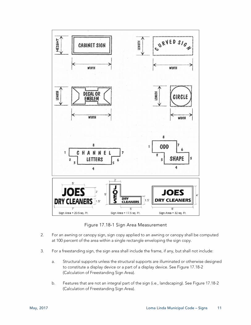
1. The surface area of a sign shall be calculated by enclosing the extreme limits of all framing, emblem, logo, representation, letters applied to the building without a distinctive background (e.g., channel letters), or other display within a single continuous perimeter composed of the smallest square, circle, rectangle, triangle, or other shapes. See Figure 17.18-1 (Sign Area Measurement).
May, 2017 Loma Linda Municipal Code – Signs 11
Figure 17.18-1 Sign Area Measurement
2. For an awning or canopy sign, sign copy applied to an awning or canopy shall be computed at 100 percent of the area within a single rectangle enveloping the sign copy.
3. For a freestanding sign, the sign area shall include the frame, if any, but shall not include:
a. Structural supports unless the structural supports are illuminated or otherwise designed to constitute a display device or a part of a display device. See Figure 17.18-2 (Calculation of Freestanding Sign Area).
b. Features that are not an integral part of the sign (i.e., landscaping). See Figure 17.18-2 (Calculation of Freestanding Sign Area).
HEI
GHT

12 Public Hearing Draft May, 2017
Figure 17.18-2 Calculation of Freestanding Sign Area
4. Only one face of a double-faced sign shall be counted in computing the allowed area of the sign. Double-faced (back-to-back) signs shall be counted as a single sign when the sign is mounted on a single structure and the distance between each sign face does not exceed two feet at any point. If the sign is multi-faced (e.g., more than two sides), then each face shall be counted in computing the allowed area of the sign.
5. Where a sign consists of one or more three-dimensional objects (i.e., balls, cubes, clusters of objects, sculpture, or statue-like trademarks), the sign area shall be measured as the maximum projection upon a vertical plane of the three-dimensional objects, as viewed from a position in the public right-of-way which produces the largest visual projection. See Figure 17.18-3 (Sign Area Measurement for Three-Dimensional Objects). Signs shall not contain three-dimensional objects that exceed a projection of six inches from the sign face.
Figure 17.18-3 Sign Area Measurement for Three Dimensional Objects
D. Measurement of Sign Height. The height of a sign shall be measured from the highest part of the sign, including any decorative features, to the height of the planned finished grade directly beneath the sign. For Freeway Center Identification Sign, the height may be measured from the freeway grade closest to the sign to the highest part of the sign.
May, 2017 Loma Linda Municipal Code – Signs 13
E. Sign Construction Materials. All signs that are not temporary signs shall be constructed of weather-durable materials, including but not limited to metal, wood, acrylic, or other comparable durable weatherproof materials, as determined by the Director of Community Development. No material more combustible than treated wood shall be used in the construction of any permanent sign.
F. Consistent Design. Where multiple signs are proposed, all signs shall be consistent with one another in terms of construction material, sign design, letter size and style, support method, and themes. Signs shall be designed to complement the use to which they are related through design elements of similar scale, color, and material.
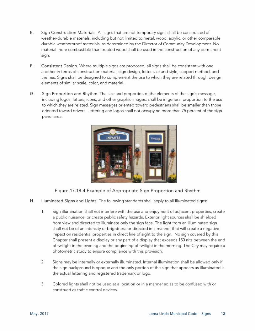
G. Sign Proportion and Rhythm. The size and proportion of the elements of the sign’s message, including logos, letters, icons, and other graphic images, shall be in general proportion to the use to which they are related. Sign messages oriented toward pedestrians shall be smaller than those oriented toward drivers. Lettering and logos shall not occupy no more than 75 percent of the sign panel area.
Figure 17.18-4 Example of Appropriate Sign Proportion and Rhythm
H. Illuminated Signs and Lights. The following standards shall apply to all illuminated signs:
1. Sign illumination shall not interfere with the use and enjoyment of adjacent properties, create a public nuisance, or create public safety hazards. Exterior light sources shall be shielded from view and directed to illuminate only the sign face. The light from an illuminated sign shall not be of an intensity or brightness or directed in a manner that will create a negative impact on residential properties in direct line of sight to the sign. No sign covered by this Chapter shall present a display or any part of a display that exceeds 150 nits between the end of twilight in the evening and the beginning of twilight in the morning. The City may require a photometric study to ensure compliance with this provision.
2. Signs may be internally or externally illuminated. Internal illumination shall be allowed only if the sign background is opaque and the only portion of the sign that appears as illuminated is the actual lettering and registered trademark or logo.
3. Colored lights shall not be used at a location or in a manner so as to be confused with or construed as traffic control devices.
14 Public Hearing Draft May, 2017
4. Reflective-type bulbs and incandescent lamps that exceed 15 watts shall not be used on the exterior surface of signs so that the face of the bulb or lamp is exposed to a public right-of-way or adjacent property.
5. Light sources shall utilize energy-efficient bulbs.
I. Sign Removal or Replacement. When a sign is removed, all brackets, poles, and other structural elements that supported the sign shall also be removed. For wall-mounted signs, affected building surfaces shall be restored to match the finish of the building, with sign wiring removed and all holes and other surface blemishes appropriately patched and finished (i.e., painted), subject to the approval of the Director of Community Development.
J. Conditional Use Permit Required for Electronic Changeable Message Signs. A Conditional Use Permit is required for all signs with electronic changeable messages, meaning any such sign that uses video display, flip-disks, incandescent lamps, fluorescent lamps, fiber optics, light-emitting diodes (LED), liquid crystal displays, plasma-displays, field emission displays, or any other mechanical or light emitting matrix to convey changing copy, message, or images.
17.18.090 PERMANENT SIGNS BY ZONE - LOCATIONS AND DESIGN REQUIREMENTS
A. Applicability. This Section establishes regulations for permanent signs by zone. References in the last column of Tables 17.18-1 through 17.18-3 provide additional regulations for specific sign types located elsewhere in this Chapter and identifies required permits.
B. Either Monument or Pylon as Primary Sign Type. No property shall be permitted to have both a monument sign(s) and a pylon sign(s) as the primary signage. Where the regulations in this Section indicate that a monument sign(s) and a pylon sign(s) are permitted, only one such sign type shall be allowed as the primary signage.
C. Zones Not Specified. Signs in all other zones not specified within this Section shall be subject to approval through a Comprehensive Sign Program in compliance with Section 17.17.050 (Comprehensive Sign Program).
D. Properties in the East Valley Corridor Overlay Zone. Tables 17.18-1 through 17.18-3 include regulations specific to properties within the East Valley Corridor Overlay Zone. Where specific regulations for the East Valley Corridor Overlay Zone are not indicated, the standards for the base zone shall apply.
E. Freeway Center Identification Signs. For any Freeway Center Identification Sign, as defined in this Chapter, in addition to regulations contained in this paragraph, the following shall apply. In a circumstance where a property is eligible for a Freeway Center Identification Sign and lies within the East Valley Corridor Overlay Zone, these Freeway Center Identification Sign regulations shall apply.
1. A Comprehensive Sign Program shall be required for any proposed Freeway Center Identification Sign. The Comprehensive Sign Program shall only be approved if the Planning Commission can find in the affirmative all the following:

May, 2017 Loma Linda Municipal Code – Signs 15
a. The signs are compatible with all other sign on the parcels for which the new signs are proposed, including individual freeway gateway signs;
b. The signs identify all of the parcels as a single center by a proper name for the center intended to be commonly used in other media to identify the property or properties, and that the name of the center shall be a dominant element of the sign by location, size, and prominence in the sign design; and
c. The parcels eligible for a Freeway Center Identification Sign are integrated in design and layout by at least one common feature, including but not limited to significant common open space, a common private street, driveway, or parking facilities.
2. Only one Freeway Center Identification Sign shall be allowed per center.
3. Notwithstanding the sign height requirements specified in this Section, the maximum height of a Freeway Center Identification Sign may be extended to 100 feet, subject to all criteria contained in this Section, and provided all of the following apply:
a. The new Freeway Center Identification Sign shall be located no closer than 1,000 feet from the closest existing Freeway Center Identification Sign; and
b. The Freeway Center Identification Sign shall serve a single parcel or collection of parcels having at least 1,000 lineal feet of freeway frontage.
4. In approving a Comprehensive Sign Program for a height extension for a Freeway Center Identification Sign, the Planning Commission, and City Council on appeal, shall be required to make the following findings:
a. The increased height will create increased visibility for the business or businesses that the sign advertises, thus allowing for heightened recognition and improved competition with similar commercial uses in other cities and surrounding areas;
b. The sign will not create adverse aesthetic impacts due to the casting of shadows, interference with protected views, or glare and lighting that impinges on nearby residential and other sensitive land uses;
c. A larger Freeway Center Identification Sign identifying a larger area and with greater sign separation would be more effective than a freeway gateway sign that follows the regulations of this Section; and
d. As applicable, that the presence of a visual obstruction of the property in question, such as bridges, structures, or vegetation not under the control of the owner/applicant, would prevent a shorter sign from being viewed, or the fact that the orientation of the property to the public right-of-way where the sign is intended to be viewed is unusual.
F. Bus Shelter Advertising Panel.
1. Where Allowed. Bus shelter advertising panels are allowed in any zone where a bus shelter associated with a public transit service provider is located, subject to the requirements of this Section.
2. Sign Permit Required. A Sign Permit shall be required to establish an advertising panel at any public transit center, bus shelter, bus stop, or other public transit-oriented structure that displays a public or commercial message.
3. Agreement and Encroachment Permit Required. An agreement between the City and the transit provider shall be established as a program to maintain and administer all bus shelter advertising panels. An encroachment permit shall be obtained for all bus shelter advertising panels located in the public right-of-way.
4. Dimensions and Design.
a. Bus shelter advertising panels shall not exceed 25 square feet in area.
16 Public Hearing Draft May, 2017
b. Such signs are allowed to have one double-sided advertising panel.
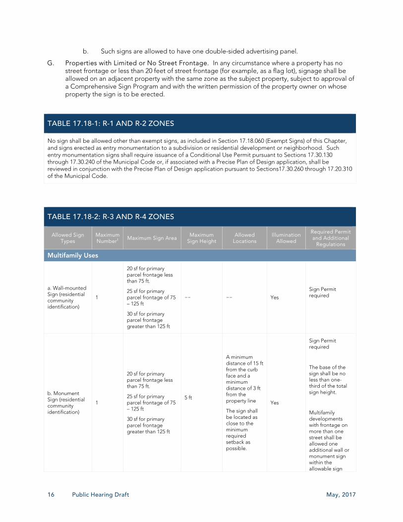
G. Properties with Limited or No Street Frontage. In any circumstance where a property has no street frontage or less than 20 feet of street frontage (for example, as a flag lot), signage shall be allowed on an adjacent property with the same zone as the subject property, subject to approval of a Comprehensive Sign Program and with the written permission of the property owner on whose property the sign is to be erected.
TABLE 17.18-1: R-1 AND R-2 ZONES
No sign shall be allowed other than exempt signs, as included in Section 17.18.060 (Exempt Signs) of this Chapter, and signs erected as entry monumentation to a subdivision or residential development or neighborhood. Such entry monumentation signs shall require issuance of a Conditional Use Permit pursuant to Sections 17.30.130 through 17.30.240 of the Municipal Code or, if associated with a Precise Plan of Design application, shall be reviewed in conjunction with the Precise Plan of Design application pursuant to Sections17.30.260 through 17.20.310 of the Municipal Code.
TABLE 17.18-2: R-3 AND R-4 ZONES
Allowed Sign Types
Maximum Number1
Maximum Sign Area Maximum
Sign Height Allowed
Locations Illumination
Allowed
Required Permit and Additional
Regulations
Multifamily Uses
a. Wall-mounted Sign (residential community identification)
1
20 sf for primary parcel frontage less than 75 ft.
25 sf for primary parcel frontage of 75 – 125 ft
30 sf for primary parcel frontage greater than 125 ft
—— —— Yes
Sign Permit required
b. Monument Sign (residential community identification)
1
20 sf for primary parcel frontage less than 75 ft.
25 sf for primary parcel frontage of 75 – 125 ft
30 sf for primary parcel frontage greater than 125 ft
5 ft
A minimum distance of 15 ft from the curb face and a minimum distance of 3 ft from the property line
The sign shall be located as close to the minimum required setback as possible.
Yes
Sign Permit required
The base of the sign shall be no less than one-third of the total sign height.
Multifamily developments with frontage on more than one street shall be allowed one additional wall or monument sign within the allowable sign

May, 2017 Loma Linda Municipal Code – Signs 17
TABLE 17.18-2: R-3 AND R-4 ZONES
Allowed Sign Types
Maximum Number1
Maximum Sign Area Maximum
Sign Height Allowed
Locations Illumination
Allowed
Required Permit and Additional
Regulations
area based on the applicable parcel frontage. In establishing the size of each sign, only the lineal frontage of the street upon which each of the sign faces shall be used in the computations, and that sign area shall be the maximum allowed on the street frontage.
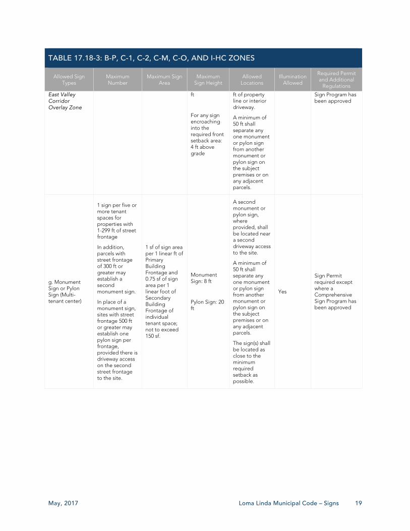
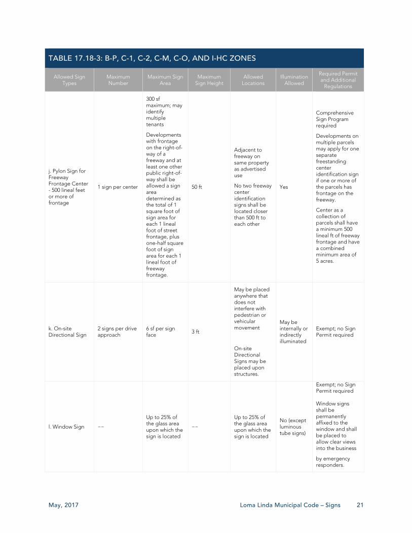
TABLE 17.18-3: B-P, C-1, C-2, C-M, C-O, AND I-HC ZONES
Allowed Sign Types
Maximum Number
Maximum Sign Area
Maximum Sign Height
Allowed Locations
Illumination Allowed
Required Permit and Additional
Regulations
Single and Multiple Tenant Sites
a. Awning Sign 1 per tenant space
20 sf N/A Limited to the front panel of the awning
Yes
Sign Permit required except where a Comprehensive Sign Program has been approved
b. Blade/Bracket Signs
1 per tenant space
6 sf
N/A
Shall be mounted to provide a minimum of 7 ft of clearance from the bottom of the sign to the public right-of-way.
On Primary Building Frontage, first floor only.
Yes
Sign Permit required except where a Comprehensive Sign Program has been approved
Sign may on extend over a public right-of-way if appropriate encroachment permits have been issued by the City.
c. Wall-mounted Sign
1 per tenant space
1 sf for each 1 foot of primary parcel frontage upon which the structure is located
See Section 17.18.100.H
See Section 17.18.100.H
Yes
Sign Permit required except where a Comprehensive Sign Program has been approved
One additional
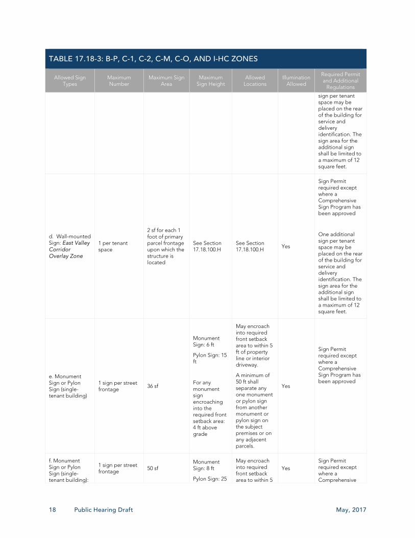
18 Public Hearing Draft May, 2017
TABLE 17.18-3: B-P, C-1, C-2, C-M, C-O, AND I-HC ZONES
Allowed Sign Types
Maximum Number
Maximum Sign Area
Maximum Sign Height
Allowed Locations
Illumination Allowed
Required Permit and Additional
Regulations
sign per tenant space may be placed on the rear of the building for service and delivery identification. The sign area for the additional sign shall be limited to a maximum of 12 square feet.
d. Wall-mounted Sign: East Valley Corridor Overlay Zone
1 per tenant space
2 sf for each 1 foot of primary parcel frontage upon which the structure is located
See Section 17.18.100.H
See Section 17.18.100.H Yes
Sign Permit required except where a Comprehensive Sign Program has been approved
One additional sign per tenant space may be placed on the rear of the building for service and delivery identification. The sign area for the additional sign shall be limited to a maximum of 12 square feet.
e. Monument Sign or Pylon Sign (single-tenant building)
1 sign per street frontage
36 sf
Monument Sign: 6 ft
Pylon Sign: 15 ft
For any monument sign encroaching into the required front setback area: 4 ft above grade
May encroach into required front setback area to within 5 ft of property line or interior driveway.
A minimum of 50 ft shall separate any one monument or pylon sign from another monument or pylon sign on the subject premises or on any adjacent parcels.
Yes
Sign Permit required except where a Comprehensive Sign Program has been approved
f. Monument Sign or Pylon Sign (single-tenant building):
1 sign per street frontage 50 sf
Monument Sign: 8 ft
Pylon Sign: 25
May encroach into required front setback area to within 5
Yes Sign Permit required except where a Comprehensive
May, 2017 Loma Linda Municipal Code – Signs 19
TABLE 17.18-3: B-P, C-1, C-2, C-M, C-O, AND I-HC ZONES
Allowed Sign Types
Maximum Number
Maximum Sign Area
Maximum Sign Height
Allowed Locations
Illumination Allowed
Required Permit and Additional
Regulations
East Valley Corridor Overlay Zone
ft
For any sign encroaching into the required front setback area: 4 ft above grade
ft of property line or interior driveway.
A minimum of 50 ft shall separate any one monument or pylon sign from another monument or pylon sign on the subject premises or on any adjacent parcels.
Sign Program has been approved
g. Monument Sign or Pylon Sign (Multi-tenant center)
1 sign per five or more tenant spaces for properties with 1-299 ft of street frontage
In addition, parcels with street frontage of 300 ft or greater may establish a second monument sign.
In place of a monument sign, sites with street frontage 500 ft or greater may establish one pylon sign per frontage, provided there is driveway access on the second street frontage to the site.
1 sf of sign area per 1 linear ft of Primary Building Frontage and 0.75 sf of sign area per 1 linear foot of Secondary Building Frontage of individual tenant space; not to exceed 150 sf.
Monument Sign: 8 ft
Pylon Sign: 20 ft
A second monument or pylon sign, where provided, shall be located near a second driveway access to the site.
A minimum of 50 ft shall separate any one monument or pylon sign from another monument or pylon sign on the subject premises or on any adjacent parcels.
The sign(s) shall be located as close to the minimum required setback as possible.
Yes
Sign Permit required except where a Comprehensive Sign Program has been approved

20 Public Hearing Draft May, 2017
TABLE 17.18-3: B-P, C-1, C-2, C-M, C-O, AND I-HC ZONES
Allowed Sign Types
Maximum Number
Maximum Sign Area
Maximum Sign Height
Allowed Locations
Illumination Allowed
Required Permit and Additional
Regulations
h. Monument Sign (Multi-tenant center): East Valley Corridor Overlay Zone
1 sign per five or more tenant spaces for properties with 1-299 ft of street frontage
In addition, parcels with street frontage of 300 ft or greater may establish a second monument sign.
In place of a monument sign, sites with street frontage 500 ft or greater may establish one pylon sign per frontage, provided there is driveway access on the second street frontage to the site.
2 sf of sign area per 1 linear ft of Primary Building Frontage and 0.75 sf of sign area per 1 linear foot of Secondary Building Frontage of individual tenant space; not to exceed 300 sf.
Monument Sign: 8 ft
Pylon Sign: 30 ft
A second monument or pylon sign, where provided, shall be located near a second driveway access to the site.
A minimum of 50 ft shall separate any one monument or pylon sign from another monument or pylon on the subject premises or on any adjacent parcels.
The sign(s) shall be located as close to the minimum required setback as possible.
Yes
Sign Permit required except where a Comprehensive Sign Program has been approved
i. Pylon Sign for Freeway Frontage Parcel - 200-499 lineal ft
1 per center
250 sf maximum; may identify multiple tenants
Developments with frontage on the right-of-way of a freeway and at least one other public right-of-way shall be allowed a sign area determined as the total of one square foot of sign area for each one lineal foot of street frontage plus one-half square foot of sign area for each one lineal foot of freeway frontage.
40 ft
Adjacent to freeway on same property as advertised use
No two freeway gateway signs shall be located closer than 100 ft to each other
Yes
Comprehensive Sign Program required
Parcel where the sign is located shall have minimum 200 ft of linear freeway frontage and be located on a freeway frontage parcel with a minimum area of 3 acres or have principle structures consisting of a collective 50,000 sf or more.
May, 2017 Loma Linda Municipal Code – Signs 21
TABLE 17.18-3: B-P, C-1, C-2, C-M, C-O, AND I-HC ZONES
Allowed Sign Types
Maximum Number
Maximum Sign Area
Maximum Sign Height
Allowed Locations
Illumination Allowed
Required Permit and Additional
Regulations
j. Pylon Sign for Freeway Frontage Center - 500 lineal feet or more of frontage
1 sign per center
300 sf maximum; may identify multiple tenants
Developments with frontage on the right-of-way of a freeway and at least one other public right-of-way shall be allowed a sign area determined as the total of 1 square foot of sign area for each 1 lineal foot of street frontage, plus one-half square foot of sign area for each 1 lineal foot of freeway frontage.
50 ft
Adjacent to freeway on same property as advertised use
No two freeway center identification signs shall be located closer than 500 ft to each other
Yes
Comprehensive Sign Program required
Developments on multiple parcels may apply for one separate freestanding center identification sign if one or more of the parcels has frontage on the freeway.
Center as a collection of parcels shall have a minimum 500 lineal ft of freeway frontage and have a combined minimum area of 5 acres.
k. On-site Directional Sign
2 signs per drive approach
6 sf per sign face 3 ft
May be placed anywhere that does not interfere with pedestrian or vehicular movement
On-site Directional Signs may be placed upon structures.
May be internally or indirectly illuminated
Exempt; no Sign Permit required
l. Window Sign --
Up to 25% of the glass area upon which the sign is located
——
Up to 25% of the glass area upon which the sign is located
No (except luminous tube signs)
Exempt; no Sign Permit required Window signs shall be permanently affixed to the window and shall be placed to allow clear views into the business
by emergency responders.

22 Public Hearing Draft May, 2017
TABLE 17.18-4: PF ZONE
Allowed Sign Types
Maximum Number
Maximum Sign Area
Maximum Sign Height
Allowed Locations
Illumination Allowed
Required Permits and Additional
Regulations
a. Blade/Bracket Signs
In addition to allowed Wall-mounted Signs, 1 Blade/Bracket sign is allowed each per tenant space
6 sf
N/A
Shall be mounted to provide a minimum of 7 ft of clearance from the bottom of the sign to the public right-of-way.
On Primary Building Frontage, first floor only.
Yes
Sign Permit required
Sign may on extend over a public right-of-way if appropriate encroachment permits have been issued by the City.
b. Monument Sign or Pylon Sign
1 sign per use with 0-300 ft of lineal street frontage
Parcels with street frontage of 300 ft or more may establish a second sign
1 sf per 1 lineal ft of street frontage
Monument Sign: 8 ft
Pylon Sign: 25 ft.
For any sign encroaching into the required front setback area: 4 ft above grade
Where allowed, the second sign shall be located near a second driveway access to the site.
A minimum of 50 ft shall separate any one monument or pylon sign from another monument or pylon sign on the subject premises or on any adjacent parcels.
The sign(s) shall be located as close to the minimum required setback as possible.
One sign per property may encroach into the required front setback area to within 5 ft of property line or interior driveway.
Yes
Sign Permit required
See Sections 17.18.100.F and 17.18.100.G regarding additional standards.
c. Wall-mounted Sign
1 per facility occupant
100 sf per structure. May be modified as part of a Comprehensive Sign Program.
—— See Section 17.188.100.H
Yes
Sign Permit required except where a Comprehensive Sign Program has been approved.
See Section 17.188.100.H

May, 2017 Loma Linda Municipal Code – Signs 23
TABLE 17.18-4: PF ZONE
Allowed Sign Types
Maximum Number
Maximum Sign Area
Maximum Sign Height
Allowed Locations
Illumination Allowed
Required Permits and Additional
Regulations
regarding additional standards.
d. Ground-mounted On-site Directional Signs
As approved through the Design Review process
6 sf per sign face
3 ft.
May be placed anywhere that does not interfere with pedestrian or vehicular movement
May be internally or indirectly illuminated
Exempt; no Sign Permit required
e. Permanent Window Sign
——
Up to 25% of the glass area upon which the sign is located
—— —— No (except luminous tube signs)
Window signs shall be permanently affixed to the window and shall be placed to allow clear views into the business by emergency responders.
24 Public Hearing Draft May, 2017
17.18.100 SPECIFIC TYPES OF PERMANENT SIGNS
The following regulations apply to specific types of permanent signs in any zone where such signs are allowed.
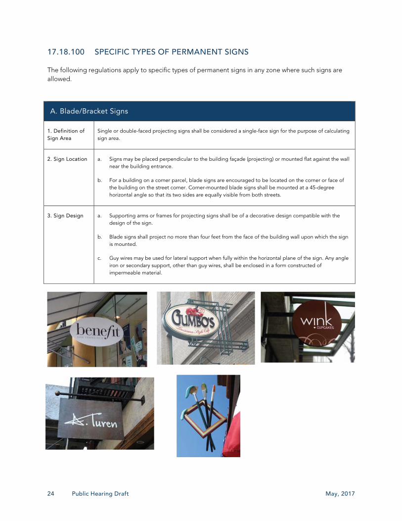
A. Blade/Bracket Signs
1. Definition of Sign Area
Single or double-faced projecting signs shall be considered a single-face sign for the purpose of calculating sign area.
2. Sign Location a. Signs may be placed perpendicular to the building façade (projecting) or mounted flat against the wall near the building entrance.
b. For a building on a corner parcel, blade signs are encouraged to be located on the corner or face of the building on the street corner. Corner-mounted blade signs shall be mounted at a 45-degree horizontal angle so that its two sides are equally visible from both streets.
3. Sign Design a. Supporting arms or frames for projecting signs shall be of a decorative design compatible with the design of the sign.
b. Blade signs shall project no more than four feet from the face of the building wall upon which the sign is mounted.
c. Guy wires may be used for lateral support when fully within the horizontal plane of the sign. Any angle iron or secondary support, other than guy wires, shall be enclosed in a form constructed of impermeable material.
May, 2017 Loma Linda Municipal Code – Signs 25
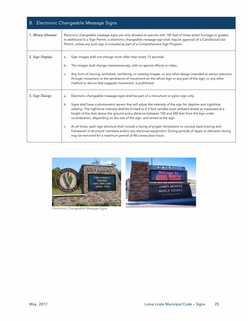
Electronic Changeable Message Signs
B. Electronic Changeable Message Signs
1. Where Allowed Electronic changeable message signs are only allowed on parcels with 100 feet of linear street frontage or greater. In additional to a Sign Permit, a electronic changeable message sign shall require approval of a Conditional Use Permit, unless any such sign is included as part of a Comprehensive Sign Program.
2. Sign Display a. Sign images shall not change more often than every 15 seconds.
b. The images shall change instantaneously, with no special effects or video.
c. Any form of moving, animated, oscillating, or rotating images, or any other design intended to attract attention through movement or the semblance of movement on the whole sign or any part of the sign, or any other method or device that suggests movement, is prohibited.
3. Sign Design a. Electronic changeable message signs shall be part of a monument or pylon sign only.
b. Signs shall have a photometric sensor that will adjust the intensity of the sign for daytime and nighttime viewing. The nighttime intensity shall be limited to 0.3 foot candles (over ambient levels) as measured at a height of five feet above the ground and a distance between 150 and 350 feet from the sign under consideration, depending on the size of the sign, and aimed at the sign.
c. At all times, each sign structure shall include a facing of proper dimensions to conceal back bracing and framework of structural members and/or any electrical equipment. During periods of repair or alteration facing may be removed for a maximum period of 48 consecutive hours.

26 Public Hearing Draft May, 2017
C. Changeable Copy Signs (Manual)
1. Where and How Many Allowed
a. Changeable copy displays may be installed on marquee, monument, pylon, and wall-mounted signs. The area of the changeable copy display shall be counted toward the allowable sign area for the type of sign upon which the changeable copy is installed.
b. The number of Manual Changeable Copy Signs is limited to one per property.
2. Lighting Manual changeable copy signs shall not be internally lit unless they use opaque inserts with translucent copy, black opaque inserts that are the same color as the opaque portions of the copy are used over all areas of the sign where copy is not present, and the opaque portion of the copy is the same color.
Manual Changeable Copy Sign

May, 2017 Loma Linda Municipal Code – Signs 27
D. Channel Letter Signs
1. Sign Design a. Only translucent faces, reverse lit channel letters, or push-through acrylic panels are allowed.
b. Exposed raceways are prohibited unless necessitated by structural features and subject to a determination by the Director of Community Development, through the review of any associated permits, that unique conditions exist. Such determination shall be documented in writing.
2. Sign Lighting a. Channel letter signs may only be internally illuminated. No open-face channel letters are allowed, whereas the method of illumination, such as but not limited to neon tubing, LED lighting, light bulb arrangement or similar, is exposed.
b. A maximum of 10 foot-candles is allowed on any portion of the sign.
c. The light source of illuminated channel letter signs shall not be visible from or cast into the right-of-way nor cause glare hazards to passersby or adjacent properties.
d. Light sources shall not be mounted to any part of the sign.
Push-through Channel Letter Sign (Wall-mounted)
LED Channel Letter Sign
Reserve-lit Channel Letter Sign (Wall-Mounted)
28 Public Hearing Draft May, 2017
E. Luminous Tube Signs
1. Included in Sign Area
Luminous tubes shall be considered part of a sign for purposes of calculating the borders of the maximum allowable sign area.
2. Sign Design a. Luminous tube lighting shall be listed with UL (Underwriters Laboratories).
b. Tubing shall not exceed one-half inch in diameter.
c. Luminous tubes shall not be combined with any reflective materials (e.g., mirrors, polished metal, highly glazed tiles, or other similar materials).
d. Luminous tube lighting that surrounds a window, door, or similar element or installed along roofs or that outlines buildings shall be prohibited.
3. Sign Lighting a. Luminous tube lighting adjacent to residential uses shall not exceed one-half foot-candle measured at the residential parcel line.
b. Signs shall have 30 milliamps per circuit maximum and a dimmer to reduce brightness.
Exterior Luminous Tube Sign
F. Monument Signs – Additional Standards
1. Frontage Requirement
A minimum property frontage on 60 feet shall be required for a monument sign.
2. Sign Design a. To ensure that emergency response personal can identify a location, the minimum letter size shall be nine inches.
b. Sign copy shall not be located closer than one half-letter height to the sign edge or other line of copy.
c. Where there is a center name or identification separate from the primary tenant, the center name or identification shall be provided and predominantly displayed on the primary monument sign and shall be counted towards the allowable sign area. This center name or identification shall be incorporated as a permanent feature of the
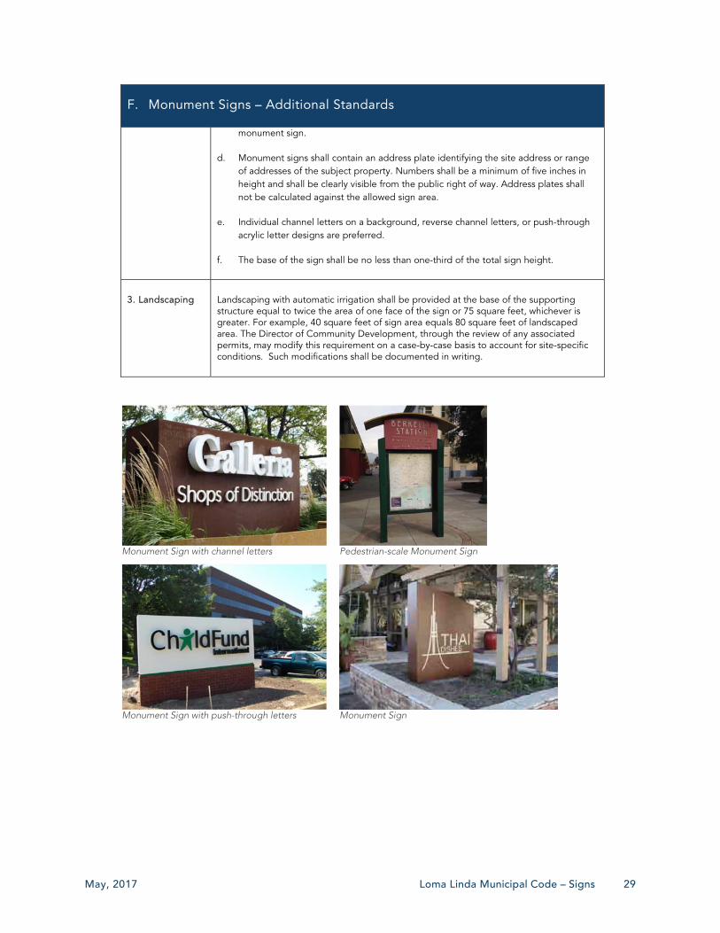
May, 2017 Loma Linda Municipal Code – Signs 29
F. Monument Signs – Additional Standards
monument sign.
d. Monument signs shall contain an address plate identifying the site address or range of addresses of the subject property. Numbers shall be a minimum of five inches in height and shall be clearly visible from the public right of way. Address plates shall not be calculated against the allowed sign area.
e. Individual channel letters on a background, reverse channel letters, or push-through acrylic letter designs are preferred.
f. The base of the sign shall be no less than one-third of the total sign height.
3. Landscaping Landscaping with automatic irrigation shall be provided at the base of the supporting structure equal to twice the area of one face of the sign or 75 square feet, whichever is greater. For example, 40 square feet of sign area equals 80 square feet of landscaped area. The Director of Community Development, through the review of any associated permits, may modify this requirement on a case-by-case basis to account for site-specific conditions. Such modifications shall be documented in writing.
Monument Sign with channel letters
Pedestrian-scale Monument Sign
Monument Sign with push-through letters
Monument Sign
30 Public Hearing Draft May, 2017
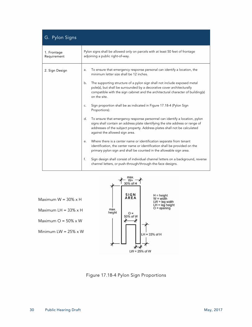
G. Pylon Signs
1. Frontage Requirement
Pylon signs shall be allowed only on parcels with at least 50 feet of frontage adjoining a public right-of-way.
2. Sign Design a. To ensure that emergency response personal can identify a location, the minimum letter size shall be 12 inches.
b. The supporting structure of a pylon sign shall not include exposed metal pole(s), but shall be surrounded by a decorative cover architecturally compatible with the sign cabinet and the architectural character of building(s) on the site.
c. Sign proportion shall be as indicated in Figure 17.18-4 (Pylon Sign Proportions).
d. To ensure that emergency response personnel can identify a location, pylon signs shall contain an address plate identifying the site address or range of addresses of the subject property. Address plates shall not be calculated against the allowed sign area.
e. Where there is a center name or identification separate from tenant identification, the center name or identification shall be provided on the primary pylon sign and shall be counted in the allowable sign area.
f. Sign design shall consist of individual channel letters on a background, reverse channel letters, or push-through/through-the-face designs.
Maximum W = 30% x H
Maximum LH = 33% x H
Maximum O = 50% x W
Minimum LW = 25% x W
Figure 17.18-4 Pylon Sign Proportions
May, 2017 Loma Linda Municipal Code – Signs 31
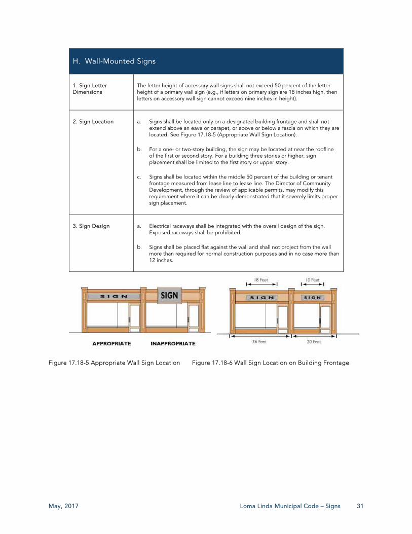
H. Wall-Mounted Signs
1. Sign Letter Dimensions
The letter height of accessory wall signs shall not exceed 50 percent of the letter height of a primary wall sign (e.g., if letters on primary sign are 18 inches high, then letters on accessory wall sign cannot exceed nine inches in height).
2. Sign Location a. Signs shall be located only on a designated building frontage and shall not extend above an eave or parapet, or above or below a fascia on which they are located. See Figure 17.18-5 (Appropriate Wall Sign Location).
b. For a one- or two-story building, the sign may be located at near the roofline of the first or second story. For a building three stories or higher, sign placement shall be limited to the first story or upper story.
c. Signs shall be located within the middle 50 percent of the building or tenant frontage measured from lease line to lease line. The Director of Community Development, through the review of applicable permits, may modify this requirement where it can be clearly demonstrated that it severely limits proper sign placement.
3. Sign Design a. Electrical raceways shall be integrated with the overall design of the sign. Exposed raceways shall be prohibited.
b. Signs shall be placed flat against the wall and shall not project from the wall more than required for normal construction purposes and in no case more than 12 inches.
Figure 17.18-5 Appropriate Wall Sign Location Figure 17.18-6 Wall Sign Location on Building Frontage
32 Public Hearing Draft May, 2017
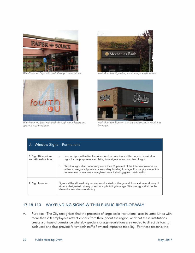
Wall-Mounted Sign with push through metal letters
Wall-Mounted Sign with push-through acrylic letters
Wall-Mounted Sign with push-through metal letters and approved painted sign
Wall-Mounted Signs on primary and secondary building frontages
J. Window Signs – Permanent
1. Sign Dimensions and Allowable Area
a. Interior signs within five feet of a storefront window shall be counted as window signs for the purpose of calculating total sign area and number of signs.
b. Window signs shall not occupy more than 25 percent of the total window area on either a designated primary or secondary building frontage. For the purpose of this requirement, a window is any glazed area, including glass curtain walls.
2. Sign Location Signs shall be allowed only on windows located on the ground floor and second story of either a designated primary or secondary building frontage. Window signs shall not be allowed above the second story.
17.18.110 WAYFINDING SIGNS WITHIN PUBLIC RIGHT-OF-WAY
A. Purpose. The City recognizes that the presence of large-scale institutional uses in Loma Linda with more than 250 employees attract visitors from throughout the region, and that these institutions create a unique circumstance whereby special signage regulations are needed to direct visitors to such uses and thus provide for smooth traffic flow and improved mobility. For these reasons, the

May, 2017 Loma Linda Municipal Code – Signs 33
City hereby establishes these regulations to allow for wayfinding signs within public rights-of-way subject to the approval of a Development Agreement.
B. Wayfinding Signage Allowed – Requirements. Institutional uses shall be permitted to erect wayfinding signage within any public right-of-way subject to approval of a Development Agreement by the City Council for each individual placement of a sign or group of signs, as well as an Encroachment Permit pursuant to Section 12.04.080 (Encroachment permit required when) of the Municipal Code. Any such signage shall be subject to the following minimum requirements, as well as any additional requirements that are specified in an approved Development Agreement.
1. Wayfinding signage shall be of a coordinated, uniform nature in terms of color, style, and use of font.
2. Any such signage shall be designed and erected in a manner that, subject to the determination of the Director of Public Works, will not interfere with safe vehicular traffic and pedestrian movement.
3. Any such signage shall, subject to the determination of the City Council, promote the City’s objectives for economic development, traffic regulations, and public safety.
C. Procedure. Any proposal to erect wayfinding signage within the public right-of-way shall require preparation of a Comprehensive Sign Program pursuant to Section 17.18.050 (Comprehensive Sign Program) of this Chapter. The Comprehensive Sign Program application shall be submitted in conjunction with any materials required for a Development Agreement application. The Director of Community Development shall have the authority to further determine the application requirements based upon the specifics of each proposed Comprehensive Sign Program for Wayfinding Signage.
17.18.120 SIGNS FOR SPECIFIC USES
A. Drive-through Establishments. In addition to the signs allowed in Section 17.18.090 (Permanent Signs by Zone – Locations and Design Requirements), drive-through food service establishments shall be allowed the following signs subject to the issuance of a Sign Permit or as part of a Comprehensive Sign Program. The purpose of such signs is to ensure the flow of traffic to and through a drive-through facility in a manner that does not obstruct vehicles on a public right-of-way and does not interfere with pedestrian movement and safety on public or private property.
1. One freestanding sign oriented to the drive-through lane with copy on a single face not to exceed 50 square feet in sign area and seven feet in height;
2. One wall-mounted menu board not to exceed 15 square feet, located in the immediate area of the drive-through lane only, and readable only onsite; and
3. Incidental signs as defined in this Chapter.
B. Home Occupations. No signs shall be provided in association with any home occupation use.

34 Public Hearing Draft May, 2017
C. Multi-tenant Buildings. Multi-tenant buildings are allowed one additional incidental sign oriented to the pedestrian or vehicle entrance with a maximum area of eight square feet. No illumination is allowed. These business directory signs shall not count towards the maximum allowable sign area for a site. Such signs shall require issuance of a Sign Permit or shall be identified in a Comprehensive Sign Program.
D. Places of Assembly. In addition to signs allowed in Section 17.18.090 (Permanent Signs by Zone – Locations and Design Requirements), facilities whose activities and events change on a regular basis (e.g., places of worship, skate rinks, theaters, stadiums, etc.) shall be allowed the following additional signs. Such signs shall require issuance of a Sign Permit or approval of a Comprehensive Sign Program.
1. Theaters with three or more screens shall be allowed an additional 10 square feet of sign area for each screen.
2. Glass encasements for special advertisements shall be allowed to be affixed to the primary building. Encasements shall not exceed a width of three feet or a height of four feet, the number of which shall be approved by the Director of Community Development via the Sign Permit process.
E. Service Stations. In addition to the signs allowed in Section 17.18.090 (Permanent Signs by Zone – Locations and Design Requirements), service stations shall be allowed the following signs subject to the issuance of a Sign Permit or approval of a Comprehensive Sign Program.
1. Service stations shall be allowed one wall or monument sign for each street frontage. A combination of wall and monument signs may be used, but no more than a total of four signs shall be allowed.
2. Wall signs shall not exceed 10 percent of the building face, with a maximum size of 30 square feet, and not exceed past the roofline or 20 feet above finish grade, whichever is less. A total maximum of two wall signs are allowed per service station.
3. Monument signs shall be located in a landscaped planter with a minimum area equal to the area of the sign.
4. Additional incidental signs are allowed up to a maximum of two per each service island, and each such sign not exceeding three square feet.
5. Signs required or authorized by State or Federal law.

May, 2017 Loma Linda Municipal Code – Signs 35
17.18.130 TEMPORARY SIGNS
A. Applicability. This Section establishes regulations for all temporary signs.
B. Temporary Sign Content Neutrality. All regulations and standards in this Section are to be exercised in light of the City’s content neutrality policy. These provisions are not intended to limit, censor, or restrict free speech.
C. Number. The maximum number of temporary signs that may be displayed at the same time is subject to compliance with the applicable requirements of this Section. The number and area of temporary signs shall not be included in the calculation of aggregate permanent sign area.
D. Materials. Temporary exterior signs shall be made of durable, weather-resistant material.
E. Sign Placement.
1. Temporary signs are allowed on private property only subject to permission of the property and shall not be placed in any public right-of-way or at off-site locations except as specified in this Section.
2. Temporary signs may be placed only in locations where permanent signs are allowed and shall not be attached to temporary structures. Placement on fences is acceptable.
3. Temporary signs shall be located a minimum distance of 10 feet from the side property line, three feet from the front property line or sidewalk, and at least five feet from a paved road (if no sidewalk exists).
4. Temporary signs shall not be placed within any corner cutoff area as defined by Section 17.14.020 (Corner cutoff area – Street intersections) of the Municipal Code.
F. Protected Noncommercial Message and Free Speech Signs. Non-illuminated temporary signs displaying protected non-commercial messages may be displayed at any time. Such signs shall be limited to a maximum height of four feet and a maximum total area of six feet. However, during the time period beginning 90 days before a general, special, primary, or runoff election and ending 14 days after such election, the amount of display area may be doubled. Any such sign shall be removed within 30 days following the election.
G. Residential Zones.
1. Number and Size Allowed.
a. One sign not to exceed three feet in height or six square feet in area per face allowed.
b. For signs posted on property that is actively marketed for sale or lease, one sign not to exceed six square feet per face, mounted on a post/arm of maximum six feet in height. The sign may have one secondary attached sign not to exceed one square foot and one brochure box not to exceed one square foot.

36 Public Hearing Draft May, 2017
c. Temporary signs located in a subdivision that is actively marketed for sale or lease shall be allowed on the same parcel with a model home, provided the signs do not exceed four in number and 10 square feet in area each.
2. Duration.
a. For temporary signs posted on a property that is actively marketed for sale or lease, display shall be limited to the time period during which the property is actively marketed for sale or lease. Such signs shall be removed within seven days of the close of sale or lease.
b. For temporary signs posted on a property on which a one-time event lasting three days or fewer is held, the sign(s) shall be erected no earlier than three days prior to the first day of the event and shall be removed within three days of the last day of the event. For events lasting four or more days, the sign(s) shall be erected no earlier than seven days prior to the first day of the event and shall be removed within three days of the last day of the event.
H. Non-Residential Zones.
1. Number and Size Allowed.
a. One temporary portable sign per property is allowed, except in the case of a multi-tenant center, each business shall be allowed one portable A-frame sign.
b. One sign not to exceed six feet in height or 36 square feet in area is allowed.
c. For signs posted on a property that is actively marketed for sale or lease, one sign not to exceed 36 square feet per face.
2. Duration.
a. For temporary signs erected for on a property that is actively marketed for sale or lease, display shall be limited to the time period during which the property or tenant space is actively marketed for sale or lease. Such signs shall be removed within seven days of the close of sale or lease.
b. For temporary signs posted on a property on which a one-time event lasting three days or fewer is held, the sign(s) shall be erected no earlier than three days prior to the first day of the event and shall be removed within three days of the last day of the event. For events lasting four or more days, the sign(s) shall be erected no earlier than seven days prior to the first day of the event and shall be removed within seven days of the last day of the event.
3. Allowable Sign Types. Wall-mounted, freestanding, canopy and awning, and portable signs are allowed.
May, 2017 Loma Linda Municipal Code – Signs 37
I. Portable Temporary Signs. The use of pedestrian-oriented, portable signs is allowed in non-residential zones on private properties in addition to other temporary signs and subject to the following standards.
1. Only businesses with street frontages shall be allowed to have portable signs. Businesses located along private pedestrian arcades/walkways having access to the street may also use portable signs. In addition, each group of businesses located along an arcade/walkway may share one portable directory sign along the arcade/walkway. No business shall have more than one portable sign.
2. Portable signs shall be utilized only during regular business hours and shall be removed during non-business hours.
3. Portable A-frame signs shall have a maximum sign area of six square feet per face. The maximum height from ground level shall be three feet and the maximum width shall be two feet.
4. Portable feather flags and wind dancer signs shall have a maximum height of 10 feet and a maximum width of two feet in any direction.
5. Portable signs may be located on private property, provided they do not interfere with pedestrian movement or wheelchair access to, through, and around the site. A minimum access width of five feet shall be maintained along all access ways and building entrances accessible to the public.
6. Portable signs shall not encroach into required off-street parking areas, public roadways, rights-of-way, sidewalks, or alleys, and may not be arranged in any manner that creates site distance conflicts or other traffic hazards. Portable signs shall not be placed within the corner curb return areas of intersections.
7. Portable signs shall have a weighted base capable of keeping the sign upright in a moderate wind.
8. Materials for portable signs shall be of a permanent nature. Signs shall be constructed of durable, weather-resistant materials and not be subject to fading or damage from weather. The use of paper or cloth is not allowed unless located within a glass or plastic enclosure.
9. No lighting is allowed on or for portable signs.
10. Portable signs shall be professionally designed.
17.18.140 SIGN MAINTENANCE
A. Maintenance Required. All signs shall be maintained in a safe, presentable, and structurally sound condition at all times, including the replacement of defective parts, painting, repainting, cleaning and other maintenance activities. Failure to comply with these requirements may cause the sign to be declared a public nuisance, and removed in compliance with this Chapter.

38 Public Hearing Draft May, 2017
B. Hazardous Signs. If a sign is damaged or not properly maintained to a degree that causes it to pose a physical danger to persons or property, the following provisions shall apply.
1. Hazardous Signs Identified. A hazardous sign is a sign that poses a danger to the public or that could create a potential hazard. Hazardous signs are declared to be a public nuisance in compliance with the Municipal Code. The determination that a sign has become hazardous or unsafe shall consider only the physical condition and characteristics of the sign and shall not consider the sign’s message content.
2. Removal of Hazardous Signs. Upon discovering a hazardous condition, the City may cause the immediate removal of a sign(s) which is a danger to the public due to unsafe conditions. No hearing shall be required before the removal of any hazardous sign. The City is not required to give notice of intent to remove the sign(s) before removal, but shall endeavor to do so and shall inform the property, business, and sign owner(s) that the hazardous sign has been removed within three days following removal, by a method that provides proof of delivery.
17.18.150 ENFORCEMENT
In addition to any administrative, criminal, nuisance, or other enforcement procedure, the City may withhold the issuance of Business Licenses, Building Permits, Grading Permits, Certificates of Occupancy, and other land use entitlements and may issue stop work orders for a development project failing to comply with the provisions of this Chapter. If any improvements or programs required by this Chapter are either rendered unusable or discontinued, the property owner and tenant may be subject to all enforcement procedures in compliance with the Municipal Code.
17.18.160 NONCONFORMING SIGNS
A. Continuance of Nonconforming Signs. Except as provided in Subsection D, below, a legal nonconforming sign that complied with all applicable codes and regulation at the time of its establishment may be continued and shall be maintained in good condition as required by Section 17.18.140 (Sign Maintenance) and shall conform to the requirements of this Chapter to the extent applicable. However, any legal nonconforming sign shall not be:
1. Structurally changed to another nonconforming sign, although its copy and pictorial content may be changed.
2. Structurally altered to prolong the life of the sign, except to meet safety requirements.
3. Expanded or altered in any manner that increases the degree of nonconformity.
B. Repair and Maintenance. Nonconforming sign shall only be repaired in place and shall not be removed from their existing location unless removal of the sign for repair is part of the sign’s customary maintenance and repair, subject to the review and confirmation by the Director of Community Development.

May, 2017 Loma Linda Municipal Code – Signs 39
C. Change of Business Type or Ownership. Upon a change of ownership, the new owner of a nonconforming sign may change the content of the sign, provided there is no change to the structure or configuration of the sign, unless repairs are required to ensure public safety.
D. Removal of Nonconforming Signs
1. Any nonconforming sign shall be removed if it is more than 50 percent destroyed and the destruction is other than facial copy replacement. A nonconforming sign shall be deemed to be more than 50 percent destroyed if the estimated cost of reconstruction and repair exceeds 50 percent of the replacement value of the sign immediately before the destruction of the sign, as determined by the Building Official.
2. The nonconforming sign shall be removed if the sign is remodeled, unless the sign is remodeled to comply with the provisions of this Chapter.
3. Nonconforming signs shall be removed before the installation of new signs advertising the same business or any new business on the site.
4. The nonconforming sign shall be removed if the sign is located on a structure to be enlarged or expanded, if the nonconforming sign is affected by the construction, enlargement, remodel, or expansion. An enlargement, remodel or expansion of the portion of the structure upon which the nonconforming sign is located or more than 50 percent of the structure area shall be deemed to affect the nonconforming sign.
5. The nonconforming sign shall be removed if the sign is temporary.
6. Any sign that does not comply with this Chapter at the time of adoption shall be considered an illegal sign and shall be removed immediately.
17.18.170 ABANDONED SIGNS
A. Determination of Abandonment. Conforming and nonconforming signs shall be presumed abandoned under any of the following circumstances.
1. The sign identifies or advertises a business that has ceased for more than 90 days.
2. The sign is located upon a structure that has been abandoned by its owner for more than 90 days.
3. The sign pertains to a bona fide business, lessor, service, owner, or product that has been unavailable upon the site for more than 90 days.
4. The sign has not been removed after the occurrence of a temporary event or activity with an approved Temporary Use Permit.
5. The sign is a hazardous sign that has been removed by the City and has not been recovered by the owner within the time period specified in Section 17.18.140 (Sign Maintenance).
40 Public Hearing Draft May, 2017
B. Removal of Abandoned Signs
1. An abandoned sign or an abandoned nonconforming sign shall be immediately removed by the owner or lessee of the premises upon which the sign is located or by a person, organization, or other entity that directly or indirectly receives a benefit from the information contained on the sign.
2. A sign frame or structure that has been abandoned shall be immediately removed by the owner or lessee of the premises upon which the sign frame or structure is located.
C. Abandoned Signs for Closed Businesses. Abandoned signs shall be promptly removed by the property owner or person responsible for its installation and/or maintenance. The City may declare abandoned signs to be a public nuisance and abate it in compliance with Chapter 9.12 (Public Nuisance) of the Municipal Code.
17.18.180 ILLEGAL SIGNS
A. Strict Liability. Violations of this Section shall be treated as a strict liability offense regardless of intent.
D. Illegal Signs Identified. The following signs are illegal, declared to be a public nuisance, and shall be subject to the citation and enforcement procedures and remedies set forth in Municipal Code Chapter 9.12 (Public Nuisance) and Section 9.24.070 (Administrative citations).
1. A sign erected, placed, posted, constructed, reconstructed, altered, maintained, or moved after the effective date of this Chapter that does not comply with all applicable provisions of this Chapter.
2. A sign erected, placed, posted, constructed, reconstructed, altered, maintained, or moved before the effective date of this Chapter or before annexation to the City that failed to comply with all regulations in effect at the time the sign was erected, placed, posted, constructed, reconstructed, altered, maintained, or moved.
3. A nonconforming sign required to be removed or altered by Subsection 17.18.160.D (Removal of Nonconforming Signs) and not removed or altered as required.
4. Signs with flashing elements that are not deactivated in compliance with Section 17.18.160 (Nonconforming Signs).
5. An abandoned nonconforming sign.
6. An abandoned sign.

May, 2017 Loma Linda Municipal Code – Signs 41
17.18.190 DEFINITIONS
A-Frame Sign. A portable freestanding sign ordinarily in the shape of an “A” or a similar variation, which is readily moveable and not permanently attached to the ground or any structure. Also referred to as a Sandwich Board Sign or Sidewalk Sign. See also “Portable Temporary Sign.”
Abandoned Nonconforming Sign. A nonconforming sign advertising a use that has ceased or is located upon a structure that has been abandoned for more than 90 days. See “Abandoned Sign.” For the purposes of this definition, abandonment for the applicable 90-day period shall be deemed conclusive evidence of abandonment irrespective of the property, sign, or business owner’s intent.
Abandoned Sign. A sign advertising a use that has ceased; is located upon a structure that has been abandoned by its owner; does not identify or advertise a current bona fide business, lessor, service, owner, or product available upon the site; or that identifies or advertises an event or activity that has previously occurred. See Section 17.18.170 (Abandoned Signs) for timelines for determining abandonment.
Address Sign. The numeric reference of a structure or use to a street included as part of a sign.
Activity. A business establishment under separate management from any other business establishment on the same site.
Advertising Structure. A structure erected or maintained for advertising purposes upon which any poster, bill, printing, painting, or other advertisement may be placed.
Alteration. Any change of copy, color, size, shape illumination, position, location, construction, or supporting structure.
Animated Sign. A sign that uses movement, lighting, or special materials to depict action or create a special effect or scene. This classification includes wind-actuated and other elements (e.g., balloons, bunting, pennants, streamers, whirligigs), or other similar devices. For the purposes of this Chapter, time and temperature displays, flags, traditional barber poles, and Electronic Changeable Copy Signs, as defined in this Chapter, are not considered animated signs.
Awning. A roof-like structure usually covered in fabric (e.g., canvas) that projects from the wall of a structure erected to shield a doorway or window from the elements.
Awning Sign. A sign painted on, printed on, or attached to the surface of an awning. See Figure 17.18-7 (Awning Sign).
Backlit Awning. An internally illuminated, fixed, space-frame structure with translucent, flexible, fabric reinforced covering designed in an awning form and with graphics or copy applied to the visible surface of the awning.
Balloon. A sphere of nonporous material filled with air or gas. See also Inflated Display Sign.
Figure 17.18-7 Awning Sign
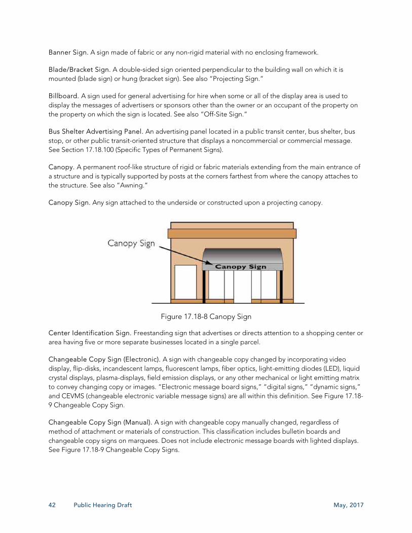
42 Public Hearing Draft May, 2017
Banner Sign. A sign made of fabric or any non-rigid material with no enclosing framework.
Blade/Bracket Sign. A double-sided sign oriented perpendicular to the building wall on which it is mounted (blade sign) or hung (bracket sign). See also “Projecting Sign.”
Billboard. A sign used for general advertising for hire when some or all of the display area is used to display the messages of advertisers or sponsors other than the owner or an occupant of the property on the property on which the sign is located. See also “Off-Site Sign.”
Bus Shelter Advertising Panel. An advertising panel located in a public transit center, bus shelter, bus stop, or other public transit-oriented structure that displays a noncommercial or commercial message. See Section 17.18.100 (Specific Types of Permanent Signs).
Canopy. A permanent roof-like structure of rigid or fabric materials extending from the main entrance of a structure and is typically supported by posts at the corners farthest from where the canopy attaches to the structure. See also “Awning.”
Canopy Sign. Any sign attached to the underside or constructed upon a projecting canopy.
Figure 17.18-8 Canopy Sign
Center Identification Sign. Freestanding sign that advertises or directs attention to a shopping center or area having five or more separate businesses located in a single parcel.
Changeable Copy Sign (Electronic). A sign with changeable copy changed by incorporating video display, flip-disks, incandescent lamps, fluorescent lamps, fiber optics, light-emitting diodes (LED), liquid crystal displays, plasma-displays, field emission displays, or any other mechanical or light emitting matrix to convey changing copy or images. “Electronic message board signs,” “digital signs,” “dynamic signs,” and CEVMS (changeable electronic variable message signs) are all within this definition. See Figure 17.18-9 Changeable Copy Sign.
Changeable Copy Sign (Manual). A sign with changeable copy manually changed, regardless of method of attachment or materials of construction. This classification includes bulletin boards and changeable copy signs on marquees. Does not include electronic message boards with lighted displays. See Figure 17.18-9 Changeable Copy Signs.

May, 2017 Loma Linda Municipal Code – Signs 43
Figure 17.18-9 Changeable Copy Sign
Channel Lettering. Three-dimensional sign face with lettering or logos where the sign is on a different projecting plane than the sign backing or structure.
Commercial Message. A message displayed on a sign that concerns primarily the economic interests of the message sponsor or the viewing audience, or both, or that proposes a commercial transaction (e.g., the exchange or sale of goods or services).
Directional Sign.
On-Site Directional Sign. A sign intended and designed to provide directions to the public for traffic (vehicular and/or pedestrian), instructions, or facility information of an establishment upon the same property but with no advertising copy (e.g., stop signs, parking, exit and entrance signs) See Figure 17.18-10 On-Site Directional Sign.
Off-Site Directional Sign. A sign intended and designed to provide public way-finding directions to points of interest or other locations open to the public for reasonably necessary traffic regulation and other public purposes, as authorized by the Director, that are located on a property different than the use, place, or activity identified, but with no advertising copy. See Section 17.18.100 (Specific Types of Permanent Signs).
Figure 17.18-10 On-Site Directional Sign

44 Public Hearing Draft May, 2017
Figure 17.18-11 Off-Site Directional Sign
Director. The Director of the Community Development Department, or the Director’s designee.
Directory Sign. A sign listing the tenants or occupants of a building or building complex.
Double-Faced Sign. A sign designed with the intent of providing copy (i.e., message) on both sides. See Figure 17.18-12 Double-Faced Sign.
Figure 17.18-12 Double-Faced Sign
Electronic Changeable Message Sign. A variable message sign that utilizes computer-generated messages or some other electronic means of changing copy. These signs generally include displays using LEDs (light-emitting diodes), CCDs (charge coupled devices), plasma, or functionally equivalent technologies to display a series of still images or full motion, usually remotely programmable and changeable.
Embedded Plaque Sign. Commemorative, historical, or decorative plaques, dates of construction, and the like when carved into stone, concreate, or similar material or made of bronze, aluminum, or other similar durable material.
Erect. To build, construct, attach, hand place, suspend or affix to or upon any surface.
Establishment. A legal, nonresidential use of land to conduct a commercial or noncommercial activity. By way of example and not limitation, this definition includes businesses, factories, farms, schools, hotels and motels, offices, libraries, places of assembly, hospitals, manufacturing facilities, etc., but does not include single-family homes, mobile homes, residential apartments, residential care facilities, residential condominiums, home-based occupations, or hobbies.

May, 2017 Loma Linda Municipal Code – Signs 45
Façade. The entire building elevation, including the parapet.
Face of Building. The wall of a building front on a street, excluding any appurtenances, such as projecting fins, columns, pilasters, canopies, marquees, showcases, or decorations, but including any required parapet wall.
Feather Flag. A temporary, portable freestanding sign of flexible material that includes copy or graphics that flutter or wave, and that is supported by a horizontal or vertical pole that is mounted into the ground and is designed to be removed daily.
Festoon. A nonmetallic string of ribbons, nonmetallic tinsel, small flags, pinwheels, pennants, or other similar items.
Flag. A rectangular or cylindrical piece of fabric of distinctive design, used as a symbol, as a sign device or as a decoration.
Flashing Sign. A sign that displays an intermittent or sequential flashing light source.
Freestanding Sign. A sign supported by structures or supports that are placed on, or anchored in, the ground and which are structurally independent from any building, including Monument Signs and Pylon Signs. See Figure 17.18-13 Types of Freestanding Signs.
Figure 17.18-13 Types of Freestanding Signs
Freeway. A divided arterial highway with full control of access and with grade separations at intersections.
Freeway Center Identification Sign. A sign that fronts a freeway within 100 feet of a freeway right-of-way and whose primary purpose, as determined by the City, is to identify a business to motorists on the freeway.
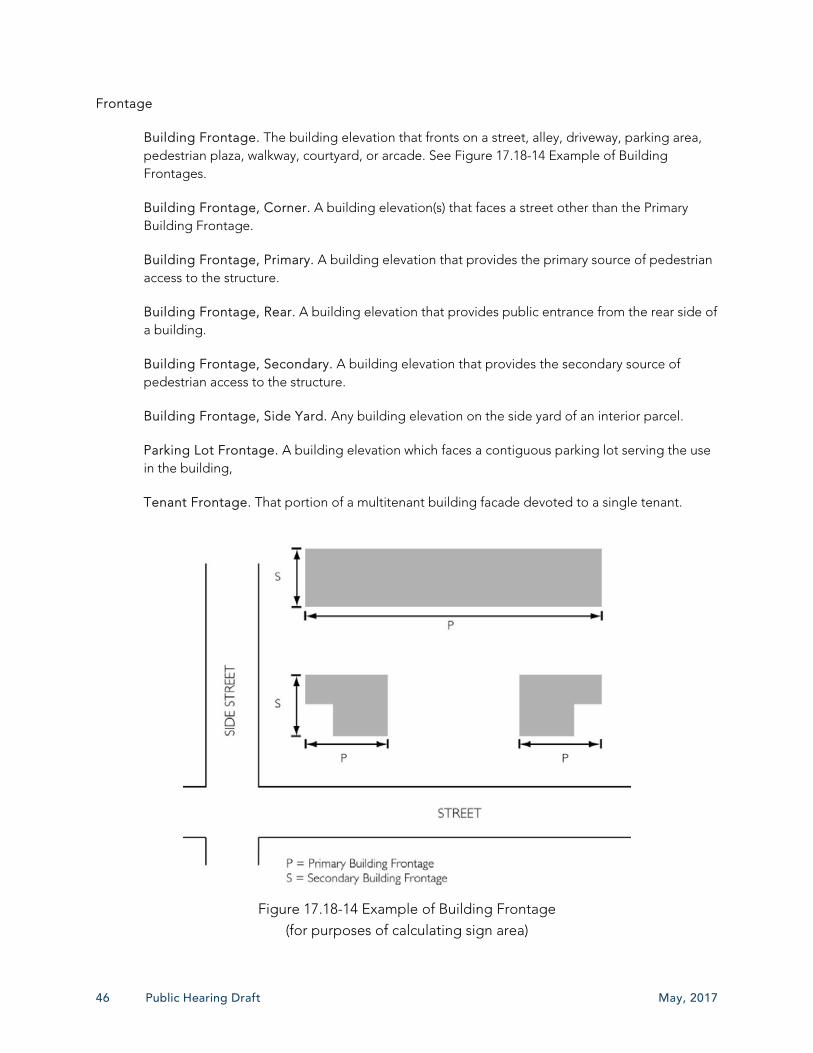
46 Public Hearing Draft May, 2017
Frontage
Building Frontage. The building elevation that fronts on a street, alley, driveway, parking area, pedestrian plaza, walkway, courtyard, or arcade. See Figure 17.18-14 Example of Building Frontages.
Building Frontage, Corner. A building elevation(s) that faces a street other than the Primary Building Frontage.
Building Frontage, Primary. A building elevation that provides the primary source of pedestrian access to the structure.
Building Frontage, Rear. A building elevation that provides public entrance from the rear side of a building.
Building Frontage, Secondary. A building elevation that provides the secondary source of pedestrian access to the structure.
Building Frontage, Side Yard. Any building elevation on the side yard of an interior parcel.
Parking Lot Frontage. A building elevation which faces a contiguous parking lot serving the use in the building,
Tenant Frontage. That portion of a multitenant building facade devoted to a single tenant.
Figure 17.18-14 Example of Building Frontage (for purposes of calculating sign area)
May, 2017 Loma Linda Municipal Code – Signs 47
Grade. The level base or specified slope of the public sidewalk or curb closest to the sign or the elevation at the base of the sign. See “Sign Height.”
Illegal Sign. A sign installed without prior issuance of a Sign Permit; or not in compliance with this Chapter; or not a legal nonconforming sign.
Illuminated Sign. A sign lighted with an artificial light source for the purpose of decorating, enhancing, outlining, accentuating, or brightening the sign area.
Externally Illuminated Sign. A sign illuminated from an exterior light source.
Indirectly Illuminated Sign. A sign whose illumination is derived entirely from an external artificial source arranged to illuminate the sign area only.
Internally Illuminated Sign. A sign illuminated from an interior light source contained within the sign cabinet or individual letter, such as a luminous tube sign or LED (light-emitting diode) sign.
Inflated Display Sign. A three-dimensional object, other than a balloon, filled or activated by moving or non-moving air or other gas, located, attached, or tethered to the ground, site, merchandise, structure, or roof and used as a sign or to attract attention. This definition does not include inflated gymnasium-type jumping or sliding devices used temporarily for a non-advertising activity (e.g. children’s parties, etc.).
Logo. An established trademark or symbol associated with a business or corporation.
Luminous Tube Signs. A sign that consist of or is illuminated by electrically charged gas-filled tubing (e.g., neon and argon signs) or by fiber optics.
Monument Sign. A freestanding sign, the structure of which is supported from finished grade, giving the appearance of having a solid base. See “Freestanding Sign.”
Nit. A nit is a unit of luminance, or brightness, emitted from a luminous surface equal to one candle per square meter, measured perpendicular to the rays of the source.
Nonconforming Sign
Legal Nonconforming Sign. A legal sign that lawfully existed (i.e., complied with all of the applicable regulations and had all of the required permits) before the effective date of this Chapter or amendment thereto, and that does not comply with the minimum sign regulations of this Chapter. This also includes legal signs lawfully located on sites annexed into the City after the adoption of this Chapter.
Illegal Nonconforming Sign. See Section 17.18180 (Illegal Signs).
Noncommercial Message. A message or image on a sign that directs public attention to or advocates an idea or issue of public interest or concern but is not advertising for hire or does not promote any business, product, activity, services, interest, or entertainment.
Off-Site Sign. A sign erected on a parcel which is not the location of the business or use that the sign is advertising. See also “Directional Sign.”

48 Public Hearing Draft May, 2017
Off-site Message. A sign that advertises commercial products, accommodations, services, or activities not provided in or on the property or premises upon which it is located. The on-site/off-site distinction applies only to commercial messages.
On-site Message. A message on a sign that advertises the commercial business, establishment, accommodation, service, or activity provided on the premises where the sign is located.
Painted Sign. A sign painted directly onto a building surface without the use of a face board.
Parapet. The extension of a false front or wall above a roofline.
Parkway. The area between the curb face to the property line of a road right of way and includes the area normally set aside for sidewalks and landscape improvements.
Pedestrian-Oriented Sign. A sign designed for and directed toward pedestrians so that the pedestrians can easily and comfortably read the sign as they approach and stand adjacent to it. A pedestrian-oriented sign typically is readable from a distance of 15 to 20 feet.
Permanent Sign. A sign solidly attached to a building, structure, or the ground by means of mounting brackets, bolts, welds, or other combination of attachment methods, rendering the sign non-moveable or difficult to reposition without the use of machinery, cutting devices, or mechanical devices.
Pole Sign. A freestanding sign supported by one exposed poles or similar support structure permanently attached directly into or upon the ground.
Political Sign. A sign that advertises a political candidate, a political party, or a political issue including but not limited to a local, state, or national election. See Non-Commercial Message.
Portable Temporary Sign. Any sign designed to be moved easily and not permanently affixed to the ground or to a structure or building. For the purposes of this definition, the only types of portable temporary signs are A-frame signs, feather flags, and wind dancers.
Projecting Sign. A building wall sign, the surface of which is not parallel to the face of the supporting wall and which is supported wholly by the wall. See also “Blade/Bracket Sign.”

May, 2017 Loma Linda Municipal Code – Signs 49
Figure 17.18-15 Projecting/Blade/Bracket Sign
Projection. The distance by which a sign extends from the building it is supported by. See Figure 17.18-16 Sign Projection.
Figure 7.18-16 Sign Projection
Public Service Sign. Signs of utilities or other publicly regulated service providers indicating danger or similar aids to service or safety, including official advisory and signal flags.
Pylon Sign. A freestanding sign supported and in direct contact with the ground or one or more solid, monumental structures, or pylons, and which typically has a sign face with a vertical dimension greater than its horizontal dimension. See “Freestanding Sign.”
Roof Line. The top edge of a roof or building parapet, whichever is higher, excluding any mansards, cupolas, pylons, chimneys, or minor projections.
Roof Sign. A sign wholly erected, constructed or placed on top of the roof of a structure including a mansard roof, and partially or totally supported by the structure.

50 Public Hearing Draft May, 2017
Sign. Any device, fixture, placard, or structure—including its component parts—that draws attention to an object, product, service, place, activity, opinion, person, establishment, institution, organization, or place of business, or that identifies or promotes the interests of any person and is to be viewed from any public street, road, highway, right-of-way or parking area.
Figure 17.18-17 Sign Types
Sign Copy. Any words, letters, numbers, figures, designs or other symbolic representations incorporated into a sign.
Sign Area. The entire area within any type of perimeter or border which may enclose the outer limits of any writing, representation, emblem, figure or character. See Section XX (Measurement of Sign Area).
Sign Height. The vertical distance from the uppermost point of the sign to the ground immediately below the point or level of the upper surface of the nearest curb of a street or alley, whichever measurement permits the greater elevation of the sign.
Sign Structures. The sign, and the supports, uprights, braces, and framework of the sign.
Site. One or more parcels of land identified by the assessor’s records and for which an integrated building development exists or has been proposed.
Spotlight. An intentionally conspicuous apparatus using a stationary or moving beam of light to attract attention to a specific location.
Supergraphic. A painted design or applied decorative art that covers all or a major portion of a wall, building facade, or other structure. A “supergraphic” is a sign.
Temporary Sign. A sign, banner, pennant, valance, or advertising display constructed of cloth, canvas, fabric, cardboard, wallboard, plywood, or other light nondurable materials, with or without frames, designed or intended to be displayed for a limited time period and is not permanently installed.
Three-dimensional Sign. A sign that consists of or has attached one or more three-dimensional objects (balls, cubes, clusters of objects, sculpture, or statue-like trademarks).
Time/Temperature Sign. An electronic or mechanical device that shows time and/or temperature but contains no business identification or advertising.

May, 2017 Loma Linda Municipal Code – Signs 51
Trademark. A word, name or symbol which, with a distinctive type or letter style associated with a business or business entity in the conduct of a business.
Under-canopy Sign. A sign that hangs below a canopy, awning, or building overhang.
Wall-Mounted Sign. A sign attached to, erected against, or fastened to a wall of a building or structure, the face of which is in a single plane parallel to the plane of the building wall to which the sign is attached or fastened.
Wayfinding Sign. A sign, map, and other graphic or audible method used to convey location and directions to travelers.
Wind Dancer. A sign that typically contains no copy but resembles a figure or object and is animated by a fan or similar object that forces air into the figure or object to create movement or semblance of movement.
Window Sign. Any sign, whether or not temporary in nature, applied or attached to a window, or located within five feet of the inside of a window in a manner visible from the exterior of the structure.


RESOLUTION NO. _______ A RESOLUTION OF THE CITY COUNCIL OF THE CITY OF LOMA LINDA
ORDERING THE CONTINUED MAINTENANCE OF LANDSCAPE MAINTENANCE DISTRICT NUMBER 1, AND CONFIRMING ENGINEER'S REPORT AND LEVYING ASSESSMENT FOR FISCAL YEAR 2017/2018
WHEREAS, the City Council of the City of Loma Linda did on the 9
th day of May 2017,
adopt its Resolution of Intention No. 2925 to order the therein described work in connection with
the continuation of assessment procedures in Landscape Maintenance District Number 1, which
Resolution of Intention No. 2925 was duly and legally published in the time, form and manner as
required by law, shown by the Affidavit of Publication of said Resolution of Intention on file in the
Office of the City Clerk; and WHEREAS, Proposition 218 was approved by the voters on November 5, 1996, added
Articles XIIIC and XIIID to the California Constitution which exempts any assessments imposed
when persons owning all of the parcels subject to the assessment agreed to being included in the
District and subject to the assessment at the time the assessment is initially imposed; and WHEREAS, said City Council having duly received and considered evidence, oral and
documentary, concerning the jurisdiction facts in the proceeding and concerning the necessity for
the contemplated work and the benefits to be derived therefrom, and said City Council having now
acquired jurisdiction to order the proposed work; and
WHEREAS, the maximum assessments for Annexations “Original and 1 through 50”, for
fiscal year 2017/2018, are not proposed to be increased and the maximum assessments for
Annexations 51 through 73 are not to be increased above the approved Consumer Price Index
(CPI); and
WHEREAS; the current CPI has been determined to be 2.68 percent, calculated from the
annual average; and
WHEREAS, notices and assessment ballots are not required if assessments are not
increased other than for the amount of the current CPI. NOW, THEREFORE, BE IT RESOLVED by the City Council of the City of Loma Linda as follows: 1. That the public interest and convenience requires the continuation of assessment
procedures for the district, and said City Council hereby orders that the work and
assessment, as set forth and described in said Resolution of Intention No. 2925 be
done and made; and 2. That the report filed by the Engineer is hereby ordered finally approved with ordered
changes, if any; and 3. That the assessments for fiscal year 2017/2018 and method of assessment in the
Engineer's Report are hereby approved.

Resolution No.
PASSED, APPROVED AND ADOPTED this 13th day of June, 2017 by the following vote: Ayes: Noes: Abstain: Absent: Rhodes Rigsby, Mayor ATTEST: Barbara Nicholson, City Clerk

City of Loma Linda
Landscape Maintenance District No. 1
2017/2018 ENGINEER’S ANNUAL LEVY REPORT
Intent Meeting: May 9, 2017
Public Hearing: June 13, 2017
27368 Via Industria, Suite 200
Temecula, California 92590
T. 951.587.3500 800.755.6864
F. 951.587.3510 888.326.6864
www.willdan.com/financial


TABLE OF CONTENTS
I. OVERVIEW 1
A. INTRODUCTION 1 B. COMPLIANCE WITH CURRENT LEGISLATION 1
II. DESCRIPTION OF THE DISTRICT 3
A. BOUNDARIES OF THE DISTRICT 3 B. DESCRIPTION OF THE DISTRICT IMPROVEMENTS AND SERVICES 6
III. METHOD OF APPORTIONMENT 10
A. GENERAL 10 B. SPECIAL BENEFIT 10 C. GENERAL BENEFIT 11 D. SELF MAINTENANCE OR NO LANDSCAPING IMPROVEMENTS 12 E. ASSESSMENT METHODOLOGY 13 F. ASSESSMENT RANGE FORMULA 14
IV. DISTRICT BUDGETS 15
A. DESCRIPTION OF BUDGET ITEMS 15 B. ASSESSMENT DETAILS 16 C. DISTRICT BUDGET FISCAL YEAR 2017/2018 18
APPENDIX A – DISTRICT BUDGET 19
APPENDIX B - DISTRICT ASSESSMENT DIAGRAM 20
APPENDIX C – 2017/2018 ASSESSMENT ROLL 21
APPENDIX D - RESOLUTIONS 22

2017/2018 Landscape Maintenance District No. 1 Page 1
I. OVERVIEW
A. INTRODUCTION
The City of Loma Linda (“City”) annually levies and collects special assessments in order to maintain the improvements within the City of Loma Linda Landscaping Maintenance District No. 1 (“District”). The District was formed in January 1976 with several annexations to the District approved in subsequent years. Annual assessments were established pursuant to the Landscape and Lighting Act of 1972, Part 2 of Division 15 of the California Streets and Highways Code (the “1972 Act”). This Engineer’s Annual Levy Report (“Report”) describes the District, any annexations or changes to the District, and the proposed assessments for Fiscal Year 2017/2018. For the purpose of this Report, the word “parcel” refers to an individual property assigned its own Assessor’s Parcel Number (“APN”) by the County of San Bernardino (“County”) Assessor’s Office. The County Auditor/Controller uses APN’s and specific Fund Numbers to identify properties on the tax roll assessed for special district benefit assessments. The proposed assessments are based on the historical and estimated costs to maintain the improvements that provide special benefit to properties within the District. The costs of improvements and the annual levy include budgeted expenditures, deficits, surpluses, revenues, and reserves. Each parcel is assessed proportionately for only those improvements provided and for which the parcel receives special benefit. Following review of the Report and consideration of public comments and written protests at a public hearing, the City Council (“Council”) may order amendments to the Report or confirm the Report as submitted. Following approval of the Report, the Council may order the levy and collection of assessments for Fiscal Year 2017/2018 pursuant to the 1972 Act. In such case, the assessment information will be submitted to the County Auditor/Controller, and included on the property tax roll for each benefiting parcel for Fiscal Year 2017/2018.
B. COMPLIANCE WITH CURRENT LEGISLATION
On November 5, 1996, California voters approved Proposition 218. This Constitutional amendment was the latest in a series of initiatives altering the revenue-raising discretion of California’s local agencies. The provisions of Proposition 218 are set forth in the California Constitution Articles XIIIC and XIIID of the California Constitution.
2017/2018 Landscape Maintenance District No. 1 Page 2
In Article XIIID Section 2 (b), “Assessments” are defined as:
“…any levy or charge upon real property by an agency for a special benefit conferred upon the real property. ‘Assessment’ includes, but is not limited to, ‘special assessment,’ ‘benefit assessment,’ ‘maintenance assessment,’ and ‘special assessment tax.’”
Article XIIID requires that beginning July 1, 1997, new and existing assessments (with some exceptions) conform to new substantive and procedural requirements. Parcels included in the original District formation and each subsequent annexation was conditioned to install landscape improvements before the development could proceed. In order to preserve the investment in the landscape improvements, the developer was required to form a separate 1972 Act Maintenance District or to be annexed into the District. Each developer who at the time owned the parcels subject to the assessment, agreed to either the formation or annexation requirement and the assessments being imposed. Subsequent owners of parcels were also made aware through title reports and Department of Real Estate “White Paper” reports that the parcels were in the District and subject to the assessments. Purchase of the parcel(s) was also in agreement to be subject to the assessments. Therefore, the assessments adopted for the District prior to the passage of Proposition 218 are exempt from the provisions of Article XIIID Section 4 of the Constitution, provided the assessments are not increased above the maximum assessment rates in effect prior to Proposition 218. Subsequent increases, if any, will be subject to the procedural and approval process of Section 4 of Article XIIID. New or increased assessments must satisfy certain noticing and meeting requirements by law. The Brown Act defines the terms “new or increased assessment” to exclude certain conditions. These certain conditions include “any assessment that does not exceed an assessment formula or range of assessments previously adopted by the agency or approved by the voters in the area where the assessment is imposed.” This definition was later confirmed by Senate Bill 919 (the proposition 218 implementing legislation).

2017/2018 Landscape Maintenance District No. 1 Page 3
II. DESCRIPTION OF THE DISTRICT
A. BOUNDARIES OF THE DISTRICT
The District consists of the original area formed in January 1976 and seventy-five (75) subsequent annexations. Reference is made to Appendix B for the District Assessment Diagram. The following table lists the various annexations, development types and development descriptions included in the boundaries of the District and subject to the District assessments.
Annexation Number
Type of Development
Development Description
Original Commercial Parcel Map 958.
1 Residential Tract Nos. 10131, 10132 and 10133.
2 Residential Tract No. 9438.
3 Commercial Loma Linda Plaza Shopping Center.
4 Multi-Family PPD 83-9.
5 Residential Tract Nos. 10134, 10135, 10136 and 10137.
6 Residential Tract No. 9389.
7 Commercial Tract No. 12734 and Parcel Maps 3231 and 4683.
8 Residential Tract Nos. 10794 and Parcel Map 5241.
9 Commercial PPD 80-2.
10 Multi-Family Parcel Map 7277.
11 Commercial Parcel Map 5564. (Subsequently combined with Annexation 26)
12 Residential Tract Nos. 11446. (Subsequently combined with Annexation 43)
13 Residential Tracts 9817 and 9817-1.
14 Commercial Parcel Map 7857.
15a Residential PPD 82-3 and Tract No. 12458.
15b Commercial PPD 82-3 and Tract No. 12458.
16 Multi-Family Tract No. 12475.
17 Multi-Family Tract Nos. 12609 and 12881.

2017/2018 Landscape Maintenance District No. 1 Page 4
Annexation Number
Type of Development
Development Description
18 Residential Tract No. 12294.
19 Residential Tract No. 11516 and Assessor's Parcel No. 293-053-01.
20 Multi-Family PPD 84-2.
21 Multi-Family PPD 84-12.
22 Commercial Parcel Map 6643.
23 Commercial Tract No. 12771 (Loma Linda Redevelopment Agency).
24 Commercial PPD 85-3.
25 Commercial Parcel Map 9198.
26 Commercial Tract No. 12916.
27 Residential Tracts 10134 and 10135.
28 Commercial PPD 86-5.
29 Residential Tract No. 13046.
30 Commercial PPD 85-13.
31 Residential Tract No. 13449.
32 Commercial Parcel Map 10741.
33a Commercial PPD 87-16 and PPD 87-9.
33b Commercial PPD 87-16 and PPD 87-9.
34 Residential Tract No. 13705.
35 Residential Tract No. 13635.
36a Commercial PPD 86-17 and PPD 87-12.
36b Commercial PPD 86-17 and PPD 87-12.
37 Multi-Family PPD 85-6.
38 Commercial PPD 85-8.
39 Residential Tract No. 13887.
40 Multi-Family Parcel Map 11886.
41 Residential Tract No. 13943.
42 Residential Tract No. 14216.

2017/2018 Landscape Maintenance District No. 1 Page 5
Annexation Number
Type of Development
Development Description
43 Multi-Family Tract No. 14339.
44 Commercial Tract No. 12962.
45 Commercial Mini-storage on Barton Road west of California Street.
46 Commercial PPD 88-10.
47 Commercial Tract No. 14545 (Subsequently combined with Annexation 54).
48 Residential Barton Road Frontage (Northwest corner of Barton Road and Benton Street).
49 Commercial PPD 89-5 (Subsequently combined with Annexation 46).
50 Commercial CUP 93-2.
51 Commercial Tract No. 12916.
52 Commercial CUP 93-5.
53 Commercial College Home Tract.
54 Residential Tract Nos. 14544, 14545, 14552.
55 Residential Tract No. 15071.
56 Residential Tract No. 15917, Van Leuven and San Timoteo Creek.
57 Commercial 24913 Redlands Boulevard.
58 Residential Tract No. 16016, Prospect Avenue and Mountain View.
59 Residential Tract No. 14543, Lawton Avenue and Whittier Avenue.
60 Commercial Along Barton Rd. between Mountain View and Bryn Mawr Ave.
61 Residential Tract No. 16234, Cole Street east of Benton Street.
62 Residential Tract No. 16259.
63 Residential Tract No. 16341.
64 Residential Tract No. 16382.
65 Residential Parcel Map 16120.
66 Residential Tract No. 16650.
67 Residential Tract No. 15422.
68 Residential Tract No. 16323.
69 Residential Tract No. 16730.

2017/2018 Landscape Maintenance District No. 1 Page 6
Annexation Number
Type of Development
Development Description
71 Commercial Along northeast corner of California Ave. and Barton Rd.
72 Commercial Along Barton Road, 600 ft. easterly of Mountain View Avenue (25805 and 25875 Barton Road).
73 Commercial Redview Plaza. Northwest corner of Mountain View Avenue and Redlands Blvd.
*Annexations 11, 12, 47, and 49 were combined with other annexations and are no longer considered as separate annexations. Annexations 63, 64, 66, 67, 68 and 69 have homeowners’ associations that will maintain most or all common area landscaping within the interior of the respective developments. Annexations 30, 32, and 44 have no landscaping and are not assessed.
B. DESCRIPTION OF THE DISTRICT IMPROVEMENTS AND SERVICES
Landscaping and irrigation improvements have been completed along the Barton Road frontage of Parcel Map 958 (Original) and the development that was the basis of the original district. There have been seventy-five (75), subsequent annexations to the District, which are shown on the map included within this Report. Only those annexations having improvements to be maintained and serviced by the District are addressed within this Report. Maintenance means the furnishing of services and materials for the ordinary and usual maintenance, operation and servicing of the ornamental structures, landscaping and appurtenant facilities, including repair, removal or replacement of all or part of any of the ornamental structures, landscaping or appurtenant facilities; providing for the life, growth, health, and beauty of the landscaping, including cultivation, irrigation, trimming, spraying, fertilizing and treating for disease or injury; the removal of trimmings, rubbish, debris and other solid waste; and the cleaning, sandblasting and painting of walls and other improvements to remove or cover graffiti. Servicing means the furnishing of electricity for the lighting and operation of the ornamental structures, landscaping, and appurtenant facilities, and water for the irrigation and control of the landscaping and the maintenance of any of the ornamental structures, landscaping, and appurtenant facilities The following table lists the various areas and location of the landscaping and irrigation improvements within the District.
Annexation Number Type of
Development Description of Area and Improvements
Original Commercial The Barton Road frontage of Parcel Map 958.
1 Residential The Mountain View Avenue frontage and interior portions of Tract Nos. 10131, 10132 and 10133.

2017/2018 Landscape Maintenance District No. 1 Page 7
Annexation Number Type of
Development Description of Area and Improvements
2 Residential The Mountain View frontage of Tract No. 9438.
3 Commercial The Barton Road frontage of the Loma Linda Plaza Shopping Center.
4 Multi-Family The Mountain View Avenue frontage of PPD 83-9.
5 Residential The Bryn Mawr Avenue frontage of Tract Nos. 10134, 10135, 10136 and 10137.
6 Residential The Mountain View Avenue frontage of Tract No. 9389.
7 Commercial The Mountain View Avenue frontage of Tract No. 12734 and Parcel Maps 3231 and 4683.
8 Residential The Mountain View Avenue frontage of Tract Nos. 10794 and Parcel Map 5241.
9 Commercial The Redlands Boulevard frontage of PPD 80-2.
10 Multi-Family The Mountain View Avenue frontage of Parcel Map 7277.
11 Commercial The Redlands Boulevard frontage of Parcel Map 5564. (see Annexation 26)
12 Residential The Mountain View Avenue frontage of Tract Nos. 11446. (see Annexation 43)
13 Residential The Mountain View Avenue frontage of Tracts 9817 and 9817-1.
14 Commercial The Redlands Boulevard frontage of Parcel Map 7857.
15a Residential The Redlands Boulevard frontage of PPD 82-3 and the Whittier Avenue, Verde Grove Avenue and Lawton Street frontages of Tract No. 12458.
15b Commercial The Redlands Boulevard frontage of PPD 82-3 and the Whittier Avenue, Verde Grove Avenue and Lawton Street frontages of Tract No. 12458.
16 Multi-Family The Redlands Boulevard frontage of Tract No. 12475.
17 Multi-Family The Redlands Boulevard frontage of Tract Nos. 12609 and 12881.
18 Residential The Bryn Mawr Avenue and Beaumont Avenue frontages of Tract No. 12294.
19 Residential The Bryn Mawr Avenue, Lawton Avenue, Whittier Avenue, and Beaumont Avenue frontages of Tract No. 11516 and Assessor's Parcel No. 293-053-01.
20 Multi-Family The Mountain View Avenue frontage of PPD 84-2.
21 Multi-Family The Redlands Boulevard frontage of PPD 84-12.
22 Commercial The Redlands Boulevard frontage of Parcel Map 6643.
23 Commercial The Redlands Boulevard, Camelot Lane, and Hampton Drive frontages of Tract No. 12771 (Loma Linda Redevelopment Agency).
24 Commercial The Barton Road frontage of PPD 85-3.
25 Commercial The Mountain View and Redlands Boulevard frontages of Parcel Map 9198.

2017/2018 Landscape Maintenance District No. 1 Page 8
Annexation Number Type of
Development Description of Area and Improvements
26 Commercial The Redlands Boulevard frontage of Tract No. 12916.
27 Residential The Bryn Mawr Avenue frontages and various interior streets of Tracts 10134 and 10135.
28 Commercial The Redlands Boulevard and Mountain View Avenue frontages of PPD 86-5.
29 Residential The Second Street and Bryn Mawr Avenue frontages of Tract No. 13046.
30 Commercial The Redlands Boulevard frontage of PPD 85-13.
31 Residential The Lawton Avenue and Bryn Mawr Avenue frontages of Tract No. 13449.
32 Commercial The Mountain View Avenue and Cottonwood Road frontages of Parcel Map 10741.
33a Commercial The Barton Road and Redlands Boulevard frontages of PPD 87-16 and PPD 87-9.
33b Commercial The Barton Road and Redlands Boulevard frontages of PPD 87-16 and PPD 87-9.
34 Residential The Second Street and Whittier Avenue frontages of Tract No. 13705.
35 Residential The Lawton Avenue and Bryn Mawr Avenue frontages of Tract No. 13635.
36a Commercial The Redlands Boulevard frontages of PPD 86-17 and PPD 87-12.
36b Commercial The Redlands Boulevard frontages of PPD 86-17 and PPD 87-12.
37 Multi-Family The Mountain View Avenue frontage of PPD 85-6.
38 Commercial The Redlands Boulevard frontage of PPD 85-8.
39 Residential The Beaumont Avenue boundary and various interior streets of Tract No. 13887.
40 Multi-Family The Oakwood and Barton Road frontages of Parcel Map 11886.
41 Residential The George, Whittier, Beaumont, and Bryn Mawr frontages and various interior streets of Tract No. 13943.
42 Residential The Mountain View Avenue frontage of Tract No. 14216.
43 Multi-Family The Mountain View and Prospect Avenue frontages of Tract No. 14339.
44 Commercial The Beaumont Street frontage of Tract No. 12962.
45 Commercial The Barton Road frontage of the mini-storage on Barton Road west of California Street.
46 Commercial The Redlands Boulevard frontage of PPD 88-10.
47 Commercial The Beaumont Avenue frontage and various interior streets of Tract No. 14545. (See Annexation 54.)
48 Residential Barton Road Frontage. (northwest corner of Barton Road and Benton Street).
49 Commercial The Redlands Boulevard frontage of PPD 89-5. (see Annexation 46)
50 Commercial The Redlands Boulevard frontage of CUP 93-2.
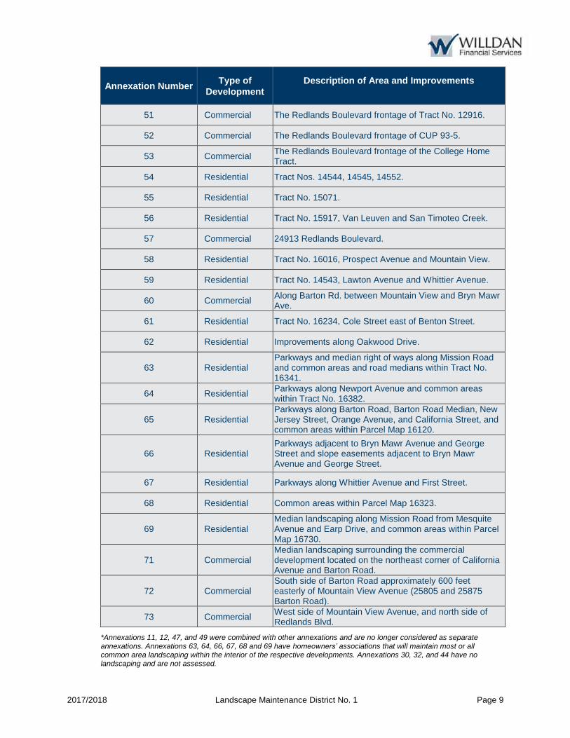
2017/2018 Landscape Maintenance District No. 1 Page 9
Annexation Number Type of
Development Description of Area and Improvements
51 Commercial The Redlands Boulevard frontage of Tract No. 12916.
52 Commercial The Redlands Boulevard frontage of CUP 93-5.
53 Commercial The Redlands Boulevard frontage of the College Home Tract.
54 Residential Tract Nos. 14544, 14545, 14552.
55 Residential Tract No. 15071.
56 Residential Tract No. 15917, Van Leuven and San Timoteo Creek.
57 Commercial 24913 Redlands Boulevard.
58 Residential Tract No. 16016, Prospect Avenue and Mountain View.
59 Residential Tract No. 14543, Lawton Avenue and Whittier Avenue.
60 Commercial Along Barton Rd. between Mountain View and Bryn Mawr Ave.
61 Residential Tract No. 16234, Cole Street east of Benton Street.
62 Residential Improvements along Oakwood Drive.
63 Residential Parkways and median right of ways along Mission Road and common areas and road medians within Tract No. 16341.
64 Residential Parkways along Newport Avenue and common areas within Tract No. 16382.
65 Residential Parkways along Barton Road, Barton Road Median, New Jersey Street, Orange Avenue, and California Street, and common areas within Parcel Map 16120.
66 Residential Parkways adjacent to Bryn Mawr Avenue and George Street and slope easements adjacent to Bryn Mawr Avenue and George Street.
67 Residential Parkways along Whittier Avenue and First Street.
68 Residential Common areas within Parcel Map 16323.
69 Residential Median landscaping along Mission Road from Mesquite Avenue and Earp Drive, and common areas within Parcel Map 16730.
71 Commercial Median landscaping surrounding the commercial development located on the northeast corner of California Avenue and Barton Road.
72 Commercial South side of Barton Road approximately 600 feet easterly of Mountain View Avenue (25805 and 25875 Barton Road).
73 Commercial West side of Mountain View Avenue, and north side of Redlands Blvd.
*Annexations 11, 12, 47, and 49 were combined with other annexations and are no longer considered as separate annexations. Annexations 63, 64, 66, 67, 68 and 69 have homeowners’ associations that will maintain most or all common area landscaping within the interior of the respective developments. Annexations 30, 32, and 44 have no landscaping and are not assessed.

2017/2018 Landscape Maintenance District No. 1 Page 10
Landscaped areas are portions of easements or road rights-of-way previously granted to the City, and the City has determined that properties within the District receive special benefit from the maintenance and servicing of these improvements. The plans and specifications for the landscaping and irrigation improvements within each annexation have been prepared by the developer and have been approved as part of the improvement plans for the various developments. The plans and specifications for the landscaping and irrigation are in conformance with the requirements of the City Council conditions of approval of said Parcel Maps, Tracts, and Planned Parcel Developments. Plans and specifications for the improvements for the original District and each subsequent annexation are voluminous and are not bound in this report but are on file in the office of the City Clerk and the City Engineer where they are available for public inspection. Said plans and specifications are by reference incorporated and made part of this report.
III. METHOD OF APPORTIONMENT
A. GENERAL
Pursuant to the 1972 Act and the provisions of Article XIIID, the costs of the District are apportioned by a formula or method which fairly distributes the net amount to be assessed among the assessable parcels in proportion to the special benefits received by each such parcel from the improvements and a parcel's assessment may not exceed the reasonable cost of the proportional special benefit conferred on that parcel. Article XIIID requires that only special benefits are assessable and that the agency shall separate the general benefit from special benefit. A special benefit is a particular and distinct benefit over and above general benefits conferred on the public at large, including real property within the district. The general enhancement of property value does not constitute a special benefit. Each parcel within the District receives special benefits from the improvements due to the close proximity of the landscaping improvements to each parcel.
B. SPECIAL BENEFIT
The method of apportionment (method of assessment) is based on the premise that each assessed parcel receives special benefit from the improvements maintained, serviced and funded by the assessments and specifically, the landscape and irrigation improvements installed in connection with the development of these parcels. The desirability of properties within the District is enhanced by the presence of well-maintained landscaping improvements in close proximity to those properties.

2017/2018 Landscape Maintenance District No. 1 Page 11
The annual assessments outlined in this Report are based on the estimated costs to provide necessary services, operation, administration, and maintenance required to ensure the satisfactory condition and quality of each improvement. The District improvements include various landscaped areas and accompanying appurtenances that provide special benefits to various properties within the District. The special benefits associated with the landscaping improvements are specifically:
Enhanced desirability of properties through association with the improvements.
Improved aesthetic appeal of properties within the District providing a positive representation of the area.
Enhanced adaptation of the urban environment within the natural environment from adequate green space and landscaping.
Environmental enhancement through improved erosion resistance and dust and debris control.
Increased sense of pride in ownership of property within the District resulting from well-maintained improvements associated with the properties.
Reduced criminal activity and property-related crimes (especially vandalism) against properties in the District through well-maintained surroundings and amenities.
Enhanced environmental quality of the parcels by moderating temperatures, providing oxygenation and attenuating noise.
The preceding special benefits contribute to a special enhancement and desirability of each of the assessed parcels within the District.
C. GENERAL BENEFIT
In addition to the special benefits received by the parcels within the proposed annexation, there are incidental general benefits conferred by the improvements within the District. Each of the following constitutes incidental general benefits conferred by the District improvements:
The proper maintenance of landscaping and appurtenant facilities within the District will control dust from blowing onto properties outside of the District boundaries.

2017/2018 Landscape Maintenance District No. 1 Page 12
The control of erosion will reduce runoff into the City's storm drain system.
The proper maintenance of landscaped areas will facilitate proper drainage of properties within the District and also reduces the potential for flooding damage to properties on the downward slope from the District.
The spraying and treating of landscaping within the District for disease reduces the likelihood of insect infestation and other diseases spreading to landscaping located throughout other properties within the City.
The proper maintenance of landscaping and ornamental structures provides a positive visual experience to persons passing by the District boundaries.
The total benefits are thus a combination of the special benefits to the parcels within the District and the general benefits to the public at large and to adjacent property owners. The portion of the total landscape maintenance and servicing costs that are associated with general benefits will not be assessed to the parcels in the District, but will be paid from other City Funds.
D. NO LANDSCAPING IMPROVEMENTS, PARTIALLY MAINTAINED OR SELF MAINTAINED
The cost allocation/special benefit nexus to developed parcels in each annexation area is similar and appropriate for most parcels. In addition, the landscape improvements in some annexations are currently maintained by the property owners and are proposed to be maintained by the property owners this coming fiscal year if approved by the City Council. Also, City, County and Redevelopment Agency annexations are exempt and are not assessed. The following is a list of annexations within this category and their status.
Annexation No. Status
3 Self Maintained
7 Self Maintained
8 Self Maintained
9 Self Maintained
11 Not Separately Assessed – Combined (see Annexation 26)*
12 Not Separately Assessed – Combined (see Annexation 43)*
13 Self Maintained
14 Self Maintained
15b Self Maintained
20 Self Maintained
23 Not Assessed – Government (Loma Linda Redevelopment Agency)
25 Self Maintained
28 Self Maintained
30 Not Assessed - No Landscaping 32 Not Assessed - No Landscaping

2017/2018 Landscape Maintenance District No. 1 Page 13
Annexation No. Status
36a Self Maintained
40 Self Maintained
43 Self Maintained
44 Not Assessed - No Landscaping
45 Self Maintained
47 Not Separately Assessed – Combined (see Annexation 54)*
49 Not Separately Assessed – Combined (see Annexation 46)*
50 Self Maintained
57 Self Maintained
58 Self Maintained
60 Self Maintained
63 Partially HOA Maintained
64 Partially HOA Maintained
65 Self Maintained 66 Partially HOA Maintained 67 Partially HOA Maintained 68 Partially HOA Maintained
69 Partially HOA Maintained
73 Self Maintained
*Annexations 11, 12, 47, and 49 were combined with other annexations and are no longer considered as separate annexations. Annexations 63, 64, 66, 67, 68 and 69 have homeowners’ associations that will maintain most or all common area landscaping within the interior of the respective developments. Annexations 30, 32, and 44 have no landscaping and are not assessed.
Property owners having parcels within the District who are allowed to provide for their own landscape maintenance receive no assessment associated with the maintenance costs because these costs are paid directly to their own employees or contractor for this maintenance. They may also pay direct water costs to keep the landscaping alive and well. However, they will receive special benefit and be assessed for the costs associated with the Report and District administration to ensure that the required landscaping will be maintained to the standards established by the City and anticipated when the improvements were initially required. Since this special benefit is associated with each annexation area, the assessments are based on the number of units of assessment for each annexation area. Thus, the assessments are the same to administer and to prepare the Report for the annexation areas providing their own landscape maintenance.
E. ASSESSMENT METHODOLOGY
The costs to provide maintenance and servicing of the improvements within or adjacent to the original area and each annexation area represent a zone of benefit (“Zone”) and provide a distinct and special benefit to each parcel in the Zone. The costs to provide maintenance and servicing of the improvements for each Zone are determined and are fairly and equitably distributed among each
2017/2018 Landscape Maintenance District No. 1 Page 14
assessable parcel in the Zone based upon the estimated special benefit received by each parcel. The costs of the Report and District administration are fairly and equitably distributed to all Zones, including those that have no improvements or that are fully or partially self-maintained. Assessable parcels within each Zone are determined to receive the same special benefit from the improvements due to their similarity in size and use and their similar proximity to the improvements. Therefore, each assessable parcel in a Zone is assessed an equal amount. For Fiscal Year 2017/2018 the assessment rate within each Zone will be the Balance to Levy divided by the number of assessable parcels in the Zone.
F. ASSESSMENT RANGE FORMULA
An assessment range formula for the District assessments has been confirmed through property owner ballot proceedings in compliance with Article XIIID, except those existing assessments within the District, such as the Original District and Annexations 1-50, which qualified as exempt assessments pursuant to Article XIIID, Section 5 of the Constitution and did not require a ballot proceeding under the provisions of Section 4. The purpose of establishing an assessment range formula is to provide for reasonable increases and inflationary adjustment to the assessment amounts without requiring costly noticing and mailing procedures, which would be added to the District costs and assessments. The assessment range formula shall be applied to future assessments within the District. The following describes this assessment range formula:
Wherein, if the proposed assessment (levy per unit or rate) is less than or equal to, the prior year’s maximum assessment plus the adjustments described in the following, then the proposed assessment is not considered an increased assessment. If the proposed assessment is less than the maximum assessment approved in the previous fiscal year adjusted by a percentage no greater than the annual percentage increase of the Consumer Price Index (“CPI”), the assessment shall not be considered as an increase. For Annexations 51 through 73, the maximum assessment amount allowed for each fiscal year shall be adjusted annually by an amount equal to the percentage increase of the CPI for the Los Angeles-Riverside-Orange County Area for Urban Consumers, as developed by the U.S. Bureau of Labor Statistics, for March of each year and the CPI for March of the previous fiscal year. The CPI adjustment for Fiscal Year 2017/2018 is 2.68%. Such assessment adjustments shall not be considered an increase in assessment and shall not require that a notice or Assessment Ballot be sent to property owners within these annexation areas.
2017/2018 Landscape Maintenance District No. 1 Page 15
The base assessment amount will be the amount originally noticed and approved by the property owners at the time of formation and adjusted annually to establish the new maximum assessment amounts. An increased assessment that exceeds this adjusted maximum assessment amount will require property owner balloting approval before the increase may be imposed.
IV. DISTRICT BUDGETS
A. DESCRIPTION OF BUDGET ITEMS
The following is a brief description of the costs associated with the improvements and services funded through the District.
DIRECT COSTS:
Maintenance — Includes regularly scheduled labor and general maintenance cost including wages, salaries, benefits and contract services required to properly maintain and ensure the satisfactory condition of the improvements and appurtenant facilities. Utilities — The furnishing of water and electricity required for the operation and maintenance of the improvements and facilities. Capital Repairs/Improvements — This item includes repairs to the improvements and facilities that are not included in the yearly maintenance costs. This may include repair of damaged amenities due to vandalism, storms, etc. Also included may be planned upgrades or replacements of the improvements and equipment that provide a special benefit to the District. Includes materials, supplies (e.g. pipe, fertilizer, insecticides, fuel, cleaning material etc.), and equipment (e.g. communication, small tools, rentals, machinery etc.) required to operate, maintain and ensure the satisfactory condition of the improvements and appurtenant facilities.
ADMINISTRATIVE COSTS:
Administration/Operations/Insurance — May include the administrative and professional service costs associated with the coordination of District services and operations including response to public concerns and education, procedures associated with the levy and collection of assessments, the costs of contracting with professionals to provide administrative, legal or engineering services specific to the District, and the cost for the County to collect assessments on the property tax bills.

2017/2018 Landscape Maintenance District No. 1 Page 16
Professional Services — The cost of contracting with professionals to provide services specific to the levy of assessments and annual administration of the District.
OTHER BUDGET ITEMS:
General Fund Contributions — If the amount that can be collected through the annual assessments is not sufficient to cover the total annual direct costs and administrative costs, a General Fund contribution from the City may be necessary to cover the shortfall. Credit/Adjustments/HOA Adjustments — Miscellaneous credits to the levy, such as the application of excess District funds, etc. Currently, Annexation 15b receives a $10 annual credit. Total Number of Parcels — The total number of parcels within the District. Total Parcels Levied — The total number of parcels within the District that are assessed. Non-assessable lots or parcels include properties that have been determined to receive no special benefits from the improvements and may include land principally encumbered by public or other rights-of-way or easements, common areas, and/or parcels that have restricted use or development potential. Levy per Parcel (shown in Appendix “A”) — This amount represents the assessment rate being applied to each assessable parcel in each area. The Levy per Parcel is the result of dividing the Balance to Levy per area by the sum of the number of assessable parcels.
B. ASSESSMENT DETAILS
Credit/Adjustments to Levy Amounts Throughout the District there are certain annexations that receive different considerations in determining their annual assessments. Annexations 3, 7, 8, 9, 13, 14, 15b, 20, 25, 28, 30, 36a, 40, 43, 45, 50, 57, 58, 60, 65, and 73 are self maintained areas, and assessments are reduced to reflect only administrative costs associated with the area. Annexations 63, 64, 66, 67, 68 and 69 are areas maintained by a Homeowner’s Association, and assessments are reduced to reflect only the improvement costs paid by the City and/or administrative costs associated with the area.
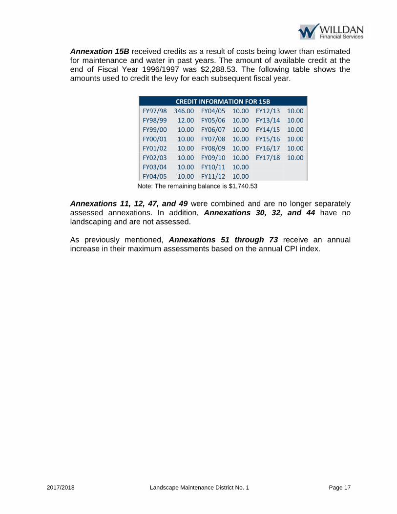
2017/2018 Landscape Maintenance District No. 1 Page 17
Annexation 15B received credits as a result of costs being lower than estimated for maintenance and water in past years. The amount of available credit at the end of Fiscal Year 1996/1997 was $2,288.53. The following table shows the amounts used to credit the levy for each subsequent fiscal year.
Note: The remaining balance is $1,740.53 Annexations 11, 12, 47, and 49 were combined and are no longer separately assessed annexations. In addition, Annexations 30, 32, and 44 have no landscaping and are not assessed. As previously mentioned, Annexations 51 through 73 receive an annual increase in their maximum assessments based on the annual CPI index.
CREDIT INFORMATION FOR 15B
FY97/98 346.00 FY04/05 10.00 FY12/13 10.00
FY98/99 12.00 FY05/06 10.00 FY13/14 10.00
FY99/00 10.00 FY06/07 10.00 FY14/15 10.00
FY00/01 10.00 FY07/08 10.00 FY15/16 10.00
FY01/02 10.00 FY08/09 10.00 FY16/17 10.00
FY02/03 10.00 FY09/10 10.00 FY17/18 10.00
FY03/04 10.00 FY10/11 10.00
FY04/05 10.00 FY11/12 10.00

2017/2018 Landscape Maintenance District No. 1 Page 18
C. DISTRICT BUDGET FISCAL YEAR 2017/2018
FISCAL YEAR 2017-2018 Landscape Maintenance District No. 1 District Budget Totals DIRECT COSTS Maintenance $159,600 Utilities 170,000 Capital Repairs/ Improvements 35,300
Subtotal $364,900 ADMINISTRATIVE COSTS Administration/ Operations/ Insurance $76,300 Professional Services 10,900
Subtotal $87,200 Total Direct & Administrative Costs $452,100 General Fund (Contribution) (56,512) Credit/Adjustments/ HOA Adjustments (10) Total Credits ($56,522) BALANCE TO LEVY $395,578
Total Number of Active Parcels 2,672
Total Number of Levied Parcels 2,577
Fund Balance Information
Beginning Reserve Balance as of 7/1/2017 $0 Reserve Fund Collection/(Deduction) 0
Ending Reserve Fund Balance $0
Credit Available for FY 2017/18(1) $1,751 Credit Used for FY 2017/18 (10)
Credit Remaining for FY 2018/19 $1,741
(1) The credit above is for Annexation 15B only.
2017/2018 Landscape Maintenance District No. 1 Page 19
APPENDIX A – DISTRICT BUDGET
Please refer to the section entitled “Appendix A – District Budget” for further details.
Slight variances in District Budget Totals due to rounding

CITY OF LOMA LINDALANDSCAPE MAINTENANCE DISTRICT NO. 1
FISCAL YEAR 2017/2018 DISTRICT BUDGETAPPENDIX A
District Name Original 1 2 3 4 5 6 7 8 9 10 11 12 13 14 15a 15b 16 17 18 19 20 21 22 23 24 25
Tract/ Parcel
Parcel Map 958
Tracts: 10131, 10132,10133
Tract: 9438
Commercial: Loma Linda Shopping
Center
Multi-Family: PPD 83-9
Tracts: 10134,10135, 10136, 10137
Tract: 9389Tract: 12734/ Parcel Maps: 3231, 4683
Tracts: 10794 / Parcel Map
5241PPD 80-2
Parcel Map 7277
Parcel Map 5564
Tract: 11446Tracts: 9817,
9817-1Parcel Map
7857
PPD 82-3/Tract:1245
8
PPD 82-3/Tract 12458
Tract 12475Tracts: 12609, 12881
Tract 12294Tract:
11516/APN: 293-052-01
PPD 84-2 PPD 84-12Parcel Map
6643Tract 12771 PPD 85-3
Parcel Map 9198
Notes (1) (1) (1) (1) (4) (4) (1) (1) (1) (1) (2) (1)
Direct CostsMaintenance $2,957 $1,692 $445 $0 $899 $925 $1,059 $0 $0 $0 $339 $0 $0 $0 $0 $1,031 $0 $511 $788 $2,112 $1,650 $0 $853 $346 $0 $2,701 $0Utilities 9,184 3,237 2,094 0 1,994 4,808 2,496 0 0 0 1,149 0 0 0 0 2,868 0 2,344 1,503 5,746 6,559 0 1,911 1,692 0 5,216 0Capital Repairs/Improvements 1,635 576 373 0 355 856 445 0 0 0 205 0 0 0 0 511 0 417 268 1,023 1,168 0 340 301 0 929 0
Subtotal $13,776 $5,505 $2,912 $0 $3,248 $6,588 $3,999 $0 $0 $0 $1,692 $0 $0 $0 $0 $4,410 $0 $3,272 $2,559 $8,881 $9,377 $0 $3,104 $2,339 $0 $8,845 $0% of Direct Costs 3.78% 1.51% 0.80% 0.00% 0.89% 1.81% 1.10% 0.00% 0.00% 0.00% 0.46% 0.00% 0.00% 0.00% 0.00% 1.21% 0.00% 0.90% 0.70% 2.43% 2.57% 0.00% 0.85% 0.64% 0.00% 2.42% 0.00%
Administrative CostsAdministration/Operations/Insurance $1,871 $1,397 $986 $360 $709 $1,417 $930 $355 $633 $494 $545 $0 $0 $1,044 $360 $1,237 $350 $1,102 $773 $1,605 $1,762 $355 $693 $610 $0 $1,324 $581Professional Services 268 200 141 51 101 203 133 51 90 71 78 0 0 149 51 177 50 158 110 230 252 51 99 87 0 189 83
Subtotal $2,139 $1,597 $1,127 $412 $810 $1,620 $1,062 $406 $723 $565 $622 $0 $0 $1,193 $412 $1,413 $400 $1,260 $883 $1,835 $2,014 $406 $792 $697 $0 $1,513 $664
Total Direct and Administrative Costs $15,914 $7,102 $4,039 $412 $4,059 $8,208 $5,062 $406 $723 $565 $2,315 $0 $0 $1,193 $412 $5,823 $400 $4,532 $3,442 $10,715 $11,392 $406 $3,897 $3,037 $0 $10,358 $664
Levy per parcel of just Direct & Admin Costs 3,978.57 81.63 65.15 205.88 4,058.79 120.71 180.77 405.88 13.15 20.16 1,157.35 #DIV/0! #DIV/0! 8.84 205.88 73.71 58.85 122.94 191.35 149.89 405.88 3,896.63 3,036.56 #DIV/0! 5,179.14 14.77
Levy AdjustmentsReserve Fund Collection/(Contribution) $0 $0 $0 $0 $0 $0 $0 $0 $0 $0 $0 $0 $0 $0 $0 $0 $0 $0 $0 $0 $0 $0 $0 $0 $0 $0 $0Other Revenue/General Fund Contribution (2,227) (1,130) (710) 0 (849) (1,135) (928) (326) (299) 0 (614) 0 0 0 (352) (931) (390) (745) (748) (1,542) (1,562) 0 (828) (679) 0 (1,660) (178)Credit/Adjustments/HOA Adjustments 0 0 0 0 0 0 0 0 0 0 0 0 0 0 0 0 (10) 0 0 0 0 0 0 0 0 0 0
Subtotal ($2,227) ($1,130) ($710) $0 ($849) ($1,135) ($928) ($326) ($299) $0 ($614) $0 $0 $0 ($352) ($931) ($400) ($745) ($748) ($1,542) ($1,562) $0 ($828) ($679) $0 ($1,660) ($178)
Balance to Levy $13,687 $5,972 $3,329 $412 $3,210 $7,073 $4,133 $80 $425 $565 $1,701 $0 $0 $1,193 $60 $4,892 $0 $3,787 $2,695 $9,174 $9,829 $406 $3,069 $2,358 $0 $8,698 $486
Total Number of Parcels 4 87 62 2 1 68 28 1 56 28 2 0 0 135 2 79 1 77 28 56 76 1 1 1 0 2 45 Total Parcels Levied 4 87 62 2 1 68 28 1 55 28 2 0 0 135 2 79 0 77 28 56 76 1 1 1 0 2 45 % of Parcels 0.16% 3.38% 2.41% 0.08% 0.04% 2.64% 1.09% 0.04% 2.13% 1.09% 0.08% 0.00% 0.00% 5.24% 0.08% 3.07% 0.00% 2.99% 1.09% 2.17% 2.95% 0.04% 0.04% 0.04% 0.00% 0.08% 1.75%
Proposed Levy Per Parcel FY 2017/18 $3,421.83 $68.64 $53.70 $205.88 $3,209.73 $104.02 $147.62 $79.80 $7.72 $20.16 $850.44 $0.00 $0.00 $8.84 $30.10 $61.92 $0.00 $49.18 $96.23 $163.81 $129.33 $405.88 $3,068.52 $2,357.92 $0.00 $4,348.98 $10.80Maximum Assessment Per Parcel 3,421.830 68.640 53.700 398.080 3,209.730 104.020 147.620 79.800 7.720 46.220 850.440 0.000 0.000 34.940 30.100 61.920 10.000 49.180 96.235 163.815 129.334 2,556.490 3,068.520 2,357.916 0.000 4,348.976 10.800Difference from Max Assessment per Parcel 0.00 0.00 0.00 192.21 0.00 0.00 0.00 0.00 0.00 26.06 0.00 0.00 0.00 26.10 0.00 0.00 10.00 0.00 0.00 0.00 0.00 2,150.61 0.00 0.00 0.00 0.00 0.00Applied rate to Max difference 0.00 0.00 0.00 -192.21 0.00 0.00 0.00 0.00 0.00 -26.06 0.00 0.00 0.00 -26.10 0.00 0.00 -10.00 0.00 0.00 0.00 0.00 -2,150.61 0.00 0.00 0.00 0.00 0.00Total Assessment Allowable $13,687.32 $5,971.68 $3,329.40 $796.16 $3,209.73 $7,073.36 $4,133.36 $79.80 $424.60 $1,294.16 $1,700.88 $0.00 $0.00 $4,716.90 $60.20 $4,891.68 $0.00 $3,786.86 $2,694.58 $9,173.63 $9,829.41 $2,556.49 $3,068.52 $2,357.92 $0.00 $8,697.95 $486.00(total assessable-total costs) ($2,226.95) ($1,130.32) ($709.65) $384.41 ($849.06) ($1,134.84) ($928.31) ($326.08) ($298.62) $729.61 ($613.82) $0.00 $0.00 $3,523.53 ($351.55) ($931.13) ($400.00) ($744.84) ($747.85) ($1,541.70) ($1,562.20) $2,150.61 ($828.11) ($678.64) $0.00 ($1,660.33) ($178.46)
51-73 increase by CPI
Levy Per Parcel FY 2016/17 $3,421.83 $68.64 $53.70 $205.95 $3,209.73 $104.02 $147.62 $79.80 $7.72 $20.23 $850.44 $0.00 $0.00 $8.91 $30.10 $61.92 $0.00 $49.18 $96.23 $163.81 $129.33 $2,556.49 $3,068.52 $2,357.92 $0.00 $4,348.98 $10.80 % change 0.00% 0.00% 0.00% -0.04% 0.00% 0.00% 0.00% 0.00% 0.00% -0.36% 0.00% n/a n/a -0.81% 0.00% 0.00% n/a 0.00% 0.00% 0.00% 0.00% -84.12% 0.00% 0.00% n/a 0.00% 0.00% % Change From Last Year: 0.00% 0.00% 0.00% -0.04% 0.00% 0.00% 0.00% 0.00% 0.00% -0.36% 0.00% 0.00% 0.00% -0.81% 0.00% 0.00% 0.00% 0.00% 0.00% 0.00% 0.00% -84.12% 0.00% 0.00% 0.00% 0.00% 0.00% Dollar Change From Last Year: $0.00 $0.00 $0.00 ($0.08) $0.00 $0.00 $0.00 $0.00 $0.00 ($0.07) $0.00 $0.00 $0.00 ($0.07) $0.00 $0.00 $0.00 $0.00 $0.00 $0.00 $0.00 ($2,150.61) $0.00 $0.00 $0.00 $0.00 $0.00Fund Balance InformationBeginning Reserve Balance as of 7/1/2017 $0 $0 $0 $0 $0 $0 $0 $0 $0 $0 $0 $0 $0 $0 $0 $0 $0 $0 $0 $0 $0 $0 $0 $0 $0 $0 $0Reserve Fund Collection/(Deduction) 0 0 0 0 0 0 0 0 0 0 0 0 0 0 0 0 0 0 0 0 0 0 0 0 0 0 0Ending Reserve Fund Balance $0 $0 $0 $0 $0 $0 $0 $0 $0 $0 $0 $0 $0 $0 $0 $0 $0 $0 $0 $0 $0 $0 $0 $0 $0 $0 $0
Credit Available for FY 2017/18 $1,751 Credit Used for FY 2017/18 (10) Credit Remaining for FY 2018/19 $1,741
Notes(1) Self Maintained - Assessed only Adminstrative Costs(2) Government/County - Not Assessed(3) No Landscaping - Not Assessed(4) Combined, no longer annexations - Not Assessed(5) HOA maintains portions of direct costs(6) Allowable CPI inflator appliedSlight variances due to rounding
Willdan Financial Services
A - 1

CITY OF LOMA LINDALANDSCAPE MAINTENANCE DISTRICT NO. 1
FISCAL YEAR 2017/2018 DISTRICT BUDGETAPPENDIX A
District Name
Tract/ Parcel
Notes
Direct CostsMaintenanceUtilitiesCapital Repairs/Improvements
Subtotal% of Direct Costs
Administrative CostsAdministration/Operations/InsuranceProfessional Services
Subtotal
Total Direct and Administrative Costs
Levy per parcel of just Direct & Admin Costs
Levy AdjustmentsReserve Fund Collection/(Contribution)Other Revenue/General Fund ContributionCredit/Adjustments/HOA Adjustments
Subtotal
Balance to Levy
Total Number of ParcelsTotal Parcels Levied% of Parcels
Proposed Levy Per Parcel FY 2017/18Maximum Assessment Per ParcelDifference from Max Assessment per ParcelApplied rate to Max differenceTotal Assessment Allowable(total assessable-total costs)
51-73 increase by CPI
Levy Per Parcel FY 2016/17 % change % Change From Last Year: Dollar Change From Last Year:Fund Balance InformationBeginning Reserve Balance as of 7/1/2017Reserve Fund Collection/(Deduction)Ending Reserve Fund Balance
Credit Available for FY 2017/18Credit Used for FY 2017/18Credit Remaining for FY 2018/19
Notes(1) Self Maintained - Assessed only Adminstrative Costs(2) Government/County - Not Assessed(3) No Landscaping - Not Assessed(4) Combined, no longer annexations - Not Assessed(5) HOA maintains portions of direct costs(6) Allowable CPI inflator appliedSlight variances due to rounding
26 27 28 29 30 31 32 33a 33b 34 35 36a 36b 37 38 39 40 41 42 43 44 45 46 47 48 49 50
Tract 12916Tracts: 10134, 10135
PPD 86--5 Tract 13046 PPD 85-13 Tract 13449Parcel Map
10741PPD 87-16,
87-9PPD 87-16,
87-9Tract 13705 Tract 13635
PPD 86-17, 87-12
PPD 86-17, 87-12
PPD PPD 85-6
PPD 85-8 Tract 13887Parcel Map
11886Tract 13943 Tract 14216 Tract 14339 Tract 12962
Mini-storage on Barton Rd., W. of Calif. St.
PPD 88-10Tract 14545 (see annex
54)
Barton Rd Frontage
(NW corner of Barton Rd & Benton St.)
PPD 89-5 CUP 93-2
(1) (3) (3) (1) (1) (1) (3) (1) (4) (4) (1)
$2,046 $1,901 $0 $1,715 $0 $2,029 $0 $688 $2,129 $1,633 $5,686 $0 $256 $216 $1,473 $2,070 $0 $8,016 $951 $0 $0 $0 $337 $0 $1,401 $0 $05,009 2,899 0 4,640 0 5,982 0 1,330 2,333 3,978 13,705 0 946 691 2,288 5,375 0 21,247 2,211 0 0 0 0 0 1,925 0 0
892 516 0 826 0 1,065 0 237 415 708 2,441 0 168 123 407 957 0 3,784 394 0 0 0 0 0 343 0 0$7,946 $5,317 $0 $7,181 $0 $9,076 $0 $2,255 $4,877 $6,320 $21,832 $0 $1,370 $1,030 $4,168 $8,402 $0 $33,047 $3,555 $0 $0 $0 $337 $0 $3,669 $0 $0
2.18% 1.46% 0.00% 1.97% 0.00% 2.49% 0.00% 0.62% 1.34% 1.73% 5.98% 0.00% 0.38% 0.28% 1.14% 2.30% 0.00% 9.06% 0.97% 0.00% 0.00% 0.00% 0.09% 0.00% 1.01% 0.00% 0.00%
$1,246 $1,263 $360 $1,322 $0 $1,817 $0 $601 $892 $1,229 $3,170 $355 $510 $467 $835 $1,512 $355 $4,341 $902 $381 $0 $0 $392 $0 $760 $0 $355178 181 51 189 0 260 0 86 127 176 453 51 73 67 119 216 51 621 129 54 0 0 56 0 109 0 51
$1,425 $1,444 $412 $1,512 $0 $2,077 $0 $687 $1,019 $1,404 $3,624 $406 $582 $534 $954 $1,728 $406 $4,961 $1,031 $435 $0 $0 $448 $0 $869 $0 $406
$9,371 $6,761 $412 $8,692 $0 $11,152 $0 $2,942 $5,896 $7,724 $25,456 $406 $1,953 $1,564 $5,122 $10,130 $406 $38,008 $4,586 $435 $0 $0 $784 $0 $4,537 $0 $406
1,561.82 104.01 205.88 234.93 #DIV/0! 119.92 #DIV/0! 2,941.77 2,947.92 208.76 296.00 405.88 976.40 1,564.33 853.66 211.04 405.88 500.11 143.30 72.54 #DIV/0! #DIV/0! 784.38 #DIV/0! 2,268.72 #DIV/0! 405.88
$0 $0 $0 $0 $0 $0 $0 $0 $0 $0 $0 $0 $0 $0 $0 $0 $0 $0 $0 $0 $0 $0 $0 $0 $0 $0 $0(1,473) (1,157) 0 (1,330) 0 (1,525) 0 (721) (1,189) (1,233) (3,514) (392) (570) (532) (1,020) (1,494) (213) (5,325) (866) (345) 0 0 (472) 0 (963) 0 (402)
0 0 0 0 0 0 0 0 0 0 0 0 0 0 0 0 0 0 0 0 0 0 0 0 0 0 0($1,473) ($1,157) $0 ($1,330) $0 ($1,525) $0 ($721) ($1,189) ($1,233) ($3,514) ($392) ($570) ($532) ($1,020) ($1,494) ($213) ($5,325) ($866) ($345) $0 $0 ($472) $0 ($963) $0 ($402)
$7,898 $5,604 $412 $7,363 $0 $9,627 $0 $2,221 $4,707 $6,491 $21,942 $14 $1,383 $1,033 $4,102 $8,636 $193 $32,683 $3,719 $90 $0 $0 $312 $0 $3,574 $0 $4
6 65 2 37 1 93 1 1 2 37 86 1 2 1 6 48 1 76 32 6 0 0 1 0 2 0 1 6 65 2 37 0 93 0 1 2 37 86 1 2 1 6 48 1 76 32 6 0 0 1 0 2 0 1
0.23% 2.52% 0.08% 1.44% 0.00% 3.61% 0.00% 0.04% 0.08% 1.44% 3.34% 0.04% 0.08% 0.04% 0.23% 1.86% 0.04% 2.95% 1.24% 0.23% 0.00% 0.00% 0.04% 0.00% 0.08% 0.00% 0.04%
$1,316.26 $86.21 $205.88 $198.99 $0.00 $103.52 $0.00 $2,220.85 $2,353.58 $175.42 $255.14 $14.33 $691.30 $1,032.57 $683.65 $179.91 $192.65 $430.04 $116.23 $15.07 $0.00 $0.00 $312.24 $0.00 $1,787.00 $0.00 $4.001,316.260 86.210 288.510 198.990 0.000 103.520 0.000 2,220.850 2,353.580 175.420 255.140 14.330 691.299 1,032.570 683.650 179.910 192.650 430.040 116.230 15.070 0.000 0.000 312.240 0.000 1,787.000 0.000 4.000
0.00 0.00 82.64 0.00 0.00 0.00 0.00 0.00 0.00 0.00 0.00 0.00 0.00 0.00 0.00 0.00 0.00 0.00 0.00 0.00 0.00 0.00 0.00 0.00 0.00 0.00 0.000.00 0.00 -82.64 0.00 0.00 0.00 0.00 0.00 0.00 0.00 0.00 0.00 0.00 0.00 0.00 0.00 0.00 0.00 0.00 0.00 0.00 0.00 0.00 0.00 0.00 0.00 0.00
$7,897.56 $5,603.63 $577.02 $7,362.63 $0.00 $9,627.36 $0.00 $2,220.85 $4,707.16 $6,490.54 $21,942.04 $14.33 $1,382.60 $1,032.57 $4,101.90 $8,635.68 $192.65 $32,683.04 $3,719.36 $90.42 $0.00 $0.00 $312.24 $0.00 $3,574.00 $0.00 $4.00($1,473.34) ($1,157.05) $165.27 ($1,329.77) $0.00 ($1,524.74) $0.00 ($720.92) ($1,188.67) ($1,233.48) ($3,513.80) ($391.55) ($570.19) ($531.76) ($1,020.03) ($1,494.07) ($213.23) ($5,325.26) ($866.28) ($344.84) $0.00 $0.00 ($472.14) $0.00 ($963.43) $0.00 ($401.88)
$1,316.26 $86.21 $205.95 $198.99 $0.00 $103.52 $0.00 $2,220.85 $2,353.58 $175.42 $255.14 $14.33 $691.30 $1,032.57 $683.65 $179.91 $192.65 $430.04 $116.23 $15.07 $0.00 $0.00 $312.24 $0.00 $1,787.00 $0.00 $4.000.00% 0.00% -0.04% 0.00% n/a 0.00% n/a 0.00% 0.00% 0.00% 0.00% 0.00% 0.00% 0.00% 0.00% 0.00% 0.00% 0.00% 0.00% 0.00% n/a n/a 0.00% n/a 0.00% n/a 0.00%0.00% 0.00% -0.04% 0.00% 0.00% 0.00% 0.00% 0.00% 0.00% 0.00% 0.00% 0.00% 0.00% 0.00% 0.00% 0.00% 0.00% 0.00% 0.00% 0.00% 0.00% 0.00% 0.00% 0.00% 0.00% 0.00% 0.00%$0.00 $0.00 ($0.08) $0.00 $0.00 $0.00 $0.00 $0.00 $0.00 $0.00 $0.00 $0.00 $0.00 $0.00 $0.00 $0.00 $0.00 $0.00 $0.00 $0.00 $0.00 $0.00 $0.00 $0.00 $0.00 $0.00 $0.00
$0 $0 $0 $0 $0 $0 $0 $0 $0 $0 $0 $0 $0 $0 $0 $0 $0 $0 $0 $0 $0 $0 $0 $0 $0 $0 $00 0 0 0 0 0 0 0 0 0 0 0 0 0 0 0 0 0 0 0 0 0 0 0 0 0 0
$0 $0 $0 $0 $0 $0 $0 $0 $0 $0 $0 $0 $0 $0 $0 $0 $0 $0 $0 $0 $0 $0 $0 $0 $0 $0 $0
Willdan Financial Services
A - 2

CITY OF LOMA LINDALANDSCAPE MAINTENANCE DISTRICT NO. 1
FISCAL YEAR 2017/2018 DISTRICT BUDGETAPPENDIX A
District Name
Tract/ Parcel
Notes
Direct CostsMaintenanceUtilitiesCapital Repairs/Improvements
Subtotal% of Direct Costs
Administrative CostsAdministration/Operations/InsuranceProfessional Services
Subtotal
Total Direct and Administrative Costs
Levy per parcel of just Direct & Admin Costs
Levy AdjustmentsReserve Fund Collection/(Contribution)Other Revenue/General Fund ContributionCredit/Adjustments/HOA Adjustments
Subtotal
Balance to Levy
Total Number of ParcelsTotal Parcels Levied% of Parcels
Proposed Levy Per Parcel FY 2017/18Maximum Assessment Per ParcelDifference from Max Assessment per ParcelApplied rate to Max differenceTotal Assessment Allowable(total assessable-total costs)
51-73 increase by CPI
Levy Per Parcel FY 2016/17 % change % Change From Last Year: Dollar Change From Last Year:Fund Balance InformationBeginning Reserve Balance as of 7/1/2017Reserve Fund Collection/(Deduction)Ending Reserve Fund Balance
Credit Available for FY 2017/18Credit Used for FY 2017/18Credit Remaining for FY 2018/19
Notes(1) Self Maintained - Assessed only Adminstrative Costs(2) Government/County - Not Assessed(3) No Landscaping - Not Assessed(4) Combined, no longer annexations - Not Assessed(5) HOA maintains portions of direct costs(6) Allowable CPI inflator appliedSlight variances due to rounding
51 52 53 54 55 56 57 58 59 60 61 62 63 64 65 66 67 68 69 71 72 73
Tract 12916 CUP 93-5College
Home Tract
Tracts: 14544, 14545, 14552
Tract 15071
Tract 15917, Van Leuven
and San Timoteo Creek
24913 Redlands
Blvd.
Tract 16016, Prospect Ave & Mountain
View
Tract 14543, Lawton Ave & Whittier
Ave
Along Barton Rd. b/t
Mountain View and Bryn Mawr Ave
Tract 16234, Cole St. east of Benton St
Tract 16259 Tract 16341 Tract 16382 Parcel Map 16120 Tract 16650 Tract 15422 Tract 16323 Tract 16730
Northeast corner of
California Ave & Barton Rd
Along Barton Road, 600 ft.
easterly of Mountain View
Avenue
Redview Plaza
(6) (6) (6) (6) (6) (1) (1) (6) (1) (6) (6) (5) & (6) (5) & (6) (1) (5) & (6) (5) (5) & (6) (5) (6) (6) (1)
$772 $1,947 $356 $4,010 $36,393 $25,040 $0 $0 $4,950 $0 $2,650 $729 $10,046 $7,085 $0 $9,025 $0 $0 $3,700 $880 $1,168 $01,424 3,390 949 19,058 7,041 1,622 0 0 158 0 229 253 873 615 0 3,071 300 300 1,159 246 1,955 0
248 604 128 3,127 159 4,956 0 0 170 0 246 68 941 663 0 845 0 0 0 123 339 0$2,443 $5,941 $1,434 $26,194 $43,593 $31,618 $0 $0 $5,278 $0 $3,125 $1,049 $11,859 $8,364 $0 $12,942 $300 $300 $4,859 $1,249 $3,462 $0
0.67% 1.63% 0.39% 7.18% 11.95% 8.66% 0.00% 0.00% 1.45% 0.00% 0.86% 0.29% 3.25% 2.29% 0.00% 3.55% 0.08% 0.08% 1.33% 0.34% 0.95% 0.00%
$621 $1,002 $516 $4,345 $5,700 $4,092 $355 $566 $1,131 $355 $762 $757 $2,655 $1,518 $440 $1,945 $645 $743 $2,046 $162 $892 $49389 143 74 621 815 585 51 81 162 51 109 108 380 217 52.94 278 92 106 293 43 127 52
$710 $1,146 $590 $4,966 $6,515 $4,678 $406 $647 $1,292 $406 $871 $866 $3,034 $1,735 $492 $2,223 $737 $849 $2,339 $205 $1,019 $545
$3,153 $7,087 $2,024 $31,161 $50,109 $36,295 $406 $647 $6,570 $406 $3,997 $1,915 $14,894 $10,099 $492 $15,164 $1,037 $1,149 $7,198 $1,454 $4,481 $545
$3,153 $7,087 $1,012 $140 $428 $626 $406 $15 $164 $406 $285 $34 $76 $202 $123 $421 $20 $16 $32 $363.51 $140 $182
$0 $0 $0 $0 $0 $0 $0 $0 $0 $0 $0 $0 $0 $0 $0 $0 $0 $0 $0 $0 $0 $0(523) (705) 0 (1,810) (4,897) (3,038) 0 0 (1,177) 0 (519) (2) 0 0 0 0 0 (245) 0 (67) (960) 0
0 0 0 0 0 0 0 0 0 0 0 0 0 0 0 0 0 0 0 0 0 0($523) ($705) $0 ($1,810) ($4,897) ($3,038) $0 $0 ($1,177) $0 ($519) ($2) $0 $0 $0 $0 $0 ($245) $0 ($67) ($960) $0
$2,630 $6,382 $2,024 $29,351 $45,211 $33,257.0 $406 $647 $5,394 $406 $3,478 $1,913 $14,894 $10,099 $492 $15,164 $1,037 $903 $7,198 $1,387 $3,521 $545
1 1 2 222 117 60 1 42 42 1 14 60 212 76 4 36 54 83 247 4 39 3 1 1 2 222 117 58 1 42 40 1 14 57 197 50 4 36 51 70 227 4 32 3
0.04% 0.04% 0.08% 8.61% 4.54% 2.25% 0.04% 1.63% 1.55% 0.04% 0.54% 2.21% 7.64% 1.94% 0.16% 1.40% 1.98% 2.72% 8.81% 0.16% 1.24% 0.12%
$2,630.46 $6,381.77 $1,012.11 $132.21 $386.41 $573.39 $405.88 $15.40 $134.84 $405.88 $248.43 $33.55 $75.60 $201.98 $123.11 $421.23 $20.33 $12.90 $31.71 $346.86 $110.01 $181.622,630.462 6,381.776 1,889.175 132.210 386.419 573.396 1,137.444 100.730 134.842 19,697.858 248.434 33.556 136.938 378.592 9,899.779 669.837 1,424.856 12.906 37.428 346.869 110.019 450.307
0.00 0.00 877.07 0.00 0.00 0.00 731.56 85.33 0.00 19,291.98 0.00 0.00 61.33 176.62 9,776.67 248.60 1,404.52 0.00 5.72 0.00 0.00 268.690.00 0.00 -877.07 0.00 0.00 0.00 -731.56 -85.33 0.00 -19,291.98 0.00 0.00 -61.33 -176.62 -9,776.67 -248.60 -1,404.52 0.00 -5.72 0.00 0.00 -268.69
$2,630.46 $6,381.78 $3,778.35 $29,350.71 $45,211.06 $33,256.99 $1,137.44 $4,230.67 $5,393.69 $19,697.86 $3,478.07 $1,912.67 $26,976.70 $18,929.60 $39,599.11 $24,114.13 $72,667.64 $903.44 $8,496.22 $1,387.48 $3,520.60 $1,350.92($522.68) ($705.05) $1,754.14 ($1,809.86) ($4,897.44) ($3,038.43) $731.56 $3,583.85 ($1,176.57) $19,291.98 ($518.74) ($2.18) $12,082.93 $8,830.83 $39,106.67 $8,949.68 $71,630.58 ($245.29) $1,298.20 ($66.54) ($960.42) $806.06
$2,630.46 $6,381.77 $1,071.36 $132.21 $386.42 $521.86 $416.84 $15.89 $134.83 $416.84 $248.43 $33.55 $78.41 $209.42 $168.43 $440.22 $20.94 $12.90 $32.56 $346.87 $110.02 $186.50 ($522.68) ($705.06) $118.51 ($1,811.02) ($4,897.44) ($6,027.69) $10.96 $20.48 ($1,176.90) $10.96 ($518.74) ($2.69) $552.77 $372.38 $181.30 $683.44 $30.64 ($245.94) $194.16 ($960.42) $14.62
$2,561.71 $6,214.98 $1,043.36 $128.75 $376.32 $508.22 $405.95 $15.47 $131.31 $405.95 $241.94 $32.67 $76.36 $203.95 $164.03 $428.71 $20.39 $12.56 $31.71 $337.80 $107.14 $181.622.68% 2.68% -3.00% 2.69% 2.68% 12.82% -0.02% -0.47% 2.69% -0.02% 2.68% 2.71% -0.99% -0.97% -24.95% -1.74% -0.26% 2.76% -0.01% 2.68% 2.68% 0.00%2.68% 2.68% -3.00% 2.69% 2.68% 12.82% -0.02% -0.47% 2.69% -0.02% 2.68% 2.71% -0.99% -0.97% -24.95% -1.74% -0.26% 2.76% -0.01% 2.68% 2.68% 0.00%
$68.75 $166.80 ($31.25) $3.46 $10.10 $65.18 ($0.07) ($0.07) $3.53 ($0.07) $6.49 $0.89 ($0.76) ($1.97) ($40.92) ($7.48) ($0.05) $0.35 ($0.00) $9.07 $2.88 $0.00
$0 $0 $0 $0 $0 $0 $0 $0 $0 $0 $0 $0 $0 $0 $0 $0 $0 $0 $0 $0 $0 $00 0 0 0 0 0 0 0 0 0 0 0 0 0 0 0 0 0 0 0 0 0
$0 $0 $0 $0 $0 $0 $0 $0 $0 $0 $0 $0 $0 $0 $0 $0 $0 $0 $0 $0 $0 $0
Willdan Financial Services
A - 3
2017/2018 Landscape Maintenance District No. 1 Page 20
APPENDIX B - DISTRICT ASSESSMENT DIAGRAM
An Assessment District Diagram has been prepared for the District in the format required by the 1972 Act and is on file with the City Clerk and, by reference, is made part of this Report. The Assessment Diagram is available for inspection at the Office of the City Clerk during normal business hours.
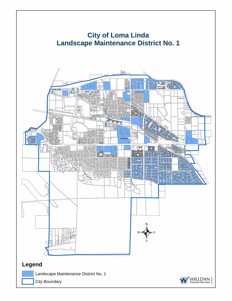
.
City of Loma LindaLandscape Maintenance District No. 1
LegendLandscape Maintenance District No. 1
City Boundary

2017/2018 Landscape Maintenance District No. 1 Page 21
APPENDIX C – 2017/2018 ASSESSMENT ROLL Parcel identification, for each lot or parcel within the District, shall be the parcel as shown on the San Bernardino County Assessor Parcel Maps and/or the San Bernardino County Secured Tax Roll for the year in which this Report is prepared. Non-assessable lots or parcels may include government owned land, public utility owned property, land principally encumbered with public rights-of-way or easements, and dedicated common areas. These parcels will not be assessed. Parcel listing of the District, along with the proposed assessment amounts, has been submitted to the City Clerk and are made part of this Report. Upon approval of the Engineer’s Annual Levy Report and confirmation of the assessments, the assessment information will be submitted to the County Auditor/Controller and included on the property tax roll in Fiscal Year 2017/2018. If the parcels or assessment numbers within the District and referenced in this Report are re-numbered, re-apportioned or changed by the County Assessor’s Office after approval of the Report, the new parcel or assessment numbers with the appropriate assessment amount will be submitted to the County Auditor/Controller. If the parcel change made by the County includes a parcel split, parcel merger or tax status change, the assessment amount submitted on the new parcels or assessment numbers will be based on the method of apportionment and levy amount approved in this Report by the City Council.

APN SITUS ADDRESS ANNEXATION MAXIMUM ASSESSMENT ($) ASSESSMENT ($)
0281-091-41-0000 24850 E REDLANDS BLVD 14 30.10 30.100281-091-42-0000 24866 REDLANDS BLVD 14 30.10 30.100281-162-22-0000 24990 W REDLANDS BLVD 51 2,630.46 2,630.460281-162-24-0000 24910 E REDLANDS BLVD 50 4.00 4.000281-241-04-0000 25300 REDLANDS BLVD 52 6,381.78 6,381.770281-242-31-0000 25630 W REDLANDS BLVD 73 450.31 181.620281-242-32-0000 25670 W REDLANDS BLVD 73 450.31 181.620281-242-33-0000 10460 MOUNTAIN VIEW AVE 73 450.31 181.620281-331-01-0000 24530 E REDLANDS BLVD 9 46.22 20.230281-331-02-0000 24532 E REDLANDS BLVD 9 46.22 20.230281-331-03-0000 24538 E REDLANDS BLVD 9 46.22 20.230281-331-04-0000 24540 E REDLANDS BLVD 9 46.22 20.230281-331-05-0000 24546 E REDLANDS BLVD 9 46.22 20.230281-331-06-0000 24548 E REDLANDS BLVD 9 46.22 20.230281-331-07-0000 24554 E REDLANDS BLVD 9 46.22 20.230281-331-08-0000 24556 E REDLANDS BLVD 9 46.22 20.230281-331-09-0000 24562 E REDLANDS BLVD 9 46.22 20.230281-331-10-0000 24564 E REDLANDS BLVD 9 46.22 20.230281-331-11-0000 24574 E REDLANDS BLVD 9 46.22 20.230281-331-12-0000 24576 E REDLANDS BLVD 9 46.22 20.230281-331-13-0000 24586 E REDLANDS BLVD 9 46.22 20.230281-331-14-0000 24588 E REDLANDS BLVD 9 46.22 20.230281-331-15-0000 24630 E REDLANDS BLVD 9 46.22 20.230281-331-16-0000 24632 E REDLANDS BLVD 9 46.22 20.230281-331-17-0000 24638 E REDLANDS BLVD 9 46.22 20.230281-331-18-0000 24640 E REDLANDS BLVD 9 46.22 20.230281-331-19-0000 24646 E REDLANDS BLVD 9 46.22 20.230281-331-20-0000 24648 E REDLANDS BLVD 9 46.22 20.230281-331-21-0000 24654 E REDLANDS BLVD 9 46.22 20.230281-331-22-0000 24656 E REDLANDS BLVD 9 46.22 20.230281-331-23-0000 24662 E REDLANDS BLVD 9 46.22 20.230281-331-24-0000 24664 E REDLANDS BLVD 9 46.22 20.230281-331-25-0000 24674 E REDLANDS BLVD 9 46.22 20.230281-331-26-0000 24676 E REDLANDS BLVD 9 46.22 20.230281-331-27-0000 24686 E REDLANDS BLVD 9 46.22 20.230281-331-28-0000 24688 E REDLANDS BLVD 9 46.22 20.230281-381-03-0000 25050 REDLANDS BLVD 26 1,316.26 1,316.260281-381-07-0000 25072 REDLANDS BLVD 26 1,316.26 1,316.260281-381-10-0000 25140 REDLANDS BLVD 26 1,316.26 1,316.260281-381-11-0000 25160 REDLANDS BLVD 26 1,316.26 1,316.260281-381-12-0000 REDLANDS BLVD 26 1,316.26 1,316.260281-381-13-0000 REDLANDS BLVD 26 1,316.26 1,316.260283-062-18-0000 53 1,889.18 1,012.110283-062-19-0000 24831 REDLANDS BLVD 53 1,889.18 1,012.110283-062-40-0000 24769 E REDLANDS BLVD 22 2,357.92 2,357.920283-062-44-0000 24541 REDLANDS BLVD 36A 14.33 14.330283-082-01-0000 24913 REDLANDS BLVD 57 1,137.44 405.880283-082-45-0000 25069 W REDLANDS BLVD 36B 691.30 691.300283-082-46-0000 25051 W REDLANDS BLVD 36B 691.30 691.300283-134-01-0000 25227 E REDLANDS BLVD 33A 2,220.85 2,220.850283-181-02-0000 10664 MOUNTAIN VIEW AVE 37 1,032.57 1,032.570283-201-51-0000 25585 E VAN LEUVEN AVE 10 850.44 850.440283-201-52-0000 25665 VAN LEUVEN ST 10 850.44 850.440283-201-53-0000 25590 PROSPECT AVE 43 15.07 15.070283-201-54-0000 25590 PROSPECT AVE 43 15.07 15.070283-201-55-0000 25590 PROSPECT AVE 43 15.07 15.070283-261-20-0000 25655 REDLANDS BLVD 28 288.51 205.95
City of Loma LindaLandscape Maintenance District No. 1Fiscal Year 2017/18 Assessment Roll
Willdan Financial Services Page 1 of 46
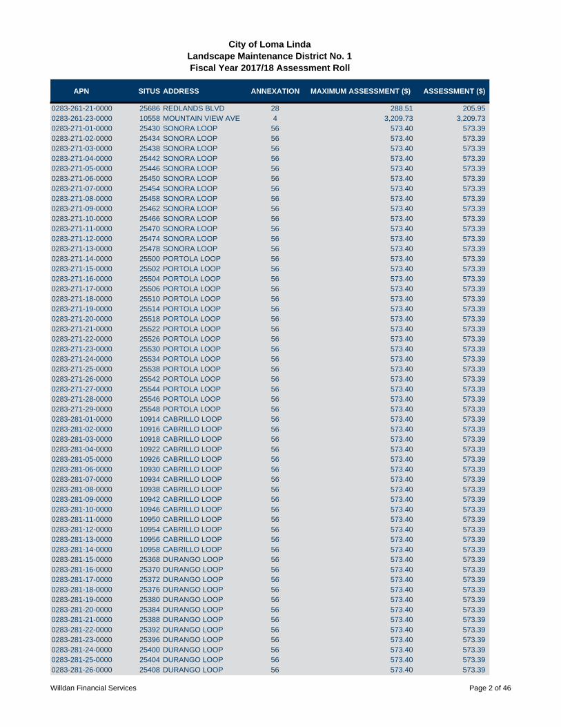
APN SITUS ADDRESS ANNEXATION MAXIMUM ASSESSMENT ($) ASSESSMENT ($)
City of Loma LindaLandscape Maintenance District No. 1Fiscal Year 2017/18 Assessment Roll
0283-261-21-0000 25686 REDLANDS BLVD 28 288.51 205.950283-261-23-0000 10558 MOUNTAIN VIEW AVE 4 3,209.73 3,209.730283-271-01-0000 25430 SONORA LOOP 56 573.40 573.390283-271-02-0000 25434 SONORA LOOP 56 573.40 573.390283-271-03-0000 25438 SONORA LOOP 56 573.40 573.390283-271-04-0000 25442 SONORA LOOP 56 573.40 573.390283-271-05-0000 25446 SONORA LOOP 56 573.40 573.390283-271-06-0000 25450 SONORA LOOP 56 573.40 573.390283-271-07-0000 25454 SONORA LOOP 56 573.40 573.390283-271-08-0000 25458 SONORA LOOP 56 573.40 573.390283-271-09-0000 25462 SONORA LOOP 56 573.40 573.390283-271-10-0000 25466 SONORA LOOP 56 573.40 573.390283-271-11-0000 25470 SONORA LOOP 56 573.40 573.390283-271-12-0000 25474 SONORA LOOP 56 573.40 573.390283-271-13-0000 25478 SONORA LOOP 56 573.40 573.390283-271-14-0000 25500 PORTOLA LOOP 56 573.40 573.390283-271-15-0000 25502 PORTOLA LOOP 56 573.40 573.390283-271-16-0000 25504 PORTOLA LOOP 56 573.40 573.390283-271-17-0000 25506 PORTOLA LOOP 56 573.40 573.390283-271-18-0000 25510 PORTOLA LOOP 56 573.40 573.390283-271-19-0000 25514 PORTOLA LOOP 56 573.40 573.390283-271-20-0000 25518 PORTOLA LOOP 56 573.40 573.390283-271-21-0000 25522 PORTOLA LOOP 56 573.40 573.390283-271-22-0000 25526 PORTOLA LOOP 56 573.40 573.390283-271-23-0000 25530 PORTOLA LOOP 56 573.40 573.390283-271-24-0000 25534 PORTOLA LOOP 56 573.40 573.390283-271-25-0000 25538 PORTOLA LOOP 56 573.40 573.390283-271-26-0000 25542 PORTOLA LOOP 56 573.40 573.390283-271-27-0000 25544 PORTOLA LOOP 56 573.40 573.390283-271-28-0000 25546 PORTOLA LOOP 56 573.40 573.390283-271-29-0000 25548 PORTOLA LOOP 56 573.40 573.390283-281-01-0000 10914 CABRILLO LOOP 56 573.40 573.390283-281-02-0000 10916 CABRILLO LOOP 56 573.40 573.390283-281-03-0000 10918 CABRILLO LOOP 56 573.40 573.390283-281-04-0000 10922 CABRILLO LOOP 56 573.40 573.390283-281-05-0000 10926 CABRILLO LOOP 56 573.40 573.390283-281-06-0000 10930 CABRILLO LOOP 56 573.40 573.390283-281-07-0000 10934 CABRILLO LOOP 56 573.40 573.390283-281-08-0000 10938 CABRILLO LOOP 56 573.40 573.390283-281-09-0000 10942 CABRILLO LOOP 56 573.40 573.390283-281-10-0000 10946 CABRILLO LOOP 56 573.40 573.390283-281-11-0000 10950 CABRILLO LOOP 56 573.40 573.390283-281-12-0000 10954 CABRILLO LOOP 56 573.40 573.390283-281-13-0000 10956 CABRILLO LOOP 56 573.40 573.390283-281-14-0000 10958 CABRILLO LOOP 56 573.40 573.390283-281-15-0000 25368 DURANGO LOOP 56 573.40 573.390283-281-16-0000 25370 DURANGO LOOP 56 573.40 573.390283-281-17-0000 25372 DURANGO LOOP 56 573.40 573.390283-281-18-0000 25376 DURANGO LOOP 56 573.40 573.390283-281-19-0000 25380 DURANGO LOOP 56 573.40 573.390283-281-20-0000 25384 DURANGO LOOP 56 573.40 573.390283-281-21-0000 25388 DURANGO LOOP 56 573.40 573.390283-281-22-0000 25392 DURANGO LOOP 56 573.40 573.390283-281-23-0000 25396 DURANGO LOOP 56 573.40 573.390283-281-24-0000 25400 DURANGO LOOP 56 573.40 573.390283-281-25-0000 25404 DURANGO LOOP 56 573.40 573.390283-281-26-0000 25408 DURANGO LOOP 56 573.40 573.39
Willdan Financial Services Page 2 of 46

APN SITUS ADDRESS ANNEXATION MAXIMUM ASSESSMENT ($) ASSESSMENT ($)
City of Loma LindaLandscape Maintenance District No. 1Fiscal Year 2017/18 Assessment Roll
0283-281-27-0000 25412 DURANGO LOOP 56 573.40 573.390283-281-28-0000 25414 DURANGO LOOP 56 573.40 573.390283-281-29-0000 25416 DURANGO LOOP 56 573.40 573.390284-021-33-0000 11171 OAKWOOD DR 40 192.65 192.650284-132-01-0000 25246 BARTON RD 48 1,787.00 1,787.000284-141-29-0000 25326 COLE ST 61 248.43 248.430284-141-30-0000 25328 COLE ST 61 248.43 248.430284-141-31-0000 25330 COLE ST 61 248.43 248.430284-141-32-0000 25332 COLE ST 61 248.43 248.430284-141-33-0000 25334 COLE ST 61 248.43 248.430284-141-34-0000 25336 COLE ST 61 248.43 248.430284-141-35-0000 25338 COLE ST 61 248.43 248.430284-141-36-0000 25340 COLE ST 61 248.43 248.430284-141-37-0000 25342 COLE ST 61 248.43 248.430284-141-38-0000 25344 COLE ST 61 248.43 248.430284-141-39-0000 25346 COLE ST 61 248.43 248.430284-141-40-0000 25348 COLE ST 61 248.43 248.430284-141-41-0000 25350 COLE ST 61 248.43 248.430284-141-42-0000 25352 COLE ST 61 248.43 248.430284-151-07-0000 25590 PROSPECT AVE 43 15.07 15.070284-151-08-0000 25590 PROSPECT AVE 43 15.07 15.070284-151-09-0000 25590 PROSPECT AVE 43 15.07 15.070284-153-10-0000 25690 E BARTON RD 3 398.08 205.950284-153-16-0000 25630 BARTON RD 3 398.08 205.950284-191-24-0000 24 4,348.98 4,348.980284-191-25-0000 25271 BARTON RD 24 4,348.98 4,348.980284-201-09-0000 25333 BARTON RD 33B 2,353.58 2,353.580284-201-19-0000 25455 BARTON RD Orig 3,421.83 3,421.830284-201-21-0000 25487 BARTON RD Orig 3,421.83 3,421.830284-201-22-0000 Orig 3,421.83 3,421.830284-201-27-0000 25333 BARTON RD 33B 2,353.58 2,353.580284-201-29-0000 11406 LOMA LINDA DR Orig 3,421.83 3,421.830284-201-31-0000 11306 MOUNTAIN VIEW AVE 7 79.80 79.800284-311-13-0000 25276 BARTON RD 48 1,787.00 1,787.000284-511-57-0000 25699 LAWTON ST 8 7.72 7.720284-511-58-0000 25697 LAWTON ST 8 7.72 7.720284-511-59-0000 25695 LAWTON ST 8 7.72 7.720284-511-60-0000 25693 LAWTON ST 8 7.72 7.720284-511-61-0000 25691 LAWTON ST 8 7.72 7.720284-511-62-0000 25689 LAWTON ST 8 7.72 7.720284-511-63-0000 25687 LAWTON ST 8 7.72 7.720284-511-64-0000 25685 LAWTON ST 8 7.72 7.720284-511-65-0000 25683 LAWTON ST 8 7.72 7.720284-511-66-0000 25681 LAWTON ST 8 7.72 7.720284-511-67-0000 25679 LAWTON ST 8 7.72 7.720284-511-68-0000 25677 LAWTON ST 8 7.72 7.720284-511-69-0000 25675 LAWTON ST 8 7.72 7.720284-511-70-0000 25673 LAWTON ST 8 7.72 7.720284-511-71-0000 25651 LAWTON ST 8 7.72 7.720284-511-72-0000 25649 LAWTON ST 8 7.72 7.720284-511-73-0000 25647 LAWTON ST 8 7.72 7.720284-511-74-0000 25653 LAWTON ST 8 7.72 7.720284-511-75-0000 25655 LAWTON ST 8 7.72 7.720284-511-76-0000 25657 LAWTON ST 8 7.72 7.720284-511-77-0000 25659 LAWTON ST 8 7.72 7.720284-511-78-0000 25661 LAWTON ST 8 7.72 7.720284-511-79-0000 25663 LAWTON ST 8 7.72 7.72
Willdan Financial Services Page 3 of 46
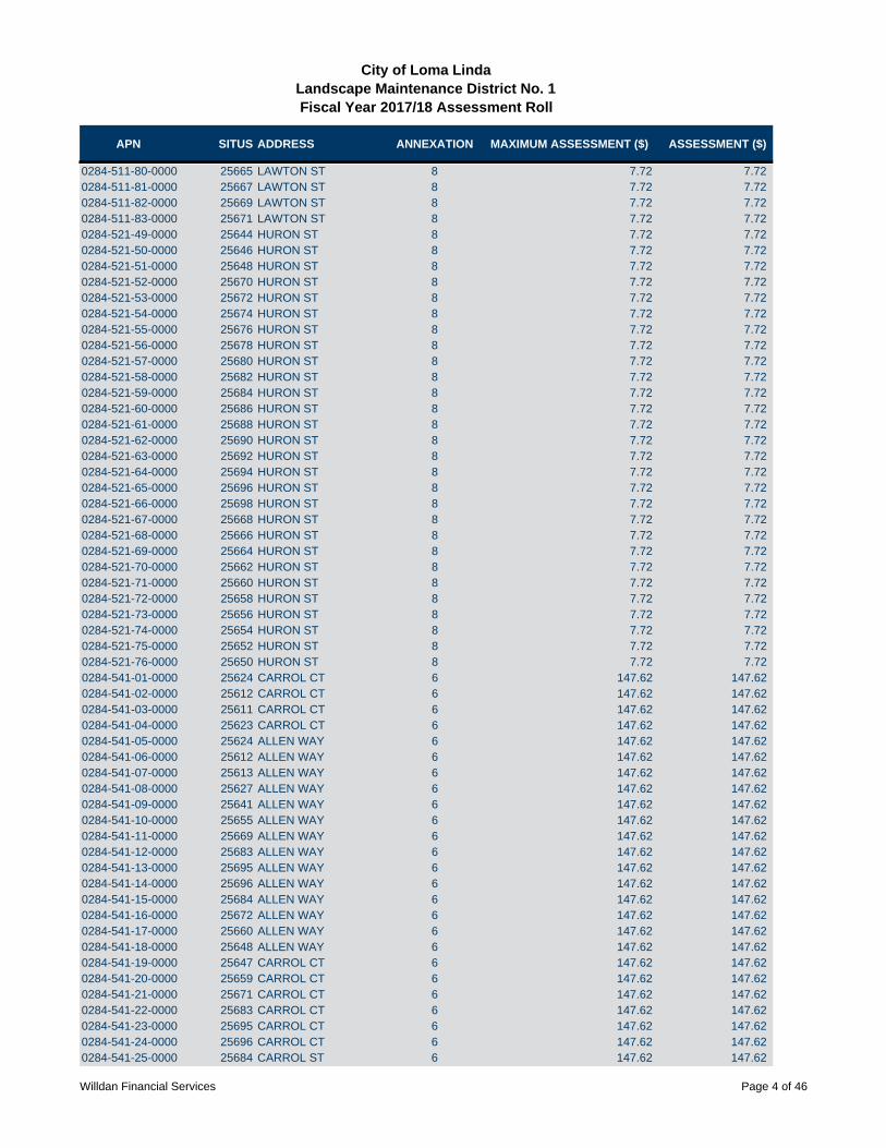
APN SITUS ADDRESS ANNEXATION MAXIMUM ASSESSMENT ($) ASSESSMENT ($)
City of Loma LindaLandscape Maintenance District No. 1Fiscal Year 2017/18 Assessment Roll
0284-511-80-0000 25665 LAWTON ST 8 7.72 7.720284-511-81-0000 25667 LAWTON ST 8 7.72 7.720284-511-82-0000 25669 LAWTON ST 8 7.72 7.720284-511-83-0000 25671 LAWTON ST 8 7.72 7.720284-521-49-0000 25644 HURON ST 8 7.72 7.720284-521-50-0000 25646 HURON ST 8 7.72 7.720284-521-51-0000 25648 HURON ST 8 7.72 7.720284-521-52-0000 25670 HURON ST 8 7.72 7.720284-521-53-0000 25672 HURON ST 8 7.72 7.720284-521-54-0000 25674 HURON ST 8 7.72 7.720284-521-55-0000 25676 HURON ST 8 7.72 7.720284-521-56-0000 25678 HURON ST 8 7.72 7.720284-521-57-0000 25680 HURON ST 8 7.72 7.720284-521-58-0000 25682 HURON ST 8 7.72 7.720284-521-59-0000 25684 HURON ST 8 7.72 7.720284-521-60-0000 25686 HURON ST 8 7.72 7.720284-521-61-0000 25688 HURON ST 8 7.72 7.720284-521-62-0000 25690 HURON ST 8 7.72 7.720284-521-63-0000 25692 HURON ST 8 7.72 7.720284-521-64-0000 25694 HURON ST 8 7.72 7.720284-521-65-0000 25696 HURON ST 8 7.72 7.720284-521-66-0000 25698 HURON ST 8 7.72 7.720284-521-67-0000 25668 HURON ST 8 7.72 7.720284-521-68-0000 25666 HURON ST 8 7.72 7.720284-521-69-0000 25664 HURON ST 8 7.72 7.720284-521-70-0000 25662 HURON ST 8 7.72 7.720284-521-71-0000 25660 HURON ST 8 7.72 7.720284-521-72-0000 25658 HURON ST 8 7.72 7.720284-521-73-0000 25656 HURON ST 8 7.72 7.720284-521-74-0000 25654 HURON ST 8 7.72 7.720284-521-75-0000 25652 HURON ST 8 7.72 7.720284-521-76-0000 25650 HURON ST 8 7.72 7.720284-541-01-0000 25624 CARROL CT 6 147.62 147.620284-541-02-0000 25612 CARROL CT 6 147.62 147.620284-541-03-0000 25611 CARROL CT 6 147.62 147.620284-541-04-0000 25623 CARROL CT 6 147.62 147.620284-541-05-0000 25624 ALLEN WAY 6 147.62 147.620284-541-06-0000 25612 ALLEN WAY 6 147.62 147.620284-541-07-0000 25613 ALLEN WAY 6 147.62 147.620284-541-08-0000 25627 ALLEN WAY 6 147.62 147.620284-541-09-0000 25641 ALLEN WAY 6 147.62 147.620284-541-10-0000 25655 ALLEN WAY 6 147.62 147.620284-541-11-0000 25669 ALLEN WAY 6 147.62 147.620284-541-12-0000 25683 ALLEN WAY 6 147.62 147.620284-541-13-0000 25695 ALLEN WAY 6 147.62 147.620284-541-14-0000 25696 ALLEN WAY 6 147.62 147.620284-541-15-0000 25684 ALLEN WAY 6 147.62 147.620284-541-16-0000 25672 ALLEN WAY 6 147.62 147.620284-541-17-0000 25660 ALLEN WAY 6 147.62 147.620284-541-18-0000 25648 ALLEN WAY 6 147.62 147.620284-541-19-0000 25647 CARROL CT 6 147.62 147.620284-541-20-0000 25659 CARROL CT 6 147.62 147.620284-541-21-0000 25671 CARROL CT 6 147.62 147.620284-541-22-0000 25683 CARROL CT 6 147.62 147.620284-541-23-0000 25695 CARROL CT 6 147.62 147.620284-541-24-0000 25696 CARROL CT 6 147.62 147.620284-541-25-0000 25684 CARROL ST 6 147.62 147.62
Willdan Financial Services Page 4 of 46
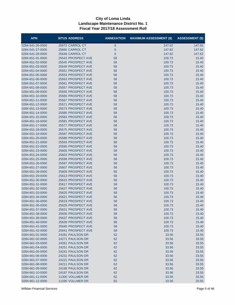
APN SITUS ADDRESS ANNEXATION MAXIMUM ASSESSMENT ($) ASSESSMENT ($)
City of Loma LindaLandscape Maintenance District No. 1Fiscal Year 2017/18 Assessment Roll
0284-541-26-0000 25672 CARROL CT 6 147.62 147.620284-541-27-0000 25660 CARROL CT 6 147.62 147.620284-541-28-0000 25648 CARROL CT 6 147.62 147.620284-651-01-0000 25543 PROSPECT AVE 58 100.73 15.400284-651-02-0000 25545 PROSPECT AVE 58 100.73 15.400284-651-03-0000 25549 PROSPECT AVE 58 100.73 15.400284-651-04-0000 25551 PROSPECT AVE 58 100.73 15.400284-651-05-0000 25553 PROSPECT AVE 58 100.73 15.400284-651-06-0000 25563 PROSPECT AVE 58 100.73 15.400284-651-07-0000 25561 PROSPECT AVE 58 100.73 15.400284-651-08-0000 25557 PROSPECT AVE 58 100.73 15.400284-651-09-0000 25555 PROSPECT AVE 58 100.73 15.400284-651-10-0000 25565 PROSPECT AVE 58 100.73 15.400284-651-11-0000 25567 PROSPECT AVE 58 100.73 15.400284-651-12-0000 25571 PROSPECT AVE 58 100.73 15.400284-651-13-0000 25573 PROSPECT AVE 58 100.73 15.400284-651-14-0000 25585 PROSPECT AVE 58 100.73 15.400284-651-15-0000 25583 PROSPECT AVE 58 100.73 15.400284-651-16-0000 25581 PROSPECT AVE 58 100.73 15.400284-651-17-0000 25577 PROSPECT AVE 58 100.73 15.400284-651-18-0000 25575 PROSPECT AVE 58 100.73 15.400284-651-19-0000 25587 PROSPECT AVE 58 100.73 15.400284-651-20-0000 25589 PROSPECT AVE 58 100.73 15.400284-651-21-0000 25593 PROSPECT AVE 58 100.73 15.400284-651-22-0000 25595 PROSPECT AVE 58 100.73 15.400284-651-23-0000 25605 PROSPECT AVE 58 100.73 15.400284-651-24-0000 25603 PROSPECT AVE 58 100.73 15.400284-651-25-0000 25599 PROSPECT AVE 58 100.73 15.400284-651-26-0000 25597 PROSPECT AVE 58 100.73 15.400284-651-27-0000 25607 PROSPECT AVE 58 100.73 15.400284-651-28-0000 25609 PROSPECT AVE 58 100.73 15.400284-651-29-0000 25613 PROSPECT AVE 58 100.73 15.400284-651-30-0000 25615 PROSPECT AVE 58 100.73 15.400284-651-31-0000 25617 PROSPECT AVE 58 100.73 15.400284-651-32-0000 25627 PROSPECT AVE 58 100.73 15.400284-651-33-0000 25625 PROSPECT AVE 58 100.73 15.400284-651-34-0000 25621 PROSPECT AVE 58 100.73 15.400284-651-35-0000 25619 PROSPECT AVE 58 100.73 15.400284-651-36-0000 25629 PROSPECT AVE 58 100.73 15.400284-651-37-0000 25631 PROSPECT AVE 58 100.73 15.400284-651-38-0000 25635 PROSPECT AVE 58 100.73 15.400284-651-39-0000 25637 PROSPECT AVE 58 100.73 15.400284-651-40-0000 25639 PROSPECT AVE 58 100.73 15.400284-651-41-0000 25645 PROSPECT AVE 58 100.73 15.400284-651-42-0000 25641 PROSPECT AVE 58 100.73 15.400284-661-01-0000 24281 PAULSON DR 62 33.56 33.550284-661-02-0000 24271 PAULSON DR 62 33.56 33.550284-661-03-0000 24261 PAULSON DR 62 33.56 33.550284-661-04-0000 24251 PAULSON DR 62 33.56 33.550284-661-05-0000 24241 PAULSON DR 62 33.56 33.550284-661-06-0000 24231 PAULSON DR 62 33.56 33.550284-661-07-0000 24221 PAULSON DR 62 33.56 33.550284-661-08-0000 24211 PAULSON DR 62 33.56 33.550284-661-09-0000 24199 PAULSON DR 62 33.56 33.550284-661-10-0000 24187 PAULSON DR 62 33.56 33.550284-661-11-0000 11300 VOLLMER DR 62 33.56 33.550284-661-12-0000 11290 VOLLMER DR 62 33.56 33.55
Willdan Financial Services Page 5 of 46

APN SITUS ADDRESS ANNEXATION MAXIMUM ASSESSMENT ($) ASSESSMENT ($)
City of Loma LindaLandscape Maintenance District No. 1Fiscal Year 2017/18 Assessment Roll
0284-661-13-0000 11278 VOLLMER DR 62 33.56 33.550284-661-14-0000 11268 VOLLMER DR 62 33.56 33.550284-661-15-0000 11256 VOLLMER DR 62 33.56 33.550284-661-16-0000 11246 VOLLMER DR 62 33.56 33.550284-661-17-0000 24162 KHAN DR 62 33.56 33.550284-661-18-0000 24172 KHAN DR 62 33.56 33.550284-661-19-0000 24184 KHAN DR 62 33.56 33.550284-661-20-0000 24198 KHAN DR 62 33.56 33.550284-661-21-0000 24204 KHAN DR 62 33.56 33.550284-661-22-0000 24214 KHAN DR 62 33.56 33.550284-661-23-0000 24226 KHAN DR 62 33.56 33.550284-661-24-0000 24236 KHAN DR 62 33.56 33.550284-661-25-0000 24246 KHAN DR 62 33.56 33.550284-661-26-0000 24258 KHAN DR 62 33.56 33.550284-661-27-0000 24270 KHAN DR 62 33.56 33.550284-661-28-0000 24282 KHAN DR 62 33.56 33.550284-661-29-0000 11247 VOLLMER DR 62 33.56 33.550284-661-30-0000 11257 VOLLMER DR 62 33.56 33.550284-661-31-0000 24207 KHAN DR 62 33.56 33.550284-661-32-0000 24225 KHAN DR 62 33.56 33.550284-661-33-0000 24237 KHAN DR 62 33.56 33.550284-661-34-0000 11247 WAREHAM CT 62 33.56 33.550284-661-35-0000 11261 WAREHAM CT 62 33.56 33.550284-661-36-0000 11273 WAREHAM CT 62 33.56 33.550284-661-37-0000 11273 VOLLMER DR 62 33.56 33.550284-661-38-0000 11283 VOLLMER DR 62 33.56 33.550284-661-39-0000 11293 VOLLMER DR 62 33.56 33.550284-661-40-0000 24226 PAULSON DR 62 33.56 33.550284-661-41-0000 24236 PAULSON DR 62 33.56 33.550284-661-42-0000 24246 PAULSON DR 62 33.56 33.550284-661-43-0000 24256 PAULSON DR 62 33.56 33.550284-661-44-0000 11278 PRICE DR 62 33.56 33.550284-661-45-0000 11268 PRICE DR 62 33.56 33.550284-661-46-0000 11258 PRICE DR 62 33.56 33.550284-661-47-0000 11248 PRICE DR 62 33.56 33.550284-661-48-0000 11238 PRICE DR 62 33.56 33.550284-661-49-0000 11226 PRICE DR 62 33.56 33.550284-661-50-0000 11225 PRICE DR 62 33.56 33.550284-661-51-0000 11235 PRICE DR 62 33.56 33.550284-661-52-0000 11245 PRICE DR 62 33.56 33.550284-661-53-0000 11255 PRICE DR 62 33.56 33.550284-661-54-0000 11265 PRICE DR 62 33.56 33.550284-661-55-0000 11275 PRICE DR 62 33.56 33.550284-661-56-0000 11285 PRICE DR 62 33.56 33.550284-661-57-0000 11295 PRICE DR 62 33.56 33.550292-091-05-0000 25825 E REDLANDS BLVD 38 683.65 683.650292-091-06-0000 25825 E REDLANDS BLVD 38 683.65 683.650292-091-07-0000 25825 E REDLANDS BLVD 38 683.65 683.650292-091-08-0000 25825 E REDLANDS BLVD 38 683.65 683.650292-091-09-0000 25825 E REDLANDS BLVD 38 683.65 683.650292-091-10-0000 25825 E REDLANDS BLVD 38 683.65 683.650292-091-20-0000 25875 REDLAND BLVD 46 312.24 312.240292-111-35-0000 25973 REDLANDS BLVD 21 3,068.52 3,068.520292-121-83-0000 25701 VAN LEUVEN ST 20 2,556.49 405.880292-141-30-0000 25980 BARTON RD 60 19,697.86 405.880292-162-19-0000 26630 BARTON RD 65 9,899.78 123.110292-162-20-0000 26630 BARTON RD 65 9,899.78 123.11
Willdan Financial Services Page 6 of 46

APN SITUS ADDRESS ANNEXATION MAXIMUM ASSESSMENT ($) ASSESSMENT ($)
City of Loma LindaLandscape Maintenance District No. 1Fiscal Year 2017/18 Assessment Roll
0292-162-21-0000 BARTON RD 65 9,899.78 123.110292-162-22-0000 BARTON RD 65 9,899.78 123.110292-162-23-0000 26526 BARTON RD 71 346.87 346.860292-162-24-0000 11245 CALIFORNIA ST 71 346.87 346.860292-162-25-0000 11221 CALIFORNIA ST 71 346.87 346.860292-162-26-0000 11201 CALIFORNIA ST 71 346.87 346.860292-371-01-0000 10468 RHONDA ST 16 49.18 49.180292-371-02-0000 10462 RHONDA ST 16 49.18 49.180292-371-03-0000 10456 RHONDA ST 16 49.18 49.180292-371-04-0000 10450 RHONDA ST 16 49.18 49.180292-371-05-0000 10442 RHONDA ST 16 49.18 49.180292-371-06-0000 10436 RHONDA ST 16 49.18 49.180292-371-07-0000 10430 RHONDA ST 16 49.18 49.180292-371-08-0000 26270 CARDIGAN PL 16 49.18 49.180292-371-09-0000 26276 CARDIGAN PL 16 49.18 49.180292-371-10-0000 26284 CARDIGAN PL 16 49.18 49.180292-371-11-0000 26288 CARDIGAN PL 16 49.18 49.180292-371-12-0000 26296 CARDIGAN PL 16 49.18 49.180292-371-13-0000 26300 CARDIGAN PL 16 49.18 49.180292-371-14-0000 26306 CARDIGAN PL 16 49.18 49.180292-371-15-0000 26312 CARDIGAN PL 16 49.18 49.180292-371-16-0000 26328 SEVERN ST 16 49.18 49.180292-371-17-0000 26334 CARDIGAN PL 16 49.18 49.180292-371-18-0000 26340 CARDIGAN PL 16 49.18 49.180292-371-19-0000 26346 CARDIGAN PL 16 49.18 49.180292-371-20-0000 26352 CARDIGAN PL 16 49.18 49.180292-371-21-0000 26358 CARDIGAN PL 16 49.18 49.180292-371-22-0000 26364 CARDIGAN PL 16 49.18 49.180292-371-23-0000 26370 CARDIGAN PL 16 49.18 49.180292-371-24-0000 26376 CARDIGAN PL 16 49.18 49.180292-371-25-0000 26382 CARDIGAN PL 16 49.18 49.180292-371-26-0000 26386 CARDIGAN PL 16 49.18 49.180292-371-27-0000 26388 SNOWDEN AVE 16 49.18 49.180292-371-28-0000 26392 SNOWDEN AVE 16 49.18 49.180292-371-29-0000 26400 SNOWDEN AVE 16 49.18 49.180292-371-30-0000 26406 SNOWDEN AVE 16 49.18 49.180292-371-31-0000 10469 TAFF ST 16 49.18 49.180292-371-32-0000 10475 TAFF ST 16 49.18 49.180292-371-33-0000 10481 TAFF ST 16 49.18 49.180292-371-34-0000 10487 TAFF ST 16 49.18 49.180292-371-35-0000 26397 SNOWDEN AVE 16 49.18 49.180292-371-36-0000 26391 SNOWDEN AVE 16 49.18 49.180292-371-37-0000 26385 SNOWDEN AVE 16 49.18 49.180292-371-38-0000 26379 SNOWDEN AVE 16 49.18 49.180292-371-39-0000 26373 SNOWDEN AVE 16 49.18 49.180292-371-40-0000 26367 SNOWDEN AVE 16 49.18 49.180292-371-41-0000 26361 SNOWDEN AVE 16 49.18 49.180292-371-42-0000 26355 SNOWDEN AVE 16 49.18 49.180292-371-43-0000 26349 SNOWDEN AVE 16 49.18 49.180292-371-44-0000 26343 SNOWDEN AVE 16 49.18 49.180292-371-45-0000 26337 SNOWDEN AVE 16 49.18 49.180292-371-46-0000 26333 SNOWDEN AVE 16 49.18 49.180292-371-47-0000 26325 SNOWDEN AVE 16 49.18 49.180292-371-48-0000 26319 SNOWDEN AVE 16 49.18 49.180292-371-49-0000 26311 SNOWDEN AVE 16 49.18 49.180292-371-50-0000 26307 SNOWDEN AVE 16 49.18 49.180292-371-51-0000 26301 SNOWDEN PL 16 49.18 49.18
Willdan Financial Services Page 7 of 46
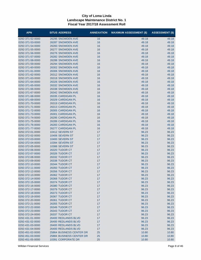
APN SITUS ADDRESS ANNEXATION MAXIMUM ASSESSMENT ($) ASSESSMENT ($)
City of Loma LindaLandscape Maintenance District No. 1Fiscal Year 2017/18 Assessment Roll
0292-371-52-0000 26295 SNOWDEN AVE 16 49.18 49.180292-371-53-0000 26287 SNOWDEN AVE 16 49.18 49.180292-371-54-0000 26283 SNOWDEN AVE 16 49.18 49.180292-371-55-0000 26277 SNOWDEN AVE 16 49.18 49.180292-371-56-0000 26276 SNOWDEN AVE 16 49.18 49.180292-371-57-0000 26282 SNOWDEN AVE 16 49.18 49.180292-371-58-0000 26288 SNOWDEN AVE 16 49.18 49.180292-371-59-0000 26294 SNOWDEN AVE 16 49.18 49.180292-371-60-0000 26302 SNOWDEN AVE 16 49.18 49.180292-371-61-0000 26306 SNOWDEN AVE 16 49.18 49.180292-371-62-0000 26312 SNOWDEN AVE 16 49.18 49.180292-371-63-0000 26318 SNOWDEN AVE 16 49.18 49.180292-371-64-0000 26326 SNOWDEN AVE 16 49.18 49.180292-371-65-0000 26332 SNOWDEN AVE 16 49.18 49.180292-371-66-0000 26338 SNOWDEN AVE 16 49.18 49.180292-371-67-0000 26342 SNOWDEN AVE 16 49.18 49.180292-371-68-0000 26335 CARDIGAN PL 16 49.18 49.180292-371-69-0000 26329 CARDIGAN PL 16 49.18 49.180292-371-70-0000 26319 CARDIGAN PL 16 49.18 49.180292-371-71-0000 26313 CARDIGAN PL 16 49.18 49.180292-371-72-0000 26305 CARDIGAN PL 16 49.18 49.180292-371-73-0000 26301 CARDIGAN PL 16 49.18 49.180292-371-74-0000 26295 CARDIGAN PL 16 49.18 49.180292-371-75-0000 26289 CARDIGAN PL 16 49.18 49.180292-371-76-0000 26283 CARDIGAN PL 16 49.18 49.180292-371-77-0000 26277 CARDIGAN PL 16 49.18 49.180292-372-01-0000 10412 SEVERN ST 17 96.23 96.230292-372-02-0000 10406 SEVERN ST 17 96.23 96.230292-372-03-0000 10400 SEVERN ST 17 96.23 96.230292-372-04-0000 10394 SEVERN ST 17 96.23 96.230292-372-05-0000 10388 SEVERN ST 17 96.23 96.230292-372-06-0000 26320 TUDOR CT 17 96.23 96.230292-372-07-0000 26326 TUDOR CT 17 96.23 96.230292-372-08-0000 26332 TUDOR CT 17 96.23 96.230292-372-09-0000 26338 TUDOR CT 17 96.23 96.230292-372-10-0000 26344 TUDOR CT 17 96.23 96.230292-372-11-0000 26350 TUDOR CT 17 96.23 96.230292-372-12-0000 26356 TUDOR CT 17 96.23 96.230292-372-13-0000 26362 TUDOR CT 17 96.23 96.230292-372-14-0000 26368 TUDOR CT 17 96.23 96.230292-372-15-0000 26374 TUDOR CT 17 96.23 96.230292-372-16-0000 26380 TUDOR CT 17 96.23 96.230292-372-17-0000 26379 TUDOR CT 17 96.23 96.230292-372-18-0000 26373 TUDOR CT 17 96.23 96.230292-372-19-0000 26367 TUDOR CT 17 96.23 96.230292-372-20-0000 26361 TUDOR CT 17 96.23 96.230292-372-21-0000 26355 TUDOR CT 17 96.23 96.230292-372-22-0000 26349 TUDOR CT 17 96.23 96.230292-372-23-0000 26343 TUDOR CT 17 96.23 96.230292-372-24-0000 26337 TUDOR CT 17 96.23 96.230292-431-01-0000 26400 REDLANDS BLVD 17 96.23 96.230292-431-02-0000 26400 REDLANDS BLVD 17 96.23 96.230292-431-03-0000 26400 REDLANDS BLVD 17 96.23 96.230292-431-04-0000 26400 REDLANDS BLVD 17 96.23 96.230292-451-02-0000 25864 BUSINESS CENTER DR 25 10.80 10.800292-451-03-0000 25884 BUSINESS CENTER DR 25 10.80 10.800292-451-05-0000 10391 CORPORATE DR 25 10.80 10.80
Willdan Financial Services Page 8 of 46

APN SITUS ADDRESS ANNEXATION MAXIMUM ASSESSMENT ($) ASSESSMENT ($)
City of Loma LindaLandscape Maintenance District No. 1Fiscal Year 2017/18 Assessment Roll
0292-451-06-0000 10421 CORPORATE DR 25 10.80 10.800292-451-07-0000 10455 CORPORATE DR 25 10.80 10.800292-451-08-0000 10479 CORPORATE DR 25 10.80 10.800292-451-09-0000 25837 BUSINESS CENTER DR 25 10.80 10.800292-451-10-0000 25809 BUSINESS CENTER DR 25 10.80 10.800292-451-14-0000 BUSINESS CENTER DR 25 10.80 10.800292-451-15-0000 25814 BUSINESS CENTER DR 25 10.80 10.800292-451-16-0000 25828 REDLANDS BLVD 25 10.80 10.800292-451-17-0000 10451 COMMERCE ST 25 10.80 10.800292-451-18-0000 10431 COMMERCE ST 25 10.80 10.800292-451-19-0000 10444 CORPORATE DR 25 10.80 10.800292-451-20-0000 10482 ENTERPRISE DR 25 10.80 10.800292-451-21-0000 10460 ENTERPRISE DR 25 10.80 10.800292-451-22-0000 10446 ENTERPRISE DR 25 10.80 10.800292-451-23-0000 10418 ENTERPRISE DR 25 10.80 10.800292-451-24-0000 10390 ENTERPRISE DR 25 10.80 10.800292-451-25-0000 10425 ENTERPRISE DR 25 10.80 10.800292-451-26-0000 10409 ENTERPRISE DR 25 10.80 10.800292-451-27-0000 10393 ENTERPRISE DR 25 10.80 10.800292-451-28-0000 26021 BUSINESS CENTER DR 25 10.80 10.800292-451-29-0000 10408 INDUSTRIAL CIR 25 10.80 10.800292-451-36-0000 BUSINESS CENTER DR 25 10.80 10.800292-451-37-0000 BUSINESS CENTER DR 25 10.80 10.800292-451-38-0000 BRYN MAWR AVE 25 10.80 10.800292-451-39-0000 BRYN MAWR AVE 25 10.80 10.800292-451-40-0000 BRYN MAWR AVE 25 10.80 10.800292-451-41-0000 REDLANDS BLVD 25 10.80 10.800292-451-42-0000 REDLANDS BLVD 25 10.80 10.800292-451-43-0000 REDLANDS BLVD 25 10.80 10.800292-451-44-0000 REDLANDS BLVD 25 10.80 10.800292-451-45-0000 REDLANDS BLVD 25 10.80 10.800292-451-46-0000 REDLANDS BLVD 25 10.80 10.800292-451-47-0000 ENTERPRISE DR 25 10.80 10.800292-451-48-0000 25 10.80 10.800292-451-49-0000 INDUSTRIAL CIR 25 10.80 10.800292-451-52-0000 10475 MOUNTAIN VIEW AVE 25 10.80 10.800292-451-53-0000 10417 MOUNTAIN VIEW AVE 25 10.80 10.800292-451-54-0000 10459 MOUNTAIN VIEW AVE 25 10.80 10.800292-451-55-0000 25948 BUSINESS CENTER DR 25 10.80 10.800292-451-56-0000 25978 BUSINESS CENTER DR 25 10.80 10.800292-451-57-0000 26008 BUSINESS CENTER DR 25 10.80 10.800292-451-58-0000 26038 BUSINESS CENTER DR 25 10.80 10.800292-521-01-0000 25967 MISSION RD 63 136.94 75.600292-521-02-0000 25979 MISSION RD 63 136.94 75.600292-521-03-0000 25989 MISSION RD 63 136.94 75.600292-521-04-0000 26001 MISSION RD 63 136.94 75.600292-521-05-0000 26011 MISSION RD 63 136.94 75.600292-521-06-0000 26023 MISSION RD 63 136.94 75.600292-521-07-0000 26014 LUGO DR 63 136.94 75.600292-521-08-0000 26008 LUGO DR 63 136.94 75.600292-521-09-0000 26004 LUGO DR 63 136.94 75.600292-521-10-0000 25998 LUGO DR 63 136.94 75.600292-521-11-0000 25992 LUGO DR 63 136.94 75.600292-521-12-0000 25986 LUGO DR 63 136.94 75.600292-521-13-0000 25980 LUGO DR 63 136.94 75.600292-521-14-0000 25976 LUGO DR 63 136.94 75.600292-521-15-0000 25970 LUGO DR 63 136.94 75.60
Willdan Financial Services Page 9 of 46

APN SITUS ADDRESS ANNEXATION MAXIMUM ASSESSMENT ($) ASSESSMENT ($)
City of Loma LindaLandscape Maintenance District No. 1Fiscal Year 2017/18 Assessment Roll
0292-521-16-0000 25960 LUGO DR 63 136.94 75.600292-521-17-0000 25956 LUGO DR 63 136.94 75.600292-521-18-0000 10923 VEACH ST 63 136.94 75.600292-521-19-0000 10972 HARRIS DR 63 136.94 75.600292-521-20-0000 10978 HARRIS DR 63 136.94 75.600292-521-21-0000 10984 HARRIS DR 63 136.94 75.600292-521-22-0000 10975 TOLLS LN 63 136.94 75.600292-521-23-0000 10969 TOLLS LN 63 136.94 75.600292-521-24-0000 10965 TOLLS LN 63 136.94 75.600292-521-25-0000 25975 LUGO DR 63 136.94 75.600292-521-26-0000 25965 LUGO DR 63 136.94 75.600292-521-27-0000 25951 LUGO DR 63 136.94 75.600292-521-28-0000 25939 LUGO DR 63 136.94 75.600292-521-29-0000 25931 LUGO DR 63 136.94 75.600292-521-30-0000 25930 BYBEE LN 63 136.94 75.600292-521-31-0000 25938 BYBEE LN 63 136.94 75.600292-521-32-0000 25946 BYBEE LN 63 136.94 75.600292-521-33-0000 25954 BYBEE LN 63 136.94 75.600292-521-34-0000 25927 MISSION RD 63 136.94 75.600292-521-35-0000 25926 VAN LEUVEN 63 136.94 75.600292-521-36-0000 25918 VAN LEUVEN ST 63 136.94 75.600292-521-37-0000 10922 VEACH ST 63 136.94 75.600292-521-38-0000 10930 VEACH ST 63 136.94 75.600292-521-39-0000 10938 VEACH ST 63 136.94 75.600292-521-40-0000 10944 VEACH ST 63 136.94 75.600292-521-41-0000 10950 VEACH ST 63 136.94 75.600292-521-42-0000 10958 VEACH ST 63 136.94 75.600292-521-43-0000 10966 VEACH ST 63 136.94 75.600292-521-44-0000 26087 MISSION RD 63 136.94 75.600292-521-45-0000 26075 MISSION RD 63 136.94 75.600292-521-46-0000 26063 MISSION RD 63 136.94 75.600292-521-47-0000 26047 MISSION RD 63 136.94 75.600292-521-48-0000 26032 LUGO DR 63 136.94 75.600292-521-49-0000 26044 LUGO DR 63 136.94 75.600292-521-50-0000 26052 LUGO DR 63 136.94 75.600292-521-51-0000 26058 LUGO DR 63 136.94 75.600292-521-52-0000 26064 LUGO DR 63 136.94 75.600292-521-53-0000 26070 LUGO DR 63 136.94 75.600292-521-54-0000 26074 LUGO DR 63 136.94 75.600292-521-55-0000 26080 LUGO DR 63 136.94 75.600292-521-56-0000 26086 LUGO DR 63 136.94 75.600292-521-59-0000 25949 MISSION RD 63 136.94 75.600292-531-01-0000 10990 HARRIS DR 63 136.94 75.600292-531-02-0000 10996 HARRIS DR 63 136.94 75.600292-531-03-0000 11004 HARRIS DR 63 136.94 75.600292-531-04-0000 11008 HARRIS DR 63 136.94 75.600292-531-05-0000 11014 HARRIS DR 63 136.94 75.600292-531-06-0000 11018 HARRIS DR 63 136.94 75.600292-531-07-0000 11024 HARRIS DR 63 136.94 75.600292-531-08-0000 11030 HARRIS DR 63 136.94 75.600292-531-09-0000 11021 TOLLS LN 63 136.94 75.600292-531-10-0000 11015 TOLLS LN 63 136.94 75.600292-531-11-0000 11009 TOLLS LN 63 136.94 75.600292-531-12-0000 11003 TOLLS LN 63 136.94 75.600292-531-13-0000 10997 TOLLS LN 63 136.94 75.600292-531-14-0000 10993 TOLLS LN 63 136.94 75.600292-531-15-0000 10987 TOLLS LN 63 136.94 75.60
Willdan Financial Services Page 10 of 46
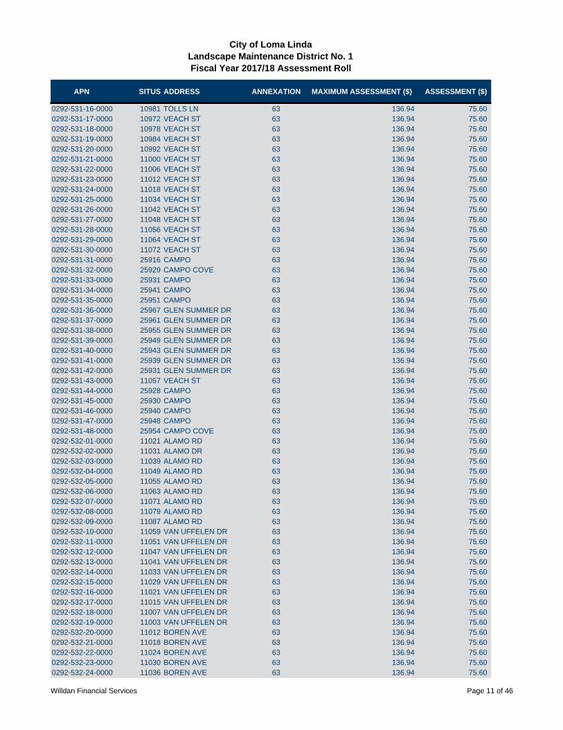
APN SITUS ADDRESS ANNEXATION MAXIMUM ASSESSMENT ($) ASSESSMENT ($)
City of Loma LindaLandscape Maintenance District No. 1Fiscal Year 2017/18 Assessment Roll
0292-531-16-0000 10981 TOLLS LN 63 136.94 75.600292-531-17-0000 10972 VEACH ST 63 136.94 75.600292-531-18-0000 10978 VEACH ST 63 136.94 75.600292-531-19-0000 10984 VEACH ST 63 136.94 75.600292-531-20-0000 10992 VEACH ST 63 136.94 75.600292-531-21-0000 11000 VEACH ST 63 136.94 75.600292-531-22-0000 11006 VEACH ST 63 136.94 75.600292-531-23-0000 11012 VEACH ST 63 136.94 75.600292-531-24-0000 11018 VEACH ST 63 136.94 75.600292-531-25-0000 11034 VEACH ST 63 136.94 75.600292-531-26-0000 11042 VEACH ST 63 136.94 75.600292-531-27-0000 11048 VEACH ST 63 136.94 75.600292-531-28-0000 11056 VEACH ST 63 136.94 75.600292-531-29-0000 11064 VEACH ST 63 136.94 75.600292-531-30-0000 11072 VEACH ST 63 136.94 75.600292-531-31-0000 25916 CAMPO 63 136.94 75.600292-531-32-0000 25929 CAMPO COVE 63 136.94 75.600292-531-33-0000 25931 CAMPO 63 136.94 75.600292-531-34-0000 25941 CAMPO 63 136.94 75.600292-531-35-0000 25951 CAMPO 63 136.94 75.600292-531-36-0000 25967 GLEN SUMMER DR 63 136.94 75.600292-531-37-0000 25961 GLEN SUMMER DR 63 136.94 75.600292-531-38-0000 25955 GLEN SUMMER DR 63 136.94 75.600292-531-39-0000 25949 GLEN SUMMER DR 63 136.94 75.600292-531-40-0000 25943 GLEN SUMMER DR 63 136.94 75.600292-531-41-0000 25939 GLEN SUMMER DR 63 136.94 75.600292-531-42-0000 25931 GLEN SUMMER DR 63 136.94 75.600292-531-43-0000 11057 VEACH ST 63 136.94 75.600292-531-44-0000 25928 CAMPO 63 136.94 75.600292-531-45-0000 25930 CAMPO 63 136.94 75.600292-531-46-0000 25940 CAMPO 63 136.94 75.600292-531-47-0000 25948 CAMPO 63 136.94 75.600292-531-48-0000 25954 CAMPO COVE 63 136.94 75.600292-532-01-0000 11021 ALAMO RD 63 136.94 75.600292-532-02-0000 11031 ALAMO DR 63 136.94 75.600292-532-03-0000 11039 ALAMO RD 63 136.94 75.600292-532-04-0000 11049 ALAMO RD 63 136.94 75.600292-532-05-0000 11055 ALAMO RD 63 136.94 75.600292-532-06-0000 11063 ALAMO RD 63 136.94 75.600292-532-07-0000 11071 ALAMO RD 63 136.94 75.600292-532-08-0000 11079 ALAMO RD 63 136.94 75.600292-532-09-0000 11087 ALAMO RD 63 136.94 75.600292-532-10-0000 11059 VAN UFFELEN DR 63 136.94 75.600292-532-11-0000 11051 VAN UFFELEN DR 63 136.94 75.600292-532-12-0000 11047 VAN UFFELEN DR 63 136.94 75.600292-532-13-0000 11041 VAN UFFELEN DR 63 136.94 75.600292-532-14-0000 11033 VAN UFFELEN DR 63 136.94 75.600292-532-15-0000 11029 VAN UFFELEN DR 63 136.94 75.600292-532-16-0000 11021 VAN UFFELEN DR 63 136.94 75.600292-532-17-0000 11015 VAN UFFELEN DR 63 136.94 75.600292-532-18-0000 11007 VAN UFFELEN DR 63 136.94 75.600292-532-19-0000 11003 VAN UFFELEN DR 63 136.94 75.600292-532-20-0000 11012 BOREN AVE 63 136.94 75.600292-532-21-0000 11018 BOREN AVE 63 136.94 75.600292-532-22-0000 11024 BOREN AVE 63 136.94 75.600292-532-23-0000 11030 BOREN AVE 63 136.94 75.600292-532-24-0000 11036 BOREN AVE 63 136.94 75.60
Willdan Financial Services Page 11 of 46

APN SITUS ADDRESS ANNEXATION MAXIMUM ASSESSMENT ($) ASSESSMENT ($)
City of Loma LindaLandscape Maintenance District No. 1Fiscal Year 2017/18 Assessment Roll
0292-532-25-0000 11044 BOREN AVE 63 136.94 75.600292-532-26-0000 11050 BOREN AVE 63 136.94 75.600292-532-27-0000 11056 BOREN AVE 63 136.94 75.600292-532-28-0000 11062 BOREN AVE 63 136.94 75.600292-532-29-0000 11068 BOREN AVE 63 136.94 75.600292-532-30-0000 11051 BOREN AVE 63 136.94 75.600292-532-31-0000 11045 BOREN AVE 63 136.94 75.600292-532-32-0000 11039 BOREN AVE 63 136.94 75.600292-532-33-0000 11031 BOREN AVE 63 136.94 75.600292-532-34-0000 11027 BOREN AVE 63 136.94 75.600292-532-35-0000 11021 BOREN AVE 63 136.94 75.600292-532-36-0000 11013 BOREN AVE 63 136.94 75.600292-532-37-0000 11040 WILSON 63 136.94 75.600292-532-38-0000 11050 WILSON 63 136.94 75.600292-532-39-0000 11056 WILSON 63 136.94 75.600292-532-40-0000 11064 WILSON 63 136.94 75.600292-532-41-0000 11068 WILSON 63 136.94 75.600292-532-42-0000 11072 WILSON 63 136.94 75.600292-541-01-0000 25953 CAMPO 63 136.94 75.600292-541-02-0000 25959 CAMPO 63 136.94 75.600292-541-03-0000 11099 VAN UFFELEN DR 63 136.94 75.600292-541-04-0000 11091 VAN UFFELEN DR 63 136.94 75.600292-541-05-0000 11085 VAN UFFELEN DR 63 136.94 75.600292-541-06-0000 11079 VAN UFFELEN DR 63 136.94 75.600292-541-07-0000 11073 VAN UFFELEN DR 63 136.94 75.600292-541-08-0000 11103 ALAMO RD 63 136.94 75.600292-541-09-0000 11111 ALAMO RD 63 136.94 75.600292-541-10-0000 11117 ALAMO RD 63 136.94 75.600292-541-11-0000 11125 ALAMO RD 63 136.94 75.600292-541-12-0000 11133 ALAMO RD 63 136.94 75.600292-541-13-0000 11143 ALAMO RD 63 136.94 75.600292-541-14-0000 26087 ARROYO LN 63 136.94 75.600292-541-15-0000 26067 ARROYO LN 63 136.94 75.600292-541-16-0000 26061 ARROYO LN 63 136.94 75.600292-541-17-0000 26055 ARROYO LN 63 136.94 75.600292-541-18-0000 26049 ARROYO LN 63 136.94 75.600292-541-19-0000 26043 ARROYO` LN 63 136.94 75.600292-541-20-0000 26037 ARROYO` LN 63 136.94 75.600292-541-21-0000 26031 ARROYO LN 63 136.94 75.600292-541-22-0000 26025 ARROYO LN 63 136.94 75.600292-541-23-0000 26019 ARROYO` LN 63 136.94 75.600292-541-24-0000 26013 ARROYO LN 63 136.94 75.600292-541-25-0000 26007 ARROYO LN 63 136.94 75.600292-541-26-0000 26001 ARROYO LN 63 136.94 75.600292-541-27-0000 25993 ARROYO LN 63 136.94 75.600292-541-28-0000 11106 BOREN AVE 63 136.94 75.600292-541-29-0000 11096 BOREN AVE 63 136.94 75.600292-541-30-0000 11090 BOREN AVE 63 136.94 75.600292-541-31-0000 11082 BOREN AVE 63 136.94 75.600292-541-32-0000 11075 BOREN AVE 63 136.94 75.600292-541-33-0000 11085 BOREN AVE 63 136.94 75.600292-541-34-0000 11093 BOREN AVE 63 136.94 75.600292-541-35-0000 11101 BOREN AVE 63 136.94 75.600292-541-36-0000 26018 ARROYO LN 63 136.94 75.600292-541-37-0000 26024 ARROYO LN 63 136.94 75.600292-541-38-0000 26030 ARROYO LN 63 136.94 75.600292-541-39-0000 26036 ARROYO LN 63 136.94 75.60
Willdan Financial Services Page 12 of 46
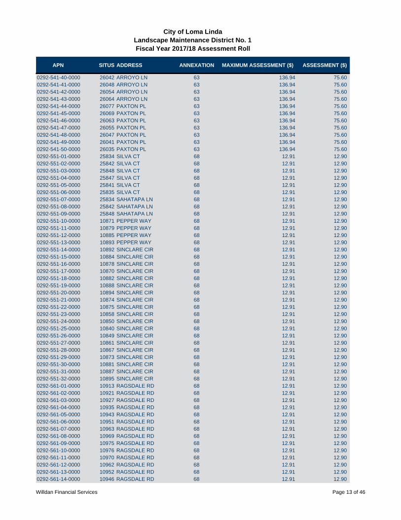
APN SITUS ADDRESS ANNEXATION MAXIMUM ASSESSMENT ($) ASSESSMENT ($)
City of Loma LindaLandscape Maintenance District No. 1Fiscal Year 2017/18 Assessment Roll
0292-541-40-0000 26042 ARROYO LN 63 136.94 75.600292-541-41-0000 26048 ARROYO LN 63 136.94 75.600292-541-42-0000 26054 ARROYO LN 63 136.94 75.600292-541-43-0000 26064 ARROYO LN 63 136.94 75.600292-541-44-0000 26077 PAXTON PL 63 136.94 75.600292-541-45-0000 26069 PAXTON PL 63 136.94 75.600292-541-46-0000 26063 PAXTON PL 63 136.94 75.600292-541-47-0000 26055 PAXTON PL 63 136.94 75.600292-541-48-0000 26047 PAXTON PL 63 136.94 75.600292-541-49-0000 26041 PAXTON PL 63 136.94 75.600292-541-50-0000 26035 PAXTON PL 63 136.94 75.600292-551-01-0000 25834 SILVA CT 68 12.91 12.900292-551-02-0000 25842 SILVA CT 68 12.91 12.900292-551-03-0000 25848 SILVA CT 68 12.91 12.900292-551-04-0000 25847 SILVA CT 68 12.91 12.900292-551-05-0000 25841 SILVA CT 68 12.91 12.900292-551-06-0000 25835 SILVA CT 68 12.91 12.900292-551-07-0000 25834 SAHATAPA LN 68 12.91 12.900292-551-08-0000 25842 SAHATAPA LN 68 12.91 12.900292-551-09-0000 25848 SAHATAPA LN 68 12.91 12.900292-551-10-0000 10871 PEPPER WAY 68 12.91 12.900292-551-11-0000 10879 PEPPER WAY 68 12.91 12.900292-551-12-0000 10885 PEPPER WAY 68 12.91 12.900292-551-13-0000 10893 PEPPER WAY 68 12.91 12.900292-551-14-0000 10892 SINCLARE CIR 68 12.91 12.900292-551-15-0000 10884 SINCLARE CIR 68 12.91 12.900292-551-16-0000 10878 SINCLARE CIR 68 12.91 12.900292-551-17-0000 10870 SINCLARE CIR 68 12.91 12.900292-551-18-0000 10882 SINCLARE CIR 68 12.91 12.900292-551-19-0000 10888 SINCLARE CIR 68 12.91 12.900292-551-20-0000 10894 SINCLARE CIR 68 12.91 12.900292-551-21-0000 10874 SINCLARE CIR 68 12.91 12.900292-551-22-0000 10875 SINCLARE CIR 68 12.91 12.900292-551-23-0000 10858 SINCLARE CIR 68 12.91 12.900292-551-24-0000 10850 SINCLARE CIR 68 12.91 12.900292-551-25-0000 10840 SINCLARE CIR 68 12.91 12.900292-551-26-0000 10849 SINCLARE CIR 68 12.91 12.900292-551-27-0000 10861 SINCLARE CIR 68 12.91 12.900292-551-28-0000 10867 SINCLARE CIR 68 12.91 12.900292-551-29-0000 10873 SINCLARE CIR 68 12.91 12.900292-551-30-0000 10881 SINCLARE CIR 68 12.91 12.900292-551-31-0000 10887 SINCLARE CIR 68 12.91 12.900292-551-32-0000 10895 SINCLARE CIR 68 12.91 12.900292-561-01-0000 10913 RAGSDALE RD 68 12.91 12.900292-561-02-0000 10921 RAGSDALE RD 68 12.91 12.900292-561-03-0000 10927 RAGSDALE RD 68 12.91 12.900292-561-04-0000 10935 RAGSDALE RD 68 12.91 12.900292-561-05-0000 10943 RAGSDALE RD 68 12.91 12.900292-561-06-0000 10951 RAGSDALE RD 68 12.91 12.900292-561-07-0000 10963 RAGSDALE RD 68 12.91 12.900292-561-08-0000 10969 RAGSDALE RD 68 12.91 12.900292-561-09-0000 10975 RAGSDALE RD 68 12.91 12.900292-561-10-0000 10976 RAGSDALE RD 68 12.91 12.900292-561-11-0000 10970 RAGSDALE RD 68 12.91 12.900292-561-12-0000 10962 RAGSDALE RD 68 12.91 12.900292-561-13-0000 10952 RAGSDALE RD 68 12.91 12.900292-561-14-0000 10946 RAGSDALE RD 68 12.91 12.90
Willdan Financial Services Page 13 of 46

APN SITUS ADDRESS ANNEXATION MAXIMUM ASSESSMENT ($) ASSESSMENT ($)
City of Loma LindaLandscape Maintenance District No. 1Fiscal Year 2017/18 Assessment Roll
0292-561-15-0000 10938 RAGSDALE RD 68 12.91 12.900292-561-16-0000 10932 RAGSDALE RD 68 12.91 12.900292-561-17-0000 10926 RAGSDALE RD 68 12.91 12.900292-561-18-0000 10918 RAGSDALE RD 68 12.91 12.900292-561-19-0000 10910 RAGSDALE RD 68 12.91 12.900292-571-01-0000 10983 RAGSDALE RD 68 12.91 12.900292-571-02-0000 10991 RAGSDALE RD 68 12.91 12.900292-571-03-0000 11005 RAGSDALE RD 68 12.91 12.900292-571-04-0000 11013 RAGSDALE RD 68 12.91 12.900292-571-05-0000 11019 RAGSDALE RD 68 12.91 12.900292-571-06-0000 11035 RAGSDALE RD 68 12.91 12.900292-571-07-0000 11041 RAGSDALE RD 68 12.91 12.900292-571-08-0000 11049 RAGSDALE RD 68 12.91 12.900292-571-09-0000 11060 RAGSDALE RD 68 12.91 12.900292-571-10-0000 11052 RAGSDALE RD 68 12.91 12.900292-571-11-0000 11044 RAGSDALE RD 68 12.91 12.900292-571-12-0000 11038 RAGSDALE RD 68 12.91 12.900292-571-13-0000 11032 RAGSDALE RD 68 12.91 12.900292-571-14-0000 11026 RAGSDALE RD 68 12.91 12.900292-571-15-0000 11018 RAGSDALE RD 68 12.91 12.900292-571-16-0000 11012 RAGSDALE RD 68 12.91 12.900292-571-17-0000 11004 RAGSDALE RD 68 12.91 12.900292-571-18-0000 10990 RAGSDALE RD 68 12.91 12.900292-571-19-0000 10984 RAGSDALE RD 68 12.91 12.900292-581-01-0000 26143 MISSION RD 69 37.43 31.710292-581-02-0000 26153 MISSION RD 69 37.43 31.710292-581-03-0000 26167 MISSION RD 69 37.43 31.710292-581-04-0000 26179 MISSION RD 69 37.43 31.710292-581-05-0000 26191 MISSION RD 69 37.43 31.710292-581-06-0000 26203 MISSION RD 69 37.43 31.710292-581-07-0000 26217 MISSION RD 69 37.43 31.710292-581-08-0000 26261 MISSION RD 69 37.43 31.710292-581-09-0000 26273 MISSION RD 69 37.43 31.710292-581-10-0000 26283 MISSION RD 69 37.43 31.710292-581-11-0000 26272 LONG ST 69 37.43 31.710292-581-12-0000 26266 LONG ST 69 37.43 31.710292-581-13-0000 26260 LONG ST 69 37.43 31.710292-581-14-0000 26254 LONG ST 69 37.43 31.710292-581-15-0000 26248 LONG ST 69 37.43 31.710292-581-16-0000 26242 LONG ST 69 37.43 31.710292-581-17-0000 26230 LONG ST 69 37.43 31.710292-581-18-0000 26226 LONG ST 69 37.43 31.710292-581-19-0000 26220 LONG ST 69 37.43 31.710292-581-20-0000 26214 LONG ST 69 37.43 31.710292-581-21-0000 26206 LONG ST 69 37.43 31.710292-581-22-0000 26200 LONG ST 69 37.43 31.710292-581-23-0000 26194 LONG ST 69 37.43 31.710292-581-24-0000 26188 LONG ST 69 37.43 31.710292-581-25-0000 26182 LONG ST 69 37.43 31.710292-581-26-0000 26176 LONG ST 69 37.43 31.710292-581-27-0000 26164 LONG ST 69 37.43 31.710292-581-28-0000 26158 LONG ST 69 37.43 31.710292-581-29-0000 26152 LONG ST 69 37.43 31.710292-581-30-0000 26146 LONG ST 69 37.43 31.710292-581-31-0000 26140 LONG ST 69 37.43 31.710292-581-32-0000 26134 LONG ST 69 37.43 31.710292-581-33-0000 26128 LONG ST 69 37.43 31.71
Willdan Financial Services Page 14 of 46
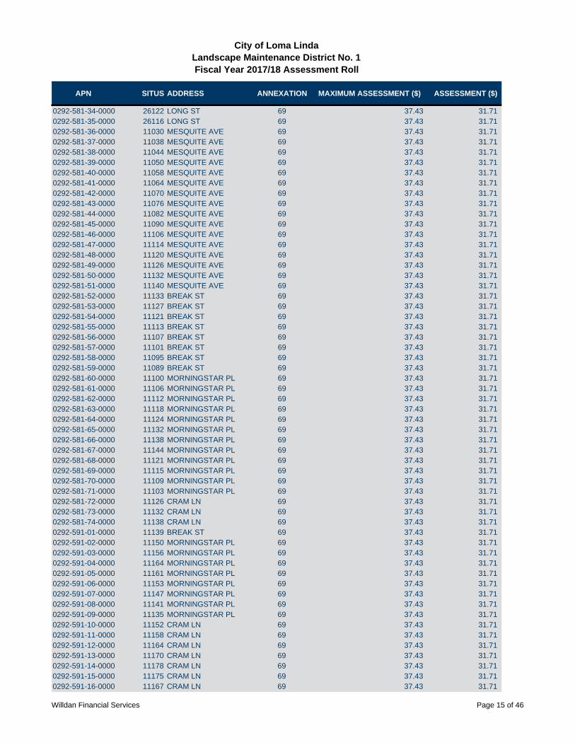
APN SITUS ADDRESS ANNEXATION MAXIMUM ASSESSMENT ($) ASSESSMENT ($)
City of Loma LindaLandscape Maintenance District No. 1Fiscal Year 2017/18 Assessment Roll
0292-581-34-0000 26122 LONG ST 69 37.43 31.710292-581-35-0000 26116 LONG ST 69 37.43 31.710292-581-36-0000 11030 MESQUITE AVE 69 37.43 31.710292-581-37-0000 11038 MESQUITE AVE 69 37.43 31.710292-581-38-0000 11044 MESQUITE AVE 69 37.43 31.710292-581-39-0000 11050 MESQUITE AVE 69 37.43 31.710292-581-40-0000 11058 MESQUITE AVE 69 37.43 31.710292-581-41-0000 11064 MESQUITE AVE 69 37.43 31.710292-581-42-0000 11070 MESQUITE AVE 69 37.43 31.710292-581-43-0000 11076 MESQUITE AVE 69 37.43 31.710292-581-44-0000 11082 MESQUITE AVE 69 37.43 31.710292-581-45-0000 11090 MESQUITE AVE 69 37.43 31.710292-581-46-0000 11106 MESQUITE AVE 69 37.43 31.710292-581-47-0000 11114 MESQUITE AVE 69 37.43 31.710292-581-48-0000 11120 MESQUITE AVE 69 37.43 31.710292-581-49-0000 11126 MESQUITE AVE 69 37.43 31.710292-581-50-0000 11132 MESQUITE AVE 69 37.43 31.710292-581-51-0000 11140 MESQUITE AVE 69 37.43 31.710292-581-52-0000 11133 BREAK ST 69 37.43 31.710292-581-53-0000 11127 BREAK ST 69 37.43 31.710292-581-54-0000 11121 BREAK ST 69 37.43 31.710292-581-55-0000 11113 BREAK ST 69 37.43 31.710292-581-56-0000 11107 BREAK ST 69 37.43 31.710292-581-57-0000 11101 BREAK ST 69 37.43 31.710292-581-58-0000 11095 BREAK ST 69 37.43 31.710292-581-59-0000 11089 BREAK ST 69 37.43 31.710292-581-60-0000 11100 MORNINGSTAR PL 69 37.43 31.710292-581-61-0000 11106 MORNINGSTAR PL 69 37.43 31.710292-581-62-0000 11112 MORNINGSTAR PL 69 37.43 31.710292-581-63-0000 11118 MORNINGSTAR PL 69 37.43 31.710292-581-64-0000 11124 MORNINGSTAR PL 69 37.43 31.710292-581-65-0000 11132 MORNINGSTAR PL 69 37.43 31.710292-581-66-0000 11138 MORNINGSTAR PL 69 37.43 31.710292-581-67-0000 11144 MORNINGSTAR PL 69 37.43 31.710292-581-68-0000 11121 MORNINGSTAR PL 69 37.43 31.710292-581-69-0000 11115 MORNINGSTAR PL 69 37.43 31.710292-581-70-0000 11109 MORNINGSTAR PL 69 37.43 31.710292-581-71-0000 11103 MORNINGSTAR PL 69 37.43 31.710292-581-72-0000 11126 CRAM LN 69 37.43 31.710292-581-73-0000 11132 CRAM LN 69 37.43 31.710292-581-74-0000 11138 CRAM LN 69 37.43 31.710292-591-01-0000 11139 BREAK ST 69 37.43 31.710292-591-02-0000 11150 MORNINGSTAR PL 69 37.43 31.710292-591-03-0000 11156 MORNINGSTAR PL 69 37.43 31.710292-591-04-0000 11164 MORNINGSTAR PL 69 37.43 31.710292-591-05-0000 11161 MORNINGSTAR PL 69 37.43 31.710292-591-06-0000 11153 MORNINGSTAR PL 69 37.43 31.710292-591-07-0000 11147 MORNINGSTAR PL 69 37.43 31.710292-591-08-0000 11141 MORNINGSTAR PL 69 37.43 31.710292-591-09-0000 11135 MORNINGSTAR PL 69 37.43 31.710292-591-10-0000 11152 CRAM LN 69 37.43 31.710292-591-11-0000 11158 CRAM LN 69 37.43 31.710292-591-12-0000 11164 CRAM LN 69 37.43 31.710292-591-13-0000 11170 CRAM LN 69 37.43 31.710292-591-14-0000 11178 CRAM LN 69 37.43 31.710292-591-15-0000 11175 CRAM LN 69 37.43 31.710292-591-16-0000 11167 CRAM LN 69 37.43 31.71
Willdan Financial Services Page 15 of 46

APN SITUS ADDRESS ANNEXATION MAXIMUM ASSESSMENT ($) ASSESSMENT ($)
City of Loma LindaLandscape Maintenance District No. 1Fiscal Year 2017/18 Assessment Roll
0292-591-17-0000 11161 CRAM LN 69 37.43 31.710292-591-18-0000 11155 CRAM LN 69 37.43 31.710292-591-19-0000 11141 CRAM LN 69 37.43 31.710292-591-20-0000 11135 CRAM LN 69 37.43 31.710292-591-21-0000 11129 CRAM LN 69 37.43 31.710292-591-22-0000 11123 CRAM LN 69 37.43 31.710292-591-23-0000 11140 DALLAS PL 69 37.43 31.710292-591-24-0000 11146 DALLAS PL 69 37.43 31.710292-591-25-0000 11152 DALLAS PL 69 37.43 31.710292-591-26-0000 11158 DALLAS PL 69 37.43 31.710292-591-27-0000 11172 DALLAS PL 69 37.43 31.710292-591-28-0000 11178 DALLAS PL 69 37.43 31.710292-591-29-0000 11184 DALLAS PL 69 37.43 31.710292-591-30-0000 11192 DALLAS PL 69 37.43 31.710292-591-31-0000 11189 DALLAS PL 69 37.43 31.710292-591-32-0000 11181 DALLAS PL 69 37.43 31.710292-591-33-0000 11175 DALLAS PL 69 37.43 31.710292-591-34-0000 11169 DALLAS PL 69 37.43 31.710292-591-35-0000 11163 DALLAS PL 69 37.43 31.710292-591-36-0000 11155 DALLAS PL 69 37.43 31.710292-591-37-0000 11149 DALLAS PL 69 37.43 31.710292-591-38-0000 11143 DALLAS PL 69 37.43 31.710292-591-39-0000 11137 DALLAS PL 69 37.43 31.710292-591-40-0000 11131 DALLAS PL 69 37.43 31.710292-591-41-0000 11141 FLORENCE LN 69 37.43 31.710292-591-42-0000 11147 FLORENCE LN 69 37.43 31.710292-591-43-0000 11153 FLORENCE LN 69 37.43 31.710292-591-44-0000 11159 FLORENCE LN 69 37.43 31.710292-591-45-0000 11165 FLORENCE LN 69 37.43 31.710292-591-46-0000 11173 FLORENCE LN 69 37.43 31.710292-591-47-0000 11179 FLORENCE LN 69 37.43 31.710292-591-48-0000 11185 FLORENCE LN 69 37.43 31.710292-591-49-0000 11191 FLORENCE LN 69 37.43 31.710292-591-50-0000 11199 FLORENCE LN 69 37.43 31.710292-591-51-0000 11224 DEWITT DR 69 37.43 31.710292-591-52-0000 11218 DEWITT DR 69 37.43 31.710292-591-53-0000 11212 DEWITT DR 69 37.43 31.710292-591-54-0000 11206 DEWITT DR 69 37.43 31.710292-591-55-0000 11200 DEWITT DR 69 37.43 31.710292-591-56-0000 11194 DEWITT DR 69 37.43 31.710292-591-57-0000 11186 DEWITT DR 69 37.43 31.710292-591-58-0000 11180 DEWITT DR 69 37.43 31.710292-591-59-0000 11174 DEWITT DR 69 37.43 31.710292-591-60-0000 11168 DEWITT DR 69 37.43 31.710292-591-61-0000 11178 SUNKIST DR 69 37.43 31.710292-591-62-0000 11184 SUNKIST DR 69 37.43 31.710292-591-63-0000 11190 SUNKIST DR 69 37.43 31.710292-591-64-0000 11196 SUNKIST DR 69 37.43 31.710292-591-65-0000 11204 SUNKIST DR 69 37.43 31.710292-591-66-0000 11210 SUNKIST DR 69 37.43 31.710292-591-67-0000 11216 SUNKIST DR 69 37.43 31.710292-591-68-0000 11222 SUNKIST DR 69 37.43 31.710292-592-01-0000 26301 MISSION RD 69 37.43 31.710292-592-02-0000 26313 MISSION RD 69 37.43 31.710292-592-03-0000 26325 MISSION RD 69 37.43 31.710292-592-04-0000 11241 SUNKIST DR 69 37.43 31.710292-592-05-0000 11235 SUNKIST DR 69 37.43 31.71
Willdan Financial Services Page 16 of 46

APN SITUS ADDRESS ANNEXATION MAXIMUM ASSESSMENT ($) ASSESSMENT ($)
City of Loma LindaLandscape Maintenance District No. 1Fiscal Year 2017/18 Assessment Roll
0292-592-06-0000 11229 SUNKIST DR 69 37.43 31.710292-592-07-0000 11223 SUNKIST DR 69 37.43 31.710292-592-08-0000 11217 SUNKIST DR 69 37.43 31.710292-592-09-0000 11209 SUNKIST DR 69 37.43 31.710292-592-10-0000 11203 SUNKIST DR 69 37.43 31.710292-592-11-0000 11197 SUNKIST DR 69 37.43 31.710292-592-12-0000 11191 SUNKIST DR 69 37.43 31.710292-592-13-0000 26324 LONG ST 69 37.43 31.710292-592-14-0000 26312 LONG ST 69 37.43 31.710292-592-15-0000 26306 LONG ST 69 37.43 31.710292-592-16-0000 26300 LONG ST 69 37.43 31.710292-592-17-0000 26294 LONG ST 69 37.43 31.710292-592-18-0000 26288 LONG ST 69 37.43 31.710292-592-19-0000 26282 LONG ST 69 37.43 31.710292-592-20-0000 26263 CITRON ST 69 37.43 31.710292-592-21-0000 26255 CITRON ST 69 37.43 31.710292-592-22-0000 26249 CITRON ST 69 37.43 31.710292-592-23-0000 26243 CITRON ST 69 37.43 31.710292-592-24-0000 26237 CITRON ST 69 37.43 31.710292-592-25-0000 26227 CITRON ST 69 37.43 31.710292-592-26-0000 26221 CITRON ST 69 37.43 31.710292-592-27-0000 26215 CITRON ST 69 37.43 31.710292-592-28-0000 26209 CITRON ST 69 37.43 31.710292-592-29-0000 26203 CITRON ST 69 37.43 31.710292-592-30-0000 26197 CITRON ST 69 37.43 31.710292-592-31-0000 26191 CITRON ST 69 37.43 31.710292-592-32-0000 26185 CITRON ST 69 37.43 31.710292-592-33-0000 26179 CITRON ST 69 37.43 31.710292-592-34-0000 26173 CITRON ST 69 37.43 31.710292-592-35-0000 26167 CITRON ST 69 37.43 31.710292-592-36-0000 26161 CITRON ST 69 37.43 31.710292-592-37-0000 26155 CITRON ST 69 37.43 31.710292-592-38-0000 26145 CITRON ST 69 37.43 31.710292-592-39-0000 26139 CITRON ST 69 37.43 31.710292-592-40-0000 26133 CITRON ST 69 37.43 31.710292-592-41-0000 26127 CITRON ST 69 37.43 31.710292-592-42-0000 26121 CITRON ST 69 37.43 31.710292-592-43-0000 11162 MESQUITE AVE 69 37.43 31.710292-592-44-0000 11154 MESQUITE AVE 69 37.43 31.710292-592-45-0000 11146 MESQUITE AVE 69 37.43 31.710292-601-01-0000 26339 MISSION RD 69 37.43 31.710292-601-02-0000 26353 MISSION RD 69 37.43 31.710292-601-03-0000 26367 MISSION RD 69 37.43 31.710292-601-04-0000 26385 MISSION RD 69 37.43 31.710292-601-05-0000 26399 MISSION RD 69 37.43 31.710292-601-06-0000 26396 FOWLER DR 69 37.43 31.710292-601-07-0000 26392 FOWLER DR 69 37.43 31.710292-601-08-0000 26388 FOWLER DR 69 37.43 31.710292-601-09-0000 26384 FOWLER DR 69 37.43 31.710292-601-10-0000 26380 FOWLER DR 69 37.43 31.710292-601-11-0000 26376 FOWLER DR 69 37.43 31.710292-601-12-0000 26396 KELLER DR 69 37.43 31.710292-601-13-0000 26392 KELLER DR 69 37.43 31.710292-601-14-0000 26388 KELLER DR 69 37.43 31.710292-601-15-0000 26384 KELLER DR 69 37.43 31.710292-601-16-0000 26380 KELLER DR 69 37.43 31.710292-601-17-0000 26376 KELLER DR 69 37.43 31.71
Willdan Financial Services Page 17 of 46
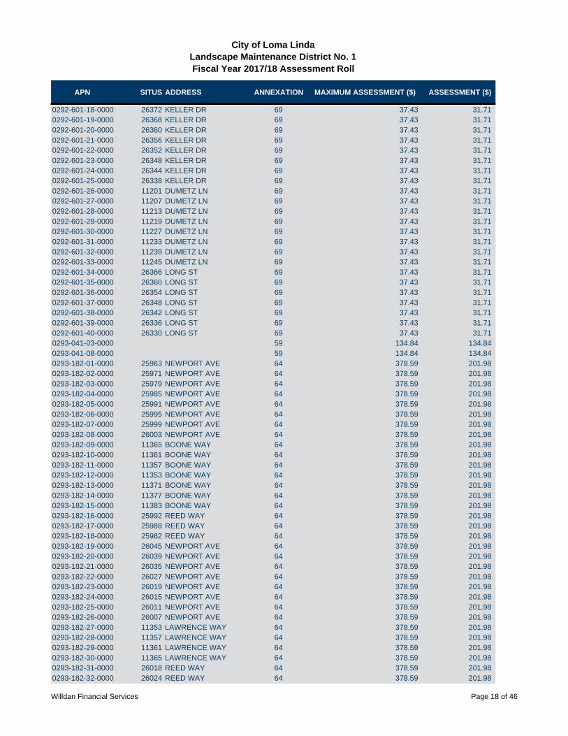
APN SITUS ADDRESS ANNEXATION MAXIMUM ASSESSMENT ($) ASSESSMENT ($)
City of Loma LindaLandscape Maintenance District No. 1Fiscal Year 2017/18 Assessment Roll
0292-601-18-0000 26372 KELLER DR 69 37.43 31.710292-601-19-0000 26368 KELLER DR 69 37.43 31.710292-601-20-0000 26360 KELLER DR 69 37.43 31.710292-601-21-0000 26356 KELLER DR 69 37.43 31.710292-601-22-0000 26352 KELLER DR 69 37.43 31.710292-601-23-0000 26348 KELLER DR 69 37.43 31.710292-601-24-0000 26344 KELLER DR 69 37.43 31.710292-601-25-0000 26338 KELLER DR 69 37.43 31.710292-601-26-0000 11201 DUMETZ LN 69 37.43 31.710292-601-27-0000 11207 DUMETZ LN 69 37.43 31.710292-601-28-0000 11213 DUMETZ LN 69 37.43 31.710292-601-29-0000 11219 DUMETZ LN 69 37.43 31.710292-601-30-0000 11227 DUMETZ LN 69 37.43 31.710292-601-31-0000 11233 DUMETZ LN 69 37.43 31.710292-601-32-0000 11239 DUMETZ LN 69 37.43 31.710292-601-33-0000 11245 DUMETZ LN 69 37.43 31.710292-601-34-0000 26366 LONG ST 69 37.43 31.710292-601-35-0000 26360 LONG ST 69 37.43 31.710292-601-36-0000 26354 LONG ST 69 37.43 31.710292-601-37-0000 26348 LONG ST 69 37.43 31.710292-601-38-0000 26342 LONG ST 69 37.43 31.710292-601-39-0000 26336 LONG ST 69 37.43 31.710292-601-40-0000 26330 LONG ST 69 37.43 31.710293-041-03-0000 59 134.84 134.840293-041-08-0000 59 134.84 134.840293-182-01-0000 25963 NEWPORT AVE 64 378.59 201.980293-182-02-0000 25971 NEWPORT AVE 64 378.59 201.980293-182-03-0000 25979 NEWPORT AVE 64 378.59 201.980293-182-04-0000 25985 NEWPORT AVE 64 378.59 201.980293-182-05-0000 25991 NEWPORT AVE 64 378.59 201.980293-182-06-0000 25995 NEWPORT AVE 64 378.59 201.980293-182-07-0000 25999 NEWPORT AVE 64 378.59 201.980293-182-08-0000 26003 NEWPORT AVE 64 378.59 201.980293-182-09-0000 11365 BOONE WAY 64 378.59 201.980293-182-10-0000 11361 BOONE WAY 64 378.59 201.980293-182-11-0000 11357 BOONE WAY 64 378.59 201.980293-182-12-0000 11353 BOONE WAY 64 378.59 201.980293-182-13-0000 11371 BOONE WAY 64 378.59 201.980293-182-14-0000 11377 BOONE WAY 64 378.59 201.980293-182-15-0000 11383 BOONE WAY 64 378.59 201.980293-182-16-0000 25992 REED WAY 64 378.59 201.980293-182-17-0000 25988 REED WAY 64 378.59 201.980293-182-18-0000 25982 REED WAY 64 378.59 201.980293-182-19-0000 26045 NEWPORT AVE 64 378.59 201.980293-182-20-0000 26039 NEWPORT AVE 64 378.59 201.980293-182-21-0000 26035 NEWPORT AVE 64 378.59 201.980293-182-22-0000 26027 NEWPORT AVE 64 378.59 201.980293-182-23-0000 26019 NEWPORT AVE 64 378.59 201.980293-182-24-0000 26015 NEWPORT AVE 64 378.59 201.980293-182-25-0000 26011 NEWPORT AVE 64 378.59 201.980293-182-26-0000 26007 NEWPORT AVE 64 378.59 201.980293-182-27-0000 11353 LAWRENCE WAY 64 378.59 201.980293-182-28-0000 11357 LAWRENCE WAY 64 378.59 201.980293-182-29-0000 11361 LAWRENCE WAY 64 378.59 201.980293-182-30-0000 11365 LAWRENCE WAY 64 378.59 201.980293-182-31-0000 26018 REED WAY 64 378.59 201.980293-182-32-0000 26024 REED WAY 64 378.59 201.98
Willdan Financial Services Page 18 of 46

APN SITUS ADDRESS ANNEXATION MAXIMUM ASSESSMENT ($) ASSESSMENT ($)
City of Loma LindaLandscape Maintenance District No. 1Fiscal Year 2017/18 Assessment Roll
0293-182-33-0000 26030 REED WAY 64 378.59 201.980293-182-34-0000 11370 LAWRENCE WAY 64 378.59 201.980293-182-35-0000 11376 LAWRENCE WAY 64 378.59 201.980293-182-36-0000 11382 LAWRENCE WAY 64 378.59 201.980293-182-37-0000 25961 REED WAY 64 378.59 201.980293-182-38-0000 25965 REED WAY 64 378.59 201.980293-182-39-0000 25971 REED WAY 64 378.59 201.980293-182-40-0000 25985 REED WAY 64 378.59 201.980293-182-41-0000 25991 REED WAY 64 378.59 201.980293-182-42-0000 25997 REED WAY 64 378.59 201.980293-182-43-0000 26003 REED WAY 64 378.59 201.980293-182-44-0000 26009 REED WAY 64 378.59 201.980293-182-45-0000 26015 REED WAY 64 378.59 201.980293-182-46-0000 26021 REED WAY 64 378.59 201.980293-182-47-0000 26027 REED WAY 64 378.59 201.980293-182-48-0000 26039 REED WAY 64 378.59 201.980293-182-49-0000 26045 REED WAY 64 378.59 201.980293-182-50-0000 26053 REED WAY 64 378.59 201.980293-192-01-0000 25805 BARTON RD 72 110.02 110.010293-192-02-0000 25805 BARTON RD 72 110.02 110.010293-192-03-0000 25805 BARTON RD 72 110.02 110.010293-192-04-0000 25805 BARTON RD 72 110.02 110.010293-192-05-0000 25805 BARTON RD 72 110.02 110.010293-192-06-0000 25805 BARTON RD 72 110.02 110.010293-192-07-0000 25805 BARTON RD 72 110.02 110.010293-192-08-0000 25805 BARTON RD 72 110.02 110.010293-192-09-0000 25875 BARTON RD 72 110.02 110.010293-192-10-0000 25875 BARTON RD 72 110.02 110.010293-192-11-0000 25875 BARTON RD 72 110.02 110.010293-192-12-0000 25875 BARTON RD 72 110.02 110.010293-192-13-0000 25875 BARTON RD 72 110.02 110.010293-192-14-0000 25875 BARTON RD 72 110.02 110.010293-192-15-0000 25875 BARTON RD 72 110.02 110.010293-192-16-0000 25875 BARTON RD 72 110.02 110.010293-192-17-0000 25815 BARTON RD 72 110.02 110.010293-192-18-0000 25815 BARTON RD 72 110.02 110.010293-192-19-0000 25815 BARTON RD 72 110.02 110.010293-192-20-0000 25815 BARTON RD 72 110.02 110.010293-192-21-0000 25865 BARTON RD 72 110.02 110.010293-192-22-0000 25865 BARTON RD 72 110.02 110.010293-192-23-0000 25865 BARTON RD 72 110.02 110.010293-192-24-0000 25865 BARTON RD 72 110.02 110.010293-192-25-0000 25835 BARTON RD 72 110.02 110.010293-192-26-0000 25835 BARTON RD 72 110.02 110.010293-192-27-0000 25835 BARTON RD 72 110.02 110.010293-192-28-0000 25835 BARTON RD 72 110.02 110.010293-192-29-0000 25845 BARTON RD 72 110.02 110.010293-192-30-0000 25845 BARTON RD 72 110.02 110.010293-192-31-0000 25845 BARTON RD 72 110.02 110.010293-192-32-0000 25845 BARTON RD 72 110.02 110.010293-211-01-0000 25801 HINCKLEY ST 1 68.64 68.640293-211-02-0000 25813 HINCKLEY ST 1 68.64 68.640293-211-03-0000 25825 HINCKLEY ST 1 68.64 68.640293-211-04-0000 25837 HINCKLEY ST 1 68.64 68.640293-211-05-0000 25849 HINCKLEY ST 1 68.64 68.640293-211-06-0000 25850 HUDSON CT 1 68.64 68.640293-211-07-0000 25838 HUDSON CT 1 68.64 68.64
Willdan Financial Services Page 19 of 46

APN SITUS ADDRESS ANNEXATION MAXIMUM ASSESSMENT ($) ASSESSMENT ($)
City of Loma LindaLandscape Maintenance District No. 1Fiscal Year 2017/18 Assessment Roll
0293-211-08-0000 25826 HUDSON CT 1 68.64 68.640293-211-09-0000 25814 HUDSON CT 1 68.64 68.640293-211-10-0000 25802 HUDSON CT 1 68.64 68.640293-211-11-0000 25801 HUDSON CT 1 68.64 68.640293-211-12-0000 25813 HUDSON CT 1 68.64 68.640293-211-13-0000 25825 HUDSON CT 1 68.64 68.640293-211-14-0000 25837 HUDSON CT 1 68.64 68.640293-211-15-0000 25849 HUDSON CT 1 68.64 68.640293-211-16-0000 25850 DAVIS WAY 1 68.64 68.640293-211-17-0000 25838 DAVIS WAY 1 68.64 68.640293-211-18-0000 25826 DAVIS WAY 1 68.64 68.640293-211-19-0000 25810 DAVIS WAY 1 68.64 68.640293-211-20-0000 25809 DAVIS WAY 1 68.64 68.640293-211-21-0000 11681 NELSON ST 1 68.64 68.640293-211-22-0000 11671 NELSON ST 1 68.64 68.640293-211-23-0000 11661 NELSON ST 1 68.64 68.640293-211-24-0000 11651 NELSON ST 1 68.64 68.640293-211-25-0000 11641 NELSON ST 1 68.64 68.640293-211-26-0000 11631 NELSON ST 1 68.64 68.640293-211-27-0000 11621 NELSON ST 1 68.64 68.640293-211-28-0000 11611 NELSON ST 1 68.64 68.640293-211-29-0000 11601 NELSON ST 1 68.64 68.640293-211-31-0000 25711 HINCKLEY ST 42 116.23 116.230293-211-32-0000 25725 HINCKLEY ST 42 116.23 116.230293-211-33-0000 11632 LOZANO PL 42 116.23 116.230293-211-34-0000 11642 LOZANO PL 42 116.23 116.230293-211-35-0000 11652 LOZANO PL 42 116.23 116.230293-211-36-0000 11662 LOZANO PL 42 116.23 116.230293-211-37-0000 11674 LOZANO PL 42 116.23 116.230293-211-38-0000 11684 LOZANO PL 42 116.23 116.230293-211-39-0000 11694 LOZANO PL 42 116.23 116.230293-211-40-0000 11693 LOZANO PL 42 116.23 116.230293-211-41-0000 11683 LOZANO PL 42 116.23 116.230293-211-42-0000 11671 LOZANO PL 42 116.23 116.230293-211-43-0000 11659 LOZANO PL 42 116.23 116.230293-211-44-0000 11647 LOZANO PL 42 116.23 116.230293-211-45-0000 11635 LOZANO PL 42 116.23 116.230293-211-46-0000 25751 HINCKLEY ST 42 116.23 116.230293-211-47-0000 25765 HINCKLEY ST 42 116.23 116.230293-211-48-0000 25781 HINCKLEY ST 42 116.23 116.230293-211-49-0000 11634 LARGO CT 42 116.23 116.230293-211-50-0000 11646 LARGO CT 42 116.23 116.230293-211-51-0000 11658 LARGO CT 42 116.23 116.230293-211-52-0000 11672 LARGO CT 42 116.23 116.230293-211-53-0000 11684 LARGO CT 42 116.23 116.230293-211-54-0000 11696 LARGO CT 42 116.23 116.230293-211-55-0000 11695 LARGO CT 42 116.23 116.230293-211-56-0000 11685 LARGO CT 42 116.23 116.230293-211-57-0000 11673 LARGO CT 42 116.23 116.230293-211-58-0000 11661 LARGO CT 42 116.23 116.230293-211-59-0000 11651 LARGO CT 42 116.23 116.230293-211-60-0000 11641 LARGO CT 42 116.23 116.230293-211-61-0000 11631 LARGO CT 42 116.23 116.230293-211-62-0000 25795 HINCKLEY ST 42 116.23 116.230293-221-01-0000 25731 EMMERSON ST 1 68.64 68.640293-221-02-0000 25711 EMMERSON ST 1 68.64 68.640293-221-03-0000 11750 MARTIN ST 1 68.64 68.64
Willdan Financial Services Page 20 of 46
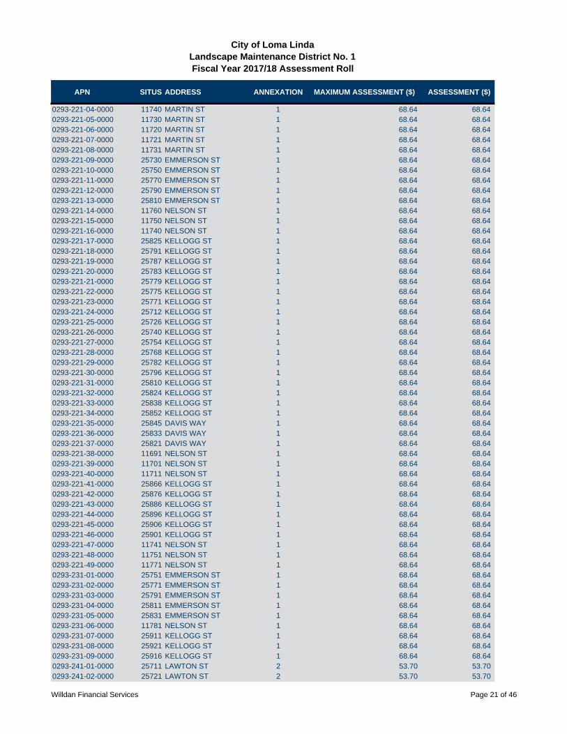
APN SITUS ADDRESS ANNEXATION MAXIMUM ASSESSMENT ($) ASSESSMENT ($)
City of Loma LindaLandscape Maintenance District No. 1Fiscal Year 2017/18 Assessment Roll
0293-221-04-0000 11740 MARTIN ST 1 68.64 68.640293-221-05-0000 11730 MARTIN ST 1 68.64 68.640293-221-06-0000 11720 MARTIN ST 1 68.64 68.640293-221-07-0000 11721 MARTIN ST 1 68.64 68.640293-221-08-0000 11731 MARTIN ST 1 68.64 68.640293-221-09-0000 25730 EMMERSON ST 1 68.64 68.640293-221-10-0000 25750 EMMERSON ST 1 68.64 68.640293-221-11-0000 25770 EMMERSON ST 1 68.64 68.640293-221-12-0000 25790 EMMERSON ST 1 68.64 68.640293-221-13-0000 25810 EMMERSON ST 1 68.64 68.640293-221-14-0000 11760 NELSON ST 1 68.64 68.640293-221-15-0000 11750 NELSON ST 1 68.64 68.640293-221-16-0000 11740 NELSON ST 1 68.64 68.640293-221-17-0000 25825 KELLOGG ST 1 68.64 68.640293-221-18-0000 25791 KELLOGG ST 1 68.64 68.640293-221-19-0000 25787 KELLOGG ST 1 68.64 68.640293-221-20-0000 25783 KELLOGG ST 1 68.64 68.640293-221-21-0000 25779 KELLOGG ST 1 68.64 68.640293-221-22-0000 25775 KELLOGG ST 1 68.64 68.640293-221-23-0000 25771 KELLOGG ST 1 68.64 68.640293-221-24-0000 25712 KELLOGG ST 1 68.64 68.640293-221-25-0000 25726 KELLOGG ST 1 68.64 68.640293-221-26-0000 25740 KELLOGG ST 1 68.64 68.640293-221-27-0000 25754 KELLOGG ST 1 68.64 68.640293-221-28-0000 25768 KELLOGG ST 1 68.64 68.640293-221-29-0000 25782 KELLOGG ST 1 68.64 68.640293-221-30-0000 25796 KELLOGG ST 1 68.64 68.640293-221-31-0000 25810 KELLOGG ST 1 68.64 68.640293-221-32-0000 25824 KELLOGG ST 1 68.64 68.640293-221-33-0000 25838 KELLOGG ST 1 68.64 68.640293-221-34-0000 25852 KELLOGG ST 1 68.64 68.640293-221-35-0000 25845 DAVIS WAY 1 68.64 68.640293-221-36-0000 25833 DAVIS WAY 1 68.64 68.640293-221-37-0000 25821 DAVIS WAY 1 68.64 68.640293-221-38-0000 11691 NELSON ST 1 68.64 68.640293-221-39-0000 11701 NELSON ST 1 68.64 68.640293-221-40-0000 11711 NELSON ST 1 68.64 68.640293-221-41-0000 25866 KELLOGG ST 1 68.64 68.640293-221-42-0000 25876 KELLOGG ST 1 68.64 68.640293-221-43-0000 25886 KELLOGG ST 1 68.64 68.640293-221-44-0000 25896 KELLOGG ST 1 68.64 68.640293-221-45-0000 25906 KELLOGG ST 1 68.64 68.640293-221-46-0000 25901 KELLOGG ST 1 68.64 68.640293-221-47-0000 11741 NELSON ST 1 68.64 68.640293-221-48-0000 11751 NELSON ST 1 68.64 68.640293-221-49-0000 11771 NELSON ST 1 68.64 68.640293-231-01-0000 25751 EMMERSON ST 1 68.64 68.640293-231-02-0000 25771 EMMERSON ST 1 68.64 68.640293-231-03-0000 25791 EMMERSON ST 1 68.64 68.640293-231-04-0000 25811 EMMERSON ST 1 68.64 68.640293-231-05-0000 25831 EMMERSON ST 1 68.64 68.640293-231-06-0000 11781 NELSON ST 1 68.64 68.640293-231-07-0000 25911 KELLOGG ST 1 68.64 68.640293-231-08-0000 25921 KELLOGG ST 1 68.64 68.640293-231-09-0000 25916 KELLOGG ST 1 68.64 68.640293-241-01-0000 25711 LAWTON ST 2 53.70 53.700293-241-02-0000 25721 LAWTON ST 2 53.70 53.70
Willdan Financial Services Page 21 of 46
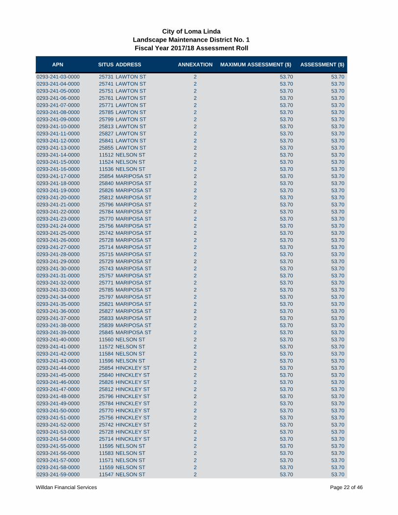
APN SITUS ADDRESS ANNEXATION MAXIMUM ASSESSMENT ($) ASSESSMENT ($)
City of Loma LindaLandscape Maintenance District No. 1Fiscal Year 2017/18 Assessment Roll
0293-241-03-0000 25731 LAWTON ST 2 53.70 53.700293-241-04-0000 25741 LAWTON ST 2 53.70 53.700293-241-05-0000 25751 LAWTON ST 2 53.70 53.700293-241-06-0000 25761 LAWTON ST 2 53.70 53.700293-241-07-0000 25771 LAWTON ST 2 53.70 53.700293-241-08-0000 25785 LAWTON ST 2 53.70 53.700293-241-09-0000 25799 LAWTON ST 2 53.70 53.700293-241-10-0000 25813 LAWTON ST 2 53.70 53.700293-241-11-0000 25827 LAWTON ST 2 53.70 53.700293-241-12-0000 25841 LAWTON ST 2 53.70 53.700293-241-13-0000 25855 LAWTON ST 2 53.70 53.700293-241-14-0000 11512 NELSON ST 2 53.70 53.700293-241-15-0000 11524 NELSON ST 2 53.70 53.700293-241-16-0000 11536 NELSON ST 2 53.70 53.700293-241-17-0000 25854 MARIPOSA ST 2 53.70 53.700293-241-18-0000 25840 MARIPOSA ST 2 53.70 53.700293-241-19-0000 25826 MARIPOSA ST 2 53.70 53.700293-241-20-0000 25812 MARIPOSA ST 2 53.70 53.700293-241-21-0000 25796 MARIPOSA ST 2 53.70 53.700293-241-22-0000 25784 MARIPOSA ST 2 53.70 53.700293-241-23-0000 25770 MARIPOSA ST 2 53.70 53.700293-241-24-0000 25756 MARIPOSA ST 2 53.70 53.700293-241-25-0000 25742 MARIPOSA ST 2 53.70 53.700293-241-26-0000 25728 MARIPOSA ST 2 53.70 53.700293-241-27-0000 25714 MARIPOSA ST 2 53.70 53.700293-241-28-0000 25715 MARIPOSA ST 2 53.70 53.700293-241-29-0000 25729 MARIPOSA ST 2 53.70 53.700293-241-30-0000 25743 MARIPOSA ST 2 53.70 53.700293-241-31-0000 25757 MARIPOSA ST 2 53.70 53.700293-241-32-0000 25771 MARIPOSA ST 2 53.70 53.700293-241-33-0000 25785 MARIPOSA ST 2 53.70 53.700293-241-34-0000 25797 MARIPOSA ST 2 53.70 53.700293-241-35-0000 25821 MARIPOSA ST 2 53.70 53.700293-241-36-0000 25827 MARIPOSA ST 2 53.70 53.700293-241-37-0000 25833 MARIPOSA ST 2 53.70 53.700293-241-38-0000 25839 MARIPOSA ST 2 53.70 53.700293-241-39-0000 25845 MARIPOSA ST 2 53.70 53.700293-241-40-0000 11560 NELSON ST 2 53.70 53.700293-241-41-0000 11572 NELSON ST 2 53.70 53.700293-241-42-0000 11584 NELSON ST 2 53.70 53.700293-241-43-0000 11596 NELSON ST 2 53.70 53.700293-241-44-0000 25854 HINCKLEY ST 2 53.70 53.700293-241-45-0000 25840 HINCKLEY ST 2 53.70 53.700293-241-46-0000 25826 HINCKLEY ST 2 53.70 53.700293-241-47-0000 25812 HINCKLEY ST 2 53.70 53.700293-241-48-0000 25796 HINCKLEY ST 2 53.70 53.700293-241-49-0000 25784 HINCKLEY ST 2 53.70 53.700293-241-50-0000 25770 HINCKLEY ST 2 53.70 53.700293-241-51-0000 25756 HINCKLEY ST 2 53.70 53.700293-241-52-0000 25742 HINCKLEY ST 2 53.70 53.700293-241-53-0000 25728 HINCKLEY ST 2 53.70 53.700293-241-54-0000 25714 HINCKLEY ST 2 53.70 53.700293-241-55-0000 11595 NELSON ST 2 53.70 53.700293-241-56-0000 11583 NELSON ST 2 53.70 53.700293-241-57-0000 11571 NELSON ST 2 53.70 53.700293-241-58-0000 11559 NELSON ST 2 53.70 53.700293-241-59-0000 11547 NELSON ST 2 53.70 53.70
Willdan Financial Services Page 22 of 46

APN SITUS ADDRESS ANNEXATION MAXIMUM ASSESSMENT ($) ASSESSMENT ($)
City of Loma LindaLandscape Maintenance District No. 1Fiscal Year 2017/18 Assessment Roll
0293-241-60-0000 11535 NELSON ST 2 53.70 53.700293-241-61-0000 11523 NELSON ST 2 53.70 53.700293-241-62-0000 11511 NELSON ST 2 53.70 53.700293-251-01-0000 25911 HINCKLEY ST 27 86.21 86.210293-251-02-0000 25921 HINCKLEY ST 27 86.21 86.210293-251-03-0000 25931 HINCKLEY ST 27 86.21 86.210293-251-04-0000 25941 HINCKLEY ST 27 86.21 86.210293-251-05-0000 11624 WILEY ST 27 86.21 86.210293-251-06-0000 11634 WILEY ST 27 86.21 86.210293-251-07-0000 11644 WILEY ST 27 86.21 86.210293-251-08-0000 11654 WILEY ST 27 86.21 86.210293-251-09-0000 11664 WILEY ST 27 86.21 86.210293-251-10-0000 11674 WILEY ST 27 86.21 86.210293-251-11-0000 11684 WILEY ST 27 86.21 86.210293-251-12-0000 11694 WILEY ST 27 86.21 86.210293-251-13-0000 25937 REYNOLDS ST 27 86.21 86.210293-251-14-0000 25949 REYNOLDS ST 27 86.21 86.210293-251-15-0000 25961 REYNOLDS ST 27 86.21 86.210293-251-16-0000 25973 REYNOLDS ST 27 86.21 86.210293-251-17-0000 25985 REYNOLDS ST 27 86.21 86.210293-251-18-0000 25997 REYNOLDS ST 27 86.21 86.210293-251-19-0000 26011 REYNOLDS ST 27 86.21 86.210293-251-20-0000 26021 REYNOLDS ST 27 86.21 86.210293-251-21-0000 26031 REYNOLDS ST 27 86.21 86.210293-251-22-0000 26041 REYNOLDS ST 27 86.21 86.210293-251-23-0000 26051 REYNOLDS ST 27 86.21 86.210293-251-24-0000 26061 REYNOLDS ST 27 86.21 86.210293-251-25-0000 25071 REYNOLDS ST 27 86.21 86.210293-251-26-0000 26081 REYNOLDS ST 27 86.21 86.210293-251-27-0000 26091 REYNOLDS ST 27 86.21 86.210293-251-28-0000 26092 REYNOLDS ST 27 86.21 86.210293-251-29-0000 26082 REYNOLDS ST 27 86.21 86.210293-251-30-0000 26072 REYNOLDS ST 27 86.21 86.210293-251-31-0000 26062 REYNOLDS ST 27 86.21 86.210293-251-32-0000 26052 REYNOLDS ST 27 86.21 86.210293-251-33-0000 26042 REYNOLDS ST 27 86.21 86.210293-251-34-0000 26032 REYNOLDS ST 27 86.21 86.210293-251-35-0000 26022 REYNOLDS ST 27 86.21 86.210293-251-36-0000 26012 REYNOLDS ST 27 86.21 86.210293-251-37-0000 11671 BUTTERFIELD ST 27 86.21 86.210293-251-38-0000 11659 BUTTERFIELD ST 27 86.21 86.210293-251-39-0000 11647 BUTTERFIELD ST 27 86.21 86.210293-251-40-0000 11635 BUTTERFIELD ST 27 86.21 86.210293-251-41-0000 26021 HINCKLEY ST 27 86.21 86.210293-251-42-0000 26031 HINCKLEY ST 27 86.21 86.210293-251-43-0000 26041 HINCKLEY ST 27 86.21 86.210293-251-44-0000 26051 HINCKLEY ST 27 86.21 86.210293-251-45-0000 26061 HINCKLEY ST 27 86.21 86.210293-251-46-0000 26071 HINCKLEY ST 27 86.21 86.210293-251-47-0000 26081 HINCKLEY ST 27 86.21 86.210293-251-48-0000 26091 HINCKLEY ST 27 86.21 86.210293-251-49-0000 25961 HINCKLEY ST 27 86.21 86.210293-251-50-0000 25971 HINCKLEY ST 27 86.21 86.210293-251-51-0000 25981 HINCKLEY ST 27 86.21 86.210293-251-52-0000 25991 HINCKLEY ST 27 86.21 86.210293-251-53-0000 11632 BUTTERFIELD ST 27 86.21 86.210293-251-54-0000 11644 BUTTERFIELD ST 27 86.21 86.21
Willdan Financial Services Page 23 of 46

APN SITUS ADDRESS ANNEXATION MAXIMUM ASSESSMENT ($) ASSESSMENT ($)
City of Loma LindaLandscape Maintenance District No. 1Fiscal Year 2017/18 Assessment Roll
0293-251-55-0000 11656 BUTTERFIELD ST 27 86.21 86.210293-251-56-0000 25998 REYNOLDS ST 27 86.21 86.210293-251-57-0000 25988 REYNOLDS ST 27 86.21 86.210293-251-58-0000 25978 REYNOLDS ST 27 86.21 86.210293-251-59-0000 25968 REYNOLDS ST 27 86.21 86.210293-251-60-0000 25958 REYNOLDS ST 27 86.21 86.210293-251-61-0000 25948 REYNOLDS ST 27 86.21 86.210293-251-62-0000 25938 REYNOLDS ST 27 86.21 86.210293-251-63-0000 11655 WILEY ST 27 86.21 86.210293-251-64-0000 11645 WILEY ST 27 86.21 86.210293-251-65-0000 11635 WILEY ST 27 86.21 86.210293-261-01-0000 11512 CHAPMAN ST 5 104.02 104.020293-261-02-0000 11524 CHAPMAN ST 5 104.02 104.020293-261-03-0000 11536 CHAPMAN ST 5 104.02 104.020293-261-04-0000 11548 CHAPMAN ST 5 104.02 104.020293-261-05-0000 25921 GARDNER ST 5 104.02 104.020293-261-06-0000 25931 GARDNER ST 5 104.02 104.020293-261-07-0000 25941 GARDNER ST 5 104.02 104.020293-261-08-0000 25951 GARDNER ST 5 104.02 104.020293-261-09-0000 25961 GARDNER ST 5 104.02 104.020293-261-10-0000 25971 GARDNER ST 5 104.02 104.020293-261-11-0000 25981 GARDNER ST 5 104.02 104.020293-261-12-0000 25991 GARDNER ST 5 104.02 104.020293-261-13-0000 25992 HINCKLEY ST 5 104.02 104.020293-261-14-0000 25982 HINCKLEY ST 5 104.02 104.020293-261-15-0000 25972 HINCKLEY ST 5 104.02 104.020293-261-16-0000 25962 HINCKLEY ST 5 104.02 104.020293-261-17-0000 25952 HINCKLEY ST 5 104.02 104.020293-261-18-0000 25942 HINCKLEY ST 5 104.02 104.020293-261-19-0000 25932 HINCKLEY ST 5 104.02 104.020293-261-20-0000 25922 HINCKLEY ST 5 104.02 104.020293-261-21-0000 25912 HINCKLEY ST 5 104.02 104.020293-261-22-0000 11548 BUTTERFIELD ST 5 104.02 104.020293-261-23-0000 25978 GARDNER ST 5 104.02 104.020293-261-24-0000 25968 GARDNER ST 5 104.02 104.020293-261-25-0000 25958 GARDNER ST 5 104.02 104.020293-261-26-0000 25948 GARDNER ST 5 104.02 104.020293-261-27-0000 25938 GARDNER ST 5 104.02 104.020293-261-28-0000 25937 LAWTON ST 5 104.02 104.020293-261-29-0000 25947 LAWTON ST 5 104.02 104.020293-261-30-0000 25957 LAWTON ST 5 104.02 104.020293-261-31-0000 25967 LAWTON ST 5 104.02 104.020293-261-32-0000 25977 LAWTON ST 5 104.02 104.020293-261-33-0000 25987 LAWTON ST 5 104.02 104.020293-261-34-0000 25997 LAWTON ST 5 104.02 104.020293-261-35-0000 11532 BUTTERFIELD ST 5 104.02 104.020293-261-36-0000 11547 BUTTERFIELD ST 5 104.02 104.020293-261-37-0000 11535 BUTTERFIELD ST 5 104.02 104.020293-261-38-0000 26021 LAWTON ST 5 104.02 104.020293-261-39-0000 26031 LAWTON ST 5 104.02 104.020293-261-40-0000 26041 LAWTON ST 5 104.02 104.020293-261-41-0000 26051 LAWTON ST 5 104.02 104.020293-261-42-0000 26061 LAWTON ST 5 104.02 104.020293-261-43-0000 26071 LAWTON ST 5 104.02 104.020293-261-44-0000 26081 LAWTON ST 5 104.02 104.020293-261-45-0000 26091 LAWTON ST 5 104.02 104.020293-261-46-0000 26092 GARDNER ST 5 104.02 104.02
Willdan Financial Services Page 24 of 46
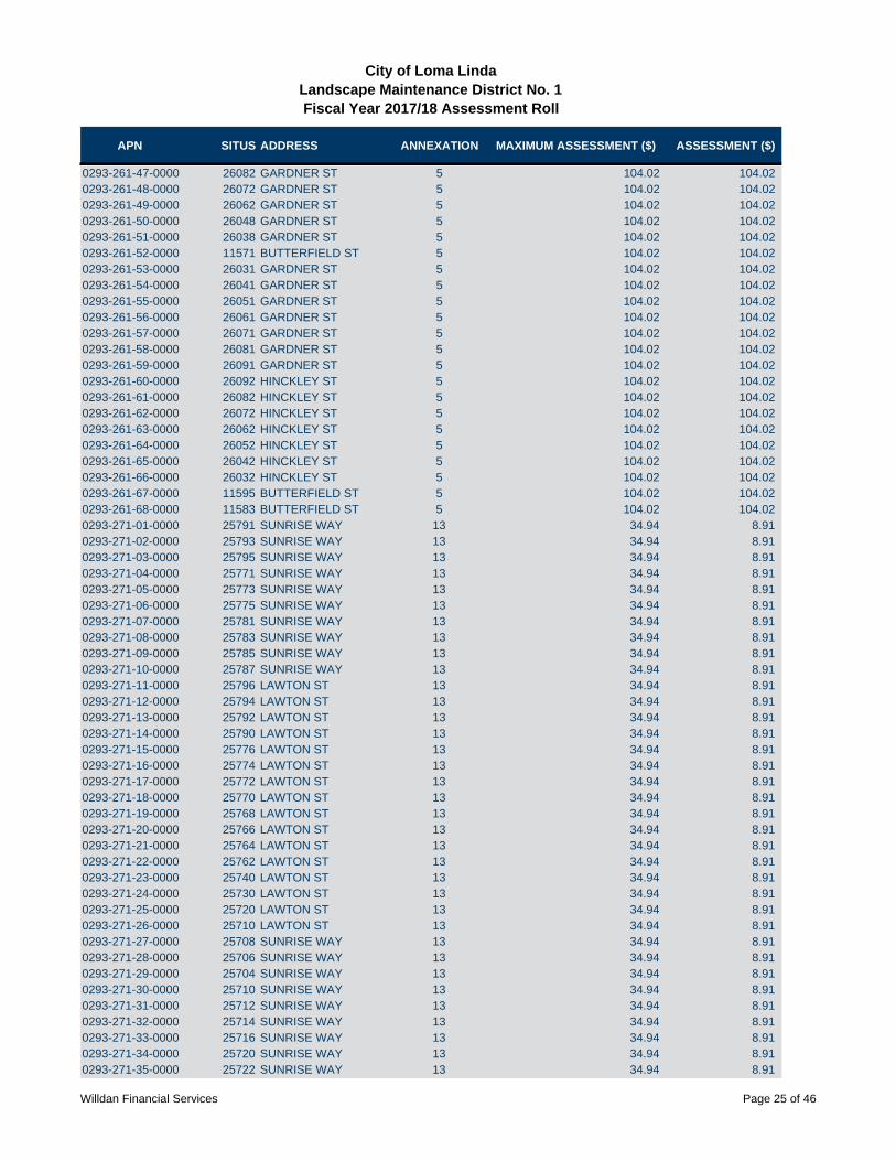
APN SITUS ADDRESS ANNEXATION MAXIMUM ASSESSMENT ($) ASSESSMENT ($)
City of Loma LindaLandscape Maintenance District No. 1Fiscal Year 2017/18 Assessment Roll
0293-261-47-0000 26082 GARDNER ST 5 104.02 104.020293-261-48-0000 26072 GARDNER ST 5 104.02 104.020293-261-49-0000 26062 GARDNER ST 5 104.02 104.020293-261-50-0000 26048 GARDNER ST 5 104.02 104.020293-261-51-0000 26038 GARDNER ST 5 104.02 104.020293-261-52-0000 11571 BUTTERFIELD ST 5 104.02 104.020293-261-53-0000 26031 GARDNER ST 5 104.02 104.020293-261-54-0000 26041 GARDNER ST 5 104.02 104.020293-261-55-0000 26051 GARDNER ST 5 104.02 104.020293-261-56-0000 26061 GARDNER ST 5 104.02 104.020293-261-57-0000 26071 GARDNER ST 5 104.02 104.020293-261-58-0000 26081 GARDNER ST 5 104.02 104.020293-261-59-0000 26091 GARDNER ST 5 104.02 104.020293-261-60-0000 26092 HINCKLEY ST 5 104.02 104.020293-261-61-0000 26082 HINCKLEY ST 5 104.02 104.020293-261-62-0000 26072 HINCKLEY ST 5 104.02 104.020293-261-63-0000 26062 HINCKLEY ST 5 104.02 104.020293-261-64-0000 26052 HINCKLEY ST 5 104.02 104.020293-261-65-0000 26042 HINCKLEY ST 5 104.02 104.020293-261-66-0000 26032 HINCKLEY ST 5 104.02 104.020293-261-67-0000 11595 BUTTERFIELD ST 5 104.02 104.020293-261-68-0000 11583 BUTTERFIELD ST 5 104.02 104.020293-271-01-0000 25791 SUNRISE WAY 13 34.94 8.910293-271-02-0000 25793 SUNRISE WAY 13 34.94 8.910293-271-03-0000 25795 SUNRISE WAY 13 34.94 8.910293-271-04-0000 25771 SUNRISE WAY 13 34.94 8.910293-271-05-0000 25773 SUNRISE WAY 13 34.94 8.910293-271-06-0000 25775 SUNRISE WAY 13 34.94 8.910293-271-07-0000 25781 SUNRISE WAY 13 34.94 8.910293-271-08-0000 25783 SUNRISE WAY 13 34.94 8.910293-271-09-0000 25785 SUNRISE WAY 13 34.94 8.910293-271-10-0000 25787 SUNRISE WAY 13 34.94 8.910293-271-11-0000 25796 LAWTON ST 13 34.94 8.910293-271-12-0000 25794 LAWTON ST 13 34.94 8.910293-271-13-0000 25792 LAWTON ST 13 34.94 8.910293-271-14-0000 25790 LAWTON ST 13 34.94 8.910293-271-15-0000 25776 LAWTON ST 13 34.94 8.910293-271-16-0000 25774 LAWTON ST 13 34.94 8.910293-271-17-0000 25772 LAWTON ST 13 34.94 8.910293-271-18-0000 25770 LAWTON ST 13 34.94 8.910293-271-19-0000 25768 LAWTON ST 13 34.94 8.910293-271-20-0000 25766 LAWTON ST 13 34.94 8.910293-271-21-0000 25764 LAWTON ST 13 34.94 8.910293-271-22-0000 25762 LAWTON ST 13 34.94 8.910293-271-23-0000 25740 LAWTON ST 13 34.94 8.910293-271-24-0000 25730 LAWTON ST 13 34.94 8.910293-271-25-0000 25720 LAWTON ST 13 34.94 8.910293-271-26-0000 25710 LAWTON ST 13 34.94 8.910293-271-27-0000 25708 SUNRISE WAY 13 34.94 8.910293-271-28-0000 25706 SUNRISE WAY 13 34.94 8.910293-271-29-0000 25704 SUNRISE WAY 13 34.94 8.910293-271-30-0000 25710 SUNRISE WAY 13 34.94 8.910293-271-31-0000 25712 SUNRISE WAY 13 34.94 8.910293-271-32-0000 25714 SUNRISE WAY 13 34.94 8.910293-271-33-0000 25716 SUNRISE WAY 13 34.94 8.910293-271-34-0000 25720 SUNRISE WAY 13 34.94 8.910293-271-35-0000 25722 SUNRISE WAY 13 34.94 8.91
Willdan Financial Services Page 25 of 46

APN SITUS ADDRESS ANNEXATION MAXIMUM ASSESSMENT ($) ASSESSMENT ($)
City of Loma LindaLandscape Maintenance District No. 1Fiscal Year 2017/18 Assessment Roll
0293-271-36-0000 25724 SUNRISE WAY 13 34.94 8.910293-271-37-0000 25726 SUNRISE WAY 13 34.94 8.910293-271-38-0000 25730 SUNRISE WAY 13 34.94 8.910293-271-39-0000 25732 SUNRISE WAY 13 34.94 8.910293-271-40-0000 25734 SUNRISE WAY 13 34.94 8.910293-271-41-0000 25736 SUNRISE WAY 13 34.94 8.910293-271-42-0000 25766 SUNRISE WAY 13 34.94 8.910293-271-43-0000 25764 SUNRISE WAY 13 34.94 8.910293-271-44-0000 25762 SUNRISE WAY 13 34.94 8.910293-271-45-0000 25760 SUNRISE WAY 13 34.94 8.910293-271-46-0000 25758 SUNRISE WAY 13 34.94 8.910293-271-47-0000 25756 SUNRISE WAY 13 34.94 8.910293-271-48-0000 25744 SUNRISE WAY 13 34.94 8.910293-271-49-0000 25742 SUNRISE WAY 13 34.94 8.910293-271-50-0000 25740 SUNRISE WAY 13 34.94 8.910293-271-51-0000 25741 SUNRISE WAY 13 34.94 8.910293-271-52-0000 25743 SUNRISE WAY 13 34.94 8.910293-271-53-0000 25745 SUNRISE WAY 13 34.94 8.910293-271-54-0000 25747 SUNRISE WAY 13 34.94 8.910293-271-55-0000 25757 SUNRISE WAY 13 34.94 8.910293-271-56-0000 25755 SUNRISE WAY 13 34.94 8.910293-271-57-0000 25753 SUNRISE WAY 13 34.94 8.910293-271-58-0000 25751 SUNRISE WAY 13 34.94 8.910293-271-59-0000 25750 SUNRISE WAY 13 34.94 8.910293-271-60-0000 25752 SUNRISE WAY 13 34.94 8.910293-271-61-0000 25754 SUNRISE WAY 13 34.94 8.910293-271-62-0000 25770 SUNRISE WAY 13 34.94 8.910293-271-63-0000 25772 SUNRISE WAY 13 34.94 8.910293-271-64-0000 25774 SUNRISE WAY 13 34.94 8.910293-271-65-0000 25776 SUNRISE WAY 13 34.94 8.910293-271-66-0000 25786 SUNRISE WAY 13 34.94 8.910293-271-67-0000 25784 SUNRISE WAY 13 34.94 8.910293-271-68-0000 25782 SUNRISE WAY 13 34.94 8.910293-271-69-0000 25780 SUNRISE WAY 13 34.94 8.910293-271-70-0000 25790 SUNRISE WAY 13 34.94 8.910293-271-71-0000 25792 SUNRISE WAY 13 34.94 8.910293-271-72-0000 25794 SUNRISE WAY 13 34.94 8.910293-271-73-0000 25796 SUNRISE WAY 13 34.94 8.910293-272-01-0000 25810 LAWTON ST 13 34.94 8.910293-272-02-0000 25812 LAWTON ST 13 34.94 8.910293-272-03-0000 25814 LAWTON ST 13 34.94 8.910293-272-04-0000 25816 LAWTON ST 13 34.94 8.910293-272-05-0000 25840 LAWTON ST 13 34.94 8.910293-272-06-0000 25842 LAWTON ST 13 34.94 8.910293-272-07-0000 25844 LAWTON ST 13 34.94 8.910293-272-08-0000 25846 LAWTON ST 13 34.94 8.910293-272-09-0000 25887 SUNRISE WAY 13 34.94 8.910293-272-10-0000 25885 SUNRISE WAY 13 34.94 8.910293-272-11-0000 25883 SUNRISE WAY 13 34.94 8.910293-272-12-0000 25881 SUNRISE WAY 13 34.94 8.910293-272-13-0000 25861 SUNRISE WAY 13 34.94 8.910293-272-14-0000 25863 SUNRISE WAY 13 34.94 8.910293-272-15-0000 25865 SUNRISE WAY 13 34.94 8.910293-272-16-0000 25867 SUNRISE WAY 13 34.94 8.910293-272-17-0000 25871 SUNRISE WAY 13 34.94 8.910293-272-18-0000 25873 SUNRISE WAY 13 34.94 8.910293-272-19-0000 25875 SUNRISE WAY 13 34.94 8.91
Willdan Financial Services Page 26 of 46
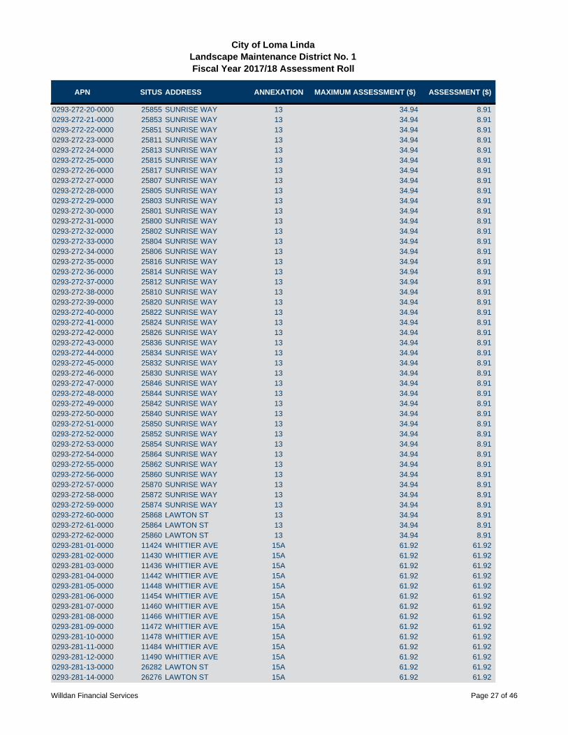
APN SITUS ADDRESS ANNEXATION MAXIMUM ASSESSMENT ($) ASSESSMENT ($)
City of Loma LindaLandscape Maintenance District No. 1Fiscal Year 2017/18 Assessment Roll
0293-272-20-0000 25855 SUNRISE WAY 13 34.94 8.910293-272-21-0000 25853 SUNRISE WAY 13 34.94 8.910293-272-22-0000 25851 SUNRISE WAY 13 34.94 8.910293-272-23-0000 25811 SUNRISE WAY 13 34.94 8.910293-272-24-0000 25813 SUNRISE WAY 13 34.94 8.910293-272-25-0000 25815 SUNRISE WAY 13 34.94 8.910293-272-26-0000 25817 SUNRISE WAY 13 34.94 8.910293-272-27-0000 25807 SUNRISE WAY 13 34.94 8.910293-272-28-0000 25805 SUNRISE WAY 13 34.94 8.910293-272-29-0000 25803 SUNRISE WAY 13 34.94 8.910293-272-30-0000 25801 SUNRISE WAY 13 34.94 8.910293-272-31-0000 25800 SUNRISE WAY 13 34.94 8.910293-272-32-0000 25802 SUNRISE WAY 13 34.94 8.910293-272-33-0000 25804 SUNRISE WAY 13 34.94 8.910293-272-34-0000 25806 SUNRISE WAY 13 34.94 8.910293-272-35-0000 25816 SUNRISE WAY 13 34.94 8.910293-272-36-0000 25814 SUNRISE WAY 13 34.94 8.910293-272-37-0000 25812 SUNRISE WAY 13 34.94 8.910293-272-38-0000 25810 SUNRISE WAY 13 34.94 8.910293-272-39-0000 25820 SUNRISE WAY 13 34.94 8.910293-272-40-0000 25822 SUNRISE WAY 13 34.94 8.910293-272-41-0000 25824 SUNRISE WAY 13 34.94 8.910293-272-42-0000 25826 SUNRISE WAY 13 34.94 8.910293-272-43-0000 25836 SUNRISE WAY 13 34.94 8.910293-272-44-0000 25834 SUNRISE WAY 13 34.94 8.910293-272-45-0000 25832 SUNRISE WAY 13 34.94 8.910293-272-46-0000 25830 SUNRISE WAY 13 34.94 8.910293-272-47-0000 25846 SUNRISE WAY 13 34.94 8.910293-272-48-0000 25844 SUNRISE WAY 13 34.94 8.910293-272-49-0000 25842 SUNRISE WAY 13 34.94 8.910293-272-50-0000 25840 SUNRISE WAY 13 34.94 8.910293-272-51-0000 25850 SUNRISE WAY 13 34.94 8.910293-272-52-0000 25852 SUNRISE WAY 13 34.94 8.910293-272-53-0000 25854 SUNRISE WAY 13 34.94 8.910293-272-54-0000 25864 SUNRISE WAY 13 34.94 8.910293-272-55-0000 25862 SUNRISE WAY 13 34.94 8.910293-272-56-0000 25860 SUNRISE WAY 13 34.94 8.910293-272-57-0000 25870 SUNRISE WAY 13 34.94 8.910293-272-58-0000 25872 SUNRISE WAY 13 34.94 8.910293-272-59-0000 25874 SUNRISE WAY 13 34.94 8.910293-272-60-0000 25868 LAWTON ST 13 34.94 8.910293-272-61-0000 25864 LAWTON ST 13 34.94 8.910293-272-62-0000 25860 LAWTON ST 13 34.94 8.910293-281-01-0000 11424 WHITTIER AVE 15A 61.92 61.920293-281-02-0000 11430 WHITTIER AVE 15A 61.92 61.920293-281-03-0000 11436 WHITTIER AVE 15A 61.92 61.920293-281-04-0000 11442 WHITTIER AVE 15A 61.92 61.920293-281-05-0000 11448 WHITTIER AVE 15A 61.92 61.920293-281-06-0000 11454 WHITTIER AVE 15A 61.92 61.920293-281-07-0000 11460 WHITTIER AVE 15A 61.92 61.920293-281-08-0000 11466 WHITTIER AVE 15A 61.92 61.920293-281-09-0000 11472 WHITTIER AVE 15A 61.92 61.920293-281-10-0000 11478 WHITTIER AVE 15A 61.92 61.920293-281-11-0000 11484 WHITTIER AVE 15A 61.92 61.920293-281-12-0000 11490 WHITTIER AVE 15A 61.92 61.920293-281-13-0000 26282 LAWTON ST 15A 61.92 61.920293-281-14-0000 26276 LAWTON ST 15A 61.92 61.92
Willdan Financial Services Page 27 of 46
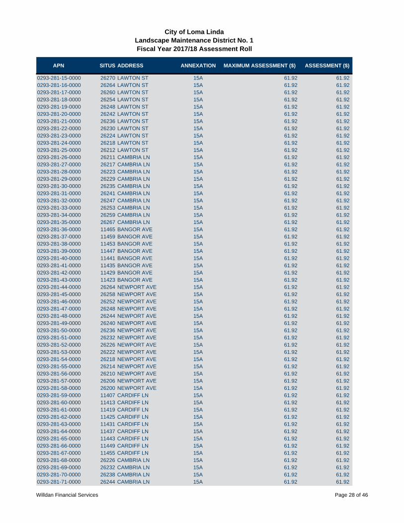
APN SITUS ADDRESS ANNEXATION MAXIMUM ASSESSMENT ($) ASSESSMENT ($)
City of Loma LindaLandscape Maintenance District No. 1Fiscal Year 2017/18 Assessment Roll
0293-281-15-0000 26270 LAWTON ST 15A 61.92 61.920293-281-16-0000 26264 LAWTON ST 15A 61.92 61.920293-281-17-0000 26260 LAWTON ST 15A 61.92 61.920293-281-18-0000 26254 LAWTON ST 15A 61.92 61.920293-281-19-0000 26248 LAWTON ST 15A 61.92 61.920293-281-20-0000 26242 LAWTON ST 15A 61.92 61.920293-281-21-0000 26236 LAWTON ST 15A 61.92 61.920293-281-22-0000 26230 LAWTON ST 15A 61.92 61.920293-281-23-0000 26224 LAWTON ST 15A 61.92 61.920293-281-24-0000 26218 LAWTON ST 15A 61.92 61.920293-281-25-0000 26212 LAWTON ST 15A 61.92 61.920293-281-26-0000 26211 CAMBRIA LN 15A 61.92 61.920293-281-27-0000 26217 CAMBRIA LN 15A 61.92 61.920293-281-28-0000 26223 CAMBRIA LN 15A 61.92 61.920293-281-29-0000 26229 CAMBRIA LN 15A 61.92 61.920293-281-30-0000 26235 CAMBRIA LN 15A 61.92 61.920293-281-31-0000 26241 CAMBRIA LN 15A 61.92 61.920293-281-32-0000 26247 CAMBRIA LN 15A 61.92 61.920293-281-33-0000 26253 CAMBRIA LN 15A 61.92 61.920293-281-34-0000 26259 CAMBRIA LN 15A 61.92 61.920293-281-35-0000 26267 CAMBRIA LN 15A 61.92 61.920293-281-36-0000 11465 BANGOR AVE 15A 61.92 61.920293-281-37-0000 11459 BANGOR AVE 15A 61.92 61.920293-281-38-0000 11453 BANGOR AVE 15A 61.92 61.920293-281-39-0000 11447 BANGOR AVE 15A 61.92 61.920293-281-40-0000 11441 BANGOR AVE 15A 61.92 61.920293-281-41-0000 11435 BANGOR AVE 15A 61.92 61.920293-281-42-0000 11429 BANGOR AVE 15A 61.92 61.920293-281-43-0000 11423 BANGOR AVE 15A 61.92 61.920293-281-44-0000 26264 NEWPORT AVE 15A 61.92 61.920293-281-45-0000 26258 NEWPORT AVE 15A 61.92 61.920293-281-46-0000 26252 NEWPORT AVE 15A 61.92 61.920293-281-47-0000 26248 NEWPORT AVE 15A 61.92 61.920293-281-48-0000 26244 NEWPORT AVE 15A 61.92 61.920293-281-49-0000 26240 NEWPORT AVE 15A 61.92 61.920293-281-50-0000 26236 NEWPORT AVE 15A 61.92 61.920293-281-51-0000 26232 NEWPORT AVE 15A 61.92 61.920293-281-52-0000 26226 NEWPORT AVE 15A 61.92 61.920293-281-53-0000 26222 NEWPORT AVE 15A 61.92 61.920293-281-54-0000 26218 NEWPORT AVE 15A 61.92 61.920293-281-55-0000 26214 NEWPORT AVE 15A 61.92 61.920293-281-56-0000 26210 NEWPORT AVE 15A 61.92 61.920293-281-57-0000 26206 NEWPORT AVE 15A 61.92 61.920293-281-58-0000 26200 NEWPORT AVE 15A 61.92 61.920293-281-59-0000 11407 CARDIFF LN 15A 61.92 61.920293-281-60-0000 11413 CARDIFF LN 15A 61.92 61.920293-281-61-0000 11419 CARDIFF LN 15A 61.92 61.920293-281-62-0000 11425 CARDIFF LN 15A 61.92 61.920293-281-63-0000 11431 CARDIFF LN 15A 61.92 61.920293-281-64-0000 11437 CARDIFF LN 15A 61.92 61.920293-281-65-0000 11443 CARDIFF LN 15A 61.92 61.920293-281-66-0000 11449 CARDIFF LN 15A 61.92 61.920293-281-67-0000 11455 CARDIFF LN 15A 61.92 61.920293-281-68-0000 26226 CAMBRIA LN 15A 61.92 61.920293-281-69-0000 26232 CAMBRIA LN 15A 61.92 61.920293-281-70-0000 26238 CAMBRIA LN 15A 61.92 61.920293-281-71-0000 26244 CAMBRIA LN 15A 61.92 61.92
Willdan Financial Services Page 28 of 46
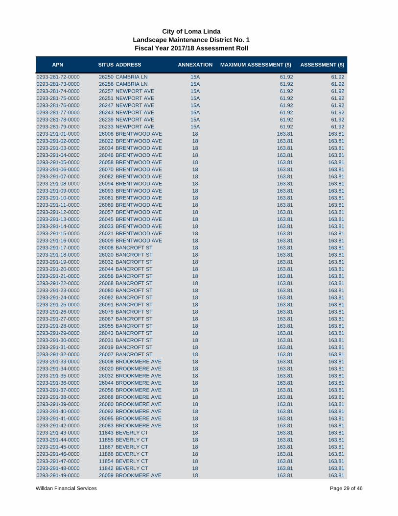
APN SITUS ADDRESS ANNEXATION MAXIMUM ASSESSMENT ($) ASSESSMENT ($)
City of Loma LindaLandscape Maintenance District No. 1Fiscal Year 2017/18 Assessment Roll
0293-281-72-0000 26250 CAMBRIA LN 15A 61.92 61.920293-281-73-0000 26256 CAMBRIA LN 15A 61.92 61.920293-281-74-0000 26257 NEWPORT AVE 15A 61.92 61.920293-281-75-0000 26251 NEWPORT AVE 15A 61.92 61.920293-281-76-0000 26247 NEWPORT AVE 15A 61.92 61.920293-281-77-0000 26243 NEWPORT AVE 15A 61.92 61.920293-281-78-0000 26239 NEWPORT AVE 15A 61.92 61.920293-281-79-0000 26233 NEWPORT AVE 15A 61.92 61.920293-291-01-0000 26008 BRENTWOOD AVE 18 163.81 163.810293-291-02-0000 26022 BRENTWOOD AVE 18 163.81 163.810293-291-03-0000 26034 BRENTWOOD AVE 18 163.81 163.810293-291-04-0000 26046 BRENTWOOD AVE 18 163.81 163.810293-291-05-0000 26058 BRENTWOOD AVE 18 163.81 163.810293-291-06-0000 26070 BRENTWOOD AVE 18 163.81 163.810293-291-07-0000 26082 BRENTWOOD AVE 18 163.81 163.810293-291-08-0000 26094 BRENTWOOD AVE 18 163.81 163.810293-291-09-0000 26093 BRENTWOOD AVE 18 163.81 163.810293-291-10-0000 26081 BRENTWOOD AVE 18 163.81 163.810293-291-11-0000 26069 BRENTWOOD AVE 18 163.81 163.810293-291-12-0000 26057 BRENTWOOD AVE 18 163.81 163.810293-291-13-0000 26045 BRENTWOOD AVE 18 163.81 163.810293-291-14-0000 26033 BRENTWOOD AVE 18 163.81 163.810293-291-15-0000 26021 BRENTWOOD AVE 18 163.81 163.810293-291-16-0000 26009 BRENTWOOD AVE 18 163.81 163.810293-291-17-0000 26008 BANCROFT ST 18 163.81 163.810293-291-18-0000 26020 BANCROFT ST 18 163.81 163.810293-291-19-0000 26032 BANCROFT ST 18 163.81 163.810293-291-20-0000 26044 BANCROFT ST 18 163.81 163.810293-291-21-0000 26056 BANCROFT ST 18 163.81 163.810293-291-22-0000 26068 BANCROFT ST 18 163.81 163.810293-291-23-0000 26080 BANCROFT ST 18 163.81 163.810293-291-24-0000 26092 BANCROFT ST 18 163.81 163.810293-291-25-0000 26091 BANCROFT ST 18 163.81 163.810293-291-26-0000 26079 BANCROFT ST 18 163.81 163.810293-291-27-0000 26067 BANCROFT ST 18 163.81 163.810293-291-28-0000 26055 BANCROFT ST 18 163.81 163.810293-291-29-0000 26043 BANCROFT ST 18 163.81 163.810293-291-30-0000 26031 BANCROFT ST 18 163.81 163.810293-291-31-0000 26019 BANCROFT ST 18 163.81 163.810293-291-32-0000 26007 BANCROFT ST 18 163.81 163.810293-291-33-0000 26008 BROOKMERE AVE 18 163.81 163.810293-291-34-0000 26020 BROOKMERE AVE 18 163.81 163.810293-291-35-0000 26032 BROOKMERE AVE 18 163.81 163.810293-291-36-0000 26044 BROOKMERE AVE 18 163.81 163.810293-291-37-0000 26056 BROOKMERE AVE 18 163.81 163.810293-291-38-0000 26068 BROOKMERE AVE 18 163.81 163.810293-291-39-0000 26080 BROOKMERE AVE 18 163.81 163.810293-291-40-0000 26092 BROOKMERE AVE 18 163.81 163.810293-291-41-0000 26095 BROOKMERE AVE 18 163.81 163.810293-291-42-0000 26083 BROOKMERE AVE 18 163.81 163.810293-291-43-0000 11843 BEVERLY CT 18 163.81 163.810293-291-44-0000 11855 BEVERLY CT 18 163.81 163.810293-291-45-0000 11867 BEVERLY CT 18 163.81 163.810293-291-46-0000 11866 BEVERLY CT 18 163.81 163.810293-291-47-0000 11854 BEVERLY CT 18 163.81 163.810293-291-48-0000 11842 BEVERLY CT 18 163.81 163.810293-291-49-0000 26059 BROOKMERE AVE 18 163.81 163.81
Willdan Financial Services Page 29 of 46

APN SITUS ADDRESS ANNEXATION MAXIMUM ASSESSMENT ($) ASSESSMENT ($)
City of Loma LindaLandscape Maintenance District No. 1Fiscal Year 2017/18 Assessment Roll
0293-291-50-0000 26047 BROOKMERE AVE 18 163.81 163.810293-291-51-0000 26035 BROOKMERE AVE 18 163.81 163.810293-291-52-0000 11841 BRIARWOOD CT 18 163.81 163.810293-291-53-0000 11853 BRIARWOOD CT 18 163.81 163.810293-291-54-0000 11840 BRIARWOOD CT 18 163.81 163.810293-291-55-0000 11828 BRIARWOOD CT 18 163.81 163.810293-291-56-0000 11816 BRIARWOOD CT 18 163.81 163.810293-301-01-0000 11539 BRYN MAWR AVE 19 129.33 129.330293-301-02-0000 11525 BRYN MAWR AVE 19 129.33 129.330293-301-03-0000 11511 BRYN MAWR AVE 19 129.33 129.330293-301-04-0000 11512 PEMBROKE ST 19 129.33 129.330293-301-05-0000 11524 PEMBROKE ST 19 129.33 129.330293-301-06-0000 11538 PEMBROKE ST 19 129.33 129.330293-301-07-0000 11561 BRYN MAWR AVE 19 129.33 129.330293-301-08-0000 11577 BRYN MAWR AVE 19 129.33 129.330293-301-09-0000 11591 BRYN MAWR AVE 19 129.33 129.330293-301-10-0000 11560 PEMBROKE ST 19 129.33 129.330293-301-11-0000 11572 PEMBROKE ST 19 129.33 129.330293-301-12-0000 11584 PEMBROKE ST 19 129.33 129.330293-301-13-0000 26139 PICTON ST 19 129.33 129.330293-301-14-0000 26149 PICTON ST 19 129.33 129.330293-301-15-0000 26159 PICTON ST 19 129.33 129.330293-301-16-0000 26169 PICTON ST 19 129.33 129.330293-301-17-0000 26179 PICTON ST 19 129.33 129.330293-301-18-0000 26189 PICTON ST 19 129.33 129.330293-301-19-0000 26199 PICTON ST 19 129.33 129.330293-301-20-0000 26209 PICTON ST 19 129.33 129.330293-301-21-0000 26219 PICTON ST 19 129.33 129.330293-301-22-0000 26229 PICTON ST 19 129.33 129.330293-301-23-0000 26239 PICTON ST 19 129.33 129.330293-301-24-0000 26249 PICTON ST 19 129.33 129.330293-301-25-0000 26259 PICTON ST 19 129.33 129.330293-301-26-0000 26269 PICTON ST 19 129.33 129.330293-301-27-0000 26279 PICTON ST 19 129.33 129.330293-301-28-0000 26289 PICTON ST 19 129.33 129.330293-301-29-0000 11570 WHITTIER AVE 19 129.33 129.330293-301-30-0000 11558 WHITTIER AVE 19 129.33 129.330293-301-31-0000 11546 WHITTIER AVE 19 129.33 129.330293-301-32-0000 11534 WHITTIER AVE 19 129.33 129.330293-301-33-0000 11522 WHITTIER AVE 19 129.33 129.330293-301-34-0000 11510 WHITTIER AVE 19 129.33 129.330293-301-35-0000 11511 ABERDARE ST 19 129.33 129.330293-301-36-0000 11523 ABERDARE ST 19 129.33 129.330293-301-37-0000 11535 ABERDARE ST 19 129.33 129.330293-301-38-0000 11547 ABERDARE ST 19 129.33 129.330293-301-39-0000 11559 ABERDARE ST 19 129.33 129.330293-301-40-0000 11571 ABERDARE ST 19 129.33 129.330293-301-41-0000 11570 ABERDARE ST 19 129.33 129.330293-301-42-0000 11558 ABERDARE ST 19 129.33 129.330293-301-43-0000 11546 ABERDARE ST 19 129.33 129.330293-301-44-0000 11534 ABERDARE ST 19 129.33 129.330293-301-45-0000 11522 ABERDARE ST 19 129.33 129.330293-301-46-0000 11510 ABERDARE ST 19 129.33 129.330293-301-47-0000 11511 GWENT ST 19 129.33 129.330293-301-48-0000 11523 GWENT ST 19 129.33 129.330293-301-49-0000 11535 GWENT ST 19 129.33 129.330293-301-50-0000 11547 GWENT ST 19 129.33 129.33
Willdan Financial Services Page 30 of 46

APN SITUS ADDRESS ANNEXATION MAXIMUM ASSESSMENT ($) ASSESSMENT ($)
City of Loma LindaLandscape Maintenance District No. 1Fiscal Year 2017/18 Assessment Roll
0293-301-51-0000 11559 GWENT ST 19 129.33 129.330293-301-52-0000 11571 GWENT ST 19 129.33 129.330293-301-53-0000 11570 GWENT ST 19 129.33 129.330293-301-54-0000 11558 GWENT ST 19 129.33 129.330293-301-55-0000 11546 GWENT ST 19 129.33 129.330293-301-56-0000 11534 GWENT ST 19 129.33 129.330293-301-57-0000 11522 GWENT ST 19 129.33 129.330293-301-58-0000 11510 GWENT ST 19 129.33 129.330293-301-59-0000 11511 MILFORD HAVEN DR 19 129.33 129.330293-301-60-0000 11523 MILFORD HAVEN DR 19 129.33 129.330293-301-61-0000 11535 MILFORD HAVEN DR 19 129.33 129.330293-301-62-0000 11547 MILFORD HAVEN DR 19 129.33 129.330293-301-63-0000 11559 MILFORD HAVEN DR 19 129.33 129.330293-301-64-0000 11571 MILFORD HAVEN DR 19 129.33 129.330293-301-65-0000 11570 MILFORD HAVEN DR 19 129.33 129.330293-301-66-0000 11558 MILFORD HAVEN DR 19 129.33 129.330293-301-67-0000 11546 MILFORD HAVEN DR 19 129.33 129.330293-301-68-0000 11534 MILFORD HAVEN DR 19 129.33 129.330293-301-69-0000 11522 MILFORD HAVEN DR 19 129.33 129.330293-301-70-0000 11510 MILFORD HAVEN DR 19 129.33 129.330293-301-71-0000 11511 PEMBROKE ST 19 129.33 129.330293-301-72-0000 11523 PEMBROKE ST 19 129.33 129.330293-301-73-0000 11535 PEMBROKE ST 19 129.33 129.330293-301-74-0000 11547 PEMBROKE ST 19 129.33 129.330293-301-75-0000 11559 PEMBROKE ST 19 129.33 129.330293-301-76-0000 11571 PEMBROKE ST 19 129.33 129.330293-311-01-0000 11488 VIA CAPRI 31 103.52 103.520293-311-02-0000 11480 VIA CAPRI 31 103.52 103.520293-311-03-0000 11470 VIA CAPRI 31 103.52 103.520293-311-04-0000 11460 VIA CAPRI 31 103.52 103.520293-311-05-0000 11452 VIA CAPRI 31 103.52 103.520293-311-06-0000 11444 VIA CAPRI 31 103.52 103.520293-311-07-0000 11436 VIA CAPRI 31 103.52 103.520293-311-08-0000 11428 VIA CAPRI 31 103.52 103.520293-311-09-0000 11420 VIA CAPRI 31 103.52 103.520293-311-10-0000 25920 VIA ORO 31 103.52 103.520293-311-11-0000 11487 VIA CAPRI 31 103.52 103.520293-311-12-0000 11479 VIA CAPRI 31 103.52 103.520293-311-13-0000 11467 VIA CAPRI 31 103.52 103.520293-311-14-0000 11459 VIA CAPRI 31 103.52 103.520293-311-15-0000 11449 VIA CAPRI 31 103.52 103.520293-311-16-0000 11441 VIA CAPRI 31 103.52 103.520293-311-17-0000 11429 VIA CAPRI 31 103.52 103.520293-311-18-0000 25932 VIA ORO 31 103.52 103.520293-311-19-0000 25940 VIA ORO 31 103.52 103.520293-311-20-0000 25950 VIA ORO 31 103.52 103.520293-311-21-0000 11426 VIA LAGOS 31 103.52 103.520293-311-22-0000 11434 VIA LAGOS 31 103.52 103.520293-311-23-0000 11442 VIA LAGOS 31 103.52 103.520293-311-24-0000 11450 VIA LAGOS 31 103.52 103.520293-311-25-0000 11460 VIA LAGOS 31 103.52 103.520293-311-26-0000 11470 VIA LAGOS 31 103.52 103.520293-311-27-0000 11478 VIA LAGOS 31 103.52 103.520293-311-28-0000 11490 VIA LAGOS 31 103.52 103.520293-311-29-0000 11489 VIA LAGOS 31 103.52 103.520293-311-30-0000 11477 VIA LAGOS 31 103.52 103.520293-311-31-0000 11467 VIA LAGOS 31 103.52 103.52
Willdan Financial Services Page 31 of 46
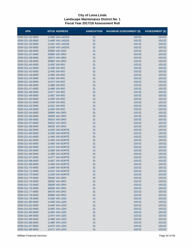
APN SITUS ADDRESS ANNEXATION MAXIMUM ASSESSMENT ($) ASSESSMENT ($)
City of Loma LindaLandscape Maintenance District No. 1Fiscal Year 2017/18 Assessment Roll
0293-311-32-0000 11459 VIA LAGOS 31 103.52 103.520293-311-33-0000 11449 VIA LAGOS 31 103.52 103.520293-311-34-0000 11441 VIA LAGOS 31 103.52 103.520293-311-35-0000 11429 VIA LAGOS 31 103.52 103.520293-311-36-0000 25958 VIA ORO 31 103.52 103.520293-311-37-0000 25966 VIA ORO 31 103.52 103.520293-311-38-0000 25974 VIA ORO 31 103.52 103.520293-311-39-0000 25984 VIA ORO 31 103.52 103.520293-311-40-0000 11430 VIA RIO 31 103.52 103.520293-311-41-0000 11438 VIA RIO 31 103.52 103.520293-311-42-0000 11446 VIA RIO 31 103.52 103.520293-311-43-0000 11456 VIA RIO 31 103.52 103.520293-311-44-0000 11464 VIA RIO 31 103.52 103.520293-311-45-0000 11474 VIA RIO 31 103.52 103.520293-311-46-0000 11486 VIA RIO 31 103.52 103.520293-311-47-0000 11489 VIA RIO 31 103.52 103.520293-311-48-0000 11477 VIA RIO 31 103.52 103.520293-311-49-0000 11467 VIA RIO 31 103.52 103.520293-311-50-0000 11459 VIA RIO 31 103.52 103.520293-311-51-0000 11449 VIA RIO 31 103.52 103.520293-311-52-0000 11441 VIA RIO 31 103.52 103.520293-311-53-0000 11429 VIA RIO 31 103.52 103.520293-311-54-0000 25994 VIA ORO 31 103.52 103.520293-311-55-0000 26006 VIA ORO 31 103.52 103.520293-311-56-0000 26014 VIA ORO 31 103.52 103.520293-311-57-0000 26024 VIA ORO 31 103.52 103.520293-311-58-0000 26032 VIA ORO 31 103.52 103.520293-311-59-0000 11430 VIA NORTE 31 103.52 103.520293-311-60-0000 11438 VIA NORTE 31 103.52 103.520293-311-61-0000 11446 VIA NORTE 31 103.52 103.520293-311-62-0000 11456 VIA NORTE 31 103.52 103.520293-311-63-0000 11464 VIA NORTE 31 103.52 103.520293-311-64-0000 11474 VIA NORTE 31 103.52 103.520293-311-65-0000 11486 VIA NORTE 31 103.52 103.520293-311-66-0000 11489 VIA NORTE 31 103.52 103.520293-311-67-0000 11477 VIA NORTE 31 103.52 103.520293-311-68-0000 11467 VIA NORTE 31 103.52 103.520293-311-69-0000 11459 VIA NORTE 31 103.52 103.520293-311-70-0000 11449 VIA NORTE 31 103.52 103.520293-311-71-0000 11441 VIA NORTE 31 103.52 103.520293-311-72-0000 11429 VIA NORTE 31 103.52 103.520293-311-73-0000 26040 VIA ORO 31 103.52 103.520293-311-74-0000 26050 VIA ORO 31 103.52 103.520293-311-75-0000 26058 VIA ORO 31 103.52 103.520293-311-76-0000 26066 VIA ORO 31 103.52 103.520293-311-77-0000 26078 VIA ORO 31 103.52 103.520293-311-78-0000 26086 VIA ORO 31 103.52 103.520293-311-79-0000 11430 VIA LIDO 31 103.52 103.520293-311-80-0000 11438 VIA LIDO 31 103.52 103.520293-311-81-0000 11446 VIA LIDO 31 103.52 103.520293-311-82-0000 11456 VIA LIDO 31 103.52 103.520293-311-83-0000 11464 VIA LIDO 31 103.52 103.520293-311-84-0000 11474 VIA LIDO 31 103.52 103.520293-311-85-0000 11486 VIA LIDO 31 103.52 103.520293-311-86-0000 11489 VIA LIDO 31 103.52 103.520293-311-87-0000 11479 VIA LIDO 31 103.52 103.520293-311-88-0000 11471 VIA LIDO 31 103.52 103.52
Willdan Financial Services Page 32 of 46
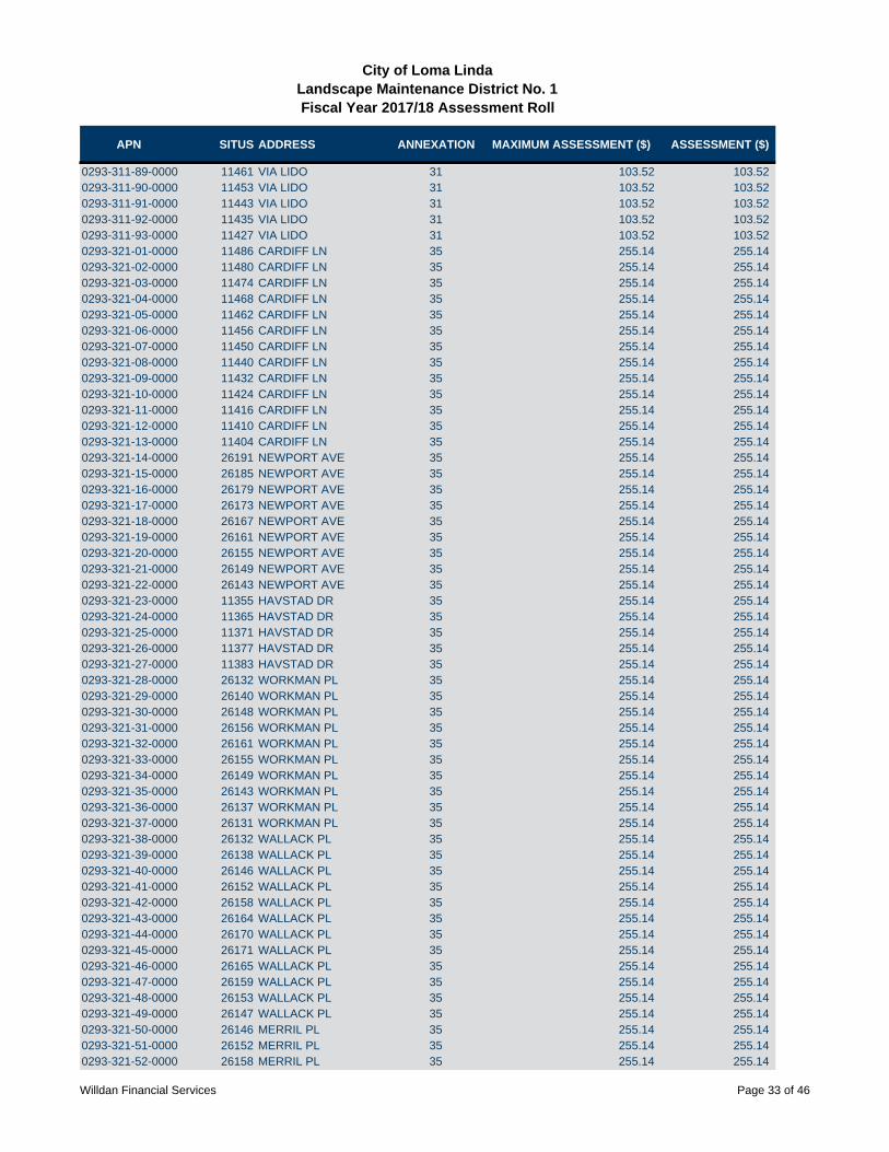
APN SITUS ADDRESS ANNEXATION MAXIMUM ASSESSMENT ($) ASSESSMENT ($)
City of Loma LindaLandscape Maintenance District No. 1Fiscal Year 2017/18 Assessment Roll
0293-311-89-0000 11461 VIA LIDO 31 103.52 103.520293-311-90-0000 11453 VIA LIDO 31 103.52 103.520293-311-91-0000 11443 VIA LIDO 31 103.52 103.520293-311-92-0000 11435 VIA LIDO 31 103.52 103.520293-311-93-0000 11427 VIA LIDO 31 103.52 103.520293-321-01-0000 11486 CARDIFF LN 35 255.14 255.140293-321-02-0000 11480 CARDIFF LN 35 255.14 255.140293-321-03-0000 11474 CARDIFF LN 35 255.14 255.140293-321-04-0000 11468 CARDIFF LN 35 255.14 255.140293-321-05-0000 11462 CARDIFF LN 35 255.14 255.140293-321-06-0000 11456 CARDIFF LN 35 255.14 255.140293-321-07-0000 11450 CARDIFF LN 35 255.14 255.140293-321-08-0000 11440 CARDIFF LN 35 255.14 255.140293-321-09-0000 11432 CARDIFF LN 35 255.14 255.140293-321-10-0000 11424 CARDIFF LN 35 255.14 255.140293-321-11-0000 11416 CARDIFF LN 35 255.14 255.140293-321-12-0000 11410 CARDIFF LN 35 255.14 255.140293-321-13-0000 11404 CARDIFF LN 35 255.14 255.140293-321-14-0000 26191 NEWPORT AVE 35 255.14 255.140293-321-15-0000 26185 NEWPORT AVE 35 255.14 255.140293-321-16-0000 26179 NEWPORT AVE 35 255.14 255.140293-321-17-0000 26173 NEWPORT AVE 35 255.14 255.140293-321-18-0000 26167 NEWPORT AVE 35 255.14 255.140293-321-19-0000 26161 NEWPORT AVE 35 255.14 255.140293-321-20-0000 26155 NEWPORT AVE 35 255.14 255.140293-321-21-0000 26149 NEWPORT AVE 35 255.14 255.140293-321-22-0000 26143 NEWPORT AVE 35 255.14 255.140293-321-23-0000 11355 HAVSTAD DR 35 255.14 255.140293-321-24-0000 11365 HAVSTAD DR 35 255.14 255.140293-321-25-0000 11371 HAVSTAD DR 35 255.14 255.140293-321-26-0000 11377 HAVSTAD DR 35 255.14 255.140293-321-27-0000 11383 HAVSTAD DR 35 255.14 255.140293-321-28-0000 26132 WORKMAN PL 35 255.14 255.140293-321-29-0000 26140 WORKMAN PL 35 255.14 255.140293-321-30-0000 26148 WORKMAN PL 35 255.14 255.140293-321-31-0000 26156 WORKMAN PL 35 255.14 255.140293-321-32-0000 26161 WORKMAN PL 35 255.14 255.140293-321-33-0000 26155 WORKMAN PL 35 255.14 255.140293-321-34-0000 26149 WORKMAN PL 35 255.14 255.140293-321-35-0000 26143 WORKMAN PL 35 255.14 255.140293-321-36-0000 26137 WORKMAN PL 35 255.14 255.140293-321-37-0000 26131 WORKMAN PL 35 255.14 255.140293-321-38-0000 26132 WALLACK PL 35 255.14 255.140293-321-39-0000 26138 WALLACK PL 35 255.14 255.140293-321-40-0000 26146 WALLACK PL 35 255.14 255.140293-321-41-0000 26152 WALLACK PL 35 255.14 255.140293-321-42-0000 26158 WALLACK PL 35 255.14 255.140293-321-43-0000 26164 WALLACK PL 35 255.14 255.140293-321-44-0000 26170 WALLACK PL 35 255.14 255.140293-321-45-0000 26171 WALLACK PL 35 255.14 255.140293-321-46-0000 26165 WALLACK PL 35 255.14 255.140293-321-47-0000 26159 WALLACK PL 35 255.14 255.140293-321-48-0000 26153 WALLACK PL 35 255.14 255.140293-321-49-0000 26147 WALLACK PL 35 255.14 255.140293-321-50-0000 26146 MERRIL PL 35 255.14 255.140293-321-51-0000 26152 MERRIL PL 35 255.14 255.140293-321-52-0000 26158 MERRIL PL 35 255.14 255.14
Willdan Financial Services Page 33 of 46

APN SITUS ADDRESS ANNEXATION MAXIMUM ASSESSMENT ($) ASSESSMENT ($)
City of Loma LindaLandscape Maintenance District No. 1Fiscal Year 2017/18 Assessment Roll
0293-321-53-0000 26164 MERRIL PL 35 255.14 255.140293-321-54-0000 26170 MERRIL PL 35 255.14 255.140293-321-55-0000 26171 MERRIL PL 35 255.14 255.140293-321-56-0000 26165 MERRIL PL 35 255.14 255.140293-321-57-0000 26159 MERRIL PL 35 255.14 255.140293-321-58-0000 26153 MERRIL PL 35 255.14 255.140293-321-59-0000 26147 MERRIL PL 35 255.14 255.140293-321-60-0000 26133 MERRIL PL 35 255.14 255.140293-321-61-0000 26127 MERRIL PL 35 255.14 255.140293-321-62-0000 26121 MERRIL PL 35 255.14 255.140293-321-63-0000 26115 MERRIL PL 35 255.14 255.140293-321-64-0000 26116 MERRIL PL 35 255.14 255.140293-321-65-0000 26120 MERRIL PL 35 255.14 255.140293-321-66-0000 26126 MERRIL PL 35 255.14 255.140293-321-67-0000 26132 MERRIL PL 35 255.14 255.140293-321-68-0000 26133 WALLACK PL 35 255.14 255.140293-321-69-0000 26127 WALLACK PL 35 255.14 255.140293-321-70-0000 26121 WALLACK PL 35 255.14 255.140293-321-71-0000 11436 HAVSTAD DR 35 255.14 255.140293-321-72-0000 11430 HAVSTAD DR 35 255.14 255.140293-321-73-0000 11424 HAVSTAD DR 35 255.14 255.140293-321-74-0000 11418 HAVSTAD DR 35 255.14 255.140293-321-75-0000 11412 HAVSTAD DR 35 255.14 255.140293-321-76-0000 11406 HAVSTAD DR 35 255.14 255.140293-321-77-0000 11400 HAVSTAD DR 35 255.14 255.140293-321-78-0000 11394 HAVSTAD DR 35 255.14 255.140293-321-79-0000 11388 HAVSTAD DR 35 255.14 255.140293-321-80-0000 11382 HAVSTAD DR 35 255.14 255.140293-321-81-0000 11376 HAVSTAD DR 35 255.14 255.140293-321-82-0000 11370 HAVSTAD DR 35 255.14 255.140293-321-83-0000 11364 HAVSTAD DR 35 255.14 255.140293-321-84-0000 11358 HAVSTAD DR 35 255.14 255.140293-321-85-0000 11352 HAVSTAD DR 35 255.14 255.140293-321-86-0000 11346 HAVSTAD DR 35 255.14 255.140293-331-01-0000 26110 WINDSOR DR 29 198.99 198.990293-331-02-0000 26120 WINDSOR DR 29 198.99 198.990293-331-03-0000 26134 WINDSOR DR 29 198.99 198.990293-331-04-0000 26140 WINDSOR DR 29 198.99 198.990293-331-05-0000 26154 WINDSOR DR 29 198.99 198.990293-331-06-0000 26160 WINDSOR DR 29 198.99 198.990293-331-07-0000 26174 WINDSOR DR 29 198.99 198.990293-331-08-0000 26180 WINDSOR DR 29 198.99 198.990293-331-09-0000 26194 WINDSOR DR 29 198.99 198.990293-331-10-0000 11630 NORMANDY LN 29 198.99 198.990293-331-11-0000 11640 NORMANDY LN 29 198.99 198.990293-331-12-0000 11650 NORMANDY LN 29 198.99 198.990293-331-13-0000 11660 NORMANDY LN 29 198.99 198.990293-331-14-0000 11670 NORMANDY LN 29 198.99 198.990293-331-15-0000 26121 CAMELOT AVE 29 198.99 198.990293-331-16-0000 26131 CAMELOT AVE 29 198.99 198.990293-331-17-0000 26141 CAMELOT AVE 29 198.99 198.990293-331-18-0000 26151 CAMELOT AVE 29 198.99 198.990293-331-19-0000 26161 CAMELOT AVE 29 198.99 198.990293-331-20-0000 26171 CAMELOT AVE 29 198.99 198.990293-331-21-0000 26135 WINDSOR DR 29 198.99 198.990293-331-22-0000 26145 WINDSOR DR 29 198.99 198.990293-331-23-0000 26155 WINDSOR DR 29 198.99 198.99
Willdan Financial Services Page 34 of 46

APN SITUS ADDRESS ANNEXATION MAXIMUM ASSESSMENT ($) ASSESSMENT ($)
City of Loma LindaLandscape Maintenance District No. 1Fiscal Year 2017/18 Assessment Roll
0293-331-24-0000 26165 WINDSOR DR 29 198.99 198.990293-331-25-0000 11646 BUCKINGHAM RD 29 198.99 198.990293-331-26-0000 11645 NORMANDY LN 29 198.99 198.990293-331-27-0000 26136 CAMELOT AVE 29 198.99 198.990293-331-28-0000 26146 CAMELOT AVE 29 198.99 198.990293-331-29-0000 26156 CAMELOT AVE 29 198.99 198.990293-331-30-0000 26166 CAMELOT AVE 29 198.99 198.990293-331-31-0000 11631 BUCKINGHAM RD 29 198.99 198.990293-331-32-0000 11641 BUCKINGHAM RD 29 198.99 198.990293-331-33-0000 11651 BUCKINGHAM RD 29 198.99 198.990293-331-34-0000 11661 BUCKINGHAM RD 29 198.99 198.990293-331-35-0000 11671 BUCKINGHAM RD 29 198.99 198.990293-331-36-0000 11681 BUCKINGHAM RD 29 198.99 198.990293-331-37-0000 11691 BUCKINGHAM RD 29 198.99 198.990293-331-38-0000 26210 WINDSOR DR 34 175.42 175.420293-331-39-0000 26220 WINDSOR DR 34 175.42 175.420293-331-40-0000 26234 WINDSOR DR 34 175.42 175.420293-331-41-0000 26240 WINDSOR DR 34 175.42 175.420293-331-42-0000 26252 WINDSOR DR 34 175.42 175.420293-331-43-0000 26260 WINDSOR DR 34 175.42 175.420293-331-44-0000 26270 WINDSOR DR 34 175.42 175.420293-331-45-0000 26280 WINDSOR DR 34 175.42 175.420293-331-46-0000 26290 WINDSOR DR 34 175.42 175.420293-331-47-0000 26291 WINDSOR DR 34 175.42 175.420293-331-48-0000 26285 WINDSOR DR 34 175.42 175.420293-331-49-0000 26275 WINDSOR DR 34 175.42 175.420293-331-50-0000 26265 WINDSOR DR 34 175.42 175.420293-331-51-0000 26255 WINDSOR DR 34 175.42 175.420293-331-52-0000 26245 WINDSOR DR 34 175.42 175.420293-331-53-0000 26235 WINDSOR DR 34 175.42 175.420293-331-54-0000 26236 CRESTHAVEN CT 34 175.42 175.420293-331-55-0000 26246 CRESTHAVEN CT 34 175.42 175.420293-331-56-0000 26256 CRESTHAVEN CT 34 175.42 175.420293-331-57-0000 26266 CRESTHAVEN CT 34 175.42 175.420293-331-58-0000 26276 CRESTHAVEN CT 34 175.42 175.420293-331-59-0000 26284 CRESTHAVEN CT 34 175.42 175.420293-331-60-0000 26290 CRESTHAVEN CT 34 175.42 175.420293-331-61-0000 26291 CRESTHAVEN CT 34 175.42 175.420293-331-62-0000 26283 CRESTHAVEN CT 34 175.42 175.420293-331-63-0000 26275 CRESTHAVEN CT 34 175.42 175.420293-331-64-0000 26265 CRESTHAVEN CT 34 175.42 175.420293-331-65-0000 26253 CRESTHAVEN CT 34 175.42 175.420293-331-66-0000 26245 CRESTHAVEN CT 34 175.42 175.420293-331-67-0000 26235 CRESTHAVEN CT 34 175.42 175.420293-331-68-0000 11690 EMERALD DR 34 175.42 175.420293-331-69-0000 11680 EMERALD DR 34 175.42 175.420293-331-70-0000 11670 EMERALD DR 34 175.42 175.420293-331-71-0000 11660 EMERALD DR 34 175.42 175.420293-331-72-0000 11650 EMERALD DR 34 175.42 175.420293-331-73-0000 11640 EMERALD DR 34 175.42 175.420293-331-74-0000 11630 EMERALD DR 34 175.42 175.420293-341-01-0000 25990 BROOKMERE AVE 39 179.91 179.910293-341-02-0000 25978 BROOKMERE AVE 39 179.91 179.910293-341-03-0000 25966 BROOKMERE AVE 39 179.91 179.910293-341-04-0000 25954 BROOKMERE AVE 39 179.91 179.910293-341-05-0000 25942 BROOKMERE AVE 39 179.91 179.910293-341-06-0000 25930 BROOKMERE AVE 39 179.91 179.91
Willdan Financial Services Page 35 of 46

APN SITUS ADDRESS ANNEXATION MAXIMUM ASSESSMENT ($) ASSESSMENT ($)
City of Loma LindaLandscape Maintenance District No. 1Fiscal Year 2017/18 Assessment Roll
0293-341-07-0000 25929 BANCROFT ST 39 179.91 179.910293-341-08-0000 25941 BANCROFT ST 39 179.91 179.910293-341-09-0000 25953 BANCROFT ST 39 179.91 179.910293-341-10-0000 25965 BANCROFT ST 39 179.91 179.910293-341-11-0000 25997 BANCROFT ST 39 179.91 179.910293-341-12-0000 25989 BANCROFT ST 39 179.91 179.910293-341-13-0000 25990 BANCROFT ST 39 179.91 179.910293-341-14-0000 25978 BANCROFT ST 39 179.91 179.910293-341-15-0000 25966 BANCROFT ST 39 179.91 179.910293-341-16-0000 25954 BANCROFT ST 39 179.91 179.910293-341-17-0000 25942 BANCROFT ST 39 179.91 179.910293-341-18-0000 25930 BANCROFT ST 39 179.91 179.910293-341-19-0000 25929 BRENTWOOD AVE 39 179.91 179.910293-341-20-0000 25941 BRENTWOOD AVE 39 179.91 179.910293-341-21-0000 25953 BRENTWOOD AVE 39 179.91 179.910293-341-22-0000 25965 BRENTWOOD AVE 39 179.91 179.910293-341-23-0000 25977 BRENTWOOD AVE 39 179.91 179.910293-341-24-0000 25989 BRENTWOOD AVE 39 179.91 179.910293-341-25-0000 25992 BRENTWOOD AVE 39 179.91 179.910293-341-26-0000 25980 BRENTWOOD AVE 39 179.91 179.910293-341-27-0000 25968 BRENTWOOD AVE 39 179.91 179.910293-341-28-0000 25956 BRENTWOOD AVE 39 179.91 179.910293-341-29-0000 25944 BRENTWOOD AVE 39 179.91 179.910293-341-30-0000 25932 BRENTWOOD AVE 39 179.91 179.910293-341-31-0000 11704 WILEY ST 39 179.91 179.910293-341-32-0000 11716 WILEY ST 39 179.91 179.910293-341-33-0000 11728 WILEY ST 39 179.91 179.910293-341-34-0000 11738 WILEY ST 39 179.91 179.910293-341-35-0000 11748 WILEY ST 39 179.91 179.910293-341-36-0000 11760 WILEY ST 39 179.91 179.910293-341-37-0000 11772 WILEY ST 39 179.91 179.910293-341-38-0000 11784 WILEY ST 39 179.91 179.910293-341-39-0000 11796 WILEY ST 39 179.91 179.910293-341-40-0000 11808 WILEY ST 39 179.91 179.910293-341-41-0000 25915 BROOKMERE AVE 39 179.91 179.910293-341-42-0000 25927 BROOKMERE AVE 39 179.91 179.910293-341-43-0000 25937 BROOKMERE AVE 39 179.91 179.910293-341-44-0000 25949 BROOKMERE AVE 39 179.91 179.910293-341-45-0000 25961 BROOKMERE AVE 39 179.91 179.910293-341-46-0000 25973 BROOKMERE AVE 39 179.91 179.910293-341-47-0000 25983 BROOKMERE AVE 39 179.91 179.910293-341-48-0000 25995 BROOKMERE AVE 39 179.91 179.910293-351-01-0000 26234 ROYALE DR 41 430.04 430.040293-351-02-0000 26246 ROYALE DR 41 430.04 430.040293-351-03-0000 26256 ROYALE DR 41 430.04 430.040293-351-04-0000 11815 KNIGHTSBRIDGE PL 41 430.04 430.040293-351-05-0000 11831 KNIGHTSBRIDGE PL 41 430.04 430.040293-351-06-0000 11847 KNIGHTSBRIDGE PL 41 430.04 430.040293-351-07-0000 11861 KNIGHTSBRIDGE PL 41 430.04 430.040293-351-08-0000 11873 KNIGHTSBRIDGE PL 41 430.04 430.040293-351-09-0000 26265 VICTORIA LN 41 430.04 430.040293-351-10-0000 26251 VICTORIA LN 41 430.04 430.040293-351-11-0000 26239 VICTORIA LN 41 430.04 430.040293-351-12-0000 26227 VICTORIA LN 41 430.04 430.040293-351-13-0000 11872 CAMBRIDGE RD 41 430.04 430.040293-351-14-0000 11860 CAMBRIDGE RD 41 430.04 430.040293-351-15-0000 26242 VICTORIA LN 41 430.04 430.04
Willdan Financial Services Page 36 of 46

APN SITUS ADDRESS ANNEXATION MAXIMUM ASSESSMENT ($) ASSESSMENT ($)
City of Loma LindaLandscape Maintenance District No. 1Fiscal Year 2017/18 Assessment Roll
0293-351-16-0000 26252 VICTORIA LN 41 430.04 430.040293-351-17-0000 26253 ROYALE DR 41 430.04 430.040293-351-18-0000 26243 ROYALE DR 41 430.04 430.040293-351-19-0000 11855 WESTMINSTER CT 41 430.04 430.040293-351-20-0000 11867 WESTMINSTER CT 41 430.04 430.040293-351-21-0000 11879 WESTMINSTER CT 41 430.04 430.040293-351-22-0000 11880 WESTMINSTER CT 41 430.04 430.040293-351-23-0000 11868 WESTMINSTER CT 41 430.04 430.040293-351-24-0000 11856 WESTMINSTER CT 41 430.04 430.040293-351-25-0000 11857 ST ANDREWS PL 41 430.04 430.040293-351-26-0000 11867 ST ANDREWS PL 41 430.04 430.040293-351-27-0000 11881 ST ANDREWS PL 41 430.04 430.040293-351-28-0000 11882 ST ANDREWS PL 41 430.04 430.040293-351-29-0000 11870 ST ANDREWS PL 41 430.04 430.040293-351-30-0000 11858 ST ANDREWS PL 41 430.04 430.040293-351-31-0000 11834 ST ANDREWS PL 41 430.04 430.040293-351-32-0000 11824 ST ANDREWS PL 41 430.04 430.040293-351-33-0000 11812 ST ANDREWS PL 41 430.04 430.040293-351-34-0000 11811 ST ANDREWS PL 41 430.04 430.040293-351-35-0000 11823 ST ANDREWS PL 41 430.04 430.040293-351-36-0000 11833 ST ANDREWS PL 41 430.04 430.040293-351-37-0000 11830 WESTMINSTER CT 41 430.04 430.040293-351-38-0000 11820 WESTMINSTER CT 41 430.04 430.040293-351-39-0000 11810 WESTMINSTER CT 41 430.04 430.040293-351-40-0000 11821 WESTMINSTER CT 41 430.04 430.040293-351-41-0000 11831 WESTMINSTER CT 41 430.04 430.040293-351-42-0000 11826 LANDSDOWN RD 41 430.04 430.040293-351-43-0000 11812 LANDSDOWN RD 41 430.04 430.040293-361-01-0000 26268 KING EDWARD DR 41 430.04 430.040293-361-02-0000 26276 KING EDWARD DR 41 430.04 430.040293-361-03-0000 11727 KNIGHTSBRIDGE PL 41 430.04 430.040293-361-04-0000 11737 KNIGHTSBRIDGE PL 41 430.04 430.040293-361-05-0000 11747 KNIGHTSBRIDGE PL 41 430.04 430.040293-361-06-0000 11757 KNIGHTSBRIDGE PL 41 430.04 430.040293-361-07-0000 11767 KNIGHTSBRIDGE PL 41 430.04 430.040293-361-08-0000 11777 KNIGHTSBRIDGE PL 41 430.04 430.040293-361-09-0000 11787 KNIGHTSBRIDGE PL 41 430.04 430.040293-361-10-0000 26261 KING EDWARD DR 41 430.04 430.040293-361-11-0000 26253 KING EDWARD DR 41 430.04 430.040293-361-12-0000 26241 KING EDWARD DR 41 430.04 430.040293-361-13-0000 26233 KING EDWARD DR 41 430.04 430.040293-361-14-0000 26232 NOTTINGHAM DR 41 430.04 430.040293-361-15-0000 26240 NOTTINGHAM DR 41 430.04 430.040293-361-16-0000 26252 NOTTINGHAM DR 41 430.04 430.040293-361-17-0000 26260 NOTTINGHAM DR 41 430.04 430.040293-361-18-0000 26259 NOTTINGHAM DR 41 430.04 430.040293-361-19-0000 26251 NOTTINGHAM DR 41 430.04 430.040293-361-20-0000 26239 NOTTINGHAM DR 41 430.04 430.040293-361-21-0000 26231 NOTTINGHAM DR 41 430.04 430.040293-361-22-0000 11798 LANDSDOWN RD 41 430.04 430.040293-361-23-0000 11788 LANDSDOWN RD 41 430.04 430.040293-361-24-0000 11778 LANDSDOWN RD 41 430.04 430.040293-361-25-0000 11768 LANDSDOWN RD 41 430.04 430.040293-361-26-0000 11758 LANDSDOWN RD 41 430.04 430.040293-361-27-0000 11748 LANDSDOWN RD 41 430.04 430.040293-361-28-0000 11738 LANDSDOWN RD 41 430.04 430.040293-361-29-0000 11728 LANDSDOWN RD 41 430.04 430.04
Willdan Financial Services Page 37 of 46

APN SITUS ADDRESS ANNEXATION MAXIMUM ASSESSMENT ($) ASSESSMENT ($)
City of Loma LindaLandscape Maintenance District No. 1Fiscal Year 2017/18 Assessment Roll
0293-361-30-0000 26216 KING EDWARD DR 41 430.04 430.040293-361-31-0000 26224 KING EDWARD DR 41 430.04 430.040293-361-32-0000 26236 KING EDWARD DR 41 430.04 430.040293-361-33-0000 26244 KING EDWARD DR 41 430.04 430.040293-361-34-0000 11710 RANDOLPH CT 66 669.84 421.230293-361-35-0000 11720 RANDOLPH CT 66 669.84 421.230293-361-36-0000 11730 RANDOLPH CT 66 669.84 421.230293-361-37-0000 11740 RANDOLPH CT 66 669.84 421.230293-361-38-0000 11750 RANDOLPH CT 66 669.84 421.230293-361-39-0000 11760 RANDOLPH CT 66 669.84 421.230293-361-40-0000 11770 RANDOLPH CT 66 669.84 421.230293-361-41-0000 11782 RANDOLPH CT 66 669.84 421.230293-361-42-0000 11792 RANDOLPH CT 66 669.84 421.230293-361-43-0000 11795 RANDOLPH CT 66 669.84 421.230293-361-44-0000 11785 RANDOLPH CT 66 669.84 421.230293-361-45-0000 11773 RANDOLPH CT 66 669.84 421.230293-361-46-0000 11763 RANDOLPH CT 66 669.84 421.230293-361-47-0000 11753 RANDOLPH CT 66 669.84 421.230293-361-48-0000 11743 RANDOLPH CT 66 669.84 421.230293-361-49-0000 11733 RANDOLPH CT 66 669.84 421.230293-361-50-0000 11723 RANDOLPH CT 66 669.84 421.230293-361-51-0000 11713 RANDOLPH CT 66 669.84 421.230293-361-52-0000 11712 KELSEY CT 66 669.84 421.230293-361-53-0000 11722 KELSEY CT 66 669.84 421.230293-361-54-0000 11732 KELSEY CT 66 669.84 421.230293-361-55-0000 11742 KELSEY CT 66 669.84 421.230293-361-56-0000 11752 KELSEY CT 66 669.84 421.230293-361-57-0000 11762 KELSEY CT 66 669.84 421.230293-361-58-0000 11772 KELSEY CT 66 669.84 421.230293-361-59-0000 11782 KELSEY CT 66 669.84 421.230293-361-60-0000 11792 KELSEY CT 66 669.84 421.230293-361-61-0000 11795 KELSEY CT 66 669.84 421.230293-361-62-0000 11785 KELSEY CT 66 669.84 421.230293-361-63-0000 11775 KELSEY CT 66 669.84 421.230293-361-64-0000 11765 KELSEY CT 66 669.84 421.230293-361-65-0000 11755 KELSEY CT 66 669.84 421.230293-361-66-0000 11745 KELSEY CT 66 669.84 421.230293-361-67-0000 11735 KELSEY CT 66 669.84 421.230293-361-68-0000 11725 KELSEY CT 66 669.84 421.230293-361-69-0000 11715 KELSEY CT 66 669.84 421.230293-371-01-0000 11598 CALDY AVE 54 132.21 132.210293-371-02-0000 11586 CALDY AVE 54 132.21 132.210293-371-03-0000 11576 CALDY AVE 54 132.21 132.210293-371-04-0000 11566 CALDY AVE 54 132.21 132.210293-371-05-0000 11556 CALDY AVE 54 132.21 132.210293-371-06-0000 11546 CALDY AVE 54 132.21 132.210293-371-07-0000 11534 CALDY AVE 54 132.21 132.210293-371-08-0000 11524 CALDY AVE 54 132.21 132.210293-371-09-0000 11435 LAUREL AVE 54 132.21 132.210293-371-10-0000 11445 LAUREL AVE 54 132.21 132.210293-371-11-0000 11455 LAUREL AVE 54 132.21 132.210293-371-12-0000 11467 LAUREL AVE 54 132.21 132.210293-371-13-0000 11477 LAUREL AVE 54 132.21 132.210293-371-14-0000 11489 LAUREL AVE 54 132.21 132.210293-371-15-0000 11499 LAUREL AVE 54 132.21 132.210293-371-16-0000 11509 LAUREL AVE 54 132.21 132.210293-371-17-0000 11519 LAUREL AVE 54 132.21 132.21
Willdan Financial Services Page 38 of 46

APN SITUS ADDRESS ANNEXATION MAXIMUM ASSESSMENT ($) ASSESSMENT ($)
City of Loma LindaLandscape Maintenance District No. 1Fiscal Year 2017/18 Assessment Roll
0293-371-18-0000 11529 LAUREL AVE 54 132.21 132.210293-371-19-0000 11539 LAUREL AVE 54 132.21 132.210293-371-20-0000 11549 LAUREL AVE 54 132.21 132.210293-371-21-0000 11559 LAUREL AVE 54 132.21 132.210293-371-22-0000 11558 LAUREL AVE 54 132.21 132.210293-371-23-0000 11548 LAUREL AVE 54 132.21 132.210293-371-24-0000 11536 LAUREL AVE 54 132.21 132.210293-371-25-0000 11526 LAUREL AVE 54 132.21 132.210293-371-26-0000 11516 LAUREL AVE 54 132.21 132.210293-371-27-0000 11506 LAUREL AVE 54 132.21 132.210293-371-28-0000 11496 LAUREL AVE 54 132.21 132.210293-371-29-0000 11486 LAUREL AVE 54 132.21 132.210293-371-30-0000 11474 LAUREL AVE 54 132.21 132.210293-371-31-0000 11541 CALDY AVE 54 132.21 132.210293-371-32-0000 11551 CALDY AVE 54 132.21 132.210293-371-33-0000 11561 CALDY AVE 54 132.21 132.210293-371-34-0000 11571 CALDY AVE 54 132.21 132.210293-371-35-0000 26450 ROBIN CT 54 132.21 132.210293-371-36-0000 26485 ROBIN CT 54 132.21 132.210293-371-37-0000 26475 ROBIN CT 54 132.21 132.210293-371-38-0000 26465 ROBIN CT 54 132.21 132.210293-371-39-0000 26455 ROBIN CT 54 132.21 132.210293-371-40-0000 26445 ROBIN CT 54 132.21 132.210293-371-41-0000 26435 ROBIN CT 54 132.21 132.210293-381-01-0000 11569 LAUREL AVE 54 132.21 132.210293-381-02-0000 11581 LAUREL AVE 54 132.21 132.210293-381-03-0000 11591 LAUREL AVE 54 132.21 132.210293-381-04-0000 11601 LAUREL AVE 54 132.21 132.210293-381-05-0000 11611 LAUREL AVE 54 132.21 132.210293-381-06-0000 11623 LAUREL AVE 54 132.21 132.210293-381-07-0000 11633 LAUREL AVE 54 132.21 132.210293-381-08-0000 11645 LAUREL AVE 54 132.21 132.210293-381-09-0000 11655 LAUREL AVE 54 132.21 132.210293-381-10-0000 11658 LAUREL AVE 54 132.21 132.210293-381-11-0000 26555 CORNELL ST 54 132.21 132.210293-381-12-0000 26543 CORNELL ST 54 132.21 132.210293-381-13-0000 26531 CORNELL ST 54 132.21 132.210293-381-14-0000 26521 CORNELL ST 54 132.21 132.210293-381-15-0000 26511 CORNELL ST 54 132.21 132.210293-381-16-0000 26510 CORNELL ST 54 132.21 132.210293-381-17-0000 26522 CORNELL ST 54 132.21 132.210293-381-18-0000 26534 CORNELL ST 54 132.21 132.210293-381-19-0000 26546 CORNELL ST 54 132.21 132.210293-381-20-0000 26560 CORNELL ST 54 132.21 132.210293-381-21-0000 26545 MAPLE AVE 54 132.21 132.210293-381-22-0000 26533 MAPLE AVE 54 132.21 132.210293-381-23-0000 26521 MAPLE AVE 54 132.21 132.210293-381-24-0000 26511 MAPLE AVE 54 132.21 132.210293-381-25-0000 26514 MAPLE AVE 54 132.21 132.210293-381-26-0000 11580 LAUREL AVE 54 132.21 132.210293-381-27-0000 11568 LAUREL AVE 54 132.21 132.210293-381-28-0000 11690 CALDY AVE 54 132.21 132.210293-381-29-0000 11678 CALDY AVE 54 132.21 132.210293-381-30-0000 11668 CALDY AVE 54 132.21 132.210293-381-31-0000 11658 CALDY AVE 54 132.21 132.210293-381-32-0000 11648 CALDY AVE 54 132.21 132.210293-381-33-0000 11638 CALDY AVE 54 132.21 132.21
Willdan Financial Services Page 39 of 46

APN SITUS ADDRESS ANNEXATION MAXIMUM ASSESSMENT ($) ASSESSMENT ($)
City of Loma LindaLandscape Maintenance District No. 1Fiscal Year 2017/18 Assessment Roll
0293-381-34-0000 11628 CALDY AVE 54 132.21 132.210293-381-35-0000 11618 CALDY AVE 54 132.21 132.210293-381-36-0000 11608 CALDY AVE 54 132.21 132.210293-381-37-0000 26438 MAPLE AVE 54 132.21 132.210293-381-38-0000 26450 MAPLE AVE 54 132.21 132.210293-381-39-0000 26460 MAPLE AVE 54 132.21 132.210293-381-40-0000 26470 MAPLE AVE 54 132.21 132.210293-381-41-0000 26480 MAPLE AVE 54 132.21 132.210293-381-42-0000 26490 MAPLE AVE 54 132.21 132.210293-381-43-0000 26500 MAPLE AVE 54 132.21 132.210293-381-44-0000 26501 MAPLE AVE 54 132.21 132.210293-381-45-0000 26491 MAPLE AVE 54 132.21 132.210293-381-46-0000 26481 MAPLE AVE 54 132.21 132.210293-381-47-0000 26471 MAPLE AVE 54 132.21 132.210293-381-48-0000 26461 MAPLE AVE 54 132.21 132.210293-381-49-0000 26451 MAPLE AVE 54 132.21 132.210293-381-50-0000 26439 MAPLE AVE 54 132.21 132.210293-381-51-0000 26438 CORNELL ST 54 132.21 132.210293-381-52-0000 26450 CORNELL ST 54 132.21 132.210293-381-53-0000 26460 CORNELL ST 54 132.21 132.210293-381-54-0000 26470 CORNELL ST 54 132.21 132.210293-381-55-0000 26480 CORNELL ST 54 132.21 132.210293-381-56-0000 26490 CORNELL ST 54 132.21 132.210293-381-57-0000 26500 CORNELL ST 54 132.21 132.210293-381-58-0000 26501 CORNELL ST 54 132.21 132.210293-381-59-0000 26491 CORNELL ST 54 132.21 132.210293-381-60-0000 26481 CORNELL ST 54 132.21 132.210293-381-61-0000 26471 CORNELL ST 54 132.21 132.210293-381-62-0000 26461 CORNELL ST 54 132.21 132.210293-381-63-0000 26451 CORNELL ST 54 132.21 132.210293-381-64-0000 26439 CORNELL ST 54 132.21 132.210293-391-01-0000 11665 LAUREL AVE 54 132.21 132.210293-391-02-0000 11675 LAUREL AVE 54 132.21 132.210293-391-03-0000 11685 LAUREL AVE 54 132.21 132.210293-391-04-0000 11697 LAUREL AVE 54 132.21 132.210293-391-05-0000 26599 GEORGE ST 54 132.21 132.210293-391-06-0000 26587 GEORGE ST 54 132.21 132.210293-391-07-0000 26575 GEORGE ST 54 132.21 132.210293-391-08-0000 26594 TANAGER CT 54 132.21 132.210293-391-09-0000 26606 TANAGER CT 54 132.21 132.210293-391-10-0000 26618 TANAGER CT 54 132.21 132.210293-391-11-0000 26628 TANAGER CT 54 132.21 132.210293-391-12-0000 26638 TANAGER CT 54 132.21 132.210293-391-17-0000 26613 TANAGER CT 54 132.21 132.210293-391-18-0000 26603 TANAGER CT 54 132.21 132.210293-391-19-0000 26623 TANAGER CT 54 132.21 132.210293-391-20-0000 26610 HUMMINGBIRD CT 54 132.21 132.210293-391-21-0000 26622 HUMMINGBIRD CT 54 132.21 132.210293-391-22-0000 26634 HUMMINGBIRD CT 54 132.21 132.210293-391-23-0000 26644 HUMMINGBIRD CT 54 132.21 132.210293-391-24-0000 26656 HUMMINGBIRD CT 54 132.21 132.210293-391-25-0000 26668 HUMMINGBIRD CT 54 132.21 132.210293-391-26-0000 26679 HUMMINGBIRD CT 54 132.21 132.210293-391-27-0000 26573 TANAGER CT 54 132.21 132.210293-391-28-0000 26561 TANAGER CT 54 132.21 132.210293-391-29-0000 26549 TANAGER CT 54 132.21 132.210293-391-30-0000 26537 TANAGER CT 54 132.21 132.21
Willdan Financial Services Page 40 of 46

APN SITUS ADDRESS ANNEXATION MAXIMUM ASSESSMENT ($) ASSESSMENT ($)
City of Loma LindaLandscape Maintenance District No. 1Fiscal Year 2017/18 Assessment Roll
0293-391-31-0000 26525 TANAGER CT 54 132.21 132.210293-391-32-0000 26513 TANAGER CT 54 132.21 132.210293-391-33-0000 26508 TANAGER CT 54 132.21 132.210293-391-34-0000 26520 TANAGER CT 54 132.21 132.210293-391-35-0000 26532 TANAGER CT 54 132.21 132.210293-391-36-0000 26544 TANAGER CT 54 132.21 132.210293-391-37-0000 26556 TANAGER CT 54 132.21 132.210293-391-38-0000 26568 TANAGER CT 54 132.21 132.210293-391-39-0000 26555 POPPY CT 54 132.21 132.210293-391-40-0000 26545 POPPY CT 54 132.21 132.210293-391-41-0000 26535 POPPY CT 54 132.21 132.210293-391-42-0000 26525 POPPY CT 54 132.21 132.210293-391-45-0000 26516 POPPY CT 54 132.21 132.210293-391-46-0000 26526 POPPY CT 54 132.21 132.210293-391-47-0000 26536 POPPY CT 54 132.21 132.210293-391-50-0000 11680 LAUREL AVE 54 132.21 132.210293-391-51-0000 11668 LAUREL AVE 54 132.21 132.210293-391-52-0000 26650 TANAGER CT 54 132.21 132.210293-391-53-0000 26643 TANAGER CT 54 132.21 132.210293-391-54-0000 26633 TANAGER CT 54 132.21 132.210293-391-55-0000 26623 TANAGER CT 54 132.21 132.210293-391-57-0000 26506 POPPY CT 54 132.21 132.210293-391-58-0000 26546 POPPY CT 54 132.21 132.210293-391-60-0000 26556 POPPY CT 54 132.21 132.210293-391-61-0000 26505 POPPY CT 54 132.21 132.210293-401-04-0000 26633 HUMMINGBIRD CT 54 132.21 132.210293-401-05-0000 26621 HUMMINGBIRD CT 54 132.21 132.210293-401-06-0000 26609 HUMMINGBIRD CT 54 132.21 132.210293-401-07-0000 26626 AMHERST CT 54 132.21 132.210293-401-08-0000 26638 AMHERST CT 54 132.21 132.210293-401-09-0000 26650 AMHERST CT 54 132.21 132.210293-401-10-0000 26660 AMHERST CT 54 132.21 132.210293-401-11-0000 26672 AMHERST CT 54 132.21 132.210293-401-12-0000 26684 AMHERST CT 54 132.21 132.210293-401-16-0000 11831 COLUMBIA CT 54 132.21 132.210293-401-17-0000 11841 COLUMBIA CT 54 132.21 132.210293-401-18-0000 11851 COLUMBIA CT 54 132.21 132.210293-401-19-0000 11876 COLUMBIA CT 54 132.21 132.210293-401-22-0000 11838 COLUMBIA CT 54 132.21 132.210293-401-23-0000 11828 COLUMBIA CT 54 132.21 132.210293-401-24-0000 11818 COLUMBIA CT 54 132.21 132.210293-401-25-0000 11839 HOLLIS CT 54 132.21 132.210293-401-26-0000 11851 HOLLIS CT 54 132.21 132.210293-401-27-0000 11863 HOLLIS CT 54 132.21 132.210293-401-28-0000 11873 HOLLIS CT 54 132.21 132.210293-401-29-0000 11885 HOLLIS CT 54 132.21 132.210293-401-30-0000 11876 HOLLIS CT 54 132.21 132.210293-401-31-0000 11864 HOLLIS CT 54 132.21 132.210293-401-32-0000 11852 HOLLIS CT 54 132.21 132.210293-401-33-0000 11840 HOLLIS CT 54 132.21 132.210293-401-34-0000 26585 AMHERST CT 54 132.21 132.210293-401-35-0000 26573 AMHERST CT 54 132.21 132.210293-401-36-0000 26561 AMHERST CT 54 132.21 132.210293-401-37-0000 26554 AMHERST CT 54 132.21 132.210293-401-38-0000 26566 AMHERST CT 54 132.21 132.210293-401-39-0000 26578 AMHERST CT 54 132.21 132.210293-401-40-0000 26590 AMHERST CT 54 132.21 132.21
Willdan Financial Services Page 41 of 46

APN SITUS ADDRESS ANNEXATION MAXIMUM ASSESSMENT ($) ASSESSMENT ($)
City of Loma LindaLandscape Maintenance District No. 1Fiscal Year 2017/18 Assessment Roll
0293-401-41-0000 26602 AMHERST CT 54 132.21 132.210293-401-42-0000 26589 HUMMINGBIRD CT 54 132.21 132.210293-401-43-0000 26577 HUMMINGBIRD CT 54 132.21 132.210293-401-44-0000 26567 HUMMINGBIRD CT 54 132.21 132.210293-401-45-0000 26557 HUMMINGBIRD CT 54 132.21 132.210293-401-46-0000 26547 HUMMINGBIRD CT 54 132.21 132.210293-401-47-0000 26535 HUMMINGBIRD CT 54 132.21 132.210293-401-48-0000 11847 CARDINAL CT 54 132.21 132.210293-401-49-0000 11857 CARDINAL CT 54 132.21 132.210293-401-50-0000 11864 CARDINAL CT 54 132.21 132.210293-401-51-0000 11881 CARDINAL CT 54 132.21 132.210293-401-52-0000 11872 CARDINAL CT 54 132.21 132.210293-401-53-0000 11860 CARDINAL CT 54 132.21 132.210293-401-54-0000 11848 CARDINAL CT 54 132.21 132.210293-401-55-0000 11838 CARDINAL CT 54 132.21 132.210293-401-56-0000 11826 CARDINAL CT 54 132.21 132.210293-401-57-0000 11816 CARDINAL CT 54 132.21 132.210293-401-58-0000 26526 HUMMINGBIRD CT 54 132.21 132.210293-401-59-0000 26538 HUMMINGBIRD CT 54 132.21 132.210293-401-60-0000 26550 HUMMINGBIRD CT 54 132.21 132.210293-401-61-0000 26562 HUMMINGBIRD CT 54 132.21 132.210293-401-62-0000 26574 HUMMINGBIRD CT 54 132.21 132.210293-401-63-0000 26586 HUMMINGBIRD CT 54 132.21 132.210293-401-65-0000 26667 HUMMINGBIRD CT 54 132.21 132.210293-401-66-0000 26655 HUMMINGBIRD CT 54 132.21 132.210293-401-67-0000 26643 HUMMINGBIRD CT 54 132.21 132.210293-401-68-0000 11864 COLUMBIA CT 54 132.21 132.210293-401-69-0000 11850 COLUMBIA CT 54 132.21 132.210293-401-71-0000 11821 COLUMBIA CT 54 132.21 132.210293-401-72-0000 11811 COLUMBIA CT 54 132.21 132.210293-401-73-0000 11801 COLUMBIA CT 54 132.21 132.210293-411-01-0000 11863 COLUMBIA CT 54 132.21 132.210293-411-02-0000 11873 COLUMBIA CT 54 132.21 132.210293-411-03-0000 11885 COLUMBIA CT 54 132.21 132.210293-431-01-0000 26403 ANTONIO CIR 55 386.42 386.410293-431-02-0000 26405 ANTONIO CIR 55 386.42 386.410293-431-03-0000 26411 ANTONIO CIR 55 386.42 386.410293-431-04-0000 11858 SANDRA CT 55 386.42 386.410293-431-05-0000 11870 SANDRA CT 55 386.42 386.410293-431-06-0000 11882 SANDRA CT 55 386.42 386.410293-431-07-0000 11885 SANDRA CT 55 386.42 386.410293-431-08-0000 11873 SANDRA CT 55 386.42 386.410293-431-09-0000 11861 SANDRA CT 55 386.42 386.410293-431-10-0000 26433 ANTONIO CIR 55 386.42 386.410293-431-11-0000 26439 ANTONIO CIR 55 386.42 386.410293-431-12-0000 26445 ANTONIO CIR 55 386.42 386.410293-431-13-0000 26451 ANTONIO CIR 55 386.42 386.410293-431-14-0000 26441 FRANCISCO LN 55 386.42 386.410293-431-15-0000 26453 FRANCISCO LN 55 386.42 386.410293-431-16-0000 26465 FRANCISCO LN 55 386.42 386.410293-431-17-0000 26477 FRANCISCO LN 55 386.42 386.410293-431-18-0000 26489 FRANCISCO LN 55 386.42 386.410293-431-19-0000 26494 FRANCISCO LN 55 386.42 386.410293-431-20-0000 26482 FRANCISCO LN 55 386.42 386.410293-431-21-0000 26470 FRANCISCO LN 55 386.42 386.410293-431-22-0000 26458 FRANCISCO LN 55 386.42 386.410293-431-23-0000 26446 FRANCISCO LN 55 386.42 386.41
Willdan Financial Services Page 42 of 46

APN SITUS ADDRESS ANNEXATION MAXIMUM ASSESSMENT ($) ASSESSMENT ($)
City of Loma LindaLandscape Maintenance District No. 1Fiscal Year 2017/18 Assessment Roll
0293-431-24-0000 26465 VERONICA CT 55 386.42 386.410293-431-25-0000 26475 VERONICA CT 55 386.42 386.410293-431-26-0000 26485 VERONICA CT 55 386.42 386.410293-431-27-0000 26495 VERONICA CT 55 386.42 386.410293-431-28-0000 26400 ANTONIO CIR 55 386.42 386.410293-431-29-0000 26406 ANTONIO CIR 55 386.42 386.410293-431-30-0000 26412 ANTONIO CIR 55 386.42 386.410293-431-31-0000 26418 ANTONIO CIR 55 386.42 386.410293-431-32-0000 26424 ANTONIO CIR 55 386.42 386.410293-431-33-0000 26430 ANTONIO CIR 55 386.42 386.410293-431-34-0000 26436 ANTONIO CIR 55 386.42 386.410293-431-35-0000 26442 ANTONIO CIR 55 386.42 386.410293-431-36-0000 26448 ANTONIO CIR 55 386.42 386.410293-431-37-0000 26454 ANTONIO CIR 55 386.42 386.410293-431-38-0000 26405 FRANCISCO LN 55 386.42 386.410293-431-39-0000 26389 FRANCISCO LN 55 386.42 386.410293-431-40-0000 26379 FRANCISCO LN 55 386.42 386.410293-431-41-0000 26369 FRANCISCO LN 55 386.42 386.410293-431-42-0000 26359 FRANCISCO LN 55 386.42 386.410293-431-43-0000 26354 FRANCISCO LN 55 386.42 386.410293-431-44-0000 26364 FRANCISCO LN 55 386.42 386.410293-431-45-0000 26374 FRANCISCO LN 55 386.42 386.410293-431-46-0000 26384 FRANCISCO LN 55 386.42 386.410293-431-47-0000 26394 FRANCISCO LN 55 386.42 386.410293-431-48-0000 26404 FRANCISCO LN 55 386.42 386.410293-431-49-0000 26416 FRANCISCO LN 55 386.42 386.410293-431-50-0000 26464 ANTONIO CIR 55 386.42 386.410293-431-51-0000 26470 ANTONIO CIR 55 386.42 386.410293-441-01-0000 26490 VERONICA CT 55 386.42 386.410293-441-02-0000 26480 VERONICA CT 55 386.42 386.410293-441-03-0000 26470 VERONICA CT 55 386.42 386.410293-441-04-0000 11767 MANUEL AVE 55 386.42 386.410293-441-05-0000 11757 MANUEL AVE 55 386.42 386.410293-441-06-0000 11747 MANUEL AVE 55 386.42 386.410293-441-07-0000 11737 MANUEL AVE 55 386.42 386.410293-441-08-0000 11727 MANUEL AVE 55 386.42 386.410293-441-09-0000 11717 MANUEL AVE 55 386.42 386.410293-441-10-0000 11718 MANUEL AVE 55 386.42 386.410293-441-11-0000 11734 MANUEL AVE 55 386.42 386.410293-441-12-0000 11750 MANUEL AVE 55 386.42 386.410293-441-13-0000 26394 ANTONIO CIR 55 386.42 386.410293-441-14-0000 26388 ANTONIO CIR 55 386.42 386.410293-441-15-0000 26382 ANTONIO CIR 55 386.42 386.410293-441-16-0000 26378 ANTONIO CIR 55 386.42 386.410293-441-17-0000 26372 ANTONIO CIR 55 386.42 386.410293-441-18-0000 26366 ANTONIO CIR 55 386.42 386.410293-441-19-0000 26360 ANTONIO CIR 55 386.42 386.410293-441-20-0000 26356 ANTONIO CIR 55 386.42 386.410293-441-21-0000 26350 ANTONIO CIR 55 386.42 386.410293-441-22-0000 26344 ANTONIO CIR 55 386.42 386.410293-441-23-0000 26332 MARGARITA LN 55 386.42 386.410293-441-24-0000 26322 MARGARITA LN 55 386.42 386.410293-441-25-0000 26312 MARGARITA LN 55 386.42 386.410293-441-26-0000 26302 MARGARITA LN 55 386.42 386.410293-441-27-0000 26301 MARGARITA LN 55 386.42 386.410293-441-28-0000 26311 MARGARITA LN 55 386.42 386.410293-441-29-0000 26321 MARGARITA LN 55 386.42 386.41
Willdan Financial Services Page 43 of 46
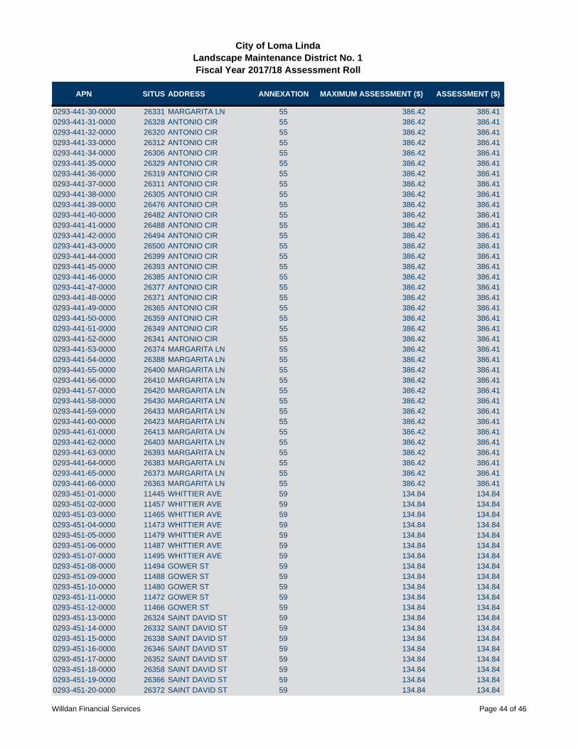
APN SITUS ADDRESS ANNEXATION MAXIMUM ASSESSMENT ($) ASSESSMENT ($)
City of Loma LindaLandscape Maintenance District No. 1Fiscal Year 2017/18 Assessment Roll
0293-441-30-0000 26331 MARGARITA LN 55 386.42 386.410293-441-31-0000 26328 ANTONIO CIR 55 386.42 386.410293-441-32-0000 26320 ANTONIO CIR 55 386.42 386.410293-441-33-0000 26312 ANTONIO CIR 55 386.42 386.410293-441-34-0000 26306 ANTONIO CIR 55 386.42 386.410293-441-35-0000 26329 ANTONIO CIR 55 386.42 386.410293-441-36-0000 26319 ANTONIO CIR 55 386.42 386.410293-441-37-0000 26311 ANTONIO CIR 55 386.42 386.410293-441-38-0000 26305 ANTONIO CIR 55 386.42 386.410293-441-39-0000 26476 ANTONIO CIR 55 386.42 386.410293-441-40-0000 26482 ANTONIO CIR 55 386.42 386.410293-441-41-0000 26488 ANTONIO CIR 55 386.42 386.410293-441-42-0000 26494 ANTONIO CIR 55 386.42 386.410293-441-43-0000 26500 ANTONIO CIR 55 386.42 386.410293-441-44-0000 26399 ANTONIO CIR 55 386.42 386.410293-441-45-0000 26393 ANTONIO CIR 55 386.42 386.410293-441-46-0000 26385 ANTONIO CIR 55 386.42 386.410293-441-47-0000 26377 ANTONIO CIR 55 386.42 386.410293-441-48-0000 26371 ANTONIO CIR 55 386.42 386.410293-441-49-0000 26365 ANTONIO CIR 55 386.42 386.410293-441-50-0000 26359 ANTONIO CIR 55 386.42 386.410293-441-51-0000 26349 ANTONIO CIR 55 386.42 386.410293-441-52-0000 26341 ANTONIO CIR 55 386.42 386.410293-441-53-0000 26374 MARGARITA LN 55 386.42 386.410293-441-54-0000 26388 MARGARITA LN 55 386.42 386.410293-441-55-0000 26400 MARGARITA LN 55 386.42 386.410293-441-56-0000 26410 MARGARITA LN 55 386.42 386.410293-441-57-0000 26420 MARGARITA LN 55 386.42 386.410293-441-58-0000 26430 MARGARITA LN 55 386.42 386.410293-441-59-0000 26433 MARGARITA LN 55 386.42 386.410293-441-60-0000 26423 MARGARITA LN 55 386.42 386.410293-441-61-0000 26413 MARGARITA LN 55 386.42 386.410293-441-62-0000 26403 MARGARITA LN 55 386.42 386.410293-441-63-0000 26393 MARGARITA LN 55 386.42 386.410293-441-64-0000 26383 MARGARITA LN 55 386.42 386.410293-441-65-0000 26373 MARGARITA LN 55 386.42 386.410293-441-66-0000 26363 MARGARITA LN 55 386.42 386.410293-451-01-0000 11445 WHITTIER AVE 59 134.84 134.840293-451-02-0000 11457 WHITTIER AVE 59 134.84 134.840293-451-03-0000 11465 WHITTIER AVE 59 134.84 134.840293-451-04-0000 11473 WHITTIER AVE 59 134.84 134.840293-451-05-0000 11479 WHITTIER AVE 59 134.84 134.840293-451-06-0000 11487 WHITTIER AVE 59 134.84 134.840293-451-07-0000 11495 WHITTIER AVE 59 134.84 134.840293-451-08-0000 11494 GOWER ST 59 134.84 134.840293-451-09-0000 11488 GOWER ST 59 134.84 134.840293-451-10-0000 11480 GOWER ST 59 134.84 134.840293-451-11-0000 11472 GOWER ST 59 134.84 134.840293-451-12-0000 11466 GOWER ST 59 134.84 134.840293-451-13-0000 26324 SAINT DAVID ST 59 134.84 134.840293-451-14-0000 26332 SAINT DAVID ST 59 134.84 134.840293-451-15-0000 26338 SAINT DAVID ST 59 134.84 134.840293-451-16-0000 26346 SAINT DAVID ST 59 134.84 134.840293-451-17-0000 26352 SAINT DAVID ST 59 134.84 134.840293-451-18-0000 26358 SAINT DAVID ST 59 134.84 134.840293-451-19-0000 26366 SAINT DAVID ST 59 134.84 134.840293-451-20-0000 26372 SAINT DAVID ST 59 134.84 134.84
Willdan Financial Services Page 44 of 46

APN SITUS ADDRESS ANNEXATION MAXIMUM ASSESSMENT ($) ASSESSMENT ($)
City of Loma LindaLandscape Maintenance District No. 1Fiscal Year 2017/18 Assessment Roll
0293-451-21-0000 26380 SAINT DAVID ST 59 134.84 134.840293-451-22-0000 26386 SAINT DAVID ST 59 134.84 134.840293-451-23-0000 26392 SAINT DAVID ST 59 134.84 134.840293-451-24-0000 26400 SAINT DAVID ST 59 134.84 134.840293-451-25-0000 26408 SAINT DAVID ST 59 134.84 134.840293-451-26-0000 26390 LAWTON ST 59 134.84 134.840293-451-27-0000 26384 LAWTON ST 59 134.84 134.840293-451-28-0000 26376 LAWTON ST 59 134.84 134.840293-451-29-0000 26368 LAWTON ST 59 134.84 134.840293-451-30-0000 26362 LAWTON ST 59 134.84 134.840293-451-31-0000 26354 LAWTON ST 59 134.84 134.840293-451-32-0000 26346 LAWTON ST 59 134.84 134.840293-451-33-0000 26347 SAINT DAVID ST 59 134.84 134.840293-451-34-0000 26355 SAINT DAVID ST 59 134.84 134.840293-451-35-0000 26377 SAINT DAVID ST 59 134.84 134.840293-451-36-0000 26414 SAINT DAVID ST 59 134.84 134.840293-451-37-0000 26422 SAINT DAVID ST 59 134.84 134.840293-451-38-0000 26426 SAINT DAVID ST 59 134.84 134.840293-461-01-0000 11410 RAMONA RD 67 1,424.86 20.330293-461-02-0000 26407 DELGADO AVE 67 1,424.86 20.330293-461-03-0000 26401 DELGADO AVE 67 1,424.86 20.330293-461-04-0000 26395 DELGADO AVE 67 1,424.86 20.330293-461-05-0000 26389 DELGADO AVE 67 1,424.86 20.330293-461-06-0000 26383 DELGADO AVE 67 1,424.86 20.330293-461-07-0000 26377 DELGADO AVE 67 1,424.86 20.330293-461-08-0000 26371 DELGADO AVE 67 1,424.86 20.330293-461-09-0000 26365 DELGADO AVE 67 1,424.86 20.330293-461-10-0000 26359 DELGADO AVE 67 1,424.86 20.330293-461-11-0000 26353 DELGADO AVE 67 1,424.86 20.330293-461-12-0000 26347 DELGADO AVE 67 1,424.86 20.330293-461-13-0000 26341 DELGADO AVE 67 1,424.86 20.330293-461-14-0000 26335 DELGADO AVE 67 1,424.86 20.330293-461-15-0000 26329 DELGADO AVE 67 1,424.86 20.330293-461-16-0000 26333 SANTA ANDREA ST 67 1,424.86 20.330293-461-17-0000 26332 SANTA ANDREA ST 67 1,424.86 20.330293-461-18-0000 26338 SANTA ANDREA ST 67 1,424.86 20.330293-461-19-0000 26344 SANTA ANDREA ST 67 1,424.86 20.330293-461-20-0000 26350 SANTA ANDREA ST 67 1,424.86 20.330293-461-21-0000 26356 SANTA ANDREA ST 67 1,424.86 20.330293-461-22-0000 26362 SANTA ANDREA ST 67 1,424.86 20.330293-461-23-0000 26368 SANTA ANDREA ST 67 1,424.86 20.330293-461-24-0000 26374 SANTA ANDREA ST 67 1,424.86 20.330293-461-25-0000 26380 SANTA ANDREA ST 67 1,424.86 20.330293-461-26-0000 26386 SANTA ANDREA ST 67 1,424.86 20.330293-461-27-0000 26392 SANTA ANDREA ST 67 1,424.86 20.330293-461-28-0000 26398 SANTA ANDREA ST 67 1,424.86 20.330293-461-29-0000 26404 SANTA ANDREA ST 67 1,424.86 20.330293-461-30-0000 26412 SANTA ANDREA ST 67 1,424.86 20.330293-461-31-0000 26418 SANTA ANDREA ST 67 1,424.86 20.330293-461-32-0000 26426 SANTA ANDREA ST 67 1,424.86 20.330293-461-33-0000 26436 SANTA ANDREA ST 67 1,424.86 20.330293-461-34-0000 11395 RAMONA RD 67 1,424.86 20.330293-461-35-0000 11403 RAMONA RD 67 1,424.86 20.330293-461-36-0000 11413 RAMONA RD 67 1,424.86 20.330293-461-37-0000 11398 RAMONA RD 67 1,424.86 20.330293-461-38-0000 26415 SANTA ANDREA ST 67 1,424.86 20.330293-461-39-0000 26400 DELGADO AVE 67 1,424.86 20.33
Willdan Financial Services Page 45 of 46

APN SITUS ADDRESS ANNEXATION MAXIMUM ASSESSMENT ($) ASSESSMENT ($)
City of Loma LindaLandscape Maintenance District No. 1Fiscal Year 2017/18 Assessment Roll
0293-461-40-0000 26393 SANTA ANDREA ST 67 1,424.86 20.330293-461-41-0000 26387 SANTA ANDREA ST 67 1,424.86 20.330293-461-42-0000 26381 SANTA ANDREA ST 67 1,424.86 20.330293-461-43-0000 26368 DELGADO AVE 67 1,424.86 20.330293-461-44-0000 26360 DELGADO AVE 67 1,424.86 20.330293-461-45-0000 26352 DELGADO AVE 67 1,424.86 20.330293-461-46-0000 26342 DELGADO AVE 67 1,424.86 20.330293-461-47-0000 26326 DELGADO AVE 67 1,424.86 20.330293-461-48-0000 26357 SANTA ANDREA ST 67 1,424.86 20.330293-461-49-0000 26363 SANTA ANDREA ST 67 1,424.86 20.330293-461-50-0000 26369 SANTA ANDREA ST 67 1,424.86 20.330293-461-51-0000 26375 SANTA ANDREA ST 67 1,424.86 20.33TOTAL 395,585.43PARCEL COUNT 2,577
Willdan Financial Services Page 46 of 46
2017/2018 Landscape Maintenance District No. 1 Page 22
APPENDIX D - RESOLUTIONS
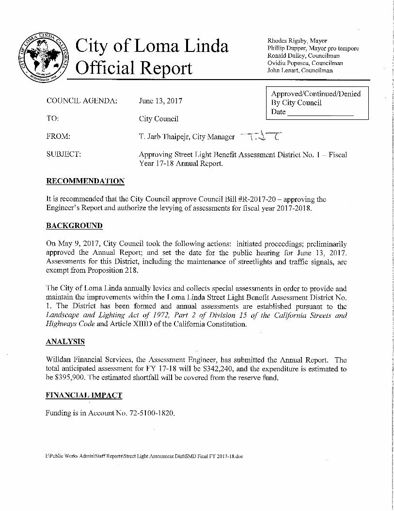
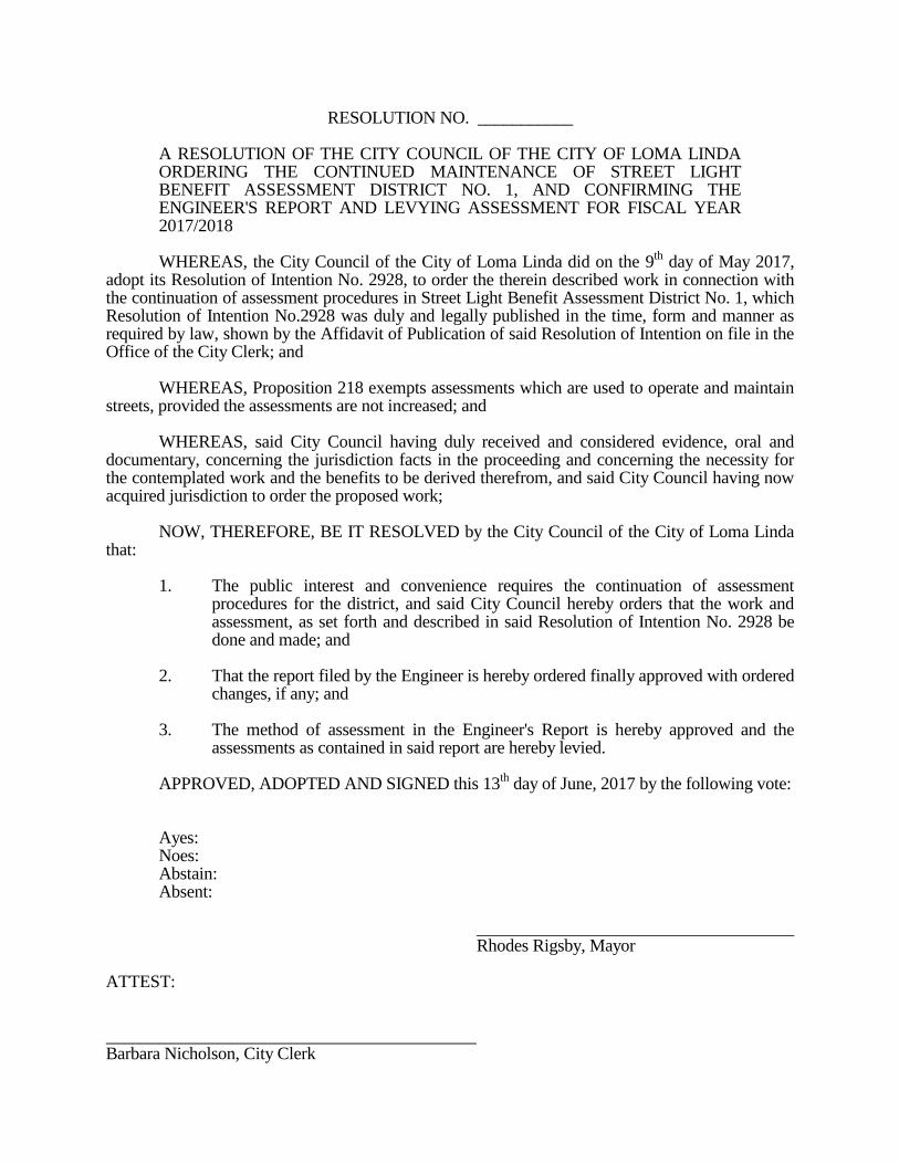
RESOLUTION NO. ___________ A RESOLUTION OF THE CITY COUNCIL OF THE CITY OF LOMA LINDA
ORDERING THE CONTINUED MAINTENANCE OF STREET LIGHT BENEFIT ASSESSMENT DISTRICT NO. 1, AND CONFIRMING THE ENGINEER'S REPORT AND LEVYING ASSESSMENT FOR FISCAL YEAR 2017/2018
WHEREAS, the City Council of the City of Loma Linda did on the 9
th day of May 2017,
adopt its Resolution of Intention No. 2928, to order the therein described work in connection with the continuation of assessment procedures in Street Light Benefit Assessment District No. 1, which Resolution of Intention No.2928 was duly and legally published in the time, form and manner as required by law, shown by the Affidavit of Publication of said Resolution of Intention on file in the Office of the City Clerk; and WHEREAS, Proposition 218 exempts assessments which are used to operate and maintain streets, provided the assessments are not increased; and WHEREAS, said City Council having duly received and considered evidence, oral and documentary, concerning the jurisdiction facts in the proceeding and concerning the necessity for the contemplated work and the benefits to be derived therefrom, and said City Council having now acquired jurisdiction to order the proposed work; NOW, THEREFORE, BE IT RESOLVED by the City Council of the City of Loma Linda that: 1. The public interest and convenience requires the continuation of assessment
procedures for the district, and said City Council hereby orders that the work and assessment, as set forth and described in said Resolution of Intention No. 2928 be done and made; and
2. That the report filed by the Engineer is hereby ordered finally approved with ordered
changes, if any; and 3. The method of assessment in the Engineer's Report is hereby approved and the
assessments as contained in said report are hereby levied. APPROVED, ADOPTED AND SIGNED this 13
th day of June, 2017 by the following vote:
Ayes: Noes: Abstain: Absent: Rhodes Rigsby, Mayor ATTEST: Barbara Nicholson, City Clerk

City of Loma Linda
Street Light Benefit Assessment
District No. 1
2017/2018 ENGINEER’S ANNUAL LEVY REPORT
Intent Meeting: May 9, 2017
Public Hearing: June 13, 2017
27368 Via Industria, Suite 200
Temecula, California 92590
T. 951.587.3500 800.755.6864
F. 951.587.3510 888.326.6864
www.willdan.com/financial


TABLE OF CONTENTS
I. OVERVIEW 1
A. INTRODUCTION 1 B. COMPLIANCE WITH CURRENT LEGISLATION 1
II. DESCRIPTION OF THE DISTRICT 2
A. BOUNDARIES OF THE DISTRICT 2 B. IMPROVEMENTS AUTHORIZED BY THE 1972 ACT 2 C. DESCRIPTION OF THE DISTRICT IMPROVEMENTS AND SERVICES 4
III. METHOD OF APPORTIONMENT 4
A. GENERAL 4 B. BENEFIT ANALYSIS 5 C. METHODOLOGY 5
IV. DISTRICT BUDGETS 6
A. ESTIMATED MAINTENANCE AND SERVICING COSTS 6 B. DESCRIPTION OF BUDGET ITEMS 7 C. ASSESSMENT CALCULATIONS 10
APPENDIX A – DISTRICT BOUNDARY MAP A-1
APPENDIX B - FISCAL YEAR 2017/2018 ASSESSMENT ROLL B-1
APPENDIX C – RESOLUTIONS C-1
2017/2018 Street Light Benefit Assessment District No. 1 Page 1 of 10
I. OVERVIEW
A. INTRODUCTION
The City of Loma Linda (“City”) annually levies and collects special assessments in order to provide and maintain the improvements within the Loma Linda Street Light Benefit Assessment District No. 1 (“District”). The District has been formed and annual assessments are established pursuant to the Landscape and Lighting Act of 1972, Part 2 of Division 15 of the California Streets and Highways Code (the “1972 Act”) and the California Constitution Article XIIID (“Article XIIID”).
The Engineer’s Annual Levy Report (“Report”) describes the District, any changes to the District, and the proposed assessments for Fiscal Year 2017/2018. For the purposes of this Report, the word “parcel” refers to an individual property assigned its own Assessor’s Parcel Number (“APN”) by the County of San Bernardino (”County”) Assessor’s Office. The County Auditor/Controller uses APNs and specific Fund Numbers to identify properties on the tax roll assessed for special district benefit assessments. The proposed assessments are based on the historical and estimated costs to maintain the improvements that provide special benefit to properties within the District. The improvements within the District and the corresponding costs that make up the annual levy and that are budgeted and assessed to the District include budgeted expenditures, deficits, surpluses, revenues, and reserves. Each parcel is assessed proportionately for only those improvements provided and for which the parcel receives special benefit.
Following review of the Report and consideration of public comments and written protests at a noticed public hearing, the City Council may order amendments to the Report or approve the Report as submitted. Following approval of the Report, the Council may order the levy and collection of assessments for Fiscal Year 2017/2018 pursuant to the 1972 Act. In such case, the assessment information will be submitted to the County Auditor/Controller and included on the property tax roll for each benefiting parcel for Fiscal Year 2017/2018.
B. COMPLIANCE WITH CURRENT LEGISLATION
On November 5, 1996, California voters approved Proposition 218. This Constitutional amendment was the latest in a series of initiatives altering the revenue-raising discretion of California’s local agencies. The provisions of Proposition 218 are set forth in the California Constitution Articles XIIIC and XIIID.

2017/2018 Street Light Benefit Assessment District No. 1 Page 2 of 10
In Article XIIID Section 2 (b), “Assessments” are defined as:
“…any levy or charge upon real property by an agency for a special benefit conferred upon the real property. ‘Assessment’ includes, but is not limited to, ‘special assessment,’ ‘benefit assessment,’ ‘maintenance assessment,’ and ‘special assessment tax.’”
Street lights and traffic signals are installed on and for street purposes and are maintained and serviced to allow the street to perform to the standards it was designed. Assessments for the maintenance and servicing of streets include street lights and traffic signals, and pursuant to the provisions of Article XIIID Section 5(a), existing assessments for street maintenance are exempt from the procedural requirements of Article XIIID Section 4 until such time that the assessments are increased.
It is the understanding of the Assessment Engineer that the assessments were to fund a degree of maintenance and servicing, which can fluctuate from year to year. As long as the maximum assessment for any prior year is not exceeded in future years, assessment balloting is not required.
II. DESCRIPTION OF THE DISTRICT
A. BOUNDARIES OF THE DISTRICT
The boundaries of the District are coterminous with the City as shown on the map entitled, “Diagram Street Light Benefit Assessment District No. 1, City of Loma Linda, California” which is on file in the Office of the City Clerk, City of Loma Linda, California.
B. IMPROVEMENTS AUTHORIZED BY THE 1972 ACT
As applicable or may be applicable to this proposed District, the 1972 Act defines improvements to mean one or any combination of the following:
The installation or planting of landscaping.
The installation or construction of statuary, fountains, and other ornamental structures and facilities.
The installation or construction of public lighting facilities.
The installation or construction of any facilities which are appurtenant to any of the foregoing or which are necessary or convenient for the maintenance
2017/2018 Street Light Benefit Assessment District No. 1 Page 3 of 10
or servicing thereof, including, but not limited to, grading, clearing, removal of debris, the installation or construction of curbs, gutters, walls, sidewalks, or paving, or water, irrigation, drainage, or electrical facilities.
The maintenance or servicing, or both, of any of the foregoing.
The acquisition of any existing improvement otherwise authorized pursuant to this section.
Incidental expenses associated with the improvements including, but not limited to:
The cost of preparation of the report, including plans, specifications, estimates, diagram, and assessment;
The costs of printing, advertising, and the publishing, posting and mailing of notices;
Compensation payable to the County for collection of assessments;
Compensation of any engineer or attorney employed to render services;
Any other expenses incidental to the construction, installation, or
maintenance and servicing of the improvements;
Any expenses incidental to the issuance of bonds or notes pursuant to Section 22662.5.
Costs associated with any elections held for the approval of a new or
increased assessment.
The 1972 Act defines "Maintain" or "maintenance" to mean furnishing of services and materials for the ordinary and usual maintenance, operation, and servicing of any improvement, including:
Repair, removal, or replacement of all or any part of any improvement.
Providing for the life, growth, health, and beauty of landscaping, including cultivation, irrigation, trimming, spraying, fertilizing, or treating for disease or injury.
The removal of trimmings, rubbish, debris, and other solid waste.
The cleaning, sandblasting, and painting of walls and other improvements
to remove or cover graffiti.

2017/2018 Street Light Benefit Assessment District No. 1 Page 4 of 10
C. DESCRIPTION OF THE DISTRICT IMPROVEMENTS AND SERVICES
The improvements in the District are for maintenance and servicing of street lights, traffic signals and intersection lighting. They are an integral part of the entire street, the same as curb, gutters, pavement, signage and striping. Taken as a group, they are the elements that provide a safe route for motorists.
Street lights and traffic signals are installed to make streets safer. The traffic signals assign the right-of-way for motorists. Street lights are installed to provide better visibility for drivers. One hundred (100) percent of the illumination from the lights is directed to the street, ninety (90) percent on the street side of the curb and ten (10) percent behind the curb. The spacing of the lights is based on the speed of the vehicles and the natural ability of the motorists’ eyes to adjust to lighter and darker areas.
The existing street light and traffic signal improvements are owned either by the Southern California Edison Company, the State of California Department of Transportation, or the City. Facilities owned by either the Southern California Edison Company or the State of California Department of Transportation were constructed in accordance with plans and specifications on file with the respective owners. Facilities constructed for or by the City are on file in the City offices. Reference is hereby made to said plans and specifications and they are by reference made a part of this report to the same extent as if said plans and specifications were attached hereto.
Although the 1972 Act allows for the construction of improvements and the assignment of the benefit assessments associated therewith, it is not anticipated that any new improvements will be installed nor benefit assessments made for the installation of improvements for Fiscal Year 2017/2018.
III. METHOD OF APPORTIONMENT
A. GENERAL
Pursuant to the 1972 Act and the provisions of the California Constitution, the costs of the District are apportioned by a formula or method that fairly distributes the net amount to be assessed among all assessable parcels in proportion to the special benefit to be received by each such parcel from the improvements. Article XIIID requires that a parcel's assessment may not exceed the reasonable cost of the proportional special benefit conferred on that parcel. Article XIIID also requires the agency to separate the general benefit from special benefit and that only special benefit is assessable.
Each parcel within the District receives special benefit from the improvements due to the close proximity of the lighting improvements to each parcel. The proposed assessments for Fiscal Year 2017/2018 are at the same rate as in the prior Fiscal

2017/2018 Street Light Benefit Assessment District No. 1 Page 5 of 10
Year 2015/2016. Since the assessments are not new or increased, and are for street lights, they are currently exempt from the procedures and approval process of Article XIIID.
The cost to provide maintenance and servicing of the improvements within the District is fairly and equitably distributed among each assessable parcel based upon the estimated special benefit received by each parcel.
B. BENEFIT ANALYSIS
The City Council, in determining the necessity of forming the District, took into account the increasing cost of providing services to the residents, businesses, and properties located within the City. The benefits of street lighting conferred upon the property within the District include the convenience, safety, and security of property, improvements and goods. Specifically:
1. Enhanced deterrence of crime and the aid to police protection.
2. Increased nighttime safety on streets through enhanced visibility.
3. Improved sense of security and safety for pedestrians, motorists and property owners.
4. Improved ingress and egress to property.
5. Reduced vandalism, other criminal acts and damage to improvements or property.
6. Reduced personal property loss.
The preceding special benefits contribute to a special enhancement and desirability of each of the assessed parcels within the District.
C. METHODOLOGY
Assessments proposed for individual lots within the District will be for special benefit received and will be determined based upon four benefit zones.
1. Residential parcels within the urban area having a minimal level of benefit.
2. Residential parcels within the urban area having a higher than minimal level of benefit.
3. Non-Residential land use within the urban area. 4. Rural land use outside the urban area.
The benefit to be received by each zone varies. There are residential properties within the urban area that have fewer street lights than other urban residential areas and thus receive less benefit. There are rural areas that have even fewer residential street lights than even the minimum urban residential areas and thus receive less benefit. The non-residential properties are generally sited along the

2017/2018 Street Light Benefit Assessment District No. 1 Page 6 of 10
major arterial streets and receive a higher level of street lighting and thus receive the highest level of benefit. These same levels of benefit are also reflected in the maintenance and servicing of traffic signals.
The benefit to properties for traffic signals and intersection and highway safety lighting on the City's major streets is a benefit to the parcels within the City. The parcels share equally the cost of the signal and highway safety lights. Thus, the total benefit to each parcel within the District is a combination of the traffic signal and highway safety lighting, plus the various levels of lighting for the residential (minimal), residential (standard), non-residential and rural zones as described above.
Properties within the District have been categorized into one of the four benefit zones. Each property has been given 1 Unit of Benefit subsequent to its categorization. Please refer to Section B “Assessment Calculation” of this report for further particulars on assessments per 1 Unit of Benefit. For a detailed explanation of the basis for assessing properties for street lights and traffic signals, refer to Section 6, “Assessment Basis,” in the Fiscal Year 1982/1983 Engineer's Report for the District.
The City Council has determined that street lights and traffic signals are an integral part of the quality of life within the City and that the parcels within the City, except publicly and government owned ones, benefit to some degree from these systems.
Railroad, gas, water or electric utility or electric line rights-of-way included within the District will not be assessed for said benefit. In addition, public schools, government agencies, and parcels with no road frontage will not be assessed.
IV. DISTRICT BUDGETS
A. ESTIMATED MAINTENANCE AND SERVICING COSTS
The maintenance and servicing of existing street light and traffic signal facilities is performed by either the Southern California Edison Company, the State of California Department of Transportation or by the City through its own forces or contract personnel. The portion of the street light system owned and operated by the Southern California Edison Company is billed to the City on a monthly flat rate or metered basis. These flat rates or metered amounts vary based upon the type and size of luminaries and actual metered amounts.
A portion of the street lighting system is owned and maintained by the City. Electrical energy is purchased from the Southern California Edison Company at metered locations. Again, as with the Edison-owned lights, there are frequent increases in the electrical energy costs; however, with the City-owned system, these increases are termed “fuel cost adjustments”.

2017/2018 Street Light Benefit Assessment District No. 1 Page 7 of 10
B. DESCRIPTION OF BUDGET ITEMS
The following is a brief description of the costs associated with the improvements and services funded through the District.
DIRECT COSTS:
Maintenance — Includes regularly scheduled labor and general maintenance cost including wages, salaries, benefits and contract services required to properly maintain and ensure the satisfactory condition of the improvements and appurtenant facilities. Utilities — The furnishing of water and electricity required for the operation and maintenance of the improvements and facilities. Capital Repairs / Improvements — This item includes repairs to the improvements and facilities that are not included in the yearly maintenance costs. This may include repair of damaged amenities due to vandalism, storms, etc. Also included may be planned upgrades or replacements of the improvements and equipment that provide a special benefit to the District. Includes materials, supplies, and equipment required to operate, maintain and ensure the satisfactory condition of the improvements and appurtenant facilities.
ADMINISTRATIVE COSTS:
Administration/Operations/Insurance — May include the administrative and professional service costs associated with the coordination of District services and operations including response to public concerns and education, procedures associated with the levy and collection of assessments, the costs of contracting with professionals to provide administrative, legal or engineering services specific to the District, and the cost for the County to collect assessments on the property tax bills. Professional Services — The cost of contracting with professionals to provide services specific to the levy of assessments and annual administration of the District.
OTHER BUDGET ITEMS:
Credit/Adjustments — If there is a surplus at the end of any fiscal year, it shall be deposited in the District account. If there is a deficit at the end of any fiscal year, the shortfall will be covered by any surplus funds in the District account. However, if there are no surplus funds in the District account, the shortfall will be made up through a General Fund contribution.

2017/2018 Street Light Benefit Assessment District No. 1 Page 8 of 10
Total Parcels Levied — The total number of parcels within the District that are assessed. Non-assessable lots or parcels include properties that have been determined to receive no special benefits from the improvements and may include land principally encumbered by public or other rights-of-way or easements, common areas, and/or parcels that have restricted use or development potential.
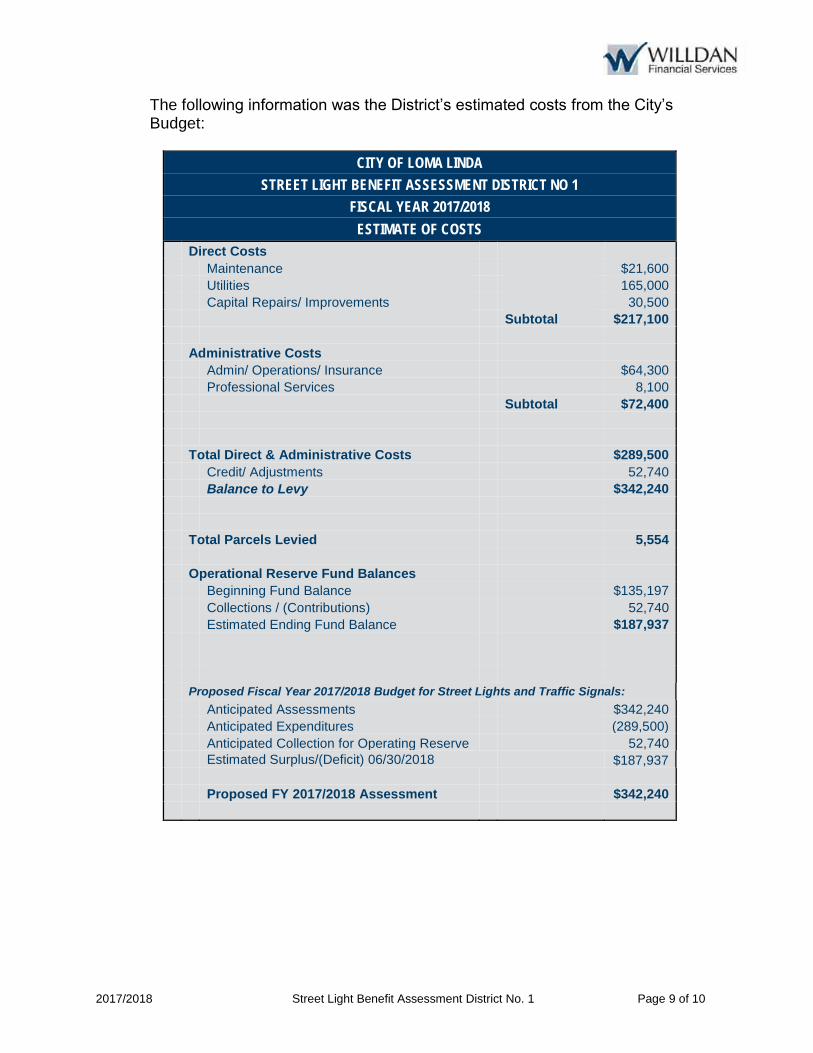
2017/2018 Street Light Benefit Assessment District No. 1 Page 9 of 10
The following information was the District’s estimated costs from the City’s Budget:
CITY OF LOMA LINDA
STREET LIGHT BENEFIT ASSESSMENT DISTRICT NO 1
FISCAL YEAR 2017/2018
ESTIMATE OF COSTS
Direct Costs Maintenance $21,600 Utilities 165,000 Capital Repairs/ Improvements 30,500 Subtotal $217,100 Administrative Costs Admin/ Operations/ Insurance $64,300 Professional Services 8,100 Subtotal $72,400 Total Direct & Administrative Costs $289,500 Credit/ Adjustments 52,740 Balance to Levy $342,240 Total Parcels Levied 5,554 Operational Reserve Fund Balances Beginning Fund Balance $135,197 Collections / (Contributions) 52,740 Estimated Ending Fund Balance $187,937 Proposed Fiscal Year 2017/2018 Budget for Street Lights and Traffic Signals:
Anticipated Assessments $342,240 Anticipated Expenditures (289,500) Anticipated Collection for Operating Reserve 52,740 Estimated Surplus/(Deficit) 06/30/2018 $187,937 Proposed FY 2017/2018 Assessment $342,240
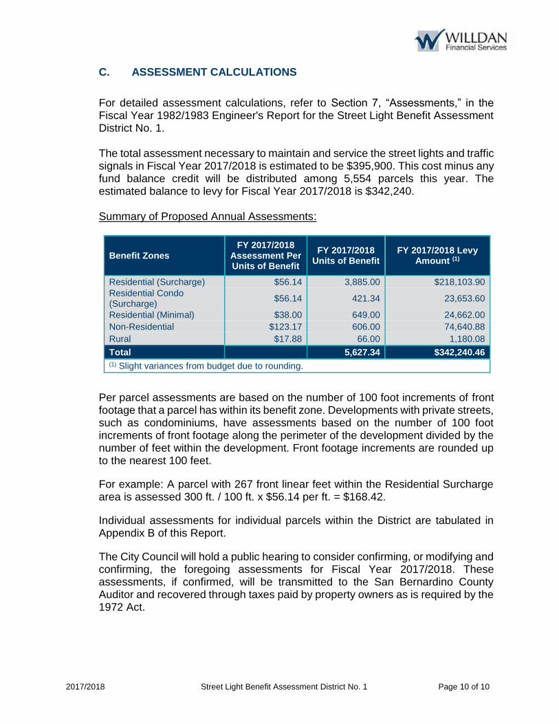
2017/2018 Street Light Benefit Assessment District No. 1 Page 10 of 10
C. ASSESSMENT CALCULATIONS
For detailed assessment calculations, refer to Section 7, “Assessments,” in the Fiscal Year 1982/1983 Engineer's Report for the Street Light Benefit Assessment District No. 1. The total assessment necessary to maintain and service the street lights and traffic signals in Fiscal Year 2017/2018 is estimated to be $395,900. This cost minus any fund balance credit will be distributed among 5,554 parcels this year. The estimated balance to levy for Fiscal Year 2017/2018 is $342,240. Summary of Proposed Annual Assessments:
Benefit Zones FY 2017/2018
Assessment Per Units of Benefit
FY 2017/2018 Units of Benefit
FY 2017/2018 Levy Amount (1)
Residential (Surcharge) $56.14 3,885.00 $218,103.90 Residential Condo (Surcharge)
$56.14 421.34 23,653.60
Residential (Minimal) $38.00 649.00 24,662.00 Non-Residential $123.17 606.00 74,640.88 Rural $17.88 66.00 1,180.08
Total 5,627.34 $342,240.46 (1) Slight variances from budget due to rounding.
Per parcel assessments are based on the number of 100 foot increments of front footage that a parcel has within its benefit zone. Developments with private streets, such as condominiums, have assessments based on the number of 100 foot increments of front footage along the perimeter of the development divided by the number of feet within the development. Front footage increments are rounded up to the nearest 100 feet.
For example: A parcel with 267 front linear feet within the Residential Surcharge area is assessed 300 ft. / 100 ft. x $56.14 per ft. = $168.42.
Individual assessments for individual parcels within the District are tabulated in Appendix B of this Report.
The City Council will hold a public hearing to consider confirming, or modifying and confirming, the foregoing assessments for Fiscal Year 2017/2018. These assessments, if confirmed, will be transmitted to the San Bernardino County Auditor and recovered through taxes paid by property owners as is required by the 1972 Act.

2017/2018 Street Light Benefit Assessment District No. 1 Page A-1
APPENDIX A – DISTRICT BOUNDARY MAP
The Boundary Diagram for the original district has previously been submitted to the Clerk of the City in the format required under the 1972 Act and is made part of this Report by reference.
The parcel identification, lines and dimensions of each parcel within the District are those lines and dimensions shown on the Assessor Maps of San Bernardino County for the year in which this Report was prepared and is incorporated by reference and made part of this Report.

2017/2018 Street Light Benefit Assessment District No. 1 Page A-2

2017/2018 Street Light Benefit Assessment District No. 1 Page B-1
APPENDIX B - FISCAL YEAR 2017/2018 ASSESSMENT ROLL
Parcel identification, for each lot or parcel within the District, shall be the parcel as shown on the San Bernardino County Assessor Parcel Maps and/or the San Bernardino County Secured Tax Roll for the year in which this Report is prepared.
Non-assessable lots or parcels may include government owned land, public utility owned property, land principally encumbered with public rights-of-way or easements and dedicated common areas. These parcels will not be assessed.
A listing of parcels within the District, along with the proposed assessment amounts, has been submitted to the City Clerk and is attached herein.
Upon approval of the Engineer’s Annual Levy Report, and confirmation of the assessments, the assessment information will be submitted to the County Auditor/Controller, and included on the property tax roll in Fiscal Year 2017/2018. If the parcels or assessment numbers within the District and referenced in this Report, are re-numbered, re-apportioned or changed by the County Assessor’s Office after approval of the Report, the new parcel or assessment numbers with the appropriate assessment amount will be submitted to the County Auditor/Controller. If the parcel change made by the County includes a parcel split, parcel merger or tax status change, the assessment amount submitted on the new parcels or assessment numbers will be based on the method of apportionment and levy amount approved in this Report by the City Council.

APN SITUS ADDRESS LAND USE CODE EBU ASSESSMENT ($)
0281-091-22-0000 24800 E REDLANDS BLVD NR 1.00 123.17
0281-091-23-0000 E REDLANDS BLVD NR 1.00 123.17
0281-091-24-0000 24756 E REDLANDS BLVD NR 1.00 123.17
0281-091-25-0000 24736 REDLANDS BLVD NR 1.00 123.17
0281-091-28-0000 24716 E REDLANDS BLVD NR 1.00 123.17
0281-091-31-0000 24893 E REDLANDS BLVD NR 1.00 123.17
0281-091-32-0000 24816 E REDLANDS BLVD NR 2.00 246.34
0281-091-34-0000 24732 E REDLANDS BLVD NR 1.00 123.17
0281-091-40-0000 24818 REDLANDS BLVD NR 1.00 123.17
0281-091-41-0000 24850 E REDLANDS BLVD NR 1.00 123.17
0281-091-42-0000 24866 E REDLANDS BLVD NR 1.00 123.17
0281-162-09-0000 25252 REDLANDS BLVD NR 1.00 123.17
0281-162-10-0000 25244 REDLANDS BLVD NR 1.00 123.17
0281-162-22-0000 24990 W REDLANDS BLVD NR 3.00 369.51
0281-162-24-0000 24910 E REDLANDS BLVD NR 1.00 123.17
0281-162-26-0000 24950 REDLANDS BLVD NR 2.00 246.34
0281-162-32-0000 10412 RICHARDSON ST NR 1.00 123.17
0281-162-33-0000 25258 REDLANDS BLVD NR 1.00 123.17
0281-162-34-0000 E REDLANDS BLVD NR 2.00 246.34
0281-162-42-0000 RICHARDSON ST NR 1.00 123.17
0281-162-50-0000 REDLANDS BLVD NR 1.00 123.17
0281-241-04-0000 25300 REDLANDS BLVD NR 6.00 739.02
0281-241-08-0000 25500 RICHARDSON ST NR 2.00 246.34
0281-241-09-0000 25500 REDLANDS BLVD NR 6.00 739.02
0281-242-19-0000 25526 REDLANDS BLVD NR 1.00 123.17
0281-242-20-0000 25526 REDLANDS BLVD RS 1.00 56.14
0281-242-31-0000 25630 W REDLANDS BLVD NR 1.00 123.17
0281-242-32-0000 25670 W REDLANDS BLVD NR 5.00 615.85
0281-242-33-0000 10460 MOUNTAIN VIEW AVE NR 3.00 369.51
0281-242-34-0000 10358 MOUNTAIN VW RS 1.00 56.14
0281-242-35-0000 10342 MOUNTAIN VW NR 2.00 246.34
0281-251-05-0000 25652 ROSEWOOD DR RS 1.00 56.14
0281-251-06-0000 25642 ROSEWOOD DR RS 1.00 56.14
0281-251-07-0000 25636 ROSEWOOD DR RS 1.00 56.14
0281-251-08-0000 25626 ROSEWOOD DR RS 1.00 56.14
0281-252-01-0000 25635 ROSEWOOD DR RS 1.00 56.14
0281-252-02-0000 10386 SPADE DR RS 1.00 56.14
0281-252-03-0000 10396 SPADE DR RS 1.00 56.14
0281-252-04-0000 10406 SPADE DR RS 1.00 56.14
0281-252-05-0000 10414 SPADE DR RS 1.00 56.14
0281-252-06-0000 10424 SPADE DR RS 1.00 56.14
0281-252-07-0000 25636 SUN AVE RS 1.00 56.14
0281-253-01-0000 25660 SUN AVE RS 1.00 56.14
0281-253-02-0000 10423 SPADE DR RS 1.00 56.14
0281-253-03-0000 10413 SPADE DR RS 1.00 56.14
0281-253-04-0000 10403 SPADE DR RS 1.00 56.14
0281-253-05-0000 10395 SPADE DR RS 1.00 56.14
0281-253-06-0000 10385 SPADE DR RS 1.00 56.14
0281-253-07-0000 25659 ROSEWOOD DR RS 1.00 56.14
0281-253-08-0000 25685 MOUNTAIN VIEW AVE RS 1.00 56.14
0281-253-09-0000 10388 MOUNTAIN VIEW AVE RS 1.00 56.14
0281-253-10-0000 10396 MOUNTAIN VIEW AVE RS 1.00 56.14
0281-253-11-0000 10404 MOUNTAIN VIEW AVE RS 1.00 56.14
0281-253-12-0000 10414 MOUNTAIN VIEW AVE RS 1.00 56.14
0281-253-13-0000 10422 MOUNTAIN VIEW AVE RS 1.00 56.14
0281-253-14-0000 25682 SUN AVE RS 1.00 56.14
0281-254-01-0000 25625 SUN AVE RS 1.00 56.14
City of Loma LindaStreet Light Benefit Assessment District No. 1
Fiscal Year 2017/18 Assessment Roll (Sorted by APN)
Willdan Financial Services Page 1 of 98

APN SITUS ADDRESS LAND USE CODE EBU ASSESSMENT ($)
City of Loma LindaStreet Light Benefit Assessment District No. 1
Fiscal Year 2017/18 Assessment Roll (Sorted by APN)
0281-254-02-0000 25635 SUN AVE RS 1.00 56.14
0281-254-03-0000 25643 SUN AVE RS 1.00 56.14
0281-254-04-0000 25653 SUN AVE RS 1.00 56.14
0281-254-05-0000 25659 SUN AVE RS 1.00 56.14
0281-254-06-0000 25669 SUN AVE RS 1.00 56.14
0281-331-01-0000 24530 E REDLANDS BLVD NR 1.00 123.17
0281-331-02-0000 24532 E REDLANDS BLVD NR 1.00 123.17
0281-331-03-0000 24538 E REDLANDS BLVD NR 1.00 123.17
0281-331-04-0000 24540 E REDLANDS BLVD NR 1.00 123.17
0281-331-05-0000 24546 E REDLANDS BLVD NR 1.00 123.17
0281-331-06-0000 24548 E REDLANDS BLVD NR 1.00 123.17
0281-331-07-0000 24554 E REDLANDS BLVD NR 1.00 123.17
0281-331-08-0000 24556 E REDLANDS BLVD NR 1.00 123.17
0281-331-09-0000 24562 E REDLANDS BLVD NR 1.00 123.17
0281-331-10-0000 24564 E REDLANDS BLVD NR 1.00 123.17
0281-331-11-0000 24574 E REDLANDS BLVD NR 1.00 123.17
0281-331-12-0000 24576 E REDLANDS BLVD NR 1.00 123.17
0281-331-13-0000 24586 E REDLANDS BLVD NR 1.00 123.17
0281-331-14-0000 24588 E REDLANDS BLVD NR 1.00 123.17
0281-331-15-0000 24630 E REDLANDS BLVD NR 1.00 123.17
0281-331-16-0000 24632 E REDLANDS BLVD NR 1.00 123.17
0281-331-17-0000 24638 E REDLANDS BLVD NR 1.00 123.17
0281-331-18-0000 24640 E REDLANDS BLVD NR 1.00 123.17
0281-331-19-0000 24646 E REDLANDS BLVD NR 1.00 123.17
0281-331-20-0000 24648 E REDLANDS BLVD NR 1.00 123.17
0281-331-21-0000 24654 E REDLANDS BLVD NR 1.00 123.17
0281-331-22-0000 24656 E REDLANDS BLVD NR 1.00 123.17
0281-331-23-0000 24662 E REDLANDS BLVD NR 1.00 123.17
0281-331-24-0000 24664 E REDLANDS BLVD NR 1.00 123.17
0281-331-25-0000 24674 E REDLANDS BLVD NR 1.00 123.17
0281-331-26-0000 24676 E REDLANDS BLVD NR 1.00 123.17
0281-331-27-0000 24686 E REDLANDS BLVD NR 1.00 123.17
0281-331-28-0000 24688 E REDLANDS BLVD NR 1.00 123.17
0281-381-03-0000 25050 REDLANDS BLVD NR 3.00 369.51
0281-381-07-0000 25072 REDLANDS BLVD NR 2.00 246.34
0281-381-12-0000 REDLANDS BLVD NR 2.00 246.34
0281-381-13-0000 REDLANDS BLVD NR 4.00 492.68
0283-062-01-0000 24519 REDLANDS BLVD NR 1.00 123.17
0283-062-05-0000 24583 E REDLANDS BLVD NR 1.00 123.17
0283-062-06-0000 24601 W REDLANDS BLVD NR 1.00 123.17
0283-062-07-0000 REDLANDS BLVD NR 2.00 246.34
0283-062-08-0000 REDLANDS BLVD NR 2.00 246.34
0283-062-17-0000 24821 REDLANDS BLVD NR 1.00 123.17
0283-062-18-0000 NO SITUS ADDRESS AVAILABLE NR 1.00 123.17
0283-062-19-0000 24831 REDLANDS BLVD NR 1.00 123.17
0283-062-20-0000 24849 REDLANDS BLVD NR 1.00 123.17
0283-062-21-0000 NO SITUS ADDRESS AVAILABLE NR 1.00 123.17
0283-062-22-0000 24871 REDLANDS BLVD NR 1.00 123.17
0283-062-23-0000 24891 REDLANDS BLVD NR 1.00 123.17
0283-062-24-0000 10540 ANDERSON ST NR 1.00 123.17
0283-062-25-0000 NO SITUS ADDRESS AVAILABLE NR 1.00 123.17
0283-062-26-0000 NO SITUS ADDRESS AVAILABLE NR 1.00 123.17
0283-062-40-0000 24769 E REDLANDS BLVD NR 5.00 615.85
0283-062-44-0000 24541 REDLANDS BLVD NR 1.00 123.17
0283-062-45-0000 24561 REDLANDS BLVD NR 1.00 123.17
0283-062-46-0000 10730 ANDERSON ST NR 1.00 123.17
0283-062-48-0000 24797 REDLAND NR 1.00 123.17
Willdan Financial Services Page 2 of 98
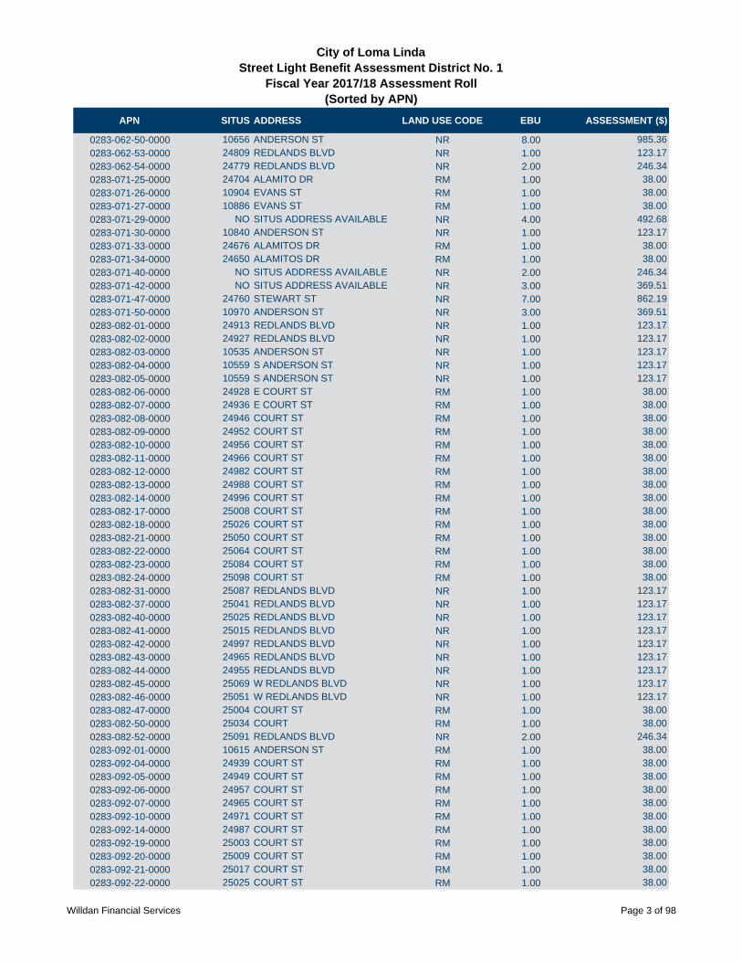
APN SITUS ADDRESS LAND USE CODE EBU ASSESSMENT ($)
City of Loma LindaStreet Light Benefit Assessment District No. 1
Fiscal Year 2017/18 Assessment Roll (Sorted by APN)
0283-062-50-0000 10656 ANDERSON ST NR 8.00 985.36
0283-062-53-0000 24809 REDLANDS BLVD NR 1.00 123.17
0283-062-54-0000 24779 REDLANDS BLVD NR 2.00 246.34
0283-071-25-0000 24704 ALAMITO DR RM 1.00 38.00
0283-071-26-0000 10904 EVANS ST RM 1.00 38.00
0283-071-27-0000 10886 EVANS ST RM 1.00 38.00
0283-071-29-0000 NO SITUS ADDRESS AVAILABLE NR 4.00 492.68
0283-071-30-0000 10840 ANDERSON ST NR 1.00 123.17
0283-071-33-0000 24676 ALAMITOS DR RM 1.00 38.00
0283-071-34-0000 24650 ALAMITOS DR RM 1.00 38.00
0283-071-40-0000 NO SITUS ADDRESS AVAILABLE NR 2.00 246.34
0283-071-42-0000 NO SITUS ADDRESS AVAILABLE NR 3.00 369.51
0283-071-47-0000 24760 STEWART ST NR 7.00 862.19
0283-071-50-0000 10970 ANDERSON ST NR 3.00 369.51
0283-082-01-0000 24913 REDLANDS BLVD NR 1.00 123.17
0283-082-02-0000 24927 REDLANDS BLVD NR 1.00 123.17
0283-082-03-0000 10535 ANDERSON ST NR 1.00 123.17
0283-082-04-0000 10559 S ANDERSON ST NR 1.00 123.17
0283-082-05-0000 10559 S ANDERSON ST NR 1.00 123.17
0283-082-06-0000 24928 E COURT ST RM 1.00 38.00
0283-082-07-0000 24936 E COURT ST RM 1.00 38.00
0283-082-08-0000 24946 COURT ST RM 1.00 38.00
0283-082-09-0000 24952 COURT ST RM 1.00 38.00
0283-082-10-0000 24956 COURT ST RM 1.00 38.00
0283-082-11-0000 24966 COURT ST RM 1.00 38.00
0283-082-12-0000 24982 COURT ST RM 1.00 38.00
0283-082-13-0000 24988 COURT ST RM 1.00 38.00
0283-082-14-0000 24996 COURT ST RM 1.00 38.00
0283-082-17-0000 25008 COURT ST RM 1.00 38.00
0283-082-18-0000 25026 COURT ST RM 1.00 38.00
0283-082-21-0000 25050 COURT ST RM 1.00 38.00
0283-082-22-0000 25064 COURT ST RM 1.00 38.00
0283-082-23-0000 25084 COURT ST RM 1.00 38.00
0283-082-24-0000 25098 COURT ST RM 1.00 38.00
0283-082-31-0000 25087 REDLANDS BLVD NR 1.00 123.17
0283-082-37-0000 25041 REDLANDS BLVD NR 1.00 123.17
0283-082-40-0000 25025 REDLANDS BLVD NR 1.00 123.17
0283-082-41-0000 25015 REDLANDS BLVD NR 1.00 123.17
0283-082-42-0000 24997 REDLANDS BLVD NR 1.00 123.17
0283-082-43-0000 24965 REDLANDS BLVD NR 1.00 123.17
0283-082-44-0000 24955 REDLANDS BLVD NR 1.00 123.17
0283-082-45-0000 25069 W REDLANDS BLVD NR 1.00 123.17
0283-082-46-0000 25051 W REDLANDS BLVD NR 1.00 123.17
0283-082-47-0000 25004 COURT ST RM 1.00 38.00
0283-082-50-0000 25034 COURT RM 1.00 38.00
0283-082-52-0000 25091 REDLANDS BLVD NR 2.00 246.34
0283-092-01-0000 10615 ANDERSON ST RM 1.00 38.00
0283-092-04-0000 24939 COURT ST RM 1.00 38.00
0283-092-05-0000 24949 COURT ST RM 1.00 38.00
0283-092-06-0000 24957 COURT ST RM 1.00 38.00
0283-092-07-0000 24965 COURT ST RM 1.00 38.00
0283-092-10-0000 24971 COURT ST RM 1.00 38.00
0283-092-14-0000 24987 COURT ST RM 1.00 38.00
0283-092-19-0000 25003 COURT ST RM 1.00 38.00
0283-092-20-0000 25009 COURT ST RM 1.00 38.00
0283-092-21-0000 25017 COURT ST RM 1.00 38.00
0283-092-22-0000 25025 COURT ST RM 1.00 38.00
Willdan Financial Services Page 3 of 98

APN SITUS ADDRESS LAND USE CODE EBU ASSESSMENT ($)
City of Loma LindaStreet Light Benefit Assessment District No. 1
Fiscal Year 2017/18 Assessment Roll (Sorted by APN)
0283-092-23-0000 25033 COURT ST RM 1.00 38.00
0283-092-26-0000 25049 COURT ST RM 1.00 38.00
0283-092-27-0000 25055 COURT ST RM 1.00 38.00
0283-092-30-0000 25073 COURT ST RM 1.00 38.00
0283-092-31-0000 10616 LIND ST RM 1.00 38.00
0283-092-32-0000 10646 LIND AVE RM 1.00 38.00
0283-092-33-0000 10660 LIND AVE RM 1.00 38.00
0283-092-34-0000 10659 LIND AVE RM 1.00 38.00
0283-092-35-0000 10655 LIND AVE RM 1.00 38.00
0283-092-36-0000 10645 LIND AVE RM 1.00 38.00
0283-092-37-0000 NO SITUS ADDRESS AVAILABLE RM 1.00 38.00
0283-092-38-0000 10613 LIND AVE RM 1.00 38.00
0283-092-41-0000 25083 COURT ST RM 1.00 38.00
0283-092-42-0000 25093 COURT ST RM 1.00 38.00
0283-092-45-0000 25063 COURT ST RM 1.00 38.00
0283-092-49-0000 24979 COURT ST RM 1.00 38.00
0283-092-50-0000 24995 COURT RM 1.00 38.00
0283-092-51-0000 10599 LIND AVE RM 1.00 38.00
0283-092-52-0000 10605 LIND AVE RM 1.00 38.00
0283-101-01-0000 10689 ANDERSON ST NR 6.00 739.02
0283-101-06-0000 NO SITUS ADDRESS AVAILABLE NR 9.00 1,108.53
0283-101-09-0000 10719 ORANGE GROVE ST NR 6.00 739.02
0283-101-10-0000 NO SITUS ADDRESS AVAILABLE NR 2.00 246.34
0283-102-01-0000 10745 ANDERSON ST NR 1.00 123.17
0283-102-02-0000 10758 ORANGE GROVE ST NR 1.00 123.17
0283-102-03-0000 10771 PARKLAND AVE NR 1.00 123.17
0283-102-04-0000 10786 ORANGE GROVE ST NR 1.00 123.17
0283-102-05-0000 10794 ORANGE GROVE ST NR 1.00 123.17
0283-102-06-0000 10808 ORANGE GROVE ST NR 1.00 123.17
0283-102-07-0000 10811 PARKLAND AVE NR 1.00 123.17
0283-102-11-0000 10801 PARKLAND AVE NR 1.00 123.17
0283-102-12-0000 10791 PARKLAND AVE NR 1.00 123.17
0283-102-13-0000 10753 PARKLAND AVE NR 1.00 123.17
0283-102-16-0000 NO SITUS ADDRESS AVAILABLE NR 3.00 369.51
0283-102-17-0000 10820 ORANGE GROVE ST NR 1.00 123.17
0283-103-03-0000 11172 ANDERSON ST RM 1.00 38.00
0283-103-04-0000 NO SITUS ADDRESS AVAILABLE RM 1.00 38.00
0283-103-05-0000 25095 VAN LEUVEN ST RM 1.00 38.00
0283-103-06-0000 NO SITUS ADDRESS AVAILABLE RM 1.00 38.00
0283-103-08-0000 NO SITUS ADDRESS AVAILABLE RM 1.00 38.00
0283-103-09-0000 NO SITUS ADDRESS AVAILABLE RM 3.00 114.00
0283-111-06-0000 25122 COURT ST RM 1.00 38.00
0283-111-07-0000 25114 COURT ST RM 1.00 38.00
0283-111-08-0000 25108 COURT ST RM 1.00 38.00
0283-111-10-0000 10542 OHIO ST RM 1.00 38.00
0283-111-13-0000 10534 OHIO ST RM 1.00 38.00
0283-114-01-0000 25107 COURT ST RM 1.00 38.00
0283-114-02-0000 10596 OHIO ST RM 1.00 38.00
0283-114-03-0000 10620 OHIO ST RM 1.00 38.00
0283-114-04-0000 10636 OHIO ST RM 1.00 38.00
0283-114-05-0000 10648 OHIO ST RM 1.00 38.00
0283-114-06-0000 10660 OHIO ST RM 1.00 38.00
0283-114-08-0000 10670 OHIO ST RM 1.00 38.00
0283-114-10-0000 NO SITUS ADDRESS AVAILABLE RM 1.00 38.00
0283-114-19-0000 10699 SEAMONT DR RM 1.00 38.00
0283-114-23-0000 10671 OHIO ST RM 1.00 38.00
0283-114-24-0000 10661 OHIO ST RM 1.00 38.00
Willdan Financial Services Page 4 of 98

APN SITUS ADDRESS LAND USE CODE EBU ASSESSMENT ($)
City of Loma LindaStreet Light Benefit Assessment District No. 1
Fiscal Year 2017/18 Assessment Roll (Sorted by APN)
0283-114-25-0000 10651 OHIO ST RM 1.00 38.00
0283-114-26-0000 OHIO ST RM 1.00 38.00
0283-114-27-0000 10631 OHIO ST RM 1.00 38.00
0283-114-28-0000 10617 OHIO ST RM 1.00 38.00
0283-114-29-0000 10615 OHIO ST RM 1.00 38.00
0283-114-30-0000 10613 OHIO ST RM 1.00 38.00
0283-114-31-0000 10595 OHIO ST RM 1.00 38.00
0283-114-32-0000 10589 OHIO ST RM 1.00 38.00
0283-114-33-0000 10575 OHIO ST RM 1.00 38.00
0283-114-35-0000 10567 OHIO ST RM 1.00 38.00
0283-114-36-0000 10557 OHIO ST RM 1.00 38.00
0283-114-38-0000 10545 OHIO ST RM 1.00 38.00
0283-114-39-0000 NO SITUS ADDRESS AVAILABLE RM 1.00 38.00
0283-114-40-0000 10531 OHIO ST RM 1.00 38.00
0283-114-41-0000 OHIO ST RM 1.00 38.00
0283-114-42-0000 OHIO ST RM 1.00 38.00
0283-114-43-0000 W REDLANDS BLVD NR 1.00 123.17
0283-114-44-0000 25153 REDLANDS BLVD NR 1.00 123.17
0283-114-45-0000 25169 REDLANDS BLVD NR 1.00 123.17
0283-114-46-0000 25183 W REDLANDS BLVD NR 1.00 123.17
0283-114-47-0000 25189 REDLANDS BLVD NR 1.00 123.17
0283-114-48-0000 25203 REDLANDS BLVD NR 1.00 123.17
0283-114-49-0000 10522 POPLAR ST RS 1.00 56.14
0283-114-50-0000 10530 POPLAR ST RS 1.00 56.14
0283-114-51-0000 10536 POPLAR ST RS 1.00 56.14
0283-114-52-0000 10544 POPLAR ST RS 1.00 56.14
0283-114-53-0000 10554 POPLAR ST RS 1.00 56.14
0283-114-54-0000 10568 POPLAR ST RS 1.00 56.14
0283-114-55-0000 10576 POPLAR ST RS 1.00 56.14
0283-114-56-0000 10582 POPLAR ST RS 1.00 56.14
0283-114-57-0000 10600 POPLAR ST RS 1.00 56.14
0283-114-58-0000 10620 POPLAR ST RS 1.00 56.14
0283-114-59-0000 10630 POPLAR ST RS 1.00 56.14
0283-114-60-0000 10644 POPLAR ST RS 1.00 56.14
0283-114-61-0000 10652 POPLAR ST RS 1.00 56.14
0283-114-62-0000 10664 POPLAR ST RS 1.00 56.14
0283-114-63-0000 10676 POPLAR ST RS 1.00 56.14
0283-114-65-0000 10692 POPLAR ST RS 1.00 56.14
0283-114-66-0000 10702 POPLAR ST RS 1.00 56.14
0283-114-68-0000 10712 POPLAR RS 1.00 56.14
0283-114-71-0000 10677 SEAMONT DR RM 1.00 38.00
0283-114-72-0000 SEAMONT DR RM 1.00 38.00
0283-114-73-0000 10679 SEAMOUNT DR RM 1.00 38.00
0283-114-77-0000 10688 OHIO ST RM 1.00 38.00
0283-121-02-0000 NO SITUS ADDRESS AVAILABLE RM 1.00 38.00
0283-121-04-0000 10796 POPLAR ST RM 1.00 38.00
0283-121-06-0000 10806 POPLAR ST RM 1.00 38.00
0283-121-20-0000 25192 VAN LEUVEN ST RS 1.00 56.14
0283-121-22-0000 25174 VAN LEUVAN ST RS 1.00 56.14
0283-121-23-0000 25168 VAN LEUVEN ST RS 1.00 56.14
0283-121-24-0000 25156 VAN LEUVEN ST RS 1.00 56.14
0283-121-25-0000 25146 VAN LEUVEN ST RS 1.00 56.14
0283-121-26-0000 25140 VAN LEUVEN ST RS 1.00 56.14
0283-121-27-0000 25134 VAN LEUVEN ST RS 1.00 56.14
0283-121-28-0000 25124 VAN LEUVEN ST RS 1.00 56.14
0283-121-29-0000 25104 VAN LEUVEN ST RS 1.00 56.14
0283-121-57-0000 25182 VAN LEUVEN ST RS 1.00 56.14
Willdan Financial Services Page 5 of 98
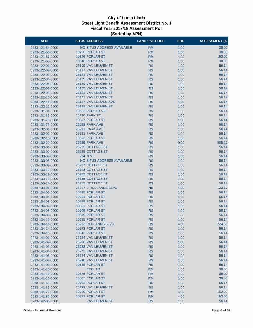
APN SITUS ADDRESS LAND USE CODE EBU ASSESSMENT ($)
City of Loma LindaStreet Light Benefit Assessment District No. 1
Fiscal Year 2017/18 Assessment Roll (Sorted by APN)
0283-121-64-0000 NO SITUS ADDRESS AVAILABLE RM 1.00 38.00
0283-121-66-0000 10756 POPLAR ST RM 1.00 38.00
0283-121-67-0000 10846 POPLAR ST RM 4.00 152.00
0283-121-68-0000 10848 POPLAR ST RM 1.00 38.00
0283-122-01-0000 25109 VAN LEUVEN ST RS 1.00 56.14
0283-122-02-0000 25117 VAN LEUVEN ST RS 1.00 56.14
0283-122-03-0000 25121 VAN LEUVEN ST RS 1.00 56.14
0283-122-04-0000 25129 VAN LEUVEN ST RS 1.00 56.14
0283-122-05-0000 25139 VAN LEUVEN ST RS 1.00 56.14
0283-122-07-0000 25173 VAN LEUVEN ST RS 1.00 56.14
0283-122-08-0000 25181 VAN LEUVEN ST RS 1.00 56.14
0283-122-10-0000 25171 VAN LEUVEN ST RS 1.00 56.14
0283-122-11-0000 25157 VAN LEUVEN AVE RS 1.00 56.14
0283-122-12-0000 25191 VAN LEUVEN ST RS 1.00 56.14
0283-131-34-0000 10653 POPLAR ST RS 1.00 56.14
0283-131-69-0000 25220 PARK ST RS 1.00 56.14
0283-131-70-0000 10637 POPLAR ST RS 1.00 56.14
0283-131-73-0000 25268 PARK AVE RS 1.00 56.14
0283-132-01-0000 25211 PARK AVE RS 1.00 56.14
0283-132-02-0000 25221 PARK AVE RS 1.00 56.14
0283-132-16-0000 10693 POPLAR ST RS 1.00 56.14
0283-132-20-0000 25269 PARK AVE RS 9.00 505.26
0283-133-01-0000 25225 COTTAGE ST RS 1.00 56.14
0283-133-02-0000 25235 COTTAGE ST RS 1.00 56.14
0283-133-07-0000 224 N ST RS 1.00 56.14
0283-133-08-0000 NO SITUS ADDRESS AVAILABLE RS 1.00 56.14
0283-133-09-0000 25287 COTTAGE ST RS 1.00 56.14
0283-133-10-0000 25293 COTTAGE ST RS 1.00 56.14
0283-133-12-0000 25239 COTTAGE ST RS 1.00 56.14
0283-133-13-0000 25255 COTTAGE ST RS 1.00 56.14
0283-133-14-0000 25259 COTTAGE ST RS 1.00 56.14
0283-134-01-0000 25227 E REDLANDS BLVD NR 1.00 123.17
0283-134-02-0000 10535 POPLAR ST RS 1.00 56.14
0283-134-04-0000 10561 POPLAR ST RS 1.00 56.14
0283-134-05-0000 10589 POPLAR ST RS 1.00 56.14
0283-134-07-0000 10601 POPLAR ST RS 1.00 56.14
0283-134-08-0000 10609 POPLAR ST RS 1.00 56.14
0283-134-09-0000 10619 POPLAR ST RS 1.00 56.14
0283-134-10-0000 10625 POPLAR ST RS 1.00 56.14
0283-134-11-0000 25293 REDLANDS BLVD RS 4.00 224.56
0283-134-14-0000 10573 POPLAR ST RS 1.00 56.14
0283-134-15-0000 10543 POPLAR ST RS 1.00 56.14
0283-141-01-0000 25294 VAN LEUVEN ST RS 1.00 56.14
0283-141-02-0000 25288 VAN LEUVEN ST RS 1.00 56.14
0283-141-03-0000 25282 VAN LEUVEN ST RS 1.00 56.14
0283-141-04-0000 25272 VAN LEUVEN ST RS 1.00 56.14
0283-141-05-0000 25264 VAN LEUVEN ST RS 1.00 56.14
0283-141-07-0000 25248 VAN LEUVEN ST RS 1.00 56.14
0283-141-09-0000 10885 POPLAR ST RS 1.00 56.14
0283-141-10-0000 POPLAR RM 1.00 38.00
0283-141-11-0000 10875 POPLAR ST RM 1.00 38.00
0283-141-13-0000 10867 POPLAR ST RM 1.00 38.00
0283-141-68-0000 10893 POPLAR ST RS 1.00 56.14
0283-141-69-0000 25232 VAN LEUVEN ST RS 1.00 56.14
0283-141-79-0000 10799 POPLAR ST RM 4.00 152.00
0283-141-80-0000 10777 POPLAR ST RM 4.00 152.00
0283-142-06-0000 VAN LEUVEN ST RS 1.00 56.14
Willdan Financial Services Page 6 of 98
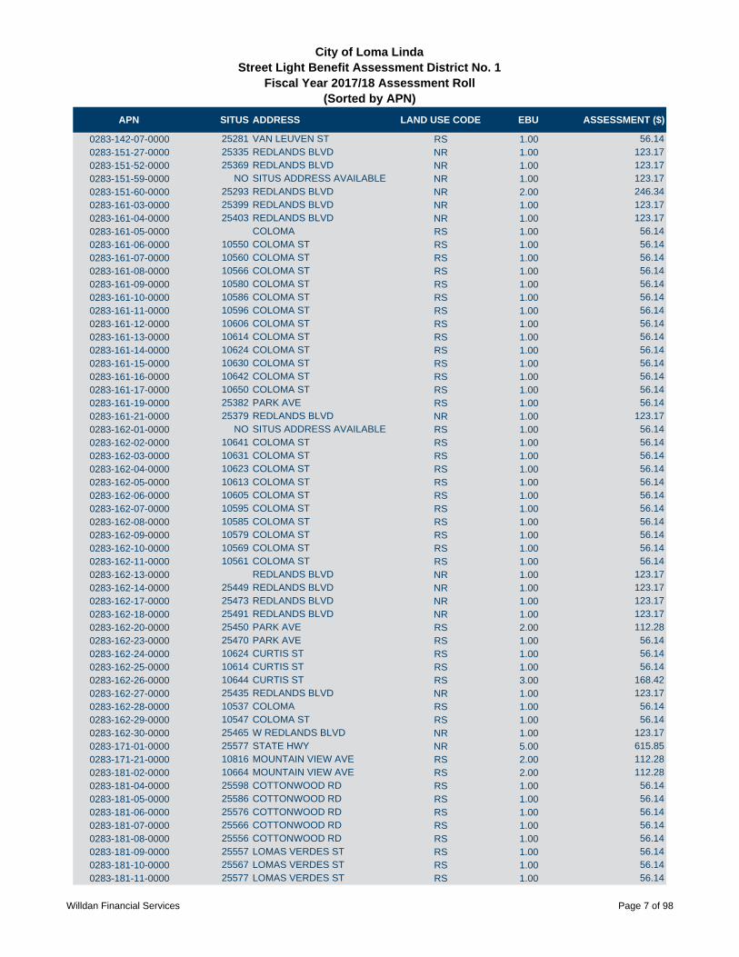
APN SITUS ADDRESS LAND USE CODE EBU ASSESSMENT ($)
City of Loma LindaStreet Light Benefit Assessment District No. 1
Fiscal Year 2017/18 Assessment Roll (Sorted by APN)
0283-142-07-0000 25281 VAN LEUVEN ST RS 1.00 56.14
0283-151-27-0000 25335 REDLANDS BLVD NR 1.00 123.17
0283-151-52-0000 25369 REDLANDS BLVD NR 1.00 123.17
0283-151-59-0000 NO SITUS ADDRESS AVAILABLE NR 1.00 123.17
0283-151-60-0000 25293 REDLANDS BLVD NR 2.00 246.34
0283-161-03-0000 25399 REDLANDS BLVD NR 1.00 123.17
0283-161-04-0000 25403 REDLANDS BLVD NR 1.00 123.17
0283-161-05-0000 COLOMA RS 1.00 56.14
0283-161-06-0000 10550 COLOMA ST RS 1.00 56.14
0283-161-07-0000 10560 COLOMA ST RS 1.00 56.14
0283-161-08-0000 10566 COLOMA ST RS 1.00 56.14
0283-161-09-0000 10580 COLOMA ST RS 1.00 56.14
0283-161-10-0000 10586 COLOMA ST RS 1.00 56.14
0283-161-11-0000 10596 COLOMA ST RS 1.00 56.14
0283-161-12-0000 10606 COLOMA ST RS 1.00 56.14
0283-161-13-0000 10614 COLOMA ST RS 1.00 56.14
0283-161-14-0000 10624 COLOMA ST RS 1.00 56.14
0283-161-15-0000 10630 COLOMA ST RS 1.00 56.14
0283-161-16-0000 10642 COLOMA ST RS 1.00 56.14
0283-161-17-0000 10650 COLOMA ST RS 1.00 56.14
0283-161-19-0000 25382 PARK AVE RS 1.00 56.14
0283-161-21-0000 25379 REDLANDS BLVD NR 1.00 123.17
0283-162-01-0000 NO SITUS ADDRESS AVAILABLE RS 1.00 56.14
0283-162-02-0000 10641 COLOMA ST RS 1.00 56.14
0283-162-03-0000 10631 COLOMA ST RS 1.00 56.14
0283-162-04-0000 10623 COLOMA ST RS 1.00 56.14
0283-162-05-0000 10613 COLOMA ST RS 1.00 56.14
0283-162-06-0000 10605 COLOMA ST RS 1.00 56.14
0283-162-07-0000 10595 COLOMA ST RS 1.00 56.14
0283-162-08-0000 10585 COLOMA ST RS 1.00 56.14
0283-162-09-0000 10579 COLOMA ST RS 1.00 56.14
0283-162-10-0000 10569 COLOMA ST RS 1.00 56.14
0283-162-11-0000 10561 COLOMA ST RS 1.00 56.14
0283-162-13-0000 REDLANDS BLVD NR 1.00 123.17
0283-162-14-0000 25449 REDLANDS BLVD NR 1.00 123.17
0283-162-17-0000 25473 REDLANDS BLVD NR 1.00 123.17
0283-162-18-0000 25491 REDLANDS BLVD NR 1.00 123.17
0283-162-20-0000 25450 PARK AVE RS 2.00 112.28
0283-162-23-0000 25470 PARK AVE RS 1.00 56.14
0283-162-24-0000 10624 CURTIS ST RS 1.00 56.14
0283-162-25-0000 10614 CURTIS ST RS 1.00 56.14
0283-162-26-0000 10644 CURTIS ST RS 3.00 168.42
0283-162-27-0000 25435 REDLANDS BLVD NR 1.00 123.17
0283-162-28-0000 10537 COLOMA RS 1.00 56.14
0283-162-29-0000 10547 COLOMA ST RS 1.00 56.14
0283-162-30-0000 25465 W REDLANDS BLVD NR 1.00 123.17
0283-171-01-0000 25577 STATE HWY NR 5.00 615.85
0283-171-21-0000 10816 MOUNTAIN VIEW AVE RS 2.00 112.28
0283-181-02-0000 10664 MOUNTAIN VIEW AVE RS 2.00 112.28
0283-181-04-0000 25598 COTTONWOOD RD RS 1.00 56.14
0283-181-05-0000 25586 COTTONWOOD RD RS 1.00 56.14
0283-181-06-0000 25576 COTTONWOOD RD RS 1.00 56.14
0283-181-07-0000 25566 COTTONWOOD RD RS 1.00 56.14
0283-181-08-0000 25556 COTTONWOOD RD RS 1.00 56.14
0283-181-09-0000 25557 LOMAS VERDES ST RS 1.00 56.14
0283-181-10-0000 25567 LOMAS VERDES ST RS 1.00 56.14
0283-181-11-0000 25577 LOMAS VERDES ST RS 1.00 56.14
Willdan Financial Services Page 7 of 98

APN SITUS ADDRESS LAND USE CODE EBU ASSESSMENT ($)
City of Loma LindaStreet Light Benefit Assessment District No. 1
Fiscal Year 2017/18 Assessment Roll (Sorted by APN)
0283-181-12-0000 22587 LOMAS VERDES ST RS 1.00 56.14
0283-181-13-0000 25597 LOMAS VERDES ST RS 1.00 56.14
0283-181-14-0000 25596 LOMAS VERDES ST RS 1.00 56.14
0283-181-15-0000 25586 LOMAS VERDES ST RS 1.00 56.14
0283-181-16-0000 25576 LOMAS VERDES ST RS 1.00 56.14
0283-181-17-0000 25566 LOMAS VERDES ST RS 1.00 56.14
0283-181-18-0000 25556 LOMAS VERDES ST RS 1.00 56.14
0283-181-19-0000 25546 LOMAS VERDES ST RS 1.00 56.14
0283-181-20-0000 25536 LOMAS VERDES ST RS 1.00 56.14
0283-181-21-0000 25526 LOMAS VERDES ST RS 1.00 56.14
0283-181-22-0000 25516 LOMAS VERDES ST RS 1.00 56.14
0283-181-23-0000 25506 LOMAS VERDES ST RS 1.00 56.14
0283-181-36-0000 COTTONWOOD RD RS 1.00 56.14
0283-181-37-0000 COTTONWOOD RD RS 1.00 56.14
0283-181-38-0000 COTTONWOOD RD RS 1.00 56.14
0283-182-12-0000 25557 COTTONWOOD RD RS 1.00 56.14
0283-182-13-0000 25567 COTTONWOOD RD RS 1.00 56.14
0283-182-14-0000 25577 COTTONWOOD RD RS 1.00 56.14
0283-182-15-0000 25581 COTTONWOOD RD RS 1.00 56.14
0283-182-16-0000 25591 COTTONWOOD RD RS 1.00 56.14
0283-182-18-0000 25637 COTTONWOOD RD RS 1.00 56.14
0283-182-20-0000 25625 COTTONWOOD RD RS 1.00 56.14
0283-182-23-0000 25619 COTTONWOOD RD RS 1.00 56.14
0283-182-26-0000 25597 COTTONWOOD RD RS 1.00 56.14
0283-182-28-0000 25647 COTTONWOOD RD RS 1.00 56.14
0283-182-30-0000 25667 COTTONWOOD RD RS 1.00 56.14
0283-182-31-0000 10714 MOUNTAIN VIEW AVE RS 1.00 56.14
0283-182-32-0000 25657 COTTONWOOD RD RS 1.00 56.14
0283-183-01-0000 10685 CURTIS ST RS 1.00 56.14
0283-183-02-0000 10675 CURTIS ST RS 1.00 56.14
0283-183-03-0000 10665 CURTIS ST RS 1.00 56.14
0283-183-04-0000 10655 CURTIS ST RS 1.00 56.14
0283-183-05-0000 10645 CURTIS ST RS 1.00 56.14
0283-183-06-0000 10644 ELM AVE RS 1.00 56.14
0283-183-07-0000 10654 ELM AVE RS 1.00 56.14
0283-183-08-0000 10664 ELM AVE RS 1.00 56.14
0283-183-09-0000 10674 ELM AVE RS 1.00 56.14
0283-183-10-0000 10684 ELM AVE RS 1.00 56.14
0283-191-01-0000 10836 MOUNTAIN VIEW AVE RS 1.00 56.14
0283-191-02-0000 25688 LANE ST RS 1.00 56.14
0283-191-03-0000 25670 LANE ST RS 1.00 56.14
0283-191-04-0000 25662 LANE ST RS 1.00 56.14
0283-191-05-0000 25654 LANE ST RS 1.00 56.14
0283-191-06-0000 25644 LANE ST RS 1.00 56.14
0283-191-07-0000 25638 LANE ST RS 1.00 56.14
0283-191-08-0000 25630 LANE ST RS 1.00 56.14
0283-191-09-0000 25620 LANE ST RS 1.00 56.14
0283-191-10-0000 25612 LANE ST RS 1.00 56.14
0283-191-11-0000 25604 LANE ST RS 1.00 56.14
0283-191-12-0000 25598 LANE ST RS 1.00 56.14
0283-191-13-0000 25588 LANE ST RS 1.00 56.14
0283-191-14-0000 25580 LANE ST RS 1.00 56.14
0283-191-18-0000 25542 LANE ST RS 1.00 56.14
0283-191-19-0000 25528 LANE ST RS 1.00 56.14
0283-191-20-0000 25522 LANE ST RS 1.00 56.14
0283-191-21-0000 25512 LANE ST RS 1.00 56.14
0283-191-22-0000 25560 LANE ST RS 1.00 56.14
Willdan Financial Services Page 8 of 98

APN SITUS ADDRESS LAND USE CODE EBU ASSESSMENT ($)
City of Loma LindaStreet Light Benefit Assessment District No. 1
Fiscal Year 2017/18 Assessment Roll (Sorted by APN)
0283-192-01-0000 25513 LANE ST RS 1.00 56.14
0283-192-02-0000 25521 LANE ST RS 1.00 56.14
0283-192-03-0000 25531 LANE ST RS 1.00 56.14
0283-192-04-0000 25539 LANE ST RS 1.00 56.14
0283-192-05-0000 25547 LANE ST RS 1.00 56.14
0283-192-06-0000 25555 LANE ST RS 1.00 56.14
0283-192-07-0000 25563 LANE ST RS 1.00 56.14
0283-192-10-0000 25587 LANE ST RS 1.00 56.14
0283-192-11-0000 25597 LANE ST RS 1.00 56.14
0283-192-12-0000 25605 LANE ST RS 1.00 56.14
0283-192-13-0000 25611 LANE ST RS 1.00 56.14
0283-192-14-0000 25619 LANE ST RS 1.00 56.14
0283-192-15-0000 25629 LANE ST RS 1.00 56.14
0283-192-16-0000 25637 LANE ST RS 1.00 56.14
0283-192-17-0000 25645 LANE ST RS 1.00 56.14
0283-192-18-0000 25655 LANE ST RS 1.00 56.14
0283-192-19-0000 25663 LANE ST RS 1.00 56.14
0283-192-20-0000 25671 LANE ST RS 1.00 56.14
0283-192-21-0000 25681 LANE ST RS 1.00 56.14
0283-192-22-0000 NO SITUS ADDRESS AVAILABLE RS 1.00 56.14
0283-192-25-0000 25684 VAN LEUVEN ST RS 1.00 56.14
0283-192-26-0000 25672 VAN LEUVEN ST RS 1.00 56.14
0283-192-27-0000 25664 VAN LEUVEN ST RS 1.00 56.14
0283-192-28-0000 25654 VAN LEUVEN ST RS 1.00 56.14
0283-192-29-0000 25648 VAN LEUVEN ST RS 1.00 56.14
0283-192-30-0000 25636 VAN LEUVEN ST RS 1.00 56.14
0283-192-33-0000 25616 VAN LEUVEN ST RS 1.00 56.14
0283-192-34-0000 25606 VAN LEUVEN ST RS 1.00 56.14
0283-192-35-0000 25598 VAN LEUVEN ST RS 1.00 56.14
0283-192-36-0000 25590 VAN LEUVEN ST RS 1.00 56.14
0283-192-37-0000 25582 VAN LEUVEN ST RS 1.00 56.14
0283-192-38-0000 25574 VAN LEUVEN ST RS 1.00 56.14
0283-192-39-0000 25564 VAN LEUVEN ST RS 1.00 56.14
0283-192-40-0000 25556 VAN LEUVEN ST RS 1.00 56.14
0283-192-41-0000 25548 VAN LEUVEN ST RS 1.00 56.14
0283-192-47-0000 10875 CURTIS ST RS 1.00 56.14
0283-192-49-0000 25512 VAN LEUVEN ST RS 1.00 56.14
0283-192-50-0000 25571 LANE ST RS 1.00 56.14
0283-192-51-0000 10878 MOUNTAIN VIEW AVE RS 1.00 56.14
0283-192-52-0000 10886 MOUNTAIN VIEW AVE RS 1.00 56.14
0283-192-54-0000 25526 VAN LEUVEN ST RS 1.00 56.14
0283-192-55-0000 25626 VAN LEUVEN ST RS 1.00 56.14
0283-192-57-0000 25540 VAN LEUVAN ST RS 1.00 56.14
0283-192-58-0000 25534 VAN LEUVEN ST RS 1.00 56.14
0283-201-12-0000 25427 VAN LEUVEN ST RM 1.00 38.00
0283-201-16-0000 25473 VAN LEUVEN ST RM 1.00 38.00
0283-201-21-0000 25445 VAN LEUVEN ST RM 1.00 38.00
0283-201-22-0000 25467 VAN LEUVEN ST RM 1.00 38.00
0283-201-23-0000 25479 VAN LEUVEN ST RM 1.00 38.00
0283-201-30-0000 25517 VAN LEUVEN ST RM 1.00 38.00
0283-201-31-0000 25505 VAN LEUVEN ST RM 1.00 38.00
0283-201-32-0000 25531 VAN LEUVEN ST RM 1.00 38.00
0283-201-33-0000 25543 VAN LEUVEN ST RM 1.00 38.00
0283-201-37-0000 25455 VAN LEUVEN ST RM 1.00 38.00
0283-201-39-0000 25437 VAN LEUVEN ST RM 1.00 38.00
0283-201-42-0000 25493 VAN LEUVEN ST RM 1.00 38.00
0283-201-43-0000 25303 VAN LEUVEN ST RS 1.00 56.14
Willdan Financial Services Page 9 of 98
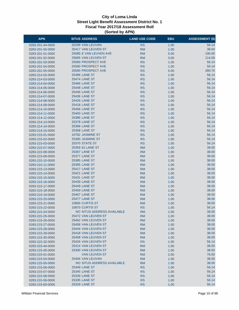
APN SITUS ADDRESS LAND USE CODE EBU ASSESSMENT ($)
City of Loma LindaStreet Light Benefit Assessment District No. 1
Fiscal Year 2017/18 Assessment Roll (Sorted by APN)
0283-201-44-0000 25299 VAN LEUVAN RS 1.00 56.14
0283-201-50-0000 25417 VAN LEUVEN ST RM 1.00 38.00
0283-201-51-0000 25585 E VAN LEUVEN AVE RM 5.00 190.00
0283-201-52-0000 25665 VAN LEUVEN ST RM 3.00 114.00
0283-201-53-0000 25590 PROSPECT AVE RS 1.00 56.14
0283-201-54-0000 25590 PROSPECT AVE RS 1.00 56.14
0283-201-55-0000 25590 PROSPECT AVE RS 5.00 280.70
0283-214-02-0000 25486 LANE ST RS 1.00 56.14
0283-214-03-0000 25474 LANE ST RS 1.00 56.14
0283-214-04-0000 25466 LANE ST RS 1.00 56.14
0283-214-05-0000 25448 LANE ST RS 1.00 56.14
0283-214-06-0000 25446 LANE ST RS 1.00 56.14
0283-214-07-0000 25436 LANE ST RS 1.00 56.14
0283-214-08-0000 25426 LANE ST RS 1.00 56.14
0283-214-09-0000 25418 LANE ST RS 1.00 56.14
0283-214-10-0000 25406 LANE ST RS 1.00 56.14
0283-214-11-0000 25400 LANE ST RS 1.00 56.14
0283-214-12-0000 25386 LANE ST RS 1.00 56.14
0283-214-13-0000 25378 LANE ST RS 1.00 56.14
0283-214-14-0000 25368 LANE ST RS 1.00 56.14
0283-214-15-0000 25358 LANE ST RS 1.00 56.14
0283-215-01-0000 10782 JASMINE ST RS 1.00 56.14
0283-215-02-0000 25380 JASMINE ST RS 1.00 56.14
0283-215-03-0000 25370 STATE ST RS 1.00 56.14
0283-215-07-0000 25359 61 LANE ST RM 1.00 38.00
0283-215-08-0000 25367 LANE ST RM 1.00 38.00
0283-215-09-0000 25377 LANE ST RM 1.00 38.00
0283-215-10-0000 25385 LANE ST RM 1.00 38.00
0283-215-11-0000 25395 LANE ST RM 1.00 38.00
0283-215-13-0000 25417 LANE ST RM 1.00 38.00
0283-215-14-0000 25421 LANE ST RM 1.00 38.00
0283-215-15-0000 25431 LANE ST RM 1.00 38.00
0283-215-16-0000 25439 LANE ST RM 1.00 38.00
0283-215-17-0000 25449 LANE ST RM 1.00 38.00
0283-215-18-0000 25459 LANE ST RM 1.00 38.00
0283-215-19-0000 25467 LANE ST RM 1.00 38.00
0283-215-20-0000 25477 LANE ST RM 1.00 38.00
0283-215-21-0000 10856 CURTIS ST RM 1.00 38.00
0283-215-22-0000 10870 CURTIS ST RS 1.00 56.14
0283-215-24-0000 NO SITUS ADDRESS AVAILABLE RM 1.00 38.00
0283-215-25-0000 25472 VAN LEUVEN ST RM 1.00 38.00
0283-215-26-0000 25462 VAN LEUVEN ST RM 1.00 38.00
0283-215-27-0000 25458 VAN LEUVEN ST RM 1.00 38.00
0283-215-28-0000 25444 VAN LEUVEN ST RM 1.00 38.00
0283-215-29-0000 25418 VAN LEUVEN ST RM 1.00 38.00
0283-215-30-0000 25408 VAN LEUVEN ST RM 1.00 38.00
0283-215-32-0000 25426 VAN LEUVEN ST RS 1.00 56.14
0283-215-44-0000 25314 VAN LEUVEN ST RM 1.00 38.00
0283-215-45-0000 25300 VAN LEUVEN ST RM 1.00 38.00
0283-215-51-0000 VAN LEUVEN ST RM 2.00 76.00
0283-215-54-0000 25494 VAN LEUVAN RM 1.00 38.00
0283-215-55-0000 NO SITUS ADDRESS AVAILABLE RM 1.00 38.00
0283-215-56-0000 25349 LANE ST RS 1.00 56.14
0283-215-57-0000 25345 LANE ST RS 1.00 56.14
0283-215-58-0000 25339 LANE ST RS 1.00 56.14
0283-215-59-0000 25335 LANE ST RS 1.00 56.14
0283-215-60-0000 25329 LANE ST RS 1.00 56.14
Willdan Financial Services Page 10 of 98

APN SITUS ADDRESS LAND USE CODE EBU ASSESSMENT ($)
City of Loma LindaStreet Light Benefit Assessment District No. 1
Fiscal Year 2017/18 Assessment Roll (Sorted by APN)
0283-215-61-0000 25325 LANE ST RS 1.00 56.14
0283-215-62-0000 10806 LILAC ST RS 1.00 56.14
0283-215-63-0000 10800 LILAC ST RS 1.00 56.14
0283-215-64-0000 10792 LILAC ST RS 1.00 56.14
0283-215-65-0000 10784 LILAC ST RS 1.00 56.14
0283-215-66-0000 10778 LILAC ST RS 1.00 56.14
0283-215-67-0000 10770 LILAC ST RS 1.00 56.14
0283-215-68-0000 10771 LILAC ST RS 1.00 56.14
0283-215-69-0000 10779 LILAC ST RS 1.00 56.14
0283-215-70-0000 10787 LILAC ST RS 1.00 56.14
0283-215-71-0000 10795 LILAC ST RS 1.00 56.14
0283-221-02-0000 25688 MEAD ST RS 1.00 56.14
0283-221-03-0000 25672 MEAD ST RS 1.00 56.14
0283-221-04-0000 25664 MEAD ST RS 1.00 56.14
0283-221-05-0000 25652 MEAD ST RS 1.00 56.14
0283-221-06-0000 25644 MEAD ST RS 1.00 56.14
0283-221-07-0000 25632 MEAD ST RS 1.00 56.14
0283-221-08-0000 25622 MEAD ST RS 1.00 56.14
0283-221-09-0000 25612 MEAD ST RS 1.00 56.14
0283-221-10-0000 25600 MEAD ST RS 1.00 56.14
0283-221-11-0000 25586 MEAD ST RS 1.00 56.14
0283-221-12-0000 25578 MEAD ST RS 1.00 56.14
0283-221-13-0000 25564 MEAD ST RS 1.00 56.14
0283-221-14-0000 10659 ELM AVE RS 1.00 56.14
0283-221-16-0000 10690 ELM AVE RS 1.00 56.14
0283-221-19-0000 25518 MEAD ST RS 1.00 56.14
0283-221-20-0000 10713 CURTIS ST RS 1.00 56.14
0283-221-21-0000 10703 CURTIS ST RS 1.00 56.14
0283-221-24-0000 10696 ELM AVE RS 1.00 56.14
0283-221-27-0000 25530 MEAD ST RS 1.00 56.14
0283-222-01-0000 10753 CURTIS ST RS 1.00 56.14
0283-222-02-0000 25515 MEAD ST RS 1.00 56.14
0283-222-03-0000 25527 MEAD ST RS 1.00 56.14
0283-222-04-0000 25535 MEAD ST RS 1.00 56.14
0283-222-05-0000 25547 MEAD ST RS 1.00 56.14
0283-222-06-0000 10712 MEAD CT RS 1.00 56.14
0283-222-07-0000 10722 MEAD CT RS 1.00 56.14
0283-222-08-0000 10734 MEAD CT RS 1.00 56.14
0283-222-09-0000 10733 MEAD CT RS 1.00 56.14
0283-222-10-0000 10721 MEAD CT RS 1.00 56.14
0283-222-11-0000 25587 MEAD ST RS 1.00 56.14
0283-222-12-0000 25603 MEAD ST RS 1.00 56.14
0283-222-13-0000 10712 MEAD LN RS 1.00 56.14
0283-222-14-0000 10722 MEAD LN RS 1.00 56.14
0283-222-15-0000 10734 MEAD LN RS 1.00 56.14
0283-222-16-0000 10733 MEAD LN RS 1.00 56.14
0283-222-17-0000 10721 MEAD LN RS 1.00 56.14
0283-222-18-0000 25631 MEAD ST RS 1.00 56.14
0283-222-19-0000 25645 MEAD ST RS 1.00 56.14
0283-222-20-0000 10710 MEAD WY RS 1.00 56.14
0283-222-21-0000 10722 MEAD WY RS 1.00 56.14
0283-222-22-0000 10734 MEAD WY RS 1.00 56.14
0283-222-23-0000 10733 MEAD WY RS 1.00 56.14
0283-222-24-0000 10721 MEAD WY RS 1.00 56.14
0283-222-25-0000 10711 MEAD WY RS 1.00 56.14
0283-222-26-0000 25685 MEAD ST RS 1.00 56.14
0283-222-27-0000 10722 MOUNTAIN VIEW AVE RS 1.00 56.14
Willdan Financial Services Page 11 of 98
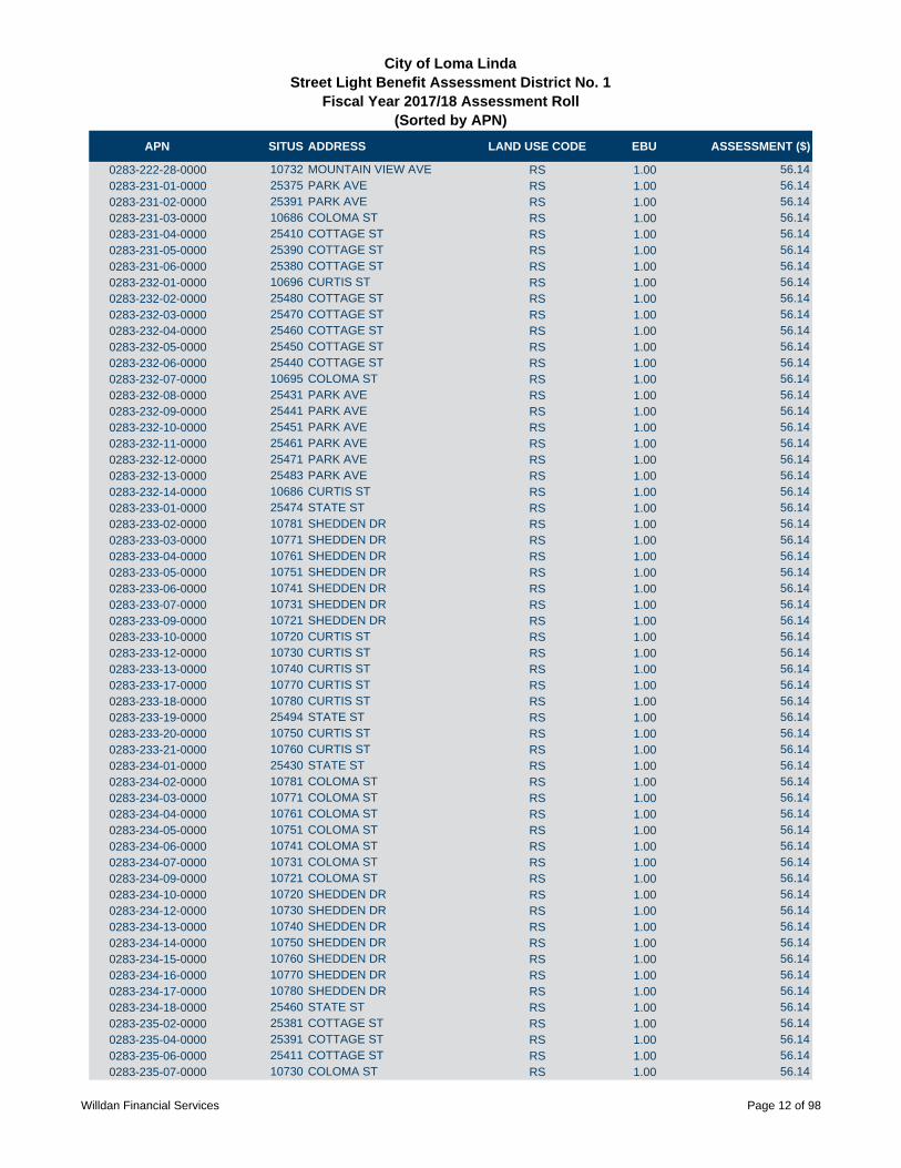
APN SITUS ADDRESS LAND USE CODE EBU ASSESSMENT ($)
City of Loma LindaStreet Light Benefit Assessment District No. 1
Fiscal Year 2017/18 Assessment Roll (Sorted by APN)
0283-222-28-0000 10732 MOUNTAIN VIEW AVE RS 1.00 56.14
0283-231-01-0000 25375 PARK AVE RS 1.00 56.14
0283-231-02-0000 25391 PARK AVE RS 1.00 56.14
0283-231-03-0000 10686 COLOMA ST RS 1.00 56.14
0283-231-04-0000 25410 COTTAGE ST RS 1.00 56.14
0283-231-05-0000 25390 COTTAGE ST RS 1.00 56.14
0283-231-06-0000 25380 COTTAGE ST RS 1.00 56.14
0283-232-01-0000 10696 CURTIS ST RS 1.00 56.14
0283-232-02-0000 25480 COTTAGE ST RS 1.00 56.14
0283-232-03-0000 25470 COTTAGE ST RS 1.00 56.14
0283-232-04-0000 25460 COTTAGE ST RS 1.00 56.14
0283-232-05-0000 25450 COTTAGE ST RS 1.00 56.14
0283-232-06-0000 25440 COTTAGE ST RS 1.00 56.14
0283-232-07-0000 10695 COLOMA ST RS 1.00 56.14
0283-232-08-0000 25431 PARK AVE RS 1.00 56.14
0283-232-09-0000 25441 PARK AVE RS 1.00 56.14
0283-232-10-0000 25451 PARK AVE RS 1.00 56.14
0283-232-11-0000 25461 PARK AVE RS 1.00 56.14
0283-232-12-0000 25471 PARK AVE RS 1.00 56.14
0283-232-13-0000 25483 PARK AVE RS 1.00 56.14
0283-232-14-0000 10686 CURTIS ST RS 1.00 56.14
0283-233-01-0000 25474 STATE ST RS 1.00 56.14
0283-233-02-0000 10781 SHEDDEN DR RS 1.00 56.14
0283-233-03-0000 10771 SHEDDEN DR RS 1.00 56.14
0283-233-04-0000 10761 SHEDDEN DR RS 1.00 56.14
0283-233-05-0000 10751 SHEDDEN DR RS 1.00 56.14
0283-233-06-0000 10741 SHEDDEN DR RS 1.00 56.14
0283-233-07-0000 10731 SHEDDEN DR RS 1.00 56.14
0283-233-09-0000 10721 SHEDDEN DR RS 1.00 56.14
0283-233-10-0000 10720 CURTIS ST RS 1.00 56.14
0283-233-12-0000 10730 CURTIS ST RS 1.00 56.14
0283-233-13-0000 10740 CURTIS ST RS 1.00 56.14
0283-233-17-0000 10770 CURTIS ST RS 1.00 56.14
0283-233-18-0000 10780 CURTIS ST RS 1.00 56.14
0283-233-19-0000 25494 STATE ST RS 1.00 56.14
0283-233-20-0000 10750 CURTIS ST RS 1.00 56.14
0283-233-21-0000 10760 CURTIS ST RS 1.00 56.14
0283-234-01-0000 25430 STATE ST RS 1.00 56.14
0283-234-02-0000 10781 COLOMA ST RS 1.00 56.14
0283-234-03-0000 10771 COLOMA ST RS 1.00 56.14
0283-234-04-0000 10761 COLOMA ST RS 1.00 56.14
0283-234-05-0000 10751 COLOMA ST RS 1.00 56.14
0283-234-06-0000 10741 COLOMA ST RS 1.00 56.14
0283-234-07-0000 10731 COLOMA ST RS 1.00 56.14
0283-234-09-0000 10721 COLOMA ST RS 1.00 56.14
0283-234-10-0000 10720 SHEDDEN DR RS 1.00 56.14
0283-234-12-0000 10730 SHEDDEN DR RS 1.00 56.14
0283-234-13-0000 10740 SHEDDEN DR RS 1.00 56.14
0283-234-14-0000 10750 SHEDDEN DR RS 1.00 56.14
0283-234-15-0000 10760 SHEDDEN DR RS 1.00 56.14
0283-234-16-0000 10770 SHEDDEN DR RS 1.00 56.14
0283-234-17-0000 10780 SHEDDEN DR RS 1.00 56.14
0283-234-18-0000 25460 STATE ST RS 1.00 56.14
0283-235-02-0000 25381 COTTAGE ST RS 1.00 56.14
0283-235-04-0000 25391 COTTAGE ST RS 1.00 56.14
0283-235-06-0000 25411 COTTAGE ST RS 1.00 56.14
0283-235-07-0000 10730 COLOMA ST RS 1.00 56.14
Willdan Financial Services Page 12 of 98

APN SITUS ADDRESS LAND USE CODE EBU ASSESSMENT ($)
City of Loma LindaStreet Light Benefit Assessment District No. 1
Fiscal Year 2017/18 Assessment Roll (Sorted by APN)
0283-235-08-0000 10740 COLOMA ST RS 1.00 56.14
0283-235-09-0000 10750 COLOMA ST RS 1.00 56.14
0283-235-10-0000 10760 COLOMA ST RS 1.00 56.14
0283-235-11-0000 10770 COLOMA ST RS 1.00 56.14
0283-235-12-0000 10780 COLOMA ST RS 1.00 56.14
0283-235-13-0000 25400 STATE ST RS 1.00 56.14
0283-235-14-0000 25390 STATE ST RS 1.00 56.14
0283-235-15-0000 10781 JASMINE ST RS 1.00 56.14
0283-235-16-0000 10771 JASMINE ST RS 1.00 56.14
0283-235-17-0000 10761 JASMINE ST RS 1.00 56.14
0283-235-18-0000 10751 JASMINE ST RS 1.00 56.14
0283-235-19-0000 10741 JASMINE ST RS 1.00 56.14
0283-236-01-0000 25379 STATE ST RS 1.00 56.14
0283-236-02-0000 25387 STATE ST RS 1.00 56.14
0283-236-03-0000 25399 STATE ST RS 1.00 56.14
0283-236-04-0000 25411 STATE ST RS 1.00 56.14
0283-236-05-0000 25423 STATE ST RS 1.00 56.14
0283-236-06-0000 25435 STATE ST RS 1.00 56.14
0283-236-07-0000 25447 STATE ST RS 1.00 56.14
0283-236-08-0000 25459 STATE ST RS 1.00 56.14
0283-236-09-0000 25471 STATE ST RS 1.00 56.14
0283-236-10-0000 25483 STATE ST RS 1.00 56.14
0283-236-11-0000 25495 STATE ST RS 1.00 56.14
0283-241-01-0000 25370 PARK AVE RS 1.00 56.14
0283-241-02-0000 25360 PARK AVE RS 1.00 56.14
0283-241-03-0000 25350 PARK AVE RS 1.00 56.14
0283-241-04-0000 25340 PARK AVE RS 1.00 56.14
0283-241-05-0000 25330 PARK AVE RS 1.00 56.14
0283-241-06-0000 25300 PARK AVE RS 1.00 56.14
0283-241-07-0000 25310 PARK AVE RS 1.00 56.14
0283-242-01-0000 25303 PARK AVE RS 1.00 56.14
0283-242-02-0000 10686 LILAC ST RS 1.00 56.14
0283-242-03-0000 10696 LILAC ST RS 1.00 56.14
0283-243-01-0000 25311 COTTAGE ST RS 1.00 56.14
0283-243-03-0000 10730 LILAC ST RS 1.00 56.14
0283-243-04-0000 10740 LILAC ST RS 1.00 56.14
0283-243-05-0000 10750 LILAC ST RS 1.00 56.14
0283-243-07-0000 10760 LILAC ST RS 1.00 56.14
0283-244-01-0000 25331 MEAD ST RS 1.00 56.14
0283-244-02-0000 25341 MEAD ST RS 1.00 56.14
0283-244-03-0000 25351 MEAD ST RS 1.00 56.14
0283-244-04-0000 25361 MEAD ST RS 1.00 56.14
0283-245-02-0000 25360 MEAD ST RS 1.00 56.14
0283-245-03-0000 25350 MEAD ST RS 1.00 56.14
0283-245-04-0000 25340 MEAD ST RS 1.00 56.14
0283-245-05-0000 10731 LILAC ST RS 1.00 56.14
0283-245-06-0000 10711 LILAC ST RS 1.00 56.14
0283-245-07-0000 25341 COTTAGE ST RS 1.00 56.14
0283-245-08-0000 25351 COTTAGE ST RS 1.00 56.14
0283-245-09-0000 25361 COTTAGE ST RS 1.00 56.14
0283-245-10-0000 25371 COTTAGE ST RS 1.00 56.14
0283-245-11-0000 25370 MEAD ST RS 1.00 56.14
0283-245-12-0000 NO SITUS ADDRESS AVAILABLE RS 1.00 56.14
0283-246-01-0000 25370 COTTAGE ST RS 1.00 56.14
0283-246-02-0000 25360 COTTAGE ST RS 1.00 56.14
0283-246-03-0000 25350 COTTAGE ST RS 1.00 56.14
0283-246-04-0000 25340 COTTAGE ST RS 1.00 56.14
Willdan Financial Services Page 13 of 98

APN SITUS ADDRESS LAND USE CODE EBU ASSESSMENT ($)
City of Loma LindaStreet Light Benefit Assessment District No. 1
Fiscal Year 2017/18 Assessment Roll (Sorted by APN)
0283-246-05-0000 10695 LILAC ST RS 1.00 56.14
0283-246-06-0000 25341 PARK AVE RS 1.00 56.14
0283-246-07-0000 25351 PARK AVE RS 1.00 56.14
0283-246-08-0000 25361 PARK AVE RS 1.00 56.14
0283-251-01-0000 25511 STATE ST RS 1.00 56.14
0283-251-02-0000 25523 STATE ST RS 1.00 56.14
0283-251-03-0000 25529 STATE ST RS 1.00 56.14
0283-251-04-0000 25539 STATE ST RS 1.00 56.14
0283-251-05-0000 25545 STATE ST RS 1.00 56.14
0283-251-06-0000 25557 STATE ST RS 1.00 56.14
0283-251-07-0000 25563 STATE ST RS 1.00 56.14
0283-251-08-0000 25573 STATE ST RS 1.00 56.14
0283-251-09-0000 25579 STATE ST RS 1.00 56.14
0283-251-10-0000 25589 STATE ST RS 1.00 56.14
0283-251-11-0000 25597 STATE ST RS 1.00 56.14
0283-251-12-0000 25609 STATE ST RS 1.00 56.14
0283-251-13-0000 25615 STATE ST RS 1.00 56.14
0283-251-14-0000 25623 STATE ST RS 1.00 56.14
0283-251-15-0000 25624 STATE ST RS 1.00 56.14
0283-251-16-0000 25614 STATE ST RS 1.00 56.14
0283-251-17-0000 25606 STATE ST RS 1.00 56.14
0283-251-18-0000 25594 STATE ST RS 1.00 56.14
0283-251-19-0000 25586 STATE ST RS 1.00 56.14
0283-251-20-0000 25576 STATE ST RS 1.00 56.14
0283-251-21-0000 25570 STATE ST RS 1.00 56.14
0283-251-22-0000 25560 STATE ST RS 1.00 56.14
0283-251-23-0000 25554 STATE ST RS 1.00 56.14
0283-251-24-0000 25542 STATE ST RS 1.00 56.14
0283-251-25-0000 25536 STATE ST RS 1.00 56.14
0283-251-26-0000 25526 STATE ST RS 1.00 56.14
0283-251-27-0000 25520 STATE ST RS 1.00 56.14
0283-251-28-0000 25508 STATE ST RS 1.00 56.14
0283-261-19-0000 25609 REDLANDS BLVD NR 2.00 246.34
0283-261-20-0000 25655 REDLANDS BLVD NR 3.00 369.51
0283-261-21-0000 25686 REDLANDS BLVD NR 3.00 369.51
0283-261-22-0000 NO SITUS ADDRESS AVAILABLE NR 2.00 246.34
0283-261-23-0000 10558 MOUNTAIN VIEW AVE RS 4.00 224.56
0283-271-01-0000 25430 SONORA LOOP RS 1.00 56.14
0283-271-02-0000 25434 SONORA LOOP RS 1.00 56.14
0283-271-03-0000 25438 SONORA LOOP RS 1.00 56.14
0283-271-04-0000 25442 SONORA LOOP RS 1.00 56.14
0283-271-05-0000 25446 SONORA LOOP RS 1.00 56.14
0283-271-06-0000 25450 SONORA LOOP RS 1.00 56.14
0283-271-07-0000 25454 SONORA LOOP RS 1.00 56.14
0283-271-08-0000 25458 SONORA LOOP RS 1.00 56.14
0283-271-09-0000 25462 SONORA LOOP RS 1.00 56.14
0283-271-10-0000 25466 SONORA LOOP RS 1.00 56.14
0283-271-11-0000 25470 SONORA LOOP RS 1.00 56.14
0283-271-12-0000 25474 SONORA LOOP RS 1.00 56.14
0283-271-13-0000 25478 SONORA LOOP RS 1.00 56.14
0283-271-14-0000 25500 PORTOLA LOOP RS 1.00 56.14
0283-271-15-0000 25502 PORTOLA LOOP RS 1.00 56.14
0283-271-16-0000 25504 PORTOLA LOOP RS 1.00 56.14
0283-271-17-0000 25506 PORTOLA LOOP RS 1.00 56.14
0283-271-18-0000 25510 PORTOLA LOOP RS 1.00 56.14
0283-271-19-0000 25514 PORTOLA LOOP RS 1.00 56.14
0283-271-20-0000 25518 PORTOLA LOOP RS 1.00 56.14
Willdan Financial Services Page 14 of 98

APN SITUS ADDRESS LAND USE CODE EBU ASSESSMENT ($)
City of Loma LindaStreet Light Benefit Assessment District No. 1
Fiscal Year 2017/18 Assessment Roll (Sorted by APN)
0283-271-21-0000 25522 PORTOLA LOOP RS 1.00 56.14
0283-271-22-0000 25526 PORTOLA LOOP RS 1.00 56.14
0283-271-23-0000 25530 PORTOLA LOOP RS 1.00 56.14
0283-271-24-0000 25534 PORTOLA LOOP RS 1.00 56.14
0283-271-25-0000 25538 PORTOLA LOOP RS 1.00 56.14
0283-271-26-0000 25542 PORTOLA LOOP RS 1.00 56.14
0283-271-27-0000 25544 PORTOLA LOOP RS 1.00 56.14
0283-271-28-0000 25546 PORTOLA LOOP RS 1.00 56.14
0283-271-29-0000 25548 PORTOLA LOOP RS 1.00 56.14
0283-281-01-0000 10914 CABRILLO LOOP RS 1.00 56.14
0283-281-02-0000 10916 CABRILLO LP RS 1.00 56.14
0283-281-03-0000 10918 CABRILLO LOOP RS 1.00 56.14
0283-281-04-0000 10922 CABRILLO LOOP RS 1.00 56.14
0283-281-05-0000 10926 CABRILLO LOOP RS 1.00 56.14
0283-281-06-0000 10930 CABRILLO LOOP RS 1.00 56.14
0283-281-07-0000 10934 CABRILLO LOOP RS 1.00 56.14
0283-281-08-0000 10938 CABRILLO LOOP RS 1.00 56.14
0283-281-09-0000 10942 CABRILLO LOOP RS 1.00 56.14
0283-281-10-0000 10946 CABRILLO LOOP RS 1.00 56.14
0283-281-11-0000 10950 CABRILLO LOOP RS 1.00 56.14
0283-281-12-0000 10954 CABRILLO LOOP RS 1.00 56.14
0283-281-13-0000 10956 CABRILLO LOOP RS 1.00 56.14
0283-281-14-0000 10958 CABRILLO LOOP RS 1.00 56.14
0283-281-15-0000 25368 DURANGO LOOP RS 1.00 56.14
0283-281-16-0000 25370 DURANGO LOOP RS 1.00 56.14
0283-281-17-0000 25372 DURANGO LOOP RS 1.00 56.14
0283-281-18-0000 25376 DURANGO LOOP RS 1.00 56.14
0283-281-19-0000 25380 DURANGO LOOP RS 1.00 56.14
0283-281-20-0000 25384 DURANGO LOOP RS 1.00 56.14
0283-281-21-0000 25388 DURANGO LOOP RS 1.00 56.14
0283-281-22-0000 25392 DURANGO LOOP RS 1.00 56.14
0283-281-23-0000 25396 DURANGO LOOP RS 1.00 56.14
0283-281-24-0000 25400 DURANGO LOOP RS 1.00 56.14
0283-281-25-0000 25404 DURANGO LOOP RS 1.00 56.14
0283-281-26-0000 25408 DURANGO LOOP RS 1.00 56.14
0283-281-27-0000 25412 DURANGO LOOP RS 1.00 56.14
0283-281-28-0000 25414 DURANGO LOOP RS 1.00 56.14
0283-281-29-0000 25416 DURANGO LOOP RS 1.00 56.14
0284-011-23-0000 24200 BARTON RD RM 1.00 38.00
0284-011-31-0000 24182 BARTON RD RM 1.00 38.00
0284-011-36-0000 24200 BARTON RD RM 1.00 38.00
0284-011-38-0000 NO SITUS ADDRESS AVAILABLE RM 1.00 38.00
0284-011-44-0000 24230 BARTON RD RM 1.00 38.00
0284-011-46-0000 24254 BARTON RD RM 1.00 38.00
0284-011-48-0000 24280 BARTON RD RM 1.00 38.00
0284-011-50-0000 NO SITUS ADDRESS AVAILABLE RM 1.00 38.00
0284-011-59-0000 24224 BARTON RD RM 1.00 38.00
0284-011-60-0000 24190 BARTON RD RM 1.00 38.00
0284-012-11-0000 24195 BARTON RD RM 1.00 38.00
0284-012-12-0000 24207 BARTON RD RM 1.00 38.00
0284-012-13-0000 24247 BARTON RD RM 1.00 38.00
0284-012-18-0000 24157 RIVERSIDE REDLANDS RD RM 1.00 38.00
0284-012-20-0000 NO SITUS ADDRESS AVAILABLE RM 1.00 38.00
0284-012-22-0000 NO SITUS ADDRESS AVAILABLE RM 1.00 38.00
0284-012-23-0000 NO SITUS ADDRESS AVAILABLE RM 1.00 38.00
0284-012-24-0000 24163 E BARTON RD RM 2.00 76.00
0284-021-18-0000 24404 UNIVERSITY AVE RM 1.00 38.00
Willdan Financial Services Page 15 of 98

APN SITUS ADDRESS LAND USE CODE EBU ASSESSMENT ($)
City of Loma LindaStreet Light Benefit Assessment District No. 1
Fiscal Year 2017/18 Assessment Roll (Sorted by APN)
0284-021-19-0000 UNIVERSITY AVE RM 1.00 38.00
0284-021-20-0000 24414 UNIVERSITY AVE RM 1.00 38.00
0284-021-27-0000 24414 UNIVERSITY AVE RM 1.00 38.00
0284-021-30-0000 24419 BARTON RD RM 1.00 38.00
0284-021-31-0000 24429 BARTON RD RM 1.00 38.00
0284-021-32-0000 24459 BARTON RD RM 1.00 38.00
0284-021-33-0000 11171 OAKWOOD DR RM 8.00 304.00
0284-021-34-0000 24273 BARTON RM 2.00 76.00
0284-031-01-0000 24500 UNIVERSITY AVE RM 1.00 38.00
0284-031-02-0000 24486 UNIVERSITY AVE RM 1.00 38.00
0284-031-03-0000 24476 UNIVERSITY AVE RM 1.00 38.00
0284-031-04-0000 24466 UNIVERSITY AVE RM 1.00 38.00
0284-031-05-0000 24458 UNIVERSITY AVE RM 1.00 38.00
0284-031-06-0000 24448 UNIVERSITY AVE RM 1.00 38.00
0284-031-07-0000 24434 UNIVERSITY AVE RM 1.00 38.00
0284-031-08-0000 24426 UNIVERSITY AVE RM 1.00 38.00
0284-032-01-0000 24389 UNIVERSITY AVE RM 1.00 38.00
0284-032-02-0000 24399 UNIVERSITY AVE RM 1.00 38.00
0284-032-03-0000 24407 UNIVERSITY AVE RM 1.00 38.00
0284-032-04-0000 11134 ROSARITA DR RM 1.00 38.00
0284-032-05-0000 11146 ROSARITA DR RM 1.00 38.00
0284-032-06-0000 11160 ROSARITA DR RM 1.00 38.00
0284-032-07-0000 11170 ROSARITA DR RM 1.00 38.00
0284-032-08-0000 11182 ROSARITA DR RM 1.00 38.00
0284-032-09-0000 11192 ROSARITA DR RM 1.00 38.00
0284-032-10-0000 11206 ROSARITA DR RM 1.00 38.00
0284-032-11-0000 11216 ROSARITA DR RM 1.00 38.00
0284-032-12-0000 11224 ROSARITA DR RM 1.00 38.00
0284-032-13-0000 11230 ROSARITA ST RM 1.00 38.00
0284-032-14-0000 11244 ROSARITA DR RM 1.00 38.00
0284-032-15-0000 11258 ROSARITA DR RM 1.00 38.00
0284-032-19-0000 11198 ROSARITA DR RM 1.00 38.00
0284-033-01-0000 11209 ROSARITA DR RM 1.00 38.00
0284-033-02-0000 11177 ROSARITA DR RM 1.00 38.00
0284-033-04-0000 11167 ROSARITA DR RM 1.00 38.00
0284-033-05-0000 11153 ROSARITA DR RM 1.00 38.00
0284-033-06-0000 24425 UNIVERSITY AVE RM 1.00 38.00
0284-033-07-0000 24433 UNIVERSITY AVE RM 1.00 38.00
0284-033-08-0000 24447 UNIVERSITY AVE RM 1.00 38.00
0284-033-09-0000 24461 UNIVERSITY AVE RM 1.00 38.00
0284-033-10-0000 24471 UNIVERSITY AVE RM 1.00 38.00
0284-033-11-0000 11136 YARDLEY PL RM 1.00 38.00
0284-033-12-0000 11146 YARDLEY PL RM 1.00 38.00
0284-033-13-0000 11164 YARDLEY PL RM 1.00 38.00
0284-033-14-0000 11183 ROSARITA DR RM 1.00 38.00
0284-034-01-0000 11111 YARDLEY PL RM 1.00 38.00
0284-034-02-0000 11129 YARDLEY PL RM 1.00 38.00
0284-034-03-0000 11135 YARDLEY PL RM 1.00 38.00
0284-034-04-0000 11143 YARDLEY PL RM 1.00 38.00
0284-034-05-0000 11153 YARDLEY PL RM 1.00 38.00
0284-034-06-0000 11159 YARDLEY PL RM 1.00 38.00
0284-034-07-0000 11167 YARDLEY PL RM 1.00 38.00
0284-034-08-0000 11175 YARDLEY PL RM 1.00 38.00
0284-034-09-0000 11183 YARDLEY PL RM 1.00 38.00
0284-034-10-0000 11189 YARDLEY PL RM 1.00 38.00
0284-034-11-0000 11199 YARDLEY PL RM 1.00 38.00
0284-041-01-0000 10908 EVANS ST RM 1.00 38.00
Willdan Financial Services Page 16 of 98

APN SITUS ADDRESS LAND USE CODE EBU ASSESSMENT ($)
City of Loma LindaStreet Light Benefit Assessment District No. 1
Fiscal Year 2017/18 Assessment Roll (Sorted by APN)
0284-041-03-0000 10934 EVANS ST RM 1.00 38.00
0284-041-04-0000 10946 EVANS ST RM 1.00 38.00
0284-041-05-0000 10952 EVANS ST RM 1.00 38.00
0284-041-06-0000 10960 EVANS ST RM 1.00 38.00
0284-041-09-0000 10972 EVANS ST RM 1.00 38.00
0284-041-10-0000 24640 STEWART ST RM 1.00 38.00
0284-041-11-0000 24632 STEWART ST RM 1.00 38.00
0284-041-12-0000 24610 STEWART ST RM 1.00 38.00
0284-041-13-0000 24604 STEWART ST RM 1.00 38.00
0284-041-28-0000 10910 EVANS ST RM 1.00 38.00
0284-041-36-0000 EVANS RM 1.00 38.00
0284-041-39-0000 NO SITUS ADDRESS AVAILABLE RM 1.00 38.00
0284-041-41-0000 24570 STEWART ST RM 3.00 114.00
0284-042-01-0000 24668 STEWART ST RM 1.00 38.00
0284-042-02-0000 24654 STEWART ST RM 1.00 38.00
0284-042-03-0000 NO SITUS ADDRESS AVAILABLE RM 1.00 38.00
0284-042-04-0000 10971 EVANS ST RM 1.00 38.00
0284-042-05-0000 10963 EVANS ST RM 1.00 38.00
0284-042-06-0000 10951 EVANS ST RM 1.00 38.00
0284-042-07-0000 10941 EVANS 45 ST RM 1.00 38.00
0284-042-08-0000 10933 EVANS ST RM 1.00 38.00
0284-042-10-0000 24679 ALAMITOS DR RM 1.00 38.00
0284-042-11-0000 10910 CAMPUS ST RS 1.00 56.14
0284-042-12-0000 10916 CAMPUS ST RS 1.00 56.14
0284-042-13-0000 10924 CAMPUS ST RS 1.00 56.14
0284-042-14-0000 10932 CAMPUS ST RS 1.00 56.14
0284-042-15-0000 10932 CAMPUS ST RS 1.00 56.14
0284-042-16-0000 10952 CAMPUS ST RS 1.00 56.14
0284-042-18-0000 10974 CAMPUS ST RS 1.00 56.14
0284-042-20-0000 24692 STEWART ST RS 1.00 56.14
0284-042-22-0000 10919 EVANS ST RM 1.00 38.00
0284-042-27-0000 10960 CAMPUS ST RS 1.00 56.14
0284-042-32-0000 24682 STEWART ST RM 1.00 38.00
0284-042-36-0000 24671 ALAMITOS RM 1.00 38.00
0284-051-01-0000 24557 STEWART ST RM 1.00 38.00
0284-051-02-0000 11010 SAN JUAN ST RM 1.00 38.00
0284-051-03-0000 11016 SAN JUAN RM 1.00 38.00
0284-051-04-0000 11024 SAN JUAN RM 1.00 38.00
0284-051-05-0000 11028 SAN JUAN ST RM 1.00 38.00
0284-051-06-0000 11038 SAN JUAN ST RM 1.00 38.00
0284-051-07-0000 11046 SAN JUAN ST RM 1.00 38.00
0284-051-08-0000 11054 SAN JUAN RM 1.00 38.00
0284-051-09-0000 11060 SAN JUAN ST RM 1.00 38.00
0284-051-10-0000 11066 SAN JUAN ST RM 1.00 38.00
0284-051-11-0000 11074 SAN JUAN ST RM 1.00 38.00
0284-051-12-0000 24566 UNIVERSITY AVE RM 1.00 38.00
0284-051-13-0000 24556 UNIVERSITY AVE RM 1.00 38.00
0284-051-14-0000 24554 UNIVERSITY AVE RM 1.00 38.00
0284-051-18-0000 24545 STUART AVE RM 1.00 38.00
0284-051-19-0000 24530 E UNIVERSITY AVE RM 1.00 38.00
0284-051-20-0000 24516 UNIVERSITY AVE RM 1.00 38.00
0284-051-21-0000 24532 UNIVERSITY AVE RM 1.00 38.00
0284-052-01-0000 24612 UNIVERSITY AVE RM 1.00 38.00
0284-052-02-0000 24604 UNIVERSITY AVE RM 1.00 38.00
0284-052-07-0000 24582 UNIVERSITY AVE RM 1.00 38.00
0284-052-08-0000 NO SITUS ADDRESS AVAILABLE RM 1.00 38.00
0284-052-09-0000 11073 SAN JUAN ST RM 1.00 38.00
Willdan Financial Services Page 17 of 98

APN SITUS ADDRESS LAND USE CODE EBU ASSESSMENT ($)
City of Loma LindaStreet Light Benefit Assessment District No. 1
Fiscal Year 2017/18 Assessment Roll (Sorted by APN)
0284-052-10-0000 11067 SAN JUAN ST RM 1.00 38.00
0284-052-11-0000 11059 SAN JUAN ST RM 1.00 38.00
0284-052-12-0000 11053 SAN JUAN ST RM 1.00 38.00
0284-052-13-0000 11045 SAN JUAN ST RM 1.00 38.00
0284-052-14-0000 11037 SAN JUAN ST RM 1.00 38.00
0284-052-15-0000 11031 SAN JUAN ST RM 1.00 38.00
0284-052-16-0000 11023 SAN JUAN ST RM 1.00 38.00
0284-052-17-0000 11015 SAN JUAN ST RM 1.00 38.00
0284-052-18-0000 24591 STRWART ST RM 1.00 38.00
0284-052-19-0000 11008 EVANS ST RM 1.00 38.00
0284-052-20-0000 11014 EVANS ST RM 1.00 38.00
0284-052-21-0000 11024 EVANS ST RM 1.00 38.00
0284-052-22-0000 11030 EVANS ST RM 1.00 38.00
0284-052-23-0000 11038 EVANS ST RM 1.00 38.00
0284-052-24-0000 11046 EVANS ST RM 1.00 38.00
0284-052-25-0000 11052 EVANS ST RM 1.00 38.00
0284-052-26-0000 11060 EVANS ST RM 1.00 38.00
0284-052-27-0000 11066 EVANS ST RM 1.00 38.00
0284-052-28-0000 11072 EVANS ST RM 1.00 38.00
0284-052-29-0000 24590 UNIVERSITY AVE RM 1.00 38.00
0284-052-30-0000 24588 UNIVERSITY RD RM 1.00 38.00
0284-053-01-0000 11075 EVANS ST RM 1.00 38.00
0284-053-02-0000 11069 EVANS ST RM 1.00 38.00
0284-053-03-0000 11061 EVANS ST RM 1.00 38.00
0284-053-04-0000 11053 EVANS ST RM 1.00 38.00
0284-053-05-0000 11045 EVANS ST RM 1.00 38.00
0284-053-06-0000 11035 EVANS ST RM 1.00 38.00
0284-053-07-0000 11031 EVANS ST RM 1.00 38.00
0284-053-08-0000 11023 EVANS ST RM 1.00 38.00
0284-053-09-0000 11015 EVANS ST RM 1.00 38.00
0284-053-10-0000 24631 STEWART ST RM 1.00 38.00
0284-053-14-0000 24673 STEWART ST RM 1.00 38.00
0284-053-15-0000 24683 STEWART ST RM 1.00 38.00
0284-053-16-0000 24689 STEWART ST RM 1.00 38.00
0284-053-17-0000 11012 CAMPUS ST RS 1.00 56.14
0284-053-29-0000 24666 SHEPARDSON DR RM 1.00 38.00
0284-053-30-0000 24654 SHEPARDSON DR RM 1.00 38.00
0284-053-31-0000 24648 SHEPARDSON DR RM 1.00 38.00
0284-053-32-0000 24649 SHEPARDSON DR RM 1.00 38.00
0284-053-33-0000 24653 SHEPARDSON DR RM 1.00 38.00
0284-053-34-0000 24665 SHEPARDSON DR RM 1.00 38.00
0284-053-41-0000 UNIVERSITY AVE RM 1.00 38.00
0284-053-42-0000 24660 UNIVERSITY AVE RM 1.00 38.00
0284-053-43-0000 24648 UNIVERSITY AVE RM 1.00 38.00
0284-053-50-0000 24665 STEWART ST RM 1.00 38.00
0284-053-51-0000 24657 STEWART ST RM 1.00 38.00
0284-053-52-0000 24649 STEWART ST RM 1.00 38.00
0284-053-54-0000 11042 CAMPUS ST RS 1.00 56.14
0284-053-55-0000 UNIVERSITY AVE RM 1.00 38.00
0284-053-57-0000 11036 CAMPUS ST RS 1.00 56.14
0284-053-58-0000 24640 CENTRAL AVE RM 1.00 38.00
0284-053-59-0000 24630 UNIVERSITY AVE RM 1.00 38.00
0284-053-62-0000 24675 SHEPARDSON DR RM 1.00 38.00
0284-053-63-0000 NO SITUS ADDRESS AVAILABLE RM 1.00 38.00
0284-053-65-0000 11022 CAMPUS ST RS 1.00 56.14
0284-053-67-0000 11060 CAMPUS ST RS 4.00 224.56
0284-061-01-0000 24509 UNIVERSITY AVE RM 1.00 38.00
Willdan Financial Services Page 18 of 98
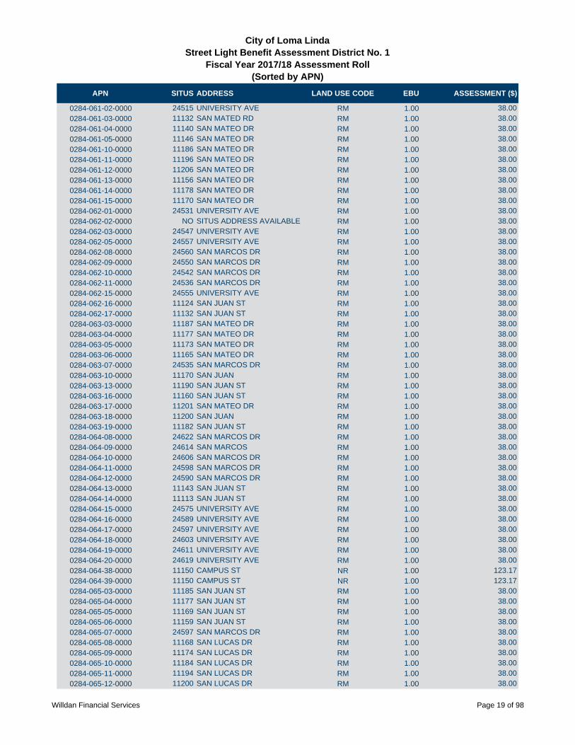
APN SITUS ADDRESS LAND USE CODE EBU ASSESSMENT ($)
City of Loma LindaStreet Light Benefit Assessment District No. 1
Fiscal Year 2017/18 Assessment Roll (Sorted by APN)
0284-061-02-0000 24515 UNIVERSITY AVE RM 1.00 38.00
0284-061-03-0000 11132 SAN MATED RD RM 1.00 38.00
0284-061-04-0000 11140 SAN MATEO DR RM 1.00 38.00
0284-061-05-0000 11146 SAN MATEO DR RM 1.00 38.00
0284-061-10-0000 11186 SAN MATEO DR RM 1.00 38.00
0284-061-11-0000 11196 SAN MATEO DR RM 1.00 38.00
0284-061-12-0000 11206 SAN MATEO DR RM 1.00 38.00
0284-061-13-0000 11156 SAN MATEO DR RM 1.00 38.00
0284-061-14-0000 11178 SAN MATEO DR RM 1.00 38.00
0284-061-15-0000 11170 SAN MATEO DR RM 1.00 38.00
0284-062-01-0000 24531 UNIVERSITY AVE RM 1.00 38.00
0284-062-02-0000 NO SITUS ADDRESS AVAILABLE RM 1.00 38.00
0284-062-03-0000 24547 UNIVERSITY AVE RM 1.00 38.00
0284-062-05-0000 24557 UNIVERSITY AVE RM 1.00 38.00
0284-062-08-0000 24560 SAN MARCOS DR RM 1.00 38.00
0284-062-09-0000 24550 SAN MARCOS DR RM 1.00 38.00
0284-062-10-0000 24542 SAN MARCOS DR RM 1.00 38.00
0284-062-11-0000 24536 SAN MARCOS DR RM 1.00 38.00
0284-062-15-0000 24555 UNIVERSITY AVE RM 1.00 38.00
0284-062-16-0000 11124 SAN JUAN ST RM 1.00 38.00
0284-062-17-0000 11132 SAN JUAN ST RM 1.00 38.00
0284-063-03-0000 11187 SAN MATEO DR RM 1.00 38.00
0284-063-04-0000 11177 SAN MATEO DR RM 1.00 38.00
0284-063-05-0000 11173 SAN MATEO DR RM 1.00 38.00
0284-063-06-0000 11165 SAN MATEO DR RM 1.00 38.00
0284-063-07-0000 24535 SAN MARCOS DR RM 1.00 38.00
0284-063-10-0000 11170 SAN JUAN RM 1.00 38.00
0284-063-13-0000 11190 SAN JUAN ST RM 1.00 38.00
0284-063-16-0000 11160 SAN JUAN ST RM 1.00 38.00
0284-063-17-0000 11201 SAN MATEO DR RM 1.00 38.00
0284-063-18-0000 11200 SAN JUAN RM 1.00 38.00
0284-063-19-0000 11182 SAN JUAN ST RM 1.00 38.00
0284-064-08-0000 24622 SAN MARCOS DR RM 1.00 38.00
0284-064-09-0000 24614 SAN MARCOS RM 1.00 38.00
0284-064-10-0000 24606 SAN MARCOS DR RM 1.00 38.00
0284-064-11-0000 24598 SAN MARCOS DR RM 1.00 38.00
0284-064-12-0000 24590 SAN MARCOS DR RM 1.00 38.00
0284-064-13-0000 11143 SAN JUAN ST RM 1.00 38.00
0284-064-14-0000 11113 SAN JUAN ST RM 1.00 38.00
0284-064-15-0000 24575 UNIVERSITY AVE RM 1.00 38.00
0284-064-16-0000 24589 UNIVERSITY AVE RM 1.00 38.00
0284-064-17-0000 24597 UNIVERSITY AVE RM 1.00 38.00
0284-064-18-0000 24603 UNIVERSITY AVE RM 1.00 38.00
0284-064-19-0000 24611 UNIVERSITY AVE RM 1.00 38.00
0284-064-20-0000 24619 UNIVERSITY AVE RM 1.00 38.00
0284-064-38-0000 11150 CAMPUS ST NR 1.00 123.17
0284-064-39-0000 11150 CAMPUS ST NR 1.00 123.17
0284-065-03-0000 11185 SAN JUAN ST RM 1.00 38.00
0284-065-04-0000 11177 SAN JUAN ST RM 1.00 38.00
0284-065-05-0000 11169 SAN JUAN ST RM 1.00 38.00
0284-065-06-0000 11159 SAN JUAN ST RM 1.00 38.00
0284-065-07-0000 24597 SAN MARCOS DR RM 1.00 38.00
0284-065-08-0000 11168 SAN LUCAS DR RM 1.00 38.00
0284-065-09-0000 11174 SAN LUCAS DR RM 1.00 38.00
0284-065-10-0000 11184 SAN LUCAS DR RM 1.00 38.00
0284-065-11-0000 11194 SAN LUCAS DR RM 1.00 38.00
0284-065-12-0000 11200 SAN LUCAS DR RM 1.00 38.00
Willdan Financial Services Page 19 of 98

APN SITUS ADDRESS LAND USE CODE EBU ASSESSMENT ($)
City of Loma LindaStreet Light Benefit Assessment District No. 1
Fiscal Year 2017/18 Assessment Roll (Sorted by APN)
0284-065-13-0000 11193 SAN JUAN DR RM 1.00 38.00
0284-071-01-0000 11220 SAN MATEO DR RM 1.00 38.00
0284-071-02-0000 11228 SAN MATEO DR RM 1.00 38.00
0284-071-03-0000 11232 SAN MATEO DR RM 1.00 38.00
0284-071-04-0000 11240 SAN MATEO DR RM 1.00 38.00
0284-071-05-0000 11244 SAN MATEO DR RM 1.00 38.00
0284-071-08-0000 11270 SAN MATEO DR RM 1.00 38.00
0284-071-09-0000 11278 SAN MATEO RM 1.00 38.00
0284-071-12-0000 11298 SAN MATEO DR RM 1.00 38.00
0284-071-16-0000 NO SITUS ADDRESS AVAILABLE RM 1.00 38.00
0284-071-17-0000 NO SITUS ADDRESS AVAILABLE RM 1.00 38.00
0284-071-18-0000 11288 SAN JUAN DR RM 1.00 38.00
0284-071-19-0000 NO SITUS ADDRESS AVAILABLE RM 1.00 38.00
0284-071-20-0000 11300 SAN JUAN DR RM 1.00 38.00
0284-071-21-0000 NO SITUS ADDRESS AVAILABLE RM 1.00 38.00
0284-071-22-0000 11300 SAN MATEO DR RM 1.00 38.00
0284-071-25-0000 11286 SAN MATEO DR RM 1.00 38.00
0284-071-26-0000 11294 SAN MATEO DR RM 1.00 38.00
0284-071-31-0000 11279 SAN MATEO DR RM 1.00 38.00
0284-071-32-0000 11274 SAN JUAN DR RM 1.00 38.00
0284-071-33-0000 11272 SAN JUAN DR RM 1.00 38.00
0284-071-34-0000 SAN MATEO RM 1.00 38.00
0284-071-35-0000 11264 SAN MATEO DR RM 1.00 38.00
0284-072-01-0000 11291 SAN MATEO DR RM 1.00 38.00
0284-072-02-0000 11275 SAN MATEO DR RM 1.00 38.00
0284-072-05-0000 11245 SAN MATEO DR RM 1.00 38.00
0284-072-06-0000 11239 SAN MATEO DR RM 1.00 38.00
0284-072-07-0000 11227 SAN MATEO DR RM 1.00 38.00
0284-072-08-0000 11221 SAN MATEO ST RM 1.00 38.00
0284-072-09-0000 11217 SAN MATEO DR RM 1.00 38.00
0284-072-10-0000 11214 SAN JUAN ST RM 1.00 38.00
0284-072-11-0000 11220 SAN JUAN ST RM 1.00 38.00
0284-072-12-0000 11228 SAN JUAN ST RM 1.00 38.00
0284-072-16-0000 11261 SAN MATEO DR RM 1.00 38.00
0284-072-17-0000 11236 SAN JUAN DR RM 1.00 38.00
0284-073-01-0000 11278 SAN LUCAS DR RM 1.00 38.00
0284-073-02-0000 11299 SAN JUAN ST RM 1.00 38.00
0284-073-03-0000 11287 SAN JUAN ST RM 1.00 38.00
0284-073-04-0000 11277 SAN JUAN ST RM 1.00 38.00
0284-073-05-0000 11257 SAN JUAN DR RM 1.00 38.00
0284-073-06-0000 11247 SAN JUAN RM 1.00 38.00
0284-073-07-0000 NO SITUS ADDRESS AVAILABLE RM 1.00 38.00
0284-073-08-0000 11231 SAN JUAN ST RM 1.00 38.00
0284-073-09-0000 11223 SAN JUAN RM 1.00 38.00
0284-073-10-0000 11217 SAN JUAN ST RM 1.00 38.00
0284-073-11-0000 11199 SAN JUAN ST RM 1.00 38.00
0284-073-12-0000 11210 SAN LUCAS DR RM 1.00 38.00
0284-073-13-0000 11214 SAN LUCAS DR RM 1.00 38.00
0284-073-14-0000 11230 SAN LUCAS DR RM 1.00 38.00
0284-073-15-0000 11234 SAN LUCAS DR RM 1.00 38.00
0284-073-18-0000 11256 SAN LUCAS DR RM 1.00 38.00
0284-073-19-0000 11244 SAN LUCAS RM 1.00 38.00
0284-074-01-0000 11301 SAN JUAN ST RM 1.00 38.00
0284-074-02-0000 11271 SAN LUCAS DR RM 1.00 38.00
0284-074-06-0000 11251 SAN LUCAS DR RM 1.00 38.00
0284-074-07-0000 11243 SAN LUCAS DR RM 1.00 38.00
0284-074-09-0000 11227 SAN LUCAS RM 1.00 38.00
Willdan Financial Services Page 20 of 98

APN SITUS ADDRESS LAND USE CODE EBU ASSESSMENT ($)
City of Loma LindaStreet Light Benefit Assessment District No. 1
Fiscal Year 2017/18 Assessment Roll (Sorted by APN)
0284-074-13-0000 NO SITUS ADDRESS AVAILABLE RM 1.00 38.00
0284-074-14-0000 11259 SAN LUCAS DR RM 1.00 38.00
0284-074-27-0000 11290 CAMPUS ST RS 2.00 112.28
0284-074-32-0000 11262 CAMPUS ST NR 1.00 123.17
0284-074-33-0000 11206 CAMPUS ST NR 1.00 123.17
0284-081-03-0000 UNIVERSITY AVE NR 1.00 123.17
0284-082-15-0000 11125 CAMPUS ST NR 5.00 615.85
0284-082-18-0000 11092 ANDERSON ST NR 5.00 615.85
0284-083-09-0000 24855 PROSPECT AVE NR 1.00 123.17
0284-083-11-0000 24873 PROSPECT DR NR 1.00 123.17
0284-083-12-0000 24891 PROSPECT AVE NR 1.00 123.17
0284-083-32-0000 PROSPECT AVE NR 11.00 1,354.87
0284-083-33-0000 11234 ANDERSON ST NR 1.00 123.17
0284-091-04-0000 11057 HILL ST NR 5.00 615.85
0284-091-06-0000 24940 MOUND ST NR 12.00 1,478.04
0284-091-07-0000 25020 MOUND ST NR 12.00 1,478.04
0284-092-20-0000 NO SITUS ADDRESS AVAILABLE NR 1.00 123.17
0284-092-25-0000 NO SITUS ADDRESS AVAILABLE NR 1.00 123.17
0284-092-28-0000 SHEPARDSON NR 4.00 492.68
0284-092-29-0000 25228 SHEPARDSON NR 3.00 369.51
0284-092-30-0000 25240 SHEPARDSON NR 3.00 369.51
0284-092-31-0000 NO SITUS ADDRESS AVAILABLE NR 8.00 985.36
0284-092-32-0000 MACHINE SHOP NR 6.00 739.02
0284-101-12-0000 24868 TAYLOR ST NR 1.00 123.17
0284-101-13-0000 24860 TAYLOR ST NR 1.00 123.17
0284-101-15-0000 11150 ANDERSON ST NR 1.00 123.17
0284-101-18-0000 11104 ANDERSON ST NR 1.00 123.17
0284-101-22-0000 24886 TAYLOR ST NR 1.00 123.17
0284-102-14-0000 24850 PROSPECT AVE NR 2.00 246.34
0284-102-17-0000 24863 TAYLOR ST NR 8.00 985.36
0284-103-02-0000 11161 ANDERSON ST NR 3.00 369.51
0284-103-03-0000 11195 ANDERSON ST NR 1.00 123.17
0284-103-04-0000 11147 ANDERSON ST NR 4.00 492.68
0284-111-03-0000 11219 ANDERSON ST RS 1.00 56.14
0284-111-04-0000 11209 ANDERSON ST RS 1.00 56.14
0284-111-05-0000 24921 PROSPECT AVE RS 1.00 56.14
0284-111-06-0000 24939 PROSPECT AVE RS 1.00 56.14
0284-111-07-0000 24947 PROSPECT AVE RS 1.00 56.14
0284-111-10-0000 24975 PROSPECT AVE RS 1.00 56.14
0284-111-11-0000 24989 PROSPECT AVE RS 1.00 56.14
0284-111-12-0000 24995 PROSPECT AVE RS 1.00 56.14
0284-111-13-0000 25005 PROSPECT AVE RS 1.00 56.14
0284-111-14-0000 STARR RS 1.00 56.14
0284-111-15-0000 25007 PROSPECT AVE RS 1.00 56.14
0284-111-16-0000 25025 PROSPECT AVE RS 1.00 56.14
0284-111-17-0000 25035 PROSPECT AVE RS 1.00 56.14
0284-111-18-0000 25045 PROSPECT AVE RS 1.00 56.14
0284-111-19-0000 11228 HILLCREST CT RS 1.00 56.14
0284-111-20-0000 25058 STARR ST RS 1.00 56.14
0284-111-21-0000 25050 STARR ST RS 1.00 56.14
0284-111-22-0000 25040 STARR ST RS 1.00 56.14
0284-111-23-0000 25030 STAR ST RS 1.00 56.14
0284-111-24-0000 25018 STARR ST RS 1.00 56.14
0284-111-27-0000 24998 STARR ST RS 1.00 56.14
0284-111-28-0000 24990 STARR ST RS 1.00 56.14
0284-111-29-0000 24982 STARR ST RS 1.00 56.14
0284-111-30-0000 24968 STARR ST RS 1.00 56.14
Willdan Financial Services Page 21 of 98

APN SITUS ADDRESS LAND USE CODE EBU ASSESSMENT ($)
City of Loma LindaStreet Light Benefit Assessment District No. 1
Fiscal Year 2017/18 Assessment Roll (Sorted by APN)
0284-111-31-0000 24960 STARR ST RS 1.00 56.14
0284-111-32-0000 24952 STARR ST RS 1.00 56.14
0284-111-33-0000 24946 STARR ST RS 1.00 56.14
0284-111-34-0000 NO SITUS ADDRESS AVAILABLE RS 1.00 56.14
0284-111-35-0000 24957 PROSPECT AVE RS 1.00 56.14
0284-111-36-0000 25008 STARR ST RS 1.00 56.14
0284-111-37-0000 11245 S ANDERSON ST NR 1.00 123.17
0284-112-01-0000 11259 ANDERSON ST RS 1.00 56.14
0284-112-02-0000 NO SITUS ADDRESS AVAILABLE RS 1.00 56.14
0284-112-03-0000 NO SITUS ADDRESS AVAILABLE RS 1.00 56.14
0284-112-04-0000 24945 STARR ST RS 1.00 56.14
0284-112-05-0000 24953 STARR ST RS 1.00 56.14
0284-112-06-0000 24959 STARR ST RS 1.00 56.14
0284-112-07-0000 24969 STARR ST RS 1.00 56.14
0284-112-08-0000 24979 STARR ST RS 1.00 56.14
0284-112-09-0000 24987 STARR ST RS 1.00 56.14
0284-112-10-0000 24993 STARR ST RS 1.00 56.14
0284-112-11-0000 24999 STARR ST RS 1.00 56.14
0284-112-12-0000 25005 STARR ST RS 1.00 56.14
0284-112-13-0000 25015 STARR ST RS 1.00 56.14
0284-112-14-0000 25002 BARTON RD RS 1.00 56.14
0284-112-15-0000 24992 BARTON RD RS 1.00 56.14
0284-112-16-0000 24984 BARTON RD RS 1.00 56.14
0284-112-17-0000 24976 BARTON RD RS 1.00 56.14
0284-112-18-0000 NO SITUS ADDRESS AVAILABLE RS 1.00 56.14
0284-112-19-0000 24954 BARTON RD RS 1.00 56.14
0284-112-20-0000 24946 BARTON RD RS 1.00 56.14
0284-112-21-0000 24934 BARTON RD RS 1.00 56.14
0284-112-22-0000 24930 BARTON RD RS 1.00 56.14
0284-112-23-0000 24914 BARTON RD NR 1.00 123.17
0284-112-24-0000 11279 ANDERSON ST RS 1.00 56.14
0284-112-25-0000 11271 ANDERSON ST RS 1.00 56.14
0284-113-01-0000 25025 STARR ST RS 1.00 56.14
0284-113-02-0000 25033 STARR ST RS 1.00 56.14
0284-113-03-0000 25039 STARR ST RS 1.00 56.14
0284-113-04-0000 25053 STARR ST RS 1.00 56.14
0284-113-05-0000 25057 STARR ST RS 1.00 56.14
0284-113-06-0000 25044 BARTON RD RS 1.00 56.14
0284-113-07-0000 25028 BARTON RD RS 1.00 56.14
0284-113-09-0000 11277 RICHARDSON ST RS 1.00 56.14
0284-113-10-0000 25020 BARTON RD RS 1.00 56.14
0284-121-01-0000 11106 RICHMONT RD RS 1.00 56.14
0284-121-02-0000 1114 RICHMONT RD RS 1.00 56.14
0284-121-03-0000 25104 LA MAR RD RS 1.00 56.14
0284-121-04-0000 25094 LA MAR RD RS 1.00 56.14
0284-121-05-0000 25086 LA MAR RD RS 1.00 56.14
0284-121-06-0000 25070 LA MAR RD RS 1.00 56.14
0284-122-01-0000 25057 LA MAR RD RS 1.00 56.14
0284-122-02-0000 25065 LA MAR RD RS 1.00 56.14
0284-122-03-0000 25073 LA MAR RD RS 1.00 56.14
0284-122-04-0000 25085 LA MAR RD RS 1.00 56.14
0284-122-05-0000 25093 LA MAR RD RS 1.00 56.14
0284-122-06-0000 25101 LA MAR RD RS 1.00 56.14
0284-122-07-0000 11132 RICHMONT RD RS 1.00 56.14
0284-122-08-0000 11140 RICHMONT RD RS 1.00 56.14
0284-122-09-0000 11152 RICHMONT RD RS 1.00 56.14
0284-122-15-0000 NO SITUS ADDRESS AVAILABLE RS 1.00 56.14
Willdan Financial Services Page 22 of 98

APN SITUS ADDRESS LAND USE CODE EBU ASSESSMENT ($)
City of Loma LindaStreet Light Benefit Assessment District No. 1
Fiscal Year 2017/18 Assessment Roll (Sorted by APN)
0284-122-16-0000 NO SITUS ADDRESS AVAILABLE RS 1.00 56.14
0284-122-19-0000 25078 RICHIE CIRCLE RS 1.00 56.14
0284-122-20-0000 25072 PROSPECT AVE RS 1.00 56.14
0284-122-21-0000 25058 PROSPECT AVE RS 1.00 56.14
0284-122-22-0000 25056 PROSPECT AVE NR 1.00 123.17
0284-122-23-0000 25034 PROSPECT AVE NR 1.00 123.17
0284-122-24-0000 25030 PROSPECT AVE NR 1.00 123.17
0284-122-25-0000 25008 PROSPECT AVE NR 1.00 123.17
0284-122-26-0000 24998 PROSPECT AVE NR 1.00 123.17
0284-122-27-0000 NO SITUS ADDRESS AVAILABLE NR 1.00 123.17
0284-122-28-0000 NO SITUS ADDRESS AVAILABLE NR 1.00 123.17
0284-122-29-0000 25037 MOUND ST NR 1.00 123.17
0284-122-31-0000 25067 MOUND ST NR 1.00 123.17
0284-122-34-0000 25039 MOUND ST NR 1.00 123.17
0284-122-37-0000 11174 RICHMONT RD RS 1.00 56.14
0284-122-38-0000 11160 RICHMONT RD RS 1.00 56.14
0284-122-39-0000 11170 RICHIE CIRCLE RS 1.00 56.14
0284-122-40-0000 11160 RICHIE CIRCLE RS 1.00 56.14
0284-122-41-0000 11178 RICHMONT RD RS 1.00 56.14
0284-122-42-0000 25110 PROSPECT AVE RS 1.00 56.14
0284-123-01-0000 11103 RICHMONT RD RS 1.00 56.14
0284-123-02-0000 11111 RICHMONT RD RS 1.00 56.14
0284-123-03-0000 11121 RICHMONT RD RS 1.00 56.14
0284-123-04-0000 11129 RICHMONT RD RS 1.00 56.14
0284-123-05-0000 11139 RICHMONT RD RS 1.00 56.14
0284-123-06-0000 11149 RICHMONT RD RS 1.00 56.14
0284-123-07-0000 11159 RICHMONT RD RS 1.00 56.14
0284-123-08-0000 11167 RICHMONT RD RS 1.00 56.14
0284-123-11-0000 11185 RICHMONT RD RS 1.00 56.14
0284-132-01-0000 25246 BARTON RD RS 1.00 56.14
0284-132-02-0000 11261 BELLAIRE RS 1.00 56.14
0284-132-03-0000 11253 BELLAIRE AVE RS 1.00 56.14
0284-132-04-0000 11243 BELLAIRE AVE RS 1.00 56.14
0284-132-05-0000 11233 BELLAIRE ST RS 1.00 56.14
0284-132-06-0000 11221 BELLAIRE ST RS 1.00 56.14
0284-132-07-0000 25265 PROSPECT AVE RS 1.00 56.14
0284-132-08-0000 11212 EXETER ST RS 1.00 56.14
0284-132-09-0000 11222 EXETER ST RS 1.00 56.14
0284-132-10-0000 11232 EXETER ST RS 1.00 56.14
0284-132-11-0000 11244 EXETER ST RS 1.00 56.14
0284-132-12-0000 11254 EXETER ST RS 1.00 56.14
0284-132-13-0000 11262 EXETER ST RS 1.00 56.14
0284-133-01-0000 11284 BELLAIRE ST RS 1.00 56.14
0284-133-02-0000 25184 BARTON RD RS 1.00 56.14
0284-133-03-0000 25176 BARTON RD RS 1.00 56.14
0284-133-04-0000 25156 BARTON RD RS 1.00 56.14
0284-133-05-0000 25144 BARTON RD RS 1.00 56.14
0284-133-06-0000 25136 BARTON RD RS 1.00 56.14
0284-133-07-0000 25124 BARTON DR RS 1.00 56.14
0284-133-08-0000 25118 BARTON RD RS 1.00 56.14
0284-133-09-0000 25108 BARTON RD RS 1.00 56.14
0284-133-10-0000 25100 BARTON RD RS 1.00 56.14
0284-133-11-0000 25092 BARTON RD RS 1.00 56.14
0284-133-12-0000 25084 BARTON RD RS 1.00 56.14
0284-133-13-0000 25072 BARTON RD RS 1.00 56.14
0284-133-14-0000 25062 BARTON RD RS 1.00 56.14
0284-133-15-0000 25075 STARR ST RS 1.00 56.14
Willdan Financial Services Page 23 of 98
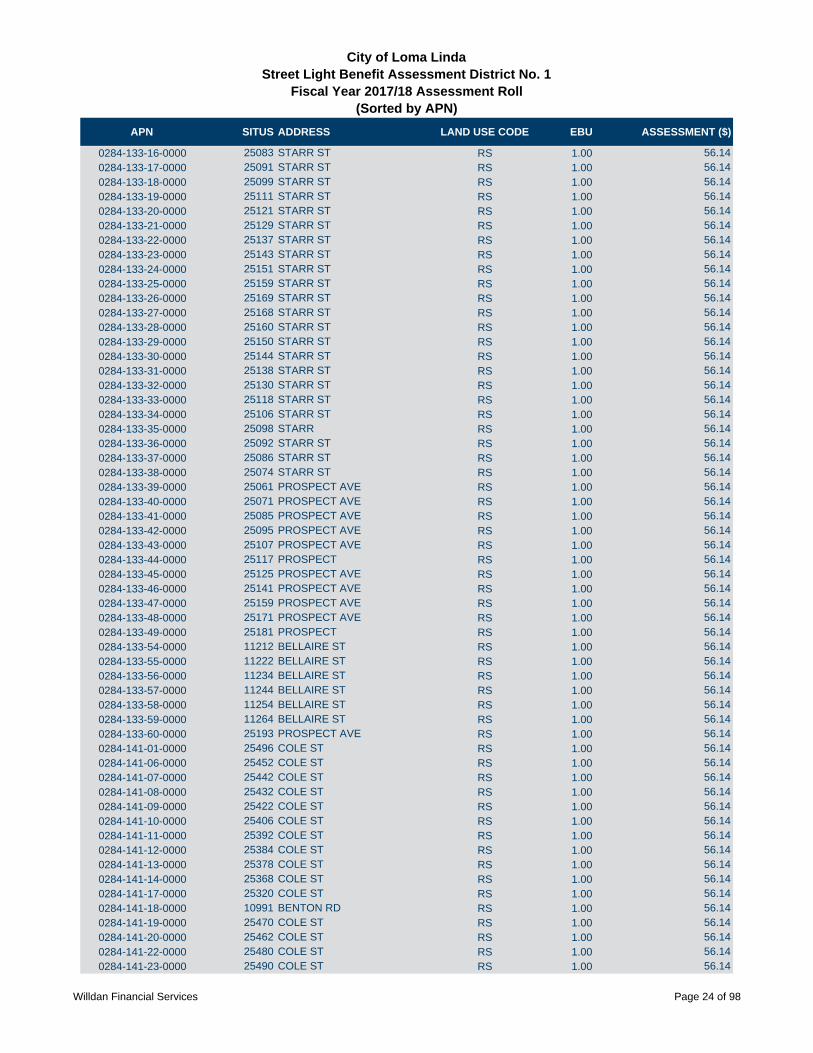
APN SITUS ADDRESS LAND USE CODE EBU ASSESSMENT ($)
City of Loma LindaStreet Light Benefit Assessment District No. 1
Fiscal Year 2017/18 Assessment Roll (Sorted by APN)
0284-133-16-0000 25083 STARR ST RS 1.00 56.14
0284-133-17-0000 25091 STARR ST RS 1.00 56.14
0284-133-18-0000 25099 STARR ST RS 1.00 56.14
0284-133-19-0000 25111 STARR ST RS 1.00 56.14
0284-133-20-0000 25121 STARR ST RS 1.00 56.14
0284-133-21-0000 25129 STARR ST RS 1.00 56.14
0284-133-22-0000 25137 STARR ST RS 1.00 56.14
0284-133-23-0000 25143 STARR ST RS 1.00 56.14
0284-133-24-0000 25151 STARR ST RS 1.00 56.14
0284-133-25-0000 25159 STARR ST RS 1.00 56.14
0284-133-26-0000 25169 STARR ST RS 1.00 56.14
0284-133-27-0000 25168 STARR ST RS 1.00 56.14
0284-133-28-0000 25160 STARR ST RS 1.00 56.14
0284-133-29-0000 25150 STARR ST RS 1.00 56.14
0284-133-30-0000 25144 STARR ST RS 1.00 56.14
0284-133-31-0000 25138 STARR ST RS 1.00 56.14
0284-133-32-0000 25130 STARR ST RS 1.00 56.14
0284-133-33-0000 25118 STARR ST RS 1.00 56.14
0284-133-34-0000 25106 STARR ST RS 1.00 56.14
0284-133-35-0000 25098 STARR RS 1.00 56.14
0284-133-36-0000 25092 STARR ST RS 1.00 56.14
0284-133-37-0000 25086 STARR ST RS 1.00 56.14
0284-133-38-0000 25074 STARR ST RS 1.00 56.14
0284-133-39-0000 25061 PROSPECT AVE RS 1.00 56.14
0284-133-40-0000 25071 PROSPECT AVE RS 1.00 56.14
0284-133-41-0000 25085 PROSPECT AVE RS 1.00 56.14
0284-133-42-0000 25095 PROSPECT AVE RS 1.00 56.14
0284-133-43-0000 25107 PROSPECT AVE RS 1.00 56.14
0284-133-44-0000 25117 PROSPECT RS 1.00 56.14
0284-133-45-0000 25125 PROSPECT AVE RS 1.00 56.14
0284-133-46-0000 25141 PROSPECT AVE RS 1.00 56.14
0284-133-47-0000 25159 PROSPECT AVE RS 1.00 56.14
0284-133-48-0000 25171 PROSPECT AVE RS 1.00 56.14
0284-133-49-0000 25181 PROSPECT RS 1.00 56.14
0284-133-54-0000 11212 BELLAIRE ST RS 1.00 56.14
0284-133-55-0000 11222 BELLAIRE ST RS 1.00 56.14
0284-133-56-0000 11234 BELLAIRE ST RS 1.00 56.14
0284-133-57-0000 11244 BELLAIRE ST RS 1.00 56.14
0284-133-58-0000 11254 BELLAIRE ST RS 1.00 56.14
0284-133-59-0000 11264 BELLAIRE ST RS 1.00 56.14
0284-133-60-0000 25193 PROSPECT AVE RS 1.00 56.14
0284-141-01-0000 25496 COLE ST RS 1.00 56.14
0284-141-06-0000 25452 COLE ST RS 1.00 56.14
0284-141-07-0000 25442 COLE ST RS 1.00 56.14
0284-141-08-0000 25432 COLE ST RS 1.00 56.14
0284-141-09-0000 25422 COLE ST RS 1.00 56.14
0284-141-10-0000 25406 COLE ST RS 1.00 56.14
0284-141-11-0000 25392 COLE ST RS 1.00 56.14
0284-141-12-0000 25384 COLE ST RS 1.00 56.14
0284-141-13-0000 25378 COLE ST RS 1.00 56.14
0284-141-14-0000 25368 COLE ST RS 1.00 56.14
0284-141-17-0000 25320 COLE ST RS 1.00 56.14
0284-141-18-0000 10991 BENTON RD RS 1.00 56.14
0284-141-19-0000 25470 COLE ST RS 1.00 56.14
0284-141-20-0000 25462 COLE ST RS 1.00 56.14
0284-141-22-0000 25480 COLE ST RS 1.00 56.14
0284-141-23-0000 25490 COLE ST RS 1.00 56.14
Willdan Financial Services Page 24 of 98

APN SITUS ADDRESS LAND USE CODE EBU ASSESSMENT ($)
City of Loma LindaStreet Light Benefit Assessment District No. 1
Fiscal Year 2017/18 Assessment Roll (Sorted by APN)
0284-141-25-0000 25460 COLE ST RS 1.00 56.14
0284-141-28-0000 25356 COLE ST RS 1.00 56.14
0284-141-29-0000 25326 COLE ST RS 1.00 56.14
0284-141-30-0000 25328 COLE ST RS 1.00 56.14
0284-141-31-0000 25330 COLE ST RS 1.00 56.14
0284-141-32-0000 25332 COLE ST RS 1.00 56.14
0284-141-33-0000 25334 COLE ST RS 1.00 56.14
0284-141-34-0000 25336 COLE ST RS 1.00 56.14
0284-141-35-0000 25338 COLE ST RS 1.00 56.14
0284-141-36-0000 25340 COLE ST RS 1.00 56.14
0284-141-37-0000 25342 COLE ST RS 1.00 56.14
0284-141-38-0000 25344 COLE ST RS 1.00 56.14
0284-141-39-0000 25346 COLE ST RS 1.00 56.14
0284-141-40-0000 25348 COLE ST RS 1.00 56.14
0284-141-41-0000 25350 COLE ST RS 1.00 56.14
0284-141-42-0000 25352 COLE ST RS 1.00 56.14
0284-142-06-0000 25393 COLE ST RS 1.00 56.14
0284-142-07-0000 25417 COLE ST RS 1.00 56.14
0284-142-08-0000 25405 COLE ST RS 1.00 56.14
0284-142-09-0000 25421 COLE ST RS 1.00 56.14
0284-142-11-0000 25461 COLE ST RS 1.00 56.14
0284-142-12-0000 25469 COLE ST RS 1.00 56.14
0284-142-15-0000 NO SITUS ADDRESS AVAILABLE RS 1.00 56.14
0284-142-23-0000 25451 COLE ST RS 1.00 56.14
0284-142-24-0000 25441 COLE ST RS 1.00 56.14
0284-142-27-0000 11051 WILLIS DR RS 1.00 56.14
0284-142-28-0000 25493 COLE ST RS 1.00 56.14
0284-142-29-0000 25388 COLE ST RS 1.00 56.14
0284-142-30-0000 11075 BENTON ST NR 2.00 246.34
0284-151-07-0000 25590 PROSPECT AVE RS 6.00 336.84
0284-151-08-0000 25590 PROSPECT AVE RS 5.00 280.70
0284-153-10-0000 25690 E BARTON RD NR 1.00 123.17
0284-153-13-0000 25675 PROSPECT AVE NR 1.00 123.17
0284-153-16-0000 25630 BARTON RD NR 10.00 1,231.70
0284-161-17-0000 24493 BARTON RD RM 1.00 38.00
0284-171-08-0000 11378 LOMA VISTA DR RM 1.00 38.00
0284-171-10-0000 11390 LOMA VIST DR RM 1.00 38.00
0284-171-13-0000 11422 LOMA VISTA DR RM 1.00 38.00
0284-171-15-0000 11436 LOMA VISTA DR RM 1.00 38.00
0284-171-17-0000 24562 VALLEY VIEW WY RM 2.00 76.00
0284-171-21-0000 11354 LOMA VISTA DR RM 1.00 38.00
0284-171-23-0000 NO SITUS ADDRESS AVAILABLE RM 3.00 114.00
0284-171-25-0000 11414 LOMA VISTA DR RM 1.00 38.00
0284-171-26-0000 11400 LOMA VISTA DR RM 1.00 38.00
0284-171-28-0000 24584 LOMA VISTA DR RM 1.00 38.00
0284-171-33-0000 11424 LOMA VISTA DR RM 1.00 38.00
0284-171-35-0000 11344 LOMA VISTA DR RM 1.00 38.00
0284-172-01-0000 11326 SAN JUAN DR RM 1.00 38.00
0284-172-02-0000 11336 SAN JUAN DR RM 1.00 38.00
0284-172-03-0000 11350 SAN JUAN DR RM 1.00 38.00
0284-172-06-0000 11384 SAN JUAN DR RM 1.00 38.00
0284-172-07-0000 11372 SAN JUAN DR RM 1.00 38.00
0284-172-08-0000 11360 SAN JUAN DR RM 1.00 38.00
0284-173-01-0000 11400 SAN JUAN DR RM 1.00 38.00
0284-173-02-0000 11410 SAN JUAN DR RM 1.00 38.00
0284-173-03-0000 NO SITUS ADDRESS AVAILABLE RM 1.00 38.00
0284-173-04-0000 11436 SAN JUAN DR RM 1.00 38.00
Willdan Financial Services Page 25 of 98

APN SITUS ADDRESS LAND USE CODE EBU ASSESSMENT ($)
City of Loma LindaStreet Light Benefit Assessment District No. 1
Fiscal Year 2017/18 Assessment Roll (Sorted by APN)
0284-174-01-0000 11441 SAN JUAN DR RM 1.00 38.00
0284-174-02-0000 11429 SAN JUAN DR RM 1.00 38.00
0284-174-03-0000 11417 SAN JUAN DR RM 1.00 38.00
0284-174-04-0000 11411 SAN JUAN DR RM 1.00 38.00
0284-174-05-0000 11397 SAN JUAN DR RM 1.00 38.00
0284-174-08-0000 11367 SAN JUAN DR RM 1.00 38.00
0284-174-12-0000 11351 SAN JUAN RM 1.00 38.00
0284-174-13-0000 11383 SAN JUAN DR RM 1.00 38.00
0284-174-14-0000 NO SITUS ADDRESS AVAILABLE RM 1.00 38.00
0284-191-21-0000 11375 ANDERSON ST NR 1.00 123.17
0284-191-22-0000 11365 ANDERSON ST NR 1.00 123.17
0284-191-23-0000 BARTON RD NR 1.00 123.17
0284-191-24-0000 NO SITUS ADDRESS AVAILABLE NR 1.00 123.17
0284-191-25-0000 25271 BARTON RD NR 1.00 123.17
0284-201-09-0000 25333 BARTON RD NR 12.00 1,478.04
0284-201-14-0000 BENTON ST NR 1.00 123.17
0284-201-18-0000 25526 LAWTON ST RS 6.00 336.84
0284-201-19-0000 25455 BARTON RD NR 4.00 492.68
0284-201-26-0000 25676 LAWTON AVE RS 6.00 336.84
0284-201-27-0000 25333 BARTON RD NR 1.00 123.17
0284-201-28-0000 25419 E BARTON RD NR 1.00 123.17
0284-201-29-0000 11406 LOMA LINDA DR NR 1.00 123.17
0284-201-31-0000 11306 MOUNTAIN VIEW AVE NR 12.00 1,478.04
0284-202-51-0000 NO SITUS ADDRESS AVAILABLE R 1.00 17.88
0284-202-52-0000 NO SITUS ADDRESS AVAILABLE R 1.00 17.88
0284-241-01-0000 11406 IRIS AVE RM 1.00 38.00
0284-241-02-0000 11412 IRIS AVE RM 1.00 38.00
0284-241-03-0000 11422 IRIS AVE RM 1.00 38.00
0284-241-04-0000 11428 IRIS AVE RM 1.00 38.00
0284-241-05-0000 11442 IRIS AVE RM 1.00 38.00
0284-241-06-0000 11452 IRIS AVE RM 1.00 38.00
0284-241-07-0000 11464 IRIS AVE RM 1.00 38.00
0284-241-08-0000 11468 IRIS AVE RM 1.00 38.00
0284-241-09-0000 11490 IRIS AVE RM 1.00 38.00
0284-242-05-0000 24846 TULIP AVE RM 1.00 38.00
0284-242-06-0000 24838 TULIP AVE RM 1.00 38.00
0284-242-07-0000 24826 TULIP AVE RM 1.00 38.00
0284-242-08-0000 24814 TULIP AVE RM 1.00 38.00
0284-242-09-0000 28404 TULIP AVE RM 1.00 38.00
0284-242-10-0000 24796 TULIP AVE RM 1.00 38.00
0284-242-11-0000 24780 TULIP AVE RM 1.00 38.00
0284-242-12-0000 24862 TULIP AVE RM 1.00 38.00
0284-242-14-0000 24880 TULIP AVE RM 1.00 38.00
0284-242-16-0000 24890 TULIP AVE RM 1.00 38.00
0284-243-01-0000 24804 LAWTON AVE RM 1.00 38.00
0284-243-02-0000 11481 IRIS AVE RM 1.00 38.00
0284-243-03-0000 11467 IRIS ST RM 1.00 38.00
0284-243-04-0000 11463 IRIS AVE RM 1.00 38.00
0284-243-05-0000 11441 IRIS AVE RM 1.00 38.00
0284-243-06-0000 24795 TULIP AVE RM 1.00 38.00
0284-243-07-0000 24801 TULIP AVE RM 1.00 38.00
0284-243-08-0000 24813 TULIP AVE RM 1.00 38.00
0284-243-09-0000 24829 TULIP AVE RM 1.00 38.00
0284-243-10-0000 24837 TULIP AVE RM 1.00 38.00
0284-243-11-0000 11460 ASTER ST RM 1.00 38.00
0284-243-12-0000 11472 ASTER ST RM 1.00 38.00
0284-243-13-0000 NO SITUS ADDRESS AVAILABLE RM 1.00 38.00
Willdan Financial Services Page 26 of 98

APN SITUS ADDRESS LAND USE CODE EBU ASSESSMENT ($)
City of Loma LindaStreet Light Benefit Assessment District No. 1
Fiscal Year 2017/18 Assessment Roll (Sorted by APN)
0284-243-14-0000 24838 LAWTON AVE RM 1.00 38.00
0284-244-06-0000 24819 LAWTON AVE RM 1.00 38.00
0284-244-07-0000 NO SITUS ADDRESS AVAILABLE RM 1.00 38.00
0284-244-09-0000 24803 LAWTON AVE RM 1.00 38.00
0284-244-11-0000 24783 LAWTON AVE RM 1.00 38.00
0284-245-01-0000 11489 ASTER ST RM 1.00 38.00
0284-245-02-0000 11479 ASTER ST RM 1.00 38.00
0284-245-03-0000 11469 ASTER ST RM 1.00 38.00
0284-245-04-0000 11455 ASTER ST RM 1.00 38.00
0284-245-05-0000 NO SITUS ADDRESS AVAILABLE RM 1.00 38.00
0284-245-06-0000 24861 TULIP AVE RM 1.00 38.00
0284-245-07-0000 11434 ANDERSON ST RS 2.00 112.28
0284-245-08-0000 11442 ANDERSON ST RS 2.00 112.28
0284-245-09-0000 11450 ANDERSON ST RS 2.00 112.28
0284-245-12-0000 11482 ANDERSON ST RS 2.00 112.28
0284-245-14-0000 11464 ANDERSON RS 2.00 112.28
0284-245-15-0000 11462 ANDERSON ST RS 2.00 112.28
0284-251-04-0000 24590 LAWTON AVE RM 1.00 38.00
0284-251-05-0000 11565 LAWTON CT RM 1.00 38.00
0284-251-06-0000 11566 LAWTON CT RM 1.00 38.00
0284-251-07-0000 11572 LAWTON CT RM 1.00 38.00
0284-251-08-0000 11580 LAWTON CT RM 1.00 38.00
0284-251-09-0000 11588 LAWTON CT RM 1.00 38.00
0284-251-10-0000 11598 LAWTON CT RM 1.00 38.00
0284-251-11-0000 24550 LAWTON AVE RM 1.00 38.00
0284-251-12-0000 24532 LAWTON AVE RM 1.00 38.00
0284-251-13-0000 24616 LAWTON AVE RM 2.00 76.00
0284-251-14-0000 24634 LAWTON AVE RM 1.00 38.00
0284-252-02-0000 24583 LAWTON AVE RM 2.00 76.00
0284-252-03-0000 24603 LAWTON AVE RM 1.00 38.00
0284-252-04-0000 24615 LAWTON RM 1.00 38.00
0284-252-06-0000 24647 LAWTON AVE RM 2.00 76.00
0284-252-07-0000 24665 LAWTON AVE RM 1.00 38.00
0284-252-08-0000 24527 LAWTON AVE RM 2.00 76.00
0284-252-09-0000 24511 LAWTON AVE RM 2.00 76.00
0284-252-10-0000 24625 LAWTON AVE RM 1.00 38.00
0284-252-11-0000 24621 LAWTON AVE RM 1.00 38.00
0284-261-01-0000 24334 LAWTON AVE RM 1.00 38.00
0284-261-02-0000 24318 LAWTON AVE RM 1.00 38.00
0284-261-03-0000 24317 LAWTON AVE RM 1.00 38.00
0284-261-05-0000 24671 LAWTON AVE RM 1.00 38.00
0284-261-06-0000 24681 LAWTON AVE RM 1.00 38.00
0284-261-09-0000 24725 LAWTON AVE RM 1.00 38.00
0284-261-13-0000 24715 LAWTON AVE RM 1.00 38.00
0284-261-14-0000 24321 LAWTON AVE RM 1.00 38.00
0284-261-15-0000 24333 LAWTON RM 1.00 38.00
0284-271-02-0000 24359 LAWTON AVE RM 1.00 38.00
0284-271-03-0000 24381 LAWTON AVE RM 1.00 38.00
0284-271-04-0000 24366 LAWTON AVE RM 1.00 38.00
0284-271-05-0000 24417 LAWTON AVE RM 3.00 114.00
0284-271-06-0000 24479 LAWTON AVE RM 1.00 38.00
0284-272-01-0000 24522 LAWTON AVE RM 1.00 38.00
0284-272-04-0000 24456 LAWTON AVE RM 1.00 38.00
0284-272-05-0000 24444 LAWTON AVE RM 1.00 38.00
0284-272-06-0000 24438 LAWTON AVE RM 1.00 38.00
0284-272-07-0000 24430 LAWTON AVE RM 1.00 38.00
0284-272-08-0000 24418 LAWTON AVE RM 1.00 38.00
Willdan Financial Services Page 27 of 98
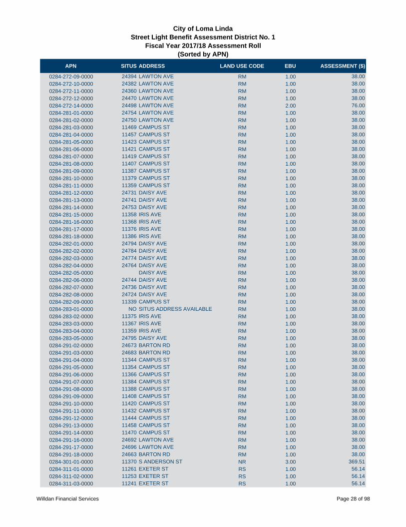
APN SITUS ADDRESS LAND USE CODE EBU ASSESSMENT ($)
City of Loma LindaStreet Light Benefit Assessment District No. 1
Fiscal Year 2017/18 Assessment Roll (Sorted by APN)
0284-272-09-0000 24394 LAWTON AVE RM 1.00 38.00
0284-272-10-0000 24382 LAWTON AVE RM 1.00 38.00
0284-272-11-0000 24360 LAWTON AVE RM 1.00 38.00
0284-272-12-0000 24470 LAWTON AVE RM 1.00 38.00
0284-272-14-0000 24498 LAWTON AVE RM 2.00 76.00
0284-281-01-0000 24754 LAWTON AVE RM 1.00 38.00
0284-281-02-0000 24750 LAWTON AVE RM 1.00 38.00
0284-281-03-0000 11469 CAMPUS ST RM 1.00 38.00
0284-281-04-0000 11457 CAMPUS ST RM 1.00 38.00
0284-281-05-0000 11423 CAMPUS ST RM 1.00 38.00
0284-281-06-0000 11421 CAMPUS ST RM 1.00 38.00
0284-281-07-0000 11419 CAMPUS ST RM 1.00 38.00
0284-281-08-0000 11407 CAMPUS ST RM 1.00 38.00
0284-281-09-0000 11387 CAMPUS ST RM 1.00 38.00
0284-281-10-0000 11379 CAMPUS ST RM 1.00 38.00
0284-281-11-0000 11359 CAMPUS ST RM 1.00 38.00
0284-281-12-0000 24731 DAISY AVE RM 1.00 38.00
0284-281-13-0000 24741 DAISY AVE RM 1.00 38.00
0284-281-14-0000 24753 DAISY AVE RM 1.00 38.00
0284-281-15-0000 11358 IRIS AVE RM 1.00 38.00
0284-281-16-0000 11368 IRIS AVE RM 1.00 38.00
0284-281-17-0000 11376 IRIS AVE RM 1.00 38.00
0284-281-18-0000 11386 IRIS AVE RM 1.00 38.00
0284-282-01-0000 24794 DAISY AVE RM 1.00 38.00
0284-282-02-0000 24784 DAISY AVE RM 1.00 38.00
0284-282-03-0000 24774 DAISY AVE RM 1.00 38.00
0284-282-04-0000 24764 DAISY AVE RM 1.00 38.00
0284-282-05-0000 DAISY AVE RM 1.00 38.00
0284-282-06-0000 24744 DAISY AVE RM 1.00 38.00
0284-282-07-0000 24736 DAISY AVE RM 1.00 38.00
0284-282-08-0000 24724 DAISY AVE RM 1.00 38.00
0284-282-09-0000 11339 CAMPUS ST RM 1.00 38.00
0284-283-01-0000 NO SITUS ADDRESS AVAILABLE RM 1.00 38.00
0284-283-02-0000 11375 IRIS AVE RM 1.00 38.00
0284-283-03-0000 11367 IRIS AVE RM 1.00 38.00
0284-283-04-0000 11359 IRIS AVE RM 1.00 38.00
0284-283-05-0000 24795 DAISY AVE RM 1.00 38.00
0284-291-02-0000 24673 BARTON RD RM 1.00 38.00
0284-291-03-0000 24683 BARTON RD RM 1.00 38.00
0284-291-04-0000 11344 CAMPUS ST RM 1.00 38.00
0284-291-05-0000 11354 CAMPUS ST RM 1.00 38.00
0284-291-06-0000 11366 CAMPUS ST RM 1.00 38.00
0284-291-07-0000 11384 CAMPUS ST RM 1.00 38.00
0284-291-08-0000 11388 CAMPUS ST RM 1.00 38.00
0284-291-09-0000 11408 CAMPUS ST RM 1.00 38.00
0284-291-10-0000 11420 CAMPUS ST RM 1.00 38.00
0284-291-11-0000 11432 CAMPUS ST RM 1.00 38.00
0284-291-12-0000 11444 CAMPUS ST RM 1.00 38.00
0284-291-13-0000 11458 CAMPUS ST RM 1.00 38.00
0284-291-14-0000 11470 CAMPUS ST RM 1.00 38.00
0284-291-16-0000 24692 LAWTON AVE RM 1.00 38.00
0284-291-17-0000 24696 LAWTON AVE RM 1.00 38.00
0284-291-18-0000 24663 BARTON RD RM 1.00 38.00
0284-301-01-0000 11370 S ANDERSON ST NR 3.00 369.51
0284-311-01-0000 11261 EXETER ST RS 1.00 56.14
0284-311-02-0000 11253 EXETER ST RS 1.00 56.14
0284-311-03-0000 11241 EXETER ST RS 1.00 56.14
Willdan Financial Services Page 28 of 98

APN SITUS ADDRESS LAND USE CODE EBU ASSESSMENT ($)
City of Loma LindaStreet Light Benefit Assessment District No. 1
Fiscal Year 2017/18 Assessment Roll (Sorted by APN)
0284-311-04-0000 11233 EXETER ST RS 1.00 56.14
0284-311-05-0000 11223 EXETER ST RS 1.00 56.14
0284-311-06-0000 11211 PROSPECT AVE RS 1.00 56.14
0284-311-07-0000 11212 BENTON ST RS 1.00 56.14
0284-311-08-0000 11221 BENTON ST RS 1.00 56.14
0284-311-09-0000 11234 BENTON ST RS 1.00 56.14
0284-311-10-0000 11242 BENTON ST RS 1.00 56.14
0284-311-11-0000 11252 BENTON ST RS 1.00 56.14
0284-311-12-0000 11262 BENTON ST RS 1.00 56.14
0284-311-13-0000 25276 BARTON RD RS 1.00 56.14
0284-321-01-0000 24984 TULIP AVE RS 1.00 56.14
0284-321-02-0000 24974 TULIP AVE RS 1.00 56.14
0284-321-03-0000 24964 TULIP AVE RS 1.00 56.14
0284-321-04-0000 24954 TULIP AVE RS 1.00 56.14
0284-321-05-0000 24944 TULIP AVE RS 1.00 56.14
0284-321-06-0000 24934 TULIP AVE RS 1.00 56.14
0284-321-07-0000 24924 TULIP AVE RS 1.00 56.14
0284-321-08-0000 11411 ANDERSON ST RS 1.00 56.14
0284-322-01-0000 24968 LAWTON AVE RS 1.00 56.14
0284-322-02-0000 11485 ORANGE GROVE ST RS 1.00 56.14
0284-322-03-0000 11465 ORANGE GROVE ST RS 1.00 56.14
0284-322-04-0000 11455 ORANGE GROVE ST RS 1.00 56.14
0284-322-05-0000 24959 TULIP AVE RS 1.00 56.14
0284-322-06-0000 24969 TULIP AVE RS 1.00 56.14
0284-322-07-0000 24979 TULIP AVE RS 1.00 56.14
0284-322-08-0000 11436 RICHARDSON ST RS 1.00 56.14
0284-322-09-0000 11446 RICHARDSON ST RS 1.00 56.14
0284-322-10-0000 11456 RICHARDSON ST RS 1.00 56.14
0284-322-11-0000 11466 RICHARDSON ST RS 1.00 56.14
0284-322-12-0000 24988 LAWTON AVE RS 1.00 56.14
0284-322-13-0000 24978 LAWTON AVE RS 1.00 56.14
0284-323-01-0000 11481 ANDERSON ST RS 1.00 56.14
0284-323-02-0000 11471 ANDERSON ST RS 1.00 56.14
0284-323-03-0000 11461 ANDERSON ST RS 1.00 56.14
0284-323-04-0000 11451 ANDERSON ST RS 1.00 56.14
0284-323-05-0000 11441 ANDERSON ST RS 1.00 56.14
0284-323-06-0000 24919 TULIP AVE RS 1.00 56.14
0284-323-07-0000 24929 TULIP AVE RS 1.00 56.14
0284-323-08-0000 11442 ORANGE GROVE ST RS 1.00 56.14
0284-323-09-0000 11452 ORANGE GROVE ST RS 1.00 56.14
0284-323-10-0000 11462 ORANGE GROVE ST RS 1.00 56.14
0284-323-11-0000 11472 ORANGE GROVE ST RS 1.00 56.14
0284-323-12-0000 24928 LAWTON AVE RS 1.00 56.14
0284-331-01-0000 25117 LAWTON AVE RS 1.00 56.14
0284-331-02-0000 11524 RICHMONT RD RS 1.00 56.14
0284-331-03-0000 11534 RICHMONT RD RS 1.00 56.14
0284-331-04-0000 11544 RICHMONT RD RS 1.00 56.14
0284-331-05-0000 11554 RICHMONT RD RS 1.00 56.14
0284-331-06-0000 11564 RICHMONT RD RS 1.00 56.14
0284-331-07-0000 11574 RICHMONT RD RS 1.00 56.14
0284-331-08-0000 11584 RICHMONT RD RS 1.00 56.14
0284-331-09-0000 25100 CRESTVIEW DR RS 1.00 56.14
0284-331-10-0000 25090 CRESTVIEW DR RS 1.00 56.14
0284-331-11-0000 25080 CRESTVIEW DR RS 1.00 56.14
0284-331-12-0000 11593 HILLCREST CT RS 1.00 56.14
0284-331-13-0000 11583 HILLCREST ST RS 1.00 56.14
0284-331-14-0000 11573 HILLCREST CT RS 1.00 56.14
Willdan Financial Services Page 29 of 98

APN SITUS ADDRESS LAND USE CODE EBU ASSESSMENT ($)
City of Loma LindaStreet Light Benefit Assessment District No. 1
Fiscal Year 2017/18 Assessment Roll (Sorted by APN)
0284-331-15-0000 11565 HILLCREST CT RS 1.00 56.14
0284-331-16-0000 11559 HILLCREST CT RS 1.00 56.14
0284-331-17-0000 11553 HILLCREST CT RS 1.00 56.14
0284-331-18-0000 11543 HILLCREST CT RS 1.00 56.14
0284-331-19-0000 11533 HILLCREST CT RS 1.00 56.14
0284-331-20-0000 11523 HILLCREST ST RS 1.00 56.14
0284-331-21-0000 25081 LAWTON AVE RS 1.00 56.14
0284-332-01-0000 11585 RICHMONT RD RS 1.00 56.14
0284-332-02-0000 11575 RICHMONT RD RS 1.00 56.14
0284-332-03-0000 11565 RICHMONT RD RS 1.00 56.14
0284-332-04-0000 11555 RICHMONT RD RS 1.00 56.14
0284-332-05-0000 11545 RICHMONT RD RS 1.00 56.14
0284-332-06-0000 11535 RICHMONT RD RS 1.00 56.14
0284-332-07-0000 11525 RICHMONT RD RS 1.00 56.14
0284-332-08-0000 25145 LAWTON AVE RS 1.00 56.14
0284-333-01-0000 25061 LAWTON AVE RS 1.00 56.14
0284-333-02-0000 11530 HILLCREST ST RS 1.00 56.14
0284-333-03-0000 11540 HILLCREST CT RS 1.00 56.14
0284-333-04-0000 11550 HILLCREST CT RS 1.00 56.14
0284-333-05-0000 11560 HILLCREST CT RS 1.00 56.14
0284-333-06-0000 11570 HILLCREST ST RS 1.00 56.14
0284-333-07-0000 11580 HILLCREST AVE RS 1.00 56.14
0284-333-08-0000 25038 HURON ST RS 1.00 56.14
0284-333-09-0000 11593 ACACIA ST RS 1.00 56.14
0284-333-10-0000 11577 ACACIA ST RS 1.00 56.14
0284-333-13-0000 11529 ACACIA ST RS 1.00 56.14
0284-333-14-0000 11513 ACACIA ST RS 1.00 56.14
0284-333-15-0000 11535 ACACIA ST RS 1.00 56.14
0284-334-04-0000 25050 CRESTVIEW DR RS 1.00 56.14
0284-334-05-0000 25052 CRESTVIEW RS 1.00 56.14
0284-334-06-0000 25044 CRESTVIEW DR RS 1.00 56.14
0284-334-07-0000 25033 HURON ST RS 1.00 56.14
0284-334-09-0000 25057 HURON ST RS 1.00 56.14
0284-335-01-0000 25045 CRESTVIEW DR RS 1.00 56.14
0284-335-02-0000 25047 CRESTVIEW DR RS 1.00 56.14
0284-335-03-0000 25051 CRESTVIEW DR RS 1.00 56.14
0284-335-04-0000 25055 CRESTVIEW DR RS 1.00 56.14
0284-335-09-0000 25101 HURON RS 1.00 56.14
0284-335-10-0000 NO SITUS ADDRESS AVAILABLE RS 1.00 56.14
0284-335-11-0000 25075 CRESTVIEW DR RS 1.00 56.14
0284-336-01-0000 25146 HURON ST RS 1.00 56.14
0284-336-02-0000 25134 HURON ST RS 1.00 56.14
0284-336-06-0000 25105 CRESTVIEW DR RS 1.00 56.14
0284-336-07-0000 25119 CRESTVIEW DR RS 1.00 56.14
0284-336-08-0000 25131 CRESTVIEW DR RS 1.00 56.14
0284-336-09-0000 25145 CRESTVIEW DR RS 1.00 56.14
0284-336-11-0000 25120 HURON ST RS 1.00 56.14
0284-336-12-0000 25091 CRESTVIEW DR RS 1.00 56.14
0284-341-01-0000 NO SITUS ADDRESS AVAILABLE RS 1.00 56.14
0284-341-02-0000 NO SITUS ADDRESS AVAILABLE RS 1.00 56.14
0284-341-03-0000 NO SITUS ADDRESS AVAILABLE RS 1.00 56.14
0284-341-04-0000 11120 POPLAR ST RS 1.00 56.14
0284-341-05-0000 11130 POPLAR ST RS 1.00 56.14
0284-341-06-0000 11140 POPLAR ST RS 1.00 56.14
0284-341-07-0000 11150 POPLAR ST RS 1.00 56.14
0284-341-08-0000 11160 POPLAR ST RS 1.00 56.14
0284-341-09-0000 11170 POPLAR ST RS 1.00 56.14
Willdan Financial Services Page 30 of 98

APN SITUS ADDRESS LAND USE CODE EBU ASSESSMENT ($)
City of Loma LindaStreet Light Benefit Assessment District No. 1
Fiscal Year 2017/18 Assessment Roll (Sorted by APN)
0284-341-10-0000 11180 POPLAR ST RS 1.00 56.14
0284-341-11-0000 11190 POPLAR ST RS 1.00 56.14
0284-342-01-0000 11189 POPLAR ST RS 1.00 56.14
0284-342-02-0000 11179 POPLAR ST RS 1.00 56.14
0284-342-03-0000 11169 POPLAR ST RS 1.00 56.14
0284-342-04-0000 11159 POPLAR ST RS 1.00 56.14
0284-342-05-0000 11149 POPLAR ST RS 1.00 56.14
0284-342-06-0000 11139 POPLAR ST RS 1.00 56.14
0284-342-07-0000 11129 POPLAR ST RS 1.00 56.14
0284-342-08-0000 11119 POPLAR ST RS 1.00 56.14
0284-342-09-0000 11095 POPLAR ST RS 1.00 56.14
0284-342-10-0000 11085 POPLAR ST RS 1.00 56.14
0284-342-11-0000 25207 SHEPARDSON DR RS 1.00 56.14
0284-342-12-0000 11096 BELLAIRE ST RS 1.00 56.14
0284-342-19-0000 11172 BELLAIRE ST RS 1.00 56.14
0284-342-20-0000 11186 BELLAIRE ST RS 1.00 56.14
0284-342-21-0000 11196 BELLAIRE ST RS 1.00 56.14
0284-342-22-0000 11160 BELLAIRE ST RS 1.00 56.14
0284-342-24-0000 11140 BELLAIRE RS 1.00 56.14
0284-342-25-0000 11120 BELLAIRE ST RS 1.00 56.14
0284-343-01-0000 25280 PROSPECT AVE RS 1.00 56.14
0284-343-02-0000 25270 PROSPECT AVE RS 1.00 56.14
0284-343-03-0000 NO SITUS ADDRESS AVAILABLE RS 1.00 56.14
0284-343-04-0000 25250 PROSPECT AVE RS 1.00 56.14
0284-343-05-0000 25230 PROSPECT AVE RS 1.00 56.14
0284-343-06-0000 25230 PROSPECT AVE RS 1.00 56.14
0284-343-07-0000 25229 TAYLOR ST RS 1.00 56.14
0284-343-08-0000 25239 TAYLOR ST RS 1.00 56.14
0284-343-09-0000 25249 TAYLOR RS 1.00 56.14
0284-343-10-0000 25259 TAYLOR ST RS 1.00 56.14
0284-343-11-0000 25269 TAYLOR ST RS 1.00 56.14
0284-343-12-0000 25279 TAYLOR ST RS 1.00 56.14
0284-344-01-0000 25278 TAYLOR ST RS 1.00 56.14
0284-344-02-0000 25268 TAYLOR ST RS 1.00 56.14
0284-344-03-0000 25258 TAYLOR ST RS 1.00 56.14
0284-344-04-0000 25248 TAYLOR ST RS 1.00 56.14
0284-344-05-0000 25238 TAYLOR ST RS 1.00 56.14
0284-344-06-0000 25228 TAYLOR ST RS 1.00 56.14
0284-344-07-0000 25231 LAMAR RD RS 1.00 56.14
0284-344-08-0000 25241 LA MAR RD RS 1.00 56.14
0284-344-09-0000 25251 LA MAR RD RS 1.00 56.14
0284-344-10-0000 25261 LA MAR RD RS 1.00 56.14
0284-344-11-0000 25271 LA MAR RD RS 1.00 56.14
0284-344-12-0000 25281 LA MAR RD RS 1.00 56.14
0284-345-01-0000 25280 LA MAR RD RS 1.00 56.14
0284-345-02-0000 25270 LA MAR RD RS 1.00 56.14
0284-345-03-0000 25260 LA MAR RD RS 1.00 56.14
0284-345-04-0000 25250 LA MAR RD RS 1.00 56.14
0284-345-05-0000 25240 LA MAR RD RS 1.00 56.14
0284-345-06-0000 25230 LA MAR RD RS 1.00 56.14
0284-345-07-0000 25233 SHEPARDSON DR RS 1.00 56.14
0284-345-08-0000 25243 SHEPARDSON DR RS 1.00 56.14
0284-345-09-0000 25253 SHEPARDSON DR RS 1.00 56.14
0284-345-10-0000 25263 SHEPARDSON DR RS 1.00 56.14
0284-345-11-0000 25273 SHEPARDSON DR RS 1.00 56.14
0284-345-12-0000 25283 SHEPARDSON DR RS 1.00 56.14
0284-351-22-0000 SCOTCH LN R 1.00 17.88
Willdan Financial Services Page 31 of 98

APN SITUS ADDRESS LAND USE CODE EBU ASSESSMENT ($)
City of Loma LindaStreet Light Benefit Assessment District No. 1
Fiscal Year 2017/18 Assessment Roll (Sorted by APN)
0284-351-23-0000 24758 SCOTCH LN R 1.00 17.88
0284-351-54-0000 12727 VISTA DR R 1.00 17.88
0284-351-56-0000 12687 VISTA DR R 1.00 17.88
0284-351-57-0000 12627 VISTA DR R 1.00 17.88
0284-351-59-0000 12717 VISTA DR R 1.00 17.88
0284-351-60-0000 12726 VISTA DR R 1.00 17.88
0284-351-63-0000 12688 VISTA DR R 1.00 17.88
0284-351-64-0000 12716 VISTA DR R 1.00 17.88
0284-351-66-0000 24734 SCOTCH LN R 1.00 17.88
0284-351-72-0000 24736 SCOTCH LN R 1.00 17.88
0284-351-73-0000 24754 SCOTCH LN R 1.00 17.88
0284-361-01-0000 25010 DAISY AVE RS 1.00 56.14
0284-361-02-0000 25020 DAISY AVE RS 1.00 56.14
0284-361-03-0000 25030 DAISY AVE RS 1.00 56.14
0284-361-04-0000 11326 HILLCREST CT RS 1.00 56.14
0284-362-01-0000 25011 DAISY AVE RS 1.00 56.14
0284-362-02-0000 25021 DAISY AVE RS 1.00 56.14
0284-362-03-0000 25031 DAISY AVE RS 1.00 56.14
0284-362-04-0000 25041 DAISY AVE RS 1.00 56.14
0284-362-05-0000 25040 FERN AVE RS 1.00 56.14
0284-362-06-0000 25030 FERN AVE RS 1.00 56.14
0284-362-07-0000 25020 FERN AVE RS 1.00 56.14
0284-362-08-0000 25010 FERN AVE RS 1.00 56.14
0284-363-01-0000 25011 FERN AVE RS 1.00 56.14
0284-363-02-0000 25021 FERN AVE RS 1.00 56.14
0284-363-03-0000 25031 FERN AVE RS 1.00 56.14
0284-363-04-0000 25041 FERN AVE RS 1.00 56.14
0284-363-05-0000 25050 TULIP AVE RS 1.00 56.14
0284-363-06-0000 25040 TULIP AVE RS 1.00 56.14
0284-363-07-0000 25030 TULIP AVE RS 1.00 56.14
0284-363-08-0000 25020 TULIP AVE RS 1.00 56.14
0284-363-09-0000 25010 TULIP AVE RS 1.00 56.14
0284-364-01-0000 25010 LAWTON AVE RS 1.00 56.14
0284-364-02-0000 11471 RICHARDSON ST RS 1.00 56.14
0284-364-03-0000 11461 RICHARDSON ST RS 1.00 56.14
0284-364-04-0000 11451 RICHARDSON ST RS 1.00 56.14
0284-364-05-0000 11441 RICHARDSON ST RS 1.00 56.14
0284-364-06-0000 25015 TULIP AVE RS 1.00 56.14
0284-364-07-0000 25035 TULIP AVE RS 1.00 56.14
0284-364-08-0000 11440 ACACIA ST RS 1.00 56.14
0284-364-09-0000 11450 ACACIA ST RS 1.00 56.14
0284-364-10-0000 11460 ACACIA ST RS 1.00 56.14
0284-364-11-0000 11470 ACACIA ST RS 1.00 56.14
0284-364-12-0000 25044 LAWTON AVE RS 1.00 56.14
0284-364-13-0000 25050 LAWTON AVE RS 1.00 56.14
0284-364-14-0000 11471 ACACIA ST RS 1.00 56.14
0284-364-15-0000 11461 ACACIA ST RS 1.00 56.14
0284-364-16-0000 11451 ACACIA ST RS 1.00 56.14
0284-364-17-0000 11441 ACACIA ST RS 1.00 56.14
0284-364-18-0000 11431 ACACIA ST RS 1.00 56.14
0284-364-19-0000 11430 HILLCREST CT RS 1.00 56.14
0284-364-20-0000 11440 HILLCREST ST RS 1.00 56.14
0284-364-21-0000 11450 HILLCREST CT RS 1.00 56.14
0284-364-22-0000 11460 HILLCREST CT RS 1.00 56.14
0284-364-23-0000 11470 HILLCREST ST RS 1.00 56.14
0284-364-24-0000 25060 HILLCREST RS 1.00 56.14
0284-365-01-0000 11481 HILLCREST ST RS 1.00 56.14
Willdan Financial Services Page 32 of 98

APN SITUS ADDRESS LAND USE CODE EBU ASSESSMENT ($)
City of Loma LindaStreet Light Benefit Assessment District No. 1
Fiscal Year 2017/18 Assessment Roll (Sorted by APN)
0284-365-02-0000 11471 HILLCREST CT RS 1.00 56.14
0284-365-03-0000 11461 HILLCREST CT RS 1.00 56.14
0284-365-04-0000 11451 HILLCREST CT RS 1.00 56.14
0284-365-05-0000 25085 ASPEN AVE RS 1.00 56.14
0284-366-01-0000 11441 HILLCREST CT RS 1.00 56.14
0284-366-02-0000 25075 TULIP AVE RS 1.00 56.14
0284-366-03-0000 25085 TULIP AVE RS 1.00 56.14
0284-367-01-0000 25070 TULIP AVE RS 1.00 56.14
0284-367-02-0000 11385 HILLCREST CT RS 1.00 56.14
0284-367-03-0000 11365 HILLCREST CT RS 1.00 56.14
0284-367-04-0000 11355 HILLCREST CT RS 1.00 56.14
0284-367-05-0000 25061 DAISY AVE RS 1.00 56.14
0284-367-06-0000 25071 DAISY AVE RS 1.00 56.14
0284-368-01-0000 11325 HILLCREST CT RS 1.00 56.14
0284-368-02-0000 25070 DAISY AVE RS 1.00 56.14
0284-371-01-0000 11491 POPLAR ST RS 1.00 56.14
0284-371-02-0000 11479 POPLAR ST RS 1.00 56.14
0284-371-03-0000 11467 POPLAR ST RS 1.00 56.14
0284-371-04-0000 11455 POPLAR ST RS 1.00 56.14
0284-371-05-0000 11443 POPLAR ST RS 1.00 56.14
0284-372-01-0000 11423 POPLAR ST RS 1.00 56.14
0284-372-02-0000 11411 POPLAR ST RS 1.00 56.14
0284-372-03-0000 11399 POPLAR ST RS 1.00 56.14
0284-372-04-0000 11387 POPLAR ST RS 1.00 56.14
0284-372-05-0000 11375 POPLAR ST RS 1.00 56.14
0284-372-06-0000 11363 POPLAR ST RS 1.00 56.14
0284-372-07-0000 25175 DAISY AVE RS 1.00 56.14
0284-373-01-0000 25178 DAISY AVE RS 1.00 56.14
0284-373-02-0000 25166 DAISY AVE RS 1.00 56.14
0284-373-03-0000 25154 DAISY AVE RS 1.00 56.14
0284-373-04-0000 25142 DAISY AVE RS 1.00 56.14
0284-373-05-0000 25130 DAISY AVE RS 1.00 56.14
0284-373-06-0000 25118 DAISY AVE RS 1.00 56.14
0284-373-07-0000 25106 DAISY AVE RS 1.00 56.14
0284-373-08-0000 25094 DAISY AVE RS 1.00 56.14
0284-373-09-0000 25082 DAISY AVE RS 1.00 56.14
0284-374-01-0000 25081 DAISY AVE RS 1.00 56.14
0284-374-02-0000 25091 DAISY AVE RS 1.00 56.14
0284-374-03-0000 25101 DAISY AVE RS 1.00 56.14
0284-374-04-0000 25111 DAISY AVE RS 1.00 56.14
0284-374-05-0000 25123 DAISY AVE RS 1.00 56.14
0284-374-06-0000 25135 DAISY AVE RS 1.00 56.14
0284-374-07-0000 25145 DAISY AVE RS 1.00 56.14
0284-374-08-0000 11350 POPLAR ST RS 1.00 56.14
0284-374-09-0000 11370 POPLAR ST RS 1.00 56.14
0284-374-10-0000 25144 TULIP AVE RS 1.00 56.14
0284-374-11-0000 25134 TULIP AVE RS 1.00 56.14
0284-374-12-0000 25122 TULIP AVE RS 1.00 56.14
0284-374-13-0000 25110 TULIP AVE RS 1.00 56.14
0284-374-14-0000 25098 TULIP AVE RS 1.00 56.14
0284-374-15-0000 25084 TULIP AVE RS 1.00 56.14
0284-375-01-0000 25097 TULIP AVE RS 1.00 56.14
0284-375-02-0000 25107 TULIP AVE RS 1.00 56.14
0284-375-03-0000 25119 TULIP AVE RS 1.00 56.14
0284-375-04-0000 25131 TULIP AVE RS 1.00 56.14
0284-375-05-0000 25143 TULIP AVE RS 1.00 56.14
0284-375-06-0000 11400 POPLAR ST RS 1.00 56.14
Willdan Financial Services Page 33 of 98

APN SITUS ADDRESS LAND USE CODE EBU ASSESSMENT ($)
City of Loma LindaStreet Light Benefit Assessment District No. 1
Fiscal Year 2017/18 Assessment Roll (Sorted by APN)
0284-375-07-0000 25154 ASPEN AVE RS 1.00 56.14
0284-375-08-0000 25142 ASPEN AVE RS 1.00 56.14
0284-375-09-0000 25130 ASPEN AVE RS 1.00 56.14
0284-375-10-0000 25118 ASPEN AVE RS 1.00 56.14
0284-375-11-0000 25104 ASPEN AVE RS 1.00 56.14
0284-375-12-0000 25086 ASPEN AVE RS 1.00 56.14
0284-376-01-0000 11442 RICHMONT RD RS 1.00 56.14
0284-376-02-0000 11454 RICHMONT RD RS 1.00 56.14
0284-376-03-0000 11466 RICHMONT RD RS 1.00 56.14
0284-376-04-0000 11478 RICHMONT RD RS 1.00 56.14
0284-376-05-0000 11490 RICHMONT RD RS 1.00 56.14
0284-376-06-0000 11491 RICHMONT RD RS 1.00 56.14
0284-376-07-0000 11479 RICHMONT RD RS 1.00 56.14
0284-376-08-0000 11467 RICHMONT RD RS 1.00 56.14
0284-376-09-0000 11455 RICHMONT RD RS 1.00 56.14
0284-376-10-0000 11443 RICHMONT RD RS 1.00 56.14
0284-376-11-0000 11442 POPLAR ST RS 1.00 56.14
0284-376-12-0000 11454 POPLAR ST RS 1.00 56.14
0284-376-13-0000 11466 POPLAR ST RS 1.00 56.14
0284-376-14-0000 11478 POPLAR ST RS 1.00 56.14
0284-376-15-0000 11490 POPLAR ST RS 1.00 56.14
0284-381-01-0000 11514 ACACIA ST RS 1.00 56.14
0284-381-02-0000 11528 ACACIA ST RS 1.00 56.14
0284-381-03-0000 11544 ACACIA ST RS 1.00 56.14
0284-381-04-0000 11560 ACACIA ST RS 1.00 56.14
0284-381-05-0000 11570 ACACIA ST RS 1.00 56.14
0284-381-06-0000 11580 ACACIA ST RS 1.00 56.14
0284-381-07-0000 11561 RICHARDSON ST RS 1.00 56.14
0284-381-08-0000 11541 RICHARDSON ST RS 1.00 56.14
0284-381-09-0000 11525 RICHARDSON ST RS 1.00 56.14
0284-381-10-0000 25031 LAWTON AVE RS 1.00 56.14
0284-382-01-0000 24957 LAWTON AVE RS 1.00 56.14
0284-382-02-0000 24971 LAWTON AVE RS 1.00 56.14
0284-382-03-0000 24985 LAWTON AVE RS 1.00 56.14
0284-382-04-0000 11530 RICHARDSON ST RS 1.00 56.14
0284-382-05-0000 24966 HURON ST RS 1.00 56.14
0284-382-06-0000 24958 HURON ST RS 1.00 56.14
0284-382-07-0000 24946 HURON ST RS 1.00 56.14
0284-383-01-0000 11533 ANDERSON ST RS 1.00 56.14
0284-383-02-0000 24917 LAWTON AVE RS 1.00 56.14
0284-383-03-0000 24927 LAWTON AVE RS 1.00 56.14
0284-383-04-0000 11520 ORANGE GROVE ST RS 1.00 56.14
0284-383-05-0000 11530 ORANGE GROVE ST RS 1.00 56.14
0284-383-06-0000 24945 HURON ST RS 1.00 56.14
0284-383-07-0000 24957 HURON ST RS 1.00 56.14
0284-383-08-0000 24965 HURON ST RS 1.00 56.14
0284-383-14-0000 11630 RICHARDSON ST RS 2.00 112.28
0284-383-23-0000 11590 RICHARDSON ST RS 1.00 56.14
0284-383-24-0000 11570 ANDERSON ST RS 1.00 56.14
0284-383-28-0000 11670 RICHARDSON ST RS 2.00 112.28
0284-383-29-0000 11650 RICHARDSON ST RS 2.00 112.28
0284-384-03-0000 11591 RICHARDSON ST RS 1.00 56.14
0284-384-04-0000 11581 RICHARDSON ST RS 1.00 56.14
0284-384-08-0000 25040 CRESTVIEW RD RS 1.00 56.14
0284-384-09-0000 25038 CRESTVIEW RS 1.00 56.14
0284-384-12-0000 25036 CRESTVIEW DR RS 1.00 56.14
0284-384-13-0000 25023 HURON ST RS 1.00 56.14
Willdan Financial Services Page 34 of 98

APN SITUS ADDRESS LAND USE CODE EBU ASSESSMENT ($)
City of Loma LindaStreet Light Benefit Assessment District No. 1
Fiscal Year 2017/18 Assessment Roll (Sorted by APN)
0284-384-14-0000 25001 HURON AVE RS 1.00 56.14
0284-384-15-0000 11605 RICHARDSON ST RS 1.00 56.14
0284-384-16-0000 11613 RICHARDSON ST RS 1.00 56.14
0284-385-02-0000 25039 CRESTVIEW DR RS 3.00 168.42
0284-401-02-0000 24837 LAWTON AVE RM 1.00 38.00
0284-401-03-0000 24853 LAWTON AVE RM 1.00 38.00
0284-401-04-0000 24863 LAWTON AVE RM 1.00 38.00
0284-401-44-0000 11514 ANDERSON ST RS 1.00 56.14
0284-401-47-0000 24879 LAWTON AVE RM 1.00 38.00
0284-401-52-0000 11534 ANDERSON ST RS 1.00 56.14
0284-401-54-0000 11524 ANDERSON ST RS 1.00 56.14
0284-411-01-0000 25100 PROSPECT AVE RSC 0.40 22.46
0284-411-02-0000 25100 PROSPECT AVE RSC 0.40 22.46
0284-411-03-0000 25100 PROSPECT AVE RSC 0.40 22.46
0284-411-04-0000 25100 PROSPECT AVE RSC 0.40 22.46
0284-411-05-0000 25100 PROSPECT AVE RSC 0.40 22.46
0284-421-01-0000 25100 PROSPECT AVE RSC 0.40 22.46
0284-421-02-0000 25100 PROSPECT AVE RSC 0.40 22.46
0284-421-03-0000 25100 PROSPECT AVE RSC 0.40 22.46
0284-421-04-0000 25100 PROSPECT AVE RSC 0.40 22.46
0284-421-05-0000 25100 PROSPECT AVE RSC 0.40 22.46
0284-431-01-0000 11504 WELEBIR ST RS 1.00 56.14
0284-431-02-0000 11514 WELEBIR ST RS 1.00 56.14
0284-431-03-0000 11515 RAY CT RS 1.00 56.14
0284-431-04-0000 11503 RAY CT RS 1.00 56.14
0284-431-05-0000 11504 RAY CT RS 1.00 56.14
0284-431-06-0000 11514 RAY CT RS 1.00 56.14
0284-431-07-0000 11524 RAY CT RS 1.00 56.14
0284-431-08-0000 11536 MURPHY ST RS 1.00 56.14
0284-431-09-0000 11546 MURPHY ST RS 1.00 56.14
0284-431-10-0000 11554 MURPHY ST RS 1.00 56.14
0284-431-11-0000 11564 MURPHY ST RS 1.00 56.14
0284-431-12-0000 11574 MURPHY ST RS 1.00 56.14
0284-431-13-0000 11584 MURPHY ST RS 1.00 56.14
0284-432-01-0000 11545 WELEBIR ST RS 1.00 56.14
0284-432-02-0000 11535 WELEBIR ST RS 1.00 56.14
0284-432-03-0000 11525 WELEBIR ST RS 1.00 56.14
0284-432-05-0000 11505 WELEBIR ST RS 1.00 56.14
0284-432-08-0000 11537 MANDARIN CT RS 1.00 56.14
0284-432-09-0000 25425 MANDARIN CT RS 1.00 56.14
0284-432-10-0000 25435 MANDARIN CT RS 1.00 56.14
0284-432-11-0000 25445 MANDARIN CT RS 1.00 56.14
0284-432-12-0000 25455 MANDARIN CT RS 1.00 56.14
0284-432-13-0000 25465 MANDARIN CT RS 1.00 56.14
0284-432-14-0000 25475 MANDARIN CT RS 1.00 56.14
0284-432-15-0000 25485 MANDARIN CT RS 1.00 56.14
0284-432-16-0000 25488 NICKS AVE RS 1.00 56.14
0284-432-17-0000 25476 NICKS AVE RS 1.00 56.14
0284-432-18-0000 25464 NICKS AVE RS 1.00 56.14
0284-432-19-0000 25452 NICKS AVE RS 1.00 56.14
0284-432-20-0000 25440 NICKS AVE RS 1.00 56.14
0284-432-21-0000 25428 NICKS AVE RS 1.00 56.14
0284-432-22-0000 25416 NICKS AVE RS 1.00 56.14
0284-432-23-0000 25404 NICKS AVE RS 1.00 56.14
0284-432-24-0000 11513 MANDARIN CT RS 1.00 56.14
0284-432-25-0000 11525 MANDARIN CT RS 1.00 56.14
0284-432-26-0000 11515 WELEBIR ST RS 1.00 56.14
Willdan Financial Services Page 35 of 98

APN SITUS ADDRESS LAND USE CODE EBU ASSESSMENT ($)
City of Loma LindaStreet Light Benefit Assessment District No. 1
Fiscal Year 2017/18 Assessment Roll (Sorted by APN)
0284-433-01-0000 11580 WELEBIR ST RS 1.00 56.14
0284-433-02-0000 11572 WELEBIR ST RS 1.00 56.14
0284-433-03-0000 11562 WELEBIR ST RS 1.00 56.14
0284-433-04-0000 11552 WELEBIR ST RS 1.00 56.14
0284-433-05-0000 11542 WELEBIR ST RS 1.00 56.14
0284-433-06-0000 11534 WELEBIR ST RS 1.00 56.14
0284-433-07-0000 11533 MURPHY ST RS 1.00 56.14
0284-433-08-0000 11543 MURPHY ST RS 1.00 56.14
0284-433-09-0000 11553 MURPHY ST RS 1.00 56.14
0284-433-10-0000 11563 MURPHY ST RS 1.00 56.14
0284-433-11-0000 11573 MURPHY ST RS 1.00 56.14
0284-433-12-0000 11583 MURPHY ST RS 1.00 56.14
0284-434-01-0000 11585 WELEBIR ST RS 1.00 56.14
0284-434-02-0000 11575 WELEBIR ST RS 1.00 56.14
0284-434-03-0000 11565 WELEBIR ST RS 1.00 56.14
0284-434-04-0000 11585 ORANGE CREST RS 1.00 56.14
0284-434-05-0000 11597 ORANGE CREST RS 1.00 56.14
0284-435-01-0000 25484 MANDARIN CT RS 1.00 56.14
0284-435-02-0000 25474 MANDARIN CT RS 1.00 56.14
0284-435-03-0000 25464 MANDARIN CT RS 1.00 56.14
0284-435-04-0000 25454 MANDARIN CT RS 1.00 56.14
0284-435-05-0000 25444 MANDARIN CT RS 1.00 56.14
0284-435-06-0000 25434 MANDARIN CT RS 1.00 56.14
0284-435-07-0000 25435 LAWTON AVE RS 1.00 56.14
0284-435-08-0000 25445 LAWTON AVE RS 1.00 56.14
0284-435-09-0000 25455 LAWTON AVE RS 1.00 56.14
0284-435-10-0000 25465 LAWTON AVE RS 1.00 56.14
0284-435-11-0000 25475 LAWTON AVE RS 1.00 56.14
0284-435-12-0000 25485 LAWTON AVE RS 1.00 56.14
0284-436-01-0000 25433 NICKS AVE RS 1.00 56.14
0284-436-02-0000 25447 NICKS AVE RS 1.00 56.14
0284-436-03-0000 25461 NICKS AVE RS 1.00 56.14
0284-436-04-0000 25475 NICKS AVE RS 1.00 56.14
0284-436-05-0000 25489 NICKS AVE RS 1.00 56.14
0284-441-01-0000 25190 BIRCH AVE RS 1.00 56.14
0284-441-02-0000 11545 POPLAR ST RS 1.00 56.14
0284-441-03-0000 11533 POPLAR ST RS 1.00 56.14
0284-441-04-0000 8 POPLAR ST RS 1.00 56.14
0284-441-05-0000 11511 POPLAR ST RS 1.00 56.14
0284-441-06-0000 11512 POPLAR ST RS 1.00 56.14
0284-441-07-0000 11522 POPLAR ST RS 1.00 56.14
0284-441-08-0000 11532 POPLAR ST RS 1.00 56.14
0284-441-09-0000 11542 POPLAR ST RS 1.00 56.14
0284-441-10-0000 11552 POPLAR ST RS 1.00 56.14
0284-441-11-0000 11562 POPLAR ST RS 1.00 56.14
0284-441-12-0000 11574 POPLAR ST RS 1.00 56.14
0284-441-13-0000 11584 POPLAR ST RS 1.00 56.14
0284-441-14-0000 11594 POPLAR ST RS 1.00 56.14
0284-441-15-0000 25158 CRESTVIEW DR RS 1.00 56.14
0284-442-01-0000 25155 CRESTVIEW DR RS 1.00 56.14
0284-442-02-0000 11626 POPLAR ST RS 1.00 56.14
0284-442-03-0000 11650 POPLAR ST RS 1.00 56.14
0284-442-04-0000 25156 HURON ST RS 1.00 56.14
0284-443-01-0000 25169 HURON ST RS 1.00 56.14
0284-443-02-0000 NO SITUS ADDRESS AVAILABLE RS 1.00 56.14
0284-443-03-0000 25189 HURON RS 1.00 56.14
0284-443-05-0000 25159 HURON AVE RS 1.00 56.14
Willdan Financial Services Page 36 of 98

APN SITUS ADDRESS LAND USE CODE EBU ASSESSMENT ($)
City of Loma LindaStreet Light Benefit Assessment District No. 1
Fiscal Year 2017/18 Assessment Roll (Sorted by APN)
0284-443-06-0000 25123 HURON ST RS 1.00 56.14
0284-443-07-0000 25139 HURON AVE RS 1.00 56.14
0284-444-01-0000 25186 HURON ST RS 1.00 56.14
0284-444-02-0000 11651 POPLAR ST RS 1.00 56.14
0284-444-03-0000 11641 POPLAR ST RS 1.00 56.14
0284-444-04-0000 11627 POPLAR ST RS 1.00 56.14
0284-444-05-0000 11617 POPLAR ST RS 1.00 56.14
0284-444-06-0000 11605 POPLAR ST RS 1.00 56.14
0284-444-07-0000 11595 POPLAR ST RS 1.00 56.14
0284-444-08-0000 11585 POPLAR ST RS 1.00 56.14
0284-444-09-0000 25185 BIRCH AVE RS 1.00 56.14
0284-451-02-0000 11400 BENTON ST RSC 0.16 9.10
0284-451-03-0000 11402 BENTON ST RSC 0.16 9.10
0284-451-04-0000 11404 BENTON ST RSC 0.16 9.10
0284-451-05-0000 25206 LAWTON AVE RSC 0.16 9.10
0284-451-06-0000 25204 LAWTON AVE RSC 0.16 9.10
0284-451-07-0000 25202 LAWTON AVE RSC 0.16 9.10
0284-451-08-0000 25200 LAWTON AVE RSC 0.16 9.10
0284-451-09-0000 11406 BENTON ST RSC 0.16 9.10
0284-451-10-0000 11408 BENTON ST RSC 0.16 9.10
0284-451-11-0000 11410 BENTON ST RSC 0.16 9.10
0284-451-12-0000 11412 BENTON ST RSC 0.16 9.10
0284-451-13-0000 11414 BENTON ST RSC 0.16 9.10
0284-451-14-0000 11416 BENTON ST RSC 0.16 9.10
0284-451-15-0000 11418 BENTON ST RSC 0.16 9.10
0284-451-16-0000 11420 BENTON ST RSC 0.16 9.10
0284-451-17-0000 11422 BENTON ST RSC 0.16 9.10
0284-451-18-0000 11424 BENTON ST RSC 0.16 9.10
0284-451-19-0000 11426 BENTON ST RSC 0.16 9.10
0284-451-20-0000 11428 BENTON ST RSC 0.16 9.10
0284-451-21-0000 11430 BENTON ST RSC 0.16 9.10
0284-451-22-0000 11432 BENTON ST RSC 0.16 9.10
0284-451-23-0000 11434 BENTON ST RSC 0.16 9.10
0284-451-24-0000 11436 BENTON ST RSC 0.16 9.10
0284-451-25-0000 11438 BENTON ST RSC 0.16 9.10
0284-451-26-0000 11440 BENTON ST RSC 0.16 9.10
0284-451-27-0000 11442 BENTON ST RSC 0.16 9.10
0284-451-28-0000 11444 BENTON ST RSC 0.16 9.10
0284-451-29-0000 11446 BENTON ST RSC 0.16 9.10
0284-451-30-0000 11448 BENTON ST RSC 0.16 9.10
0284-451-31-0000 11450 BENTON ST RSC 0.16 9.10
0284-451-32-0000 11464 BENTON ST RSC 0.16 9.10
0284-451-33-0000 11462 BENTON ST RSC 0.16 9.10
0284-451-34-0000 11460 BENTON ST RSC 0.16 9.10
0284-451-35-0000 11452 BENTON ST RSC 0.16 9.10
0284-451-36-0000 11454 BENTON ST RSC 0.16 9.10
0284-451-37-0000 11456 BENTON ST RSC 0.16 9.10
0284-451-38-0000 11458 BENTON ST RSC 0.16 9.10
0284-461-01-0000 25208 LAWTON AVE RSC 0.39 21.73
0284-461-02-0000 25210 LAWTON AVE RSC 0.39 21.73
0284-461-03-0000 25212 LAWTON AVE RSC 0.39 21.73
0284-461-04-0000 25214 LAWTON AVE RSC 0.39 21.73
0284-461-05-0000 25222 LAWTON AVE RSC 0.39 21.73
0284-461-06-0000 25220 LAWTON AVE RSC 0.39 21.73
0284-461-07-0000 25218 LAWTON AVE RSC 0.39 21.73
0284-461-08-0000 25216 LAWTON AVE RSC 0.39 21.73
0284-461-09-0000 25224 LAWTON AVE RSC 0.39 21.73
Willdan Financial Services Page 37 of 98
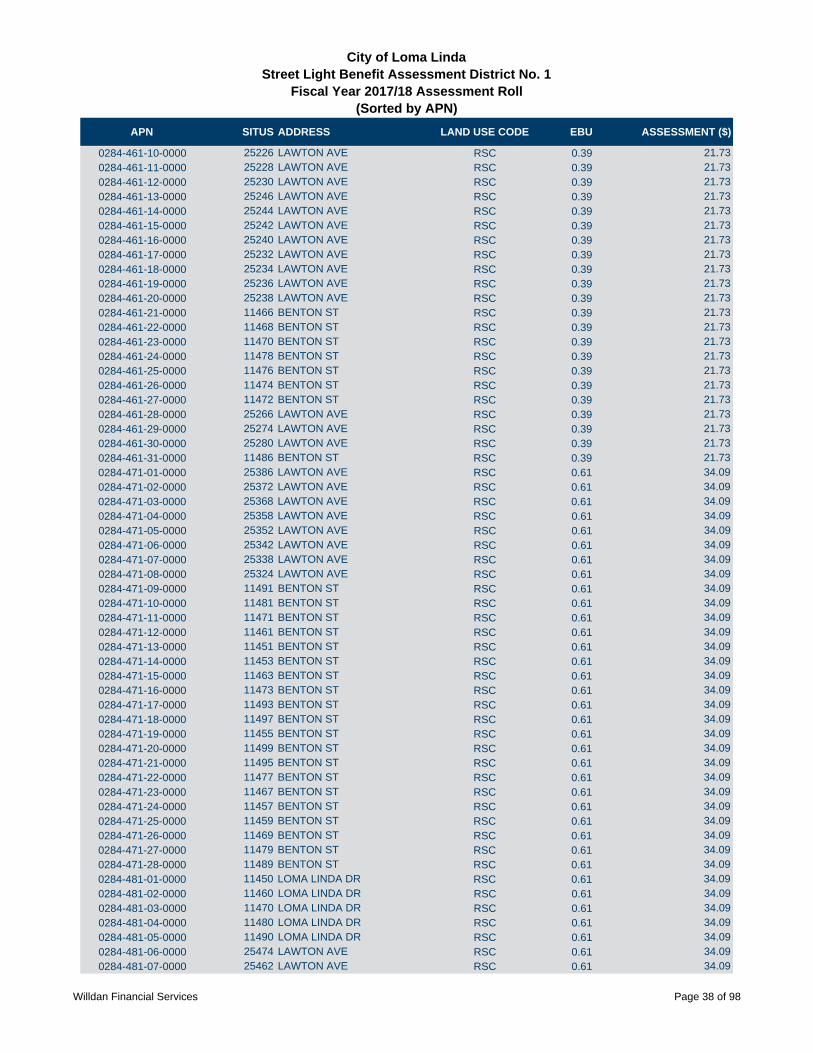
APN SITUS ADDRESS LAND USE CODE EBU ASSESSMENT ($)
City of Loma LindaStreet Light Benefit Assessment District No. 1
Fiscal Year 2017/18 Assessment Roll (Sorted by APN)
0284-461-10-0000 25226 LAWTON AVE RSC 0.39 21.73
0284-461-11-0000 25228 LAWTON AVE RSC 0.39 21.73
0284-461-12-0000 25230 LAWTON AVE RSC 0.39 21.73
0284-461-13-0000 25246 LAWTON AVE RSC 0.39 21.73
0284-461-14-0000 25244 LAWTON AVE RSC 0.39 21.73
0284-461-15-0000 25242 LAWTON AVE RSC 0.39 21.73
0284-461-16-0000 25240 LAWTON AVE RSC 0.39 21.73
0284-461-17-0000 25232 LAWTON AVE RSC 0.39 21.73
0284-461-18-0000 25234 LAWTON AVE RSC 0.39 21.73
0284-461-19-0000 25236 LAWTON AVE RSC 0.39 21.73
0284-461-20-0000 25238 LAWTON AVE RSC 0.39 21.73
0284-461-21-0000 11466 BENTON ST RSC 0.39 21.73
0284-461-22-0000 11468 BENTON ST RSC 0.39 21.73
0284-461-23-0000 11470 BENTON ST RSC 0.39 21.73
0284-461-24-0000 11478 BENTON ST RSC 0.39 21.73
0284-461-25-0000 11476 BENTON ST RSC 0.39 21.73
0284-461-26-0000 11474 BENTON ST RSC 0.39 21.73
0284-461-27-0000 11472 BENTON ST RSC 0.39 21.73
0284-461-28-0000 25266 LAWTON AVE RSC 0.39 21.73
0284-461-29-0000 25274 LAWTON AVE RSC 0.39 21.73
0284-461-30-0000 25280 LAWTON AVE RSC 0.39 21.73
0284-461-31-0000 11486 BENTON ST RSC 0.39 21.73
0284-471-01-0000 25386 LAWTON AVE RSC 0.61 34.09
0284-471-02-0000 25372 LAWTON AVE RSC 0.61 34.09
0284-471-03-0000 25368 LAWTON AVE RSC 0.61 34.09
0284-471-04-0000 25358 LAWTON AVE RSC 0.61 34.09
0284-471-05-0000 25352 LAWTON AVE RSC 0.61 34.09
0284-471-06-0000 25342 LAWTON AVE RSC 0.61 34.09
0284-471-07-0000 25338 LAWTON AVE RSC 0.61 34.09
0284-471-08-0000 25324 LAWTON AVE RSC 0.61 34.09
0284-471-09-0000 11491 BENTON ST RSC 0.61 34.09
0284-471-10-0000 11481 BENTON ST RSC 0.61 34.09
0284-471-11-0000 11471 BENTON ST RSC 0.61 34.09
0284-471-12-0000 11461 BENTON ST RSC 0.61 34.09
0284-471-13-0000 11451 BENTON ST RSC 0.61 34.09
0284-471-14-0000 11453 BENTON ST RSC 0.61 34.09
0284-471-15-0000 11463 BENTON ST RSC 0.61 34.09
0284-471-16-0000 11473 BENTON ST RSC 0.61 34.09
0284-471-17-0000 11493 BENTON ST RSC 0.61 34.09
0284-471-18-0000 11497 BENTON ST RSC 0.61 34.09
0284-471-19-0000 11455 BENTON ST RSC 0.61 34.09
0284-471-20-0000 11499 BENTON ST RSC 0.61 34.09
0284-471-21-0000 11495 BENTON ST RSC 0.61 34.09
0284-471-22-0000 11477 BENTON ST RSC 0.61 34.09
0284-471-23-0000 11467 BENTON ST RSC 0.61 34.09
0284-471-24-0000 11457 BENTON ST RSC 0.61 34.09
0284-471-25-0000 11459 BENTON ST RSC 0.61 34.09
0284-471-26-0000 11469 BENTON ST RSC 0.61 34.09
0284-471-27-0000 11479 BENTON ST RSC 0.61 34.09
0284-471-28-0000 11489 BENTON ST RSC 0.61 34.09
0284-481-01-0000 11450 LOMA LINDA DR RSC 0.61 34.09
0284-481-02-0000 11460 LOMA LINDA DR RSC 0.61 34.09
0284-481-03-0000 11470 LOMA LINDA DR RSC 0.61 34.09
0284-481-04-0000 11480 LOMA LINDA DR RSC 0.61 34.09
0284-481-05-0000 11490 LOMA LINDA DR RSC 0.61 34.09
0284-481-06-0000 25474 LAWTON AVE RSC 0.61 34.09
0284-481-07-0000 25462 LAWTON AVE RSC 0.61 34.09
Willdan Financial Services Page 38 of 98
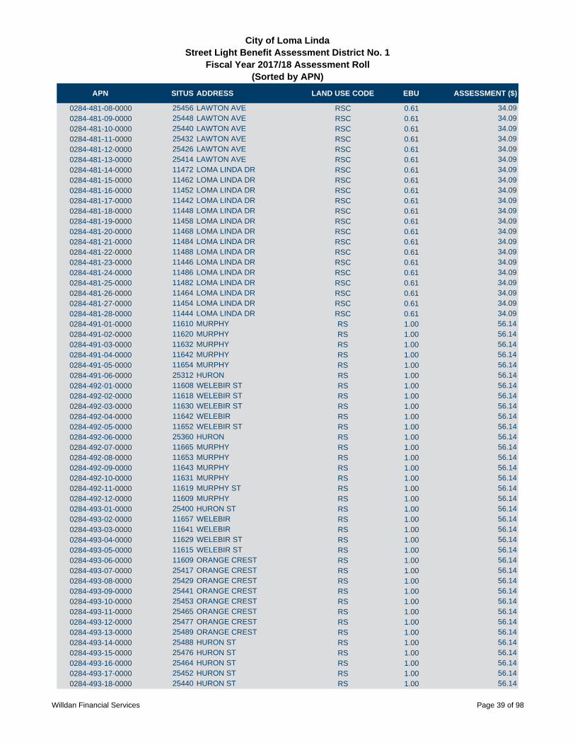
APN SITUS ADDRESS LAND USE CODE EBU ASSESSMENT ($)
City of Loma LindaStreet Light Benefit Assessment District No. 1
Fiscal Year 2017/18 Assessment Roll (Sorted by APN)
0284-481-08-0000 25456 LAWTON AVE RSC 0.61 34.09
0284-481-09-0000 25448 LAWTON AVE RSC 0.61 34.09
0284-481-10-0000 25440 LAWTON AVE RSC 0.61 34.09
0284-481-11-0000 25432 LAWTON AVE RSC 0.61 34.09
0284-481-12-0000 25426 LAWTON AVE RSC 0.61 34.09
0284-481-13-0000 25414 LAWTON AVE RSC 0.61 34.09
0284-481-14-0000 11472 LOMA LINDA DR RSC 0.61 34.09
0284-481-15-0000 11462 LOMA LINDA DR RSC 0.61 34.09
0284-481-16-0000 11452 LOMA LINDA DR RSC 0.61 34.09
0284-481-17-0000 11442 LOMA LINDA DR RSC 0.61 34.09
0284-481-18-0000 11448 LOMA LINDA DR RSC 0.61 34.09
0284-481-19-0000 11458 LOMA LINDA DR RSC 0.61 34.09
0284-481-20-0000 11468 LOMA LINDA DR RSC 0.61 34.09
0284-481-21-0000 11484 LOMA LINDA DR RSC 0.61 34.09
0284-481-22-0000 11488 LOMA LINDA DR RSC 0.61 34.09
0284-481-23-0000 11446 LOMA LINDA DR RSC 0.61 34.09
0284-481-24-0000 11486 LOMA LINDA DR RSC 0.61 34.09
0284-481-25-0000 11482 LOMA LINDA DR RSC 0.61 34.09
0284-481-26-0000 11464 LOMA LINDA DR RSC 0.61 34.09
0284-481-27-0000 11454 LOMA LINDA DR RSC 0.61 34.09
0284-481-28-0000 11444 LOMA LINDA DR RSC 0.61 34.09
0284-491-01-0000 11610 MURPHY RS 1.00 56.14
0284-491-02-0000 11620 MURPHY RS 1.00 56.14
0284-491-03-0000 11632 MURPHY RS 1.00 56.14
0284-491-04-0000 11642 MURPHY RS 1.00 56.14
0284-491-05-0000 11654 MURPHY RS 1.00 56.14
0284-491-06-0000 25312 HURON RS 1.00 56.14
0284-492-01-0000 11608 WELEBIR ST RS 1.00 56.14
0284-492-02-0000 11618 WELEBIR ST RS 1.00 56.14
0284-492-03-0000 11630 WELEBIR ST RS 1.00 56.14
0284-492-04-0000 11642 WELEBIR RS 1.00 56.14
0284-492-05-0000 11652 WELEBIR ST RS 1.00 56.14
0284-492-06-0000 25360 HURON RS 1.00 56.14
0284-492-07-0000 11665 MURPHY RS 1.00 56.14
0284-492-08-0000 11653 MURPHY RS 1.00 56.14
0284-492-09-0000 11643 MURPHY RS 1.00 56.14
0284-492-10-0000 11631 MURPHY RS 1.00 56.14
0284-492-11-0000 11619 MURPHY ST RS 1.00 56.14
0284-492-12-0000 11609 MURPHY RS 1.00 56.14
0284-493-01-0000 25400 HURON ST RS 1.00 56.14
0284-493-02-0000 11657 WELEBIR RS 1.00 56.14
0284-493-03-0000 11641 WELEBIR RS 1.00 56.14
0284-493-04-0000 11629 WELEBIR ST RS 1.00 56.14
0284-493-05-0000 11615 WELEBIR ST RS 1.00 56.14
0284-493-06-0000 11609 ORANGE CREST RS 1.00 56.14
0284-493-07-0000 25417 ORANGE CREST RS 1.00 56.14
0284-493-08-0000 25429 ORANGE CREST RS 1.00 56.14
0284-493-09-0000 25441 ORANGE CREST RS 1.00 56.14
0284-493-10-0000 25453 ORANGE CREST RS 1.00 56.14
0284-493-11-0000 25465 ORANGE CREST RS 1.00 56.14
0284-493-12-0000 25477 ORANGE CREST RS 1.00 56.14
0284-493-13-0000 25489 ORANGE CREST RS 1.00 56.14
0284-493-14-0000 25488 HURON ST RS 1.00 56.14
0284-493-15-0000 25476 HURON ST RS 1.00 56.14
0284-493-16-0000 25464 HURON ST RS 1.00 56.14
0284-493-17-0000 25452 HURON ST RS 1.00 56.14
0284-493-18-0000 25440 HURON ST RS 1.00 56.14
Willdan Financial Services Page 39 of 98
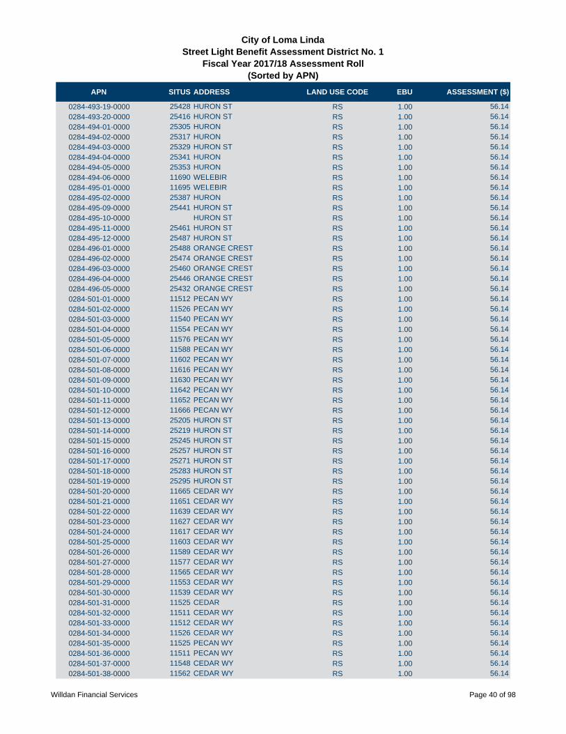
APN SITUS ADDRESS LAND USE CODE EBU ASSESSMENT ($)
City of Loma LindaStreet Light Benefit Assessment District No. 1
Fiscal Year 2017/18 Assessment Roll (Sorted by APN)
0284-493-19-0000 25428 HURON ST RS 1.00 56.14
0284-493-20-0000 25416 HURON ST RS 1.00 56.14
0284-494-01-0000 25305 HURON RS 1.00 56.14
0284-494-02-0000 25317 HURON RS 1.00 56.14
0284-494-03-0000 25329 HURON ST RS 1.00 56.14
0284-494-04-0000 25341 HURON RS 1.00 56.14
0284-494-05-0000 25353 HURON RS 1.00 56.14
0284-494-06-0000 11690 WELEBIR RS 1.00 56.14
0284-495-01-0000 11695 WELEBIR RS 1.00 56.14
0284-495-02-0000 25387 HURON RS 1.00 56.14
0284-495-09-0000 25441 HURON ST RS 1.00 56.14
0284-495-10-0000 HURON ST RS 1.00 56.14
0284-495-11-0000 25461 HURON ST RS 1.00 56.14
0284-495-12-0000 25487 HURON ST RS 1.00 56.14
0284-496-01-0000 25488 ORANGE CREST RS 1.00 56.14
0284-496-02-0000 25474 ORANGE CREST RS 1.00 56.14
0284-496-03-0000 25460 ORANGE CREST RS 1.00 56.14
0284-496-04-0000 25446 ORANGE CREST RS 1.00 56.14
0284-496-05-0000 25432 ORANGE CREST RS 1.00 56.14
0284-501-01-0000 11512 PECAN WY RS 1.00 56.14
0284-501-02-0000 11526 PECAN WY RS 1.00 56.14
0284-501-03-0000 11540 PECAN WY RS 1.00 56.14
0284-501-04-0000 11554 PECAN WY RS 1.00 56.14
0284-501-05-0000 11576 PECAN WY RS 1.00 56.14
0284-501-06-0000 11588 PECAN WY RS 1.00 56.14
0284-501-07-0000 11602 PECAN WY RS 1.00 56.14
0284-501-08-0000 11616 PECAN WY RS 1.00 56.14
0284-501-09-0000 11630 PECAN WY RS 1.00 56.14
0284-501-10-0000 11642 PECAN WY RS 1.00 56.14
0284-501-11-0000 11652 PECAN WY RS 1.00 56.14
0284-501-12-0000 11666 PECAN WY RS 1.00 56.14
0284-501-13-0000 25205 HURON ST RS 1.00 56.14
0284-501-14-0000 25219 HURON ST RS 1.00 56.14
0284-501-15-0000 25245 HURON ST RS 1.00 56.14
0284-501-16-0000 25257 HURON ST RS 1.00 56.14
0284-501-17-0000 25271 HURON ST RS 1.00 56.14
0284-501-18-0000 25283 HURON ST RS 1.00 56.14
0284-501-19-0000 25295 HURON ST RS 1.00 56.14
0284-501-20-0000 11665 CEDAR WY RS 1.00 56.14
0284-501-21-0000 11651 CEDAR WY RS 1.00 56.14
0284-501-22-0000 11639 CEDAR WY RS 1.00 56.14
0284-501-23-0000 11627 CEDAR WY RS 1.00 56.14
0284-501-24-0000 11617 CEDAR WY RS 1.00 56.14
0284-501-25-0000 11603 CEDAR WY RS 1.00 56.14
0284-501-26-0000 11589 CEDAR WY RS 1.00 56.14
0284-501-27-0000 11577 CEDAR WY RS 1.00 56.14
0284-501-28-0000 11565 CEDAR WY RS 1.00 56.14
0284-501-29-0000 11553 CEDAR WY RS 1.00 56.14
0284-501-30-0000 11539 CEDAR WY RS 1.00 56.14
0284-501-31-0000 11525 CEDAR RS 1.00 56.14
0284-501-32-0000 11511 CEDAR WY RS 1.00 56.14
0284-501-33-0000 11512 CEDAR WY RS 1.00 56.14
0284-501-34-0000 11526 CEDAR WY RS 1.00 56.14
0284-501-35-0000 11525 PECAN WY RS 1.00 56.14
0284-501-36-0000 11511 PECAN WY RS 1.00 56.14
0284-501-37-0000 11548 CEDAR WY RS 1.00 56.14
0284-501-38-0000 11562 CEDAR WY RS 1.00 56.14
Willdan Financial Services Page 40 of 98
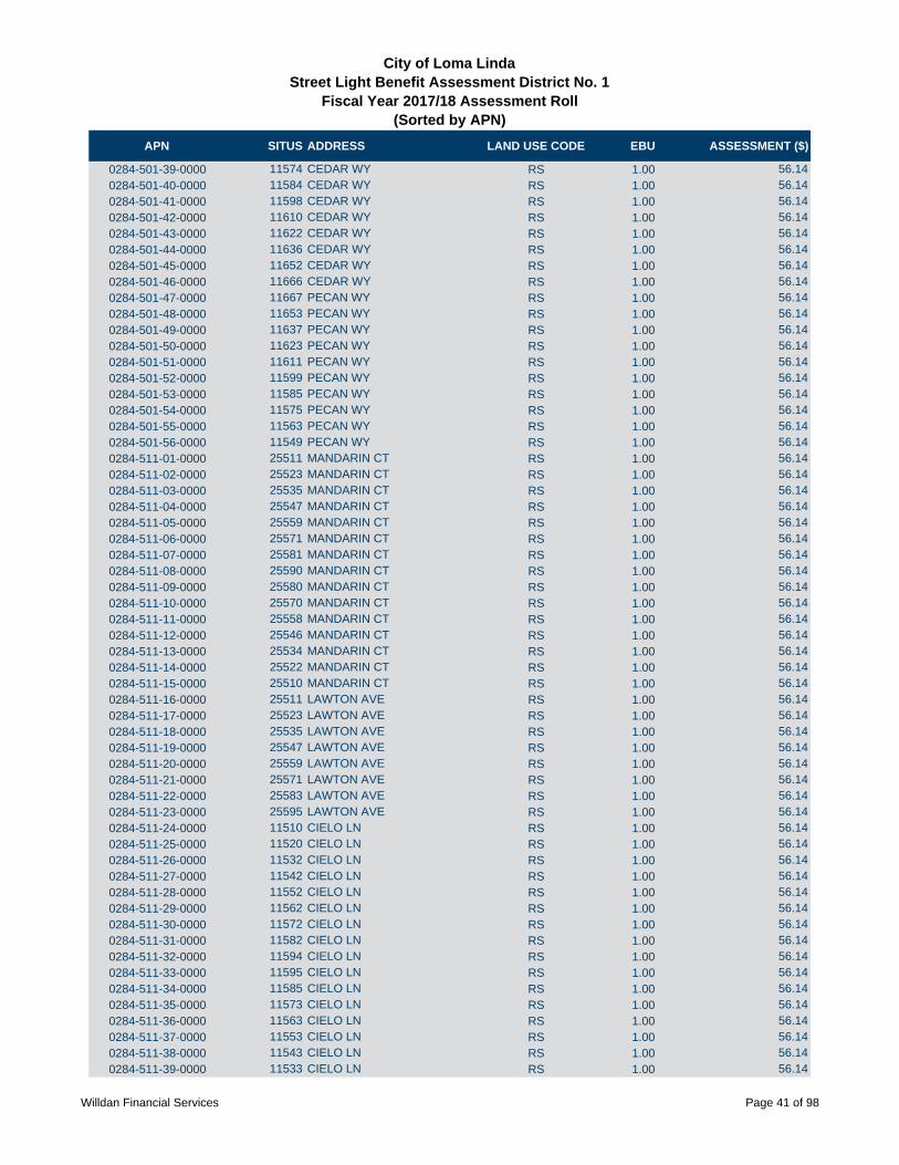
APN SITUS ADDRESS LAND USE CODE EBU ASSESSMENT ($)
City of Loma LindaStreet Light Benefit Assessment District No. 1
Fiscal Year 2017/18 Assessment Roll (Sorted by APN)
0284-501-39-0000 11574 CEDAR WY RS 1.00 56.14
0284-501-40-0000 11584 CEDAR WY RS 1.00 56.14
0284-501-41-0000 11598 CEDAR WY RS 1.00 56.14
0284-501-42-0000 11610 CEDAR WY RS 1.00 56.14
0284-501-43-0000 11622 CEDAR WY RS 1.00 56.14
0284-501-44-0000 11636 CEDAR WY RS 1.00 56.14
0284-501-45-0000 11652 CEDAR WY RS 1.00 56.14
0284-501-46-0000 11666 CEDAR WY RS 1.00 56.14
0284-501-47-0000 11667 PECAN WY RS 1.00 56.14
0284-501-48-0000 11653 PECAN WY RS 1.00 56.14
0284-501-49-0000 11637 PECAN WY RS 1.00 56.14
0284-501-50-0000 11623 PECAN WY RS 1.00 56.14
0284-501-51-0000 11611 PECAN WY RS 1.00 56.14
0284-501-52-0000 11599 PECAN WY RS 1.00 56.14
0284-501-53-0000 11585 PECAN WY RS 1.00 56.14
0284-501-54-0000 11575 PECAN WY RS 1.00 56.14
0284-501-55-0000 11563 PECAN WY RS 1.00 56.14
0284-501-56-0000 11549 PECAN WY RS 1.00 56.14
0284-511-01-0000 25511 MANDARIN CT RS 1.00 56.14
0284-511-02-0000 25523 MANDARIN CT RS 1.00 56.14
0284-511-03-0000 25535 MANDARIN CT RS 1.00 56.14
0284-511-04-0000 25547 MANDARIN CT RS 1.00 56.14
0284-511-05-0000 25559 MANDARIN CT RS 1.00 56.14
0284-511-06-0000 25571 MANDARIN CT RS 1.00 56.14
0284-511-07-0000 25581 MANDARIN CT RS 1.00 56.14
0284-511-08-0000 25590 MANDARIN CT RS 1.00 56.14
0284-511-09-0000 25580 MANDARIN CT RS 1.00 56.14
0284-511-10-0000 25570 MANDARIN CT RS 1.00 56.14
0284-511-11-0000 25558 MANDARIN CT RS 1.00 56.14
0284-511-12-0000 25546 MANDARIN CT RS 1.00 56.14
0284-511-13-0000 25534 MANDARIN CT RS 1.00 56.14
0284-511-14-0000 25522 MANDARIN CT RS 1.00 56.14
0284-511-15-0000 25510 MANDARIN CT RS 1.00 56.14
0284-511-16-0000 25511 LAWTON AVE RS 1.00 56.14
0284-511-17-0000 25523 LAWTON AVE RS 1.00 56.14
0284-511-18-0000 25535 LAWTON AVE RS 1.00 56.14
0284-511-19-0000 25547 LAWTON AVE RS 1.00 56.14
0284-511-20-0000 25559 LAWTON AVE RS 1.00 56.14
0284-511-21-0000 25571 LAWTON AVE RS 1.00 56.14
0284-511-22-0000 25583 LAWTON AVE RS 1.00 56.14
0284-511-23-0000 25595 LAWTON AVE RS 1.00 56.14
0284-511-24-0000 11510 CIELO LN RS 1.00 56.14
0284-511-25-0000 11520 CIELO LN RS 1.00 56.14
0284-511-26-0000 11532 CIELO LN RS 1.00 56.14
0284-511-27-0000 11542 CIELO LN RS 1.00 56.14
0284-511-28-0000 11552 CIELO LN RS 1.00 56.14
0284-511-29-0000 11562 CIELO LN RS 1.00 56.14
0284-511-30-0000 11572 CIELO LN RS 1.00 56.14
0284-511-31-0000 11582 CIELO LN RS 1.00 56.14
0284-511-32-0000 11594 CIELO LN RS 1.00 56.14
0284-511-33-0000 11595 CIELO LN RS 1.00 56.14
0284-511-34-0000 11585 CIELO LN RS 1.00 56.14
0284-511-35-0000 11573 CIELO LN RS 1.00 56.14
0284-511-36-0000 11563 CIELO LN RS 1.00 56.14
0284-511-37-0000 11553 CIELO LN RS 1.00 56.14
0284-511-38-0000 11543 CIELO LN RS 1.00 56.14
0284-511-39-0000 11533 CIELO LN RS 1.00 56.14
Willdan Financial Services Page 41 of 98

APN SITUS ADDRESS LAND USE CODE EBU ASSESSMENT ($)
City of Loma LindaStreet Light Benefit Assessment District No. 1
Fiscal Year 2017/18 Assessment Roll (Sorted by APN)
0284-511-40-0000 11521 CIELO LN RS 1.00 56.14
0284-511-41-0000 11511 CIELO LN RS 1.00 56.14
0284-511-42-0000 25511 NICKS AVE RS 1.00 56.14
0284-511-43-0000 25523 E NICKS AVE RS 1.00 56.14
0284-511-44-0000 25535 E NICKS AVE RS 1.00 56.14
0284-511-45-0000 25547 NICKS AVE RS 1.00 56.14
0284-511-46-0000 25559 E NICKS ST RS 1.00 56.14
0284-511-47-0000 25571 NICKS AVE RS 1.00 56.14
0284-511-48-0000 25581 E NICKS AVE RS 1.00 56.14
0284-511-49-0000 25590 NICKS AVE RS 1.00 56.14
0284-511-50-0000 25580 E NICKS AVE RS 1.00 56.14
0284-511-51-0000 25570 NICKS AVE RS 1.00 56.14
0284-511-52-0000 25558 NICKS AVE RS 1.00 56.14
0284-511-53-0000 25546 E NICKS AVE RS 1.00 56.14
0284-511-54-0000 25534 E NICKS AVE RS 1.00 56.14
0284-511-55-0000 25522 NICKS AVE RS 1.00 56.14
0284-511-56-0000 25510 E NICKS AVE RS 1.00 56.14
0284-511-57-0000 25699 LAWTON ST RSC 0.59 33.27
0284-511-58-0000 25697 LAWTON ST RSC 0.59 33.27
0284-511-59-0000 25695 LAWTON ST RSC 0.59 33.27
0284-511-60-0000 25693 LAWTON ST RSC 0.59 33.27
0284-511-61-0000 25691 LAWTON ST RSC 0.59 33.27
0284-511-62-0000 25689 LAWTON ST RSC 0.59 33.27
0284-511-63-0000 25687 LAWTON ST RSC 0.59 33.27
0284-511-64-0000 25685 LAWTON ST RSC 0.59 33.27
0284-511-65-0000 25683 LAWTON ST RSC 0.59 33.27
0284-511-66-0000 25681 LAWTON ST RSC 0.59 33.27
0284-511-67-0000 25679 LAWTON ST RSC 0.59 33.27
0284-511-68-0000 25677 LAWTON ST RSC 0.59 33.27
0284-511-69-0000 25675 LAWTON ST RSC 0.59 33.27
0284-511-70-0000 25673 LAWTON ST RSC 0.59 33.27
0284-511-71-0000 25651 LAWTON ST RSC 0.59 33.27
0284-511-72-0000 25649 LAWTON ST RSC 0.59 33.27
0284-511-73-0000 25647 LAWTON ST RSC 0.59 33.27
0284-511-74-0000 25653 LAWTON ST RSC 0.59 33.27
0284-511-75-0000 25655 LAWTON ST RSC 0.59 33.27
0284-511-76-0000 25657 LAWTON ST RSC 0.59 33.27
0284-511-77-0000 25659 LAWTON ST RSC 0.59 33.27
0284-511-78-0000 25661 LAWTON ST RSC 0.59 33.27
0284-511-79-0000 25663 LAWTON ST RSC 0.59 33.27
0284-511-80-0000 25665 LAWTON ST RSC 0.59 33.27
0284-511-81-0000 25667 LAWTON ST RSC 0.59 33.27
0284-511-82-0000 25669 LAWTON ST RSC 0.59 33.27
0284-511-83-0000 25671 LAWTON ST RSC 0.59 33.27
0284-521-01-0000 11604 CIELO LN RS 1.00 56.14
0284-521-02-0000 11614 CIELO LN RS 1.00 56.14
0284-521-03-0000 11624 CIELO LN RS 1.00 56.14
0284-521-04-0000 11634 CIELO LN RS 1.00 56.14
0284-521-05-0000 11644 CIELO LN RS 1.00 56.14
0284-521-06-0000 11654 CIELO LN RS 1.00 56.14
0284-521-07-0000 11666 CIELO LN RS 1.00 56.14
0284-521-08-0000 11684 CIELO LN RS 1.00 56.14
0284-521-09-0000 11696 CIELO LN RS 1.00 56.14
0284-521-10-0000 11697 CIELO LN RS 1.00 56.14
0284-521-11-0000 11685 CIELO LN RS 1.00 56.14
0284-521-12-0000 11667 CIELO LN RS 1.00 56.14
0284-521-13-0000 11655 CIELO LN RS 1.00 56.14
Willdan Financial Services Page 42 of 98

APN SITUS ADDRESS LAND USE CODE EBU ASSESSMENT ($)
City of Loma LindaStreet Light Benefit Assessment District No. 1
Fiscal Year 2017/18 Assessment Roll (Sorted by APN)
0284-521-14-0000 11645 CIELO LN RS 1.00 56.14
0284-521-15-0000 11635 CIELO LN RS 1.00 56.14
0284-521-16-0000 11625 CIELO LN RS 1.00 56.14
0284-521-17-0000 11615 CIELO LN RS 1.00 56.14
0284-521-18-0000 11605 CIELO LN RS 1.00 56.14
0284-521-19-0000 25511 HURON ST RS 1.00 56.14
0284-521-20-0000 25525 HURON ST RS 1.00 56.14
0284-521-21-0000 25539 HURON ST RS 1.00 56.14
0284-521-22-0000 25553 HURON ST RS 1.00 56.14
0284-521-23-0000 25567 HURON ST RS 1.00 56.14
0284-521-24-0000 25581 HURON ST RS 1.00 56.14
0284-521-25-0000 25595 HURON ST RS 1.00 56.14
0284-521-26-0000 25594 HURON ST RS 1.00 56.14
0284-521-27-0000 25582 HURON ST RS 1.00 56.14
0284-521-28-0000 25570 HURON ST RS 1.00 56.14
0284-521-29-0000 25558 HURON ST RS 1.00 56.14
0284-521-30-0000 25546 HURON ST RS 1.00 56.14
0284-521-31-0000 25534 HURON ST RS 1.00 56.14
0284-521-32-0000 25522 HURON ST RS 1.00 56.14
0284-521-33-0000 25510 HURON ST RS 1.00 56.14
0284-521-34-0000 25511 ORANGE CREST RS 1.00 56.14
0284-521-35-0000 25523 ORANGE CREST RS 1.00 56.14
0284-521-36-0000 25535 ORANGE CREST RS 1.00 56.14
0284-521-37-0000 25547 ORANGE CREST RS 1.00 56.14
0284-521-38-0000 25559 ORANGE CREST RS 1.00 56.14
0284-521-39-0000 25571 ORANGE CREST RS 1.00 56.14
0284-521-40-0000 25581 E ORANGE CREST RS 1.00 56.14
0284-521-41-0000 25590 E ORANGE CREST RS 1.00 56.14
0284-521-42-0000 25580 E ORANGE CREST RS 1.00 56.14
0284-521-43-0000 25570 E ORANGE CREST RS 1.00 56.14
0284-521-44-0000 25558 ORANGE CREST RS 1.00 56.14
0284-521-45-0000 25546 ORANGE CREST RS 1.00 56.14
0284-521-46-0000 25534 E ORANGE CREST RS 1.00 56.14
0284-521-47-0000 25522 ORANGE CREST RS 1.00 56.14
0284-521-48-0000 25510 E ORANGE CREST RS 1.00 56.14
0284-521-49-0000 25644 HURON ST RSC 0.59 33.28
0284-521-50-0000 25646 HURON ST RSC 0.59 33.28
0284-521-51-0000 25648 HURON ST RSC 0.59 33.28
0284-521-52-0000 25670 HURON ST RSC 0.59 33.28
0284-521-53-0000 25672 HURON ST RSC 0.59 33.28
0284-521-54-0000 25674 HURON ST RSC 0.59 33.28
0284-521-55-0000 25676 HURON ST RSC 0.59 33.28
0284-521-56-0000 25678 HURON ST RSC 0.59 33.28
0284-521-57-0000 25680 HURON ST RSC 0.59 33.28
0284-521-58-0000 25682 HURON ST RSC 0.59 33.28
0284-521-59-0000 25684 HURON ST RSC 0.59 33.28
0284-521-60-0000 25686 HURON ST RSC 0.59 33.28
0284-521-61-0000 25688 HURON ST RSC 0.59 33.28
0284-521-62-0000 25690 HURON ST RSC 0.59 33.28
0284-521-63-0000 25692 HURON ST RSC 0.59 33.28
0284-521-64-0000 25694 HURON ST RSC 0.59 33.28
0284-521-65-0000 25696 HURON ST RSC 0.59 33.28
0284-521-66-0000 25698 HURON ST RSC 0.59 33.28
0284-521-67-0000 25668 HURON ST RSC 0.59 33.28
0284-521-68-0000 25666 HURON ST RSC 0.59 33.28
0284-521-69-0000 25664 HURON ST RSC 0.59 33.28
0284-521-70-0000 25662 HURON ST RSC 0.59 33.28
Willdan Financial Services Page 43 of 98

APN SITUS ADDRESS LAND USE CODE EBU ASSESSMENT ($)
City of Loma LindaStreet Light Benefit Assessment District No. 1
Fiscal Year 2017/18 Assessment Roll (Sorted by APN)
0284-521-71-0000 25660 HURON ST RSC 0.59 33.28
0284-521-72-0000 25658 HURON ST RSC 0.59 33.28
0284-521-73-0000 25656 HURON ST RSC 0.59 33.28
0284-521-74-0000 25654 HURON ST RSC 0.59 33.28
0284-521-75-0000 25652 HURON ST RSC 0.59 33.28
0284-521-76-0000 25650 HURON ST RSC 0.59 33.28
0284-521-78-0000 25661 HURON ST RS 1.00 56.14
0284-521-79-0000 25677 HURON ST RS 1.00 56.14
0284-521-80-0000 25693 HURON ST RS 1.00 56.14
0284-531-01-0000 10993 RINCON ST RS 1.00 56.14
0284-531-02-0000 10983 RINCON ST RS 1.00 56.14
0284-531-03-0000 10973 RINCON ST RS 1.00 56.14
0284-531-04-0000 10963 RINCON ST RS 1.00 56.14
0284-531-05-0000 10953 RINCON ST RS 1.00 56.14
0284-531-06-0000 10943 RINCON ST RS 1.00 56.14
0284-531-07-0000 10933 RINCON ST RS 1.00 56.14
0284-531-08-0000 10923 RINCON ST RS 1.00 56.14
0284-531-09-0000 10913 RINCON ST RS 1.00 56.14
0284-531-10-0000 10903 RINCON 09 ST RS 1.00 56.14
0284-531-11-0000 24555 CANADA ST RS 1.00 56.14
0284-531-12-0000 24567 CANADA ST RS 1.00 56.14
0284-531-13-0000 24573 CANADA ST RS 1.00 56.14
0284-531-18-0000 24576 CANADA ST RS 1.00 56.14
0284-531-19-0000 24566 CANADA ST RS 1.00 56.14
0284-531-20-0000 24554 CANADA ST RS 1.00 56.14
0284-531-22-0000 24510 CANADA 04 ST RS 1.00 56.14
0284-531-23-0000 10912 RINCON 18 ST RS 1.00 56.14
0284-531-24-0000 10922 RINCON 28 ST RS 1.00 56.14
0284-531-25-0000 10932 RINCON 38 ST RS 1.00 56.14
0284-531-26-0000 10942 RINCON ST RS 1.00 56.14
0284-531-27-0000 10952 RINCON 58 ST RS 1.00 56.14
0284-531-28-0000 10962 RINCON 68 ST RS 1.00 56.14
0284-531-29-0000 10972 RINCON 78 ST RS 1.00 56.14
0284-531-30-0000 10982 RINCON 88 ST RS 1.00 56.14
0284-531-31-0000 10992 RINCON 98 ST RS 1.00 56.14
0284-531-32-0000 24594 CANADA ST RS 1.00 56.14
0284-531-33-0000 24629 CANADA ST RS 1.00 56.14
0284-531-34-0000 24613 CANADA ST RS 1.00 56.14
0284-531-35-0000 24589 CANADA ST RS 1.00 56.14
0284-541-01-0000 25624 CARROL CT RS 1.00 56.14
0284-541-02-0000 25612 CARROL CT RS 1.00 56.14
0284-541-03-0000 25611 CARROL CT RS 1.00 56.14
0284-541-04-0000 25623 CARROL CT RS 1.00 56.14
0284-541-05-0000 25624 ALLEN WY RS 1.00 56.14
0284-541-06-0000 25612 ALLEN WY RS 1.00 56.14
0284-541-07-0000 25613 ALLEN WY RS 1.00 56.14
0284-541-08-0000 25627 ALLEN WY RS 1.00 56.14
0284-541-09-0000 25641 ALLEN WY RS 1.00 56.14
0284-541-10-0000 25655 ALLEN WY RS 1.00 56.14
0284-541-11-0000 25669 ALLEN WY RS 1.00 56.14
0284-541-12-0000 25683 ALLEN WY RS 1.00 56.14
0284-541-13-0000 25695 ALLEN WY RS 1.00 56.14
0284-541-14-0000 25696 ALLEN WY RS 1.00 56.14
0284-541-15-0000 25684 ALLEN WY RS 1.00 56.14
0284-541-16-0000 25672 ALLEN WY RS 1.00 56.14
0284-541-17-0000 25660 ALLEN WY RS 1.00 56.14
0284-541-18-0000 25648 ALLEN WY RS 1.00 56.14
Willdan Financial Services Page 44 of 98

APN SITUS ADDRESS LAND USE CODE EBU ASSESSMENT ($)
City of Loma LindaStreet Light Benefit Assessment District No. 1
Fiscal Year 2017/18 Assessment Roll (Sorted by APN)
0284-541-19-0000 25647 CARROL CT RS 1.00 56.14
0284-541-20-0000 25659 CARROL CT RS 1.00 56.14
0284-541-21-0000 25671 CARROL CT RS 1.00 56.14
0284-541-22-0000 25683 CARROL CT RS 1.00 56.14
0284-541-23-0000 25695 CARROL CT RS 1.00 56.14
0284-541-24-0000 25696 CARROL CT RS 1.00 56.14
0284-541-25-0000 25684 CARROL ST RS 1.00 56.14
0284-541-26-0000 25672 CARROL CT RS 1.00 56.14
0284-541-27-0000 25660 CARROL CT RS 1.00 56.14
0284-541-28-0000 25648 CARROL CT RS 1.00 56.14
0284-551-01-0000 11721 WELEBIR ST RS 1.00 56.14
0284-551-02-0000 11731 WELEBIR ST RS 1.00 56.14
0284-551-03-0000 11751 WELEBIR ST RS 1.00 56.14
0284-551-04-0000 11761 WELIBIR ST RS 1.00 56.14
0284-551-05-0000 WELEBIR ST RS 1.00 56.14
0284-551-06-0000 11781 WELEBIR ST RS 1.00 56.14
0284-551-07-0000 11722 WELIBIR ST RS 1.00 56.14
0284-551-08-0000 25342 CYPRESS ST RS 1.00 56.14
0284-551-09-0000 25330 CYPRESS ST RS 1.00 56.14
0284-551-10-0000 CYPRESS ST RS 1.00 56.14
0284-551-11-0000 25306 CYPRESS ST RS 1.00 56.14
0284-551-12-0000 25296 CYPRESS ST RS 1.00 56.14
0284-551-13-0000 11771 ALMOND CT RS 1.00 56.14
0284-551-14-0000 11761 ALMOND CT RS 1.00 56.14
0284-551-15-0000 11751 ALMOND CT RS 1.00 56.14
0284-551-16-0000 25323 CYPRESS ST RS 1.00 56.14
0284-551-17-0000 25337 CYPRESS ST RS 1.00 56.14
0284-551-18-0000 11746 WELEBIR ST RS 1.00 56.14
0284-551-19-0000 11756 WELEBIR ST RS 1.00 56.14
0284-551-20-0000 11762 WELEBIR ST RS 1.00 56.14
0284-551-24-0000 11778 WELEBIR ST RS 1.00 56.14
0284-551-27-0000 ALMOND CT RS 1.00 56.14
0284-561-01-0000 25284 CYPRESS ST RS 1.00 56.14
0284-561-02-0000 25272 CYPRESS ST RS 1.00 56.14
0284-561-03-0000 25258 CYPRESS ST RS 1.00 56.14
0284-561-04-0000 25246 CYPRESS ST RS 1.00 56.14
0284-561-06-0000 11730 PECAN WY RS 2.00 112.28
0284-561-07-0000 11750 PECAN WY RS 1.00 56.14
0284-561-10-0000 11780 PECAN WY RS 1.00 56.14
0284-561-11-0000 11790 PECAN WY RS 1.00 56.14
0284-561-12-0000 11781 S PECAN WY RS 1.00 56.14
0284-561-13-0000 11771 PECAN WY RS 1.00 56.14
0284-561-14-0000 11761 PECAN RS 1.00 56.14
0284-561-15-0000 11741 PECAN AVE RS 1.00 56.14
0284-561-16-0000 25243 CYPRESS ST RS 1.00 56.14
0284-561-17-0000 CYPRESS ST RS 1.00 56.14
0284-561-18-0000 11748 ALMOND CT RS 1.00 56.14
0284-561-19-0000 11758 ALMOND CT RS 1.00 56.14
0284-561-20-0000 11778 ALMOND CT RS 1.00 56.14
0284-561-21-0000 ALMOND CT RS 1.00 56.14
0284-561-23-0000 11770 PECAN WY RS 1.00 56.14
0284-561-25-0000 11710 PECAN RS 1.00 56.14
0284-561-26-0000 11760 PECAN RS 1.00 56.14
0284-651-01-0000 25543 PROSPECT AVE RSC 0.19 10.69
0284-651-02-0000 25545 PROSPECT AVE RSC 0.19 10.69
0284-651-03-0000 25549 PROSPECT AVE RSC 0.19 10.69
0284-651-04-0000 25551 PROSPECT AVE RSC 0.19 10.69
Willdan Financial Services Page 45 of 98

APN SITUS ADDRESS LAND USE CODE EBU ASSESSMENT ($)
City of Loma LindaStreet Light Benefit Assessment District No. 1
Fiscal Year 2017/18 Assessment Roll (Sorted by APN)
0284-651-05-0000 25553 PROSPECT AVE RSC 0.19 10.69
0284-651-06-0000 25563 PROSPECT AVE RSC 0.19 10.69
0284-651-07-0000 25561 PROSPECT AVE RSC 0.19 10.69
0284-651-08-0000 25557 PROSPECT AVE RSC 0.19 10.69
0284-651-09-0000 25555 PROSPECT AVE RSC 0.19 10.69
0284-651-10-0000 25565 PROSPECT AVE RSC 0.19 10.69
0284-651-11-0000 25567 PROSPECT AVE RSC 0.19 10.69
0284-651-12-0000 25571 PROSPECT AVE RSC 0.19 10.69
0284-651-13-0000 25573 PROSPECT AVE RSC 0.19 10.69
0284-651-14-0000 25585 PROSPECT AVE RSC 0.19 10.69
0284-651-15-0000 25583 PROSPECT AVE RSC 0.19 10.69
0284-651-16-0000 25581 PROSPECT AVE RSC 0.19 10.69
0284-651-17-0000 25577 PROSPECT AVE RSC 0.19 10.69
0284-651-18-0000 25575 PROSPECT AVE RSC 0.19 10.69
0284-651-19-0000 25587 PROSPECT AVE RSC 0.19 10.69
0284-651-20-0000 25589 PROSPECT AVE RSC 0.19 10.69
0284-651-21-0000 25593 PROSPECT AVE RSC 0.19 10.69
0284-651-22-0000 25595 PROSPECT AVE RSC 0.19 10.69
0284-651-23-0000 25605 PROSPECT AVE RSC 0.19 10.69
0284-651-24-0000 25603 PROSPECT AVE RSC 0.19 10.69
0284-651-25-0000 25599 PROSPECT AVE RSC 0.19 10.69
0284-651-26-0000 25597 PROSPECT AVE RSC 0.19 10.69
0284-651-27-0000 25607 PROSPECT AVE RSC 0.19 10.69
0284-651-28-0000 25609 PROSPECT AVE RSC 0.19 10.69
0284-651-29-0000 25613 PROSPECT AVE RSC 0.19 10.69
0284-651-30-0000 25615 PROSPECT AVE RSC 0.19 10.69
0284-651-31-0000 25617 PROSPECT AVE RSC 0.19 10.69
0284-651-32-0000 25627 PROSPECT AVE RSC 0.19 10.69
0284-651-33-0000 25625 PROSPECT AVE RSC 0.19 10.69
0284-651-34-0000 25621 PROSPECT AVE RSC 0.19 10.69
0284-651-35-0000 25619 PROSPECT AVE RSC 0.19 10.69
0284-651-36-0000 25629 PROSPECT AVE RSC 0.19 10.69
0284-651-37-0000 25631 PROSPECT AVE RSC 0.19 10.69
0284-651-38-0000 25635 PROSPECT AVE RSC 0.19 10.69
0284-651-39-0000 25637 PROSPECT AVE RSC 0.19 10.69
0284-651-40-0000 25639 PROSPECT AVE RSC 0.19 10.69
0284-651-41-0000 25645 PROSPECT AVE RSC 0.19 10.69
0284-651-42-0000 25641 PROSPECT AVE RSC 0.19 10.69
0284-661-01-0000 24281 PAULSON DR RS 1.00 56.14
0284-661-02-0000 24271 PAULSON DR RS 1.00 56.14
0284-661-03-0000 24261 PAULSON DR RS 1.00 56.14
0284-661-04-0000 24251 PAULSON DR RS 1.00 56.14
0284-661-05-0000 24241 PAULSON DR RS 1.00 56.14
0284-661-06-0000 24231 PAULSON DR RS 1.00 56.14
0284-661-07-0000 24221 PAULSON DR RS 1.00 56.14
0284-661-08-0000 24211 PAULSON DR RS 1.00 56.14
0284-661-09-0000 24199 PAULSON DR RS 1.00 56.14
0284-661-10-0000 24187 PAULSON DR RS 1.00 56.14
0284-661-11-0000 11300 VOLLMER DR RS 1.00 56.14
0284-661-12-0000 11290 VOLLMER DR RS 1.00 56.14
0284-661-13-0000 11278 VOLLMER DR RS 1.00 56.14
0284-661-14-0000 11268 VOLLMER DR RS 1.00 56.14
0284-661-15-0000 11256 VOLLMER DR RS 1.00 56.14
0284-661-16-0000 11246 VOLLMER DR RS 1.00 56.14
0284-661-17-0000 24162 KHAN DR RS 1.00 56.14
0284-661-18-0000 24172 KHAN DR RS 1.00 56.14
0284-661-19-0000 24184 KHAN DR RS 1.00 56.14
Willdan Financial Services Page 46 of 98
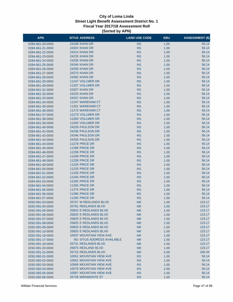
APN SITUS ADDRESS LAND USE CODE EBU ASSESSMENT ($)
City of Loma LindaStreet Light Benefit Assessment District No. 1
Fiscal Year 2017/18 Assessment Roll (Sorted by APN)
0284-661-20-0000 24198 KHAN DR RS 1.00 56.14
0284-661-21-0000 24204 KHAN DR RS 1.00 56.14
0284-661-22-0000 24214 KHAN DR RS 1.00 56.14
0284-661-23-0000 24226 KHAN DR RS 1.00 56.14
0284-661-24-0000 24236 KHAN DR RS 1.00 56.14
0284-661-25-0000 24246 KHAN DR RS 1.00 56.14
0284-661-26-0000 24258 KHAN DR RS 1.00 56.14
0284-661-27-0000 24270 KHAN DR RS 1.00 56.14
0284-661-28-0000 24282 KHAN DR RS 1.00 56.14
0284-661-29-0000 11247 VOLLMER DR RS 1.00 56.14
0284-661-30-0000 11257 VOLLMER DR RS 1.00 56.14
0284-661-31-0000 24207 KHAN DR RS 1.00 56.14
0284-661-32-0000 24225 KHAN DR RS 1.00 56.14
0284-661-33-0000 24237 KHAN DR RS 1.00 56.14
0284-661-34-0000 11247 WAREHAM CT RS 1.00 56.14
0284-661-35-0000 11261 WAREHAM CT RS 1.00 56.14
0284-661-36-0000 11273 WAREHAM CT RS 1.00 56.14
0284-661-37-0000 11273 VOLLMER DR RS 1.00 56.14
0284-661-38-0000 11283 VOLLMER DR RS 1.00 56.14
0284-661-39-0000 11293 VOLLMER DR RS 1.00 56.14
0284-661-40-0000 24226 PAULSON DR RS 1.00 56.14
0284-661-41-0000 24236 PAULSON DR RS 1.00 56.14
0284-661-42-0000 24246 PAULSON DR RS 1.00 56.14
0284-661-43-0000 24256 PAULSON DR RS 1.00 56.14
0284-661-44-0000 11278 PRICE DR RS 1.00 56.14
0284-661-45-0000 11268 PRICE DR RS 1.00 56.14
0284-661-46-0000 11258 PRICE DR RS 1.00 56.14
0284-661-47-0000 11248 PRICE DR RS 1.00 56.14
0284-661-48-0000 11238 PRICE DR RS 1.00 56.14
0284-661-49-0000 11226 PRICE DR RS 1.00 56.14
0284-661-50-0000 11225 PRICE DR RS 1.00 56.14
0284-661-51-0000 11235 PRICE DR RS 1.00 56.14
0284-661-52-0000 11245 PRICE DR RS 1.00 56.14
0284-661-53-0000 11255 PRICE DR RS 1.00 56.14
0284-661-54-0000 11265 PRICE DR RS 1.00 56.14
0284-661-55-0000 11275 PRICE DR RS 1.00 56.14
0284-661-56-0000 11285 PRICE DR RS 1.00 56.14
0284-661-57-0000 11295 PRICE DR RS 1.00 56.14
0292-091-03-0000 25757 W REDLANDS BLVD NR 1.00 123.17
0292-091-04-0000 25761 REDLANDS BLVD NR 1.00 123.17
0292-091-05-0000 25825 E REDLANDS BLVD NR 1.00 123.17
0292-091-06-0000 25825 E REDLANDS BLVD NR 1.00 123.17
0292-091-07-0000 25825 E REDLANDS BLVD NR 1.00 123.17
0292-091-08-0000 25825 E REDLANDS BLVD NR 1.00 123.17
0292-091-09-0000 25825 E REDLANDS BLVD NR 1.00 123.17
0292-091-10-0000 25825 E REDLANDS BLVD NR 1.00 123.17
0292-091-16-0000 10537 MOUNTAIN VIEW AVE NR 1.00 123.17
0292-091-17-0000 NO SITUS ADDRESS AVAILABLE NR 1.00 123.17
0292-091-18-0000 25731 REDLANDS BLVD NR 1.00 123.17
0292-091-20-0000 25875 REDLAND BLVD NR 1.00 123.17
0292-091-21-0000 25715 REDLANDS BLVD NR 2.00 246.34
0292-092-01-0000 10551 MOUNTAIN VIEW AVE RS 1.00 56.14
0292-092-02-0000 10561 MOUNTAIN VIEW AVE RS 1.00 56.14
0292-092-03-0000 10569 MOUNTAIN VIEW AVE RS 1.00 56.14
0292-092-04-0000 10579 MOUNTAIN VIEW AVE RS 1.00 56.14
0292-092-05-0000 10587 MOUNTAIN VIEW AVE RS 1.00 56.14
0292-092-06-0000 25728 MIRAMONTE ST RS 1.00 56.14
Willdan Financial Services Page 47 of 98
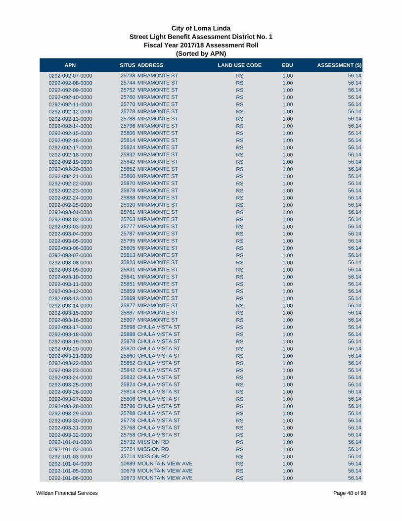
APN SITUS ADDRESS LAND USE CODE EBU ASSESSMENT ($)
City of Loma LindaStreet Light Benefit Assessment District No. 1
Fiscal Year 2017/18 Assessment Roll (Sorted by APN)
0292-092-07-0000 25738 MIRAMONTE ST RS 1.00 56.14
0292-092-08-0000 25744 MIRAMONTE ST RS 1.00 56.14
0292-092-09-0000 25752 MIRAMONTE ST RS 1.00 56.14
0292-092-10-0000 25760 MIRAMONTE ST RS 1.00 56.14
0292-092-11-0000 25770 MIRAMONTE ST RS 1.00 56.14
0292-092-12-0000 25778 MIRAMONTE ST RS 1.00 56.14
0292-092-13-0000 25788 MIRAMONTE ST RS 1.00 56.14
0292-092-14-0000 25796 MIRAMONTE ST RS 1.00 56.14
0292-092-15-0000 25806 MIRAMONTE ST RS 1.00 56.14
0292-092-16-0000 25814 MIRAMONTE ST RS 1.00 56.14
0292-092-17-0000 25824 MIRAMONTE ST RS 1.00 56.14
0292-092-18-0000 25832 MIRAMONTE ST RS 1.00 56.14
0292-092-19-0000 25842 MIRAMONTE ST RS 1.00 56.14
0292-092-20-0000 25852 MIRAMONTE ST RS 1.00 56.14
0292-092-21-0000 25860 MIRAMONTE ST RS 1.00 56.14
0292-092-22-0000 25870 MIRAMONTE ST RS 1.00 56.14
0292-092-23-0000 25878 MIRAMONTE ST RS 1.00 56.14
0292-092-24-0000 25888 MIRAMONTE ST RS 1.00 56.14
0292-092-25-0000 25920 MIRAMONTE ST RS 1.00 56.14
0292-093-01-0000 25761 MIRAMONTE ST RS 1.00 56.14
0292-093-02-0000 25763 MIRAMONTE ST RS 1.00 56.14
0292-093-03-0000 25777 MIRAMONTE ST RS 1.00 56.14
0292-093-04-0000 25787 MIRAMONTE ST RS 1.00 56.14
0292-093-05-0000 25795 MIRAMONTE ST RS 1.00 56.14
0292-093-06-0000 25805 MIRAMONTE ST RS 1.00 56.14
0292-093-07-0000 25813 MIRAMONTE ST RS 1.00 56.14
0292-093-08-0000 25823 MIRAMONTE ST RS 1.00 56.14
0292-093-09-0000 25831 MIRAMONTE ST RS 1.00 56.14
0292-093-10-0000 25841 MIRAMONTE ST RS 1.00 56.14
0292-093-11-0000 25851 MIRAMONTE ST RS 1.00 56.14
0292-093-12-0000 25859 MIRAMONTE ST RS 1.00 56.14
0292-093-13-0000 25869 MIRAMONTE ST RS 1.00 56.14
0292-093-14-0000 25877 MIRAMONTE ST RS 1.00 56.14
0292-093-15-0000 25887 MIRAMONTE ST RS 1.00 56.14
0292-093-16-0000 25907 MIRAMONTE ST RS 1.00 56.14
0292-093-17-0000 25898 CHULA VISTA ST RS 1.00 56.14
0292-093-18-0000 25888 CHULA VISTA ST RS 1.00 56.14
0292-093-19-0000 25878 CHULA VISTA ST RS 1.00 56.14
0292-093-20-0000 25870 CHULA VISTA ST RS 1.00 56.14
0292-093-21-0000 25860 CHULA VISTA ST RS 1.00 56.14
0292-093-22-0000 25852 CHULA VISTA ST RS 1.00 56.14
0292-093-23-0000 25842 CHULA VISTA ST RS 1.00 56.14
0292-093-24-0000 25832 CHULA VISTA ST RS 1.00 56.14
0292-093-25-0000 25824 CHULA VISTA ST RS 1.00 56.14
0292-093-26-0000 25814 CHULA VISTA ST RS 1.00 56.14
0292-093-27-0000 25806 CHULA VISTA ST RS 1.00 56.14
0292-093-28-0000 25796 CHULA VISTA ST RS 1.00 56.14
0292-093-29-0000 25788 CHULA VISTA ST RS 1.00 56.14
0292-093-30-0000 25778 CHULA VISTA ST RS 1.00 56.14
0292-093-31-0000 25768 CHULA VISTA ST RS 1.00 56.14
0292-093-32-0000 25758 CHULA VISTA ST RS 1.00 56.14
0292-101-01-0000 25732 MISSION RD RS 1.00 56.14
0292-101-02-0000 25724 MISSION RD RS 1.00 56.14
0292-101-03-0000 25714 MISSION RD RS 1.00 56.14
0292-101-04-0000 10689 MOUNTAIN VIEW AVE RS 1.00 56.14
0292-101-05-0000 10679 MOUNTAIN VIEW AVE RS 1.00 56.14
0292-101-06-0000 10673 MOUNTAIN VIEW AVE RS 1.00 56.14
Willdan Financial Services Page 48 of 98

APN SITUS ADDRESS LAND USE CODE EBU ASSESSMENT ($)
City of Loma LindaStreet Light Benefit Assessment District No. 1
Fiscal Year 2017/18 Assessment Roll (Sorted by APN)
0292-101-07-0000 10663 MOUNTAIN VIEW AVE RS 1.00 56.14
0292-101-08-0000 10655 MOUNTAIN VIEW AVE RS 1.00 56.14
0292-101-09-0000 10645 MOUNTAIN VIEW AVE RS 1.00 56.14
0292-101-10-0000 10635 MOUNTAIN VIEW AVE RS 1.00 56.14
0292-101-11-0000 10625 MOUNTAIN VIEW AVE RS 1.00 56.14
0292-101-12-0000 10617 MOUNTAIN VIEW AVE RS 1.00 56.14
0292-101-13-0000 10609 MOUNTAIN VIEW AVE RS 1.00 56.14
0292-101-14-0000 10610 AMAPOLAS ST RS 1.00 56.14
0292-101-15-0000 10618 AMAPOLAS ST RS 1.00 56.14
0292-101-16-0000 10628 AMAPOLAS ST RS 1.00 56.14
0292-101-17-0000 10636 AMAPOLAS ST RS 1.00 56.14
0292-101-18-0000 10646 AMAPOLAS ST RS 1.00 56.14
0292-101-19-0000 10654 AMAPOLAS ST RS 1.00 56.14
0292-101-20-0000 10664 AMAPOLAS ST RS 1.00 56.14
0292-101-21-0000 10674 AMAPOLAS ST RS 1.00 56.14
0292-101-22-0000 10682 AMAPOLAS ST RS 1.00 56.14
0292-101-23-0000 10692 AMAPOLAS ST RS 1.00 56.14
0292-101-24-0000 10696 AMAPOLAS ST RS 1.00 56.14
0292-101-25-0000 25765 AMAPOLAS ST RS 1.00 56.14
0292-101-26-0000 25773 AMAPOLAS ST RS 1.00 56.14
0292-101-27-0000 25781 AMAPOLAS RS 1.00 56.14
0292-102-01-0000 25757 CHULA VISTA ST RS 1.00 56.14
0292-102-02-0000 25767 CHULA VISTA ST RS 1.00 56.14
0292-102-03-0000 25777 CHULA VISTA ST RS 1.00 56.14
0292-102-04-0000 25787 CHULA VISTA ST RS 1.00 56.14
0292-102-05-0000 25795 CHULA VISTA ST RS 1.00 56.14
0292-102-06-0000 25805 CHULA VISTA ST RS 1.00 56.14
0292-102-07-0000 25813 CHULA VISTA ST RS 1.00 56.14
0292-102-08-0000 25823 CHULA VISTA ST RS 1.00 56.14
0292-102-09-0000 25831 CHULA VISTA ST RS 1.00 56.14
0292-102-10-0000 25841 CHULA VISTA ST RS 1.00 56.14
0292-102-11-0000 25851 CHULA VISTA ST RS 1.00 56.14
0292-102-12-0000 25859 CHULA VISTA ST RS 1.00 56.14
0292-102-13-0000 25869 CHULA VISTA ST RS 1.00 56.14
0292-102-14-0000 25877 CHULA VISTA ST RS 1.00 56.14
0292-102-15-0000 25887 CHULA VISTA ST RS 1.00 56.14
0292-102-16-0000 25897 CHULA VISTA ST RS 1.00 56.14
0292-102-17-0000 25898 LOMAS VERDES ST RS 1.00 56.14
0292-102-18-0000 25888 LOMAS VERDES ST RS 1.00 56.14
0292-102-19-0000 25878 LOMAS VERDES ST RS 1.00 56.14
0292-102-20-0000 25870 LOMAS VERDES ST RS 1.00 56.14
0292-102-21-0000 25860 LOMAS VERDES ST RS 1.00 56.14
0292-102-22-0000 25852 LOMAS VERDES ST RS 1.00 56.14
0292-102-23-0000 25842 LOMAS VERDES ST RS 1.00 56.14
0292-102-24-0000 25832 LOMAS VERDES ST RS 1.00 56.14
0292-102-25-0000 25824 LOMAS VERDES ST RS 1.00 56.14
0292-102-26-0000 25814 LOMAS VERDES ST RS 1.00 56.14
0292-102-27-0000 25806 LOMAS VERDES ST RS 1.00 56.14
0292-102-28-0000 25796 LOMAS VERDES ST RS 1.00 56.14
0292-102-29-0000 25788 LOMAS VERDES ST RS 1.00 56.14
0292-102-30-0000 25778 LOMAS VERDES ST RS 1.00 56.14
0292-102-31-0000 25768 LOMAS VERDES ST RS 1.00 56.14
0292-102-32-0000 25758 LOMAS VERDES ST RS 1.00 56.14
0292-103-01-0000 25757 LOMAS VERDES ST RS 1.00 56.14
0292-103-02-0000 25767 LOMAS VERDES ST RS 1.00 56.14
0292-103-03-0000 25777 LOMAS VERDES ST RS 1.00 56.14
0292-103-04-0000 25787 LOMAS VERDES ST RS 1.00 56.14
Willdan Financial Services Page 49 of 98
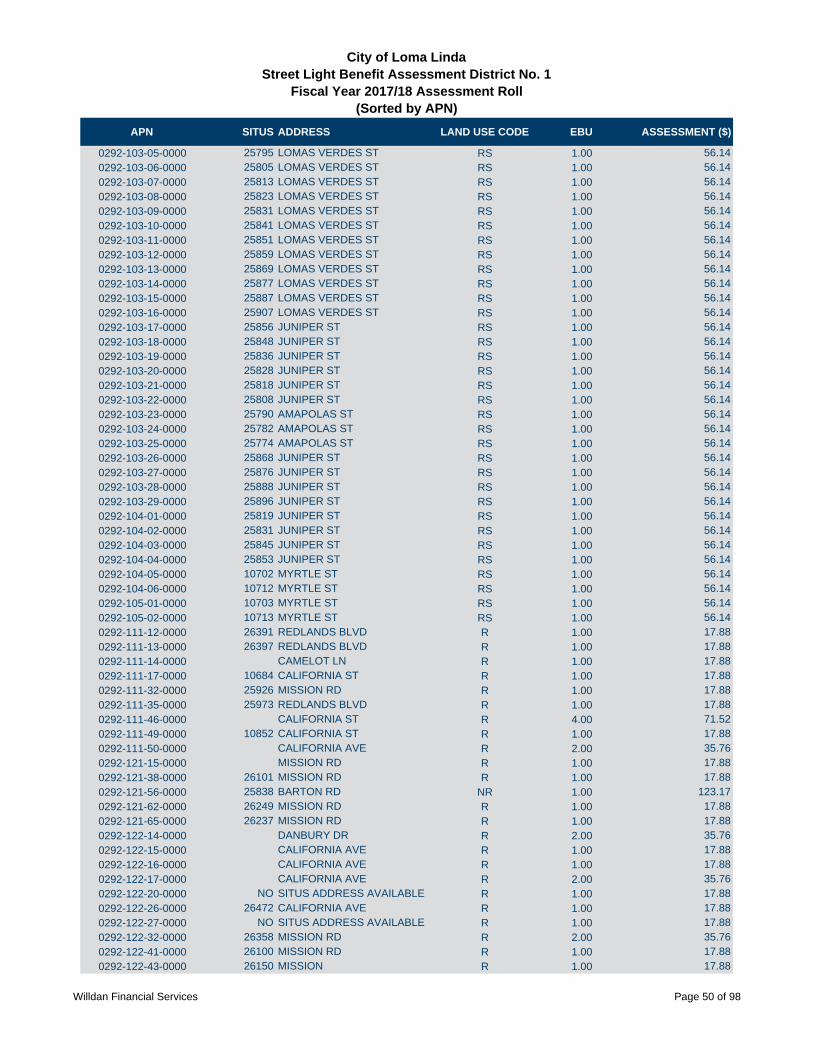
APN SITUS ADDRESS LAND USE CODE EBU ASSESSMENT ($)
City of Loma LindaStreet Light Benefit Assessment District No. 1
Fiscal Year 2017/18 Assessment Roll (Sorted by APN)
0292-103-05-0000 25795 LOMAS VERDES ST RS 1.00 56.14
0292-103-06-0000 25805 LOMAS VERDES ST RS 1.00 56.14
0292-103-07-0000 25813 LOMAS VERDES ST RS 1.00 56.14
0292-103-08-0000 25823 LOMAS VERDES ST RS 1.00 56.14
0292-103-09-0000 25831 LOMAS VERDES ST RS 1.00 56.14
0292-103-10-0000 25841 LOMAS VERDES ST RS 1.00 56.14
0292-103-11-0000 25851 LOMAS VERDES ST RS 1.00 56.14
0292-103-12-0000 25859 LOMAS VERDES ST RS 1.00 56.14
0292-103-13-0000 25869 LOMAS VERDES ST RS 1.00 56.14
0292-103-14-0000 25877 LOMAS VERDES ST RS 1.00 56.14
0292-103-15-0000 25887 LOMAS VERDES ST RS 1.00 56.14
0292-103-16-0000 25907 LOMAS VERDES ST RS 1.00 56.14
0292-103-17-0000 25856 JUNIPER ST RS 1.00 56.14
0292-103-18-0000 25848 JUNIPER ST RS 1.00 56.14
0292-103-19-0000 25836 JUNIPER ST RS 1.00 56.14
0292-103-20-0000 25828 JUNIPER ST RS 1.00 56.14
0292-103-21-0000 25818 JUNIPER ST RS 1.00 56.14
0292-103-22-0000 25808 JUNIPER ST RS 1.00 56.14
0292-103-23-0000 25790 AMAPOLAS ST RS 1.00 56.14
0292-103-24-0000 25782 AMAPOLAS ST RS 1.00 56.14
0292-103-25-0000 25774 AMAPOLAS ST RS 1.00 56.14
0292-103-26-0000 25868 JUNIPER ST RS 1.00 56.14
0292-103-27-0000 25876 JUNIPER ST RS 1.00 56.14
0292-103-28-0000 25888 JUNIPER ST RS 1.00 56.14
0292-103-29-0000 25896 JUNIPER ST RS 1.00 56.14
0292-104-01-0000 25819 JUNIPER ST RS 1.00 56.14
0292-104-02-0000 25831 JUNIPER ST RS 1.00 56.14
0292-104-03-0000 25845 JUNIPER ST RS 1.00 56.14
0292-104-04-0000 25853 JUNIPER ST RS 1.00 56.14
0292-104-05-0000 10702 MYRTLE ST RS 1.00 56.14
0292-104-06-0000 10712 MYRTLE ST RS 1.00 56.14
0292-105-01-0000 10703 MYRTLE ST RS 1.00 56.14
0292-105-02-0000 10713 MYRTLE ST RS 1.00 56.14
0292-111-12-0000 26391 REDLANDS BLVD R 1.00 17.88
0292-111-13-0000 26397 REDLANDS BLVD R 1.00 17.88
0292-111-14-0000 CAMELOT LN R 1.00 17.88
0292-111-17-0000 10684 CALIFORNIA ST R 1.00 17.88
0292-111-32-0000 25926 MISSION RD R 1.00 17.88
0292-111-35-0000 25973 REDLANDS BLVD R 1.00 17.88
0292-111-46-0000 CALIFORNIA ST R 4.00 71.52
0292-111-49-0000 10852 CALIFORNIA ST R 1.00 17.88
0292-111-50-0000 CALIFORNIA AVE R 2.00 35.76
0292-121-15-0000 MISSION RD R 1.00 17.88
0292-121-38-0000 26101 MISSION RD R 1.00 17.88
0292-121-56-0000 25838 BARTON RD NR 1.00 123.17
0292-121-62-0000 26249 MISSION RD R 1.00 17.88
0292-121-65-0000 26237 MISSION RD R 1.00 17.88
0292-122-14-0000 DANBURY DR R 2.00 35.76
0292-122-15-0000 CALIFORNIA AVE R 1.00 17.88
0292-122-16-0000 CALIFORNIA AVE R 1.00 17.88
0292-122-17-0000 CALIFORNIA AVE R 2.00 35.76
0292-122-20-0000 NO SITUS ADDRESS AVAILABLE R 1.00 17.88
0292-122-26-0000 26472 CALIFORNIA AVE R 1.00 17.88
0292-122-27-0000 NO SITUS ADDRESS AVAILABLE R 1.00 17.88
0292-122-32-0000 26358 MISSION RD R 2.00 35.76
0292-122-41-0000 26100 MISSION RD R 1.00 17.88
0292-122-43-0000 26150 MISSION R 1.00 17.88
Willdan Financial Services Page 50 of 98
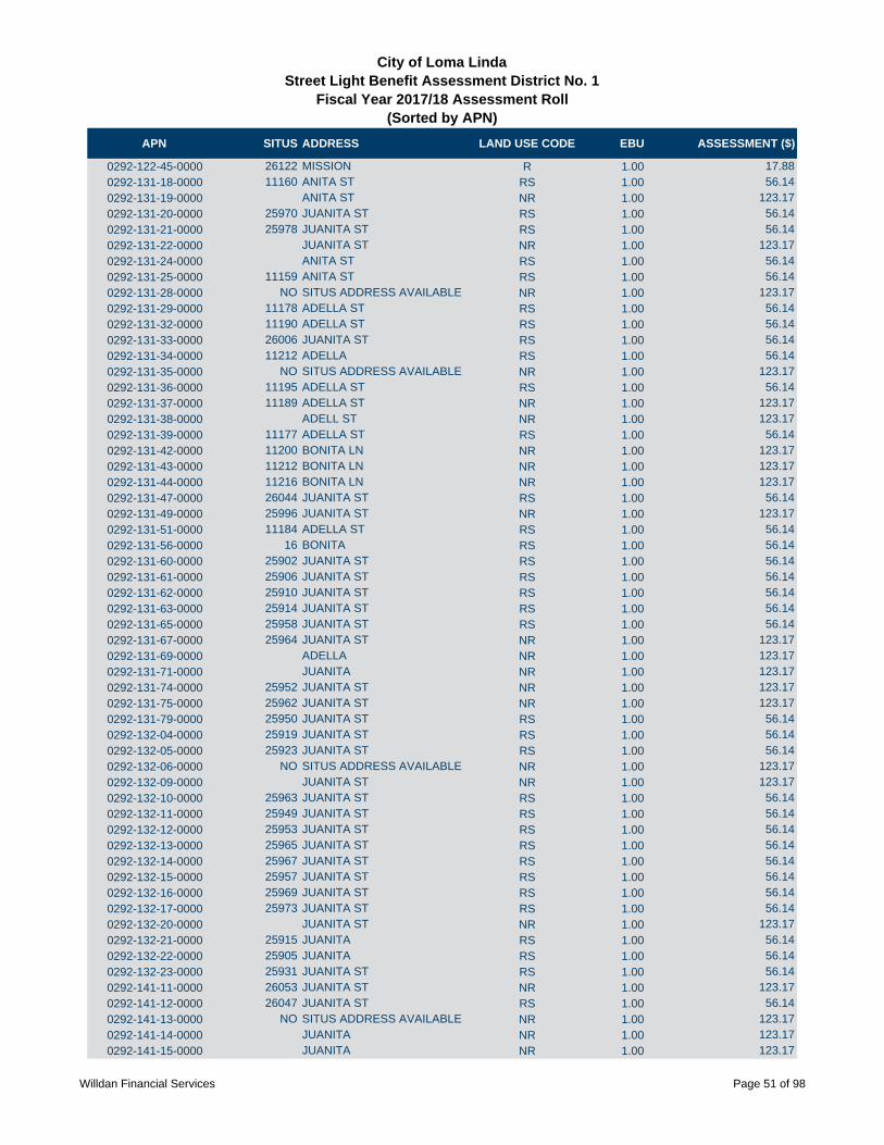
APN SITUS ADDRESS LAND USE CODE EBU ASSESSMENT ($)
City of Loma LindaStreet Light Benefit Assessment District No. 1
Fiscal Year 2017/18 Assessment Roll (Sorted by APN)
0292-122-45-0000 26122 MISSION R 1.00 17.88
0292-131-18-0000 11160 ANITA ST RS 1.00 56.14
0292-131-19-0000 ANITA ST NR 1.00 123.17
0292-131-20-0000 25970 JUANITA ST RS 1.00 56.14
0292-131-21-0000 25978 JUANITA ST RS 1.00 56.14
0292-131-22-0000 JUANITA ST NR 1.00 123.17
0292-131-24-0000 ANITA ST RS 1.00 56.14
0292-131-25-0000 11159 ANITA ST RS 1.00 56.14
0292-131-28-0000 NO SITUS ADDRESS AVAILABLE NR 1.00 123.17
0292-131-29-0000 11178 ADELLA ST RS 1.00 56.14
0292-131-32-0000 11190 ADELLA ST RS 1.00 56.14
0292-131-33-0000 26006 JUANITA ST RS 1.00 56.14
0292-131-34-0000 11212 ADELLA RS 1.00 56.14
0292-131-35-0000 NO SITUS ADDRESS AVAILABLE NR 1.00 123.17
0292-131-36-0000 11195 ADELLA ST RS 1.00 56.14
0292-131-37-0000 11189 ADELLA ST NR 1.00 123.17
0292-131-38-0000 ADELL ST NR 1.00 123.17
0292-131-39-0000 11177 ADELLA ST RS 1.00 56.14
0292-131-42-0000 11200 BONITA LN NR 1.00 123.17
0292-131-43-0000 11212 BONITA LN NR 1.00 123.17
0292-131-44-0000 11216 BONITA LN NR 1.00 123.17
0292-131-47-0000 26044 JUANITA ST RS 1.00 56.14
0292-131-49-0000 25996 JUANITA ST NR 1.00 123.17
0292-131-51-0000 11184 ADELLA ST RS 1.00 56.14
0292-131-56-0000 16 BONITA RS 1.00 56.14
0292-131-60-0000 25902 JUANITA ST RS 1.00 56.14
0292-131-61-0000 25906 JUANITA ST RS 1.00 56.14
0292-131-62-0000 25910 JUANITA ST RS 1.00 56.14
0292-131-63-0000 25914 JUANITA ST RS 1.00 56.14
0292-131-65-0000 25958 JUANITA ST RS 1.00 56.14
0292-131-67-0000 25964 JUANITA ST NR 1.00 123.17
0292-131-69-0000 ADELLA NR 1.00 123.17
0292-131-71-0000 JUANITA NR 1.00 123.17
0292-131-74-0000 25952 JUANITA ST NR 1.00 123.17
0292-131-75-0000 25962 JUANITA ST NR 1.00 123.17
0292-131-79-0000 25950 JUANITA ST RS 1.00 56.14
0292-132-04-0000 25919 JUANITA ST RS 1.00 56.14
0292-132-05-0000 25923 JUANITA ST RS 1.00 56.14
0292-132-06-0000 NO SITUS ADDRESS AVAILABLE NR 1.00 123.17
0292-132-09-0000 JUANITA ST NR 1.00 123.17
0292-132-10-0000 25963 JUANITA ST RS 1.00 56.14
0292-132-11-0000 25949 JUANITA ST RS 1.00 56.14
0292-132-12-0000 25953 JUANITA ST RS 1.00 56.14
0292-132-13-0000 25965 JUANITA ST RS 1.00 56.14
0292-132-14-0000 25967 JUANITA ST RS 1.00 56.14
0292-132-15-0000 25957 JUANITA ST RS 1.00 56.14
0292-132-16-0000 25969 JUANITA ST RS 1.00 56.14
0292-132-17-0000 25973 JUANITA ST RS 1.00 56.14
0292-132-20-0000 JUANITA ST NR 1.00 123.17
0292-132-21-0000 25915 JUANITA RS 1.00 56.14
0292-132-22-0000 25905 JUANITA RS 1.00 56.14
0292-132-23-0000 25931 JUANITA ST RS 1.00 56.14
0292-141-11-0000 26053 JUANITA ST NR 1.00 123.17
0292-141-12-0000 26047 JUANITA ST RS 1.00 56.14
0292-141-13-0000 NO SITUS ADDRESS AVAILABLE NR 1.00 123.17
0292-141-14-0000 JUANITA NR 1.00 123.17
0292-141-15-0000 JUANITA NR 1.00 123.17
Willdan Financial Services Page 51 of 98
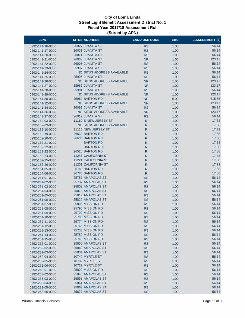
APN SITUS ADDRESS LAND USE CODE EBU ASSESSMENT ($)
City of Loma LindaStreet Light Benefit Assessment District No. 1
Fiscal Year 2017/18 Assessment Roll (Sorted by APN)
0292-141-16-0000 26027 JUANITA ST RS 1.00 56.14
0292-141-17-0000 26031 JUANITA ST RS 1.00 56.14
0292-141-20-0000 26011 JUANITA ST RS 1.00 56.14
0292-141-21-0000 26009 JUANITA ST NR 1.00 123.17
0292-141-22-0000 26003 JUANITA ST RS 1.00 56.14
0292-141-23-0000 25997 JUANITA ST RS 1.00 56.14
0292-141-24-0000 NO SITUS ADDRESS AVAILABLE RS 1.00 56.14
0292-141-25-0000 25995 JUANITA ST RS 1.00 56.14
0292-141-26-0000 NO SITUS ADDRESS AVAILABLE NR 1.00 123.17
0292-141-27-0000 25985 JUANITA ST NR 1.00 123.17
0292-141-28-0000 25981 JUANITA ST RS 1.00 56.14
0292-141-29-0000 NO SITUS ADDRESS AVAILABLE NR 1.00 123.17
0292-141-30-0000 25980 BARTON RD NR 5.00 615.85
0292-141-32-0000 NO SITUS ADDRESS AVAILABLE NR 1.00 123.17
0292-141-34-0000 26095 JUANITA ST RS 1.00 56.14
0292-141-36-0000 NO SITUS ADDRESS AVAILABLE NR 1.00 123.17
0292-141-37-0000 26019 JUANITA ST RS 1.00 56.14
0292-162-03-0000 11180 S NEW JERSEY ST R 1.00 17.88
0292-162-09-0000 NO SITUS ADDRESS AVAILABLE R 1.00 17.88
0292-162-10-0000 11116 NEW JERSEY ST R 1.00 17.88
0292-162-19-0000 26630 BARTON RD R 1.00 17.88
0292-162-20-0000 26630 BARTON RD R 1.00 17.88
0292-162-21-0000 BARTON RD R 1.00 17.88
0292-162-22-0000 BARTON RD R 1.00 17.88
0292-162-23-0000 26526 BARTON RD R 1.00 17.88
0292-162-24-0000 11245 CALIFORNIA ST R 1.00 17.88
0292-162-25-0000 11221 CALIFORNIA ST R 1.00 17.88
0292-162-26-0000 11201 CALIFORNIA ST R 1.00 17.88
0292-164-05-0000 26780 BARTON RD R 1.00 17.88
0292-164-06-0000 26780 BARTON RD R 1.00 17.88
0292-261-01-0000 25789 AMAPOLAS ST RS 1.00 56.14
0292-261-02-0000 25797 AMAPOLAS ST RS 1.00 56.14
0292-261-03-0000 25803 AMAPOLAS ST RS 1.00 56.14
0292-261-04-0000 25813 AMAPOLAS ST RS 1.00 56.14
0292-261-05-0000 25819 AMAPOLAS ST RS 1.00 56.14
0292-261-06-0000 25829 AMAPOLAS ST RS 1.00 56.14
0292-261-07-0000 25806 MISSION RD RS 1.00 56.14
0292-261-08-0000 25798 MISSION RD RS 1.00 56.14
0292-261-09-0000 25790 MISSION RD RS 1.00 56.14
0292-261-10-0000 25780 MISSION RD RS 1.00 56.14
0292-261-11-0000 25774 MISSION RD RS 1.00 56.14
0292-261-12-0000 25766 MISSION RD RS 1.00 56.14
0292-261-13-0000 25758 MISSION RD RS 1.00 56.14
0292-261-14-0000 25750 MISSION RD RS 1.00 56.14
0292-261-15-0000 25740 MISSION RD RS 1.00 56.14
0292-262-01-0000 25850 AMAPOLAS ST RS 1.00 56.14
0292-262-02-0000 25842 AMAPOLAS ST RS 1.00 56.14
0292-262-03-0000 25834 AMAPOLAS ST RS 1.00 56.14
0292-262-04-0000 10742 MYRTLE ST RS 1.00 56.14
0292-262-05-0000 10732 MYRTLE ST RS 1.00 56.14
0292-262-06-0000 10722 MYRTLE ST RS 1.00 56.14
0292-263-01-0000 25822 MISSION RD RS 1.00 56.14
0292-263-02-0000 25845 AMAPOLAS ST RS 1.00 56.14
0292-263-03-0000 25853 AMAPOLAS ST RS 1.00 56.14
0292-263-04-0000 25861 AMAPOLAS ST RS 1.00 56.14
0292-263-05-0000 25869 AMAPOLAS ST RS 1.00 56.14
0292-263-06-0000 25877 AMAPOLAS ST RS 1.00 56.14
Willdan Financial Services Page 52 of 98

APN SITUS ADDRESS LAND USE CODE EBU ASSESSMENT ($)
City of Loma LindaStreet Light Benefit Assessment District No. 1
Fiscal Year 2017/18 Assessment Roll (Sorted by APN)
0292-263-07-0000 25885 AMAPOLAS ST RS 1.00 56.14
0292-263-08-0000 25893 AMAPOLAS ST RS 1.00 56.14
0292-263-09-0000 25899 AMAPOLAS ST RS 1.00 56.14
0292-263-10-0000 25894 MISSION RD RS 1.00 56.14
0292-263-11-0000 NO SITUS ADDRESS AVAILABLE RS 1.00 56.14
0292-263-12-0000 25878 MISSION RD RS 1.00 56.14
0292-263-13-0000 25870 MISSION RD RS 1.00 56.14
0292-263-14-0000 25862 MISSION RD RS 1.00 56.14
0292-263-15-0000 25854 MISSION RD RS 1.00 56.14
0292-263-16-0000 25846 MISSION RD RS 1.00 56.14
0292-263-17-0000 25838 MISSION RD RS 1.00 56.14
0292-263-18-0000 25830 MISSION RD RS 1.00 56.14
0292-264-01-0000 25896 AMAPOLAS ST RS 1.00 56.14
0292-264-02-0000 25882 AMAPOLAS ST RS 1.00 56.14
0292-264-03-0000 10743 MYRTLE ST RS 1.00 56.14
0292-264-04-0000 10733 MYRTLE ST RS 1.00 56.14
0292-264-05-0000 10723 MYRTLE ST RS 1.00 56.14
0292-265-01-0000 25775 MISSION RD RSC 0.71 39.98
0292-265-02-0000 25777 MISSION RD RSC 0.71 39.98
0292-265-03-0000 25779 MISSION RD RSC 0.71 39.98
0292-265-04-0000 25781 MISSION RD RSC 0.71 39.98
0292-265-05-0000 10745 LORO VERDE AVE RSC 0.71 39.98
0292-265-06-0000 10747 LORO VERDE AVE RSC 0.71 39.98
0292-265-07-0000 10749 LORO VERDE AVE RSC 0.71 39.98
0292-265-08-0000 25797 MISSION RD RSC 0.71 39.98
0292-265-09-0000 25795 MISSION RD RSC 0.71 39.98
0292-265-10-0000 25793 MISSION RD RSC 0.71 39.98
0292-265-11-0000 25791 MISSION RD RSC 0.71 39.98
0292-265-12-0000 25807 MISSION RD RSC 0.71 39.98
0292-265-13-0000 25809 MISSION RD RSC 0.71 39.98
0292-265-14-0000 25811 MISSION RD RSC 0.71 39.98
0292-265-15-0000 25813 MISSION RD RSC 0.71 39.98
0292-265-16-0000 25823 MISSION RD RSC 0.71 39.98
0292-265-17-0000 25825 MISSION RD RSC 0.71 39.98
0292-265-18-0000 25815 MISSION RD RSC 0.71 39.98
0292-265-19-0000 25817 MISSION RD RSC 0.71 39.98
0292-265-20-0000 25819 MISSION RD RSC 0.71 39.98
0292-265-21-0000 25821 MISSION RD RSC 0.71 39.98
0292-265-22-0000 25805 MISSION RD RSC 0.71 39.98
0292-265-23-0000 25803 MISSION RD RSC 0.71 39.98
0292-265-24-0000 25801 MISSION RD RSC 0.71 39.98
0292-265-25-0000 25799 MISSION RD RSC 0.71 39.98
0292-265-26-0000 10789 LORO VERDE AVE RSC 0.71 39.98
0292-265-27-0000 10793 LORO VERDE AVE RSC 0.71 39.98
0292-265-28-0000 10797 LORO VERDE AVE RSC 0.71 39.98
0292-265-29-0000 10801 LORO VERDE AVE RSC 0.71 39.98
0292-265-30-0000 10805 LORO VERDE AVE RSC 0.71 39.98
0292-266-01-0000 25715 MISSION RD RSC 0.71 39.98
0292-266-02-0000 25717 MISSION RD RSC 0.71 39.98
0292-266-03-0000 25737 MISSION RD RSC 0.71 39.98
0292-266-04-0000 25739 MISSION RD RSC 0.71 39.98
0292-266-05-0000 25741 MISSION RD RSC 0.71 39.98
0292-266-06-0000 25743 MISSION RD RSC 0.71 39.98
0292-266-07-0000 25745 MISSION RD RSC 0.71 39.98
0292-266-08-0000 10712 LORO VERDE AVE RSC 0.71 39.98
0292-266-09-0000 10716 LORO VERDE AVE RSC 0.71 39.98
0292-266-10-0000 10720 LORO VERDE AVE RSC 0.71 39.98
Willdan Financial Services Page 53 of 98

APN SITUS ADDRESS LAND USE CODE EBU ASSESSMENT ($)
City of Loma LindaStreet Light Benefit Assessment District No. 1
Fiscal Year 2017/18 Assessment Roll (Sorted by APN)
0292-266-11-0000 10724 LORO VERDE AVE RSC 0.71 39.98
0292-266-12-0000 10711 MOUNTAIN VIEW AVE RSC 0.71 39.98
0292-266-13-0000 10713 MOUNTAIN VIEW AVE RSC 0.71 39.98
0292-266-14-0000 10715 MOUNTAIN VIEW AVE RSC 0.71 39.98
0292-266-15-0000 10717 MOUNTAIN VIEW AVE RSC 0.71 39.98
0292-266-16-0000 10735 MOUNTAIN VIEW AVE RSC 0.71 39.98
0292-266-17-0000 10737 MOUNTAIN VIEW AVE RSC 0.71 39.98
0292-266-18-0000 10739 MOUNTAIN VIEW AVE RSC 0.71 39.98
0292-266-19-0000 10741 MOUNTAIN VIEW AVE RSC 0.71 39.98
0292-266-20-0000 10744 LORO VERDE AVE RSC 0.71 39.98
0292-266-21-0000 10742 LORO VERDE AVE RSC 0.71 39.98
0292-266-22-0000 10740 LORO VERDE AVE RSC 0.71 39.98
0292-266-23-0000 10788 LORO VERDE AVE RSC 0.71 39.98
0292-266-24-0000 10790 LORO VERDE AVE RSC 0.71 39.98
0292-266-25-0000 10792 LORO VERDE AVE RSC 0.71 39.98
0292-266-26-0000 10794 LORO VERDE AVE RSC 0.71 39.98
0292-266-27-0000 10785 MOUNTAIN VIEW AVE RSC 0.71 39.98
0292-266-28-0000 10783 MOUNTAIN VIEW AVE RSC 0.71 39.98
0292-266-29-0000 10781 MOUNTAIN VIEW AVE RSC 0.71 39.98
0292-266-30-0000 10817 MOUNTAIN VIEW AVE RSC 0.71 39.98
0292-266-31-0000 10819 MOUNTAIN VIEW AVE RSC 0.71 39.98
0292-266-32-0000 10821 MOUNTAIN VIEW AVE RSC 0.71 39.98
0292-266-33-0000 10823 MOUNTAIN VIEW AVE RSC 0.71 39.98
0292-266-34-0000 10810 LORO VERDE AVE RSC 0.71 39.98
0292-266-35-0000 10808 LORO VERDE AVE RSC 0.71 39.98
0292-266-36-0000 10806 LORO VERDE AVE RSC 0.71 39.98
0292-291-01-0000 10861 LORO VERDE AVE RSC 0.71 39.98
0292-291-02-0000 10863 LORO VERDE AVE RSC 0.71 39.98
0292-291-03-0000 10865 LORO VERDE AVE RSC 0.71 39.98
0292-291-04-0000 10825 LORO VERDE AVE RSC 0.71 39.98
0292-291-05-0000 10823 LORO VERDE AVE RSC 0.71 39.98
0292-291-06-0000 10821 LORO VERDE AVE RSC 0.71 39.98
0292-291-07-0000 10819 LORO VERDE AVE RSC 0.71 39.98
0292-291-09-0000 10818 LORO VERDE AVE RSC 0.71 39.98
0292-291-10-0000 10816 LORO VERDE AVE RSC 0.71 39.98
0292-291-11-0000 10814 LORO VERDE AVE RSC 0.71 39.98
0292-291-12-0000 10812 LORO VERDE AVE RSC 0.71 39.98
0292-291-13-0000 10840 LORO VERDE AVE RSC 0.71 39.98
0292-291-14-0000 10842 LORO VERDE AVE RSC 0.71 39.98
0292-291-15-0000 10844 LORO VERDE AVE RSC 0.71 39.98
0292-291-16-0000 10846 LORO VERDE AVE RSC 0.71 39.98
0292-291-17-0000 10848 LORO VERDE AVE RSC 0.71 39.98
0292-291-18-0000 10850 LORO VERDE AVE RSC 0.71 39.98
0292-291-19-0000 10851 MOUNTAIN VIEW AVE RSC 0.71 39.98
0292-291-20-0000 10849 MOUNTAIN VIEW AVE RSC 0.71 39.98
0292-291-21-0000 10847 MOUNTAIN VIEW AVE RSC 0.71 39.98
0292-291-22-0000 10853 MOUNTAIN VIEW AVE RSC 0.71 39.98
0292-291-23-0000 10857 MOUNTAIN VIEW AVE RSC 0.71 39.98
0292-291-24-0000 10861 MOUNTAIN VIEW AVE RSC 0.71 39.98
0292-291-25-0000 10865 MOUNTAIN VIEW AVE RSC 0.71 39.98
0292-291-26-0000 10868 MOUNTAIN VIEW AVE RSC 0.71 39.98
0292-291-27-0000 10878 LORO VERDE AVE RSC 0.71 39.98
0292-291-28-0000 10876 LORO VERDE AVE RSC 0.71 39.98
0292-291-29-0000 10874 LORO VERDE AVE RSC 0.71 39.98
0292-291-30-0000 10872 LORO VERDE AVE RSC 0.71 39.98
0292-291-31-0000 10860 LORO VERDE AVE RSC 0.71 39.98
0292-291-32-0000 10858 LORO VERDE AVE RSC 0.71 39.98
Willdan Financial Services Page 54 of 98

APN SITUS ADDRESS LAND USE CODE EBU ASSESSMENT ($)
City of Loma LindaStreet Light Benefit Assessment District No. 1
Fiscal Year 2017/18 Assessment Roll (Sorted by APN)
0292-291-33-0000 10856 LORO VERDE AVE RSC 0.71 39.98
0292-291-34-0000 10854 LORO VERDE AVE RSC 0.71 39.98
0292-291-35-0000 10852 LORO VERDE AVE RSC 0.71 39.98
0292-291-36-0000 10882 LORO VERDE AVE RSC 0.71 39.98
0292-291-37-0000 10884 LORO VERDE AVE RSC 0.71 39.98
0292-291-38-0000 10886 LORO VERDE AVE RSC 0.71 39.98
0292-291-39-0000 10888 LORO VERDE AVE RSC 0.71 39.98
0292-291-40-0000 25746 VAN LEUVEN ST RSC 0.71 39.98
0292-291-41-0000 25742 VAN LEUVEN ST RSC 0.71 39.98
0292-291-42-0000 25738 VAN LEUVEN ST RSC 0.71 39.98
0292-291-43-0000 25734 VAN LEUVEN ST RSC 0.71 39.98
0292-291-44-0000 25730 VAN LEUVEN ST RSC 0.71 39.98
0292-291-45-0000 25726 VAN LEUVEN ST RSC 0.71 39.98
0292-291-46-0000 25722 VAN LEUVEN ST RSC 0.71 39.98
0292-291-47-0000 10885 LORO VERDE AVE RSC 0.71 39.98
0292-291-48-0000 10887 LORO VERDE AVE RSC 0.71 39.98
0292-291-49-0000 25792 VAN LEUVEN ST RSC 0.71 39.98
0292-291-50-0000 25796 VAN LEUVEN ST RSC 0.71 39.98
0292-291-51-0000 25800 VAN LEUVEN ST RSC 0.71 39.98
0292-291-52-0000 25804 VAN LEUVEN ST RSC 0.71 39.98
0292-291-53-0000 25810 VAN LEUVEN ST RSC 0.71 39.98
0292-291-54-0000 25814 VAN LEUVEN ST RSC 0.71 39.98
0292-291-55-0000 10866 PEPPER WY RSC 0.71 39.98
0292-291-56-0000 10864 PEPPER WY RSC 0.71 39.98
0292-291-57-0000 10862 PEPPER WY RSC 0.71 39.98
0292-291-58-0000 10860 PEPPER WY RSC 0.71 39.98
0292-291-59-0000 10850 PEPPER WY RSC 0.71 39.98
0292-291-60-0000 10852 PEPPER WY RSC 0.71 39.98
0292-291-61-0000 10854 PEPPER WY RSC 0.71 39.98
0292-291-62-0000 10834 PEPPER WY RSC 0.71 39.98
0292-291-63-0000 10832 PEPPER WY RSC 0.71 39.98
0292-291-64-0000 10830 PEPPER WY RSC 0.71 39.98
0292-291-65-0000 10820 PEPPER WY RSC 0.71 39.98
0292-291-66-0000 10822 PEPPER WY RSC 0.71 39.98
0292-291-67-0000 10824 PEPPER WY RSC 0.71 39.98
0292-291-68-0000 10826 PEPPER WY RSC 0.71 39.98
0292-291-69-0000 10840 PEPPER WY RSC 0.71 39.98
0292-291-70-0000 10842 PEPPER WY RSC 0.71 39.98
0292-291-71-0000 10844 PEPPER WY RSC 0.71 39.98
0292-291-72-0000 10846 PEPPER WY RSC 0.71 39.98
0292-291-73-0000 10848 PEPPER WY RSC 0.71 39.98
0292-291-74-0000 10870 PEPPER WY RSC 0.71 39.98
0292-291-75-0000 10872 PEPPER WY RSC 0.71 39.98
0292-291-76-0000 10874 PEPPER WY RSC 0.71 39.98
0292-291-77-0000 10876 PEPPER WY RSC 0.71 39.98
0292-301-01-0000 26200 REDLANDS BLVD RSC 1.00 56.14
0292-301-02-0000 26200 REDLANDS BLVD RSC 1.00 56.14
0292-301-03-0000 26200 REDLANDS BLVD RSC 1.00 56.14
0292-301-04-0000 26200 REDLANDS BLVD RSC 1.00 56.14
0292-301-05-0000 26200 REDLANDS BLVD RSC 1.00 56.14
0292-301-06-0000 26200 REDLANDS BLVD RSC 1.00 56.14
0292-301-07-0000 26200 REDLANDS BLVD RSC 1.00 56.14
0292-301-08-0000 26200 REDLANDS BLVD RSC 1.00 56.14
0292-301-09-0000 26200 REDLANDS BLVD RSC 1.00 56.14
0292-301-10-0000 26200 REDLANDS BLVD RSC 1.00 56.14
0292-301-11-0000 26200 REDLANDS BLVD RSC 1.00 56.14
0292-301-12-0000 26200 REDLANDS BLVD RSC 1.00 56.14
Willdan Financial Services Page 55 of 98
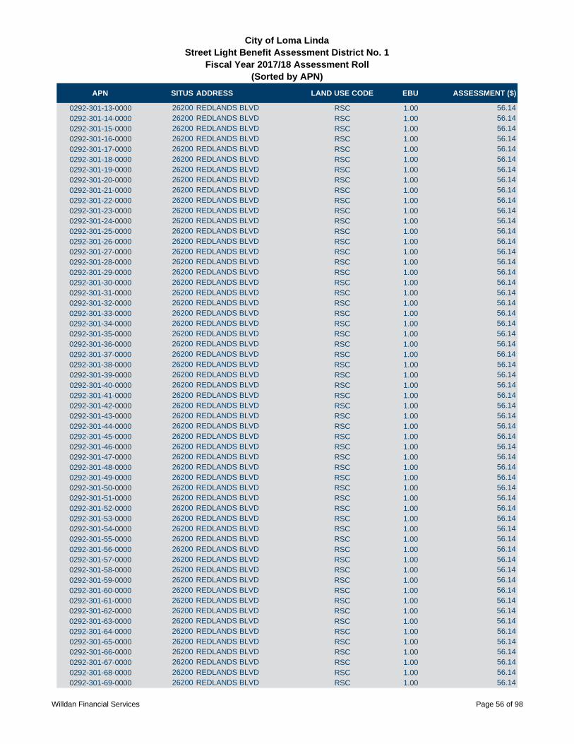
APN SITUS ADDRESS LAND USE CODE EBU ASSESSMENT ($)
City of Loma LindaStreet Light Benefit Assessment District No. 1
Fiscal Year 2017/18 Assessment Roll (Sorted by APN)
0292-301-13-0000 26200 REDLANDS BLVD RSC 1.00 56.14
0292-301-14-0000 26200 REDLANDS BLVD RSC 1.00 56.14
0292-301-15-0000 26200 REDLANDS BLVD RSC 1.00 56.14
0292-301-16-0000 26200 REDLANDS BLVD RSC 1.00 56.14
0292-301-17-0000 26200 REDLANDS BLVD RSC 1.00 56.14
0292-301-18-0000 26200 REDLANDS BLVD RSC 1.00 56.14
0292-301-19-0000 26200 REDLANDS BLVD RSC 1.00 56.14
0292-301-20-0000 26200 REDLANDS BLVD RSC 1.00 56.14
0292-301-21-0000 26200 REDLANDS BLVD RSC 1.00 56.14
0292-301-22-0000 26200 REDLANDS BLVD RSC 1.00 56.14
0292-301-23-0000 26200 REDLANDS BLVD RSC 1.00 56.14
0292-301-24-0000 26200 REDLANDS BLVD RSC 1.00 56.14
0292-301-25-0000 26200 REDLANDS BLVD RSC 1.00 56.14
0292-301-26-0000 26200 REDLANDS BLVD RSC 1.00 56.14
0292-301-27-0000 26200 REDLANDS BLVD RSC 1.00 56.14
0292-301-28-0000 26200 REDLANDS BLVD RSC 1.00 56.14
0292-301-29-0000 26200 REDLANDS BLVD RSC 1.00 56.14
0292-301-30-0000 26200 REDLANDS BLVD RSC 1.00 56.14
0292-301-31-0000 26200 REDLANDS BLVD RSC 1.00 56.14
0292-301-32-0000 26200 REDLANDS BLVD RSC 1.00 56.14
0292-301-33-0000 26200 REDLANDS BLVD RSC 1.00 56.14
0292-301-34-0000 26200 REDLANDS BLVD RSC 1.00 56.14
0292-301-35-0000 26200 REDLANDS BLVD RSC 1.00 56.14
0292-301-36-0000 26200 REDLANDS BLVD RSC 1.00 56.14
0292-301-37-0000 26200 REDLANDS BLVD RSC 1.00 56.14
0292-301-38-0000 26200 REDLANDS BLVD RSC 1.00 56.14
0292-301-39-0000 26200 REDLANDS BLVD RSC 1.00 56.14
0292-301-40-0000 26200 REDLANDS BLVD RSC 1.00 56.14
0292-301-41-0000 26200 REDLANDS BLVD RSC 1.00 56.14
0292-301-42-0000 26200 REDLANDS BLVD RSC 1.00 56.14
0292-301-43-0000 26200 REDLANDS BLVD RSC 1.00 56.14
0292-301-44-0000 26200 REDLANDS BLVD RSC 1.00 56.14
0292-301-45-0000 26200 REDLANDS BLVD RSC 1.00 56.14
0292-301-46-0000 26200 REDLANDS BLVD RSC 1.00 56.14
0292-301-47-0000 26200 REDLANDS BLVD RSC 1.00 56.14
0292-301-48-0000 26200 REDLANDS BLVD RSC 1.00 56.14
0292-301-49-0000 26200 REDLANDS BLVD RSC 1.00 56.14
0292-301-50-0000 26200 REDLANDS BLVD RSC 1.00 56.14
0292-301-51-0000 26200 REDLANDS BLVD RSC 1.00 56.14
0292-301-52-0000 26200 REDLANDS BLVD RSC 1.00 56.14
0292-301-53-0000 26200 REDLANDS BLVD RSC 1.00 56.14
0292-301-54-0000 26200 REDLANDS BLVD RSC 1.00 56.14
0292-301-55-0000 26200 REDLANDS BLVD RSC 1.00 56.14
0292-301-56-0000 26200 REDLANDS BLVD RSC 1.00 56.14
0292-301-57-0000 26200 REDLANDS BLVD RSC 1.00 56.14
0292-301-58-0000 26200 REDLANDS BLVD RSC 1.00 56.14
0292-301-59-0000 26200 REDLANDS BLVD RSC 1.00 56.14
0292-301-60-0000 26200 REDLANDS BLVD RSC 1.00 56.14
0292-301-61-0000 26200 REDLANDS BLVD RSC 1.00 56.14
0292-301-62-0000 26200 REDLANDS BLVD RSC 1.00 56.14
0292-301-63-0000 26200 REDLANDS BLVD RSC 1.00 56.14
0292-301-64-0000 26200 REDLANDS BLVD RSC 1.00 56.14
0292-301-65-0000 26200 REDLANDS BLVD RSC 1.00 56.14
0292-301-66-0000 26200 REDLANDS BLVD RSC 1.00 56.14
0292-301-67-0000 26200 REDLANDS BLVD RSC 1.00 56.14
0292-301-68-0000 26200 REDLANDS BLVD RSC 1.00 56.14
0292-301-69-0000 26200 REDLANDS BLVD RSC 1.00 56.14
Willdan Financial Services Page 56 of 98

APN SITUS ADDRESS LAND USE CODE EBU ASSESSMENT ($)
City of Loma LindaStreet Light Benefit Assessment District No. 1
Fiscal Year 2017/18 Assessment Roll (Sorted by APN)
0292-301-70-0000 26200 REDLANDS BLVD RSC 1.00 56.14
0292-301-71-0000 26200 REDLANDS BLVD RSC 1.00 56.14
0292-301-72-0000 26200 REDLANDS BLVD RSC 1.00 56.14
0292-301-73-0000 26200 REDLANDS BLVD RSC 1.00 56.14
0292-301-74-0000 26200 REDLANDS BLVD RSC 1.00 56.14
0292-301-75-0000 26200 REDLANDS BLVD RSC 1.00 56.14
0292-301-76-0000 26200 REDLANDS BLVD RSC 1.00 56.14
0292-301-77-0000 26200 REDLANDS BLVD RSC 1.00 56.14
0292-301-78-0000 26200 REDLANDS BLVD RSC 1.00 56.14
0292-301-79-0000 26200 REDLANDS BLVD RSC 1.00 56.14
0292-301-80-0000 26200 REDLANDS BLVD RSC 1.00 56.14
0292-301-81-0000 26200 REDLANDS BLVD RSC 1.00 56.14
0292-301-82-0000 26200 REDLANDS BLVD RSC 1.00 56.14
0292-301-83-0000 26200 REDLANDS BLVD RSC 1.00 56.14
0292-301-84-0000 26200 REDLANDS BLVD RSC 1.00 56.14
0292-301-85-0000 26200 REDLANDS BLVD RSC 1.00 56.14
0292-301-86-0000 26200 REDLANDS BLVD RSC 1.00 56.14
0292-301-87-0000 26200 REDLANDS BLVD RSC 1.00 56.14
0292-301-88-0000 26200 REDLANDS BLVD RSC 1.00 56.14
0292-302-01-0000 26200 REDLANDS BLVD RSC 1.00 56.14
0292-302-02-0000 26200 REDLANDS BLVD RSC 1.00 56.14
0292-302-03-0000 26200 REDLANDS BLVD RSC 1.00 56.14
0292-302-04-0000 26200 REDLANDS BLVD RSC 1.00 56.14
0292-302-05-0000 26200 REDLANDS BLVD RSC 1.00 56.14
0292-302-06-0000 26200 REDLANDS BLVD RSC 1.00 56.14
0292-302-07-0000 26200 REDLANDS BLVD RSC 1.00 56.14
0292-302-08-0000 26200 REDLANDS BLVD RSC 1.00 56.14
0292-302-09-0000 26200 REDLANDS BLVD RSC 1.00 56.14
0292-302-10-0000 26200 REDLANDS BLVD RSC 1.00 56.14
0292-302-11-0000 26200 REDLANDS BLVD RSC 1.00 56.14
0292-302-12-0000 26200 REDLANDS BLVD RSC 1.00 56.14
0292-302-13-0000 26200 REDLANDS BLVD RSC 1.00 56.14
0292-302-14-0000 26200 REDLANDS BLVD RSC 1.00 56.14
0292-302-15-0000 26200 REDLANDS BLVD RSC 1.00 56.14
0292-302-16-0000 26200 REDLANDS BLVD RSC 1.00 56.14
0292-302-17-0000 26200 REDLANDS BLVD RSC 1.00 56.14
0292-302-18-0000 26200 REDLANDS BLVD RSC 1.00 56.14
0292-302-19-0000 26200 REDLANDS BLVD RSC 1.00 56.14
0292-302-20-0000 26200 REDLANDS BLVD RSC 1.00 56.14
0292-302-21-0000 26200 REDLANDS BLVD RSC 1.00 56.14
0292-302-22-0000 26200 REDLANDS BLVD RSC 1.00 56.14
0292-302-23-0000 26200 REDLANDS BLVD RSC 1.00 56.14
0292-302-24-0000 26200 REDLANDS BLVD RSC 1.00 56.14
0292-302-25-0000 26200 REDLANDS BLVD RSC 1.00 56.14
0292-302-26-0000 26200 REDLANDS BLVD RSC 1.00 56.14
0292-302-27-0000 26200 REDLANDS BLVD RSC 1.00 56.14
0292-302-28-0000 26200 REDLANDS BLVD RSC 1.00 56.14
0292-302-29-0000 26200 REDLANDS BLVD RSC 1.00 56.14
0292-302-30-0000 26200 REDLANDS BLVD RSC 1.00 56.14
0292-302-31-0000 26200 REDLANDS BLVD RSC 1.00 56.14
0292-302-32-0000 26200 REDLANDS BLVD RSC 1.00 56.14
0292-302-33-0000 26200 REDLANDS BLVD RSC 1.00 56.14
0292-302-34-0000 26200 REDLANDS BLVD RSC 1.00 56.14
0292-302-35-0000 26200 REDLANDS BLVD RSC 1.00 56.14
0292-302-36-0000 26200 REDLANDS BLVD RSC 1.00 56.14
0292-302-37-0000 26200 REDLANDS BLVD RSC 1.00 56.14
0292-302-38-0000 26200 REDLANDS BLVD RSC 1.00 56.14
Willdan Financial Services Page 57 of 98

APN SITUS ADDRESS LAND USE CODE EBU ASSESSMENT ($)
City of Loma LindaStreet Light Benefit Assessment District No. 1
Fiscal Year 2017/18 Assessment Roll (Sorted by APN)
0292-302-39-0000 26200 REDLANDS BLVD RSC 1.00 56.14
0292-302-40-0000 26200 REDLANDS BLVD RSC 1.00 56.14
0292-302-41-0000 26200 REDLANDS BLVD RSC 1.00 56.14
0292-302-42-0000 26200 REDLANDS BLVD RSC 1.00 56.14
0292-302-43-0000 26200 REDLANDS BLVD RSC 1.00 56.14
0292-302-44-0000 26200 REDLANDS BLVD RSC 1.00 56.14
0292-302-45-0000 26200 REDLANDS BLVD RSC 1.00 56.14
0292-302-46-0000 26200 REDLANDS BLVD RSC 1.00 56.14
0292-302-47-0000 26200 REDLANDS BLVD RSC 1.00 56.14
0292-302-48-0000 26200 REDLANDS BLVD RSC 1.00 56.14
0292-302-49-0000 26200 REDLANDS BLVD RSC 1.00 56.14
0292-302-50-0000 26200 REDLANDS BLVD RSC 1.00 56.14
0292-302-51-0000 26200 REDLANDS BLVD RSC 1.00 56.14
0292-302-52-0000 26200 REDLANDS BLVD RSC 1.00 56.14
0292-302-53-0000 26200 REDLANDS BLVD RSC 1.00 56.14
0292-302-54-0000 26200 REDLANDS BLVD RSC 1.00 56.14
0292-302-55-0000 26200 REDLANDS BLVD RSC 1.00 56.14
0292-302-56-0000 26200 REDLANDS BLVD RSC 1.00 56.14
0292-302-57-0000 26200 REDLANDS BLVD RSC 1.00 56.14
0292-302-58-0000 26200 REDLANDS BLVD RSC 1.00 56.14
0292-302-59-0000 26200 REDLANDS BLVD RSC 1.00 56.14
0292-302-60-0000 26200 REDLANDS BLVD RSC 1.00 56.14
0292-302-61-0000 26200 REDLANDS BLVD RSC 1.00 56.14
0292-302-62-0000 26200 REDLANDS BLVD RSC 1.00 56.14
0292-302-63-0000 26200 REDLANDS BLVD RSC 1.00 56.14
0292-302-64-0000 26200 REDLANDS BLVD RSC 1.00 56.14
0292-302-65-0000 26200 REDLANDS BLVD RSC 1.00 56.14
0292-302-66-0000 26200 REDLANDS BLVD RSC 1.00 56.14
0292-302-67-0000 26200 REDLANDS BLVD RSC 1.00 56.14
0292-302-68-0000 26200 REDLANDS BLVD RSC 1.00 56.14
0292-302-69-0000 26200 REDLANDS BLVD RSC 1.00 56.14
0292-302-70-0000 26200 REDLANDS BLVD RSC 1.00 56.14
0292-302-71-0000 26200 REDLANDS BLVD RSC 1.00 56.14
0292-302-72-0000 26200 REDLANDS BLVD RSC 1.00 56.14
0292-302-73-0000 26200 REDLANDS BLVD RSC 1.00 56.14
0292-302-74-0000 26200 REDLANDS BLVD RSC 1.00 56.14
0292-302-75-0000 26200 REDLANDS BLVD RSC 1.00 56.14
0292-302-76-0000 26200 REDLANDS BLVD RSC 1.00 56.14
0292-302-77-0000 26200 REDLANDS BLVD RSC 1.00 56.14
0292-302-78-0000 26200 REDLANDS BLVD RSC 1.00 56.14
0292-302-79-0000 26200 REDLANDS BLVD RSC 1.00 56.14
0292-302-80-0000 26200 REDLANDS BLVD RSC 1.00 56.14
0292-302-81-0000 26200 REDLANDS BLVD RSC 1.00 56.14
0292-302-82-0000 26200 REDLANDS BLVD RSC 1.00 56.14
0292-302-83-0000 26200 REDLANDS BLVD RSC 1.00 56.14
0292-302-84-0000 26200 REDLANDS BLVD RSC 1.00 56.14
0292-302-85-0000 26200 REDLANDS BLVD RSC 1.00 56.14
0292-302-86-0000 26200 REDLANDS BLVD RSC 1.00 56.14
0292-302-87-0000 26200 REDLANDS BLVD RSC 1.00 56.14
0292-302-88-0000 26200 REDLANDS BLVD RSC 1.00 56.14
0292-302-89-0000 26200 REDLANDS BLVD RSC 1.00 56.14
0292-302-90-0000 26200 REDLANDS BLVD RSC 1.00 56.14
0292-302-91-0000 26200 REDLANDS BLVD RSC 1.00 56.14
0292-302-92-0000 26200 REDLANDS BLVD RSC 1.00 56.14
0292-302-93-0000 26200 REDLANDS BLVD RSC 1.00 56.14
0292-302-94-0000 26200 REDLANDS BLVD RSC 1.00 56.14
0292-302-95-0000 26200 REDLANDS BLVD RSC 1.00 56.14
Willdan Financial Services Page 58 of 98

APN SITUS ADDRESS LAND USE CODE EBU ASSESSMENT ($)
City of Loma LindaStreet Light Benefit Assessment District No. 1
Fiscal Year 2017/18 Assessment Roll (Sorted by APN)
0292-302-96-0000 26200 REDLANDS BLVD RSC 1.00 56.14
0292-371-01-0000 10468 RHONDA ST RS 1.00 56.14
0292-371-02-0000 10462 RHONDA ST RS 1.00 56.14
0292-371-03-0000 10456 RHONDA ST RS 1.00 56.14
0292-371-04-0000 10450 RHONDA ST RS 1.00 56.14
0292-371-05-0000 10442 RHONDA ST RS 1.00 56.14
0292-371-06-0000 10436 RHONDA ST RS 1.00 56.14
0292-371-07-0000 10430 RHONDA ST RS 1.00 56.14
0292-371-08-0000 26270 CARDIGAN PL RS 1.00 56.14
0292-371-09-0000 26276 CARDIGAN PL RS 1.00 56.14
0292-371-10-0000 26284 CARDIGAN PL RS 1.00 56.14
0292-371-11-0000 26288 CARDIGAN PL RS 1.00 56.14
0292-371-12-0000 26296 CARDIGAN PL RS 1.00 56.14
0292-371-13-0000 26300 CARDIGAN PL RS 1.00 56.14
0292-371-14-0000 26306 CARDIGAN PL RS 1.00 56.14
0292-371-15-0000 26312 CARDIGAN PL RS 1.00 56.14
0292-371-16-0000 26328 SEVERN ST RS 1.00 56.14
0292-371-17-0000 26334 CARDIGAN PL RS 1.00 56.14
0292-371-18-0000 26340 CARDIGAN PL RS 1.00 56.14
0292-371-19-0000 26346 CARDIGAN PL RS 1.00 56.14
0292-371-20-0000 26352 CARDIGAN PL RS 1.00 56.14
0292-371-21-0000 26358 CARDIGAN PL RS 1.00 56.14
0292-371-22-0000 26364 CARDIGAN PL RS 1.00 56.14
0292-371-23-0000 26370 CARDIGAN PL RS 1.00 56.14
0292-371-24-0000 26376 CARDIGAN PL RS 1.00 56.14
0292-371-25-0000 26382 CARDIGAN PL RS 1.00 56.14
0292-371-26-0000 26386 CARDIGAN PL RS 1.00 56.14
0292-371-27-0000 26388 SNOWDEN AVE RS 1.00 56.14
0292-371-28-0000 26392 SNOWDEN AVE RS 1.00 56.14
0292-371-29-0000 26400 SNOWDEN AVE RS 1.00 56.14
0292-371-30-0000 26406 SNOWDEN AVE RS 1.00 56.14
0292-371-31-0000 10469 TAFF ST RS 1.00 56.14
0292-371-32-0000 10475 TAFF ST RS 1.00 56.14
0292-371-33-0000 10481 TAFF ST RS 1.00 56.14
0292-371-34-0000 10487 TAFF ST RS 1.00 56.14
0292-371-35-0000 26397 SNOWDEN AVE RS 1.00 56.14
0292-371-36-0000 26391 SNOWDEN AVE RS 1.00 56.14
0292-371-37-0000 26385 SNOWDEN AVE RS 1.00 56.14
0292-371-38-0000 26379 SNOWDEN AVE RS 1.00 56.14
0292-371-39-0000 26373 SNOWDEN AVE RS 1.00 56.14
0292-371-40-0000 26367 SNOWDEN AVE RS 1.00 56.14
0292-371-41-0000 26361 SNOWDEN AVE RS 1.00 56.14
0292-371-42-0000 26355 SNOWDEN AVE RS 1.00 56.14
0292-371-43-0000 26349 SNOWDEN AVE RS 1.00 56.14
0292-371-44-0000 26343 SNOWDEN AVE RS 1.00 56.14
0292-371-45-0000 26337 SNOWDEN AVE RS 1.00 56.14
0292-371-46-0000 26333 SNOWDEN AVE RS 1.00 56.14
0292-371-47-0000 26325 SNOWDEN AVE RS 1.00 56.14
0292-371-48-0000 26319 SNOWDEN AVE RS 1.00 56.14
0292-371-49-0000 26311 SNOWDEN AVE RS 1.00 56.14
0292-371-50-0000 26307 SNOWDEN AVE RS 1.00 56.14
0292-371-51-0000 26301 SNOWDEN PL RS 1.00 56.14
0292-371-52-0000 26295 SNOWDEN AVE RS 1.00 56.14
0292-371-53-0000 26287 SNOWDEN AVE RS 1.00 56.14
0292-371-54-0000 26283 SNOWDEN AVE RS 1.00 56.14
0292-371-55-0000 26277 SNOWDEN AVE RS 1.00 56.14
0292-371-56-0000 26276 SNOWDEN AVE RS 1.00 56.14
Willdan Financial Services Page 59 of 98

APN SITUS ADDRESS LAND USE CODE EBU ASSESSMENT ($)
City of Loma LindaStreet Light Benefit Assessment District No. 1
Fiscal Year 2017/18 Assessment Roll (Sorted by APN)
0292-371-57-0000 26282 SNOWDEN AVE RS 1.00 56.14
0292-371-58-0000 26288 SNOWDEN AVE RS 1.00 56.14
0292-371-59-0000 26294 SNOWDEN AVE RS 1.00 56.14
0292-371-60-0000 26302 SNOWDEN AVE RS 1.00 56.14
0292-371-61-0000 26306 SNOWDEN AVE RS 1.00 56.14
0292-371-62-0000 26312 SNOWDEN AVE RS 1.00 56.14
0292-371-63-0000 26318 SNOWDEN AVE RS 1.00 56.14
0292-371-64-0000 26326 SNOWDEN AVE RS 1.00 56.14
0292-371-65-0000 26332 SNOWDEN AVE RS 1.00 56.14
0292-371-66-0000 26338 SNOWDEN AVE RS 1.00 56.14
0292-371-67-0000 26342 SNOWDEN AVE RS 1.00 56.14
0292-371-68-0000 26335 CARDIGAN PL RS 1.00 56.14
0292-371-69-0000 26329 CARDIGAN PL RS 1.00 56.14
0292-371-70-0000 26319 CARDIGAN PL RS 1.00 56.14
0292-371-71-0000 26313 CARDIGAN PL RS 1.00 56.14
0292-371-72-0000 26305 CARDIGAN PL RS 1.00 56.14
0292-371-73-0000 26301 CARDIGAN PL RS 1.00 56.14
0292-371-74-0000 26295 CARDIGAN PL RS 1.00 56.14
0292-371-75-0000 26289 CARDIGAN PL RS 1.00 56.14
0292-371-76-0000 26283 CARDIGAN PL RS 1.00 56.14
0292-371-77-0000 26277 CARDIGAN PL RS 1.00 56.14
0292-371-78-0000 26300 REDLANDS BLVD RS 1.00 56.14
0292-372-01-0000 10412 SEVERN ST RS 1.00 56.14
0292-372-02-0000 10406 SEVERN ST RS 1.00 56.14
0292-372-03-0000 10400 SEVERN ST RS 1.00 56.14
0292-372-04-0000 10394 SEVERN ST RS 1.00 56.14
0292-372-05-0000 10388 SEVERN ST RS 1.00 56.14
0292-372-06-0000 26320 TUDOR CT RS 1.00 56.14
0292-372-07-0000 26326 TUDOR CT RS 1.00 56.14
0292-372-08-0000 26332 TUDOR CT RS 1.00 56.14
0292-372-09-0000 26338 TUDOR CT RS 1.00 56.14
0292-372-10-0000 26344 TUDOR CT RS 1.00 56.14
0292-372-11-0000 26350 TUDOR CT RS 1.00 56.14
0292-372-12-0000 26356 TUDOR CT RS 1.00 56.14
0292-372-13-0000 26362 TUDOR CT RS 1.00 56.14
0292-372-14-0000 26368 TUDOR CT RS 1.00 56.14
0292-372-15-0000 26374 TUDOR CT RS 1.00 56.14
0292-372-16-0000 26380 TUDOR CT RS 1.00 56.14
0292-372-17-0000 26379 TUDOR CT RS 1.00 56.14
0292-372-18-0000 26373 TUDOR CT RS 1.00 56.14
0292-372-19-0000 26367 TUDOR CT RS 1.00 56.14
0292-372-20-0000 26361 TUDOR CT RS 1.00 56.14
0292-372-21-0000 26355 TUDOR CT RS 1.00 56.14
0292-372-22-0000 26349 TUDOR CT RS 1.00 56.14
0292-372-23-0000 26343 TUDOR CT RS 1.00 56.14
0292-372-24-0000 26337 TUDOR CT RS 1.00 56.14
0292-421-01-0000 11105 MOUNTAIN VIEW AVE NR 2.00 246.34
0292-421-03-0000 MOUNTAIN VIEW AVE NR 3.00 369.51
0292-421-04-0000 11235 MOUNTAIN VIEW AVE NR 2.00 246.34
0292-421-05-0000 11255 MOUNTAIN VIEW AVE NR 3.00 369.51
0292-421-06-0000 25710 BARTON RD NR 3.00 369.51
0292-421-07-0000 11215 MOUNTAIN VIEW AVE NR 1.00 123.17
0292-421-08-0000 11185 MOUNTAIN VIEW AVE NR 1.00 123.17
0292-421-09-0000 11175 MOUNTAIN VIEW AVE NR 1.00 123.17
0292-421-10-0000 11155 MOUNTAIN VIEW AVE NR 1.00 123.17
0292-421-11-0000 11165 MOUNTAIN VIEW AVE NR 1.00 123.17
0292-421-12-0000 11135 MOUNTAIN VIEW AVE NR 1.00 123.17
Willdan Financial Services Page 60 of 98

APN SITUS ADDRESS LAND USE CODE EBU ASSESSMENT ($)
City of Loma LindaStreet Light Benefit Assessment District No. 1
Fiscal Year 2017/18 Assessment Roll (Sorted by APN)
0292-431-01-0000 26400 REDLANDS BLVD RSC 1.00 56.14
0292-431-02-0000 26400 REDLANDS BLVD RS 1.00 56.14
0292-431-03-0000 26400 REDLANDS BLVD RS 1.00 56.14
0292-431-04-0000 26400 REDLANDS BLVD RS 1.00 56.14
0292-451-02-0000 25864 BUSINESS CENTER DR NR 1.00 123.17
0292-451-03-0000 25884 BUSINESS CENTER DR NR 1.00 123.17
0292-451-05-0000 10391 CORPORATE DR NR 2.00 246.34
0292-451-06-0000 10421 CORPORATE DR NR 2.00 246.34
0292-451-07-0000 10455 CORPORATE DR NR 1.00 123.17
0292-451-08-0000 10479 CORPORATE DR NR 1.00 123.17
0292-451-09-0000 25837 BUSINESS CENTER DR NR 2.00 246.34
0292-451-10-0000 25809 BUSINESS CENTER DR NR 2.00 246.34
0292-451-13-0000 NO SITUS ADDRESS AVAILABLE NR 1.00 123.17
0292-451-14-0000 BUSINESS CENTER DR NR 6.00 739.02
0292-451-15-0000 25814 BUSINESS CENTER DR NR 3.00 369.51
0292-451-16-0000 25828 REDLANDS BLVD NR 3.00 369.51
0292-451-17-0000 10451 COMMERCE ST NR 1.00 123.17
0292-451-18-0000 10431 COMMERCE ST NR 1.00 123.17
0292-451-19-0000 10444 CORPORATE DR NR 3.00 369.51
0292-451-20-0000 10482 ENTERPRISE DR NR 1.00 123.17
0292-451-21-0000 10460 ENTERPRISE DR NR 1.00 123.17
0292-451-22-0000 10446 ENTERPRISE DR NR 1.00 123.17
0292-451-23-0000 10418 ENTERPRISE DR NR 2.00 246.34
0292-451-24-0000 10390 ENTERPRISE DR NR 1.00 123.17
0292-451-25-0000 10425 ENTERPRISE DR NR 1.00 123.17
0292-451-26-0000 10409 ENTERPRISE DR NR 1.00 123.17
0292-451-27-0000 10393 ENTERPRISE DR NR 1.00 123.17
0292-451-28-0000 26021 BUSINESS CENTER DR NR 1.00 123.17
0292-451-29-0000 10408 INDUSTRIAL CIR NR 1.00 123.17
0292-451-36-0000 NO SITUS ADDRESS AVAILABLE NR 1.00 123.17
0292-451-37-0000 NO SITUS ADDRESS AVAILABLE NR 1.00 123.17
0292-451-38-0000 NO SITUS ADDRESS AVAILABLE NR 1.00 123.17
0292-451-39-0000 NO SITUS ADDRESS AVAILABLE NR 1.00 123.17
0292-451-40-0000 NO SITUS ADDRESS AVAILABLE NR 1.00 123.17
0292-451-41-0000 NO SITUS ADDRESS AVAILABLE NR 1.00 123.17
0292-451-42-0000 NO SITUS ADDRESS AVAILABLE NR 1.00 123.17
0292-451-43-0000 NO SITUS ADDRESS AVAILABLE NR 1.00 123.17
0292-451-44-0000 NO SITUS ADDRESS AVAILABLE NR 1.00 123.17
0292-451-45-0000 NO SITUS ADDRESS AVAILABLE NR 1.00 123.17
0292-451-46-0000 NO SITUS ADDRESS AVAILABLE NR 1.00 123.17
0292-451-47-0000 NO SITUS ADDRESS AVAILABLE NR 1.00 123.17
0292-451-48-0000 NO SITUS ADDRESS AVAILABLE NR 1.00 123.17
0292-451-49-0000 NO SITUS ADDRESS AVAILABLE NR 1.00 123.17
0292-451-50-0000 NO SITUS ADDRESS AVAILABLE NR 2.00 246.34
0292-451-51-0000 NO SITUS ADDRESS AVAILABLE NR 2.00 246.34
0292-451-52-0000 10475 MOUNTAIN VIEW AVE NR 6.00 739.02
0292-451-53-0000 10417 MOUNTAIN VIEW AVE NR 6.00 739.02
0292-451-54-0000 10459 MOUNTAIN VIEW AVE NR 6.00 739.02
0292-451-55-0000 25948 BUSINESS CENTER DR NR 1.00 123.17
0292-451-56-0000 25978 BUSINESS CENTER DR NR 1.00 123.17
0292-451-57-0000 26008 BUSINESS CENTER DR NR 1.00 123.17
0292-451-58-0000 26038 BUSINESS CENTER DR NR 1.00 123.17
0292-471-04-0000 NO SITUS ADDRESS AVAILABLE R 1.00 17.88
0292-471-05-0000 26210 MISSION RD R 1.00 17.88
0292-471-08-0000 26220 MISSION RD R 1.00 17.88
0292-471-09-0000 26234 MISSION RD R 1.00 17.88
0292-521-01-0000 25967 MISSION RD RS 1.00 56.14
Willdan Financial Services Page 61 of 98

APN SITUS ADDRESS LAND USE CODE EBU ASSESSMENT ($)
City of Loma LindaStreet Light Benefit Assessment District No. 1
Fiscal Year 2017/18 Assessment Roll (Sorted by APN)
0292-521-02-0000 25979 MISSION RD RS 1.00 56.14
0292-521-03-0000 25989 MISSION RD RS 1.00 56.14
0292-521-04-0000 26001 MISSION RD RS 1.00 56.14
0292-521-05-0000 26011 MISSION RD RS 1.00 56.14
0292-521-06-0000 26023 MISSION RD RS 1.00 56.14
0292-521-07-0000 26014 LUGO DR RS 1.00 56.14
0292-521-08-0000 26008 LUGO DR RS 1.00 56.14
0292-521-09-0000 26004 LUGO DR RS 1.00 56.14
0292-521-10-0000 25998 LUGO DR RS 1.00 56.14
0292-521-11-0000 25992 LUGO DR RS 1.00 56.14
0292-521-12-0000 25986 LUGO DR RS 1.00 56.14
0292-521-13-0000 25980 LUGO DR RS 1.00 56.14
0292-521-14-0000 25976 LUGO DR RS 1.00 56.14
0292-521-15-0000 25970 LUGO DR RS 1.00 56.14
0292-521-16-0000 25960 LUGO DR RS 1.00 56.14
0292-521-17-0000 25956 LUGO DR RS 1.00 56.14
0292-521-18-0000 10923 VEACH ST RS 1.00 56.14
0292-521-19-0000 10972 HARRIS DR RS 1.00 56.14
0292-521-20-0000 10978 HARRIS DR RS 1.00 56.14
0292-521-21-0000 10984 HARRIS DR RS 1.00 56.14
0292-521-22-0000 10975 TOLLS LN RS 1.00 56.14
0292-521-23-0000 10969 TOLLS LN RS 1.00 56.14
0292-521-24-0000 10965 TOLLS LN RS 1.00 56.14
0292-521-25-0000 25975 LUGO DR RS 1.00 56.14
0292-521-26-0000 25965 LUGO DR RS 1.00 56.14
0292-521-27-0000 25951 LUGO DR RS 1.00 56.14
0292-521-28-0000 25939 LUGO DR RS 1.00 56.14
0292-521-29-0000 25931 LUGO DR RS 1.00 56.14
0292-521-30-0000 25930 BYBEE LN RS 1.00 56.14
0292-521-31-0000 25938 BYBEE LN RS 1.00 56.14
0292-521-32-0000 25946 BYBEE LN RS 1.00 56.14
0292-521-33-0000 25954 BYBEE LN RS 1.00 56.14
0292-521-34-0000 25927 MISSION RD RS 1.00 56.14
0292-521-35-0000 25926 VAN LEUVEN RS 1.00 56.14
0292-521-36-0000 25918 VAN LEUVEN ST RS 1.00 56.14
0292-521-37-0000 10922 VEACH ST RS 1.00 56.14
0292-521-38-0000 10930 VEACH ST RS 1.00 56.14
0292-521-39-0000 10938 VEACH ST RS 1.00 56.14
0292-521-40-0000 10944 VEACH ST RS 1.00 56.14
0292-521-41-0000 10950 VEACH ST RS 1.00 56.14
0292-521-42-0000 10958 VEACH ST RS 1.00 56.14
0292-521-43-0000 10966 VEACH ST RS 1.00 56.14
0292-521-44-0000 26087 MISSION RD RS 1.00 56.14
0292-521-45-0000 26075 MISSION RD RS 1.00 56.14
0292-521-46-0000 26063 MISSION RD RS 1.00 56.14
0292-521-47-0000 26047 MISSION RD RS 1.00 56.14
0292-521-48-0000 26032 LUGO DR RS 1.00 56.14
0292-521-49-0000 26044 LUGO DR RS 1.00 56.14
0292-521-50-0000 26052 LUGO DR RS 1.00 56.14
0292-521-51-0000 26058 LUGO DR RS 1.00 56.14
0292-521-52-0000 26064 LUGO DR RS 1.00 56.14
0292-521-53-0000 26070 LUGO DR RS 1.00 56.14
0292-521-54-0000 26074 LUGO DR RS 1.00 56.14
0292-521-55-0000 26080 LUGO DR RS 1.00 56.14
0292-521-56-0000 26086 LUGO DR RS 1.00 56.14
0292-521-59-0000 25949 MISSION RD RS 1.00 56.14
0292-531-01-0000 10990 HARRIS DR RS 1.00 56.14
Willdan Financial Services Page 62 of 98
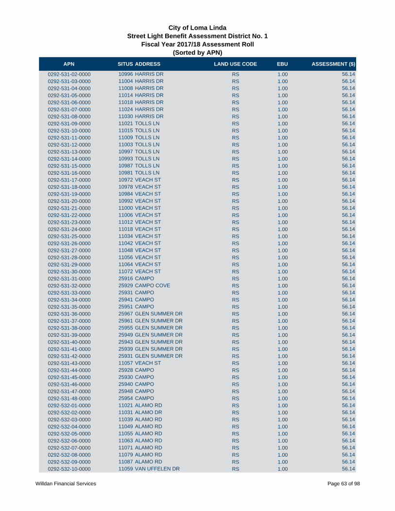
APN SITUS ADDRESS LAND USE CODE EBU ASSESSMENT ($)
City of Loma LindaStreet Light Benefit Assessment District No. 1
Fiscal Year 2017/18 Assessment Roll (Sorted by APN)
0292-531-02-0000 10996 HARRIS DR RS 1.00 56.14
0292-531-03-0000 11004 HARRIS DR RS 1.00 56.14
0292-531-04-0000 11008 HARRIS DR RS 1.00 56.14
0292-531-05-0000 11014 HARRIS DR RS 1.00 56.14
0292-531-06-0000 11018 HARRIS DR RS 1.00 56.14
0292-531-07-0000 11024 HARRIS DR RS 1.00 56.14
0292-531-08-0000 11030 HARRIS DR RS 1.00 56.14
0292-531-09-0000 11021 TOLLS LN RS 1.00 56.14
0292-531-10-0000 11015 TOLLS LN RS 1.00 56.14
0292-531-11-0000 11009 TOLLS LN RS 1.00 56.14
0292-531-12-0000 11003 TOLLS LN RS 1.00 56.14
0292-531-13-0000 10997 TOLLS LN RS 1.00 56.14
0292-531-14-0000 10993 TOLLS LN RS 1.00 56.14
0292-531-15-0000 10987 TOLLS LN RS 1.00 56.14
0292-531-16-0000 10981 TOLLS LN RS 1.00 56.14
0292-531-17-0000 10972 VEACH ST RS 1.00 56.14
0292-531-18-0000 10978 VEACH ST RS 1.00 56.14
0292-531-19-0000 10984 VEACH ST RS 1.00 56.14
0292-531-20-0000 10992 VEACH ST RS 1.00 56.14
0292-531-21-0000 11000 VEACH ST RS 1.00 56.14
0292-531-22-0000 11006 VEACH ST RS 1.00 56.14
0292-531-23-0000 11012 VEACH ST RS 1.00 56.14
0292-531-24-0000 11018 VEACH ST RS 1.00 56.14
0292-531-25-0000 11034 VEACH ST RS 1.00 56.14
0292-531-26-0000 11042 VEACH ST RS 1.00 56.14
0292-531-27-0000 11048 VEACH ST RS 1.00 56.14
0292-531-28-0000 11056 VEACH ST RS 1.00 56.14
0292-531-29-0000 11064 VEACH ST RS 1.00 56.14
0292-531-30-0000 11072 VEACH ST RS 1.00 56.14
0292-531-31-0000 25916 CAMPO RS 1.00 56.14
0292-531-32-0000 25929 CAMPO COVE RS 1.00 56.14
0292-531-33-0000 25931 CAMPO RS 1.00 56.14
0292-531-34-0000 25941 CAMPO RS 1.00 56.14
0292-531-35-0000 25951 CAMPO RS 1.00 56.14
0292-531-36-0000 25967 GLEN SUMMER DR RS 1.00 56.14
0292-531-37-0000 25961 GLEN SUMMER DR RS 1.00 56.14
0292-531-38-0000 25955 GLEN SUMMER DR RS 1.00 56.14
0292-531-39-0000 25949 GLEN SUMMER DR RS 1.00 56.14
0292-531-40-0000 25943 GLEN SUMMER DR RS 1.00 56.14
0292-531-41-0000 25939 GLEN SUMMER DR RS 1.00 56.14
0292-531-42-0000 25931 GLEN SUMMER DR RS 1.00 56.14
0292-531-43-0000 11057 VEACH ST RS 1.00 56.14
0292-531-44-0000 25928 CAMPO RS 1.00 56.14
0292-531-45-0000 25930 CAMPO RS 1.00 56.14
0292-531-46-0000 25940 CAMPO RS 1.00 56.14
0292-531-47-0000 25948 CAMPO RS 1.00 56.14
0292-531-48-0000 25954 CAMPO RS 1.00 56.14
0292-532-01-0000 11021 ALAMO RD RS 1.00 56.14
0292-532-02-0000 11031 ALAMO DR RS 1.00 56.14
0292-532-03-0000 11039 ALAMO RD RS 1.00 56.14
0292-532-04-0000 11049 ALAMO RD RS 1.00 56.14
0292-532-05-0000 11055 ALAMO RD RS 1.00 56.14
0292-532-06-0000 11063 ALAMO RD RS 1.00 56.14
0292-532-07-0000 11071 ALAMO RD RS 1.00 56.14
0292-532-08-0000 11079 ALAMO RD RS 1.00 56.14
0292-532-09-0000 11087 ALAMO RD RS 1.00 56.14
0292-532-10-0000 11059 VAN UFFELEN DR RS 1.00 56.14
Willdan Financial Services Page 63 of 98

APN SITUS ADDRESS LAND USE CODE EBU ASSESSMENT ($)
City of Loma LindaStreet Light Benefit Assessment District No. 1
Fiscal Year 2017/18 Assessment Roll (Sorted by APN)
0292-532-11-0000 11051 VAN UFFELEN DR RS 1.00 56.14
0292-532-12-0000 11047 VAN UFFELEN DR RS 1.00 56.14
0292-532-13-0000 11041 VAN UFFELEN DR RS 1.00 56.14
0292-532-14-0000 11033 VAN UFFELEN DR RS 1.00 56.14
0292-532-15-0000 11029 VAN UFFELEN DR RS 1.00 56.14
0292-532-16-0000 11021 VAN UFFELEN DR RS 1.00 56.14
0292-532-17-0000 11015 VAN UFFELEN DR RS 1.00 56.14
0292-532-18-0000 11007 VAN UFFELEN DR RS 1.00 56.14
0292-532-19-0000 11003 VAN UFFELEN DR RS 1.00 56.14
0292-532-20-0000 11012 BOREN AVE RS 1.00 56.14
0292-532-21-0000 11018 BOREN AVE RS 1.00 56.14
0292-532-22-0000 11024 BOREN AVE RS 1.00 56.14
0292-532-23-0000 11030 BOREN AVE RS 1.00 56.14
0292-532-24-0000 11036 BOREN AVE RS 1.00 56.14
0292-532-25-0000 11044 BOREN AVE RS 1.00 56.14
0292-532-26-0000 11050 BOREN AVE RS 1.00 56.14
0292-532-27-0000 11056 BOREN AVE RS 1.00 56.14
0292-532-28-0000 11062 BOREN AVE RS 1.00 56.14
0292-532-29-0000 11068 BOREN AVE RS 1.00 56.14
0292-532-30-0000 11051 BOREN AVE RS 1.00 56.14
0292-532-31-0000 11045 BOREN AVE RS 1.00 56.14
0292-532-32-0000 11039 BOREN AVE RS 1.00 56.14
0292-532-33-0000 11031 BOREN AVE RS 1.00 56.14
0292-532-34-0000 11027 BOREN AVE RS 1.00 56.14
0292-532-35-0000 11021 BOREN AVE RS 1.00 56.14
0292-532-36-0000 11013 BOREN AVE RS 1.00 56.14
0292-532-37-0000 11040 WILSON RS 1.00 56.14
0292-532-38-0000 11050 WILSON RS 1.00 56.14
0292-532-39-0000 11056 WILSON RS 1.00 56.14
0292-532-40-0000 11064 WILSON RS 1.00 56.14
0292-532-41-0000 11068 WILSON RS 1.00 56.14
0292-532-42-0000 11072 WILSON RS 1.00 56.14
0292-541-01-0000 25953 CAMPO RS 1.00 56.14
0292-541-02-0000 25959 CAMPO RS 1.00 56.14
0292-541-03-0000 11099 VAN UFFELEN DR RS 1.00 56.14
0292-541-04-0000 11091 VAN UFFELEN DR RS 1.00 56.14
0292-541-05-0000 11085 VAN UFFELEN DR RS 1.00 56.14
0292-541-06-0000 11079 VAN UFFELEN DR RS 1.00 56.14
0292-541-07-0000 11073 VAN UFFELEN DR RS 1.00 56.14
0292-541-08-0000 11103 ALAMO RD RS 1.00 56.14
0292-541-09-0000 11111 ALAMO RD RS 1.00 56.14
0292-541-10-0000 11117 ALAMO RD RS 1.00 56.14
0292-541-11-0000 11125 ALAMO RD RS 1.00 56.14
0292-541-12-0000 11133 ALAMO RD RS 1.00 56.14
0292-541-13-0000 11143 ALAMO RD RS 1.00 56.14
0292-541-14-0000 26087 ARROYO LN RS 1.00 56.14
0292-541-15-0000 26067 ARROYO LN RS 1.00 56.14
0292-541-16-0000 26061 ARROYO LN RS 1.00 56.14
0292-541-17-0000 26055 ARROYO LN RS 1.00 56.14
0292-541-18-0000 26049 ARROYO LN RS 1.00 56.14
0292-541-19-0000 26043 ARROYO` LN RS 1.00 56.14
0292-541-20-0000 26037 ARROYO` LN RS 1.00 56.14
0292-541-21-0000 26031 ARROYO LN RS 1.00 56.14
0292-541-22-0000 26025 ARROYO LN RS 1.00 56.14
0292-541-23-0000 26019 ARROYO` LN RS 1.00 56.14
0292-541-24-0000 26013 ARROYO LN RS 1.00 56.14
0292-541-25-0000 26007 ARROYO LN RS 1.00 56.14
Willdan Financial Services Page 64 of 98

APN SITUS ADDRESS LAND USE CODE EBU ASSESSMENT ($)
City of Loma LindaStreet Light Benefit Assessment District No. 1
Fiscal Year 2017/18 Assessment Roll (Sorted by APN)
0292-541-26-0000 26001 ARROYO LN RS 1.00 56.14
0292-541-27-0000 25993 ARROYO LN RS 1.00 56.14
0292-541-28-0000 11106 BOREN AVE RS 1.00 56.14
0292-541-29-0000 11096 BOREN AVE RS 1.00 56.14
0292-541-30-0000 11090 BOREN AVE RS 1.00 56.14
0292-541-31-0000 11082 BOREN AVE RS 1.00 56.14
0292-541-32-0000 11075 BOREN AVE RS 1.00 56.14
0292-541-33-0000 11085 BOREN AVE RS 1.00 56.14
0292-541-34-0000 11093 BOREN AVE RS 1.00 56.14
0292-541-35-0000 11101 BOREN AVE RS 1.00 56.14
0292-541-36-0000 26018 ARROYO LN RS 1.00 56.14
0292-541-37-0000 26024 ARROYO LN RS 1.00 56.14
0292-541-38-0000 26030 ARROYO LN RS 1.00 56.14
0292-541-39-0000 26036 ARROYO LN RS 1.00 56.14
0292-541-40-0000 26042 ARROYO LN RS 1.00 56.14
0292-541-41-0000 26048 ARROYO LN RS 1.00 56.14
0292-541-42-0000 26054 ARROYO LN RS 1.00 56.14
0292-541-43-0000 26064 ARROYO LN RS 1.00 56.14
0292-541-44-0000 26077 PAXTON PL RS 1.00 56.14
0292-541-45-0000 26069 PAXTON PL RS 1.00 56.14
0292-541-46-0000 26063 PAXTON PL RS 1.00 56.14
0292-541-47-0000 26055 PAXTON PL RS 1.00 56.14
0292-541-48-0000 26047 PAXTON PL RS 1.00 56.14
0292-541-49-0000 26041 PAXTON PL RS 1.00 56.14
0292-541-50-0000 26035 PAXTON PL RS 1.00 56.14
0292-551-01-0000 25834 SILVA CT RS 1.00 56.14
0292-551-02-0000 25842 SILVA CT RS 1.00 56.14
0292-551-03-0000 25848 SILVA CT RS 1.00 56.14
0292-551-04-0000 25847 SILVA CT RS 1.00 56.14
0292-551-05-0000 25841 SILVA CT RS 1.00 56.14
0292-551-06-0000 25835 SILVA CT RS 1.00 56.14
0292-551-07-0000 25834 SAHATAPA LN RS 1.00 56.14
0292-551-08-0000 25842 SAHATAPA LN RS 1.00 56.14
0292-551-09-0000 25848 SAHATAPA LN RS 1.00 56.14
0292-551-10-0000 10871 PEPPER WY RS 1.00 56.14
0292-551-11-0000 10879 PEPPER WY RS 1.00 56.14
0292-551-12-0000 10885 PEPPER WY RS 1.00 56.14
0292-551-13-0000 10893 PEPPER WY RS 1.00 56.14
0292-551-14-0000 10892 SINCLARE CIR RS 1.00 56.14
0292-551-15-0000 10884 SINCLARE CIR RS 1.00 56.14
0292-551-16-0000 10878 SINCLARE CIR RS 1.00 56.14
0292-551-17-0000 10870 SINCLARE CIR RS 1.00 56.14
0292-551-18-0000 10882 SINCLARE CIR RS 1.00 56.14
0292-551-19-0000 10888 SINCLARE CIR RS 1.00 56.14
0292-551-20-0000 10894 SINCLARE CIR RS 1.00 56.14
0292-551-21-0000 10874 SINCLARE CIR RS 1.00 56.14
0292-551-22-0000 10875 SINCLARE CIR RS 1.00 56.14
0292-551-23-0000 10858 SINCLARE CIR RS 1.00 56.14
0292-551-24-0000 10850 SINCLARE CIR RS 1.00 56.14
0292-551-25-0000 10840 SINCLARE CIR RS 1.00 56.14
0292-551-26-0000 10849 SINCLARE CIR RS 1.00 56.14
0292-551-27-0000 10861 SINCLARE CIR RS 1.00 56.14
0292-551-28-0000 10867 SINCLARE CIR RS 1.00 56.14
0292-551-29-0000 10873 SINCLARE CIR RS 1.00 56.14
0292-551-30-0000 10881 SINCLARE CIR RS 1.00 56.14
0292-551-31-0000 10887 SINCLARE CIR RS 1.00 56.14
0292-551-32-0000 10895 SINCLARE CIR RS 1.00 56.14
Willdan Financial Services Page 65 of 98
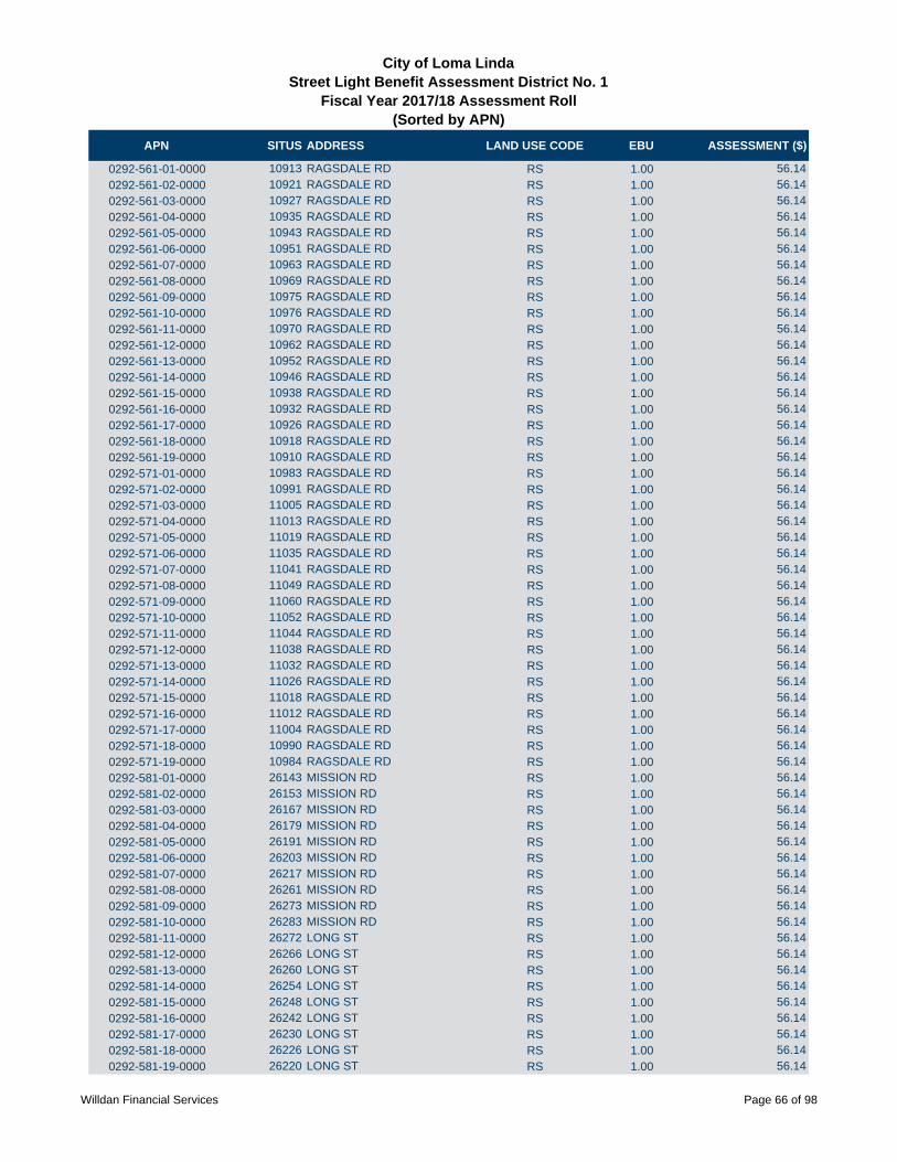
APN SITUS ADDRESS LAND USE CODE EBU ASSESSMENT ($)
City of Loma LindaStreet Light Benefit Assessment District No. 1
Fiscal Year 2017/18 Assessment Roll (Sorted by APN)
0292-561-01-0000 10913 RAGSDALE RD RS 1.00 56.14
0292-561-02-0000 10921 RAGSDALE RD RS 1.00 56.14
0292-561-03-0000 10927 RAGSDALE RD RS 1.00 56.14
0292-561-04-0000 10935 RAGSDALE RD RS 1.00 56.14
0292-561-05-0000 10943 RAGSDALE RD RS 1.00 56.14
0292-561-06-0000 10951 RAGSDALE RD RS 1.00 56.14
0292-561-07-0000 10963 RAGSDALE RD RS 1.00 56.14
0292-561-08-0000 10969 RAGSDALE RD RS 1.00 56.14
0292-561-09-0000 10975 RAGSDALE RD RS 1.00 56.14
0292-561-10-0000 10976 RAGSDALE RD RS 1.00 56.14
0292-561-11-0000 10970 RAGSDALE RD RS 1.00 56.14
0292-561-12-0000 10962 RAGSDALE RD RS 1.00 56.14
0292-561-13-0000 10952 RAGSDALE RD RS 1.00 56.14
0292-561-14-0000 10946 RAGSDALE RD RS 1.00 56.14
0292-561-15-0000 10938 RAGSDALE RD RS 1.00 56.14
0292-561-16-0000 10932 RAGSDALE RD RS 1.00 56.14
0292-561-17-0000 10926 RAGSDALE RD RS 1.00 56.14
0292-561-18-0000 10918 RAGSDALE RD RS 1.00 56.14
0292-561-19-0000 10910 RAGSDALE RD RS 1.00 56.14
0292-571-01-0000 10983 RAGSDALE RD RS 1.00 56.14
0292-571-02-0000 10991 RAGSDALE RD RS 1.00 56.14
0292-571-03-0000 11005 RAGSDALE RD RS 1.00 56.14
0292-571-04-0000 11013 RAGSDALE RD RS 1.00 56.14
0292-571-05-0000 11019 RAGSDALE RD RS 1.00 56.14
0292-571-06-0000 11035 RAGSDALE RD RS 1.00 56.14
0292-571-07-0000 11041 RAGSDALE RD RS 1.00 56.14
0292-571-08-0000 11049 RAGSDALE RD RS 1.00 56.14
0292-571-09-0000 11060 RAGSDALE RD RS 1.00 56.14
0292-571-10-0000 11052 RAGSDALE RD RS 1.00 56.14
0292-571-11-0000 11044 RAGSDALE RD RS 1.00 56.14
0292-571-12-0000 11038 RAGSDALE RD RS 1.00 56.14
0292-571-13-0000 11032 RAGSDALE RD RS 1.00 56.14
0292-571-14-0000 11026 RAGSDALE RD RS 1.00 56.14
0292-571-15-0000 11018 RAGSDALE RD RS 1.00 56.14
0292-571-16-0000 11012 RAGSDALE RD RS 1.00 56.14
0292-571-17-0000 11004 RAGSDALE RD RS 1.00 56.14
0292-571-18-0000 10990 RAGSDALE RD RS 1.00 56.14
0292-571-19-0000 10984 RAGSDALE RD RS 1.00 56.14
0292-581-01-0000 26143 MISSION RD RS 1.00 56.14
0292-581-02-0000 26153 MISSION RD RS 1.00 56.14
0292-581-03-0000 26167 MISSION RD RS 1.00 56.14
0292-581-04-0000 26179 MISSION RD RS 1.00 56.14
0292-581-05-0000 26191 MISSION RD RS 1.00 56.14
0292-581-06-0000 26203 MISSION RD RS 1.00 56.14
0292-581-07-0000 26217 MISSION RD RS 1.00 56.14
0292-581-08-0000 26261 MISSION RD RS 1.00 56.14
0292-581-09-0000 26273 MISSION RD RS 1.00 56.14
0292-581-10-0000 26283 MISSION RD RS 1.00 56.14
0292-581-11-0000 26272 LONG ST RS 1.00 56.14
0292-581-12-0000 26266 LONG ST RS 1.00 56.14
0292-581-13-0000 26260 LONG ST RS 1.00 56.14
0292-581-14-0000 26254 LONG ST RS 1.00 56.14
0292-581-15-0000 26248 LONG ST RS 1.00 56.14
0292-581-16-0000 26242 LONG ST RS 1.00 56.14
0292-581-17-0000 26230 LONG ST RS 1.00 56.14
0292-581-18-0000 26226 LONG ST RS 1.00 56.14
0292-581-19-0000 26220 LONG ST RS 1.00 56.14
Willdan Financial Services Page 66 of 98
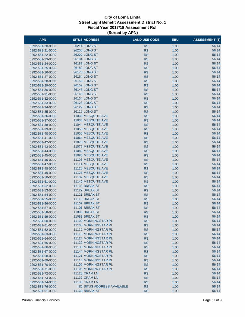
APN SITUS ADDRESS LAND USE CODE EBU ASSESSMENT ($)
City of Loma LindaStreet Light Benefit Assessment District No. 1
Fiscal Year 2017/18 Assessment Roll (Sorted by APN)
0292-581-20-0000 26214 LONG ST RS 1.00 56.14
0292-581-21-0000 26206 LONG ST RS 1.00 56.14
0292-581-22-0000 26200 LONG ST RS 1.00 56.14
0292-581-23-0000 26194 LONG ST RS 1.00 56.14
0292-581-24-0000 26188 LONG ST RS 1.00 56.14
0292-581-25-0000 26182 LONG ST RS 1.00 56.14
0292-581-26-0000 26176 LONG ST RS 1.00 56.14
0292-581-27-0000 26164 LONG ST RS 1.00 56.14
0292-581-28-0000 26158 LONG ST RS 1.00 56.14
0292-581-29-0000 26152 LONG ST RS 1.00 56.14
0292-581-30-0000 26146 LONG ST RS 1.00 56.14
0292-581-31-0000 26140 LONG ST RS 1.00 56.14
0292-581-32-0000 26134 LONG ST RS 1.00 56.14
0292-581-33-0000 26128 LONG ST RS 1.00 56.14
0292-581-34-0000 26122 LONG ST RS 1.00 56.14
0292-581-35-0000 26116 LONG ST RS 1.00 56.14
0292-581-36-0000 11030 MESQUITE AVE RS 1.00 56.14
0292-581-37-0000 11038 MESQUITE AVE RS 1.00 56.14
0292-581-38-0000 11044 MESQUITE AVE RS 1.00 56.14
0292-581-39-0000 11050 MESQUITE AVE RS 1.00 56.14
0292-581-40-0000 11058 MESQUITE AVE RS 1.00 56.14
0292-581-41-0000 11064 MESQUITE AVE RS 1.00 56.14
0292-581-42-0000 11070 MESQUITE AVE RS 1.00 56.14
0292-581-43-0000 11076 MESQUITE AVE RS 1.00 56.14
0292-581-44-0000 11082 MESQUITE AVE RS 1.00 56.14
0292-581-45-0000 11090 MESQUITE AVE RS 1.00 56.14
0292-581-46-0000 11106 MESQUITE AVE RS 1.00 56.14
0292-581-47-0000 11114 MESQUITE AVE RS 1.00 56.14
0292-581-48-0000 11120 MESQUITE AVE RS 1.00 56.14
0292-581-49-0000 11126 MESQUITE AVE RS 1.00 56.14
0292-581-50-0000 11132 MESQUITE AVE RS 1.00 56.14
0292-581-51-0000 11140 MESQUITE AVE RS 1.00 56.14
0292-581-52-0000 11133 BREAK ST RS 1.00 56.14
0292-581-53-0000 11127 BREAK ST RS 1.00 56.14
0292-581-54-0000 11121 BREAK ST RS 1.00 56.14
0292-581-55-0000 11113 BREAK ST RS 1.00 56.14
0292-581-56-0000 11107 BREAK ST RS 1.00 56.14
0292-581-57-0000 11101 BREAK ST RS 1.00 56.14
0292-581-58-0000 11095 BREAK ST RS 1.00 56.14
0292-581-59-0000 11089 BREAK ST RS 1.00 56.14
0292-581-60-0000 11100 MORNINGSTAR PL RS 1.00 56.14
0292-581-61-0000 11106 MORNINGSTAR PL RS 1.00 56.14
0292-581-62-0000 11112 MORNINGSTAR PL RS 1.00 56.14
0292-581-63-0000 11118 MORNINGSTAR PL RS 1.00 56.14
0292-581-64-0000 11124 MORNINGSTAR PL RS 1.00 56.14
0292-581-65-0000 11132 MORNINGSTAR PL RS 1.00 56.14
0292-581-66-0000 11138 MORNINGSTAR PL RS 1.00 56.14
0292-581-67-0000 11144 MORNINGSTAR PL RS 1.00 56.14
0292-581-68-0000 11121 MORNINGSTAR PL RS 1.00 56.14
0292-581-69-0000 11115 MORNINGSTAR PL RS 1.00 56.14
0292-581-70-0000 11109 MORNINGSTAR PL RS 1.00 56.14
0292-581-71-0000 11103 MORNINGSTAR PL RS 1.00 56.14
0292-581-72-0000 11126 CRAM LN RS 1.00 56.14
0292-581-73-0000 11132 CRAM LN RS 1.00 56.14
0292-581-74-0000 11138 CRAM LN RS 1.00 56.14
0292-581-76-0000 NO SITUS ADDRESS AVAILABLE RS 1.00 56.14
0292-591-01-0000 11139 BREAK ST RS 1.00 56.14
Willdan Financial Services Page 67 of 98

APN SITUS ADDRESS LAND USE CODE EBU ASSESSMENT ($)
City of Loma LindaStreet Light Benefit Assessment District No. 1
Fiscal Year 2017/18 Assessment Roll (Sorted by APN)
0292-591-02-0000 11150 MORNINGSTAR PL RS 1.00 56.14
0292-591-03-0000 11156 MORNINGSTAR PL RS 1.00 56.14
0292-591-04-0000 11164 MORNINGSTAR PL RS 1.00 56.14
0292-591-05-0000 11161 MORNINGSTAR PL RS 1.00 56.14
0292-591-06-0000 11153 MORNINGSTAR PL RS 1.00 56.14
0292-591-07-0000 11147 MORNINGSTAR PL RS 1.00 56.14
0292-591-08-0000 11141 MORNINGSTAR PL RS 1.00 56.14
0292-591-09-0000 11135 MORNINGSTAR PL RS 1.00 56.14
0292-591-10-0000 11152 CRAM LN RS 1.00 56.14
0292-591-11-0000 11158 CRAM LN RS 1.00 56.14
0292-591-12-0000 11164 CRAM LN RS 1.00 56.14
0292-591-13-0000 11170 CRAM LN RS 1.00 56.14
0292-591-14-0000 11178 CRAM LN RS 1.00 56.14
0292-591-15-0000 11175 CRAM LN RS 1.00 56.14
0292-591-16-0000 11167 CRAM LN RS 1.00 56.14
0292-591-17-0000 11161 CRAM LN RS 1.00 56.14
0292-591-18-0000 11155 CRAM LN RS 1.00 56.14
0292-591-19-0000 11141 CRAM LN RS 1.00 56.14
0292-591-20-0000 11135 CRAM LN RS 1.00 56.14
0292-591-21-0000 11129 CRAM LN RS 1.00 56.14
0292-591-22-0000 11123 CRAM LN RS 1.00 56.14
0292-591-23-0000 11140 DALLAS PL RS 1.00 56.14
0292-591-24-0000 11146 DALLAS PL RS 1.00 56.14
0292-591-25-0000 11152 DALLAS PL RS 1.00 56.14
0292-591-26-0000 11158 DALLAS PL RS 1.00 56.14
0292-591-27-0000 11172 DALLAS PL RS 1.00 56.14
0292-591-28-0000 11178 DALLAS PL RS 1.00 56.14
0292-591-29-0000 11184 DALLAS PL RS 1.00 56.14
0292-591-30-0000 11192 DALLAS PL RS 1.00 56.14
0292-591-31-0000 11189 DALLAS PL RS 1.00 56.14
0292-591-32-0000 11181 DALLAS PL RS 1.00 56.14
0292-591-33-0000 11175 DALLAS PL RS 1.00 56.14
0292-591-34-0000 11169 DALLAS PL RS 1.00 56.14
0292-591-35-0000 11163 DALLAS PL RS 1.00 56.14
0292-591-36-0000 11155 DALLAS PL RS 1.00 56.14
0292-591-37-0000 11149 DALLAS PL RS 1.00 56.14
0292-591-38-0000 11143 DALLAS PL RS 1.00 56.14
0292-591-39-0000 11137 DALLAS PL RS 1.00 56.14
0292-591-40-0000 11131 DALLAS PL RS 1.00 56.14
0292-591-41-0000 11141 FLORENCE LN RS 1.00 56.14
0292-591-42-0000 11147 FLORENCE LN RS 1.00 56.14
0292-591-43-0000 11153 FLORENCE LN RS 1.00 56.14
0292-591-44-0000 11159 FLORENCE LN RS 1.00 56.14
0292-591-45-0000 11165 FLORENCE LN RS 1.00 56.14
0292-591-46-0000 11173 FLORENCE LN RS 1.00 56.14
0292-591-47-0000 11179 FLORENCE LN RS 1.00 56.14
0292-591-48-0000 11185 FLORENCE LN RS 1.00 56.14
0292-591-49-0000 11191 FLORENCE LN RS 1.00 56.14
0292-591-50-0000 11199 FLORENCE LN RS 1.00 56.14
0292-591-51-0000 11224 DEWITT DR RS 1.00 56.14
0292-591-52-0000 11218 DEWITT DR RS 1.00 56.14
0292-591-53-0000 11212 DEWITT DR RS 1.00 56.14
0292-591-54-0000 11206 DEWITT DR RS 1.00 56.14
0292-591-55-0000 11200 DEWITT DR RS 1.00 56.14
0292-591-56-0000 11194 DEWITT DR RS 1.00 56.14
0292-591-57-0000 11186 DEWITT DR RS 1.00 56.14
0292-591-58-0000 11180 DEWITT DR RS 1.00 56.14
Willdan Financial Services Page 68 of 98

APN SITUS ADDRESS LAND USE CODE EBU ASSESSMENT ($)
City of Loma LindaStreet Light Benefit Assessment District No. 1
Fiscal Year 2017/18 Assessment Roll (Sorted by APN)
0292-591-59-0000 11174 DEWITT DR RS 1.00 56.14
0292-591-60-0000 11168 DEWITT DR RS 1.00 56.14
0292-591-61-0000 11178 SUNKIST DR RS 1.00 56.14
0292-591-62-0000 11184 SUNKIST DR RS 1.00 56.14
0292-591-63-0000 11190 SUNKIST DR RS 1.00 56.14
0292-591-64-0000 11196 SUNKIST DR RS 1.00 56.14
0292-591-65-0000 11204 SUNKIST DR RS 1.00 56.14
0292-591-66-0000 11210 SUNKIST DR RS 1.00 56.14
0292-591-67-0000 11216 SUNKIST DR RS 1.00 56.14
0292-591-68-0000 11222 SUNKIST DR RS 1.00 56.14
0292-591-69-0000 NO SITUS ADDRESS AVAILABLE RS 1.00 56.14
0292-592-01-0000 26301 MISSION RD RS 1.00 56.14
0292-592-02-0000 26313 MISSION RD RS 1.00 56.14
0292-592-03-0000 26325 MISSION RD RS 1.00 56.14
0292-592-04-0000 11241 SUNKIST DR RS 1.00 56.14
0292-592-05-0000 11235 SUNKIST DR RS 1.00 56.14
0292-592-06-0000 11229 SUNKIST DR RS 1.00 56.14
0292-592-07-0000 11223 SUNKIST DR RS 1.00 56.14
0292-592-08-0000 11217 SUNKIST DR RS 1.00 56.14
0292-592-09-0000 11209 SUNKIST DR RS 1.00 56.14
0292-592-10-0000 11203 SUNKIST DR RS 1.00 56.14
0292-592-11-0000 11197 SUNKIST DR RS 1.00 56.14
0292-592-12-0000 11191 SUNKIST DR RS 1.00 56.14
0292-592-13-0000 26324 LONG ST RS 1.00 56.14
0292-592-14-0000 26312 LONG ST RS 1.00 56.14
0292-592-15-0000 26306 LONG ST RS 1.00 56.14
0292-592-16-0000 26300 LONG ST RS 1.00 56.14
0292-592-17-0000 26294 LONG ST RS 1.00 56.14
0292-592-18-0000 26288 LONG ST RS 1.00 56.14
0292-592-19-0000 26282 LONG ST RS 1.00 56.14
0292-592-20-0000 26263 CITRON ST RS 1.00 56.14
0292-592-21-0000 26255 CITRON ST RS 1.00 56.14
0292-592-22-0000 26249 CITRON ST RS 1.00 56.14
0292-592-23-0000 26243 CITRON ST RS 1.00 56.14
0292-592-24-0000 26237 CITRON ST RS 1.00 56.14
0292-592-25-0000 26227 CITRON ST RS 1.00 56.14
0292-592-26-0000 26221 CITRON ST RS 1.00 56.14
0292-592-27-0000 26215 CITRON ST RS 1.00 56.14
0292-592-28-0000 26209 CITRON ST RS 1.00 56.14
0292-592-29-0000 26203 CITRON ST RS 1.00 56.14
0292-592-30-0000 26197 CITRON ST RS 1.00 56.14
0292-592-31-0000 26191 CITRON ST RS 1.00 56.14
0292-592-32-0000 26185 CITRON ST RS 1.00 56.14
0292-592-33-0000 26179 CITRON ST RS 1.00 56.14
0292-592-34-0000 26173 CITRON ST RS 1.00 56.14
0292-592-35-0000 26167 CITRON ST RS 1.00 56.14
0292-592-36-0000 26161 CITRON ST RS 1.00 56.14
0292-592-37-0000 26155 CITRON ST RS 1.00 56.14
0292-592-38-0000 26145 CITRON ST RS 1.00 56.14
0292-592-39-0000 26139 CITRON ST RS 1.00 56.14
0292-592-40-0000 26133 CITRON ST RS 1.00 56.14
0292-592-41-0000 26127 CITRON ST RS 1.00 56.14
0292-592-42-0000 26121 CITRON ST RS 1.00 56.14
0292-592-43-0000 11162 MESQUITE AVE RS 1.00 56.14
0292-592-44-0000 11154 MESQUITE AVE RS 1.00 56.14
0292-592-45-0000 11146 MESQUITE AVE RS 1.00 56.14
0292-601-01-0000 26339 MISSION RD RS 1.00 56.14
Willdan Financial Services Page 69 of 98

APN SITUS ADDRESS LAND USE CODE EBU ASSESSMENT ($)
City of Loma LindaStreet Light Benefit Assessment District No. 1
Fiscal Year 2017/18 Assessment Roll (Sorted by APN)
0292-601-02-0000 26353 MISSION RD RS 1.00 56.14
0292-601-03-0000 26367 MISSION RD RS 1.00 56.14
0292-601-04-0000 26385 MISSION RD RS 1.00 56.14
0292-601-05-0000 26399 MISSION RD RS 1.00 56.14
0292-601-06-0000 26396 FOWLER DR RS 1.00 56.14
0292-601-07-0000 26392 FOWLER DR RS 1.00 56.14
0292-601-08-0000 26388 FOWLER DR RS 1.00 56.14
0292-601-09-0000 26384 FOWLER DR RS 1.00 56.14
0292-601-10-0000 26380 FOWLER DR RS 1.00 56.14
0292-601-11-0000 26376 FOWLER DR RS 1.00 56.14
0292-601-12-0000 26396 KELLER DR RS 1.00 56.14
0292-601-13-0000 26392 KELLER DR RS 1.00 56.14
0292-601-14-0000 26388 KELLER DR RS 1.00 56.14
0292-601-15-0000 26384 KELLER DR RS 1.00 56.14
0292-601-16-0000 26380 KELLER DR RS 1.00 56.14
0292-601-17-0000 26376 KELLER DR RS 1.00 56.14
0292-601-18-0000 26372 KELLER DR RS 1.00 56.14
0292-601-19-0000 26368 KELLER DR RS 1.00 56.14
0292-601-20-0000 26360 KELLER DR RS 1.00 56.14
0292-601-21-0000 26356 KELLER DR RS 1.00 56.14
0292-601-22-0000 26352 KELLER DR RS 1.00 56.14
0292-601-23-0000 26348 KELLER DR RS 1.00 56.14
0292-601-24-0000 26344 KELLER DR RS 1.00 56.14
0292-601-25-0000 26338 KELLER DR RS 1.00 56.14
0292-601-26-0000 11201 DUMETZ LN RS 1.00 56.14
0292-601-27-0000 11207 DUMETZ LN RS 1.00 56.14
0292-601-28-0000 11213 DUMETZ LN RS 1.00 56.14
0292-601-29-0000 11219 DUMETZ LN RS 1.00 56.14
0292-601-30-0000 11227 DUMETZ LN RS 1.00 56.14
0292-601-31-0000 11233 DUMETZ LN RS 1.00 56.14
0292-601-32-0000 11239 DUMETZ LN RS 1.00 56.14
0292-601-33-0000 11245 DUMETZ LN RS 1.00 56.14
0292-601-34-0000 26366 LONG ST RS 1.00 56.14
0292-601-35-0000 26360 LONG ST RS 1.00 56.14
0292-601-36-0000 26354 LONG ST RS 1.00 56.14
0292-601-37-0000 26348 LONG ST RS 1.00 56.14
0292-601-38-0000 26342 LONG ST RS 1.00 56.14
0292-601-39-0000 26336 LONG ST RS 1.00 56.14
0292-601-40-0000 26330 LONG ST RS 1.00 56.14
0292-601-41-0000 NO SITUS ADDRESS AVAILABLE RS 1.00 56.14
0292-601-42-0000 NO SITUS ADDRESS AVAILABLE RS 1.00 56.14
0292-601-43-0000 NO SITUS ADDRESS AVAILABLE RS 1.00 56.14
0293-011-12-0000 26093 BARTON RD NR 3.00 369.51
0293-011-24-0000 25915 BARTON RD NR 3.00 369.51
0293-011-26-0000 25701 BARTON RD NR 4.00 492.68
0293-011-27-0000 25705 BARTON RD NR 3.00 369.51
0293-011-28-0000 25755 BARTON RD NR 4.00 492.68
0293-011-29-0000 25775 BARTON RD NR 2.00 246.34
0293-021-19-0000 26151 MAIN ST NR 1.00 123.17
0293-021-20-0000 11362 MAIN ST NR 1.00 123.17
0293-021-21-0000 MAIN ST NR 1.00 123.17
0293-021-24-0000 NO SITUS ADDRESS AVAILABLE NR 1.00 123.17
0293-021-25-0000 NO SITUS ADDRESS AVAILABLE NR 1.00 123.17
0293-021-26-0000 26275 AVENIDA REQUERO NR 1.00 123.17
0293-021-27-0000 26275 E 1ST ST NR 1.00 123.17
0293-021-28-0000 26293 AVENIDA REQUERO RS 1.00 56.14
0293-021-29-0000 NO SITUS ADDRESS AVAILABLE NR 1.00 123.17
Willdan Financial Services Page 70 of 98

APN SITUS ADDRESS LAND USE CODE EBU ASSESSMENT ($)
City of Loma LindaStreet Light Benefit Assessment District No. 1
Fiscal Year 2017/18 Assessment Roll (Sorted by APN)
0293-021-36-0000 26245 AVENIDA REQUEJO RS 1.00 56.14
0293-021-39-0000 11376 WHITTIER AVE RS 1.00 56.14
0293-021-41-0000 26151 MAYBERRY ST NR 4.00 492.68
0293-022-06-0000 NO SITUS ADDRESS AVAILABLE NR 1.00 123.17
0293-022-09-0000 26271 BARTON NR 2.00 246.34
0293-022-12-0000 26271 BARTON RD NR 1.00 123.17
0293-031-11-0000 1ST ST NR 1.00 123.17
0293-031-12-0000 26450 1ST ST RS 1.00 56.14
0293-031-21-0000 26470 1ST ST RS 1.00 56.14
0293-031-22-0000 26419 BARTON RD NR 1.00 123.17
0293-032-01-0000 26325 FIRST ST RS 1.00 56.14
0293-032-04-0000 1ST ST NR 1.00 123.17
0293-032-05-0000 26359 1ST ST RS 1.00 56.14
0293-032-06-0000 26363 FIRST RS 1.00 56.14
0293-032-07-0000 26373 1ST ST RS 1.00 56.14
0293-032-08-0000 26379 1ST ST RS 1.00 56.14
0293-032-09-0000 NO SITUS ADDRESS AVAILABLE NR 1.00 123.17
0293-032-10-0000 26389 1ST ST RS 1.00 56.14
0293-032-11-0000 NO SITUS ADDRESS AVAILABLE NR 1.00 123.17
0293-032-14-0000 26415 1ST ST RS 1.00 56.14
0293-032-15-0000 NO SITUS ADDRESS AVAILABLE NR 1.00 123.17
0293-032-16-0000 26425 1ST ST RS 1.00 56.14
0293-032-17-0000 26433 1ST ST RS 1.00 56.14
0293-032-18-0000 26437 1ST ST RS 1.00 56.14
0293-032-19-0000 26445 1ST ST RS 1.00 56.14
0293-032-20-0000 26451 1ST ST RS 1.00 56.14
0293-032-21-0000 26455 1ST ST RS 1.00 56.14
0293-032-23-0000 26339 1ST ST RS 1.00 56.14
0293-032-32-0000 26405 1ST ST RS 1.00 56.14
0293-041-08-0000 NO SITUS ADDRESS AVAILABLE RSC 0.28 15.59
0293-052-15-0000 BEAUMONT RD R 1.00 17.88
0293-052-16-0000 26007 BEAUMONT AVE R 1.00 17.88
0293-052-23-0000 BEAUMONT RD R 1.00 17.88
0293-061-02-0000 BARTON RD R 1.00 17.88
0293-182-01-0000 25963 NEWPORT AVE RS 1.00 56.14
0293-182-02-0000 25971 NEWPORT AVE RS 1.00 56.14
0293-182-03-0000 25979 NEWPORT AVE RS 1.00 56.14
0293-182-04-0000 25985 NEWPORT AVE RS 1.00 56.14
0293-182-05-0000 25991 NEWPORT AVE RS 1.00 56.14
0293-182-06-0000 25995 NEWPORT AVE RS 1.00 56.14
0293-182-07-0000 25999 NEWPORT AVE RS 1.00 56.14
0293-182-08-0000 26003 NEWPORT AVE RS 1.00 56.14
0293-182-09-0000 11365 BOONE WY RS 1.00 56.14
0293-182-10-0000 11361 BOONE WY RS 1.00 56.14
0293-182-11-0000 11357 BOONE WY RS 1.00 56.14
0293-182-12-0000 11353 BOONE WY RS 1.00 56.14
0293-182-13-0000 11371 BOONE WY RS 1.00 56.14
0293-182-14-0000 11377 BOONE WY RS 1.00 56.14
0293-182-15-0000 11383 BOONE WY RS 1.00 56.14
0293-182-16-0000 25992 REED WY RS 1.00 56.14
0293-182-17-0000 25988 REED WY RS 1.00 56.14
0293-182-18-0000 25982 REED WY RS 1.00 56.14
0293-182-19-0000 26045 NEWPORT AVE RS 1.00 56.14
0293-182-20-0000 26039 NEWPORT AVE RS 1.00 56.14
0293-182-21-0000 26035 NEWPORT AVE RS 1.00 56.14
0293-182-22-0000 26027 NEWPORT AVE RS 1.00 56.14
0293-182-23-0000 26019 NEWPORT AVE RS 1.00 56.14
Willdan Financial Services Page 71 of 98
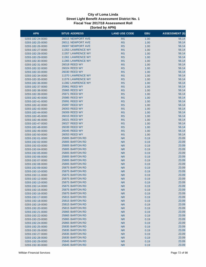
APN SITUS ADDRESS LAND USE CODE EBU ASSESSMENT ($)
City of Loma LindaStreet Light Benefit Assessment District No. 1
Fiscal Year 2017/18 Assessment Roll (Sorted by APN)
0293-182-24-0000 26015 NEWPORT AVE RS 1.00 56.14
0293-182-25-0000 26011 NEWPORT AVE RS 1.00 56.14
0293-182-26-0000 26007 NEWPORT AVE RS 1.00 56.14
0293-182-27-0000 11353 LAWRENCE WY RS 1.00 56.14
0293-182-28-0000 11357 LAWRENCE WY RS 1.00 56.14
0293-182-29-0000 11361 LAWRENCE WY RS 1.00 56.14
0293-182-30-0000 11365 LAWRENCE WY RS 1.00 56.14
0293-182-31-0000 26018 REED WY RS 1.00 56.14
0293-182-32-0000 26024 REED WY RS 1.00 56.14
0293-182-33-0000 26030 REED WY RS 1.00 56.14
0293-182-34-0000 11370 LAWRENCE WY RS 1.00 56.14
0293-182-35-0000 11376 LAWRENCE WY RS 1.00 56.14
0293-182-36-0000 11382 LAWRENCE WY RS 1.00 56.14
0293-182-37-0000 25961 REED WY RS 1.00 56.14
0293-182-38-0000 25965 REED WY RS 1.00 56.14
0293-182-39-0000 25971 REED WY RS 1.00 56.14
0293-182-40-0000 25985 REED WY RS 1.00 56.14
0293-182-41-0000 25991 REED WY RS 1.00 56.14
0293-182-42-0000 25997 REED WY RS 1.00 56.14
0293-182-43-0000 26003 REED WY RS 1.00 56.14
0293-182-44-0000 26009 REED WY RS 1.00 56.14
0293-182-45-0000 26015 REED WY RS 1.00 56.14
0293-182-46-0000 26021 REED WY RS 1.00 56.14
0293-182-47-0000 26027 REED WY RS 1.00 56.14
0293-182-48-0000 26039 REED WY RS 1.00 56.14
0293-182-49-0000 26045 REED WY RS 1.00 56.14
0293-182-50-0000 26053 REED WY RS 1.00 56.14
0293-192-01-0000 25805 BARTON RD NR 0.19 23.09
0293-192-02-0000 25805 BARTON RD NR 0.19 23.09
0293-192-03-0000 25805 BARTON RD NR 0.19 23.09
0293-192-04-0000 25805 BARTON RD NR 0.19 23.09
0293-192-05-0000 25805 BARTON RD NR 0.19 23.09
0293-192-06-0000 25805 BARTON RD NR 0.19 23.09
0293-192-07-0000 25805 BARTON RD NR 0.19 23.09
0293-192-08-0000 25805 BARTON RD NR 0.19 23.09
0293-192-09-0000 25875 BARTON RD NR 0.19 23.09
0293-192-10-0000 25875 BARTON RD NR 0.19 23.09
0293-192-11-0000 25875 BARTON RD NR 0.19 23.09
0293-192-12-0000 25875 BARTON RD NR 0.19 23.09
0293-192-13-0000 25875 BARTON RD NR 0.19 23.09
0293-192-14-0000 25875 BARTON RD NR 0.19 23.09
0293-192-15-0000 25875 BARTON RD NR 0.19 23.09
0293-192-16-0000 25875 BARTON RD NR 0.19 23.09
0293-192-17-0000 25815 BARTON RD NR 0.19 23.09
0293-192-18-0000 25815 BARTON RD NR 0.19 23.09
0293-192-19-0000 25815 BARTON RD NR 0.19 23.09
0293-192-20-0000 25815 BARTON RD NR 0.19 23.09
0293-192-21-0000 25865 BARTON RD NR 0.19 23.09
0293-192-22-0000 25865 BARTON RD NR 0.19 23.09
0293-192-23-0000 25865 BARTON RD NR 0.19 23.09
0293-192-24-0000 25865 BARTON RD NR 0.19 23.09
0293-192-25-0000 25835 BARTON RD NR 0.19 23.09
0293-192-26-0000 25835 BARTON RD NR 0.19 23.09
0293-192-27-0000 25835 BARTON RD NR 0.19 23.09
0293-192-28-0000 25835 BARTON RD NR 0.19 23.09
0293-192-29-0000 25845 BARTON RD NR 0.19 23.09
0293-192-30-0000 25845 BARTON RD NR 0.19 23.09
Willdan Financial Services Page 72 of 98

APN SITUS ADDRESS LAND USE CODE EBU ASSESSMENT ($)
City of Loma LindaStreet Light Benefit Assessment District No. 1
Fiscal Year 2017/18 Assessment Roll (Sorted by APN)
0293-192-31-0000 25845 BARTON RD NR 0.19 23.09
0293-192-32-0000 25845 BARTON RD NR 0.19 23.09
0293-211-01-0000 25801 HINCKLEY ST RS 1.00 56.14
0293-211-02-0000 25813 HINCKLEY ST RS 1.00 56.14
0293-211-03-0000 25825 HINCKLEY ST RS 1.00 56.14
0293-211-04-0000 25837 HINCKLEY ST RS 1.00 56.14
0293-211-05-0000 25849 HINCKLEY ST RS 1.00 56.14
0293-211-06-0000 25850 HUDSON CT RS 1.00 56.14
0293-211-07-0000 25838 HUDSON CT RS 1.00 56.14
0293-211-08-0000 25826 HUDSON CT RS 1.00 56.14
0293-211-09-0000 25814 HUDSON CT RS 1.00 56.14
0293-211-10-0000 25802 HUDSON CT RS 1.00 56.14
0293-211-11-0000 25801 HUDSON CT RS 1.00 56.14
0293-211-12-0000 25813 HUDSON CT RS 1.00 56.14
0293-211-13-0000 25825 HUDSON CT RS 1.00 56.14
0293-211-14-0000 25837 HUDSON CT RS 1.00 56.14
0293-211-15-0000 25849 HUDSON CT RS 1.00 56.14
0293-211-16-0000 25850 DAVIS WY RS 1.00 56.14
0293-211-17-0000 25838 DAVIS WY RS 1.00 56.14
0293-211-18-0000 25826 DAVIS WY RS 1.00 56.14
0293-211-19-0000 25810 DAVIS WY RS 1.00 56.14
0293-211-20-0000 25809 DAVIS WY RS 1.00 56.14
0293-211-21-0000 11681 NELSON ST RS 1.00 56.14
0293-211-22-0000 11671 NELSON ST RS 1.00 56.14
0293-211-23-0000 11661 NELSON ST RS 1.00 56.14
0293-211-24-0000 11651 NELSON ST RS 1.00 56.14
0293-211-25-0000 11641 NELSON ST RS 1.00 56.14
0293-211-26-0000 11631 NELSON ST RS 1.00 56.14
0293-211-27-0000 11621 NELSON ST RS 1.00 56.14
0293-211-28-0000 11611 NELSON ST RS 1.00 56.14
0293-211-29-0000 11601 NELSON ST RS 1.00 56.14
0293-211-31-0000 25711 HINCKLEY ST RS 1.00 56.14
0293-211-32-0000 25725 HINCKLEY ST RS 1.00 56.14
0293-211-33-0000 11632 LOZANO PL RS 1.00 56.14
0293-211-34-0000 11642 LOZANO PL RS 1.00 56.14
0293-211-35-0000 11652 LOZANO PL RS 1.00 56.14
0293-211-36-0000 11662 LOZANO PL RS 1.00 56.14
0293-211-37-0000 11674 LOZANO PL RS 1.00 56.14
0293-211-38-0000 11684 LOZANO PL RS 1.00 56.14
0293-211-39-0000 11694 LOZANO PL RS 1.00 56.14
0293-211-40-0000 11693 LOZANO PL RS 1.00 56.14
0293-211-41-0000 11683 LOZANO PL RS 1.00 56.14
0293-211-42-0000 11671 LOZANO PL RS 1.00 56.14
0293-211-43-0000 11659 LOZANO PL RS 1.00 56.14
0293-211-44-0000 11647 LOZANO PL RS 1.00 56.14
0293-211-45-0000 11635 LOZANO PL RS 1.00 56.14
0293-211-46-0000 25751 HINCKLEY ST RS 1.00 56.14
0293-211-47-0000 25765 HINCKLEY ST RS 1.00 56.14
0293-211-48-0000 25781 HINCKLEY ST RS 1.00 56.14
0293-211-49-0000 11634 LARGO CT RS 1.00 56.14
0293-211-50-0000 11646 LARGO CT RS 1.00 56.14
0293-211-51-0000 11658 LARGO CT RS 1.00 56.14
0293-211-52-0000 11672 LARGO CT RS 1.00 56.14
0293-211-53-0000 11684 LARGO CT RS 1.00 56.14
0293-211-54-0000 11696 LARGO CT RS 1.00 56.14
0293-211-55-0000 11695 LARGO CT RS 1.00 56.14
0293-211-56-0000 11685 LARGO CT RS 1.00 56.14
Willdan Financial Services Page 73 of 98

APN SITUS ADDRESS LAND USE CODE EBU ASSESSMENT ($)
City of Loma LindaStreet Light Benefit Assessment District No. 1
Fiscal Year 2017/18 Assessment Roll (Sorted by APN)
0293-211-57-0000 11673 LARGO CT RS 1.00 56.14
0293-211-58-0000 11661 LARGO CT RS 1.00 56.14
0293-211-59-0000 11651 LARGO CT RS 1.00 56.14
0293-211-60-0000 11641 LARGO CT RS 1.00 56.14
0293-211-61-0000 11631 LARGO CT RS 1.00 56.14
0293-211-62-0000 25795 HINCKLEY ST RS 1.00 56.14
0293-221-01-0000 25731 EMMERSON ST RS 1.00 56.14
0293-221-02-0000 25711 EMMERSON ST RS 1.00 56.14
0293-221-03-0000 11750 MARTIN ST RS 1.00 56.14
0293-221-04-0000 11740 MARTIN ST RS 1.00 56.14
0293-221-05-0000 11730 MARTIN ST RS 1.00 56.14
0293-221-06-0000 11720 MARTIN ST RS 1.00 56.14
0293-221-07-0000 11721 MARTIN ST RS 1.00 56.14
0293-221-08-0000 11731 MARTIN ST RS 1.00 56.14
0293-221-09-0000 25730 EMMERSON ST RS 1.00 56.14
0293-221-10-0000 25750 EMMERSON ST RS 1.00 56.14
0293-221-11-0000 25770 EMMERSON ST RS 1.00 56.14
0293-221-12-0000 25790 EMMERSON ST RS 1.00 56.14
0293-221-13-0000 25810 EMMERSON ST RS 1.00 56.14
0293-221-14-0000 11760 NELSON ST RS 1.00 56.14
0293-221-15-0000 11750 NELSON ST RS 1.00 56.14
0293-221-16-0000 11740 NELSON ST RS 1.00 56.14
0293-221-17-0000 25825 KELLOGG ST RS 1.00 56.14
0293-221-18-0000 25791 KELLOGG ST RS 1.00 56.14
0293-221-19-0000 25787 KELLOGG ST RS 1.00 56.14
0293-221-20-0000 25783 KELLOGG ST RS 1.00 56.14
0293-221-21-0000 25779 KELLOGG ST RS 1.00 56.14
0293-221-22-0000 25775 KELLOGG ST RS 1.00 56.14
0293-221-23-0000 25771 KELLOGG ST RS 1.00 56.14
0293-221-24-0000 25712 KELLOGG ST RS 1.00 56.14
0293-221-25-0000 25726 KELLOGG ST RS 1.00 56.14
0293-221-26-0000 25740 KELLOGG ST RS 1.00 56.14
0293-221-27-0000 25754 KELLOGG ST RS 1.00 56.14
0293-221-28-0000 25768 KELLOGG ST RS 1.00 56.14
0293-221-29-0000 25782 KELLOGG ST RS 1.00 56.14
0293-221-30-0000 25796 KELLOGG ST RS 1.00 56.14
0293-221-31-0000 25810 KELLOGG ST RS 1.00 56.14
0293-221-32-0000 25824 KELLOGG ST RS 1.00 56.14
0293-221-33-0000 25838 KELLOGG ST RS 1.00 56.14
0293-221-34-0000 25852 KELLOGG ST RS 1.00 56.14
0293-221-35-0000 25845 DAVIS WY RS 1.00 56.14
0293-221-36-0000 25833 DAVIS WY RS 1.00 56.14
0293-221-37-0000 25821 DAVIS WY RS 1.00 56.14
0293-221-38-0000 11691 NELSON ST RS 1.00 56.14
0293-221-39-0000 11701 NELSON ST RS 1.00 56.14
0293-221-40-0000 11711 NELSON ST RS 1.00 56.14
0293-221-41-0000 25866 KELLOGG ST RS 1.00 56.14
0293-221-42-0000 25876 KELLOGG ST RS 1.00 56.14
0293-221-43-0000 25886 KELLOGG ST RS 1.00 56.14
0293-221-44-0000 25896 KELLOGG ST RS 1.00 56.14
0293-221-45-0000 25906 KELLOGG ST RS 1.00 56.14
0293-221-46-0000 25901 KELLOGG ST RS 1.00 56.14
0293-221-47-0000 11741 NELSON ST RS 1.00 56.14
0293-221-48-0000 11751 NELSON ST RS 1.00 56.14
0293-221-49-0000 11771 NELSON ST RS 1.00 56.14
0293-231-01-0000 25751 EMMERSON ST RS 1.00 56.14
0293-231-02-0000 25771 EMMERSON ST RS 1.00 56.14
Willdan Financial Services Page 74 of 98
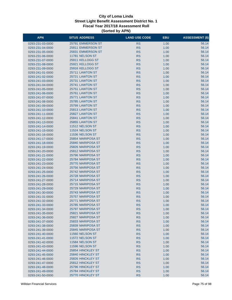
APN SITUS ADDRESS LAND USE CODE EBU ASSESSMENT ($)
City of Loma LindaStreet Light Benefit Assessment District No. 1
Fiscal Year 2017/18 Assessment Roll (Sorted by APN)
0293-231-03-0000 25791 EMMERSON ST RS 1.00 56.14
0293-231-04-0000 25811 EMMERSON ST RS 1.00 56.14
0293-231-05-0000 25831 EMMERSON ST RS 1.00 56.14
0293-231-06-0000 11781 NELSON ST RS 1.00 56.14
0293-231-07-0000 25911 KELLOGG ST RS 1.00 56.14
0293-231-08-0000 25921 KELLOGG ST RS 1.00 56.14
0293-231-09-0000 25916 KELLOGG ST RS 1.00 56.14
0293-241-01-0000 25711 LAWTON ST RS 1.00 56.14
0293-241-02-0000 25721 LAWTON ST RS 1.00 56.14
0293-241-03-0000 25731 LAWTON ST RS 1.00 56.14
0293-241-04-0000 25741 LAWTON ST RS 1.00 56.14
0293-241-05-0000 25751 LAWTON ST RS 1.00 56.14
0293-241-06-0000 25761 LAWTON ST RS 1.00 56.14
0293-241-07-0000 25771 LAWTON ST RS 1.00 56.14
0293-241-08-0000 25785 LAWTON ST RS 1.00 56.14
0293-241-09-0000 25799 LAWTON ST RS 1.00 56.14
0293-241-10-0000 25813 LAWTON ST RS 1.00 56.14
0293-241-11-0000 25827 LAWTON ST RS 1.00 56.14
0293-241-12-0000 25841 LAWTON ST RS 1.00 56.14
0293-241-13-0000 25855 LAWTON ST RS 1.00 56.14
0293-241-14-0000 11512 NELSON ST RS 1.00 56.14
0293-241-15-0000 11524 NELSON ST RS 1.00 56.14
0293-241-16-0000 11536 NELSON ST RS 1.00 56.14
0293-241-17-0000 25854 MARIPOSA ST RS 1.00 56.14
0293-241-18-0000 25840 MARIPOSA ST RS 1.00 56.14
0293-241-19-0000 25826 MARIPOSA ST RS 1.00 56.14
0293-241-20-0000 25812 MARIPOSA ST RS 1.00 56.14
0293-241-21-0000 25796 MARIPOSA ST RS 1.00 56.14
0293-241-22-0000 25784 MARIPOSA ST RS 1.00 56.14
0293-241-23-0000 25770 MARIPOSA ST RS 1.00 56.14
0293-241-24-0000 25756 MARIPOSA ST RS 1.00 56.14
0293-241-25-0000 25742 MARIPOSA ST RS 1.00 56.14
0293-241-26-0000 25728 MARIPOSA ST RS 1.00 56.14
0293-241-27-0000 25714 MARIPOSA ST RS 1.00 56.14
0293-241-28-0000 25715 MARIPOSA ST RS 1.00 56.14
0293-241-29-0000 25729 MARIPOSA ST RS 1.00 56.14
0293-241-30-0000 25743 MARIPOSA ST RS 1.00 56.14
0293-241-31-0000 25757 MARIPOSA ST RS 1.00 56.14
0293-241-32-0000 25771 MARIPOSA ST RS 1.00 56.14
0293-241-33-0000 25785 MARIPOSA ST RS 1.00 56.14
0293-241-34-0000 25797 MARIPOSA ST RS 1.00 56.14
0293-241-35-0000 25821 MARIPOSA ST RS 1.00 56.14
0293-241-36-0000 25827 MARIPOSA ST RS 1.00 56.14
0293-241-37-0000 25833 MARIPOSA ST RS 1.00 56.14
0293-241-38-0000 25839 MARIPOSA ST RS 1.00 56.14
0293-241-39-0000 25845 MARIPOSA ST RS 1.00 56.14
0293-241-40-0000 11560 NELSON ST RS 1.00 56.14
0293-241-41-0000 11572 NELSON ST RS 1.00 56.14
0293-241-42-0000 11584 NELSON ST RS 1.00 56.14
0293-241-43-0000 11596 NELSON ST RS 1.00 56.14
0293-241-44-0000 25854 HINCKLEY ST RS 1.00 56.14
0293-241-45-0000 25840 HINCKLEY ST RS 1.00 56.14
0293-241-46-0000 25826 HINCKLEY ST RS 1.00 56.14
0293-241-47-0000 25812 HINCKLEY ST RS 1.00 56.14
0293-241-48-0000 25796 HINCKLEY ST RS 1.00 56.14
0293-241-49-0000 25784 HINCKLEY ST RS 1.00 56.14
0293-241-50-0000 25770 HINCKLEY ST RS 1.00 56.14
Willdan Financial Services Page 75 of 98

APN SITUS ADDRESS LAND USE CODE EBU ASSESSMENT ($)
City of Loma LindaStreet Light Benefit Assessment District No. 1
Fiscal Year 2017/18 Assessment Roll (Sorted by APN)
0293-241-51-0000 25756 HINCKLEY ST RS 1.00 56.14
0293-241-52-0000 25742 HINCKLEY ST RS 1.00 56.14
0293-241-53-0000 25728 HINCKLEY ST RS 1.00 56.14
0293-241-54-0000 25714 HINCKLEY ST RS 1.00 56.14
0293-241-55-0000 11595 NELSON ST RS 1.00 56.14
0293-241-56-0000 11583 NELSON ST RS 1.00 56.14
0293-241-57-0000 11571 NELSON ST RS 1.00 56.14
0293-241-58-0000 11559 NELSON ST RS 1.00 56.14
0293-241-59-0000 11547 NELSON ST RS 1.00 56.14
0293-241-60-0000 11535 NELSON ST RS 1.00 56.14
0293-241-61-0000 11523 NELSON ST RS 1.00 56.14
0293-241-62-0000 11511 NELSON ST RS 1.00 56.14
0293-241-63-0000 LAWTON ST RS 1.00 56.14
0293-251-01-0000 25911 HINCKLEY ST RS 1.00 56.14
0293-251-02-0000 25921 HINCKLEY ST RS 1.00 56.14
0293-251-03-0000 25931 HINCKLEY ST RS 1.00 56.14
0293-251-04-0000 25941 HINCKLEY ST RS 1.00 56.14
0293-251-05-0000 11624 WILEY ST RS 1.00 56.14
0293-251-06-0000 11634 WILEY ST RS 1.00 56.14
0293-251-07-0000 11644 WILEY ST RS 1.00 56.14
0293-251-08-0000 11654 WILEY ST RS 1.00 56.14
0293-251-09-0000 11664 WILEY ST RS 1.00 56.14
0293-251-10-0000 11674 WILEY ST RS 1.00 56.14
0293-251-11-0000 11684 WILEY ST RS 1.00 56.14
0293-251-12-0000 11694 WILEY ST RS 1.00 56.14
0293-251-13-0000 25937 REYNOLDS ST RS 1.00 56.14
0293-251-14-0000 25949 REYNOLDS ST RS 1.00 56.14
0293-251-15-0000 25961 REYNOLDS ST RS 1.00 56.14
0293-251-16-0000 25973 REYNOLDS ST RS 1.00 56.14
0293-251-17-0000 25985 REYNOLDS ST RS 1.00 56.14
0293-251-18-0000 25997 REYNOLDS ST RS 1.00 56.14
0293-251-19-0000 26011 REYNOLDS ST RS 1.00 56.14
0293-251-20-0000 26021 REYNOLDS ST RS 1.00 56.14
0293-251-21-0000 26031 REYNOLDS ST RS 1.00 56.14
0293-251-22-0000 26041 REYNOLDS ST RS 1.00 56.14
0293-251-23-0000 26051 REYNOLDS ST RS 1.00 56.14
0293-251-24-0000 26061 REYNOLDS ST RS 1.00 56.14
0293-251-25-0000 25071 REYNOLDS ST RS 1.00 56.14
0293-251-26-0000 26081 REYNOLDS ST RS 1.00 56.14
0293-251-27-0000 26091 REYNOLDS ST RS 1.00 56.14
0293-251-28-0000 26092 REYNOLDS ST RS 1.00 56.14
0293-251-29-0000 26082 REYNOLDS ST RS 1.00 56.14
0293-251-30-0000 26072 REYNOLDS ST RS 1.00 56.14
0293-251-31-0000 26062 REYNOLDS ST RS 1.00 56.14
0293-251-32-0000 26052 REYNOLDS ST RS 1.00 56.14
0293-251-33-0000 26042 REYNOLDS ST RS 1.00 56.14
0293-251-34-0000 26032 REYNOLDS ST RS 1.00 56.14
0293-251-35-0000 26022 REYNOLDS ST RS 1.00 56.14
0293-251-36-0000 26012 REYNOLDS ST RS 1.00 56.14
0293-251-37-0000 11671 BUTTERFIELD ST RS 1.00 56.14
0293-251-38-0000 11659 BUTTERFIELD ST RS 1.00 56.14
0293-251-39-0000 11647 BUTTERFIELD ST RS 1.00 56.14
0293-251-40-0000 11635 BUTTERFIELD ST RS 1.00 56.14
0293-251-41-0000 26021 HINCKLEY ST RS 1.00 56.14
0293-251-42-0000 26031 HINCKLEY ST RS 1.00 56.14
0293-251-43-0000 26041 HINCKLEY ST RS 1.00 56.14
0293-251-44-0000 26051 HINCKLEY ST RS 1.00 56.14
Willdan Financial Services Page 76 of 98

APN SITUS ADDRESS LAND USE CODE EBU ASSESSMENT ($)
City of Loma LindaStreet Light Benefit Assessment District No. 1
Fiscal Year 2017/18 Assessment Roll (Sorted by APN)
0293-251-45-0000 26061 HINCKLEY ST RS 1.00 56.14
0293-251-46-0000 26071 HINCKLEY ST RS 1.00 56.14
0293-251-47-0000 26081 HINCKLEY ST RS 1.00 56.14
0293-251-48-0000 26091 HINCKLEY ST RS 1.00 56.14
0293-251-49-0000 25961 HINCKLEY ST RS 1.00 56.14
0293-251-50-0000 25971 HINCKLEY ST RS 1.00 56.14
0293-251-51-0000 25981 HINCKLEY ST RS 1.00 56.14
0293-251-52-0000 25991 HINCKLEY ST RS 1.00 56.14
0293-251-53-0000 11632 BUTTERFIELD ST RS 1.00 56.14
0293-251-54-0000 11644 BUTTERFIELD ST RS 1.00 56.14
0293-251-55-0000 11656 BUTTERFIELD ST RS 1.00 56.14
0293-251-56-0000 25998 REYNOLDS ST RS 1.00 56.14
0293-251-57-0000 25988 REYNOLDS ST RS 1.00 56.14
0293-251-58-0000 25978 REYNOLDS ST RS 1.00 56.14
0293-251-59-0000 25968 REYNOLDS ST RS 1.00 56.14
0293-251-60-0000 25958 REYNOLDS ST RS 1.00 56.14
0293-251-61-0000 25948 REYNOLDS ST RS 1.00 56.14
0293-251-62-0000 25938 REYNOLDS ST RS 1.00 56.14
0293-251-63-0000 11655 WILEY ST RS 1.00 56.14
0293-251-64-0000 11645 WILEY ST RS 1.00 56.14
0293-251-65-0000 11635 WILEY ST RS 1.00 56.14
0293-261-01-0000 11512 CHAPMAN ST RS 1.00 56.14
0293-261-02-0000 11524 CHAPMAN ST RS 1.00 56.14
0293-261-03-0000 11536 CHAPMAN ST RS 1.00 56.14
0293-261-04-0000 11548 CHAPMAN ST RS 1.00 56.14
0293-261-05-0000 25921 GARDNER ST RS 1.00 56.14
0293-261-06-0000 25931 GARDNER ST RS 1.00 56.14
0293-261-07-0000 25941 GARDNER ST RS 1.00 56.14
0293-261-08-0000 25951 GARDNER ST RS 1.00 56.14
0293-261-09-0000 25961 GARDNER ST RS 1.00 56.14
0293-261-10-0000 25971 GARDNER ST RS 1.00 56.14
0293-261-11-0000 25981 GARDNER ST RS 1.00 56.14
0293-261-12-0000 25991 GARDNER ST RS 1.00 56.14
0293-261-13-0000 25992 HINCKLEY ST RS 1.00 56.14
0293-261-14-0000 25982 HINCKLEY ST RS 1.00 56.14
0293-261-15-0000 25972 HINCKLEY ST RS 1.00 56.14
0293-261-16-0000 25962 HINCKLEY ST RS 1.00 56.14
0293-261-17-0000 25952 HINCKLEY ST RS 1.00 56.14
0293-261-18-0000 25942 HINCKLEY ST RS 1.00 56.14
0293-261-19-0000 25932 HINCKLEY ST RS 1.00 56.14
0293-261-20-0000 25922 HINCKLEY ST RS 1.00 56.14
0293-261-21-0000 25912 HINCKLEY ST RS 1.00 56.14
0293-261-22-0000 11548 BUTTERFIELD ST RS 1.00 56.14
0293-261-23-0000 25978 GARDNER ST RS 1.00 56.14
0293-261-24-0000 25968 GARDNER ST RS 1.00 56.14
0293-261-25-0000 25958 GARDNER ST RS 1.00 56.14
0293-261-26-0000 25948 GARDNER ST RS 1.00 56.14
0293-261-27-0000 25938 GARDNER ST RS 1.00 56.14
0293-261-28-0000 25937 LAWTON ST RS 1.00 56.14
0293-261-29-0000 25947 LAWTON ST RS 1.00 56.14
0293-261-30-0000 25957 LAWTON ST RS 1.00 56.14
0293-261-31-0000 25967 LAWTON ST RS 1.00 56.14
0293-261-32-0000 25977 LAWTON ST RS 1.00 56.14
0293-261-33-0000 25987 LAWTON ST RS 1.00 56.14
0293-261-34-0000 25997 LAWTON ST RS 1.00 56.14
0293-261-35-0000 11532 BUTTERFIELD ST RS 1.00 56.14
0293-261-36-0000 11547 BUTTERFIELD ST RS 1.00 56.14
Willdan Financial Services Page 77 of 98
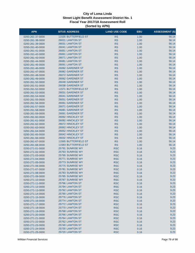
APN SITUS ADDRESS LAND USE CODE EBU ASSESSMENT ($)
City of Loma LindaStreet Light Benefit Assessment District No. 1
Fiscal Year 2017/18 Assessment Roll (Sorted by APN)
0293-261-37-0000 11535 BUTTERFIELD ST RS 1.00 56.14
0293-261-38-0000 26021 LAWTON ST RS 1.00 56.14
0293-261-39-0000 26031 LAWTON ST RS 1.00 56.14
0293-261-40-0000 26041 LAWTON ST RS 1.00 56.14
0293-261-41-0000 26051 LAWTON ST RS 1.00 56.14
0293-261-42-0000 26061 LAWTON ST RS 1.00 56.14
0293-261-43-0000 26071 LAWTON ST RS 1.00 56.14
0293-261-44-0000 26081 LAWTON ST RS 1.00 56.14
0293-261-45-0000 26091 LAWTON ST RS 1.00 56.14
0293-261-46-0000 26092 GARDNER ST RS 1.00 56.14
0293-261-47-0000 26082 GARDNER ST RS 1.00 56.14
0293-261-48-0000 26072 GARDNER ST RS 1.00 56.14
0293-261-49-0000 26062 GARDNER ST RS 1.00 56.14
0293-261-50-0000 26048 GARDNER ST RS 1.00 56.14
0293-261-51-0000 26038 GARDNER ST RS 1.00 56.14
0293-261-52-0000 11571 BUTTERFIELD ST RS 1.00 56.14
0293-261-53-0000 26031 GARDNER ST RS 1.00 56.14
0293-261-54-0000 26041 GARDNER ST RS 1.00 56.14
0293-261-55-0000 26051 GARDNER ST RS 1.00 56.14
0293-261-56-0000 26061 GARDNER ST RS 1.00 56.14
0293-261-57-0000 26071 GARDNER ST RS 1.00 56.14
0293-261-58-0000 26081 GARDNER ST RS 1.00 56.14
0293-261-59-0000 26091 GARDNER ST RS 1.00 56.14
0293-261-60-0000 26092 HINCKLEY ST RS 1.00 56.14
0293-261-61-0000 26082 HINCKLEY ST RS 1.00 56.14
0293-261-62-0000 26072 HINCKLEY ST RS 1.00 56.14
0293-261-63-0000 26062 HINCKLEY ST RS 1.00 56.14
0293-261-64-0000 26052 HINCKLEY ST RS 1.00 56.14
0293-261-65-0000 26042 HINCKLEY ST RS 1.00 56.14
0293-261-66-0000 26032 HINCKLEY ST RS 1.00 56.14
0293-261-67-0000 11595 BUTTERFIELD ST RS 1.00 56.14
0293-261-68-0000 11583 BUTTERFIELD ST RS 1.00 56.14
0293-271-01-0000 25791 SUNRISE WY RSC 0.16 9.23
0293-271-02-0000 25793 SUNRISE WY RSC 0.16 9.23
0293-271-03-0000 25795 SUNRISE WY RSC 0.16 9.23
0293-271-04-0000 25771 SUNRISE WY RSC 0.16 9.23
0293-271-05-0000 25773 SUNRISE WY RSC 0.16 9.23
0293-271-06-0000 25775 SUNRISE WY RSC 0.16 9.23
0293-271-07-0000 25781 SUNRISE WY RSC 0.16 9.23
0293-271-08-0000 25783 SUNRISE WY RSC 0.16 9.23
0293-271-09-0000 25785 SUNRISE WY RSC 0.16 9.23
0293-271-10-0000 25787 SUNRISE WY RSC 0.16 9.23
0293-271-11-0000 25796 LAWTON ST RSC 0.16 9.23
0293-271-12-0000 25794 LAWTON ST RSC 0.16 9.23
0293-271-13-0000 25792 LAWTON ST RSC 0.16 9.23
0293-271-14-0000 25790 LAWTON ST RSC 0.16 9.23
0293-271-15-0000 25776 LAWTON ST RSC 0.16 9.23
0293-271-16-0000 25774 LAWTON ST RSC 0.16 9.23
0293-271-17-0000 25772 LAWTON ST RSC 0.16 9.23
0293-271-18-0000 25770 LAWTON ST RSC 0.16 9.23
0293-271-19-0000 25768 LAWTON ST RSC 0.16 9.23
0293-271-20-0000 25766 LAWTON ST RSC 0.16 9.23
0293-271-21-0000 25764 LAWTON ST RSC 0.16 9.23
0293-271-22-0000 25762 LAWTON ST RSC 0.16 9.23
0293-271-23-0000 25740 LAWTON ST RSC 0.16 9.23
0293-271-24-0000 25730 LAWTON ST RSC 0.16 9.23
0293-271-25-0000 25720 LAWTON ST RSC 0.16 9.23
Willdan Financial Services Page 78 of 98
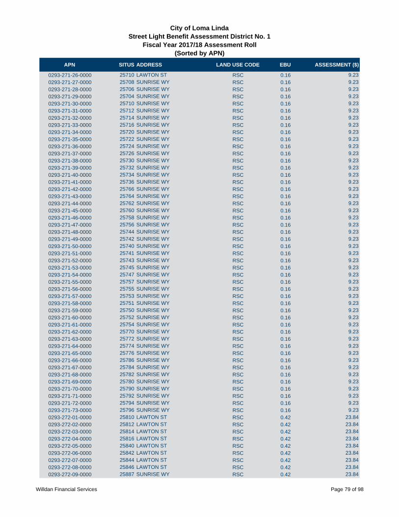
APN SITUS ADDRESS LAND USE CODE EBU ASSESSMENT ($)
City of Loma LindaStreet Light Benefit Assessment District No. 1
Fiscal Year 2017/18 Assessment Roll (Sorted by APN)
0293-271-26-0000 25710 LAWTON ST RSC 0.16 9.23
0293-271-27-0000 25708 SUNRISE WY RSC 0.16 9.23
0293-271-28-0000 25706 SUNRISE WY RSC 0.16 9.23
0293-271-29-0000 25704 SUNRISE WY RSC 0.16 9.23
0293-271-30-0000 25710 SUNRISE WY RSC 0.16 9.23
0293-271-31-0000 25712 SUNRISE WY RSC 0.16 9.23
0293-271-32-0000 25714 SUNRISE WY RSC 0.16 9.23
0293-271-33-0000 25716 SUNRISE WY RSC 0.16 9.23
0293-271-34-0000 25720 SUNRISE WY RSC 0.16 9.23
0293-271-35-0000 25722 SUNRISE WY RSC 0.16 9.23
0293-271-36-0000 25724 SUNRISE WY RSC 0.16 9.23
0293-271-37-0000 25726 SUNRISE WY RSC 0.16 9.23
0293-271-38-0000 25730 SUNRISE WY RSC 0.16 9.23
0293-271-39-0000 25732 SUNRISE WY RSC 0.16 9.23
0293-271-40-0000 25734 SUNRISE WY RSC 0.16 9.23
0293-271-41-0000 25736 SUNRISE WY RSC 0.16 9.23
0293-271-42-0000 25766 SUNRISE WY RSC 0.16 9.23
0293-271-43-0000 25764 SUNRISE WY RSC 0.16 9.23
0293-271-44-0000 25762 SUNRISE WY RSC 0.16 9.23
0293-271-45-0000 25760 SUNRISE WY RSC 0.16 9.23
0293-271-46-0000 25758 SUNRISE WY RSC 0.16 9.23
0293-271-47-0000 25756 SUNRISE WY RSC 0.16 9.23
0293-271-48-0000 25744 SUNRISE WY RSC 0.16 9.23
0293-271-49-0000 25742 SUNRISE WY RSC 0.16 9.23
0293-271-50-0000 25740 SUNRISE WY RSC 0.16 9.23
0293-271-51-0000 25741 SUNRISE WY RSC 0.16 9.23
0293-271-52-0000 25743 SUNRISE WY RSC 0.16 9.23
0293-271-53-0000 25745 SUNRISE WY RSC 0.16 9.23
0293-271-54-0000 25747 SUNRISE WY RSC 0.16 9.23
0293-271-55-0000 25757 SUNRISE WY RSC 0.16 9.23
0293-271-56-0000 25755 SUNRISE WY RSC 0.16 9.23
0293-271-57-0000 25753 SUNRISE WY RSC 0.16 9.23
0293-271-58-0000 25751 SUNRISE WY RSC 0.16 9.23
0293-271-59-0000 25750 SUNRISE WY RSC 0.16 9.23
0293-271-60-0000 25752 SUNRISE WY RSC 0.16 9.23
0293-271-61-0000 25754 SUNRISE WY RSC 0.16 9.23
0293-271-62-0000 25770 SUNRISE WY RSC 0.16 9.23
0293-271-63-0000 25772 SUNRISE WY RSC 0.16 9.23
0293-271-64-0000 25774 SUNRISE WY RSC 0.16 9.23
0293-271-65-0000 25776 SUNRISE WY RSC 0.16 9.23
0293-271-66-0000 25786 SUNRISE WY RSC 0.16 9.23
0293-271-67-0000 25784 SUNRISE WY RSC 0.16 9.23
0293-271-68-0000 25782 SUNRISE WY RSC 0.16 9.23
0293-271-69-0000 25780 SUNRISE WY RSC 0.16 9.23
0293-271-70-0000 25790 SUNRISE WY RSC 0.16 9.23
0293-271-71-0000 25792 SUNRISE WY RSC 0.16 9.23
0293-271-72-0000 25794 SUNRISE WY RSC 0.16 9.23
0293-271-73-0000 25796 SUNRISE WY RSC 0.16 9.23
0293-272-01-0000 25810 LAWTON ST RSC 0.42 23.84
0293-272-02-0000 25812 LAWTON ST RSC 0.42 23.84
0293-272-03-0000 25814 LAWTON ST RSC 0.42 23.84
0293-272-04-0000 25816 LAWTON ST RSC 0.42 23.84
0293-272-05-0000 25840 LAWTON ST RSC 0.42 23.84
0293-272-06-0000 25842 LAWTON ST RSC 0.42 23.84
0293-272-07-0000 25844 LAWTON ST RSC 0.42 23.84
0293-272-08-0000 25846 LAWTON ST RSC 0.42 23.84
0293-272-09-0000 25887 SUNRISE WY RSC 0.42 23.84
Willdan Financial Services Page 79 of 98
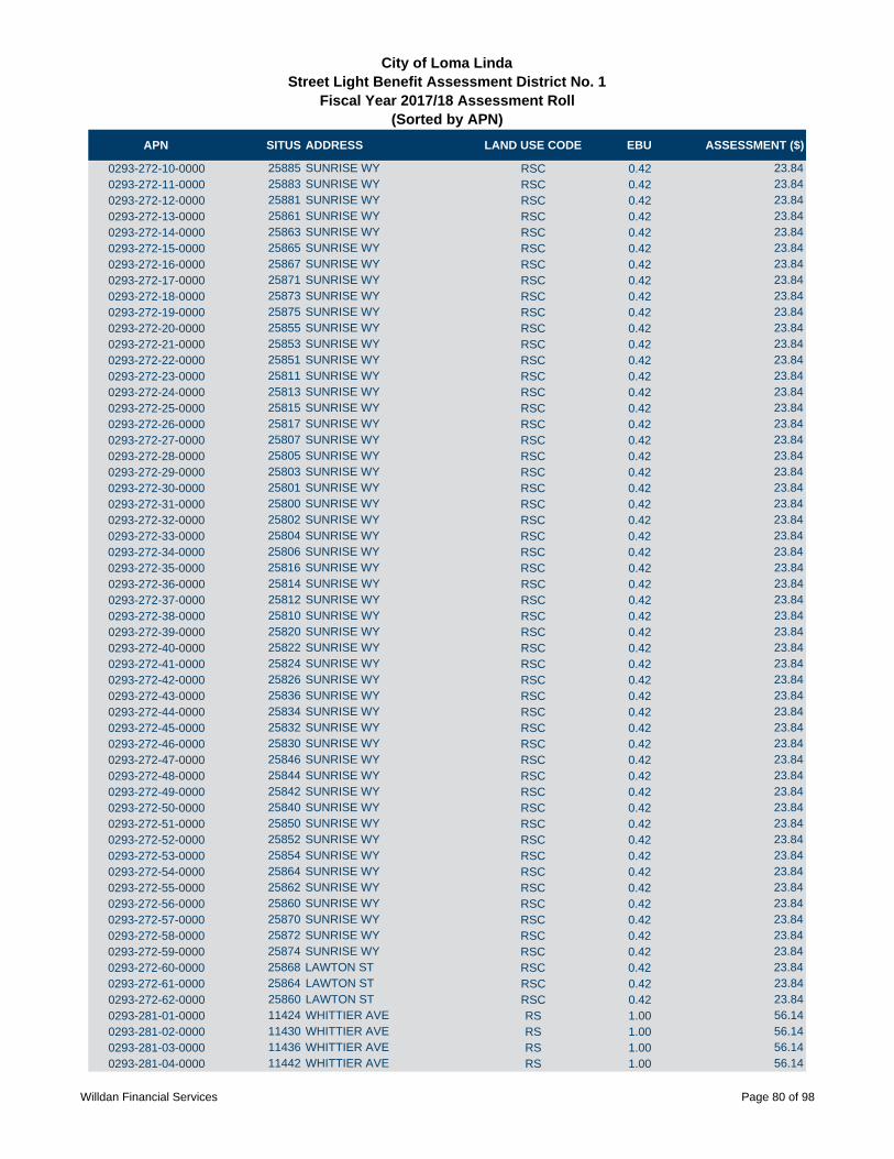
APN SITUS ADDRESS LAND USE CODE EBU ASSESSMENT ($)
City of Loma LindaStreet Light Benefit Assessment District No. 1
Fiscal Year 2017/18 Assessment Roll (Sorted by APN)
0293-272-10-0000 25885 SUNRISE WY RSC 0.42 23.84
0293-272-11-0000 25883 SUNRISE WY RSC 0.42 23.84
0293-272-12-0000 25881 SUNRISE WY RSC 0.42 23.84
0293-272-13-0000 25861 SUNRISE WY RSC 0.42 23.84
0293-272-14-0000 25863 SUNRISE WY RSC 0.42 23.84
0293-272-15-0000 25865 SUNRISE WY RSC 0.42 23.84
0293-272-16-0000 25867 SUNRISE WY RSC 0.42 23.84
0293-272-17-0000 25871 SUNRISE WY RSC 0.42 23.84
0293-272-18-0000 25873 SUNRISE WY RSC 0.42 23.84
0293-272-19-0000 25875 SUNRISE WY RSC 0.42 23.84
0293-272-20-0000 25855 SUNRISE WY RSC 0.42 23.84
0293-272-21-0000 25853 SUNRISE WY RSC 0.42 23.84
0293-272-22-0000 25851 SUNRISE WY RSC 0.42 23.84
0293-272-23-0000 25811 SUNRISE WY RSC 0.42 23.84
0293-272-24-0000 25813 SUNRISE WY RSC 0.42 23.84
0293-272-25-0000 25815 SUNRISE WY RSC 0.42 23.84
0293-272-26-0000 25817 SUNRISE WY RSC 0.42 23.84
0293-272-27-0000 25807 SUNRISE WY RSC 0.42 23.84
0293-272-28-0000 25805 SUNRISE WY RSC 0.42 23.84
0293-272-29-0000 25803 SUNRISE WY RSC 0.42 23.84
0293-272-30-0000 25801 SUNRISE WY RSC 0.42 23.84
0293-272-31-0000 25800 SUNRISE WY RSC 0.42 23.84
0293-272-32-0000 25802 SUNRISE WY RSC 0.42 23.84
0293-272-33-0000 25804 SUNRISE WY RSC 0.42 23.84
0293-272-34-0000 25806 SUNRISE WY RSC 0.42 23.84
0293-272-35-0000 25816 SUNRISE WY RSC 0.42 23.84
0293-272-36-0000 25814 SUNRISE WY RSC 0.42 23.84
0293-272-37-0000 25812 SUNRISE WY RSC 0.42 23.84
0293-272-38-0000 25810 SUNRISE WY RSC 0.42 23.84
0293-272-39-0000 25820 SUNRISE WY RSC 0.42 23.84
0293-272-40-0000 25822 SUNRISE WY RSC 0.42 23.84
0293-272-41-0000 25824 SUNRISE WY RSC 0.42 23.84
0293-272-42-0000 25826 SUNRISE WY RSC 0.42 23.84
0293-272-43-0000 25836 SUNRISE WY RSC 0.42 23.84
0293-272-44-0000 25834 SUNRISE WY RSC 0.42 23.84
0293-272-45-0000 25832 SUNRISE WY RSC 0.42 23.84
0293-272-46-0000 25830 SUNRISE WY RSC 0.42 23.84
0293-272-47-0000 25846 SUNRISE WY RSC 0.42 23.84
0293-272-48-0000 25844 SUNRISE WY RSC 0.42 23.84
0293-272-49-0000 25842 SUNRISE WY RSC 0.42 23.84
0293-272-50-0000 25840 SUNRISE WY RSC 0.42 23.84
0293-272-51-0000 25850 SUNRISE WY RSC 0.42 23.84
0293-272-52-0000 25852 SUNRISE WY RSC 0.42 23.84
0293-272-53-0000 25854 SUNRISE WY RSC 0.42 23.84
0293-272-54-0000 25864 SUNRISE WY RSC 0.42 23.84
0293-272-55-0000 25862 SUNRISE WY RSC 0.42 23.84
0293-272-56-0000 25860 SUNRISE WY RSC 0.42 23.84
0293-272-57-0000 25870 SUNRISE WY RSC 0.42 23.84
0293-272-58-0000 25872 SUNRISE WY RSC 0.42 23.84
0293-272-59-0000 25874 SUNRISE WY RSC 0.42 23.84
0293-272-60-0000 25868 LAWTON ST RSC 0.42 23.84
0293-272-61-0000 25864 LAWTON ST RSC 0.42 23.84
0293-272-62-0000 25860 LAWTON ST RSC 0.42 23.84
0293-281-01-0000 11424 WHITTIER AVE RS 1.00 56.14
0293-281-02-0000 11430 WHITTIER AVE RS 1.00 56.14
0293-281-03-0000 11436 WHITTIER AVE RS 1.00 56.14
0293-281-04-0000 11442 WHITTIER AVE RS 1.00 56.14
Willdan Financial Services Page 80 of 98

APN SITUS ADDRESS LAND USE CODE EBU ASSESSMENT ($)
City of Loma LindaStreet Light Benefit Assessment District No. 1
Fiscal Year 2017/18 Assessment Roll (Sorted by APN)
0293-281-05-0000 11448 WHITTIER AVE RS 1.00 56.14
0293-281-06-0000 11454 WHITTIER AVE RS 1.00 56.14
0293-281-07-0000 11460 WHITTIER AVE RS 1.00 56.14
0293-281-08-0000 11466 WHITTIER AVE RS 1.00 56.14
0293-281-09-0000 11472 WHITTIER AVE RS 1.00 56.14
0293-281-10-0000 11478 WHITTIER AVE RS 1.00 56.14
0293-281-11-0000 11484 WHITTIER AVE RS 1.00 56.14
0293-281-12-0000 11490 WHITTIER AVE RS 1.00 56.14
0293-281-13-0000 26282 LAWTON ST RS 1.00 56.14
0293-281-14-0000 26276 LAWTON ST RS 1.00 56.14
0293-281-15-0000 26270 LAWTON ST RS 1.00 56.14
0293-281-16-0000 26264 LAWTON ST RS 1.00 56.14
0293-281-17-0000 26260 LAWTON ST RS 1.00 56.14
0293-281-18-0000 26254 LAWTON ST RS 1.00 56.14
0293-281-19-0000 26248 LAWTON ST RS 1.00 56.14
0293-281-20-0000 26242 LAWTON ST RS 1.00 56.14
0293-281-21-0000 26236 LAWTON ST RS 1.00 56.14
0293-281-22-0000 26230 LAWTON ST RS 1.00 56.14
0293-281-23-0000 26224 LAWTON ST RS 1.00 56.14
0293-281-24-0000 26218 LAWTON ST RS 1.00 56.14
0293-281-25-0000 26212 LAWTON ST RS 1.00 56.14
0293-281-26-0000 26211 CAMBRIA LN RS 1.00 56.14
0293-281-27-0000 26217 CAMBRIA LN RS 1.00 56.14
0293-281-28-0000 26223 CAMBRIA LN RS 1.00 56.14
0293-281-29-0000 26229 CAMBRIA LN RS 1.00 56.14
0293-281-30-0000 26235 CAMBRIA LN RS 1.00 56.14
0293-281-31-0000 26241 CAMBRIA LN RS 1.00 56.14
0293-281-32-0000 26247 CAMBRIA LN RS 1.00 56.14
0293-281-33-0000 26253 CAMBRIA LN RS 1.00 56.14
0293-281-34-0000 26259 CAMBRIA LN RS 1.00 56.14
0293-281-35-0000 26267 CAMBRIA LN RS 1.00 56.14
0293-281-36-0000 11465 BANGOR AVE RS 1.00 56.14
0293-281-37-0000 11459 BANGOR AVE RS 1.00 56.14
0293-281-38-0000 11453 BANGOR AVE RS 1.00 56.14
0293-281-39-0000 11447 BANGOR AVE RS 1.00 56.14
0293-281-40-0000 11441 BANGOR AVE RS 1.00 56.14
0293-281-41-0000 11435 BANGOR AVE RS 1.00 56.14
0293-281-42-0000 11429 BANGOR AVE RS 1.00 56.14
0293-281-43-0000 11423 BANGOR AVE RS 1.00 56.14
0293-281-44-0000 26264 NEWPORT AVE RS 1.00 56.14
0293-281-45-0000 26258 NEWPORT AVE RS 1.00 56.14
0293-281-46-0000 26252 NEWPORT AVE RS 1.00 56.14
0293-281-47-0000 26248 NEWPORT AVE RS 1.00 56.14
0293-281-48-0000 26244 NEWPORT AVE RS 1.00 56.14
0293-281-49-0000 26240 NEWPORT AVE RS 1.00 56.14
0293-281-50-0000 26236 NEWPORT AVE RS 1.00 56.14
0293-281-51-0000 26232 NEWPORT AVE RS 1.00 56.14
0293-281-52-0000 26226 NEWPORT AVE RS 1.00 56.14
0293-281-53-0000 26222 NEWPORT AVE RS 1.00 56.14
0293-281-54-0000 26218 NEWPORT AVE RS 1.00 56.14
0293-281-55-0000 26214 NEWPORT AVE RS 1.00 56.14
0293-281-56-0000 26210 NEWPORT AVE RS 1.00 56.14
0293-281-57-0000 26206 NEWPORT AVE RS 1.00 56.14
0293-281-58-0000 26200 NEWPORT AVE RS 1.00 56.14
0293-281-59-0000 11407 CARDIFF LN RS 1.00 56.14
0293-281-60-0000 11413 CARDIFF LN RS 1.00 56.14
0293-281-61-0000 11419 CARDIFF LN RS 1.00 56.14
Willdan Financial Services Page 81 of 98

APN SITUS ADDRESS LAND USE CODE EBU ASSESSMENT ($)
City of Loma LindaStreet Light Benefit Assessment District No. 1
Fiscal Year 2017/18 Assessment Roll (Sorted by APN)
0293-281-62-0000 11425 CARDIFF LN RS 1.00 56.14
0293-281-63-0000 11431 CARDIFF LN RS 1.00 56.14
0293-281-64-0000 11437 CARDIFF LN RS 1.00 56.14
0293-281-65-0000 11443 CARDIFF LN RS 1.00 56.14
0293-281-66-0000 11449 CARDIFF LN RS 1.00 56.14
0293-281-67-0000 11455 CARDIFF LN RS 1.00 56.14
0293-281-68-0000 26226 CAMBRIA LN RS 1.00 56.14
0293-281-69-0000 26232 CAMBRIA LN RS 1.00 56.14
0293-281-70-0000 26238 CAMBRIA LN RS 1.00 56.14
0293-281-71-0000 26244 CAMBRIA LN RS 1.00 56.14
0293-281-72-0000 26250 CAMBRIA LN RS 1.00 56.14
0293-281-73-0000 26256 CAMBRIA LN RS 1.00 56.14
0293-281-74-0000 26257 NEWPORT AVE RS 1.00 56.14
0293-281-75-0000 26251 NEWPORT AVE RS 1.00 56.14
0293-281-76-0000 26247 NEWPORT AVE RS 1.00 56.14
0293-281-77-0000 26243 NEWPORT AVE RS 1.00 56.14
0293-281-78-0000 26239 NEWPORT AVE RS 1.00 56.14
0293-281-79-0000 26233 NEWPORT AVE RS 1.00 56.14
0293-291-01-0000 26008 BRENTWOOD AVE RS 1.00 56.14
0293-291-02-0000 26022 BRENTWOOD AVE RS 1.00 56.14
0293-291-03-0000 26034 BRENTWOOD AVE RS 1.00 56.14
0293-291-04-0000 26046 BRENTWOOD AVE RS 1.00 56.14
0293-291-05-0000 26058 BRENTWOOD AVE RS 1.00 56.14
0293-291-06-0000 26070 BRENTWOOD AVE RS 1.00 56.14
0293-291-07-0000 26082 BRENTWOOD AVE RS 1.00 56.14
0293-291-08-0000 26094 BRENTWOOD AVE RS 1.00 56.14
0293-291-09-0000 26093 BRENTWOOD AVE RS 1.00 56.14
0293-291-10-0000 26081 BRENTWOOD AVE RS 1.00 56.14
0293-291-11-0000 26069 BRENTWOOD AVE RS 1.00 56.14
0293-291-12-0000 26057 BRENTWOOD AVE RS 1.00 56.14
0293-291-13-0000 26045 BRENTWOOD AVE RS 1.00 56.14
0293-291-14-0000 26033 BRENTWOOD AVE RS 1.00 56.14
0293-291-15-0000 26021 BRENTWOOD AVE RS 1.00 56.14
0293-291-16-0000 26009 BRENTWOOD AVE RS 1.00 56.14
0293-291-17-0000 26008 BANCROFT ST RS 1.00 56.14
0293-291-18-0000 26020 BANCROFT ST RS 1.00 56.14
0293-291-19-0000 26032 BANCROFT ST RS 1.00 56.14
0293-291-20-0000 26044 BANCROFT ST RS 1.00 56.14
0293-291-21-0000 26056 BANCROFT ST RS 1.00 56.14
0293-291-22-0000 26068 BANCROFT ST RS 1.00 56.14
0293-291-23-0000 26080 BANCROFT ST RS 1.00 56.14
0293-291-24-0000 26092 BANCROFT ST RS 1.00 56.14
0293-291-25-0000 26091 BANCROFT ST RS 1.00 56.14
0293-291-26-0000 26079 BANCROFT ST RS 1.00 56.14
0293-291-27-0000 26067 BANCROFT ST RS 1.00 56.14
0293-291-28-0000 26055 BANCROFT ST RS 1.00 56.14
0293-291-29-0000 26043 BANCROFT ST RS 1.00 56.14
0293-291-30-0000 26031 BANCROFT ST RS 1.00 56.14
0293-291-31-0000 26019 BANCROFT ST RS 1.00 56.14
0293-291-32-0000 26007 BANCROFT ST RS 1.00 56.14
0293-291-33-0000 26008 BROOKMERE AVE RS 1.00 56.14
0293-291-34-0000 26020 BROOKMERE AVE RS 1.00 56.14
0293-291-35-0000 26032 BROOKMERE AVE RS 1.00 56.14
0293-291-36-0000 26044 BROOKMERE AVE RS 1.00 56.14
0293-291-37-0000 26056 BROOKMERE AVE RS 1.00 56.14
0293-291-38-0000 26068 BROOKMERE AVE RS 1.00 56.14
0293-291-39-0000 26080 BROOKMERE AVE RS 1.00 56.14
Willdan Financial Services Page 82 of 98

APN SITUS ADDRESS LAND USE CODE EBU ASSESSMENT ($)
City of Loma LindaStreet Light Benefit Assessment District No. 1
Fiscal Year 2017/18 Assessment Roll (Sorted by APN)
0293-291-40-0000 26092 BROOKMERE AVE RS 1.00 56.14
0293-291-41-0000 26095 BROOKMERE AVE RS 1.00 56.14
0293-291-42-0000 26083 BROOKMERE AVE RS 1.00 56.14
0293-291-43-0000 11843 BEVERLY CT RS 1.00 56.14
0293-291-44-0000 11855 BEVERLY CT RS 1.00 56.14
0293-291-45-0000 11867 BEVERLY CT RS 1.00 56.14
0293-291-46-0000 11866 BEVERLY CT RS 1.00 56.14
0293-291-47-0000 11854 BEVERLY CT RS 1.00 56.14
0293-291-48-0000 11842 BEVERLY CT RS 1.00 56.14
0293-291-49-0000 26059 BROOKMERE AVE RS 1.00 56.14
0293-291-50-0000 26047 BROOKMERE AVE RS 1.00 56.14
0293-291-51-0000 26035 BROOKMERE AVE RS 1.00 56.14
0293-291-52-0000 11841 BRIARWOOD CT RS 1.00 56.14
0293-291-53-0000 11853 BRIARWOOD CT RS 1.00 56.14
0293-291-54-0000 11840 BRIARWOOD CT RS 1.00 56.14
0293-291-55-0000 11828 BRIARWOOD CT RS 1.00 56.14
0293-291-56-0000 11816 BRIARWOOD CT RS 1.00 56.14
0293-301-01-0000 11539 BRYN MAWR AVE RS 1.00 56.14
0293-301-02-0000 11525 BRYN MAWR AVE RS 1.00 56.14
0293-301-03-0000 11511 BRYN MAWR AVE RS 1.00 56.14
0293-301-04-0000 11512 PEMBROKE ST RS 1.00 56.14
0293-301-05-0000 11524 PEMBROKE ST RS 1.00 56.14
0293-301-06-0000 11538 PEMBROKE ST RS 1.00 56.14
0293-301-07-0000 11561 BRYN MAWR AVE RS 1.00 56.14
0293-301-08-0000 11577 BRYN MAWR AVE RS 1.00 56.14
0293-301-09-0000 11591 BRYN MAWR AVE RS 1.00 56.14
0293-301-10-0000 11560 PEMBROKE ST RS 1.00 56.14
0293-301-11-0000 11572 PEMBROKE ST RS 1.00 56.14
0293-301-12-0000 11584 PEMBROKE ST RS 1.00 56.14
0293-301-13-0000 26139 PICTON ST RS 1.00 56.14
0293-301-14-0000 26149 PICTON ST RS 1.00 56.14
0293-301-15-0000 26159 PICTON ST RS 1.00 56.14
0293-301-16-0000 26169 PICTON ST RS 1.00 56.14
0293-301-17-0000 26179 PICTON ST RS 1.00 56.14
0293-301-18-0000 26189 PICTON ST RS 1.00 56.14
0293-301-19-0000 26199 PICTON ST RS 1.00 56.14
0293-301-20-0000 26209 PICTON ST RS 1.00 56.14
0293-301-21-0000 26219 PICTON ST RS 1.00 56.14
0293-301-22-0000 26229 PICTON ST RS 1.00 56.14
0293-301-23-0000 26239 PICTON ST RS 1.00 56.14
0293-301-24-0000 26249 PICTON ST RS 1.00 56.14
0293-301-25-0000 26259 PICTON ST RS 1.00 56.14
0293-301-26-0000 26269 PICTON ST RS 1.00 56.14
0293-301-27-0000 26279 PICTON ST RS 1.00 56.14
0293-301-28-0000 26289 PICTON ST RS 1.00 56.14
0293-301-29-0000 11570 WHITTIER AVE RS 1.00 56.14
0293-301-30-0000 11558 WHITTIER AVE RS 1.00 56.14
0293-301-31-0000 11546 WHITTIER AVE RS 1.00 56.14
0293-301-32-0000 11534 WHITTIER AVE RS 1.00 56.14
0293-301-33-0000 11522 WHITTIER AVE RS 1.00 56.14
0293-301-34-0000 11510 WHITTIER AVE RS 1.00 56.14
0293-301-35-0000 11511 ABERDARE ST RS 1.00 56.14
0293-301-36-0000 11523 ABERDARE ST RS 1.00 56.14
0293-301-37-0000 11535 ABERDARE ST RS 1.00 56.14
0293-301-38-0000 11547 ABERDARE ST RS 1.00 56.14
0293-301-39-0000 11559 ABERDARE ST RS 1.00 56.14
0293-301-40-0000 11571 ABERDARE ST RS 1.00 56.14
Willdan Financial Services Page 83 of 98
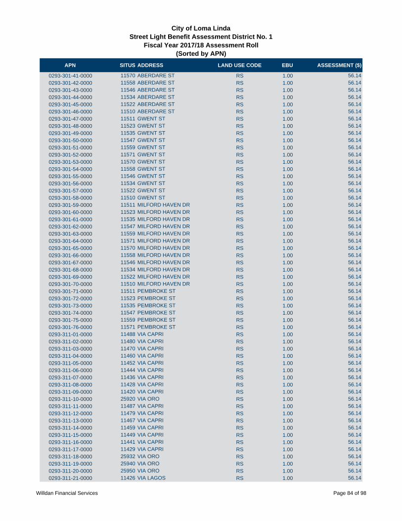
APN SITUS ADDRESS LAND USE CODE EBU ASSESSMENT ($)
City of Loma LindaStreet Light Benefit Assessment District No. 1
Fiscal Year 2017/18 Assessment Roll (Sorted by APN)
0293-301-41-0000 11570 ABERDARE ST RS 1.00 56.14
0293-301-42-0000 11558 ABERDARE ST RS 1.00 56.14
0293-301-43-0000 11546 ABERDARE ST RS 1.00 56.14
0293-301-44-0000 11534 ABERDARE ST RS 1.00 56.14
0293-301-45-0000 11522 ABERDARE ST RS 1.00 56.14
0293-301-46-0000 11510 ABERDARE ST RS 1.00 56.14
0293-301-47-0000 11511 GWENT ST RS 1.00 56.14
0293-301-48-0000 11523 GWENT ST RS 1.00 56.14
0293-301-49-0000 11535 GWENT ST RS 1.00 56.14
0293-301-50-0000 11547 GWENT ST RS 1.00 56.14
0293-301-51-0000 11559 GWENT ST RS 1.00 56.14
0293-301-52-0000 11571 GWENT ST RS 1.00 56.14
0293-301-53-0000 11570 GWENT ST RS 1.00 56.14
0293-301-54-0000 11558 GWENT ST RS 1.00 56.14
0293-301-55-0000 11546 GWENT ST RS 1.00 56.14
0293-301-56-0000 11534 GWENT ST RS 1.00 56.14
0293-301-57-0000 11522 GWENT ST RS 1.00 56.14
0293-301-58-0000 11510 GWENT ST RS 1.00 56.14
0293-301-59-0000 11511 MILFORD HAVEN DR RS 1.00 56.14
0293-301-60-0000 11523 MILFORD HAVEN DR RS 1.00 56.14
0293-301-61-0000 11535 MILFORD HAVEN DR RS 1.00 56.14
0293-301-62-0000 11547 MILFORD HAVEN DR RS 1.00 56.14
0293-301-63-0000 11559 MILFORD HAVEN DR RS 1.00 56.14
0293-301-64-0000 11571 MILFORD HAVEN DR RS 1.00 56.14
0293-301-65-0000 11570 MILFORD HAVEN DR RS 1.00 56.14
0293-301-66-0000 11558 MILFORD HAVEN DR RS 1.00 56.14
0293-301-67-0000 11546 MILFORD HAVEN DR RS 1.00 56.14
0293-301-68-0000 11534 MILFORD HAVEN DR RS 1.00 56.14
0293-301-69-0000 11522 MILFORD HAVEN DR RS 1.00 56.14
0293-301-70-0000 11510 MILFORD HAVEN DR RS 1.00 56.14
0293-301-71-0000 11511 PEMBROKE ST RS 1.00 56.14
0293-301-72-0000 11523 PEMBROKE ST RS 1.00 56.14
0293-301-73-0000 11535 PEMBROKE ST RS 1.00 56.14
0293-301-74-0000 11547 PEMBROKE ST RS 1.00 56.14
0293-301-75-0000 11559 PEMBROKE ST RS 1.00 56.14
0293-301-76-0000 11571 PEMBROKE ST RS 1.00 56.14
0293-311-01-0000 11488 VIA CAPRI RS 1.00 56.14
0293-311-02-0000 11480 VIA CAPRI RS 1.00 56.14
0293-311-03-0000 11470 VIA CAPRI RS 1.00 56.14
0293-311-04-0000 11460 VIA CAPRI RS 1.00 56.14
0293-311-05-0000 11452 VIA CAPRI RS 1.00 56.14
0293-311-06-0000 11444 VIA CAPRI RS 1.00 56.14
0293-311-07-0000 11436 VIA CAPRI RS 1.00 56.14
0293-311-08-0000 11428 VIA CAPRI RS 1.00 56.14
0293-311-09-0000 11420 VIA CAPRI RS 1.00 56.14
0293-311-10-0000 25920 VIA ORO RS 1.00 56.14
0293-311-11-0000 11487 VIA CAPRI RS 1.00 56.14
0293-311-12-0000 11479 VIA CAPRI RS 1.00 56.14
0293-311-13-0000 11467 VIA CAPRI RS 1.00 56.14
0293-311-14-0000 11459 VIA CAPRI RS 1.00 56.14
0293-311-15-0000 11449 VIA CAPRI RS 1.00 56.14
0293-311-16-0000 11441 VIA CAPRI RS 1.00 56.14
0293-311-17-0000 11429 VIA CAPRI RS 1.00 56.14
0293-311-18-0000 25932 VIA ORO RS 1.00 56.14
0293-311-19-0000 25940 VIA ORO RS 1.00 56.14
0293-311-20-0000 25950 VIA ORO RS 1.00 56.14
0293-311-21-0000 11426 VIA LAGOS RS 1.00 56.14
Willdan Financial Services Page 84 of 98

APN SITUS ADDRESS LAND USE CODE EBU ASSESSMENT ($)
City of Loma LindaStreet Light Benefit Assessment District No. 1
Fiscal Year 2017/18 Assessment Roll (Sorted by APN)
0293-311-22-0000 11434 VIA LAGOS RS 1.00 56.14
0293-311-23-0000 11442 VIA LAGOS RS 1.00 56.14
0293-311-24-0000 11450 VIA LAGOS RS 1.00 56.14
0293-311-25-0000 11460 VIA LAGOS RS 1.00 56.14
0293-311-26-0000 11470 VIA LAGOS RS 1.00 56.14
0293-311-27-0000 11478 VIA LAGOS RS 1.00 56.14
0293-311-28-0000 11490 VIA LAGOS RS 1.00 56.14
0293-311-29-0000 11489 VIA LAGOS RS 1.00 56.14
0293-311-30-0000 11477 VIA LAGOS RS 1.00 56.14
0293-311-31-0000 11467 VIA LAGOS RS 1.00 56.14
0293-311-32-0000 11459 VIA LAGOS RS 1.00 56.14
0293-311-33-0000 11449 VIA LAGOS RS 1.00 56.14
0293-311-34-0000 11441 VIA LAGOS RS 1.00 56.14
0293-311-35-0000 11429 VIA LAGOS RS 1.00 56.14
0293-311-36-0000 25958 VIA ORO RS 1.00 56.14
0293-311-37-0000 25966 VIA ORO RS 1.00 56.14
0293-311-38-0000 25974 VIA ORO RS 1.00 56.14
0293-311-39-0000 25984 VIA ORO RS 1.00 56.14
0293-311-40-0000 11430 VIA RIO RS 1.00 56.14
0293-311-41-0000 11438 VIA RIO RS 1.00 56.14
0293-311-42-0000 11446 VIA RIO RS 1.00 56.14
0293-311-43-0000 11456 VIA RIO RS 1.00 56.14
0293-311-44-0000 11464 VIA RIO RS 1.00 56.14
0293-311-45-0000 11474 VIA RIO RS 1.00 56.14
0293-311-46-0000 11486 VIA RIO RS 1.00 56.14
0293-311-47-0000 11489 VIA RIO RS 1.00 56.14
0293-311-48-0000 11477 VIA RIO RS 1.00 56.14
0293-311-49-0000 11467 VIA RIO RS 1.00 56.14
0293-311-50-0000 11459 VIA RIO RS 1.00 56.14
0293-311-51-0000 11449 VIA RIO RS 1.00 56.14
0293-311-52-0000 11441 VIA RIO RS 1.00 56.14
0293-311-53-0000 11429 VIA RIO RS 1.00 56.14
0293-311-54-0000 25994 VIA ORO RS 1.00 56.14
0293-311-55-0000 26006 VIA ORO RS 1.00 56.14
0293-311-56-0000 26014 VIA ORO RS 1.00 56.14
0293-311-57-0000 26024 VIA ORO RS 1.00 56.14
0293-311-58-0000 26032 VIA ORO RS 1.00 56.14
0293-311-59-0000 11430 VIA NORTE RS 1.00 56.14
0293-311-60-0000 11438 VIA NORTE RS 1.00 56.14
0293-311-61-0000 11446 VIA NORTE RS 1.00 56.14
0293-311-62-0000 11456 VIA NORTE RS 1.00 56.14
0293-311-63-0000 11464 VIA NORTE RS 1.00 56.14
0293-311-64-0000 11474 VIA NORTE RS 1.00 56.14
0293-311-65-0000 11486 VIA NORTE RS 1.00 56.14
0293-311-66-0000 11489 VIA NORTE RS 1.00 56.14
0293-311-67-0000 11477 VIA NORTE RS 1.00 56.14
0293-311-68-0000 11467 VIA NORTE RS 1.00 56.14
0293-311-69-0000 11459 VIA NORTE RS 1.00 56.14
0293-311-70-0000 11449 VIA NORTE RS 1.00 56.14
0293-311-71-0000 11441 VIA NORTE RS 1.00 56.14
0293-311-72-0000 11429 VIA NORTE RS 1.00 56.14
0293-311-73-0000 26040 VIA ORO RS 1.00 56.14
0293-311-74-0000 26050 VIA ORO RS 1.00 56.14
0293-311-75-0000 26058 VIA ORO RS 1.00 56.14
0293-311-76-0000 26066 VIA ORO RS 1.00 56.14
0293-311-77-0000 26078 VIA ORO RS 1.00 56.14
0293-311-78-0000 26086 VIA ORO RS 1.00 56.14
Willdan Financial Services Page 85 of 98

APN SITUS ADDRESS LAND USE CODE EBU ASSESSMENT ($)
City of Loma LindaStreet Light Benefit Assessment District No. 1
Fiscal Year 2017/18 Assessment Roll (Sorted by APN)
0293-311-79-0000 11430 VIA LIDO RS 1.00 56.14
0293-311-80-0000 11438 VIA LIDO RS 1.00 56.14
0293-311-81-0000 11446 VIA LIDO RS 1.00 56.14
0293-311-82-0000 11456 VIA LIDO RS 1.00 56.14
0293-311-83-0000 11464 VIA LIDO RS 1.00 56.14
0293-311-84-0000 11474 VIA LIDO RS 1.00 56.14
0293-311-85-0000 11486 VIA LIDO RS 1.00 56.14
0293-311-86-0000 11489 VIA LIDO RS 1.00 56.14
0293-311-87-0000 11479 VIA LIDO RS 1.00 56.14
0293-311-88-0000 11471 VIA LIDO RS 1.00 56.14
0293-311-89-0000 11461 VIA LIDO RS 1.00 56.14
0293-311-90-0000 11453 VIA LIDO RS 1.00 56.14
0293-311-91-0000 11443 VIA LIDO RS 1.00 56.14
0293-311-92-0000 11435 VIA LIDO RS 1.00 56.14
0293-311-93-0000 11427 VIA LIDO RS 1.00 56.14
0293-321-01-0000 11486 CARDIFF LN RS 1.00 56.14
0293-321-02-0000 11480 CARDIFF LN RS 1.00 56.14
0293-321-03-0000 11474 CARDIFF LN RS 1.00 56.14
0293-321-04-0000 11468 CARDIFF LN RS 1.00 56.14
0293-321-05-0000 11462 CARDIFF LN RS 1.00 56.14
0293-321-06-0000 11456 CARDIFF LN RS 1.00 56.14
0293-321-07-0000 11450 CARDIFF LN RS 1.00 56.14
0293-321-08-0000 11440 CARDIFF LN RS 1.00 56.14
0293-321-09-0000 11432 CARDIFF LN RS 1.00 56.14
0293-321-10-0000 11424 CARDIFF LN RS 1.00 56.14
0293-321-11-0000 11416 CARDIFF LN RS 1.00 56.14
0293-321-12-0000 11410 CARDIFF LN RS 1.00 56.14
0293-321-13-0000 11404 CARDIFF LN RS 1.00 56.14
0293-321-14-0000 26191 NEWPORT AVE RS 1.00 56.14
0293-321-15-0000 26185 NEWPORT AVE RS 1.00 56.14
0293-321-16-0000 26179 NEWPORT AVE RS 1.00 56.14
0293-321-17-0000 26173 NEWPORT AVE RS 1.00 56.14
0293-321-18-0000 26167 NEWPORT AVE RS 1.00 56.14
0293-321-19-0000 26161 NEWPORT AVE RS 1.00 56.14
0293-321-20-0000 26155 NEWPORT AVE RS 1.00 56.14
0293-321-21-0000 26149 NEWPORT AVE RS 1.00 56.14
0293-321-22-0000 26143 NEWPORT AVE RS 1.00 56.14
0293-321-23-0000 11355 HAVSTAD DR RS 1.00 56.14
0293-321-24-0000 11365 HAVSTAD DR RS 1.00 56.14
0293-321-25-0000 11371 HAVSTAD DR RS 1.00 56.14
0293-321-26-0000 11377 HAVSTAD DR RS 1.00 56.14
0293-321-27-0000 11383 HAVSTAD DR RS 1.00 56.14
0293-321-28-0000 26132 WORKMAN PL RS 1.00 56.14
0293-321-29-0000 26140 WORKMAN PL RS 1.00 56.14
0293-321-30-0000 26148 WORKMAN PL RS 1.00 56.14
0293-321-31-0000 26156 WORKMAN PL RS 1.00 56.14
0293-321-32-0000 26161 WORKMAN PL RS 1.00 56.14
0293-321-33-0000 26155 WORKMAN PL RS 1.00 56.14
0293-321-34-0000 26149 WORKMAN PL RS 1.00 56.14
0293-321-35-0000 26143 WORKMAN PL RS 1.00 56.14
0293-321-36-0000 26137 WORKMAN PL RS 1.00 56.14
0293-321-37-0000 26131 WORKMAN PL RS 1.00 56.14
0293-321-38-0000 26132 WALLACK PL RS 1.00 56.14
0293-321-39-0000 26138 WALLACK PL RS 1.00 56.14
0293-321-40-0000 26146 WALLACK PL RS 1.00 56.14
0293-321-41-0000 26152 WALLACK PL RS 1.00 56.14
0293-321-42-0000 26158 WALLACK PL RS 1.00 56.14
Willdan Financial Services Page 86 of 98

APN SITUS ADDRESS LAND USE CODE EBU ASSESSMENT ($)
City of Loma LindaStreet Light Benefit Assessment District No. 1
Fiscal Year 2017/18 Assessment Roll (Sorted by APN)
0293-321-43-0000 26164 WALLACK PL RS 1.00 56.14
0293-321-44-0000 26170 WALLACK PL RS 1.00 56.14
0293-321-45-0000 26171 WALLACK PL RS 1.00 56.14
0293-321-46-0000 26165 WALLACK PL RS 1.00 56.14
0293-321-47-0000 26159 WALLACK PL RS 1.00 56.14
0293-321-48-0000 26153 WALLACK PL RS 1.00 56.14
0293-321-49-0000 26147 WALLACK PL RS 1.00 56.14
0293-321-50-0000 26146 MERRIL PL RS 1.00 56.14
0293-321-51-0000 26152 MERRIL PL RS 1.00 56.14
0293-321-52-0000 26158 MERRIL PL RS 1.00 56.14
0293-321-53-0000 26164 MERRIL PL RS 1.00 56.14
0293-321-54-0000 26170 MERRIL PL RS 1.00 56.14
0293-321-55-0000 26171 MERRIL PL RS 1.00 56.14
0293-321-56-0000 26165 MERRIL PL RS 1.00 56.14
0293-321-57-0000 26159 MERRIL PL RS 1.00 56.14
0293-321-58-0000 26153 MERRIL PL RS 1.00 56.14
0293-321-59-0000 26147 MERRIL PL RS 1.00 56.14
0293-321-60-0000 26133 MERRIL PL RS 1.00 56.14
0293-321-61-0000 26127 MERRIL PL RS 1.00 56.14
0293-321-62-0000 26121 MERRIL PL RS 1.00 56.14
0293-321-63-0000 26115 MERRIL PL RS 1.00 56.14
0293-321-64-0000 26116 MERRIL PL RS 1.00 56.14
0293-321-65-0000 26120 MERRIL PL RS 1.00 56.14
0293-321-66-0000 26126 MERRIL PL RS 1.00 56.14
0293-321-67-0000 26132 MERRIL PL RS 1.00 56.14
0293-321-68-0000 26133 WALLACK PL RS 1.00 56.14
0293-321-69-0000 26127 WALLACK PL RS 1.00 56.14
0293-321-70-0000 26121 WALLACK PL RS 1.00 56.14
0293-321-71-0000 11436 HAVSTAD DR RS 1.00 56.14
0293-321-72-0000 11430 HAVSTAD DR RS 1.00 56.14
0293-321-73-0000 11424 HAVSTAD DR RS 1.00 56.14
0293-321-74-0000 11418 HAVSTAD DR RS 1.00 56.14
0293-321-75-0000 11412 HAVSTAD DR RS 1.00 56.14
0293-321-76-0000 11406 HAVSTAD DR RS 1.00 56.14
0293-321-77-0000 11400 HAVSTAD DR RS 1.00 56.14
0293-321-78-0000 11394 HAVSTAD DR RS 1.00 56.14
0293-321-79-0000 11388 HAVSTAD DR RS 1.00 56.14
0293-321-80-0000 11382 HAVSTAD DR RS 1.00 56.14
0293-321-81-0000 11376 HAVSTAD DR RS 1.00 56.14
0293-321-82-0000 11370 HAVSTAD DR RS 1.00 56.14
0293-321-83-0000 11364 HAVSTAD DR RS 1.00 56.14
0293-321-84-0000 11358 HAVSTAD DR RS 1.00 56.14
0293-321-85-0000 11352 HAVSTAD DR RS 1.00 56.14
0293-321-86-0000 11346 HAVSTAD DR RS 1.00 56.14
0293-331-01-0000 26110 WINDSOR DR RS 1.00 56.14
0293-331-02-0000 26120 WINDSOR DR RS 1.00 56.14
0293-331-03-0000 26134 WINDSOR DR RS 1.00 56.14
0293-331-04-0000 26140 WINDSOR DR RS 1.00 56.14
0293-331-05-0000 26154 WINDSOR DR RS 1.00 56.14
0293-331-06-0000 26160 WINDSOR DR RS 1.00 56.14
0293-331-07-0000 26174 WINDSOR DR RS 1.00 56.14
0293-331-08-0000 26180 WINDSOR DR RS 1.00 56.14
0293-331-09-0000 26194 WINDSOR DR RS 1.00 56.14
0293-331-10-0000 11630 NORMANDY LN RS 1.00 56.14
0293-331-11-0000 11640 NORMANDY LN RS 1.00 56.14
0293-331-12-0000 11650 NORMANDY LN RS 1.00 56.14
0293-331-13-0000 11660 NORMANDY LN RS 1.00 56.14
Willdan Financial Services Page 87 of 98
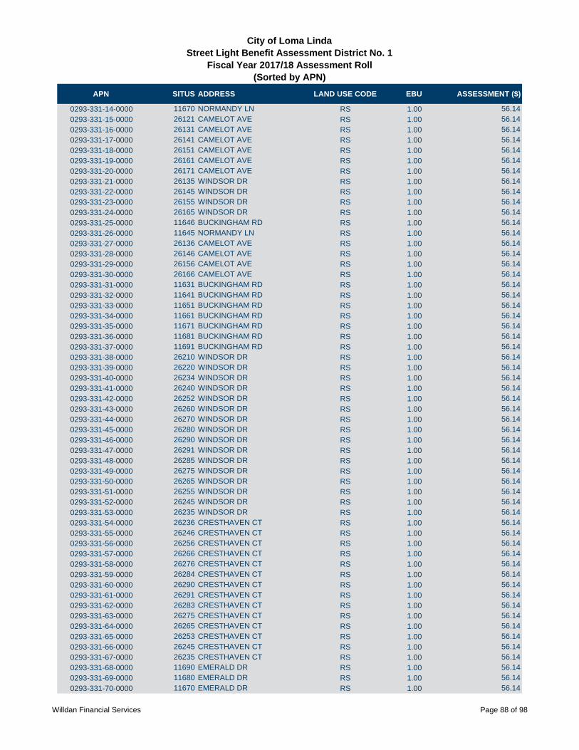
APN SITUS ADDRESS LAND USE CODE EBU ASSESSMENT ($)
City of Loma LindaStreet Light Benefit Assessment District No. 1
Fiscal Year 2017/18 Assessment Roll (Sorted by APN)
0293-331-14-0000 11670 NORMANDY LN RS 1.00 56.14
0293-331-15-0000 26121 CAMELOT AVE RS 1.00 56.14
0293-331-16-0000 26131 CAMELOT AVE RS 1.00 56.14
0293-331-17-0000 26141 CAMELOT AVE RS 1.00 56.14
0293-331-18-0000 26151 CAMELOT AVE RS 1.00 56.14
0293-331-19-0000 26161 CAMELOT AVE RS 1.00 56.14
0293-331-20-0000 26171 CAMELOT AVE RS 1.00 56.14
0293-331-21-0000 26135 WINDSOR DR RS 1.00 56.14
0293-331-22-0000 26145 WINDSOR DR RS 1.00 56.14
0293-331-23-0000 26155 WINDSOR DR RS 1.00 56.14
0293-331-24-0000 26165 WINDSOR DR RS 1.00 56.14
0293-331-25-0000 11646 BUCKINGHAM RD RS 1.00 56.14
0293-331-26-0000 11645 NORMANDY LN RS 1.00 56.14
0293-331-27-0000 26136 CAMELOT AVE RS 1.00 56.14
0293-331-28-0000 26146 CAMELOT AVE RS 1.00 56.14
0293-331-29-0000 26156 CAMELOT AVE RS 1.00 56.14
0293-331-30-0000 26166 CAMELOT AVE RS 1.00 56.14
0293-331-31-0000 11631 BUCKINGHAM RD RS 1.00 56.14
0293-331-32-0000 11641 BUCKINGHAM RD RS 1.00 56.14
0293-331-33-0000 11651 BUCKINGHAM RD RS 1.00 56.14
0293-331-34-0000 11661 BUCKINGHAM RD RS 1.00 56.14
0293-331-35-0000 11671 BUCKINGHAM RD RS 1.00 56.14
0293-331-36-0000 11681 BUCKINGHAM RD RS 1.00 56.14
0293-331-37-0000 11691 BUCKINGHAM RD RS 1.00 56.14
0293-331-38-0000 26210 WINDSOR DR RS 1.00 56.14
0293-331-39-0000 26220 WINDSOR DR RS 1.00 56.14
0293-331-40-0000 26234 WINDSOR DR RS 1.00 56.14
0293-331-41-0000 26240 WINDSOR DR RS 1.00 56.14
0293-331-42-0000 26252 WINDSOR DR RS 1.00 56.14
0293-331-43-0000 26260 WINDSOR DR RS 1.00 56.14
0293-331-44-0000 26270 WINDSOR DR RS 1.00 56.14
0293-331-45-0000 26280 WINDSOR DR RS 1.00 56.14
0293-331-46-0000 26290 WINDSOR DR RS 1.00 56.14
0293-331-47-0000 26291 WINDSOR DR RS 1.00 56.14
0293-331-48-0000 26285 WINDSOR DR RS 1.00 56.14
0293-331-49-0000 26275 WINDSOR DR RS 1.00 56.14
0293-331-50-0000 26265 WINDSOR DR RS 1.00 56.14
0293-331-51-0000 26255 WINDSOR DR RS 1.00 56.14
0293-331-52-0000 26245 WINDSOR DR RS 1.00 56.14
0293-331-53-0000 26235 WINDSOR DR RS 1.00 56.14
0293-331-54-0000 26236 CRESTHAVEN CT RS 1.00 56.14
0293-331-55-0000 26246 CRESTHAVEN CT RS 1.00 56.14
0293-331-56-0000 26256 CRESTHAVEN CT RS 1.00 56.14
0293-331-57-0000 26266 CRESTHAVEN CT RS 1.00 56.14
0293-331-58-0000 26276 CRESTHAVEN CT RS 1.00 56.14
0293-331-59-0000 26284 CRESTHAVEN CT RS 1.00 56.14
0293-331-60-0000 26290 CRESTHAVEN CT RS 1.00 56.14
0293-331-61-0000 26291 CRESTHAVEN CT RS 1.00 56.14
0293-331-62-0000 26283 CRESTHAVEN CT RS 1.00 56.14
0293-331-63-0000 26275 CRESTHAVEN CT RS 1.00 56.14
0293-331-64-0000 26265 CRESTHAVEN CT RS 1.00 56.14
0293-331-65-0000 26253 CRESTHAVEN CT RS 1.00 56.14
0293-331-66-0000 26245 CRESTHAVEN CT RS 1.00 56.14
0293-331-67-0000 26235 CRESTHAVEN CT RS 1.00 56.14
0293-331-68-0000 11690 EMERALD DR RS 1.00 56.14
0293-331-69-0000 11680 EMERALD DR RS 1.00 56.14
0293-331-70-0000 11670 EMERALD DR RS 1.00 56.14
Willdan Financial Services Page 88 of 98

APN SITUS ADDRESS LAND USE CODE EBU ASSESSMENT ($)
City of Loma LindaStreet Light Benefit Assessment District No. 1
Fiscal Year 2017/18 Assessment Roll (Sorted by APN)
0293-331-71-0000 11660 EMERALD DR RS 1.00 56.14
0293-331-72-0000 11650 EMERALD DR RS 1.00 56.14
0293-331-73-0000 11640 EMERALD DR RS 1.00 56.14
0293-331-74-0000 11630 EMERALD DR RS 1.00 56.14
0293-341-01-0000 25990 BROOKMERE AVE RS 1.00 56.14
0293-341-02-0000 25978 BROOKMERE AVE RS 1.00 56.14
0293-341-03-0000 25966 BROOKMERE AVE RS 1.00 56.14
0293-341-04-0000 25954 BROOKMERE AVE RS 1.00 56.14
0293-341-05-0000 25942 BROOKMERE AVE RS 1.00 56.14
0293-341-06-0000 25930 BROOKMERE AVE RS 1.00 56.14
0293-341-07-0000 25929 BANCROFT ST RS 1.00 56.14
0293-341-08-0000 25941 BANCROFT ST RS 1.00 56.14
0293-341-09-0000 25953 BANCROFT ST RS 1.00 56.14
0293-341-10-0000 25965 BANCROFT ST RS 1.00 56.14
0293-341-11-0000 25997 BANCROFT ST RS 1.00 56.14
0293-341-12-0000 25989 BANCROFT ST RS 1.00 56.14
0293-341-13-0000 25990 BANCROFT ST RS 1.00 56.14
0293-341-14-0000 25978 BANCROFT ST RS 1.00 56.14
0293-341-15-0000 25966 BANCROFT ST RS 1.00 56.14
0293-341-16-0000 25954 BANCROFT ST RS 1.00 56.14
0293-341-17-0000 25942 BANCROFT ST RS 1.00 56.14
0293-341-18-0000 25930 BANCROFT ST RS 1.00 56.14
0293-341-19-0000 25929 BRENTWOOD AVE RS 1.00 56.14
0293-341-20-0000 25941 BRENTWOOD AVE RS 1.00 56.14
0293-341-21-0000 25953 BRENTWOOD AVE RS 1.00 56.14
0293-341-22-0000 25965 BRENTWOOD AVE RS 1.00 56.14
0293-341-23-0000 25977 BRENTWOOD AVE RS 1.00 56.14
0293-341-24-0000 25989 BRENTWOOD AVE RS 1.00 56.14
0293-341-25-0000 25992 BRENTWOOD AVE RS 1.00 56.14
0293-341-26-0000 25980 BRENTWOOD AVE RS 1.00 56.14
0293-341-27-0000 25968 BRENTWOOD AVE RS 1.00 56.14
0293-341-28-0000 25956 BRENTWOOD AVE RS 1.00 56.14
0293-341-29-0000 25944 BRENTWOOD AVE RS 1.00 56.14
0293-341-30-0000 25932 BRENTWOOD AVE RS 1.00 56.14
0293-341-31-0000 11704 WILEY ST RS 1.00 56.14
0293-341-32-0000 11716 WILEY ST RS 1.00 56.14
0293-341-33-0000 11728 WILEY ST RS 1.00 56.14
0293-341-34-0000 11738 WILEY ST RS 1.00 56.14
0293-341-35-0000 11748 WILEY ST RS 1.00 56.14
0293-341-36-0000 11760 WILEY ST RS 1.00 56.14
0293-341-37-0000 11772 WILEY ST RS 1.00 56.14
0293-341-38-0000 11784 WILEY ST RS 1.00 56.14
0293-341-39-0000 11796 WILEY ST RS 1.00 56.14
0293-341-40-0000 11808 WILEY ST RS 1.00 56.14
0293-341-41-0000 25915 BROOKMERE AVE RS 1.00 56.14
0293-341-42-0000 25927 BROOKMERE AVE RS 1.00 56.14
0293-341-43-0000 25937 BROOKMERE AVE RS 1.00 56.14
0293-341-44-0000 25949 BROOKMERE AVE RS 1.00 56.14
0293-341-45-0000 25961 BROOKMERE AVE RS 1.00 56.14
0293-341-46-0000 25973 BROOKMERE AVE RS 1.00 56.14
0293-341-47-0000 25983 BROOKMERE AVE RS 1.00 56.14
0293-341-48-0000 25995 BROOKMERE AVE RS 1.00 56.14
0293-341-49-0000 BEAUMONT AVE RS 1.00 56.14
0293-351-01-0000 26234 ROYALE DR RS 1.00 56.14
0293-351-02-0000 26246 ROYALE DR RS 1.00 56.14
0293-351-03-0000 26256 ROYALE DR RS 1.00 56.14
0293-351-04-0000 11815 KNIGHTSBRIDGE PL RS 1.00 56.14
Willdan Financial Services Page 89 of 98

APN SITUS ADDRESS LAND USE CODE EBU ASSESSMENT ($)
City of Loma LindaStreet Light Benefit Assessment District No. 1
Fiscal Year 2017/18 Assessment Roll (Sorted by APN)
0293-351-05-0000 11831 KNIGHTSBRIDGE PL RS 1.00 56.14
0293-351-06-0000 11847 KNIGHTSBRIDGE PL RS 1.00 56.14
0293-351-07-0000 11861 KNIGHTSBRIDGE PL RS 1.00 56.14
0293-351-08-0000 11873 KNIGHTSBRIDGE PL RS 1.00 56.14
0293-351-09-0000 26265 VICTORIA LN RS 1.00 56.14
0293-351-10-0000 26251 VICTORIA LN RS 1.00 56.14
0293-351-11-0000 26239 VICTORIA LN RS 1.00 56.14
0293-351-12-0000 26227 VICTORIA LN RS 1.00 56.14
0293-351-13-0000 11872 CAMBRIDGE RD RS 1.00 56.14
0293-351-14-0000 11860 CAMBRIDGE RD RS 1.00 56.14
0293-351-15-0000 26242 VICTORIA LN RS 1.00 56.14
0293-351-16-0000 26252 VICTORIA LN RS 1.00 56.14
0293-351-17-0000 26253 ROYALE DR RS 1.00 56.14
0293-351-18-0000 26243 ROYALE DR RS 1.00 56.14
0293-351-19-0000 11855 WESTMINSTER CT RS 1.00 56.14
0293-351-20-0000 11867 WESTMINSTER CT RS 1.00 56.14
0293-351-21-0000 11879 WESTMINSTER CT RS 1.00 56.14
0293-351-22-0000 11880 WESTMINSTER CT RS 1.00 56.14
0293-351-23-0000 11868 WESTMINSTER CT RS 1.00 56.14
0293-351-24-0000 11856 WESTMINSTER CT RS 1.00 56.14
0293-351-25-0000 11857 ST ANDREWS PL RS 1.00 56.14
0293-351-26-0000 11867 ST ANDREWS PL RS 1.00 56.14
0293-351-27-0000 11881 ST ANDREWS PL RS 1.00 56.14
0293-351-28-0000 11882 ST ANDREWS PL RS 1.00 56.14
0293-351-29-0000 11870 ST ANDREWS PL RS 1.00 56.14
0293-351-30-0000 11858 ST ANDREWS PL RS 1.00 56.14
0293-351-31-0000 11834 ST ANDREWS PL RS 1.00 56.14
0293-351-32-0000 11824 ST ANDREWS PL RS 1.00 56.14
0293-351-33-0000 11812 ST ANDREWS PL RS 1.00 56.14
0293-351-34-0000 11811 ST ANDREWS PL RS 1.00 56.14
0293-351-35-0000 11823 ST ANDREWS PL RS 1.00 56.14
0293-351-36-0000 11833 ST ANDREWS PL RS 1.00 56.14
0293-351-37-0000 11830 WESTMINSTER CT RS 1.00 56.14
0293-351-38-0000 11820 WESTMINSTER CT RS 1.00 56.14
0293-351-39-0000 11810 WESTMINSTER CT RS 1.00 56.14
0293-351-40-0000 11821 WESTMINSTER CT RS 1.00 56.14
0293-351-41-0000 11831 WESTMINSTER CT RS 1.00 56.14
0293-351-42-0000 11826 LANDSDOWN RD RS 1.00 56.14
0293-351-43-0000 11812 LANDSDOWN RD RS 1.00 56.14
0293-361-01-0000 26268 KING EDWARD DR RS 1.00 56.14
0293-361-02-0000 26276 KING EDWARD DR RS 1.00 56.14
0293-361-03-0000 11727 KNIGHTSBRIDGE PL RS 1.00 56.14
0293-361-04-0000 11737 KNIGHTSBRIDGE PL RS 1.00 56.14
0293-361-05-0000 11747 KNIGHTSBRIDGE PL RS 1.00 56.14
0293-361-06-0000 11757 KNIGHTSBRIDGE PL RS 1.00 56.14
0293-361-07-0000 11767 KNIGHTSBRIDGE PL RS 1.00 56.14
0293-361-08-0000 11777 KNIGHTSBRIDGE PL RS 1.00 56.14
0293-361-09-0000 11787 KNIGHTSBRIDGE PL RS 1.00 56.14
0293-361-10-0000 26261 KING EDWARD DR RS 1.00 56.14
0293-361-11-0000 26253 KING EDWARD DR RS 1.00 56.14
0293-361-12-0000 26241 KING EDWARD DR RS 1.00 56.14
0293-361-13-0000 26233 KING EDWARD DR RS 1.00 56.14
0293-361-14-0000 26232 NOTTINGHAM DR RS 1.00 56.14
0293-361-15-0000 26240 NOTTINGHAM DR RS 1.00 56.14
0293-361-16-0000 26252 NOTTINGHAM DR RS 1.00 56.14
0293-361-17-0000 26260 NOTTINGHAM DR RS 1.00 56.14
0293-361-18-0000 26259 NOTTINGHAM DR RS 1.00 56.14
Willdan Financial Services Page 90 of 98
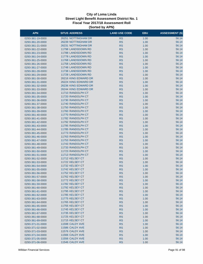
APN SITUS ADDRESS LAND USE CODE EBU ASSESSMENT ($)
City of Loma LindaStreet Light Benefit Assessment District No. 1
Fiscal Year 2017/18 Assessment Roll (Sorted by APN)
0293-361-19-0000 26251 NOTTINGHAM DR RS 1.00 56.14
0293-361-20-0000 26239 NOTTINGHAM DR RS 1.00 56.14
0293-361-21-0000 26231 NOTTINGHAM DR RS 1.00 56.14
0293-361-22-0000 11798 LANDSDOWN RD RS 1.00 56.14
0293-361-23-0000 11788 LANDSDOWN RD RS 1.00 56.14
0293-361-24-0000 11778 LANDSDOWN RD RS 1.00 56.14
0293-361-25-0000 11768 LANDSDOWN RD RS 1.00 56.14
0293-361-26-0000 11758 LANDSDOWN RD RS 1.00 56.14
0293-361-27-0000 11748 LANDSDOWN RD RS 1.00 56.14
0293-361-28-0000 11738 LANDSDOWN RD RS 1.00 56.14
0293-361-29-0000 11728 LANDSDOWN RD RS 1.00 56.14
0293-361-30-0000 26216 KING EDWARD DR RS 1.00 56.14
0293-361-31-0000 26224 KING EDWARD DR RS 1.00 56.14
0293-361-32-0000 26236 KING EDWARD DR RS 1.00 56.14
0293-361-33-0000 26244 KING EDWARD DR RS 1.00 56.14
0293-361-34-0000 11710 RANDOLPH CT RS 1.00 56.14
0293-361-35-0000 11720 RANDOLPH CT RS 1.00 56.14
0293-361-36-0000 11730 RANDOLPH CT RS 1.00 56.14
0293-361-37-0000 11740 RANDOLPH CT RS 1.00 56.14
0293-361-38-0000 11750 RANDOLPH CT RS 1.00 56.14
0293-361-39-0000 11760 RANDOLPH CT RS 1.00 56.14
0293-361-40-0000 11770 RANDOLPH CT RS 1.00 56.14
0293-361-41-0000 11782 RANDOLPH CT RS 1.00 56.14
0293-361-42-0000 11792 RANDOLPH CT RS 1.00 56.14
0293-361-43-0000 11795 RANDOLPH CT RS 1.00 56.14
0293-361-44-0000 11785 RANDOLPH CT RS 1.00 56.14
0293-361-45-0000 11773 RANDOLPH CT RS 1.00 56.14
0293-361-46-0000 11763 RANDOLPH CT RS 1.00 56.14
0293-361-47-0000 11753 RANDOLPH CT RS 1.00 56.14
0293-361-48-0000 11743 RANDOLPH CT RS 1.00 56.14
0293-361-49-0000 11733 RANDOLPH CT RS 1.00 56.14
0293-361-50-0000 11723 RANDOLPH CT RS 1.00 56.14
0293-361-51-0000 11713 RANDOLPH CT RS 1.00 56.14
0293-361-52-0000 11712 KELSEY CT RS 1.00 56.14
0293-361-53-0000 11722 KELSEY CT RS 1.00 56.14
0293-361-54-0000 11732 KELSEY CT RS 1.00 56.14
0293-361-55-0000 11742 KELSEY CT RS 1.00 56.14
0293-361-56-0000 11752 KELSEY CT RS 1.00 56.14
0293-361-57-0000 11762 KELSEY CT RS 1.00 56.14
0293-361-58-0000 11772 KELSEY CT RS 1.00 56.14
0293-361-59-0000 11782 KELSEY CT RS 1.00 56.14
0293-361-60-0000 11792 KELSEY CT RS 1.00 56.14
0293-361-61-0000 11795 KELSEY CT RS 1.00 56.14
0293-361-62-0000 11785 KELSEY CT RS 1.00 56.14
0293-361-63-0000 11775 KELSEY CT RS 1.00 56.14
0293-361-64-0000 11765 KELSEY CT RS 1.00 56.14
0293-361-65-0000 11755 KELSEY CT RS 1.00 56.14
0293-361-66-0000 11745 KELSEY CT RS 1.00 56.14
0293-361-67-0000 11735 KELSEY CT RS 1.00 56.14
0293-361-68-0000 11725 KELSEY CT RS 1.00 56.14
0293-361-69-0000 11715 KELSEY CT RS 1.00 56.14
0293-371-01-0000 11598 CALDY AVE RS 1.00 56.14
0293-371-02-0000 11586 CALDY AVE RS 1.00 56.14
0293-371-03-0000 11576 CALDY AVE RS 1.00 56.14
0293-371-04-0000 11566 CALDY AVE RS 1.00 56.14
0293-371-05-0000 11556 CALDY AVE RS 1.00 56.14
0293-371-06-0000 11546 CALDY AVE RS 1.00 56.14
Willdan Financial Services Page 91 of 98
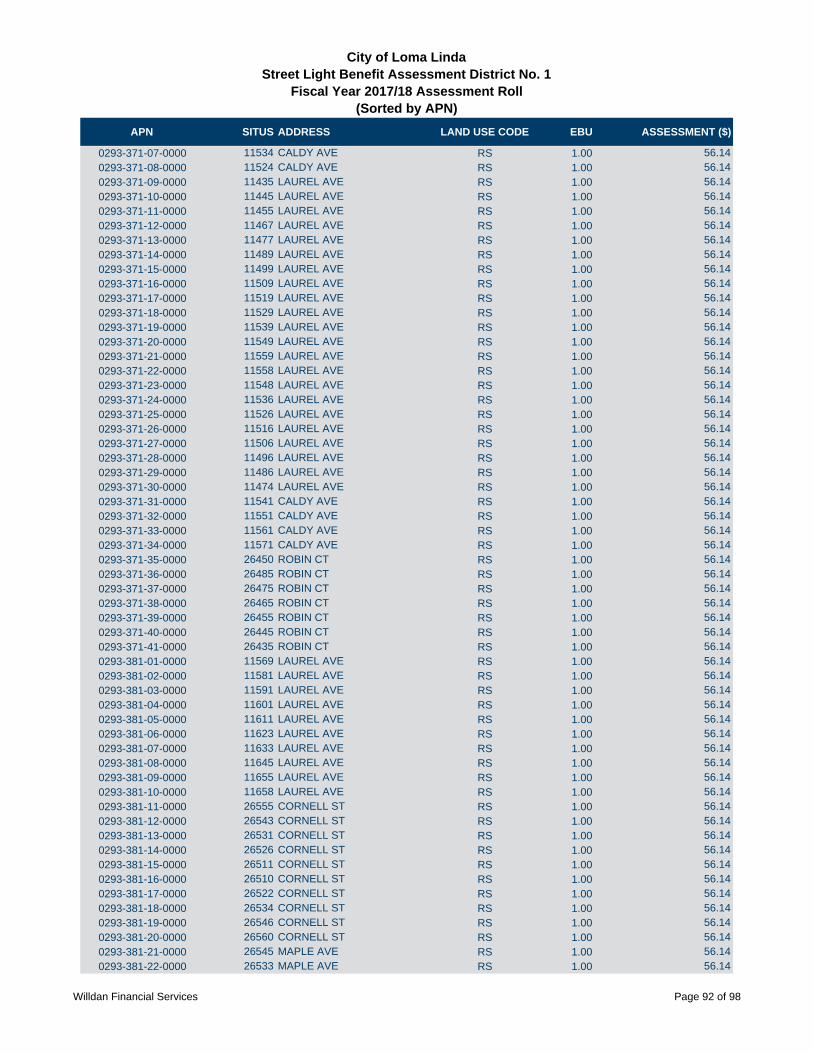
APN SITUS ADDRESS LAND USE CODE EBU ASSESSMENT ($)
City of Loma LindaStreet Light Benefit Assessment District No. 1
Fiscal Year 2017/18 Assessment Roll (Sorted by APN)
0293-371-07-0000 11534 CALDY AVE RS 1.00 56.14
0293-371-08-0000 11524 CALDY AVE RS 1.00 56.14
0293-371-09-0000 11435 LAUREL AVE RS 1.00 56.14
0293-371-10-0000 11445 LAUREL AVE RS 1.00 56.14
0293-371-11-0000 11455 LAUREL AVE RS 1.00 56.14
0293-371-12-0000 11467 LAUREL AVE RS 1.00 56.14
0293-371-13-0000 11477 LAUREL AVE RS 1.00 56.14
0293-371-14-0000 11489 LAUREL AVE RS 1.00 56.14
0293-371-15-0000 11499 LAUREL AVE RS 1.00 56.14
0293-371-16-0000 11509 LAUREL AVE RS 1.00 56.14
0293-371-17-0000 11519 LAUREL AVE RS 1.00 56.14
0293-371-18-0000 11529 LAUREL AVE RS 1.00 56.14
0293-371-19-0000 11539 LAUREL AVE RS 1.00 56.14
0293-371-20-0000 11549 LAUREL AVE RS 1.00 56.14
0293-371-21-0000 11559 LAUREL AVE RS 1.00 56.14
0293-371-22-0000 11558 LAUREL AVE RS 1.00 56.14
0293-371-23-0000 11548 LAUREL AVE RS 1.00 56.14
0293-371-24-0000 11536 LAUREL AVE RS 1.00 56.14
0293-371-25-0000 11526 LAUREL AVE RS 1.00 56.14
0293-371-26-0000 11516 LAUREL AVE RS 1.00 56.14
0293-371-27-0000 11506 LAUREL AVE RS 1.00 56.14
0293-371-28-0000 11496 LAUREL AVE RS 1.00 56.14
0293-371-29-0000 11486 LAUREL AVE RS 1.00 56.14
0293-371-30-0000 11474 LAUREL AVE RS 1.00 56.14
0293-371-31-0000 11541 CALDY AVE RS 1.00 56.14
0293-371-32-0000 11551 CALDY AVE RS 1.00 56.14
0293-371-33-0000 11561 CALDY AVE RS 1.00 56.14
0293-371-34-0000 11571 CALDY AVE RS 1.00 56.14
0293-371-35-0000 26450 ROBIN CT RS 1.00 56.14
0293-371-36-0000 26485 ROBIN CT RS 1.00 56.14
0293-371-37-0000 26475 ROBIN CT RS 1.00 56.14
0293-371-38-0000 26465 ROBIN CT RS 1.00 56.14
0293-371-39-0000 26455 ROBIN CT RS 1.00 56.14
0293-371-40-0000 26445 ROBIN CT RS 1.00 56.14
0293-371-41-0000 26435 ROBIN CT RS 1.00 56.14
0293-381-01-0000 11569 LAUREL AVE RS 1.00 56.14
0293-381-02-0000 11581 LAUREL AVE RS 1.00 56.14
0293-381-03-0000 11591 LAUREL AVE RS 1.00 56.14
0293-381-04-0000 11601 LAUREL AVE RS 1.00 56.14
0293-381-05-0000 11611 LAUREL AVE RS 1.00 56.14
0293-381-06-0000 11623 LAUREL AVE RS 1.00 56.14
0293-381-07-0000 11633 LAUREL AVE RS 1.00 56.14
0293-381-08-0000 11645 LAUREL AVE RS 1.00 56.14
0293-381-09-0000 11655 LAUREL AVE RS 1.00 56.14
0293-381-10-0000 11658 LAUREL AVE RS 1.00 56.14
0293-381-11-0000 26555 CORNELL ST RS 1.00 56.14
0293-381-12-0000 26543 CORNELL ST RS 1.00 56.14
0293-381-13-0000 26531 CORNELL ST RS 1.00 56.14
0293-381-14-0000 26526 CORNELL ST RS 1.00 56.14
0293-381-15-0000 26511 CORNELL ST RS 1.00 56.14
0293-381-16-0000 26510 CORNELL ST RS 1.00 56.14
0293-381-17-0000 26522 CORNELL ST RS 1.00 56.14
0293-381-18-0000 26534 CORNELL ST RS 1.00 56.14
0293-381-19-0000 26546 CORNELL ST RS 1.00 56.14
0293-381-20-0000 26560 CORNELL ST RS 1.00 56.14
0293-381-21-0000 26545 MAPLE AVE RS 1.00 56.14
0293-381-22-0000 26533 MAPLE AVE RS 1.00 56.14
Willdan Financial Services Page 92 of 98

APN SITUS ADDRESS LAND USE CODE EBU ASSESSMENT ($)
City of Loma LindaStreet Light Benefit Assessment District No. 1
Fiscal Year 2017/18 Assessment Roll (Sorted by APN)
0293-381-23-0000 26521 MAPLE AVE RS 1.00 56.14
0293-381-24-0000 26511 MAPLE AVE RS 1.00 56.14
0293-381-25-0000 26514 MAPLE AVE RS 1.00 56.14
0293-381-26-0000 11580 LAUREL AVE RS 1.00 56.14
0293-381-27-0000 11568 LAUREL AVE RS 1.00 56.14
0293-381-28-0000 11690 CALDY AVE RS 1.00 56.14
0293-381-29-0000 11678 CALDY AVE RS 1.00 56.14
0293-381-30-0000 11668 CALDY AVE RS 1.00 56.14
0293-381-31-0000 11658 CALDY AVE RS 1.00 56.14
0293-381-32-0000 11648 CALDY AVE RS 1.00 56.14
0293-381-33-0000 11638 CALDY AVE RS 1.00 56.14
0293-381-34-0000 11628 CALDY AVE RS 1.00 56.14
0293-381-35-0000 11618 CALDY AVE RS 1.00 56.14
0293-381-36-0000 11608 CALDY AVE RS 1.00 56.14
0293-381-37-0000 26438 MAPLE AVE RS 1.00 56.14
0293-381-38-0000 26450 MAPLE AVE RS 1.00 56.14
0293-381-39-0000 26460 MAPLE AVE RS 1.00 56.14
0293-381-40-0000 26470 MAPLE AVE RS 1.00 56.14
0293-381-41-0000 26480 MAPLE AVE RS 1.00 56.14
0293-381-42-0000 26490 MAPLE AVE RS 1.00 56.14
0293-381-43-0000 26500 MAPLE AVE RS 1.00 56.14
0293-381-44-0000 26501 MAPLE AVE RS 1.00 56.14
0293-381-45-0000 26491 MAPLE AVE RS 1.00 56.14
0293-381-46-0000 26481 MAPLE AVE RS 1.00 56.14
0293-381-47-0000 26471 MAPLE AVE RS 1.00 56.14
0293-381-48-0000 26461 MAPLE AVE RS 1.00 56.14
0293-381-49-0000 26451 MAPLE AVE RS 1.00 56.14
0293-381-50-0000 26439 MAPLE AVE RS 1.00 56.14
0293-381-51-0000 26438 CORNELL ST RS 1.00 56.14
0293-381-52-0000 26450 CORNELL ST RS 1.00 56.14
0293-381-53-0000 26460 CORNELL ST RS 1.00 56.14
0293-381-54-0000 26470 CORNELL ST RS 1.00 56.14
0293-381-55-0000 26480 CORNELL ST RS 1.00 56.14
0293-381-56-0000 26490 CORNELL ST RS 1.00 56.14
0293-381-57-0000 26500 CORNELL ST RS 1.00 56.14
0293-381-58-0000 26501 CORNELL ST RS 1.00 56.14
0293-381-59-0000 26491 CORNELL ST RS 1.00 56.14
0293-381-60-0000 26481 CORNELL ST RS 1.00 56.14
0293-381-61-0000 26471 CORNELL ST RS 1.00 56.14
0293-381-62-0000 26461 CORNELL ST RS 1.00 56.14
0293-381-63-0000 26451 CORNELL ST RS 1.00 56.14
0293-381-64-0000 26439 CORNELL ST RS 1.00 56.14
0293-391-01-0000 11665 LAUREL AVE RS 1.00 56.14
0293-391-02-0000 11675 LAUREL AVE RS 1.00 56.14
0293-391-03-0000 11685 LAUREL AVE RS 1.00 56.14
0293-391-04-0000 11697 LAUREL AVE RS 1.00 56.14
0293-391-05-0000 26599 GEORGE ST RS 1.00 56.14
0293-391-06-0000 26587 GEORGE ST RS 1.00 56.14
0293-391-07-0000 26575 GEORGE ST RS 1.00 56.14
0293-391-08-0000 26594 TANAGER CT RS 1.00 56.14
0293-391-09-0000 26606 TANAGER CT RS 1.00 56.14
0293-391-10-0000 26618 TANAGER CT RS 1.00 56.14
0293-391-11-0000 26628 TANAGER CT RS 1.00 56.14
0293-391-12-0000 26638 TANAGER CT RS 1.00 56.14
0293-391-17-0000 26613 TANAGER CT RS 1.00 56.14
0293-391-18-0000 26603 TANAGER CT RS 1.00 56.14
0293-391-19-0000 26623 TANAGER CT RS 1.00 56.14
Willdan Financial Services Page 93 of 98

APN SITUS ADDRESS LAND USE CODE EBU ASSESSMENT ($)
City of Loma LindaStreet Light Benefit Assessment District No. 1
Fiscal Year 2017/18 Assessment Roll (Sorted by APN)
0293-391-20-0000 26610 HUMMINGBIRD CT RS 1.00 56.14
0293-391-21-0000 26622 HUMMINGBIRD CT RS 1.00 56.14
0293-391-22-0000 26634 HUMMINGBIRD CT RS 1.00 56.14
0293-391-23-0000 26644 HUMMINGBIRD CT RS 1.00 56.14
0293-391-24-0000 26656 HUMMINGBIRD CT RS 1.00 56.14
0293-391-25-0000 26668 HUMMINGBIRD CT RS 1.00 56.14
0293-391-26-0000 26679 HUMMINGBIRD CT RS 1.00 56.14
0293-391-27-0000 26573 TANAGER CT RS 1.00 56.14
0293-391-28-0000 26561 TANAGER CT RS 1.00 56.14
0293-391-29-0000 26549 TANAGER CT RS 1.00 56.14
0293-391-30-0000 26537 TANAGER CT RS 1.00 56.14
0293-391-31-0000 26525 TANAGER CT RS 1.00 56.14
0293-391-32-0000 26513 TANAGER CT RS 1.00 56.14
0293-391-33-0000 26508 TANAGER CT RS 1.00 56.14
0293-391-34-0000 26520 TANAGER CT RS 1.00 56.14
0293-391-35-0000 26532 TANAGER CT RS 1.00 56.14
0293-391-36-0000 26544 TANAGER CT RS 1.00 56.14
0293-391-37-0000 26556 TANAGER CT RS 1.00 56.14
0293-391-38-0000 26568 TANAGER CT RS 1.00 56.14
0293-391-39-0000 26555 POPPY CT RS 1.00 56.14
0293-391-40-0000 26545 POPPY CT RS 1.00 56.14
0293-391-41-0000 26535 POPPY CT RS 1.00 56.14
0293-391-42-0000 26525 POPPY CT RS 1.00 56.14
0293-391-45-0000 26516 POPPY CT RS 1.00 56.14
0293-391-46-0000 26526 POPPY CT RS 1.00 56.14
0293-391-47-0000 26536 POPPY CT RS 1.00 56.14
0293-391-50-0000 11680 LAUREL AVE RS 1.00 56.14
0293-391-51-0000 11668 LAUREL AVE RS 1.00 56.14
0293-391-52-0000 26650 TANAGER CT RS 1.00 56.14
0293-391-53-0000 26643 TANAGER CT RS 1.00 56.14
0293-391-54-0000 26633 TANAGER CT RS 1.00 56.14
0293-391-55-0000 26623 TANAGER CT RS 1.00 56.14
0293-391-57-0000 26506 POPPY CT RS 1.00 56.14
0293-391-58-0000 26546 POPPY CT RS 1.00 56.14
0293-391-60-0000 26556 POPPY CT RS 1.00 56.14
0293-391-61-0000 26505 POPPY CT RS 1.00 56.14
0293-401-04-0000 26633 HUMMINGBIRD CT RS 1.00 56.14
0293-401-05-0000 26621 HUMMINGBIRD CT RS 1.00 56.14
0293-401-06-0000 26609 HUMMINGBIRD CT RS 1.00 56.14
0293-401-07-0000 26626 AMHERST CT RS 1.00 56.14
0293-401-08-0000 26638 AMHERST CT RS 1.00 56.14
0293-401-09-0000 26650 AMHERST CT RS 1.00 56.14
0293-401-10-0000 26660 AMHERST CT RS 1.00 56.14
0293-401-11-0000 26672 AMHERST CT RS 1.00 56.14
0293-401-12-0000 26684 AMHERST CT RS 1.00 56.14
0293-401-16-0000 11831 COLUMBIA CT RS 1.00 56.14
0293-401-17-0000 11841 COLUMBIA CT RS 1.00 56.14
0293-401-18-0000 11851 COLUNBIA CT RS 1.00 56.14
0293-401-19-0000 11876 COLUMBIA CT RS 1.00 56.14
0293-401-22-0000 11838 COLUMBIA CT RS 1.00 56.14
0293-401-23-0000 11828 COLUMBIA CT RS 1.00 56.14
0293-401-24-0000 11818 COLUMBIA CT RS 1.00 56.14
0293-401-25-0000 11839 HOLLIS CT RS 1.00 56.14
0293-401-26-0000 11851 HOLLIS CT RS 1.00 56.14
0293-401-27-0000 11863 HOLLIS CT RS 1.00 56.14
0293-401-28-0000 11873 HOLLIS CT RS 1.00 56.14
0293-401-29-0000 11885 HOLLIS CT RS 1.00 56.14
Willdan Financial Services Page 94 of 98

APN SITUS ADDRESS LAND USE CODE EBU ASSESSMENT ($)
City of Loma LindaStreet Light Benefit Assessment District No. 1
Fiscal Year 2017/18 Assessment Roll (Sorted by APN)
0293-401-30-0000 11876 HOLLIS CT RS 1.00 56.14
0293-401-31-0000 11864 HOLLIS CT RS 1.00 56.14
0293-401-32-0000 11852 HOLLIS CT RS 1.00 56.14
0293-401-33-0000 11840 HOLLIS CT RS 1.00 56.14
0293-401-34-0000 26585 AMHERST CT RS 1.00 56.14
0293-401-35-0000 26573 AMHERST CT RS 1.00 56.14
0293-401-36-0000 26561 AMHERST CT RS 1.00 56.14
0293-401-37-0000 26554 AMHERST CT RS 1.00 56.14
0293-401-38-0000 26566 AMHERST CT RS 1.00 56.14
0293-401-39-0000 26578 AMHERST CT RS 1.00 56.14
0293-401-40-0000 26590 AMHERST CT RS 1.00 56.14
0293-401-41-0000 26602 AMHERST CT RS 1.00 56.14
0293-401-42-0000 26589 HUMMINGBIRD CT RS 1.00 56.14
0293-401-43-0000 26577 HUMMINGBIRD CT RS 1.00 56.14
0293-401-44-0000 26567 HUMMINGBIRD CT RS 1.00 56.14
0293-401-45-0000 26557 HUMMINGBIRD CT RS 1.00 56.14
0293-401-46-0000 26547 HUMMINGBIRD CT RS 1.00 56.14
0293-401-47-0000 26535 HUMMINGBIRD CT RS 1.00 56.14
0293-401-48-0000 11847 CARDINAL CT RS 1.00 56.14
0293-401-49-0000 11857 CARDINAL CT RS 1.00 56.14
0293-401-50-0000 11864 CARDINAL CT RS 1.00 56.14
0293-401-51-0000 11881 CARDINAL CT RS 1.00 56.14
0293-401-52-0000 11872 CARDINAL CT RS 1.00 56.14
0293-401-53-0000 11860 CARDINAL CT RS 1.00 56.14
0293-401-54-0000 11848 CARDINAL CT RS 1.00 56.14
0293-401-55-0000 11838 CARDINAL CT RS 1.00 56.14
0293-401-56-0000 11826 CARDINAL CT RS 1.00 56.14
0293-401-57-0000 11816 CARDINAL CT RS 1.00 56.14
0293-401-58-0000 26526 HUMMINGBIRD CT RS 1.00 56.14
0293-401-59-0000 26838 HUMMINGBIRD CT RS 1.00 56.14
0293-401-60-0000 26550 HUMMINGBIRD CT RS 1.00 56.14
0293-401-61-0000 26562 HUMMINGBIRD CT RS 1.00 56.14
0293-401-62-0000 26574 HUMMINGBIRD CT RS 1.00 56.14
0293-401-63-0000 26586 HUMMINGBIRD CT RS 1.00 56.14
0293-401-65-0000 26667 HUMMINGBIRD CT RS 1.00 56.14
0293-401-66-0000 26655 HUMMINGBIRD CT RS 1.00 56.14
0293-401-67-0000 26643 HUMMINGBIRD CT RS 1.00 56.14
0293-401-68-0000 11864 COLUMBIA CT RS 1.00 56.14
0293-401-69-0000 11850 COLUMBIA CT RS 1.00 56.14
0293-401-71-0000 11821 COLUMBIA CT RS 1.00 56.14
0293-401-72-0000 11811 COLUMBIA CT RS 1.00 56.14
0293-401-73-0000 11801 COLUMBIA CT RS 1.00 56.14
0293-411-01-0000 11863 COLUMBIA CT RS 1.00 56.14
0293-411-02-0000 11873 COLUMBIA CT RS 1.00 56.14
0293-411-03-0000 11885 COLUMBIA CT RS 1.00 56.14
0293-431-01-0000 26403 ANTONIO CIR RS 1.00 56.14
0293-431-02-0000 26405 ANTONIO CIR RS 1.00 56.14
0293-431-03-0000 26411 ANTONIO CIR RS 1.00 56.14
0293-431-04-0000 11858 SANDRA CT RS 1.00 56.14
0293-431-05-0000 11870 SANDRA CT RS 1.00 56.14
0293-431-06-0000 11882 SANDRA CT RS 1.00 56.14
0293-431-07-0000 11885 SANDRA CT RS 1.00 56.14
0293-431-08-0000 11873 SANDRA CT RS 1.00 56.14
0293-431-09-0000 11861 SANDRA CT RS 1.00 56.14
0293-431-10-0000 26433 ANTONIO CIR RS 1.00 56.14
0293-431-11-0000 26439 ANTONIO CIR RS 1.00 56.14
0293-431-12-0000 26445 ANTONIO CIR RS 1.00 56.14
Willdan Financial Services Page 95 of 98
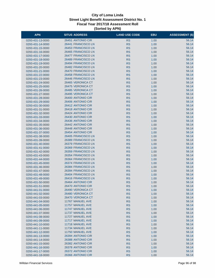
APN SITUS ADDRESS LAND USE CODE EBU ASSESSMENT ($)
City of Loma LindaStreet Light Benefit Assessment District No. 1
Fiscal Year 2017/18 Assessment Roll (Sorted by APN)
0293-431-13-0000 26451 ANTONIO CIR RS 1.00 56.14
0293-431-14-0000 26441 FRANCISCO LN RS 1.00 56.14
0293-431-15-0000 26453 FRANCISCO LN RS 1.00 56.14
0293-431-16-0000 26465 FRANCISCO LN RS 1.00 56.14
0293-431-17-0000 26477 FRANCISCO LN RS 1.00 56.14
0293-431-18-0000 26489 FRANCISCO LN RS 1.00 56.14
0293-431-19-0000 26494 FRANCISCO LN RS 1.00 56.14
0293-431-20-0000 26482 FRANCISCO LN RS 1.00 56.14
0293-431-21-0000 26470 FRANCISCO LN RS 1.00 56.14
0293-431-22-0000 26458 FRANCISCO LN RS 1.00 56.14
0293-431-23-0000 26446 FRANCISCO LN RS 1.00 56.14
0293-431-24-0000 26465 VERONICA CT RS 1.00 56.14
0293-431-25-0000 26475 VERONICA CT RS 1.00 56.14
0293-431-26-0000 26485 VERONICA CT RS 1.00 56.14
0293-431-27-0000 26495 VERONICA CT RS 1.00 56.14
0293-431-28-0000 26400 ANTONIO CIR RS 1.00 56.14
0293-431-29-0000 26406 ANTONIO CIR RS 1.00 56.14
0293-431-30-0000 26412 ANTONIO CIR RS 1.00 56.14
0293-431-31-0000 26418 ANTONIO CIR RS 1.00 56.14
0293-431-32-0000 26424 ANTONIO CIR RS 1.00 56.14
0293-431-33-0000 26430 ANTONIO CIR RS 1.00 56.14
0293-431-34-0000 26436 ANTONIO CIR RS 1.00 56.14
0293-431-35-0000 26442 ANTONIO CIR RS 1.00 56.14
0293-431-36-0000 26448 ANTONIO CIR RS 1.00 56.14
0293-431-37-0000 26454 ANTONIO CIR RS 1.00 56.14
0293-431-38-0000 26405 FRANCISCO LN RS 1.00 56.14
0293-431-39-0000 26389 FRANCISCO LN RS 1.00 56.14
0293-431-40-0000 26379 FRANCISCO LN RS 1.00 56.14
0293-431-41-0000 26369 FRANCISCO LN RS 1.00 56.14
0293-431-42-0000 26359 FRANCISCO LN RS 1.00 56.14
0293-431-43-0000 26354 FRANCISCO LN RS 1.00 56.14
0293-431-44-0000 26364 FRANCISCO LN RS 1.00 56.14
0293-431-45-0000 26374 FRANCISCO LN RS 1.00 56.14
0293-431-46-0000 26384 FRANCISCO LN RS 1.00 56.14
0293-431-47-0000 26394 FRANCISCO LN RS 1.00 56.14
0293-431-48-0000 26404 FRANCISCO LN RS 1.00 56.14
0293-431-49-0000 26416 FRANCISCO LN RS 1.00 56.14
0293-431-50-0000 26464 ANTONIO CIR RS 1.00 56.14
0293-431-51-0000 26470 ANTONIO CIR RS 1.00 56.14
0293-441-01-0000 26490 VERONICA CT RS 1.00 56.14
0293-441-02-0000 26480 VERONICA CT RS 1.00 56.14
0293-441-03-0000 26470 VERONICA CT RS 1.00 56.14
0293-441-04-0000 11767 MANUEL AVE RS 1.00 56.14
0293-441-05-0000 11757 MANUEL AVE RS 1.00 56.14
0293-441-06-0000 11747 MANUEL AVE RS 1.00 56.14
0293-441-07-0000 11737 MANUEL AVE RS 1.00 56.14
0293-441-08-0000 11727 MANUEL AVE RS 1.00 56.14
0293-441-09-0000 11717 MANUEL AVE RS 1.00 56.14
0293-441-10-0000 11718 MANUEL AVE RS 1.00 56.14
0293-441-11-0000 11734 MANUEL AVE RS 1.00 56.14
0293-441-12-0000 11750 MANUEL AVE RS 1.00 56.14
0293-441-13-0000 26394 ANTONIO CIR RS 1.00 56.14
0293-441-14-0000 26388 ANTONIO CIR RS 1.00 56.14
0293-441-15-0000 26382 ANTONIO CIR RS 1.00 56.14
0293-441-16-0000 26378 ANTONIO CIR RS 1.00 56.14
0293-441-17-0000 26372 ANTONIO CIR RS 1.00 56.14
0293-441-18-0000 26366 ANTONIO CIR RS 1.00 56.14
Willdan Financial Services Page 96 of 98

APN SITUS ADDRESS LAND USE CODE EBU ASSESSMENT ($)
City of Loma LindaStreet Light Benefit Assessment District No. 1
Fiscal Year 2017/18 Assessment Roll (Sorted by APN)
0293-441-19-0000 26360 ANTONIO CIR RS 1.00 56.14
0293-441-20-0000 26356 ANTONIO CIR RS 1.00 56.14
0293-441-21-0000 26350 ANTONIO CIR RS 1.00 56.14
0293-441-22-0000 26344 ANTONIO CIR RS 1.00 56.14
0293-441-23-0000 26332 MARGARITA LN RS 1.00 56.14
0293-441-24-0000 26322 MARGARITA LN RS 1.00 56.14
0293-441-25-0000 26312 MARGARITA LN RS 1.00 56.14
0293-441-26-0000 26302 MARGARITA LN RS 1.00 56.14
0293-441-27-0000 26301 MARGARITA LN RS 1.00 56.14
0293-441-28-0000 26311 MARGARITA LN RS 1.00 56.14
0293-441-29-0000 26321 MARGARITA LN RS 1.00 56.14
0293-441-30-0000 26331 MARGARITA LN RS 1.00 56.14
0293-441-31-0000 26328 ANTONIO CIR RS 1.00 56.14
0293-441-32-0000 26320 ANTONIO CIR RS 1.00 56.14
0293-441-33-0000 26312 ANTONIO CIR RS 1.00 56.14
0293-441-34-0000 26306 ANTONIO CIR RS 1.00 56.14
0293-441-35-0000 26329 ANTONIO CIR RS 1.00 56.14
0293-441-36-0000 26319 ANTONIO CIR RS 1.00 56.14
0293-441-37-0000 26311 ANTONIO CIR RS 1.00 56.14
0293-441-38-0000 26305 ANTONIO CIR RS 1.00 56.14
0293-441-39-0000 26476 ANTONIO CIR RS 1.00 56.14
0293-441-40-0000 26482 ANTONIO CIR RS 1.00 56.14
0293-441-41-0000 26488 ANTONIO CIR RS 1.00 56.14
0293-441-42-0000 26494 ANTONIO CIR RS 1.00 56.14
0293-441-43-0000 26500 ANTONIO CIR RS 1.00 56.14
0293-441-44-0000 26399 ANTONIO CIR RS 1.00 56.14
0293-441-45-0000 26393 ANTONIO CIR RS 1.00 56.14
0293-441-46-0000 26385 ANTONIO CIR RS 1.00 56.14
0293-441-47-0000 26377 ANTONIO CIR RS 1.00 56.14
0293-441-48-0000 26371 ANTONIO CIR RS 1.00 56.14
0293-441-49-0000 26365 ANTONIO CIR RS 1.00 56.14
0293-441-50-0000 26359 ANTONIO CIR RS 1.00 56.14
0293-441-51-0000 26349 ANTONIO CIR RS 1.00 56.14
0293-441-52-0000 26341 ANTONIO CIR RS 1.00 56.14
0293-441-53-0000 26374 MARGARITA LN RS 1.00 56.14
0293-441-54-0000 26388 MARGARITA LN RS 1.00 56.14
0293-441-55-0000 26400 MARGARITA LN RS 1.00 56.14
0293-441-56-0000 26410 MARGARITA LN RS 1.00 56.14
0293-441-57-0000 26420 MARGARITA LN RS 1.00 56.14
0293-441-58-0000 26430 MARGARITA LN RS 1.00 56.14
0293-441-59-0000 26433 MARGARITA LN RS 1.00 56.14
0293-441-60-0000 26423 MARGARITA LN RS 1.00 56.14
0293-441-61-0000 26413 MARGARITA LN RS 1.00 56.14
0293-441-62-0000 26403 MARGARITA LN RS 1.00 56.14
0293-441-63-0000 26393 MARGARITA LN RS 1.00 56.14
0293-441-64-0000 26383 MARGARITA LN RS 1.00 56.14
0293-441-65-0000 26373 MARGARITA LN RS 1.00 56.14
0293-441-66-0000 26363 MARGARITA LN RS 1.00 56.14
0293-451-01-0000 11445 WHITTIER AVE RS 1.00 56.14
0293-451-02-0000 11457 WHITTIER AVE RS 1.00 56.14
0293-451-03-0000 11465 WHITTIER AVE RS 1.00 56.14
0293-451-04-0000 11473 WHITTIER AVE RS 1.00 56.14
0293-451-05-0000 11479 WHITTIER AVE RS 1.00 56.14
0293-451-06-0000 11487 WHITTIER AVE RS 1.00 56.14
0293-451-07-0000 11495 WHITTIER AVE RS 1.00 56.14
0293-451-08-0000 11494 GOWER ST RS 1.00 56.14
0293-451-09-0000 11488 GOWER ST RS 1.00 56.14
Willdan Financial Services Page 97 of 98

APN SITUS ADDRESS LAND USE CODE EBU ASSESSMENT ($)
City of Loma LindaStreet Light Benefit Assessment District No. 1
Fiscal Year 2017/18 Assessment Roll (Sorted by APN)
0293-451-10-0000 11480 GOWER ST RS 1.00 56.14
0293-451-11-0000 11472 GOWER ST RS 1.00 56.14
0293-451-12-0000 11466 GOWER ST RS 1.00 56.14
0293-451-13-0000 26324 SAINT DAVID ST RS 1.00 56.14
0293-451-14-0000 26332 SAINT DAVID ST RS 1.00 56.14
0293-451-15-0000 26338 SAINT DAVID ST RS 1.00 56.14
0293-451-16-0000 26346 SAINT DAVID ST RS 1.00 56.14
0293-451-17-0000 26352 SAINT DAVID ST RS 1.00 56.14
0293-451-18-0000 26358 SAINT DAVID ST RS 1.00 56.14
0293-451-19-0000 26366 SAINT DAVID ST RS 1.00 56.14
0293-451-20-0000 26372 SAINT DAVID ST RS 1.00 56.14
0293-451-21-0000 26380 SAINT DAVID ST RS 1.00 56.14
0293-451-22-0000 26386 SAINT DAVID ST RS 1.00 56.14
0293-451-23-0000 26392 SAINT DAVID ST RS 1.00 56.14
0293-451-24-0000 26400 SAINT DAVID ST RS 1.00 56.14
0293-451-25-0000 26408 SAINT DAVID ST RS 1.00 56.14
0293-451-26-0000 26390 LAWTON ST RS 1.00 56.14
0293-451-27-0000 26384 LAWTON ST RS 1.00 56.14
0293-451-28-0000 26376 LAWTON ST RS 1.00 56.14
0293-451-29-0000 26368 LAWTON ST RS 1.00 56.14
0293-451-30-0000 26362 LAWTON ST RS 1.00 56.14
0293-451-31-0000 26354 LAWTON ST RS 1.00 56.14
0293-451-32-0000 26346 LAWTON ST RS 1.00 56.14
0293-451-33-0000 26347 SAINT DAVID ST RS 1.00 56.14
0293-451-34-0000 26355 SAINT DAVID ST RS 1.00 56.14
TOTAL 5,627.34 342,240.46PARCEL COUNT 5,554
Willdan Financial Services Page 98 of 98
2017/2018 Street Light Benefit Assessment District No. 1 Page C-1
APPENDIX C – RESOLUTIONS


Council Bill #R-2017-21
RESOLUTION NO. _____
A RESOLUTION OF THE CITY COUNCIL OF THE CITY OF LOMA LINDA
CONFIRMING THE ANNEXATION OF CITRUS LANE DEVELOPMENT
(ANNEXATION TERRITORY) INTO LOMA LINDA LANDSCAPE
MAINTENANCE DISTRICT NO. 1, THE DIAGRAM AND ASSESSMENTS
RELATED THERETO, OVERRULING ALL PROTESTS CONCERNING THE
ASSESSMENTS, AND ORDERING THE LEVY AND COLLECTION OF
ASSESSMENTS FOR FISCAL YEAR 2017/2018
WHEREAS, pursuant to the provisions of the Landscaping and Lighting Act of 1972, Part 2 of
Division 15 of the California Streets and Highways Code (“1972 Act”), the City Council by previous
resolution, initiated proceedings and ordered the preparation of an Engineer’s Report in connection with
the annexation of the Citrus Lane development (“Annexation Territory”) comprised of the 35 single-
family residential parcels, located on the southeast corner of California Street and Citrus Avenue, into the
Landscape Maintenance District No. 1 (the “District”) to fund the special benefit costs and expenses for
the ongoing maintenance, operation and servicing of the landscaping improvements and appurtenant
facilities related thereto; and,
WHEREAS, after fully considering the Engineer's Report presented, the City Council by
resolution approved and filed said Engineer's Report, declared its intention to annex the Annexation
Territory into the District, to conduct a property owner protest ballot proceeding for the proposed new
assessments related thereto in accordance with the provisions of Article XIIID of the California
Constitution (the “Constitution”) and Government Code §§ 53750 et seq., and set the Public Hearing to
be noticed pursuant to applicable law for June 13, 2017 at 7:00 p.m.; and,
WHEREAS, notices and ballots were mailed to the property owners of record regarding the
annexation of the Annexation Territory into the District and the new assessments as described in the
Engineer’s Report, pursuant to the applicable laws and regulations governing majority protest
proceedings for return receipt prior to the close of the public hearing on June 13, 2017; and
WHEREAS, on June 13, 2017, the City Council held the duly noticed Public Hearing, to consider
all oral statements and written protests, objections, and communication made or filed by any interested
person regarding the annexation of the Annexation Territory into the District and the proposed new
assessments; and to receive and accept all protest ballots from the property owners of record within the
proposed Annexation Territory; and,
WHEREAS, at the conclusion of the Public Hearing, a tabulation and canvass of the property
owner protest ballots was conducted by the City Clerk or their designee, with all valid protest ballots
returned by the affected property owners being counted; and,
NOW, THEREFORE, BE IT RESOLVED by the City Council of the City of Loma Linda as
follows:
1. The above recitals are true and correct.
2. Following notice duly given, the City Council has held a full and fair public hearing
regarding the annexation of Citrus Lane Development (Annexation Territory) into the City of Loma
Linda Landscape Maintenance District No. 1, the levy and collection of assessments, and has

Resolution No. ____
Page 2
considered all public testimony and written statements, protests and communications made or filed
by interested persons.
3. In accordance with the provisions of the Constitution, the City Council has evaluated the
results of the property owner protest ballot proceedings, and has determined that majority protest of
the proposed new assessments did not exist and overrules all oral or written protests that may have
been presented concerning the annual assessments for the District commencing in Fiscal Year
2017/2018.
4. Based upon its review of the facts presented and the Engineer’s Report that has been filed
with the City Clerk, the City Council hereby finds and determines that:
(4a.) The land within the Annexation Territory and District will receive special benefit from the
operation, maintenance and servicing of the improvements to be provided by the District as
described in the Engineer’s Report.
(4b.) The Annexation Territory and District as defined by the Assessment Diagram contained in
the Engineer’s Report, includes all of the lands receiving such special benefit.
(4c.) The net amount to be assessed upon the lands within the Annexation Territory and District
has been apportioned by a formula and method which fairly distributes the net amount
among all eligible parcels in proportion to the special benefit to be received by each parcel
from the improvements and services to be provided commencing with fiscal year 2017/2018.
5. The adoption of this Resolution constitutes the annexation of the Annexation Territory into
the District, the boundaries of the Annexation Territory, District and any Zones therein as contained
in the Assessment Diagram presented in the Engineer’s Report; the establishment of the maximum
assessment rate and assessment range formula connected therewith; and the assessments to be
levied for the Annexation Territory for the fiscal year commencing July 1, 2017 and ending June 30,
2018, as described in the Engineer’s Report and adopted by the City Council.
6. The City Council hereby orders the Annexation Territory and District improvements to be
made for fiscal year 2017/2018 as outlined by the Engineer’s Report and by these proceedings.
7. Pursuant to applicable law, City staff or their designee is hereby authorized and directed to
file the levy of assessments for fiscal year 2017/2018 as approved herein with the San Bernardino
County Auditor/Controller along with a certified copy of this Resolution; and/or as may be required
by the County Auditor/Controller or County Assessor, copies of the Engineer’s Report or
Assessment Diagram confirmed by this Resolution.
8. The City Clerk shall certify to the passage and adoption of this Resolution, and the minutes
of this meeting shall so reflect the City Council’s approval of the annexation of the Annexation
Territory into the District; the confirmation of the Assessment Diagram; and the establishment of the
maximum assessment rates, assessment range formula, and the assessments for Fiscal Year
2017/2018 as outlined in the Engineer’s Report and approved in these proceedings.

Resolution No. ____
Page 3
PASSED, APPROVED AND ADOPTED this 13
th day of June 2017 by the following vote:
Ayes:
Noes:
Abstain:
Absent:
Rhodes Rigsby, Mayor
ATTEST:
Barbara Nicholson, City Clerk
City of Loma Linda Engineer’s Report Fiscal Year Page Landscape Maintenance
District No. 1 Annexation No. 74 2017/2018
CITY OF LOMA LINDA
ENGINEER’S REPORT
LANDSCAPE MAINTENANCE
DISTRICT NO. 1
ANNEXATION NO. 74
(CITRUS LANE DEVELOPMENT)
FISCAL YEAR 2017/2018
INTENT MEETING: MAY 23, 2017 PUBLIC HEARING: JUNE 13, 2017
CITY OF LOMA LINDA 25541 BARTON ROAD
LOMA LINDA, CA 92354
MAY 2017
PREPARED BY
WILLDAN FINANCIAL SERVICES
27368 Via Industria
Suite 200
Temecula, CA 92590
T 951.587.3500 | 800.755.6864
F 951.587.3510
www.willdan.com/financial

City of Loma Linda Engineer’s Report Fiscal Year Page ii Landscape Maintenance
District No. 1 Annexation No. 74 2017/2018
TABLE OF CONTENTS
INTRODUCTION ................................................................................................... 1
PART A — PLANS AND SPECIFICATIONS ....................................................... 4
DESCRIPTION OF THE ANNEXATION TERRITORY ............................................................................. 4
DESCRIPTION OF IMPROVEMENTS TO BE MAINTAINED AND SERVICED ....................................... 4
PART B — METHOD OF APPORTIONMENT ..................................................... 5
BACKGROUND ........................................................................................................................................ 5
SPECIAL BENEFIT ANALYSIS ............................................................................................................... 5
GENERAL BENEFIT ANALYSIS ............................................................................................................. 5
APPORTIONMENT ................................................................................................................................... 6
ASSESSMENT RANGE FORMULA ......................................................................................................... 7
PART C –ESTIMATED COST OF THE IMPROVEMENTS ................................. 8
PART D — ASSESSMENT DIAGRAMS .............................................................. 9
PART E — ASSESSMENT ROLL ...................................................................... 12

City of Loma Linda Engineer’s Report Fiscal Year Page 1 Landscape Maintenance
District No. 1 Annexation No. 74 2017/2018
INTRODUCTION
Pursuant to the provisions of the Landscape and Lighting Act of 1972, being Part 2, Division 15, of the California Streets and Highways Code, commencing with Section 22500 (hereafter referred to as the “1972 Act”), this report is prepared in compliance with the requirements of Article 4, Chapter 1, of the 1972 Act regarding the annexation of territory into the City of Loma Linda existing Landscape Maintenance District No. 1 (hereafter referred to as “LMD No. 1” or “District”).
The City Council of the City of Loma Linda being the legislative body for LMD No. 1, may, pursuant to the 1972 Act, annex territory and levy annual assessments for the operations and administration of LMD No. 1. In Section 22608 of the 1972 Act, it states “right of majority protest shall be limited to the territory proposed to be annexed”.
In addition, the 1972 Act provides for the levy of annual assessments after annexation into or formation of an assessment district for the continued maintenance and servicing of the improvements. The 1972 Act further allows various areas to be annexed into an existing district when the territory in the annexation receives substantially the same proportional special benefits from the improvements. The costs associated with the installation, maintenance, and servicing of the improvements may be assessed to properties, which benefit from the installation, maintenance, and servicing of such improvements.
This report specifically addresses the annexation of approximately seven (6.812) acres of territory consisting of one residential development that includes thirty-five (35) single-family residential homes. This territory is more specifically identified as:
Citrus Lane Development- Tract 18963 which is located east of California Street and south of Citrus Avenue. This master case development includes the following: Assessor’s Parcel Book 292, Page 641, Parcels 1 through 39;
This annexation territory is proposed to be annexed into LMD No. 1 as Annexation No. 74 (referred to as “Annexation Territory”) and levied assessments commencing in Fiscal Year 2017/2018.
The properties associated with and identified herein as Annexation Territory are shown on the Assessment Diagrams incorporated herein as Part D of this Report.
Ballot Proceedings
As part of this annexation proceeding, pursuant to the provisions of Article XIIID, Section 4 of the California Constitution, the City shall conduct a property owner protest ballot proceeding (referred to as “Ballot Proceeding”) for the proposed levy of new assessments as described in this Report. In conjunction with this Ballot Proceeding, the City Council will conduct a noticed public hearing (scheduled for June 15, 2016) to consider public testimonies, comments and written protests regarding the levy of the proposed new assessments. Upon conclusion of the public hearing, property owner protest ballots received will be opened and tabulated to determine whether majority protest exists:
“A majority protest exists if, upon the conclusion of the hearing, ballots submitted in opposition to the assessment exceed the ballots submitted in favor of the assessment. In tabulating the ballots, the ballots shall be weighted according to the proportional financial obligation of the affected property.”
After completion of the ballot tabulation, the City Council will confirm the results of the balloting. If majority protest exists the proposed new assessments (including the inflationary adjustment), further proceedings to

City of Loma Linda Engineer’s Report Fiscal Year Page 2 Landscape Maintenance
District No. 1 Annexation No. 74 2017/2018
implement the proposed new assessments and the annexation of the Annexation Territory shall be abandoned at this time.
If tabulation of the ballots indicates that majority protest does not exist for the proposed assessment and the assessment range formula presented and described herein, the City Council may by Resolution approve this Report (as submitted or amended), order the annexation of the Annexation Territory to the District, approve the assessment diagram and confirm the assessments. The City Council may order the levy and collection of the assessments for the Annexation Territory for Fiscal Year 2017/2018 as part of this same Resolution, or subsequently order the levy and collection of the assessments for the Annexation Territory together with the assessments for other properties in the District during the annual assessment approval process for Fiscal Year 2017/2018. In either case, the Annexation Territory assessments for Fiscal Year 2017/2018 if any, shall be submitted to the San Bernardino County Auditor/Controller for inclusion on the property tax roll for each parcel within the Annexation Territory as approved and ordered by the City Council.
Each subsequent fiscal year, an Engineer’s Report for the District including the Annexation Territory shall be prepared and presented to the City Council to address any proposed changes to the improvements, budget and assessments for that fiscal year. The City Council shall hold a noticed public hearing regarding these matters prior to approving and ordering the levy of such assessments.
This Report consists of five (5) parts:
PART A – PLANS AND SPECIFICATIONS Provides an overall description of the District, the Zones therein and the improvements to be provided including those improvements associated with the Annexation Territory being addressed by this Report. The Zones previously established for this District or established herein as part of this annexation proceedings are based on the type of improvements and services provide to properties within each development and the type of property development (residential versus non-residential).
PART B – METHOD OF APPORTIONMENT Describes the basis on which the costs have been apportioned to each parcel of land within the Annexation Territory of the District, in proportion to the estimated benefits to be received by such lots and parcels. This section also identifies and outlines an Assessment Range Formula that provides for an annual adjustment to the maximum assessment rate initially established by this Report. This Assessment Range Formula limits increases on future assessments, but also provides for reasonable cost adjustments due to inflation without the added expense of additional property owner protest ballot proceedings.
PART C – ESTIMATE OF COST An estimate of the annual expenditures and revenues budgeted for the maintenance and servicing of the landscaping and lighting improvements installed and constructed in connection with the development of properties within the Annexation Territory and/or shared with other properties in the District that benefit from similar improvements. The budget(s) include an estimate of anticipated direct maintenance costs and incidental expenses associated with the improvements, including but not limited to administration expenses and the collection of appropriate fund balances. The maximum assessment rates established for the Zones are based on similarities in property developments, improvements, services and expenses. The maximum allowable assessment rate (Rate per Benefit Unit) for each Zone of the District, as approved by a vote of the property owners in a protest ballot proceeding, includes an assessment range formula that provides for an annual Consumer Price Index adjust to the maximum rate.

City of Loma Linda Engineer’s Report Fiscal Year Page 3 Landscape Maintenance
District No. 1 Annexation No. 74 2017/2018
PART D – ASSESSMENT DIAGRAM Contains a Diagram of the exterior boundaries of the Annexation Territory along with the lines and dimensions of each lot or parcel of land within the Annexation Territory.
PART E – ASSESSMENT ROLL
Identifies the maximum assessment to be levied on each benefited lot or parcel of land within the Annexation Territory.
City of Loma Linda Engineer’s Report Fiscal Year Page 4 Landscape Maintenance
District No. 1 Annexation No. 74 2017/2018
PART A — PLANS AND SPECIFICATIONS
DESCRIPTION OF THE ANNEXATION TERRITORY
The Annexation Territory addressed in this Report incorporates the lots and parcels of land within and/or in proximity to the residential development and improvement areas associated with Tract Map No. 18963 (Citrus Lane Development). Specifically, the Annexation Territory consists of thirty-nine (39) Assessor’s Parcels on Book 292, Page 641. Out of the thirty-nine parcels, thirty-five (35) parcels are developed into Single-Family residential homes.
DESCRIPTION OF IMPROVEMENTS TO BE MAINTAINED AND SERVICED
The improvements installed, maintained and serviced within the Annexation No. 74 are generally described as landscaping and irrigation improvements within or adjacent to the Annexation Territory and surrounding properties. Together these improvements provide special benefits to those individual parcels located within the Annexation Territory. These improvements collectively may include, but are not limited to: landscaping, planting, shrubbery, trees, grass, other ornamental vegetation, irrigation systems, hardscapes, and fixtures; statuary, fountains, and other ornamental structures and facilities; facilities which are appurtenant to any of the foregoing or which are necessary or convenient for the maintenance or servicing thereof, including, but not limited to, clearing, removal of debris, the installation or construction of curbs, gutters, walls, sidewalks, paving, or water, irrigation, drainage, or electrical facilities.
The Annexation Territory, as part of LMD No. 1, will fund costs in connection with the maintenance and servicing including, but not limited to, labor, electrical energy, water, materials, contracting services, administration, and other expenses necessary for the satisfactory maintenance and servicing of these improvements.
Maintenance means the furnishing of services and materials for the ordinary and usual maintenance, operation and servicing of the ornamental structures, landscaping and appurtenant facilities, including repair, removal or replacement of all or part of any of the ornamental structures, landscaping or appurtenant facilities; providing for the life, growth, health, and beauty of the landscaping, including cultivation, irrigation, trimming, spraying, fertilizing, and treating for disease or injury; the removal of trimmings, rubbish, debris, other solid waste; and pest control; the cleaning, sandblasting, and painting of walls and other improvements to remove or cover graffiti.
Servicing means the furnishing of electricity for the operation of any appurtenant facilities, and water for the irrigation and control of the landscaping and the maintenance of any of the ornamental structures, landscaping and appurtenant facilities.
The improvements to be maintained as part of Annexation No. 74 includes approximately 26,139 square feet of landscape area within or adjacent to the Annexation Territory.
A more detailed description of the plans and specifications for the improvements associated with the Annexation Territory as part of the District or improvement area described herein is summarized below and by reference the details and specifics of such improvements, which are on file at the City in their entirety are incorporated herein and made part of the Report.
City of Loma Linda Engineer’s Report Fiscal Year Page 5 Landscape Maintenance
District No. 1 Annexation No. 74 2017/2018
PART B — METHOD OF APPORTIONMENT
BACKGROUND
The 1972 Act provides that assessments may be apportioned upon all assessable lots or parcels of land within an assessment district or annexation in proportion to the estimated benefits to be received by each lot or parcel from the improvements. In addition, the California Constitution Article XIII D requires a parcel's assessment may not exceed the reasonable cost of the proportional special benefit conferred on that parcel. Article XIII D further provides that only special benefits are assessable, and the City must separate the general benefits from the special benefits conferred on a parcel. A special benefit is a particular and distinct benefit over and above general benefits conferred on the public at large, including real property within the district or annexation. The general enhancement of property value does not constitute a special benefit.
SPECIAL BENEFIT ANALYSIS
The ongoing maintenance of public landscaped areas within the District provide aesthetic benefits to the properties within each respective Annexation and more specifically, those improvements identified in Part A of this Report, provide aesthetic benefits to the properties within the Annexation Territory and create a more pleasant environment to walk, drive, live, and work. The primary function of these landscape improvements and related amenities, serve as an aesthetically pleasing enhancement and green space for the benefit of those parcels and developments for which the improvements are to be constructed and installed for the benefit of those parcels and developments within the Annexation Territory. These improvements are an integral part of the physical environment of parcels within the Annexation Territory and the associated District, providing a positive enhancement of the community character, attractiveness, and desirability. Collectively the improvements to be provided by the District and specifically for the Annexation Territory as part of Annexation No. 74 represent a physical extension of those parcels, and if the improvements are not properly maintained, it is these parcels that would be aesthetically burdened. As a result, the maintenance of these landscaped improvements and amenities are a particular and distinct benefit to the properties within the Annexation Territory.
GENERAL BENEFIT ANALYSIS
Pursuant to the 1972 Act and the provisions of the California Constitution, the costs of the District are apportioned by a formula or method that fairly distributes the net amount to be assessed among all assessable parcels in proportion to the special benefit to be received by each such parcel from the improvements. Article XIIID requires that a parcel's assessment may not exceed the reasonable cost of the proportional special benefit conferred on that parcel. Article XIIID also requires the agency to separate the general benefit from special benefit and that only special benefit is assessable.
Each parcel within the District receives special benefit from the improvements due to the close proximity of the lighting improvements to each parcel. The cost to provide maintenance and servicing of the improvements within the District is fairly and equitably distributed among each assessable parcel based upon the estimated special benefit received by each parcel.

City of Loma Linda Engineer’s Report Fiscal Year Page 6 Landscape Maintenance
District No. 1 Annexation No. 74 2017/2018
APPORTIONMENT
The method of apportionment (method of assessment) is based on the premise that each assessed parcel receives special benefit from the improvements maintained, serviced and funded by the assessments and specifically, the landscape and irrigation improvements installed in connection with the development of these parcels. The desirability of properties within the District is enhanced by the presence of well-maintained landscaping improvements in close proximity to those properties.
The costs to provide maintenance and servicing of the improvements within or adjacent to the original area and each annexation area represent a zone of benefit (“Zone”) and provide a distinct and special benefit to each parcel in the Zone. The costs to provide maintenance and servicing of the improvements for each Zone are determined and are fairly and equitably distributed among each assessable parcel in the Zone based upon the estimated special benefit received by each parcel. The costs of the Report and District administration are fairly and equitably distributed to all Zones, including those that have no improvements or that are fully or partially self-maintained.
In addition to the use of Zones, the method of apportionment established for the District to reflect the proportional special benefit of each parcel utilizes a weighted methodology of apportionment commonly referred to as an Equivalent Benefit Unit (EBU) methodology.
Assessable parcels within each Zone are determined to receive the same special benefit from the improvements due to their similarity in size and use and their similar proximity to the improvements. Therefore, each assessable parcel in a Zone is assigned 1 EBU.
An assessment amount per EBU (“Rate”) for the Zone improvements is established by taking the total cost of the improvements and dividing that amount by the total number of EBUs for parcels benefiting from such improvements.
Total Balance to Levy / Total EBUs = Levy per EBU (“Rate”)
This amount is then applied back to each parcel’s individual EBU to determine each parcel’s proportionate benefit and assessment obligation.
Rate x Parcel EBU = Parcel Levy Amount
EXEMPT PARCELS
The following are exempt from the assessment: areas of streets, avenues, lanes, roads, drives, courts, alleys, public easements, rights-of-way, and parkways. Also exempt are utility rights-of-way used exclusively for utility transmission, common areas (such as in condominium complexes), land dedicated as open space or parks, landlocked parcels, and small parcels vacated by the City, as these parcels do not benefit from the improvements. In addition, public schools, government agencies, and parcels with no road frontage will not be assessed.

City of Loma Linda Engineer’s Report Fiscal Year Page 7 Landscape Maintenance
District No. 1 Annexation No. 74 2017/2018
ASSESSMENT RANGE FORMULA
The maximum assessment amount allowed for each fiscal year shall be adjusted annually by an amount equal to the percentage increase of the CPI for the Los Angeles-Riverside-Orange County Area for Urban Consumers, as developed by the U.S. Bureau of Labor Statistics, for March of each year and the CPI for March of the previous fiscal year.

City of Loma Linda Engineer’s Report Fiscal Year Page 8 Landscape Maintenance
District No. 1 Annexation No. 74 2017/2018
PART C –ESTIMATED COST OF THE IMPROVEMENTS
The 1972 Act provides that the estimated costs of the improvements shall include the total cost of the improvements, including incidental expenses, which may include reserves to operate the District until funds are collected on the County tax rolls and are transferred to the City from the County around December 10 of the current fiscal year.
The 1972 Act also provides that the amount of any surplus, deficit, or contribution be included in the estimated cost of improvements. The net amount to be assessed on the lots or parcels within LMD No. 1 is the total cost of installation, maintenance, and servicing with adjustments either positive or negative for reserves, surpluses, deficits, and/or contributions.
The following budget outlines the estimated costs to maintain the improvements at build-out and establishes the initial Maximum Assessment per EBU (Maximum Assessment Rate) and the proposed budget and applicable assessment rates for Fiscal Year 2017/2018.
Annexation No. 74 (Citrus Lane Development) Budget Estimates
BUDGET ITEM MAXIMUM ASSESSMENT FY 2017/2018
APPLIED ASSESSMENT FY 2017/2018
DIRECT COSTS
Maintenance $5,021 $5,021
Utilities 2,309 2,309
Capital Repairs/ Improvements 1,506 1,506
Subtotal $8,836 $8,836
ADMINISTRATIVE COSTS
Administration/ Operations/ Insurance $1,062 $1,062
Professional Services 148 148
Subtotal $1,210 $1,210
Total Direct & Administrative Costs $10,046 $10,046
Total Number of Parcels 39 39
Total Number of Parcels Assessed 35 35
Per Parcel Assessment Amount $287.04 $287.04

City of Loma Linda Engineer’s Report Fiscal Year Page 9 Landscape Maintenance
District No. 1 Annexation No. 74 2017/2018
PART D — ASSESSMENT DIAGRAMS
The Assessment Diagram for LMD No. 1 is on file at the City and by reference herein is made part of this Report. The Assessment Diagrams for Annexation No. 74 (Citrus Lane Development) are provided on the following pages and consist of all lots, parcels, and subdivisions of land listed on the Assessment Roll contained herein as Part E, the lines and dimensions of which are shown on the San Bernardino County Assessor’s parcel maps for the current year and are incorporated by reference herein and made part of this Report.

City of Loma Linda Engineer’s Report Fiscal Year Page 10 Landscape Maintenance
District No. 1 Annexation No. 74 2017/2018

City of Loma Linda Engineer’s Report Fiscal Year Page 11 Landscape Maintenance
District No. 1 Annexation No. 74 2017/2018

City of Loma Linda Engineer’s Report Fiscal Year Page 12 Landscape Maintenance
District No. 1 Annexation No. 74 2017/2018
PART E — ASSESSMENT ROLL
All assessed lots or parcels of real property within Annexation No. 74 (Citrus Lane Development) are listed on the assessment roll below. Each parcel’s corresponding Balloted Maximum Assessment is based on the parcel’s proposed land use and the maximum assessment rate for Fiscal Year 2017/2018 ($178.03). Commencing Fiscal Year 2018/2019, the maximum assessment rate shall be adjusted annually by an amount equal to the percentage increase of the CPI for the Los Angeles-Riverside-Orange County Area for Urban Consumers, as developed by the U.S. Bureau of Labor Statistics, for March of each year and the CPI for March of the previous fiscal year.
Assessor's Parcel Number
Balloted Benefit Zone
Balloted Land Use
Balloted EBU
Balloted Maximum Assessment
0292-641-01-0000 74 Residential 1.00 $287.04
0292-641-02-0000 74 Residential 1.00 287.04
0292-641-03-0000 74 Residential 1.00 287.04
0292-641-04-0000 74 Residential 1.00 287.04
0292-641-05-0000 74 Residential 1.00 287.04
0292-641-06-0000 74 Residential 1.00 287.04
0292-641-07-0000 74 Residential 1.00 287.04
0292-641-08-0000 74 Residential 1.00 287.04
0292-641-09-0000 74 Residential 1.00 287.04
0292-641-10-0000 74 Residential 1.00 287.04
0292-641-11-0000 74 Residential 1.00 287.04
0292-641-12-0000 74 Residential 1.00 287.04
0292-641-13-0000 74 Residential 1.00 287.04
0292-641-14-0000 74 Residential 1.00 287.04
0292-641-15-0000 74 Residential 1.00 287.04
0292-641-16-0000 74 Residential 1.00 287.04
0292-641-17-0000 74 Residential 1.00 287.04
0292-641-18-0000 74 Residential 1.00 287.04
0292-641-19-0000 74 Residential 1.00 287.04
0292-641-20-0000 74 Residential 1.00 287.04
0292-641-21-0000 74 Residential 1.00 287.04
0292-641-22-0000 74 Residential 1.00 287.04
0292-641-23-0000 74 Residential 1.00 287.04
0292-641-24-0000 74 Residential 1.00 287.04
0292-641-25-0000 74 Residential 1.00 287.04
0292-641-26-0000 74 Residential 1.00 287.04
0292-641-27-0000 74 Residential 1.00 287.04
0292-641-28-0000 74 Residential 1.00 287.04
0292-641-29-0000 74 Residential 1.00 287.04
0292-641-30-0000 74 Residential 1.00 287.04
0292-641-31-0000 74 Residential 1.00 287.04

City of Loma Linda Engineer’s Report Fiscal Year Page 13 Landscape Maintenance
District No. 1 Annexation No. 74 2017/2018
Assessor's Parcel Number
Balloted Benefit Zone
Balloted Land Use
Balloted EBU
Balloted Maximum Assessment
0292-641-32-0000 74 Residential 1.00 287.04
0292-641-33-0000 74 Residential 1.00 287.04
0292-641-34-0000 74 Residential 1.00 287.04
0292-641-35-0000 74 Residential 1.00 287.04
0292-641-36-0000 74 EXEMPT 0.00 0.00
0292-641-37-0000 74 EXEMPT 0.00 0.00
0292-641-38-0000 74 EXEMPT 0.00 0.00
0292-641-39-0000 74 EXEMPT 0.00 0.00
Total 35.00 $10,046.40


Council Bill #R-2017-22
RESOLUTION NO. _____
A RESOLUTION OF THE CITY COUNCIL OF THE CITY OF LOMA LINDA
CONFIRMING THE ANNEXATION OF CITRUS LANE DEVELOPMENT
(ANNEXATION TERRITORY) INTO LOMA LINDA STREET LIGHT BENEFIT
ASSESSMENT DISTRICT NO. 1, THE DIAGRAM AND ASSESSMENTS RELATED
THERETO, OVERRULING ALL PROTESTS CONCERNING THE ASSESSMENTS,
AND ORDERING THE LEVY AND COLLECTION OF ASSESSMENTS FOR FISCAL
YEAR 2017/2018
WHEREAS, pursuant to the provisions of the Landscaping and Lighting Act of 1972, Part 2 of
Division 15 of the California Streets and Highways Code (“1972 Act”), the City Council by previous
resolution, initiated proceedings and ordered the preparation of an Engineer’s Report in connection with
the annexation of the Citrus Lane development (“Annexation Territory”) comprised of the 35 single-
family residential parcels, located on the southeast corner of California Street and Citrus Avenue, into the
Lighting Maintenance District No. 1 (the “District”) to fund the special benefit costs and expenses for the
ongoing maintenance, operation and servicing of the lighting improvements and appurtenant facilities
related thereto; and,
WHEREAS, after fully considering the Engineer's Report presented, the City Council by
resolution approved and filed said Engineer's Report, declared its intention to annex the Annexation
Territory into the District, to conduct a property owner protest ballot proceeding for the proposed new
assessments related thereto in accordance with the provisions of Article XIIID of the California
Constitution (the “Constitution”) and Government Code §§ 53750 et seq., and set the Public Hearing to
be noticed pursuant to applicable law for June 13, 2017 at 7:00 p.m.; and,
WHEREAS, notices and ballots were mailed to the property owners of record regarding the
annexation of the Annexation Territory into the District and the new assessments as described in the
Engineer’s Report, pursuant to the applicable laws and regulations governing majority protest
proceedings for return receipt prior to the close of the public hearing on June 13, 2017; and
WHEREAS, on June 13, 2017, the City Council held the duly noticed Public Hearing, to consider
all oral statements and written protests, objections, and communication made or filed by any interested
person regarding the annexation of the Annexation Territory into the District and the proposed new
assessments; and to receive and accept all protest ballots from the property owners of record within the
proposed Annexation Territory; and,
WHEREAS, at the conclusion of the Public Hearing, a tabulation and canvass of the property
owner protest ballots was conducted by the City Clerk or their designee, with all valid protest ballots
returned by the affected property owners being counted; and,
NOW, THEREFORE, BE IT RESOLVED by the City Council of the City of Loma Linda as
follows:
1. The above recitals are true and correct.
2. Following notice duly given, the City Council has held a full and fair public hearing
regarding the annexation of Citrus Lane Development (Annexation Territory) into the City of Loma
Linda Street Light Benefit Assessment District No. 1, the levy and collection of assessments, and has
considered all public testimony and written statements, protests and communications made or filed
by interested persons.
Resolution No. ____
Page 2
3. In accordance with the provisions of the Constitution, the City Council has evaluated the
results of the property owner protest ballot proceedings, and has determined that majority protest of
the proposed new assessments did not exist and overrules all oral or written protests that may have
been presented concerning the annual assessments for the District commencing in Fiscal Year
2017/2018.
4. Based upon its review of the facts presented and the Engineer’s Report that has been filed
with the City Clerk, the City Council hereby finds and determines that:
(4a.) The land within the Annexation Territory and District will receive special benefit from the
operation, maintenance and servicing of the improvements to be provided by the District as
described in the Engineer’s Report.
(4b.) The Annexation Territory and District as defined by the Assessment Diagram contained in
the Engineer’s Report, includes all of the lands receiving such special benefit.
(4c.) The net amount to be assessed upon the lands within the Annexation Territory and District
has been apportioned by a formula and method which fairly distributes the net amount
among all eligible parcels in proportion to the special benefit to be received by each parcel
from the improvements and services to be provided commencing with fiscal year 2017/2018.
5. The adoption of this Resolution constitutes the annexation of the Annexation Territory into
the District, the boundaries of the Annexation Territory, District and any Zones therein as contained
in the Assessment Diagram presented in the Engineer’s Report; the establishment of the maximum
assessment rate and assessment range formula connected therewith; and the assessments to be
levied for the Annexation Territory for the fiscal year commencing July 1, 2017 and ending June 30,
2018, as described in the Engineer’s Report and adopted by the City Council.
6. The City Council hereby orders the Annexation Territory and District improvements to be
made for fiscal year 2017/2018 as outlined by the Engineer’s Report and by these proceedings.
7. Pursuant to applicable law, City staff or their designee is hereby authorized and directed to
file the levy of assessments for fiscal year 2017/2018 as approved herein with the San Bernardino
County Auditor/Controller along with a certified copy of this Resolution; and/or as may be required
by the County Auditor/Controller or County Assessor, copies of the Engineer’s Report or
Assessment Diagram confirmed by this Resolution.
8. The City Clerk shall certify to the passage and adoption of this Resolution, and the minutes
of this meeting shall so reflect the City Council’s approval of the annexation of the Annexation
Territory into the District; the confirmation of the Assessment Diagram; and the establishment of the
maximum assessment rates, assessment range formula, and the assessments for Fiscal Year
2017/2018 as outlined in the Engineer’s Report and approved in these proceedings.

Resolution No. ____
Page 3
PASSED, APPROVED AND ADOPTED this 13th day of June 2017 by the following vote:
Ayes:
Noes:
Abstain:
Absent:
Rhodes Rigsby, Mayor
ATTEST:
Barbara Nicholson, City Clerk

City of Loma Linda Engineer’s Report Fiscal Year Page i Street Light Benefit Assessment
District No. 1 Citrus Lane Development
Annexation 2017/2018
CITY OF LOMA LINDA
ENGINEER’S REPORT
STREET LIGHT BENEFIT ASSESSMENT
DISTRICT NO. 1
CITRUS LANE DEVELOPMENT ANNEXATION
FISCAL YEAR 2017/2018
INTENT MEETING: MAY 23, 2017 PUBLIC HEARING: JUNE 13, 2017
CITY OF LOMA LINDA 25541 BARTON ROAD
LOMA LINDA, CA 92354
MAY 2017
PREPARED BY
WILLDAN FINANCIAL SERVICES
27368 Via Industria
Suite 200
Temecula, CA 92590
T 951.587.3500 | 800.755.6864
F 951.587.3510
www.willdan.com/financial


City of Loma Linda Engineer’s Report Fiscal Year Page ii Street Light Benefit Assessment
District No. 1 Citrus Lane Development
Annexation 2017/2018
TABLE OF CONTENTS
INTRODUCTION .................................................................................................................. 1
PART A — PLANS AND SPECIFICATIONS ........................................................................ 3
IMPROVEMENTS AUTHORIZED BY THE 1972 ACT ............................................................................. 3
DESCRIPTION OF IMPROVEMENTS TO BE MAINTAINED AND SERVICED ....................................... 3
PART B — METHOD OF APPORTIONMENT ...................................................................... 5
BACKGROUND ........................................................................................................................................ 5
SPECIAL BENEFIT ANALYSIS ............................................................................................................... 5
GENERAL BENEFIT ANALYSIS ............................................................................................................. 6
APPORTIONMENT ................................................................................................................................... 6
ASSESSMENT RATE ............................................................................................................................... 7
PART C –ESTIMATED COST OF THE IMPROVEMENTS ................................................... 8
PART D — ASSESSMENT DIAGRAMS .............................................................................. 9
PART E — ASSESSMENT ROLL ...................................................................................... 12
City of Loma Linda Engineer’s Report Fiscal Year Page 1 Street Light Benefit Assessment
District No. 1 Citrus Lane Development
Annexation 2017/2018
INTRODUCTION
Pursuant to the provisions of the Landscape and Lighting Act of 1972, being Part 2, Division 15, of the California Streets and Highways Code, commencing with Section 22500 (hereafter referred to as the “1972 Act”), this report is prepared in compliance with the requirements of Article 4, Chapter 1, of the 1972 Act regarding the annexation of territory into the City of Loma Linda existing Street Light Benefit Assessment District No. 1 (hereafter referred to as “SLBAD No. 1” or “District”).
The City Council of the City of Loma Linda being the legislative body for SLBAD No. 1, may, pursuant to the 1972 Act, annex territory and levy annual assessments for the operations and administration of SLBAD No. 1. In Section 22608 of the 1972 Act, it states “right of majority protest shall be limited to the territory proposed to be annexed”.
In addition, the 1972 Act provides for the levy of annual assessments after annexation into or formation of an assessment district for the continued maintenance and servicing of the improvements. The 1972 Act further allows various areas to be annexed into an existing district when the territory in the annexation receives substantially the same proportional special benefits from the improvements. The costs associated with the installation, maintenance, and servicing of the improvements may be assessed to properties, which benefit from the installation, maintenance, and servicing of such improvements.
This report specifically addresses the annexation of approximately seven (6.811) acres of territory consisting of one residential development that includes thirty-five (35) single-family residential units. This territory is more specifically identified as:
Citrus Lane - Tract 18963 which is located east of California Street and South of Citrus Avenue. This master case development includes the following Assessor’s Parcel Book 292, Page 641, Parcels 1 through 39;
Collectively, this annexation territory is proposed to be annexed into SLBAD No. 1 and levied assessments commencing in Fiscal Year 2017/2018 and shall be known as:
Citrus Lane Development Annexation, for the Street Light Benefit Assessment District No. 1
(hereafter referred to as “Citrus Lane Annexation”. The properties associated with and identified herein as Cirtus Lane Annexation are shown on the Assessment Diagrams incorporated herein as Part D of this Report.
City of Loma Linda Engineer’s Report Fiscal Year Page 2 Street Light Benefit Assessment
District No. 1 Citrus Lane Development
Annexation 2017/2018
This Report has been prepared in connection with the annexation of parcels into SLBAD No. 1 for Fiscal Year 2017/2018, pursuant to a resolution of the City Council and consists of five (5) parts:
PART A – PLANS AND SPECIFICATIONS
Contains a description of the improvements to be maintained or serviced through SLBAD No. 1.
PART B – METHOD OF APPORTIONMENT
Describes the basis on which the costs have been apportioned to each parcel of land within SLBAD No. 1, in proportion to the estimated benefits to be received.
PART C – ESTIMATE OF COST
Identifies the estimated cost of the services or maintenance to be provided through SLBAD No. 1, including incidental costs and expenses in connection therewith.
PART D – ASSESSMENT DIAGRAM
Contains diagrams showing the existing exterior boundaries of SLBAD No. 1, and the location and parcels that receive special benefits from the streetlight improvements to be provided and maintained as part of the Citrus Lane Annexation. The lines and dimensions of each lot, parcel, and subdivision of land within the Citrus Lane Annexation are inclusive of all parcels listed in Part E – Assessment Roll of this Report and the corresponding San Bernardino County Assessor's Parcel Maps for said parcels as they existed at the time this Report was prepared and shall include all subsequent subdivisions, lot-line adjustments, or parcel changes therein. Reference is hereby made to the San Bernardino County Assessor’s maps for a detailed description of the lines and dimensions of each lot and parcel of land within Citrus Lane Development.
PART E – ASSESSMENT ROLL
Identifies the maximum assessment to be levied on each benefited lot or parcel of land within the Citrus Lane Annexation.
City of Loma Linda Engineer’s Report Fiscal Year Page 3 Street Light Benefit Assessment
District No. 1 Citrus Lane Development
Annexation 2017/2018
PART A — PLANS AND SPECIFICATIONS
IMPROVEMENTS AUTHORIZED BY THE 1972 ACT
As applicable or may be applicable to the District, the 1972 Act defines improvements to mean one or any combination of the following:
The installation or construction of public lighting facilities.
The maintenance and/or servicing of any public lighting facilities.
The acquisition of any existing lighting improvement otherwise authorized pursuant to this section.
Incidental expenses associated with the lighting improvements which include, but are not limited to:
The cost of preparation of the report, including plans, specifications, estimates, diagram, and assessment;
The costs of printing, advertising, and the giving of published, posted, and mailed notices;
Compensation payable to the county for collection of assessments;
Compensation of any engineer or attorney employed to render services in the proceeding;
Any other expenses incidental to the construction, installation, or maintenance and servicing of the improvements;
Any expenses incidental to the issuance of bonds or notes pursuant to Section 22662.5.
Costs associated with any elections held for the approval of a new or increased assessment.
The 1972 Act defines "maintain" or "maintenance" to mean furnishing of services and materials for the ordinary and usual maintenance, operation, and servicing of any improvement, including the repair, removal, or replacement of all or any part of any lighting improvement.
DESCRIPTION OF IMPROVEMENTS TO BE MAINTAINED AND SERVICED
SLBAD No. 1 was established to collect funds to cover the expenses for energy and maintenance of a majority of streetlights in the City. These costs are billed by the Southern California Edison Company for approximate 1,508 streetlights, currently Edison owns and maintains 456 streetlights and the City owns 1,052 streetlights. Within the Citrus Lane Annexation there will be additional streetlights of approximately 19 added to the SLBAD No. 1.
The proposed new and/or existing improvements for SLBAD No. 1 include, but are not limited to, and may be generally described as follows:
The installation of streetlighting, traffic signals, and other appurtenant facilities that are necessary for the daily operation of said lighting located within City road rights-of-way. Installation covers all work necessary for the installment or replacement of said lighting and all appurtenant work necessary to complete said installation or replacement.
City of Loma Linda Engineer’s Report Fiscal Year Page 4 Street Light Benefit Assessment
District No. 1 Citrus Lane Development
Annexation 2017/2018
The operation, maintenance, and servicing of all existing streetlighting, traffic signals, and other appurtenant facilities necessary for the daily operation of said lighting located within City road rights-of-way. Operation, maintenance, and servicing means all work necessary to maintain said lights in proper operation including providing energy to operate the lights.
Plans and Specifications for the improvements for Street Light Benefit Assessment District No. 1 are voluminous and not bound in this report but by this reference are incorporated and made a part of this report. The plans and specifications are on file at the City where they are available for public inspection.
Locations of all streetlights for SLBAD No. 1 are included on lighting inventory maps available for inspection at the City. The streetlight facilities in the vicinity and local proximity to parcels within Citrus Lane Development generally include, but are not limited to public streetlight facilities on and in the vicinity of California Street and Citrus Avenue.
.

City of Loma Linda Engineer’s Report Fiscal Year Page 5 Street Light Benefit Assessment
District No. 1 Citrus Lane Development
Annexation 2017/2018
PART B — METHOD OF APPORTIONMENT
BACKGROUND
The 1972 Act provides that assessments may be apportioned upon all assessable lots or parcels of land within an assessment district or annexation in proportion to the estimated benefits to be received by each lot or parcel from the improvements. In addition, the California Constitution Article XIII D requires a parcel's assessment may not exceed the reasonable cost of the proportional special benefit conferred on that parcel. Article XIII D further provides that only special benefits are assessable, and the City must separate the general benefits from the special benefits conferred on a parcel. A special benefit is a particular and distinct benefit over and above general benefits conferred on the public at large, including real property within the district or annexation. The general enhancement of property value does not constitute a special benefit.
SPECIAL BENEFIT ANALYSIS
To determine the proportionate special benefit derived by each parcel, the proximity of the parcel to the public improvements (detailed in Part A above), as well as the capital, maintenance, and operating costs, were considered and analyzed. Due to the close proximity of the parcels to the improvements, it has been demonstrated and determined the parcels within SLBAD No. 1 and within Citrus Lane Development are uniquely benefited by, receive a direct advantage from, and are conferred a particular and distinct special benefit over and above general benefits by said public improvements.
Most of the streetlighting improvements were conditions of approval for the creation or development of the parcels within SLBAD No. 1. In order to create or develop the parcels, the City required the original developers to install and guarantee the maintenance of streetlighting and appurtenant facilities to serve the parcels. Therefore, these parcels within the District could not have been developed in the absence of the installation and promised maintenance of these facilities.
The proper maintenance of the streetlighting and appurtenant facilities specially benefit parcels within the District including those parcels within Citrus Lane Development. The proper maintenance of the streetlighting and appurtenant facilities reduces property-related crimes (especially vandalism) against properties in the District. The streetlighting located in SLBAD No. 1 helps to visually join the various segments of the community, which enhance property. In addition, all of the above mentioned improvements contribute to a specific enhancement of the property value of each of the parcels within the District.
The benefit provided by streetlighting consists of safety for pedestrians and motorists living and owning property in the District during the nighttime hours. This is a particular and distinct special benefit to all developed parcels in the District.
Streetlights can be determined to be an integral part of streets as a permanent public improvement. One of the principle purposes of fixed roadway lighting is to create a nighttime environment conducive to quick, accurate, and comfortable seeing for the user of the facility. These factors, if attained, combine to improve traffic safety and achieve efficient traffic movement. Fixed lighting can enable the motorist to see detail more distinctly and to react safely toward roadway and traffic conditions present on or near the roadway.
Streets are constructed for the safe and convenient travel by vehicles and pedestrians. They also provide an area for underground and overhead utilities.
City of Loma Linda Engineer’s Report Fiscal Year Page 6 Street Light Benefit Assessment
District No. 1 Citrus Lane Development
Annexation 2017/2018
Streetlights are installed on and are for street purposes, and are maintained and serviced for optimum use of the streets as intended in their design. Assessments for the maintenance and servicing of streets may include streetlights.
Streetlights are considered an integral part of the entire street, the same as curbs, gutters, pavement, signage, and striping. They are the elements that provide a safe route for motorists and pedestrians. Streetlights are installed to make streets safer.
Streetlights are installed to provide better visibility for drivers. One hundred percent (100%) of the illumination from the lights is directed to the street, ninety percent (90%) on the street side of the curb and ten percent (10%) behind the curb. The spacing of the lights is based on the speed of the vehicles and the natural ability of the motorists’ eyes to adjust to light and dark areas.
The systems of streets within the District are established to provide access to each parcel in the District. Streetlights provide a safer street environment for owners of the parcels served. If the parcels were not subdivided to individual parcels within the District, there would be no need for providing a system of streets with safety lighting for the owners of the individual parcels.
The City has determined that streetlights are also an integral part of the quality of life within the City. This quality of life is a special benefit to some degree to all parcels, except government owned parcels, including easements, and flood channel parcels.
Therefore, the installation, operation, and maintenance of streetlights are for the express, special benefit of the parcels within the District, including Citrus Lane Development.
GENERAL BENEFIT ANALYSIS
Pursuant to the 1972 Act and the provisions of the California Constitution, the costs of the District are apportioned by a formula or method that fairly distributes the net amount to be assessed among all assessable parcels in proportion to the special benefit to be received by each such parcel from the improvements. Article XIIID requires that a parcel's assessment may not exceed the reasonable cost of the proportional special benefit conferred on that parcel. Article XIIID also requires the agency to separate the general benefit from special benefit and that only special benefit is assessable.
Each parcel within the District receives special benefit from the improvements due to the close proximity of the lighting improvements to each parcel. The cost to provide maintenance and servicing of the improvements within the District is fairly and equitably distributed among each assessable parcel based upon the estimated special benefit received by each parcel.
APPORTIONMENT
Assessments proposed for individual lots within the District will be for special benefit received and will be determined based upon four benefit zones. This same method of apportionment is applicable to parcels within Citrus Lane Development.
1. Residential parcels within the urban area having a minimal level of benefit. 2. Residential parcels within the urban area having a higher than minimal level of benefit. 3. Non-Residential land use within the urban area. 4. Rural land use outside the urban area.
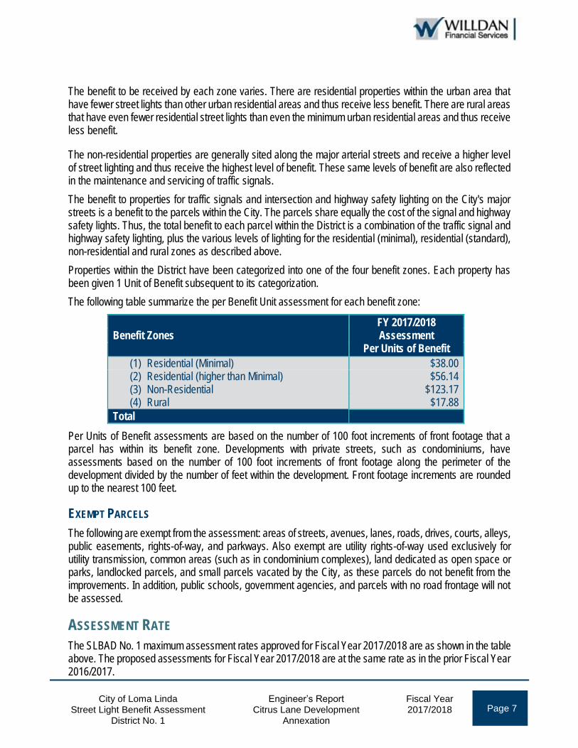
City of Loma Linda Engineer’s Report Fiscal Year Page 7 Street Light Benefit Assessment
District No. 1 Citrus Lane Development
Annexation 2017/2018
The benefit to be received by each zone varies. There are residential properties within the urban area that have fewer street lights than other urban residential areas and thus receive less benefit. There are rural areas that have even fewer residential street lights than even the minimum urban residential areas and thus receive less benefit.
The non-residential properties are generally sited along the major arterial streets and receive a higher level of street lighting and thus receive the highest level of benefit. These same levels of benefit are also reflected in the maintenance and servicing of traffic signals.
The benefit to properties for traffic signals and intersection and highway safety lighting on the City's major streets is a benefit to the parcels within the City. The parcels share equally the cost of the signal and highway safety lights. Thus, the total benefit to each parcel within the District is a combination of the traffic signal and highway safety lighting, plus the various levels of lighting for the residential (minimal), residential (standard), non-residential and rural zones as described above.
Properties within the District have been categorized into one of the four benefit zones. Each property has been given 1 Unit of Benefit subsequent to its categorization.
The following table summarize the per Benefit Unit assessment for each benefit zone:
Benefit Zones FY 2017/2018 Assessment
Per Units of Benefit
(1) Residential (Minimal) $38.00 (2) Residential (higher than Minimal) $56.14 (3) Non-Residential $123.17 (4) Rural $17.88
Total
Per Units of Benefit assessments are based on the number of 100 foot increments of front footage that a parcel has within its benefit zone. Developments with private streets, such as condominiums, have assessments based on the number of 100 foot increments of front footage along the perimeter of the development divided by the number of feet within the development. Front footage increments are rounded up to the nearest 100 feet.
EXEMPT PARCELS
The following are exempt from the assessment: areas of streets, avenues, lanes, roads, drives, courts, alleys, public easements, rights-of-way, and parkways. Also exempt are utility rights-of-way used exclusively for utility transmission, common areas (such as in condominium complexes), land dedicated as open space or parks, landlocked parcels, and small parcels vacated by the City, as these parcels do not benefit from the improvements. In addition, public schools, government agencies, and parcels with no road frontage will not be assessed.
ASSESSMENT RATE
The SLBAD No. 1 maximum assessment rates approved for Fiscal Year 2017/2018 are as shown in the table above. The proposed assessments for Fiscal Year 2017/2018 are at the same rate as in the prior Fiscal Year 2016/2017.
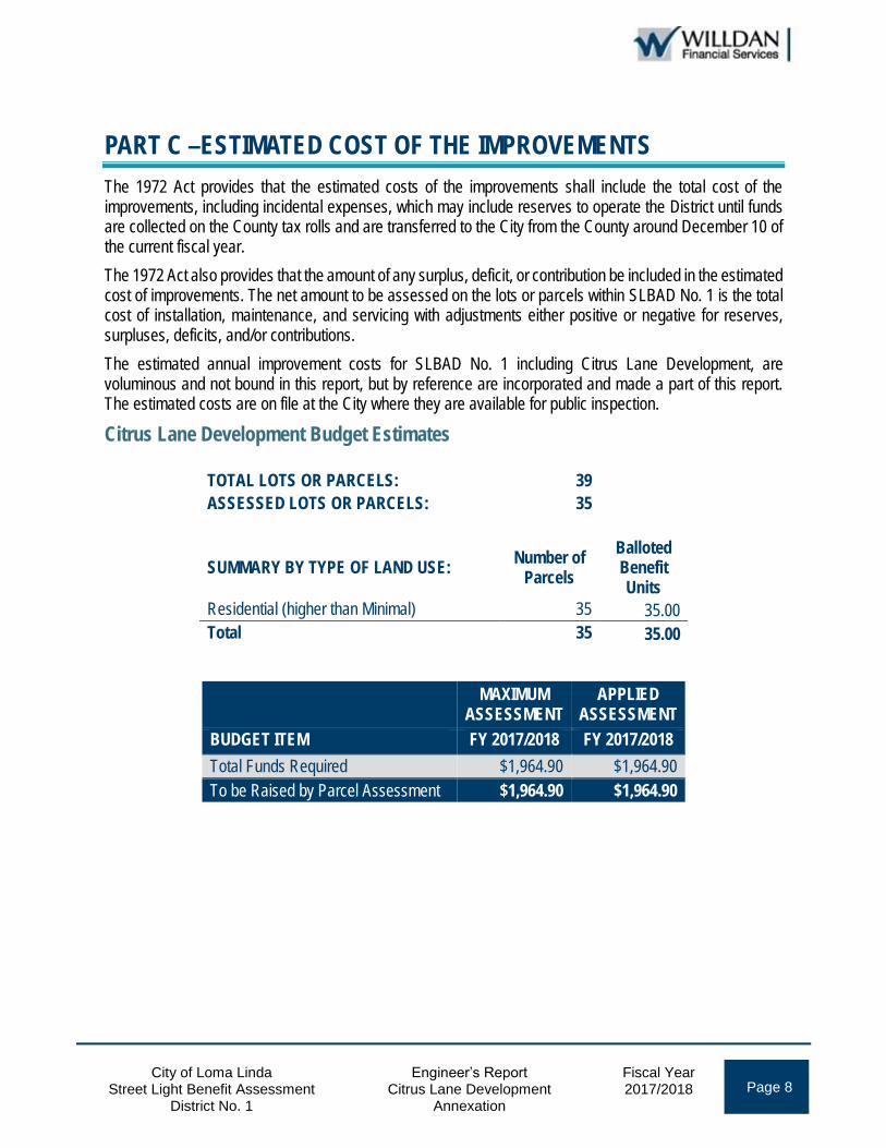
City of Loma Linda Engineer’s Report Fiscal Year Page 8 Street Light Benefit Assessment
District No. 1 Citrus Lane Development
Annexation 2017/2018
PART C –ESTIMATED COST OF THE IMPROVEMENTS
The 1972 Act provides that the estimated costs of the improvements shall include the total cost of the improvements, including incidental expenses, which may include reserves to operate the District until funds are collected on the County tax rolls and are transferred to the City from the County around December 10 of the current fiscal year.
The 1972 Act also provides that the amount of any surplus, deficit, or contribution be included in the estimated cost of improvements. The net amount to be assessed on the lots or parcels within SLBAD No. 1 is the total cost of installation, maintenance, and servicing with adjustments either positive or negative for reserves, surpluses, deficits, and/or contributions.
The estimated annual improvement costs for SLBAD No. 1 including Citrus Lane Development, are voluminous and not bound in this report, but by reference are incorporated and made a part of this report. The estimated costs are on file at the City where they are available for public inspection.
Citrus Lane Development Budget Estimates
TOTAL LOTS OR PARCELS: 39
ASSESSED LOTS OR PARCELS: 35
SUMMARY BY TYPE OF LAND USE: Number of
Parcels
Balloted Benefit Units
Residential (higher than Minimal) 35 35.00
Total 35 35.00
MAXIMUM APPLIED
ASSESSMENT ASSESSMENT
BUDGET ITEM FY 2017/2018 FY 2017/2018
Total Funds Required $1,964.90 $1,964.90
To be Raised by Parcel Assessment $1,964.90 $1,964.90

City of Loma Linda Engineer’s Report Fiscal Year Page 9 Street Light Benefit Assessment
District No. 1 Citrus Lane Development
Annexation 2017/2018
PART D — ASSESSMENT DIAGRAMS
The Assessment Diagram for SLBAD No. 1 is on file at the City and by reference herein is made part of this Report. The Assessment Diagrams for the Citrus Lane Annexation are provided on the following pages and consist of all lots, parcels, and subdivisions of land listed on the Assessment Roll contained herein as Part E, the lines and dimensions of which are shown on the San Bernardino County Assessor’s parcel maps for the current year and are incorporated by reference herein and made part of this Report.

City of Loma Linda Engineer’s Report Fiscal Year Page 10 Street Light Benefit Assessment
District No. 1 Citrus Lane Development
Annexation 2017/2018

City of Loma Linda Engineer’s Report Fiscal Year Page 11 Street Light Benefit Assessment
District No. 1 Citrus Lane Development Annexation 2017/2018

City of Loma Linda Engineer’s Report Fiscal Year Page 12 Street Light Benefit Assessment
District No. 1 Citrus Lane Development
Annexation 2017/2018
PART E — ASSESSMENT ROLL
All assessed lots or parcels of real property within Citrus Lane Development are listed on the assessment roll below. Each parcel’s corresponding Balloted Maximum Assessment is based on the parcel’s proposed land use and the maximum assessment rate for Fiscal Year 2017/2018 ($56.14). The balloted maximum assessments are not subject to increase without assessment balloting.
Assessor's Parcel Number
Balloted Benefit Zone
Balloted Land Use
Balloted Benefit Units
Balloted Maximum
Assessment
0292-641-01-0000 2 Residential 1.00 $56.14
0292-641-02-0000 2 Residential 1.00 56.14
0292-641-03-0000 2 Residential 1.00 56.14
0292-641-04-0000 2 Residential 1.00 56.14
0292-641-05-0000 2 Residential 1.00 56.14
0292-641-06-0000 2 Residential 1.00 56.14
0292-641-07-0000 2 Residential 1.00 56.14
0292-641-08-0000 2 Residential 1.00 56.14
0292-641-09-0000 2 Residential 1.00 56.14
0292-641-10-0000 2 Residential 1.00 56.14
0292-641-11-0000 2 Residential 1.00 56.14
0292-641-12-0000 2 Residential 1.00 56.14
0292-641-13-0000 2 Residential 1.00 56.14
0292-641-14-0000 2 Residential 1.00 56.14
0292-641-15-0000 2 Residential 1.00 56.14
0292-641-16-0000 2 Residential 1.00 56.14
0292-641-17-0000 2 Residential 1.00 56.14
0292-641-18-0000 2 Residential 1.00 56.14
0292-641-19-0000 2 Residential 1.00 56.14
0292-641-20-0000 2 Residential 1.00 56.14
0292-641-21-0000 2 Residential 1.00 56.14
0292-641-22-0000 2 Residential 1.00 56.14
0292-641-23-0000 2 Residential 1.00 56.14
0292-641-24-0000 2 Residential 1.00 56.14
0292-641-25-0000 2 Residential 1.00 56.14
0292-641-26-0000 2 Residential 1.00 56.14
0292-641-27-0000 2 Residential 1.00 56.14
0292-641-28-0000 2 Residential 1.00 56.14
0292-641-29-0000 2 Residential 1.00 56.14
0292-641-30-0000 2 Residential 1.00 56.14
0292-641-31-0000 2 Residential 1.00 56.14
0292-641-32-0000 2 Residential 1.00 56.14
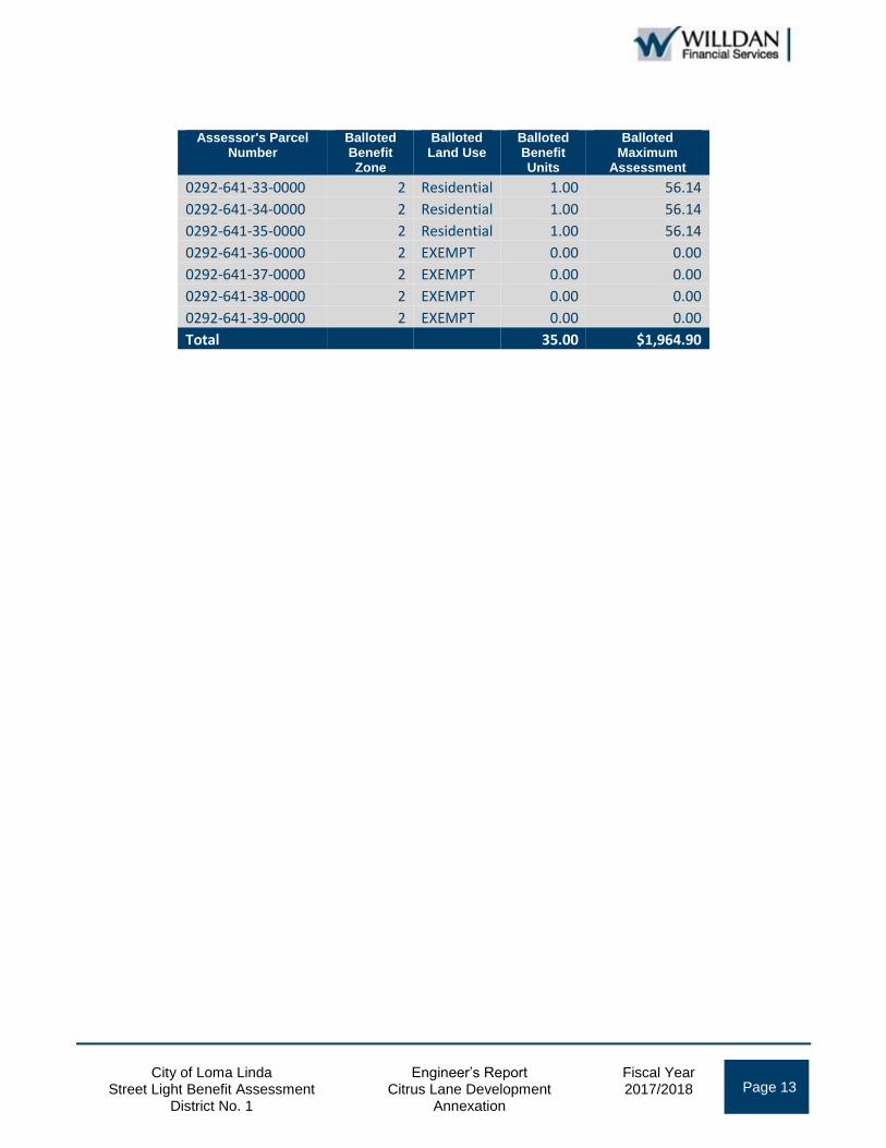
City of Loma Linda Engineer’s Report Fiscal Year Page 13 Street Light Benefit Assessment
District No. 1 Citrus Lane Development
Annexation 2017/2018
Assessor's Parcel Number
Balloted Benefit Zone
Balloted Land Use
Balloted Benefit Units
Balloted Maximum
Assessment
0292-641-33-0000 2 Residential 1.00 56.14
0292-641-34-0000 2 Residential 1.00 56.14
0292-641-35-0000 2 Residential 1.00 56.14
0292-641-36-0000 2 EXEMPT 0.00 0.00
0292-641-37-0000 2 EXEMPT 0.00 0.00
0292-641-38-0000 2 EXEMPT 0.00 0.00
0292-641-39-0000 2 EXEMPT 0.00 0.00
Total 35.00 $1,964.90


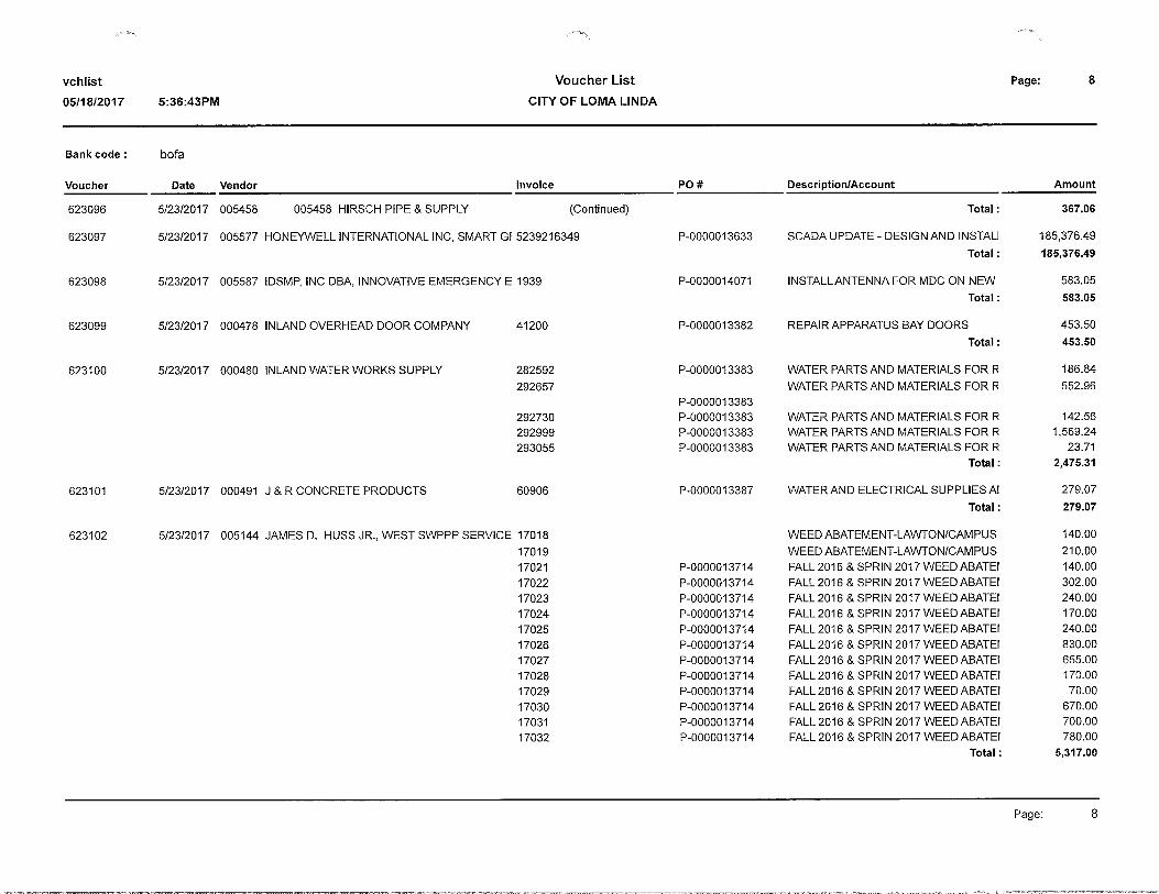
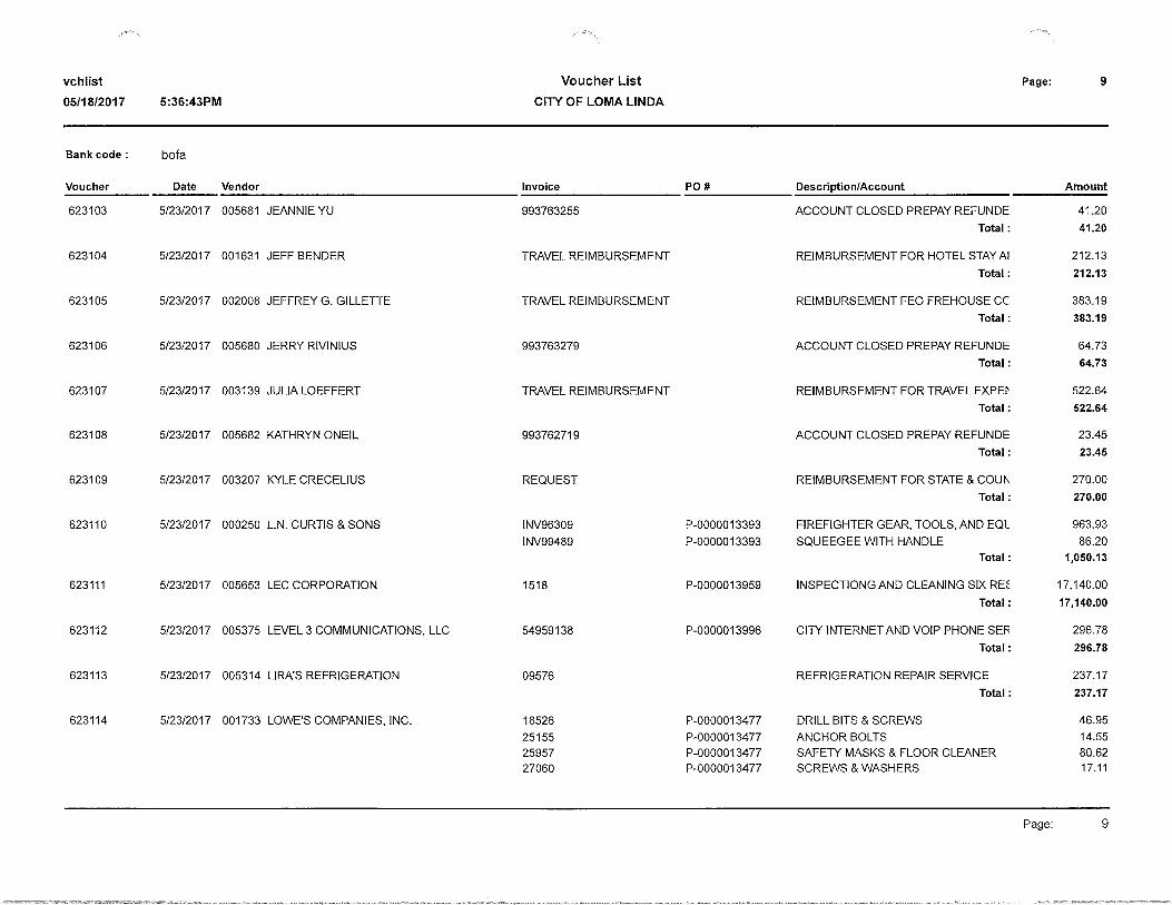


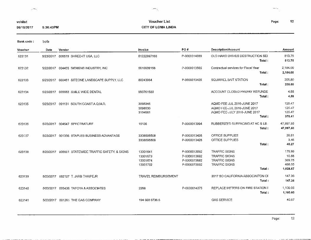


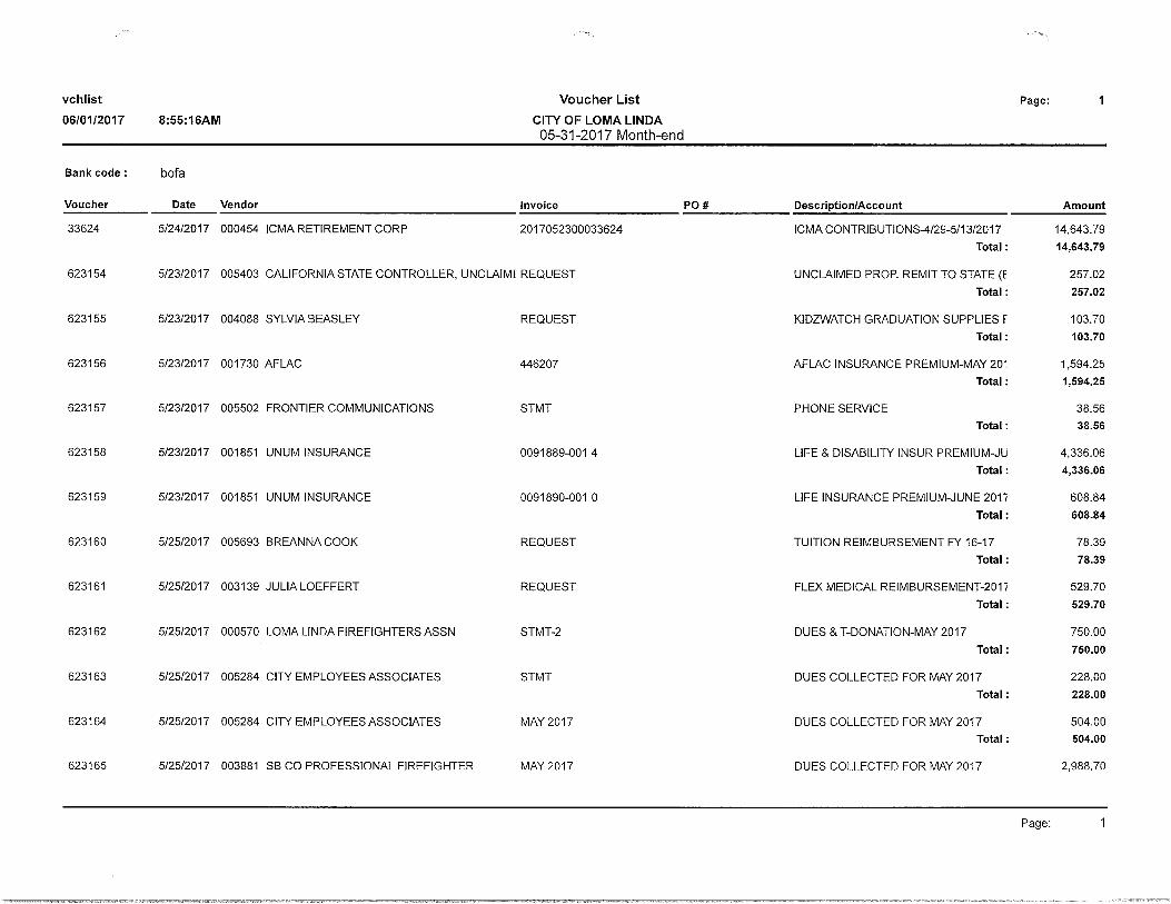
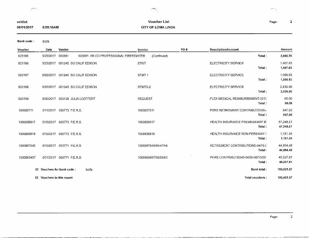
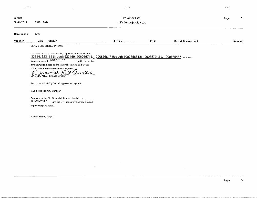


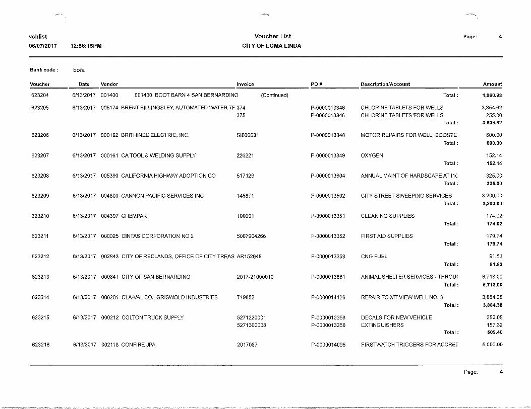
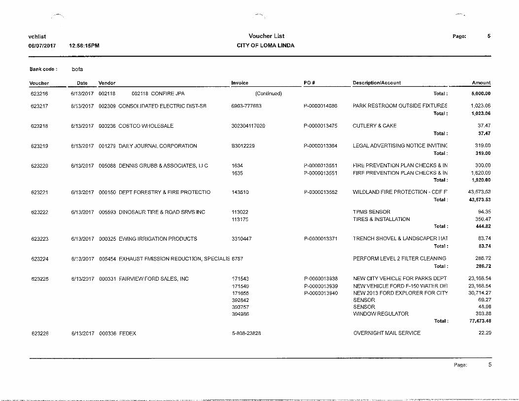
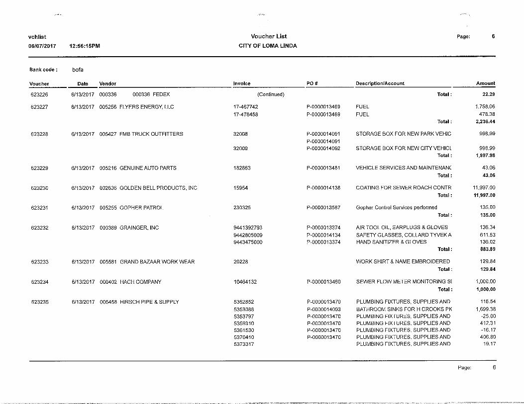


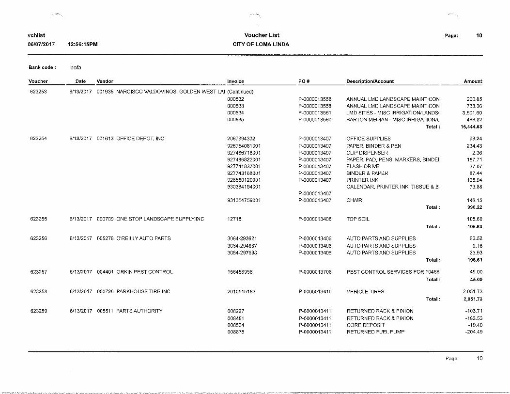

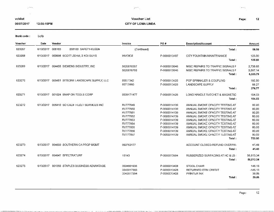

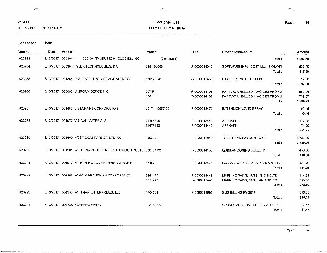


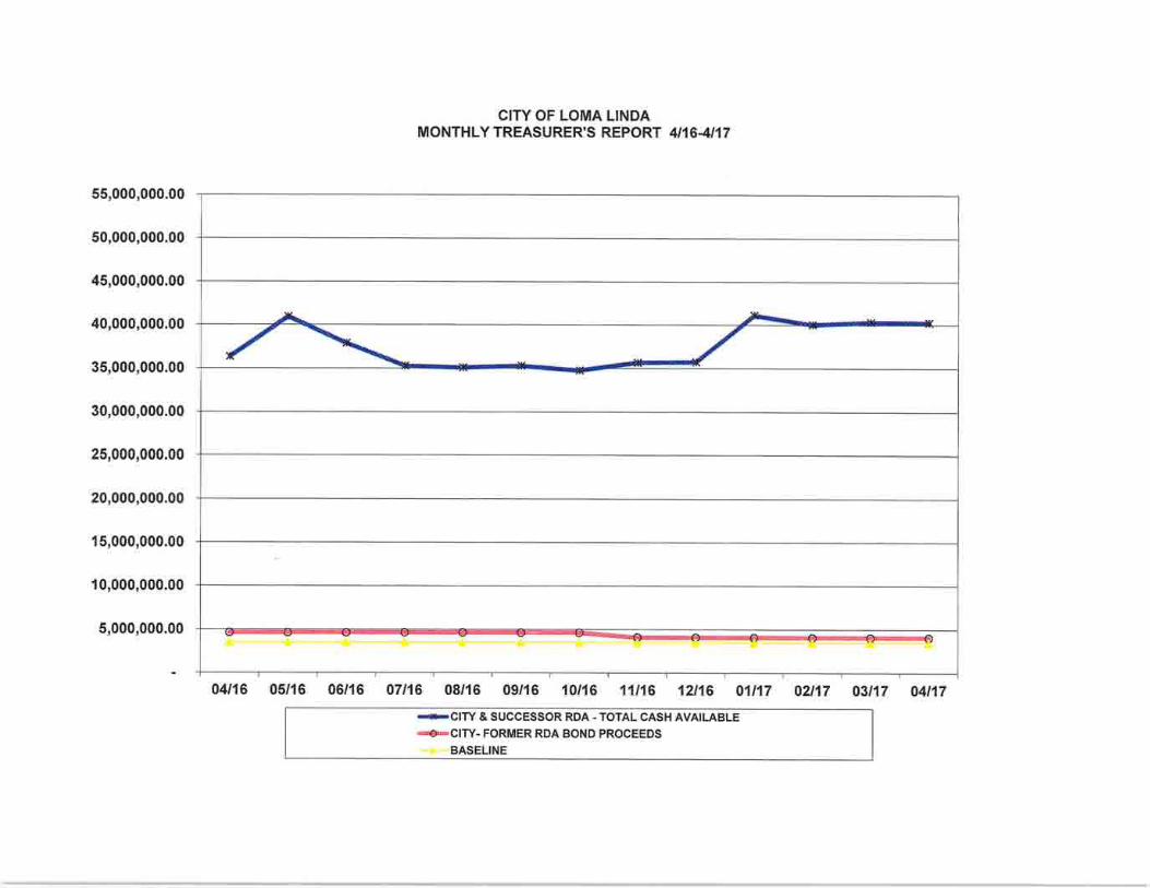
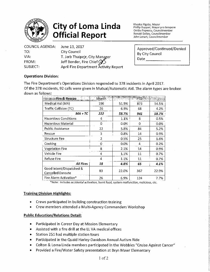
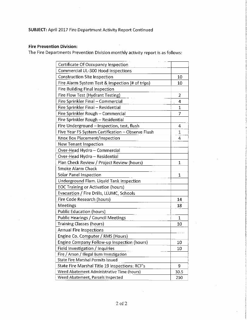


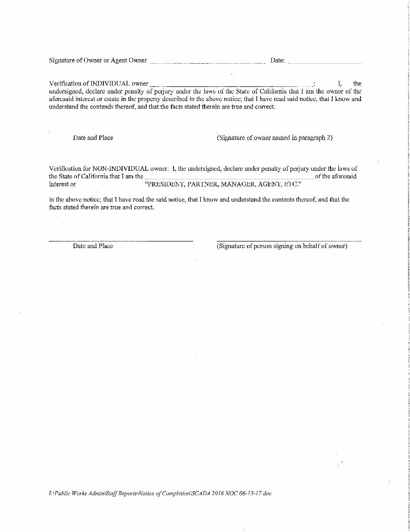
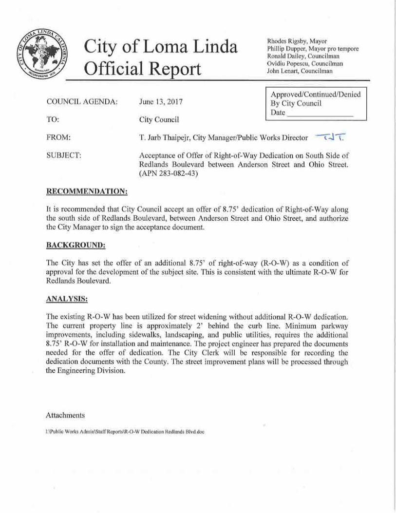


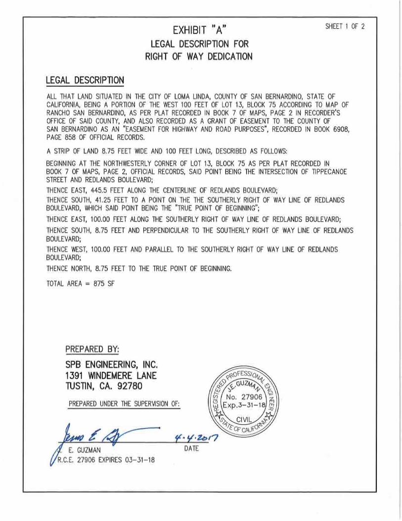

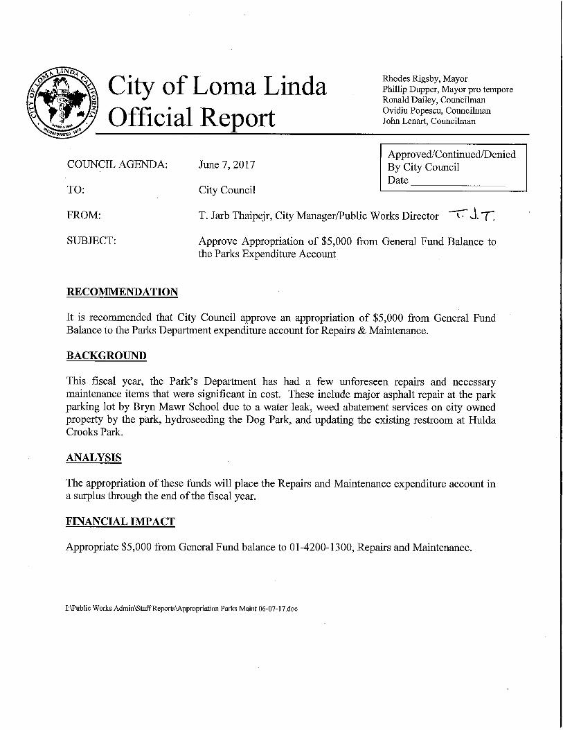
ORDINANCE NO. O-2016-10
AN ORDINANCE OF THE CITY COUNCIL OF
THE CITY OF LOMA LINDA
THE CITY COUNCIL OF THE CITY OF LOMA LINDA DOES HEREBY ORDAIN
AS FOLLOWS:
Section 1. Chapter 17.02 (Introduction and Definitions) of Title 17 (Zoning) of the Loma Linda
Municipal Code is hereby amended to delete Sections 17.02.100 (Accessory), 17.02.105 (Amusement devices, electrical or mechanical), 17.02.107 (Arcades, recreational), 17.02.120 (Borrow pit), 17.02.160
(Child care home), 17.02.170 (Churches), 17.02.185 (Drop off or collection program), 17.02.190
(Educational institution), 17.02.195 (Emergency shelter), 17.02.205 (Formula-based fast food retail),
17.02.210 (Hotel), 17.02.330 (Mobile home), 17.02.335 (Mobile recycling unit), 17.02.340 (Motel), 17.02.370 (Occasional assembly), 17.02.404 (Recycling facility), 17.02.410 (Residence, single-family),
17.02.430 (Residential, two family), and 17.02.435 (Reverse vending machine), and to hereby add to Title
17 (Zoning) new Section 17.02.212 (Land use definitions), as set forth in Attachment A.
Section 2. New Chapter 17.30.125 (Minor Use Permits) is hereby added to Title 17 (Zoning) of the
Loma Linda Municipal Code, as set forth in Attachment B.
Section 3. Section 17.30.260 is amended in its entirety to read as follows:
“17.30.260 Precise plan of design—Required when.
In order to fairly administer and provide for adequate consideration of all provisions of this title, it shall
be required for all property development or establishment of use on a property to file a precise plan of
design (minor or major) to accomplish as nearly as possible a uniformity in the permitted use and enjoyment in any zone while at the same time imposing a uniformity of regulation to protect use and
enjoyment of surrounding properties. Therefore, no person shall commence any use and no building
permit shall be issued for any structure until a precise plan of design (minor or major) covering the parcel or parcels to be used shall be approved and adopted as herein provided. For purposes of this section, the
term “minor” shall be defined as all new individual single-family homes, including additions or
modifications that are 500 square feet or larger, and all other types of development projects considered to
be small projects of over 120 square feet and up to and including 500 square feet in total building area, which require public notice and an administrative Director’s hearing. The term “major” shall be defined
as all other types of development projects, except for those classified as “exceptions” in this section.
Exceptions to this include additions or modifications to individual single-family homes of less than 500 square feet, fences in residential zones, or any other accessory structure having a valuation of one
thousand five hundred dollars or less.”
Section 4. Chapter 17.32 (A-1 Agricultural Estates Zone) through Chapter 17.52 (M-1 Light Manufacturing Zone), inclusive, and Chapter 17.56 (OS Open Space Zone) through Chapter 17.70 (Planned
Community District, inclusive, of Title 17 (Zoning) of the Loma Linda Municipal Code are hereby repealed
in their entirety and replaced with Attachment C. Chapter 17.54 (Hillside Development Suffix Zone) is retained.
Section 5. If any section, subsection, sentence, clause or phrase of this Ordinance is for any reason held to be invalid, such holding or holdings shall not affect the validity of the remaining portions of this
Ordinance. The City Council hereby declares that it would have passed this Ordinance and each section,
subsection, sentence, clause and phrase thereof, irrespective of the fact that any one or more sections, subsections, sentences, clauses or phrases be declared invalid.

Section 6. Posting. Prior to the expiration of fifteen (15) days from its passage, the City Clerk
shall cause this Ordinance to be posted pursuant to law in three (3) public places designated for such purpose by the City Council.
This Ordinance was introduced at the regular meeting of the City Council of the City of Loma Linda, California, held on the 11
th day of April 2017 and was adopted on the _____ day of
____________________________ by the following vote to wit:
Ayes:
Noes:
Abstain:
Absent:
Rhodes Rigsby, Mayor
Attest:
Barbara Nicholson, City Clerk

Attachment A
Section 17.02.212 (Land use definitions)
“A” Definitions
Accessory Structures and Uses.
Accessory Agricultural Structures or Uses. A structure for sheltering animals, or agricultural equipment, hay, feed, etc. Examples of these structures include barns, non-commercial
greenhouses, coops, corrals, and pens.
Accessory Nonresidential Structures. Attached and detached accessory structures located
within a health care, hotel, office, or industrial complex for the purpose of serving the
nonresidential uses. Examples of these structures include:
▪ garages
▪ gazebos
▪ outdoor play equipment
▪ refuse collection structures
▪ solar collection devices (freestanding)
▪ spas and hot tubs
▪ storage sheds
▪ swimming pools
▪ tennis and other on-site sport courts
▪ workshops
Accessory Residential Structures. A structure that is customarily a part of, and clearly
incidental and secondary to a residence, and does not change the character of the residential use. This definition includes the following detached accessory structures, and other similar structures
normally associated with a residential use of property.
▪ caretaker quarters
▪ carports
▪ garages
▪ gazebos
▪ greenhouses (non-commercial)
▪ guesthouse (Also, see Guesthouse)
▪ office ▪ outdoor play equipment
▪ patios
▪ refuse collection structures
▪ solar collection devices
(freestanding)
▪ spas and hot tubs
▪ storage sheds
▪ studios ▪ swimming pools
▪ tennis and other on-site sport courts
▪ workshops
Also includes the indoor storage of motor vehicles (including their incidental noncommercial
restoration and repair), personal recreational vehicles, and other personal property, accessory to a residential use.
Accessory Retail and Service Uses. A retail use that is customarily a part of, and clearly incidental and secondary to, a nonresidential use and does not change the character of the
nonresidential use. Typically, the retail sales of various products in a store or similar facility or
the provision of services in a defined area that is located within a health care, hotel, office, or industrial complex for the purpose of serving employees or customers; is not visible from public
streets; and has no outside signs. Examples of these uses include:
▪ automated teller machines (ATMs) ▪ dry cleaning (collection/pick-up only)
▪ food service establishments
▪ gift shops
▪ newsstands

Accessory Structures. A structure that is physically detached from, clearly secondary and incidental to, and customarily associated with the primary or main structure.
Adult Businesses. A land use type that includes the following. Any business:
Conducted for the entertainment of adults, engaged in the selling, renting, or displaying of
publications depicting the specified anatomical areas or specified sexual activities or other
material of a sexually explicit nature;
Which, as a substantial or significant course of conduct, sells, offers for sale, rents, exhibits,
shows, or displays publications depicting the specified anatomical areas or specified sexual activities or other material of a sexually explicit nature;
Selling, renting, or displaying sexually oriented devices intended for use in the specified sexual
activities;
Conducted for the entertainment of adults where an employee, patron, or any other person
engages in or is shown the specified sexual activities or exhibits or engages in partial or total nudity or otherwise exposes the specified anatomical areas; or
Which, as a substantial or significant portion of its business, provides live or filmed entertainment wherein the specified anatomical areas are exposed.
Agricultural, Industrial, Construction Equipment Sales and Rentals. Commercial establishments
assembling, maintaining, renting, repairing, selling, and/or storing agricultural, industrial, and construction equipment, machinery, and related supplies.
Agriculture. As defined in California Labor Code Section 1140.4 (a), it includes farming in all its branches, including the cultivation and tillage of the soil, dairying, the production, cultivation, growing,
and harvesting of any agricultural or horticultural commodities, the raising of livestock, bees, furbearing
animals, or poultry. It includes any practices (including any forestry or lumbering operations) performed
by a farmer or on a farm as incidental to or in conjunction with the farming operations, including preparation for market and delivery to storage, market, or carriers for transportation to market.
Agricultural Activities and Facilities. The commercial production, keeping, or maintenance, for sale, lease, or personal use, of plants useful to humans, primarily in the soil on the site or in
greenhouses, including the following:
▪ field crops
▪ flowers and seeds
▪ fruits
▪ grains
▪ grapes
▪ nuts
▪ ornamental crops
▪ trees and sod
▪ vegetables
Also includes associated crop preparation services and harvesting activities (e.g., mechanical soil
preparation, irrigation system construction, spraying, crop processing, etc.) and the processing of
harvested crops to prepare them for on-site marketing or processing and packaging elsewhere
(e.g., baling, cubing, cooling, drying, grain cleaning, grinding, sorting, grading, and packaging, hulling, shelling, etc.).
Airports, Heliports, Helistops, and Other Landing Fields.
Airports. Any area which is used or is intended to be used for the taking off and landing of
aircraft, including helicopters, and any appurtenant areas which are used or are intended to be
used for airport structures or facilities, including open spaces, taxiways, and tie-down areas.
Heliports. An area for the landing and takeoff of rotary wing aircraft, for embarking and
disembarking passengers and other purposes, with safety and navigation markings and facilities
as required by the Federal Aviation Administration and California Department of Transportation, Division of Aeronautics. This use may also include helicopter hanger and maintenance facilities.
Helistops. A single pad used for the landing, parking, or takeoff of one helicopter and other facilities as may be required by Federal and State regulations, but not including operations
facilities (e.g., fueling, loading and unloading, maintenance, storage, terminal facilities, etc.).
Landing Fields and Strips. An area of land or water set aside for general aviation and other noncommercial aircraft takeoffs and landings, and any accessory areas for support structures (for
example, aircraft hangers) and other related facilities.
Alcohol Beverage Sales. The retail sale of beer, wine, and/or distilled spirits for on-site or off-site
consumption.
Alcohol Sales (off-site/off-sale) – Beer and Wine. A retail alcohol beverage sales establishment
as defined above, that is classified as a ABC Type 40, 42, 61, 66, and/or 69, selling beer and/or
wine exclusively for off-site/off-sale consumption. Also referred to as a liquor store or
convenience store selling beer and/or wine among other packaged products.
Alcohol Sales (on-site/on-sale) – Beer and Wine. A retail alcohol beverage sales establishment
as defined above, that is classified as a ABC Type 40, 42, 61, 66, and/or 69, selling/serving beer and/or wine exclusively for on-site/on-sale consumption. Also referred to as a bar, lounge,
nightclub, pub, or tavern.
Alcohol Sales (off-site/off-sale) – Liquor. A retail alcohol beverage sales establishment as defined above, that is classified as a ABC Type 20 and/or 21, selling liquor (i.e., all types of
alcoholic beverages) exclusively for off-site/off-sale consumption. Also referred to as a liquor
store or convenience store selling liquor (i.e., all types of alcoholic beverages) among other packaged products.
Alcohol Sales (on-site/on-sale) – Liquor. A retail alcohol beverage sales establishment as defined above, that is classified as a ABC Type 20 and/or 21, selling liquor (i.e., all types of
alcoholic beverages) exclusively for on-site/on-sale consumption. Also referred to as a bar,
lounge, nightclub, pub, or tavern selling/serving liquor (i.e., all types of alcoholic beverages).
Animal. Every non-human species of animal, both domestic and wild.
Animal Grooming. A commercial establishment that provides household pet grooming services (i.e., bathe, brush, clip, or comb animals for the purpose of enhancing their aesthetic value or
health).
Animal Keeping – Commercial. The commercial keeping or raising of farm animals (including
cattle, goats, horses, sheep, fowl, poultry, fish, and other animals not commonly regarded as
household pets) and cats, dogs, and other household pets.
Animal Keeping – Private. The noncommercial keeping or raising of farm animals (including
cattle, goats, horses, sheep, fowl, poultry, fish, and other animals not commonly regarded as household pets) and cats, dogs, and other household pets.
Apiary. A place where bees are kept; a collection of beehives.
Archeological and Paleontological Sites. Sites containing archeological (i.e., evidence of past activity)
and paleontological (i.e., evidence of fossil animal and plant) resources that are recognized as significant
to our culture and are afforded protection by Federal, State, and local environmental guidelines.
Assembly Uses.
Places of Public Assembly. A facility for public or private assembly and meetings. Examples of
these uses include:
▪ auditoriums, civic and private ▪ banquet halls
▪ community centers
▪ conference/convention facilities
▪ meeting halls for clubs and other membership organizations
Places of Religious Assembly. Any structure used for non-profit purposes by an established religious organization holding either tax exempt status under Section 501(c)(3) of the Internal
Revenue Code or under the California property tax law, where the structure is primarily intended
to be used as a place of worship. The term includes, but is not necessarily limited to, church, temple, synagogue, and mosque. Also includes functionally related internal facilities (i.e.,
kitchens, multi-purpose rooms, storage, etc.). Does not include conference and meeting rooms
that are accessory and incidental to another principal use and typically used only by on-site employees and clients, and that occupy less floor area on the site than the offices they support.
Does not include sports or other commercial entertainment facilities. Does not include funeral
homes and mortuaries.
Auction Houses. A structure or enclosure where goods or livestock are sold by auction.
Auditoriums and Theaters.
Auditoriums. Indoor facilities for public assembly and/or group meeting/entertainment, other
than sporting events, including: banquet halls, exhibition and conference/convention halls;
meeting halls for rent; public and quasi-public auditoriums; and similar public assembly uses. See “Places of Public Assembly.”
Theaters. Indoor facilities for public assembly and group entertainment, other than sporting events, including civic theaters, and facilities for "live" theater, concerts, recitals, circuses, and
movie theaters.
“B” Definitions
Bars, Lounges, Nightclubs, and Taverns. Establishments engaged in selling or serving alcoholic
beverages for consumption on the premises, with or without live entertainment.
Boarding and Lodging Houses. A structure containing a single dwelling unit and provisions for five but not more than 15 guests, where lodging is provided with or without meals for compensation, but does not
include rest homes.

Building Materials Sales. An indoor or outdoor retail establishment selling hardware, tools, appliances, lumber and other building materials, plants, portable spas, and other landscaping materials. Includes paint,
wallpaper, flooring, glass, fixtures, and similar products. Includes these types of stores selling to the
general public, even if contractor sales account for a major proportion of total sales. May also include the
rental of tools and equipment used in the building trades.
Bus and Taxi Stations. A passenger station for vehicular (i.e., bus, taxi), and rail mass transit systems,
or a terminal facility providing maintenance and service for the vehicles operated in the transit system.
“C” Definitions
Care Uses.
Child Day Care – Large (8 or more children). Day care facilities located in single-unit
dwellings where an occupant of the dwelling provides care and supervision for eight or more
children. Children under the age of 10 years who reside in the dwelling count as children served
by the day care facility.
Child Day Care – Small (7 or fewer children). Day care facilities located in single-unit
dwellings where an occupant of the dwelling provides care and supervision for seven or fewer children. Children under the age of 10 years who reside in the dwelling count as children served
by the day care facility.
Community Care Facility. As defined in Section 1502 of the Health and Safety Code, any
facility, place, or structure that is maintained and operated to provide non-medical residential
care, day treatment, adult day care, or foster family agency services for children, adults, or
children and adults, including, but not limited to, the physically handicapped, mentally impaired, incompetent persons, and abused or neglected children, and includes following:
Adult Day Program. Any community–based facility or program that provides care to persons 18 years of age or older in need of personal services, supervision, or assistance
essential for sustaining the activities of daily living for the protection of the individual on
less than a 24-hour basis.
Community Treatment Facility. Any residential facility that provides mental health
treatment services to children in a group setting and that has the capacity to provide
secure containment.
Foster Family Agency. Any organization engaged in the recruiting, certifying, and
training of, and providing professional support to, foster parents, or in finding homes or other places for the placement of children for temporary or permanent care who require
that level of care as an alternative to a group home. Private foster family agencies shall be
organized and operated on a non-profit basis.
Full-Service Adoption Agency. Any licensed entity engaged in the business of
providing adoption services that does all of the following: (a) assumes care, custody, and
controls of a child through relinquishment of the child to the agency or involuntary termination of parental rights to the child; (b) assesses the birth parents, prospective
adoptive parents, or child; (c) places children for adoption; and (d) supervises adoptive
placements.
Noncustodial Adoption Agency. Any licensed entity engaged in the business of
providing adoption services, that does all of the following: (a) assesses the prospective
adoptive parents; (b) cooperatively matches children freed for adoption, who are under the care, custody, and control of a licensed adoption agency, for adoption, with assessed
and approved adoptive applicants; and (c) cooperatively supervises adoptive placements
with a full-service adoptive agency, but does not disrupt the placement or remove a child
from a placement.
Social Rehabilitation Facility. Any residential facility that provides social rehabilitation
service for no longer than 18 months in a group setting to adults recovering from mental illness who temporarily need assistance, guidance, or counseling.
Therapeutic Day Services Facility. Any facility that provides non-medical care, counseling, educational or vocational support, or social rehabilitation services on less
than a 24-hour basis to persons under 18 years of age who would otherwise be placed in
foster care or who are returning to families from foster care.
Transitional Housing Placement Facility. A community care facility licensed by the
department in compliance with Section 1559.110 to provide transitional housing
opportunities to persons at least 17 years of age, and not more than 18 years of age.
Transitional Shelter Care Facility. Any group care facility that provides for 24-hour
non-medical care of person in need of personal services, supervision, or assistance essential for sustaining the activities of daily living or for the protection of the individual.
Residential Care Facility. A facility, place, or structure that is maintained and operated to
provide 24-hour non-medical residential care for, but not limited to, developmentally disabled, physically mentally impaired, incompetent persons, and abused or neglected children.
Catering Services. A business that prepares food for consumption on the premises of a client, or at another venue selected by the client.
Cemeteries, Columbariums, Mausoleums, and Mortuaries.
Cemeteries, cinerarium, columbarium, crematoriums, and mausoleums. Establishments
(e.g., private or public entity or religious institution) which subdivide property and offer burial
plots and/or air space for sale. Includes animal cemeteries; cinerarium, columbarium, crematoriums, mausoleums, and mortuaries, but only when operated in conjunction with and
within the boundaries of a cemetery.
Mortuaries. An establishment in which the deceased are prepared for burial or cremation, and
funeral services may be conducted. Full-service mortuaries include facilities for the preparation
of the deceased for burial and for cremation, but does not perform burials or cremations. May
include ancillary uses (e.g., sales of caskets, urns, etc.) Partial service facilities include only chapels and similar rooms for viewing, religious services, wakes, and similar activities, together
with accessory office facilities. Does not include “Cemetery.”
Crematorium. A mortuary building or facility that holds the equipment necessary for cremation.
Commercial Bakeries.
Bakeries, retail. Retail establishments primarily engaged in the retail sale of bakery products,
including bread, cakes, and pies, and produce some or all of the products on the premises.

Bakeries, wholesale. Retail establishments engaged in the manufacture of bakery products for
the purpose of resale only.
Commercial Recreation and Entertainment. Indoor and outdoor commercial establishments providing
amusement and entertainment services for a fee or admission charge, including the following activities:
Indoor. Facilities for various indoor participation or spectator sports and types of recreation
where a fee or similar charge is charged for use, including:
▪ arenas/stadiums
▪ baseball and softball training
facilities
▪ basketball court
▪ billiard halls (pool rooms) ▪ bingo halls (excluding nonprofit
activities)
▪ bowling alleys
▪ boxing clubs
▪ dance halls, clubs, and ballrooms
▪ handball courts ▪ ice rinks
▪ laser tag
▪ paintball
▪ racetracks (scale model vehicles
operated by remote control)
▪ racquetball courts ▪ shooting galleries
▪ skating rinks
▪ soccer centers
▪ swim centers
▪ tennis courts
▪ trampoline and gymnastics centers
Outdoor. Facilities for various outdoor participation or spectator sports and types of recreation
where a fee or similar charge is charged for use, including:
▪ amphitheaters
▪ baseball
▪ basketball
▪ batting cages
▪ bocce ball ▪ drive-in movie theaters
▪ football
▪ go cart and miniature auto race
tracks
▪ golf courses
▪ golf driving ranges separate from golf courses
▪ handball courts
▪ health and athletic club outdoor
facilities
▪ lacrosse ▪ miniature golf courses
▪ racing and drag strips (automobile,
truck, and motorcycle)
▪ paintball
▪ race tracks (remote control) ▪ rugby
▪ shooting ranges
▪ skateboard parks
▪ soccer
▪ softball
▪ stadiums and coliseums
▪ swim and tennis clubs ▪ tennis courts
▪ volleyball
▪ water slides
▪ zoos
Commercial Uses (incidental and accessory to allowed uses). See “Accessory Retail and Services.”
Contractors’ Yard. An outdoor storage facility operated by, or on behalf of, a State licensed contractor
for the storage of large equipment, vehicles, and/or other materials commonly used in the individual
contractor's type of business. The facility may also include storage of scrap materials used for repair and
maintenance of contractor's own equipment, and structures for uses including offices and repair facilities.
Convalescent Homes. An establishment that provides care on a 24-hour basis for persons requiring
regular medical attention. Patients include those with post-operative, convalescent, chronic illness, or dietary problems, and persons aged or infirm unable to care for themselves. Does not include facilities
providing outpatient medical services or surgical services.

Correctional Institutions. Institutions for the confinement and correction of offenders sentenced by a court. This use includes county jails, Federal and State prisons, and secure re-entry facilities, but does not
include facilities at a police department or sheriff’s office for temporarily holding persons taken into
custody before release or transfer to another confinement facility. The use does not include halfway
houses or residential drug rehabilitation facilities, which are instead included under "Group Homes."
Cultural Centers and Facilities. A facility that provides access to cultural resources, including art,
scientific and historical items, performances, or reference materials. Examples include: aquariums, arboretums, public art galleries and exhibitions, botanical gardens, historic sites and exhibits, libraries,
museums, and planetariums. This use may also include accessory retail uses including gift/book shops
and restaurants.
Day Care Facilities. See “Care Uses.”
“D” Definitions
Development of Natural Resources. The development (i.e., conservation, conversion [trees to lumber], creation [planting of trees], improvement, management, and preservation) of natural resources. It includes
sunlight, atmosphere, water, land (includes all minerals) along with all vegetation and animal life that
naturally subsists upon or within the above identified characteristics and substances.
Dormitories. A structure intended or used principally for sleeping accommodations, where the structure
is related to an educational or public institution, including religious institutions and fraternities and sororities.
Drive-in and Drive-thru Businesses. A facility where food or other products may be purchased by
motorists without leaving their vehicles. Examples of drive-in and drive-through retail businesses include fast-food restaurants, drive-through coffee, dairy product, photo stores, pharmacies, etc.
Dwellings. A structure or portion of a structure designed for residential purposes, including single-family, two-family, and multifamily dwellings.
Manufactured Housing. A factory-built structure that is manufactured or constructed under
authority of 42 U.S.C. Sec. 5403, Federal Manufactured Home Construction and Safety Standards, or California law and is to be used as a place for human habitation. The structure is
manufactured either in whole or in substantial part at an off-site location, transported to the site,
assembled on-site, and placed on a permanent foundation. For the purpose of this Development Code, a manufactured home shall be considered the same as any site-built, single-family detached
dwelling (see “Dwellings - Single-Family”). Does not include mobile homes. A mobile home is
not a manufactured home unless it has been converted to real property and is taxed as a site-built dwelling.
Mobile Home Park. Any site that is planned and improved to accommodate two or more mobile
homes used for residential purposes, or on which two or more mobile home lots are rented, leased, or held out for rent or lease, or were formerly held out for rent or lease and later converted
to a subdivision, cooperative, condominium, or other form of resident ownership, to
accommodate mobile homes used for residential purposes.
Multifamily Dwellings. A structure or development containing three or more dwelling units,
each of which is for occupancy by one or more persons living as a single housekeeping unit. Includes: triplexes (structures under one ownership with three dwelling units in the same
structure); fourplexes (structures under one ownership with four dwelling units in the same

structure); apartments (five or more dwelling units under one ownership in a single structure or
complex); and common ownership, attached unit projects including condominiums and townhouses. Does not include two-family duplexes.
Second Dwelling Unit. A second permanent dwelling that is accessory to a principal dwelling on
the same site. A second dwelling unit provides complete, independent living facilities for one or more persons, including permanent provisions for living, sleeping, eating, cooking, sanitation,
and parking. Does not include guesthouse.
Single-Family Dwelling. A structure containing one dwelling unit located on a single parcel for
occupancy by one single housekeeping unit. Also includes manufactured housing (see
“Manufactured Housing”) and mobile homes (see “Mobile Home Park”), when placed on permanent foundation systems.
Attached Single-Family Dwelling. A dwelling that is attached to another dwelling,
excluding accessory dwellings. Each dwelling is owned in fee, located on an individual parcel, and is joined to another dwelling along a single lot line. Each dwelling is totally
separated from the other by an unpierced vertical wall extending from ground to roof.
Row houses and town homes are examples of this dwelling unit type.
Detached Single-Family Dwelling. A dwelling that is not attached to any other dwelling.
The dwelling is owned in fee and is located on an individual parcel.
Two-Family Dwellings (also known as a duplex). A structure located on a single parcel and
containing two dwelling units, each of which is for occupancy by one single housekeeping unit.
Also includes manufactured housing (see “Manufactured Housing”) and mobile homes (see “Mobile Home Park”), when placed on permanent foundation systems.
“E” Definitions
Emergency shelters. Any establishment operated by an emergency shelter provider that provides homeless people with immediate, short-term housing for no more than 180 days within a twelve-month
period, where no person is denied occupancy because of inability to pay. Emergency shelters may also
provide shelter residents with additional supportive services (i.e., counseling, laundry, and access to other
social programs). Emergency shelters may have individual rooms and common areas for residents of the facility, but may not be developed with individual dwelling units, with the exception of a manager’s unit.
Enclosed Storage Structures. The storage of various materials entirely within an enclosed structure, as the primary use of the structure. The storage of materials, supplies, and products clearly secondary and
incidental to a primary use is not considered a land use separate from the primary or main use.
“F” Definitions
Fast Food Restaurant. A restaurant which supplies food and beverages primarily in disposable
containers and which is characterized by high automobile accessibility, self-service and short stays by
customers.
Fast Food Restaurant with no drive-in or drive-through (no late-night hours). A fast food
restaurant as defined above, that does not provide drive-in or drive-through or late-night hour
services. See “Late-Night Hour Services.”
Fast Food Restaurant with no drive-in or drive-through (with late-night hours). A fast food
restaurant as defined above, that does provide late-night hour services, but does not provide drive-in or drive-through services. See “Late-Night Hour Services.”
Fast Food Restaurant with drive-in or drive-through (no late-night hours). A fast food
restaurant as defined above, that does provide drive-in or drive-through services, but does not provide late-night hour services. See “Late-Night Hour Services.”
Outdoor Dining. A dining area with seats and/or tables located outdoors of a fast food, sit-down restaurant, or other food service establishment. Outdoor dining is located entirely outside the
walls of the contiguous structure or enclosed on one or two sides by the walls of the structure
with or without a solid roof cover.
Limited. Outdoor dining area encompassing up to 800 square feet of area, inclusive.
General. Outdoor dining area encompassing more than 800 square feet of area.
Fast Food Restaurant - Formula-Based. A food service establishment that uses a trademark,
logo, service mark or other mutually identifying name or symbol, which maintains any standardized array of merchandise, or standard services, decor, color scheme, business methods,
architecture, layout, uniform apparel, signage or similar, standardized features; and is dedicated to
food service where food is consumed on or off the site and that exhibits three or more of the following characteristics:
Standardized menus, ingredients, and food preparation methods are dictated by a franchise
agreement or other contractual controls that prohibit the restaurant owner/entrepreneur from deviating from the “formula,” to ensure a uniform “product” that will meet the expectations
of consumers at other formula-based fast food restaurants under the same trademark or logo,
(regardless of location or ownership), for such uniformity;
Food orders are typically served in seven minutes or less from time of order to delivery;
Food is often pre-made and wrapped before the customers place their orders;
Food is served in disposable containers and wrappers, with disposable tableware;
Food consumed on the premises is ordered from a wall menu while customers are standing
at a service counter;
Payment is made by customers before food is consumed; and/or
The service counter is closer to an entry/exit than is the seating/dining area.
Financial Institutions and Related Services. A bank, savings and loan, credit union, or other financial
institution that provides retail banking services to individuals and businesses. These uses include only
those institutions engaged in the on-site circulation of cash money. This does not include check cashing establishments. Financial institutions including the following:
▪ Banks and trust companies
▪ Credit agencies
▪ Holding (but not primarily operating) companies
▪ Lending and thrift institutions
▪ Other investment companies
▪ Securities/commodity contract brokers
and dealers ▪ Security and commodity exchanges
▪ Vehicle finance (equity) leasing
agencies

This land use type does not include check cashing establishments, which are defined under "Personal Services, Restricted."
Fire and Police Stations. Facilities operated by public agencies, including city administration buildings;
city hall; fire stations and other fire prevention and firefighting facilities; police and sheriff substations and headquarters, including interim incarceration facilities. Does not include facilities specifically
identified under another land use category, including schools.
Food Processing and/or Storage. Commercial establishments processing and storing agricultural
products not operated in conjunction with a bonafide agricultural operation including agricultural
cooperatives which receive agricultural products from parcels owned or operated by members of the cooperative.
Forest Maintenance Facilities and Ranger Stations. A publically owned, staffed, and maintained
facility operated by a Federal, State, or local governmental organization for the purpose of protecting and maintaining the forest and adjacent areas.
“G” Definitions
Game Arcade, Internet Café, or Similar Businesses.
Game Arcade. An establishment that provides more than four amusement devices, whether or
not the devices constitute the primary use or an accessory or incidental use of the premises. Amusement devices mean an electronic or mechanical equipment, game, or machine that is
played or used for amusement, which, when so played or used involves skill and which is
activated by coin, key, or token, or for which the player or user pays money for the privilege of
playing or using.
Internet/Cyber Café. An establishment that provides more than three computers and/or other
electronic devices, for access to that system commonly referred to as the "internet," e-mail, playing video games over the Internet or other network system, and/or access to other computer
software programs, to the public for compensation and/or for public access. Internet cafe is also
synonymous with PC cafe, cyber cafe, internet gaming center, computer/internet rental and cyber
centers.
Golf Course and Related Facilities. A commercial or members-only facility for playing golf, with three
to 18 holes, and accessory facilities and uses which may include: a clubhouse with bar and/or restaurant, locker and shower facilities; driving ranges; “pro shops” for on-site sales of golfing equipment; and golf
cart repair, sales, and storage facilities. Does not include driving ranges separate from golf courses,
miniature golf courses, or other similar commercial enterprises, unless specifically allowed.
Governmental Offices and Facilities.
Group Homes. A single-family dwelling or multi-unit facility that provides 24-hour medical and/or non-medical care of persons who are in need of personal services, supervision, or assistance essential for
addressing issues of mental illness and substance-abuse. Examples include halfway houses, board and
care homes, clean and sober homes, rehabilitation centers, and the like. This use type includes both unlicensed facilities and those licensed or supervised by a Federal, State, or local health/welfare agency.
Group Home (six or fewer residents plus one employee). A group home as defined above, that provides care for six or fewer residents.
Group Home (seven or more residents plus employees). A group home as defined above, that
provides care for seven or more residents.
Guesthouse. A house or rooms for guests in an accessory structure, provided the structure does not
contain kitchen or cooking facilities and is used for the occasional housing of guests of the occupants of
the principal structure and not as a rental unit.
“H” Definitions
Health Centers. Physical fitness centers, gymnasiums, health and athletic clubs including indoor sauna,
and spa or hot tub facilities; indoor steam baths; indoor handball, racquetball, tennis, and other indoor sports activities.
Hiking Trails and Related Improvements. The construction, protection, and maintenance of trails for hiking, running, or walking made available for the visitation and enjoyment of the general public.
Historical or Landmark Structures with Commercial Activities. Memorials, monuments, parks,
structures, and other sites of an historic value which are preserved and available for the visitation and enjoyment of the general public. May also contain and operate a retail commercial establishment offering
souvenir and convenience items to the general public.
Historical Preserve. An area designated by the Federal, State, or local government within which the
structures, appurtenances, or places are of basic and vital importance because of their association with
history, or because of their unique architectural detail, or because of their being a part of or related to a square, park, or area the design or general arrangement of which should be preserved and/or developed
according to an established plan based on architectural, cultural, or historical motives and purposes
Home Occupations. An accessory occupational use conducted by a resident(s) of a dwelling, which is conducted entirely within a dwelling by its inhabitants, which is clearly incidental to the use of the
structure for dwelling purposes and which does not change its character, and for which there is no display,
no stock in trade, no commodity sold on the premises, and no mechanical equipment used, except that necessary for housekeeping purposes. The home occupation is clearly incidental and secondary to the use
of the dwelling for residential purposes, compatible with surrounding residential uses, and conducted in
compliance with adopted home occupation standards.
Homeless Shelter. A residential facility, other than a community care facility, operated by either a
governmental agency or private nonprofit organization, which offers temporary accommodations to the
homeless. Such temporary accommodations mean that persons may reside at the shelter for a period not to exceed 180 days. See “Emergency Shelters.”
Hospitals/Medical Facilities. A facility providing medical, psychiatric, or surgical services on a 24-hour basis for sick or injured persons primarily on an in-patient basis, and including ancillary facilities for out-
patient and emergency treatment, diagnostic services, training, research, administration, and services to
patients, employees, or visitors. These establishments have an organized medical staff, inpatient beds, and
equipment and facilities to provide complete health care, which may include emergency rooms and intensive care units, trauma centers, etc. This use type includes nonresidential treatment facilities for
alcohol and drug addiction, as well as mental illness treatment institutions. This use type may also include
on-site accessory clinics and laboratories. Accessory retail uses include restaurants, news and flower stands, gift shops, and on-site ambulance dispatch facilities.

Hotels/Motels.
Hotel. A facility in which guest rooms or suites are offered for compensation to the general
public for transient lodging with or without meals for compensation and where no provision is
made for cooking in an individual guest room or suite. Hotel rooms are accessed from interior
hallways and typically include a variety of accessory services (e.g., accessory retail, personal services, restaurants, etc.) Also includes accessory guest facilities (e.g., meeting facilities,
computer/work stations, swimming pools, tennis courts, indoor athletic facilities, etc.).
Extended Stay Hotel. A hotel with rooms that contain kitchen facilities for food preparation.
Extended-stay lodging facilities may contain lobbies, conference rooms, meeting rooms, child
play areas, or restaurants.
Motel. A structure or series of structures in which guest rooms are offered to the general public
for transient lodging, without kitchen facilities; with or without meals; and for compensation. A
motel is distinguished from a hotel primarily by direct independent access to, and adjoining parking for, each room.
“I” Definitions
Industry. Establishments engaged in the manufacturing of finished parts or products, either from raw materials or previously prepared materials, within an enclosed structure. Includes processing, fabrication,
assembly, treatment, testing (e.g., laboratories), packaging, incidental office storage, sales, and
distribution of the parts or products; and laundry and dry cleaning plants. Excludes vehicle/equipment rentals, vehicle repair and service, vehicle sales.
Industry – Heavy. The manufacture and/or processing of materials and goods utilizing large
quantities of raw materials, and generally requiring high capitalization and production of large quantities of output. Heavy industry often sells output to other business users rather than
consumers. Characteristics of heavy industry include, but are not limited to, heavy trucking
activity, noise, emissions requiring Federal or State environmental permits, use of large quantities of hazardous materials as defined the U.S. Environmental Protection Agency, and requirement for
specialized permits from Federal and State occupational health and safety agencies. Examples of
heavy industry uses include chemical manufacturing, glass product manufacturing, paving and
roofing materials manufacturing, petroleum refining and related industries, plastics, other synthetics and rubber product manufacturing, primary metals industries, pulp and pulp paper
product manufacturing, textile and leather product manufacturing.
Industry – Light. The manufacture and/or processing of consumer-oriented goods in a manner
that does not produce noticeable odors, air emissions, or other environmental effects, and that has
limited associated trucking activity. Light industries generally require limited amounts of raw materials to produce goods. Examples of light industry uses include artisan/craft product
manufacturing, clothing and fabric product manufacturing, electronics, equipment and appliance
manufacturing, handcraft industries, small-scale manufacturing, paper product manufacturing,
wholesale photo/film processing, and printing and publishing (books, magazines, etc.).
“J” Definitions
“K” Definitions
Kennels. Facilities where four or more dogs, cats, or other small animals over the age of four months are
kept, whether for breeding, exhibiting, pleasure, or profit including places where the animals are boarded,
or kept for sale or hire.
“L” Definitions
Laboratories – Medical Related. Establishments providing biological, dental, medical, or optometrical laboratory and testing services.
Landfills. A site or facility used for the disposal of solid waste that is not reused, recycled, or combusted for energy recovery.
Landscape Plant Nurseries – Retail or Wholesale. The retail or wholesale sale of plants, arrangements,
and maintenance of materials (i.e., trees, ground cover, shrubbery. and other plant material). Decorative natural and structural features (walls, fences, hedges, trellises, fountains, and sculptures), earth patterning
and bedding materials and other similar site improvements that serve an aesthetic or functional purpose
may be included.
Late-Night Hour Services. Any nonresidential activity that occurs between the hours of 12:00 a.m.
(midnight) and 6:00 a.m., also including 24 hour uses.
Libraries. See “Cultural Centers and Facilities.”
Local and Buffer Greenbelts. Open space natural, or made to appear in a natural condition, areas located to provide wide open spaces to protect or separate uses deemed in need of protection or
separation. May also be used for outdoor enjoyment and/or recreational entertainment by the general
public.
“M” Definitions
Maintenance and Repair Services (other than vehicle). Base facilities for various businesses that
provide services on the premises of their clients for other than motor vehicles. Includes carpet cleaning,
gardening, janitorial, pest control, water and smoke damage recovery, and similar services; and appliance, computer, electronics, elevator, equipment, HVAC, instrument, plumbing, security systems, and other
maintenance and repair services not operating from a retail establishment that sells the products being
maintained or repaired. When these services operate from a retail establishment that sells the products being maintained or repaired, they are instead considered part of the retail use.
Marijuana Dispensary (Medical). A facility or place of business that distributes, transmits, gives, or otherwise provides medical marijuana to qualified patients or primary caregivers in compliance with
California Health and Safety Code Sections 11362.5 through 11362.83, inclusive, commonly referred to
as the Compassionate Use Act of 1996 and the Medical Marijuana Program.
Massage. An establishment where any person certified in compliance with Business and Professions
Code Section 4600 et seq. and having a fixed place of business where any person, firm association,
partnership, or corporation engages in, conducts, or carries on, or permits to be engaged in, conducted or carried on, any business of giving massages, baths, administration of fomentation, electric or magnetic
treatments, alcohol rubs, or any other type of system for treatment or manipulation of the human body
with or without any characteristic of bath (i.e., Turkish, Russian, Swedish, Japanese, vapor, shower, electric tub, sponge, mineral, fomentation or any other type of bath). Massage establishments do not
include the following:

Physicians, surgeons, chiropractors, osteopaths, or physical therapists who are duly licensed to practice their respective professions by and in the State;
Nurses, registered under the laws of the State;
Barbers and beauticians who are duly licensed under the laws of the State while engaging in
practice within the scope of their licenses, except that this provision shall apply solely to the massaging of the neck, face, and/or scalp of the customer or client;
Hospitals, nursing homes, sanitariums, or other health care facilities duly licensed by the
State; Accredited high schools, junior colleges, and colleges or universities whose coaches and
trainers are acting within the scope of their employment; and
Trainers of amateur, semiprofessional, or professional athletes or athletic teams.
(See “Personal Services, Restricted.”)
Medical, Dental Clinics/Offices. A facility where medical, dental, mental health, eye care, surgical, acupuncture, acupressure, massage therapy, or other personal health care services are provided on an
outpatient basis by chiropractors, medical doctors, psychiatrists, opticians, etc., licensed by the State.
Does not include medical clinics, laboratories, or urgent care facilities; hospitals; counseling services by other than medical doctors or psychiatrists in locations other than in the offices of other medical doctors
or psychiatrists; palm readers, hypnotists, card readers, psychics, and similar services.
Multiple Residences. See “Dwellings.”
Museums. See “Cultural Centers and Facilities.”
“N” Definitions
“O” Definitions
Offices – Other than medical or dental.
Accessory. An office facility for administration, or on-site business and operations management that are incidental and accessory to another business, sales, or service activity that is the primary
use. For example, a business office within a grocery store.
Business/Service. Establishments providing direct services to consumers. Examples of these uses
include employment agencies, insurance agent offices, legal services, real estate offices, travel
agencies, utility company offices, elected official satellite offices, etc. This use does not include “Financial Services,” which is separately defined.
Government. Administrative, clerical, or public contact or service offices of a local, State, or
Federal government agency or service facilities. Includes post offices, but not bulk mailing distribution centers.
Processing. Office-type facilities characterized by high employee densities, and occupied by businesses engaged in information processing, and other computer-dependent or
telecommunications-based activities. Examples of these uses include:
▪ airline, lodging chain, and rental car
company reservation centers
▪ computer software and hardware
design and development
▪ consumer credit reporting
▪ data processing services
▪ health management organization
(HMO) offices where no medical
services are provided
▪ insurance claim processing
▪ mail order and electronic commerce
transaction processing
▪ telecommunications facility design
and management
▪ telemarketing
Professional/Administrative. Office-
type facilities occupied by businesses that provide professional services, or are
engaged in the production of intellectual
property. Examples of these uses include:
▪ accounting, auditing and
bookkeeping services
▪ advertising agencies ▪ appraisers
▪ attorneys
▪ business associations, chambers of
commerce
▪ collection agencies
▪ construction contractors (office facilities only)
▪ counseling services
▪ court reporting services
▪ detective agencies and similar
services ▪ design services including
architecture, engineering, landscape
architecture, urban planning
▪ educational, scientific and research
organizations
▪ financial management and
investment counseling
▪ graphic art and design services ▪ literary and talent agencies
▪ management and public relations
services
▪ manufacturers’ agents
▪ media postproduction services
▪ news services ▪ photographers and photography
studios
▪ planners
▪ political campaign headquarters
▪ psychologists
▪ secretarial, stenographic, word processing, and temporary clerical
employee services
▪ security and commodity brokers
▪ title and escrow companies
▪ writers and artists’ offices
Temporary. A mobile home, recreational vehicle, or modular unit used as a temporary office
facility. Temporary offices may include: construction supervision offices on a construction site or
off-site construction yard; a temporary on-site real estate office for a development project; or a
temporary business office in advance of permanent facility construction.
Temporary Real Estate. The temporary use of a dwelling unit within a residential development
project as a sales office for the units on the same site, which is converted to residential use at the conclusion of its office use.
Open Space. A parcel or area of land or water set aside, designated, dedicated, or reserved for public or private use or enjoyment.
Common Open Space. The land area within a residential or nonresidential development that is
not individually owned or dedicated for public use and that is designed, intended, and reserved exclusively for the shared enjoyment or use by all the residents/occupants and their guests. Does
not include enclosed spaces/facilities (e.g., community center, meeting rooms, etc.). Illustrative
examples include:
areas of scenic or natural beauty
barbecue areas
habitat areas hiking, riding, or off-street bicycle trails
landscaped areas
play areas swimming pools
tennis courts
turf areas
Private Open Space. An outdoor or unenclosed area directly adjoining and accessible to an
individual unit (residential or nonresidential), reserved for the exclusive private enjoyment and
use of residents/occupants of the dwelling unit and their guests (e.g., balcony, deck, porch, terrace, etc.). Boundaries are evident through the use of fences, gates, hedges, walls, or other
similar methods of controlling access and maintaining privacy.
Usable Open Space. An outdoor or unenclosed area within a residential development on the
ground, or on a roof, balcony, deck, porch or terrace, designed and accessible for outdoor living,
active or passive recreation, pedestrian access, or landscaping. Parking facilities, driveways, utility or service areas, required front or street side setback areas, and submerged land do not
constitute usable open space.
Outdoor Storage Facility. The storage of goods, equipment, or materials outside an enclosed structure for any purpose other than outside sales and display.
“P” Definitions
Parks and Playgrounds. Public parks, play lots, playgrounds, and athletic fields for noncommercial neighborhood or community use, including tennis courts. May include passive outdoor recreation areas.
Does not include the same facilities that are privately-owned, commercial recreation facilities (See
"Commercial Recreation Facilities"), or recreational vehicle parks and campgrounds.
Parolee Homes. A facility where a person granted permission to leave prison before the end of a
sentence, usually as a reward for behaving well, reside until the period of time dedicated by the court or
prison system overseeing the person’s wellbeing is completed.
Personal Services, General. Establishments providing non-medical services to individuals as a primary
use. Examples of these uses include:
barber and beauty shops
(without massage)
clothing rental shops dry cleaning/laundry pick up
stores only, with very limited
equipment and services home electronics and small
appliance repair
laundromats (self-service
laundries)
locksmiths nail salons
shoe repair shops
tailors and seamstresses tanning salons
These uses may also include accessory retail sales of products related to the services provided.
Personal Service, Restricted. Personal services that may tend to have a blighting or deteriorating effect
upon surrounding areas and that may need to be dispersed to minimize their adverse impacts. Examples of these uses include:
check cashing stores payday advance businesses
fortune tellers
massage palm and card readers
pawnshops
psychics spas and hot tubs for hourly
rental
tattoo parlors and body piercing studios

Personal Storage Facilities. A structure or group of structures where individual storage spaces are leased to individuals, organizations, or businesses for self-service storage of personal property, goods, and
wares. Also known as mini–storage facilities.
Pharmacy. Commercial establishments where a licensed pharmacist(s) prepares prescription medicine for sale, which may also sell over-the-counter medicines, personal care products, and other miscellaneous
health care products. A pharmacy may be an accessory retail use within a medical clinic or hospital.
Liquor and cosmetics shall not be sold except by prescription.
Planned Residential Developments. A residential development characterized by comprehensive
planning for the project as a whole, clustering of structures to preserve usable open space and other natural features, and a mixture of housing types developed in compliance with a plan approved by the
Commission or Council, as allowed in specific zones, and subject to the special standards and conditions.
Further defined by Civil Code Section 1351(k), as a residential development (other than a community
apartment project, condominium, or stock cooperative) having either or both of the following features:
▪ The common area is owned either by an association or in common by the owners of the separate
interests who possess appurtenant rights to the beneficial use and enjoyment of the common area;
and/or
▪ A power exists in the association to enforce an obligation of an owner of a separate interest with
respect to the beneficial use and enjoyment of the common area by means of an assessment which
may become a lien upon the separately owned parcel, or area in compliance with Civil Code Section 1367.
Photocopy, Postal and Mailing Services, and Similar Activities. Commercial establishments providing services to the general public relating to or involved in the sending, handling, and delivery of
mail and packages shipped via the United State Postal Service or one of many commercial common
carriers. Other services provided may include renting of postal boxes, copying, printing, binding of presentation materials, notary and passport picture services, and the sale of packaging, and other types of
paper and office stationary products.
Parking.
Parking Facility - Public or Commercial. Parking lots or structures operated by a local
government, or a private entity providing short term parking for a fee. This use does not include towing impound and storage facilities.
Parking Lots. An improved, generally uncovered, surface area maintained for the short-term parking of motor vehicles, motorcycles, scooters, and/or bicycles. See Parking Facility.”
Parking Structure. A readily accessible covered area within a structure, or a garage maintained
only for the short-term parking of motor vehicles, motorcycles, scooter and bicycles. See “Parking Facility.”
Public and Private Parking Lots and Structures (incidental and accessory to primary use). Public and private parking lots and structures providing short term parking exclusively for
patrons of the primary use of the site. See “Parking Facility - Public or Commercial.”
Public Parking Lots and Structures (not associated with a primary use). See “Parking Facility - Public or Commercial.”
Public Utility Structures and Service Facilities. Fixed base structures and facilities for the collection,
distribution, maintenance, provision, transmission, or disposal of gas, information, oil, power, storm and sanitary sewage, telecommunication, telephone cable services, and water by public utilities, and includes
facilities for the generation of electricity. Does not include wireless telecommunication facilities.
Public utility facilities, major. Fixed base structures and facilities serving as junction points for transferring utility services from one transmission voltage to another or to local distribution and
service voltages. These uses include any of the following facilities that are not exempted from
land use permit requirements by Government Code Section 53091:
▪ Corporation and maintenance yards.
▪ Electrical distribution and transmission substations and switching stations.
▪ Natural gas regulating and distribution facilities.
▪ Public water system treatment plants storage facilities. ▪ Wastewater treatment plants, settling ponds and disposal fields.
Public utility facilities, minor. Fixed base structures and facilities serving as junction points for
transferring utility services from one transmission voltage to another or to local distribution and service voltages. These uses include any of the following facilities that are not exempted from
land use permit requirements by Government Code Section 53091:
▪ Electrical poles, supports, and wires. ▪ Public water system wells and water pumping stations.
▪ Telephone booths, permanent or temporary.
▪ Telephone switching facilities.
“Q” Definitions
“R” Definitions
Recycling Facilities. A center for the collection and/or processing of recyclable materials. A recycling or
processing facility that is certified by the California Department of Conservation as meeting the
requirements of the California Beverage Container Recycling and Litter Reduction Act of 1986.
Recycling - Large Collection Facility. A facility that occupies an area of more than 350 square
feet or includes permanent structures where the public may donate, redeem, or sell recyclable
materials.
Recycling - Small Collection Facility. A facility that occupies an area of 350 square feet or less
where the public may donate, redeem, or sell recyclable materials and may include:
▪ A mobile unit;
▪ Reverse vending machines or a grouping of reverse vending machines occupying more than
50 square feet; and/or
▪ Kiosk-type units that may include permanent structures.
Research and Development (R&D). A facility for scientific research, and the design, development, and
testing of electrical, electronic, magnetic, optical and computer equipment and software, and
telecommunications components in advance of product manufacturing, and the assembly of related products from parts produced off-site, where the manufacturing activity is secondary to the research and
development activities. Examples include pharmaceutical, chemical, and biotechnology research and
development. This use does not include soils and other materials testing laboratories or medical laboratories.
Residences for Institutional Personnel. The provision of residential dwelling units exclusively for use by those employed by the primary institutional use on the subject site. See “Dwellings.”
Restaurants.
Restaurant, Cafe, Coffee Shop. A retail business selling ready-to-eat food and/or beverages for
on- or off-premise consumption. These include eating businesses where customers are served
from a walk-up ordering counter for either on- or off-premise consumption ("counter service"); and businesses where customers are served food at their tables for on premise consumption
("table service"), that may also provide food for take-out.
Restaurant – Outdoor Dining. A restaurant or other eating establishment, including food take-
out, where food or beverage are served, on private property, and where there is not a roof and
walls on all sides. (See Commercial Accessory Use.)
Sit-down. A food service establishment engaged in the business of selling food and
beverages, including alcoholic beverages, prepared on site for primarily on-site
consumption. Food and beverages are served to the customer at a fixed location (i.e., booth, counter, or table). Food and beverages are ordered from individual menus.
Customers typically pay for food and beverages after service and/or consumption. The
sale or service of sandwiches, whether prepared in the kitchen or made elsewhere and heated up on the premises, or snack foods, shall not constitute a sit-down restaurant.
Restaurant – Sit-down (no late hours). A sit-down restaurant as defined above,
that does not provide late-night hour services. See “Late-Night Hour Services.”
Restaurant – Sit-down (with late hours). A sit-down restaurant as defined
above, that does provide late-night hour services. See “Late-Night Hour Services.”
Take-Out Service. A food service establishment that offers a limited variety of food or
beverages. Transactions are sales for off-site consumption. Customers are served either at a counter or service window. Incidental seating (less than 250 sq. ft. of seating area) may
be provided for limited on-site consumption of food or beverages. Typical uses include
bakeries, coffee stores, ice cream and frozen dessert stores, delivery-only pizza establishments, small delicatessens, and similar establishments.
Retail Sales related to an Institution. See Accessory Uses.”
Retail Sales. Stores and shops selling goods or merchandise, not specifically listed under another land
use, to the general public for personal or household consumption and rendering services incidental to the
sale of goods.
Bulk Merchandise. Retail establishments engaged in selling goods or merchandise to the general
public as well as to other retailers, contractors, or businesses, and rendering services incidental to the sale of the goods. Bulk retail is differentiated from general retail by either of the following
characteristics:
▪ A high volume of sales of related or unrelated products in a warehouse setting (i.e., “big box”
retail).
▪ The sale of goods or merchandise that require a large amount of floor space and that are
warehoused and retailed at the same location. Examples of items for sale include:

▫ Computers and computer
equipment ▫ Electrical and heating
fixtures and supplies
▫ Furniture
▫ Groceries
▫ Home appliances (refrigerators, stoves, etc.)
▫ Home furnishings
(draperies, floor coverings,
lawn/outdoor furniture, movable spas/hot tubs, etc.)
▫ Home products
▫ Home sound systems ▫ Interior decorating materials
and services
▫ Large musical instruments
▫ Lumber
▫ Nursery stock
▫ Office furniture ▫ Personal care products
▫ Televisions
Does not include warehousing, wholesaling, or distribution or vehicle sales.
Retail stores, general merchandise. Retail establishments, completely enclosed within
structures, engaged in selling goods or merchandise to the general public for profit. Examples of
these establishments and lines of merchandise include:
▪ antiques
▪ appliances (small)
▪ artwork
▪ artists' supplies ▪ automotive/vehicle parts and
accessories (no installation or
repair)
▪ bakeries (retail only)
▪ bicycle sales and rentals ▪ book stores
▪ bridal shops
▪ candle shops
▪ candy shops
▪ carpeting and floor covering
▪ china and glassware shops
▪ clothing and accessories ▪ collectibles (cards, coins, comics,
stamps, etc.)
▪ computer and video stores
▪ decorating shops
▪ discount stores
▪ drug stores ▪ electrical supplies
▪ electronic equipment
▪ fabrics and sewing supplies
▪ florists and houseplant stores
(indoor sales only)
▪ gift shops ▪ handcrafted items
▪ hardware
▪ hobby materials
▪ jewelry
▪ kitchen utensils
▪ luggage and leather goods
▪ medical supplies and equipment
▪ mirrors
▪ musical instruments, parts and accessories
▪ newsstands
▪ office equipment and supplies
▪ orthopedic supplies
▪ paint and wallpaper
▪ photography and film supplies ▪ picture frames
▪ posters
▪ religious goods
▪ shoe stores
▪ signs
▪ small wares
▪ specialty shops ▪ sporting goods and equipment
▪ stationery
▪ telephone and communications
▪ toys and games
▪ trophy stores
▪ video and DVD stores
Does not include adult businesses; stores that sell furniture or other items requiring large amounts of floor space; medical marijuana dispensaries; secondhand stores; or stand-alone tobacco stores.
Retail Sales Center (30,000 sf or less). Retail establishments as defined above, containing 30,000 square feet or less of gross floor area.
Retail Sales Center (30,001 sf or greater). Retail establishments as defined above, containing
30,001 square feet or greater of gross floor area.
“S” Definitions
Schools – Private. A private institution that offers instruction in several branches of learning and study.
Includes elementary, middle, junior high, and high schools serving kindergarten through 12th grade students. Does not include preschools and child day care.
Secondhand Stores. Retail establishments that sell used merchandise.
Senior Housing. A structure serving as a residence for a group of senior citizens with available
centralized services, where the emphasis of the facility remains residential.
Shopping center. A group of commercial establishments, planned, generally constructed, and managed
as a total entity with employee and customer parking provided on site under common control or shared
under a reciprocal agreement. Shopping centers are further defined as regional (50 or more acres), community (15-49 acres), and neighborhood (up to 14 acres). For signs, commercial developments shall
be classified as shopping centers rather than business centers when comprised of at least 10 businesses
and contain a minimum floor area of 25,000 square feet.
Structures Incidental and Accessory to Allowed uses. See “Accessory Structures and Uses.”
“T” Definitions
Temporary Uses. A use established for a limited and prescribed period of time, typically less than 12 months, with the intent to discontinue the use at the end of the time period. Examples of temporary uses
include: art shows, car washes, charitable functions, seasonal sales lots.
“U” Definitions
Universities and Colleges. A post-secondary institution for higher learning that grants associate or
bachelor degrees and may also have research facilities or professional schools that grant master and
doctoral degrees. This may also include community colleges that grant associate or bachelor degrees or
certificates of completion in business or technical fields. These institutions require at least a high school diploma or equivalent general academic training for admission. Includes community colleges, public
colleges, universities, and technical schools
Unimproved Open Space. Undeveloped land(s) that is protected from development by Federal, State, or
local regulations or by conditions imposed on a development project.
“V” Definitions
Vehicle Parts Sales (including stereos/alarms, but no installation). The retail sale of new motor vehicle or motorcycle parts, tires, and accessories within an enclosed structure. Does not include
establishments that provide installation and repair services (see "Vehicle Services”); or businesses dealing
exclusively in used parts.
Vehicle Sales – New. Sale of new automobiles, motorcycles, recreational vehicles, trucks, and similar
motor vehicles and equipment, including display, storage, maintenance, repair, and incidental rental of the vehicles and equipment. May also include the sale of used motor vehicles, but only when conducted as
part of a new motor vehicle sales facility. May include the sale, installation, and servicing of related
equipment and parts.
Vehicle Sales – Used. Sale of used automobiles, motorcycles, recreational vehicles, trucks, and similar
motor vehicles and equipment, including display, storage, maintenance, repair, and incidental rental of the
vehicles and equipment. May include the sale, installation, and servicing of related equipment and parts
Vehicle Services. The repair, servicing, alteration, restoration, towing, painting, cleaning, or finishing of
automobiles, light duty trucks, recreational vehicles, boats, golf carts, and other motor vehicles as a
primary use, including the incidental wholesale and retail sale of vehicle parts as an accessory use. This use includes the following categories:
Motor Vehicle Repair – Major. Major repair of automobiles, motorcycles, recreational vehicles, or trucks including light-duty trucks (i.e., gross vehicle weights of less than 10,000
pounds) and heavy-duty trucks (i.e., gross vehicle weights of more than 10,000 pounds).
Examples of uses include full-service motor vehicle repair garages; body and fender shops; brake shops; machine shops; paint shops; tire sales and installation shops; towing services; transmission
shops; and salvage tire recapping. Does not include vehicle dismantling.
Motor Vehicle Repair – Minor. Minor repair of golf carts, automobiles, motorcycles, recreational vehicles, or light duty trucks, vans or similar size motor vehicles (i.e., vehicles that
have gross vehicle weights less than 10,000 pounds) including detailing services; installation of
electronic equipment (e.g., alarms, stereos, etc.); servicing of cooling, electrical, fuel and exhaust systems; brake adjustments, relining and repairs; oil and lube shops; tire and battery sales and
installation (not including recapping); and wheel alignment and balancing. Does not include any
type of car washing service (“Motor Vehicle Washing/Detailing”).
Motor Vehicle Service Stations. A commercial facility that sells gasoline, diesel, or alternative
fuel for the on-site fueling of individual motor vehicles. May include incidental "minor"
maintenance and repair (i.e., battery charging and tire changing and repair) of automobiles and light duty trucks, vans, or similar size motor vehicles (i.e., vehicles that have gross vehicle
weights less than 10,000 pounds). May also include a convenience store operated by the service
station owner.
Motor Vehicle Washing/Detailing.
Motor Vehicle Washing, Automated. A commercial facility for washing automobiles, light duty trucks, and vans where the customer washes the vehicle using on-site
equipment by driving through an automated car washing and drying facility.
Motor Vehicle Washing, Full Service. A commercial facility for washing automobiles,
light duty trucks, and vans where facility employees wash and dry the vehicles.

Motor Vehicle Washing, Self-Service. A commercial facility for washing automobiles,
light-duty trucks, and vans where the customer washes the vehicle using on-site equipment.
Truck Repair. See “Motor Vehicle Repair – Major.”
Vending Machines. Reach-in/walk-in automated mechanical devices containing/dispensing a range of
products for purchase, including beverage, ice, and food products.
Veterinary Facilities. Commercial office and medical treatment facilities used by veterinarians where
animals receive medical and surgical treatment, including large and small animal veterinary clinics, and
animal hospitals. Grooming and temporary (short-time) boarding of animals or pets for up to 30 days is included, if incidental to the hospital use.
Vocational Schools. A post-secondary educational institution designed to provide vocational education or technical skills required to perform the tasks of a particular job. Also referred to as a trade school or
vocational college. Vocational schools are traditionally distinguished from four-year colleges by their
focus on job-specific training to students who are typically bound for one of the skilled trades, rather than
providing academic training for students pursuing careers in a professional discipline.
“W” Definitions
Warehousing/Wholesaling.
Warehousing. Facilities for the storage of furniture, household goods, or other commercial goods
of any nature. Includes cold storage. Does not include: warehouse, storage or personal, self, or
mini-storage facilities offered for rent or lease to the general public; warehouse facilities in which the primary purpose of storage is for wholesaling and distribution (see “Wholesaling and
Distribution”); or terminal facilities for handling freight.
Wholesaling and Distribution. Establishments engaged in selling merchandise to retailers; to industrial, commercial, institutional, farm, or professional business users; to other wholesalers; or
acting as agents or brokers in buying merchandise for or selling merchandise to these persons or
companies. Includes the following establishments:
▪ agents, merchandise or commodity brokers, and commission merchants
▪ assemblers, buyers and associations engaged in the cooperative marketing of farm products
▪ merchant wholesalers
▪ stores primarily selling electrical, plumbing, heating and air conditioning supplies and
equipment.
Also includes storage, processing, packaging, and shipping facilities for mail order and e-
commerce retail establishments.
Wholesaling and Distribution - Up to 50,000 sf. Wholesaling and distribution
establishments as defined above, containing 50,000 square feet or less of gross floor area.
Wholesaling and Distribution - Greater than 50,001 sf. Wholesaling and distribution
establishments as defined above, containing 50,001 square feet or greater of gross floor
area.
Water Resource Management Facilities. The activity of planning, developing, distributing and
managing the optimum use of water resources. Examples of related uses include, but are not limited, to the following: groundwater recharge basins, percolation, water wells, reservoirs, tanks, dams, treatment
plants, gauging stations, and pumping stations.
Wildlife Preserves and Sanctuaries. A nature reserve (natural reserve, bioreserve, [natural/nature]
preserve or [national/nature] conserve) is a protected area of importance for wildlife, flora, fauna, or
features of geological or other special interest, which is reserved and managed for conservation and to provide special opportunities for study or research. These preserves may be designated by government
institutions in some areas, or by private landowners (i.e., charities and research institutions).
Wireless Telecommunications Facilities. Public, commercial, and private electromagnetic and photoelectrical transmission, broadcast, repeater, and receiving stations for radio, television, telegraph,
telephone, cellular telephone, and data networks communications; including commercial earth stations for
satellite-based communications as may be described in the Communications Act of 1934, as amended by the Telecommunications Act of 1996, or as otherwise authorized by the Federal Communications
Commission. Includes antennas, towers, commercial satellite dish antennas, and equipment structures.
Does not include telephone, telegraph, and cable television transmission facilities utilizing hard-wired or
direct cable connections.
“X” Definitions
“Y” Definitions
“Z” Definitions
Zone. A specifically delineated area or district within a municipality in which regulations and requirements uniformly govern the use, placement, spacing, and size of land and structures. Also known
as a zone or zoning district.
Zoning Map. The map(s) which are a part of this Development Code and delineate the boundaries of the
individual zones or zoning districts.
Attachment B
Chapter 17.30.125 — Minor Use Permits
A. Purpose and Process.
1. Purpose. The purpose of a Minor Use Permit is to provide sufficient flexibility in the use
regulations to further the objective of this Development Code.
2. Process for reviewing uses. A Minor Use Permit provides a process for reviewing uses
and activities that may be appropriate in the applicable zone, but whose effects on a
specific site and surroundings cannot be determined before being proposed for the specific site.
3. Special consideration. Certain types of land uses require special consideration in a particular zone or in the City as a whole because they possess unique characteristics or
present special problems that make automatic inclusion as allowed uses either impractical
or undesirable.
B. Applicability. A Minor Use Permit is required to authorize proposed land uses identified in
Chapter 17.32 (Residential Zones) through Chapter 17.48 (Combining Overlay Zones), inclusive,
as being allowable in the applicable zone subject to the approval of a Minor Use Permit.
C. Review Authority.
1. Action by Director. Minor Use Permits shall be approved or denied by the Director of
Community Development.
2. Director may refer to Commission. The Director may choose to refer any Minor Use Permit application to the Planning Commission for review and final decision.
D. Application Requirements. A signed application and payment of such fee as shall be established by resolution of the City Council shall be submitted to the Planning Department accompanied by
copies of the site development and elevation as required by the Planning Department. The
application shall include:
1. A site plan prepared to scale showing accurately, and with complete dimensioning, all
buildings proposed for the parcel. The data contained on the plan shall include information on
all buildings, structures, signs, parking, landscaping, walls or fences, and the points of ingress and egress. In addition, all necessary information to clearly define the intended use of the
property and its relationship to adjacent properties shall be included;
2. A legal description of the property involved;
3. Reference to specific provisions of this title which are applicable to the Minor Use Permit
sought;
4. A list of all names and addresses of all owners of real property within 300 feet from external
boundaries of the property involved, as shown on the latest available tax roll;
5. Evidence of ability and intention of applicant to proceed with actual construction work in
accordance with a submitted plan within one hundred eighty days from the date of granting the permits; and
6. Any additional information required by the Planning Department to evaluate the application.
E. Project Review, Notice, and Hearing. Each application shall be reviewed by the Director to
ensure that the proposal complies with all applicable requirements of this title. Before a decision on a Minor Use Permit, the City shall provide notice as follows.
1. Notice.
a. The notice shall state that the Director will decide whether to approve or deny the Minor
Use Permit application on a date specified in the notice, and that a public hearing will be
held only if requested in writing by any interested person at least five days before the specified date for the decision.
b. The written request for a hearing shall be based on issues of significance directly related
to the application (e.g., provision of evidence that the request cannot meet one or more of the findings identified in Paragraph F [Findings and Decision], below).
c. If the Director determines that the evidence has merit and can be properly addressed by a condition(s) added to the Minor Use Permit approval, the Director may consider the
permit in compliance with Subparagraph 3. (If no hearing is requested), below.
2. If hearing is requested. If a public hearing is requested, and the provisions of Subparagraph
E. 1. c., above do not apply, the Director shall schedule the hearing that shall be noticed and
conducted in compliance with Sections 17.30.180 and 17.30.200.
3. If no hearing is requested. If no public hearing is requested, the Director shall render a decision on the date specified in the notice referred to in Subparagraph E. 1. a., above.
4. Appeals. The Director’s decision is appealable to the Planning Commission.
F. Findings and Decision.
1. Review authority’s action. An application for a Minor Use Permit may be approved subject
to conditions, or denied by the review authority.
2. Required findings. The review authority may approve a Minor Use Permit only if it first makes all the following findings:
a. The proposed use is consistent with the General Plan and any applicable specific plan;
b. The proposed use is allowed within the applicable zone and complies with all other
applicable provisions of this title and the Municipal Code;
c. The design, location, size, and operating characteristics of the proposed activity will be
compatible with the existing and future land uses in the vicinity;
d. The site is physically suitable in terms of:
1) Its design, location, shape, size, and operating characteristics of the proposed use;
2) The provision of public and emergency vehicle (e.g., fire and medical) access;
3) Public protection services (e.g., fire protection, police protection, etc.); and
4) The provision of utilities (e.g., potable water, schools, solid waste collection and disposal, storm drainage, wastewater collection, treatment, and disposal, etc.).
e. The measure of site suitability shall be required to ensure that the type, density, and intensity of use being proposed will not adversely affect the public convenience, health,
interest, safety, or general welfare, constitute a nuisance, or be materially injurious to the
improvements, persons, property, or uses in the vicinity and zone in which the property is
located.
f. The applicant agrees in writing to comply with any and all of the conditions imposed by
the review authority in the approval of the Conditional Use Permit or Minor Use Permit.
G. Conditions of Approval. In approving a Minor Use Permit, the review authority may impose
any conditions deemed reasonable and necessary to ensure that the approval will comply with the
findings required by in Subaragraph F.2 (Required findings) above.
H. Use of Property before Final Action. No permits or approvals shall be issued for any use
involved in an application for a Minor Use Permit until and unless the same shall have become final.
I. Modification of Permit. An approved Minor Use Permit may be modified in compliance with Section 17.30.470 (Modification).
J. Periodic Review. The City may conduct a periodic review of the permit to ensure proper
compliance with this title and any developmental or operational conditions imposed by the review authority.
K. Permit to Run with the Land. A Minor Use Permit approved in compliance with the provisions of this Section shall continue to be valid upon a change of ownership of the business, parcel,
service, structure, or use that was the subject of the permit application in the same area,
configuration, and manner as it was originally approved in compliance with this Section.

Attachment C
Article 2 – Zones, Allowable Uses, and Development Standards Chapter 17-32
Chapter 17.32 Residential Zones (R-1, R-2, R-3, and R-4)
Sections
Purpose and Intent 17.32.010
Land Use Regulations and Allowable Uses 17.32.020
Development Standards 17.32.030
Purpose and Intent 17.32.010
The purposes of the individual residential zones and the manner in which they are applied are as follows.
A. R-1 - Single-Family Residential Zone (0 to 4 dwelling units/acre). The intent of the Single-Family
Residential zone is to accommodate traditional single-family houses and subdivisions on relatively flat
areas of the City and to support accessory dwelling units consistent with State law. The allowable density
ranges from 0 to 4 dwelling units per acre. This zone implements the General Plan Low Density
Residential land use designation.
B. R-2 - Medium Density Residential Zone (0 to 9 dwelling units/acre). The intent of the Medium Density
Two-Family Residential zone is to accommodate single-family and duplex types of residential
development, with appropriate amenities for the residents. The allowable density ranges from 0 to 9
dwelling units per acre. This zone implements the General Plan Medium Density Residential land use
designation.
C. R-3 - High Density Residential Zone (0 to 13 dwelling units/acre). The intent of the High Density
Multifamily zone is to accommodate and encourage multifamily residential uses consisting of low-rise (one
to three stories in height) apartment, condominium, and townhouse style development, with appropriate
amenities for the residents and common and private open spaces. The allowable density ranges from 0 to
13 dwelling units per acre. This zone implements the General Plan High Density Residential land use
designation.
D. R-4 - Very High Density Residential Zone (0 to 20 dwelling units/acre). The intent of the Very High
Density Multifamily zone is to accommodate and encourage multifamily residential uses consisting of low-
rise (one to three stories in height) apartment, condominium, and townhouse style development, with
appropriate amenities for the residents and common and private open spaces. The allowable density ranges
from 0 to 20 dwelling units per acre. This zone implements the General Plan Very High Density
Residential land use designation.
Land Use Regulations and Allowable Uses 17.32.020
A. Table 2-1. Table 2-1 indicates the uses allowed within each residential zone and any permits required to
establish the use, in compliance with Chapter 17.30 (Administration) and Chapters 17.30.410 (Hearings)
through 17.30.470 (Modification), inclusive.
B. Primary and Accessory Uses. Residential uses represent the primary allowed use, and only those
additional uses that are complementary to, and can exist in harmony with, the residential character of each
zone may be allowed as accessory, conditionally permitted, and/or temporary uses. Accessory uses deemed
appropriate may only be allowed when provided as a secondary use on property for which a legally allowed
residential unit exists or is proposed in conjunction with establishment of the accessory use, except as may
be otherwise allowed in Chapter 17.22 (Nonconforming Uses).

Chapter 17-32 Residential Zones (R-1, R-2, R-3, and R-4)
C. Prohibited Land Uses. Any table cell with a “--” means that the listed land use is prohibited in that
specific zone.
D. Land Uses Not Listed in Table 2-1. Land uses that are not listed in Table 2-1 or are not shown in another
zone are not allowed, except as otherwise provided by Section 17.02.040 (Interpretation by City Council).
E. Additional Regulations. Where the last column in the Table 2-1 includes a Chapter or Section number,
the regulations in the referenced Chapter or Section shall apply to the use. Provisions in other Sections of
this title may also apply.
F. Precise Plan of Design Review. See Sections 17.30.260 (Precise plan of design – required when) through
17.30.300 (Precise plan of design – Conditional approval), inclusive, requirements for new or modified
construction activities.
G. Definitions. See Chapter 17.02 (Introduction and Definitions) for land use definitions and explanations.
H General Plan Considerations. Development must conform with the General Plan, Hillside Conservation
Measure, Hillside Development Control Measure, Growth Management Element of the General Plan, and
South Hills Preservation Measure.
Table 2-1
Allowed Uses and Permit
Requirements for Residential Zones
P
CUP
MUP
--
Permitted by Right (Planning Permit May Be Required)
Conditional Use Permit
Minor Use Permit
Not Allowed
R-1
R-2
R-3
R-4
Single Family Residential (0 to 4 units/acre)
Medium Density Residential (0 to 9 units/acre)
High Density Residential (0 to 13 units/acre)
Very High Density Residential (0 to 20 units/acre)
Land Use R-1 R-2 R-3 R-4 Specific Use Regulations
Residential Uses
Boarding and Lodging Houses -- -- CUP CUP
Dormitories -- -- CUP CUP
Dwellings
Accessory Dwelling Unit P -- -- --
Single-Family Dwelling P P CUP CUP
Manufactured Housing P P -- --
Mobile Home Park CUP CUP CUP CUP
Multifamily Dwellings -- -- P P
Two-Family Dwellings (duplex) -- P P --
Group Home (six or fewer residents
plus one employee) P P P P
Group Home (seven or more residents
plus employees) -- -- MUP MUP
Planned Residential Developments CUP CUP CUP CUP
Senior Housing -- -- CUP CUP
Care Uses
Child Day Care – Large (8 or more
children) MUP MUP MUP MUP

Table 2-1
Allowed Uses and Permit
Requirements for Residential Zones
P
CUP
MUP
--
Permitted by Right (Planning Permit May Be Required)
Conditional Use Permit
Minor Use Permit
Not Allowed
R-1
R-2
R-3
R-4
Single Family Residential (0 to 4 units/acre)
Medium Density Residential (0 to 9 units/acre)
High Density Residential (0 to 13 units/acre)
Very High Density Residential (0 to 20 units/acre)
Land Use R-1 R-2 R-3 R-4 Specific Use Regulations
Child Day Care – Small (7 or fewer
children) P P P P
Residential Care Facility -- -- CUP CUP
Other Uses
Airports, Heliports, and Other Landing
Fields -- -- -- --
Assembly Uses
Places of Public Assembly -- CUP CUP CUP
Places of Religious Assembly CUP CUP CUP CUP
Cemeteries, Columbariums,
Mausoleums, and Mortuaries -- -- -- --
Enclosed Storage Structures -- -- CUP CUP See note 10 in Table 2-2
Golf Course and Related Facilities CUP CUP CUP CUP
Home Occupations P P P P Chapter 17.12 (Home Occupations)
Parolee Homes -- -- CUP CUP
Public Utility Structures and Service
Facilities CUP CUP CUP CUP
Schools - Private -- -- -- --
Development Standards 17.32.030
A. General. New land uses and structures, and alterations to existing land uses and structures, shall be
designed, constructed, and/or established in compliance with the requirements specified in Tables 2-2 and
2-3, in addition to the general development standards (e.g., landscaping, parking and loading, etc.) and land
use standards specified elsewhere in this title. Standards for accessory structures are specified in Chapter
17.10 (Accessory Buildings) and in the notes in Table 2-2.
B. Prohibition on Structures in Front Setback Area. Portions of any habitable structure and/or accessory
structure shall not occupy any portion of a required front setback area, except as provided in Section
17.08.050 (Permitted Projections).
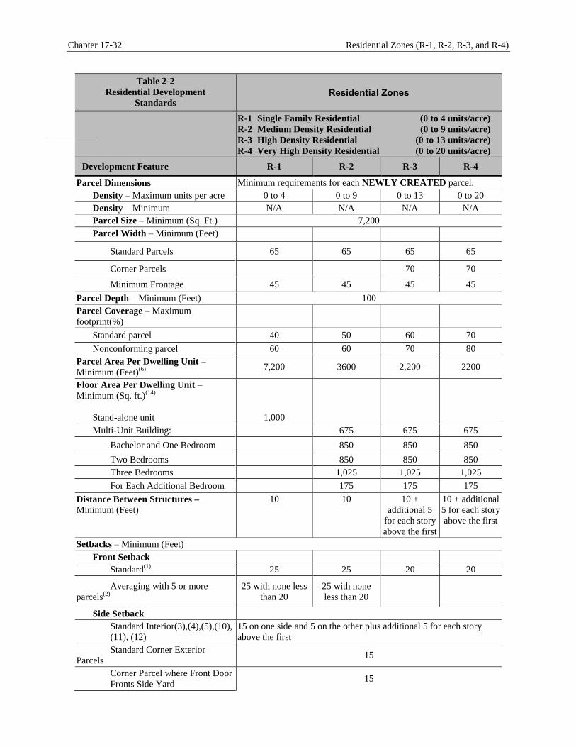
Chapter 17-32 Residential Zones (R-1, R-2, R-3, and R-4)
Table 2-2
Residential Development
Standards Residential Zones
R-1 Single Family Residential (0 to 4 units/acre)
R-2 Medium Density Residential (0 to 9 units/acre)
R-3 High Density Residential (0 to 13 units/acre)
R-4 Very High Density Residential (0 to 20 units/acre)
Development Feature R-1 R-2 R-3 R-4
Parcel Dimensions Minimum requirements for each NEWLY CREATED parcel.
Density – Maximum units per acre 0 to 4 0 to 9 0 to 13 0 to 20
Density – Minimum N/A N/A N/A N/A
Parcel Size – Minimum (Sq. Ft.) 7,200
Parcel Width – Minimum (Feet)
Standard Parcels 65 65 65 65
Corner Parcels 70 70
Minimum Frontage 45 45 45 45
Parcel Depth – Minimum (Feet) 100
Parcel Coverage – Maximum
footprint(%)
Standard parcel 40 50 60 70
Nonconforming parcel 60 60 70 80
Parcel Area Per Dwelling Unit –
Minimum (Feet)(6)
7,200 3600 2,200 2200
Floor Area Per Dwelling Unit –
Minimum (Sq. ft.)(14)
Stand-alone unit
1,000
Multi-Unit Building: 675 675 675
Bachelor and One Bedroom 850 850 850
Two Bedrooms 850 850 850
Three Bedrooms 1,025 1,025 1,025
For Each Additional Bedroom 175 175 175
Distance Between Structures –
Minimum (Feet)
10 10 10 +
additional 5
for each story
above the first
10 + additional
5 for each story
above the first
Setbacks – Minimum (Feet)
Front Setback
Standard(1)
25 25 20 20
Averaging with 5 or more
parcels(2)
25 with none less
than 20
25 with none
less than 20
Side Setback
Standard Interior(3),(4),(5),(10),
(11), (12)
15 on one side and 5 on the other plus additional 5 for each story
above the first
Standard Corner Exterior
Parcels 15
Corner Parcel where Front Door
Fronts Side Yard 15
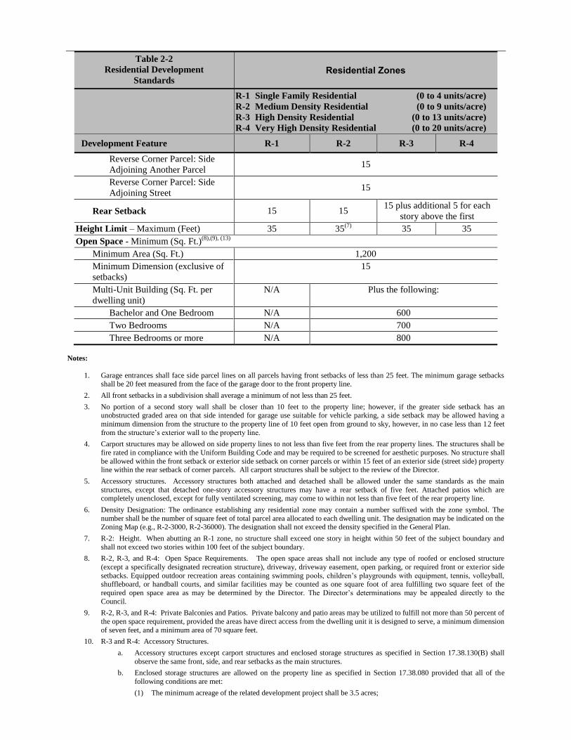
Table 2-2
Residential Development
Standards Residential Zones
R-1 Single Family Residential (0 to 4 units/acre)
R-2 Medium Density Residential (0 to 9 units/acre)
R-3 High Density Residential (0 to 13 units/acre)
R-4 Very High Density Residential (0 to 20 units/acre)
Development Feature R-1 R-2 R-3 R-4
Reverse Corner Parcel: Side
Adjoining Another Parcel 15
Reverse Corner Parcel: Side
Adjoining Street 15
Rear Setback 15 15 15 plus additional 5 for each
story above the first
Height Limit – Maximum (Feet) 35 35(7)
35 35
Open Space - Minimum (Sq. Ft.)(8),(9), (13)
Minimum Area (Sq. Ft.) 1,200
Minimum Dimension (exclusive of
setbacks)
15
Multi-Unit Building (Sq. Ft. per
dwelling unit)
N/A Plus the following:
Bachelor and One Bedroom N/A 600
Two Bedrooms N/A 700
Three Bedrooms or more N/A 800
Notes:
1. Garage entrances shall face side parcel lines on all parcels having front setbacks of less than 25 feet. The minimum garage setbacks shall be 20 feet measured from the face of the garage door to the front property line.
2. All front setbacks in a subdivision shall average a minimum of not less than 25 feet.
3. No portion of a second story wall shall be closer than 10 feet to the property line; however, if the greater side setback has an unobstructed graded area on that side intended for garage use suitable for vehicle parking, a side setback may be allowed having a
minimum dimension from the structure to the property line of 10 feet open from ground to sky, however, in no case less than 12 feet
from the structure’s exterior wall to the property line.
4. Carport structures may be allowed on side property lines to not less than five feet from the rear property lines. The structures shall be
fire rated in compliance with the Uniform Building Code and may be required to be screened for aesthetic purposes. No structure shall
be allowed within the front setback or exterior side setback on corner parcels or within 15 feet of an exterior side (street side) property line within the rear setback of corner parcels. All carport structures shall be subject to the review of the Director.
5. Accessory structures. Accessory structures both attached and detached shall be allowed under the same standards as the main
structures, except that detached one-story accessory structures may have a rear setback of five feet. Attached patios which are completely unenclosed, except for fully ventilated screening, may come to within not less than five feet of the rear property line.
6. Density Designation: The ordinance establishing any residential zone may contain a number suffixed with the zone symbol. The
number shall be the number of square feet of total parcel area allocated to each dwelling unit. The designation may be indicated on the Zoning Map (e.g., R-2-3000, R-2-36000). The designation shall not exceed the density specified in the General Plan.
7. R-2: Height. When abutting an R-1 zone, no structure shall exceed one story in height within 50 feet of the subject boundary and
shall not exceed two stories within 100 feet of the subject boundary.
8. R-2, R-3, and R-4: Open Space Requirements. The open space areas shall not include any type of roofed or enclosed structure
(except a specifically designated recreation structure), driveway, driveway easement, open parking, or required front or exterior side
setbacks. Equipped outdoor recreation areas containing swimming pools, children’s playgrounds with equipment, tennis, volleyball, shuffleboard, or handball courts, and similar facilities may be counted as one square foot of area fulfilling two square feet of the
required open space area as may be determined by the Director. The Director’s determinations may be appealed directly to the
Council.
9. R-2, R-3, and R-4: Private Balconies and Patios. Private balcony and patio areas may be utilized to fulfill not more than 50 percent of
the open space requirement, provided the areas have direct access from the dwelling unit it is designed to serve, a minimum dimension
of seven feet, and a minimum area of 70 square feet.
10. R-3 and R-4: Accessory Structures.
a. Accessory structures except carport structures and enclosed storage structures as specified in Section 17.38.130(B) shall
observe the same front, side, and rear setbacks as the main structures.
b. Enclosed storage structures are allowed on the property line as specified in Section 17.38.080 provided that all of the
following conditions are met:
(1) The minimum acreage of the related development project shall be 3.5 acres;
Chapter 17-32 Residential Zones (R-1, R-2, R-3, and R-4)
(2) The enclosed storage structure shall not exceed 1,000 square feet in area and one story in height;
(3) A Conditional Use Permit and Precise Plan Of Design application in compliance with provisions of this Development Code shall be required;
(4) The enclosed storage structure shall be allowed on property lines that are adjacent to zoning designations that allow
development equal to or more intense than the R-3 zone; and
(5) Subject to a finding by the Council that there is no other reasonable location for the enclosed storage structure on the
subject property.
c. The minimum distance between accessory and main structures and accessory structures shall be 10 feet exclusive of any vehicular accessway or parking area with an additional 10 feet for each story over one on the accessory structure.
d. Garages or carports opening onto an alley shall supply a minimum turning radius of 25 feet to the opposite side of the
alley.
11. R-3 and R-4: Garages and Parking Areas. When a parcel abuts an arterial highway, as depicted on the Master Plan of Arterial
Highways, and an alley or local street, access to all garages and parking spaces shall be from the alleys or local streets and not from
the arterial highway. No more than two garage spaces shall take access directly from a local street for each 65 feet of parcel frontage on a local street. No open parking shall take access directly from a local street. Any garage entered directly from the street shall have a
minimum setback of 20 feet from the ultimate right-of-way, measured from the face of the garage door to the front property line.
12. R-3 and R-4: Side and Rear Setbacks. The interior side setback shall be maintained free and unencumbered from the ground to the
sky and shall not be used for any driveway, parking space, or access. If a dwelling unit faces an interior side setback, the minimum
required setback shall be the same as that required for a front setback (20 feet) with an additional five feet supplied for each additional
story above a one-story structure.
13. Landscaping. Any part of a developed parcel that is visible from the street, including turf on separated parkways, shall be landscaped
in compliance with Section 17.02.215 (Landscaping). On a natural slope, the slope may be left in its natural condition or as otherwise required; however, a manufactured slope shall be landscaped. All lawns, yards, and gardens visible from the street shall be maintained
in a manner which creates a neat, clean, and orderly appearance and which prevents visual blight and property deterioration. Pruning,
mowing and edging of lawns, weeding, removal of litter, fertilizing, and regular watering of all plantings are examples of proper maintenance. All dead plants shall be replaced. Landscaping shall be maintained by the property owner or any occupant or person in
charge or control of the subject property.
14. Minimum Floor Area. For purposes of this Section, any separately enclosed, habitable room shown on a submitted floor plan shall be considered a bedroom regardless of designation as a “den,” “family room,” “study,” or similar room. No balcony, patio, porch, or
similar feature shall be considered in determining unit floor area.
Article 2 – Zones, Allowable Uses, and Development Standards Chapter 17-36
Chapter 17.36 Hillside Residential Zones (HR-C, HR-LD, HR-MD, HR-RE, HR-VL, AND HR-SH)
Sections
17.36.010 Intent and Purpose 17.36.020 Land Use Regulations and Allowable Uses 17.36.030 Development Standards
Intent and Purpose 17.36.010
A. Intent. The intent of the Hillside Residential zone is to provide opportunities for hillside residential
development approaches, including clustering of development consistent with the General Plan and policy
directives associated with the Hillside Conservation Measure, Hillside Development Control Measure,
Growth Management Element of the General Plan, and South Hills Preservation Measure (that balance
preservation of hillside environments with the City’s desire to accommodate single-family neighborhoods
on large parcels) including rural-type development.
B. Purpose. The purposes of the individual hillside residential zones and the manner in which they are
applied are as follows.
1. HR-C Hillside Conservation (0 to 1 dwelling unit per 10 acres). The purpose of the Hillside
Conservation zone is to accommodate extremely low density single-family residential homes in
the Hillside Conservation Area. The allowable density for this category ranges from zero to one
dwelling unit per 10 acres.
2. HR-LD Low Density Hillside Preservation (0 to 1 dwelling unit per 10 acres). The
purpose of the Low Density Hillside Preservation zone is to accommodate low density single-
family residential homes in the Hillside Preservation Area. The allowable density for this category
ranges from zero to one dwelling unit per 10 acres.
3. HR-MD Medium Density Hillside Preservation (0 to 1 dwelling unit per 5 acres). The
purpose of the Medium Density Hillside Preservation zone is to accommodate low density single-
family residential homes in the Hillside Preservation Area. The allowable density for this category
ranges from zero to one dwelling unit per five acres.
4. HR-RE Rural Estates (0 to 1 dwelling unit per acre). The purpose of the Rural Estates
zone is to accommodate single-family homes in a rural setting. The allowable density for this
category ranges from zero to one dwelling unit per acre.
5. Very Low Density (0 to 2 dwelling units/acre). The purpose of the Very Low Density zone is to
accommodate single-family homes in a rural setting. The allowable density for this category
ranges from zero to two dwelling units per acre.
Land Use Regulations and Allowable Uses 17.36.020
A. Table 2-3. Table 2-3 indicates the uses allowed within each hillside residential zone and any permits
required to establish the use, in compliance with Chapter 17.30 (Administration) and Chapters 17.30.410
(Hearings) through 17.30.470 (Modification), inclusive.
B. Primary and Accessory Uses. Residential uses represent the primary allowed use, and only those
additional uses that are complementary to, and can exist in harmony with, the hillside residential character
of each zone may be allowed as accessory, conditionally permitted, and/or temporary uses. Accessory uses
deemed appropriate may only be allowed when provided as a secondary use on property for which a legally
Chapter 17-36 Hillside Residential Zones (HR-C, HR-LD, HR-MD, HR-RE, HR-VL, AND HR-SH)
allowed residential unit exists or is proposed in conjunction with establishment of the accessory use, except
as may be otherwise allowed in Chapter 17.22 (Nonconforming Uses).
C. Prohibited Land Uses. Any table cell with a “--” means that the listed land use is prohibited in that
specific zone.
D. Land Uses Not Listed in Table 2-3. Land uses that are not listed in Table 2-3 or are not shown in another
zone are not allowed, except as otherwise provided by Section 17.02.040 (Interpretation by City Council).
E. Additional Regulations. Where the last column in the Table 2-3 includes a Chapter or Section number,
the regulations in the referenced Chapter or Section shall apply to the use. Provisions in other Sections of
this title may also apply.
F. Precise Plan of Design Review. See Sections 17.30.260 (Precise plan of design - Required when) through
17.30.300 (Precise plan of design – Conditional approval), inclusive, requirements for new or modified
construction activities.
G. Definitions. See Chapter 17.02 (Introduction and Definitions) for land use definitions and explanations.
H General Plan Considerations. Development must conform with the General Plan, Hillside Conservation
Measure, Residential and Hillside Development Control Measure, Growth Management Element of the
general Plan, and South Hills Preservation Measure
Table 2-3
Allowed Uses and Permit
Requirements for Hillside
Residential Zones
P
CUP
MUP
--
Permitted By Right (Planning Permit May Be Required)
Conditional Use Permit
Minor Use Permit
Not Allowed
HR-C
HR-LD
HR-MD
HR-RE
VL
Hillside - Conservation (0 to 0.1 unit/acre)
Hillside – Low Density (0 to 0.1 units/acre)
Hillside – Medium Density (0 to 0.2 units/acre)
Hillside – Rural Estate (0 to 1 units/acre)
Very Low Density (0 to 2 units/acre)
Land Use HR-C HR-LD HR-MD HR-RE HR-VL Specific Use
Regulations
Residential Uses
Dwellings
Accessory Dwelling Unit P P P P P
Single-Family Dwelling P P P P P
Manufactured Housing P P P P P
Group Home (six or fewer residents
plus one employee) P P P P P
Planned Residential Developments CUP CUP CUP CUP CUP
Care Uses
Child Day Care – Small (7 or fewer
children) P P P P P
Other Uses
Enclosed Storage Structures CUP CUP CUP CUP CUP
Home Occupations P P P P P
Public Utility Structures and Service
Facilities CUP CUP CUP CUP CUP

Article 2 – Zones, Allowable Uses, and Development Standards Chapter 17-36
Development Standards 17.36.030
A. General. New land uses and structures, and alterations to existing land uses and structures, shall be
designed, constructed, and/or established in compliance with the requirements specified in Table 2-4, in
addition to the general development standards (e.g., landscaping, parking and loading, etc.) and land use
standards specified elsewhere in this title. Standards for accessory structures are specified in Chapter 17.10
(Accessory Buildings) and in the notes in Table 2-4.
B. Prohibition on Structures in Front Setback Area. Portions of any habitable structure and/or accessory
structure shall not occupy any portion of a required front setback area, except as provided in Section
17.08.050 (Permitted Projections).
Table 2-4
Hillside Residential Development
Standards Hillside Residential Zones
HR-C Hillside − Conservation (0 to 0.1 unit/acre)
HR-LD Hillside – Low Density (0 to 0.1 units/acre)
HR-MD Hillside – Medium Density (0 to 0.2 units/acre)
HR-RE Hillside – Rural Estate (0 to 1 units/acre)
HR-VL Hillside – Very Low Density (0 to 2 units/acre)
Development Feature HR-C HR-LD HR-MD HR-RE HR-VL
Parcel Dimensions Minimum requirements for each NEWLY CREATED parcel.
Density
Maximum dwelling units/acre 1 du/10 acres 1 du/10 acres 1 du/5 acres 1 du/1 acre 2 du/1 acre
Clustered Development 1 du/5 acre 1 du/5 acre 1 du/2.5 acre NA NA
Parcel Size – Minimum (Sq. ft.) 435,600 435,600 217,800 43,560 21,780
Parcel Width – Minimum (Feet) 150
Parcel Depth – Minimum (Feet) 200
Parcel Coverage – Maximum footprint See Table 2-3.a(1)
Distance Between Structures –
Minimum (Feet) 10 plus additional 5 for each story above the first
Setbacks – Minimum (Feet) (4)(5)
Front Setback 25 25 25 25 25
Side Setback –
Interior and Standard Corner Parcels
15
Side Setback –
Corner Parcel where Front Door
Fronts Side Yard
15
Side Setback –
Reverse Corner Parcel: Side
Adjoining Another Parcel
15
Side Setback –
Reverse Corner Parcel: Side
Adjoining a Street
15
Rear Setback 50 50 50 15 15
Height Limit - Maximum (Feet) 35
Notes:
1. No portion of a second story wall shall be closer than 30 feet to the property line; however, if the greater side setback has an unobstructed graded area on that side intended for garage use suitable for vehicle parking, a side setback may be allowed having a
minimum dimension from the structure to the property line of 30 feet open from ground to sky.
2. Carport structures may be allowed on side property lines to not less than five feet from the rear property lines. The structures shall be fire rated in compliance with the Uniform Building Code and may be required to be screened for aesthetic purposes. No structure shall

Chapter 17-36 Hillside Residential Zones (HR-C, HR-LD, HR-MD, HR-RE, HR-VL, AND HR-SH)
be allowed within the front setback or exterior side setback on corner parcels or within 15 feet of an exterior side (street side) property
line within the rear setback of corner parcels. All carport structures shall be subject to the review of the Director.
3. Accessory structures. Accessory structures both attached and detached shall be allowed under the same standards as the main
structures, except that detached one-story accessory structures may have a rear setback of five feet. Attached patios which are
completely unenclosed, except for fully ventilated screening, may come to within not less than five feet of the rear property line.
4. Permitted Development. The City shall only allow future development within the Hillside Preservation Area, the Hillside
Conservation Area, and the Expanded Hillside Area which:
a. Protects the area’s natural environment and sensitive environmental features, as well as public health and safety, maximizing the preservation of land in permanent public open space;
b. Ensures that the design and layout of future hillside development adapts to the natural hillside topography; and
c. Minimizes the need for and costs of providing infrastructure, utilities, and public services to all hillside areas.
5. Preservation of natural scenic vistas and view shed areas.
a. Preservation of Vistas: New development shall only be approved if it preserves scenic vistas of natural hillside areas and
ridgelines.
b. Minimization of View Shed Intrusion: New Development shall only be approved if it minimizes wall surfaces facing
towards view shed areas through the use of split pads, varying setbacks, low roof pitches, and landscaping.
c. Architectural Compatibility: New development shall only be approved if it uses architectural style which is compatible
with the natural setting. The use of colors, textures, materials, and forms which will attract attention shall be avoided.
d. Massing and Scale: The overall scale and massing of structures shall respect the natural surroundings by incorporating
designs which minimize bulk and mass, and minimize visual intrusion on the natural landscape. Structures shall be sited to best fit with a hillside’s natural contours in hillside areas.
6. Ridgeline Setbacks. Development shall be set back from Primary Ridgelines 100 feet horizontally and 100 feet vertically. “Primary Ridgelines” include ridgelines having any of the following characteristics:
a. Ridges that have a difference in elevation of at least 200 feet from the toe of slope of the valley floor or the toe of slope of
any canyon floor.
b. Ridges which, prior to grading, are visible, or which would be visible but for manmade obstructions such as buildings or
houses.
c. Ridges that form a prominent landform in the foreground, a major skyline ridge in the background, or one of the layers of ridges that may be visible in between, or which would be visible but for man-made obstructions such as buildings or
houses.
d. Ridges that frame major visual access when a person is traveling through the Hillside Preservation Area, the Hillside Conservation Area or the Expanded Hillside Area and will provide the first view of valley and canyon areas as a traveler
emerges from the other side of the ridge.
7. Grading:
a. Focused Grading Required. Focused Grading is defined as the minimum grading required for access roads, the grading
necessary for the extension of City services, and/or the grading of no more than the size of the footprint of the house and
ancillary structures on each individual parcel, with each footprint and ancillary structures separated from each adjacent parcel by ungraded, natural terrain. Mass Grading is defined as any grading that does not meet the definition of Focused
Grading.
b. Mass Grading Prohibited. Mass Grading on any Primary Ridgeline or any Northerly Facing Slope is prohibited.
c. Slope Conforming Foundations Required. Development shall preserve natural scenic vistas were the natural slope is 15
percent or greater by requiring building foundations for structures to conform to the natural slope to minimize grading and
other environmental impacts and to ensure that roof lines do not eliminate or obstruct ridgelines.
8. Average Slope and Parcel Coverage Standards.
a. For the purposes of this Subsection, the average slope of any parcel shall be determined by the following formula.
S = .0023IL
A
Where: S is the average slope expressed as a percent; I is contour interval in feet; L is the combined length of contour lines
in scale feet; and A is the gross area in acres of the parcel.
b. The calculation of the average slope, S, shall be prepared by a registered civil engineer or land surveyor using the
following criteria:
c. The contour map shall have a maximum interval of 10 feet;
d. An interval of two feet shall be used for calculation of the average slope and shall be interpolated if necessary;
e. The scale of development plans and topographic maps shall be no smaller than:
(1) For a parcel smaller than two acres, one inch equals 20 feet,
(2) For a parcel from two to 20 acres, one inch equals 50 feet,
(3) For a parcel larger than 20 acres, one inch equals 100 feet,
f. The plans and maps shall be in compliance with the requirements for tentative maps established by the Subdivision Code.
Article 2 – Zones, Allowable Uses, and Development Standards Chapter 17-36
9. The maximum parcel coverage on a parcel located within the Hillside Residential Zones shall be as specified in the following table:
Table 2-4-A
Maximum Parcel Coverage
Average Slope (%) Maximum Parcel Coverage
(Calculated as maximum % of roof coverage)
10-15 45
15-20 40
20-25 35
25-30 30
30-35 25
35-40 20
40-45 15
Over 45 5

Chapter 17-36 Hillside Residential Zones (HR-C, HR-LD, HR-MD, HR-RE, HR-VL, AND HR-SH)
This page intentionally left blank.

Article 2 – Zones, Allowable Uses, and Development Standards Chapter 17.40
Chapter 17.40 Commercial and Industrial Zones (BP, C1, C2, CM, and CO)
Sections
17.40.010 Purpose and Intent 17.40.020 Land Use Regulations and Allowable Uses 17.40.040 Specific Use Regulations 17.40.050 Development Standards
Purpose and Intent 17.40.010
The purposes of the individual commercial zones and the manner in which they are applied are as follows.
A. B-P Business Park Zone. The intent of the Business Park zone is to provide locations for professional
offices, research and development activities, and light industrial uses that contribute both revenues and jobs
to the local economy. Limited retail or service uses designed to meet the business needs of offices or the
personal needs of office workers are also allowed. Development profiles may consist of low- to high-rise
developments (one to five stores in height) constructed either as stand-alone structures or a coordinated
project in terms of site layout, architectural design, and landscaping to form a campus-like setting. The
community seeks to expand these types of uses by attracting firms that are related to the medical
technology field, or that would benefit from the medical advances associated with businesses and
institutions in the City. This zone implements the General Plan Business Park land use designation.
B. C-1 Neighborhood Business Zone. The intent of the Neighborhood Business zone is to provide locations
for shopping and commercial service businesses that cater to the daily needs of the residential community
and local workers. Examples of intended development include neighborhood shopping centers, specialty
shops, and stand-alone commercial uses. This zone also allows limited office and religious assembly uses
that are incorporated into commercial development (e.g., offices in small storefronts, or religious assembly
uses in structures originally designed for commercial uses) if the dominant character of the overall
development remains commercial. The overall character of uses in this zone is one of low impact in terms
of traffic generation, noise, and other features that might adversely affect adjacent residential
neighborhoods. This zone implements the General Plan Commercial land use designation.
C. C-2 General Business Zone. The intent of the General Business zone is to accommodate the shopping and
commercial service needs of the residential community, local workers, and visitors to the City. Examples of
intended development include larger shopping centers and in-line shops, hotels/motels, specialty shops, and
stand-alone commercial uses. This zone also allows a limited number of office uses and religious assembly
uses incorporated into commercial development if the dominant character of the overall development
remains commercial. This zone implements the General Plan Commercial land use designation.
D. C-M Commercial Manufacturing Zone. The intent of the Commercial Manufacturing zone is to
accommodate light industrial uses (e.g., manufacturing, assembly, warehousing, and distribution
businesses) that have limited or no impact related to air quality, electrical or electronic interference,
hazardous materials, light and glare, liquid and solid wastes, noise, odors, ground vibration, or water
quality. Warehousing and distribution uses are limited to those uses that generate a relatively low number
of vehicle trips. Office uses that are ancillary to the principal commercial or manufacturing uses are
allowed. This zone implements the General Plan Industrial land use designation.

Chapter 17-40 Commercial and Industrial Zones (BP, C1, C2, CM, and CO)
E. C-O Commercial Office Zone (Administrative and Professional Office Zone). The intent of the
Commercial Office zone is to accommodate professional and medical office uses. However, commercial
uses that support the office uses or office workers (e.g., office supply stores, copy services, pharmacies, day
care, restaurants, dry cleaners, and sundry stores) are also allowed. Development intensity may vary from
one to five stories in height depending on adjacent uses, with lower-rise structures required adjacent to
residential development. This zone implements the General Plan Office land use designation.
Land Use Regulations and Allowable Uses 17.40.020
A. Table 2-5. Table 2-5 indicates the uses allowed within each residential zone and any permits required to
establish the use, in compliance with Chapter 17.30 (Administration) and Chapters 17.30.410 (Hearings)
through 17.30.470 (Modifications), inclusive.
B. Prohibited Land Uses. Any table cell with a “--” means that the listed land use is prohibited in that
specific zone.
C. Land Uses Not Listed in Table 2-5. Land uses that are not listed in Table 2-5 or are not shown in another
zone are not allowed, except as otherwise provided by Section 17.02.040 (Interpretation by City Council).
D. Additional Regulations. Where the last column in the Table 2-5 includes a Chapter or Section number,
the regulations in the referenced Chapter or Section shall apply to the use. Provisions in other Sections of
this title may also apply.
E. Precise Plan of Design Review. See Sections 17.30.260 (Precise plan of design - Required when) through
17.30300 (Precise plan of design – Conditional approval), inclusive, requirements for new or modified
construction activities.
F. Definitions. See Chapter 17.02 (Introduction and Definitions) for land use definitions and explanations.
Table 2-5
Allowed Uses and Permit
Requirements for Commercial and
Industrial Zones
P Permitted By Right (Planning Permit May Be Required)
CUP Conditional Use Permit
MUP Minor Use Permit
-- Not Allowed
C-O Commercial Office
B-P Business Park
C-1 Neighborhood Commercial
C-2 General business
C-M Commercial Manufacturing
Land Use C-O B-P C-1 C-2 C-M Specific Use Regulations
Retail Trade Uses
Alcohol Beverage Sales
Alcohol Sales (off-sale) – Beer and
Wine -- CUP CUP CUP --
Alcohol Sales (on-sale) – Beer and
Wine CUP CUP CUP -- -- See note 1
Alcohol Sales (off-sale) – Liquor --
P P --
Only permitted provided that the
structure containing this use has a
minimum floor area of 30,000 sq.
ft. and that a maximum of 10
percent of the gross floor area is
devoted to the sales of package
liquor
Alcohol Sales (on-sale) – Liquor -- CUP -- CUP --

Article 2 – Zones, Allowable Uses, and Development Standards Chapter 17-40
Table 2-5
Allowed Uses and Permit
Requirements for Commercial and
Industrial Zones
P Permitted By Right (Planning Permit May Be Required)
CUP Conditional Use Permit
MUP Minor Use Permit
-- Not Allowed
C-O Commercial Office
B-P Business Park
C-1 Neighborhood Commercial
C-2 General business
C-M Commercial Manufacturing
Land Use C-O B-P C-1 C-2 C-M Specific Use Regulations
Building Materials -- -- -- MUP P
Drive-in and Drive-thru Businesses CUP -- CUP CUP CUP
Landscape Nurseries – Retail or
Wholesale CUP -- CUP CUP P
Two-acre minimum parcel size
required.
Retail Store or Center (Less than 30,000
sf) -- -- -- P P
Retail Store or Center (30,001 sf or
greater) -- -- P P P
Vehicle Sales – New -- -- -- P P
Vehicle Sales – Used -- -- -- P P
Allowed only in association with a
new vehicle sales business. Stand-
along used vehicle sales are not
permitted.
Vehicle Parts Sales (including
stereos/alarms, but no installation) -- -- P P P
Vending Machines P P P P P
Business, Financial, and Professional
Financial Institutions and Related
Services P P P P P
Governmental Offices and Facilities P P P P P
Historical or Landmark Structures with
Commercial Activities CUP CUP CUP CUP CUP
Offices – Other than medical or dental P P P P P
In the C-1 and C-2 zones, on the
ground floor, office use is limited
to 15% of the floor area. No
limitation applies to second floors
are above.
In the C-M zone, office use is
limited to ancillary uses associated
with the business and shall not
exceed 15% of the floor area.
Eating and Drinking Establishments
Bars, Lounges, Nightclubs, and Taverns -- -- -- CUP --
Catering Services -- -- P P P
Fast Food Restaurant with no drive-
through (no late-night hours) P P P P P
Fast Food Restaurant with no drive-
through (with late-night hours) CUP CUP CUP CUP CUP
Fast Food Restaurant with drive-through -- -- -- -- --
Restaurant – Outdoor Dining CUP CUP CUP CUP CUP
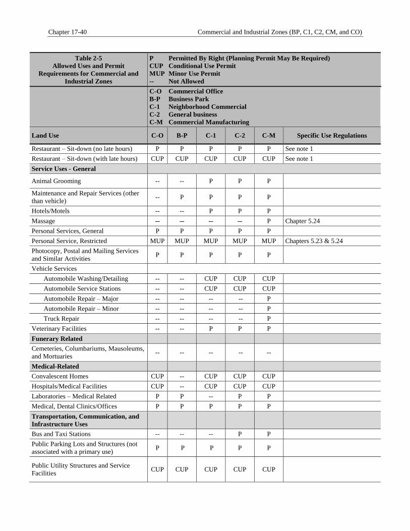
Chapter 17-40 Commercial and Industrial Zones (BP, C1, C2, CM, and CO)
Table 2-5
Allowed Uses and Permit
Requirements for Commercial and
Industrial Zones
P Permitted By Right (Planning Permit May Be Required)
CUP Conditional Use Permit
MUP Minor Use Permit
-- Not Allowed
C-O Commercial Office
B-P Business Park
C-1 Neighborhood Commercial
C-2 General business
C-M Commercial Manufacturing
Land Use C-O B-P C-1 C-2 C-M Specific Use Regulations
Restaurant – Sit-down (no late hours) P P P P P See note 1
Restaurant – Sit-down (with late hours) CUP CUP CUP CUP CUP See note 1
Service Uses - General
Animal Grooming -- -- P P P
Maintenance and Repair Services (other
than vehicle) -- P P P P
Hotels/Motels -- -- P P P
Massage -- -- -- -- P Chapter 5.24
Personal Services, General P P P P P
Personal Service, Restricted MUP MUP MUP MUP MUP Chapters 5.23 & 5.24
Photocopy, Postal and Mailing Services
and Similar Activities P P P P P
Vehicle Services
Automobile Washing/Detailing -- -- CUP CUP CUP
Automobile Service Stations -- -- CUP CUP CUP
Automobile Repair – Major -- -- -- -- P
Automobile Repair – Minor -- -- -- -- P
Truck Repair -- -- -- -- P
Veterinary Facilities -- -- P P P
Funerary Related
Cemeteries, Columbariums, Mausoleums,
and Mortuaries -- -- -- -- --
Medical-Related
Convalescent Homes CUP -- CUP CUP CUP
Hospitals/Medical Facilities CUP -- CUP CUP CUP
Laboratories – Medical Related P P -- P P
Medical, Dental Clinics/Offices P P P P P
Transportation, Communication, and
Infrastructure Uses
Bus and Taxi Stations -- -- -- P P
Public Parking Lots and Structures (not
associated with a primary use) P P P P P
Public Utility Structures and Service
Facilities CUP CUP CUP
CUP
CUP
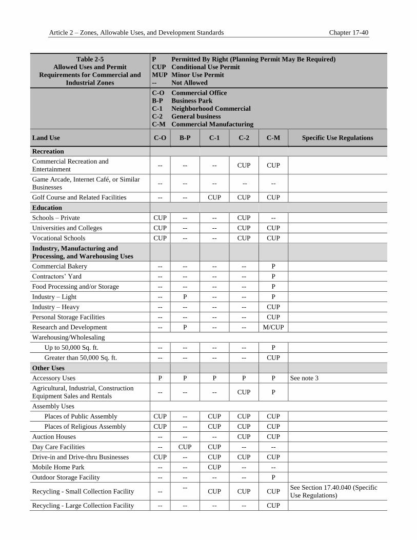
Article 2 – Zones, Allowable Uses, and Development Standards Chapter 17-40
Table 2-5
Allowed Uses and Permit
Requirements for Commercial and
Industrial Zones
P Permitted By Right (Planning Permit May Be Required)
CUP Conditional Use Permit
MUP Minor Use Permit
-- Not Allowed
C-O Commercial Office
B-P Business Park
C-1 Neighborhood Commercial
C-2 General business
C-M Commercial Manufacturing
Land Use C-O B-P C-1 C-2 C-M Specific Use Regulations
Recreation
Commercial Recreation and
Entertainment -- -- -- CUP CUP
Game Arcade, Internet Café, or Similar
Businesses -- -- -- -- --
Golf Course and Related Facilities -- -- CUP CUP CUP
Education
Schools – Private CUP -- -- CUP --
Universities and Colleges CUP -- -- CUP CUP
Vocational Schools CUP -- -- CUP CUP
Industry, Manufacturing and
Processing, and Warehousing Uses
Commercial Bakery -- -- -- -- P
Contractors’ Yard -- -- -- -- P
Food Processing and/or Storage -- -- -- -- P
Industry – Light -- P -- -- P
Industry – Heavy -- -- -- -- CUP
Personal Storage Facilities -- -- -- -- CUP
Research and Development -- P -- -- M/CUP
Warehousing/Wholesaling
Up to 50,000 Sq. ft. -- -- -- -- P
Greater than 50,000 Sq. ft. -- -- -- -- CUP
Other Uses
Accessory Uses P P P P P See note 3
Agricultural, Industrial, Construction
Equipment Sales and Rentals -- -- -- CUP P
Assembly Uses
Places of Public Assembly CUP -- CUP CUP CUP
Places of Religious Assembly CUP -- CUP CUP CUP
Auction Houses -- -- -- CUP CUP
Day Care Facilities -- CUP CUP -- --
Drive-in and Drive-thru Businesses CUP -- CUP CUP CUP
Mobile Home Park -- -- CUP -- --
Outdoor Storage Facility -- -- -- -- P
Recycling - Small Collection Facility -- --
CUP CUP CUP See Section 17.40.040 (Specific
Use Regulations)
Recycling - Large Collection Facility -- -- -- -- CUP
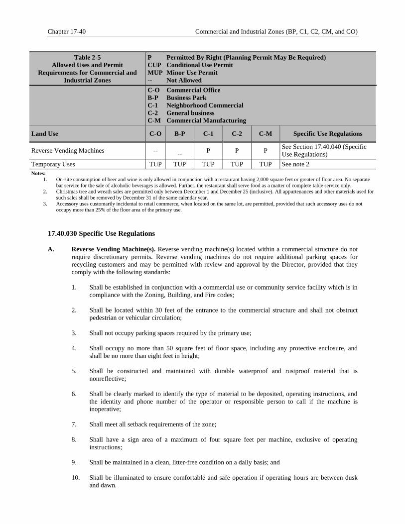
Chapter 17-40 Commercial and Industrial Zones (BP, C1, C2, CM, and CO)
Table 2-5
Allowed Uses and Permit
Requirements for Commercial and
Industrial Zones
P Permitted By Right (Planning Permit May Be Required)
CUP Conditional Use Permit
MUP Minor Use Permit
-- Not Allowed
C-O Commercial Office
B-P Business Park
C-1 Neighborhood Commercial
C-2 General business
C-M Commercial Manufacturing
Land Use C-O B-P C-1 C-2 C-M Specific Use Regulations
Reverse Vending Machines --
-- P P P
See Section 17.40.040 (Specific
Use Regulations)
Temporary Uses TUP TUP TUP TUP TUP See note 2
Notes:
1. On-site consumption of beer and wine is only allowed in conjunction with a restaurant having 2,000 square feet or greater of floor area. No separate
bar service for the sale of alcoholic beverages is allowed. Further, the restaurant shall serve food as a matter of complete table service only. 2. Christmas tree and wreath sales are permitted only between December 1 and December 25 (inclusive). All appurtenances and other materials used for
such sales shall be removed by December 31 of the same calendar year.
3. Accessory uses customarily incidental to retail commerce, when located on the same lot, are permitted, provided that such accessory uses do not occupy more than 25% of the floor area of the primary use.
Specific Use Regulations 17.40.030
A. Reverse Vending Machine(s). Reverse vending machine(s) located within a commercial structure do not
require discretionary permits. Reverse vending machines do not require additional parking spaces for
recycling customers and may be permitted with review and approval by the Director, provided that they
comply with the following standards:
1. Shall be established in conjunction with a commercial use or community service facility which is in
compliance with the Zoning, Building, and Fire codes;
2. Shall be located within 30 feet of the entrance to the commercial structure and shall not obstruct
pedestrian or vehicular circulation;
3. Shall not occupy parking spaces required by the primary use;
4. Shall occupy no more than 50 square feet of floor space, including any protective enclosure, and
shall be no more than eight feet in height;
5. Shall be constructed and maintained with durable waterproof and rustproof material that is
nonreflective;
6. Shall be clearly marked to identify the type of material to be deposited, operating instructions, and
the identity and phone number of the operator or responsible person to call if the machine is
inoperative;
7. Shall meet all setback requirements of the zone;
8. Shall have a sign area of a maximum of four square feet per machine, exclusive of operating
instructions;
9. Shall be maintained in a clean, litter-free condition on a daily basis; and
10. Shall be illuminated to ensure comfortable and safe operation if operating hours are between dusk
and dawn.

Article 2 – Zones, Allowable Uses, and Development Standards Chapter 17-40
B. Small Collection Facilities. Small collection facilities shall comply with the following standards.
1. Shall be established by Conditional Use Permit in conjunction with an existing commercial use or
community service facility which is in compliance with the Zoning, Building, and Fire Codes;
2. Shall be no larger than 500 square feet and no greater than 10 feet in height, and shall occupy no
more than five parking spaces, not including space that will be periodically needed for removal of
materials or exchange of containers;
3. Shall meet all setback requirements of the zone and shall not obstruct pedestrian or vehicular
circulation;
4. Shall accept only glass, metals, plastic containers, papers, and reusable items. Used motor oil may be
accepted with permission of the County of San Bernardino Department of Environmental Health;
5. Shall use no power-driven processing equipment except for reverse vending machines;
6. Shall use containers that are constructed and maintained with durable waterproof and rustproof
material that is nonreflective and matches the materials and color of the primary use. The containers
shall be covered when the site is not attended, secured from unauthorized entry or removal of
material, and shall be of a capacity sufficient to accommodate materials collected and collection
schedule;
7. Shall store all recyclable material in containers or in the mobile unit vehicle. Storage containers shall
be screened from view in an aesthetically pleasing manner;
8. Shall be maintained free of litter and any other undesirable materials;
9. Mobile facilities, at which truck or containers are removed at the end of each collection day, shall be
swept at the end of each collection day;
10. Attended facilities located within 100 feet of a property zoned or occupied for residential use shall
operate only during the hours between 9:00 A.M. and 7:00 P.M.;
11. Containers for the 24-hour donation of materials shall be at least 50 feet from any property zoned or
occupied for residential use unless there is a recognized service corridor and acoustical shielding
between the containers and the residential use;
12. Containers shall be clearly marked to identify the type of material which may be deposited; the
facility shall be clearly marked to identify the name and telephone number of the facility operator
and the hours of operation, and display a notice stating that no material shall be left outside the
recycling enclosure or containers.
13. Signs may be provided as follows:
a. Recycling facilities may have identification signs with a maximum of 15 percent per side or 12
square feet, whichever is larger, in addition to informational signs; in the case of a wheeled facility,
the side will be measured from the pavement to the top of the container.
b. Signs must be consistent with the character of the location.
c. Directional signs, bearing no advertising message, may be installed if necessary to facilitate traffic
circulation, or if the facility is not visible from the public right-of-way.
14. The facility shall not impair the landscaping required for any concurrent use or any permit issued
pursuant thereto;
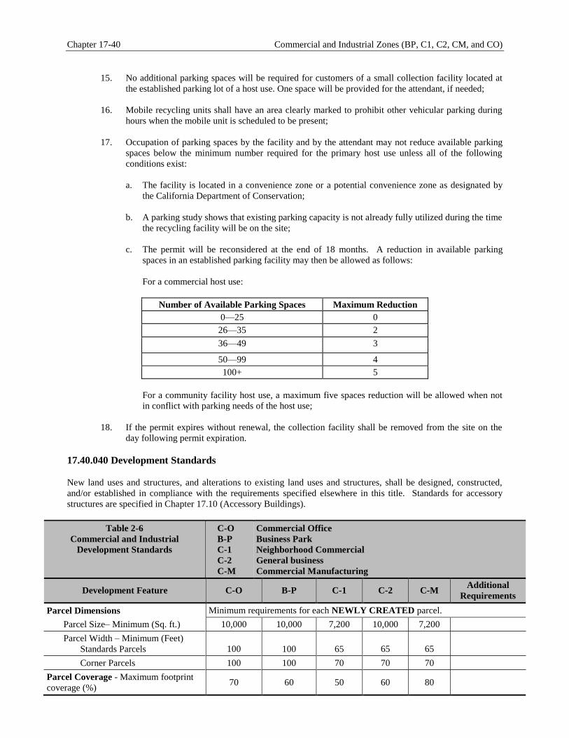
Chapter 17-40 Commercial and Industrial Zones (BP, C1, C2, CM, and CO)
15. No additional parking spaces will be required for customers of a small collection facility located at
the established parking lot of a host use. One space will be provided for the attendant, if needed;
16. Mobile recycling units shall have an area clearly marked to prohibit other vehicular parking during
hours when the mobile unit is scheduled to be present;
17. Occupation of parking spaces by the facility and by the attendant may not reduce available parking
spaces below the minimum number required for the primary host use unless all of the following
conditions exist:
a. The facility is located in a convenience zone or a potential convenience zone as designated by
the California Department of Conservation;
b. A parking study shows that existing parking capacity is not already fully utilized during the time
the recycling facility will be on the site;
c. The permit will be reconsidered at the end of 18 months. A reduction in available parking
spaces in an established parking facility may then be allowed as follows:
For a commercial host use:
Number of Available Parking Spaces Maximum Reduction
0—25 0
26—35 2
36—49 3
50—99 4
100+ 5
For a community facility host use, a maximum five spaces reduction will be allowed when not
in conflict with parking needs of the host use;
18. If the permit expires without renewal, the collection facility shall be removed from the site on the
day following permit expiration.
Development Standards 17.40.040
New land uses and structures, and alterations to existing land uses and structures, shall be designed, constructed,
and/or established in compliance with the requirements specified elsewhere in this title. Standards for accessory
structures are specified in Chapter 17.10 (Accessory Buildings).
Table 2-6
Commercial and Industrial
Development Standards
C-O
B-P
C-1
C-2
C-M
Commercial Office
Business Park
Neighborhood Commercial
General business
Commercial Manufacturing
Development Feature C-O B-P C-1 C-2 C-M Additional
Requirements
Parcel Dimensions Minimum requirements for each NEWLY CREATED parcel.
Parcel Size– Minimum (Sq. ft.) 10,000 10,000 7,200 10,000 7,200
Parcel Width – Minimum (Feet)
Standards Parcels
100
100
65
65
65
Corner Parcels 100 100 70 70 70
Parcel Coverage - Maximum footprint
coverage (%) 70 60 50 60 80
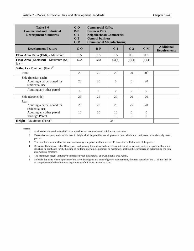
Article 2 – Zones, Allowable Uses, and Development Standards Chapter 17-40
Table 2-6
Commercial and Industrial
Development Standards
C-O
B-P
C-1
C-2
C-M
Commercial Office
Business Park
Neighborhood Commercial
General business
Commercial Manufacturing
Development Feature C-O B-P C-1 C-2 C-M Additional
Requirements
Floor Area Ratio (FAR) - Maximum 0.5 0.5 0.5 0.5 0.6
Floor Area (Enclosed) – Maximum (Sq.
ft.)(1)
N/A N/A (3)(4) (3)(4) (3)(4)
Setbacks - Minimum (Feet)(2)
Front 25 25 20 20 20(6)
Side (interior, each)
Abutting a parcel zoned for
residential use
20
20
0
0
20
Abutting any other parcel 5 5 0 0 0
Side (Street side) 25 25 20 20 20
Rear
Abutting a parcel zoned for
residential use
Abutting any other parcel
Through Parcel
20
10
20
10
25
10
10
25
0
0
20
0
0
Height – Maximum (Feet)(5)
35
Notes:
1. Enclosed or screened areas shall be provided for the maintenance of solid waste containers.
2. Decorative masonry walls of six feet in height shall be provided on all property lines which are contiguous to residentially zoned
parcels.
3. The total floor area in all of the structures on any one parcel shall not exceed 13 times the buildable area of the parcel.
4. Basement floor space, cellar floor space, and parking floor space with necessary interior driveway and ramps, or space within a roof
structure or penthouse for the housing of building operating equipment or machinery, shall not be considered in determining the total area within a structure.
5. The maximum height limit may be increased with the approval of a Conditional Use Permit.
6. Setbacks for a site where a portion of the street frontage is in a zone of greater requirements, the front setback of the C-M use shall be in compliance with the minimum requirements of the more restrictive zone.

Chapter 17-40 Commercial and Industrial Zones (BP, C1, C2, CM, and CO)
This page intentionally left blank.

Article 2 – Zones, Allowable Uses, and Development Standards Chapter 17.44
Chapter 17.44 — Special Purpose Zones (I-HC, OS, PC, and PF)
Sections
17.44.010 Purpose and Intent 17.44.020 Land Use Regulations and Allowable Uses 17.44.030 Specific Use Regulations 17.44.040 Development Standards
Purpose and Intent 17.44.010
The purposes of the individual special purpose zones and the manner in which they are applied are as follows.
A. I-HC Institutional-Health Care Zone. The primary intent of the Institutional-Health Care zone is to
accommodate hospitals, medical clinics, medical research facilities, rehabilitation centers, and residential
facilities that provide a high degree of medical care and supervision. This zone also allows employee
housing as an accessory use. The zone also accommodates educational institutions and religious assembly
uses including the Loma Linda University campus inclusive of lecture halls, administration, classroom,
laboratory, and service buildings. Also allowed is student housing (dorms, detached or attached dwelling
units) and employee housing (detached or attached dwelling units). This zone also accommodates
educational uses and religious assembly uses, inclusive of assembly areas or structures, classrooms,
religious administrative offices, and limited accessory residential facilities. This zone implements the
General Plan Health Care land use designation.
B. OS Open Space Zone. The intent of the Open Space zone is to define properties reserved for the
preservation of wilderness areas for passive recreational use and other undeveloped recreation lands.
Development of structures is prohibited, except for those structures that may be ancillary to a passive
recreational use (e.g., restrooms and small service buildings). This zone implements the General Plan
Public Open Space land use designation.
C. PC Planned Community Zone. The intent of the Planned Community zone is to accommodate flexibility
in development, encourage creative and imaginative design, and provide for development of parcels of land
as coordinated projects involving a mixture of residential densities and housing types, community facilities
both public and private and commercial areas. This zone is further intended to accommodate the optimum
integration of urban and natural amenities within developments. The Planned Community zone allows for
creation of unique use regulations and development standards for a development project, provided the
regulations and standards clearly implement General Plan policy and subsequent project proposals under
the Planned Community zone reflect the character envisioned by the City at the time of Planned
Community zone approval. This zone implements various General Plan land use designations and can be
used to implement the Special Planning Area designation.
D. PF Public Facilities Zone. The intent of the Public Facilities zone is to accommodate civic, government,
quasi-public uses (e.g., utility easements), and public parks and recreational facilities. Civic uses include a
range of uses and facilities that support government service operations (e.g., City Hall, fire stations, parks,
and senior and community centers). This zone implements the General Plan City Facilities, Institutional
and Parks land use designations.
Land Use Regulations and Allowable Uses 17.44.020
A. Table 2-7. Table 2-7 indicates the uses allowed within each special purpose zone and any permits required
to establish the use, in compliance with Chapter 17.30 (Administration) and Chapters 17.30.410 (Hearings)
through 17.30.470 (Modifications), inclusive.
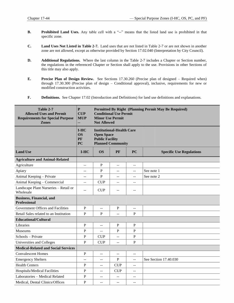
Chapter 17-44 — Special Purpose Zones (I-HC, OS, PC, and PF)
B. Prohibited Land Uses. Any table cell with a “--” means that the listed land use is prohibited in that
specific zone.
C. Land Uses Not Listed in Table 2-7. Land uses that are not listed in Table 2-7 or are not shown in another
zone are not allowed, except as otherwise provided by Section 17.02.040 (Interpretation by City Council).
D. Additional Regulations. Where the last column in the Table 2-7 includes a Chapter or Section number,
the regulations in the referenced Chapter or Section shall apply to the use. Provisions in other Sections of
this title may also apply.
E. Precise Plan of Design Review. See Sections 17.30.260 (Precise plan of designed – Required when)
through 17.30.300 (Precise plan of design – Conditional approval), inclusive, requirements for new or
modified construction activities.
F. Definitions. See Chapter 17.02 (Introduction and Definitions) for land use definitions and explanations.
Table 2-7
Allowed Uses and Permit
Requirements for Special Purpose
Zones
P
CUP
MUP
--
Permitted By Right (Planning Permit May Be Required)
Conditional Use Permit
Minor Use Permit
Not Allowed
I-HC
OS
PF
PC
Institutional-Health Care
Open Space
Public Facility
Planned Community
Land Use I-HC OS PF PC Specific Use Regulations
Agriculture and Animal-Related
Agriculture -- P -- --
Apiary -- P -- -- See note 1
Animal Keeping – Private -- P -- -- See note 2
Animal Keeping – Commercial -- CUP -- --
Landscape Plant Nurseries – Retail or
Wholesale -- CUP -- --
Business, Financial, and
Professional
Government Offices and Facilities P -- P --
Retail Sales related to an Institution P P -- P
Educational/Cultural
Libraries P -- P P
Museums P -- P P
Schools – Private P CUP -- P
Universities and Colleges P CUP -- P
Medical-Related and Social Services
Convalescent Homes P -- -- --
Emergency Shelters -- -- P -- See Section 17.40.030
Health Centers P -- CUP --
Hospitals/Medical Facilities P -- CUP --
Laboratories – Medical Related P -- -- --
Medical, Dental Clinics/Offices P -- -- --

Article 2 – Zones, Allowable Uses, and Development Standards Chapter 17-44
Table 2-7
Allowed Uses and Permit
Requirements for Special Purpose
Zones
P
CUP
MUP
--
Permitted By Right (Planning Permit May Be Required)
Conditional Use Permit
Minor Use Permit
Not Allowed
I-HC
OS
PF
PC
Institutional-Health Care
Open Space
Public Facility
Planned Community
Land Use I-HC OS PF PC Specific Use Regulations
Pharmacy P -- -- --
Recreation
Auditoriums and Theaters CUP -- CUP P
Cultural Centers P -- MUP P
Golf Course and Related Facilities CUP CUP -- CUP
Hiking Trails and Related
Improvements -- P P P
Parks and Playgrounds -- P MUP P
Resources and Open Space Uses
Local and Buffer Greenbelts -- P P P
Unimproved Open Space -- P P --
Water Resource Management
Facilities (groundwater recharge
basins, percolation, water wells,
reservoirs, tanks, dams, treatment
plants, gauging stations, and pumping
stations)
-- P MUP P
Wildlife Preserves and Sanctuaries -- P P --
Transportation, Communication,
and Infrastructure Uses
Airports, Heliports, and Other Landing
Fields CUP CUP CUP --
Fire and Police Stations P -- P P
Public Parking Lots and Structures
(not associated with a primary use) CUP CUP CUP CUP
Public and Private Parking Lots and
Structures (incidental and accessory to
primary use)
MUP MUP MUP MUP
Public Utility Structures and Service
Facilities CUP CUP P CUP
Other Uses
Archeological and Paleontological
Sites -- P P --
Assembly Uses
Places of Public Assembly P CUP CUP CUP
Places of Religious Assembly P CUP CUP CUP
Cemeteries, Columbariums,
Mausoleums, and Mortuaries CUP CUP -- CUP

Chapter 17-44 — Special Purpose Zones (I-HC, OS, PC, and PF)
Table 2-7
Allowed Uses and Permit
Requirements for Special Purpose
Zones
P
CUP
MUP
--
Permitted By Right (Planning Permit May Be Required)
Conditional Use Permit
Minor Use Permit
Not Allowed
I-HC
OS
PF
PC
Institutional-Health Care
Open Space
Public Facility
Planned Community
Land Use I-HC OS PF PC Specific Use Regulations
Commercial Uses (incidental and
accessory to allowed uses) -- CUP MUP MUP
Correctional Institutions CUP -- MUP --
Development of Natural Resources CUP CUP CUP CUP
Forest Maintenance Facilities and
Ranger Stations -- CUP P --
Historical Preserve -- P P --
Landfills -- CUP -- --
Multiple Residences CUP -- -- -- Must meet development standards for the
analogous residential zone
Planned Residential Development CUP CUP -- CUP
Residences for Institutional Personnel P -- P --
Reclamation for open space purposes
of mines, quarries, and pits resulting
from the commercial extraction of
rock, sand, gravel, earth, clay, and
similar materials
-- CUP CUP --
Recycling - Small Collection Facility -- -- -- MUP
Recycling - Large Collection Facility -- -- -- CUP
Structures Incidental and Accessory to
Allowed uses MUP MUP P MUP Subsection 17.56.030 J
Notes:
1. No occupied hives shall be closer than 100 feet to any street or highway, and not closer than 400 feet to any existing dwelling unless the
permission of the owner is secured in writing and notarized. No hive shall be closer than 50 feet to any common property line.
2. The noncommercial keeping of equines or bovines for purposes other than grazing is permitted, provided that any shelter or feeding
structure is located a minimum distance of 75 feet from any street or highway right-of-way line and from any common property line.
Specific Use Regulations 17.44.030
A. Emergency Shelters. The requirements of this Section shall apply to all emergency shelters as defined in
Section 17.02.195.
1. Capacity. Emergency shelters may provide a maximum of 150 beds per establishment.
2. Intake/Waiting Areas. On-site intake areas shall be enclosed or screened from the public right-of-
way and adjacent properties. Queuing within the public right-of-way or any parking area is not
permitted.
3. Lighting. Lighting shall be stationary, directed away from adjacent properties and public rights-of-
way, and of an intensity that is consistent with existing lighting in the neighborhood.
Article 2 – Zones, Allowable Uses, and Development Standards Chapter 17-44
4. Noise. For the purposes of noise abatement, organized outdoor activities and intake of residents in
non-enclosed areas may only be conducted between the hours of 7:00 A.M. and 10:00 P.M.
5. On-Site Management. Emergency shelter providers must submit a written management plan at the
time of application submittal, including provisions for staff training, and counseling, treatment, and
training programs for residents. The management plan shall be subject to approval by the Planning
Commission.
6. On-Site Supervision. At minimum, one staff member shall be provided for every 15 beds.
7. Parking. Emergency shelters that do not accept walk-in clients must provide one parking space for
every 10 beds. Shelters that accept walk-in clients must provide one parking space for every five
beds.
8. Client Restriction. Emergency shelter providers must screen for and refuse service to registered sex
offenders as part of their client intake process.
9. Security. Emergency shelter providers must submit a written security plan prior to beginning
operation that includes the hours of operation, intake/discharge procedures, screening of clients prior
to admission to the shelter, and provisions for on-site security guards, if any. A site plan shall also be
provided which clearly indicates parking areas, lighting, and the location of on-site walk-in and
client intake areas. The security plan shall be subject to approval by the chief of police.
9. Separation from Other Shelters. No emergency shelter shall be located within a radius of 300 feet
from the nearest shelter, as measured from property line to property line.
10. Storage. For emergency shelters that accept walk-in clients, an enclosed area must be provided for
residents to store their belongings, such as bicycles, shopping carts, and other possessions.
11. Maximum Stay. No one person shall stay more than 180 consecutive days and no more than 240
days in one calendar year.
12. Facilities.
a. One toilet/shower per eight clients of each gender or for family areas.
b. Laundry, kitchen, dining room and storage permitted.
13. A conditional use permit shall be required should the City determine that the number of beds
exceeds the need/demand for an emergency shelter. The determination of homeless need will be
made at the time of the application.
Development Standards 17.44.040
New land uses and structures, and alterations to existing land uses and structures, shall be designed, constructed,
and/or established in compliance with the requirements specified in Tables 2-8, in addition to the general
development standards (e.g., landscaping, parking and loading, etc.) and land use standards specified elsewhere in
this title. Standards for accessory structures are specified in Chapter 17.10 (Accessory Buildings).

Chapter 17-44 — Special Purpose Zones (I-HC, OS, PC, and PF)
Table 2-8
Development Standards for Special
Purpose Zones
Special Purpose Zones
I-HC
OS
PF
PC
Institutional-Health Care
Open Space
Public Facility
Planned Community
Development Feature I-HC OS PF PC Additional Requirements
Parcel Size – Minimum (sq. ft.) These standards apply to each NEWLY CREATED parcel.
Parcel Area – Minimum (sq. ft.) 0 43,560 0 7,200
Parcel Width – Minimum (Feet) 100 0 100 65
Parcel Depth – Minimum (Feet) 70 0 70 45
Parcel Coverage – Maximum footprint
coverage (%)(1)
50 N/A 50 See Table 2-8.A
Floor Area Ratio (FAR) – Maximum 1.0 0.1 0.8 0.5
Minimum Unit, Patio, and Balcony
Areas See Table 2-7.b
Setbacks – Minimum (Feet)(2)
From Street (public or private) 25 50 25
15 Min.
20 Average
20 Garage Doors
Front 25 0 25 25
Side (interior)
Abutting a parcel zoned for:
Residential use
2
0
20
15 on one side and 5 on
the other + additional 5
for each story above
the first
All other zones 10 0 5
Side (Street side) 25 50 25
15 Min.
20 Average
20 Garage Doors
Rear 15 on one side and 5 on
the other + additional 5
for each story above
the first
Abutting a parcel zoned for:
Residential use 20 0 20
All other zones 10 0 0
Height (Feet) -- 0(3)
35 35
Open Space – Minimum (Sq. ft.) -- -- -- See Table 2-8.C
Notes:
1. All open areas shall be permanently landscaped with an automatic irrigation system, including not less than four percent of the off-
street parking area.
2. OS Setbacks for Walls and Fences: Walls and fences may be installed in compliance with the following limitations:
A. Natural wood, metal, or fiber, non-opaque fences may be installed, provided they are consistent with the purpose and intent
of the Open Space zone and a minimum of 20 feet from the ultimate right-of-way line of any street or highway.
B. Masonry or solid wood fences shall be shielded from view from any street or highway by landscaping, berm, or other topographic feature, and they shall be set back a minimum distance of 50 feet from the ultimate right-of-way line of any
street or highway.
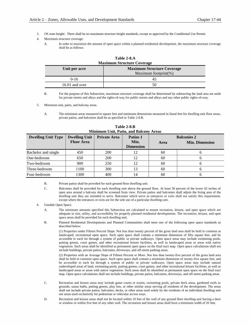
Article 2 – Zones, Allowable Uses, and Development Standards Chapter 17-44
3. OS zone height: There shall be no maximum structure height standards, except as approved by the Conditional Use Permit.
4. Maximum structure coverage:
A. In order to maximize the amount of open space within a planned residential development, the maximum structure coverage
shall be as follows:
Table 2-8.A
Maximum Structure Coverage
Unit per acre Maximum Structure Coverage
Maximum footprint(%)
0-16 45
16.01 and over 50
B. For the purpose of this Subsection, maximum structure coverage shall be determined by subtracting the land area set aside
for private streets and alleys and the rights-of-way for public streets and alleys and any other public rights-of-way.
5. Minimum unit, patio, and balcony areas.
A. The minimum areas measured in square feet and minimum dimensions measured in lineal feet for dwelling unit floor areas,
private patios, and balconies shall be as specified in Table 2-8.B.
Table 2-8.B
Minimum Unit, Patio, and Balcony Areas
Dwelling Unit Type Dwelling Unit
Floor Area
Private Area Patios 1
Min.
Dimension
Balconies 2
Area Min. Dimension
Bachelor and single 450 200 12 60 6
One-bedroom 650 200 12 60 6
Two-bedroom 900 250 12 60 6
Three-bedroom 1100 300 13 60 6
Four-bedroom 1300 400 14 60 6
B. Private patios shall be provided for each ground-floor dwelling unit.
C. Balconies shall be provided for each dwelling unit above the ground floor. At least 50 percent of the lower 42 inches of
open area around a balcony shall be screened from view. Private patios and balconies shall adjoin the living area of the
dwelling unit they are intended to serve. Balconies which serve as entrances or exits shall not satisfy this requirement, except where the entrances or exits are for the sole use of a particular dwelling unit.
6. Useable Open Space.
A. The minimum amounts specified this Subsection are calculated to ensure recreation, leisure, and open space which are adequate in size, utility, and accessibility for properly planned residential developments. The recreation, leisure, and open
space areas shall be provided for each dwelling unit.
B. Planned Residential Developments and Planned Communities shall meet one of the following open space standards as described below:
(1) Properties under Fifteen Percent Slope. Not less than twenty percent of the gross land area shall be held in common as
landscaped, recreational open space. Such open space shall contain a minimum dimension of fifty square feet, and be accessible to each lot through a system of public or private walkways. Open space areas may include swimming pools,
putting greens, court games, and other recreational leisure facilities, as well as landscaped areas or areas with native
vegetation. Such areas shall be identified as permanent open space on the final tract map. Open space calculations shall not
include buildings, private patios, balconies, driveways, and off-street parking areas.
(2) Properties with an Average Slope of Fifteen Percent or More. Not less than twenty-five percent of the gross land area
shall be held in common open space. Such open space shall contain a minimum dimension of twenty-five square feet, and be accessible to each lot through a system of public or private walkways. Open space areas may include natural
undeveloped areas of land, swimming pools, putting greens, court games, and other recreational leisure facilities, as well as
landscaped areas or areas with native vegetation. Such areas shall be identified as permanent open space on the final tract map. Open space calculations shall not include buildings, private patios, balconies, driveways, and off-street parking areas.
C. Recreation and leisure areas may include game courts or rooms, swimming pools, private dock areas, gardened roofs or grounds, sauna baths, putting greens, play lots, or other similar areas serving all residents of the development. The areas
shall not include private patios, balconies, decks, or other areas used solely by the residents of an individual dwelling unit nor areas used exclusively for pedestrian or vehicular access ways.
D. Recreation and leisure areas shall not be located within 10 feet of the wall of any ground floor dwelling unit having a door
or window or within five feet of any other wall. The recreation and leisure areas shall have a minimum width of 20 feet.

Chapter 17-44 — Special Purpose Zones (I-HC, OS, PC, and PF)
E. The minimum square footage requirements for usable open space, as specified in Subsection B., above, shall not satisfy
any requirement of dedication of land or in lieu fees relating to public park and recreational facilities.
F. Private water areas may partially satisfy the open space requirement, but not less than 35 percent of the required open
space for each dwelling unit shall be land area.
G. Enclosed recreation or leisure areas may occupy not more than 15 percent of the square footage required. The remaining area shall be open space.
H. In addition to meeting all other design criteria, attempts shall be made to maximize the number of dwelling units that abut
the usable open space.
I. A recreation area containing at least 10,000 square feet with a minimum dimension of 50 feet and a minimum
average dimension of 100 feet shall be provided and maintained.
2. The area shall be located at least 20 feet away from a structure wall with ground floor windows or doors, and at least five feet from a structure wall with no windows or doors.
J. Special attention shall be given to the placement of tot lots which shall be arranged at convenient locations.
K. Recreation areas shall include appropriate facilities (e.g., swimming pools, tennis courts, basketball courts, putting greens, playground equipment, volleyball courts, lawn bowling, outdoor cooking facilities, etc.)
L. Clubhouse facilities shall be provided in one of the recreation areas, and of sufficient size to accommodate meetings held
by the membership of the homeowners’ association and shall contain other facilities usually associated with a clubhouse
(e.g., kitchens, recreation areas, workshops, lounges, etc.).
Article 2 – Zones, Allowable Uses, and Development Standards Chapter 17.48
Chapter 17.45 Combining/Overlay Zones (FP, GH, HM, and PD)
Sections
17.48.010 Applicability 17.48.020 Purpose and Intent
Applicability 17.45.010
A. Applicability
1. The applicability of any combining/overlay zone to specific sites is illustrated by the overlay
Zoning Map symbol established by Section 17.04.050 (Zones Established).
2. Combining/overlay zones will generally be applied to areas that have different underlying zones,
but have unique features or characteristics that are common to the parcels that are located within
the combining/overlay zone.
B. Identification. Combining/overlay zones shall be identified by suffixing the applicable combining/overlay
letters next to the underlying Zoning Map’s symbol.
C. In the Event of Conflicts. In the event of any conflict between the provisions of this Chapter and any
other provision of Title 17, this Chapter shall control.
Purpose and Intent 17.45.020
The purposes of the individual combining/overlay zones and the manner in which they are applied are as follows:
A. FP Floodplain Overlay Zone. The intent of the Floodplain Overlay zone is to safeguard those areas of
the City subject to periodic flooding and accompanying hazards, with the objective of promoting health,
safety, and general welfare of the people of the City. This overlay zone implements various General Plan
land use designations. The objectives of the Floodplain Overlay zone are:
1. To prohibit occupancy or the encroachment of any structure, improvement, or development that
would obstruct the natural flow of floodwaters within a designated floodway on the floodplain;
2. To keep developments in the remainder of the floodplain above the design flood flow elevation;
and
3. To prevent economic loss caused by excessive flooding and to prevent loss of life or property.
B. GH Geologic Hazards Overlay Zone. The intent of the Geologic Hazards Overlay zone is to provide for
suitable protection for areas subject to the threat of loss, life, and/or personal property due to seismic
shaking and resultant ruptures or ground failure, landslides, and other potential geologic hazards. More
specifically, this overlay zone will allow the City to exercise the mandated approval authority within
special study zones as established by the State Geologist required by the provisions of the Geologic
Hazards Zones Act (Chapter 7.5, Division 2, of the California Public Resources Code). This overlay zone
implements various General Plan land use designations.
C. H Historic Mission Overlay Zone.
1. The intent of the Historic Mission Overlay zone is to accommodate a basic framework for future
development to achieve the following objectives:
Chapter 17-48 Combining/Overlay Zones (FP, GH, HM, and PD)
a. To preserve and enhance the Mission Road area and associated historical and cultural
resources;
b. To preserve and enhance the rural atmosphere of the area;
c. To facilitate the continued use and enjoyment of existing properties by focusing on new
development projects and/or rehabilitation, restoration, and adaptive reuse of historical
and/or cultural resources;
d. To allow for consistent, compatible, and complementary development of the vacant
properties within the Mission Road area; and
e. To encourage pedestrian friendly new development in the area through the incorporation
of livable/walkable community concepts.
2. This overlay zone implements various General Plan land use designations.
D. PD Planned Development Overlay Zone.
1. The intent of the Planned Development Overlay zone is to provide opportunities for nontraditional
approaches to residential development. Using this overlay zone, applicants can craft unique
development standards, provided that the density complies with that established for the underlying
zone and all applicable General Plan policies, and further provided that the development plan:
a. Preserves natural land features, open space, and other valuable and desirable
environmental features of a particular area;
b. Provides for specified community benefits not otherwise required for development in the
underlying zone as a trade-off for deviating from the otherwise applicable development
standards; and
c. Clearly demonstrates compatibility of use with respect to existing and future
developments in the surrounding areas.
d. Provides for specified community benefits not otherwise required for development in the
underlying zone as a trade-off for deviating from the otherwise applicable development
standards; and
e. Clearly demonstrates compatibility of use with respect to existing and future
developments in the surrounding areas.
2. This overlay zone shall only be applied to suitable properties classified in the commercial,
institutional, mixed use, and residential zones. This zone implements various General Plan land
use designations.


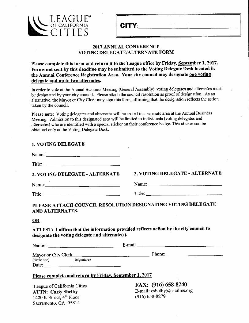

CITY OF LOMA LINDA
CITY COUNCIL AS SUCCESSOR AGENCY TO THE LOMA LINDA REDEVELOPMENT AGENCY
AGENDA
REGULAR MEETING OF June 13, 2017
A regular meeting of the City Council of the City of Loma Linda as successor agency to the Loma Linda Redevelopment Agency is scheduled to be held Tuesday, June 13, 2017 in the City Council Chamber, 25541 Barton Road, Loma Linda, California. Pursuant to Municipal Code Section 2.08.010, study session or closed session items may begin at 5:30 p.m. or as soon thereafter as possible. The public meeting begins at 7:00 p.m.
In acting in the limited capacity of Successor Agency as provided in California Health
and Safety Code §§ 34173 and 34176, the City Council expressly determines, recognizes,
reaffirms, and ratifies the statutory limitation on the City and the City Council's liability
with regards to the responsibilities of the former Loma Linda Redevelopment Agency
under AB 1X26. Nothing herein shall be construed as an action, commitment, obligation,
or debt of the City itself, or a commitment of any resources, funds, or assets of the City to
fund the City's limited capacity as the Successor Agency to the Loma Linda
Redevelopment Agency. Obligations of the Successor Agency shall be funded solely by
those funds or resources provided for that purpose pursuant to AB 1X26 and related
statutes.
Reports and Documents relating to each agenda item are on file in the Office of the City Clerk and are available for public inspection during normal business hours. The Loma Linda Branch Library is also provided an agenda packet for your convenience. The agenda and reports are also located on the City’s Website at www.lomalinda-ca.gov. Materials related to an item on this Agenda submitted to the City Council after distribution of the agenda
packet are available for public inspection in the City Clerk’s Office, 25541 Barton Road, Loma Linda, CA
during normal business hours. Such documents are also available on the City’s website at
www.lomalinda-ca.gov subject to staff’s ability to post the documents before the meeting. Persons wishing to speak on an agenda item, including any closed session items, are asked to complete an information card and present it to the City Clerk prior to consideration of the item. When the item is to be considered, please step forward to the podium, the Chair will recognize you and you may offer your comments. The City Council meeting is recorded to assist in the preparation of the Minutes, and you are therefore asked to give your name and address prior to offering testimony. The Oral Reports/Public Participation portion of the agenda pertains to items NOT on the agenda and is limited to 30 minutes; 3 minutes allotted for each speaker. Pursuant to the Brown Act, no action may be taken by the City Council at this time; however, the City Council may refer your comments/concerns to staff or request that the item be placed on a future agenda. In compliance with the Americans with Disabilities Act, if you need special assistance to participate in
this meeting, please contact the City Clerk at (909) 799-2819. Notification 48 hours prior to the meeting
will enable the City to make reasonable arrangements to ensure accessibility to this meeting. Later
requests will be accommodated to the extent feasible. Agenda item requests for the July 11. 2017 meeting must be submitted in writing to the City Clerk no later than NOON, TUESDAY, June 27, 2017

A. Call To Order B. Roll Call C. Closed Session D. Items To Be Added Or Deleted E. Oral Reports/Public Participation - Non-Agenda Items (Limited to 30 minutes; 3 minutes
allotted for each speaker) F. Conflict of Interest Disclosure - Note agenda item that may require member abstentions due to
possible conflicts of interest G. Scheduled and Related Items H. Consent Calendar 1. Demands Register 2. Minutes of May 9, 2017 I. Old Business J. New Business K. Adjournment
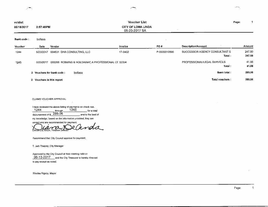

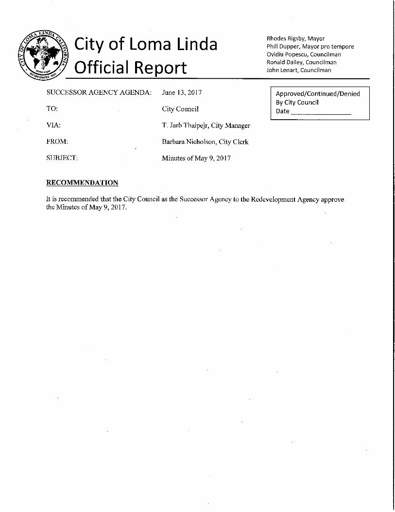


LOMA LINDA HOUSING AUTHORITY
AGENDA
REGULAR MEETING OF JUNE 13, 2017 A regular meeting of the Housing Authority of the City of Loma Linda is scheduled to be held at 7:00 p.m. or as soon thereafter as possible, Tuesday, June 13, 2017 in the City Council Chamber, 25541 Barton Road, Loma Linda, California. Reports and Documents relating to each agenda item are on file in the Office of the City Clerk and are available for public inspection during normal business hours. The Loma Linda Branch Library is also provided an agenda packet for your convenience. The agenda and reports are also located on the City’s Website at www.lomalinda-ca.gov. Materials related to an item on this Agenda submitted to the Housing Authority Board after distribution
of the agenda packet are available for public inspection in the City Clerk’s Office, 25541 Barton Road,
Loma Linda, CA during normal business hours. Such documents are also available on the City’s website
at www.lomalinda-ca.gov subject to staff’s ability to post the documents before the meeting. Persons wishing to speak on an agenda item are asked to complete an information card and present it to the City Clerk prior to consideration of the item. When the item is to be considered, please step forward to the podium, the Chair will recognize you and you may offer your comments. The Housing Authority meeting is recorded to assist in the preparation of the Minutes, and you are therefore asked to give your name and address prior to offering testimony. The Oral Reports/Public Participation portion of the agenda pertains to items NOT on the agenda and is limited to 30 minutes; 3 minutes allotted for each speaker. Pursuant to the Brown Act, no action may be taken by the Housing Authority at this time; however, the Housing Authority Board may refer your comments/concerns to staff or request that the item be placed on a future agenda. In compliance with the Americans with Disabilities Act, if you need special assistance to participate in
this meeting, please contact the City Clerk at (909) 799-2819. Notification 48 hours prior to the meeting
will enable the City to make reasonable arrangements to ensure accessibility to this meeting. Later
requests will be accommodated to the extent feasible. Agenda item requests for the July 11, 2017 meeting must be submitted in writing to the City Clerk no later than noon, Tuesday June 27, 2017 A. Call To Order B. Roll Call C. Items To Be Added Or Deleted D. Oral Reports/Public Participation - Non-Agenda Items (Limited to 30 minutes; 3 minutes
allotted for each speaker) E. Conflict of Interest Disclosure - Note agenda item that may require member abstentions due to
possible conflicts of interest
F. Scheduled Items

G. Consent Calendar 1. Demands Register 2. Minutes of May 9, 2017 3. LLHA Bill #R-2017-02 – Approving a Modification Agreement of loan for 25474 Sonora
Loop and request to waive $500 fee for document preparation and processing [Secretary] H. New Business
I. Chair and Member Reports J. Reports of Officers K. Adjournment


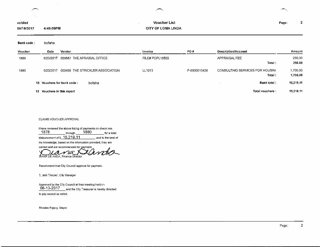
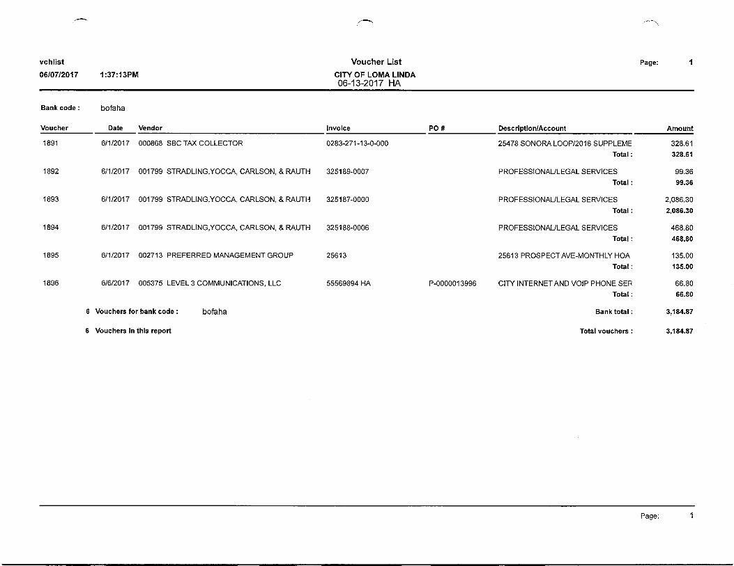


City of Loma Linda Official Report
HOUSING AUTHORITY AGENDA: June 13, 2017
TO: Housing Authority
FROM: Barbara Nicholson, Secretary
VIA: T. Jarb Thaipejr, Executive Director
SUBJECT: Modification of loan for 25474 Sonora Loop and request to waive $500 fee for
document preparation and processing
RECOMMENDATION
It is recommended that the Housing Authority Board adopt the attached Resolution No. LLHA Bill #R-
2017-02 authorizing modification of the loan for 25474 Sonora Loop and waiver of the document
preparation and processing fee of $500.00.
BACKGROUND
The owner of 25474 Sonora Loop has become delinquent in payment of the loan financed by the Housing
Authority due to health problems experienced by two of her children. The children’s illness required her
to miss work in order to provide for their care. The children’s issues are now resolved and she has
returned to full-time employment. During her time off work, she became delinquent and incurred late
payment penalties.
The options of restructuring the loan as well as providing the Housing Authority with a Deed in Lieu of
payment were discussed with the owner. She has requested that the Housing Authority consider
modification of the loan. Property taxes are current in that there were adequate funds in the Impound
Account for payment. The principal balance of the existing loan is $154,809.03.
ANALYSIS
The terms of the existing loan of $160,000 were 30-years at a fixed interest rate of 5.084 percent. The
new loan would be in the amount of $173,080.36 for 26 years at a fixed interest rate of 3.72 percent;
however in the event of default or an event of acceleration, interest commences to accrue at the rate equal
to the lesser of 10 percent simple per annum or the highest rate of interest that may be charged by a
housing authority. The owner is also required to make three equal deposits to the Impound Account of
$656.15 by September 15 to assure an adequate amount available to pay the property taxes due in
December 2017. The owner is requesting waiver of the $500 document preparation and processing fee.
FINANCIAL IMPACT
Account Number 80-1800-8835. Minor cost related to legal and title charges to conclude the transaction.
Rhodes Rigsby, Chairman Ovidiu Popescu, Vice-Chairman Ronald Dailey, Member Phillip Dupper, Member John Lenart, Member
Approved/Continued/Denied By Housing Authority Date _________________
LLHA Bill #R-2017-02
RESOLUTION NO. ____
A RESOLUTION OF THE LOMA LINDA HOUSING AUTHORITY
APPROVING A MODIFICATION AGREEMENT AMENDING DEED OF
TRUST AND A 2017 AMENDED SECOND NOTE IN CONNECTION WITH
PROPERTY PREVIOUSLY PURCHASED BY DINA JARAMILLO FROM
THE LOMA LINDA REDEVELOPMENT AGENCY
(25474 Sonora Loop)
WHEREAS, California Health and Safety Code Sections 33334.2 and 33334.6 formerly
authorized and directed the Loma Linda Redevelopment Agency (the “Redevelopment Agency”) to
expend a certain percentage of all taxes which are allocated to the Redevelopment Agency pursuant
to Section 33670 for the purposes of increasing, improving and preserving the community’s supply
of low and moderate income housing available at affordable housing cost to persons and families of
low- and moderate-income, lower income, and very low income; and
WHEREAS, pursuant to applicable law the Redevelopment Agency established a Low and
Moderate Income Housing Fund (the “Housing Fund”); and
WHEREAS, pursuant to Health and Safety Code Section 33334.2(e), in carrying out its
affordable housing activities, the Redevelopment Agency sold to Dino Jaramillo, a single woman
(“Participant”) property located at 25474 Sonora Loop (the “Property”) under an agreement dated as
of June 9, 2009 between the Participant and the Redevelopment Agency (the “Housing Disposition
Agreement”). As part of the Housing Disposition Agreement, Participant was obligated to pay a
purchase price primarily by means of two promissory notes in the forms of Attachment No. 3 (the
“Original First Note”) and Attachment No. 9 (the “Original Second Note” and, together with the
Original First Note, the “Original Notes”) to the Housing Disposition Agreement. The Original First
Note was secured by a deed of trust recorded among the official land records of the County Recorder
of the County of San Bernardino (“Official Records”) as Document No. 2009-0289039 (the “Original
First Deed of Trust”). The Original Second Note was secured by a deed of trust recorded among the
Official Records as Document No. 2009-0289041 (the “Original Second Deed of Trust”); and
WHEREAS, the Redevelopment Agency, along with all redevelopment agencies in the State
of California, was dissolved pursuant to ABx1 26, Chapter 5, Statutes of 2011 (the “Dissolution
Law”). In connection with the Dissolution Law and various actions taken by the City Council of the
City of Loma Linda (the “City”), the housing assets of the Redevelopment Agency, including
without limitation the right to receive payment under the Original Notes as well as all rights formerly
held by the Redevelopment Agency under the Housing Disposition Agreement, were transferred to
the Loma Linda Housing Authority (the “Housing Authority”); and
WHEREAS, the Housing Authority and Participant entered into an agreement dated as of
August 27, 2013 entitled “Amended and Restated Homebuyer Loan Agreement” (the “2013
Agreement”) under which the terms of Second Note were amended and restated (as restated, the
“2013 Amended Second Note”, which : the terms of the Original First Note remained the same. In
connection with the modification of the Second Note by the 2013 Amended Second Note, the
Participant and Housing Authority executed an instrument entitled “Modification Agreement
Amending Deed of Trust” dated as of August 27, 2013 and recorded among the Official Records as
Document No. 2013-0400878 (the “2013 Modification Agreement”); and

Resolution No.
Page 2
2
WHEREAS, subsequent to the approval of the 2013 Agreement, Participant encountered
various hardship situations. In view of those situations, Participant requested that the Housing
Authority amend and restructure the 2013 Amended Second Note. Upon review of the unique facts
and circumstances pertaining to Participant, Housing Authority staff recommends that the Housing
Authority agree to modify the terms of the 2013 Amended Second Note as set forth in the form of
“Modification Agreement Amending Deed of Trust” (the “2017 Trust Deed Modification”) and the
form of promissory note entitled “2017 Amended Second Note” (the “2017 Amended Second Note”)
substantially in the forms submitted herewith. The terms of the Original First Note would remain
unchanged and the Property would remain subject to covenants of record; and
WHEREAS, the Housing Disposition Agreement provides for Participant to pay a processing
fee of Five Hundred Dollars ($500.00) (the “Processing Fee”) in the event loan modification is to be
considered; and
WHEREAS, Participant has requested that, based upon the unique facts and circumstances of
Participant, that Housing Authority waive collection of the Processing Fee; and
WHEREAS, the Housing Authority has duly considered all terms and conditions of the
proposed 2017 Trust Deed Modification and the 2017 Amended Second Note (together, the
“Instruments”) and believes that the approval and implementation of such Instruments is in the best
interests of the Housing Authority and the City and the health, safety, and welfare of its residents,
and in accord with the public purposes and provisions of applicable State and local law requirements;
and
WHEREAS, all actions required by all applicable law with respect to the proposed actions
have been taken in an appropriate and timely manner.
NOW, THEREFORE, THE LOMA LINDA HOUSING AUTHORITY DOES RESOLVE
AS FOLLOWS:
Section 1. The Housing Authority finds and determines that each of the Recitals is true
and correct.
Section 2. The Housing Authority finds and determines that, based upon substantial
evidence provided in the record before it, the approval and implementation of the Instruments will
further the objectives of the Housing Authority.
Section 3. The Housing Authority hereby approves the Instruments in substantially the
form presented to the Housing Authority, subject to such revisions as may be made by the Executive
Director of the Housing Authority or his designee. The Housing Authority approves the waiver of
the Processing Fee, on a one-time basis, in connection with the approval of the Instruments and their
implementation. The Executive Director of the Housing Authority is hereby authorized to execute
the 2017 Trust Deed Modification on behalf of the Housing Authority, together with any instruments
necessary or convenient to implement the Instruments. A copy of the Instruments shall, when
executed, be placed on file in the office of the Secretary of the Housing Authority.
Section 4. The Executive Director of the Housing Authority (or his designee) is hereby
authorized, on behalf of the Housing Authority, to make revisions to the Agreement which do not
materially or substantially increase any obligations of the Housing Authority or reduce the
Resolution No.
Page 3
3
consideration payable to the Housing Authority under the Instruments, to sign all documents, to
make all approvals and take all actions necessary or appropriate to carry out and implement the
Instruments and to administer the Redevelopment Agency’s obligations, responsibilities and duties to
be performed under the Agreement and related documents.
APPROVED AND ADOPTED this 13th day of June, 2017.
By:
Chairman
ATTEST:
Barbara Nicholson
Housing Authority Secretary
STATE OF CALIFORNIA )
COUNTY OF SAN BERNARDINO )
CITY OF LOMA LINDA )
I, Barbara Nicholson, Secretary of the Loma Linda Housing Authority, do hereby certify that the
foregoing Resolution No. ____ was introduced and adopted at a regular meeting provided by law of
the Loma Linda Housing Authority held on the 9th day of May, 2017, by the following vote of the
members thereof:
AYES: HOUSING AUTHORITY MEMBERS:
NOES: HOUSING AUTHORITY MEMBERS:
ABSENT: HOUSING AUTHORITY MEMBERS:
ABSTAIN: HOUSING AUTHORITY MEMBERS:

1
RECORDING REQUESTED BY AND
WHEN RECORDED MAIL TO:
LOMA LINDA HOUSING AUTHORITY
25541 Barton Road
Loma Linda, California 92354
Attention: Executive Director
[Space above for recorder.]
This document is exempt from the payment of
a recording fee pursuant to Government Code
Section Government Code Section 6103 and
Revenue and Taxation Code Section 11922.
MODIFICATION AGREEMENT AMENDING DEED OF TRUST
The undersigned agree per this Modification Agreement Amending Deed of Trust
(“Modification Agreement”) which is dated as of May 1, 2017, that certain promissory note dated as
of June 1, 2009 as amended August 27, 2013 (as so amended, the “2013 Agency Second Note”),
which was in the original principal amount of One Hundred Sixty Four Thousand Dollars ($164,000)
(the “Prior Note Amount”) executed by DINA JARAMILLO, as “Maker” or “Trustor” in favor of
the LOMA LINDA REDEVELOPMENT AGENCY, a public body, corporate and politic (the
“Former Holder”), whose interests under such Agency Second Note have succeeded to the LOMA
LINDA HOUSING AUTHORITY, a public body corporate and politic (the “Holder” or
“Beneficiary”) has been amended and restated in that promissory note of even date herewith (the
“2017 Amended Second Note”), which 2017 Amended Second Note: (i) modifies the principal
amount from the Prior Note Amount to One Hundred Seventy Three Thousand Eighty Dollars and
Thirty Six Cents ($173,080.36) (the “2017 Amended Second Loan Amount”), and (ii) modifies the
scheduled monthly payments thereunder to the sum of Eight Hundred Sixty One Dollars and Fifty
One Cents ($861.51) per month (the “2017 Revised Second Payment Amount”).

2
The 2013 Second Note was secured, and upon recordation hereof the 2017 Amended Second
Note shall be secured, by that certain deed of trust (the “Original Second Trust Deed”) dated as of
June 1, 2009 executed by Maker, as “Trustor” in favor of the Former Holder, recorded July 1, 2009
as Document No. 2009-0289041, in the Official Records in the Office of the County Recorder of San
Bernardino County, California (“Official Records”), as modified by that certain agreement between
Holder and Maker which was entitled “Modification Agreement Amending Deed of Trust” and
which was recorded among Official Records on September 11, 2013 as Document No. 2013-0400878
(the “2013 Modification”).
Upon recordation of this Modification Agreement, the Original Second Trust Deed, as
modified by the 2013 Modification, shall be modified to provide for the 2017 Amended Second Loan
Amount and the 2017 Revised Second Payment Amount as set forth above.
It is expressly agreed and acknowledged that the Original Second Trust Deed, as modified by
the 2013 Modification and this Modification Agreement, shall not be reconveyed prior to September
1, 2043 without regard to payments having been made, in any amount, under the 2017 Amended
Second Note, it being expressly acknowledged that the Housing Authority Second Trust Deed (as
originally recorded and as modified hereunder) secures the ongoing performance (including as to the
limitation of use of the Property to Eligible Persons and Households at Affordable Housing Cost) as
provided under each of (i) the Housing Disposition Agreement by and between Maker and Former
Holder dated as of June 9, 2009, (ii) an Amended and Restated Homebuyer Loan Agreement by and
between Maker and Holder dated as of August 27, 2013, (iii) covenants under that certain deed dated
as of June 1, 2009, recorded on July 1, 2009 among the official land records of San Bernardino
County as Document No. 2009-0289039; and (iv) that certain option agreement dated as of June 1,
2009, recorded on July 1, 2009 among the official land records of San Bernardino County as
Document No. 2009-0289040; each of which items (i) to (iv), inclusive, is on file with the Housing
Authority as a public record and is incorporated herein by reference.
(signatures on following page)
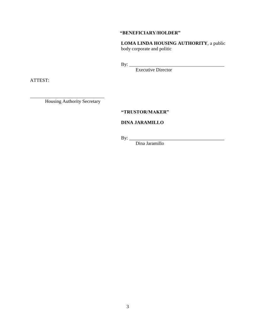
3
“BENEFICIARY/HOLDER”
LOMA LINDA HOUSING AUTHORITY, a public
body corporate and politic
By:
Executive Director
ATTEST:
Housing Authority Secretary
“TRUSTOR/MAKER”
DINA JARAMILLO
By:
Dina Jaramillo
STATE OF CALIFORNIA )
) ss.
COUNTY OF ____________ )
On ___________________________ , before me, ______________________________ , Notary Public, (Print Name of Notary Public)
personally appeared
who proved to me on the basis of satisfactory evidence to be the person(s) whose name(s)
is/are subscribed to the within instrument and acknowledged to me that he/she/they executed
the same in his/her/their authorized capacity(ies), and that by his/her/their signature(s) on the
instrument the person(s), or the entity upon behalf of which the person(s) acted, executed the
instrument.
I certify under PENALTY OF PERJURY under the laws of the State of California that the
foregoing paragraph is true and correct.
WITNESS my hand and official seal.
Signature of Notary Public
OPTIONAL
Though the data below is not required by law, it may prove valuable to persons relying on the document and could prevent
fraudulent reattachment of this form.
CAPACITY CLAIMED BY SIGNER DESCRIPTION OF ATTACHED DOCUMENT
Individual
Corporate Officer
___________________________________________________________
Title(s) ___________________________________________________________
Title Or Type Of Document
Partner(s) Limited
General
Attorney-In-Fact
Trustee(s)
Guardian/Conservator
Other: _____________________________________ Signer is representing: Name Of Person(s) Or Entity(ies)
___________________________________________________________
___________________________________________________________
___________________________________________________________ Number Of Pages
___________________________________________________________
Date Of Documents
___________________________________________________________
Signer(s) Other Than Named Above

ATTACHMENT NO. 1
DESCRIPTION OF THE PROPERTY
Lot 41 of Tract 15917 in the City of Loma Linda, County of San Bernardino, State of California, as per plat
recorded in Book 275 of Maps, Pages 31 – 37, inclusive, in the Office of the County Recorder of said County.
APN: 0283-271-12-0-000
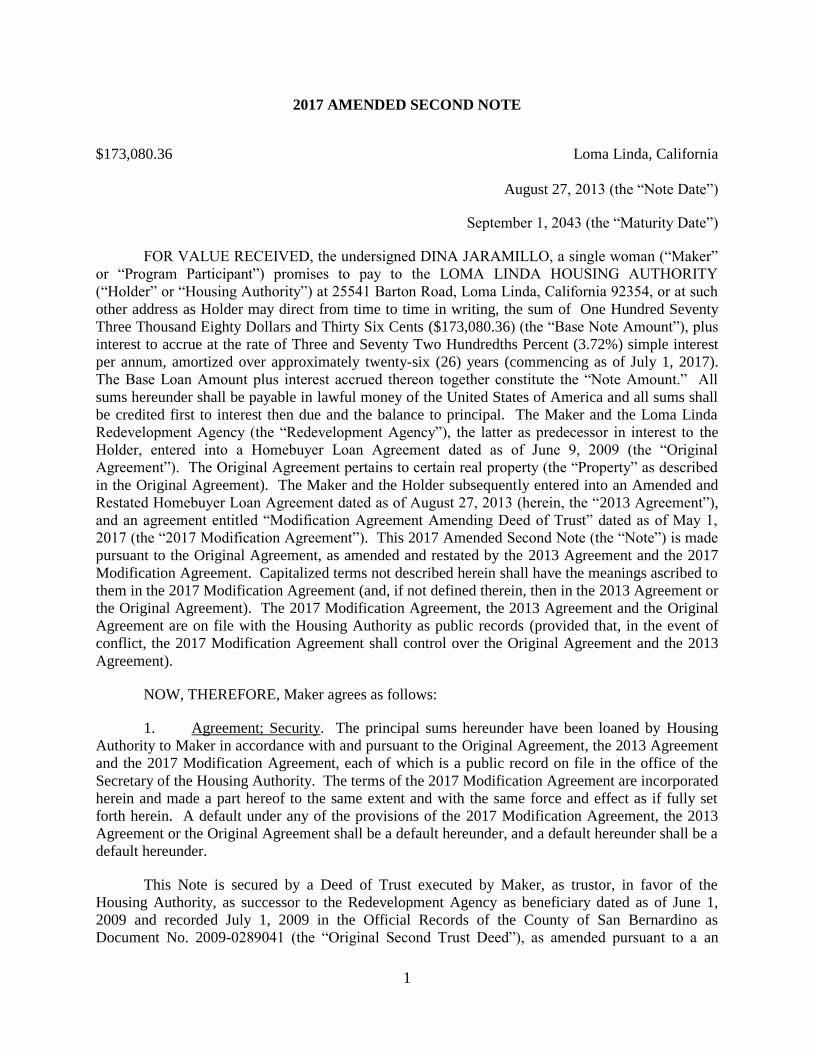
1
2017 AMENDED SECOND NOTE
$173,080.36 Loma Linda, California
August 27, 2013 (the “Note Date”)
September 1, 2043 (the “Maturity Date”)
FOR VALUE RECEIVED, the undersigned DINA JARAMILLO, a single woman (“Maker”
or “Program Participant”) promises to pay to the LOMA LINDA HOUSING AUTHORITY
(“Holder” or “Housing Authority”) at 25541 Barton Road, Loma Linda, California 92354, or at such
other address as Holder may direct from time to time in writing, the sum of One Hundred Seventy
Three Thousand Eighty Dollars and Thirty Six Cents ($173,080.36) (the “Base Note Amount”), plus
interest to accrue at the rate of Three and Seventy Two Hundredths Percent (3.72%) simple interest
per annum, amortized over approximately twenty-six (26) years (commencing as of July 1, 2017).
The Base Loan Amount plus interest accrued thereon together constitute the “Note Amount.” All
sums hereunder shall be payable in lawful money of the United States of America and all sums shall
be credited first to interest then due and the balance to principal. The Maker and the Loma Linda
Redevelopment Agency (the “Redevelopment Agency”), the latter as predecessor in interest to the
Holder, entered into a Homebuyer Loan Agreement dated as of June 9, 2009 (the “Original
Agreement”). The Original Agreement pertains to certain real property (the “Property” as described
in the Original Agreement). The Maker and the Holder subsequently entered into an Amended and
Restated Homebuyer Loan Agreement dated as of August 27, 2013 (herein, the “2013 Agreement”),
and an agreement entitled “Modification Agreement Amending Deed of Trust” dated as of May 1,
2017 (the “2017 Modification Agreement”). This 2017 Amended Second Note (the “Note”) is made
pursuant to the Original Agreement, as amended and restated by the 2013 Agreement and the 2017
Modification Agreement. Capitalized terms not described herein shall have the meanings ascribed to
them in the 2017 Modification Agreement (and, if not defined therein, then in the 2013 Agreement or
the Original Agreement). The 2017 Modification Agreement, the 2013 Agreement and the Original
Agreement are on file with the Housing Authority as public records (provided that, in the event of
conflict, the 2017 Modification Agreement shall control over the Original Agreement and the 2013
Agreement).
NOW, THEREFORE, Maker agrees as follows:
1. Agreement; Security. The principal sums hereunder have been loaned by Housing
Authority to Maker in accordance with and pursuant to the Original Agreement, the 2013 Agreement
and the 2017 Modification Agreement, each of which is a public record on file in the office of the
Secretary of the Housing Authority. The terms of the 2017 Modification Agreement are incorporated
herein and made a part hereof to the same extent and with the same force and effect as if fully set
forth herein. A default under any of the provisions of the 2017 Modification Agreement, the 2013
Agreement or the Original Agreement shall be a default hereunder, and a default hereunder shall be a
default hereunder.
This Note is secured by a Deed of Trust executed by Maker, as trustor, in favor of the
Housing Authority, as successor to the Redevelopment Agency as beneficiary dated as of June 1,
2009 and recorded July 1, 2009 in the Official Records of the County of San Bernardino as
Document No. 2009-0289041 (the “Original Second Trust Deed”), as amended pursuant to a an
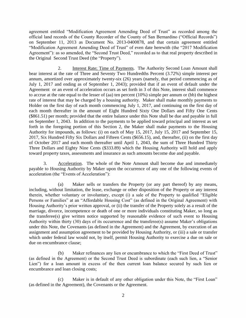
2
agreement entitled “Modification Agreement Amending Deed of Trust” as recorded among the
official land records of the County Recorder of the County of San Bernardino (“Official Records”)
on September 11, 2013 as Document No. 2013-0400878, and that certain agreement entitled
“Modification Agreement Amending Deed of Trust” of even date herewith (the “2017 Modification
Agreement”): as so amended, the “Second Trust Deed,” recorded as to that real property described in
the Original Second Trust Deed (the “Property”).
2. Interest Rate; Time of Payments. The Authority Second Loan Amount shall
bear interest at the rate of Three and Seventy Two Hundredths Percent (3.72%) simple interest per
annum, amortized over approximately twenty-six (26) years (namely, that period commencing as of
July 1, 2017 and ending as of September 1, 2043); provided that if an event of default under the
Agreement or an event of acceleration occurs as set forth in 3 of this Note, interest shall commence
to accrue at the rate equal to the lesser of (aa) ten percent (10%) simple per annum or (bb) the highest
rate of interest that may be charged by a housing authority. Maker shall make monthly payments to
Holder on the first day of each month commencing July 1, 2017, and continuing on the first day of
each month thereafter in the amount of Eight Hundred Sixty One Dollars and Fifty One Cents
($861.51) per month; provided that the entire balance under this Note shall be due and payable in full
on September 1, 2043. In addition to the payments to be applied toward principal and interest as set
forth in the foregoing portion of this Section 2, the Maker shall make payments to the Housing
Authority for impounds, as follows: (i) on each of May 15, 2017, July 15, 2017 and September 15,
2017, Six Hundred Fifty Six Dollars and Fifteen Cents ($656.15), and, thereafter, (ii) on the first day
of October 2017 and each month thereafter until April 1, 2043, the sum of Three Hundred Thirty
Three Dollars and Eighty Nine Cents ($333.89) which the Housing Authority will hold and apply
toward property taxes, assessments and insurance as such amounts become due and payable.
3. Acceleration. The whole of the Note Amount shall become due and immediately
payable to Housing Authority by Maker upon the occurrence of any one of the following events of
acceleration (the “Events of Acceleration”):
(a) Maker sells or transfers the Property (or any part thereof) by any means,
including, without limitation, the lease, exchange or other disposition of the Property or any interest
therein, whether voluntary or involuntary, except (i) a sale of the Property to qualified “Eligible
Persons or Families” at an “Affordable Housing Cost” (as defined in the Original Agreement) with
Housing Authority’s prior written approval, or (ii) the transfer of the Property solely as a result of the
marriage, divorce, incompetence or death of one or more individuals constituting Maker, so long as
the transferee(s) give written notice supported by reasonable evidence of such event to Housing
Authority within thirty (30) days of its occurrence and the transferee(s) assume Maker’s obligations
under this Note, the Covenants (as defined in the Agreement) and the Agreement, by execution of an
assignment and assumption agreement to be provided by Housing Authority, or (iii) a sale or transfer
which under federal law would not, by itself, permit Housing Authority to exercise a due on sale or
due on encumbrance clause;
(b) Maker refinances any lien or encumbrance to which the “First Deed of Trust”
(as defined in the Agreement) or the Second Trust Deed is subordinate (each such lien, a “Senior
Lien”) for a loan amount in excess of the then current loan balance secured by such lien or
encumbrance and loan closing costs;
(c) Maker is in default of any other obligation under this Note, the “First Loan”
(as defined in the Agreement), the Covenants or the Agreement.

3
At the request of Maker, and for a specific occasion, Housing Authority may, in its
sole and absolute discretion, in writing waive the requirements of this section (2) and defer
repayment of the Note Amount and/or extend the term of this Note. Any waiver or deferment shall
be on a case by case basis, and no future rights for waiver or deferment shall arise or be implied.
3. Prepayment. Participant may prepay amounts under this Note. In any event, the
restrictions of the Covenants shall continue in full force and effect, notwithstanding any such
prepayment or other payments without regard to amount.
4. Assumption Under the Note. This Note may be assumed by a qualified subsequent
purchaser of the Property only with the prior written approval of the Housing Authority.
5. [Intentionally Omitted].
6. Maker’s Waivers. Maker waives any rights to require Housing Authority to: (i)
demand payment of amounts due (known as “presentment”), (ii) give notice that amounts due have
not been paid (known as “notice of dishonor”) and (iii) obtain an official certification of nonpayment
(known as “protest”).
7. Repayment Under the Promissory Note. If there is an event of acceleration pursuant
to Section 2 above, Maker shall pay in full all amounts due under this Note.
8. Note Amount Due In Full. The whole of the Note Amount shall be due in full when
an event of acceleration occurs. After paying all costs and fees relating to the transaction, if any
(such as escrow fees, transfer taxes, recording fees, brokerage commissions and similar costs), the
proceeds of any such transaction (or, in the case of any event of acceleration other than a sale, an
amount representing the appraised value of the Property as determined by a good faith estimate by
the Housing Authority or an appraiser retained for such purpose by the Housing Authority) shall be
distributed or applied in the following order of priority:
(a) Repayment of the senior loan with respect to which the Housing Authority
has affirmatively subordinated the lien of the Second Trust Deed by recorded instrument recorded on
or after the Note Date;
(b) Repayment to Housing Authority of any other amounts payable under this
Note.
(c) Maker agrees and acknowledges that the Second Trust Deed shall secure, in
addition to any other obligations secured thereby, the payment and performance by Maker of all
obligations under this Second Note, together with interest and other charges thereon and any and all
amendments, modifications, extensions and renewals thereof, whether or not any such amendment,
modification, extension or renewal is evidenced by a new or additional promissory note or notes. In
addition to amounts which become due under this Second Note, the Second Trust Deed secures
performance of affordability requirements as referenced therein. Consequently, the Second Trust
Deed shall remain of record and shall not be reconveyed without regard to whether the Note Amount
has been paid in full. In addition, any failure to cause the Property to be used in conformity with this
Agreement (including without limitation the Covenants, the Modification Agreement and the Second
Trust Deed) shall result in the availability of remedies in favor of the Housing Authority to recover
for the cost to the Housing Authority to create another affordable unit for a period of time equal to
4
the Affordability Period (which shall be without limitation to the ability of the Housing Authority to
recover under the First Note and the Second Note). The Housing Authority shall make a
determination as to what amounts are due and payable to the Housing Authority under this subsection
(d).
(e) The remainder of the proceeds of sale, should any remain after item (d), shall
be released to Maker.
9. Holder May Assign. Holder may, at its option, assign its right to receive payment
under this Note without necessity of obtaining the consent of the Maker.
10. Maker Assignment Prohibited. In no event shall Maker assign or transfer any portion
of this Note or the Agreement without the prior express written consent of the Holder, which consent
may be given or withheld in the Holder’s sole discretion. Likewise, no assumption of the Second
Loan shall be permitted at any time. This Section shall not prohibit the Holder’s right to assign all or
any portion of its rights to the loan proceeds hereunder.
11. Attorneys’ Fees and Costs. In the event that any action is instituted to enforce
payment under this Note, the Maker promises to pay such sums as a court may fix for court costs and
reasonable attorneys’ fees.
12. Non-Waiver. Failure or delay in giving any notice required hereunder shall not
constitute a waiver of any default or late payment, nor shall it change the time for any default or
payment.
13. Successors Bound. This Promissory Note shall be binding upon the parties hereto
and their respective heirs, successors and assigns.
14. Usury. It is the intention of Maker and Housing Authority to conform strictly to the
Interest Law, as defined below, applicable to this loan transaction. Accordingly, it is agreed that
notwithstanding any provision to the contrary in this Note, or in any of the documents securing
payment hereof or otherwise relating hereto, the aggregate of all interest and any other charges or
consideration constituting interest under the applicable Interest Law that is taken, reserved,
contracted for, charged or received under this Note, or under any of the other aforesaid agreements or
otherwise in connection with this loan transaction, shall under no circumstances exceed the
maximum amount of interest allowed by the Interest Law applicable to this loan transaction. If any
excess of interest in such respect is provided for in this Note, or in any of the documents securing
payment hereof or otherwise relating hereto, then, in such event: the provisions of this paragraph
shall govern and control; neither Maker nor Maker’s heirs, legal representatives, successors or
assigns shall be obligated to pay the amount of such interest to the extent that it is in excess of the
maximum amount of interest allowed by the Interest Law applicable to this loan transaction; any
excess shall be deemed canceled automatically and, if theretofore paid, shall be credited on this Note
by Housing Authority or, if this Note shall have been paid in full, refunded to Maker; and the
effective rate of interest shall be automatically subject to reduction to the Maximum Legal Rate of
Interest (as defined below), allowed under such Interest Law, as now or hereafter construed by courts
of appropriate jurisdiction. To the extent permitted by the Interest Law applicable to this loan
transaction, all sums paid or agreed to be paid to Housing Authority for the use, forbearance or
detention of the indebtedness evidenced hereby shall be amortized, prorated, allocated and spread
throughout the full term of this Note. For purposes of this Note, “Interest Law” shall mean any

5
present or future law of the State of California, the United States of America, or any other
jurisdiction which has application to the interest and other charges under this Note. The “Maximum
Legal Rate of Interest” shall mean the maximum rate of interest that Housing Authority may from
time to time charge Maker, and under which Maker would have no claim or defense of usury under
the Interest Law.
15. Restatement of the Agency Second Note. This Note is an amendment and
restatement of that certain promissory note dated as of June 1, 2009, executed by Maker, in favor of
the Redevelopment Agency in the original principal amount of $164,000.00 (the “Agency Second
Note”), to which the Housing Authority has succeeded as beneficiary), and shall replace the Agency
Second Note in its entirety; provided all provisions of the Original Agreement (except to the extent
superseded by the Agreement) and the Covenants shall remain in full force and effect.
16. Ratification of Agreement and Restrictions. The Maker expressly acknowledges,
ratifies and affirms that the Original Agreement (except to the extent amended by this Agreement)
and the restrictions concerning affordability, affordable housing cost and occupancy by owner
occupant remain in full force and effect, as shall the Option Agreement, and the Housing Authority
shall retain all remedies in connection therewith as well as those remedies available in connection
with this Note.
17. Miscellaneous. Time is of the essence hereof. If this Note is now, or hereafter shall
be, signed by more than one party or person, it shall be the joint and several obligation of such parties
or persons (including, without limitation, all makers, endorsers, guarantors and sureties), and shall be
binding upon such parties and upon their respective successors and assigns. This Note shall be
governed by and construed under the laws of the State of California. Developer irrevocably and
unconditionally submits to the jurisdiction of the Superior Court of the State of California for the
County of San Bernardino or the United States District Court of the Central District of California, as
Housing Authority hereof may deem appropriate, in connection with any legal action or proceeding
arising out of or relating to this Note. Maker also waives any objection regarding personal or in rem
jurisdiction or venue.
“MAKER”
DINA JARAMILLO
By:
Printed Name: Dina Jaramillo

1 (Lower Income)
jaramillo_regulation_z_disclosure_statement.docx
TRUTH-IN-LENDING
REGULATION Z DISCLOSURE STATEMENT
FOR THE LOMA LINDA HOUSING AUTHORITY
AUTHORITY FIRST LOAN
Date: May _______, 2017
Annual
Percentage Rate
Finance
Charge
Amount
Financed
Total of
Payments
The cost of your loan
as a yearly rate
(interest).
The dollar amount the
loan will cost you
(total accrued
interest).
The amounts payable
under the Promissory
Note) provided to you
or on your behalf.
The amount you have
paid after you have
made all payments as
scheduled.
3.72% simple interest
$98,294.02. $173.080.36 $271,374.38
*NOTE: THE PROVISIONS HEREOF DO NOT INCLUDE REFERENCE TO THE
SEPARATE AUTHORITY FIRST LOAN IN THE PRINCIPAL AMOUNT OF $80,300; A
SEPARATE DISCLOSURE STATEMENT HAS BEEN PROVIDED FOR THAT
PURPOSE.
Creditor: LOMA LINDA HOUSING AUTHORITY
25541 Barton Road
Loma Linda, California 92354
Borrower: Dina Jaramillo
25474 Sonora Loop
Loma Linda, California 92354
Itemization of Amount Financed: You have the right to receive at this time an
itemization of the Amount Financed.
_____ I want an itemization. _____ I do not want an itemization.
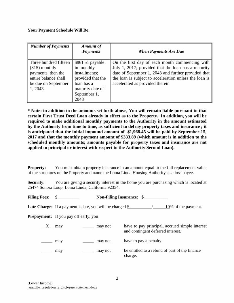
2 (Lower Income) jaramillo_regulation_z_disclosure_statement.docx
Your Payment Schedule Will Be:
Number of Payments Amount of
Payments
When Payments Are Due
Three hundred fifteen
(315) monthly
payments, then the
entire balance shall
be due on September
1, 2043.
$861.51 payable
in monthly
installments;
provided that the
loan has a
maturity date of
September 1,
2043
On the first day of each month commencing with
July 1, 2017; provided that the loan has a maturity
date of September 1, 2043 and further provided that
the loan is subject to acceleration unless the loan is
accelerated as provided therein
* Note: in addition to the amounts set forth above, You will remain liable pursuant to that
certain First Trust Deed Loan already in effect as to the Property. In addition, you will be
required to make additional monthly payments to the Authority in the amount estimated
by the Authority from time to time, as sufficient to defray property taxes and insurance ; it
is anticipated that the initial impound amount of $1,968.45 will be paid by September 15,
2017 and that the monthly payment amount of $333.89 (which amount is in addition to the
scheduled monthly amounts; amounts payable for property taxes and insurance are not
applied to principal or interest with respect to the Authority Second Loan).
Property: You must obtain property insurance in an amount equal to the full replacement value
of the structures on the Property and name the Loma Linda Housing Authority as a loss payee.
Security: You are giving a security interest in the home you are purchasing which is located at
25474 Sonora Loop, Loma Linda, California 92354.
Filing Fees: $__________ Non-Filing Insurance: $___________
Late Charge: If a payment is late, you will be charged $ / 10% of the payment.
Prepayment: If you pay off early, you
X may _____ may not have to pay principal, accrued simple interest
and contingent deferred interest.
_____ may _____ may not have to pay a penalty.
_____ may _____ may not be entitled to a refund of part of the finance
charge.

3 (Lower Income) jaramillo_regulation_z_disclosure_statement.docx
Interest Rate: The Authority First Loan has a base interest rate that is
___X__fixed at 3.720% per year.
variable. Disclosures about the variable-rate feature have been provided to you
earlier.
Assumption: Someone buying your house
X may, subject to conditions, be allowed to assume the remainder of the mortgage on
the original terms.
_____ cannot assume the remainder of the mortgage on the original terms.
Demand Feature: This obligation
X [is payable on demand] or [has a demand feature]
_____ [is not payable on demand] or [has no demand feature]
See your loan documents for any additional information about the Authority First Loan
terms, nonpayment, default and penalties and any required repayment in full before the scheduled
date.
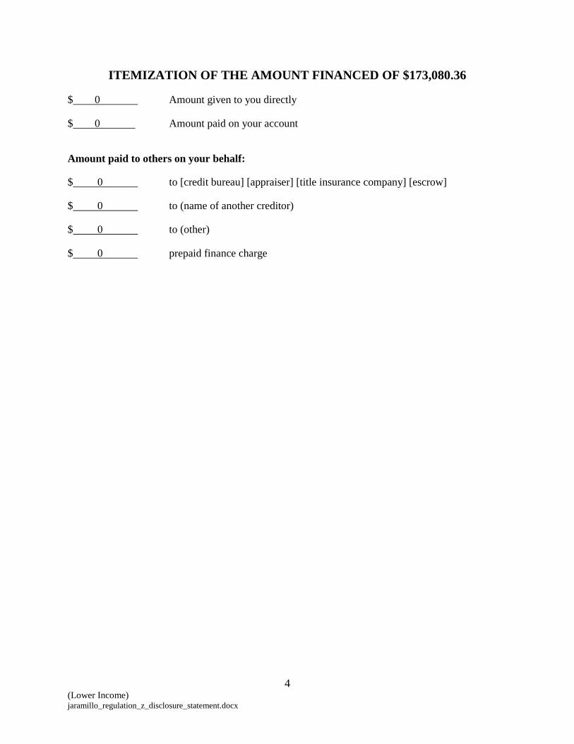
4 (Lower Income) jaramillo_regulation_z_disclosure_statement.docx
ITEMIZATION OF THE AMOUNT FINANCED OF $173,080.36
$ 0 Amount given to you directly
$ 0 Amount paid on your account
Amount paid to others on your behalf:
$ 0 to [credit bureau] [appraiser] [title insurance company] [escrow]
$ 0 to (name of another creditor)
$ 0 to (other)
$ 0 prepaid finance charge

5 (Lower Income) jaramillo_regulation_z_disclosure_statement.docx
NOTICE OF RIGHT TO CANCEL
Your Right to Cancel
You are entering into a transaction that will result in a lien on your home. You have a legal
right under federal law to cancel this transaction, without cost, within three business days from
whichever of the following events occurs last:
(1) the date of the transaction, which is _____________________________; or
(2) the date you received your Truth in Lending disclosures; or
(3) the date you received this notice of your right to cancel.
If you cancel the transaction, the lien is also canceled. Within 20 calendar days after we
receive your notice, we must take the steps necessary to reflect the fact that the lien on your home
has been canceled, and we must return to you any money or property you have given to us or to
anyone else in connection with this transaction.
You may keep any money or property we have given you until we have done the things
mentioned above, but you must then offer to return the money or property. If it is impractical or
unfair for you to return the property, you must offer its reasonable value. You may offer to return the
property at any location in the City of Loma Linda convenient to you. Money must be returned to
the address below. If we do not take possession of the money or property within 20 calendar days of
you offer, you may keep it without further obligation.
How to Cancel
If you decide to cancel this transaction, you may do so by notifying us in writing, at
LOMA LINDA HOUSING AUTHORITY
25541 Barton Road
Loma Linda, California 92354
Attn: Executive Director
You may use any written statement that is signed and dated by you and states your intention
to cancel, or you may use this notice by dating and signing below. Keep one copy of this notice
because it contains important information about your rights.
If you cancel by mail or telegram, you must send the notice no later than midnight of the
third business day following the latest of the three events listed above. If you send or deliver your
written notice to cancel some other way, it must be delivered to the above address no later than that
time.

6 (Lower Income) jaramillo_regulation_z_disclosure_statement.docx
ACKNOWLEDGMENT OF RECEIPT
I have received two (2) copies of this Notice of Right to Cancel.
________________________________________ _____________________________
Signature Date
________________________________________ _____________________________
Signature Date
I WISH TO CANCEL
________________________________________ _____________________________
Signature Date
________________________________________ _____________________________
Signature Date
I HAVE NOT CANCELED
I confirm that at least four days ago (excluding Sundays and federal holidays) I received two
(2) copies of this notice, and I have not canceled the transaction for which this notice is given.
________________________________________ _____________________________
Signature Date
________________________________________ _____________________________
Signature Date