Embed Size (px)
Citation preview
City of Joondalup
Beach Management Plan
Page | 2
Contents
Introduction ...................................................................................................................................................... 4
Statement on Sea-Level Rising ..................................................................................................................... 5
Purpose ............................................................................................................................................................. 6
Area Covered by Plan ...................................................................................................................................... 7
Planning Framework ....................................................................................................................................... 8
Related Legal, Strategic and Policy Documents ............................................................................................ 8
Development of Plan ..................................................................................................................................... 11
Principles ........................................................................................................................................................ 12
Stakeholders .................................................................................................................................................. 13
Department of Environment and Conservation ............................................................................................ 13Department of Planning ............................................................................................................................... 13Western Australian Planning Commission ................................................................................................... 14Department of Transport .............................................................................................................................. 14Department of Health ................................................................................................................................... 15Water Corporation ........................................................................................................................................ 15Department of Fisheries ............................................................................................................................... 16Western Australian Police ............................................................................................................................ 16Fire and Emergency Services Authority ....................................................................................................... 17Department of the Environment, Water, Heritage and the Arts (Federal) ................................................... 17
Non-Statutory Authority Stakeholders ........................................................................................................ 18
Whitfords Volunteer Sea Rescue Group (Inc.) ............................................................................................ 18Wanneroo/Joondalup State Emergency Service Unit .................................................................................. 18Surf Life Saving Western Australia .............................................................................................................. 18
Designated Recreational Intensity Areas .................................................................................................... 19
Low-Intensity Recreation Zone .................................................................................................................... 19Medium-Intensity Recreation Zone .............................................................................................................. 20High-Intensity Recreation Zone ................................................................................................................... 20
Structure ......................................................................................................................................................... 21
Key Focus Area 1: Infrastructure ................................................................................................................. 22
1.1 Paths ................................................................................................................................................. 221.2 Car Parks .......................................................................................................................................... 241.3 Community Buildings ........................................................................................................................ 251.4 Toilets and Change Rooms ............................................................................................................... 261.5 Fencing .............................................................................................................................................. 281.6 Signage ............................................................................................................................................. 291.7 Park Assets ....................................................................................................................................... 30
Key Focus Area 2: Management .................................................................................................................. 32
2.1 Recreational Activities ....................................................................................................................... 322.2 Patrols ............................................................................................................................................... 352.3 Commercial Trading .......................................................................................................................... 362.4 Events and Functions ........................................................................................................................ 37
Key Focus Area 3: Development .................................................................................................................. 40
3.1 Commercial ....................................................................................................................................... 40
References ..................................................................................................................................................... 42
APPENDIX 1 ..................................................................................................................................................... 1
APPENDIX 2 ..................................................................................................................................................... 2

Page | 3
APPENDIX 3 ..................................................................................................................................................... 3
APPENDIX 4 ..................................................................................................................................................... 5
APPENDIX 5 ..................................................................................................................................................... 6
Page | 4
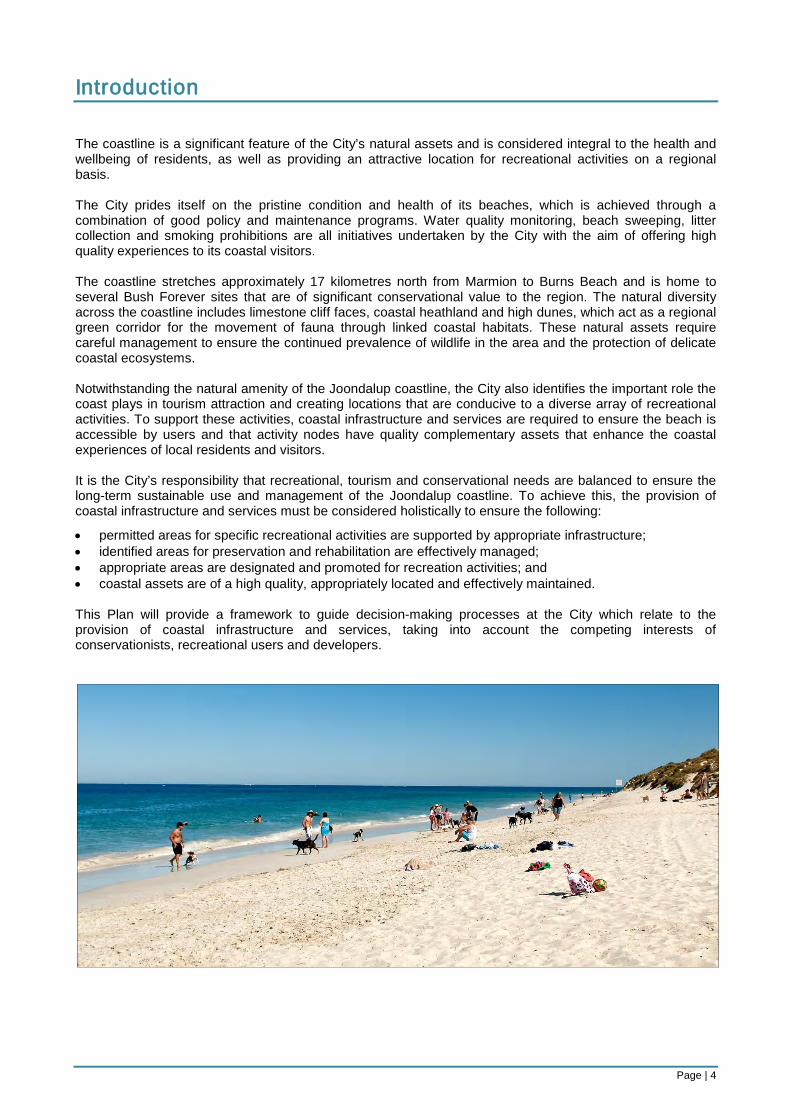
Introduction The coastline is a significant feature of the City’s natural assets and is considered integral to the health and wellbeing of residents, as well as providing an attractive location for recreational activities on a regional basis. The City prides itself on the pristine condition and health of its beaches, which is achieved through a combination of good policy and maintenance programs. Water quality monitoring, beach sweeping, litter collection and smoking prohibitions are all initiatives undertaken by the City with the aim of offering high quality experiences to its coastal visitors. The coastline stretches approximately 17 kilometres north from Marmion to Burns Beach and is home to several Bush Forever sites that are of significant conservational value to the region. The natural diversity across the coastline includes limestone cliff faces, coastal heathland and high dunes, which act as a regional green corridor for the movement of fauna through linked coastal habitats. These natural assets require careful management to ensure the continued prevalence of wildlife in the area and the protection of delicate coastal ecosystems. Notwithstanding the natural amenity of the Joondalup coastline, the City also identifies the important role the coast plays in tourism attraction and creating locations that are conducive to a diverse array of recreational activities. To support these activities, coastal infrastructure and services are required to ensure the beach is accessible by users and that activity nodes have quality complementary assets that enhance the coastal experiences of local residents and visitors. It is the City’s responsibility that recreational, tourism and conservational needs are balanced to ensure the long-term sustainable use and management of the Joondalup coastline. To achieve this, the provision of coastal infrastructure and services must be considered holistically to ensure the following:
• permitted areas for specific recreational activities are supported by appropriate infrastructure; • identified areas for preservation and rehabilitation are effectively managed; • appropriate areas are designated and promoted for recreation activities; and • coastal assets are of a high quality, appropriately located and effectively maintained. This Plan will provide a framework to guide decision-making processes at the City which relate to the provision of coastal infrastructure and services, taking into account the competing interests of conservationists, recreational users and developers.
Page | 5
Statement on Sea-Level Rising The City acknowledges that future environmental changes will occur in light of the effects of global warming and that these changes will have impact on the City’s coastal areas. Given that information on the extent of these impacts is yet to become readily available, this Plan does not address the issue of sea-level rising. However, statements made within the Plan are cognisant of the fact that sea-level rising will become an issue in the future. When information does become available, the City will ensure its integration into the Plan when undertaking scheduled review processes.
Page | 6
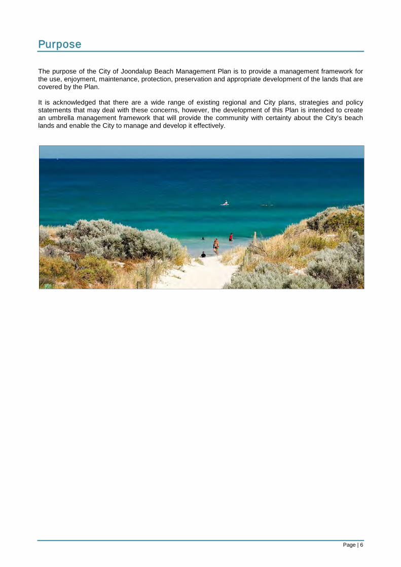
Purpose The purpose of the City of Joondalup Beach Management Plan is to provide a management framework for the use, enjoyment, maintenance, protection, preservation and appropriate development of the lands that are covered by the Plan. It is acknowledged that there are a wide range of existing regional and City plans, strategies and policy statements that may deal with these concerns, however, the development of this Plan is intended to create an umbrella management framework that will provide the community with certainty about the City’s beach lands and enable the City to manage and develop it effectively.
Page | 7
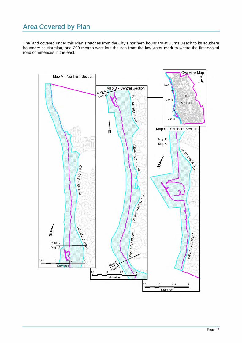
Area Covered by Plan The land covered under this Plan stretches from the City’s northern boundary at Burns Beach to its southern boundary at Marmion, and 200 metres west into the sea from the low water mark to where the first sealed road commences in the east.
Page | 8
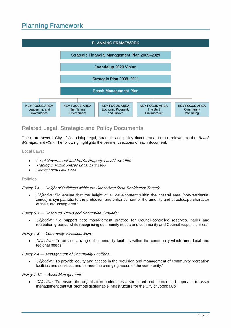
Planning Framework
Related Legal, Strategic and Policy Documents There are several City of Joondalup legal, strategic and policy documents that are relevant to the Beach Management Plan. The following highlights the pertinent sections of each document: Local Laws:
• Local Government and Public Property Local Law 1999 • Trading in Public Places Local Law 1999 • Health Local Law 1999
Policies: Policy 3-4 — Height of Buildings within the Coast Area (Non-Residential Zones):
• Objective: ‘To ensure that the height of all development within the coastal area (non-residential zones) is sympathetic to the protection and enhancement of the amenity and streetscape character of the surrounding area.’
Policy 6-1 — Reserves, Parks and Recreation Grounds:
• Objective: ‘To support best management practice for Council-controlled reserves, parks and recreation grounds while recognising community needs and community and Council responsibilities.’
Policy 7-3 — Community Facilities, Built:
• Objective: ‘To provide a range of community facilities within the community which meet local and regional needs.’
Policy 7-4 — Management of Community Facilities:
• Objective: ‘To provide equity and access in the provision and management of community recreation facilities and services, and to meet the changing needs of the community.’
Policy 7-19 — Asset Management:
• Objective: ‘To ensure the organisation undertakes a structured and coordinated approach to asset management that will promote sustainable infrastructure for the City of Joondalup.’
PLANNING FRAMEWORK
Strategic Financial Management Plan 2009–2029
Joondalup 2020 Vision
Strategic Plan 2008–2011
KEY FOCUS AREA The Natural Environment
KEY FOCUS AREA The Built
Environment
KEY FOCUS AREA Leadership and
Governance
KEY FOCUS AREA Community Wellbeing
KEY FOCUS AREA Economic Prosperity
and Growth
Beach Management Plan
Page | 9
Plans: Joondalup 2020 Vision:
• ‘The City contains a comprehensive and well-connected network of cycle paths with high quality end of trip facilities available for cyclists at key destinations.’
• ‘From an environmental perspective, the City is recognised as a world leader in preserving biodiversity with a broad network of bushland and open space which is interconnected to support the movement of fauna.’
• ‘The City’s coastal environment is maintained in a pristine condition, with appropriate facilities to enable the public to enjoy this wonderful asset. Such facilities include developments at the boat harbour in Ocean Reef which make it an attractive, vibrant and memorable place to visit.’
• ‘That residents have easy access to a wide variety of recreational and leisure opportunities, from beautiful parklands to active play areas, and community facilities of the highest quality.’
Strategic Plan 2008–2011:
• Mission Statement: ‘To undertake all our activities with the endeavour of meeting community expectations and achieving sustainable lifestyles.’ Key Focus Area 2: The Natural Environment
⋅ Objective 2.1: ‘To ensure that the City’s natural environmental assets are preserved, rehabilitated and maintained.’
⋅ Objective 2.2: ‘To engage proactively with the community and other relevant organisations in the preservation of the City’s natural environmental assets.’
Key Focus Area 4: The Built Environment ⋅ Objective 4.2: ‘To progress a range of innovative and high quality urban development
projects within the City.’ Key Focus Area 5: Community Wellbeing
⋅ Objective 5.2: ‘To facilitate healthy lifestyles within the community.’ ⋅ Objective 5.4: ‘To work collaboratively with stakeholders to increase community safety and
respond to emergencies effectively.’ Environment Plan 2007–2011
• Strategic Position: ‘To provide ongoing environmental leadership to the community to ensure the City retains its natural environmental assets and preserves them for future generations to enjoy. The City of Joondalup will achieve this goal through integrated planning and working in partnership with the community, key stakeholders and relevant agencies.’ Focus Area 1: Land
⋅ Objective: ‘To incorporate environmental considerations into major land approval and planning processes and to use external networks for establishing management and monitoring processes.’
Focus Area 3: Biodiversity ⋅ Objective: ‘To ensure the effective protection and maintenance of the City’s biodiversity.’
Biodiversity Action Plan 2009–2019
• Aim: ‘For the City of Joondalup’s rich biological diversity to be understood, maintained and protected.’ Key Focus Area 2: Catchment Management
⋅ Objective: ‘To undertake appropriate management at a catchment scale in order to reduce negative impacts on the City’s natural areas.’
Key Focus Area 5: Community Awareness and Education ⋅ Objective: ‘To improve awareness and understanding in the local community about
biodiversity and its importance.’ Key Focus Area 6: Community Engagement and Partnerships
⋅ Objective: ‘To improve outcomes by undertaking meaningful engagement and working in partnership with the community, key stakeholders and relevant agencies.’
Page | 10
Joondalup Coastal Foreshore Natural Areas Management Plan
• Conservation Zone: Objective: ‘To provide for the protection of the environment, landforms, significant fauna habitat
and important vegetation communities while allowing low-intensity public access to areas that are of significant environmental value.’
• Low-Intensity Passive Recreation Zone: Objective: ‘To provide facilities to cater for low levels of public use and recreation, whilst
maintaining the conservation value of the area.’ • Medium-Intensity Passive Recreation Zone:
Objective: ‘To provide facilities to cater for medium levels of public use and recreation, whilst maintaining the integrity of the vegetation and landforms of the area.’
• High-Intensity Passive Recreation Zone: Objective: ‘To provide facilities and management for high levels of passive recreational activities,
while implementing measures that will reduce the impact of these activities on the biophysical environment.’
Landscape Master Plan 2009–2019
• Vision: ‘Landscaping in the City of Joondalup will be innovative, distinctive, functional and appealing, and valued by residents and visitors and will evoke a sense of ownership and pride amongst its residents. This vision will be achieved through the application of sustainable principles that will underpin all landscaping practices, with a focus on environmental best practice and the preservation, enhancement and showcasing of local natural biodiversity.”
Asset Management Plan 2009–2012
• Vision: ‘The City of Joondalup’s vision for its Community Infrastructure is to provide the desired level of service in the most cost effective manner for present and future customers. The City’s Asset Management Plan provides a strategic road map and framework for successful achievement of this vision.’
Bike Plan 2009
• Aims and Objectives: ‘To improve the cycling infrastructure by maintaining the already extensive network of pathways, cycle lanes and signed bicycle routes servicing major destinations and the wider bicycle network within the City and providing new infrastructure where necessary’
Tourism Development Plan 2005–2009
• Vision: ‘The creation of a vibrant tourism industry that is environmentally responsible, socially sound and economically viable. The industry is responsive to the community and visitors (tourists) and built on partnerships and networks.’
Access and Inclusion Plan 2009-2011
• Policy Statement: ‘The City of Joondalup is committed to ensuring that the community is accessible for, equal to and inclusive of all members of the community and visitors.’
District Planning Scheme No.2
• Purpose: ‘To set out the way land is to be used and developed. It classifies areas for land use and includes provisions to coordinate infrastructure and development in a locality. It also includes controls to ensure long-term strategic planning objectives are achieved.’
Page | 11
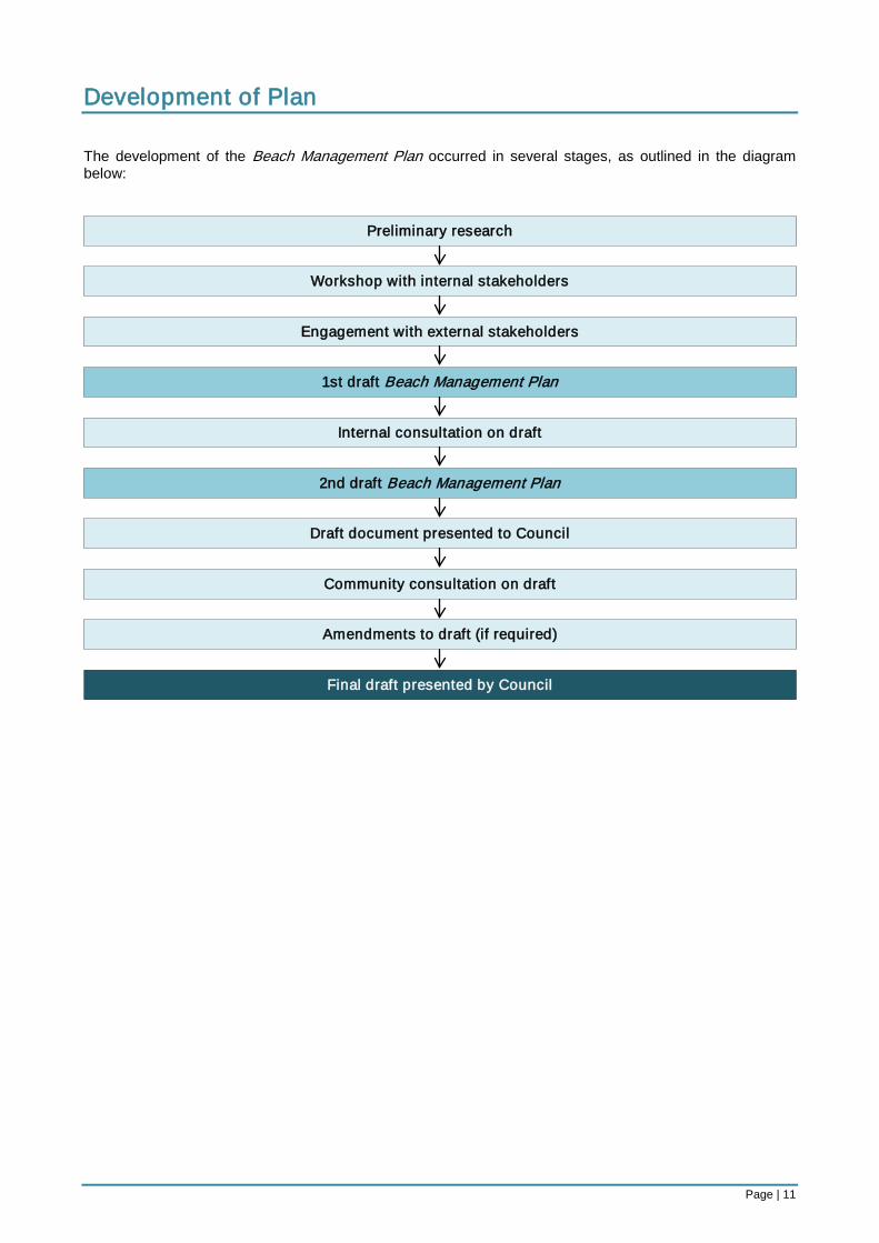
Development of Plan The development of the Beach Management Plan occurred in several stages, as outlined in the diagram below:
Preliminary research
Workshop with internal stakeholders
Engagement with external stakeholders
1st draft Beach Management Plan
Internal consultation on draft
Draft document presented to Council
Community consultation on draft
Amendments to draft (if required)
Final draft presented by Council
2nd draft Beach Management Plan
Page | 12
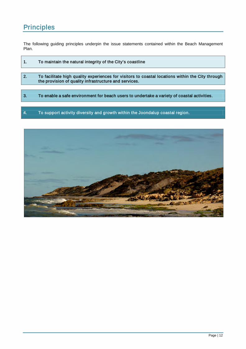
Principles The following guiding principles underpin the issue statements contained within the Beach Management Plan.
1. To maintain the natural integrity of the City’s coastline
2. To facilitate high quality experiences for visitors to coastal locations within the City through
the provision of quality infrastructure and services.
3. To enable a safe environment for beach users to undertake a variety of coastal activities.
4. To support activity diversity and growth within the Joondalup coastal region.
Page | 13
Stakeholders There are various State Government departments and agencies empowered with specific management responsibilities along the State’s coastline. There are also several non-government organisations that assist in the delivery of coastal-related services whom the City considers to be major stakeholders in the management of its beaches and coastal reserves. Below is a list of relevant organisations involved in the delivery of coastal management services, including a brief outline of the extent of their jurisdiction and any activity restrictions they have applied within the City of Joondalup. Department of Environment and Conservation Extent of Jurisdiction: The Department of Environment and Conservation is responsible for the following relevant coastal management duties:
• Assisting the Marine Parks and Reserves Authority in the management and protection of marine parks and reserves under the Conservation and Land Management Act 1984.
• Identifying and establishing marine conservation reserves. • Developing and enforcing management plans for the ongoing protection and preservation of
conservation areas. • Providing advice to other government agencies as to the activities that should be prohibited or
restricted in and around marine conservation areas (including: fishing, boating, surface-water sports, swimming, diving, and snorkelling)
Restrictions Applied within the City of Joondalup: The City of Joondalup is home to the Marmion Marine Park, which extends from Trigg Island in the south, to Burns Beach in the north. The Marmion Marine Park Management Plan 1992-2002 has informed the direction of management processes and actions by the Department in the Marine Park since 1992. Although the Marmion Marine Park Management Plan 1992-2002 is due for review, actions and statements within the Plan are still applied by the Department in the management of the Park. This includes the issuing of commercial operator licenses to businesses that conduct water-based activities on Reserves managed by the Department. Within the City of Joondalup, this extends to commercial recreational, tourism and fishing operations. Appendix 1 outlines the current area of the Marmion Marine Park, the classified zones within the Park, and the locations where specific activities may be undertaken. Department of Planning Extent of Jurisdiction: The Department of Planning (formally Department of Planning and Infrastructure) is responsible for the following relevant coastal management duties:
• Providing advice and support to the WA Planning Commission and other relevant stakeholders in relation to regional coastal planning.
• Preparing the Metropolitan Regional Scheme. • Supporting Planning Policies for adoption by the WA Planning Commission
Restrictions Applied within the City of Joondalup: The Department of Planning has developed the Draft Perth Coastal Planning Strategy, which will provide policy advice and strategic guidance to stakeholders in the future planning and development of metropolitan coastal areas. The draft Strategy classifies the State’s coastline into precinct areas, under which, appropriate land use and precinct types are identified (i.e. ‘Built-Up Precincts’, ‘Open Space Precincts’ and ‘Industry Precincts’). Appendix 3 outlines the proposed precinct areas and types within the City of Joondalup. When adopted, the Perth Coastal Planning Strategy will be utilised by the Department of Planning and WA
Page | 14
Planning Commission in the consideration of coastal development applications. The City’s proposed management plan will need to be cognisant of the State planning prerogatives illustrated in Appendix 3. The Metropolitan Regional Scheme sets out a broad pattern of land use for the Perth Metropolitan Area by classifying specific areas into zones to control the types of developments that can occur in each location. The Planning Policies support the Scheme by creating a guide for decision-making processes by local governments when considering planning applications. Planning Policies are non-statutory but are useful instruments for making consistent town planning decisions. Relevant coastal Planning Policies prepared by the Department of Planning include:
• Statement of Planning Policy No. 2.6: State Coastal Planning Policy • Statement of Planning Policy No. 3.4: Natural Hazards and Disasters Policy • Statement of Planning Policy No. 2.0: Environment and Natural Resources Policy • Statement of Planning Policy No. 2.8: Draft Bushland Policy for the Perth Metropolitan Region
Western Australian Planning Commission Extent of Jurisdiction: The Western Australian Planning Commission is responsible for the following relevant coastal management duties:
• Determining the approval of development applications within areas reserved for Parks and Recreation under the Metropolitan Regional Scheme and for the Hillarys Marina.
Restrictions Applied within the City of Joondalup: The Commission considers all applications on the advice of the Department of Planning who assess development applications on the basis of existing legislation and approved planning policies and practices. Department of Transport Extent of Jurisdiction: The Department of Transport (formally Department of Planning and Infrastructure) is responsible for the following relevant coastal management duties:
• Administering the Western Australian Marine Act 1982 (i.e.: designating (in specific areas): prohibited boating areas, permitted waterski locations, and boating restrictions (relating to speed)).
• Ensuring marine safety. • Licensing recreational boating and commercial vessels. • Managing oil pollution and coastal erosion. • Determining areas for boating restrictions. • Planning and developing coastal infrastructure (relating to harbours and boating facilities). • Acquiring and analysing coastal data (including: nautical charts, tide predictions, maritime
geographical data, and wave data) Restrictions Applied within the City of Joondalup: Within the City of Joondalup, the Department of Transport has placed the following restrictions on water-based activities:
• Prohibited Boating Location: located approximately 34 metres west of, and parallel to, the western Hillarys Boat Harbour wall.
• Restricted Boating Speed: limited to 8 knots within 200 metres of the shoreline along the entire length of the Joondalup coast.
• Permitted Waterski Area: see Appendix 2.
Page | 15
Department of Health Extent of Jurisdiction: The Department of Health is responsible for the following relevant coastal management duties:
• Administering the Bacterial Monitoring Program (i.e.: testing popular swimming beaches within the Perth Metropolitan Region for levels of bacteria to assess the potential safety impacts on beach users. This is assisted by local government Environmental Health Officers).
• Ensuring the water at swimming beaches is safe to swim in. • Classifying water bodies to help bathers decide where they want to swim. • Issuing warnings during pollution events. • Identifying bacterial pollution sources. • Looking for long-term bacterial trends. • Approving/disapproving the decommissioning of septic tanks with assistance from local government
Environmental Health Officers (particularly within sensitive coastal areas). • Approving/disapproving the installation of leach tanks and soak wells for large development
applications. Restrictions Applied within the City of Joondalup: Restrictions may apply in the case of pollution and/or contamination events in the form of restricted public access. Visit <www.healthyswimming.health.wa.gov.au/sites/northbeaches.cfm
> for data on seasonal micro-bacterial analysis within the City of Joondalup.
Water Corporation Extent of Jurisdiction: The Water Corporation is responsible for the following relevant coastal management duties:
• Coordinating Perth’s Long-Term Ocean Outlet Monitoring Program (PLOOM Program) (i.e.: monitoring outlet areas for water quality, sediment quality, phytoplankton, marine habitats, heavy metal and pesticides, and wastewater plumes).
• Disposing of secondary treated wastewater from the Beenyup Wastewater Treatment Plant (located within the suburb of Craigie) by discharge into the ocean (outlet located south of the Ocean Reef Marina).
• Monitoring the impacts of the discharged secondary treated wastewater on the marine environment for nutrient enrichment, pathogenic microorganisms, and contaminants.
• Managing the State’s sewerage infrastructure. • Coordinating the Infill Sewerage Program (i.e.: eradicating household septic tanks within the Perth
Metropolitan Region to reduce the health and environmental risks to future generations. Coastal areas within the City of Joondalup that were subject to capital works under the Infill Sewerage Program are illustrated at <www.watercorporation.com.au/l/infill_sewerage_maps.cfm
>. (n.b.: the Infill Sewerage Program only extends to household sewerage connections therefore some City-owned buildings within coastal reserves are still on septic tank sewerage systems, including: Mullaloo Surf Lifesaving Club, Jack Kikeros Hall, Sorrento Surf Lifesaving Club, Whitford nodes toilets and change rooms, Mullaloo North toilet, Ocean Reef Sea Rescue Club, Ocean Reef Sea Sports Club, Iluka Foreshore toilets, and Burns Beach change rooms.))
Restrictions Applied within the City of Joondalup: Restrictions may apply in the case of pollution and/or contamination events in the form of restricted public access.
Page | 16
Department of Fisheries Extent of Jurisdiction: The Department of Fisheries are responsible for the following relevant coastal management duties:
• Managing recreational and commercial fishing in the Marmion Marine Park. • Determining catch limits and sizes for recreational and commercial fishing. • Ensuring fishing restrictions and prohibitions are adhered to in the Marmion Marine Park. • Administering licences for rock lobster, abalone, marron, south-west freshwater angling, and net
fishing practices (n.b.: licences for recreational boat fishing to be introduced in March 2010). Restrictions Applied within the City of Joondalup: The Department of Fisheries is responsible for the Marmion Marine Park in conjunction with the Department of Environment and Conservation. Under the jurisdiction of the Department of Fisheries, the following restrictions apply in the Park:
• Spearfishing is prohibited within 1,800 metres of the shore, while spearfishing on compressed air is not permitted throughout the rest of the marine park; and
• Access by boats is permitted throughout the Marine Park. • Line fishing from the shore is permitted in all areas. • Line fishing from a boat is permitted in all areas except Sanctuary Zones and the Watermans Reef
Observation Area. • All shellfish and sea urchins are protected. • Abalone fishing is permitted in season in all areas except Sanctuary Zones and the Watermans Reef
Observation Area. • Rock lobster fishing is permitted in all areas except the Sanctuary Zones and Watermans Reef
Observation Area. • Commercial fishing is permitted in all areas except Sanctuary Zones and the Watermans Reef
Observation Area. Visit <www.fish.wa.gov.au/docs/pub/MPMarmion/index.php
> for the boundaries of the Marmion Marine Park.
Western Australian Police Extent of Jurisdiction: The Western Australian Police are responsible for the following relevant coastal management duties:
• Operating the Water Police Coordination Centre as the Hazard Management Authority responsible for coordinating marine search and rescue operations.
• Operating the Diving Squad (i.e.: providing support to the WA Police in the areas of underwater search and rescue, sonar scanning, and underwater crime scene investigation).
• Operating the Marine Intelligence division (i.e.: providing specialised intelligence and investigative support to the WA Police in the areas of marine-based collection, collation, analysis and dissemination of information from the community and other sources).
• Coordinating the Marine Watch crime prevention program (i.e.: providing a designated Local Marine Liaison Officer at coastal police stations to assist the local community and maritime clubs and organisations in the reporting of unusual or suspicious marine activity).
• Operating Coast Radio Perth and monitoring HF and VHF marine channels for distress calls. • Assisting victims of any marine- or coastal-related crimes.
Restrictions Applied within the City of Joondalup: Restrictions to coastal areas may be applied by the WA Police in the case of emergencies, accidents, criminal monitoring, criminal activities, and/or crime scene investigations in the form of restricted access or restrictions relating to special powers. The Water Police Branch of the Western Australian Police Service is also responsible for enforcing any restrictions imposed by the Department of Transport over water-based activities.
Page | 17
Fire and Emergency Services Authority Extent of Jurisdiction: The Fire and Emergency Services Authority is responsible for the following relevant coastal management duties:
• Administering the Fire and Emergency Services Authority of Western Australia Act 1998, Fire Brigades Act 1942, Bush Fires Act 1954, and Emergency Management Act 2005.
• Coordinating and providing operational and financial support to the Volunteer Marine Rescue Services, State Emergency Services, Volunteer Fire and Rescue Service and Bush Fire Brigades.
• Providing emergency management training. • Conducting community engagement, research, liaison, risk planning, and evaluation in related to fire
and emergency services. Restrictions Applied within the City of Joondalup: Restrictions may be applied by the Fire and Emergency Services Authority in the case of emergencies and/or accidents in the form of restricted access or restrictions relating to State Emergency special powers. Department of the Environment, Water, Heritage and the Arts (Federal) Extent of Jurisdiction: The Department of the Environment, Water, Heritage and the Arts is responsible for the following relevant coastal management duties:
• Approving development applications that may impact on any species listed under the Environmental Protection and Biodiversity Protection Act 1999.
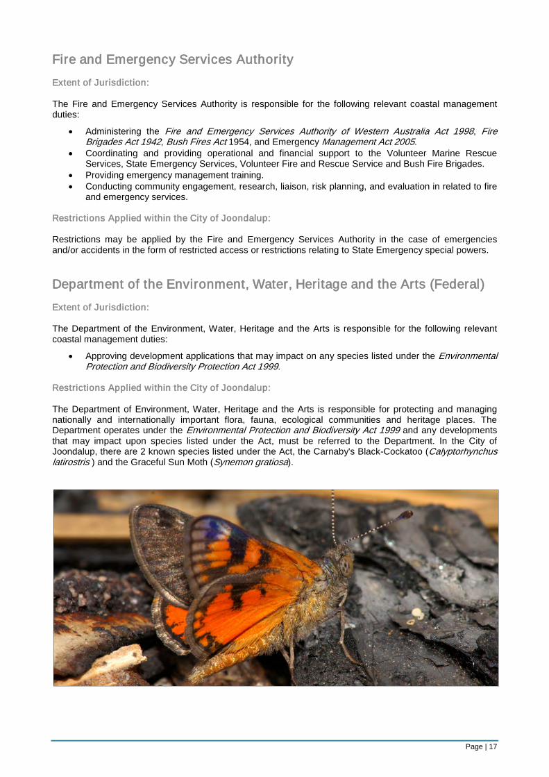
Restrictions Applied within the City of Joondalup: The Department of Environment, Water, Heritage and the Arts is responsible for protecting and managing nationally and internationally important flora, fauna, ecological communities and heritage places. The Department operates under the Environmental Protection and Biodiversity Act 1999 and any developments that may impact upon species listed under the Act, must be referred to the Department. In the City of Joondalup, there are 2 known species listed under the Act, the Carnaby's Black-Cockatoo (Calyptorhynchus latirostris ) and the Graceful Sun Moth (Synemon gratiosa).
Page | 18
Non-Statutory Authority Stakeholders Whitfords Volunteer Sea Rescue Group (Inc.) Extent of Jurisdiction: The Whitfords Volunteer Sea Rescue Group an independent not-for-profit organisation which is contracted under the State Government and is responsible for the following relevant coastal management duties:
• Acting as the State Government’s ‘first responder’ for all sea rescue incidents that occur between Alkimos in the north, and City Beach in the South.
• Providing crew, radio operators, support personnel, craft, equipment, and communication facilities for marine search and rescue operations.
• Providing training in powerboating, marine search and rescue, Recreational Skippers Ticket, Marine Radio Operators Certificate, and coastal navigation.
• Providing escort vessels for large events (e.g.: Rottnest Channel Swim, Dragon Boat Races in Hillarys Boat Harbour).
• Assisting Water Police Coordination Centre in search and rescue operations. Wanneroo/Joondalup State Emergency Service Unit Extent of Jurisdiction: The Wanneroo/Joondalup State Emergency Service Unit is supported by the Fire and Emergency Services Authority. The Unit is staffed by volunteers who undertake the following relevant coastal management responsibilities:
• Acting as a ‘hazard management agency’ for flood, cyclone, storm, tsunami, and earthquake incidents.
• Assisting in emergency repairs and restorations on buildings and essential services affected by natural disasters.
• Coordinating land searches (including beaches, cliffs and caves). • Assisting in incident control, planning and logistics. • Providing community education to service groups, senior centres and homes, local businesses and
schools. • Assisting and supporting other emergency agencies, including the WA Police, where required.
Surf Life Saving Western Australia Extent of Jurisdiction: Surf Life Saving Western Australia is a volunteer-based, not-for-profit organisation which coordinates 28 surf life saving clubs in Western Australia, including Mullaloo Surf Life Saving Club and Sorrento Surf Life Saving Club. In addition to voluntary life saving services, club personnel are contracted by the City to conduct supplementary services on weekdays during peak periods. The volunteers and contracted life savers undertake the following relevant coastal management responsibilities:
• Patrolling beaches and providing life saving services along the coastline (with additional services during peak periods).
• Providing life saving education to beach users (e.g.: sun smart, shark sightings). • Providing surf life saving training to club members and the community. The City’s Local Government and Public Property Local Law 1999 permits life saving clubs to designate swimming areas where the entry of boats, personal watercraft and surfboards is prohibited or restricted. Under the local law, surf life saving clubs are also permitted to restrict bathing, fishing and launch life saving watercraft or any life saving equipment for life saving activities. In addition, members of a life saving patrol have authority under to direct beach users to bathe within patrol flags and/or leave the water during dangerous conditions.
Page | 19
Designated Recreational Intensity Areas In order to guide management decisions for the appropriate provision of coastal infrastructure and the designation of permitted areas for recreational activity, the following recreation zones have been developed.
1. Low-Intensity Recreation Zone 2. Medium-Intensity Recreation Zone 3. High-Intensity Recreation Zone
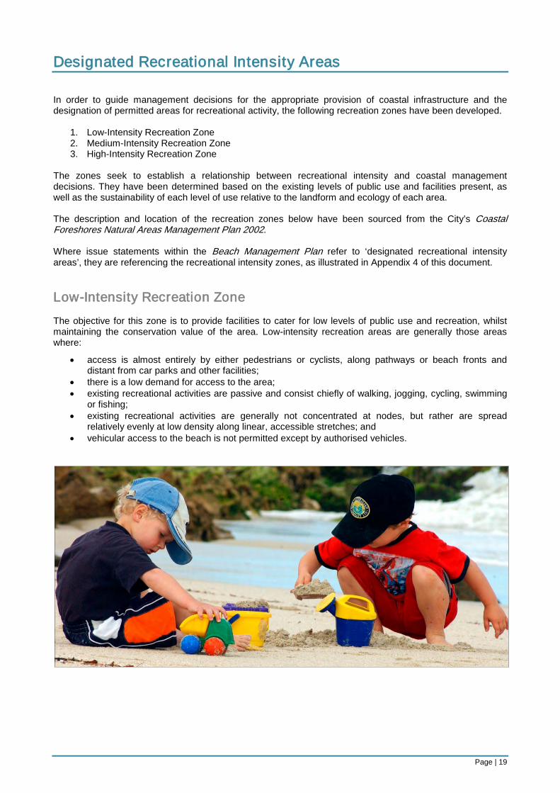
The zones seek to establish a relationship between recreational intensity and coastal management decisions. They have been determined based on the existing levels of public use and facilities present, as well as the sustainability of each level of use relative to the landform and ecology of each area. The description and location of the recreation zones below have been sourced from the City’s Coastal Foreshores Natural Areas Management Plan 2002. Where issue statements within the Beach Management Plan refer to ‘designated recreational intensity areas’, they are referencing the recreational intensity zones, as illustrated in Appendix 4 of this document. Low-Intensity Recreation Zone The objective for this zone is to provide facilities to cater for low levels of public use and recreation, whilst maintaining the conservation value of the area. Low-intensity recreation areas are generally those areas where:
• access is almost entirely by either pedestrians or cyclists, along pathways or beach fronts and distant from car parks and other facilities;
• there is a low demand for access to the area; • existing recreational activities are passive and consist chiefly of walking, jogging, cycling, swimming
or fishing; • existing recreational activities are generally not concentrated at nodes, but rather are spread
relatively evenly at low density along linear, accessible stretches; and • vehicular access to the beach is not permitted except by authorised vehicles.
Page | 20
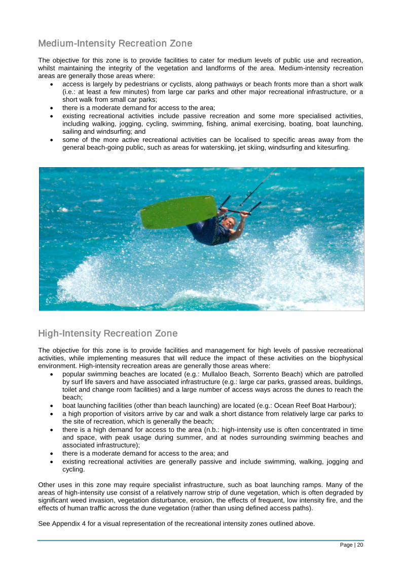
Medium-Intensity Recreation Zone The objective for this zone is to provide facilities to cater for medium levels of public use and recreation, whilst maintaining the integrity of the vegetation and landforms of the area. Medium-intensity recreation areas are generally those areas where:
• access is largely by pedestrians or cyclists, along pathways or beach fronts more than a short walk (i.e.: at least a few minutes) from large car parks and other major recreational infrastructure, or a short walk from small car parks;
• there is a moderate demand for access to the area; • existing recreational activities include passive recreation and some more specialised activities,
including walking, jogging, cycling, swimming, fishing, animal exercising, boating, boat launching, sailing and windsurfing; and
• some of the more active recreational activities can be localised to specific areas away from the general beach-going public, such as areas for waterskiing, jet skiing, windsurfing and kitesurfing.
High-Intensity Recreation Zone The objective for this zone is to provide facilities and management for high levels of passive recreational activities, while implementing measures that will reduce the impact of these activities on the biophysical environment. High-intensity recreation areas are generally those areas where:
• popular swimming beaches are located (e.g.: Mullaloo Beach, Sorrento Beach) which are patrolled by surf life savers and have associated infrastructure (e.g.: large car parks, grassed areas, buildings, toilet and change room facilities) and a large number of access ways across the dunes to reach the beach;
• boat launching facilities (other than beach launching) are located (e.g.: Ocean Reef Boat Harbour); • a high proportion of visitors arrive by car and walk a short distance from relatively large car parks to
the site of recreation, which is generally the beach; • there is a high demand for access to the area (n.b.: high-intensity use is often concentrated in time
and space, with peak usage during summer, and at nodes surrounding swimming beaches and associated infrastructure);
• there is a moderate demand for access to the area; and • existing recreational activities are generally passive and include swimming, walking, jogging and
cycling. Other uses in this zone may require specialist infrastructure, such as boat launching ramps. Many of the areas of high-intensity use consist of a relatively narrow strip of dune vegetation, which is often degraded by significant weed invasion, vegetation disturbance, erosion, the effects of frequent, low intensity fire, and the effects of human traffic across the dune vegetation (rather than using defined access paths). See Appendix 4 for a visual representation of the recreational intensity zones outlined above.
Page | 21
Structure The Beach Management Plan is divided into the following Key Focus Areas:
1. Infrastructure 2. Management 3. Development
Each Key Focus Area outlines the objectives associated with coastal asset provision and maintenance, activities management, and commercial developments. Issues under each Key Focus Area are identified and supported by issue statements which articulate the City’s position on how specific issues should be resolved or managed. The issue statements do not seek to act as specific tasks or actions, rather, they aim to provide guidance to decision-making processes which relate to the provision of coastal services and infrastructure. To support the Beach Management Plan, an Implementation Plan will be developed to articulate the processes and mechanisms required to give effect to the issue statements within the Plan. This could include, for example:
• amendments to existing local laws and polices; • development of guidelines; • erection of coastal signage; • engagement with external stakeholders; or • procedural amendments.
Page | 22
Key Focus Area 1: Infrastructure Coastal infrastructure is varied and provides for the needs of both local and regional communities. Close proximity to the ocean makes coastal infrastructure more vulnerable to deterioration from conditions and high usage. Pressures on infrastructure are generally seasonal and depend on the type of infrastructure. For example, coastal dual-use pathways are generally popular throughout the year for walking, jogging and cycling, whereas car parks, toilets, and change room facilities at popular swimming nodes are much more popular during the summer months. The following objectives relate to the provision of all coastal infrastructures. Objectives:
• To provide quality infrastructure for the lowest ‘whole-of-life’ cost. • To provide adequate levels of infrastructure that are able to service the needs of the region within
designated activity locations. • To ensure the preservation of natural areas through effective infrastructure design and location.
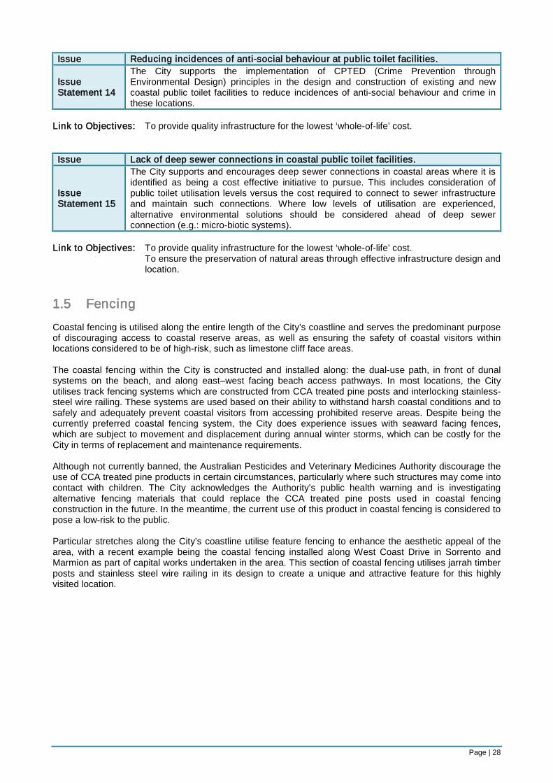
1.1 Paths The City’s coastline stretches over 17 kilometres and contains a large number of pathways. Most notably, the ‘coastal dual-use pathway’, which runs north–south along the City’s coast and is utilised by local residents, tourists and regional visitors year-round. This pathway currently extends from Marmion Beach in the south to Burns Beach in the north (excluding a length of approximately 700 metres at the City’s northern border). Its total current length is approximately 21.7 kms. Recent capital works undertaken in Sorrento-Marmion upgraded the most popular section of the dual-use pathway by removing the concrete surface and replacing it with red asphalt. Certain locations along this section of the pathway were also subject to widening as part of the works program. At the northern end of the City, negotiations with the City of Wanneroo and the Department of Environment and Conservation have commenced to determine under which arrangements an extension of the dual-use pathway from Burns Beach to Mindarie should occur. The Council is yet to resolve its position on this issue, however, should the project progress, the dual-use pathway within the City of Joondalup will effectively be extended 700 metres north to the City of Wanneroo border. There are also over 45 designated beach access paths along the City’s coast which the City is responsible for maintaining, including the boat access ramp at Ocean Reef. Inspections for coastal paths are undertaken by the City’s Operations Services while maintenance works are performed by both the City and external contractors. Inspections and maintenance requirements occur on a scheduled and ‘as needs’ basis, which normally involve path sweeping processes and repairs to concrete, asphalt and limestone surfaces. Many informal beach access paths are also present along the coast; however, these are neither maintained nor recognised by the City and are created by beach users who access the beach through illegal means (i.e. traversing dunal systems). Most informal pathways lead to well-known fishing and surfing locations within dangerous limestone-cliff areas and are created and reinforced on a seasonal basis. The City utilises coastal fencing, signage and patrols to deter ongoing access to these areas and to reduce the use of informal beach access paths.
Page | 23
Issues and Issue Statements:
Issue Congestion along the Mullaloo section of the dual-use pathway during the summer months and inconsistent path widths between Hillarys and Burns Beach.
Issue Statement 1
The City’s Bike Plan 2009 promotes the construction of a continuous coastal shared-path and identifies the appropriate construction of off-road bicycle networks as an infrastructure priority. As such, when undertaking assessments of the coastal dual-use pathway, the City should give consideration as to whether the pathway meets current community needs and whether it can adequately enable multiple recreational activities to be undertaken simultaneously. The potential for path widening and continuity should be priority design features considered during path assessments and sections of path listed for refurbishment within the Capital Works Program should be prioritised according to usage.
Link to Objectives: To provide adequate levels of infrastructure that are able to service the needs of the
region within designated activity locations.
Issue Use of informal beach access pathways that lead to high-risk areas such as limestone cliff locations.
Issue Statement 2
The City discourages the use of informal beach access pathways and believes this should be supported through the installation of adequate fencing infrastructure and educational signage along the coastal dual-use pathway to inhibit and discourage access to high-risk limestone cliff locations.
Link to Objectives: To ensure the preservation of natural areas through effective infrastructure design and
location.
Issue Deterioration of the limestone and concrete, hard-stand surfaces on beach access paths and sand build-up at popular beach access points where hard-stand surfaces are present.
Issue Statement 3
It is the City’s position that limestone and concrete hard-stand surfaces should continue to be utilised on beach access paths, however, the point in which hard-stand surfaces end should be in such a location that path degradation and sand build-up is minimised. Any design and construction features of beach access paths should take into consideration overall maintenance costs, including path reconstruction and the removal of accreted sand.
Link to Objectives: To provide quality infrastructure for the lowest ‘whole-of-life’ cost.
Issue Excessive numbers of beach access pathways that are under-utilised and inappropriately located.
Issue Statement 4
It is the City’s position that in order to reduce overall maintenance costs and improve the current standards of popular beach access paths, an assessment of the location and utilisation levels of beach access paths be undertaken with a view to reducing the overall number of available paths. Approved formal access paths should also be numbered to improve methods of identification for maintenance purposes.
Link to Objectives: To provide adequate levels of infrastructure that are able to service the needs of the
region within designated activity locations.
Page | 24
1.2 Car Parks There are currently 24 car parking locations along the City’s coastline, 19 of which are owned and managed by the City of Joondalup. Within these locations, there are a total of 4,737 car parking bays, with 2,768 concentrated within the Hillarys Marina Complex. The remaining 1,969 are distributed across car parks and range in size from 12 bays per car park to 372. Although generally considered to be sufficient, the current level of coastal car parking bays is tested during the months of summer when car parking demands at popular swimming beaches often exceed the level of bays available in the area. This generally leads to incursions into residential areas as surplus visitors seek out alternative car parking solutions that are close to the beach. Local residents often suffer a loss of amenity as a result of these incursions and seek remedy from the City to patrol the affected residential areas more often during peak summer months. Coastal car parks are also identified as anti-social hot-spots, demanding careful design and patrolling to ensure the safety of car park users. Issues and Issue Statements: Issue Inadequate car parking at the current animal exercise beach car park in Hillarys.
Issue Statement 5
The City acknowledges that current car parking facilities at the Hillarys Dog Beach have reached capacity during peak summer periods. To maintain the amenity of the area, the following approaches to car parking solutions should be preferred:
• Maximising car parking spaces within the existing car park footprint at the Hillarys Dog Beach; and
• Prohibiting horse exercising on the beach and reconfiguring the horse float car park to accommodate a greater number of car bays for dog owners.
Link to Objectives: To provide adequate levels of infrastructure that are able to service the needs of the
region within designated activity locations. To ensure the preservation of natural areas through effective infrastructure design and
location.
Issue Inadequate car parking facilities during the summer months between Mullaloo and North Mullaloo Beaches and at Sorrento Beach.
Issue Statement 6
The City acknowledges that current car parking facilities at Mullaloo and Sorrento Beach have reached capacity during peak summer periods. To maintain the amenity of the area, the following approaches to car parking solutions should be preferred:
• Maximising car parking spaces within existing car park footprints if possible. • Investigating possible shared-use arrangements on nearby private land. • Investigating the construction of additional car bays within road reserves, excluding
areas adjacent Tom Simpson Park in Mullaloo. • Investigating the introduction of alternative transport solutions.
Link to Objectives: To provide adequate levels of infrastructure that are able to service the needs of the
region within designated activity locations.
Issue Poorly located coastal car parks that do not correlate to popular beach access points or other coastal attractions.
Issue Statement 7
Numbers of available car parking bays should correlate to the level of recreational intensity the City wishes to encourage in the area and in locations where beach access is appropriate and promoted by the City. As such, designated high-intensity recreation areas should have the greatest number of total available parking bays, while designated medium-intensity recreation areas should concentrate car parks to locations where access is encouraged. Designated low-intensity recreation areas should have the least number of available parking bays in order to discourage access and to promote the preservation of native vegetation.
Link to Objectives: To provide adequate levels of infrastructure that are able to service the needs of the
region within designated activity locations.
Page | 25
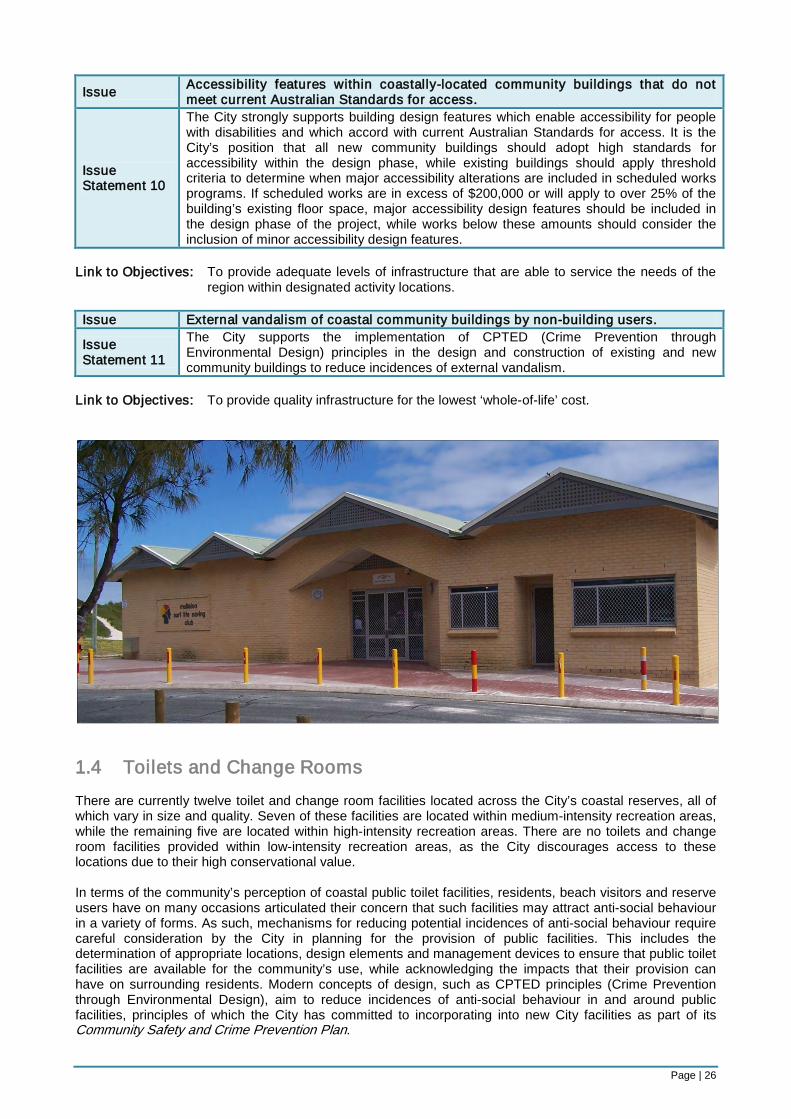
1.3 Community Buildings There are currently five community buildings located within coastal reserves in the City, four of which are subject to ongoing leasing arrangements. All but one, are located within high-intensity recreation areas with the fifth located in a medium-intensity recreation area. This particular community building (Jack Kikeros Hall in Burns Beach) experiences moderate utilisation levels from casual and regular community hire arrangements, which vary in activities from small functions to community group meetings. Two of the five coastal community buildings, namely, the Whitfords Volunteer Sea Rescue Building and the Ocean Reef Sea Sports Club, are subject to lease arrangements and will be subject to temporary removal as part of the development of the Ocean Reef Marina. Concept plans for the Marina indicate that the buildings will be reconstructed within the Marina complex, although, relocated from their current premises to a location which complements the overall layout of the development site. The buildings’ redesign is unknown at this stage, however, it will be subject to consultation prior to the reconstruction phase. The remaining coastal community buildings are surf lifesaving clubs, namely, Mullaloo Surf Life Saving Club and Sorrento Surf Life Saving Club, which are also subject to ongoing leasing arrangements. The clubhouses serve as a base for surf life saving activities within the area of their location and can be hired on a casual basis for functions and events. These buildings experience high utilisation rates and serve an important function in facilitating safe swimming environments for beach users near the buildings’ location. In terms of the building materials used in the construction of coastal community buildings, they tend to vary depending on the age of the building, as continual modifications to building and design codes are adopted. The construction dates of current coastal community buildings are as follows: Building Construction Date Sorrento Surf Life Saving Club Rooms 1972 Ocean Reef Sea Sports Club Rooms 1980 Whitfords Volunteer Sea Rescue Building 1980 Jack Kikeros Community 1983 Mullaloo Surf Life Saving Club Rooms 1991
Issues and Issue Statements: Issue Not all coastal sites are supported by community buildings.
Issue Statement 8
Only high or appropriate medium-intensity recreation areas along the coast should be supported by community buildings. The buildings should also be ‘fit for purpose’ and facilitate either coastal-related activities (e.g.: surf life saving, watercraft sports, sea rescue operations, etc.) or dining experiences which maximise coastal views in the buildings’ design.
Link to Objectives: To provide adequate levels of infrastructure that are able to service the needs of the
region within designated activity locations. Issue Use of inappropriate building materials within a marine environment.
Issue Statement 9
All coastal construction projects undertaken by the City should require specifications that stipulate the use of appropriate building materials which aim to decrease the ‘whole-of-life’ cost of the infrastructure asset. Coastal building refurbishments and major repairs should also be scheduled in accord with the City’s Building Asset Management Plan.
Link to Objectives: To provide quality infrastructure for the lowest ‘whole-of-life’ cost.
Page | 26
Issue Accessibility features within coastally-located community buildings that do not meet current Australian Standards for access.
Issue Statement 10
The City strongly supports building design features which enable accessibility for people with disabilities and which accord with current Australian Standards for access. It is the City’s position that all new community buildings should adopt high standards for accessibility within the design phase, while existing buildings should apply threshold criteria to determine when major accessibility alterations are included in scheduled works programs. If scheduled works are in excess of $200,000 or will apply to over 25% of the building’s existing floor space, major accessibility design features should be included in the design phase of the project, while works below these amounts should consider the inclusion of minor accessibility design features.
Link to Objectives: To provide adequate levels of infrastructure that are able to service the needs of the
region within designated activity locations. Issue External vandalism of coastal community buildings by non-building users.
Issue Statement 11
The City supports the implementation of CPTED (Crime Prevention through Environmental Design) principles in the design and construction of existing and new community buildings to reduce incidences of external vandalism.
Link to Objectives: To provide quality infrastructure for the lowest ‘whole-of-life’ cost.
1.4 Toilets and Change Rooms There are currently twelve toilet and change room facilities located across the City’s coastal reserves, all of which vary in size and quality. Seven of these facilities are located within medium-intensity recreation areas, while the remaining five are located within high-intensity recreation areas. There are no toilets and change room facilities provided within low-intensity recreation areas, as the City discourages access to these locations due to their high conservational value. In terms of the community’s perception of coastal public toilet facilities, residents, beach visitors and reserve users have on many occasions articulated their concern that such facilities may attract anti-social behaviour in a variety of forms. As such, mechanisms for reducing potential incidences of anti-social behaviour require careful consideration by the City in planning for the provision of public facilities. This includes the determination of appropriate locations, design elements and management devices to ensure that public toilet facilities are available for the community’s use, while acknowledging the impacts that their provision can have on surrounding residents. Modern concepts of design, such as CPTED principles (Crime Prevention through Environmental Design), aim to reduce incidences of anti-social behaviour in and around public facilities, principles of which the City has committed to incorporating into new City facilities as part of its Community Safety and Crime Prevention Plan.
Page | 27
Similarly to coastal community buildings, the design and building materials used to construct coastal toilet changeroom facilities vary due to their differing levels of refurbishment and construction ages. As such, the incorporation of modern design features such as CPTED principles (Crime Prevention through Environmental Design) and new accessibility requirements for the disabled are not consistent across facilities. To overcome this issue of inconsistency, the City plans to develop a Public Toilet Strategy which will provide guidance on the future provision of public toilets within the City (including coastal reserves). This will aim to stipulate minimum design and construction standards for new and existing facilities, as well as examining appropriate locations for their construction. The construction dates of current coastal toilet and change room facilities are as follows: Toilet and Change Room Facility Construction Date Sorrento/North Beach Toilets and Change Rooms 1979 Ocean Reef Boat Ramp Toilets and Change Rooms 1980 Burns Beach Toilets and Change Rooms 1984 Whitfords Node Toilets and Change Rooms 1984 Mullaloo North Toilets and Change Rooms 1984 Mullaloo South Toilets and Change Rooms 1991 Pinnaroo Point Toilets and Change Rooms 1994 Hillarys Animal Beach Toilets and Change Rooms 1995 Hillarys North beachside Toilets and Change Rooms 1996 Key West Mullaloo Automated Toilet 1999 Iluka Foreshore Toilets and Change Rooms 2006 Marmion Beach Toilets and Change Rooms Rebuilt 2009
Issues and Issue Statements: Issue Appropriate location and design for coastal public toilet facilities.
Issue Statement 12
The location of public toilet facilities should reflect the level of patronage and recreational intensity experienced at particular coastal sites and should be associated to the beach activities undertaken adjacent to car parking facilities. As such, coastal public toilets should be located in car parks or reserves that are contained within high and medium intensity recreational areas, where the nearby infrastructure promotes long-stay use and beach activities. Coastal car parking locations used predominantly to park and undertake activities along the coastal dual-use path, rather than on the beach, should receive less support for public toilet facilities. The City should also seek to include significant design aspects relating to improved accessibility when undertaking new public toilet constructions or major refurbishments of existing facilities. Minor accessibility design features should be considered as part of smaller scale refurbishment works.
Link to Objectives: To provide adequate levels of infrastructure that are able to service the needs of the
region within designated activity locations. Issue Providing after-hours access to coastal public toilets.
Issue Statement 13
The City supports access to coastal toilet and change room facilities provided between the hours of dawn to dusk to reduce incidences of vandalism and anti-social behaviour. After-hours access to coastal public toilets facilities, that are located within community buildings, should continue to be provided under the current hire and lease arrangements for the building (this does not extend to general public access).
Link to Objectives: To provide quality infrastructure for the lowest ‘whole-of-life’ cost.
Page | 28
Issue Reducing incidences of anti-social behaviour at public toilet facilities.
Issue Statement 14
The City supports the implementation of CPTED (Crime Prevention through Environmental Design) principles in the design and construction of existing and new coastal public toilet facilities to reduce incidences of anti-social behaviour and crime in these locations.
Link to Objectives: To provide quality infrastructure for the lowest ‘whole-of-life’ cost. Issue Lack of deep sewer connections in coastal public toilet facilities.
Issue Statement 15
The City supports and encourages deep sewer connections in coastal areas where it is identified as being a cost effective initiative to pursue. This includes consideration of public toilet utilisation levels versus the cost required to connect to sewer infrastructure and maintain such connections. Where low levels of utilisation are experienced, alternative environmental solutions should be considered ahead of deep sewer connection (e.g.: micro-biotic systems).
Link to Objectives: To provide quality infrastructure for the lowest ‘whole-of-life’ cost. To ensure the preservation of natural areas through effective infrastructure design and
location. 1.5 Fencing Coastal fencing is utilised along the entire length of the City’s coastline and serves the predominant purpose of discouraging access to coastal reserve areas, as well as ensuring the safety of coastal visitors within locations considered to be of high-risk, such as limestone cliff face areas. The coastal fencing within the City is constructed and installed along: the dual-use path, in front of dunal systems on the beach, and along east–west facing beach access pathways. In most locations, the City utilises track fencing systems which are constructed from CCA treated pine posts and interlocking stainless-steel wire railing. These systems are used based on their ability to withstand harsh coastal conditions and to safely and adequately prevent coastal visitors from accessing prohibited reserve areas. Despite being the currently preferred coastal fencing system, the City does experience issues with seaward facing fences, which are subject to movement and displacement during annual winter storms, which can be costly for the City in terms of replacement and maintenance requirements. Although not currently banned, the Australian Pesticides and Veterinary Medicines Authority discourage the use of CCA treated pine products in certain circumstances, particularly where such structures may come into contact with children. The City acknowledges the Authority’s public health warning and is investigating alternative fencing materials that could replace the CCA treated pine posts used in coastal fencing construction in the future. In the meantime, the current use of this product in coastal fencing is considered to pose a low-risk to the public. Particular stretches along the City’s coastline utilise feature fencing to enhance the aesthetic appeal of the area, with a recent example being the coastal fencing installed along West Coast Drive in Sorrento and Marmion as part of capital works undertaken in the area. This section of coastal fencing utilises jarrah timber posts and stainless steel wire railing in its design to create a unique and attractive feature for this highly visited location.
Page | 29
Issues and Issue Statements:
Issue The annual loss and displacement of seaward-facing fencing due to storm surges and coastal erosion.
Issue Statement 16
The City supports the continued use of seaward-facing fencing for the purpose of preserving coastal native vegetation by encouraging beach access via designated beach access paths. ‘Fit-for-purpose’ design features should be included in the construction and instalment of seaward-facing coastal fencing to reduce ongoing maintenance and replacement costs. Programs for the rehabilitation of degraded coastal vegetation should be identified, costed, and scheduled through the review of the City’s Coastal Foreshores Natural Areas Management Plan. The content of this Plan should be informed by the completion of a native vegetation extent and condition mapping process.
Link to Objectives: To provide quality infrastructure for the lowest ‘whole-of-life’ cost. To ensure the preservation of natural areas through effective infrastructure design and
location.
1.6 Signage The City has many signs erected along its coastline which relate to safety, activity direction and prohibition. Examples of the nature of information provided on current coastal signs include: • direction on the appropriate use of the dual-use pathway (re: cyclists and pedestrians) • requirements to place litter within bins • direction on permitted dog exercising activities • “burglar beware” signage within coastal car parks • direction to remain out of natural areas and only access beaches and reserves via pathways • prohibited dog exercising and smoking areas
Over the years the design, corporate branding and statutory references on coastal signs has become inconsistent, which can cause confusion for visitors to coastal areas within the City. The over provision of signage can also contribute to reduced amenity in the form of visual pollution and may overwhelm coastal visitors at locations where signage is particularly prolific. The maintenance of coastal signs is carried out by the City of Joondalup and involves graffiti removal, repairing, repainting and the installation of new signs. Signage inspections are undertaken as part of general coastal inspections for paths and fencing.
Page | 30
There are currently no interpretive signs present along the City’s coastline, however, plans for the design and installation of coastal biodiversity interpretive signs is being pursued by the City. This project will involve the construction and installation of feature signs containing information on the biodiversity within the City’s coastal foreshore. Issues and Issue Statements:
Issue Inconsistent design features and lack of guidance on appropriate locations for coastal signage that direct or prohibit coastal activities.
Issue Statement 17
The design, installation and location of coastal signage should be guided by standardised coastal signage guidelines to ensure design consistency, appropriate corporate branding, consistent installation methods, appropriate material use and appropriate locations for installation. The guidelines should also outline a schedule for the maintenance and replacement of coastal signs.
Link to Objectives: To provide quality infrastructure for the lowest ‘whole-of-life’ cost. 1.7 Park Assets The City is home to 13 coastal parks and public open space reserves which provide attractive and popular locations for the undertaking of recreational activities by coastal visitors. The assets contained within these areas vary depending on their size, purpose and location. For instance, public open space reserves along the coast generally contain protected vegetation species and as such, public access is limited through the installation of fencing and designated access pathways. Assets within these areas are therefore limited to signage, pathways, lighting and carparks. Parks, on the other hand, tend to contain a greater number of assets due to the presence of open grassed areas that act as popular activity nodes along the coast. The locations of coastal grassed areas include: • Sorrento Foreshore, Sorrento • Hillarys Beach Park (Whitfords Node South), Hillarys • Pinnaroo Point (Whitfords Node Central), Hillarys • Tom Simpson Park, Mullaloo • Iluka Foreshore Reserve, Iluka • Burns Beach Park, Burns Beach
Assets contained within these areas include: toilet facilities, floodlighting, car parks, play equipment, barbeques, picnic shelters and park benches. In light of their coastal location, assets contained within these areas require more frequent replacement and maintenance, as corrosion from the salty air and sand erosion during storm surges demand ongoing repair requirements. Issues and Issue Statements:
Issue Lack of an holistic approach to park design and scheduling works programs for the refurbishment or installation of new park assets within coastal parks.
Issue Statement 18
The City supports a coordinated and holistic approach to park developments, which should be delivered through the implementation of its Parks Asset Management Plan 2008–2028, Landscape Master Plan 2009–2019, and draft Parks Classification Framework. Park asset planning decisions determined via this process should be integrated into the City’s forward Capital Works Program.
Link to Objectives: To provide adequate levels of infrastructure that are able to service the needs of the
region within designated activity locations.
Page | 31
Issue Lack of standardisation of park asset designs and criteria for associated feature inclusions
Issue Statement 19
The design and construction of park assets should be guided by standardised asset design guidelines which include requirements for assets to:
• meet appropriate generic design standards (e.g.: Australian Standards); • utilise appropriate building materials which reduce the ‘whole-of-life’ cost of the
asset; • consider complementary infrastructure to support access and inclusion
requirements which accord with legislated standards; and • be sized and designed according to the classification of the park in which it is
located (i.e.: District Parks will contain more complex or larger park assets than Local or Neighbourhood Parks which seek to service the needs of a smaller number of community members).
Link to Objectives: To provide quality infrastructure for the lowest ‘whole-of-life’ cost. To provide adequate levels of infrastructure that are able to service the needs of the
region within designated activity locations.
Page | 32
Key Focus Area 2: Management As a popular destination for the undertaking of recreational activities on a regional basis, the City’s coastline requires effective management to ensure the safe access and enjoyment of natural areas and infrastructure assets for all visitors. The following coastal management objectives underpin this philosophy: Objectives:
• To facilitate safe environments for the undertaking of recreational activities along the City’s coastline.
• To effectively minimise opportunities for antisocial behaviour to occur within susceptible coastal locations.
• To effectively manage the undertaking of coastal commercial activities within designated activity locations.
• To appropriately manage the organisation and approval of events and functions along the City’s coastline.
2.1 Recreational Activities As a regional facility, the City’s coastline attracts many recreational user groups on both a casual and organised basis. Organised events and activities are currently managed through event application processes, commercial trading licences and local laws, whereas casual recreational activities are subject to management via signage and patrols that are supported through relevant local law provisions. The City recognises and acknowledges the presence of activity conflicts along the coast, as users compete for access to coastal facilities and locations for the undertaking of various recreational pursuits. In order to determine the most appropriate mechanisms for managing these activities, the following assessment has been undertaken by the City to classify casual recreational activities on the basis of their propensity and ability to conflict with other activities. The classifications are also sub-classified according to their level of conflict on the beach or water. Highly conflicting activities: activities considered to be unpredictable by nature, involve high-speeds, are likely to pose a risk to others or have the potential to impact on the surrounding natural environment. Medium conflicting activities: activities that may pose a risk to others, are relatively predictable by nature or temporarily interrupt other activities during launching or casting processes. Low conflicting activities: activities considered to be passive, predictable and unlikely to pose a risk to others. Casual Recreational Beach Activities Highly Conflicting Medium Conflicting Low Conflicting Kitesurfing Animal Exercising
Fishing Non-powered boat launching
Walking Jogging Picnicking
Casual Recreational Water-Based Activities Highly Conflicting Medium Conflicting Low Conflicting Kitesurfing Free-style jet skiing Waterskiing
Kayaking Surfing Sailing Boating Windsurfing
Swimming Snorkelling Diving
Page | 33
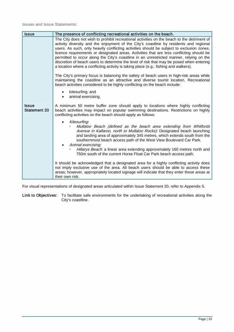
Issues and Issue Statements: Issue The presence of conflicting recreational activities on the beach.
Issue Statement 20
The City does not wish to prohibit recreational activities on the beach to the detriment of activity diversity and the enjoyment of the City’s coastline by residents and regional users. As such, only heavily conflicting activities should be subject to exclusion zones, licence requirements or designated areas. Activities that are less conflicting should be permitted to occur along the City’s coastline in an unrestricted manner, relying on the discretion of beach users to determine the level of risk that may be posed when entering a location where a conflicting activity is taking place (e.g.: fishing and walkers). The City’s primary focus is balancing the safety of beach users in high-risk areas while maintaining the coastline as an attractive and diverse tourist location. Recreational beach activities considered to be highly conflicting on the beach include:
• kitesurfing; and • animal exercising.
A minimum 50 metre buffer zone should apply to locations where highly conflicting beach activities may impact on popular swimming destinations. Restrictions on highly conflicting activities on the beach should apply as follows:
• Kitesurfing: Mullaloo Beach (defined as the beach area extending from Whitfords
Avenue in Kallaroo, north to Mullaloo Rocks): Designated beach launching and landing area of approximately 345 metres, which extends south from the southernmost beach access path of the West View Boulevard Car Park.
• Animal exercising: Hillarys Beach: a linear area extending approximately 160 metres north and
750m south of the current Horse Float Car Park beach access path.
It should be acknowledged that a designated area for a highly conflicting activity does not imply exclusive use of the area. All beach users should be able to access these areas; however, appropriately located signage will indicate that they enter these areas at their own risk.
For visual representations of designated areas articulated within Issue Statement 20, refer to Appendix 5. Link to Objectives: To facilitate safe environments for the undertaking of recreational activities along the
City’s coastline.
Page | 34
Issue The presence of conflicting recreational activities 200 metres into the water from the low water mark.
Issue Statement 21
In light of its expansive and open coastline, the City supports water-based activity diversity in a manner that facilitates safe and enjoyable experiences for ocean users. As such, water-based activities classified as low to medium conflicting should be permitted to occur along the City’s coastline without restriction. Water-based activities classified as highly conflicting should be subject to restrictions in order to reduce the level of impact they pose to other ocean-users. Designated areas and exclusion zones should therefore apply for these classified activities. Water-based activities considered to be highly conflicting include:
• waterskiing; • free-style jet skiing; and • kitesurfing
Restrictions on highly conflicting activities on the water should apply as follows:
• Waterskiing: Only within the area designated by the Department of Transport as a
permitted waterski area. • Free-style jet skiing:
Not permitted within 200 metres of the low water mark along the City’s coastline or the area designated by the Department of Transport as a permitted water ski area.
• Kitesurfing: Exclusion zones applicable: 611m north and 889m south of the Mullaloo Surf Life Saving Club and
200m seawards from the low water mark between these northern and southern boundaries.
300m north and 400m south of the Key West Mullaloo Car Park beach access path and 200m seawards from the low water mark between these northern and southern boundaries
470m north and 300m south of the Sorrento Surf Life Saving Club and 200m seawards from the low water mark between these northern and southern boundaries.
It should be acknowledged that a designated area for a highly conflicting activity does not imply exclusive use of the area. All beach users should be able to access these areas; however, appropriately located signage will indicate that they enter these areas at their own risk.
For visual representations of kitesurfing exclusion zones articulated within Issue Statement 21, refer to Appendix 5. Link to Objectives: To facilitate safe environments for the undertaking of recreational activities along the
City’s coastline.
Issue No current direction on ‘rights-of-way’ for activities undertaken within designated areas on the beach and in the water.
Issue Statement 22
It is the City’s position that ‘rights-of-way’ for activities should apply as follows:
• Within designated areas for highly-conflicting activities: the activity for which the area has been designated should have right-of-way over other activities that may be undertaken within the same area.
• Within designated surf lifesaving club patrol areas: swimming activities should have right-of-way over other activities undertaken within the area to a distance of 200 metres seaward from the low water mark. These areas include: between the permitted swimming flags at Sorrento Beach; and between the permitted swimming flags at Mullaloo Beach.
Link to Objectives: To facilitate safe environments for the undertaking of recreational activities along the
City’s coastline.
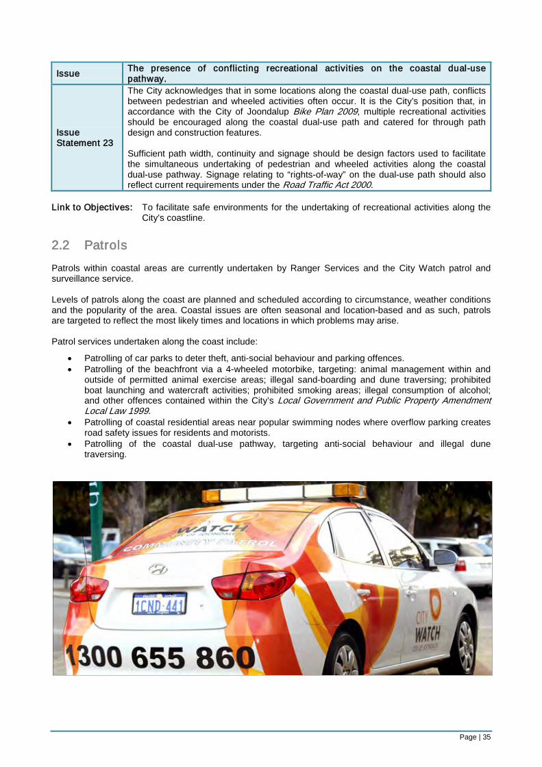
Page | 35
Issue The presence of conflicting recreational activities on the coastal dual-use pathway.
Issue Statement 23
The City acknowledges that in some locations along the coastal dual-use path, conflicts between pedestrian and wheeled activities often occur. It is the City’s position that, in accordance with the City of Joondalup Bike Plan 2009, multiple recreational activities should be encouraged along the coastal dual-use path and catered for through path design and construction features. Sufficient path width, continuity and signage should be design factors used to facilitate the simultaneous undertaking of pedestrian and wheeled activities along the coastal dual-use pathway. Signage relating to “rights-of-way” on the dual-use path should also reflect current requirements under the Road Traffic Act 2000.
Link to Objectives: To facilitate safe environments for the undertaking of recreational activities along the
City’s coastline. 2.2 Patrols Patrols within coastal areas are currently undertaken by Ranger Services and the City Watch patrol and surveillance service. Levels of patrols along the coast are planned and scheduled according to circumstance, weather conditions and the popularity of the area. Coastal issues are often seasonal and location-based and as such, patrols are targeted to reflect the most likely times and locations in which problems may arise. Patrol services undertaken along the coast include:
• Patrolling of car parks to deter theft, anti-social behaviour and parking offences. • Patrolling of the beachfront via a 4-wheeled motorbike, targeting: animal management within and
outside of permitted animal exercise areas; illegal sand-boarding and dune traversing; prohibited boat launching and watercraft activities; prohibited smoking areas; illegal consumption of alcohol; and other offences contained within the City’s Local Government and Public Property Amendment Local Law 1999.
• Patrolling of coastal residential areas near popular swimming nodes where overflow parking creates road safety issues for residents and motorists.
• Patrolling of the coastal dual-use pathway, targeting anti-social behaviour and illegal dune traversing.
Page | 36
Issues and Issue Statements: Issue Managing coastal area ‘hot-spots’ which are susceptible to anti-social behaviour.
Issue Statement 24
The City supports the continued provision of a patrol and surveillance service along coastal roads and within coastal car parks to deter anti-social behaviour and provide assistance to Police. Patrol and surveillance services along the coast should be targeted according to identified ‘hot-spot’ areas where incidences of anti-social behaviour and crime are most likely to occur. Ranger patrols should also seek to assist in the management of ‘hot-spot’ coastal areas by increasing levels of visual presence within the areas and support greater deterrence of anti-social behaviour.
Link to Objectives: To effectively minimise opportunities for anti-social behaviour to occur within
susceptible coastal locations. 2.3 Commercial Trading As a popular tourism destination, the City’s coastline attracts many visitors who engage in active and passive recreational activities. To support these activities, casual commercial traders often provide goods and services for visitors to enhance their coastal experiences, increase vibrancy and attract greater tourism patronage. Casual traders that currently operate along the City’s coastline include: • Coffee and drinks vans • Ice cream vendors • Boot-camp operators • Kitesurfing coaches • Dog washing services Casual commercial traders are subject to conditions under the City’s Trading in Public Places Local Law 1999 and if selling food or drink items, the City’s Health Local Law 1999 will provide additional operating restrictions. In order to operate, commercial traders must apply to the City to obtain a trading permit which must be renewed on an annual basis. Issues and Issue Statements:
Issue Need for holistic approach in the consideration of commercial trading licenses along the coast, including the designation of appropriate areas for casual commercial activities to be undertaken.
Issue Statement 25
The City supports the continuation of casual trading activities along its coast and believes that potential traders should be judged on the merits of their application. It is also the City’s position that the process for applying for a commercial trading license under the City’s Trading in Public Places Local Law 1999 should be guided by a transparent set of criteria that outlines, amongst other things, the following:
• Appropriate locations for coastal trading activities. • The maximum number of trading activities that can be undertaken within a
particular area. • Compliance requirements under the City’s Health Local Laws 1999. • Requirements for access to utilities. • Requirements relating to waste disposal on site.
Link to Objectives: To effectively manage the undertaking of coastal commercial activities within
designated activity locations.
Page | 37
Issue Enabling beach access for permitted vehicles which operate under a commercial trading licence.
Issue Statement 26
It is the City’s position that vehicle access to beaches be minimised as much as possible. Permission to drive vehicles onto the beach should only be gained through the successful completion of a licence application process, where beach vehicle access is requested within the application. Strict conditions on access and set-up locations should also apply, which take into consideration the sensitivity of the area to environmental degradation and beach user safety. Breaching these conditions should result in the cancellation of the trading licence. Vehicle access should only be permitted if no other alternative solution is available for transporting trading materials onto the beach and the trading activity itself is considered to be of value to beach users.
Link to Objectives: To effectively manage the undertaking of coastal commercial activities within
designated activity locations. 2.4 Events and Functions The City’s coastline provides an attractive location for the holding of events and functions within popular activity nodes and community facilities. The size, nature and organisers of an event or function may vary greatly, which will pose different levels of impact on other coastal visitors and residents. Issues and Issue Statements:
Issue The consideration of applications for extended trading permits within identified anti-social ‘hot-spot’ areas.
Issue Statement 27
It is the City’s position that applicants seeking extended trading permits for the sale of liquor within identified anti-social ‘hot-spot’ areas along the coast, should be eligible for these permits, however, the application process should be subject to a transparent set of guidelines that articulate the following conditions:
• City Watch services and the Police are informed of the event and are present on location at the end of the trading period
• An Event Management Plan is prepared by the applicant, outlining the strategies that will be in place to ensure the safe and expedient exit of patrons from the premises
• If, at the end of the trading period significant anti-social behaviour breaks out as a result of the conclusion of the event, the permit holder and/or the organisation should not be eligible for an extended trading permit in the same location for a 2-year period.
Link to Objectives: To appropriately manage the organisation and approval of events and functions along
the City’s coastline.
Page | 38
Issue Need for holistic approach in the consideration of external event applications within coastal parks and reserves, including the designation of appropriate areas for the undertaking of large-scale, medium-scale and small-scale activities.
Issue Statement 28
The City supports the undertaking of community and private events within parks and reserves that accord with a set of transparent guidelines determined by the City. The guidelines should not be used as set criteria, but rather, a means of outlining important factors for consideration when assessing event approvals. They may also be used to provide advice to the community on appropriate locations for the undertaking of events within different parks and reserves. Factors that should be considered within the guidelines include:
• Appropriate locations for different sized events. • The proximity of locations to major traffic arterials. • Existing seasonal activity uses within parks and reserves. • Availability of car parking. • Necessary approval or licensing requirements. • Duration of the event. • Whether the event will be private or attract general community members. • Relevant event sponsors.
Link to Objectives: To appropriately manage the organisation and approval of events and functions along
the City’s coastline.
Issue Need for holistic approach in the consideration of event applications for triathlons undertaken along the City’s coast.
Issue Statement 29
The City supports the undertaking of triathlon events that are based out of the Whitford Node South Coastal Reserve. In order to achieve a consistent approach to the organisation and delivery of triathlon events within this location, approval processes should be guided by the following:
• A coordinated approach to the provision of triathlon participant parking that is developed in association with the Department of Transport, City Officers, and Event Organisers.
• An internal Traffic Management Checklist that supports the legislative requirements articulated under the Road Traffic Act 1974. (This document should seek to enhance the local notification requirements for road closures).
• A City guideline for events and functions undertaken within parks and reserves (as articulated in the preceding issue statement).
Link to Objectives: To appropriately manage the organisation and approval of events and functions along
the City’s coastline.
Page | 39
Issue Anti-social behaviour that may arise as a result of liquor being consumed at events or functions on public open spaces or at community facilities within the City of Joondalup.
Issue Statement 30
It is the City’s position that the consumption of liquor at events or functions booked on public open spaces or at community facilities within the City be permitted to occur in alignment with the following Policies: Policy 6-1: Reserves, Parks and Recreation Grounds and Policy 7-3: Community Facilities — Built, which articulate:
• The Chief Executive Officer must be satisfied that the application will not cause undue disruption to the community.
• Appropriate liquor licence(s) must be in place. • Restricted licence applications will apply as follows:
⋅ Thursdays to 11 pm ⋅ Fridays and Saturdays to midnight ⋅ Sundays to 10 pm
The circumstances in which the City should consider an event as being unlikely to cause undue disruption to the community include:
• For the duration of a wedding ceremony on a City park or reserve (not to exceed 1 hour).
• For private events or functions held within community facilities. • For a fundraising event held either on a City park or reserve or within a
community facility, where liquor is being sold and a liquor licence has been successfully obtained from the Department of Racing, Gaming and Liquor.
• For corporate functions or events held on a City park or reserve or within a community facility.
• For City-run community events held on a City park or reserve, allowing BYO liquor.
The City does not support the consumption or sale of liquor in the following circumstances:
• Within Tom Simpson Park, Mullaloo (excluding the Mullaloo Surf Life Saving Clubroom facility)
• For private functions or events on a City park or reserve that are not of a fundraising or corporate purpose (excluding wedding ceremonies).
Link to Objectives: To appropriately manage the organisation and approval of events and functions along
the City’s coastline.
Page | 40
Key Focus Area 3: Development As a popular regional destination, the City’s coastline attracts thousands of visitors every year, each seeking to experience its beauty by partaking in passive and active recreational pursuits. Activity centres and mixed use areas are one way in which development can support and contribute to these experiences by establishing locations for commercial activity, high levels of infrastructure, transport nodes and vibrancy. Under the State Government’s Draft Perth Coastal Planning Strategy, the following coastal precinct areas within the City of Joondalup have been identified as appropriate sites for promoting commercial activity:
• Sorrento: mixed use • Hillarys: activity centre with marina • Ocean Reef: mixed use with marina • Burns Beach: residential with some mixed use
Although some development has already been established within these areas it is important that the City effectively plans for the future expansion of commercial development sites, as demand for access to coastal locations increases along with the region’s population. Objective:
• To effectively plan for commercial development opportunities along the City’s coastline. 3.1 Commercial As an identified tourism development zone within the City’s Tourism Development Plan, the City’s coastline requires a certain level of established commercial infrastructure to support visitors to the area who seek to experience the local natural attractions. Outside of the Plan area (that is, east of the first major sealed road), there are some established coastal commercial zoned areas, particularly within the suburbs of Sorrento and Mullaloo. However, areas reserved for Parks and Recreation (west of the first major sealed road) do not currently leverage opportunities for commercial development, which could complement and support existing passive and active coastal recreational activities. It is acknowledged that commercial developments and activities require a balance against the existing character of an area and potential environmental impacts. As such, effective and clear planning for new commercial opportunities within coastal park and recreation areas is required in order to ensure that a sufficient balance between these competing interests is struck. Issues and Issue Statements:
Issue Current lack of coastal commercial development within the City, particularly with regard to the provision of café, kiosk and restaurant establishments.
Issue Statement 31
Appropriate sites for coastal commercial development on City managed land should be identified on the basis of the following criteria:
• Environmental impacts • Aspect • Site capability • Access • Car parking • Commerciality • Complementary businesses • Complementary amenities • Service utilities • Security • Value-adding opportunities • Community consultation outcomes
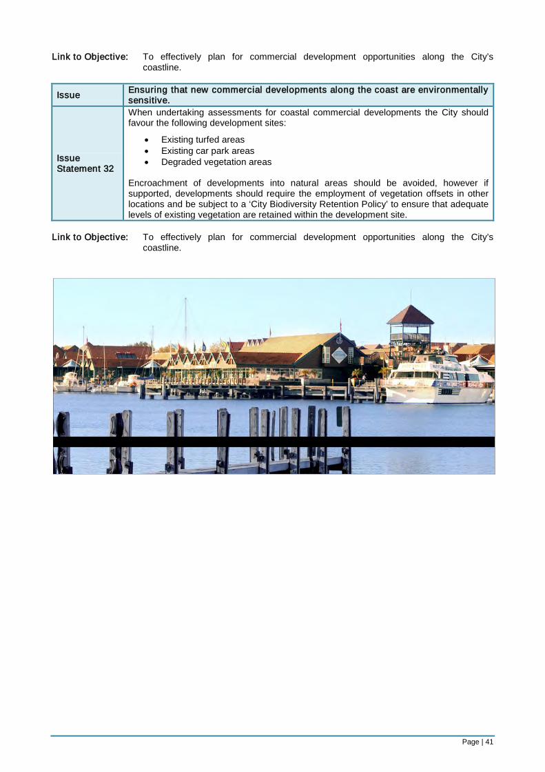
Page | 41
Link to Objective: To effectively plan for commercial development opportunities along the City’s coastline.
Issue Ensuring that new commercial developments along the coast are environmentally sensitive.
Issue Statement 32
When undertaking assessments for coastal commercial developments the City should favour the following development sites:
• Existing turfed areas • Existing car park areas • Degraded vegetation areas
Encroachment of developments into natural areas should be avoided, however if supported, developments should require the employment of vegetation offsets in other locations and be subject to a ‘City Biodiversity Retention Policy’ to ensure that adequate levels of existing vegetation are retained within the development site.
Link to Objective: To effectively plan for commercial development opportunities along the City’s
coastline.
Page | 42
References City of Albany 1999, Nanarup Beach Management Plan: A Community Initiative, City of Albany, Albany. City of Joondalup 2009, Draft Local Housing Strategy, (unpublished), Perth. Department of Climate Change 2009, Climate Change Risks to Australia’s Coast, Australian Government, Canberra. Department of Conservation and Land Management 1992, Marmion Marine Park: Management Plan 1992-2002, Western Australian Government, Perth. Department of Planning and Infrastructure 2008, Draft Perth Coastal Planning Strategy for Public Comment, Western Australian Government, Perth. Department of Transport 2009, Marine Safety: Restricted Areas of Navigable Waters, Western Australian Government, Perth. Ballina Shire Council 2003, Ballina Coastal Reserve Plan of Management, Ballina Shire Council, Ballina. Ecoscape (Australia) Pty Ltd 2004, Foreshore Management Plan: Mindarie-Quinns Rocks, City of Wanneroo, Perth. Ecoscape (Australia) Pty Ltd 2002, Joondalup Coastal Foreshore Natural Areas Management Plan, City of Joondalup, Perth. Friends of Marmion Marine Park, et. al. 2009, A Survey of Beach Litter in the Marmion Marine Park, (unpublished), Perth. Parks and Open Spaces Ltd 2008, Foxton Beach Coastal Reserves Draft Management Plan: For Public Consultation, Horowhenua District Council, Levin. Town of Cottesloe 2004, Policy: Beach, Town of Cottesloe, Perth, retrieved from <http://www.cottesloe.wa. gov.au/__data/page/38/Beach.pdf>.
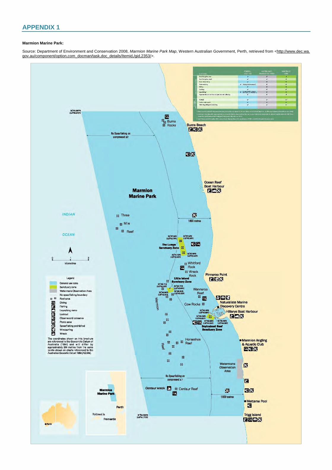
APPENDIX 1 Marmion Marine Park:
Source: Department of Environment and Conservation 2008, Marmion Marine Park Map, Western Australian Government, Perth, retrieved from <http://www.dec.wa. gov.au/component/option,com_docman/task,doc_details/Itemid,/gid,2353/>.
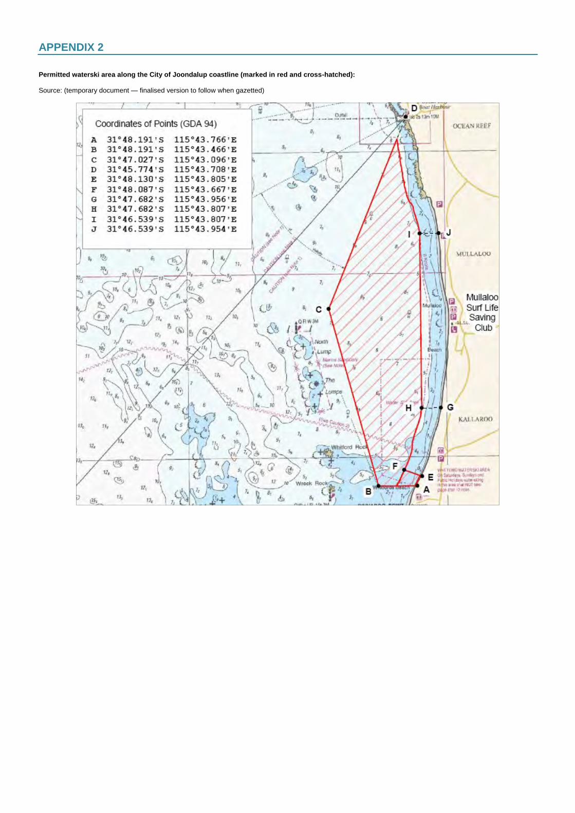
APPENDIX 2 Permitted waterski area along the City of Joondalup coastline (marked in red and cross-hatched): Source: (temporary document — finalised version to follow when gazetted)
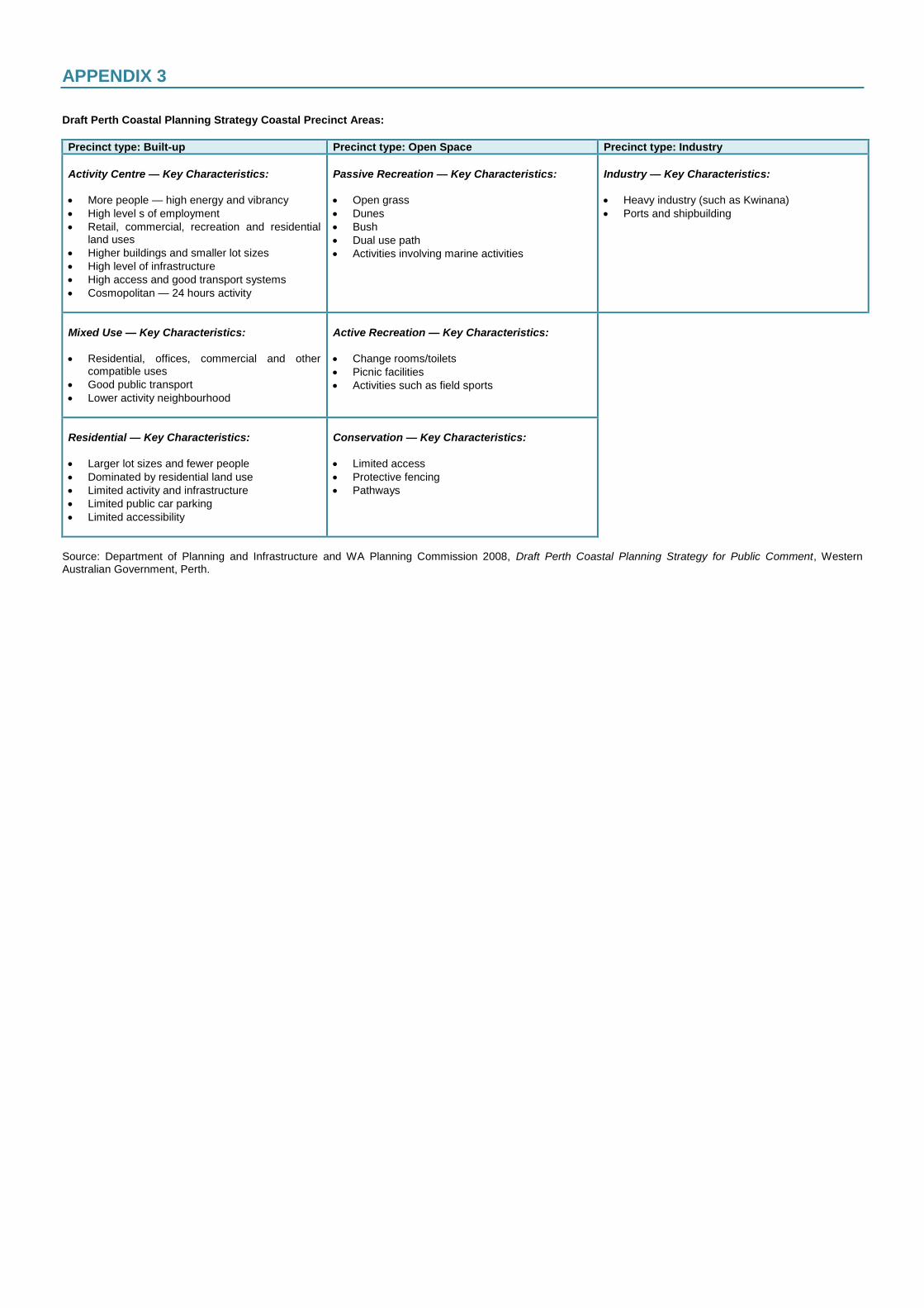
APPENDIX 3 Draft Perth Coastal Planning Strategy Coastal Precinct Areas:
Precinct type: Built-up Precinct type: Open Space Precinct type: Industry
Activity Centre — Key Characteristics:
More people — high energy and vibrancy
High level s of employment
Retail, commercial, recreation and residential land uses
Higher buildings and smaller lot sizes
High level of infrastructure
High access and good transport systems
Cosmopolitan — 24 hours activity
Passive Recreation — Key Characteristics:
Open grass
Dunes
Bush
Dual use path
Activities involving marine activities
Industry — Key Characteristics:
Heavy industry (such as Kwinana)
Ports and shipbuilding
Mixed Use — Key Characteristics:
Residential, offices, commercial and other compatible uses
Good public transport
Lower activity neighbourhood
Active Recreation — Key Characteristics:
Change rooms/toilets
Picnic facilities
Activities such as field sports
Residential — Key Characteristics:
Larger lot sizes and fewer people
Dominated by residential land use
Limited activity and infrastructure
Limited public car parking
Limited accessibility
Conservation — Key Characteristics:
Limited access
Protective fencing
Pathways
Source: Department of Planning and Infrastructure and WA Planning Commission 2008, Draft Perth Coastal Planning Strategy for Public Comment, Western Australian Government, Perth.
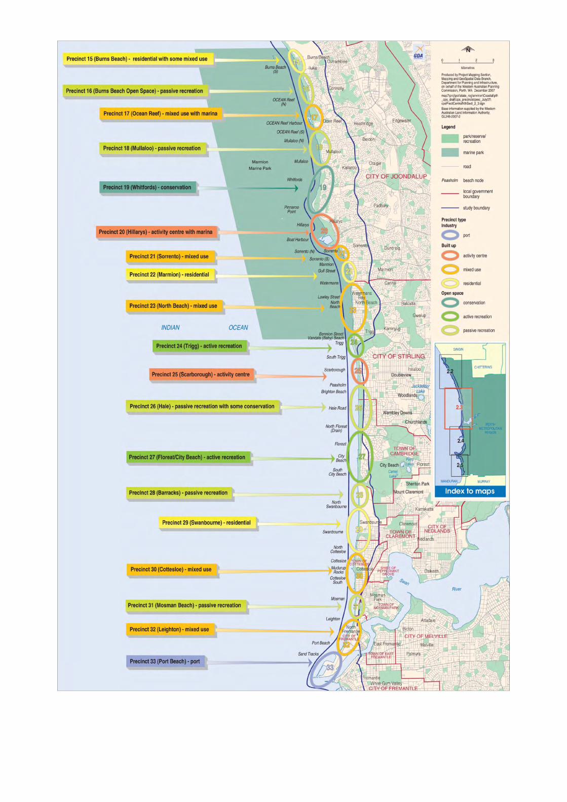
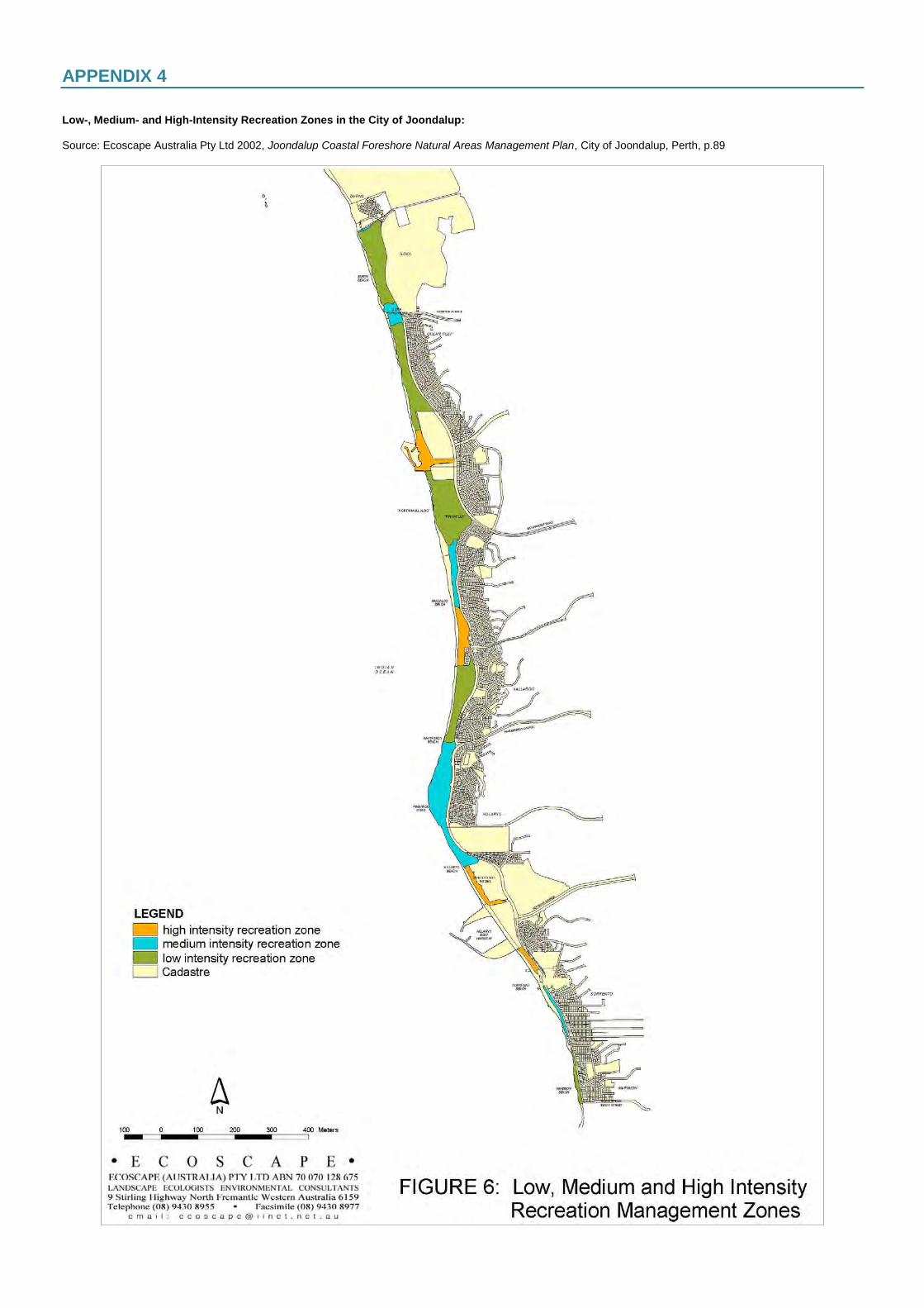
APPENDIX 4 Low-, Medium- and High-Intensity Recreation Zones in the City of Joondalup: Source: Ecoscape Australia Pty Ltd 2002, Joondalup Coastal Foreshore Natural Areas Management Plan, City of Joondalup, Perth, p.89
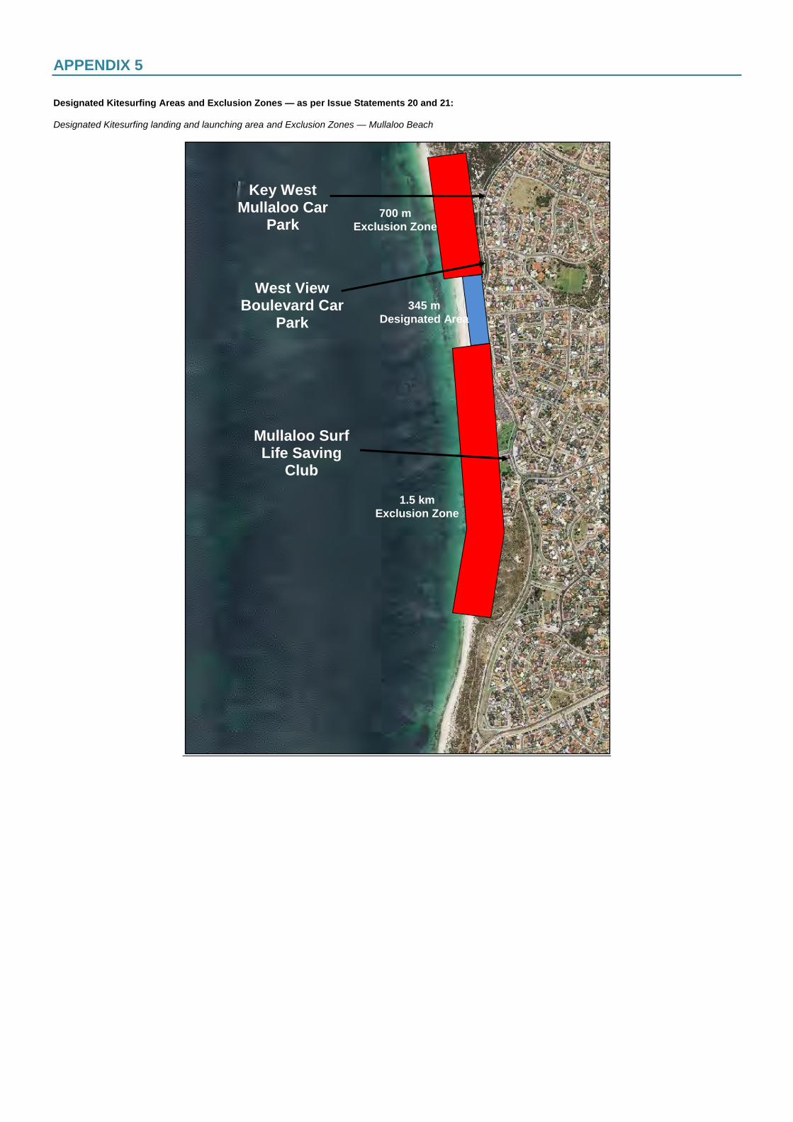
APPENDIX 5 Designated Kitesurfing Areas and Exclusion Zones — as per Issue Statements 20 and 21: Designated Kitesurfing landing and launching area and Exclusion Zones — Mullaloo Beach
345 m
Designated Area
1.5 km
Exclusion Zone
Mullaloo Surf Life Saving
Club
700 m
Exclusion Zone
Key West Mullaloo Car
Park
West View Boulevard Car
Park
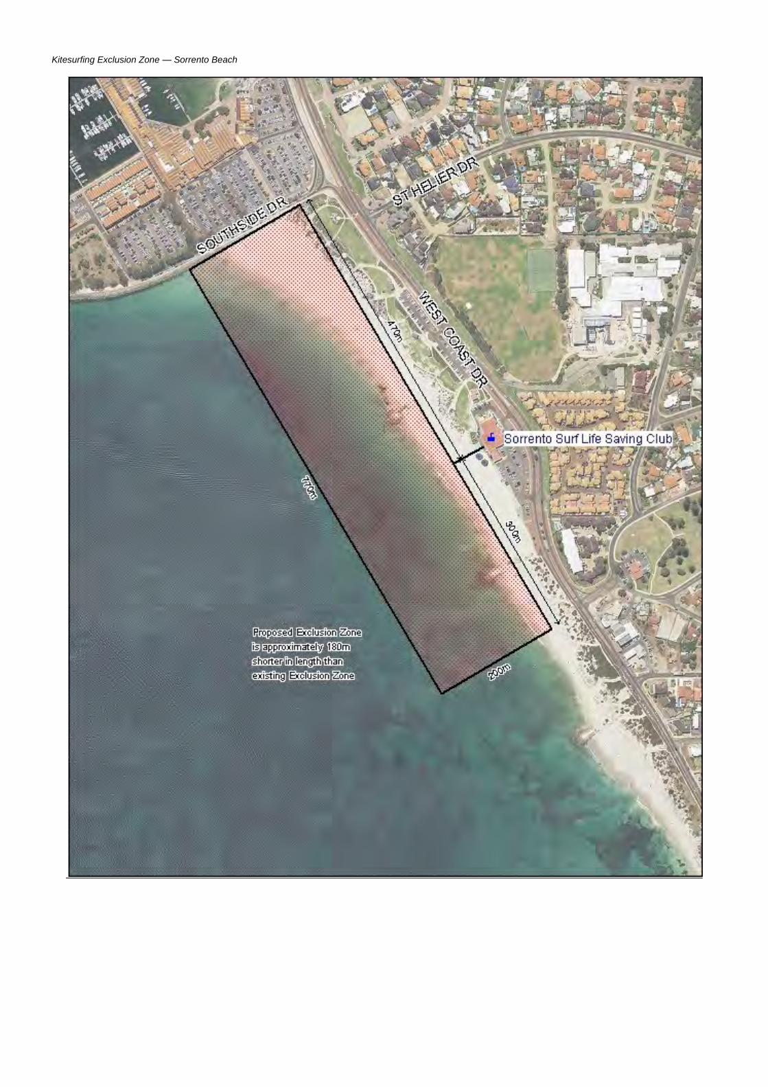
Kitesurfing Exclusion Zone — Sorrento Beach
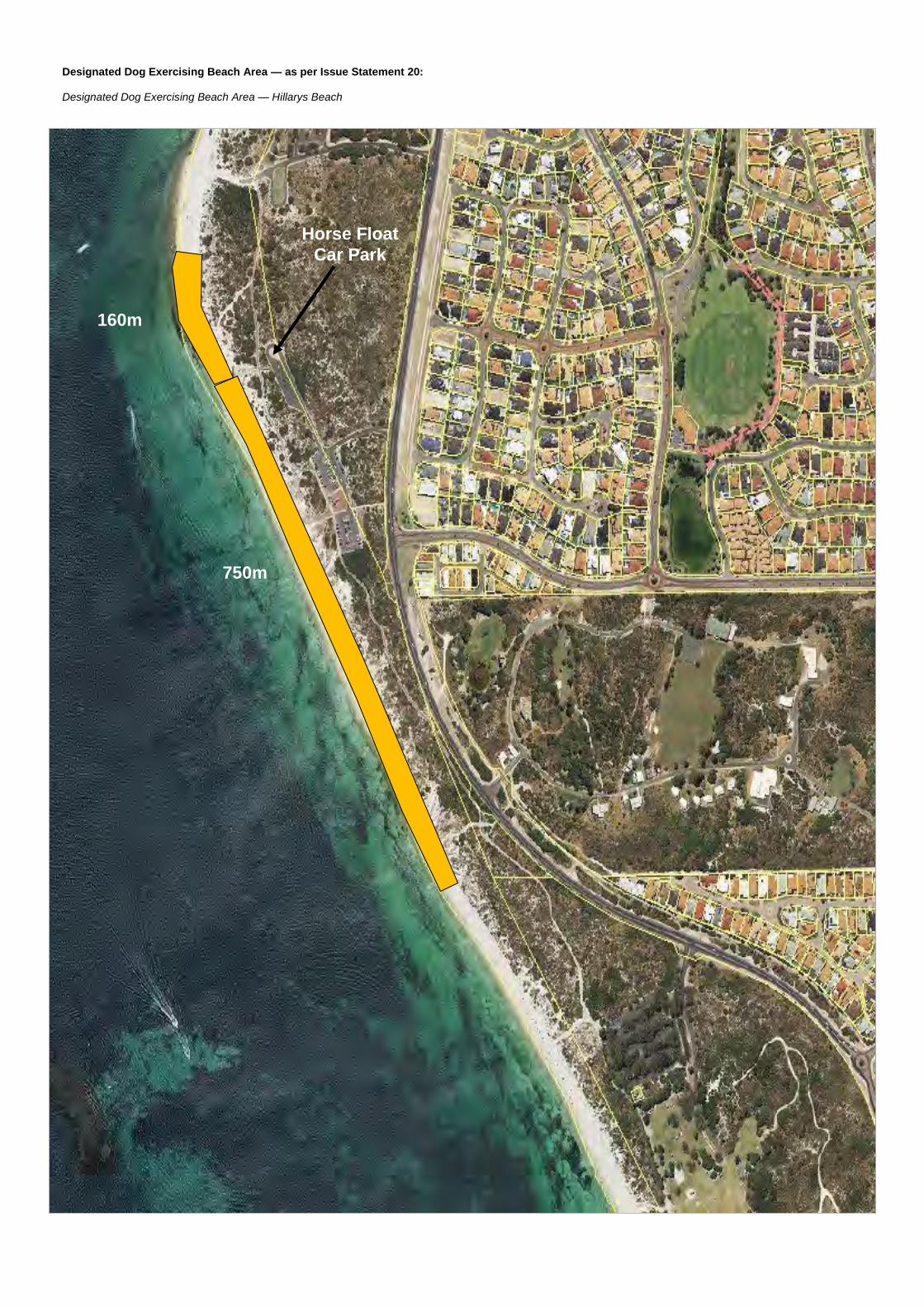
Designated Dog Exercising Beach Area — as per Issue Statement 20: Designated Dog Exercising Beach Area — Hillarys Beach
160m
750m
Horse Float
Car Park