Embed Size (px)
Citation preview
CITY OF GREATER GERALDTON
Local Planning Scheme No. 1
Amendment No. 3
Basic omnibus amendment proposing a number of minor modifications to correct various administrative errors, clarify clauses and normalise structure planned areas.
PLANNING AND DEVELOPMENT ACT 2005
RESOLUTION TO ADOPT AMENDMENT TO LOCAL PLANNING SCHEME
CITY OF GREATER GERALDTON
LOCAL PLANNING SCHEME No. 1
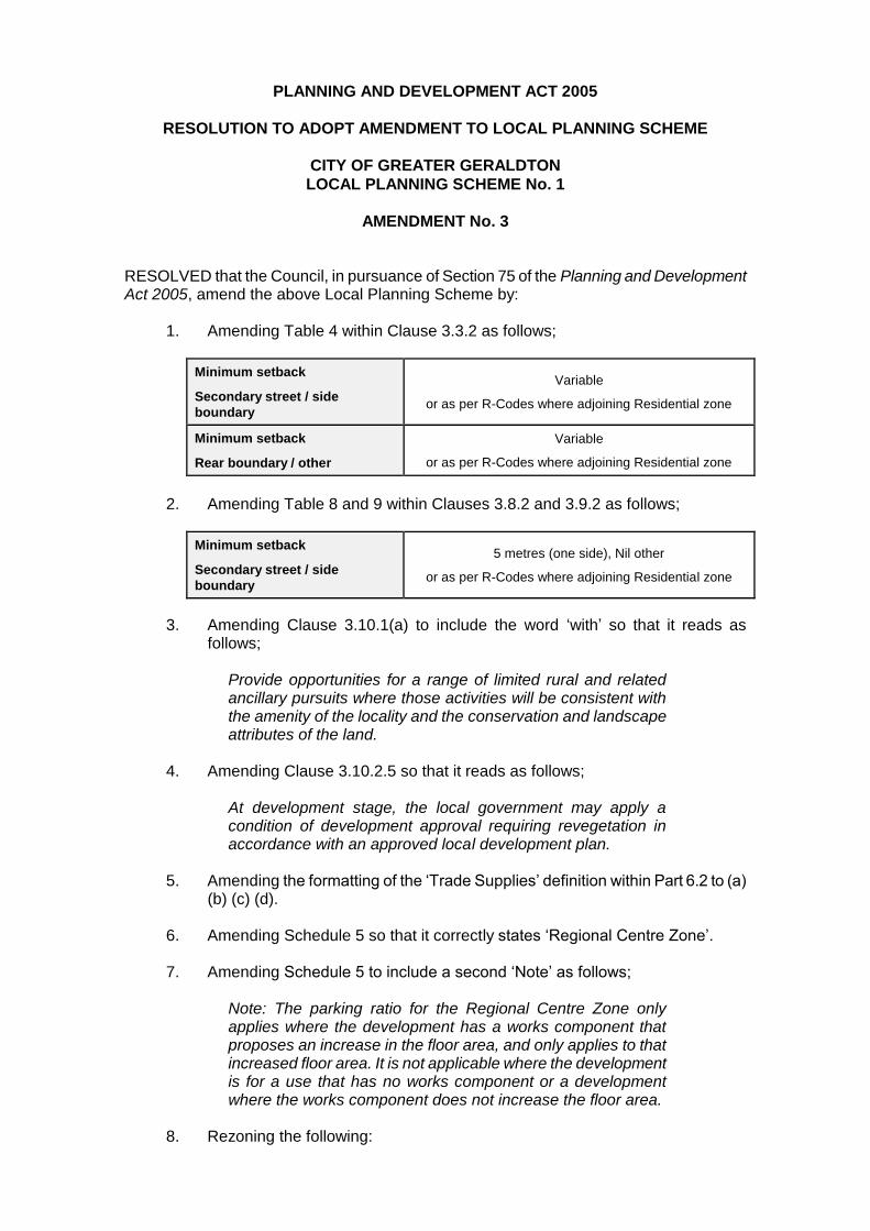
AMENDMENT No. 3 RESOLVED that the Council, in pursuance of Section 75 of the Planning and Development Act 2005, amend the above Local Planning Scheme by:
1. Amending Table 4 within Clause 3.3.2 as follows;
Minimum setback
Secondary street / side
boundary
Variable
or as per R-Codes where adjoining Residential zone
Minimum setback
Rear boundary / other
Variable
or as per R-Codes where adjoining Residential zone
2. Amending Table 8 and 9 within Clauses 3.8.2 and 3.9.2 as follows;
Minimum setback
Secondary street / side
boundary
5 metres (one side), Nil other
or as per R-Codes where adjoining Residential zone
3. Amending Clause 3.10.1(a) to include the word ‘with’ so that it reads as follows;
Provide opportunities for a range of limited rural and related ancillary pursuits where those activities will be consistent with the amenity of the locality and the conservation and landscape attributes of the land.
4. Amending Clause 3.10.2.5 so that it reads as follows;
At development stage, the local government may apply a condition of development approval requiring revegetation in accordance with an approved local development plan.
5. Amending the formatting of the ‘Trade Supplies’ definition within Part 6.2 to (a)
(b) (c) (d).
6. Amending Schedule 5 so that it correctly states ‘Regional Centre Zone’.
7. Amending Schedule 5 to include a second ‘Note’ as follows;
Note: The parking ratio for the Regional Centre Zone only applies where the development has a works component that proposes an increase in the floor area, and only applies to that increased floor area. It is not applicable where the development is for a use that has no works component or a development where the works component does not increase the floor area.
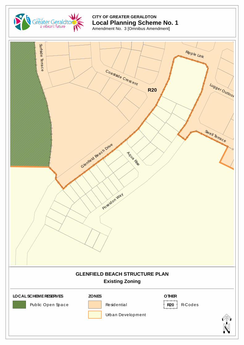
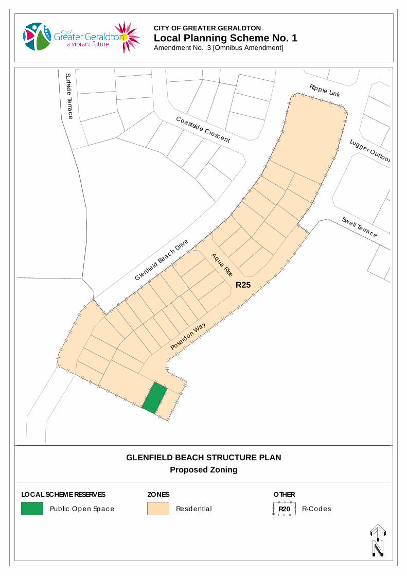
8. Rezoning the following:

a Portion of Lot 9502, Lots 5-8, Lots 26-34 and Lot 207 Glenfield Beach Drive,
Lots 9-12 and Lots 22-25 Aqua Rise; and
Lots 13-16, Lot 35-42, Lot 204, Lot 206 Poseidon Way, Glenfield from ‘Urban Development’ zone to ‘Residential R25’.
9. Rezoning the newly created road reserves of:
Aqua Rise,
Poseidon Way; and
a portion of Glenfield Beach Drive from ‘Urban Development’ zone to ‘Residential R25’.
10. Rezoning Lot 205 Poseidon Way, Glenfield from ‘Urban Development’ zone to
‘Public Open Space’ local scheme reserve.
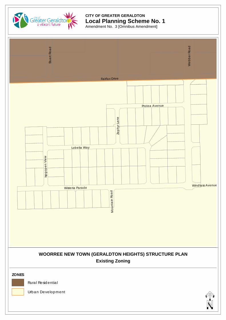
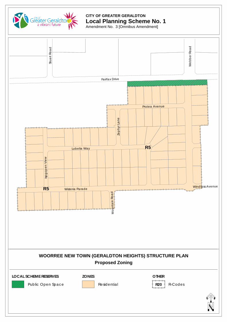
11. Rezoning the following:
Lots 91-95 and Lots 108-11 1Webber Road,
Lots 14-29 Protea Avenue,
Lot 100 Zephyr Lane,
Lot 47, Lots 75-86, Lots 96-99 and Lots 101-106 Lobelia Way,
Lots 40-46 and Lots 49-50 Isopogon View,
Lot 48, Lots 51-52, Lots 55-74 and Lots 87-90 Wisteria Parade,
Lots 112-113 Phaeton Road; and
Lot 114 Windlass Avenue, Moresby from ‘Urban Development’ zone to ‘Residential R5’.
12. Rezoning the newly created road reserves of:
Webber Road,
Phaeton Road,
Windlass Avenue,
Wisteria Parade,
Mountain Road,
Isopogon View,
Lobelia Way,
Zephyr Lane; and
Protea Avenue from ‘Urban Development’ zone to ‘Residential R5’.
13. Rezoning Lots 116 and 117 Fairfax Drive, Moresby (Reserve 51615) from
‘Urban Development’ zone to ‘Public Open Space’ local scheme reserve.
14. Rezoning Lot 485 on Deposited Plan 77050 (Reserve 51686) from the ‘Residential R5’ zone to the ‘Public Open Space’ local scheme reserve.
15. Rezoning Lot 486 on Deposited Plan 77050 from ‘Rural Residential’, ‘Residential R5’ and ‘Residential R2.5’ to the ‘Foreshore’ local scheme reserve.
16. Rezoning a portion of the newly created road reserve of Dorset Drive from ‘Rural Residential and ‘Residential R2.5’ to the ‘Public Open Space’ local scheme reserve.
17. Amending the R2.5 R-Code boundary to exclude Lots 485 and 486 on Deposited Plan 77050 and a portion of Dorset Drive. Amend the R5 R-Code boundary to exclude Lot 486 on Deposited Plan 77050.
18. Updating the scheme maps accordingly.
The amendment is basic under the provisions of the Planning and Development (Local Planning Schemes) Regulations 2015 for the following reasons:
1. The amendment is to correct an administrative error,
2. The amendment is to ensure consistency with another provision of the local planning scheme; and
3. The amendment is consistent with a structure plan that has been approved
under the scheme for the land to which the amendment related and the scheme currently includes zones of all types that are outlined in the structure plans.
Dated this day of 2017.
______________________________ CHIEF EXECUTIVE OFFICER
PLANNING AND DEVELOPMENT ACT 2005
CITY OF GREATER GERALDTON
LOCAL PLANNING SCHEME No. 1
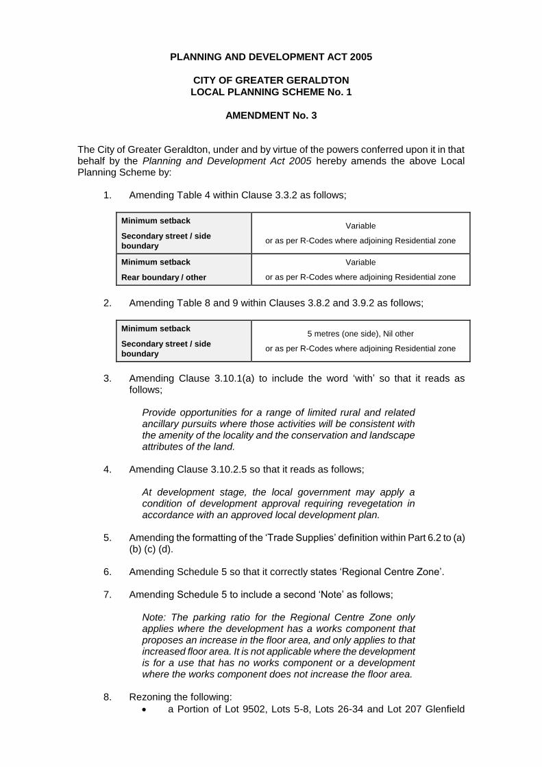
AMENDMENT No. 3 The City of Greater Geraldton, under and by virtue of the powers conferred upon it in that behalf by the Planning and Development Act 2005 hereby amends the above Local Planning Scheme by:
1. Amending Table 4 within Clause 3.3.2 as follows;
Minimum setback
Secondary street / side
boundary
Variable
or as per R-Codes where adjoining Residential zone
Minimum setback
Rear boundary / other
Variable
or as per R-Codes where adjoining Residential zone
2. Amending Table 8 and 9 within Clauses 3.8.2 and 3.9.2 as follows;
Minimum setback
Secondary street / side
boundary
5 metres (one side), Nil other
or as per R-Codes where adjoining Residential zone
3. Amending Clause 3.10.1(a) to include the word ‘with’ so that it reads as follows;
Provide opportunities for a range of limited rural and related ancillary pursuits where those activities will be consistent with the amenity of the locality and the conservation and landscape attributes of the land.
4. Amending Clause 3.10.2.5 so that it reads as follows;
At development stage, the local government may apply a condition of development approval requiring revegetation in accordance with an approved local development plan.
5. Amending the formatting of the ‘Trade Supplies’ definition within Part 6.2 to (a)
(b) (c) (d).
6. Amending Schedule 5 so that it correctly states ‘Regional Centre Zone’.
7. Amending Schedule 5 to include a second ‘Note’ as follows;
Note: The parking ratio for the Regional Centre Zone only applies where the development has a works component that proposes an increase in the floor area, and only applies to that increased floor area. It is not applicable where the development is for a use that has no works component or a development where the works component does not increase the floor area.
8. Rezoning the following:
a Portion of Lot 9502, Lots 5-8, Lots 26-34 and Lot 207 Glenfield
Beach Drive,
Lots 9-12 and Lots 22-25 Aqua Rise; and
Lots 13-16, Lot 35-42, Lot 204, Lot 206 Poseidon Way, Glenfield from ‘Urban Development’ zone to ‘Residential R25’.
9. Rezoning the newly created road reserves of:
Aqua Rise,
Poseidon Way; and
a portion of Glenfield Beach Drive from ‘Urban Development’ zone to ‘Residential R25’.
10. Rezoning Lot 205 Poseidon Way, Glenfield from ‘Urban Development’ zone to
‘Public Open Space’ local scheme reserve.
11. Rezoning the following:
Lots 91-95 and Lots 108-11 1Webber Road,
Lots 14-29 Protea Avenue,
Lot 100 Zephyr Lane,
Lot 47, Lots 75-86, Lots 96-99 and Lots 101-106 Lobelia Way,
Lots 40-46 and Lots 49-50 Isopogon View,
Lot 48, Lots 51-52, Lots 55-74 and Lots 87-90 Wisteria Parade,
Lots 112-113 Phaeton Road; and
Lot 114 Windlass Avenue, Moresby from ‘Urban Development’ zone to ‘Residential R5’.
12. Rezoning the newly created road reserves of:
Webber Road,
Phaeton Road,
Windlass Avenue,
Wisteria Parade,
Mountain Road,
Isopogon View,
Lobelia Way,
Zephyr Lane; and
Protea Avenue from ‘Urban Development’ zone to ‘Residential R5’.
13. Rezoning Lots 116 and 117 Fairfax Drive, Moresby (Reserve 51615) from
‘Urban Development’ zone to ‘Public Open Space’ local scheme reserve.
14. Rezoning Lot 485 on Deposited Plan 77050 (Reserve 51686) from the ‘Residential R5’ zone to the ‘Public Open Space’ local scheme reserve.
15. Rezoning Lot 486 on Deposited Plan 77050 from ‘Rural Residential’, ‘Residential R5’ and ‘Residential R2.5’ to the ‘Foreshore’ local scheme reserve.
16. Rezoning a portion of the newly created road reserve of Dorset Drive from ‘Rural Residential and ‘Residential R2.5’ to the ‘Public Open Space’ local scheme reserve.
17. Amending the R2.5 R-Code boundary to exclude Lots 485 and 486 on Deposited Plan 77050 and a portion of Dorset Drive. Amend the R5 R-Code boundary to exclude Lot 486 on Deposited Plan 77050.
18. Updating the scheme maps accordingly.
ADOPTION Adopted by resolution of the Council of the City of Greater Geraldton at the ordinary meeting of the Council held on the day of 2017.
______________________________ MAYOR
______________________________ CHIEF EXECUTIVE OFFICER
FINAL APPROVAL Adopted for Final Approval by Resolution of the City of Greater Geraldton at the ordinary meeting of the Council held on the day of 2017. and the Common Seal of the City of Greater Geraldton was hereunto affixed by the authority of a resolution of the Council in the presence of:
______________________________ MAYOR
______________________________ CHIEF EXECUTIVE OFFICER
Recommended/Submitted for Final Approval
______________________________ DELEGATED UNDER S.16
OF THE PD ACT 2005
______________________________ Date
Final Approval Granted
______________________________ MINISTER FOR PLANNING
______________________________ Date
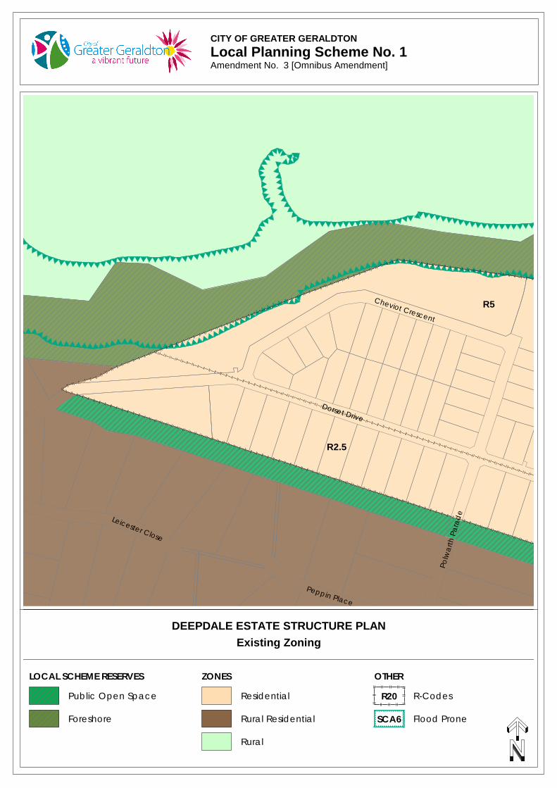
CITY OF GREATER GERALDTONLocal Planning Scheme No. 1Scheme Amendment No.
Cheviot Crescent
Dorset Drive
Polw
arth
Par
ade
Peppin Place
Leicester Close
R5
R2.5
Rural
LOCAL SCHEME RESERVES ZONES OTHER
ResidentialPublic Open Space R-CodesR20
Existing Zoning
SCA6 Flood ProneForeshore Rural Residential
DEEPDALE ESTATE STRUCTURE PLAN
CITY OF GREATER GERALDTONLocal Planning Scheme No. 1Amendment No. 3 [Omnibus Amendment]
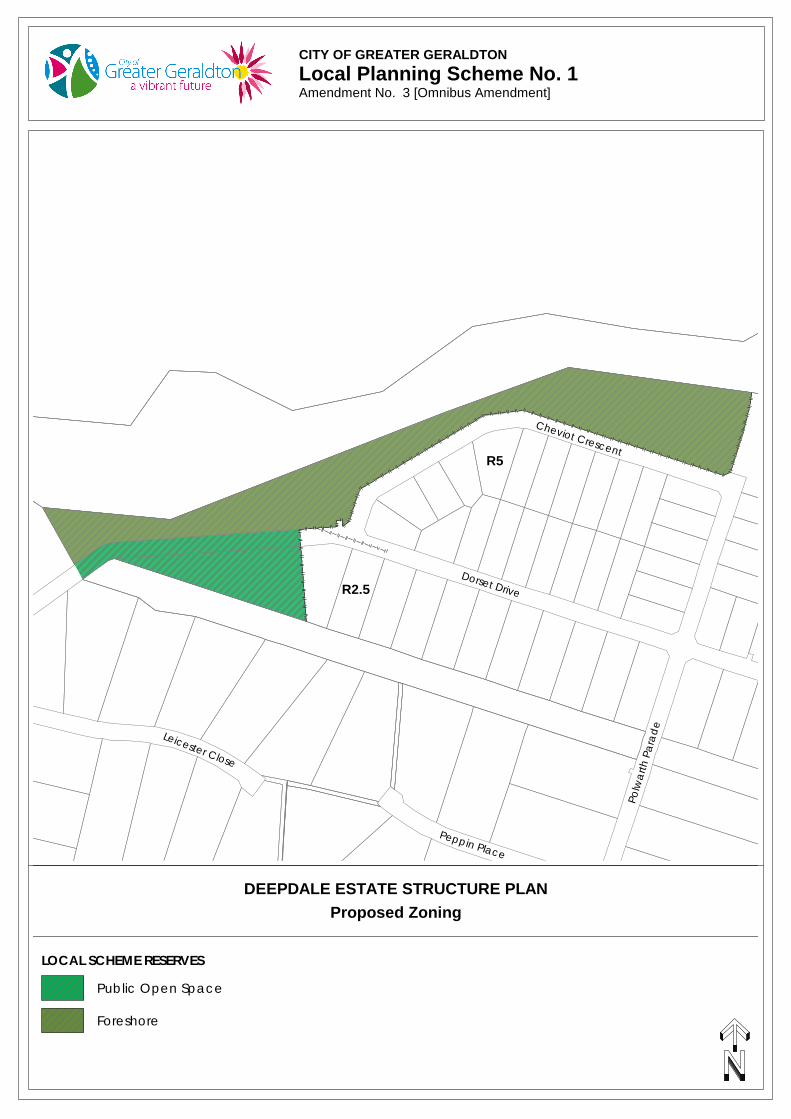
CITY OF GREATER GERALDTONLocal Planning Scheme No. 1Amendment No.
Polw
arth
Par
ade
Peppin Place
Cheviot Crescent
Dorset Drive
Leicester Close
Proposed Zoning
Public Open Space
Foreshore
LOCAL SCHEME RESERVES
DEEPDALE ESTATE STRUCTURE PLAN
R5
R2.5
CITY OF GREATER GERALDTONLocal Planning Scheme No. 1Amendment No. 3 [Omnibus Amendment]
CITY OF GREATER GERALDTONLocal Planning Scheme No. 1Scheme Amendment No.
Coastside Crescent
Glenfield Beach Drive
Ripple Link
Aqua Rise
Poseidon Way
Swell Terrace
Lugger Outlook
Surfside Terra
ce
R20
GLENFIELD BEACH STRUCTURE PLAN
LOCAL SCHEME RESERVES ZONES OTHER
ResidentialPublic Open Space R-CodesR20
Existing Zoning
Urban Development
CITY OF GREATER GERALDTONLocal Planning Scheme No. 1Amendment No. 3 [Omnibus Amendment]
CITY OF GREATER GERALDTONLocal Planning Scheme No. 1Scheme Amendment No.
Coastside Crescent
Glenfield Beach Drive
Ripple Link
Aqua Rise
Poseidon Way
Swell Terrace
Lugger Outlook
Surfside Terra
ce
R25
Proposed Zoning
LOCAL SCHEME RESERVES ZONES OTHER
ResidentialPublic Open Space R-CodesR20
GLENFIELD BEACH STRUCTURE PLAN
CITY OF GREATER GERALDTONLocal Planning Scheme No. 1Amendment No. 3 [Omnibus Amendment]
CITY OF GREATER GERALDTONLocal Planning Scheme No. 1Scheme Amendment No.
Fairfax Drive
Stua
rt Ro
ad
Web
ber
Roa
d
Protea Avenue
Lobelia Way
Wisteria Parade
Ispgo
pen
Vie
w
Zeph
yr L
ane
Mou
nta
in R
oad
Windlass Avenue
ZONES
Urban Development
Rural Residential
Existing ZoningWOORREE NEW TOWN (GERALDTON HEIGHTS) STRUCTURE PLAN
CITY OF GREATER GERALDTONLocal Planning Scheme No. 1Amendment No. 3 [Omnibus Amendment]
CITY OF GREATER GERALDTONLocal Planning Scheme No. 1Scheme Amendment No.
Fairfax Drive
Stua
rt Ro
ad
Web
ber
Roa
d
Protea Avenue
Lobelia Way
Wisteria Parade
Ispgo
pen
Vie
w
Zeph
yr L
ane
Mou
nta
in R
oad
Windlass Avenue
R5
R5
Proposed Zoning
LOCAL SCHEME RESERVES ZONES OTHER
ResidentialPublic Open Space R-CodesR20
WOORREE NEW TOWN (GERALDTON HEIGHTS) STRUCTURE PLAN
CITY OF GREATER GERALDTONLocal Planning Scheme No. 1Amendment No. 3 [Omnibus Amendment]
SCHEME AMENDMENT REPORT
1. INTRODUCTION The City of Greater Geraldton Local Planning Scheme No. 1 (“the Scheme”) was gazetted on 11 December 2015. Amendment No. 3 to the Scheme proposes a number of minor modifications to correct various administrative errors and to clarify clauses within the scheme. The amendment also proposes to update the scheme maps to include the recent development of a number of structure planned areas.
2. JUSTIFICATION FOR PROPOSED MODIFICATIONS
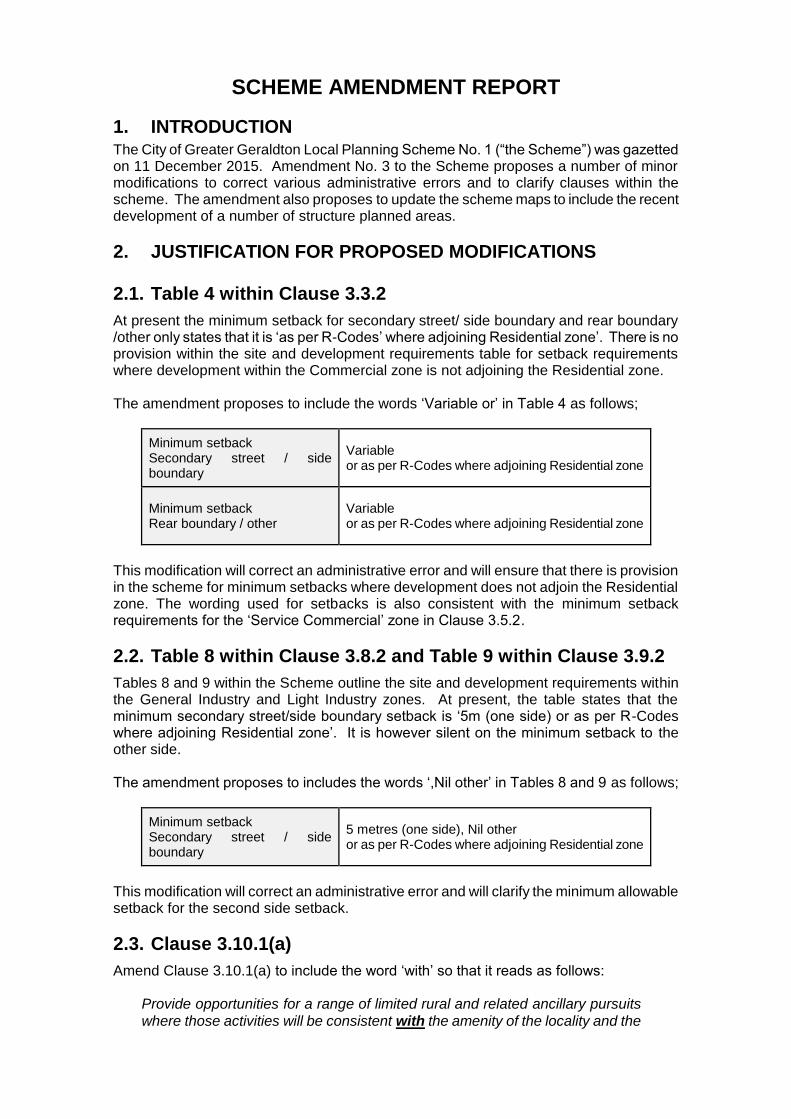
2.1. Table 4 within Clause 3.3.2
At present the minimum setback for secondary street/ side boundary and rear boundary /other only states that it is ‘as per R-Codes’ where adjoining Residential zone’. There is no provision within the site and development requirements table for setback requirements where development within the Commercial zone is not adjoining the Residential zone. The amendment proposes to include the words ‘Variable or’ in Table 4 as follows;
Minimum setback Secondary street / side boundary
Variable or as per R-Codes where adjoining Residential zone
Minimum setback Rear boundary / other
Variable or as per R-Codes where adjoining Residential zone
This modification will correct an administrative error and will ensure that there is provision in the scheme for minimum setbacks where development does not adjoin the Residential zone. The wording used for setbacks is also consistent with the minimum setback requirements for the ‘Service Commercial’ zone in Clause 3.5.2.
2.2. Table 8 within Clause 3.8.2 and Table 9 within Clause 3.9.2
Tables 8 and 9 within the Scheme outline the site and development requirements within the General Industry and Light Industry zones. At present, the table states that the minimum secondary street/side boundary setback is ‘5m (one side) or as per R-Codes where adjoining Residential zone’. It is however silent on the minimum setback to the other side. The amendment proposes to includes the words ‘,Nil other’ in Tables 8 and 9 as follows;
Minimum setback Secondary street / side boundary
5 metres (one side), Nil other or as per R-Codes where adjoining Residential zone
This modification will correct an administrative error and will clarify the minimum allowable setback for the second side setback.
2.3. Clause 3.10.1(a)
Amend Clause 3.10.1(a) to include the word ‘with’ so that it reads as follows:
Provide opportunities for a range of limited rural and related ancillary pursuits
where those activities will be consistent with the amenity of the locality and the
conservation and landscape attributes of the land. This will rectify an administrative error.
2.4. Clause 3.10.2.5
Clause 3.10.2.5 currently reads as
At development stage, and subject to completion of a local development plan in accordance with clause 3.10.2.4, the local government may apply a condition of development approval requiring revegetation in accordance with the approved local development plan.
It is proposed to delete the wording ‘and subject to completion of a local development plan in accordance with clause 3.10.2.4’ so that clause 3.10.2.5 reads as follows;
At development stage, the local government may apply a condition of development approval requiring revegetation in accordance with an approved local development plan.
Currently the inclusion of ‘and subject to completion of a local development plan in accordance with clause 3.10.2.4’ prevents the City from applying a condition for revegetation where a prior subdivision has not occurred. However, there are specific situations where revegetation of the site in association with the development of land would be considered appropriate despite the land not being subdivided prior. For example, a revegetation condition as part of a development application for a proposed ‘Winery’ on a lot within the Waggrakine Rural Residential Structure Plan area which is also located within a strategic biodiversity linkage specified in the Local Biodiversity Strategy would be considered advantageous given that land management plans and works in association with the development would already be required. The modification to the wording of Clause 3.10.2.5 would allow the City to exercise discretion with regard to requesting a revegetation condition as part of a development application where revegetation of the site is considered strategically important in accordance with other approved documents.
2.5. Part 6.2 - Definition of ‘trade supplies’
Amend the formatting within the ‘trade supplies’ definition to change the bullet points from (d) (e) (f) (g) to (a) (b) (c) (d). This will rectify an administrative error.
2.6. Schedule 5 – Parking Requirements
Amend ‘Centre Zone’ in the table to read ‘Regional Centre Zone’. This will rectify an administrative error.
2.7. Schedule 5 – Parking Requirements
Include a second ‘Note’ at the bottom of Schedule 5 as follows:
Note: The parking ratio for the Regional Centre Zone only applies where the development has a works component that proposes an increase in the floor area, and only applies to that increased floor area. It is not applicable where the development is for a use that has no works component or a development where the works component does not increase the floor area.
As per Clause 1.4 of LPS No 1, notes printed in italics do not form part of the scheme and the inclusion of this note does not change the requirements of Schedule 5. The note merely seeks to assist in the interpretation and application of Schedule 5 within the Regional Centre zone which is consistent with the previous Scheme No. 3 (Geraldton) which included Clause 5.7.6 which stated;
Where development of a site is the redevelopment, restoration or refurbishing of an existing building, and does not involve a change of use or an increase in the number of persons employed on site, or a material increase in the intensity of site use, the requirements of Table 3 or clause 5.75 shall apply only to the floor area which is in excess of that existing at the time of application for planning consent.
2.8. Normalising developed structure planned areas
Under the Planning and Development (Local Planning Schemes) Regulations 2015 an approved structure plan is a document to which planning decision-makers are to give due regard to when making decisions on the subdivision and development of land within the structure plan area. Although structure plans do not have the statutory force and effect of a scheme, the decision-maker is to consider and apply the requirements of the structure plan when assessing applications within the structure plan area. In order to have the statutory force and effect of a scheme, an approved structure plan is to be incorporated or ‘normalised’ into a scheme, via a scheme amendment or as part of a scheme review. Essentially incorporating (or ‘normalising’) a structure plan into a planning scheme simply involves rezoning the lots created to reflect what they were shown as in the structure plan. This is proposed for a number of structure planned areas listed below.
2.8.1. Glenfield Beach Structure Plan
The Glenfield Beach Structure Plan was endorsed on 17 February 2016 and subsequent subdivision and development has occurred in accordance with the approved structure plan. The amendment proposes to rezone the newly created residential lots and road reserves to ‘Residential R25’ and Lot 205 Poseidon Way, Glenfield to ‘Public Open Space’ local scheme reserve in accordance with the structure plan.
2.8.2. Woorree New Town Structure Plan (Geraldton Heights)
The Woorree New Town Structure Plan was endorsed on 8 March 2010 and subsequent subdivision and development has occurred in accordance with the approved structure plan. The amendment proposed to rezone the newly created residential lots and road reserves to ‘Residential R5’ and Reserve 51615 to ‘Public Open Space’ local scheme reserve in accordance with the approved structure plan.
2.8.3. Deepdale Estate Structure Plan
The Deepdale Estate Structure Plan was endorsed on 28 August 2012 and subsequent subdivision and development has occurred in accordance with the approved structure plan. The area covered by the structure plan is already zoned ‘Residential R2.5’ and

‘Residential R5’, however the newly created Reserve 51686 needs to be appropriately rezoned ‘Foreshore’ and ‘Public Open Space’ local scheme reserve and the R-Coding removed.
3. CONCLUSION It is considered that the proposed amendment is well justified and the rezoning of the affected areas is supported given
The modifications are to correct administrative errors, anomalies or to ensure consistency across the scheme.
The proposed rezonings are consistent with endorsed structure plans and proposed zones are all included within the scheme.