Embed Size (px)
Citation preview
1
CITY OF GATLINBURG
MUNICIPAL ZONING ORDINANCE
UPDATED THROUGH March 30, 2016
2
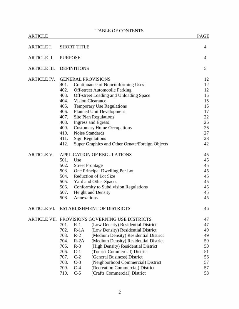
TABLE OF CONTENTS ARTICLE PAGE ARTICLE I. SHORT TITLE 4 ARTICLE II. PURPOSE 4 ARTICLE III. DEFINITIONS 5 ARTICLE IV. GENERAL PROVISIONS 12
401. Continuance of Nonconforming Uses 12 402. Off-street Automobile Parking 12 403. Off-street Loading and Unloading Space 15 404. Vision Clearance 15 405. Temporary Use Regulations 15 406. Planned Unit Development 17 407. Site Plan Regulations 22 408. Ingress and Egress 26 409. Customary Home Occupations 26 410. Noise Standards 27 411. Sign Regulations 28 412. Super Graphics and Other Ornate/Foreign Objects 42
ARTICLE V. APPLICATION OF REGULATIONS 45 501. Use 45 502. Street Frontage 45 503. One Principal Dwelling Per Lot 45 504. Reduction of Lot Size 45 505. Yard and Other Spaces 45 506. Conformity to Subdivision Regulations 45 507. Height and Density 45 508. Annexations 45 ARTICLE VI. ESTABLISHMENT OF DISTRICTS 46 ARTICLE VII. PROVISIONS GOVERNING USE DISTRICTS 47 701. R-1 (Low Density) Residential District 47 702. R-1A (Low Density) Residential District 49 703. R-2 (Medium Density) Residential District 49 704. R-2A (Medium Density) Residential District 50 705. R-3 (High Density) Residential District 50 706. C-1 (Tourist Commercial) District 51 707. C-2 (General Business) District 56 708. C-3 (Neighborhood Commercial) District 57 709. C-4 (Recreation Commercial) District 57 710. C-5 (Crafts Commercial) District 58
3
711. C-6 (Planned Golf Resort Development) District 58 712. FP-1 (Floodplain) District 60
713. CA (Commercial Aesthetic) District 61 714. CSFZ (Critical Slope Floating Zone) 63
715. HOD (Hillside Overlay) District 67 716. E/C (Educational/Cultural) District 74 ARTICLE VIII. AREA, YARD, AND HEIGHT REQUIREMENTS 75 ARTICLE IX. EXCEPTIONS AND MODIFICATIONS 77 901. Lot of Record 77 902. Adjoining and Vacant Lots of Record 77 903. Front Yards 77 904. Group Housing Projects 77 ARTICLE X. ENFORCEMENT 78
1001. Enforcing Officer 78 1002. Building Permit Required 78 1003. Issuance of Building Permit 78 1004. Certificate of Occupancy 78 1005. Penalties 78 1006. Remedies 78
ARTICLE XI. BOARD OF ZONING APPEALS 79
1101. Creation and Appointment 79 1102. Procedure 79 1103. Appeals 79 1104. Powers 79 1105. Action of the Board of Zoning Appeals 80
ARTICLE XII. AMENDMENT 81
1201. Procedure 81 1202. Approval by Planning Commission 81 1203. Introduction of Amendment 81
ARTICLE XIII. LEGAL STATUS PROVISIONS 82
1301. Conflict with other Ordinances 82 1302. Validity 82 1303. Effective Date 82
ARTICLE XIV. WIRELESS TELECOMMUNICATIONS TOWERS AND ANTENNAS 83 APPENDIX 91
4
ZONING ORDINANCE OF THE
CITY OF GATLINBURG, TENNESSEE
AUTHORITY AN ORDINANCE, IN PURSUANCE OF THE AUTHORITY GRANTED BY SECTIONS 13-7-201 THROUGH 13-7-210 AND SECTION 13-7-401, TENNESSEE CODE ANNOTATED, for the purpose of promoting the public health, safety, morals, convenience, order, prosperity and general welfare; to provide for the establishment of districts within the corporate limits; to regulate, within such districts, the location, height, bulk, number of stories and size of buildings and structures, the percentage of lot occupancy, the required open spaces, the density of population and the uses of land, buildings and structures; to provide methods of administration of this ordinance and to prescribe penalties for the violation thereof. BE IT ORDAINED BY THE CITY OF GATLINBURG CITY COMMISSION.
ARTICLE I. SHORT TITLE This ordinance shall be known as the "Zoning Ordinance of the City of Gatlinburg, Tennessee," and the map herein referenced, which is identified by the title "Zoning Map of the City of Gatlinburg, Tennessee," and all explanatory matter thereon are hereby adopted and made a part of this ordinance.
ARTICLE II. PURPOSE These zoning regulations and districts as herein set forth have been made in accordance with a comprehensive plan for the purpose of promoting the health, safety, morals and the general welfare of the community. They have been designed to lessen congestion in the streets, to secure safety from fire, panic and other danger, to provide adequate light and air, to prevent the overcrowding of land, to avoid undue concentration of population, to facilitate the adequate provision of transportation, water, sewerage, schools, parks and other public requirements. They have been made with reasonable consideration among other things, as to the character of each district and its particular suitability for particular uses, and with a view of conserving the value of buildings and encouraging the most appropriate use of land throughout the city.

5
ARTICLE III. DEFINITIONS Unless otherwise stated, the following words shall, for the purpose of this ordinance, have the meaning therein indicated. Words used in the present tense include the future. The singular number includes the plural and the singular. The word "shall" is mandatory, not directory. The word "used" or "occupied" as applied to any land or building shall be construed to include the word "intended", arranged or designed to be used or occupied. ADULT ORIENTED BUSINESSES. Establishments selling obscene material as defined in the Gatlinburg Municipal Code, Section 11-9, are not permitted within the City of Gatlinburg. ARTERIAL STREET. A street that provides for traffic movement between areas and across portions of the city and secondarily for direct access to abutting land, as shown on the Zoning Map of the City of Gatlinburg. AVERAGE BUILDING HEIGHT. As shown on Sketches A, B, and C in the Appendix at a cross-section. BED AND BREAKFAST ESTABLISHMENTS. Bed and breakfast establishment means an inn, or other unique residential facility offering bed and breakfast accommodations and one (1) daily meal and having not more than twelve (12) guest rooms furnished for pay, with guests staying not more than fourteen (14) days, and where the innkeeper resides on the premises or property or immediately adjacent to it and where guest rooms shall be established and maintained distinct and separate from the innkeeper's quarters. BOARDING OR ROOMING HOUSE. A building containing a single dwelling unit and not more than five guest rooms where lodging is provided with or without meals for compensation. BUFFER STRIP. A plant material acceptable to the Planning Commission which has such growth characteristics as will provide an obscuring screen not less than six feet in height. BUILDING. Any structure having a roof supported by columns or by walls and intended for the shelter, housing or enclosure of persons, animals, or chattels.
MAIN OR PRINCIPAL: A building in which is conducted the principal use of the lot on which it is situated. In any residential district, any dwelling shall be deemed to be a main building on the lot on which it is situated.
ACCESSORY BUILDING: A subordinate structure or building, the use of which is incidental to that of a main structure and use and located on the same lot therewith.
BUILDING LINE: A vertical plane running parallel with the outermost surface of all exterior bearing and non-bearing walls. BUILDING OFFICIAL: The officer or designated authority charged with the administration and enforcement of this and other related (i.e., building) codes, or his duly authorized representative.
6
CARPORT: A structure used for the storage of vehicles and having no enclosure other than its roof and such necessary support as will present the minimum obstruction to light, air, and view. CLINIC: A structure used in providing medical services for outpatients only. CLUB: Buildings and facilities owned or operated by an association or persons for a social or recreational purpose, but not operated primarily for profit or to render a service which is customarily carried on as a business. COLLECTOR STREET: A street providing for traffic movement within the city as shown on the Zoning Map of the City of Gatlinburg. CROSS SECTION: A cut-away view of any portion of the building perpendicular to the building line. DAY CARE CENTER: A place operated by a person, society, agency, corporation, institution, or other group that receives pay for the care of eight or more children under 17 years of age for less than 24 hours per day, without transfer of custody. The term "Day Care Center" also includes child development centers, nursery schools, day nurseries, play schools, and kindergartens, as well as agencies providing before and after school care, regardless of name, purpose, or auspices. (Excluding school grades 1-12 and kindergartens operated by governmental units or by religious organizations). DWELLING - SINGLE FAMILY: A building designed, constructed and used for one dwelling unit. DWELLING - TWO FAMILY OR DUPLEX: A building designed, constructed or reconstructed and used for two dwelling units that are connected by a common structural wall. DWELLING - MULTI-FAMILY: A building designed, constructed and used for more than two dwelling units, with each dwelling unit having a common structural wall with any other dwelling unit on the same floor. FAMILY: One or more persons occupying a premise and living together as a single housekeeping unit. FINISH GRADE LINE: A straight line between the points where finish grade intersects the vertical building line through any cross-section. (See sketches A, B, and C in the Appendix) FLOODWAY: The channel of a stream and that portion of the adjoining floodplain designated by the City of Gatlinburg to reasonably provide for the passage of flood flows, which in the ordinance shall be floodways shown on the plates which are made a part of this ordinance or for streams or portions of streams not shown on the above plates, an area equal to five (5) times the width of the stream at the top of the banks unless it can be shown in a study by a registered engineer that a smaller area would be a reasonable requirement.
7
FLOODWAY FRINGE AREA: Areas lying outside the floodway but within the floodplain - (See Appendix). FLOOR AREA RATIO: A mathematical expression determined by dividing the total floor area of a building by the area of the lot on which it is located, as FA = FAR LA HOME OCCUPATION: An occupation for gain or support which is customarily conducted at the home, which is incidental to the use of the dwelling unit, which employs not more than two persons not residents of the premises, and not more than thirty (30 percent) of the total actual floor area is used for home occupation purposes. LOT: A parcel of land which fronts on and has access to a public street and which is occupied or intended to be occupied by a building or buildings with customary accessories and open spaces. LOT LINE: The boundary dividing a given lot from a street, alley, or adjacent lots. LOT OF RECORD: A lot, the boundaries of which are filed as legal record. MAXIMUM BUILDING HEIGHT: The vertical distance between the point where average finish grade intersects the building line at the lowest most point to the roof height through any cross-section and runs parallel to the finish grade line. (See sketches A, B, and C in the Appendix). MODULAR HOME/BUILDING: A unit of construction which is totally or in part constructed off-site and transported for on-site erection, placement, assembly or similar terms.
MODULAR HOME/BUILDINGS are constructed in methods which include but are not limited to:
Basically complete units which may be transported to the permanent site and placed in a permanent position or location with no assembly required other than attachment to the foundation, structure or other modular or non-modular constructions, connections to utilities, etc.
As above, but transported in halves or other sections due to size or site considerations.
Prefabricated, panelized or other method whereby the components (i.e., walls, roof) are constructed in sections for on-site assembly.
Pre-cut units where construction materials are pre-pared off-site and may be assembled on-site or off-site into components (i.e., walls, roof).
8
Modular Home/Building are acceptable in the City of Gatlinburg, provided: They meet all provisions of the zoning ordinance;
They are constructed to comply with the various building codes of the city; They meet all the various codes of the city in their completed condition;
They are placed on a permanent site and are not intended or easily capable of being relocated;
They are approved and bear the insignia of approval of the Commissioner of the Tennessee Department of Commerce and Insurance, his designee, or inspection agency approved by the Commissioner.
MOBILE HOME/MOBILE BUILDING: A modular unit designed and constructed to be transported (either as a whole or in halves or other sections) and is so designed that it is intended and/or capable of being relocated. Mobile Homes/Mobile Buildings are categorized into two basic classifications: Type 1: Those that are constructed to comply with the Standard Building Code, and Type 2: Those which do not comply with the Standard Building Code.
Type 2 Mobile Home/Mobile Buildings may not be used within the City of Gatlinburg except as residences in approved mobile home and/or travel trailer parks.
Type 1 Mobile Home/Mobile Buildings may not be used within the City of Gatlinburg but may be used in the Gatlinburg Planning Region, provided all provisions of the Zoning Ordinance are complied with.
NONCONFORMING USE: Any structure or land lawfully occupied by a use that does not conform to the use regulations of the district in which it is situated. NON-TRADITIONAL BUILDING FACADES. A building facade visible from any public right-of-way, that is designed to attract attention through the use of an unorthodox or abnormal design method, style, scale, or site placement, and does not have a correlation to the surrounding properties and the generally accepted community standards. Non-traditional building facades shall be subject to the provisions of Article IV, Section 412 of this ordinance. NURSING HOME: A facility licensed by the State of Tennessee. OPEN SPACE: Any land or area, the preservation and/or creation of which would (1) conserve and enhance natural or scenic resources; or (2) create outdoor quite spaces and recreation areas and opportunities; and (3) provides visual relief to developed areas of the site through the use of
9
enhanced landscaping applications or existing natural vegetation. Open space does not include areas of parking and vehicle circulation associated with the development.
OTHER ORNATE/FOREIGN OBJECTS. All other objects or items designed to attract attention that are not classified as a sign or super graphic, but includes two or three dimensional objects either still or moving, noiseless or emitting noise, and are incorporated into, on, or projecting from the building or property so that the object is visible from and public right-of-way. All other objects shall be subject to the provisions of Article IV, Section 412 of this ordinance. PLANNED UNIT DEVELOPMENT: A planned residential, commercial or industrial development, professionally designed as a unit, approved by the Gatlinburg Planning Commission and located in those areas zoned for its use. ROOF HEIGHT: The highest most point of the finished roof surface in the case of flat and slightly sloping roofs or to one-half the vertical distance between the uppermost ceiling level and highest most point of the finished roof having a pitch of more than one (1) foot in (4 ½) feet through any cross-section. SHOPPING CENTER: For the purpose of this ordinance, a mall, a shopping center, a multi-tenant building and similar situations are the same thing. They represent a single enterprise which is located on a single parcel of property which is internally separated or segregated into individual shops or separate, distinct business or function. Actual ownership of the individual, separate functions is not a factor. STREET: A public right-of-way set aside for public travel which (a) has been accepted for maintenance by the City of Gatlinburg; (b) has been established as a public street prior to the date of adoption of this ordinance; (c) has been dedicated to the City of Gatlinburg for public travel by the recording of a street plat or a plat of a subdivision which has been approved by the Planning Commission. STRUCTURE: Anything constructed or erected, the use of which requires location on the ground, or attachment to something having location on the ground. TATTOO PARLOR/STUDIOS: As defined in §T.C.A. 62-38-201 et.seq. TOTAL FLOOR AREA: The area of all floors of a building including finished attic, finished basement and covered porches. TOWNHOUSE: A townhouse is a single family dwelling unit constructed in a series or group of attached units with property lines separating such units. TRAVEL TRAILER: Any vehicle used, or so constructed as to permit its being used as conveyance upon the public streets or highways and duly licensable as such, and constructed in such a manner as will permit occupancy thereof as a dwelling or sleeping place for one (1) or more persons, and designed for short-term occupancy, for frequent and/or extensive travel, and for recreational and vacation use, including camper trucks and self-propelled campers, etc.
10
TRAVEL TRAILER PARK: Any plat of land upon which two or more travel trailers are located and used as temporary living or sleeping quarters. The occupants of such parks may not remain in the same trailer park more than 30 days. Proposed parks shall be considered planned unit developments. YARD: That portion of any land division held free of development for the purposes complementary to the public health, safety, and welfare. Development within the required yard areas is prohibited without written approval of the Gatlinburg Municipal Board of Zoning Appeals unless otherwise exempted herein.
Exempted from review by the Municipal Board of Zoning Appeals and deemed appropriate in required yard areas are the following instances:
a) Driveways and related drainage accessories limited to one point of access, b) Sidewalks,
c) Fences in residential instances, and commercial instances subject to approval by the Environmental Design Review Board.
d) Signage per other ordinance provisions, e) Planters in all districts, f) Steps which are part of the sidewalk system in all districts, g) Parking in all districts, h) The planting of trees and vegetation that does not obstruct traffic vision.
i) Roof overhangs in the amount of 1.5 inches for every one foot of building setback and 1.5 inches for every one foot of roofline height from average grade, not to exceed 60 inches in C-1 zones, 72 inches in C-2 zones, and 36 inches in C-3 and C-5 zones. In residential zones, roof overhangs in the amount of one inch for every one foot of building setback and one inch for every one foot of roofline height from average grade, not to exceed 36 inches.
If there is any question of the acceptability of proposed development within the
required yard areas, the Board of Zoning appeals must review and approve said proposal prior to issuance of a building permit.
FRONT YARD: Yard extending across the entire width of the lot along any adjoining public right-of-way. In the event the front property line and outside edge of the public right-of-way, sidewalk, or street do not coincide, the front yard shall commence at the outside edge of the
11
property line, roadway, sidewalk or right-of-way, whichever is furthest from the roadway center line. REAR YARD: Yard extending across the entire width of the lot along the rear lot line. Yard, Rear: An open (other than for permitted accessory structures) space on the same lot with the principal building between the rear line of the building and the rear line of the lot and extending the full width of the lot. SIDE YARD: A yard extending along the side lot lines from the front yard to the rear yard. TOURIST RESIDENCE: Any dwelling used for the overnight and/or weekly rental to tourists and required by the city to obtain an annual Tourist Residence Permit.
12
ARTICLE IV. GENERAL PROVISIONS
401. CONTINUANCE OF NONCONFORMING USES: Any lawful use of any building or land existing at the time of the enactment of this ordinance or whenever a district is changed by an amendment thereafter may be continued although such use does not conform with the following limitations:
401.1 No building or land containing a nonconforming use, except commercial and industrial uses exemplified by TCA 13-7-208, shall hereafter be extended unless such extensions shall conform with the provisions of this ordinance for the district in which it is located; provided, however, that a nonconforming use may be extended throughout those parts of a building which were manifestly arranged or designed for such use prior to the time of enactment of this ordinance. 401.2 Any nonconforming building which has been damaged by fire or other causes, may be reconstructed and used as before unless the building inspector determines that the building is damaged to the extent of more than fifty (50) percent of its appraised value for tax purposes, in which case any repair or reconstruction shall be in conformity with the provisions of this ordinance. 401.3 When a nonconforming use of any building or land has ceased for a period of 30 days, it shall not be reestablished or changed to any use not in conformity with the provisions of this ordinance.
402. OFF-STREET AUTOMOBILE PARKING: Off-street automobile parking space shall be provided on every lot on which any of the following uses are hereafter established except for non-residential uses in the C-1 (Central Business) District. The number of automobile parking spaces provided shall be at least as great as the number specified below for various uses. Each space shall have at least one hundred sixty (160) square feet in area and shall have vehicular access to a public street. Turning space shall be provided so that no vehicle will be required to back into the street ... “except backing into the public right-of-way may be permitted on certain lots subject to the following conditions:”
1. The lot must be located in an R-1 or R-1A zoning district; 2. The lot must be located adjacent to a minor residential street as designated on the
Official Street Classification Map for the City of Gatlinburg. 3. The lot must be located on the down side of the public right-of-way giving access to
the lot; 4. The on-site parking area must be level with the street;
5. The area utilized for parking and backing out must be situated in such a manner as to insure adequate and safe sight distances as determined by the Gatlinburg Building and Planning Departments;
6. The average slope of the proposed building site must exceed 30 percent (as verified by a licensed surveyor).
13
402.1 AUTOMOBILE REPAIR GARAGES: One space for each regular employee plus one space for each 250 square feet of floor space used for repair work.
402.2 CHURCHES: One space for each four (4) seats.
402.3 CLUBS and LODGES: One space for each three hundred (300) square feet of floor space.
402.4 DWELLINGS:
402.4.1 SINGLE and DUPLEX - Two spaces for each unit.
402.4.2 Multi-Family Units with:
a) A maximum of 600 square feet total floor area: 1.1 spaces per unit.
b) A maximum of 900 square feet total floor area: 1.25 spaces per unit.
c) A maximum of 1,200 square feet total floor area: 1.5 spaces per unit.
d) A maximum of 1,500 square feet total floor area: 1.75 spaces per unit.
e) More than 1,500 square feet total floor area: two (2) spaces per unit.
402.4.3 Bed and Breakfast Establishments: One space for each sleeping unit,
plus two (2). 402.5 FUNERAL PARLORS: One space for each four (4) seats in the chapel.
402.6 GASOLINE SERVICE STATIONS and SIMILAR ESTABLISHMENTS: Four (4) spaces for each bay or similar facility plus one space for each employee.
402.7 HOSPITALS AND NURSING HOMES: One space for each two staff or visiting doctors plus one space for each two employees and one space for each four beds, computed on the largest number of employees on duty at any period of time.
402.8 HOTELS: One space for each guest room, plus two (2).
402.9 RESERVED FOR FUTURE USE
402.10 MOTELS: One space for each accommodation, plus two (2).
14
402.11 OFFICES:
402.11.1 MEDICAL: one space for each three hundred (300) square feet of floor space.
402.11.2 OTHER PROFESSIONAL: One space for each four hundred (400) square feet of floor space.
402.11.3 GENERAL: One space for each four hundred (400) square feet of floor space.
402.12 PLACES OF PUBLIC ASSEMBLY: One space for each five (5) seats in the principal assembly room or area.
402.13 RECREATION AND AMUSEMENT AREAS WITHOUT SEATING CAPACITY: One Space for each four (4) customers, computed on a maximum service capacity.
402.14 RESTAURANTS: One space for each four (4) customers, computed on a maximum service capacity.
402.15 RETAIL BUSINESS AND SIMILAR USES: One space for each three hundred (300) square feet of gross floor space.
402.16 SCHOOLS: One space for each faculty member, plus one space for each four (4) pupils except in elementary schools.
402.17 MOBILE HOME PARKS: One space for each mobile home.
402.18 WHOLESALE BUSINESS: One space for each three (3) employees based on maximum seasonal employment.
402.19 If off-street parking space required above cannot be reasonably provided on the same lot on which the principal use is conducted, it may be provided on other off-street property provided such space lies within four hundred (400) feet of the main entrance to such principal use. Such vehicle standing space shall be deemed to be required open space associated with the permitted use and shall not thereafter be reduced or encroached upon in any manner; provided, that such remote off-street parking shall be permanent with the use and officially recorded as such with the Sevier County Registrar of Deeds.
402.20 EXTENSION OF PARKING SPACE INTO A RESIDENTIAL DISTRICT: Required parking space may extend up to 120 feet into a residential zoning district, provided that: (1) the parking space adjoins a commercial or industrial district; (2) has its only exit to or from the same street as the property in the commercial or industrial district from which it provides the required parking space; and (3) is separated from abutting
15
properties in the residential district by a plat or fence buffer strip as determined by the building official.
403. OFF-STREET LOADING AND UNLOADING SPACE: On every lot in which a business, trade, or industry use is hereafter established, space with access to a public street or alley shall be provided as indicated below for the loading and unloading of vehicles off the public street or alley.
403.1 RETAIL BUSINESS: Except in the C-1 district, one space of at least 12 by 25 feet for each 3,000 square feet of floor space or part thereof.
403.2 WHOLESALE: One space of at least 12 by 50 feet for each 10,000 square feet of floor area or part thereof.
403.3 TERMINALS: Sufficient space to accommodate the maximum number of buses or trucks that will be stored and loading and unloading at the terminal at any one time.
404. VISION CLEARANCE: In all districts there shall be no plants or structures placed in or on any yard portion of a lot that would obstruct the vision of auto or pedestrian traffic using the intersecting public streets. 405. TEMPORARY USES.
405.1 PURPOSE: Temporary uses are allowed in commercial districts of the City as provided in the provisions established herein. Temporary uses shall be allowed for certain uses for a limited duration and which are generally associated with the tourist industry. For the purpose of this section, temporary use is defined as activities conducted by the principal occupant of the property, including the placement of merchandise or products. In properties that function as a mall (indoor and/or outdoor), multi-tenant structure, shopping center, and/or similar structures, the principal occupant shall be the mall, multi-tenant structure, shopping center and/or similar structure and not the individual tenants located within said mall unless designated as the principal occupant by the mall. In these instances, a notarized document shall be supplied to the City from the principal occupant designating said tenant and acknowledging that the herein time limitations are not based on a per tenant basis, but for the entire property. A temporary use permit shall be limited to a maximum duration of 14 days and no more than two (2) temporary use permits shall be issued within a 12-month period on any given parcel of property.
405.2 PERMITTED USE. Temporary use activities may be conducted by the principal occupant of the property, and/or as limited access shows/events as per Section 405.4; however, they cannot be conducted in the front yard setback. The principal occupant shall be defined as the person or persons, who by the authority of a legally recorded deed or lease agreement, occupies a building on any given parcel of property. In properties that function as malls (indoor & outdoor), multi-tenant structures, shopping centers, and/or similar structures, the principal occupant shall be the mall, multi-tenant structure, shopping center and/or similar structure and not the individual tenants located within said mall unless designated by the mall. For the purposes of this section, a building shall be defined as a fully enclosed structure intended for the shelter and/or housing of persons,
16
animals, or chattels associated with the occupancy of the building. In addition, cultural exhibits, arts and crafts exhibits, and music activities approved by the Board of Commissioners of the City shall be permitted provided these activities are for exhibition or demonstration purposes only.
405.3 CERTAIN PUBLIC USES EXEMPTED. The following public properties and uses shall be exempt from the provisions of the Gatlinburg Zoning Ordinance and the Temporary Use Regulations of the City provided however, such uses shall be in compliance with the use policies of the Gatlinburg Convention Center or Recreation Department or the Parking Department, whichever is applicable:
405.3.1. Gatlinburg Convention Center. 405.3.2. City owned public parks and parking garage facilities.
405.3.3. Pi Beta Phi Elementary School and Gatlinburg-Pittman High School. 405.3.4 City Sponsored Special Events.
405.4 OTHER EXEMPTED USES. The following uses shall be exempted from the Temporary Use Regulations of this Ordinance provided the use is compliant with all other applicable Zoning Ordinance Requirements:
405.4.1. FARMERS MARKETS. Farmers Markets as defined under Article VII, Section 706.10 provided that the principal occupant of the property or in the case of a vacant property, the property owner, provides a consent form for the use of the property as a Farmers Market to the City of Gatlinburg. In addition, the market must comply with all the provisions established in Section 706.10.
405.5 LIMITED ACCESS SHOWS/EVENTS. Limited access shows/events may be conducted by applicants other than the principal occupant of the property under the following conditions:
a) The event shall be limited access (i.e. access by invitation only); b) The event shall not exceed 14 days; c) All temporary structures associated with the event may be erected no more than 7 days prior to the event and must be removed no later than 7 days following the event; d) No more than two (2) temporary use permits shall be issued for limited access shows/events for any given parcel or parcels occupied by a single business within a 12 month period; e) Limited access shows/events shall not be permitted within required setback areas.
405.6 PERMIT REQUIRED. A temporary use or limited access show/event is required to obtain a permit prior to such use or event. Application shall be made to the City at least 14 days prior to such use or event.
17
406. PLANNED UNIT DEVELOPMENT (PUD). 406.1 PURPOSE AND INTENT. A PUD is an alternative means of developing property which the planning commission may allow or require where flexible land development standards are utilized in order to preserve, protect, and enhance the unique character of the City of Gatlinburg. For the purposes of this ordinance, the following uses shall be classified as PUDs: multi-use residential and/or commercial and/or recreation uses, multi-ownership condominiums (single-family or multi-family units), cluster type single-family rental or permanent housing units. The provisions are intended to achieve economies in land development, maintenance, street systems, and utility networks while preserving community character, protecting scenic vistas, and reducing visual clutter for the general well-being of the inhabitants and the surrounding citizens. 406.2 GENERAL PROVISIONS.
406.2.1 LOCATION. A PUD may be located within any zoning district provided that the density and use provisions of the district in which such PUD plan is to be located have been reviewed and recommended for approval by the Gatlinburg Municipal/Regional Planning Commission. However, only single family dwellings, not rented on an overnight basis, shall be permitted in R-1A districts.
406.2.2 PERMITTED USES. Any use permitted in that district in which the PUD is to be located. 406.2.3 STAGING OF DEVELOPMENT. The PUD applicant may elect to develop the site in successive stages. The stages and expected development periods shall be shown on the preliminary PUD development plan. However, each stage given final PUD approval must be substantially complete within itself, including appropriate legal documentation of covenants and restrictions for open space. The planning commission may also require the development of a PUD project in stages if public facilities are not adequate to handle the entire development initially.
406.2.4 RELATIONSHIP OF PUD REGULATIONS TO SUBDIVISION REGULATIONS AND SITE PLAN REGULATIONS.
406.2.4.1 RELATIONSHIP TO SUBDIVISION REGULATIONS.
Public and common ways for pedestrian and vehicular circulation shall be developed in relationship to other existing or planned streets and ways and with the Major Thoroughfare Plan, Gatlinburg, TN. Whether or not the subdivision of property is proposed within a PUD, all project street and way improvements shall comply with the construction standards set out in the subdivision regulations. Due to the uniqueness of each PUD, the owner/developer of a PUD may request slight adjustments in widths of streets, ways, utility easements, curbing, and similar standards set out in the subdivision regulations; and, upon a determination of good cause being shown
18
for such adjustments, the planning commission may permit changes or alterations in standards, provided the spirit and intent of these PUD provisions can be preserved. 406.2.4.2 RELATIONSHIP TO SITE PLAN REGULATIONS. Unless specifically altered by any provision of Section 406, the site plan regulations of Section 407 and any other applicable provision of this ordinance shall also apply to the development of a PUD.
406.2.5 HEIGHT, DENSITY, AND AREA REGULATIONS. No building project shall exceed the height restrictions of the zoning district in which the PUD is located. All PUDs shall have a minimum development site of one (1) acre; and, each PUD shall adhere to the density requirements for the zoning district in which it is located. No freestanding buildings shall be closer than twenty-five (25) feet to any exterior property line or public street right-of-way and no closer than fifteen (15) feet to any private street edge. No freestanding building shall be closer than twenty (20) feet to any other freestanding building. Provided, however, PUDs, not including single-family and/or two family/duplex dwelling units, within the C-1 and C-2 districts shall adhere to the setback requirements within their respective districts except where adjoining residential districts, in which case the 25 foot setback shall be required from the residential zoning district property. 406.2.6 SITE IMPROVEMENTS.
406.2.6.1 All dedicated public streets shall be constructed so as to conform with the intent of the Gatlinburg Subdivision Regulations. All sidewalks shall be constructed in accordance with the sidewalk improvements specifications for the City of Gatlinburg. 406.2.6.2 Storm drainage and erosion control plans shall be provided in accordance with the Gatlinburg Subdivision Regulations. 406.2.6.3 Off-street automobile parking space shall be provided in accordance with Section 402. 406.2.6.4 A landscaping plan shall be provided in accordance with Section 407.3.
406.2.6.5 Each residential PUD shall provide on site usable open space intended to serve the residents of the PUD. In cases of residential rental units, the creation and maintenance of open space shall be established by legal documentation.
406.3 SIGNS. The number, size, type, and placement of signs shall be governed by the applicable provisions of Section 411.
19
406.4 PUD PLAN PREPARATION AND REVIEW PROCESS. Applicants for PUD approval shall follow the plan preparation and review process, set out below, except that, the planning commission may modify this process as may be necessary so long as the intent of this section is not violated.
406.4.1 PUDs INVOLVING SINGLE FAMILY RESIDENTIAL UNITS. Single family residential PUDs shall be developed as one of three types:
a) as a potential subdivision including a preliminary plat and PUD plan in accordance with the provisions of Section 406.4.2.2 and meeting the lot size requirements of the zone in which it is located. b) as a potential cluster type subdivision including a preliminary plat and PUD plan in accordance with the provisions of Section 406.4.2.2 with reduced lot sizes of 10,000 square feet in R-1, 7500 square feet in R-2, and 5000 square feet in R-3, and with legal documentation for ownership of common open space such that the zoning district minimum lot size averages are maintained.
c) an individual unit ownership, or condominium concept PUD, including a PUD plan in accordance with Section 406.4.3 with legal documentation of appropriate covenants and restrictions to ensure assignment and maintenance of common open space. The number of potential units shall be limited to the maximum number of lots if property were subdivided. Prior to acceptance by the City of Gatlinburg, all streets must meet the standards of the Gatlinburg Subdivision Regulations.
406.4.2 PUDs INVOLVING THE SUBDIVISION OF PROPERTY FOR RESALE OR LEASE.
406.4.2.1 PRELIMINARY PUD PLAN. Prior to submitting a preliminary subdivision plat for review, a preliminary PUD plan shall be submitted to the planning commission which shall include the following: the general location of buildings and uses, general circulation patterns, open space and recreation areas, parking areas, ingress/egress points, sketch elevations, a drainage and erosion control plan, the boundary dimensions, overall density of development, public uses, landscaping concepts, zoning classification, and other information deemed pertinent by the planning commission. The approved preliminary PUD plan shall serve as the plan upon which the final PUD plan and preliminary subdivision plat are based. Approval of a preliminary PUD plan shall be subject to the vested property rights and periods established under TCA §13-4-310 for development plans.
20
406.4.2.2 FINAL PUD PLAN/PRELIMINARY SUBDIVISION PLAT. In addition to meeting the applicable provisions of the subdivision regulations regarding preparation of a preliminary plat, the final PUD plan shall include detailed architectural/engineering plans for: utilities, vehicular and pedestrian circulation systems, location of all structures, topographic intervals at no more than five (5) feet, minimum elevations and grading, the physical relationship of uses, parking areas, open space and recreation areas, landscaped areas, buffer or screening materials and locations, areas proposed for dedication as parks, ways, or places, final drafts of legal documents, a signed certificate of acknowledgement, by the property owner, recognizing the Final PUD Site Plan approval expiration period, and other information deemed pertinent by the planning commission. Upon approval of the final PUD plan and preliminary subdivision plat by the planning commission, development may commence with the installation of public improvements. No lots, however, shall be sold until final subdivision plat approval has been granted by the planning commission with all required improvements having either been installed or appropriate security posted for the installation of such improvements. Approval of a final PUD plan shall be subject to the vested property rights and periods established under TCA §13-4-310 for development plans.
406.4.3 PUDs NOT INVOLVING THE SUBDIVISION OF PROPERTY FOR RESALE OR LEASE. In PUDs in which no individual parcel of property is owned or rented, such as a condominium and similar uses, the following requirements for PUD plan preparation apply.
406.4.3.1 PRELIMINARY PUD PLAN. A concept plan containing the following information shall be submitted to the planning commission for review: the general location of buildings and uses, general circulation patterns, open space and recreation areas, parking areas, ingress/egress points, sketch elevations, a drainage and erosion control plan, the boundary dimensions, overall density of development, public uses, landscaping concepts, zoning classification, and other information deemed pertinent by the planning commission. The approved preliminary PUD plan shall serve as the plan upon which the final PUD plan is based. Approval of a preliminary PUD plan shall be subject to the vested property rights and periods established under TCA §13-4-310 for development plans. 406.4.3.2 FINAL PUD PLAN. Following approval of a preliminary PUD plan, the developer may proceed to prepare a final PUD plan which shall include detailed architectural/engineering plans for: utilities, vehicular and pedestrian circulation systems, location of all structures, topographic intervals at no more than five (5) feet, minimum elevations and grading, the physical relationship of uses, parking areas, open space and recreation areas,
21
landscaped areas, buffer or screening materials and locations, areas proposed for dedication as parks, ways, or places, final drafts of legal documents including covenants and restrictions for open space, a signed certificate of acknowledgement, by the property owner, recognizing the Final PUD Site Plan approval expiration period, and other information deemed pertinent by the planning commission. Upon approval of the final PUD plan, appropriate permits may be issued. Approval of a final PUD plan shall be subject to the vested property rights and periods established under TCA §13-4-310 for development plans.
406.5 PERMITS. The developer of the PUD shall be entitled to receive appropriate development permits after approval of the final PUD plan and the preliminary subdivision plat, where applicable.
406.6 CHANGES AND MODIFICATIONS. A PUD project may be changed or modified under conditions established for minor changes and major changes.
406.6.1 MINOR CHANGES. The planning commission may approve changes in minor shifts of building locations, proposed streets and ways, utilities and easements, recreation and open space areas or other features on the approved plan. However, these changes shall not increase densities, change exterior boundary lines, change uses, materially change location or amount of land devoted to specific uses, or significantly change the exterior features or appearance of buildings and uses shown on the approved plans.
406.6.2 MAJOR CHANGES. All changes other than those established as minor shall be considered as major changes to the PUD plan and shall require a new plan submission in accordance with the procedures and requirements for approval of a PUD plan.
22
407. SITE PLAN REGULATIONS FOR MULIT-FAMILY, COMMERCIAL, AND INDUSTRIAL USES.
407.1 PURPOSE AND INTENT. Prior to the preparation of construction drawings, a site plan of any multi-family, commercial, or industrial project shall be reviewed and approved by the Planning Commission. It is the intent of this section that the development or redevelopment of land must be preceded by plans that are to be reviewed for compliance with the city's comprehensive planning program which leads to a more desirable environment by encouraging the appropriate grouping of buildings and uses to discourage strip development and lessen congestion caused by parking, traffic, and structures, thereby securing adequate light and air and creating a more pleasant community for the residents.
407.2 GENERAL PROVISIONS:
407.2.1 No building permit shall be issued until the site plan is approved by the Planning Commission and its approval is certified to the building official. Such plan shall then control the issuance of all building and occupancy permits and restrict construction, location, use, and facilities to the conditions set forth on the site plan. 407.2.2 Site plans for small additions or renovations to existing buildings shall be exempt from these regulations when in the opinion of the planning staff and building official the building alteration will not adversely affect the intent and purpose of this section. 407.2.3 The site plan shall contain the following information:
407.2.3.1 A location map of sufficient size and content to relate to others the property's location in the city. 407.2.3.2 A boundary plat and a certification that the parcel is a legal lot of record. 407.2.3.3 The location of existing streets, sidewalks, utilities, and other pertinent features or facilities that may be required by the Planning Commission. 407.2.3.4 Topography at intervals of five (5) feet or less. 407.2.3.5 A plan for grading, surface drainage, terraces, retaining wall heights, and ground floor elevations. 407.2.3.6 All transportation features including streets, drives, access points, paved parking and loading areas, and walkways.
23
407.2.3.7 Water, sewer, and power utilities. The extension of power shall utilize an underground system where feasible. Where undergrounding is not possible, as determined by the Planning Commission, power service connections shall be located at the rear of all buildings or structures. 407.2.3.8 All signage of the proposed development. 407.2.3.9 The location and dimensions of all buildings and structures, setbacks, distances between buildings, easements, and covenants. 407.2.3.10 A legend and title box with information on ownership, zoning, tabulations of pertinent data on land area, number of units, density, building area, parking area and spaces, date, scale, north point and other pertinent notes and certifications. 407.2.3.11 The location of fire hydrants, sprinkler system connections, and open space areas. 407.2.3.12 A landscaping plan to meet the requirements of Section 407.3. 407.2.3.13 Buffer screening may be required by the Planning Commission for uses that would adversely affect adjacent existing land uses. The buffer may be developed by use of one or a combination of the following: trees, shrubs, hedges, land berms, fencing of stone, brick or wood and other similar materials deemed appropriate by the Planning Commission.
407.3 LANDSCAPING REQUIREMENTS.
407.3.1 PURPOSE AND INTENT. Prior to the issuance of any permit for site plan, a landscape plan shall be reviewed and approved by the Planning Commission. It is the intent of these provisions to require landscape plans that comply with the City's comprehensive planning program, to enhance the aesthetic appearance and environment of new development and redevelopment in Gatlinburg, and to insure that the developments adequately provide greenery, light, air, and open space. This section is also intended to provide guidelines to assist landscape designers in creating site specific plans which will help Gatlinburg to complement, rather than conflict with, the beauty of the surrounding environment.
NOTE: In order to encourage creative landscape designs and to assist with accomplishing the intent and purpose for landscaping in Gatlinburg, the Planning Commission may allow deviation from the specific tree, ground cover, number, and size requirements of the following sections, provided the developer's design provides adequate alternative means of landscaping the site and meeting the intent set forth above.
24
407.3.2 PARKING LOT EXTERIOR LANDSCAPING.
407.3.2.1 Parking area boundaries not fronting on streets shall have minimum landscape strips of five (5) feet in width with one (1) tree for each twenty-five (25) feet or fraction thereof. 407.3.2.2 Walls and fences may be utilized along boundaries, when permitted within the underlying zoning district, and shall be constructed of natural stone, brick or wood arranged to complement the development and adjacent properties. For each ten (10) linear feet of non-living barriers, one shrub or tree, as appropriate, shall be planted adjacent to the barrier exterior.
407.3.2.3 All exterior solid waste containers shall be screened on all but one (1) side. Screening shall be by an opaque fence, landscaping, or other suitable enclosure, at least one (1) foot higher than the container height, and shall be permitted within the yard area of all land use zoning districts.
407.3.3 PARKING LOT INTERIOR LANDSCAPING.
407.3.3.1 Off-street parking areas, excluding loading, unloading, and storage areas, containing more than twenty (20) parking spaces shall provide interior landscaping. For uses not requiring off-street parking, a landscape plan or street improvements (sidewalk, setback area, etc.) shall be substituted. 407.3.3.2 Five (5) square feet of interior landscaped area shall be provided for each one hundred fifty (150) square feet of parking lot area, and a minimum of one (1) tree for each three hundred (300) square feet of parking lot area or fraction thereof, shall be provided. 407.3.3.3 The interior landscaped area shall be placed in a manner to properly divide the expanse of paving and to guide traffic flow. The interior area shall be no larger than three hundred fifty (350) square feet in lots under thirty thousand (30,000) square feet in area, and no larger than fifteen hundred (1500) square feet in lots larger than thirty thousand (30,000) square feet. This interior landscape area may be placed adjacent to buildings if deemed appropriate by the Planning Commission.
407.3.4 LANDSCAPE MATERIALS.
407.3.4.1 Where developments have and intend to keep existing landscape features and growth, these existing materials must be accurately shown on the landscaping plan, accurately, and may be used to meet the landscape plan requirements. The existing landscaping should meet the intent of the provisions of Section 407.3.
25
407.3.4.2 All plant materials shall be trees, shrubs, hedges, and ground cover and shall meet the provisions given below, subject to Section 407.3.1. 407.3.4.3 Evergreen trees shall be a minimum of three (3) feet in height. All other trees shall be a minimum of five (5) feet in height. Dwarf trees and exotic trees may be substituted if shown that their uses enhance the landscape plan. 407.3.4.4 Shrubs and hedges shall be at least eighteen (18) inches in average height. 407.3.4.5 Ground cover shall consist of grass and other permeable organic material capable of absorbing run-off water, or may include no more than forty (40) percent area of pebbles, wood chips, bark, mulch, and similar materials. 407.3.4.6 Earth mounds may be utilized as buffers provided proper design and adequate surface landscaping are provided.
407.3.5 LANDSCAPE INSTALLATION AND MAINTENANCE.
407.3.5.1 All landscaping shall be installed in a sound workmanship manner and in accordance with the approved landscape plan prior to the issuance of a Certificate of Occupancy; however, where conditions do not permit immediate planting, a Surety Bond or other appropriate guarantee in the form of a Letter of Credit or pledged Certificate of Deposit approved by the Planning Commission equal to 100 percent of the cost of the required plantings may be provided until plantings can be installed and a temporary Certificate of Occupancy may then be issued. 407.3.5.2 All landscaping shall be permanently maintained. The owner, tenant, and then agent, if any, shall be responsible for continued maintenance.
26
408. INGRESS AND EGRESS. A plan for adequate and safe ingress and egress for all land uses shall be required.
408.1 A point of ingress and egress for vehicles onto a public street shall not exceed twenty-six (26) feet in width with all points being constructed to allow proper drainage. 408.2 There shall be no more than two (2) points of ingress and egress on any street for each three hundred (300) feet of lot frontage or fraction thereof; provided, however, that lots of one hundred (100) feet or less of frontage shall have no more than one point of ingress and egress to the same street. 408.3 No point of ingress and egress shall be allowed within twenty-five (25) feet of the right-of-way line of an intersecting street. 408.4 The arrangement of off-street parking shall be so designed to prevent vehicles form backing into a street, notwithstanding existing commercial uses and/or renovation of less than 50 percent.
409. CUSTOMARY HOME OCCUPATIONS. A customary home occupation is a gainful occupation or profession conducted by a person residing on the premises.
409.1 Customary home occupations include: professional offices, craftmaking and related activities, teaching of music, beauty and/or barber shop, children's day care of less than six (6) persons, photography, art studio, insurance agency, and other similar activities. 409.2 Renting of tourist homes in the principal dwelling shall be considered a home occupation; provided, that no more than five (5) tourist rooms are used and that one (1) off-street parking space is provided for each tourist room. 409.3 Limitations:
409.3.1 No home occupation use shall be allowed to have stock or trade displayed outside the dwelling. 409.3.2 No alteration shall be made to the exterior of any dwelling to indicate that the dwelling is being used for any purpose other than a residential unit.
27
410. NOISE STANDARDS. Any use to be located within the City of Gatlinburg shall be subject to meeting noise standards.
410.1 On any lot or tract within residential districts, noise levels shall not exceed sixty (60) decibels between 7 a.m. and 7 p.m. and fifty-five (55) decibels between 7 p.m. and 7 a.m. 410.2 On any lot or tract within commercial, industrial, and floodway districts, noise levels shall not exceed seventy (70) decibels between 7 a.m. and 7 p.m. and sixty-five (65) decibels between 7 p.m. and 7 a.m. 410.3 For any use with questionable noise levels, a plan of compliance shall be required by the building office. The plan shall show how the above specified standards will be met. ` 410.4 Measurements shall be taken with an American National Standards Institute (ANSI) Type 1 or 2 sound level meter using the A-weighed scale. 410.5 Reasonable flexibility and application of noise regulations shall be allowed for short time periods; however, noises in excess of ninety (90) decibels shall not be allowed at anytime.
28
ARTICLE IV
SECTION 411 SIGN REGULATIONS 411.1 PURPOSE. It is recognized that the City of Gatlinburg is a Premier Resort City with its only industry being tourism. For this reason, it is found that the proper control of signs is of particular importance and that the right to identify a place, business, or convey a public message should and must be kept within reasonable boundaries consistent with the objectives and goals of the community in order to retain its unique character and the economic advantages which rests largely on the quality of its appearance. Therefore, the purpose of this ordinance is to regulate the number, location, size, height, and placement of signs in the City of Gatlinburg so as to preserve, promote, and protect: 1) the unique character of the city by the orderly display of signs, and thereby discourage confusing communications with the public; and 2) the public's health, safety, and welfare by assuring adequate light, air, and open spaces and a minimum of congestion and hazardous conditions. Therefore, all signs (except signs exempted elsewhere) erected, replaced, constructed, expanded, relocated or otherwise installed on any property within the city shall conform to these regulations. 411.2 DEFINITIONS:
411.2.1 Sign Administrator. The City Building Official or his/her designated agent. 411.2.2 Area Directional Sign. A sign located on public property at an intersection of two major thoroughfares, as approved by the Board of Commissioners which designates a definable area, business area, or community. 411.2.3 Banners. Any flexible announcement device affixed to poles, wires, or ropes for the purpose of temporarily announcing or promoting events or activities or used for decoration (see special event sign). 411.2.4 Billboard. An outdoor advertising sign that is not located upon the premises to which such advertising copy pertains, or an on-premise sign greater than 100 square feet in display service area. 411.2.5 Business Directional Sign. A standardized sign placed by the city at the intersection where a minor street intersects a major thoroughfare indicating the direction to a business with access located on the minor street. 411.2.6 Changeable Copy (Marquee). A sign with a permanent background and a designed format to accommodate changeable copy for the purpose of advertising specials. 411.2.7 Copy. The wording or pictorial graphics on a sign surface either in permanent or removable form.
29
411.2.8 Directory Sign. An outdoor sign erected by a mall, arcade, shopping center, multi-tenant building and the like, which lists the name of all businesses, in a uniform manner and on a single structure. 411.2.9 Display Service Area. The net geometric area enclosed by the display surface (sign face) of the sign and/or including the outer extremities of all letters, characters, and delineations; this shall not include structural supports. This area is used for size limitation determination. 411.2.10 Erect. To assemble, build, construct, attach, and install, place, raise, suspend, affix, paint, or in any way bring into being or establishment. 411.2.11 Flag. Any local, state, national or similar type of flag, not displayed for sale. 411.2.12 Freestanding Sign. A single or multi-faced sign affixed to a supporting structure or embedded in and extending from the ground and detached from the building. Allowable size does not include supporting structure (see "ground sign", as defined in the Standard Building Code). 411.2.13 Incidental Signs. As defined by Section 411.3.1.2. 411.2.14 Information Sign. Any on-premise sign containing no other message, copy, announcement, or decoration other than instructions or directions to the public. Such signs include but are not limited to signs which identify restrooms, walkways, entrances, exits, etc. 411.2.15 Mall. Mall, shopping center, Planned Unit Development, arcade, or any multi-tenant building on a single parcel of property which is internally separated or segregated into individual shops or similar subdivisions, each of which is, or appears to be, a separate and distinct business or function. 411.2.16 Menu Sign. Sign space devoted solely to the exterior display of restaurant and food service business menus. 411.2.17 Multi-tenant Building. Two or more retail stores, rental living units and/or service establishments, or any combination thereof, sharing common customer entries and areas, regardless of whether said stores, rental living units and/or establishments occupy separate structures or are under separate ownership. In the event two or more businesses occupy the same area, they shall be considered as a single tenant or business with regards to the total allowable signage. 411.2.18 Off-premise Sign. A sign other than an on-premise sign. 411.2.19 On-premise Sign. A sign relating in its subject matter to the premises on which it is located or to products, accommodations, services, or activities on the premises.
30
411.2.20 Pennants or Bunting. Long narrow or triangular shaped flags displayed on rope, wire, or string for the purpose of drawing the attention of the public. 411.2.21 Permanent Sign. As defined by Section 411.3.1.1. 411.2.22 Political Sign. A temporary sign denoting political campaign headquarters, party affiliation, cause or candidate. 411.2.23 Portable Sign. A single or double surfaced sign which is easily moveable usually mounted on wheels and not permanently erected. 411.2.24 Premises. The "premises" is the entire, single parcel of property occupied. In the case of malls, shopping centers, and multi-tenant buildings, the "premises" for each of the various businesses or functions is limited to the space occupied or directly connected to and associated with that particular business or function, exclusive of common areas. 411.2.25 Product Sign. Any on-premise sign which advertises a product or service offered, sold or otherwise provided by a business or activity, including signs attached to outdoor vending machines, stands, gasoline pumps, and display racks which direct attention to products dispensed therefrom. 411.2.26 Projecting Sign. A sign affixed to the building wall or structural support member and extending beyond the building wall or structural member more than 12 inches. 411.2.27 Public Sign. A sign owned and maintained by the City, State or Federal Government and used exclusively to preserve, protect and promote the general public's health, safety, and welfare, including "Business" and "Area Directional" signs. 411.2.28 Rate and Price Sign. Any outdoor advertising sign, or any sign placed within a business window, door or open store front which cannot be read from within the structure, which contains language and/or figures thereon tending to advertise the rates or prices for any merchandise, product, service, or facility. 411.2.29 Real Estate Sign. Any sign pertaining to the sale, rental, development or lease of a lot, tract, land, or one or more structures or portions thereof, including auction signs. 411.2.30 Roof Sign. Any sign attached to, supported by, erected, or maintained on the roof structure or the top of a parapet wall. 411.2.31 Sandwich Sign. An advertising device which is ordinarily in the shape of an "A" or some variation thereof, on the ground, easily moveable, and which is usually two sided.
31
411.2.32 Sign. Any object, device, or structure, or part thereof, which is used to advertise, identify, display, direct, or attract attention to an object, person, institution, organization, business, product, service, event or location by letters, words, numbers, figures, designs, symbols, fixtures, projected images or other symbols, devices, or representations. 411.2.33 Site Development Sign. A sign limited to identifying the name, location, and type of development; the parties involved in the construction and/or where to obtain more information about the construction. 411.2.34 Special Event. An activity or circumstance of a business or organization which is not part of its normal daily activities and occurs uninterrupted for a specified period of time not to exceed 30 days. 411.2.35 Special Event Sign. A sign pertaining to a special event. 411.2.36 Subdivision Entrance Sign. A sign to identify the name of a subdivision, mobile home park, condominium complex, PUD, and bed and breakfast establishments, or similar uses. 411.2.37 Super Graphics. A painted scene, mural, figure, or decorative design used to enhance or complement the building architecture or use, exclusive of any words, letters, numbers, or symbols either directly or indirectly associated with or connected to the super graphics. 411.2.38 Temporary Sign. Any "Permanent Business" sign temporarily erected with the intention of being removed or replaced within 30 days. 411.2.39 Internal Traffic Control Sign. A sign used for the purpose of identifying private parking areas and directing the flow of traffic on private property. (See also, "Information Sign") 411.2.40 Wall Sign. A sign affixed to any building, wall, or structural support member projecting not more than 12 inches. 411.2.41 Window Sign. A sign affixed to or located within six (6) inches of the interior or exterior surface of a window.
32
411.3 GENERAL PROVISIONS
411.3.1 Sign Classification. For the purpose of the administration of this ordinance, every sign shall be classified as either "permanent" or "incidental" based on its intended use.
411.3.1.1 Permanent Signage. A permanent sign shall include any identification or advertising which lends advertising to a business, activity or public function that is not generally subject to change unless a change in the name, lessee, ownership or nature of the business, activity or public function occurs. Permanent signage shall include but is not limited to the following:
1. Business Identification Signs. Signs in which the copy subject matter makes reference to the name or nature of a particular business or public function and exceeds three square feet in display service area. 2. Mall Directory Signs. As permitted per Section 411.11. 3. Subdivision Entrance Signs. Provided they do not exceed 20 square feet in display service area, and no more than one sign for each entrance from an existing city street. 4. Changeable Copy (Marquee) Signs that exceed (4) square feet in display service area. The periodic changing of letters or numbers shall not constitute a change in the sign classification, except for the display of rates and prices. 5. Super Graphics. Provided they are used to enhance or identify the architecture or use of the building and recommended for approval by the Environmental Design Review Board. 6. Business Directional Signs. As permitted per Section 411.10. 7. Other Signs. Any sign that does not qualify as incidental signage as identified in the following section shall be considered as permanent signage, unless specifically limited to incidental elsewhere in this ordinance.
411.3.1.2 Incidental Signage. An incidental sign shall include any sign which lends
advertising to business or public function operations or activities which are generally subject to periodic changes, irrespective of a change in the name, lessee, ownership or nature of the business or public function, unless the use of which is specifically identified as a permanent sign. Incidental signs shall include, but not limited to the following:
1. Banners. Provided they qualify as "Special Event" or "Temporary" signs. Banners are further limited to only incidental signage.
33
2. Information or Instructional Signs. Provided they do not exceed four (4) square feet 3. Product Signs. Provided they do not exceed four (4) square feet in display service area and qualify as wall signs. 4. Real Estate Signs. Real estate signs are limited to only incidental signage, and must meet the schedule in Section 411.6.13. 5. Site Development Signs. Provided they do not exceed thirty-two (32) square feet in display service area and no more than two signs being erected on the site during the period beginning 90 days prior to the start of construction through to 90 days following the first occupancy, with one sign per front yard or street entrance. Site development signs are further limited to only incidental signage. 6. Special Event Signs. Provided they do not exceed thirty-two (32) square feet in display service area, no more than one per front yard or street entrance, and not erected for more than thirty (30) days. Special event signs shall also include pennants, provided they do not exceed one per ten (10) foot spacing with a maximum total number of fifteen (15) pennants. 7. Temporary Signs. As permitted in Section 411.7. 8. Traffic Control Signs. Provided they do not exceed four (4) square feet in display service area. 9. Warning Signs. As described in Section 411.6.10. 10. Menu Sign. Provided they do not exceed 4 square feet in display service area. 11. Rate and Price Signs for Parking Lots. Provided that only one sign per each business street entrance is allowed, no larger than two (2) square feet, and must qualify as a wall sign or be located on ticket dispensing machines in parking lots. Once permitted, the message upon the sign may be changed, but the location and size may not change without a new permit.

34
411.3.2 Sign Location. All signs shall be affixed, mounted, or otherwise installed in accordance with the building code adopted by the City of Gatlinburg and in accordance with one of the following locations, unless specifically prohibited elsewhere in this ordinance:
1. Freestanding Ground Signs. 2. Wall Signs. 3. Projecting Signs. 4. Window Signs. Provided they do not exceed thirty (30) percent of the gross window area. 5. Roof Signs are limited to only permanent signage and in accordance with Section 411.8. No sign shall be located in relation to a public street, right-of-way, sidewalk, or thoroughfare so as to create a traffic hazard by distracting motorists, obscuring traffic signs, or impairing drivers sight lines; nor create hazards by blocking doors, windows, or other openings which are necessary for safe emergency egress, adequate fire suppression, or police surveillance activities; nor create hazards to pedestrians by obscuring, disrupting, or otherwise interfering with the safe movement of pedestrians.
411.3.3 Sign Structures. A sign structure shall be limited to that portion of the structure that is only necessary for the support of the sign and shall be designed so as to adequately support the weight being imposed on the structure, including applicable wind loads. All other portions of the structure including sign roofs in the building setback area shall be considered as part of the sign display service area. 411.3.4 Sign Height. Unless otherwise mentioned in this ordinance, no sign shall have a height of more than twenty-five (25) feet above average grade, but in cases of unique topography or congestion, the height may be extended to a maximum of thirty (30) feet above any point of grade, including flagpoles. No sign shall be less than nine (9) feet clear above any private drive or pedestrian walkway and no less than seven (7) feet clear above any covered walkway. 411.3.5 Sign Setback. The sign setback dimension shall be the least dimension from the leading edge of the sign or sign structure to any surrounding public right-of-way, street or sidewalk, whichever is furthest from the roadway centerline. The minimum setback dimension for each sign shall be five (5) feet. Businesses located in existing buildings which are located within the 5 foot setback area, with existing signage, shall be permitted to replace the signs provided the new signs comply with the number and size requirement of this ordinance, and extend no farther than the existing signage. No sign shall be allowed to be located on or overhang a public right-of-way, street, sidewalk or other
35
public property, except publicly owned and used signs specifically approved by the Board of Commissioners. 411.3.6 Total Allowable Signage. The total number of signs and sign area shall not exceed the limits established in the following sections, exclusive of those signs exempt from the permit requirements of this ordinance.
411.3.6.1 Permanent Signage. Each business or public function may have a maximum of four (4) permanent on-premise signs. The gross display service area of the sum of all signage is regulated proportionately with the closest setback dimension of any existing or proposed sign. Gross display service area is equivalent to twice the setback dimension of the closest sign plus fifty (50). The relationship between sign display area and sign location shall not exceed the following: Closest Setback Dimension Gross Display Service Area 5 feet minimum 60 square feet maximum 10 feet minimum 70 square feet maximum 15 feet minimum 80 square feet maximum 20 feet minimum 90 square feet maximum 25 feet minimum 100 square feet maximum
Etc., up to a maximum gross display service area of 150 square feet.
NOTE: Signs constructed of routed or sandblasted wood or other wooden materials, approved
by the Environmental Design Review Board, may qualify for a display area increase of 25 percent.
411.3.6.2 Incidental Signage. The total number of incidental signs for each business is regulated proportionately with the building frontage on a public street and the front yard setback measured from that portion of the building line closest to the outside edge of the property line, public right-of-way, street or sidewalk, whichever is furthest away from the roadway centerline, except businesses located within the Commercial Aesthetic (C-A) Overlay District which shall be limited to a maximum of four (4) signs. Each business may have any combination of up to four (4) incidental business signs, plus one (1) sign for each additional five (5) feet of building frontage on a public street or fraction thereof over 25 feet, plus one (1) additional sign for each additional five (5) feet of building setback or fraction thereof over ten (10) feet. Each sign, which is an addition to the four (4) permitted each business, must be located on the business premises where the additional frontage or setback occurs. 411.3.6.3 Double Sided Sign Area. The gross display service area of a two-sided sign includes only the display service area of one side provided, both sides of the sign display the same identical information, physically connect at one point and run parallel to each other or have an angle of departure 45 degrees or less.
36
411.4 REMOVAL OF ABANDONED AND/OR UNSAFE SIGNS.
411.4.1 Abandoned Signs. Whenever it appears that a sign or sign structure has been abandoned or that an establishment advertised or identified by a sign or other identifying device is no longer in business, the sign administrator shall attempt to contact the owner and to cause its removal. Failing in this, a notice shall be placed in a local newspaper which shall declare the intentions of the city to remove the sign. The advertisement shall be allowed to run twice per week for two (2) consecutive weeks; and if the sign is not removed or suitable arrangements made for its removal within thirty (30) days of first notice published, the sign administrator shall cause the sign to be removed at the owner’s expense. 411.4.2 Unsafe Signs. Upon determination by the sign administrator that any sign is unsafe or unsecured, or is a menace to the public, he/she shall give written notice to the owner, agent, or person having the beneficial interest in the premises on which the sign is located. Correction of the condition which caused the sign administrator to give such notice shall be effected within ten (10) days after the receipt of the notice. If the condition is not corrected by the end of the ten (10) day period, the sign administrator is hereby authorized to cause the sign to be removed forthwith at the expense of the owner, agent, or person having the beneficial interest in the premises on which the sign is located. Notwithstanding the foregoing provision, the sign administrator is authorized to cause any sign to be removed summarily and without notice, at the expense of the owner, agent, or person having the beneficial interest in the premises on which the sign is located, whenever he/she determines that such sign is an immediate peril to persons or property.
411.5 PROHIBITED SIGNS. The following signs are hereby expressly prohibited in this ordinance:
411.5.1 Portable Signs. All signs which are not permanently affixed, erected, mounted or otherwise safely secured to a permanent structure shall be considered portable and therefore not allowed. 411.5.2 Vehicular Signs. Vehicle signs which are not used in the day-to-day operations of the business for which it advertises or vehicles parked on property and used for signage purposes shall be considered as portable signs and therefore not allowed. 411.5.3 Off-Premise Signs. Including outdoor advertising signs for any business, service, product, or facility not located inside the City limits of Gatlinburg. 411.5.4 Billboards. 411.5.5 Rate and Price Signs. 411.5.6 Sandwich Signs.
37
411.5.7 Flashing/Blinking Signs that flash, revolve, rotate, swing, move, or otherwise attract attention through movement or flashing parts. 411.5.8 Posters and Handbills, including all other flexible announcement devices which do not qualify as "temporary" or "special event" signage, or exempted signs per Section 411.6. 411.5.9 Tree Signs. All signs which are attached or otherwise affixed to trees or other living vegetation. 411.5.10 Any Sign which imitates, interferes with, obstructs the view of, or can be confused with any authorized traffic control sign, signal, or other device. 411.5.11 Any Sign that does not qualify as either "Incidental" or "Permanent" signage, or does not conform to the requirements of this ordinance.
411.6 EXEMPT SIGNS. The following signs are exempt from the permit requirements of this ordinance:
411.6.1 Vehicle Signs other than those which qualify as portable signs. 411.6.2 Traffic Control Signs not exceeding three (3) square feet in display service area which provide direction or instruction to persons using the facility, provided that such signs do not contain advertising of any kind. 411.6.3 Flags. Flags, emblems or insignia of political, professional, religious, educational, or corporate organizations, provided that such flags, emblems, or insignias are displayed for non-commercial purposes (i.e. pennants or buntings) and do not exceed thirty (30) feet in height from grade, no more than one of each category or type of flag. 411.6.4 Governmental Signs that are used for the control of traffic and other regulatory purposes, street signs, warning signs, and signs of public service companies indicating danger and aids to service or safety, and including banners, on private and public parking lots which meet the city's directional sign program requirements. 411.6.5 Signs not Visible from a Public Way. Signs which are not visible from a public thoroughfare or public sidewalk. 411.6.6 Memorial Signs. Memorial plaques or tablets, grave markers, statutory or other remembrances of persons or events that are non-commercial in nature. 411.6.7 Instructional Signs. Signs which give instructions such as no dumping, no trespassing, no fishing, no parking, open/closed or other similar messages, provided they do not exceed three (3) square feet in display service area.
38
411.6.8 Vending Machine Signs. Permanent, non-flashing signs on vending machines indicating only the contents dispensed therefrom, the pricing of the contents contained within, or directional or instructional information as to the use of such machines. 411.6.9 "Self-Service" or "Full-Service" Island Signs. Permanent, non-flashing signs on gasoline pump islands, provided they do not exceed three (3) square feet in display service area and no more than two (2) signs per island. 411.6.10 Warning Signs. Signs warning the public of the existence of danger. Such warning signs are limited to only such wording as is necessary to adequately warn the public and may be of such type, size, shape, number, height, location or illumination as deemed necessary by the sign administrator to warn the public of the impending or existence of dangers. 411.6.11 Holiday Decorations. Signs, displays, or other materials temporarily displayed on traditionally accepted civic, patriotic, or religious holidays, or displayed in association with such civic events as are approved by the Chamber of Commerce and the Board of Commissioners, provided that the signs or displays shall not contain any form of commercial advertising. 411.6.12 Name and Address Plates. Signs indicting the occupant’s name, address of the premise or identification of any legal business, service or operation which exists on the premise, provided they do not exceed three (3) square feet.
411.6.13 Real Estate Signs in accordance with the following schedule:
FRONTAGE NUMBER SQUARE FEET TOTAL 0 – 100 1 4 each 4 sq.ft. 100 – 500 2 12 each 24 sq.ft. OVER 500 3 12 each 36 sq.ft.
Multiple signs must be separated by a minimum of 100 feet.
411.6.14 The Periodic Removal and replacement of incidental signs that were previously approved and permitted in accordance with Section 411.13 are not required to be re-issued a permit, provided the name, ownership, lessee or nature of the business for which the original permit was issued does not change, and the sign continues to meet all the provisions of this ordinance and the conditions attached to the original permit. 411.6.15 Auction Signs. Signs describing the auction date for the proposed property sale, provided that such signs may not exceed 20 square feet in display service area, and are limited to one sign per lot, not to exceed a display duration of thirty (30) days.
39
411.6.16 Yard Sale, Garage Sale Signs. On premise, and not more than 4 square feet each.
411.7 TEMPORARY SIGNS. Temporary signs shall be allowed in lieu of permanent signage or for use by a temporary business or public function provided they meet the following requirements:
411.7.1 No more than one sign for each front yard area with access from a public street and not exceeding twenty-four (24) square feet of display service area, and 411.7.2 May be permanently erected for a period not to exceed 30 days and shall be removed within three (3) days after the erection of the permanent signage.
411.8 ROOF SIGNS. Roof signs shall be allowed only where pre-existing conditions of the land or structure exist which make the use of other sign locations impractical and impose a physical hardship. The applicant may present his/her roof sign proposal to the Board of Zoning Appeals. The Board of Zoning Appeals is hereby authorized to grant approval for the proposed roof sign, provided the sign meets the following requirements:
411.8.1 The gross service display area of the sign does not exceed ten (10) percent of the vertical plane area of the roof, but in no case shall it exceed the maximum gross area allowed for permanent signage, and 411.8.2 The sign shall not extend above the ridge of the roof and in no case more than twenty-five (25) feet above average grade.
411.9 CHANGEABLE COPY (MARQUEE) SIGNS. In order to promote more uniform signage through encouraging the use of changeable copy signs and thereby reducing the need for incidental signs, each business or public function is permitted one (1) marquee sign in addition to the total allowable signage permitted by Section 411.3.6.1, subject to the following limitations:
411.9.1 The gross display service area of the marquee sign does not exceed 50 percent of the maximum permitted by Section 411.3.6.1. 411.9.2 The total number of incidental signs erected for the business or public function does not exceed four (4).
411.10 BUSINESS DIRECTIONAL SIGNS. Business directional signs are permitted for certain qualifying businesses as discussed in Section 12-502 of the Gatlinburg Municipal Code.
40
411.11 SPECIAL CONSIDERATIONS.
Opened or covered malls, shopping centers, multi-tenant buildings, arcades and similar uses are herein given the following special considerations:
411.11.1 The "mall" and each of the individual businesses or functions are allowed on-premise signage as permitted per Section 411.3. The "mall" has the full signage allowable as a business, exclusive of a "directory". Except that businesses within enclosed mall buildings whose only public access is from within the building, may either advertise on the building exterior, immediately adjacent to their business space, but shall be limited to one sign and a maximum size of 50 percent of the available wall area, not to exceed 35 square feet, or may advertise on an approved directory sign. Such directory signs, as described in 411.11.2, are permitted an additional display service area increase of ten (10) percent per each interior business. Also, the mall is permitted a 10 percent per each interior business increase in their mall business signage. 411.11.2 The "mall" is permitted one (1) directory sign which does not exceed in gross display service area the total allowable sign area permitted by Section 411.3.6.1. 411.11.3 The "premises" of the "mall" is the entire single parcel or property occupied. The "premises" of the various businesses or functions is the space occupied or directly connected to and associated with that particular business or function. Areas used by and which are common to all businesses, tenants or functions are considered to be off-premise to the individual businesses, and therefore, these signs are not allowed to the individual businesses in these areas. See Section 411.5.3.
411.12 NON-CONFORMING SIGNS. For the purpose of this section, a non-conforming sign shall be defined as a sign existing legally at the time of the effective date of this ordinance which does not comply with every provision of this ordinance.
411.12.1 All non-conforming signs shall meet the provisions of Article IV, Section 401 of the Municipal Zoning Ordinance; except that off-premise, non-conforming signs shall be allowed to remain until such time as the nature of the business advertised thereon changes.
411.12.2 The appeal of any decision regarding Section 411.12.1 may occur as described in Article XI, Section 1103 of the Municipal Zoning Ordinance.
411.13 SIGN PERMITS. Each person erecting, replacing, expanding, or relocating a sign shall make application for a sign permit. A permit shall be required for each sign, except where specifically exempted in this ordinance. A sign permit shall be in addition to a building permit.
41
411.13.1 Applications. Applications for sign permits shall be submitted to the sign administrator and shall contain or have attached thereto such information in the form of photographs, scaled drawings, specifications, written agreements, and/or such information as required by the sign administrator to ensure compliance with the provisions of this ordinance. 411.13.2 Approval. It shall be unlawful for any person to erect any sign required to be permitted without first complying with all the following requirements, unless hereafter accepted:
1. Completion of the application for a sign permit, 2. Approval of the sign administrator, 3. Review by the Environmental Design Review Board, except signs classified
as "incidental signage", 4. Approval by the Municipal/Regional Planning Commission, except for
"incidental" signs and signs approved by the Environmental Design Review Board, and
5. Issuance of a sign permit.
411.13.3 Sign Permit Fees. In order to recoup the administrative costs associated with the processing, approval and issuance of a sign permit and inspecting the signs permitted under this section, the following fees shall be paid to the City for each sign permit issued:
1. Incidental Sign $10.00 2. Permanent Sign (Requiring EDRB Review) $50.00 3. Permanent Sign (Requiring EDRB and PC Review) $100.00
42
412. SUPER GRAPHICS & OTHER ORNATE/FOREIGN OBJECTS 412.1 SUPER GRAPHICS.
A super graphic is a painted mural or scene that does not include letters, words, or numbers. The super graphic shall be considered a sign if letters words or numbers are incorporated within or on the super graphic. This section shall be in addition to Section 411 of this ordinance dealing with signs.
412.2 SUPER GRAPHIC DESIGN APPROVAL.
1. In reviewing the application, the Sign Administrator may recommend and the Environmental Design Review Board may approve the proposed graphic design if it:
a. Harmonizes with the structure or structures on the parcel on which it is to be
painted; b. Is compatible with the other signs or graphic designs on the premises; c. Is suitable and appropriate to the neighborhood; d. Contributes to any special characteristics of the particular area of the city in
which it is to be located. e. Is well-designed and pleasing in appearance; f. Does not constitute a nuisance to the occupants of adjacent or contiguous
property as determined by the Sign Administrator or the Environmental Design Review Board.
g. Does not constitute a traffic and safety hazard because it is distracting or is not
considered indecent or otherwise offensive to public morals. h. The gross display service area of the super graphic shall conform to the total
allowable signage provisions of Article IV, Section 411.3.6 for permanent signage.
2. The Environmental Design Review Board may attach to its approval of a
development application, any conditions which in its judgment are necessary to carry out the purposes and intent of the review standards. The Board may also require annual maintenance inspections of the design by the building inspector, and revoke any permit issued if a graphic design is not maintained.
3. No development application for a graphic design permit shall be required to repaint
any graphic design exactly as it previously existed, pursuant to a previously approved graphic design permit.
43
412.3 Other Ornate and/or Objects.
All other objects or items designed to attract attention that are not classified as a sign or super graphic, but includes two or three dimensional objects either still or moving, noiseless or emitting noise, and are incorporated into, on, or projecting from the building or property so that the object is visible from any public right-of-way. All other objects shall be subject to the provisions of Section 412.3.1.
412.3.1 Approvals and Applications. 1. In reviewing the application, the Sign Administrator may recommend and the
Environmental Design Review Board may approve the proposed graphic design if it:
a. Harmonizes with the structure or structures on the parcel on which it is located;
b. Is compatible with the other signs or graphic designs on the premises; c. Is suitable and appropriate to the commercial district; d. Contributes to any special characteristics of the particular area of the
City in which it is to be located; e. Is well-designed and pleasing in appearance; f. Does not constitute a nuisance to the occupants of adjacent or contiguous
property as determined by the Sign Administrator or the Environmental Design Review Board;
g. Does not constitute a traffic and safety hazard because it is distracting, or is
not considered indecent or otherwise offensive to public morals.
2. The Environmental Design Review Board may attach to its approval of a development application, any conditions which in its judgment are necessary to carry out the purposes and intent of the review standards. The Board may also require annual maintenance inspections of the design by the building inspector, and revoke any permit issued if a graphic design is not maintained.
3. No development application for a graphic design permit shall be required to
repaint any design exactly as it previously existed, pursuant to a previously approved graphic design.
44
412.3.2 Non-traditional Building Facades Prohibited.
In accordance with the goals and objectives of the Environmental Design Review Board (EDRB) as established in the Gatlinburg Municipal Code, Title 2, Chapter 3, Section 2-310, the Environmental Design Review Board shall not approve any non-traditional building facades that are unorthodox or abnormal in appearance, scale, and placement in relation to its surrounding properties and generally accepted community standards. This shall include facades that are oriented on the property to give an intentional exterior appearance of being damaged, distorted, inverted, or otherwise false or misleading impression. Furthermore, the Building Official shall deny all building permit applications for any non-traditional building facades that are visible from the public right-of-way and have not received approval by the EDRB.
45
ARTICLE V. APPLICATION OF REGULATIONS 501. USE. Except as herein provided, no building or land shall hereafter be used and no building or part thereof shall be erected, moved, or altered unless for a use expressly permitted by and in conformity with the regulations herein specified for the district in which it is located. 502. STREET FRONTAGE. No dwelling shall be erected on a lot which does not abut or have access on at least one street for at least forty (40) feet except that condominiums and townhouses may be excluded from this provision through the plan approval process for Planned Unit Developments. 503. ONE PRINCIPAL DWELLING ON A LOT. Only one principal dwelling and its customary accessory building may hereafter be erected on any lot, except for Planned Unit Developments approved by the Gatlinburg Planning Commission. 504. REDUCTION OF LOT SIZE. No lot shall be reduced in area so that yards, lot area per family lot width, building area, or other provisions of this ordinance shall not be maintained. 505. YARD AND OTHER SPACES. No part of a yard or other open space required about any building for the purpose of complying with the provisions of this ordinance shall be included as a part of a yard or other open space required under this ordinance for another building. 506. CONFORMITY TO SUBDIVISION REGULATIONS. No building permit shall be issued for or no building shall be erected on any lot within the municipality, unless the street giving access to the lot upon which said building is proposed to be placed shall have been accepted or opened as a public street prior to that time or unless such street corresponds in its location and lines with a street shown on a subdivision plat approved by the Gatlinburg Regional Planning Commission and such approval entered in writing on the plat by the secretary of the Commission. 507. HEIGHT AND DENSITY. No building or structure shall hereafter be erected or altered so as to exceed the height limit, to accommodate or house a greater number of families, to have narrower or smaller front yards or side yards than are required or specified in the regulations herein for the district in which it is located. 508. ANNEXATIONS. All territory which may hereafter be annexed to the City of Gatlinburg, Tennessee, shall be considered to be in the R-1 Low Density Residential District until otherwise classified.
46
ARTICLE VI. ESTABLISHMENT OF DISTRICTS For the purpose of this ordinance, the City of Gatlinburg, Tennessee, is hereby divided into sixteen (16) classes of districts as follows:
Zoning Districts: R-1 District Low Density Residential R-1A District Low Density Residential R-2 District Medium Density Residential R-2A District Medium Density Residential R-3 District High Density Residential C-1 District Tourist Commercial C-2 District General Business C-3 District Neighborhood Commercial C-4 District Recreation Commercial C-5 District Crafts Commercial C-6 District Planned Golf Resort Development E-C District Educational/Cultural
Overlay Districts:
FP-1 District Floodplain C-A District Commercial Aesthetic CSFZ District Critical Slope Floating Zone HOD District Hillside Overlay
The boundaries of these districts are hereby established as shown on the map entitled "Zoning Map of the City of Gatlinburg, Tennessee," dated ________________________and all amendments thereof, which are a part of this ordinance and which are on file in the office of the building official. Unless otherwise specifically indicated on the map, the boundaries of districts are lot lines or the centerline of streets or alleys or such lines extended, the corporate limit lines or a line midway between the main track of a railroad or the center lines of streams or other water bodies. Questions concerning the exact locations of district boundaries shall be determined by the Board of Zoning Appeals.
47
ARTICLE VII. PROVISIONS GOVERNING USE DISTRICTS 701. R-1 Low Density Residential. It is the intent of this district to establish low density residential areas along with open areas which appear likely to develop in a similar manner. The requirements for the district are designed to protect essential characteristics of the district, to promote and encourage an environment for family life, and to prohibit business activities. In order to achieve the intent of the R-1 (Low Density) Residential District, as shown on the Zoning Map of the City of Gatlinburg, Tennessee, the following uses are permitted:
701.1 Single family residences, except mobile homes. 701.2 Customary general farming. 701.3 Day care centers: Day care centers upon approval of site plan by the building official and the issuance of a letter of approval by the Department of Human Services. 701.4 Customary home occupations. 701.5 Tourist residences - Single family dwellings may be used as tourist residences by obtaining an annual Tourist Residence Permit from the building official. The permit shall be obtained after meeting the following special conditions:
701.5.1 Off-Street Parking: Requirements shall be determined by the building official based on the maximum sleeping accommodations established for the tourist residence and in no case may be less than two (2) on- site parking spaces, except single bedroom units shall be required to provide one (1) on-site parking space. 701.5.2 The structure shall meet all applicable City Code requirements for the housing of transient residents. 701.5.3 Administrative review and approval of a site plan which shall show the location of the principal building, any accessory buildings, off-street parking provisions, and any other site information required by the City’s Planning and Building Inspections Departments.
701.6 Public owned buildings and uses, schools, offering general education, and churches provided that:
701.6.1 A site plan is approved by the Planning Commission.
701.6.2 The buildings are placed not less than fifty (50) feet from the side and rear property lines. 701.6.3 There are planted buffer strips along side and rear property lines.
48
701.7 Customary accessory buildings. 701.8 Signs: As regulated under Article IV. 701.9 Residential Planned Unit Developments (PUD).
701.9.1. Planned Unit Developments for single family residential uses provided a site development plan is prepared in accordance with the provision of Article IV, Section 406, of this Ordinance, and approved by the Gatlinburg Municipal Planning Commission. 701.9.2. Accessory uses are permitted provided that said accessory uses shall be strictly and exclusively limited to the premises on which said PUD accessory use is located and shall in no way be permitted to serve persons and/or properties outside of the Planned Unit Development. Further, in no instance shall the accessory use be permitted unless as an integrated part of an approved Planned Unit Development. Accessory uses in residential instances shall be limited to the following: A single property Check-in Office; Maintenance Buildings; Security Buildings; and Club House/Recreational Facilities. However, only a single property Check-in office shall be permitted in a Planned Unit Development regardless of the number of parcels or phases associated with the PUD. 701.9.3. All accessory structures shall be located no less than fifty (50) feet from all exterior property line boundaries. 701.9.4. There shall be a planted, native evergreen plant species buffer along the immediate side/s and rear of all accessory structures adjoining an exterior property line boundary. The initial plant species shall be no less than six (6) feet in height from finished grade and so arranged to accomplish no less than 75 percent screening of the building within two (2) years of the initial planting. 701.9.5. There shall be a minimum of two (2) parking spaces provided for each accessory use however; in no instance shall there be less than one parking space for each three hundred (300) square feet of accessory use floor space. 701.9.6. All accessory structures shall be shown on the Planned Unit Development site plan and subject to review and approval of the Municipal Planning Commission. 701.9.7. In addition to the permitted PUD/Subdivision Entrance Sign permitted in Article IV, Section 411.3.1.1, Number 2, only one (1) externally illuminated wall sign not exceeding four (4) square feet, shall be allowed per each accessory structure.
701.10. Bed and Breakfast Establishments. Bed and Breakfast Establishments as defined in Article III of this Ordinance provided the following conditions are met:
49
701.10.1 One parking space shall be provided for each sleeping unit in addition
to the required parking for the innkeeper or permanent resident. 702. R-1A Low Density Residential. It is the intent of this district to establish low density residential areas along with open areas which appear likely to develop in a similar manner. The requirements of the district are designed to protect the total characteristics of the district, to promote and encourage an environment for family life and to restrict all business orientated activities including tourist residence uses. In order to achieve the intent of the R-1A (Low Density) district, as shown on the Zoning Map of the City of Gatlinburg, Tennessee, the following uses are permitted.
702.1 Any use permitted in the R-1 residential district, except tourist residences and Planned Unit Developments.
703. R-2 Medium Density Residential. It is the intent of this district to provide areas for single and multi-family dwellings; to encourage development and continued use of the land for residential purposes; to prohibit business and industrial uses; and other uses which would interfere with development or continuation of single or multi-family dwellings. In order to achieve the intent of the R-2 (Medium Density) Residential District, as shown on the Zoning Map of the City of Gatlinburg, Tennessee, the following uses are permitted:
703.1 Any use permitted in the R-1 Residential District. 703.2 Two family and multi-family dwellings.
703.3 Boarding and rooming houses and bed and breakfast establishments. 703.4 Accessory Real Estate Offices. An on-site accessory real estate office for multi-family developments may be permitted as a Special Use on Review Permit from the Municipal Board of Zoning Appeals provided the following conditions are met: 703.4.1 The on-site real estate office shall be permitted provided that said office
is strictly and exclusively limited to the premises on which the R-2 District multi-family development is located and shall in no way be permitted to serve persons and/or properties outside of the development.
703.4.2 Only one (1) Special Use on Review Permit for an on-site real estate
office per development may be granted by the Board and shall be voided if the use is discontinued for a period of ninety (90) days or more. If the use is discontinued for a period of ninety (90) days or more, a new application to the MBZA will be required to reestablish the use.
703.4.3 The on-site real estate office shall not exceed 400 square feet in area and
shall have a minimum of two (2) parking spaces designated specifically for the office use.
50
703.4.4 In instances where the real estate office is located in a
detached/freestanding building as the only occupant, said building must be located no less than fifty (50) feet from all exterior property line boundaries.
703.4.5 Only one (1) non-illuminated wall sign, located immediately adjacent to
the space occupied by the real estate office, and not exceeding four (4) square feet in service display area, shall be permitted for the on-site real estate office. All real estate office signs shall be consistent with material and colors of the existing building and other on-site development signs.
703.4.6 The Special Use on Review Permit shall be subject to any and all
additional stipulations and/or requirements of the Municipal Board of Zoning Appeals.
704. R-2A Medium Density Residential. It is the intent of this district to provide areas for single and multi-family dwellings; to encourage the development and continued use of the land for residential purposes, and prohibit business oriented uses which would in any way interfere with the continued residential character of the district. In order to achieve the intent of the R-2A (Medium Density) Residential District, as shown on the Zoning Map of the City of Gatlinburg, Tennessee, the following uses are permitted:
704.1 Any use permitted in the R-2 Residential District, except tourist residences. 705. R-3 High Density Residential. It is the intent of this district to establish high density residential areas which will provide for single and multi-family units and maintain open areas. In order to achieve the intent of the R-3 (High Density) Residential District, as shown on the Zoning Map of the City of Gatlinburg, Tennessee, the following uses are permitted.
705.1 Any use permitted in the R-2 (Medium Density) Residential District.
705.2 Boarding and rooming houses.
705.3 Medical clinics, clubs not operated for profit, nursing homes, offices for doctors, lawyers, dentists, architects, real estate agencies, insurance agencies, and similar uses provided that:
705.3.1 The buildings shall be placed not less than twenty-five (25) feet from all property lines. 705.3.2 There is a planted buffer strip erected on side and rear property lines. 705.3.3 Site plan approved by Planning Commission.
705.4 Existing buildings may be utilized provided that the provisions of this ordinance are met as closely as possible and that:
51
705.4.1 No parking shall be allowed in front yards.
705.4.2 A site plan is approved by the Planning Commission.
706. C-1 Tourist Commercial District. It is the intent of this district to establish an area for concentrated general business development that the general public requires. The requirements are designed to protect the essential characteristics of the district by promotion of business and public uses which serve the general public and to discourage industrial and wholesale development which do not lend themselves to pedestrian traffic. Due to the heavy volume of pedestrian traffic and congestion and in order to promote the orderly flow of visitors and to enhance the safety of both pedestrian and vehicular traffic flow, the outdoor display and sale of merchandise within the front yard setback in the C-1 zone is prohibited. In addition, personal solicitation for businesses, the rendering of services and all other commercial activity including vending machines, are also specifically prohibited outside within the front yard setback. In order to achieve the intent of the C-1 (Tourist Commercial) District, as shown on the Zoning Map of the City of Gatlinburg, Tennessee, the following uses are permitted:
706.1 Residential dwellings.
706.2 Stores and shops conducting retail business, "excluding tattoo parlors/studios, pawn shops, body piercing establishments, and flea markets.
706.3 Personal, business, and professional services, excluding junkyards, auto repair garages, etc., and other similar uses.
706.4 Public buildings and uses upon review of the Gatlinburg Regional Planning Commission.
706.5 Signs as regulated under Article IV.
706.6 Parking lots and garages.
706.7 Lodges and clubs, hotels and motels, restaurants, and similar services.
706.8 Commercial Planned Unit Developments involving recreational uses and accompanying service uses such as theatres, miniature golf courses, swimming pools, major amusements, and similar uses.
706.9 Tourist Residence 706.10 Farmers Markets. For the purposes of this ordinance a “Farmers Market” shall be defined as: A cultural activity where a common facility or area is utilized and local farmers/growers gather on a regular, recurring basis to sell a variety of fresh fruits, vegetables, produce, baked goods, fresh-cut flowers, and plants from independent stands directly to consumers, and consisting of no less than six
52
(6) individual vendors. The term “local” farmers/growers shall consist of only farmers/growers who are residents of Sevier County and/or surrounding counties.
1. Accessory Uses for Farmers Markets shall include: Live acoustical music,
educational programs and demonstrations, children’s programs and activities. A single kiosk/booth, operated by the farmer’s market managing agency, in which community and area information is distributed and where consumable food items can be purchased by patrons provided said kiosk/booth is approved by the Sevier County Health Department. In addition, arts and crafts exhibitions may be permitted as an accessory use provided the following conditions are met:
No more than ten (10) crafters may be permitted to demonstrate during the operating hours of any approved Farmer’s Market; Crafters may be permitted to sell their craft but only while demonstrating and may not demonstrate or sell goods outside the operating hours of any approved Farmer’s Market; Demonstrating crafters must be a Gatlinburg resident and/or have a shop within the City Limits, where their goods are being sold.
Farmers Markets and their accessory uses shall be permitted provided the following provisions and conditions are met: A. Permit Requirements
1. All market locations shall be approved by the Municipal Planning Commission. An application for approval shall be submitted to the Planning Commission 15 days prior to a regular scheduled Planning Commission Meeting date. All applications must be submitted and approved a minimum of one (1) month preceding the proposed opening date of the market.
2. No farmers market shall be permitted to operate without the approval of the
Municipal Planning Commission and an annual Farmers Market permit from the Planning and Building Inspections Department of the City. Farmer’s market permits shall be non-transferable and will be required on an annual basis for each farmer’s market location.
3. A permit fee of $100 will be required for each market location and will be
required annually with each permit request. An approval covers one harvest season, running from April 1st through November 30th. The approval is issued based on the location of the market. If a market chooses to move locations, a new application and approval fee shall apply. Fees are subject to change.
53
B. Location
1. Farmers markets and their accessory uses shall only be located in commercial districts which specifically allow such uses as established in the Municipal Zoning Ordinance.
2. The market shall not block any drive aisle extending from a major or collector street. Vendors and/or market managers must take every reasonable precaution to protect the safety of the customers from traffic and other hazards.
3. There shall be a minimum separation of 3,000 feet between permitted farmers markets.
C. Site Plan Requirements
1. A Site Plan must be submitted to Municipal Planning Commission for review and approval. The Site Plan shall include the following: Vicinity Map, location of all facilities (such as tents, canopies, vendor displays, etc.) and accessory uses, parking areas for vendor cars and trucks, public walkways, parking areas (including any off-site parking) for customers including handicap parking, toilet facilities, temporary water and electric utilities (if any), garbage container locations, signs and sign locations, a emergency access plan which also depicts fire hydrant locations. The site plan shall also contain all necessary signatures of approval from Utility Department, Fire Department, and Sevier County Health Department (if applicable). All aspects of the Site Plan must be in compliance with all applicable building codes including ADA. Access to existing fire hydrants must be maintained and shown on the Site Plan.
If the farmer’s market site is to contain any type of permanent structure(s) then the Site Plan shall be designed by a licensed professional architect, engineer and/or surveyor. However, if the farmers market site is to remain temporary in nature and contain no permanent structures then the Site Plan may be designed without the seal of a professional architect, engineer and/or surveyor as long as the Site Plan is drawn to scale. This provision shall be administered at the discretion of the Planning Department Staff.
2. A copy of the farmer’s markets by-laws and any liability insurance policy that
may be required by the property owner shall be provided to the City upon application for review and a farmer’s market permit. All City sponsored farmers market shall be required to obtain liability insurance with the City as an additional named insured and provide a copy of same to the City.
D. Parking
54
1. Two (2) parking spaces consisting of no less than 9’ by 18’ in size shall be required per vendor stall. This parking recommendation is in addition to any existing parking requirements for a shopping center or business, depending on where the market location is proposed.
2. Parking shall be located on the same site of the farmers market or maybe located off-site provided it is located within 500 feet of the main entrance and provided a copy of the parking agreement between the farmer’s market management agency and the off-site property owner is provided to the City. Adequate and safe ingress and egress from the off-site parking area to the farmer’s market location shall be provided by the farmer’s market management agency.
3. Delivery trucks shall not occupy more than one parking space. Delivery trucks
shall only be parked on the premises on the day of the market. 4. No handicap parking spaces or handicap access ramps shall be blocked by the
operation of the market.
5. No parking shall occur on unapproved parking surfaces, such as, but not limited to, parking islands, medians, common open spaces, parkland, etc. All parking must occur on designated surfaces and areas.
E. Infrastructure
1. The markets shall consist of temporary, removable structures in specific areas designated on the approved site plan. Market set-up and removal must occur on the day of the operation.
2. Lighting shall only be utilized within the market if an overhead covering is installed, to light only vendor spaces and customer aisles. No lighting shall flood adjacent properties, or be utilized to light event signage.
3. Applicants shall contact the Gatlinburg Fire Department and Building Inspection Services Department to ensure site layout accommodates adequate Fire Department access and request an inspection of the premises if the structure warrants an inspection. The inspection and approval shall take place prior to the opening of the market.
4. Applicants shall be required to contact the Sevier County Health Department to gain all necessary inspections and approvals prior to the opening of the market if required by the Health Department.
5. The applicant shall be responsible for contacting the Tennessee Department of Revenue regarding market and vendor tax and business licensing requirements. All markets and vendors shall be responsible for ensuring compliance with all
55
local, state and federal requirements associated with the farmer’s markets use and establishment.
6. Copies of the applicable business license, permits and inspections shall be displayed in a conspicuous place on the day of the market.
F. Signage
1. Each market shall be allowed one (1) temporary banner sign at each entrance to
the premises from the adjacent street giving access to the market. The banner shall be no larger than 32 square feet and may contain only pertinent market information such as the management company and sponsorship information, hours of operation and contact information. All banners shall be subject to setback and height restrictions, and permitting requirements of Sign Ordinance Provisions of the Municipal Zoning Ordinance, Article IV, Section 411.
2. The market entrance banners shall be permitted to be erected no more than 14
days prior to the initial opening date of the market. After the initial opening date, all market entrance banners shall then be temporary in nature and displayed only during the hours of operation. No signs shall be displayed on vehicles.
3. No sign shall impede the view of vehicular or pedestrian traffic. 4. Additional internal vendor signs shall be permitted at each vendor location within
the farmers market provided the signs are no larger than four (4) square feet and only one sign is permitted per vendor. The vendor is also permitted product rate and price signs provided that all signs are displayed internally to market patrons, not visible to the adjacent public right-of-way areas, and do not exceed one (1) square foot in size.
G. Operation
1. Each market shall be permitted to operate from April 1st through November 30th. 2. Each market may only operate Saturdays between 7 a.m. and 12 noon. Market
set-up shall not begin prior to 6 a.m. and market break down and clean-up shall be completed by 1 p.m.
3. If a market location is proposed for the parking lot of an existing business, written
permission must be submitted by the property owner with the application. In that letter, the market management and the property owner must supply an official copy of the necessary insurance, if required, to operate a market on the premises.
4. Property owners are ultimately responsible for the clean-up of the market after closing.
56
5. The applicant is ultimately responsible for ensuring that all vendors have the appropriate documents to permit the vendor activity of a farmers market, as well as being responsible to ensure that all applicable guidelines are followed from the City of Gatlinburg, Sevier County Health Department and the State of Tennessee.
H. Enforcement
1. The City of Gatlinburg reserves the right to inspect all markets. If a market is
found to be in violation of the terms of the permit and/or the guidelines above, a fine may be levied on the property owner and/or market management agency, after proper notice has been issued.
2. All violations must be corrected within the same day when practical but no less than by the next market open date. Multiple or reoccurring violations, of which previous notice of violation has been given by the City, will result in revocation of the farmers market permit based on the sole discretion of the City.
3. A revoked permit shall not be reissued for a farmer’s market agency within the same calendar year.
707. C-2 General Business District. It is the intent of this district to establish business areas that encourage the groupings of compatible business activities in which parking and traffic congestion can be reduced to a minimum. In order to achieve the intent of the C-2 (General Business) district, as shown on the Zoning Map of the City of Gatlinburg, Tennessee, the following uses are permitted:
707.1 Any use permitted in the C-1 District. 707.2 Hotels and motels. 707.3 Auto sales. 707.4 Funeral homes. 707.5 Public buildings upon approval by the Planning Commission. 707.6 Semi-public buildings and uses. 707.7 Travel trailer parks. 707.8 Lodges and clubs. 707.9 Wholesale business, warehouses, storage yards and buildings, and similar uses. 707.10 Auto repair garages and similar operations.
57
707.11 Hospitals. 707.12 Gasoline service stations provided that all structures, including underground storage tanks, shall be placed not less than twenty (20) feet from all property lines. Points of ingress and egress shall be not less than twenty-five (25) feet from intersection of street lines. 707.13 Tattoo parlors/studios provided that the building in which the service is being provided is located a minimum of 1000 feet from any public school and 200 feet from any church with an active congregation that meets on a regular basis. 707.14 Pawn shops as defined in T.C.A. 45-6-203. 707.15 Body piercing establishments as defined in T.C.A. 62-38-301, provided that the building in which the service is being provided is located a minimum of 1,000 feet from any public school, 200 feet from any church with an active congregation that meets on a regular basis, and 250 feet from any residence.
708. C-3 Neighborhood Commercial District. It is the intent of this district to establish business areas to serve the surrounding residential districts. The district regulations are intended to discourage strip business development and encourage grouping of uses in which parking and traffic congestion is reduced to a minimum. In order to achieve the intent of the C-3 (Neighborhood Commercial) District, as shown on the Zoning Map of the City of Gatlinburg, Tennessee, the following uses are permitted:
708.1 Any use permitted in the R-3 Residential District, subject to the regulations of that district. 708.2 Shopping centers provided that they shall conform to all requirements of the Planned Unit Developments regulations. 708.3 Grocery stores, drug stores, hardware stores, shoe repair shops, barber and beauty shops, Laundromats, and laundry pick-up stations, restaurants, and similar uses. 708.4 Signs, as regulated under Article IV. 708.5 Gasoline service stations provided that all structures, including underground storage tanks, shall be placed not less than twenty (20) feet from all property lines. Points of ingress and egress shall be not less than twenty-five (25) feet from intersection of street lines.
708.6 Farmers Markets as per Section 706.10.
709. C-4 Recreation Commercial District. It is the intent of this district to establish areas for concentrated recreational commercial activities and other commercial activities associated with large scale recreational uses for the benefit of tourists and citizens. The requirements are
58
designed to protect the essential characteristics of the district and community. In order to achieve the intent of the C-4 (Recreational Commercial) District, as shown on the Zoning Map of the City of Gatlinburg, Tennessee, the following uses are permitted:
709.1 Commercial Planned Unit Developments entailing such recreational uses and accompanying service uses as theatres, miniature golf courses, golf courses, swimming pools, major amusements, ski lodges, restaurants, motels or hotels, rinks, courts, and similar uses. 709.2 Public buildings and uses approved by the Gatlinburg Planning Commission. 709.3 Signs as regulated under Article IV.
710. C-5 Crafts Commercial District. It is the intent of this district to establish areas for the production and retail distribution of local arts and crafts. The requirements are designed to protect the essential characteristics of the district and provide protection for the surrounding neighborhood. In order to achieve the intent of the C-5 (Crafts Commercial) District, as shown on the Zoning Map of the City of Gatlinburg, Tennessee, the following uses are permitted:
710.1 Any use permitted in Residential Districts subject to the area regulations of the R-2 Residential District. 710.2 Arts and craft shops when at least 50 percent of the goods displayed are produced on the premises. 710.3 Signs as regulated under Article IV. 710.4 Shops offering Antiques for sale. 710.5 Restaurants and Food Establishments. 710.6 Bed and Breakfast Establishments as defined in Article III, Section 302.1. 710.7 Wedding Chapels. 710.8 Farmers Markets as per Section 706.10.
711. C-6 Planned Golf Resort Development District. The intent of this district is to establish areas suitable for planned golf resort developments for the benefit of tourists and citizens. These provisions are designed to protect the essential characteristics of the district by providing alternative means of developing property that promote and encourage open space developments while providing protection to the surrounding environment and land uses. In order to achieve the intent, all developments in the C-6 District, as shown on the Zoning Map of the City of Gatlinburg, shall be developed as Planned Unit Developments in accordance with all applicable Municipal Zoning Ordinances and Codes. The following principal uses are permitted in the C-6 District:
59
711.1 Public and/or Private Golf Courses/Country Clubs. Public and or privately owned regulation golf courses/country clubs, and their permitted accessory uses as defined in Section 711.3, shall be permitted provided the following conditions are met:
711.1.1 The golf course shall be developed as a Planned Unit Development and subject to the provisions of Article IV, Section 406 of this ordinance; 711.1.2 The course consists of a minimum of nine (9) holes;
711.1.3 The development site on which the golf course is to be located consists of a minimum of one hundred and fifty (150) acres; 711.1.4 The golf course field of play shall not be lighted for night play or use; 711.1.5 Golf course and country club signage shall be limited to subdivision entrance signs as defined and regulated under Article IV, Section 411, of this ordinance; 711.1.6 Off-street parking shall be provided in accordance with Article IV, Section 402, of this ordinance.
711.2 Planned Golf Developments. Planned golf developments consisting of a golf course/country club integrated with mixed residential density uses. Permitted residential uses shall include: single family residential, multi-family residential, condominiums, townhouses, and similar developments. These developments shall be subject to the following standards:
711.2.1 Planned golf developments shall be developed as Planned Unit Developments and subject to the provisions of Article IV, Section 406 of this ordinance; 7.11.2.2 The golf course and country club facilities shall be in compliance with all applicable provisions of Section 711; 711.2.3 All residential development areas must comply with the area, yard, and height requirements of the R-2 (Medium Density Residential) district as established in Article VIII of this ordinance; 711.2.4 Off-street parking shall be provided in accordance with Article IV, Section 402, of this ordinance.
711.3 Permitted Accessory Uses. The following subordinate accessory uses shall be permitted to the principal uses: a club house, practice and driving range facilities, cart storage and maintenance buildings, golf retail gift/pro-shops, hotels, lodges, restaurants,
60
parking areas and facilities, and other customary country club facilities and amenities. These accessory uses shall be permitted subject to the following standards:
711.3.1 All permitted accessory uses and parking facilities shall be located no closer than two hundred (200) feet to any exterior property line boundary or public right-of-way excluding detached units, villas, or cottages not exceeding two (2) stories or heights of 36' average and 48' maximum. These detached units shall be subject to all Planned Unit Development (PUD) setback provisions; 711.3.2 The exterior lighting for accessory uses and buildings shall be shielded to prevent any glare onto public right-of-ways or adjacent private property. No freestanding exterior light fixture shall be permitted to exceed fifty (50) feet in height above finished grade; 711.3.3 All accessory uses shall be developed in accordance with the area, yard, and height requirements established in Article VIII, of this ordinance; 711.3.4 Signage located on the exterior of accessory uses and buildings shall be limited to wall signs and subject to the size and number allotments of Article IV, Section 411, of this ordinance; 711.3.5 Off-street parking areas for all accessory uses and structures shall be provided in accordance with Article IV, Section 402 of this ordinance.
711.4 Prohibited Uses. The following uses shall not be permitted within the C-6 District:
711.4.1 Miniature golf courses consisting of putt-putt and par three (3) courses and other non-regulation golf courses, and any other uses not specifically permitted under this section.”
The following districts are hereby established as overlay districts. For the purpose of this ordinance, these overlay districts are established to prescribe additional requirements upon the underlying zoning districts as identified in the preceding sections of Article VII. Where the standards of the overlay districts and the underlying zoning districts are conflicting, the more restrictive standard shall apply. 712. FP-1 Floodplain District. The intent of the Floodplain Overlay District is to regulate the use of flood prone lands within the City and to ensure that all development upon such land is in accordance with the National Flood Disaster Act of 1973, and any subsequent amendments thereof. The district’s boundaries shall be established in accordance with and corresponding to the City’s Flood Damage Prevention Ordinance, the Sevier County Flood Insurance Study, all applicable Flood Insurance Rate Maps issued by the Federal Emergency Management Agency and TVA/OECD/FPM-82/20 Flood Report, dated September 1982. The FP-1 District is established as an overlay district, which places an additional layer of requirements upon the underlying zoning. Within the overlay district no land development, improvement, or building
61
project shall be undertaken unless said project is in conformance with the City’s adopted Flood Damage Prevention Ordinance and a permit has been issued by the City’s Building Official documenting compliance with said ordinance. In addition, the following regulations shall be applicable: 712.1 Within designated 500-year floodways, no permanent structure shall be allowed,
except as are constructed consistent with the sketch in the Appendix and which are approved by the Planning Commission. In addition, no filling of land or any other similar obstructions to flood flow are allowed within the designated 500-year floodways.
712.2 Within designated 100-year and 500-year flood fringe areas, uses permitted in the
underlying zoning district shall be allowed, subject to the conditions established in the Flood Damage Prevention Ordinance, provided that development does not encroach beyond the top of the natural stream bank as shown in the Appendix of this ordinance.
712.3 GENERAL PROVISIONS: 712.3.1 All structures shall be designed to withstand flood conditions at the site. 712.3.2 The lowest finished floor surface of all structures and additions shall be
constructed at or above the applicable 500-year, "with floodway" elevation, except that uses which contain no overnight sleeping accommodations may be constructed at or above the applicable 100-year, "with floodway" elevation, provided the following conditions are met:
712.3.2.1 Adequate emergency means of egress are provided as are
necessary to provide for the safe evacuation of all the building occupants in the event of a flood.
712.3.2.2 A site plan is reviewed and approved by the person in responsible
charge of the City Flood Evacuation Plan, or his/her designee, and recommended to the Planning Commission.
712.3.2.3 Where no "with floodway" elevation has been established, the
"without floodway" elevation may be used. 712.3.3 A registered engineer or land surveyor shall certify the finished floor
elevation. 712.3.4 Any structure with mixed uses that contains any accommodations for
overnight use, on any floor, shall be considered as a residential use for the purpose of this section.
713. C-A Commercial Aesthetic District. The intent of the C-A District is to preserve, protect, and enhance the unique aesthetic cultural and/or architectural character and value of designed
62
portions of the City of Gatlinburg. The district is designed to provide protection from uses and activities which would be detrimental to the public's health, safety, and welfare, and which might increase congestion and hazardous conditions. This zone is an overlay district. In order to achieve the intent of this district and the underlying districts, as shown on the Zoning Map of the City of Gatlinburg, Tennessee, the following regulations shall apply:
713.1 This zone shall permit any uses permitted in the underlying zoning districts, except that the outdoor display of merchandise shall be expressly prohibited. Exempt from these provisions within the overlay district are petroleum products at service and gasoline stations, firewood, kindling products, and Special Events as defined in Section 713.1.3.
713.1.1 Outdoor display shall be defined as the placement of merchandise on the exterior of a business, including outside the exterior walls, doors, windows, fascias, mansards, roofs, or overhangs of any building or structure or entranceway; or beyond the exterior load-bearing walls of the building; or within the required setback area. 713.1.2 Merchandise shall be defined as and include any merchandise item or product, or any sample, example or likeness of any product or item offered for sale by a business. 713.1.3 Special Events of limited duration, not to exceed thirty (30) days, held at the Gatlinburg Convention Center or open mall areas, provided that such events shall occur at least thirty (30) feet from the nearest public street and shall not adversely affect pedestrian or vehicular flow. Each special event shall require a special event permit, reviewed and issued by the Planning and Building Department, which describe the date, duration and location of the event. 713.1.4 Arts and crafts exhibitions and/or demonstrations conducted by local artisans and approved by the Gatlinburg Municipal Board of Zoning Appeals as a Special Use on Review Permit provided that the following conditions are met: 1. The exhibition and/or demonstrations may not be conducted within the
required setback areas; 2. No sale or monetary transactions shall be permitted for the art and/or craft
outside the principal building; 3. No exhibitions or demonstrations shall be permitted that violate or conflict
with any with any other code or ordinance adopted by the City; 4. No exhibition or demonstration shall be permitted that creates a nuisance
or interferes with the adjoining public right-of-way, sidewalk, or pedestrian traffic flow;
5. The Municipal Board of Zoning Appeals approval of a Special Use on Review Permit shall expire six (6) months after the approval;
6. Only one (1) permit per tax parcel shall be granted by the Board;
63
7. The exhibition and/or demonstration may only be conducted during the operating hours of the business.
For the purposes of this section, an art or craft shall be defined as visual art forms of original creations and of a handmade workmanship quality which are traditional to the Appalachian Region. Arts and crafts shall include candle making, glass blowing, weaving, pottery making, woodworking, sculpting, and painting. The term does not include outdoor air-brushing of tee shirts, caricaturing, face painting and/or body art, or other similar activities.
714. Critical Slope Floating Zone (CSFZ). The intent of this overlay district is to provide additional standards of design and construction to avoid any undue adverse impacts of hillside development on steep slopes, and to provide protection from uses and activities which would be detrimental to the public’s health, safety, and welfare. For the purposes of this ordinance, a critical slope shall be defined as an area consisting of a natural thirty (30) percent slope and greater. The slope of the property shall be determined by a licensed, registered engineer or surveyor by the use of an industry accepted computer aided design software or by the following slope formula:
S = (.0023) (I) (L) A
S=slope: I= contour interval in feet; L= contour length in feet; A=area in acres The following provisions of 714 shall apply to all developments within the CSFZ.
714.1 Artificial Slope: Grades & Benching.
714.1.1. No artificial slope shall exceed a two horizontal to one vertical maximum slope unless certified by an approved licensed professional.
714.1.2. The maximum height for un-terraced slopes shall not exceed 15feet.
714.1.3. All artificial terraced slopes shall be landscaped in accordance with an approved landscape plan.
714.1.4. The maximum height for all artificial, terraced slope and engineered wall sections shall be 15 feet from the finished grade immediately adjoining the toe of slope or wall. The minimum horizontal distance between any two terraced slopes or wall sections shall be five feet.
714.2 Artificial Slope, Materials, Compaction, & Dewatering.
714.2.1. A certification by a registered, professional engineer of artificial slope construction shall be provided for all slopes in excess of a two horizontal to one vertical slope.
714.3 Artificial Slope: Disposal of fill and borrow.
64
714.3.1 No fill or borrow shall be placed within 25’ of a permanent and/or intermittent stream.
714.4 Artificial Slopes: Mass Grading.
714.4.1. Mass grading shall be prohibited prior to construction. 714.4.2. A planting schedule and a cashier’s check for 100 percent of the
amount for replanting of all artificial slopes shall be required prior to construction. Upon completion of the planting or replanting, the funds shall be refunded to the property owner by the City of Gatlinburg. Any such amounts shall be deposited into an escrow account. Interest earned, if any, on said account shall accrue to the City to cover its cost of administration.
714.5 Roadways.
714.5.1. Road grades whether public or private, shall not exceed a 15% maximum grade.
714.5.2. If deemed necessary and approved by the Municipal Planning Commission, road grades may be permitted up to a maximum grade of 18% provided the length of said section of road grade is less than 200 feet and adequate access is provided for fire and rescue vehicles.
714.5.3 Roadways should be constructed with property topography rather than across topography to reduce land disturbance areas.
714.6 Driveways.
714.6.1. Driveways shall be constructed per the adopted Municipal Code Requirements.
714.6.2 Driveways should be constructed with property topography rather than across topography to reduce land disturbance areas.
714.7 Roadway Switchbacks.
714.7.1 The use of roadway switchbacks should be avoided where possible but when necessary, designed and constructed in accordance with the City of Gatlinburg Subdivision Regulation Standards.
714.8 Stream Buffers.
714.8.1 The stream buffer shall be a minimum of 25’ setback from all streams but no less than the adopted Storm Water Ordinance of the City.
714.8.2 The applicability of stream buffers shall be determined using resources such as TDEC, Army Corp of Engineers, and adopted FEMA and TVA maps.
65
714.9 Utilities.
714.9.1 The local utility authorities and building codes should govern construction and placement of utilities.
714.10 Storm Water & Erosion: Impervious Surfaces.
714.10.1. The use of pervious surfaces in development is encouraged. 714.10.2. Impervious surfaces shall be limited to a maximum of 20% for lots
‹ ½ acre, 15% for lots › ½ acre and a maximum of 15% for the entire subdivision and/or planned development area.
714.11 Storm Water & Erosion: Sheet Flow.
714.11.1. The use of sheet flow techniques versus a central discharge point is the preferred method of discharge.
714.11.2. Long-term central detention structures should be avoided. 714.11.3. Alternative, lower discharge rates are preferred.
714.12 Storm Water & Erosion: Runoff and Artificial Slopes.
714.12.1. Avoid and/or limit upslope runoff over artificial slopes. 714.12.2. Artificial slopes are to be stabilized with vegetation or geotextiles
and pervious engineered surfaces. 714.12.3. The use of floating bark/mulch as a soil stabilizer should be
avoided. 714.12.4. Trees should be utilized for long term soil stabilization.
714.13 Storm Water & Erosion: Acid Rock Drainage.
714.13.1. The exposure of acid soils and rock formations should be avoided where possible.
714.13.2. If acid soils and rock formations are exposed, said soils and rock formation should be properly sealed as recommended by a soils engineer.
714.14 Storm Water & Erosion: Post Construction Peak Flow Rates.
714.14.1. All storm water systems shall be designed so that post construction peak flow rates do not exceed pre-construction peak flow rates as required by the Storm Water Ordinance.
714.15 Grading and Clearing: Commencement.
66
714.15.1. Grading commencement shall be limited to 15 days prior to the initiation of construction and building of sites.
714.15.2. All disturbances shall be stabilized within 7 days from the initial disturbance per Title 12, Chapter 6 of the Gatlinburg Municipal Code.
714.16 Enhanced site plan requirements for CSFZ District.
In addition to other applicable site plan, PUD and subdivision application requirements, the following enhanced land disturbance information shall be required for development permits within a CSFZ district to identify any potential adverse impacts:
• Slope/topography maps at two (2) foot contours for areas of disturbance and
five (5) foot contours for areas outside the disturbance area; • Site plan showing all existing structures on the site; • Locations and design of septic or community sewage treatment systems; • Existing and proposed driveways, including the length, grade, and surface
type; • Perennial and intermittent waterways, springs, seeps, and wetlands; • Soil type by erosion susceptibility and naturally acidifying properties; • All applicable setbacks from ridgelines, watercourses, and property lines; • Delineation of protected sensitive habitats for flora and fauna; • Written narrative and maps identifying potential sources and kinds of water
pollution during and after development of the project, inclusive of non-point sources of water pollution;
• Proposed final ground cover, by type; • A geotechnical report which includes:
1. A narrative of conditions and hazards identified on the site. The narrative should address the scope of the site inspection, the suitability of the site for development, the foundation types for site improvements, retaining systems, grading, drainage considerations, stability of cut-slopes and constructed embankments, settlement of the site and adjacent sites due to existing conditions, proposed construction, and proposed surface and subsurface drainage facilities;
2. A soils map derived from a soil survey on the site and using Unified Soil Classifications;
3. Subsurface conditions- Depth(s) to bedrock; Strike and dip of bedrock; Orientations of any identified joints, faults, and slip planes within the bedrock that are considered to be indicative of prevailing site conditions; Bedrock by type identified on the site; Strength and load bearing capacity of bedrock by type and whereon structural foundations are proposed; Any structural cross-section illustrative of conditions at the site; The mapped locations and logs of any drilling or core samples;
4. Grading- Location of cut and fill locations; angle of back slopes and fill slopes; Cut material suitability as fill material, including calculations and assumptions; Water content; Weathering; Densities;
67
Expansion or consolidation potential; Optimal moisture conditions of fill material;
5. Foundations- Foundation designs, footing depth, footing widths, assumptions for foundation materials; tested bearing values, settlement- total, differential, and rate;
6. Water- The location of perennial and intermittent waterways; The location of seeps, springs, and wetlands; Natural surface drainage patterns and a characterization of near surface hydrology;
7. Natural Slope Failure- Locations of colluvial deposits or other features that exhibit evidence of mass wasting, landslides, soil creep, or rock creep within 100 feet laterally and 500 feet vertically of proposed area of disturbance; description of cause(s) and recent activity;
8. Prior activity- Location of excavations, cave entrances, sinkholes, and active or abandoned mine entrances, wells, pits, or quarries;
9. Slope aspects; 10. Signed and certified by professional geotechnical engineer.
715. Hillside Overlay District (HOD): The intent of this overlay district is to provide additional standards of design and construction to protect significant aesthetic and scenic resources of Gatlinburg and the Great Smoky Mountains region from inappropriate hillside and ridges development. Due to the fact that Gatlinburg’s economy is solely driven by the tourist industry, which is dependent upon the natural resources and beauty of the area, it is vital that said resources and beauty are preserved and protected for continued economic growth. For the purposes of this section, development shall mean any land altering activity to improved or unimproved property including but not limited to buildings and other structures, grading, excavation, filling and clearing activities. The following public Scenic and Landscape Resources of Significance (SLRS’s) have been identified as publicly accessible places from which views of hillside and ridges are enjoyed. Therefore, the elevations above the SLRS’s as established below, and as measured along any given point of the SLRS, should be protected from potential adverse impacts of hillside and ridge development:
SLRS’s Elevation Above SLRS’s 1. River Road 60 feet 2. East Parkway – U.S. Highway 321 60 feet 3. Parkway – U.S. Highway 441 60 feet 4. Historic Nature Trail/Airport Road 60 feet 5. Glades Road 36 feet 6. Buckhorn Road 36 feet 7. Bird’s Creek road 36 feet
For the purpose of determining the applicability of the heightened development review standards of this section, two factors must exists: 1) the development must be located above the established SLRS elevation and 2) the development must be visible from a SLRS. To determine if the development is visible, a licensed architect, landscape architect, or engineer shall provide visual documentation and/or an on-site demonstration
68
that will illustrate the view of the proposed development from all of the above listed SLRS’s as seen during May 15th through October 15th. 715.1 General Requirements and Standards of Design and Construction for Achieving
Visually Subordinate Development.
No building permit for any development within an HOD area shall be issued without the prior approval of the Gatlinburg Municipal Planning Commission, in accordance with the following procedures and standards in addition to all other applicable codes and ordinances of the City, except for a single family residential dwelling and its accessory structures that are located on a single lot. In the case of a single family residential dwelling, the Building Official may issue a permit without previous approval of the Gatlinburg Municipal Planning Commission provided the permit application complies with Sections 715.1 through 715.2.12 of this ordinance. Where the standards of the overlay districts and the underlying zoning districts are conflicting, the more restrictive standard shall apply. Exceptions to the HOD provisions may be considered by the Building Official for telecommunications towers and public utility structures. In order to achieve visually subordinate developments, all developments within the designated Hillside Overlay District must contain sufficient vegetation to accomplish a minimum of 75% screening as viewed from a SLRS, or obtain approval of an acceptable mitigation plan. Sections 715.1.1 through 715.1.5 shall apply to developments that contain 75% screening and those which do not.
715.1.1. Vegetation clearing for preliminary site survey and analysis
activities. The following standards shall apply to the site pre-construction activities such as site surveying, soils testing, and other site analysis activities: • Path access clearing for site surveying activities shall be
limited to a maximum path with of eight (8) feet. • Site clearing shall be limited to areas only needed to
conduct the survey boundary. • Site analysis and testing activities shall be limited to
selective patches with a minimum of 100 feet separation between patches.
• Clearing activities associated with access paths or pioneer roads to testing sites shall be limited to a maximum width of 8 to 10 feet.
• The removal of vegetation of 4” dbh and greater in diameter and of ≥ 40’in height shall be prohibited during surveying and soils testing activities. All tree removal activities shall be done in accordance with Title 14 of the Gatlinburg Municipal Code.
69
715.1.2. Vegetation Clearing for Construction: Roadway & Utility,
Perimeter Buffer Area, and Building Envelope.
• Clearing for roadways, utilities, parking, and related internal traffic circulation areas shall be to the minimum extent possible, to limit land disturbance activities.
• Clearing exceptions for onsite water & wastewater utilities shall be permitted provided said clearing shall be limited to the minimum extent possible as determined by the Building Official.
• Clearing allowances for specific building types shall be permitted as follows: Principal building – not to exceed 40’ beyond; detached accessory buildings not to exceed 20’ beyond; and buildings of ≤ 100 sq. ft., not to exceed 5’ beyond the perimeter of buildings.
• It is recommended that the “Fire Wise” construction standards as established by the National Forestry Division be the basis for a perimeter buffer clearing techniques and shall consist of primarily underbrush clearing.
715.1.3 Additional Clearing for Construction and Views.
• Additional clearing for safe construction and on-site
utilities may be permitted provided a clearing plan prepared by a licensed professional shall be provided that designates additional areas of clearing.
• Clearing for a view from an existing structure may be permitted by an individual landowner(s).
The above clearing practices shall be permitted provided these specific standards and requirements are followed: 1. Clearing must not exceed 25% and must result in a
minimum of 75% screening of all structures as viewed from a SLRS;
2. Clearing must not result in ¼ acre or more in size on any one lot or development as viewed from an SLRS;
3. A plan identifying location, type, and DBH of every four (4) or more inches of DBH that will be affected by the proposed clearing, will be required;
4. An inventory of all vegetation to be removed and protected from removal shall be provided;
5. All vegetation for removal shall be identified and marked in the field;
70
6. Establish trimming methods that allows for a filtered view from the property towards a SLRS, not resulting in views of more than 25% of the structure as seen from the SLRS, and that assures the continued health of each remaining tree.
715.1.4 Tree Fencing.
• Tree fencing around areas to remain undisturbed shall be required for all developments in an HOD.
• The covering/filling of tree root areas above the natural grade is prohibited.
715.1.5 Forestry and Timber Harvesting.
• A vegetation removal permit for all timber harvesting
activities shall be required in HOD areas in accordance with Title 12 of the Gatlinburg Municipal Code.
• A harvesting and reforestation plan shall be required by a registered architect, landscape architect, and/or engineer that depict no impact from an SLRS.
• Harvested areas shall be restricted from development for 5 years.
• Areas proposed for development on previously harvested sites that do not contain sufficient vegetation to accomplish a minimum of 75% screening, planting shall be required to achieve a minimum of 75% screening.
715.2 Additional Design and Construction Standards.
The following provisions shall apply for areas of development with existing vegetation which achieves 75% screening.
715.2.1 Setdowns from Ridgelines:
For the purposes of this section, Ridgeline shall be defined as a line connecting the highest points along a ridge and separating drainage basins or small-scale drainage systems from one another.
• Setdowns from Ridgelines - House/structures shall not be
permitted to extend above the tree line on a ridge in the HOD viewshed areas.
• Ridgeline forest canopies shall remain undisturbed during construction so that the pre and post development conditions do not change.
715.2.2 Set Into Hillside:
71
• Buildings should be built into or stepped into the hillside
and not pushed out, up, and/or away from topography. • Buildings should not be perched on highpoints,
outcroppings, or prominent knolls. • Structures should be designed and oriented along
topography rather than across topography.
715.2.3 Retaining Walls:
• Retaining walls should be designed and constructed parallel to pre-disturbed slopes to the maximum extent practicable;
• Landscaping to the maximum extent practicable should be required;
• Grading with the natural contours of the property is preferred to reduce visual impacts of grading.
715.2.4 Setbacks:
• Setbacks shall be based on zoning district requirements as
established in Article VIII, being the Area, Yard, and Height Requirements of this ordinance.
715.2.5 Signage:
• No signage shall be permitted above the existing tree
canopy or 25’ height limit.
715.2.6 Roads and Driveways:
• All roads and driveways should be constructed with the natural contour of the property and not across the contour.
• The grading of roadways and driveways should be done in a manner to limit the area of disturbance to the minimum extent practicable.
715.2.7 Lighting:
• Required lighting in functional areas should be shielded and downcast at 45 degrees;
• Lighting should be restricted to areas below roof eaves and parapets;
• Landscape and continuous lighting should be restricted to no more than 75 watts;
• Subdivision and Planned Unit Development street lighting should be restricted to intersections only.
72
715.2.8 Color:
• Colors for building exteriors shall be limited to muted, dark earth tones.
• The use of white on building exteriors shall be avoided.
715.2.9 Buildings & Retaining Walls:
• Uniform and blank massing shall be avoided for buildings and retaining walls
715.2.10 Terrace Retaining Walls and Constructed Slopes:
• All retaining wall surfaces shall be finished with a color
and texture, similar to natural surrounding conditions. 715.2.11 Reflectivity:
• Non-mirrored, tinted, and low-reflectivity glass shall be
used.
715.2.12 Walls/Rooflines:
• Continuous rooflines in excess of 40 feet in length shall be avoided;
• Smaller roof sections and components shall be used that imitate the natural terrain;
• Major rooflines of structures shall parallel the hillside topography.
715.3. Mitigation Measures – When 75% screening cannot be achieved or more than ¼ acre is disturbed. The following mitigation measures must be submitted to the Municipal Planning Commission for their review and approval if the required screening cannot be achieved for the proposed or existing development. For the purposes of Sections 715.3 and 715.4, the provisions of 715.2 through 715.2.12 shall apply and the requirements therein shall be mandatory, not discretionary. Where the word ‘should’ appears in said sections, the word ‘shall’, shall be substituted.
715.3.1 The applicant must provide certified information from a Tennessee
Licensed Civil Engineer, Landscape Architect, or Architect, demonstrating the need to exceed limits;
715.3.2 Professional Design & Siting – Professional siting of all buildings and land improvements are be utilized to avoid visual impacts to unique aesthetic resources within view sheds;
73
715.3.3 Screening – Screens consisting of natural or artificial materials may be used to conceal objects from view; Screens shall appear natural and harmonious (such as wood or stone); Berms can be used provided they are developed harmoniously with the adjacent topography and do not appear artificial;
715.3.4 Profile – The height of screens should be minimized to reduce visual effects.
715.3.5 Relocation – Relocation of a facility to mitigate visual impact is recommended.
715.3.6 Camouflaging – Screening objects should be camouflaged or disguised with the use of colors and patterns;
715.3.7 Downsizing – Reducing the number of objects and density of objects is recommended.
715.3.8 Non-Specular Materials – the use of material that are non-reflective or do not shine is recommended;
715.3.9 Lighting – Efforts to minimize or prohibit glare and sky glow is recommended; Lighting design and engineering practices should not exceed the necessary functional requirements of the project;
715.3.10 Maintenance – Project maintenance i.e. landscaping and buildings, should be emphasized as a mitigation strategy.
715.3.11 Decommissioning – Objects or structures that are no longer in use and have a negative visual impact should be removed from the site.
715.3.12 Building Height.
• A maximum building height of 30 feet above ground level shall be used if 75 percent screening cannot be achieved.
• Shrubs and saplings less than 1 inch DBH shall not be permitted for screening if 75 percent screening does not exists at the site.
• The "mean" height as the method for calculating building height and shall be determined by measuring from the lowest natural grade to the uppermost roofline.
• No structure shall be permitted to extend above the ridgeline elevation.
• Chimneys and satellite systems shall be exempted from height requirements.
• Existing ridgeline vegetation and tree canopies are to be unbroken and used as a backdrop for new development.
715.4 Vegetative Screening Procedures.
74
715.4.1. Must provide vegetation when existing vegetation does not provide for 75% screening;
715.4.2. Native species matching the kinds and density of vegetation that is indigenous to the area is to be planted;
715.4.3. Plantings shall be provided to achieve 75% screening within a 2-year period;
715.4.4. Planted vegetation shall be of a 4” DBH and no less than 10 feet in height at the time of planting;
715.4.5. Plantings shall be in harmony with surrounding area conditions and should avoid suburban style hedgegrow.
716. Educational/Cultural District. It is the intent of this District to establish areas for the preservation of certain education, cultural, and community purposes. The requirements are designed to protect the essential characteristics of the District and to provide protection for the surrounding neighborhoods. In order to achieve the intent of the E/C Educational/Cultural District, as shown on the zoning map of the City of Gatlinburg, Tennessee, the following uses are permitted:
716.1 Schools, including public, private, primary, secondary and crafts, as well as the normal ancillary facilities associated with schools;
716.2 Open space, parks, landscaping, and recreation facilities; 716.3 Public buildings, including community centers, museums, public libraries, boys
and girls clubs, and facilities for the display, exhibition, and sale of native crafts; 716.4 Historic and cultural premises; 716.5 Facilities for educational services, to include gymnasiums, playgrounds,
dormitories, eating facilities (for students and those otherwise occupying the premises), maintenance facilities, and other related amenities.
75
ARTICLE VIII
AREA, YARD, AND HEIGHT REQUIREMENTS
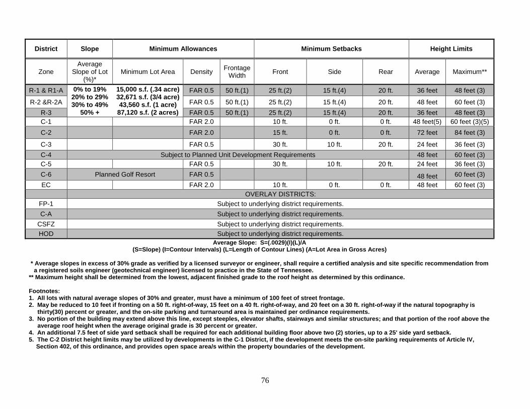
76
District Slope Minimum Allowances Minimum Setbacks Height Limits
Zone Average
Slope of Lot (%)*
Minimum Lot Area Density Frontage Width Front Side Rear Average Maximum**
R-1 & R1-A 0% to 19% 20% to 29% 30% to 49%
50% +
15,000 s.f. (.34 acre) 32,671 s.f. (3/4 acre) 43,560 s.f. (1 acre)
87,120 s.f. (2 acres)
FAR 0.5 50 ft.(1) 25 ft.(2) 15 ft.(4) 20 ft. 36 feet 48 feet (3)
R-2 &R-2A FAR 0.5 50 ft.(1) 25 ft.(2) 15 ft.(4) 20 ft. 48 feet 60 feet (3) R-3 FAR 0.5 50 ft.(1) 25 ft.(2) 15 ft.(4) 20 ft. 36 feet 48 feet (3) C-1 FAR 2.0 10 ft. 0 ft. 0 ft. 48 feet(5) 60 feet (3)(5) C-2 FAR 2.0 15 ft. 0 ft. 0 ft. 72 feet 84 feet (3)
C-3 FAR 0.5 30 ft. 10 ft. 20 ft. 24 feet 36 feet (3) C-4 Subject to Planned Unit Development Requirements 48 feet 60 feet (3) C-5 FAR 0.5 30 ft. 10 ft. 20 ft. 24 feet 36 feet (3) C-6 Planned Golf Resort FAR 0.5 48 feet 60 feet (3) EC FAR 2.0 10 ft. 0 ft. 0 ft. 48 feet 60 feet (3)
OVERLAY DISTRICTS: FP-1 Subject to underlying district requirements. C-A Subject to underlying district requirements.
CSFZ Subject to underlying district requirements. HOD Subject to underlying district requirements.
Average Slope: S=(.0029)(I)(L)/A (S=Slope) (I=Contour Intervals) (L=Length of Contour Lines) (A=Lot Area in Gross Acres)
* Average slopes in excess of 30% grade as verified by a licensed surveyor or engineer, shall require a certified analysis and site specific recommendation from
a registered soils engineer (geotechnical engineer) licensed to practice in the State of Tennessee. ** Maximum height shall be determined from the lowest, adjacent finished grade to the roof height as determined by this ordinance. Footnotes: 1. All lots with natural average slopes of 30% and greater, must have a minimum of 100 feet of street frontage. 2. May be reduced to 10 feet if fronting on a 50 ft. right-of-way, 15 feet on a 40 ft. right-of-way, and 20 feet on a 30 ft. right-of-way if the natural topography is
thirty(30) percent or greater, and the on-site parking and turnaround area is maintained per ordinance requirements. 3. No portion of the building may extend above this line, except steeples, elevator shafts, stairways and similar structures; and that portion of the roof above the
average roof height when the average original grade is 30 percent or greater. 4. An additional 7.5 feet of side yard setback shall be required for each additional building floor above two (2) stories, up to a 25' side yard setback. 5. The C-2 District height limits may be utilized by developments in the C-1 District, if the development meets the on-site parking requirements of Article IV,
Section 402, of this ordinance, and provides open space area/s within the property boundaries of the development.
77
ARTICLE IX. EXCEPTIONS AND MODIFICATIONS 901. LOT OF RECORD. Where the owner of a lot consisting of one or more adjacent lots of official record at the time does not own sufficient land to enable him/her to conform to the yard or other requirements of this ordinance, an application may be submitted to the Board of Zoning Appeals for a variance from the terms of this ordinance, in accordance with Article XI. Such lot may be used as a building site; provided, however, that the yard and other requirements of the district are complied with as closely as is possible in the opinion of the Board of Zoning Appeals. 902. ADJOINING AND VACANT LOTS OF RECORD. A plat of land consisting of one or more adjacent lots with continuous frontage in single ownership which individually are less than lot widths required by this ordinance, such groups of lots shall be considered as a single lot or several lots of minimum permitted size and the lot or lots in one ownership shall be subjected to the requirements of this ordinance. 903. FRONT YARDS. The front yard requirements of this ordinance for dwellings shall not apply to any lot where the average depth of existing front yards on developed lots located within one hundred (100) feet on each side of such lot and within the same block and zoning district and fronting on the same street as such lot, is less than the minimum required front yard depth. In such case, the minimum front yard shall be the average of the existing front yard depths on the developed lots. 904. GROUP HOUSING PROJECTS. In the case of a group housing project or two or more buildings to be constructed on a plat of ground of at least one acre not subdivided into the customary streets and lots and which will not be so subdivided or where the existing or contemplated street and lot layout make it impractical to apply the requirements of this ordinance to the individual building units in such housing projects, a special exception to the terms of this ordinance may be made by the Board of Zoning Appeals in a manner that will be in harmony with the character of the neighborhood; will insure substantially the same character of occupancy and an intensity of land use no higher and a standard of open space no lower than that permitted by this ordinance in the district in which the project is to be located. However, in no case shall the Board of Zoning Appeals authorize a use prohibited in the district in which the project is located or a smaller lot area per family than the minimum required in such district, or a greater height or a larger coverage than the requirements of this ordinances permit in such a district.
78
ARTICLE X. ENFORCEMENT 1001. ENFORCING OFFICER. The provisions of this ordinance shall be administered and enforced by the Municipal Building Official. This official shall have the right to enter upon any premises necessary to carry out his/her duties in the enforcement of this ordinance. 1002. BUILDING PERMIT REQUIRED. It shall be unlawful to commence the excavation for or the construction of any structure, including accessory structures, or to commence the moving or alteration of any structure, including accessory structures, until the building official has issued for such work a permit including a statement that the plans, specifications, and intended use of such structure in all respects conform with the provisions of this ordinance. Application for a permit shall be made to the building official. 1003. ISSUANCE OF A BUILDING PERMIT. In applying to the building official for a building permit, the applicant shall submit a dimensioned sketch or scale plan indicating the shape, size, height, and location of all buildings to be erected, altered, or moved, and of any building already on the lot. The applicant shall also state the existing and intended use of all such buildings and structures and supply such other information as may be required by the building official for determining whether the provisions of this ordinance are being observed. If the proposed excavation or construction as set forth in the application is in conformity with the provisions of this ordinance, the building official shall issue a permit for such excavation or construction. If a permit is refused, the building official shall state such refusal in writing with cause. 1004. CERTIFICATE OF OCCUPANCY. Upon the completion of the construction or alteration of a building or structure for which a building permit has been granted, application shall be made to the building official for a Certificate of Occupancy. The building official shall make a final inspection of the property in question and shall issue a Certificate of Occupancy if the building or structure is found to conform to the provisions of the ordinance and the statements made in the application for the building permit. If such a certificate is refused, the building official shall state such refusal in writing with the cause. No land or building hereafter erected or altered in its use shall be used until such a Certificate of Occupancy has been granted. 1005. PENALTIES. Any person violating any provision of this ordinance shall be guilty of a misdemeanor and upon conviction shall be fined not less than two dollars ($2.00), not more than fifty dollars ($50.00) for each offense. Each day such violation shall continue shall constitute a separate offense. 1006. REMEDIES. In case any building or structure is erected, constructed, reconstructed, repaired, converted, or maintained, or any building, structure or land is used in violation of this ordinance, the building official or any other appropriate authority of any adjacent or neighboring property owner who could be damaged by such violation, in addition to other remedies, may institute injunction, mandamus, or other appropriate action in proceeding to prevent the occupancy or use of such building.
79
ARTICLE XI. BOARD OF ZONING APPEALS 1101. CREATION AND APPOINTMENT. A Board of Zoning Appeals is hereby established in accordance with Section 13-7-205, Tennessee Code Annotated, Volume 3, same being Section 5, Chapter 44 of Public Acts of Tennessee of 1935. The Board shall consist of five (5) members appointed by the Gatlinburg Board of City Commissioners. Each term shall be for a period of five (5) years; however, the initial appointments shall be for one (1), two (2), three (3), four (4), and five (5) years so as to create staggered terms for each appointment. Any member missing three (3) consecutive regular scheduled meetings will automatically be dismissed from the Board and the remaining term of said Board member shall be filled with an appointee of the Gatlinburg Board of Commissioners. 1102. PROCEDURE. Meetings of the Board of Zoning Appeals shall be held at the call of the chairperson or by a majority of the membership and at such other times as the board may determine. Such chairperson, or in his/her absence, the acting chairperson, may administer oaths and compel the attendance of witnesses. All meetings of the board shall be open to the public. The board shall keep minutes of its proceedings, showing the vote of each member upon each question, or, if absent or failing to vote, indicating such fact; shall take all evidence necessary to justify or explain its action, and shall keep records of its examinations and of other official action, all of which shall be immediately filed in the office of the board and shall be a public record. 1103. APPEALS: How Taken. An appeal to the Board of Zoning Appeals may be taken by any person, firm or corporation aggrieved, or by any governmental officer, department, board, or bureau affected by any decision of the building official based in the whole or part on provisions of this ordinance. Such appeal shall be taken within a reasonable time, as provided by the rules of the board, by filing with the building official and with the Board of Zoning appeals a notice of appeal, specifying the grounds thereof. The building official shall transmit forthwith, to the board, all papers constituting the record upon which the action appealed was taken. The board shall fix a reasonable time for the hearing of the appeal, give public notice thereof, as well as due notice to the parties in interest, and decide the same within a reasonable time. Upon hearing, any party may appear in person or by agent or attorney. 1104. POWERS. The Board of Zoning Appeals shall have the following powers:
1104.1 ADMINISTRATIVE REVIEW. To hear and decide appeals where it is alleged by the appellant that there is error in any order, requirement, permit decision, determination, or refusal made by the building official or other administrative official in the carrying out or enforcement of any provision of this ordinance. 1104.2 SPECIAL EXCEPTIONS. To hear and decide special exceptions to this ordinance as set forth in Article IX. 1104.3 VARIANCE. To hear and decide applications for variance from the terms of this ordinance, but only where by reason of exceptional topographical conditions or other extraordinary or exceptional situations or conditions of a piece of property, the strict
80
application of the provisions of this ordinance would result in exceptional practical difficulties to or exceptional and undue hardship upon the owner of such property, provided that such relief may be granted without substantial detriment to the public good and without substantially impairing the intent and purpose of this ordinance. In granting a variance, the board may attach thereto such conditions regarding the location, character, and other features of the proposed building, structure, or use as it may deem advisable in furtherance of the purpose of this ordinance. In addition, all adjoining property owners shall be notified, by Certified Mail, of all variance requests and the hearing date. In the event of a setback variance request, the applicant shall show the three-dimensional physical impact of the proposed addition by utilizing flags, poles, strings, or other easily distinguishable markers on the property.
1105. ACTION OF THE BOARD OF ZONING APPEALS. In exercising the aforementioned powers, the Board of Zoning Appeals may, in conformity with the provision of this ordinance, reverse or affirm, wholly or partly, or may modify the order; requirement, decision or determination appealed from, and to that end shall have all powers of the building official. The concurring vote of a majority of the board shall be necessary to reverse any order, requirement, decision, or determination of any such administrative official, or to decide in favor of the applicant on any matter upon which it is required to pass under this ordinance, or to authorize any variance from the terms of this ordinance.
81
ARTICLE XII. AMENDMENT 1201. PROCEDURE. The City Commission may amend the regulations, boundaries, or any provision of this ordinance. Any member of the City Commission may introduce such amendment, or any official, board, or any other person may present a petition to the City Commission requesting an amendment or amendments to this ordinance. 1202. APPROVAL BY PLANNING COMMISSION. No such amendment shall become effective unless the same be first submitted for approval, disapproval, or suggestions to the Planning Commission. If the Planning Commission within thirty (30) days disapproves after such submission, it shall require the favorable vote of a majority of the entire membership of the City Commission to become effective. If the Planning Commission neither approves nor disapproves such proposed amendment within forty-five (45) days after such submission, the action of such amendment by said board shall be deemed favorable. 1203. INTRODUCTION OF AMENDMENT. Upon the introduction of an amendment of this ordinance or upon the receipt of a petition to amend this ordinance, the City Commission shall publish notice of such request for an amendment, together with the notice of the set for hearing by the City Commission of the request change. Said notice shall be published in some newspaper of general circulation in the City of Gatlinburg, Tennessee. Said hearing by the City Commission shall take place not sooner than fifteen (15) days after the date of publication of such notice.
82
ARTICLE XIII. LEGAL STATUS PROVISIONS 1301. CONFLICT WITH OTHER ORDINANCES. In case of conflict between this ordinance, or any part thereof, and the whole or part of any existing or future ordinance of the City of Gatlinburg, the most restrictive shall in all cases apply. 1302. VALIDITY. If any section, clause, provision, or portion of this ordinance shall be held to be invalid or unconstitutional by any court of competent jurisdiction, provision, or portion of this ordinance which is not of itself invalid or unconstitutional. 1303. EFFECTIVE DATE. This ordinance shall take effect and be in force from and after its passage (July 21, 1982), the public welfare demanding it. CERTIFIED BY PLANNING COMMISSION READING Passed on first reading______________________________________________ READING Passed on second reading____________________________________________ APPROVED AND SIGNED IN OPEN MEETING ______________________________________________________________________________ MAYOR Approved as to Form: /s/____________________________________, City Attorney Attest: /s/ , City Recorder
83
ARTICLE XIV. WIRELESS TELECOMMUNICATIONS TOWERS AND ANTENNAS
1401. FINDINGS. The Communications Act of 1934 as amended by the Telecommunications Act of 1996 (the “Act”) grants the Federal Communications Commission (FCC) exclusive jurisdiction over:
(a) The regulation of the environmental effects of radio frequency (RF) emissions from Telecommunications Facilities; and (b) The regulation of radio signal interference among users of the RF spectrum.
The City’s regulation of towers and telecommunications facilities in the City will not have the effect of prohibiting any person from providing wireless telecommunications services in violation of the Act. 1402. PURPOSES. The general purpose of this Article is to regulate the placement, construction, and modification of Towers and Telecommunications Facilities in order to protect the health, safety, and welfare of the public, while at the same time not unreasonably interfering with the development of the competitive wireless telecommunications marketplace in the City.
Specifically, the purposes of this Article are:
(a) To regulate the location of Towers and Telecommunications Facilities in the City; (b) To protect residential areas and land uses from potential adverse impact of Towers and Telecommunications Facilities; (c) To minimize adverse visual impact of Towers and Telecommunications Facilities through careful design, siting, landscaping, and camouflaging techniques; (d) To promote and encourage shared use/collocation of Towers and Antenna Support Structures as a primary option rather than construction of additional single-use Towers; (e) To promote and encourage utilization of technological designs that will either eliminate or reduce the need for erection of new Tower structures to support antenna and Telecommunications Facilities;
84
(f) To avoid potential damage to property caused by Towers and Telecommunications Facilities by ensuring such structures are soundly and carefully designed, constructed, modified, maintained, and removed when no longer used or are determined to be structurally unsound; and (g) To ensure that Towers and Telecommunications Facilities are compatible with surrounding land uses.
1403. DEFINITIONS. The following words, terms, and phrases when used in this Article, shall have the meanings ascribed to them in this Article, except where the context clearly indicates a different meaning:
(a) Antenna Support Structure means any building or structure other than a Tower which can be used for location of Telecommunications Facilities. (b) Applicant means any Person that applies for a Tower development permit. (c) Application means the process by which the Owner of a parcel of land within the City, or any person who submits a request to develop, construct, build, modify, or erect a Tower upon such parcel of land. Application includes all written documentation, verbal statements, and representations, in whatever form or forum, made by an Applicant to the City concerning such a request. (d) Engineer means any engineer licensed by the State of Tennessee.
(e) Owner means any Person with fee title to any parcel of land within the City upon which a person desires to develop or construct, build, modify, or erect a Tower upon such parcel of land. (f) Person is any natural person, firm, partnership, association, corporation, company, or other legal entity, private or public, whether for profit or not for profit. (g) Stealth means any Tower or Telecommunications Facility which is designed to enhance compatibility with adjacent land uses, including, but not limited to, architecturally screened roof-mounted antennas, antennas integrated into architectural elements, and Towers designed to look other than like a Tower such a light poles, power poles, and trees. (h) Telecommunications Facilities means any cables, wires, lines, wave guides, antennas, and any other equipment or facilities associated with the transmission or reception of communications which a Person seeks to locate or
85
has installed upon or near a Tower or Antenna Support Structure. However, Telecommunications Facilities shall not include:
(1) Any satellite earth station antenna two (2) meters in diameter or less which is located in an area zoned industrial or commercial; or (2) Any satellite earth station antenna one (1) meter or less in diameter, regardless of zoning category.
(i) Tower means a self-supporting lattice, guyed, or monopole structure constructed from grade which supports Telecommunications Facilities. The term Tower shall not include amateur radio operators’ equipment, as licensed by the FCC or towers which do not exceed the maximum building height of the zone in which it is located.
1404. PREFERRED LOCATION. Co-Location of antennas on existing Towers, buildings, and other existing structures shall be preferred over the construction of new Towers or Antennas. 1405. DEVELOPMENT OF TOWERS. (a) A Tower shall be a permitted use of land in any zoning district of the
City of Gatlinburg. No person shall build, erect, or construct a Tower upon any parcel of land unless a development permit shall have been issued by the City Planner. Application shall be made in the manner provided in this Article.
(b) No person shall build, erect, or construct a Tower upon any parcel of
land unless a building permit shall have been issued by the City. A building permit from the City shall be required in addition to the development permit.
(c) Towers are exempt from the maximum height restrictions of the
districts where located. Towers shall be permitted to a height of one hundred and fifty (150) feet. Towers may be permitted in excess of one hundred and fifty (150) feet in accordance with Section 1412.
(d) No new Tower shall be built, constructed, or erected in the City unless
the Tower is capable of supporting another Person’s operating Telecommunications Facilities comparable in weight, size, and surface area to the Telecommunications Facilities installed by the Applicant on the Tower.
(e) An Application to develop a Tower shall include:
(1) The name, address, and telephone number of the Owner and lessee (if applicable) of the parcel of land upon which the Tower is situated. If the Applicant is not the Owner of the parcel of land upon
86
which the Tower is situated, the written consent of the Owner shall be evidenced in the Application. The Owner shall also consent to the terms of Section 1414 hereof regarding abandonment and removal of towers. (2) The legal description, parcel number, and address of the parcel of land upon which the Tower is situated, including a site survey by a licensed surveyor. (3) The names, addresses, and telephone numbers of all owners of other Towers or usable Antenna Support Structures within a one-half (½) mile radius of the proposed new Tower site, including City-owned property. (4) A description of the design plan proposed by the Applicant. Applicant must submit site drainage and erosion control plans, bearing the certification of a licensed engineer. (5) An affidavit attesting to the fact that the Applicant made diligent, but unsuccessful, efforts to obtain permission to install or collocate the Applicant’s Telecommunications Facilities on City-owned Towers or usable Antenna Support Structures located within a one-half (½) mile radius of the proposed Tower Site. (6) Written technical evidence from an Engineer that the proposed Tower or Telecommunications Facilities cannot be installed or collocated on another person’s Tower or usable Antenna Support Structures owned by other Persons located within one-half (½) mile radius of the proposed Tower site. (7) A written statement from an Electrical Engineer, or person with a bachelor of science degree in electrical engineering from an accredited institution with a minimum of four (4) years experience in radio frequency engineering, that the construction and placement of the Tower will not interfere with public safety communications and the usual and customary transmission or reception of radio, television, or other communications services enjoyed by adjacent residential and non-residential properties. (8) Written, technical evidence from an Engineer that the proposed structure meets the standards established by the FAA or the FCC. (9) In order to assist City staff in evaluating visual impact, the Applicant shall submit color photo simulations showing the proposed site of the Tower with a photo-realistic representation of the proposed
87
Tower as it would appear viewed from the closest residential property and from adjacent roadways. Towers which utilize stealth technology shall be preferred, where practical. (10) A description of the Tower which shall include the height, cross-sections, and elevations. (11) A description of the Tower’s capacity, including the number and type of antennas that it can accommodate. (12) A letter of commitment by the Applicant to lease excess space on the Tower to other potential users at prevailing rates and standard terms. The letter shall commit the Tower owner and its successors in interest to this obligation. (13) A written statement from an Electrical Engineer or a Person with a bachelor of science degree in electrical engineering from an accredited institution with a minimum of four (4) years experience in radio frequency engineering that the proposed Tower shall be no higher than the height which is necessary to accomplish the radio frequency objectives of the proposed occupant of the Tower with whom the Applicant has a binding and valid commitment for the location and operation of such occupant’s antennas upon the Tower.
(f) The City Planner and/or his/her designee may require an Applicant to
supplement any information that he considers inadequate or that the Applicant has failed to supply. He may deny an Application on the basis that the Applicant has not satisfactorily supplied the information required in this section. Applications shall be reviewed by the City in a prompt manner and decisions shall be supported in writing setting forth the reasons for approval or denial. Applications meeting the requirements of this section may be administratively approved by the City Planner.
(g) The Applicant shall submit payment with the Application in the amount
of Five Hundred Dollars ($500.00) to cover the administrative expenses of the City in processing the Application.
1406. SETBACKS. In addition to the minimum setbacks required in the zone in which a Tower is located, a Tower shall be constructed no closer than one hundred fifty (150) feet in height from any residence or occupied structure. In the event no existing residence or occupied structure exists on the adjoining properties, the applicant shall be required to submit one of the following:
88
(a) documentation by a structural engineer, that in the event of a structural failure, the proposed Tower will not fall beyond the property boundaries on which the Tower is located; (b) documentation consisting of a deed, license, easement or other agreement for the fall zone between the adjoining property owner(s)and the Applicant, which has been filed on record at the Sevier County Register of Deeds Office. The document must indicate the area that has been identified by a structural engineer, which is required to accommodate the maximum potential encroachment in the event the Tower falls beyond property line boundaries during a structural failure. To the extent a Tower exceeds one hundred fifty (150) feet in height, the Tower shall be set back from any residence or occupied structure a distance at least equal to the height of the Tower unless the Applicant submits a certification from a licensed Engineer that the Tower will collapse within a smaller diameter than its actual height, in which case the required setback shall be the minimum collapse diameter or one hundred fifty (150) feet, whichever is greater.
1407. ILLUMINATION. No lighting is required on a wireless Telecommunications Tower except lighting that is specifically required by the FAA or other applicable authority. Where lighting is required, the lights so installed shall be of the “dual lighting” variety whereby white strobe lights are permitted for daytime and red lights for nighttime. Such lighting shall meet the requirements of the FAA with regard to dual lighting requirements, but shall not exceed any FAA minimum standards without proof from a reputable authority that such level of illumination is necessary. 1408. EXTERIOR FINISH. Towers not requiring FAA painting or markings shall have an exterior finish which enhances compatibility with adjacent land as determined by the City Planner. 1409. SIGNS. Signs shall not be allowed on Towers or Antennas, except safety signs which are required by law or regulation. 1410. FENCING. Telecommunications Towers and Antennas shall be completely surrounded by a security fence.
89
1411. LANDSCAPING. Tower Facilities shall be landscaped by means of native evergreen plant species to sufficiently obscure said facilities from view. The landscaped area shall be no less than six (6) feet in height with the access opening to the facility not to exceed twenty-five (25) feet in width. 1412. EXCEPTION OF HEIGHT. An Applicant seeking to build a tower in excess of one hundred fifty (150) feet in height may seek approval from the Board of Zoning Appeals. Such Applicants shall submit all information and meet all requirements in Section 1405. The Board is authorized to approve towers in excess of this height upon the following conditions: (a) Applicants for Towers between 150-200 feet high must provide
evidence that:
(1) (A) Such Tower will be owned by a Person who will operate and locate one or more antenna(s) upon the Tower and that such Person actually plans to operate one or more antenna(s) upon the Tower; and
(B) Such Person has obtained a letter of intent from at least
one other Person who will utilize the Tower for the location and operation of one or more antenna(s); or
(2) (A) The Applicant has entered into a valid and binding
agreement with at least one occupant of the Tower who will utilize the Tower for at least one or more antenna(s); and
(B) The Applicant has obtained a letter of intent from at least
one other Person who will utilize the Tower for the location and operation of one or more antenna(s).
(b) Applicants seeking approval for Towers in excess of two hundred (200)
feet high shall (1) submit proof of valid and binding written commitments (either agreement or letter of intent) for each additional occupant for every ten feet in height in excess of two hundred (200) feet, (2) unless the Applicant can show that the Tower must be in excess of two hundred (200) feet to meet the radio frequency coverage objectives of the proposed occupant of the Tower which evidence shall include a sworn statement from an Electrical Engineer or a Person with a bachelor of science degree in electrical engineering from an accredited institution with a minimum of four (4) years experience in radio frequency engineering.
(c) In no instance shall a Tower exceed two hundred fifty (250) feet.
90
A public hearing shall be held in conjunction with the Board review of
an application submitted under this section, with adequate public notice of same.
1413. MODIFICATION OF EXISTING TOWERS.
Existing towers may continue in operation without complying with the provisions of this article; however, any tower being replaced shall comply with these provisions. Replacement towers which do not exceed the height of the tower they are replacing may be administratively approved by the City Planner. The City Planner may also approve a replacement tower which is not more than 30 feet higher than its predecessor, if it will accommodate at least three additional occupants. Applicants for an additional antenna on an existing Tower shall only be required to obtain a building permit and provide a certificate from an engineer that the Tower will structurally support such additional antenna.
1414. ABANDONMENT AND REMOVAL.
Any telecommunications tower and equipment which is not operated for a wireless communications purpose for a continuous period of six (6) months shall be considered abandoned and shall be removed by the owner of the telecommunications tower or the owner of the property where the facility is located. If such tower is not removed within sixty (60) days of receipt of notice from the City, the City may remove such tower as set forth below. When the owner of a telecommunications tower or owner of the property fails to remove same more than sixty (60) days after notice from the City, the City shall advertise its intent to remove said tower and, thereafter, remove or cause its removal. The cost of removal and any administrative cost of the City shall be assessed against the owner of the tower or the property owner. Failure to pay same, shall result in a lien being placed upon the real property upon which the tower is located, which lien may be perfected and collected the same as any real property tax lien. 1415. MAINTENANCE. Tower sites shall be maintained in a neat and orderly fashion. Landscaping shall be pruned or replaced as needed. The tower structure shall be routinely inspected and maintained in order to assure safety. 1416. PENALTIES.
Any person violating any of the provisions of this article shall, upon conviction thereof, be subject to a civil penalty of up to Five Hundred Dollars ($500.00) for each and every offense. Each day shall constitute a separate offense.
91
APPENDIX Appendices Page Building Sketch “A” 92 Building Sketch “B” 93 Building Sketch “C” 94 Floodplain Sketch 95 Preliminary PUD Checklist 96 Final PUD Checklist 97 Preliminary Plat Checklist 99 Final Plat Checklist 100 Minor Subdivision Checklist 101 Commercial Site Plan Checklist 102 Sign Permit Checklist 103 Residential Site Plan Checklist 104 Critical Slope Floating Zone Checklist 105 Hillside Overlay District Checklist 107 Rezoning Request Checklist 109
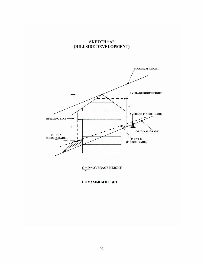
92
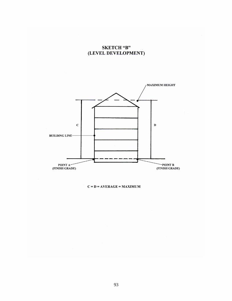
93
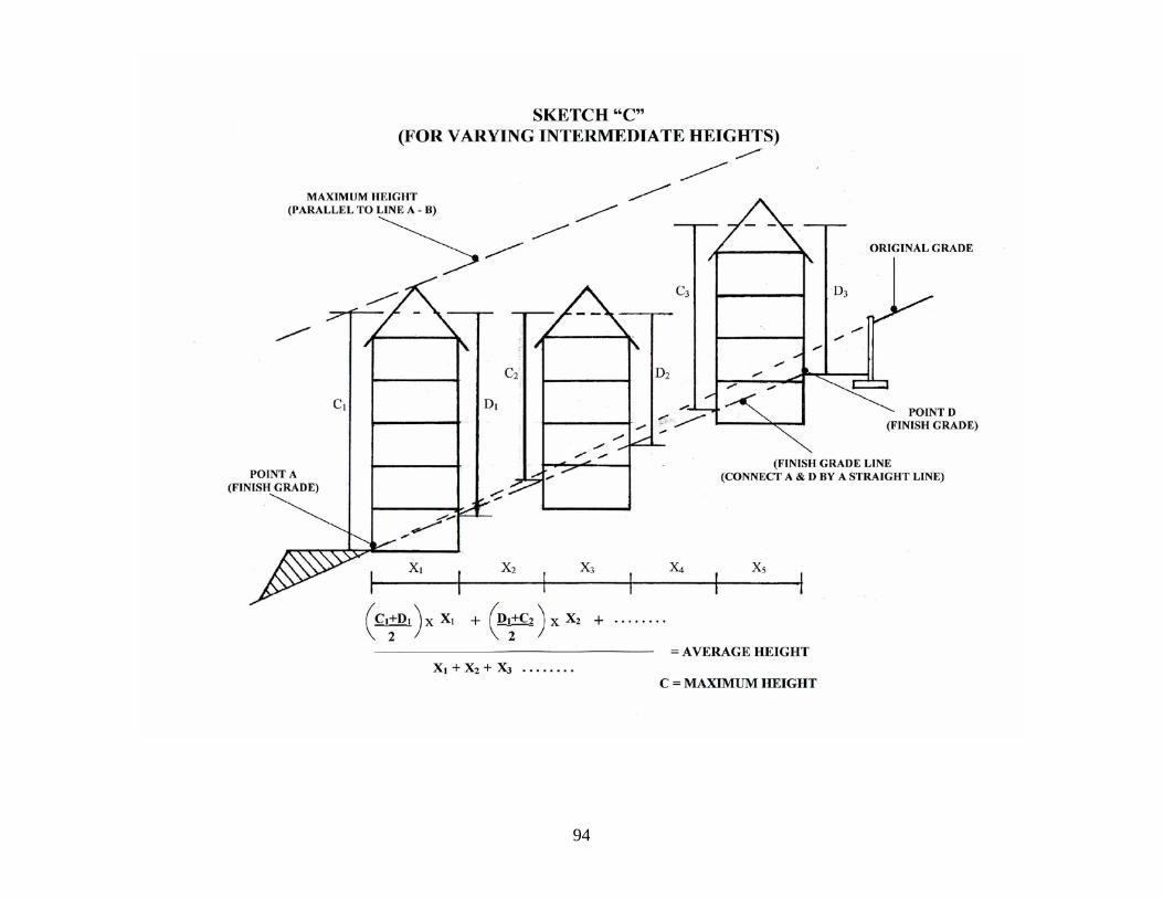
94
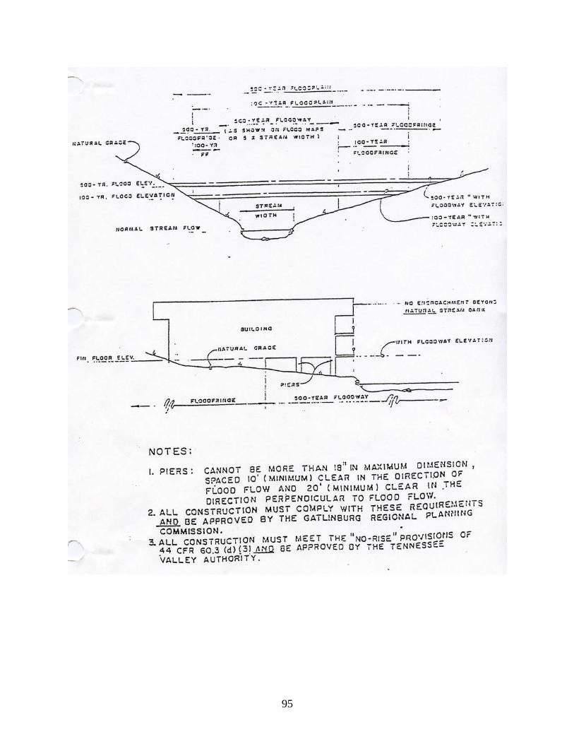
95
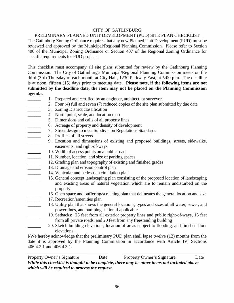
96
CITY OF GATLINBURG PRELIMINARY PLANNED UNIT DEVELOPMENT (PUD) SITE PLAN CHECKLIST
The Gatlinburg Zoning Ordinance requires that any new Planned Unit Development (PUD) must be reviewed and approved by the Municipal/Regional Planning Commission. Please refer to Section 406 of the Municipal Zoning Ordinance or Section 407 of the Regional Zoning Ordinance for specific requirements for PUD projects. This checklist must accompany all site plans submitted for review by the Gatlinburg Planning Commission. The City of Gatlinburg's Municipal/Regional Planning Commission meets on the third (3rd) Thursday of each month at City Hall, 1230 Parkway East, at 5:00 p.m. The deadline is at noon, fifteen (15) days prior to meeting date. Please note, if the following items are not submitted by the deadline date, the item may not be placed on the Planning Commission agenda. ______ 1. Prepared and certified by an engineer, architect, or surveyor. ______ 2. Four (4) full and seven (7) reduced copies of the site plan submitted by due date ______ 3. Zoning District classification ______ 4. North point, scale, and location map ______ 5. Dimensions and calls of all property lines ______ 6. Acreage of property and density of development ______ 7. Street design to meet Subdivision Regulations Standards ______ 8. Profiles of all streets ______ 9. Location and dimensions of existing and proposed buildings, streets, sidewalks,
easements, and right-of-ways ______ 10. Width of access points on a public road ______ 11. Number, location, and size of parking spaces ______ 12. Grading plan and topography of existing and finished grades ______ 13. Drainage and erosion control plan ______ 14. Vehicular and pedestrian circulation plan ______ 15. General concept landscaping plan consisting of the proposed location of landscaping
and existing areas of natural vegetation which are to remain undisturbed on the property
______ 16. Open space and buffering/screening plan that delineates the general location and size ______ 17. Recreation/amenities plan ______ 18. Utility plan that shows the general locations, types and sizes of all water, sewer, and
power lines, and pumping station if applicable ______ 19. Setbacks: 25 feet from all exterior property lines and public right-of-ways, 15 feet
from all private roads, and 20 feet from any freestanding building ______ 20. Sketch building elevations, location of areas subject to flooding, and finished floor
elevations. I/We hereby acknowledge that the preliminary PUD plan shall lapse twelve (12) months from the date it is approved by the Planning Commission in accordance with Article IV, Sections 406.4.2.1 and 406.4.3.1. ___________________________________ ___________________________________ Property Owner’s Signature Date Property Owner’s Signature Date While this checklist is thought to be complete, there may be other items not included above which will be required to process the request.
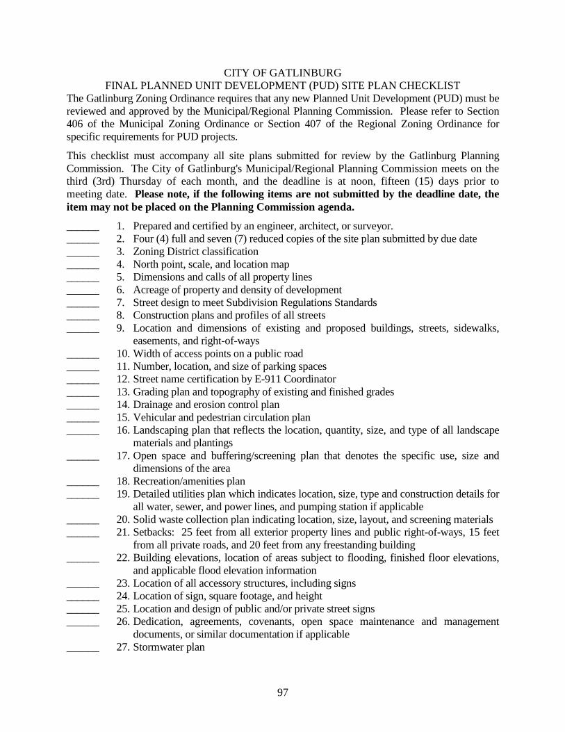
97
CITY OF GATLINBURG FINAL PLANNED UNIT DEVELOPMENT (PUD) SITE PLAN CHECKLIST
The Gatlinburg Zoning Ordinance requires that any new Planned Unit Development (PUD) must be reviewed and approved by the Municipal/Regional Planning Commission. Please refer to Section 406 of the Municipal Zoning Ordinance or Section 407 of the Regional Zoning Ordinance for specific requirements for PUD projects. This checklist must accompany all site plans submitted for review by the Gatlinburg Planning Commission. The City of Gatlinburg's Municipal/Regional Planning Commission meets on the third (3rd) Thursday of each month, and the deadline is at noon, fifteen (15) days prior to meeting date. Please note, if the following items are not submitted by the deadline date, the item may not be placed on the Planning Commission agenda. ______ 1. Prepared and certified by an engineer, architect, or surveyor. ______ 2. Four (4) full and seven (7) reduced copies of the site plan submitted by due date ______ 3. Zoning District classification ______ 4. North point, scale, and location map ______ 5. Dimensions and calls of all property lines ______ 6. Acreage of property and density of development ______ 7. Street design to meet Subdivision Regulations Standards ______ 8. Construction plans and profiles of all streets ______ 9. Location and dimensions of existing and proposed buildings, streets, sidewalks,
easements, and right-of-ways ______ 10. Width of access points on a public road ______ 11. Number, location, and size of parking spaces ______ 12. Street name certification by E-911 Coordinator ______ 13. Grading plan and topography of existing and finished grades ______ 14. Drainage and erosion control plan ______ 15. Vehicular and pedestrian circulation plan ______ 16. Landscaping plan that reflects the location, quantity, size, and type of all landscape
materials and plantings ______ 17. Open space and buffering/screening plan that denotes the specific use, size and
dimensions of the area ______ 18. Recreation/amenities plan ______ 19. Detailed utilities plan which indicates location, size, type and construction details for
all water, sewer, and power lines, and pumping station if applicable ______ 20. Solid waste collection plan indicating location, size, layout, and screening materials ______ 21. Setbacks: 25 feet from all exterior property lines and public right-of-ways, 15 feet
from all private roads, and 20 feet from any freestanding building ______ 22. Building elevations, location of areas subject to flooding, finished floor elevations,
and applicable flood elevation information ______ 23. Location of all accessory structures, including signs ______ 24. Location of sign, square footage, and height ______ 25. Location and design of public and/or private street signs ______ 26. Dedication, agreements, covenants, open space maintenance and management
documents, or similar documentation if applicable ______ 27. Stormwater plan
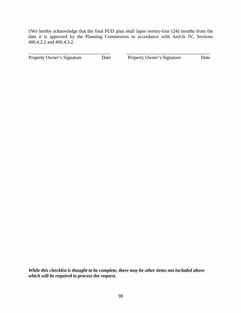
98
I/We hereby acknowledge that the final PUD plan shall lapse twenty-four (24) months from the date it is approved by the Planning Commission in accordance with Article IV, Sections 406.4.2.2 and 406.4.3.2. ___________________________________ ___________________________________ Property Owner’s Signature Date Property Owner’s Signature Date
While this checklist is thought to be complete, there may be other items not included above which will be required to process the request.
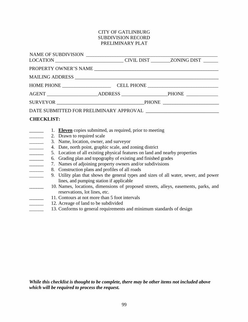
99
CITY OF GATLINBURG SUBDIVISION RECORD
PRELIMINARY PLAT NAME OF SUBDIVISION ______________________________________________________ LOCATION ____________________________ CIVIL DIST ________ZONING DIST ______
PROPERTY OWNER’S NAME ___________________________________________________
MAILING ADDRESS ___________________________________________________________
HOME PHONE ____________________ CELL PHONE _____________________________
AGENT _____________________ADDRESS ___________________PHONE _____________
SURVEYOR ____________________________________PHONE _______________________
DATE SUBMITTED FOR PRELIMINARY APPROVAL ______________________________
CHECKLIST: ______ 1. Eleven copies submitted, as required, prior to meeting ______ 2. Drawn to required scale ______ 3. Name, location, owner, and surveyor ______ 4. Date, north point, graphic scale, and zoning district ______ 5. Location of all existing physical features on land and nearby properties ______ 6. Grading plan and topography of existing and finished grades ______ 7. Names of adjoining property owners and/or subdivisions ______ 8. Construction plans and profiles of all roads ______ 9. Utility plan that shows the general types and sizes of all water, sewer, and power
lines, and pumping station if applicable ______ 10. Names, locations, dimensions of proposed streets, alleys, easements, parks, and
reservations, lot lines, etc. ______ 11. Contours at not more than 5 foot intervals ______ 12. Acreage of land to be subdivided ______ 13. Conforms to general requirements and minimum standards of design While this checklist is thought to be complete, there may be other items not included above which will be required to process the request.
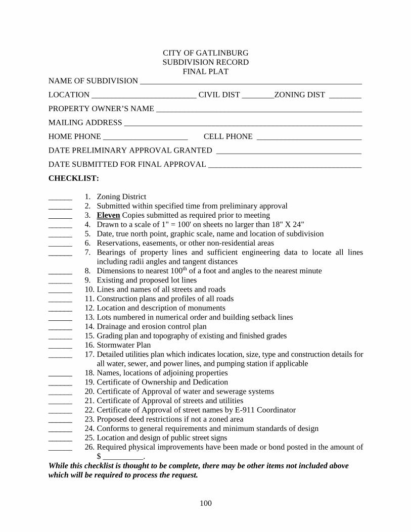
100
CITY OF GATLINBURG SUBDIVISION RECORD
FINAL PLAT NAME OF SUBDIVISION _______________________________________________________
LOCATION __________________________ CIVIL DIST ________ZONING DIST ________
PROPERTY OWNER’S NAME ___________________________________________________
MAILING ADDRESS ___________________________________________________________
HOME PHONE _____________________ CELL PHONE __________________________
DATE PRELIMINARY APPROVAL GRANTED ____________________________________
DATE SUBMITTED FOR FINAL APPROVAL ______________________________________
CHECKLIST: ______ 1. Zoning District ______ 2. Submitted within specified time from preliminary approval ______ 3. Eleven Copies submitted as required prior to meeting ______ 4. Drawn to a scale of 1" = 100' on sheets no larger than 18" X 24" ______ 5. Date, true north point, graphic scale, name and location of subdivision ______ 6. Reservations, easements, or other non-residential areas ______ 7. Bearings of property lines and sufficient engineering data to locate all lines
including radii angles and tangent distances ______ 8. Dimensions to nearest 100th of a foot and angles to the nearest minute ______ 9. Existing and proposed lot lines ______ 10. Lines and names of all streets and roads ______ 11. Construction plans and profiles of all roads ______ 12. Location and description of monuments ______ 13. Lots numbered in numerical order and building setback lines ______ 14. Drainage and erosion control plan ______ 15. Grading plan and topography of existing and finished grades ______ 16. Stormwater Plan ______ 17. Detailed utilities plan which indicates location, size, type and construction details for
all water, sewer, and power lines, and pumping station if applicable ______ 18. Names, locations of adjoining properties ______ 19. Certificate of Ownership and Dedication ______ 20. Certificate of Approval of water and sewerage systems ______ 21. Certificate of Approval of streets and utilities ______ 22. Certificate of Approval of street names by E-911 Coordinator ______ 23. Proposed deed restrictions if not a zoned area ______ 24. Conforms to general requirements and minimum standards of design ______ 25. Location and design of public street signs ______ 26. Required physical improvements have been made or bond posted in the amount of
$ __________. While this checklist is thought to be complete, there may be other items not included above which will be required to process the request.
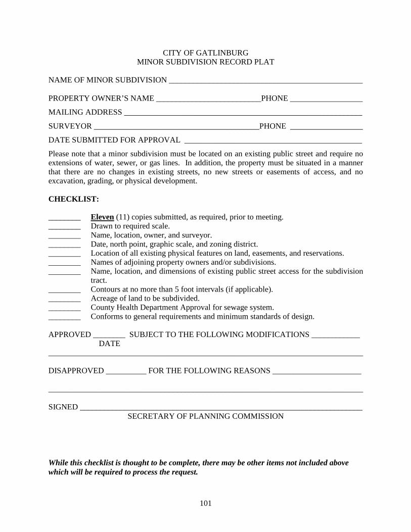
101
CITY OF GATLINBURG MINOR SUBDIVISION RECORD PLAT
NAME OF MINOR SUBDIVISION ________________________________________________ PROPERTY OWNER’S NAME __________________________PHONE __________________
MAILING ADDRESS ___________________________________________________________
SURVEYOR _________________________________________PHONE __________________
DATE SUBMITTED FOR APPROVAL ____________________________________________
Please note that a minor subdivision must be located on an existing public street and require no extensions of water, sewer, or gas lines. In addition, the property must be situated in a manner that there are no changes in existing streets, no new streets or easements of access, and no excavation, grading, or physical development. CHECKLIST: ________ Eleven (11) copies submitted, as required, prior to meeting. ________ Drawn to required scale. ________ Name, location, owner, and surveyor. ________ Date, north point, graphic scale, and zoning district. ________ Location of all existing physical features on land, easements, and reservations. ________ Names of adjoining property owners and/or subdivisions. ________ Name, location, and dimensions of existing public street access for the subdivision
tract. ________ Contours at no more than 5 foot intervals (if applicable). ________ Acreage of land to be subdivided. ________ County Health Department Approval for sewage system. ________ Conforms to general requirements and minimum standards of design. APPROVED ________ SUBJECT TO THE FOLLOWING MODIFICATIONS ____________
DATE ______________________________________________________________________________ DISAPPROVED __________ FOR THE FOLLOWING REASONS ______________________ ______________________________________________________________________________ SIGNED ______________________________________________________________________
SECRETARY OF PLANNING COMMISSION
While this checklist is thought to be complete, there may be other items not included above which will be required to process the request.
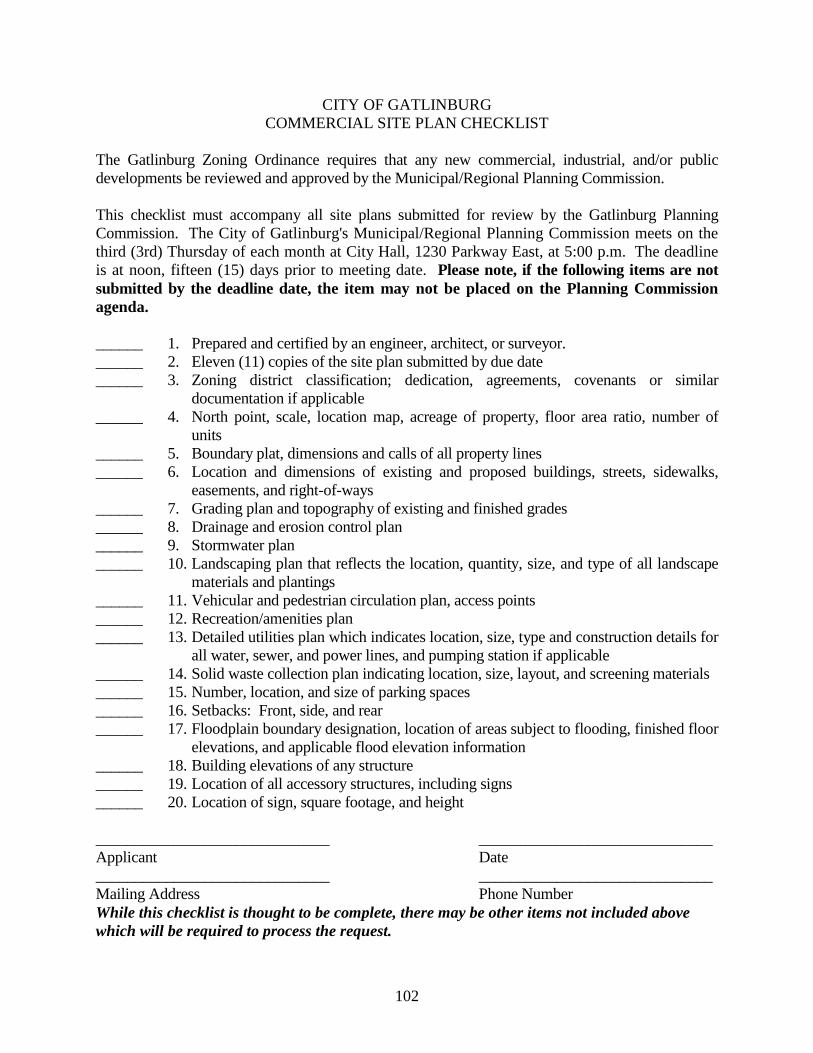
102
CITY OF GATLINBURG COMMERCIAL SITE PLAN CHECKLIST
The Gatlinburg Zoning Ordinance requires that any new commercial, industrial, and/or public developments be reviewed and approved by the Municipal/Regional Planning Commission. This checklist must accompany all site plans submitted for review by the Gatlinburg Planning Commission. The City of Gatlinburg's Municipal/Regional Planning Commission meets on the third (3rd) Thursday of each month at City Hall, 1230 Parkway East, at 5:00 p.m. The deadline is at noon, fifteen (15) days prior to meeting date. Please note, if the following items are not submitted by the deadline date, the item may not be placed on the Planning Commission agenda. ______ 1. Prepared and certified by an engineer, architect, or surveyor. ______ 2. Eleven (11) copies of the site plan submitted by due date ______ 3. Zoning district classification; dedication, agreements, covenants or similar
documentation if applicable ______ 4. North point, scale, location map, acreage of property, floor area ratio, number of
units ______ 5. Boundary plat, dimensions and calls of all property lines ______ 6. Location and dimensions of existing and proposed buildings, streets, sidewalks,
easements, and right-of-ways ______ 7. Grading plan and topography of existing and finished grades ______ 8. Drainage and erosion control plan ______ 9. Stormwater plan ______ 10. Landscaping plan that reflects the location, quantity, size, and type of all landscape
materials and plantings ______ 11. Vehicular and pedestrian circulation plan, access points ______ 12. Recreation/amenities plan ______ 13. Detailed utilities plan which indicates location, size, type and construction details for
all water, sewer, and power lines, and pumping station if applicable ______ 14. Solid waste collection plan indicating location, size, layout, and screening materials ______ 15. Number, location, and size of parking spaces ______ 16. Setbacks: Front, side, and rear ______ 17. Floodplain boundary designation, location of areas subject to flooding, finished floor
elevations, and applicable flood elevation information ______ 18. Building elevations of any structure ______ 19. Location of all accessory structures, including signs ______ 20. Location of sign, square footage, and height ______________________________ ______________________________ Applicant Date ______________________________ ______________________________ Mailing Address Phone Number While this checklist is thought to be complete, there may be other items not included above which will be required to process the request.
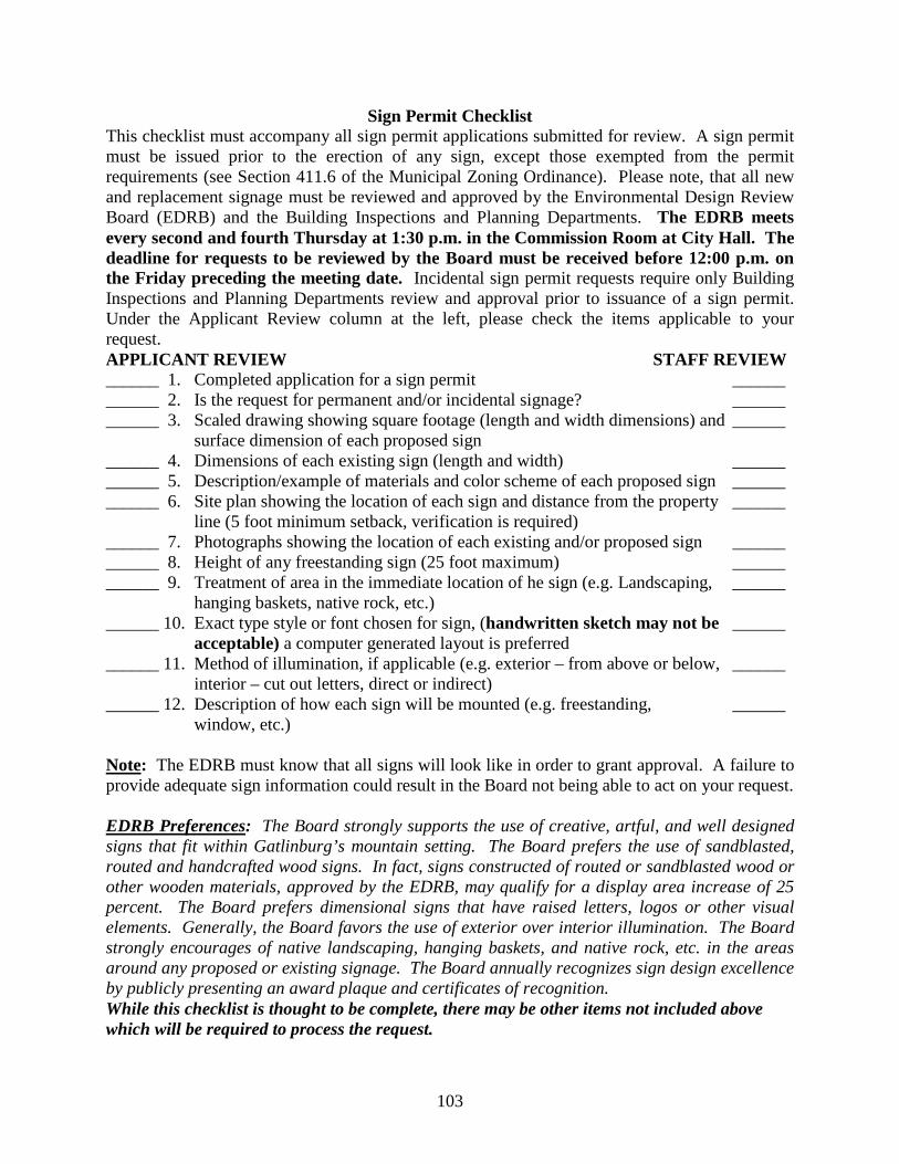
103
Sign Permit Checklist This checklist must accompany all sign permit applications submitted for review. A sign permit must be issued prior to the erection of any sign, except those exempted from the permit requirements (see Section 411.6 of the Municipal Zoning Ordinance). Please note, that all new and replacement signage must be reviewed and approved by the Environmental Design Review Board (EDRB) and the Building Inspections and Planning Departments. The EDRB meets every second and fourth Thursday at 1:30 p.m. in the Commission Room at City Hall. The deadline for requests to be reviewed by the Board must be received before 12:00 p.m. on the Friday preceding the meeting date. Incidental sign permit requests require only Building Inspections and Planning Departments review and approval prior to issuance of a sign permit. Under the Applicant Review column at the left, please check the items applicable to your request. APPLICANT REVIEW STAFF REVIEW ______ 1. Completed application for a sign permit ______ ______ 2. Is the request for permanent and/or incidental signage? ______ ______ 3. Scaled drawing showing square footage (length and width dimensions) and ______ surface dimension of each proposed sign ______ 4. Dimensions of each existing sign (length and width) ______ ______ 5. Description/example of materials and color scheme of each proposed sign ______ ______ 6. Site plan showing the location of each sign and distance from the property ______ line (5 foot minimum setback, verification is required) ______ 7. Photographs showing the location of each existing and/or proposed sign ______ ______ 8. Height of any freestanding sign (25 foot maximum) ______ ______ 9. Treatment of area in the immediate location of he sign (e.g. Landscaping, ______ hanging baskets, native rock, etc.) ______ 10. Exact type style or font chosen for sign, (handwritten sketch may not be ______ acceptable) a computer generated layout is preferred ______ 11. Method of illumination, if applicable (e.g. exterior – from above or below, ______ interior – cut out letters, direct or indirect) ______ 12. Description of how each sign will be mounted (e.g. freestanding, ______ window, etc.) Note: The EDRB must know that all signs will look like in order to grant approval. A failure to provide adequate sign information could result in the Board not being able to act on your request. EDRB Preferences: The Board strongly supports the use of creative, artful, and well designed signs that fit within Gatlinburg’s mountain setting. The Board prefers the use of sandblasted, routed and handcrafted wood signs. In fact, signs constructed of routed or sandblasted wood or other wooden materials, approved by the EDRB, may qualify for a display area increase of 25 percent. The Board prefers dimensional signs that have raised letters, logos or other visual elements. Generally, the Board favors the use of exterior over interior illumination. The Board strongly encourages of native landscaping, hanging baskets, and native rock, etc. in the areas around any proposed or existing signage. The Board annually recognizes sign design excellence by publicly presenting an award plaque and certificates of recognition. While this checklist is thought to be complete, there may be other items not included above which will be required to process the request.
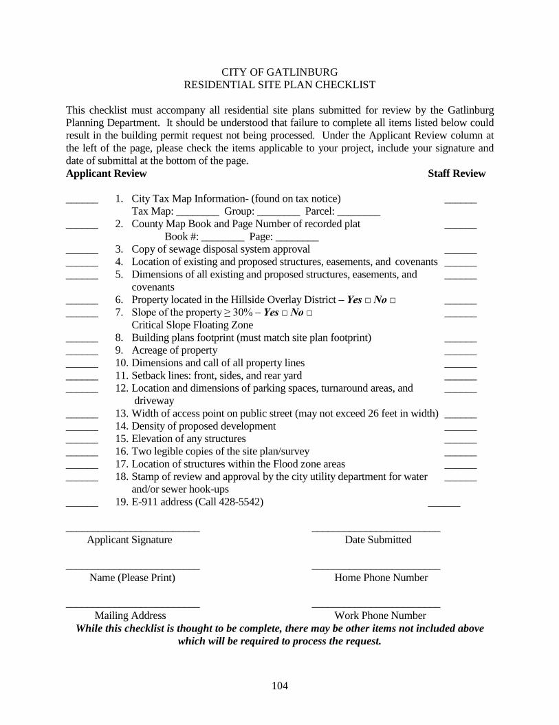
104
CITY OF GATLINBURG RESIDENTIAL SITE PLAN CHECKLIST
This checklist must accompany all residential site plans submitted for review by the Gatlinburg Planning Department. It should be understood that failure to complete all items listed below could result in the building permit request not being processed. Under the Applicant Review column at the left of the page, please check the items applicable to your project, include your signature and date of submittal at the bottom of the page. Applicant Review Staff Review ______ 1. City Tax Map Information- (found on tax notice) ______ Tax Map: ________ Group: ________ Parcel: ________ ______ 2. County Map Book and Page Number of recorded plat ______ Book #: ________ Page: ________ ______ 3. Copy of sewage disposal system approval ______ ______ 4. Location of existing and proposed structures, easements, and covenants ______ ______ 5. Dimensions of all existing and proposed structures, easements, and ______ covenants ______ 6. Property located in the Hillside Overlay District – Yes □ No □ ______ ______ 7. Slope of the property ≥ 30% – Yes □ No □ ______ Critical Slope Floating Zone ______ 8. Building plans footprint (must match site plan footprint) ______ ______ 9. Acreage of property ______ ______ 10. Dimensions and call of all property lines ______ ______ 11. Setback lines: front, sides, and rear yard ______ ______ 12. Location and dimensions of parking spaces, turnaround areas, and ______ driveway ______ 13. Width of access point on public street (may not exceed 26 feet in width) ______ ______ 14. Density of proposed development ______ ______ 15. Elevation of any structures ______ ______ 16. Two legible copies of the site plan/survey ______ ______ 17. Location of structures within the Flood zone areas ______ ______ 18. Stamp of review and approval by the city utility department for water ______ and/or sewer hook-ups ______ 19. E-911 address (Call 428-5542) ______ _________________________ ________________________ Applicant Signature Date Submitted _________________________ ________________________ Name (Please Print) Home Phone Number _________________________ ________________________ Mailing Address Work Phone Number
While this checklist is thought to be complete, there may be other items not included above which will be required to process the request.
105
CITY OF GATLINBURG 714 – CRITICAL SLOPE FLOATING ZONE (CSFZ) CHECKLIST
In addition to other applicable site plan, PUD and subdivision application requirements, the following enhanced land disturbance information shall be required for development permits within a CSFZ district to identify any potential adverse impacts: Does the natural slope of the property exceed thirty (30) percent as certified by a licensed, registered engineer or surveyor? The licensed professional should consult with the slope formula in Article VIII of the ordinance. If you answered yes to the above question, please proceed with the checklist. ______ 1. Artificial slopes constructed at 2H:1V or certification by a registered engineer ______ 2. Grading plan that reflects the location and height of all un-terraced and terraced
slopes and engineered walls with a minimum horizontal distance between any two terraced slope or wall sections of 5’, location of all fill and borrow,
______ 3. Landscape plan for all artificial terraced slopes ______ 4. Planting schedule and cashier’s check for mass grading sites ______ 5. Construction plans and profiles of all streets and driveways ______ 6. Stormwater plan ______ 7. Detailed utilities plan which indicates location, size, type and construction details for
all water, sewer, and power lines, and pumping station if applicable ______ 8. Impervious surfaces plan ENHANCED SITE PLAN: ______ 1. Slope/topography maps at two (2) foot contours for areas of disturbance and five
(5) foot contours for areas outside the disturbance area; ______ 2. Site plan showing all existing structures on the site; ______ 3. Locations and design of septic or community sewage treatment systems; ______ 4. Existing and proposed driveways, including the length, grade, and surface type; ______ 5. Perennial and intermittent waterways, springs, seeps, and wetlands; ______ 6. Soil type by erosion susceptibility and naturally acidifying properties; ______ 7. All applicable setbacks from ridgelines, watercourses, and property lines; ______ 8. Delineation of protected sensitive habitats for flora and fauna; ______ 9. Written narrative and maps identifying potential sources and kinds of water
pollution during and after development of the project, inclusive of non-point sources of water pollution;
______ 10. Proposed final ground cover, by type; ______ 11. A geotechnical report which includes: ______ a. A narrative of conditions and hazards identified on the site.
The narrative should address the scope of the site inspection, the suitability of the site for development, the foundation types for site improvements, retaining systems, grading, drainage considerations, stability of cut-slopes and constructed embankments, settlement of the site and adjacent sites due to
106
existing conditions, proposed construction, and proposed surface and subsurface drainage facilities;
______ b. A soils map derived from a soil survey on the site and using Unified Soil Classifications;
______ c. Subsurface conditions- Depth(s) to bedrock; Strike and dip of bedrock; Orientations of any identified joints, faults, and slip planes within the bedrock that are considered to be indicative of prevailing site conditions; Bedrock by type identified on the site; Strength and load bearing capacity of bedrock by type and whereon structural foundations are proposed; Any structural cross-section illustrative of conditions at the site; The mapped locations and logs of any drilling or core samples;
______ d. Grading- Location of cut and fill locations; angle of back slopes and fill slopes; Cut material suitability as fill material, including calculations and assumptions; Water content; Weathering; Densities; Expansion or consolidation potential; Optimal moisture conditions of fill material;
______ e. Foundations- Foundation designs, footing depth, footing widths, assumptions for foundation materials; tested bearing values, settlement- total, differential, and rate;
______ f. Water- The location of perennial and intermittent waterways; The location of seeps, springs, and wetlands; Natural surface drainage patterns and a characterization of near surface hydrology;
______ g. Natural Slope Failure- Locations of colluvial deposits or other features that exhibit evidence of mass wasting, landslides, soil creep, or rock creep within 100 feet laterally and 500 feet vertically of proposed area of disturbance; description of cause(s) and recent activity;
______ h. Prior activity- Location of excavations, cave entrances, sinkholes, and active or abandoned mine entrances, wells, pits, or quarries;
______ i. Slope aspects; ______ j. Signed and certified by professional geotechnical engineer. All applicants should consult the Gatlinburg Municipal Code for additional grading and tree protection requirements.
While this checklist is thought to be complete, there may be other items not included above which will be required to process the request.
107
CITY OF GATLINBURG 715 – HILLSIDE OVERLAY (HOD) CHECKLIST
For the purpose of determining the applicability of the heightened development review standards of this section, two factors must exists: 1) the development must be located above the established SLRS elevation and 2) the development must be visible from a SLRS. To determine if the development is visible, a licensed architect, landscape architect, or engineer shall provide visual documentation and/or an on-site demonstration that will illustrate the view of the proposed development from all of the above listed SLRS’s as seen during May 15th through October 15th. In order to achieve visually subordinate developments, all developments within the designated Hillside Overlay District must contain sufficient vegetation to accomplish a minimum of 75% screening as viewed from a SLRS, or obtain approval of an acceptable mitigation plan. Are you visible from one of the City’s seven established Scenic and Landscape Resources of Significance (SLRS’s)? This question shall be addressed by the landowner’s professional engineer or surveyor. If you answered yes to the above question, please proceed with the checklist. If 75% Screening Can Be Achieved: ______ 1. Vegetation clearing plan for preliminary site survey and analysis ______ 2. Site clearing plan for all improvements, please be aware that a minimum of 75%
screening of all structures as viewed from a SLRS. ______ 3. A plan identifying location, type, and DBH of every four (4) or more inches of
DBH that will be affected by the proposed clearing, an inventory of all vegetation to be removed and protected from removal shall be provided, all vegetation for removal shall be identified and marked in the field.
______ 4. Tree fencing plan ______ 5. Plan identifying all ridgelines and drainage basins ______ 6. Site plan with building(s) set into hillside ______ 7. Grading plan which reflects all natural and artificial slopes along with a landscape
plan ______ 8. Setbacks ______ 9. Signage ______ 10. Construction plans and profiles of all streets and driveways ______ 11. Lighting plan ______ 12. Sample materials and colors for all structures, including retaining walls ______ 13. Roofline plan If 75% Screening Cannot Be Achieved or More Than ¼ Acre Is Disturbed: ______ 1. The applicant must provide certified information from a Tennessee Licensed Civil
Engineer, Landscape Architect, or Architect, demonstrating the need to exceed limits;
108
______ 2. Professional Design & Siting – Professional siting of all buildings and land improvements are be utilized to avoid visual impacts to unique aesthetic resources within view sheds;
______ 3. Screening – Screens consisting of natural or artificial materials may be used to conceal objects from view; Screens shall appear natural and harmonious (such as wood or stone); Berms can be used provided they are developed harmoniously with the adjacent topography and do not appear artificial;
______ 4. Profile – The height of screens should be minimized to reduce visual effects. ______ 5. Relocation – Relocation of a facility to mitigate visual impact is recommended. ______ 6. Camouflaging – Screening objects should be camouflaged or disguised with the
use of colors and patterns; ______ 7. Downsizing – Reducing the number of objects and density of objects is
recommended. ______ 8. Non-Specular Materials – the use of material that are non-reflective or do not
shine is recommended; ______ 9. Lighting – Efforts to minimize or prohibit glare and sky glow is recommended;
Lighting design and engineering practices should not exceed the necessary functional requirements of the project;
______10. Maintenance – Project maintenance, i.e. landscaping and buildings, should be emphasized as a mitigation strategy.
______11. Decommissioning – Objects or structures that are no longer in use and have a negative visual impact should be removed from the site.
______12. Building Height ______13. Vegetative Screening Plan (715.4)
While this checklist is thought to be complete, there may be other items not included above which will be required to process the request.
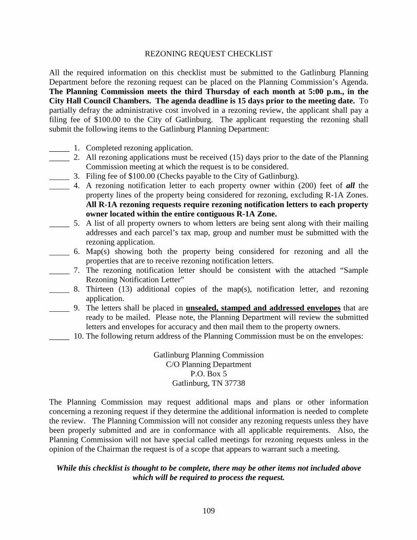
109
REZONING REQUEST CHECKLIST All the required information on this checklist must be submitted to the Gatlinburg Planning Department before the rezoning request can be placed on the Planning Commission’s Agenda. The Planning Commission meets the third Thursday of each month at 5:00 p.m., in the City Hall Council Chambers. The agenda deadline is 15 days prior to the meeting date. To partially defray the administrative cost involved in a rezoning review, the applicant shall pay a filing fee of $100.00 to the City of Gatlinburg. The applicant requesting the rezoning shall submit the following items to the Gatlinburg Planning Department: 1. Completed rezoning application. 2. All rezoning applications must be received (15) days prior to the date of the Planning Commission meeting at which the request is to be considered. 3. Filing fee of $100.00 (Checks payable to the City of Gatlinburg). 4. A rezoning notification letter to each property owner within (200) feet of all the
property lines of the property being considered for rezoning, excluding R-1A Zones. All R-1A rezoning requests require rezoning notification letters to each property owner located within the entire contiguous R-1A Zone.
5. A list of all property owners to whom letters are being sent along with their mailing addresses and each parcel’s tax map, group and number must be submitted with the rezoning application. 6. Map(s) showing both the property being considered for rezoning and all the
properties that are to receive rezoning notification letters. 7. The rezoning notification letter should be consistent with the attached “Sample Rezoning Notification Letter” 8. Thirteen (13) additional copies of the map(s), notification letter, and rezoning
application. 9. The letters shall be placed in unsealed, stamped and addressed envelopes that are ready to be mailed. Please note, the Planning Department will review the submitted letters and envelopes for accuracy and then mail them to the property owners. 10. The following return address of the Planning Commission must be on the envelopes:
Gatlinburg Planning Commission C/O Planning Department
P.O. Box 5 Gatlinburg, TN 37738
The Planning Commission may request additional maps and plans or other information concerning a rezoning request if they determine the additional information is needed to complete the review. The Planning Commission will not consider any rezoning requests unless they have been properly submitted and are in conformance with all applicable requirements. Also, the Planning Commission will not have special called meetings for rezoning requests unless in the opinion of the Chairman the request is of a scope that appears to warrant such a meeting.
While this checklist is thought to be complete, there may be other items not included above which will be required to process the request.
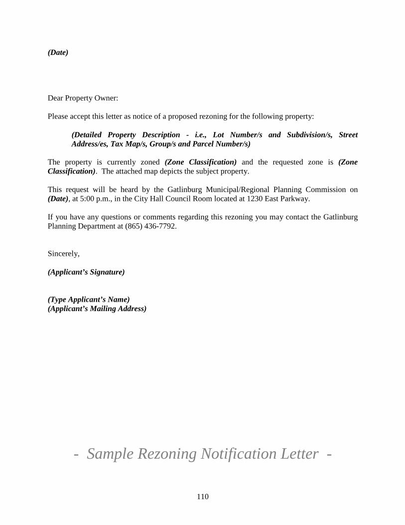
110
(Date) Dear Property Owner:
Please accept this letter as notice of a proposed rezoning for the following property:
(Detailed Property Description - i.e., Lot Number/s and Subdivision/s, Street Address/es, Tax Map/s, Group/s and Parcel Number/s)
The property is currently zoned (Zone Classification) and the requested zone is (Zone Classification). The attached map depicts the subject property. This request will be heard by the Gatlinburg Municipal/Regional Planning Commission on (Date), at 5:00 p.m., in the City Hall Council Room located at 1230 East Parkway. If you have any questions or comments regarding this rezoning you may contact the Gatlinburg Planning Department at (865) 436-7792. Sincerely, (Applicant’s Signature)
(Type Applicant’s Name) (Applicant’s Mailing Address)
- Sample Rezoning Notification Letter -