Embed Size (px)
Citation preview
CITY OF GRESHAM
MAYOR AND CITY COUNCIL
Charles J. Becker, MayorVicki Thompson, Council President
Jack Horner, CouncilorChris Lassen, CouncilorCathy Butts, CouncilorJack Hanna, Councilor
Larry Havercamp, Councilor
PLANNING COMMISSION
Dick Anderson, ChairCarl Culham, Vice Chair
Wes BellRob CookDick Ehr
Dennis OganShannon Schmiitt
Pat SpeerMike Whisler
Vicki Thompson, Council ContactAnn Pytynia, Staff Liaison
PARKS AND RECREATION COUNCIL ADVISORY
COMMITTEE
Ernest Drapela, ChairGary Bisbee, Vice Chair
Ron PetersonRichard DwyerDavid Hamilton
Charles SievekingSam Murray
Cathy Butts, Council LiaisonJack Hanna, Council Liaison Alternate
Don Robertson, Staff Liaison
CITY OF GRESHAM STAFF
Bonnie R. Kraft, City ManagerDave Rouse, Department of Environmental Services
DirectorDon Robertson, Parks & Recreation Division ManagerDavid Lewis, Landscape Architect & Project Manager
Phil Kidby, Landscape ArchitectJohn Dorst, Transportation Division Manager
Rebecca Ocken, Senior Transportation Planner
PLANNING CONSULTANTS
Otak, IncorporatedTrail Planners, Landscape Architects, and Civil
EngineersRon Heiden, Project Manager
Jerry Offer, PlannerTim Simons, Civil Engineer
Don Hanson, Principal-in-Charge
DKS Associates, Inc.Traffic Planners/Engineers
Randy McCourt, Traffic EngineerJim Peters, Traffic Engineer
COOPERATING PARTICIPANTS
Transportation DivisionWastewater Services Division
Stormwater DivisionDepartment of Environmental Services
Community and Economic DevelopmentDepartment
Police and Fire DepartmentsCity of Gresham
Metro Greenspaces Planning Staff
TECHNICAL ADVISORY COMMITTEE
Dave Rouse, Former Gresham Transporta-tion Division Manager
Marianne Zarkin, Landscape ArchitectCindy Bee, Park Planner
Darlene Maddux, Oregon Department ofTransportation
John Dorst, Former Multnomah CountyTransportation Planner
Doug Strickler, Multnomah County Transpor-tation Planner
Rob Choy, City of Fairview PlannerKeyle McKeon, PacifiCorpAlec Johnson, PacificCorp
Patt Opdyke, East Multnomah SWCDCatherine Rogers, Portland General Electric
Wes Waldron, Portland General ElectricMike Porter, Portland General Electric
John Griffiths, Tri-MetRick Kindig, Tri-Met
Gresham Parks and Recreation StaffGresham Transportation Planning Staff
The City of Gresham’s programs, services, employment opportunities and volunteer positions are open to allpersons without regard to race, religion, color, national origin, sex, age, marital status, disability, or political affiliation.
GRESHAM / FAIRVIEW TRAIL MASTER PLAN
Acknowledgments

The City of Gresham,with help through citizen involvement,
is developing and operating a very successfulparks, recreation, trails, and open space system.
This success is built on the philosophyestablished in the stated Mission of the
Gresham Parks and Recreation Division...
“To offer facilities and programs that invite the public’s use.Our efforts shall enhance Gresham’s quality of life through the significant benefits provided by recreation.
We take an active role in delivering park and recreation services in a cost-effective manner.We strive to offer fully accessible services in partnership with others, encouraging volunteer involvement.”
Mission Statement
GRESHAM / FAIRVIEW TRAIL MASTER PLAN

Mission Statement
Executive Summary ..................................................................................................................... 1
Chapter 1: Recommended Trail Route ..................................................................................................... 2Gresham/ Fairview Trail Map ............................................................................................................. 3Segment A: Springwater Trail to Division Street ............................................................................ 4Segment B: Division Street to Burnside Street .............................................................................. 6Segment C: Burnside Street to Halsey Street ................................................................................ 7Segment D: Halsey Street Along 201st Avenue to Sandy Boulevard ......................................... 8Segment E: Sandy Boulevard to Marine Drive ................................................................................ 9Gresham/Fairview Trail Photo Map ................................................................................................. 11
Chapter 2: Natural Resources and Trail FacilitiesAlong the Gresham/Fairview Trail ............................................................................................................. 12
Johnson CreekSpringwater Trail CorridorLinnemann Station TrailheadSouthwest Community ParkFairview CreekGrant ButteMAX TrailSalish Ponds TrailI-84 Multi-Use Bike/Pedestrian PathColumbia River Slough Greenway Hiking Trail40-Mile LoopMetro’s Blue Lake Regional Park
Chapter 3: Trail Master Plan Development ......................................................................................... 14Public InvolvementCommunity ConcernsResponses to Community ConcernsMeetingsCoordination with Other Planning Efforts
GRESHAM / FAIRVIEW TRAIL MASTER PLAN
Table of Contents
Chapter 4: Trail Improvement Recommendations ............................................................................ 18Recommended Trail ImprovementsRecommended Trail Corridor Easements/AcquisitionsTrail Management & Maintenance RecommendationsSignage Overview
Chapter 5: Implementation Phasing and Funding Summary ........................................................ 22Preliminary Trail Construction Estimate, Segment A................................................................... 23Preliminary Trail Construction Estimate, Segment B................................................................... 24Preliminary Trail Construction Estimate, Segment C .................................................................. 25Preliminary Trail Construction Estimate, Segment D .................................................................. 26Preliminary Trail Construction Estimate, Segment E ................................................................... 27
Chapter 6: Trail Development Approval Process ................................................................................ 28
Appendices ........................................................................................................................................................ 29Appendix A: Gresham/Fairview Trail Letters of CommentAppendix B: Gresham/Fairview Trail Natural Resource Documentation and Impact
Analysis, Executive Summary, Fishman Environmental Services
GRESHAM / FAIRVIEW TRAIL MASTER PLAN
Table of Contents

1GRESHAM/FAIRVIEW TRAIL MASTER PLAN
Executive Summary
The Gresham/Fairview Trail is a regionallysignificant project which will provide manybenefits to the community. The trail was identi-fied in the 1995 Gresham Parks, Recreation andOpen Space Master Plan, the 1996 GreshamTrails Master Plan, as well as the MetropolitanGreenspaces Master Plan and the Regional BikePlan as a regional multi-use trail.
A survey of Gresham residents identified “walk-ing for pleasure” as the most popular of recre-ation activities. Bicycling and nature walks wererated third and fourth in this survey. TheGresham/Fairvew Trail will provide improvedopportunities for these activities.
The Gresham/Fairview Trail will:1. provide opportunities for rest and relaxation
through trail-related recreation;2. reduce auto dependency and contribute to
the environmental health of the community;3. improve access to parks and recreational
areas and link homes, workplaces, neighbor-hoods, and other community facilities;
4. provide a much-needed place to walk, ride abike, run, roller skate or skateboard,observe nature, take a hike, or commute;
5. be fully accessible to the disabled and to trail users of all ages.
The Gresham/Fairview Trail will link neighbor-hoods to employment centers, schools, parks,natural areas, and industrial areas. The trail willbe within walking distance of bus stops and lightrail stations, thus providing a link to transit use.It will connect to natural areas along JohnsonCreek, Fairview Creek, Columbia River Sloughand the Columbia River. It will also greatlyenhance the existing on-street bicycle network.
This 5.2 mile long multi-use paved trail, separatedfrom motorized traffic, will provide a safe north/south alternative route of travel for commuters,recreationalists, bicyclists and pedestrians. Thetrail will provide safe pedestrian and bicyclistcrossings at seven arterial streets (Powell,Division, Burnside, Stark, Glisan, Halsey andSandy). The trail will also provide a safe crossingof the MAX light rail transit tracks and beneaththe Banfield Freeway I-84 and the Union Pacificand Burlington Northern railroad tracks.
The Gresham/Fairview Trail will serve as a majornorth/south connector between two regionallysignificant and heavily used trails: The SpringwaterTrail and the 40-Mile Loop at Marine Drive. Thetrail will provide the missing link betweenneighborhoods and these two important regionaltrails. It will also connect with the ColumbiaRiver Slough Greenway walking/hiking trail; the I-84 multi-use bike/pedestrian path; the SalishPonds Trail; the MAX Trail; and will help connectwith Metro’s Blue Lake Regional Park.
During the trail planning process, several routeoptions were identified and evaluated at variousmeetings with interested citizens, propertyowners, city officials and staff, other local agencystaff, and the trail planning team. The preferredtrail route was determined based on user safety,ease of use, land ownership, cost effectivenessand public involvement.

2GRESHAM/FAIRVIEW TRAIL MASTER PLAN
Chapter 1:Recommended Trail Route
The trail route was determined based on avariety of factors including user safety, ease ofuse, land ownership, cost effectiveness, and publicinvolvement.
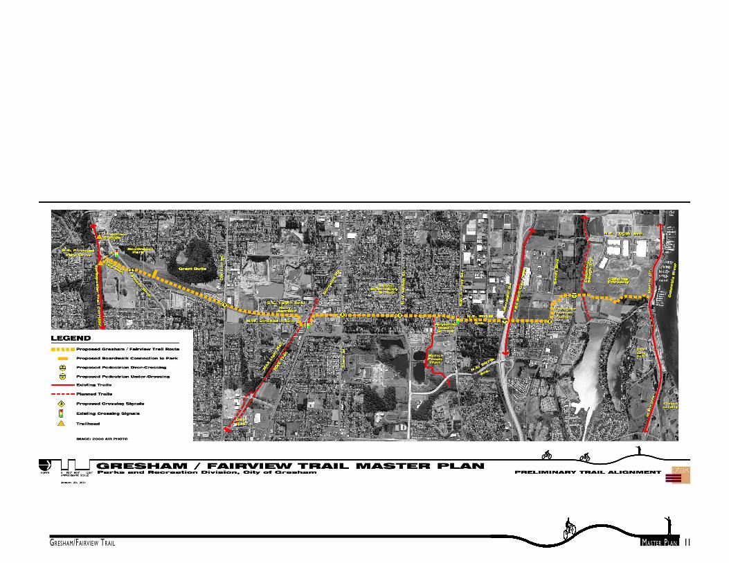
The trail route, in general, begins at theSpringwater Trail, runs north along the vacated10th Street, continues north along an abandonedrailway right-of-way adjacent to Fairview Creek,and through Tri-Met’s Ruby Junction Light Railmaintenance facility. The trail continues norththrough an existing PGE power corridor west ofBirdsdale Avenue and 201st Avenue, to HalseyStreet. The trail then parallels 201st Avenue toSandy Boulevard. At Sandy Boulevard, the trailturns west along the frontage of Gresham’swastewater treatment plant for a short distance.Just west of the treatment plant, the trail turnsnorthward across the railroad tracks and alongthe east edge of the Catellus Corporationindustrial facility to Marine Drive where itconnects to the 40-Mile Loop. For purposes ofthe Master Plan, the trail is divided into segmentsA through E which are described in more detailon the following pages.

3GRESHAM/FAIRVIEW TRAIL MASTER PLAN
������������� ���� ���

4GRESHAM/FAIRVIEW TRAIL MASTER PLAN
Segment A: Springwater Trail to DivisionStreet
Segment A begins at the intersection of theSpringwater Trail and vacated 10th Street. Atrailhead parking lot will be built in the future atthis location when funding is available. Thetrailhead will have good automobile access fromPowell Boulevard. Trail users will be able toaccess either the Gresham/Fairview Trail or theSpringwater Trail from this trailhead. Anothertrailhead just to the west is also planned as part
of the Springwater Trail Master Plan.
From the proposed 10th Street trailhead, thetrail will travel north along the Old Powell LoopRoad towards Powell Boulevard.
The City of Gresham owns the approximately1.1-mile former railroad alignment between theSpringwater Trail and Division Street. The trailroute would follow Old Powell Loop Road andcross Powell Boulevard to the old railroad bed.A separated over-crossing ramp over Powell
Segment A
Powell Blvd. Crossing Location
Boardwalk
Boulevard would be used.
The trail would then continue north on the oldrailroad bed toward Division Street. About halfway to Division Street, a boardwalk over wet-lands would be built from the trail as a link tothe neighborhood and Southwest CommunityPark. The boardwalk crossing of the wetlandswould replace an existing hard-packed, dirt farmroad which passes directly through the wetland.The boardwalk would be constructed as part ofthe trail development. In the Gresham-Fairview

5GRESHAM/FAIRVIEW TRAIL MASTER PLAN
Trail Natural Resource Documentation andImpact Analysis, Fishman Environmental Services,LLC, found that placement of a boardwalk in thisarea would provide an excellent opportunity forwetland enhancement and improvement ofaquatic quality through removal of the existingculvert and road fill, in addition to providingaccess between the trail and the neighborhoodand planned park to the west.
There are wonderful views across the wetlandsto the community park and to several buttes ofvolcanic origin.
From the boardwalk north, the trail wouldcontinue on the old railroad bed to DivisionStreet. The trail would then cross Division witha full, at-grade, crossing.
Grant ButteOld Farm Road 10th Street/Powell Blvd. Intersection
The anticipated trail user group will includeslower and inexperienced users such as begin-ning cyclists, children, people with disabilities, andfamilies with strollers. Based on the effective useof signalized crossings of the Springwater TrailCorridor and to insure a high degree of safety, afull pedestrian-activated signal, high-visibility“ladder” stripe cross walk, bollards, center-raisedmedian refuge, landscaping, night lighting, ex-tended curbs, and curb ramped crossing are thepreferred trail crossing road improvements. TheGresham to Fairview Trail Crossing Analysisreport prepared by DKS Associates recommendssimilar improvements at the trail’s intersectionswith Powell, Division, and Burnside. The signalshould be synchronized with other traffic signalson Division Street.
The Gresham to Fairview Trail Crossing Analysisby DKS Associates also considered grade sepa-rated overhead and below grade trail crossingsat Division Street. The report does not recom-mend using either of these grade separatedcrossing options due to the potential for trailusers to cross at grade to avoid the inconve-nience of grade separated crossings; the safetyrisks of overhead and below grade crossings; andthe additional expense of constructing gradeseparated crossings.

6GRESHAM/FAIRVIEW TRAIL MASTER PLAN
MAX Rail Crossing
Ruby Junction
Segment B: Division Street to Burnside Streetthrough Tri-Met’s Ruby Junction Light RailMaintenance Facility
After crossing Division Street, the trail willcontinue along the old railroad bed to Tri-Met’sRuby Junction light rail transit maintenancefacility. The trail will go through the maintenancefacility grounds. An easement, for access throughthe east side of the facility, is being obtained fromTri-Met, at no cost to the City. The maintenancefacility is in operation 24 hours a day, 7 days aweek. It is well lit, as will be the trail due to Tri-
Met’s lights.
The maintenance work on train cars and trolleysat the Ruby Junction facility is fascinating. This isa great opportunity for interpretive signage,which could discuss the regional MAX light railtransit system and the purpose and function ofthe facility.
From Ruby Junction, the trail jogs to the east toBirdsdale Avenue. The trail then crosses theMAX tracks and the proposed MAX Trail atBurnside Road. The proposed MAX Trail will
connect to the Ruby Junction MAX Station atS.E. 197th Avenue and to points to the east indowntown Gresham
The Gresham/Fairview Trail will continue northacross Burnside Street at the existing Birdsdale/Burnside signal crossing. Recommended crossingtreatment at the trail’s intersection withBurnside includes a combination of widersidewalk/pathway, roadway illumination, signing,bicycle loop detectors, pedestrian detectors,wide curb ramps, a high visibility ”ladder” crosswalk and a curved path approaching the crossing.
Segment B

7GRESHAM/FAIRVIEW TRAIL MASTER PLAN
201st Avenue and Halsey StreetSegment C - North of Ruby Junction
PGE Corridor
Segment C: Burnside Street to Halsey Street
After crossing Burnside Street, the trail turnswest for about half a block to access a 100-footwide powerline corridor owned by PortlandGeneral Electric. The City of Gresham is seekingto acquire, at no cost, an approximately 1.19 milepublic access easement to locate the trail withinthe corridor. The trail, in this segment, may bedesigned with a larger 14-foot width to not onlyaccommodate pedestrian and bicyclists, but alsoto accommodate PGE’s maintenance vehicleswhich will occasionally need to access the
corridor. Locked, removable bollards will limitaccess to only authorized motorized vehicles.
This segment of the trail will improve connec-tions to and between two schools in this area,Davis Elementary School and Reynolds MiddleSchool.
The trail will cross Stark and Glisan Streets withat-grade crossings similar to the crossing atDivision Street. Traffic signals will be installedwhen warrants are met.
PGE Corridor at Glisan Street
South of Halsey Street, the Gresham FairviewTrail comes very close to the Salish Ponds Trail.A trail connection could be planned throughReynolds Middle School connecting the twotrails and could be constructed by the City ofFairview. The Salish Ponds Trail leads through anatural area and connects to Fairview City Halland Multnomah County’s Fairview Library.
At Halsey Street the trail will cross to 201st
Avenue at the existing crossing signal. TheHalsey Street crossing will be improved similarto the Burnside Street crossing.
8GRESHAM/FAIRVIEW TRAIL MASTER PLAN
Segment D 201st Avenue Railroad Overpass
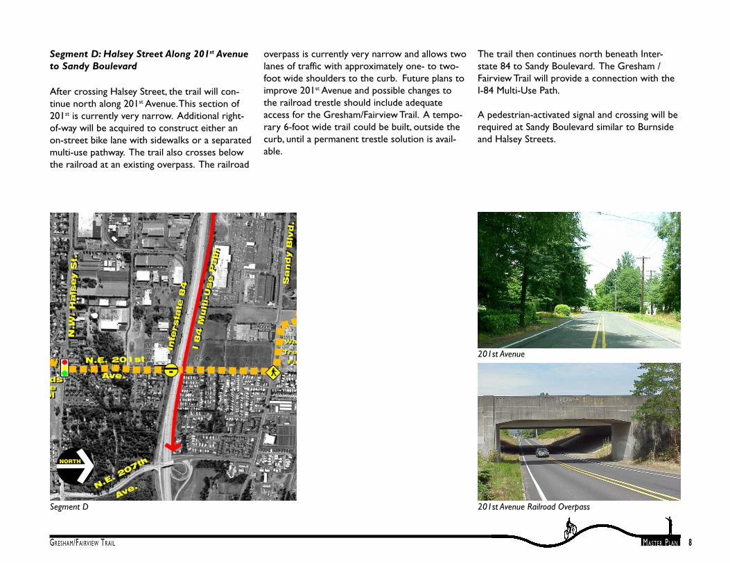
Segment D: Halsey Street Along 201st Avenueto Sandy Boulevard
After crossing Halsey Street, the trail will con-tinue north along 201st Avenue. This section of201st is currently very narrow. Additional right-of-way will be acquired to construct either anon-street bike lane with sidewalks or a separatedmulti-use pathway. The trail also crosses belowthe railroad at an existing overpass. The railroad
overpass is currently very narrow and allows twolanes of traffic with approximately one- to two-foot wide shoulders to the curb. Future plans toimprove 201st Avenue and possible changes tothe railroad trestle should include adequateaccess for the Gresham/Fairview Trail. A tempo-rary 6-foot wide trail could be built, outside thecurb, until a permanent trestle solution is avail-able.
The trail then continues north beneath Inter-state 84 to Sandy Boulevard. The Gresham /Fairview Trail will provide a connection with theI-84 Multi-Use Path.
A pedestrian-activated signal and crossing will berequired at Sandy Boulevard similar to Burnsideand Halsey Streets.
201st Avenue

9GRESHAM/FAIRVIEW TRAIL MASTER PLAN
Segment E
Segment E: Sandy Boulevard to MarineDrive
Much of this section of the trail may be devel-oped as part of future commercial developmentin the area. Eight thousand people will eventuallybe employed within the Catellus property andmany more within adjacent lands yet to bedeveloped. The trail will provide a valuable
alternative transportation connection andrecreation opportunity.
After crossing to the north side of Sandy Boule-vard, the trail will turn west along the frontage ofGresham’s wastewater treatment facility. Thisexisting 1,000 foot long portion of the trail hasthe distinction of being the first constructed trailsection. At the western property boundary of
the treatment plant, the trail will turn northwardagain along the route of an existing dirt roadtowards the Columbia Slough.
Trail Along Wastewater Treatment Facility Frontage
Dirt Road West of Wastewater Treatment Facility
10GRESHAM/FAIRVIEW TRAIL MASTER PLAN
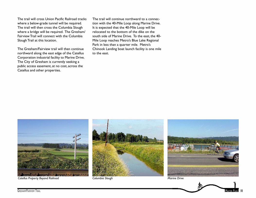
The trail will cross Union Pacific Railroad trackswhere a below-grade tunnel will be required.The trail will then cross the Columbia Sloughwhere a bridge will be required. The Gresham/Fairview Trail will connect with the ColumbiaSlough Trail at this location.
The Gresham/Fairview trail will then continuenorthward along the east edge of the CatellusCorporation industrial facility to Marine Drive.The City of Gresham is currently seeking apublic access easement, at no cost, across theCatellus and other properties.
Catellus Property Beyond Railroad Marine DriveColumbia Slough
The trail will continue northward to a connec-tion with the 40-Mile Loop along Marine Drive.It is expected that the 40-Mile Loop will berelocated to the bottom of the dike on thesouth side of Marine Drive. To the east, the 40-Mile Loop reaches Metro’s Blue Lake RegionalPark in less than a quarter mile. Metro’sChinook Landing boat launch facility is one mileto the east.
11GRESHAM/FAIRVIEW TRAIL MASTER PLAN

12GRESHAM/FAIRVIEW TRAIL MASTER PLAN
Chapter 2: Natural Resources And TrailFacilities Along the Gresham/Fairview Trail
The Gresham/Fairview Trail will be developedwithin and in close proximity to natural re-sources and will provide connections to otherexisting trail systems. The natural resource areasinclude wetlands and riparian greenways ofFairview Creek and the Columbia Slough. Thetrail alignment provides views of Grant Butte,Jenne Butte, and other nearby buttes of volcanicorigin. The trail also will provide a connectionbetween the Springwater Trail Corridor and theColumbia River portion of the 40-Mile LoopTrail. All of these resources and facilities offerexcellent opportunities for interpretive anddirectional signage along the trail.
These resources and facilities are addressedbelow from south to north.
Johnson CreekAs one of the region’s last free-flowing urbancreeks, Johnson Creek is a valuable resource forthe community. The Creek is also home tofederally listed steelhead, making it one of thefew urban waterways in the nation with a listedspecies.
Springwater Trail CorridorThe 4.8-mile segment of the Springwater TrailCorridor (STC), within Gresham’s city limits, isthe most popular existing public trail. Com-pleted in 1996, Gresham’s segment of the STC isa 10 to 12-foot wide asphalt-paved multi-usepath which parallels Johnson Creek.
The STC is part of the region-wide MetroGreenspaces Program aimed at protecting andpreserving open space and creating recreationaltrails. The STC was the first urban rails-to-trailsconversion project in Oregon, and is part of the‘40-Mile Loop’ regional trail system, whichincludes over 140 miles of planned and alreadydeveloped trails.
Fairview Creek/Southwest Community Park Linnemann StationSpringwater Trail
In 1993, an estimated 376,000 user trips weremade on the STC. It is projected that by 2001,more than 1,000,000 user trips will be madeannually on the STC.
Linnemann Station TrailheadThe Linnemann Station trailhead is located at thesite of a former railway station at the junction ofthe Springwater Division rail line and anothershort line, which extended to the north to theColumbia River. The station was constructedcirca 1903. The trailhead, currently under design,will primarily serve the Springwater Trail Corri-dor. Users will also be able to access theGresham/Fairview Trail from this trailhead.Design and construction is being funded in partthrough a $532,000 Metro grant.
Southwest Community ParkThe City intends to develop a community parkon approximately 18 acres of property west ofthe wetlands and north of Powell Boulevard.This property is partially wooded and slopestowards the creek. The future park includes two

13GRESHAM/FAIRVIEW TRAIL MASTER PLAN
tree groves which have recently been designatedas Significant Tree Groves by the City ofGresham. These groves include a Douglas firforest and a western red cedar mixed grove. Theproposed Gresham/Fairview Trail will provide anopportunity for access to this future park.
Fairview CreekFairview Creek flows northward to Salish Pondsfrom the City-owned wetlands and open spaceexisting between Powell Boulevard and DivisionStreet and eventually to Fairview Lake. This openspace area provides valuable fish and wildlifehabitat, which is being preserved and enhancedas part of the City’s open space conservationeffort.
Grant ButteGrant Butte is one of eight dormant volcanicformations which are natural landmarks withinthe Gresham area. Grant Butte rises to anelevation of 602 feet and has upland forestvegetation with second growth conifer trees.Dominant species are Douglas fir, red alder, and
bigleaf maple. The forest cover provides impor-tant wildlife habitat, watershed protection, andaesthetic benefits. The Gresham/Fairview Trailprovides scenic views of Grant Butte, as well asviews of other buttes in the southern end of thecity.
MAX TrailThe MAX Trail is a proposed off-street multi-usetrail connecting Tri-Met’s Cleveland station to theRuby Junction station.
Salish Ponds TrailLocated between Halsey and Glisan streets andopened in October 1999, the 70-acre SalishPonds Wetlands Park is Fairview's largest citypark.
I-84 Multi-Use Bike/Pedestrian PathThe I-84 Path parallels the interstate highwayfrom NE 122nd to 207th. The path is 10 to 12-feet wide and is maintained by the state ofOregon.
MAX Light Rail
Columbia River Slough Greenway HikingTrailThe Columbia Slough extends 18 miles betweenFairview Lake on the east to the WillametteRiver at Kelley Point Park on the west. A por-tion of the Columbia Slough crosses through thenorth end of Gresham. The Columbia SloughTrail is planned to parallel the Slough fromFairview Lake to Kelley Point Park.
40-Mile LoopThe 40-Mile Loop along Marine Drive is part ofthe regional trail system. This existing trailconsists of designated bike lanes along bothshoulders of Marine Drive.
Metro’s Blue Lake Regional ParkMetro’s Blue Lake Regional Park is located alongthe north shore of a 64-acre natural lake. BlueLake Park provides opportunities for boating,fishing, swimming, picnics, community events andspecial programs throughout the year.
Columbia SloughGrant Butte

14GRESHAM/FAIRVIEW TRAIL MASTER PLAN
Typical Trail Section
Chapter 3: Trail Master Plan Development
Public Involvement
During the trail planning process, many routeoptions were identified and evaluated at meet-ings with interested citizens, property owners,city officials and staff, other local agency staff, andthe trail planning team. The preferred trail routewas determined based on user safety, ease of use,land ownership, cost effectiveness, and publicinvolvement.
Community involvement was an integral part ofthis trail planning process. Two public meetingswere held at Gresham City Hall to gather inputfrom interested citizens. To advertise thesepublic meetings, over 18,000 flyers were mailedto residents living within the surrounding neigh-borhood associations. Citizens and businesseswere contacted within the Hollybrook, Centen-nial, Northwest, Rockwood, and North Greshamneighborhood associations.
In addition, trail planning coordination meetingsincluded two meetings with a subcommitteecomprised of citizens interested in the trail, andthree meetings with a Technical Advisory Com-mittee (TAC) made up of representatives fromMultnomah County, Oregon Department ofTransportation, City of Fairview, Portland Gen-eral Electric, Pacific Power & Light, Tri-Met, andCity of Gresham Transportation Engineering andTransportation Planning staff.
The Plan was also presented to the Parks &
Recreation Council Advisory Committee, theTransportation System Council Advisory Com-mittees, the BIKE-PED Task Force, and theGresham Planning Commission.
Community Concerns
Residents who attended the public meetingsexpressed the following concerns:
• The trail segment as a multi-use path alongthe west side of Birdsdale Avenue wouldpose negative impacts to existing residentialand business properties. It was also statedthat this trail segment would be dangerousbecause of the high speeds and heavy vol-umes of traffic on this street. Neighborssuggested that an off-street route should beconsidered, such as through Tri-Met’s RubyJunction maintenance yard.
• The trail could have adverse impacts on thevaluable wetlands and wildlife habitat existingalong Fairview Creek.
• Routing the trail through the future South-west Community Park site would be prema-ture and should be determined as part of thepark’s master planning process.
• The trail north of Stark Street should bescreened or buffered with landscaping and/orfencing to minimize impacts to adjacentprivate residential properties.
Responses to Community ConcernsThese concerns were addressed as part of thetrail master plan process.
• It was determined that the trail would bebetter located through the Ruby Junctionfacility than along Birdsdale Avenue. Aneasement through Ruby Junction is beingnegotiated with Tri-Met.
• The potential impacts upon wetlands andwildlife habitat have been addressed byFishman Environmental Services’ NaturalResource Documentation and Impact Analysis.
• The trail alignment is not routed throughSouthwest Community Park.
• The trail through the PGE Corridor will notbe closer than 30 feet from adjacent proper-ties and will be screened with plant materialto protect the privacy of the adjacentproperty owners.
15GRESHAM/FAIRVIEW TRAIL MASTER PLAN
Meetings
The following is a summary of meetings whichhave been held for the Gresham/Fairview TrailMaster Plan:
September 24, 1998 - TAC Meeting No. 1.Planning workshop was held.
October 6, 1998 - Trail route options werepresented to trails subcommittee.
October 20, 1998 - Public Meeting/OpenHouse No. 1. Trail route options werepresented.
October 29, 1998 - Trail presentation tothe Bike-Ped Task Force.
November 4, 1998 - TAC Meeting No. 2.Review of options and preferred trailroute.
November 12, 1998 - Public Meeting/OpenHouse No. 2. Preferred trail route waspresented.
November 18, 1998 - Trail presentationwas made to the Gresham Parks andRecreation Council Advisory Committee(PRCAC).
December 14, 1998 - Trail presentationwas made to the Gresham PlanningCommission.
December 16, 1998 - Pre-application conferencewas held with City planning and
development engineering staff regardingPhase 1 trail construction project.
December 23, 1998 - GreshamTransportation Planning Section memoregarding City staff review comments.
January 5, 1999 - Trail project was discussed withthe Columbia Slough Watershed Council.
January 7, 1999 - Trail project wasdiscussed at the Gresham TSCACmeeting.
January 19, 1999 - Meeting with City’strails maintenance staff regarding Phase1 trail design and construction.
January 20, 1999 - TAC Meeting No. 3.
January 26, 1999 - Council workshop to discusstrail alignment between Powell Boulevard andDivision Street.
January 28, 1999 - Trail presentation. Meetingwith Centennial Neighborhood Association todiscuss trail alignment north of Powell Boule-vard.
February 9, 1999 - Second meeting of thetrail’s subcommittee.
February 16, 1999 - Trail presentationwas made to the Gresham City Council.
March 3, 1999 - North Gresham NeighborhoodAssociation Meeting - trail presentation.
March 15, 1999 - Trail presentation to the Neigh-borhood Coalition.
March 16, 1999 - Master Plan and Phase 1 trailconstruction project was presented tothe Gresham City Council for theirapproval. Master Plan and Phase I Design tabledpending further public meetings/input.
April 29, 1999 - Meeting with Bike-Ped TaskForce to discuss trail alignment north of PowellBoulevard.
August 18, 1999 - PRCAC trail update and re-view of request for funding for Statewide En-hancement Grant.
October 5, 1999 - City Council review of State-wide Enhancement Grant proposal for fundingthe trail.
October 12, 1999 - Updated memo sent toJohnson Creek Watershed Council (requested amemo rather than an update at their meeting).
October 13, 1999 - Update memos sent to Bike-Ped Task Force and TSCAC (requested a memorather than a meeting).
November 9, 1999 - TAC meeting No.4 to dis-cuss new options for the trail alignment.
November 17, 1999 - PRCAC update regardingfunding, trail alignment options.
December 1, 1999 - Meeting with FairviewCreek Watershed Council to discuss trail align-ment options.

16GRESHAM/FAIRVIEW TRAIL MASTER PLAN
December 9, 1999 - Public Workshop No.3 - dis-cussed potential new alignments, outstanding is-sues, etc.
January 10, 2000 - Neighborhood Coalition - up-date meeting, discussion of options.
January 25, 2000 - Council policy developmentmeeting to discuss the Springwater Trail to Divi-sion Street alignment via Birdsdale Avenue .
February 9, 2000 - Meeting with Gresham Parksand Recreation Committee concerning com-ments and direction on the trail master plan.
March 9, 2000 - Joint meeting of Centennial andSouthwest Neighborhood Associations - updateon planning and development of trail.
May 3, 2001 - Joint meeting with Gresham Trans-portation Council Advisory Committee and Gre-sham Bicycle Pedestrian Task Force. Review ofPowell and Division crossing options and pre-ferred alternatives.
May 8, 2001 - TAC meeting review of Powell andDivision crossing options and preferred alterna-tives.
May 16, 2001 - Meeting with Gresham Park andRecreation Council Advisory Committee con-cerning Powell and Division crossing options andpreferred alternatives.
June 18, 2001 - Meeting with Gresham Parks andRecreation Council Advisory Committee con-cerning Powell crossing options and natural re-source and documentation and impact analysis.
June 27, 2001 - Meeting with Scott Forrester andReita Hribernick concerning Powell crossinganalysis and natural resource documentation andimpact analysis.
July 2001 - Centennial Neighborhood Associa-tion meeting update presentation concerningtrail master plan.
August 22, 2001 - Met with Fairview Creek Wa-tershed Conservation Group to discuss trailalignment north of Powell Boulevard.
November 14, 2001 - Gresham Parks and Recre-ation Council Advisory Committee. Update ontrail master planning and tentative recommenda-tion of approval.
November 26, 2001 - Gresham Planning Com-mission. Review and discussion of draft trailmaster plan.
January 14, 2002 - Gresham Neighborhood Coa-lition. Recommended crossing Powell Blvd. atthe railroad bed.
January 16, 2002 - Gresham Parks and Recre-ation Council Advisory Committee. Recommen-dation of approval.
January 23, 2002 - Fairview Creek WatershedCouncil. Recommended crossing Powell Blvd. atthe railroad bed.
February 5, 2002 - Gresham City Council. Re-viewed and adopted the draft trail master plan.
This totals approximately 47 meetings held overa three-year period.

17GRESHAM/FAIRVIEW TRAIL MASTER PLAN
Coordination With Other Planning Efforts
In developing the Master Plan for the Gresham/Fairview Trail, the following plans, guidelines andhandbooks were consulted.
Americans with Disabilities Act AccessibilityGuidelinesThe Gresham/Fairview Trail will be made accessibleper applicable outdoor recreation standards, bestpractices and guidelines.
Gresham Parks, Recreation & Open SpaceMaster Plan (1995)The Gresham/Fairview Trail will provide access tomany other trails, open spaces, parks, and schools.
Gresham Trails Master Plan (1996)The proposed Gresham/Fairview Trail is consistentwith the Goals set forth in the 1996 Gresham TrailsMaster Plan.
Springwater Trail Corridor Master Plan (1991)The Gresham/Fairview Trail will link the SpringwaterCorridor Trail with several other regionally significanttrails. It will enhance access and add variety to theSpringwater Trail. Design standards for theGresham/Fairview Trail will be similar to theSpringwater Trail to provide visual and functionalcohesiveness between the two.
Oregon Bicycle and Pedestrian Plan (1995)Design safety standards for the trail will beconsistent and comply with accepted practices andstandards.
Metro 2040 Plan (1991)The Gresham/Fairview Trail will provide alternativetransportation links consistent with Metro’s 2040Plan.
Metro Greenspaces Master Plan (1992)The Gresham/Fairview Trail is consistent with andmeets the goals of Metro’s Greenspaces Master Planby interconnecting regional parks, natural areas, trailsand greenways for fish, wildlife and people.
40-Mile Loop Master Plan (1983)The Gresham/Fairview Trail will link the 40-Mile Loopwith several other regionally significant trails. Accessto the 40-Mile Loop will become safer and moreconvenient.
Columbia South Shore Slough Trail Master Plan(1993)The Gresham/Fairview Trail will link the ColumbiaSouth Shore Slough Trail with several other regionallysignificant trails.
Tri-Met Planning and Design for Transit Hand-bookTrail connections to Tri-Met’s transit facilities will beprovided to allow safe and convenient off-streetaccess.

18GRESHAM/FAIRVIEW TRAIL MASTER PLAN
Chapter 4: Trail ImprovementRecommendations
The following describes the master plan recom-mendations based on the input received fromcitizens, City staff, the Technical Advisory Com-mittee, and other public agencies. These recom-mendations are organized into five generalcategories: trail improvements, corridor ease-ment/acquisitions, management and maintenance,and signage overview.
Recommended Trail Improvements:
• Trail surfacing material should be concreteor asphaltic concrete pavement over acompacted gravel base. The paved trail widthshould be a minimum of 10 feet wide to amaximum of 14 feet wide (preferred width),with 2-foot wide gravel shoulders. Theseimprovements are necessary to assure thatthe trail will accommodate wheel chairs,strollers, maintenance vehicles, and emer-gency vehicles as well as bicyclists, skaters,and pedestrians
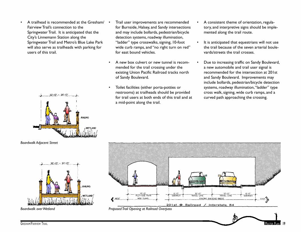
• Boardwalks are proposed for trail crossingsof wetlands to avoid filling the wetlands.Anti-slip surfaces with drain holes may beused to allow light to penetrate below thesurface to benefit vegetation and to alsoreduce the possibility of injury from slippingduring wet or icy conditions.
• The trail will be designed and installed toapplicable accessibility standards, bestpractices, and current guidelines at the timeof implementation.
• Median refuges, high-visibility “ladder”crosswalks and other striping specific to mid-block crossings, trail user-activated pedes-trian signals, signage, overhead lightingimprovements, wide curb ramps, specializedpaving, bollards, and curb extensions arerecommended for the trail mid-blockcrossings of Division, Stark, and GlisanStreets for trail user safety. Signals will beinstalled as traffic warrants are met.
• Construction of the trail adjacent to 201st
Avenue between Halsey Street and SandyBoulevard is recommended to be part offuture roadway and sanitary sewer improve-ment projects.
Mid-Block Street Crossing - Plan ViewMid-Block Street Crossing - Section View
19GRESHAM/FAIRVIEW TRAIL MASTER PLAN
• A trailhead is recommended at the Gresham/Fairview Trail’s connection to theSpringwater Trail. It is anticipated that theCity’s Linnemann Station along theSpringwater Trail and Metro’s Blue Lake Parkwill also serve as trailheads with parking forusers of this trail.
Proposed Trail Opening at Railroad OverpassBoardwalk over Wetland
• Trail user improvements are recommendedfor Burnside, Halsey, and Sandy intersectionsand may include bollards, pedestrian/bicycledetection systems, roadway illumination,“ladder” type crosswalks, signing, 10-footwide curb ramps, and “no right turn on red”for east bound vehicles.
• A new box culvert or new tunnel is recom-mended for the trail crossing under theexisting Union Pacific Railroad tracks northof Sandy Boulevard.
• Toilet facilities (either porta-potties orrestrooms) at trailheads should be providedfor trail users at both ends of this trail and ata mid-point along the trail.
• A consistent theme of orientation, regula-tory, and interpretive signs should be imple-mented along the trail route.
• It is anticipated that equestrians will not usethe trail because of the seven arterial boule-vards/streets the trail crosses.
• Due to increasing traffic on Sandy Boulevard,a new automobile and trail user signal isrecommended for the intersection at 201stand Sandy Boulevard. Improvements mayinclude bollards, pedestrian/bicycle detectionsystems, roadway illumination, “ladder” typecross walk, signing, wide curb ramps, and acurved path approaching the crossing.
Boardwalk Adjacent Street

20GRESHAM/FAIRVIEW TRAIL MASTER PLAN
Recommended Trail Corridor Easements/Acquisitions:
The City will need to acquire property or accesseasements for the trail corridor. Portions of thecorridor are currently owned by Tri-Met, Port-land General Electric, and private landowners.
• The City has acquired land from Tri-Met forthis trail to be developed between PowellBoulevard and Division Street.
• An easement is being obtained for accessthrough Tri-Met’s Test Track and RubyJunction maintenance facility.
• The City of Gresham is seeking to acquire anapproximately 1.19-mile easement, at nocost, to locate the trail within PortlandGeneral Electric’s 100-foot wide power linecorridor. The corridor is located west of202nd Avenue between Burnside and HalseyStreets. The trail will be designed to accom-modate maintenance vehicles. The trailwithin the PGE corridor will improve con-nections to two schools in this area,Reynolds Middle School and Davis Elemen-tary School.
• South of Halsey Street, the Gresham/Fairview Trail comes very close to the SalishPonds Trail. A connection may be possiblethrough Reynolds Middle School to theSalish Ponds Trail. The Salish Ponds Trailleads through the natural area and eventuallyto Fairview City Hall.
PGE Corridor
• Additional right-of-way will be required toconstruct the trail section along 201st
Avenue, between Halsey Street and SandyBoulevard. The existing road is narrow andthe terrain steep. Current conditions willnot allow for a separated multi-use trail oron-street bike lanes. Future plans for rede-velopment of 201st Avenue should includethe addition of a multi-use trail. The trailright-of-way will also be coordinated withGresham Wastewater Services Division asthey acquire easements for sanitary sewerlines.
• The City of Gresham is seeking an easementfor the trail along the east edge of Catellus’Southshore Corporate Park industrialdevelopment south of Marine Drive. Eightthousand people will eventually be employedwithin the area so this connection willprovide excellent alternative transportationto those who will work there.
Future 201st Avenue

21GRESHAM/FAIRVIEW TRAIL MASTER PLAN
Orientation, Directional, Warning Signs
Trail Management & MaintenanceRecommendations:The management and maintenance strategy forthe Gresham/Fairview Trail is described in detailin Chapter 10 of the 1996 Gresham Trails MasterPlan report.
Signage OverviewSignage will play a crucial role in ensuring thesuccessful use of the Gresham/Fairview Trail.Residents and visitors alike will require orienta-tion, guidance, and information about permissibletrail uses. Trail users will also appreciate inter-pretive information about the many natural,historical, and cultural features found along andin proximity to this trail.
Signage guidelines were developed as an integralpart of the city-wide Gresham trails planningprocess. These signage guidelines were summa-rized in the 1996 Gresham Trails Master Plandocument and described in detail in a separatereport, the 1997 Gresham Trails Signage Guidelines.

22GRESHAM/FAIRVIEW TRAIL MASTER PLAN
Chapter 5: Implementation Phasing and Funding Summary
The City has $1,517,000 available for construction ($1,076,000 Federal Grants and $441,000 CityFunding) for this trail. The City will have to acquire additional funds for trail construction to com-plete the project. At this time it has not been decided which Segment will be selected as the firstphase of implementation and construction.
Segment A - Springwater Trail to Division Street ............................................................................... $2,815,426
Segment B - Division Street to Burnside Street .................................................................................... $483,538
Segment C - Burnside Street to Halsey Street ................................................................................... $1,694,761
Segment D - Halsey Street along 201st Avenue to Sandy Blvd. ....................................................... $381,070
Segment E - Sandy Blvd. to Marine Drive .......................................................................................... $2,024,438
Preliminary Estimated Total .......................................................................................................... $7,399,233*
* These figures include construction, architecture, engineering, contingency, and administrationbut do not include land acquisition costs for Segments D and E, Halsey Street along 201st
Avenue to Marine Drive.
Blackberries Found Along the Trail
Trail Provides Opportunities for Nature Study

23GRESHAM/FAIRVIEW TRAIL MASTER PLAN
Preliminary Trail Construction Estimate, Segment - ASpringwater Trail to Division StreetApproximate trail length of Segment A = 5,650'
Mobilization & Permits .................................................................................................................................... $ 48,670
Site Preparation Work ...................................................................................................................................... $ 35,000
Grading Work – Trail Surface .......................................................................................................................... $ 35,000
Gravel Base for Trail Surface ........................................................................................................................... $ 98,875
Asphalt Paving .................................................................................................................................................... $ 70,625
Boardwalk at Farm Road .............................................................................................................................. $ 152,460
Separated Over-Crossing Ramp Over Powell Blvd. .................................................................................. $814,500
Erosion Control Seeding ...................................................................................................................................... $ 6,900
Wetlands Mitigation Plantings (along trail) ................................................................................................. $ 11,500
Trail Facilities (signs, benches, bollards) ........................................................................................................ $ 10,000
Trailhead ............................................................................................................................................................ $ 368,000
Division Street Mid-Block Crossing with Signal ........................................................................................ $ 270,000
Estimated Sub-Total ........................................................................................................................... $ 1,921,530
Architecture and Engineering, 20% ............................................................................................................ $ 384,306
Contingency, 10% ............................................................................................................................................ $ 230,584
Administration, 11%........................................................................................................................................ $ 279,006
Segment A
View to SW Community Park from Existing Farm Road
24GRESHAM/FAIRVIEW TRAIL MASTER PLAN
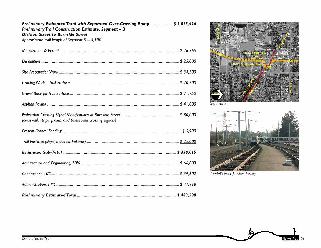
Preliminary Estimated Total with Separated Over-Crossing Ramp ......................... $ 2,815,426Preliminary Trail Construction Estimate, Segment - BDivision Street to Burnside StreetApproximate trail length of Segment B = 4,100'
Mobilization & Permits .................................................................................................................................... $ 26,365
Demolition ........................................................................................................................................................... $ 25,000
Site Preparation Work ...................................................................................................................................... $ 34,500
Grading Work – Trail Surface .......................................................................................................................... $ 20,500
Gravel Base for Trail Surface ........................................................................................................................... $ 71,750
Asphalt Paving .................................................................................................................................................... $ 41,000
Pedestrian Crossing Signal Modifications at Burnside Street ................................................................. $ 80,000(crosswalk striping, curb, and pedestrian crossing signals)
Erosion Control Seeding ...................................................................................................................................... $ 5,900
Trail Facilities (signs, benches, bollards) ........................................................................................................ $ 25,000
Estimated Sub-Total ............................................................................................................................... $ 330,015
Architecture and Engineering, 20% .............................................................................................................. $ 66,003
Contingency, 10% .............................................................................................................................................. $ 39,602
Administration, 11%.......................................................................................................................................... $ 47,918
Preliminary Estimated Total ............................................................................................................... $ 483,538
Segment B
Tri-Met’s Ruby Junction Facility

25GRESHAM/FAIRVIEW TRAIL MASTER PLAN
Preliminary Trail Construction Estimate, Segment - CBurnside Street to Halsey StreetApproximate trail length of Segment C = 6,650'
Mobilization & Permits .................................................................................................................................... $ 98,000
Site Preparation Work ..................................................................................................................................... $ 50,000
Grading Work – Trail Surface .......................................................................................................................... $ 39,900
Gravel Base for Trail Surface ......................................................................................................................... $ 179,550
Asphalt Paving .................................................................................................................................................. $ 139,650
Stark Street Mid-Block Crossing with Signal ............................................................................................ $ 270,000
Glisan Street Mid-Block Crossing with Signal ........................................................................................... $ 270,000
Erosion Control Seeding ...................................................................................................................................... $ 9,576
Trail Facilities (signs, benches, bollards) ........................................................................................................ $ 20,000
Pedestrian Crossing Signal Modifications at Halsey Street ..................................................................... $ 80,000
Estimated Sub-Total ........................................................................................................................... $ 1,156,676
Architecture and Engineering, 20% ............................................................................................................ $ 231,335
Contingency, 10% ............................................................................................................................................ $ 138,801
Administration, 11%........................................................................................................................................ $ 176,949
Preliminary Estimated Total ........................................................................................................... $ 1,694,761
Segment C
PGE Corridor Looking North

26GRESHAM/FAIRVIEW TRAIL MASTER PLAN
Preliminary Trail Construction Estimate, Segment - DHalsey Street along 201st Avenue to Sandy Blvd.Approximate trail length Segment D = 3,950'
Mobilization & Permits .................................................................................................................................... $ 30,100
Site Preparation Work ..................................................................................................................................... $ 50,000
Grading Work – Trail Surface .......................................................................................................................... $ 37,000
Gravel Base for Trail Surface ........................................................................................................................... $ 69,125
Asphalt Paving .................................................................................................................................................... $ 49,375
Erosion Control Seeding ...................................................................................................................................... $ 9,480
Trail Facilities (signs, benches, bollards) ........................................................................................................ $ 15,000
Estimated Sub-Total ............................................................................................................................... $ 260,080
Architecture and Engineering, 20% .............................................................................................................. $ 52,016
Contingency, 10% .............................................................................................................................................. $ 31,210
Administration, 11%.......................................................................................................................................... $ 37,764
Preliminary Estimated Total ............................................................................................................... $ 381,070
Segment D
201st Avenue Looking North

27GRESHAM/FAIRVIEW TRAIL MASTER PLAN
Preliminary Trail Construction Estimate, Segment - ESandy Blvd. To Marine DriveApproximate trail length of Segment E = 5,650'
Mobilization & Permits ...................................................................................................................................... $52,900
Demolition ............................................................................................................................................................. $25,000
Site Preparation Work ........................................................................................................................................ $34,500
Grading Work – Trail Surface .......................................................................................................................... $22,000
Gravel Base for Trail Surface ............................................................................................................................. $82,250
Asphalt Paving ...................................................................................................................................................... $58,750
Pedestrian Crossing Signal at Sandy Blvd. .................................................................................................. $270,000
Erosion Control Seeding ..................................................................................................................................... $11,280
Trail Facilities (signs, benches, bollards) .......................................................................................................... $25,000
Tunnel under Railroad ..................................................................................................................................... $600,000
Clearspan Pedestrian Bridge across Columbia Slough ............................................................................ $200,000
Estimated Sub-Total ........................................................................................................................... $ 1,381,680
Architecture and Engineering, 20% ............................................................................................................. $276,336
Contingency, 10% ............................................................................................................................................. $165,802
Administration, 11%......................................................................................................................................... $200,620
Preliminary Estimated Total .............................................................................................................$2,024,438
The Type III review and approval process for this project will include:
• Application
Segment E
View to Mt. Hood from Catellus Property

28GRESHAM/FAIRVIEW TRAIL MASTER PLAN
Chapter 6: Trail Development ApprovalProcess
Gresham’s Community Development Plandefines a multi-use path as a Type III communityservice use. Approval of the trail as a communityservice use will require a public hearing andapproval by the Planning Commission. The multi-use path will also require site design review aspart of the Type III development permit. Por-tions of the trail will need to be reviewed forcompliance with applicable regulations of thenatural overlay zoning district, the floodplainoverlay zoning district, and the open spaceoverlay zoning district. Portions of the trailcorridor are located within each of these overlayzoning districts.
The trail development approval process providesmany opportunities for public input. The follow-ing describes this trail development approvalprocess:
• Neighborhood meetings
• Prepare concept trail design
• Parks and Recreation Council AdvisoryCommittee meeting (public input)
• Pre-application conference
• Site survey (if needed)
• Finalize trail design plan
• Application for development permit

GRESHAM/FAIRVIEW TRAIL MASTER PLAN
Appendix A
Gresham/Fairview Trail Letters of Comment


GRESHAM/FAIRVIEW TRAIL MASTER PLAN
Appendix B
Gresham/Fairview Trail Natural Resource DocumentationExecutive Summary
Fishman Environmental Services

Note: Option 3 of this document is similar to the Master Plan Route.