Embed Size (px)
Citation preview

Citizen Weather Observer Program (CWOP)
for Collection and Use of Citizen Weather Data
Russ Chadwick (FSL), Patty Miller (FSL), and Dave Helms (NWS)
Great Divide Weather WorkshopBillings Weather Forecast Office
September 8-10, 2004

Contributors to CWOP Success
• Mike Barth CW0004• Steve Dimse K4HG• Philip Gladstone CW0003• Pete Loveall AE5PL• Bill Moninger• Phil Pacier AD6NH• Dick Stanich KB7ZVA

Appendix 4, p. 65Catalog of NOAA’s Observing Systems

Purpose of CWOP
Private-public partnership with goals:
1. Collect weather data contributed by private citizens;
2. Make these data available for public and private weather services;
3. Provide feedback to the contributors so they have tools to improve data quality.

Private-Public Partnership• Data Collection (privately owned and operated)
– WX stations operated by private citizens– Data transfer by APRS-IS (internet service)– Data management by findu.com
• Data Distribution (provided by NOAA)– Data distribution by MADIS– Data quality checking by QCMS– NOAA FSL Central Computer Facility

NonePossible 8,000 total
None40% Year, unlimited potentialRecent Growth
50 states, US territories, DC6 states50 states, US territories, DC
50 states, US territories, DC, 35 countries
Current Coverage
275,000 (est.)20011,0003,686Current # Observers
Tornados, Funnel Clouds, Hail, Wind Damage Reports, Snow Depth (event based reporting)
T, Precip (5 minute)
T (max/min), Precip (daily)
T, Td, Wind, Pressure, Precip (most 5 minute)
Parameters
NAYesYes (most)NoClimate Quality
NAYes –Periodic Inspections
Yes –Periodic Inspections
No – Guidance Only and statistical monitoring
Government Site Inspections
Classroom CertificationWeb/DVD (GFS)
Web/DVD (GFS)
Web (developed by volunteers)Training
NAPrivate/GFSPrivatePrivateSite Lease
Private (Internet/Phone)GFSGFS (Mail, WxCoder, IV -ROCS)
Private (Internet/ Wireless Packet Radio) – 10 volunteer SYSOPS; $100K/yr in donated bandwidth
Communications
NAGFSNAPrivate; access to $70K data logging applications
Equipment -Software
NAGFSGFSPrivate; access to $700K weather equipment
Equipment -Hardware
SkywarnCOOP-MCOOPCWOP
Comparison of CWOP with other NWS Volunteer Observing Programs

Weatherstation
APRS Servers
Weatherstation
APRS-IS
findu.comdatabase
FSL Central Facility
CWOPdatabase
MADIS
I-Gates
OtherUsers
WR WFOsAWIPS
UCARNCEP
MesoWest
RF
Mobilestation
RFRFRF
CWOP Data Flow

MesoWest CWOPNorth Americantraffic last 4 days.
Linked from www.wxqa.com
Or direct http://www.met.utah.edu/mesowest/monitor/APRSWXNET.gif
Real-time CWOP Traffic Check
WeeklyUpdate
MesoWestDown

CWOP Membership
• CWOP database - 3686 • AP001 – AR495, 1465 hams by callsign• C0000 – C2467, 2221 citizens• Registered stations – 2803• Inactive stations – 830• US states and territories - 52 • International countries participating - 53• Currently sending data – 1615 stations
Updated: August 2004

CWOP Growth:4x in 2 Years
May 2002: 400 stations reporting
August 2004: 1,600 stations reporting

1,300 Members / Year
CWOP Membership Time-Series

CWOP Registered Stations

CWOP Registered Stations in US

CWOP QC Feedback to Members
Quality Checking and Monitoring System (QCMS)
- part of MADIS involved with checking data quality
- http://www.wxqa.com/aprswxnetqc.html gives links
- diurnal differences between observations and analysis
- daily QCMS results can be e-mailed to members
- and…..
Philip Gladstone’s CWOP QC Time Series: QCMS Analysis vs. Station Report

MesoWest:Additional Views of CWOP Data
Weather Conditions for C0351Current time: August 29, 2004 - 2:18 EDT
Most Recent Observations at August 29, 2004 - 2:05 EDT2:05 Max since Midnight Min since Midnight 24 Hour Max 24 Hour Min
Temperature 74.0° F 76.0 at 0:05 74.0 at 1:20 87.0 at 14:50 71.0 at 5:05
Dew Point 71.9° F 72.9 at 0:05 71.9 at 1:20 74.2 at 13:50 70.1 at 5:05
Relative Humidity 93% 93 at 1:20 90 at 0:05 100 at 7:35 60 at 15:20
Wind Speed 0 mph 0 at 0:05 0 at 0:05 5 at 12:05 0 at 2:20
Wind Gust 0 mph 0 at 0:05 0 at 0:05 9 at 16:20 0 at 2:20
Pressure 29.43 in 29.46 at 0:05 29.43 at 2:05 29.53 at 8:35 29.41 at 18:35
Sea Level Pressure 29.93 in 29.96 at 0:05 29.93 at 2:05 30.03 at 8:35 29.90 at 18:35
Altimeter 29.95 in 29.98 at 0:05 29.95 at 2:05 30.05 at 8:35 29.93 at 18:35
Time Series Plots
Quality Control Regression Analysis
Tabular Reports

CWOP User Guide in Development

Hurricane Charley over Orlando, FLAugust 14, 2004 at 0225UTC

CWOP Station KD4MRL

CWOP Station KB2RC6.6 miles ENE

Circulation associated with Charley near Orlando, Florida
CW2363
H0295
CW0927
KD4WLI
WA4LZC
KC6TYC
CW0587

Hypothetical Poison-GasRelease in Washington DC

IMAC
HSOCFXC
Sterling WFO
hysplit (40s)FXC
NCEP
hysplit (10m)FXC
LawrenceLivermore
------------ Intrado
IntellicastCall-out
First Responders
Homeland Security Response
MADIS

CWOP stations in Washington DC Area

Regional CWOP Stations

Growing a Mesonet in your CWA
-Brief the public about CWOP during Skywarn training sessions. Many already have home weather stations or would be interested in purchasing and operating one if they knew the data would be useful.
-Tell your local Ham Radio chapters and clubs about benefits of CWOP to your office. They may help support APRS-IS infrastructure and contribute additional stations to the network.
-Consider appropriate home weather station as Birthday or Christmas gift to a deserving friend or relative who has DSL. Convince them of the desirability of leaving their computer on.
-Suggest that your child’s school purchase and install a home weather station and incorporate it into their science classes (REALM).

Applications of CWOP data at WFOs
- WFO Bismarck, ND (local mesonet)
- WFO Grand Rapids, MI (local mesonet)
- WFO Billings, MT (local Mesonet)
- WFO Riverton, WY (local mesonet with school participation)
- WFO Pendleton, OR (local mesonet)
- WFO Melbourne, FL (ARPS Local Model assimilation)
- WFO Huntsville, AL (ham radio collaboration adds stationsand earns two hams 2004 NOAA Environmental Hero Awards)

You need: computer with internet access, WX station hardware, WX station software, CW number
www.wxqa.com click “CWOP info” for list of stations and software
www.wxqa.com click “how to join CWOP” and fill out the form to get a CW number
www.wxqa.com click “CW Packet Checking” for links to set-up software
How to join CWOP and send in WX data

Select and enter aprs server name and port number and send a data packet
http://map.findu.com/CWxxxx where xxxx is your CW number and check your location on the maps
If your location is OK, send e-mail to [email protected]
If location is wrong, recheck set-up and lat/long values (item #3, FAQ), 4545.03N/10834.19W
How to join CWOP and send WX data (cont)

Percentage of WX programs supporting CWOP currently in use

Meteorological Assimilation Data Ingest System (MADIS)
Goal: To share observations and observation-handling technology with the greater meteorological community.
Features• Access to real-time and archived data sets• Observational quality control• Application Program Interface (API)• User documentation and utility programs
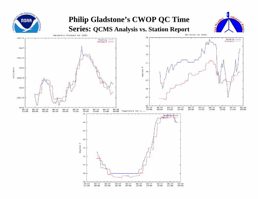
MADIS Data Sets
• Upper Air Observations– Radiosonde– Automated Aircraft– NOAA Profiler Network (NPN) Wind Profiler– Multi-Agency Profiler– Satellite Winds
• Surface Observations– Meteorological Aviation Reports (METARs)– Maritime– Surface Aviation Observations (SAOs)– Modernized Cooperative Observer Program (COOP)– Mesonet

MADIS Mesonet Providers 8/30/2004
Mesonet Description Provider Name No. of Sites Coverage
Total = 14,026
MarylandGlobalCONUSU.S.ColoradoColoradoFloridaColoradoCO/KS/NEGulf of MaineU.S.New EnglandIowaIowaColoradoKansasLouisiana/Miss.CONUSWest CONUSMinnesotaCONUSNew EnglandOklahomaU.S.U.S.ColoradoWisconsinTexasU.S.
U.S. Army Aberdeen Proving GroundsAutomated Position Reporting SystemAnything Weather NetworkAWS Convergence Technologies, Inc.Colorado Department of TransportationColorado E-470 Public Highway AuthorityFlorida MesonetFt. Collins UtilitiesGoodland WFO MiscellaneousGulf of Maine Ocean Observing SystemFSL Ground-Based GPSHydrometeorological Automated Data SystemIowa Department of TransportationIowa Environmental MesonetBoulder WFO MiscellaneousKansas Department of TransportationLSU – JSU MesonetMulti-Agency Profiler Surface ObservationsCooperative Mesonets in the Western U.S.Minnesota Department of TransportationNational Ocean Service Physical Oceanographic Real-Time SystemNational Weather Service Cooperative Observer ProgramOklahoma MesonetRemote Automated Weather StationsRadiometerDenver Urban Drainage & Flood Control Dist.Wisconsin Department of TransportationWest Texas MesonetWeather for You
52446
645648108
7395
159
34059508813412615
22949239
113116
18632
175841
413
APGAPRSWXNETAWXAWSCODOTCO_E-470FL – MesoFTCOLLINSGLDNWSGoMOOSGPSMETHADSIADOTIEMINTERNETKSDOTLSU-JSUMAPMesoWestMNDOTNOS – PORTSNWS – COOPOK - MesoRAWSRDMTRUDFCDWIDOTWT-MesoWXforYou
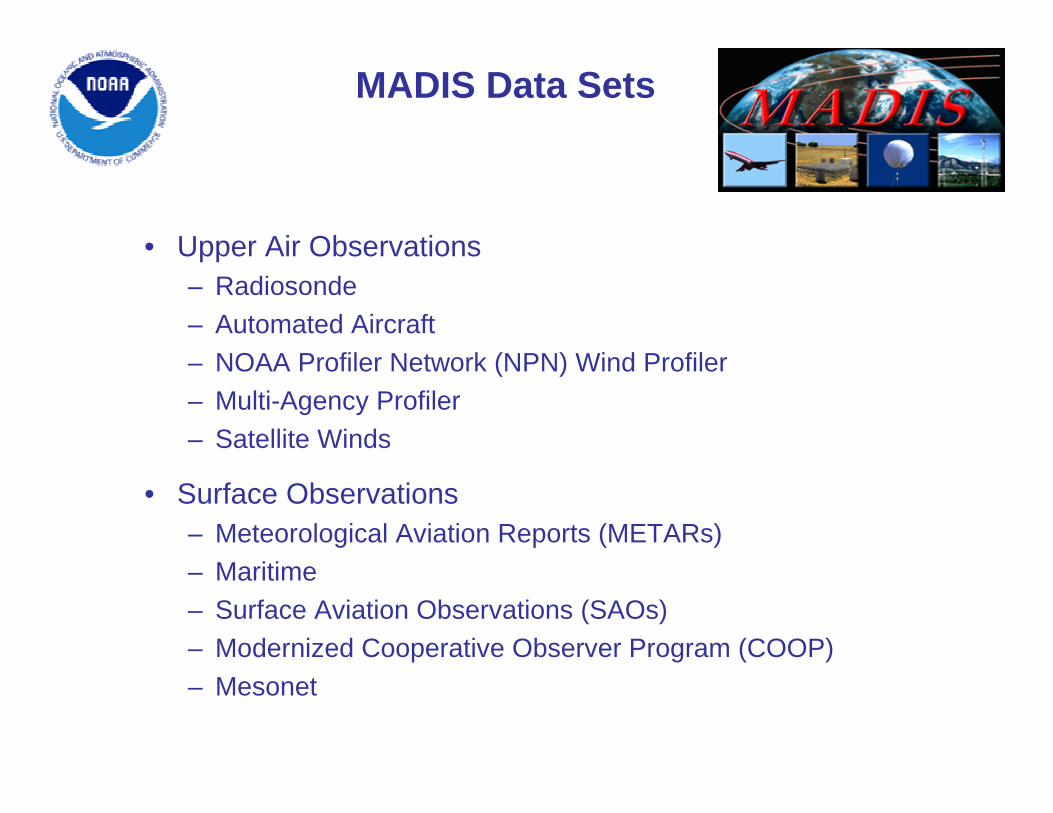
MADIS Mesonet Acquisition
• Data files (in any format)• “Station” file specifying location, ID, and time zone• “Description” file specifying variables and units
Provides easy ingest of mesonet observations and also provides data integration and time zone and unit resolution
Input (for each mesonet)
• Integrated mesonet filesOutput

MADIS Surface Observation QC and Monitoring System (QCMS)
• Automated Quality Control Checks– Validity, temporal consistency, internal
consistency, spatial consistency• Station Monitoring
– Hourly, daily, weekly, and monthly summaries of the frequency of failure and RMS and mean errors
• Quality Control Flag and Text Outputs

MADIS Output Data Files
• Include Observations and Quality Control Flags• Real-Time Distribution
– ftp, LDM, OPeNDAP• On-Line Archive (saved real-time data files)
– From July 1, 2001

• NWS forecast offices and modeling centers• Universities and research organizations• Private companies• Citizen weather data contributors• Others
MADIS Distribution
Provides easy distribution of observation and QC information to:
• Distribution to NWS• Distribution to government, research, and
education organizations• Full distribution
Distribution Categories:

MADIS Software Support
• Application Program Interface (API) to read the observation and QC information
API Advantages• Invisible data formats and file structures• Multiple retrieval of similar observations• Variable transformation• Time windowing• Domain specification• Sounding generation• QC information• Utility routines• Portability

MADIS/CWOP URLs
• MADIS Home Pagewww-sdd.fsl.noaa.gov/MADIS
• Real-Time Surface Observation Displaywww-frd.fsl.noaa.gov/mesonet/
• Real-Time Profiler Displaywww.profiler.noaa.gov/jsp/profiler.jsp
• Real-Time Aircraft Displayacweb.fsl.noaa.gov
• Real-Time Upper Air Soundingswww-frd.fsl.noaa.gov/soundings/java
• CWOP Home Pagewww.wxqa.com