Embed Size (px)
Citation preview

1
Agroforestry and watershed functions of tropical land use mosaics
Meine van Noordwijk1, Ai Farida1 and Bruno Verbist1, Tom P. Tomich2
1. World Agroforestry Centre, ICRAF Southeast Asia, P.O. Box 161, Bogor 16001, Indonesia; [email protected] ; 2. Global Coordinator Alternatives to Slash and Burn project, World
Agroforestry Centre, Nairobi, Kenya; [email protected] Abstract An ‘ecohydrology’ approach involves more than a focus on the degree of forest cover in the upper watersheds, as the quantity, timing and quality of water flows is determined by the land cover and land use in the whole landscape. We discuss the different perceptions that still exist on the special relations between ‘forest’ and ‘watershed functions’ and consider which specific function is relevant for whom. Land use change can modify the evapotranspiration and hence the total water yield of a catchment, but also the pathways that water will take and hence the amount of soil particles, nutrients, agrochemicals and (in arid regions) salt that it will carry downstream. Evenness of river flow is influenced by the infiltration rates in the landscape if small areas are considered. Partial spatial independence of rainfall becomes a dominant explanation of ‘evenness of flow’ when larger areas are considered, reducing the relative importance of land use. Agroforestry options for the riparian zone can have a major impact on the water quality and evenness of flow perceived downstream, probably exceeding the importance of forest cover in upper watersheds.
Introduction: from a focus of ‘forest’ to a whole-landscape approach
The general public and policy perception of ‘watershed protection’ specifies a desirable condition (‘forest’) for the upper watershed and associates any flooding event to a loss of forest cover in the hills and mountains, with tree planting as the knee-jerk rehabilitation measure. An ‘ecohydrology’ approach involves more than a focus on the degree of forest cover in the upper watersheds, as the quantity, timing and quality of water flows is determined by the land cover and land use in the whole landscape. In Indonesia it seems that the public and policy debate has not progressed much since De Haan (1936) wrote in his 'contemplations on the issue of forest reserves':
"There has been too much emphasis on the contrast between "forest' and "non-forest". One often supposed that as long as a certain percentage of an area was reserved as 'protection forest', agriculturalists outside of that area could do as they wished. Nothing is further from the truth. The difference in hydrological behaviour between a montane forest and for example a rubber garden is certainly much smaller than that between this rubber garden and the cropped fields of a smallholder."
Kartasubrata (1981) summarized the development of ideas about forest and water in Indonesia, as they were reflected in debates during the colonial era. As the debate still resonates today, it may be interesting to see the arguments as phrased at that time. The debate heated up with a statement of Heringa (1939) who pleaded for a substantial increase of forest cover on Java, both for the production of timber, resin, turpentine and tannin, as well as for the hydrological significance of forests. On the island of Java with its high volcanoes the rivers have such a strong fall that in the west monsoon the rainwater flows rapidly into the sea in its force transporting much fertile soil and mud from the fields and from the riverbeds to be deposited into the sea. Heringa formulated a theory that stirred up much of the debate, when he said:
"The forest works as a sponge; it sucks up the water from the soil in the wet season, to release it gradually in the dry monsoon at the time when there is shortage of irrigation water. Decrease of forest cover therefore will bring about decrease of discharge during the East monsoon (‘dry season’) and cause shortage of the needed irrigation water. Therefore, a balance is needed between forest condition and output of agricultural lands (rice fields). Consequently one has to determine a minimum forest percentage for every catchment area".
Roessel (1939) applauded the idea of extension of industrial forests, however, he criticized the use of hydrological arguments to justify reforestation. He posed the ‘infiltration theory’ that emphasized that percolation of water through the subsoil produces spring water, not the forests as such. Coster (1938) working at the Forest Research Institute in Bogor provided quantitative data and suggested a synthesis: vegetation determines recharge to the ‘sponge’, but water is held in the subsoil, not in the forest as such.
2nd Asia Pacific Training Workshop on Ecohydrology "Integrating Ecohydrology and Phytotechnology into Workplans of Government, Private, and Multinational companies" Cibinong, West Java, INDONESIA. 21 - 26 July 2003
2
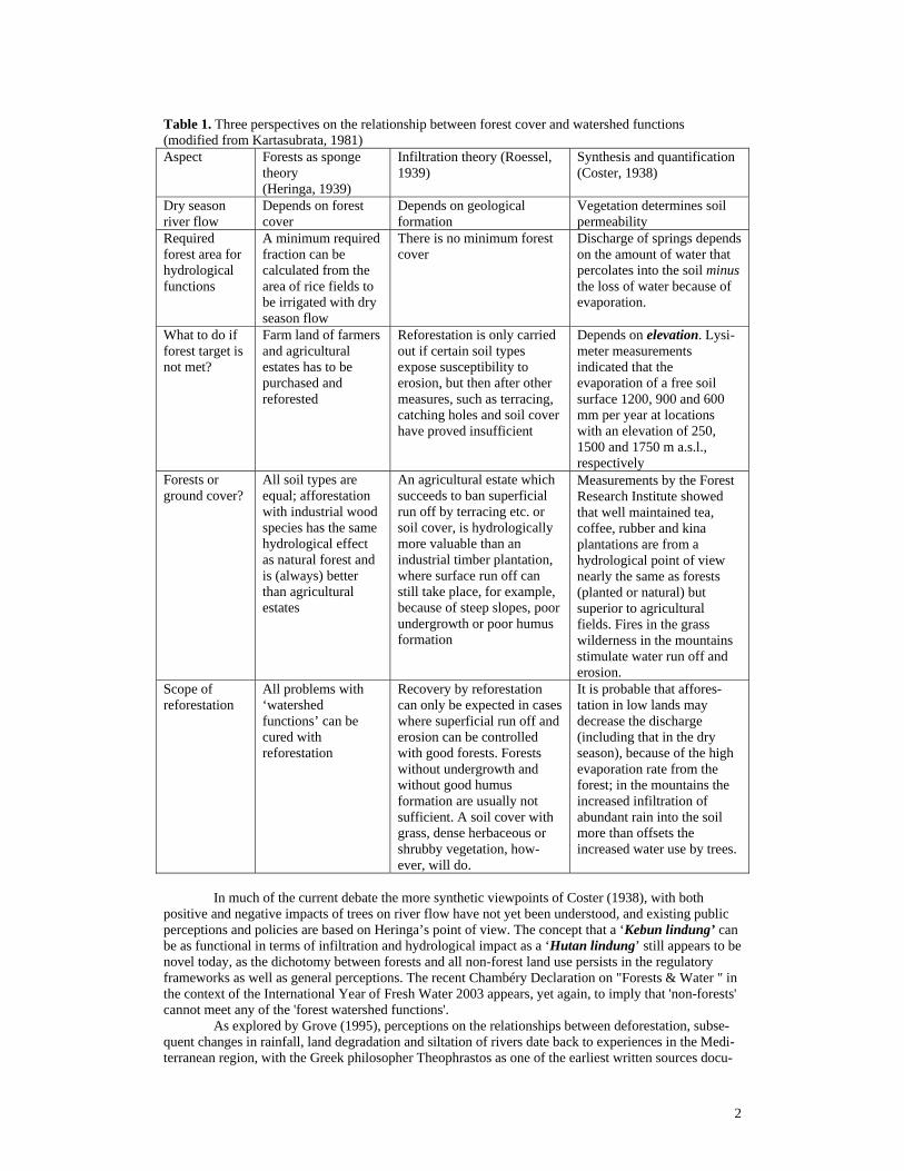
Table 1. Three perspectives on the relationship between forest cover and watershed functions (modified from Kartasubrata, 1981) Aspect Forests as sponge
theory (Heringa, 1939)
Infiltration theory (Roessel, 1939)
Synthesis and quantification (Coster, 1938)
Dry season river flow
Depends on forest cover
Depends on geological formation
Vegetation determines soil permeability
Required forest area for hydrological functions
A minimum required fraction can be calculated from the area of rice fields to be irrigated with dry season flow
There is no minimum forest cover
Discharge of springs depends on the amount of water that percolates into the soil minus the loss of water because of evaporation.
What to do if forest target is not met?
Farm land of farmers and agricultural estates has to be purchased and reforested
Reforestation is only carried out if certain soil types expose susceptibility to erosion, but then after other measures, such as terracing, catching holes and soil cover have proved insufficient
Depends on elevation. Lysi-meter measurements indicated that the evaporation of a free soil surface 1200, 900 and 600 mm per year at locations with an elevation of 250, 1500 and 1750 m a.s.l., respectively
Forests or ground cover?
All soil types are equal; afforestation with industrial wood species has the same hydrological effect as natural forest and is (always) better than agricultural estates
An agricultural estate which succeeds to ban superficial run off by terracing etc. or soil cover, is hydrologically more valuable than an industrial timber plantation, where surface run off can still take place, for example, because of steep slopes, poor undergrowth or poor humus formation
Measurements by the Forest Research Institute showed that well maintained tea, coffee, rubber and kina plantations are from a hydrological point of view nearly the same as forests (planted or natural) but superior to agricultural fields. Fires in the grass wilderness in the mountains stimulate water run off and erosion.
Scope of reforestation
All problems with ‘watershed functions’ can be cured with reforestation
Recovery by reforestation can only be expected in cases where superficial run off and erosion can be controlled with good forests. Forests without undergrowth and without good humus formation are usually not sufficient. A soil cover with grass, dense herbaceous or shrubby vegetation, how-ever, will do.
It is probable that affores-tation in low lands may decrease the discharge (including that in the dry season), because of the high evaporation rate from the forest; in the mountains the increased infiltration of abundant rain into the soil more than offsets the increased water use by trees.
In much of the current debate the more synthetic viewpoints of Coster (1938), with both
positive and negative impacts of trees on river flow have not yet been understood, and existing public perceptions and policies are based on Heringa’s point of view. The concept that a ‘Kebun lindung’ can be as functional in terms of infiltration and hydrological impact as a ‘Hutan lindung’ still appears to be novel today, as the dichotomy between forests and all non-forest land use persists in the regulatory frameworks as well as general perceptions. The recent Chambéry Declaration on "Forests & Water " in the context of the International Year of Fresh Water 2003 appears, yet again, to imply that 'non-forests' cannot meet any of the 'forest watershed functions'. As explored by Grove (1995), perceptions on the relationships between deforestation, subse-quent changes in rainfall, land degradation and siltation of rivers date back to experiences in the Medi-terranean region, with the Greek philosopher Theophrastos as one of the earliest written sources docu-

3
menting these perceptions. The European colonial expansion into the tropics and particularly their experiences in small islands such as Mauritius strengthened perceptions that forests generate rainfall. Yet, hard evidence of a change in documented rainfall as a consequence of deforestation still hardly exists, and the causality of the association between forests and rainfall (rainfall => forest) is generally the reverse of what is perceived (forest => rainfall). A recent re-analysis of rainfall patterns for Indonesia (Kaimuddin, 2000; Rizaldi Boer, pers. comm.), for example, indicates shifts in the isohyets (zones of equal rainfall) in Indonesia, that are not obviously related to local land cover change: some areas that lost forest cover became wetter, other areas that lost forest cover became drier; for Indonesia as a whole average rainfall did not change, despite the considerable loss of forest cover, but there may have been a change in the overall circulation pattern that affects local rainfall. Although at local scale real changes in rainfall may have coincided with real changes in forest cover, there is no convincing evidence to support hypotheses about causal relationships. The way a landscape ‘processes’ the incoming rainfall, however, does directly depend on the land cover, and the total amount of water, the regularity of the flow and the quality of the water in the streams can be directly affected by changes in cover.
A final quote on this historical section: “Formerly the view was generally accepted, that forests had the tendency to increase rainfall to a large extent. Nowadays this view is combated by many investigators, who deny any appreciable influence; others support the view that the distribution is changed by the forest, and not the total amount of rainfall....” Braak (1929). Widely held perceptions of the overriding importance of forest cover for the maintenance of watershed functions in source areas have been questioned over the last decades in hydrological research, and rather than using a ‘forest’ <=> ‘non-forest’ dichotomy, have lead to the recognition that the types of land use that follow after forest conversion can make a lot of difference. Land use (including but not restricted to the protection of existing forest cover) in such source areas thus has local as well as external stakeholders and beneficiaries, and increasing demands for water in the lowlands have often lead to an increased sense of conflict over what happens in the source areas. Yet, upper watersheds in much of the tropics provide a living for large numbers of farmers and rural communities, who have often remained outside of the main stream of development. The consequences of this is an ‘upland’ – ‘lowland’ distinction with a strong perception of a conflict of interest: people living in the upper watershed are perceived to ‘destroy the watershed functions’, where in fact there is no recognition or reward mechanisms for all those situations where their land use protects water resources.
In this contribution we will try to answer the following questions 1. What are ‘watershed functions’ to various external stakeholders? 2. How closely do or can different types of agriculturally used landscapes (‘agroforestry’)
substitute for ‘natural’ forest in various hydrological functions under different geophysical conditions (e.g. rainfall pattern, slope, scale)?
3. To what degree do watershed functions depend on spatial organization of a landscape (‘agro-forestry mosaic’) rather than on the average tree or forest cover? Can we model the impacts?
4. Which ‘ecohydrological’ interventions involving agroforestry are appropriate? Answering question 1: Who is interested in which watershed function?
Based on the ratio of incoming precipitation and evapotranspiration, we can distinguish between areas that are net suppliers of water in surface or subsurface lateral flow pathways, and sink areas where plant growth and evapotranspiration is limited by the incoming precipitation, unless surface or subsurface irrigation makes up for the difference between supply and demand. In between these ‘source’ and ‘sink’ areas for water, we can generally find ‘transmission’ zones that can affect the quality of the water, the degree of buffering of incoming peak flows and that deliver water to oceans and seas in as far as it is not used beforehand. As rainfall usually increases with elevation, ‘upper watersheds’ often are ‘source’ areas, supplying the lower parts with water via rivers or groundwater flows. Domestic and industrial use of water generally affects the quality rather than the amount of water, but it may lead to increased evapotranspiration and/or reallocation between surface and subsurface flows and thus be important for the overall hydrological cycle. A comprehensive assessment of the way land uses modifies the supply and demand for water may, in this light, be expected to consider:

4
1. Land use change in ‘source’ areas and its impact on the total amount, the regularity of the flow, the allocation over surface and subsurface pathways and the quality of the water that leaves the area,
2. Land use change as well as domestic and industrial water use in the transmission zones and their impacts on water quality, mainly via the characteristics of the rivers (‘channels’) or groundwater flows,
3. Land use in areas that are or can be supported with additional water via irrigation.
Forest conversion and other land use change in ‘source’ areas may affect the quality and quantity of water flows in a number of ways, based on the combined effects on cloud interception, effects on rainfall patterns as such, rainfall interception by plant canopies, infiltration of the soil surface, subsequent water use for evapotranspiration and partitioning over surface and surface flow pathways. Of these effects, the interaction between land use mosaics and rainfall is the least understood and most speculative one. Changes from natural forests to landscapes used for agriculture or production forestry normally involve many if not all of the terms of the water balance, with a mixture of positive and negative effects.
The main ‘functions’ of watersheds from a downstream perspective are for it to provide an adequate supply of high quality water and not to provide a medium for soil transport and/or flash floods. Concerns for loss of watershed functions can be a combination of (van Noordwijk et al., 1998):
A. On-site loss of land productivity as a result of erosion, B. Off-site concerns about water quantity:
B1. Annual water yield, B2. Peak (storm) flow, B3. Dry season base flow, B4. Groundwater recharge or depletion,
C. Off-site concerns about water quality: C1. Sediment loads, leading to siltation of reservoirs, and transport of trees and other large
debris that can destroy downstream infrastructure (bridges) and flood-plain houses C2. Organic and nutrient inputs leading to high Biological Oxygen Demand (BOD) and its
risks for fish and other aquatic life forms C3. Agro-chemical residues that affect aquatic life and restrict the safety of downstream use of
water. C4. Microbes and other biota e.g. derived from domestic water use that restrict the safe use of
water downstream. Not all of these ‘functions’ are equally relevant in all situations: e.g. once reservoirs have been constructed or occur naturally (lakes), the downstream interests will shift from a focus on dry season river flows to concerns for total water quantity and the sediment load that affects the expected life time of the reservoir. Table 2 provides examples of situations where these various concerns are of particular relevance.
Table 2. Examples of situations where specific watershed functions are of relevance
Watershed function Importance (example) Water quantity • Dependable (high) total water yield • High dry-season flow • Low peak-flow • Adequate groundwater recharge Soil movement • Low sediment load of streams • Few landslides/mudflows Good water quality: • Suitable as drinking water, • Adequate for fish & other biota • Low organic pollution (=> low BOD =
biological oxygen demand) • Low nutrient load • Low pesticide, heavy metals etc. • No sub-soil salt movement
• Filling up lakes & reservoirs • Downstream users without lakes • Flooding risk in lowland • Allows sustainable groundwater use elsewhere • Reservoir life-time; marine coral reefs • Villages and towns in valleys • Direct source of drinking water • Fishermen, biodiversity conservation • Idem, processed drinking water • Idem, processed drinking water • Use as irrigation water, processed drinking
water • Stalinization of valleys (e.g. dry parts of
Australia)
5
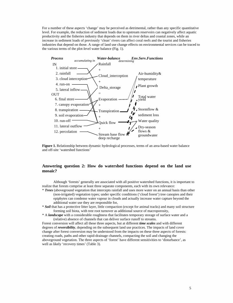
For a number of these aspects ‘change’ may be perceived as detrimental, rather than any specific quantitative level. For example, the reduction of sediment loads due to upstream reservoirs can negatively affect aquatic productivity and the fisheries industry that depends on them in river deltas and coastal zones, while an increase in sediment loads of previously ‘clean’ rivers can affect coral reefs and the tourist and fisheries industries that depend on those. A range of land use change effects on environmental services can be traced to the various terms of the plot-level water balance (Fig. 1).
Figure 1. Relationship between dynamic hydrological processes, terms of an area-based water balance and off-site ‘watershed functions’
Answering question 2: How do watershed functions depend on the land use mosaic?
Although ‘forests’ generally are associated with all positive watershed functions, it is important to realize that forests comprise at least three separate components, each with its own relevance: * Trees (aboveground vegetation that intercepts rainfall and uses more water on an annual basis than other
(non-irrigated) vegetation types; under specific conditions (‘cloud forest’) tree canopies and their epiphytes can condense water vapour in clouds and actually increase water capture beyond the additional water use they are responsible for,
* Soil that has a protective litter layer, little compaction (except for animal tracks) and many soil structure forming soil biota, with tree root turnover as additional source of macroporosity,
* A landscape with a considerable roughness that facilitates temporary storage of surface water and a (relative) absence of channels that can deliver surface runoff to streams.
Forest conversion will affect all these three aspects, but at different time scales and with different degrees of reversibility, depending on the subsequent land use practices. The impacts of land cover change after forest conversion may be understood from the impacts on these three aspects of forests: creating roads, paths and other rapid-drainage channels, compacting the soil and changing the aboveground vegetation. The three aspects of ‘forest’ have different sensitivities to ‘disturbance’, as well as likely ‘recovery times’ (Table 3).
IN1. initial store2. rainfall3. cloud interception4. run-on5. lateral inflow
OUT 6. final store 7. canopy evaporation 8. transpiration 9. soil evaporation10. run-off11. lateral outflow12. percolation
Rainfall+Cloud_interception+ Delta_storage=Evaporation+Transpiration+Quick flow+Stream base flow &deep recharge
Air-humidity&temperature
Plant growth
Total wateryield
Stormflow &sediment lossWater quality
Dry-seasonflows &groundwater
Process Water-balance Env.Serv.Functionsaccumulating in determining

6
Table 3. Scheme of how three aspects of forests are affected by human disturbance of forests and how this in turns modifies the water balance Terms of water balance
affected Effects of disturbance Recovery-time
Trees Interception, Transpiration
Logging & fire reduce tree cover, slash-and-burn land clearing reduces it to zero
Water use can recover in 1-3 year, LAI and interception in 4-10 year; tree biomass will take decades and species composition a century or more
Forest soil
Rate of surface infiltration, Percolation and subsurface lateral flow, surface evaporation
Compaction, decline due to loss of macropore formation
Surface permeability can be restored in < 1 year, soil macroporosity may take decades
Forest land-scape
Time available for surface infiltration, percolation and subsurface lateral flow
paths, tracks and roads lead to quickflow, leveling and swamp drainage reduces surface buffer storage capacity
channels can be closed, surface and roughness restored rapidly through specific actions
B1: Off-site effects on total water yield When measured over a sufficiently long period of time for changes in soil and groundwater storage to be ignored, total water yield of a catchment area equals rainfall minus evapotranspiration. Given the site-specific properties of rainfall, changes in total water yield derive from changes in evapotranspiration.
Four classes of land cover can be distinguished from the perspective of evapotranspiration: - Open water bodies, where water loss is determined by the relative humidity of the air and the
presence of a stagnant boundary layer of air that reduces the transport of water vapour, - Open soil, which may have a rate of evaporation similar to open water bodies when the
surface is wet, but where evaporation may rapidly become limited by the rate of transport to the soil surface; soil cover with a litter layer provides a stagnant air zone, further reducing transport opportunities and mixing with the atmosphere
- Seasonally green vegetation: most plants are able to provide their leaves (evaporating surfaces) with the amount of water that is needed for evaporation similar to an open water surface, during most of the rainy season; during periodic dry spells, plant transpiration is likely to drop below the value of open water, but stay above that of open soil,
- Evergreen vegetation with tree species like pines, eucalypts, or Grevillea, irrigated rice paddies or irrigated vegetable crops will have a rate of transpiration equal to that of open water, or higher if lateral flows of dry air drive the evapotranspiration per unit area to higher levels.
Efforts of land users that will reduce evapotranspiration and thus increase total water yield may thus be found in not planting evergreen trees (especially fast growing ones), or not irrigating rice paddies or vegetable crops in the dry season.
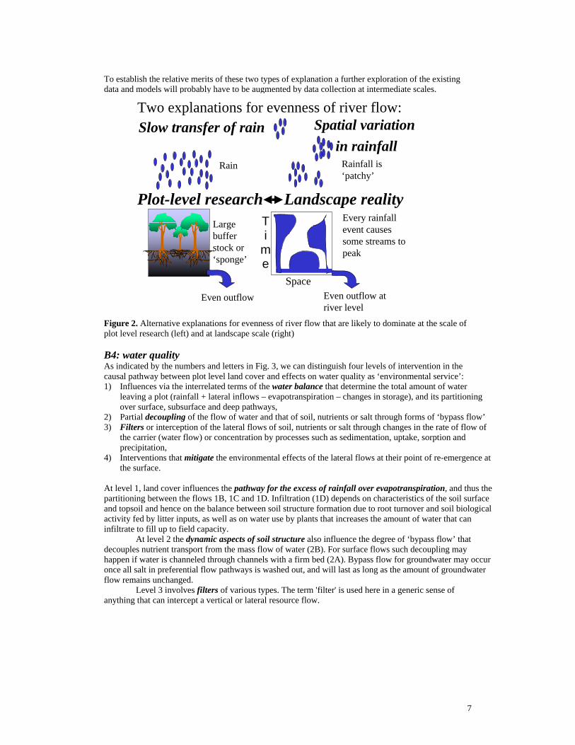
The pathways by which this ‘total water yield’ reaches downstream areas include: groundwater movement, subsoil lateral flows in the non-saturated zone and surface water flow (overland, streams, rivers). The pathway chosen can have important consequences for the movement of soil particles, nutrients, salt and agrochemical pollutants. Thus, changes in evapotranspiration can have consequences for water quality as well as water quantity. In a review of the literature under preparation (Ranieri et al., in prep.) we will focus on the biophysical aspects of lateral water movement, its consequences for the movement of solutes and soil, and how different types and arrangements of land use can affect these types of lateral flow. B2 and B3: evenness of flow The dry season base flow and peak flow issues can be seen as two sides of the coin that we call ‘evenness of flow’. Infiltration is the keyword for both processes. At this stage we cannot distinguish between two alternative explanations for ‘evenness of flow’: • Rainfall largely infiltrates the soil and passes to the stream via a substantial buffer that evens out
the flow, • Rainfall events are highly variable in space and small rainfall events in different parts of the
catchment, passing to the stream through small buffers, contribute to the steady flow at river level.
7
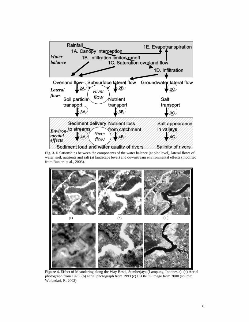
To establish the relative merits of these two types of explanation a further exploration of the existing data and models will probably have to be augmented by data collection at intermediate scales. Figure 2. Alternative explanations for evenness of river flow that are likely to dominate at the scale of plot level research (left) and at landscape scale (right) B4: water quality As indicated by the numbers and letters in Fig. 3, we can distinguish four levels of intervention in the causal pathway between plot level land cover and effects on water quality as ‘environmental service’: 1) Influences via the interrelated terms of the water balance that determine the total amount of water
leaving a plot (rainfall + lateral inflows – evapotranspiration – changes in storage), and its partitioning over surface, subsurface and deep pathways,
2) Partial decoupling of the flow of water and that of soil, nutrients or salt through forms of ‘bypass flow’ 3) Filters or interception of the lateral flows of soil, nutrients or salt through changes in the rate of flow of
the carrier (water flow) or concentration by processes such as sedimentation, uptake, sorption and precipitation,
4) Interventions that mitigate the environmental effects of the lateral flows at their point of re-emergence at the surface.
At level 1, land cover influences the pathway for the excess of rainfall over evapotranspiration, and thus the partitioning between the flows 1B, 1C and 1D. Infiltration (1D) depends on characteristics of the soil surface and topsoil and hence on the balance between soil structure formation due to root turnover and soil biological activity fed by litter inputs, as well as on water use by plants that increases the amount of water that can infiltrate to fill up to field capacity.
At level 2 the dynamic aspects of soil structure also influence the degree of ‘bypass flow’ that decouples nutrient transport from the mass flow of water (2B). For surface flows such decoupling may happen if water is channeled through channels with a firm bed (2A). Bypass flow for groundwater may occur once all salt in preferential flow pathways is washed out, and will last as long as the amount of groundwater flow remains unchanged.
Level 3 involves filters of various types. The term 'filter' is used here in a generic sense of anything that can intercept a vertical or lateral resource flow.
Even outflow atriver level
Every rainfallevent causessome streams topeak
Two explanations for evenness of river flow:
Rainfall is‘patchy’
Even outflow
Rain
Largebufferstock or‘sponge’
Slow transfer of rain Spatial variation in rainfall
Plot-level research Landscape reality
T i
me
Space
8
Fig. 3. Relationships between the components of the water balance (at plot level), lateral flows of water, soil, nutrients and salt (at landscape level) and downstream environmental effects (modified from Ranieri et al., 2003). Figure 4. Effect of Meandering along the Way Besai, Sumberjaya (Lampung, Indonesia). (a) Aerial photograph from 1976; (b) aerial photograph from 1993 (c) IKONOS image from 2000 (source: Wulandari, R. 2002)
(a) (b) (c )
Rainfall
Subsurface lateral flow Groundwater lateral flow
Nutrient loss
from catchment
Salt appearance
in valleys
Salinity of rivers
Soil particle
transport
Sediment delivery
to streams
Nutrient
transport
Salt transport
1D. Infiltration
1E. Evapotranspiration
Overland flow
Sediment load and water quality of rivers
1A. Canopy interception
1C. Saturation overland flow 1B. Infiltration limited runoff Water
balance
Lateral flows
Environ- mental effects
2A
3A
4A
2B
3B
4B
2C
3C
4C
River flow
River flow
9
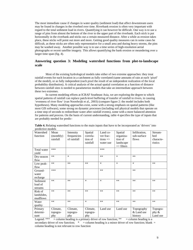
The most immediate cause if changes in water quality (sediment load) that affect downstream users may be found in changes in the riverbed over time. Riverbank erosion is often very important with regard to the total sediment load in rivers. Quantifying it can however be difficult. One way is to use a range of pins from almost the bottom of the river to the upper part of the riverbank. Each stick is put horizontally in the riverbank and sticks out a certain measured distance. After a while as erosion takes place, these sticks will point out more and more. Getting good quality measures can in some cases be difficult, as these sticks are often only representative for a small area and during heavy storms, the pins may be washed away. Another possible way is to use a time series of high-resolution aerial photographs or recent satellite imagery. This allows quantifying the bank erosion or meandering over a larger time span (fig. 4). Answering question 3: Modeling watershed functions from plot-to-landscape scale
Most of the existing hydrological models take either of two extreme approaches: they treat rainfall events for each location in a catchment as fully correlated (same amounts of rain at each ‘pixel’ of the model), or as fully independent (each pixel the result of an independent realization of the local probability distribution). A critical analysis of the actual spatial correlation as a function of distance between rainfall sites is needed to parameterize models that take an intermediate approach between these two extremes. In current modeling efforts at ICRAF Southeast Asia, we are exploring the degree to which spatial patterns of rainfall can replace patch-level buffering of transfer of rainfall to rivers, in causing ‘evenness of river flow’ (van Noordwijk et al., 2003) (compare figure 2: the model includes both hypotheses). Many modeling approaches exist, some with a strong emphasis on spatial patterns (like most GIS software), some strong on dynamic processes (including soil physical models that operate on a time step of seconds to redistribute water after rainfall events), some with a more balanced attention for patterns and process. On the basis of current understanding, table 4 specifies the type of inputs that are probably needed for predic- Table 4. Relating watershed functions to the main inputs that have to be incorporated as ‘drivers’ into predictive models Watershed function
Mean (monthly) rainfall
Intensity frequencies of rainfall
Spatial correla-tion of rainfall
Land co-ver frac-tions => water use
Spatial organiza-tion of landscape => filters
Infiltration, sub-surface flows
Stream-bed characte-ristics
Total water yield
*** ***
Dry-season flow
** * ** * **
Low peak-flow
** ** ** * * * **
Ground-water recharge
*** ** **
Sediment load of streams
** ** * * ** ** **
Risk of landslides, mudflows
** ** ** ** ** ** **
Water quality
** ** * ** ** ** **
Primary determi-nant
Climate, topogra-phy
Climate, topogra-phy
Climate, topogra-phy
Land use Land use Topography & Land use history
Topogra-phy & Land use
Legend: *** = column heading is a primary driver of row function; ** = column heading is a secondary driver of row function; * = column heading is a minor driver of row function; blank = column heading is not relevant to row function
10
tion of the various ‘watershed functions’ that we have discussed so far. No single model can deliver all of these outputs for the relevant range of scales, so we need to conceptually bridge between models originally designed for different scales.
The model approach chosen should allow us to separate between four contributors to ‘evenness of flow’:
- Natural capital, in the form of the seasonal and daily pattern of rainfall, - Natural capital in the form of the geological formations and landscape form, - Guardianship by upland land users, leading to maintenance of infiltration rates, - ‘Stewardship’ and technical interventions that increase or decrease the rate of drainage and
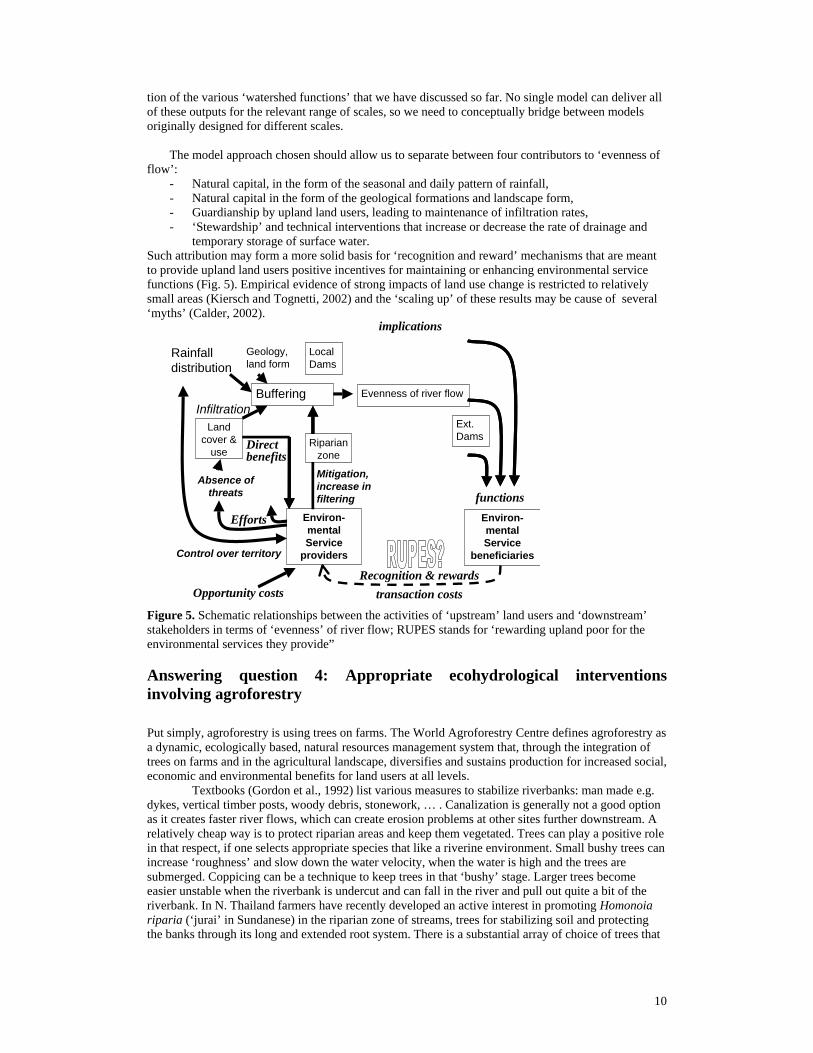
temporary storage of surface water. Such attribution may form a more solid basis for ‘recognition and reward’ mechanisms that are meant to provide upland land users positive incentives for maintaining or enhancing environmental service functions (Fig. 5). Empirical evidence of strong impacts of land use change is restricted to relatively small areas (Kiersch and Tognetti, 2002) and the ‘scaling up’ of these results may be cause of several ‘myths’ (Calder, 2002).
Figure 5. Schematic relationships between the activities of ‘upstream’ land users and ‘downstream’ stakeholders in terms of ‘evenness’ of river flow; RUPES stands for ‘rewarding upland poor for the environmental services they provide” Answering question 4: Appropriate ecohydrological interventions involving agroforestry
Put simply, agroforestry is using trees on farms. The World Agroforestry Centre defines agroforestry as a dynamic, ecologically based, natural resources management system that, through the integration of trees on farms and in the agricultural landscape, diversifies and sustains production for increased social, economic and environmental benefits for land users at all levels. Textbooks (Gordon et al., 1992) list various measures to stabilize riverbanks: man made e.g. dykes, vertical timber posts, woody debris, stonework, … . Canalization is generally not a good option as it creates faster river flows, which can create erosion problems at other sites further downstream. A relatively cheap way is to protect riparian areas and keep them vegetated. Trees can play a positive role in that respect, if one selects appropriate species that like a riverine environment. Small bushy trees can increase ‘roughness’ and slow down the water velocity, when the water is high and the trees are submerged. Coppicing can be a technique to keep trees in that ‘bushy’ stage. Larger trees become easier unstable when the riverbank is undercut and can fall in the river and pull out quite a bit of the riverbank. In N. Thailand farmers have recently developed an active interest in promoting Homonoia riparia (‘jurai’ in Sundanese) in the riparian zone of streams, trees for stabilizing soil and protecting the banks through its long and extended root system. There is a substantial array of choice of trees that
Environ-mental Service
providers
Rainfall distribution
Control over territory
Efforts
functions
Recognition & rewards
Evenness of river flow
implications
Environ-mental Service
beneficiaries
Direct benefits
transaction costsOpportunity costs
Absence of threats
Mitigation, increase in filtering
Buffering
Geology, land form
Land cover &
useRiparian
zone
Local Dams
Ext. Dams
Infiltration
11
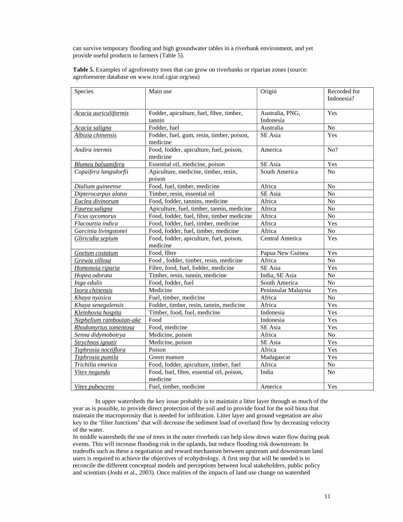
can survive temporary flooding and high groundwater tables in a riverbank environment, and yet provide useful products to farmers (Table 5). Table 5. Examples of agroforestry trees that can grow on riverbanks or riparian zones (source: agroforestree database on www.icraf.cgiar.org/sea) Species Main use Origin Recorded for
Indonesia?
Acacia auriculiformis Fodder, apiculture, fuel, fibre, timber, tannin
Australia, PNG, Indonesia
Yes
Acacia saligna Fodder, fuel Australia No Albizia chinensis Fodder, fuel, gum, resin, timber, poison,
medicine SE Asia Yes
Andira inermis Food, fodder, apiculture, fuel, poison, medicine
America No?
Blumea balsamifera Essential oil, medicine, poison SE Asia Yes Copaifera langsdorfii Apiculture, medicine, timber, resin,
poison South America No
Dialium guineense Food, fuel, timber, medicine Africa No Dipterocarpus alatus Timber, resin, essential oil SE Asia No Euclea divinorum Food, fodder, tannins, medicine Africa No Faurea saligna Apiculture, fuel, timber, tannin, medicine Africa No Ficus sycomorus Food, fodder, fuel, fibre, timber medicine Africa No Flacourtia indica Food, fodder, fuel, timber, medicine Africa Yes Garcinia livingstonei Food, fodder, fuel, timber, medicine Africa No Gliricidia sepium Food, fodder, apiculture, fuel, poison,
medicine Central America Yes
Gnetum costatum Food, fibre Papua New Guinea Yes Grewia villosa Food , fodder, timber, resin, medicine Africa No Homonoia riparia Fibre, food, fuel, fodder, medicine SE Asia Yes Hopea odorata Timber, resin, tannin, medicine India, SE Asia No Inga edulis Food, fodder, fuel South America No Ixora chinensis Medicine Peninsular Malaysia Yes Khaya nyasica Fuel, timber, medicine Africa No Khaya senegalensis Fodder, timber, resin, tannin, medicine Africa Yes Kleinhovia hospita Timber, food, fuel, medicine Indonesia Yes Nephelium ramboutan-ake Food Indonesia Yes Rhodomyrtus tomentosa Food, medicine SE Asia Yes Senna didymobotrya Medicine, poison Africa No Strychnos ignatii Medicine, poison SE Asia Yes Tephrosia noctiflora Poison Africa Yes Tephrosia pumila Green manure Madagascar Yes Trichilia emetica Food, fodder, apiculture, timber, fuel Africa No Vitex negundo Food, fuel, fibre, essential oil, poison,
medicine India No
Vitex pubescens Fuel, timber, medicine America Yes
In upper watersheds the key issue probably is to maintain a litter layer through as much of the year as is possible, to provide direct protection of the soil and to provide food for the soil biota that maintain the macroporosity that is needed for infiltration. Litter layer and ground vegetation are also key to the ‘filter functions’ that will decrease the sediment load of overland flow by decreasing velocity of the water. In middle watersheds the use of trees in the outer riverbeds can help slow down water flow during peak events. This will increase flooding risk in the uplands, but reduce flooding risk downstream. In tradeoffs such as these a negotiation and reward mechanism between upstream and downstream land users is required to achieve the objectives of ecohydrology. A first step that will be needed is to reconcile the different conceptual models and perceptions between local stakeholders, public policy and scientists (Joshi et al., 2003). Once realities of the impacts of land use change on watershed

12
functions start to be the basis of the debate, in stead of general perceptions on the forest – non-forest dichotomy, real progress can probably be made relatively quickly. Acknowledgements ICRAF’s research on watershed functions in Agroforestry mosaics is supported by grants from the Worldbank and ACIAR References Braak, C., 1929. The Climate of the Netherlands Indies. Koninklijk Magnetisch en Meteorologisch
Observatorium te Batavia, Verhandelingen No. 8 Calder, I.R., 2002. Forests and hydrological services: reconciling public and science perceptions. Land
Use and Water Resources Research 2, 2.1-2.12 (www.luwrr.com) Coster, C.. 1938. Naschrift: herbebossching op Java (Postscript: reforestation on Java) - Tectona 32:
602-605. De Haan, J. H., 1936. Overwegingen in verband met boschreserveering (Considerations concerning
forest reservation). Het Bosch 4: 1-28. Gordon, N. D., T. A. McMahon, et al. (1992). Stream Hydrology: An Introduction for Ecologists.
Chichester, New York, Brisbane, Toronto, Singapore, John Wiley & Sons. Grove, R.H., 1995. Green Imperialism: Colonial Expansion, Tropical Island Edens and the Origins of
Environmentalism, 1600-1860.. Cambridge University Press, Cambridge (UK), 540 pp Heringa, P.K.. (1939). De Boschspons Theory? (The Forest Sponge Theory?) Tectona 32: 239-246. Joshi et al. 2003. Soil and water movement: combining local ecological knowledge with that of
modellers when scaling up from plot to landscape level. In: M. van Noordwijk, G. Cadisch and C.K. Ong (Eds.) Belowground Interactions in Tropical Agrocecosystems. CAB International, Wallingford, UK (in press)
Kaimuddin, 2000. Dampak perubahan iklim dan tataguna lahan terhadap keseimbangan air wilayah Sulawesi Selatan. PhD thesis, Program Pascasarjana, Institut Pertanian Bogor
Kartasubrata (1981) Pre-war concepts concerning land use in Java in particular related to forest conser-vation. Presented at symposium on forest land use planning, Gajah Mada university, Jogyajarta. Reprinted in: Kartasubrata, J. (ed.) 2003. Social Forestry and Agroforestry in Asia, Book 2. Faculty of Forestry, Bogor Asgicultural Unviversity, Bogor, Indonesia. Pp 3 – 11.
Kiersch, B. and Tognetti, S., 2002. Land-water linkages in rural watersheds. Land Use and Water Resources Research 2, 1.1-1.6(www.luwrr.com)
Ranieri S., Stirzaker, R., Suprayogo, D., Purwanto, E., de Willigen, P. and van Noordwijk, M. 2003 Managing movements of water, solutes and soil: from plot to landscape scale. In: M. van Noordwijk, G. Cadisch and C.K. Ong (Eds.) Belowground Interactions in Tropical Agrocecosystems. CAB International, Wallingford, UK (in press)
Roessel, B.W.P. (1939). Herbebossching op Java (Reforestation on Java) – Tectona 32: 230-238. Van Noordwijk, M., Van Roode, M., McCallie, E.L. and Lusiana, B., 1998. Erosion and sedimentation as
multiscale, fractal processes: implications for models, experiments and the real world. In: F. Penning de Vries, F. Agus and J. Kerr (Eds.) Soil Erosion at Multiple Scales, Principles and Methods for Assessing Causes and Impacts.. CAB International, Wallingford. pp 223-253
Van Noordwijk, M, Farida, A., Suyamto, D., Lusiana, B. and Khasanah, N., 2003. Spatial variability of rainfall governs river flow and reduces effects of land use change at landscape scale: GenRiver and SpatRain simulations. MODSIM proceedings, Townsville (Australia) July 2003.
Wulandari, R. (2002). Deteksi perubahan penutupan lahan pada areal sempadan sungai di Sumberjaya, Lampung Barat. Jurusan Konservasi Sumberdaya hutan, Fakultas Kehutanan. Bogor, Institut Pertanian Bogor and ICRAF-SEA, Bogor, Indonesia: 58