Embed Size (px)
Citation preview
Chuckwalla Special Recreation Management Area (SRMA)
RMZ LIST WITH DISTINCTIVE USES AND OVERVIEW
1. Chuckwalla Mountains Wilderness RMZ- Designated in 1994 through the passage of the California
Desert Protection Act (with additions added in the 2009 Omnibus Public Land Management Act),
this 99,548 acre wilderness occupies the area between Interstate 10 to the north and the historic
Bradshaw Trail Back Country Byway to the south. This remote desert wilderness is comprised of a
variety of landform features including rugged mountains, steep-walled canyons, large dry washes,
and vast stretches of desert pavement. Popular activities include primitive camping, hiking,
horseback riding, hunting, and sightseeing.
2. Corn Springs RMZ – This area encompasses the entire region central to the Chuckwalla Mountains
Wilderness. It includes Corn Springs Campground, a primitive campground comprised of nine camp
spots (including a group site), tables, grills, potable water, shade ramadas, and an interpretive trail.
Handicap-accessible vaulted toilets are also available in this campground. Corn Springs was a major
occupation site of prehistoric Native American Indian groups. The petroglyphs at Corn Springs are
one of the finest examples of rock art in the Colorado Desert. They display a wide variety of
elements and cover a long time span, with the earliest petroglyphs dating as far back as 10,000
years.
RMA/RECREATION MANAGEMENT ZONE (RMZ) OBJECTIVE(S) DECISIONS
Overall SRMA Objective Statement: Designate this area as a Special Recreation Management Area. The
primary objective is to provide opportunities for area residents, visitors, and commercial recreation
providers to engage in motorized and non-motorized recreation activities that are compatible with
recovery efforts for the desert tortoise and other ACEC values.
Activities: The primary activities for the Chuckwalla SRMA are motorized recreation touring and other
recreational activities that rely on motorized vehicles to access public lands. This SRMA provides other
primary activities such as hiking, camping, equestrian use, motorized touring , wildlife and wild flower
viewing, sightseeing, visiting cultural/historic sites, hunting, photography, picnicking, stargazing, rock
hounding, interpretive trail walking, and special recreation permitted activities such as commercial ATV
touring along designated open routes (currently west side only).
Experiences: Enjoying the closeness of friends and family; increased independence/autonomy;
experiencing solitude; developing skills and abilities; escaping urban areas; enjoying the scenic quality of
the natural and prehistoric landscapes
Benefits: Personal benefits include opportunities to escape the stress of an urban environment, greater self-reliance
as they explore a primitive wilderness area, improved outdoor skills, and the overall enjoyment of nature. These
things help visitors feel more connected to the land, both physically and spiritually. Families and friends use these
areas to enjoy quality time together in a natural setting with few distractions, thus allowing a greater freedom from
urban living. Economically, the area provides a positive contribution to the local communities of Chiriaco Summit,
Desert Center, and Blythe, CA. Visitors use these communities for food, gas, and other supplies before venturing in
the back country. Environmental benefits include an increased awareness and protection of natural landscapes
which can lead to a reduction of negative human impacts such as litter, vandalism, unauthorized OHV trails, etc.
RECREATION SETTING CHARACTERISTICS (RSC) DESCRIPTIONS
Physical Components: The Chuckwalla SRMA is rural (Within ½ mile of paved/primary roads and highways) The SRMA is located approximately 1 hour from the vast urban center of the Coachella Valley. There are 4 main exits from Interstate 10 (Red Cloud Road, Desert Center, Corn Springs, and Ford Dry Lake) that the majority of people use to access the SRMA. Visitors can access the SRMA from the Bradshaw Trail, a county-maintained road suitable for 4x4 vehicle use. This SRMA has qualities of the landscape fitting the Middle Country Classification. A few modifications contrast with the character of the landscape (e.g. fences, primitive roads) – In the Chuckwalla SRMA, the character of the natural landscape is retained as there are not many human-caused changes to the scenery. Some of the modifications to the landscape include primitive 4x4 roads and remnants of mining activity. There are a few modifications that would exhibit Front Country characteristics, including several power lines within the utility corridor found adjacent to I-10 and a communications site with several facilities and towers located near the top of Chuckwalla Peak. However, the vast majority of the region exhibits few noticeable modifications. In fact, the majority of the eastern half of the SRMA was found to have wilderness characteristics. The only developed visitor facility within the Chuckwalla SRMA is Corn Springs Campground located within the Corn Springs ACEC. This campground includes shade ramadas, picnic tables, fire rings, small grills, and a vault toilet. The vast majority of the Chuckwalla SRMA does not contain any established visitor facilities. Social Components: This SRMA is primitive (fewer than 3 encounters/day at campsites; and fewer than 6 encounters/day on travel routes). Visitors to the SRMA often do not see other people travelling along routes or camping. Most of the contacts that people make occur on the western side of the SRMA, along Gas Line and Red Cloud Roads. In recent years, there has been increased activity at the intersection of these two roads in the form of RV camping. On holiday weekends, BLM staff has witnessed a substantial increase in the number of motorhomes (and associated Off-Highway Vehicles) that congregate at this spot. Although this spot is popular on holiday weekends, it is typically deserted the rest of the year. With the exception of the Red Cloud/Gas Line site mentioned above, most group sizes are small. Operational Components: Most of the designated open routes found within the SRMA are 4x4 use only. The exceptions would be Corn Springs Road, which is maintained by Riverside County, and Graham’s Pass Road. Both of these roads are passable by 2 wheel drive vehicles. There are a number of informational kiosks located at the intersections of major routes. These kiosks show an overview map of the area and include other important information on sensitive species and how to travel safely in the desert. BLM Law Enforcement Rangers patrol this area periodically as do Border Patrol personnel. Specific management prescriptions for the area can be found in the Northern and Eastern Colorado Desert (NECO) Coordinated Management Plan (2002).
RMZ: Chuckwalla Mountains Wilderness
Physical Components: This RMZ has qualities of the landscape fitting the Middle Country Classification.
The wilderness is proximate to Interstate 10. Access is along 4x4 roads which form the western and
eastern boundaries of the wilderness. There are a few routes branching off of the Bradshaw Trail Back
Country Byway that allow visitors to access the southern boundary of the wilderness.
Naturalness is one of the key components of a wilderness area. The Chuckwalla Mountains Wilderness is
comprised of a variety of landform features that include rugged mountains, steep-walled canyons, large
dry washes, and vast stretches of desert pavement. The vast majority of the wilderness retains its primeval
character. There are no designated hiking trail within the wilderness. Structures are a prohibited use per
Section 4(c) of the Wilderness Act of 1964 (Public Law 88-577).
Social Components: Visitors to the wilderness would be hard-pressed to make contact with more than
three people per day on their trip. Even the designated routes on the boundaries do not receive much
traffic, with the exception of Red Cloud and Corn Springs Roads. Even then, contacts are few and far
between.
Operational Components: Visitors can enter the wilderness at any location. Because there are no
designated trailheads, there are no maps or brochures available on site. With the exception of some
carsonite and metal signs delineating the boundary, there are no interpretive or other visitor regulation
signs installed.
RMZ: Corn Springs
Physical Components: This RMZ has qualities of the landscape fitting the Front Country Classification This
area is located within the non-designated interior portion of the Chuckwalla Mountains Wilderness.
Riverside County maintains the road leading to the Corn Springs Campground
Besides the campground, there are very few modifications to the landscape. There are sites nearby where
past mining activity is apparent. Facilities at the campground include nine campsites, shade ramadas,
tables, fire rings, small grills, and a handicap accessible vault toilet.
Social Components: Based on the number of camping permits sold, activity within this region is very light.
Visitors are most likely to encounter other people within the campground, especially on the weekend.
Most of the camping permits show group sizes of 3 people or less.
Operational Components: Corn Springs Road is maintained by Riverside County. Even larger vehicles such
as self-contained campers can drive to Corn Springs Campground.
MANAGEMENT ACTIONS & ALLOWABLE USES
Camping limits: Camping limited to fourteen days within a twenty eight day period. Camping is limited to
100 feet from road centerlines and 200 yards from restricted water sources. Camping within Corn Springs
Campground limited to designated spaces only.
Recreation permit/fees: There are no day use fees to use the SRMA. There is, however, a Recreation fee
charge at Corn Springs Campground (see Corn Springs RMZ). Additionally, Special Recreation Permits are
authorized for specific recreational uses of the public lands. They are issued as a means to manage visitor
use, protect natural and cultural resources, and provide a mechanism to accommodate commercial
recreational uses. Authorized by the Land and Water Conservation Fund Act, there are five types of uses
for which these permits are required: commercial, competitive, vending, individual or group use in special
areas, and organized group activity and event use.
Conditions of use: Special Recreation Permits (including commercial jeep/atv touring) will be analyzed on
a case to case basis. Within Corn Springs Campground, all pets must be on leash within the campground.
No plant or wildlife collecting in campground or oasis. No shooting within ½ mile of campground. Fires
limited to fire pits and/or stoves within campground. Within wilderness, certain uses, such as motorized
equipment and/or mechanized travel, are prohibited per Section 4 (c) of the Wilderness Act (1964).
Hunters must comply with CA DFG laws and regulations.
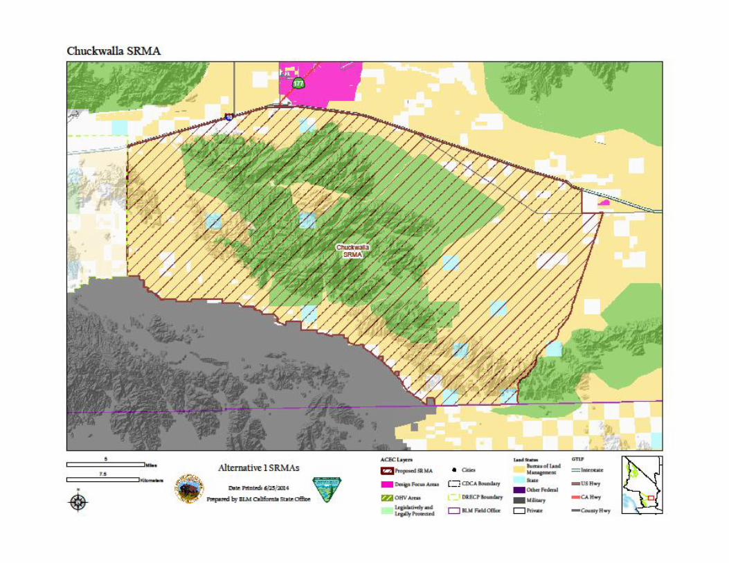
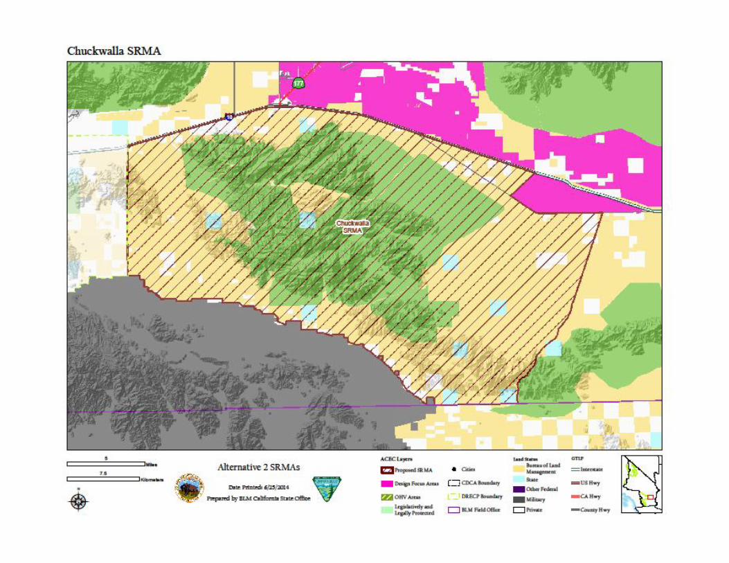
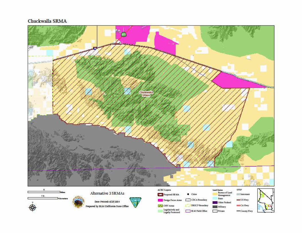
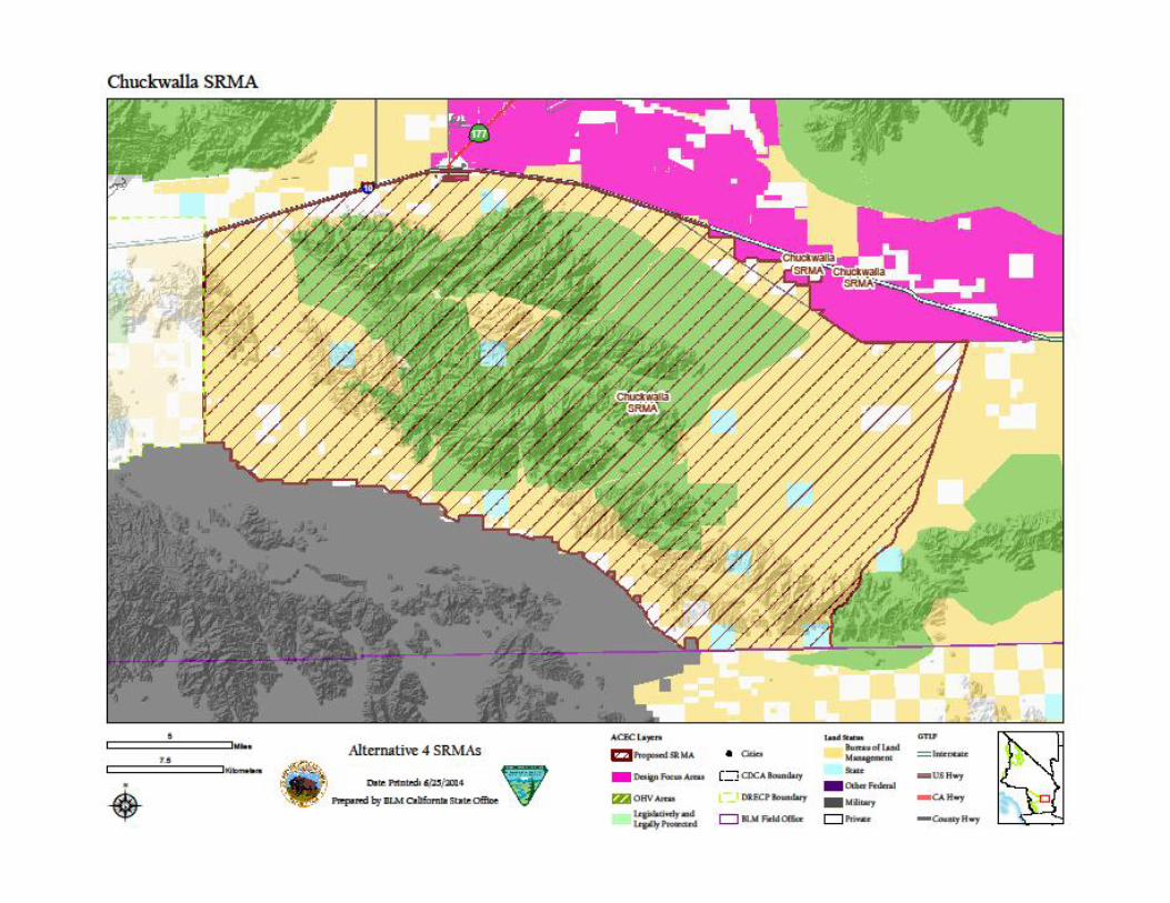
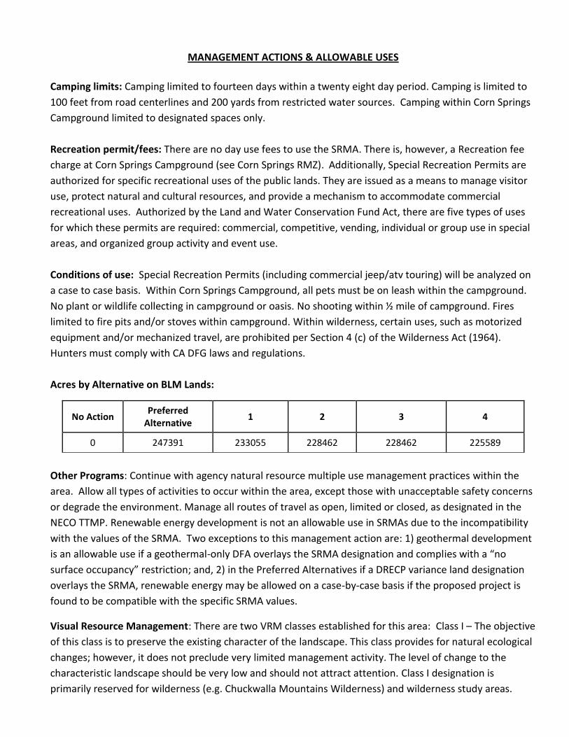
Acres by Alternative on BLM Lands:
No Action Preferred
Alternative 1 2 3 4
0 247391 233055 228462 228462 225589
Other Programs: Continue with agency natural resource multiple use management practices within the
area. Allow all types of activities to occur within the area, except those with unacceptable safety concerns
or degrade the environment. Manage all routes of travel as open, limited or closed, as designated in the
NECO TTMP. Renewable energy development is not an allowable use in SRMAs due to the incompatibility
with the values of the SRMA. Two exceptions to this management action are: 1) geothermal development
is an allowable use if a geothermal-only DFA overlays the SRMA designation and complies with a “no
surface occupancy” restriction; and, 2) in the Preferred Alternatives if a DRECP variance land designation
overlays the SRMA, renewable energy may be allowed on a case-by-case basis if the proposed project is
found to be compatible with the specific SRMA values.
Visual Resource Management: There are two VRM classes established for this area: Class I – The objective
of this class is to preserve the existing character of the landscape. This class provides for natural ecological
changes; however, it does not preclude very limited management activity. The level of change to the
characteristic landscape should be very low and should not attract attention. Class I designation is
primarily reserved for wilderness (e.g. Chuckwalla Mountains Wilderness) and wilderness study areas.
Class II – The objective of this class is to retain the existing character of the landscape. The level of change
to the characteristic landscape should be low. Management activities may be seen, but should not attract
the attention of the casual observer. Any changes must repeat the basic elements of form, line, color, and
texture found in the predominant natural features of the characteristic landscape. The remaining portion
of the SRMA not designated as wilderness is classified as Class II.
Implementation Decisions: An activity level plan would be developed to identify and designate current
and future recreational opportunities, appropriate facilities to provide for and manage the proposed uses,
parameters for streamlined Special Recreation Permitting of recreation events, staffing and funding needs,
parameters for facility and road/trail maintenance, partnerships, possible recreation fee considerations,
and an implementation schedule.
1. Management a. Continue management as per NECO plan b. Continue existing management of Corn Springs ACEC and campground, including caretaking
activities and fee collection. c. Manage Chuckwalla Mountains Wilderness as congressionally designated Wilderness area d. Maintain interpretive trail at campground. e. Update Corn Springs campground facilities, including tables, shade ramadas, fire pits, etc.
2. Administration a. Manage wilderness as VRM Class I b. Draft Wilderness Management Plan for Chuckwalla Mountains Wilderness c. Manage as VRM Class II
3. Education
a. Install interpretive signs and panels, including maps b. Create interpretive brochures, maps, etc. to be made available at the office c. Promote volunteerism/friends group for the area.
Mitigation:
1. Maintain through traffic motorized route network connectivity with roads and trails leading into
and through the Chuckwalla SRMA.
2. Manage renewable energy development on adjacent and nearby lands to avoid traffic conflicts
with visitors & permitted uses.


The Bureau of Land Management makes no warranties ,implied or expressed, with respect to information shown on this map.