Embed Size (px)
Citation preview

Christina Holt1,2,3, Ligia Bernardet1,2,3, Mrinal Biswas1,4 1Developmental Testbed Center
2NOAA ESRL Global Systems Division, Boulder CO3University of Colorado CIRES , Boulder CO
4National Center for Atmospheric Research, Boulder, CO
Advancing Microphysics Parameterizations in the Hurricane Weather Research and Forecasting
(HWRF) System
WWOSC 2014Thursday, August 21, 2014
Montreal, Canada
Acknowledgements:
Rob Fovell, UCLA
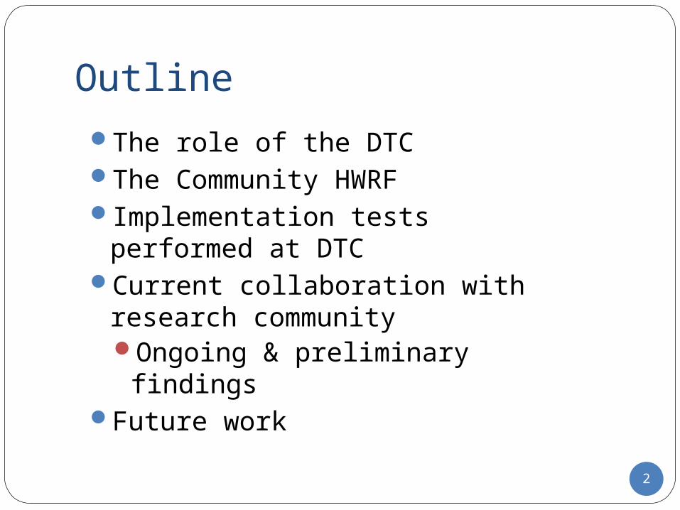
Outline
The role of the DTCThe Community HWRFImplementation tests performed at
DTCCurrent collaboration with research
communityOngoing & preliminary findings
Future work
2

The Developmental Testbed Center…is a distributed facility (NCAR and NOAA)
where the NWP community can test and evaluate models and techniques for use in research and operations
DTC’s GoalsLink Research and Operational CommunitiesSpeed transition of research results in operationsAccelerate improvement in NWPDevelop and test promising new NWP techniquesProvide an opportunity for NWP community to
perform cycled tests of model and data assimilation systems
3

DTC Strategies to promote HWRF R2OCode Management
Create and sustain a framework for NCEP and the research community to collaborate and keep HWRF code unified
User and developer support Support the community in using an operational hurricane model
DTC Visitor Program – some approved projects involving HWRF
Development of an HWRF diagnostics module to evaluate intensity and structure using synthetic flight paths through tropical cyclones (J. Vigh - NCAR)
Diagnosing tropical cyclone motion forecast errors in HWRF (T. Galarneau - NCAR)
Improving HWRF track and intensity forecasts via model physics evaluation and tuning (R. Fovell - UCLA)
Evaluation of two HWRF microphysics/radiation configurations with remote-sensing data (S. Bao – CCU)
Testing and Evaluation Perform tests to assure integrity of community code and
evaluate new developments for potential operational implementation 4
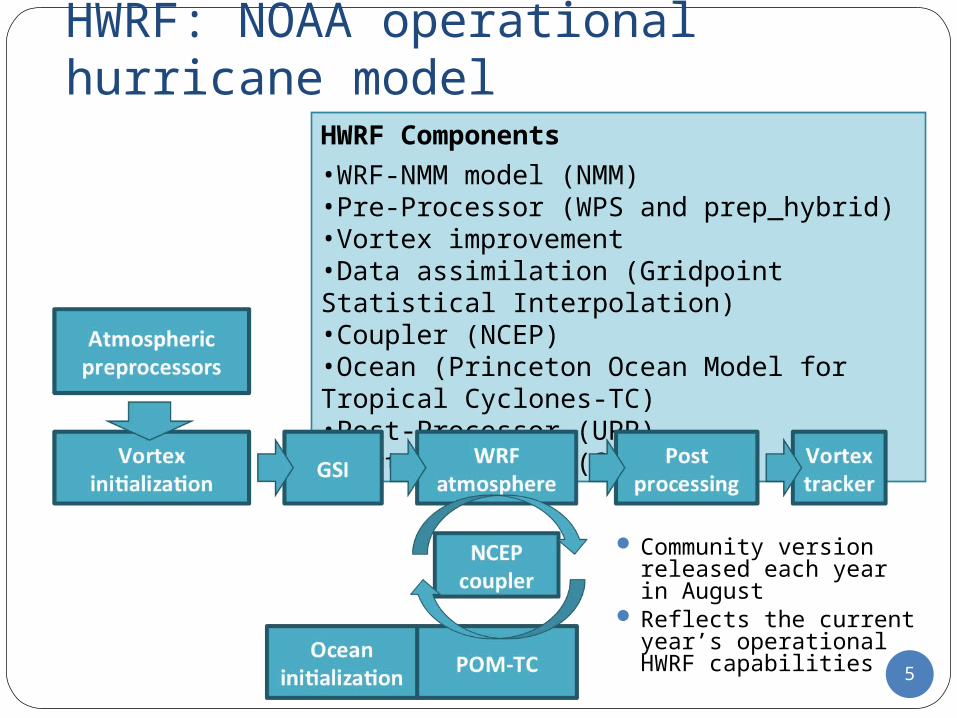
HWRF: NOAA operational hurricane model
HWRF Components•WRF-NMM model (NMM)•Pre-Processor (WPS and prep_hybrid)•Vortex improvement•Data assimilation (Gridpoint Statistical Interpolation)•Coupler (NCEP)•Ocean (Princeton Ocean Model for Tropical Cyclones-TC)•Post-Processor (UPP)•Vortex Tracker (GFDL)
Community version released each year in August
Reflects the current year’s operational HWRF capabilities 5

Physics Parameterization
Cumulus (d01 and d02)
Simplified Arakawa Schubert with shallow convection
Microphysics Ferrier for the tropics
Planetary Boundary Layer
GFS (Hong and Pan 1996,Vickers and Mahrt 2004, Gopal et al 2013) (90:90:30 s)
Surface Layer GFDL (modified)
Land Surface Model GFDL slab model
Radiation GFDL (60:60:60 min)
6
27 km
3 km
9 km
POM-TCPOM-TC
Introduced an empirical
dependency of BL height on Critical
Richardson Number
Introduced an empirical scaling factor, gfs_alpha,
that reduces mixing by limiting the
momentum eddy viscosity
HWRF v3.5a Atmospheric Configuration

Advects individual species
Advects total condensate
Partial Double Moment
Single Moment
6-classes w/ graupel
Cloud, rain, and snow
Coupled with RRTMG
(mixing ratio & concentration)
Supplies only MR to
radiation scheme
Tested for HWRF:
red. int. bias at long lead times
in ATL
Used in Operational
HWRF
HWRF T&E: Thompson/RRTMG
Thompson vs. Ferrier
RRTMG vs. GFDLUses internal assumptions to compute
concentrations given MR
Uses assumptions consistent
with Thompson to
compute concentrations given MR
Interacts with clouds
Interacts with clouds*
Tested for HWRF:
red. int. bias at long lead times in the
ATL
Used in Operational
HWRF
Thompson mp for Hurricane Sandy improved track forecasts
-A. Chakraborty, India CAOS,
NCAR/RAL visitor
Thompson mp for Hurricane Sandy improved track forecasts
-A. Chakraborty, India CAOS,
NCAR/RAL visitor
DTC: Coupling of the Thompson with RRTMG
DTC: Coupling of the Thompson with RRTMG
7
* Inconsistencies between Ferrier and GFDL radiation: clouds too transparent to radiation
-Rob Fovell, UCLA, HFIP Participant
* Inconsistencies between Ferrier and GFDL radiation: clouds too transparent to radiation
-Rob Fovell, UCLA, HFIP Participant

T/RRTMG improves track for AL but degrades for EP
T/RRTMGF/GFDLTrack error
North Atlantic Eastern North PacificIntensity Bias
T/RRTMG increases intensity for shorter lead
times, decreases for longer lead times 8
T/RRTMG creates negative intensity bias in EP

Case study: Daniel 04E
Thompson too fast and northward; reason under investigation
Ferrier runs similar at 5-day lead time
Bulk statistics for Daniel 04E and case study show that Thompson takes track to N
Storms are in area of strong SST gradientNorthern tracks leads to cool SST under storm and low bias
SS
T (
C)
9

DTC VSP: Rob Fovell and Peggy Bu, UCLAHWRF’s GFDL radiation scheme is deficient with
respect to cloud-radiative forcing (CRF)… see Bu et al. (2014)With proper CRF, the horizontal extent of the near
surface wind field increasesStorms with larger wind fields advect more
planetary vorticity northward (beta drift) and move fasterWesterly moving storms pull northward, and are
ahead of the observed stormWorking Hypotheses:
CRF and gfs_alpha work together to broaden the wind field too much, causing increased beta drift northward
Once the storms are over cold water to the north, they lose intensity 10

Results from DTC visit
T/RRTMG has narrower/weaker storm
F/RRTMG has slightly weaker, broader storm
Courtesy of Rob Fovell
11
30-36 hr 72-96 hr
T/RRTMG has broader/weaker storm
gfs_alpha = 0.7

New DTC Physics ExperimentsSeries of forecasts started from the same
initial conditions using HWRF v3.5a Varying microphysics scheme and
gfs_alphaAssess storm size and track changes
Are the forecasts with real storm settings consistent with the working hypotheses from the ideal studies?gfs_alpha Microphysics Radiation
0.7 Ferrier GFDL0.4 Thompson RRTMG0.4 Ferrier RRTMG0.7 Thompson RRTMG0.7 Ferrier RRTMG 12

Storm Tracks for Daniel (EP 2012)
Thompson 0.4Thompson 0.7Ferrier 0.4Ferrier 0.7Ferrier/GFDL/0.7Best Track
• Tracks diverge around 60 hrs• Thompson fcsts take a northward
track• gfs_alpha = 0.4 has a more
accurate track• Ferrier is less sensitive to gfs_alpha
13

14
Averaged over 60 -126 hrs
Thompson 0.4Thompson 0.7Ferrier 0.4Ferrier 0.7Ferrier/GFDL/0.7Observed
Average Radial Velocity
Averaged over first 60 hrs
SummaryThe findings in the real case study reflect
the idealized findings obtained by DTC Visiting ScientistsCRF + larger gfs_alpha broaden the wind
field at shorter lead timesBroader wind field (all else equal) leads to
northward trackInvestigation of other factors is needed to
determine the intensity/size relationships with physics
Further testing would be necessary to identify potential alternatives for operational implementation
15

Moving forwardDTC will continue to work
with visiting scientistsAssess the impact of
gfs_alpha, radiation, and microphysics combinations on forecasts
Provide resources to assess the potential for future R20
Look at radiation budgets, and the sensitivity of track, intensity, and structure to CRF
Physics for high-resolution
Framework: multiple
moving nests
LSM, storm surge,
inundation
Ongoing
development
DA / Initialization
16
Community Support by DTC-Model freely available and supported -Upcoming release this month•2014 operational capability•Idealized capability•Support for all basins•Unified Python scripts with EMCImproved model for 2014•Updated moving nests, ocean, and initialization improved forecast•Opened opportunities for major future developments