Embed Size (px)
Citation preview

China’s Internet: Topology Mapping and Geolocating
Ye Tian‡, Ratan Dey§, Yong Liu§, Keith W. Ross§
‡University of Science and Technology of China, Hefei, Anhui 230026, China§Polytechnic Institute of New York University, Brooklyn, NY 11201, USA
[email protected], [email protected], [email protected], [email protected]
ABSTRACTWe perform a large-scale topology mapping and geolocationstudy for China’s Internet. To overcome the limited num-ber of Chinese PlanetLab nodes and looking glass servers,we leverage unique features in China’s Internet, includingthe hierarchical structure of the major ISPs and the abun-dance of IDC datacenters. Using only 15 vantage points, wedesign a traceroute scheme that finds significantly more in-terfaces and links than iPlane with significantly fewer tracer-oute probes.
We then consider the problem of geolocating router inter-faces and end hosts in China. When examining three well-known Chinese geoIP databases, we observe frequent occur-rences of null replies and erroneous entries, suggesting thatthere is significant room for improvement. We develop aheuristic for clustering the interface topology of a hierarchi-cal ISP, and then apply the heuristic to the major ChineseISPs. We show that the clustering heuristic can geolocaterouter interfaces with significantly more detail and accuracythan can the existing geoIP databases in isolation. We showthat the resulting clusters expose several characteristics ofthe Chinese Internet, including the major ISPs’ provincialstructure and the centralized inter-connections among theISPs. Finally, using the clustering heuristic, we proposea methodology for improving commercial geoIP databasesand evaluate using IDC datacenter landmarks.
1. INTRODUCTIONChina1 is the country with the largest number of In-
ternet users and the second largest IP address space[5]. Nevertheless, China’s Internet has received rela-tively little attention in the measurement communityto date. This is perhaps because China’s Internet lacksthe infrastructure and resources that are essential forlarge-scale Internet measurement studies such as thosecarried out in Rocketfuel [26] and iPlane [14]. For exam-ple, China has few PlanetLab nodes and looking glassservers, which are important infrastructure componentsfor large-scale Internet measurement studies. Moreover,whereas many routers outside of China have names from
1By China we mean Mainland China.
which geolocation can be inferred, few router interfaceshave names in China.Nevertheless, China’s Internet is complex and has its
unique structural features, which makes it very differentfrom the Internet in US and Europe. China has a verysimple AS-topology with few Chinese ASes. However,both of two major ISPs in China each have one giantAS that not only includes a national backbone network,but also includes regional networks in many provincesas well as residential networks. As China’s Internet isdominated by few major ISPs, it is therefore largelyshaped by the internal structure of these giant ASesrather than the AS-topology.Of particular interest is geolocation services for
China’s Internet. More and more online businesses andservices – including targeted advertising, spam filter-ing, and fraud prevention – are based on geolocation ofIP addresses. Commercial geoIP databases for Chinaand elsewhere typically incorporate multiple informa-tion sources, including information directly from ISPs,DNS reverse lookups, and end user inputs. As we willshow in this paper, existing commercial geoIP databasesfor Chinese IP addresses have many incomplete and er-roneous entries, particularly for router interfaces.In this paper, we carry out a large-scale topology
mapping and geolocation study for China’s Internet.To overcome the insufficient number of Chinese Planet-Lab nodes, looking glass servers, and router interfaceswith geographical names, we leverage unique features inChina’s Internet, including the hierarchical structure ofthe major ISPs and the abundance of IDC datacenters.The contributions of this paper are as follows:
• We find that existing measurement practices donot adequately cover China’s Internet. We developtwo techniques, namely nested IP block partition-ing and collaborative tracerouting, which allow usto perform a comprehensive and efficient tracer-oute measurement study of China’s Internet us-ing only 15 internal vantage points. In particu-lar, our approach discovers significantly more in-terfaces and links than iPlane with significantlyfewer traceroute probes.
1
• Using the IP addresses obtained from our tracer-oute measurements, we examine three well-knownChinese geoIP databases and MaxMind. We findthat the three Chinese geoIP databases are onlymoderately accurate for end host geolocating, andsubstantially less accurate for router interfaces. Inparticular, we observe frequent occurrences of nullreplies and erroneous entries, suggesting that thereis significant room for improvement.
• With the goal of accurately geolocating routers inChina, we develop a heuristic for clustering the in-terface topology of a hierarchical ISP, so that eachcluster is a connected component within a city.We then apply the heuristic to the major ChineseISPs, leveraging the interface topologies derivedfrom our traceroute measurements as well as theexisting Chinese geolocation services. We showthat this clustering heuristic can geolocate routerinterfaces with significantly more detailed locationinformation than the existing geoIP databases inisolation.
• We analyze the clusters generated by our cluster-ing heuristic. We show that they expose severalcharacteristics of the Chinese Internet, includingrecent mergers of ISPs. We observe the provin-cial capital cities are not only government centersbut are also hubs in the ISPs’ networks, and inter-ISP traffic is concentrated to a few routers acrossChina.
• Using the geo-clustering heuristic, we proposea methodology for improving commercial geoIPdatabases. By evaluating with datacenter land-marks, we show that our approach is able to pro-vide more detailed and accurate location informa-tion as compared with the original geoIP database,and the methodology can also differentiate the re-sults from geoIP databases with different confi-dence levels. By improving on the best geoIPdatabases in China, we are currently providing themost accurate geolocation service for China’s In-ternet.
The reminder part of this paper is organized as fol-lows. Section 2 presents a brief overview of China’sInternet. We present our traceroute measurementmethodology in Section 3 and compare our resultswith iPlane. Section 4 evaluates the geolocation ser-vices of popular geoIP databases. We propose the geo-clustering heuristic in Section 5, and use the resultinggeo-clusters to analyze China’s Internet. In Section 6 wedevelop a methodology for improving geoIP databases.Section 7 discusses related work and we conclude in Sec-tion 8.
2. OVERVIEW OF CHINA’S INTERNETBefore presenting our methodologies for mapping
and geolocating China’s Internet, it is useful to brieflyoverview China’s Internet. The two largest ISPs inChina are China Telecom (a.k.a. ChinaNet and hence-forth referred to as Telecom) and China Unicom (hence-forth referred to as Unicom)2. Both Telecom andUnicom have high-performance national backbone net-works, connecting regional and residential networks inChina’s provinces and major cities; and both also pro-vide high-performance connections to the Internet out-side of China [5]. Both Telecom and Unicom also havetheir own networks in many provinces and cities inChina, and also provide access directly to end users.Unicom holds the dominant market share in the north-ern provinces, whereas Telecom dominates southernChina [28]. The other commercial ISPs in China aremuch smaller than Telecom and Unicom; they gener-ally rely on Telecom/Unicom’s backbone networks foraccessing services connected to Telecom/Unicom, andfor accessing services on the international Internet.In addition to Telecom and Unicom, CERNET3 is
also a major ISP in China. As an academic network thatconnects the universities and research institutes all overChina (analogous to Internet2 in the USA), CERNETis largely independent with its own national backboneand peers with many international commercial and aca-demic networks.Since Telecom and Unicom are government-owned
companies, it is not surprising that their topologicalstructure is hierarchical and mimics the provincial orga-nization of the Chinese government. Using Telecom asan example, Telecom Corporation is in charge of Tele-com’s national backbone network. For each province,Telecom has a provincial subsidiary that manages itsprovincial network; and for most cities in the province,there is a city company under the provincial companythat is responsible for constructing and maintaining res-idential networks and providing Internet services to endusers in that city. In addition, Telecom assigns blocksof IP addresses along this three-level structure, that is,from its address space, it allocates blocks to each of theprovincial subsidiaries, and each provincial subsidiaryallocates blocks of addresses to cities. In fact, manyChinese geoIP databases exploit this hierarchical IP ad-dress assignment to provide basic geolocation services.Internet Datacenters (IDCs) are widely used in China.
An IDC datacenter can provide many services to enter-prises and individual customers, including server host-ing, server leasing, and virtual servers. Most of thedatacenters connect directly to either the Telecom orUnicom backbones, and some connect to both (and di-
2Here we are referring to the current China Unicom, whichmerged with China Netcom (a.k.a. CNCGroup) in 2008.3China Eduction and Research Network
2

rectly to other Chinese ISPs). Because the datacentershave high-speed connections directly to the backbones,they are attractive for hosting websites and other onlineservices for various customers. In fact, many Chineseuniversity web sites are not hosted on the universitycampuses, but instead in IDC datacenters; similarly,many government web sites are hosted in IDC datacen-ters. Furthermore, many popular Web sites in Chinaare mirrored across several datacenters.
3. TRACEROUTE MEASUREMENTTraceroute is one of the most fundamental measure-
ment tools for studying the Internet. Unfortunately,existing large-scale traceroute measurement practices,such as iPlane [14] and CAIDA/Ark [2], do not sat-isfactorily cover China’s Internet. These projects usevery few vantage points within China: only two Plan-etLab nodes from China are used in iPlane and onlyone Chinese monitor is used in Ark. As a result, thesetwo projects use vantage points from outside China tocollect most of their Chinese traceroute path segments.Moreover, a recent study shows that there are only 24ASes in China’s Internet that peer with foreign ISPs.In fact, it is well known that Telecom and Unicom havemost of the international Internet connections in China[5]; therefore most of the traceroute probes originatingfrom outside of China will enter China through a smallnumber of ASes in Telecom and Unicom. Thus, fortraceroutes originating from outside of China, they arelikely to follow similar paths when traversing China’sInternet, thereby not revealing many diverse interfacesand links. For comprehensively mapping China’s In-ternet, we must therefore use vantage points located inChina.
Table 1: Distribution of IP block prefix length618 19 20 21 22 23 24 >252,793 1,197 1,987 1,210 1,175 1,133 4,404 104
We face two challenges when attempting to mapChina’s Internet with traceroute. The first is to identifya set of target IP addresses that is sufficiently, but notoverly, dense within the Chinese Internet. Large-scaletraceroute measurement studies (e.g., [14] and [2]) oftenuse CIDR IP blocks from public BGP snapshots (e.g.,from Oregon Routeviews [23] and RIPE RIS [22]); theblocks are used to partition the IP space, and then oneaddress is selected from each block in the partition asthe traceroute targets. However, there is no operationalpublic BGP router in China’s Internet [27]; therefore,we can only gather Chinese blocks from routers that areoutside of China. Because these blocks are likely to havebeen aggregated by the border routers in China’s Inter-net, they are generally too coarse for topology mapping.To establish this claim, we have downloaded eight BGP
snapshots from different routers in Oregon Routeviewsand RIPE RIS. (The routers are located in USA, Eu-rope, and Japan.) Table 1 lists the numbers of distinctIP blocks in China with their prefix lengths. We cansee that there are many large blocks (e.g., blocks withprefix lengths smaller than 20, 18, and so on).The other challenge is efficiency, that is, devising
a traceroute strategy that sufficiently covers the Chi-nese Internet without overly burdening the traceroutesources (vantage points). iPlane and Ark spread theirworkload over hundreds of vantage points. In our tracer-oute measurements, we only use stable vantage pointsfrom within China, for which we have only identified 15(7 PlanetLab nodes and 8 web-based traceroute servers).If we use iPlane’s or Ark’s probing strategy, we wouldoverload our 15 vantage points with too many tasks. Toaddress these two challenges, we devise two techniques,namely, nested IP block partitioning and collaborativetracerouting.
3.1 Nested IP Block Partitioning
(a)
(b)
(c)
Figure 1: Nested-block Partitioning
We need to partition the large Chinese IP addressspace, and then choose one IP address from each setin the partition as a traceroute target. For the parti-tioning, a simple approach is to evenly divide the largeblocks obtained from the public BGP tables. However,taking a close look at these blocks, we find that blocknesting [30], where a block from one BGP routing tableentry resides in another block from a different entry, isvery common; moreover, there are often several levels ofnesting. An example of nested IP blocks is shown in Fig-ure 1(a). In the Figure, three blocks are obtained fromBGP tables, i.e., 202.85.208.0/20, 202.85.208.0/23, and
3

202.85.216.0/24, where the latter two blocks are nestedin the first one. Clearly, the smaller nested blocks sug-gest the existence of different subnets, as they appearas separate entries in the routing tables. If we setthe granularity of the traceroute probing up to prefix/22, then for the block 202.85.208.0/20, we would ob-tain four equal-sized /22 blocks, but the smaller nestedblocks would be masked. On the other hand, evenlydividing 202.85.208.0/20 into /24 blocks results in 16blocks, which may overly increase the workload of themeasurement.We design a tree-based method to partition the Chi-
nese IP address space with a minimal number of blockswhile preserving the nested blocks obtained from theBGP tables. The blocks from the BGP tables are nodesin trees. We consider a block encompassing other blocksas the root of a binary tree, and all the nested blocksas leaves. With this tree the problem becomes: giventhe root node and a number of leaf nodes, constructa binary tree with the fewest leaves. After the tree isobtained, we use all the blocks corresponding to theleaf nodes (including the original nested blocks) to re-place the root block. For example, for the case in Fig-ure 1(a), the block binary tree is shown in Figure 1(b),and we use seven blocks to replace the original largeblock 202.85.208.0/20, as shown in Figure 1(c). Afterpartitioning the nested IP blocks, we further evenly di-vide any blocks that are larger than our granularity,while reserving the smaller blocks for traceroute prob-ing. For the example in Figure 1, if the granularity isprefix /22, then 7 blocks are probed instead of the 4or 16 blocks that would be generated by evenly divid-ing. Thus, with nested-block partitioning, we can fullyexploit the small nested blocks, suggesting different sub-nets, without naively dividing all the large blocks intosmaller ones, which would geometrically increase theprobing workload.
3.2 Collaborative TraceroutingArk and iPlane apply different strategies to reduce
the workload (when probing the entire Internet). InArk, each /24 block is probed in one measurement round,but Ark groups its vantage points into teams, with eachteam having a geographically distributed set of mem-bers. Each team only probes a subset of the targets.Although a target is only probed by one team, the num-ber and the geographical distribution of the team’s van-tage points ensure the diversity of the traceroutes. IniPlane, IP blocks from BGP snapshots with similar ASpaths are further combined to reduce the workload [18].We, however, cannot apply either Ark’s or iPlane’s
strategies for two reasons: (i) we have only 15 vantagepoints to spread the workload over; and (ii) we need todivide IP blocks from BGP snapshots rather than clus-ter them. Even after the nested-block partitioning, as
described in Section 3.1, there are still 223,714 CIDRblocks in China to be tracerouted. It is impractical toprobe each block from each of the vantage points. Arecent study [4] shows that there are many redundantprobes in Ark and iPlane. We propose a mechanismfor having the vantage points collaboratively and dy-namically determine their traceroute targets, therebyavoiding redundant probes.In our measurement, the IP blocks obtained in Sec-
tion 3.1 (which partition the Chinese IP space) are thebasic probe units. When a vantage point probes a block,we always use the second IP address of that block (i.e.,a.b.c.1) as the target, as such addresses are usually usedfor gateways and are, thus, more likely to respond to aprobe than other addresses. In our collaborative tracer-outing scheme, a vantage point actively uses the resultsof its previous probes and other vantage points’ probesto avoid redundant probes. Specifically, each vantagepoint keeps a set, reach set, of all the addresses thevantage point has observed during its previous probes;and each IP block keeps a set, source set, containing allthe IP addresses that lead to this block from previoustraceroutes from all the vantage points. When a van-tage point v encounters an IP block B it has not probedbefore, it examines v’s reach set and B’s source set; ifthe two sets overlap, then an interface path can be foundfrom v to the block B from previous traceroutes, so thevantage point v doesn’t probe the block B.( )k kh B 1 1( )k kh B+ + ( )m mh B
1 1( )h B 1 1( )h B′ ′1 1( )l lh B+ +′ ′( )n nh B′ ′
Figure 2: An example of collaborative tracer-outing
As an example, suppose a vantage point v1 probes atarget with the traceroute path
h1, ..., hk, hk+1, ..., hm
where the interfaces are in the blocks B1, ..., Bk, Bk+1,..., Bm, as shown in Figure 2. v1 inserts all the inter-face IP addresses it has reached, i.e., h1, ..., hm, intoits reach set. For each interface IP, the correspondingblock inserts all the IPs preceding it along the path intoits source set. For example, h1, ..., hm−1 are insertedinto Bm’s source set. Clearly, after this probing, v1can skip B1, ..., Bm−1 in future measurements, as v1’s
4

reach set overlaps with the source set for each of theseblocks. Moreover, suppose another vantage point v2 hasa traceroute path
h′1, ..., hk, h
′l+1, ..., h
′n
that traverses the blocks of B′1, ..., Bk, B
′l+1, ..., B
′n. As
a result of this probe, hk will be included in source setsof B′
l+1, ..., B′n, which means that v1 can skip these
blocks as an interface path has already been found fromv1 to them via hk, as shown in Figure 2. (Shown as thedotted line in the left of the figure.) Similarly, v2 canalso skip the blocks of Bk+1, ..., Bm. (Shown as thedotted line in the right of the figure.)
3.3 Measurement Results
Table 2: Traceroute measurement resultsiPlane iPlane cTrace Both(one day) (two days)
Traceroutes 1,244,667 2,381,482 106,580Interfaces 17,308 17,761 71,047 10,023Links 76,120 82,791 146,542 27,735
Using nested-block partitioning and collaborative tracer-outing, we perform a traceroute measurement on China’sInternet with 15 vantage points (from 9 different citiesand in 4 different ISPs) in China. We applied thenested-block partitioning algorithm on the IP blocksfrom 8 BGP snapshots and further divided them to pre-fix /22 blocks for obtaining the target addresses. Themeasurement was performed from 12 December 2010 to2 January 2011. We also downloaded iPlane’s tracer-oute data on Dec. 19 and Dec. 20, 2010 for comparison.For each path in iPlane, we extract the segment that ison China’s Internet.
100 102 104 10600.20.40.60.81Traversal times
CDF iPlanecTrace
Figure 3: Number of times the links are visited
Table 2 compares the iPlane data with our measure-ment results (referred to as cTrace). For iPlane, wepresent the results for both one and two days of mea-surement. As compared with iPlane, our approach em-ploys only 5% of the number of traceroute probes butfinds four times as many interfaces and twice as manyinterface links. This experiment therefore shows that
using vantage points in China is much more efficient inexposing China’s Internet, and collaborative tracerout-ing can effectively eliminate redundant probes.To further demonstrate our point, we plot the distri-
butions of the number of times the links are visited iniPlane (over 2 days) and in cTrace in Figure 3. In twodays, iPlane visited some links thousands of times, eventhough most of its vantage points are outside of Chinaand, thus, are far away from these links.Finally, from Table 2 we note that although cTrace
contains many more interfaces and links than iPlane,there are still over 7,000 interfaces and 50,000 links iniPlane that are not discovered by cTrace. We believethese interfaces and links are located on the border ofChina’s Internet that connects to the international In-ternet. These links are thus unlikely to be traversed bycTrace, which uses vantage points within China. Forthis reason, we combine cTrace with the 2-day iPlanedata, and use the combined data for further study inthis paper.In summary, we perform a traceroute measurement
with as few as 15 vantage points on China’s Internet.As compared to existing large-scale traceroute measure-ments, our scheme not only reveals a much larger num-ber of Chinese links and interfaces, but also uses signif-icantly fewer traceroute probes.
4. GEOLOCATION SERVICES ON CHINA’SINTERNET
One goal of this paper is to develop a methodologyfor accurately geolocating Chinese IP addresses for bothend hosts and router interfaces. In this Section, webriefly examine the geolocation services currently avail-able for China’s Internet. In the subsequent section, wewill develop methodologies to improve these services.We consider four geoIP databases in this study,
namely, IP138 [12], QQWry [21], IPcn [13], and Max-Mind [19]. The first three are Chinese databases thatare well-known in the Chinese Internet community,whereas MaxMind is a leading global geolocation serviceprovider. The locations returned by these databasesgenerally have two levels: the province level and thecity level. For the directly-controlled municipalities ofBeijing, Shanghai, Tianjin and Chongqing, we considerthem as both provinces and cities. For cases when bo-gus locations are returned (e.g., a non-exist locationname), we consider the corresponding level location in-formation as null.
Table 3: Null reply ratios for the addresses fromtraceroute
IP138 QQWry IPcn MaxMindProvince 0.105 0.074 0.108 0.186City 0.240 0.212 0.280 0.227
5
Table 4: Null reply ratios for Xunlei peersIP138 QQWry IPcn MaxMind
Province 0.011 0.004 0.021 0.161City 0.153 0.137 0.178 0.224
We first consider null-reply ratios for each database.A database’s null-reply ratio is defined as the fractionof the cases for which the database fails to providelocation information [25]. We use the 78, 229 IP ad-dresses from the combined traceroute data to examinethe geoIP databases. Table 3 shows the null-reply ratiosfor the four databases at the province and city levels.We can see that each database frequently returns nullreplies, particularly for the city-level location informa-tion.Two types of IP addresses are included in our tracer-
oute data: router interface addresses and end host ad-dresses. To gain further insight into the databases’performance for different types of addresses, we ran-domly selected 2,000 IP addresses from peers collectedby crawling the Xunlei DHT [6] (a popular P2P down-load acceleration application in China) and fed theseend host addresses to the geoIP databases. Table 4shows the null-reply ratios on Xunlei peers. Comparingwith Table 3, we can see that except for MaxMind, thethree Chinese databases have fewer null replies for Xun-lei peers, suggesting that the three Chinese databasescover better end host IP addresses than router interfaceaddresses.In summary, we find that the three Chinese geoIP
databases are moderately accurate for end host geolo-cating, and substantially less accurate for router inter-faces. In particular, we observe frequent occurrences ofnull replies and erroneous entries, suggesting that thereis significant room for improvement.
5. GEOLOCATING THE INTERFACETOPOLOGY
With the combined traceroute data obtained in Sec-tion 3, we have obtained a separate interface topologyfor Telecom, Unicom and CERNET. Each of these inter-face topologies can be viewed as a directed graph: Eachinterface (IP address) forms a vertex, and each pair ofsuccessive interfaces from the traceroutes forms a di-rected edge. In this section, we seek to geolocate thethree interface topologies. In many countries, routerinterfaces are often assigned names that indicate theinterface’s location. In such cases, the location of aninterface can be determined by simply performing a re-verse DNS lookup on the corresponding IP address. InChina, however, very few router interfaces have names.We therefore must develop an alternative approach forgeolocating the router interfaces. We develop a cluster-
ing approach, as described subsequently.For a given interface topology T , we say a set of router
interfaces S forms a cluster if (a) all the interfaces inS belong to the same city, and (b) the subgraph of Tinduced by S is weakly connected. We further say thata cluster S is a maximal cluster if it is not possible tocreate a larger cluster by adding more interfaces to it.Our goal is to determine the maximal clusters in eachof three interface topologies. Note that a city couldhave more than one maximal cluster, for example, itcould have two maximal clusters which do not have adirect link between them, but which have an indirectpath between them via another city.
Figure 4: Erroneous clusters example
A naive method to create the clusters is to simply usethe city information provided by the geoIP databaseson face value. However, this naive approach leads to alarge number of small and disconnected erroneous clus-ters due to missing and erroneous entries in the geoIPdatabases. Figure 4 provides an example, with boxesrepresenting the interfaces and arrows representing thelinks. All the interfaces on the graph are at the samelocation, and should be included in one cluster. How-ever, if interface b’s location from geoIP database iswrong or missing, four instead of one cluster is formed,as shown in the figure. This example shows that a fewerrors in geoIP databases will cause many clusters tobe erroneously formed. On the other hand, by com-bining the information in the geoIP databases with thetopological information obtained from the traceroutes,it may be possible for us to identify the errors in geoIPdatabases and determine the interfaces’ real locations.For example, for interface b in Figure 4, as all the in-terfaces adjacent to it are at the same location, we canconclude that b’s database location is likely incorrectand b is likely located at the same location as all theother interfaces on the graph. Inspired by this obser-vation, we propose a heuristic for accurately determin-ing the maximal clusters in each of the three interfacetopologies.
5.1 Geo-Clustering HeuristicGeolocating an interface network using a partially
accurate geoIP database is a challenging problem foran arbitrary interface topology. Fortunately, the ma-
6

jor Chinese ISPs have a hierarchical structure, whichmakes the problem more tractable. The heuristic wepresent here could be used for any ISP with a hierar-chical structure (not just Chinese ISPs).For each of these ISPs, using the traceroute data,
we first obtain an interface topology that expands fromthe ISP’s backbone network to the traceroute targetsin that ISP. After obtaining the interface topology, theclustering algorithm starts from the interfaces at theedge of the topology, then gradually moves towards thebackbone interfaces located at the core. The heuristicalgorithm consists of four steps. In the first step, weform singleton clusters using the interfaces at the edgeof the interface topology. In the second step, we re-peatedly select the interfaces that are one step closer tothe backbone network and, based on their inferred loca-tions, group them into existing clusters. In this step, wecluster router interfaces in the residential and provincialnetworks. In the third step, we cluster the router inter-faces in the backbone network using a method similarto step two, but we apply different rules for inferringthe interfaces’ locations. Finally, in step four, we mergethe singletons and small clusters that remain after step3 to create the maximal clusters. In the following wedescribe each of the steps in detail.
5.1.1 Step Zero: PreprocessingBefore clustering the interfaces, we first filter out the
influence of the vantage points and anonymous routersin the interface topologies. For a typical traceroute pathtraversing Telecom, Unicom, or CERNET, it containsthree subpaths: the subpath from the vantage point tothe first backbone router, the subpath inside the back-bone network, and the subpath from the last backbonerouter to the target. We only include the last two sub-paths in our interface topology. By filtering out all the“up backbone” links in the first subpath, the resultinginterface topology can be viewed as expanding from thebackbone network to the traceroute targets. In addi-tion, if an anonymous router is found in the third sub-path, all the interfaces after the anonymous interfaceare removed.In this preprocessing step, we need to identify the
backbone routers. Although most routers in China arenameless, and thus cannot be reverse DNS queried, thethree Chinese databases do return backbone network in-formation, indicating whether an address being queriedbelongs to the Telecom, Unicom, or CERNET back-bone. By filtering we remove only a small fraction ofthe addresses from the traceroute data. For example,only 2.5%, 5.9%, and 15.3% of the interfaces on the in-terface topologies of Telecom, Unicom, and CERNETare removed using the geoIP database of IP138.
5.1.2 Step One: Startup Clusters from the Edge
Figure 5: Example of step one clustering
In the first step, we select the addresses at the edgeof the interface topology to form startup singleton clus-ters. Specifically, for an interface in the topology, sayi1, if it has no outgoing links, or for each interface i2 itlinks to, there exists a path from i2 to i1 in the inter-face topology, a singleton cluster containing only i1 isformed. We use i1’s location from the geoIP database(referred to as i1’s DB location) as the cluster’s loca-tion. A simple example is shown in Figure 5. In the leftfigure, i1 has no outgoing links, and a singleton clusteris formed. In the right figure, i1 and i2 link to eachother, so there is a return path for both of them; thustwo singleton clusters, one containing i1 and the othercontaining i2, are formed.
5.1.3 Step Two: Clustering Residential and Provin-cial Networks
Figure 6: Example of step two clustering
After obtaining the startup singleton clusters, we con-tinue to cluster more router interfaces. The heuristicworks in rounds. In each round, we select some of theunclustered addresses in the interface topology as can-didates for clustering. An unclustered interface i is se-lected as a candidate if each of i’s out-linked interfacesis (a) either clustered (as are interfaces i2, i3, i4, and i5in Figure 6) or (b) there exists a path in the interfacetopology from the out-linked interface back to i (as isi1 in Figure 6).For each candidate interface, we use its out-linked
interfaces to infer its location. Suppose a candidate in-terface i links to interfaces i1, i2, ..., in, which belong toclusters c1, c2, ..., cm. We then have i1, i2, ..., in vote toinfer i’s location. For each out-linked interface, say ik,if its DB location contains a city-level location, it usesits DB location to vote; otherwise it uses the locationof the cluster it belongs to (referred to as ik’s clusterlocation). After voting, if there exists a city-level loca-
7

tion x that wins the voting by exceeding a threshold ofc vote, x is assigned as i’s cluster location (but i stillkeeps its DB location). We further merge all clustersamong c1, c2, ..., cm that have cluster location x intoone larger cluster, and also put i into this newly mergedcluster. When there is no winner from the voting, if i’sDB location has a city-level location, say y, we merge allclusters among c1, c2, ..., cm that have cluster locationy into one larger cluster, and put interface i into thisnewly merged cluster. Otherwise, i cannot be put intoany cluster and will form a singleton cluster contain-ing only itself. A simple example of voting and clustermerging is shown in Figure 6: in the left graph, the can-didate interface i’s DB entry does not include city-levelinformation; however, its cluster location is inferred bythe voting among its out-linked interfaces i1, ..., i5; af-ter the voting, i is assigned the same location as theclusters of i2, i3 and i4, and they join i to form a largercluster, as shown in the right graph.For a candidate interface, if more than one province
appears in the voting, it is likely that this interface be-longs to a backbone network. In this case, we abortthe voting-based inference without forming or mergingany clusters, and move on to the next candidate. Afterall the candidate interfaces are processed, the heuristicfinishes a round and selects new candidates for the nextround. Step 2 stops when we can’t form or merge anyclusters during a round.
5.1.4 Step Three: Clustering Interfaces in the Back-bone
Step 3 works similarly as Step 2 by first selecting aset of candidate interfaces, inferring their cluster loca-tions, and merging the clusters with the same clusterlocation. We use the same method as in Step 2 to se-lect a candidate. However, unlike Step 2, where candi-date interfaces are on routers in residential or provincialnetworks, in Step 3, nearly all the candidate interfacesare on backbone routers, which usually connect manyrouters at different locations. In addition, the links thatconnect backbone interfaces are usually traversed manytimes during the traceroute measurement. This makesit possible to accurately estimate delays on those links.For a candidate interface i, we sequentially apply thefollowing rules to infer its cluster location.
• We first examine each link incident from i to aclustered interface, say i1, that has been traversedmore than t times times. For such a link, we usethe median of the delays estimated from differentvantage points, as proposed in [9], as its delay. Ifthe delay is smaller than the threshold of l delay,we assign i1’s cluster location x to i, and merge iwith all the clusters that connect to i with locationx. However, if more than one link is observed,suggesting different cluster locations, we apply the
next rule.
• We use the same voting-based method as in Step 2to infer candidate i’s city-level location. But herewe don’t apply the stop condition when more thanone province appears. We use the location thatwins the voting as i’s cluster location and mergeits out-linked clusters if possible. If there is nowinner from the voting, apply the next rule.
• We conduct a province-level voting using a methodsimilar to Step 2. For each of i’s out-linked inter-faces, only its province-level cluster location infor-mation is used. We use a threshold of p vote tofind the winner. After the voting, if a province-level location wins, we assign the capital city ofthat province as the candidate’s city-level loca-tion. This is because a provincial network usuallyaccesses the backbone network at the capital cityof that province (see Section 5.3). We then per-form cluster merging with the assigned city-levellocation if possible.
Finally, if none of above rules can be applied to i, asingleton cluster is formed for it.
5.1.5 Step Four: Merging Singleton and Small Clus-ters
After applying Steps 2 and 3, all the interfaces in thetopology are clustered. Careful examination on the re-sulting clusters shows that for nearly all the cities, thereare one or two large clusters containing most of the in-terfaces, as well as a number of singleton or small clus-ters. The objective of Step 4 is to merge these singletonand small clusters into a large one. We consider theclusters containing less than c size interfaces as merge-able small clusters, and the others are regarded as largeclusters. For a small cluster, if it is only connected toone large cluster, then the location information given inthe database for the small cluster is likely to be wrong;we therefore merge it into the large cluster, regardlessof its original cluster location. By repeatedly mergingsmall clusters, we can eliminate most of them.We refer to this four-step heuristic as the geo-clustering
heuristic on the interface topology.
5.2 Geo-ClustersWe applied the geo-clustering heuristic on the Tele-
com, Unicom, and CERNET interface topologies us-ing each of three geoIP databases. For the parame-ters, we use c vote = 0.5, l delay = 1ms, t times = 5,p vote = 0.5 and c size = 5. For example, for the Tele-com’s interface topology using the geoIP database ofIP138, there are 38, 181 interfaces. After Steps 1, 2, 3,and 4, we get 26, 518, 7, 326, 7, 467, and 1, 125 clusters,respectively. 532 of the final clusters contain 37, 488interfaces and have been assigned city level locations.
8

0 100 200 300 40005001000City indexCluster sizeTelecom
(a) Telecom
0 100 200 30005001000City indexCluster sizeUnicom
(b) Unicom
0 50 100 1500100200300City indexCluster sizeCERNET
(c) CERNET
Figure 7: Distribution of the sizes of geo-clusters across cities in three major ISPs
(The remaining clusters are singleton clusters for whichthe heuristic did not assign to a city since there was noclear majority winner in the voting.) The observationindicates that by geo-clustering, we can group most ofthe interfaces into clusters with detailed city-level loca-tion information. We refer to a cluster with a city-levellocation as a geo-cluster. Similar results are observedusing the two other geoIP databases and for the twoother backbone ISPs. We omit them due to lack ofspace.By examining the 532 geo-clusters obtained on Tele-
com’s interface topology, we find they are located in324 different cities, which are nearly all the cities inChina. We show the sizes of the geo-clusters for eachcity for Telecom, Unicom, and CERNET in Figure 7,where the x-axis is the city index, the y-axis is the clus-ter size, and each point on the figure corresponds toa geo-cluster. For each ISP, the cities are indexed ac-cording to the total number of IP addresses across allgeo-clusters in the city. From Telecom and CERNET’sfigures, we can see that for many cities, there is only onegeo-cluster. For a small fraction of the cities, multipleclusters are found, with one cluster containing the ma-jority of the interfaces. There are two possible reasonsfor multiple clusters in a city: (i) the ISP has multiplenetworks serving different purposes in that city; andmore likely (ii) some of the singleton and small clus-ters cannot be merged into large clusters in step four.Note that the Unicom’s geo-cluster distribution is dis-tinctly different from those of Telecom and CERNET.In particular, for Unicom in many cities there are twolarge geo-clusters of comparable size, as shown in Figure7(b). Our heuristic is consistent with the fact that in2008 Unicom merged with China Netcom, which usedto be the second largest ISP in China. As a result, inmany cities we can observe one large geo-cluster for theformer Unicom network, and another large geo-clusterfor the former Netcom network.Figure 8 shows the geo-clusters of the top 10 cities.
For clarity we remove the singleton clusters. From thefigure we an see that each top-10 city has only one ma-jor cluster per ISP (including Unicom for these cities);
0100020003000Cluster size BeijingShanghaiShenzhenGuangzhouTianjinChengduWuhanChongqingHangzhouDongguanTelecomUnicomCERNET
Figure 8: Geo-clusters in the top-10 cities
moreover, Unicom has much larger geo-clusters thanTelecom in Beijing and Tianjin, located northern China,while Telecom has larger geo-clusters in other cities insouthern and western China.
5.3 The Hierarchical Structure
Table 5: Statistics of inter-cluster linksSame province Different provinceCap. Other 2Cap. Cap. Other
Telecom 3,236 2,097 169 283 42Unicom 1,504 1,281 199 25 0CERNET 69 1 181 21 0
Using our clustering heuristic, we now study the in-ternal structure of each ISP. Table 5 categorizes inter-cluster links based on the locations of the two endpointsof the links. In this table we have removed the links withboth endpoints on the backbone. The first and the sec-ond columns are for the intra-province links, where thefirst column is for links between the capital city and an-other non-capital city in that province, and the secondcolumn is for links between two non-capital cities. Thethird through fifth columns are for inter-province links:links between the capital cities of two different provinces(column 3), links with only one endpoint at a capitalcity (column 4), and links between two non-capital citiesin different provinces (column 5). From the table wecan see that for Telecom and Unicom, there are many
9
intra-province links, and more than half of them arebetween capital and non-capital cities. There are rela-tively few inter-province links, and the majority of themconnect to at least one capital city. We can thereforeconclude that the major Chinese ISPs are highly hier-archical following China’s provincial organization, andthat the provincial capital cities are not only govern-ment centers but also hubs in the ISPs’ networks. Thisstrikingly contrasts with flattening trends in the inter-national Internet [3] [16]. Finally, we observe relativelyfew intra-province links in CERNET, as CERNET onlyreaches cities that have many universities and researchinstitutes, and such cities are usually the provincial cap-ital cities in China.
1~1516~30>30Figure 9: Cluster topology for Hunan province
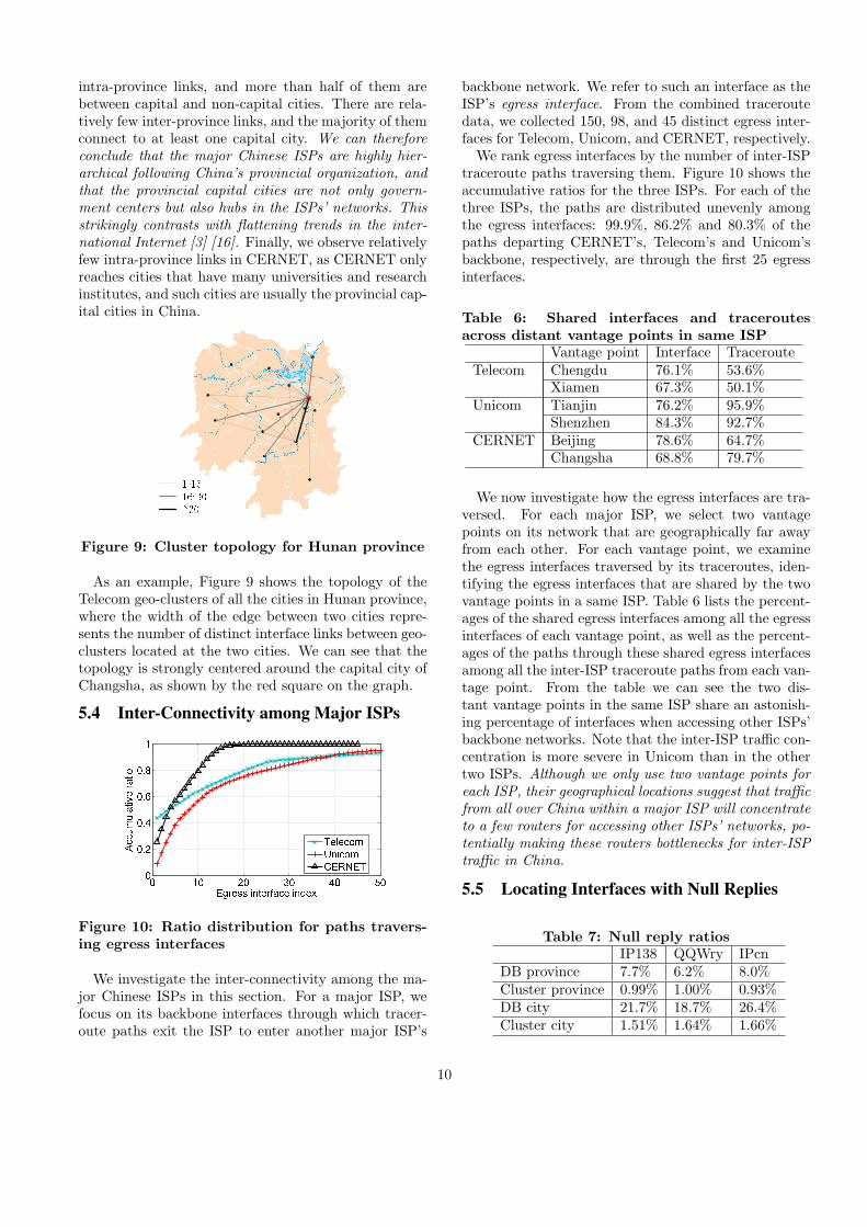
As an example, Figure 9 shows the topology of theTelecom geo-clusters of all the cities in Hunan province,where the width of the edge between two cities repre-sents the number of distinct interface links between geo-clusters located at the two cities. We can see that thetopology is strongly centered around the capital city ofChangsha, as shown by the red square on the graph.
5.4 Inter-Connectivity among Major ISPs
0 10 20 30 40 5000.20.40.60.81Egress interface indexAccumulative
ratio TelecomUnicomCERNETFigure 10: Ratio distribution for paths travers-ing egress interfaces
We investigate the inter-connectivity among the ma-jor Chinese ISPs in this section. For a major ISP, wefocus on its backbone interfaces through which tracer-oute paths exit the ISP to enter another major ISP’s
backbone network. We refer to such an interface as theISP’s egress interface. From the combined traceroutedata, we collected 150, 98, and 45 distinct egress inter-faces for Telecom, Unicom, and CERNET, respectively.We rank egress interfaces by the number of inter-ISP
traceroute paths traversing them. Figure 10 shows theaccumulative ratios for the three ISPs. For each of thethree ISPs, the paths are distributed unevenly amongthe egress interfaces: 99.9%, 86.2% and 80.3% of thepaths departing CERNET’s, Telecom’s and Unicom’sbackbone, respectively, are through the first 25 egressinterfaces.
Table 6: Shared interfaces and traceroutesacross distant vantage points in same ISP
Vantage point Interface TracerouteTelecom Chengdu 76.1% 53.6%
Xiamen 67.3% 50.1%Unicom Tianjin 76.2% 95.9%
Shenzhen 84.3% 92.7%CERNET Beijing 78.6% 64.7%
Changsha 68.8% 79.7%
We now investigate how the egress interfaces are tra-versed. For each major ISP, we select two vantagepoints on its network that are geographically far awayfrom each other. For each vantage point, we examinethe egress interfaces traversed by its traceroutes, iden-tifying the egress interfaces that are shared by the twovantage points in a same ISP. Table 6 lists the percent-ages of the shared egress interfaces among all the egressinterfaces of each vantage point, as well as the percent-ages of the paths through these shared egress interfacesamong all the inter-ISP traceroute paths from each van-tage point. From the table we can see the two dis-tant vantage points in the same ISP share an astonish-ing percentage of interfaces when accessing other ISPs’backbone networks. Note that the inter-ISP traffic con-centration is more severe in Unicom than in the othertwo ISPs. Although we only use two vantage points foreach ISP, their geographical locations suggest that trafficfrom all over China within a major ISP will concentrateto a few routers for accessing other ISPs’ networks, po-tentially making these routers bottlenecks for inter-ISPtraffic in China.
5.5 Locating Interfaces with Null Replies
Table 7: Null reply ratiosIP138 QQWry IPcn
DB province 7.7% 6.2% 8.0%Cluster province 0.99% 1.00% 0.93%DB city 21.7% 18.7% 26.4%Cluster city 1.51% 1.64% 1.66%
10

Each interface in an ISP’s interface topology has nowbeen assigned two locations: the geoIP database loca-tion and its cluster location (with the clusters derivedfrom the same database). In this section, we show thatthe cluster locations are significantly more complete andaccurate.We first examine the completeness by comparing the
null reply ratios. In this comparison, all the IP ad-dresses of the interfaces on Telecom, Unicom, and CER-NET’s interface topologies are included. Table 7 showsthe null reply ratios at the province and the city lev-els for both DB and cluster locations. Observe thatthe ratios for cluster locations are much smaller thanthose for the DB locations. The geoIP services give ahigh-level of null replies because many router addressesdo not have city-level or province-level locations in thedatabase. However, the cluster locations for many ofthese router interfaces have been inferred at the citylevel (by the voting in Steps 2 and 3 and by the merg-ing in Step 4).
Table 8: Number of the interfaces that have con-sistent locations
Total 3DB identical 3Cluster identicalTelecom 38,181 25,625 (67.1%) 35,376 (92.7%)Unicom 24,781 15,794 (63.7%) 21,938 (88.5%)CERNET 1,798 1,343 (74.7%) 1,602 (89.1%)Total 64,760 42,762 (66.0%) 58,916 (91.0%)
We now examine the accuracies of the DB and clusterlocations. Unfortunately, given the lack of landmarksfor router interfaces, it is not possible to say with 100%certainty whether a geoIP database location or a clus-ter location is correct. (However, we will be able to uselandmarks in Section 6 when we study end host geoloca-tion.) Instead, here we use cross validation to supportour claim that clustering approach is substantially moreaccurate than the geoIP databases for router interfaces.For an interface, if the locations from the three
databases are the same, it is likely that the locationis correct; if, however, all three databases do not givethe same location, then we have a low level of confidenceon the location information. Similarly, using the threesets of geo-clusters based on the three different geoIPdatabases, we can cross-validate the cluster locations.Table 8 shows for each of the three ISPs, the numberof the addresses that have consistent locations for thetwo approaches. We see that the three geoIP databasesagree only for 66.0% of the interfaces (average acrossthe three ISPs), but after applying the geo-clusteringheuristic, as many as 91.0% interfaces have the samecluster locations.In summary, for a hierarchical interface topology, we
propose a heuristic to geolocate the interfaces from tracer-oute measurements by forming geo-clusters. We apply
the heuristic to China’s Internet and provide evidencethat resulting large geo-clusters are essentially the max-imal clusters. The geo-clusters clearly expose China’shierarchical structure down to the city level. We also ob-serve a concentration of inter-ISP traffic at a relativelysmall number of interfaces. In addition, we show thatour heuristic can geolocate router interface addresseswith more detailed and accurate location informationthan can existing geoIP databases.
6. IMPROVING GEOLOCATION SERVICESWITH GEO-CLUSTERS
In the previous section, we showed how our method-ology can geolocate router interface addresses that havenull or erroneous entries in the geoIP databases. In thissection, we develop a methodology for accurately geolo-cating arbitrary Chinese IP addresses, including hostinterfaces. Our goal here is to provide a significant im-provement over the existing Chinese geoIP databases.
6.1 Geolocating an Arbitrary IP AddressOur methodology relies on the geo-clustering heuris-
tic described in Section 5.1. For a given IP address pthat we wish to geolocate, we first determine the ISPto which it belongs (e.g., by first determining the ASto which it belongs from BGP tables). This ISP has aninterface topology, say T , which we obtained from ourtraceroute data.To apply the geolocating algorithm in Section 5 to
an arbitrary IP address p, we need to first augmentT to reach p. This requires us to conduct additionaltraceroute probes. We choose a subset of existing van-tage points, each of which keeps a queue of targets tobe probed. For initialization, we put p into the tar-get queue of each vantage point. Then vantage pointsconduct traceroute probes by working through their tar-get queues: at each step, each vantage point dequeuesa target t and performs a traceroute to t. Along thetraceroute path, if there exists an interface i between Tand t for which there is no anonymous router betweenT and i, we insert i into the target queues of all thevantage points (except for the one that just returnedthis path). This process continues until the queues ofall the vantage points become empty.We then use the new traceroutes to augment the
topology T to create a new interface topology T ′ (us-ing Step 0 in the heuristic, as described in Section 5.1).Applying the geo-clustering heuristic to the new aug-mented topology T ′, we obtain a new set of geo-clusters.The location of p is then determined from these newgeo-clusters using one of the following three cases:
• Case 1: p is in the topology T ′ and therefore isincluded in one of the geo-clusters. In this case,we simply set p’s location to the location of thecluster that encompasses it.
11

• Case 2: p can be reached by at least one traceroutepath, but p is not in T ′ (due to the occurrence ofanonymous routers in the traceroute paths). Inthis case, we find the geo-cluster that is closest top among all the traceroute paths, which we refer toas the last-hop geo-cluster. If the distance betweenthe last-hop geo-cluster and p is no larger than athreshold (2 hops in our evaluation), we set p’slocation to the location of the last-hop geo-cluster.However, if there are multiple last-hop geo-clusterswith different cluster locations for p, then Step 2is inconclusive, and we proceed to Step 3.
• Case 3: If we don’t set p’s location in Case 1 and2, the location from the geoIP database is used.
6.2 Evaluation
6.2.1 Collecting LandmarksWe use a number of landmarks as the ground truth
for evaluating the accuracies of the geoIP databases andof our methodology. Generally it is difficult to obtainground truth landmarks, particularly for China’s Inter-net, as many websites are hosted by IDCs, includinguniversity and government websites (which are oftenused as landmarks in other studies [20] [29]). In thispaper, we leverage the numerous IDC datacenters lo-cated in many cities in China, for collecting the land-marks. For a datacenter, we find one or more of its IPaddresses, and associate the datacenter’s location withthe IP addresses to get landmarks.We combine the IDC datacenter IP addresses we have
found from the websites listed on www.IDCquan.netand the mirror servers of the popular software down-loading site onlinedown.net to collect IDC datacenterlandmarks. We have successfully collected 305 land-marks – 199 on Telecom and 106 on Unicom – withtheir ground-truth locations detailed to the city level.
6.2.2 Evaluation Results
Table 9: Evaluation using Telecom landmarksCase 1 Case 2 Case 3 Total
IP138 DB 105/115 11/15 56/69 172/199Improve 110/115 15/15 56/69 181/199
QQWry DB 107/117 11/15 54/67 172/199Improve 111/117 14/15 54/67 179/199
IPcn DB 102/117 11/15 57/67 170/199Improve 111/117 14/15 57/67 182/199
MaxMind DB N/A N/A N/A 85/199
We use ten vantage points located in seven differentcities to geolocate the 305 landmarks. Our methodologyrequires us to probe a few additional addresses for eachlandmark to extend the interface topology. For each
landmark, 4 additional probes from each vantage pointwere required on average.
Table 10: Evaluation using Unicom landmarksCase 1 Case 2 Case 3 Total
IP138 DB 46/55 9/10 34/41 89/106Improve 52/55 9/10 34/41 95/106
QQWry DB 48/55 8/8 33/43 89/106Improve 53/55 8/8 33/43 94/106
IPcn DB 44/55 8/10 28/41 80/106Improve 52/55 9/10 28/41 89/106
MaxMind DB N/A N/A N/A 57/106
For each landmark, we compare the location deter-mined by our geo-clustering methodology and the lo-cation from the corresponding geoIP database with thelandmark’s ground truth location. The number of thelandmarks that are accurately located by the differentmethods are shown in Table 9 for Telecom landmarksand in Table 10 for Unicom landmarks. We further clas-sify the landmarks into three cases based on how theirlocations are determined by our methodology. As anexample, consider the case of Telecom and the IP138geoIP database. Of these 199 Telecom landmarks, 115fall into Case 1. Of these 115 landmarks, the IP138database correctly located 105; whereas our methodol-ogy (using the same location database) correctly located110. We also evaluate the MaxMind database, and findthat MaxMind is inaccurate comparing with the threeChinese databases.From Table 9 and Table 10, we see that for both
ISPs, our geo-clustering methodology can accurately ge-olocate more landmarks than can the geoIP databases.For the landmarks in Case 1 and Case 2, we are able toaccurately geolocate over 7% more Telecom landmarksand over 10% more Unicom landmarks on average. Inaddition, more than 60% of the landmarks under eval-uation fall into case 1 and case 2, suggesting that ourmethodology can improve the geolocation services formany IP addresses in the Chinese Internet. Althoughthese improvements for locating end host IPs are notas dramatic as our results for locating router interfaceIPs, we believe that the improvements are neverthelesssignificant and useful.In addition to improved accuracy, a less obvious ben-
efit of our methodology is that it provides a means forusers to assess the quality of the results returned fromgeoIP databases. Specifically, each geoIP database issignificantly more accurate for targets falling into Case1 or 2 than those falling into Case 3. Thus, when using ageoIP database, if the target falls into Case 1 or 2, theuser can be relatively confident about the result, butless confident when the target falls into Case 3. Fur-thermore, we find that when a geoIP database gives anaccurate result, our methodology always provides the
12

same result, with only one exception of a Unicom land-mark using the databases of IP138 and QQWry.For the landmarks belonging to Case 3, by examining
the traceroute paths to them, we find that the distancesbetween their last-hop geo-clusters and the traceroutetargets are larger than 2 hops, and many paths neverreach the landmarks. We remark that for an IP addressthat is unreachable with traceroute, or is far behindanonymous devices, it becomes difficult to geolocate forany traceroute-based mechanism.In summary, we have designed a traceroute-based
methodology for improving the Chinese geoIP databases.Our evaluation with ground-truth landmarks shows thatthe methodology provides more detailed and accurate lo-cation information, and also allows users to assign lev-els of confidence to the results returned from the geoIPdatabases. Finally, we point out that by improving theresults from IP138, QQWry, and IPcn, which are cur-rently considered as the best geoIP databases in China,we are indeed providing the (currently) best geolocationservice for China’s Internet.
7. RELATED WORKSpring et al. [26] propose Rocketfuel to probe ISPs’
networks with public traceroute servers. Rocketfuel im-proves measurement efficiency by avoiding traceroutesthrough the same ingress and egress interfaces of thetarget ISP. The iPlane project [14, 18] also uses a pub-lic platform composed of PlanetLab nodes and tracer-oute servers; it reduces the probing workload by re-ducing the targets with BGP atoms [1]. On the otherhand, CAIDA/Ark [2] works with dedicated monitors,dividing its monitors into teams for workload reduction.Several algorithms are proposed for improving the mea-surement efficiency on dedicated platforms: Donnet etal. [7] propose the Double Tree algorithm to avoid re-dundant probing packets by heuristically probing for-ward and backward to a vantage point and a targetfrom the mid-point. Beverly et al. [4] propose a schemethat optimally selects the probing packets that can fullycover the entire interface topology obtained in the pre-vious measurement cycle. Our collaborative tracerout-ing scheme differs from these works in that it is moresuitable for a public platform of PlanetLab nodes andtraceroute servers, and is more effective than the ap-proaches used in Rocketfuel and iPlane; in particular,our approach avoids probes if an earlier interface pathwas found from the vantage point to the target. In ad-dition, we leverage the block nesting in BGP snapshots[30] to improve the measurement coverage without in-troducing many unnecessary targets.For mapping the Internet, interfaces are typically clus-
tered to routers and PoPs in order to reveal the Inter-net structure [26, 14, 2, 24]. However, router and PoPclusterings typically rely on having numerous vantage
points and on the ability to reverse DNS router inter-face IPs, both of which are unavailable in China’s Inter-net. In this work, we instead group the interfaces intogeo-clusters, which reveals the internal structure of themajor Chinese ISPs.Many automatic IP address geolocation techniques
based on landmarks and active delay measurement havebeen proposed in recent years [20, 10, 15, 8, 29]. How-ever, Li et al. [17] show that the delay-distance correla-tion, which is a foundation for many delay measurementbased geolocation techniques, is weak in China’s Inter-net. Shavitt et al. [25] propose to use PoP-level topolo-gies, which are derived from delay measurements [24],to compare and evaluate geoIP database services. Inthis paper, we exploit the location information in geoIPdatabases to cluster the interfaces from a traceroutemeasurement; we then use the resulting geo-clusters toimprove the completeness and accuracy of these databases.There have only been a few studies focused on China’s
Internet. Guo et al. propose Structon [11], which minesand extracts location information from web pages in or-der to provide a geolocation service within China. Ourapproach differs from Structon in that we first obtain in-terface topologies from traceroute measurements, thencombine the interface topology with the partially cor-rect locations from commercial geoIP databases. Struc-ton uses a prefix partitioning rule and location voting.We instead use traceroutes, which directly reveal theunderlying network structure, to infer IP addresses’ lo-cations; also, instead of using locations found on web-pages, we use commercial geoIP databases that providericher and more accurate location information to driveour heuristic.
8. CONCLUSIONChina’s Internet has received relatively little atten-
tion in the measurement community to date. In this pa-per, we carried out a large-scale topology mapping andgeolocation study for China’s Internet. We first devel-oped two traceroute techniques, namely, nested-blockpartitioning and collaborative tracerouting, to compre-hensively and efficiently probe China’s Internet from asmall number of vantage points inside China. Our ap-proach is able to discover many more interfaces withsignificantly fewer traceroute probes than the existingtraceroute schemes. By further exploiting the hierar-chical structure of China’s Internet, we proposed a geo-clustering heuristic that clusters interfaces within thesame city. We show that the clustering heuristic can ge-olocate IP addresses with significantly more detail andaccuracy than can the existing geoIP databases in iso-lation.
9. REFERENCES[1] Y. Afek, O. Ben-Shalom, and A. Bremler-Barr.
13

On the structure and application of BGP policyatoms. In Proc. of the 2nd SIGCOMM Workshopon Internet Measurment, Marseille, France, Nov.2002.
[2] Archipelago measurement infrastructure.http://www.caida.org/projects/ark/.
[3] B. Augustin, B. Krishnamurthy, andW. Willinger. IXPs: Mapped? In Proc. ofIMC’09, Chicago, IL, USA, Nov. 2009.
[4] R. Beverly, A. Berger, and G. G. Xie. Primitivesfor active internet topology mapping: Towardhigh-frequency characterization. In Proc. ofIMC’10, Melbourne, Australia, Nov. 2010.
[5] China Internet Network Information Center.Statistical report on Internet development inChina, Jan. 2011.
[6] P. Dhungel, K. W. Ross, M. Steiner, Y. Tian, andX. Hei. Xunlei: Peer-assisted downloadacceleration on a massive scale. Technical report,Polytechnic Institute of NYU, Apr. 2011.
[7] B. Donnet, P. Raoult, T. Friedman, andM. Crovella. Efficient algorithms for large-scaletopology discovery. In Proc. of SIGMETRICS’05,Banff, Alberta, Canada, Jun. 2005.
[8] B. Eriksson, P. Barford, J. Sommersy, andR. Nowak. A learning-based approach for IPgeolocation. In Proc. of PAM’10, Zurich,Switzerland, Apr. 2010.
[9] D. Feldman and Y. Shavitt. An optimal mediancalculation algorithm for estimating Internet linkdelays from active measurements. In Proc. ofWorkshop on End-to-End Monitoring Techniquesand Services, Munich, Germany, May 2007.
[10] B. Gueye, A. Ziviani, M. Crovella, and S. Fdida.Constraint-based geolocation of Internet hosts.IEEE/ACM Trans. Net., 14(6):1219 – 1232, 2006.
[11] C. Guo, Y. Liu, W. Shen, H. J. Wang, Q. Yu, andY. Zhang. Mining the web and the Internet foraccurate IP address geolocations. In Proc. ofINFOCOM’09, Rio de Janeiro, Brazil, Apr. 2009.
[12] IP138. http://www.ip138.com/.[13] IPcn. http://www.ip.cn/.[14] iPlane: An information plane for distributed
services. http://iplane.cs.washington.edu/.[15] E. Katz-Bassett, J. P. John, A. Krishnamurthy,
D. Wetherall, T. Anderson, and Y. Chawathe.Towards IP geolocation using delay and topologymeasurements. In Proc. of IMC’06, Rio deJaneiro, Brazil, Oct. 2006.
[16] C. Labovitz, S. Iekel-Johnson, D. McPherson,J. Oberheide, and F. Jahanian. Internetinter-domain traffic. In Proc. of SIGCOMM’10,New Delhi, India, Aug. 2010.
[17] D. Li, J. Chen, C. Guo, Y. Liu, J. Zhang,Z. Zhang, and Y. Zhang. IP-geolocation mapping
for involving moderately-connected Internetregions. Technical report, Microsoft, 2009.
[18] H. V. Madhyastha, T. Isdal, M. Piatek, C. Dixon,T. Anderson, A. Krishnamurthy, andA. Venkataramani. iPlane: An information planefor distributed services. In Proc. of OSDI’06,Seattle, WA, USA, Nov. 2006.
[19] MaxMind. http://www.maxmind.com/.[20] V. N. Padmanabhan and L. Subramanian. An
investigation of geographic mapping techniquesfor Internet host. In Proc. of SIGCOMM’01, SanDiego, CA, USA, Aug. 2001.
[21] QQWry. http://www.cz88.net/.[22] Routing information service.
http://www.ripe.net/data-tools/stats/ris/routing-information-service.
[23] University of Oregon route views project.http://www.routeviews.org/.
[24] Y. Shavitt and N. Zilberman. A structuralapproach for PoP geo-location. In Proc. ofINFOCOM Workshop on Network Science forCommunications (NetSciCom), San Diego, CA,USA, Mar. 2010.
[25] Y. Shavitt and N. Zilberman. A study ofgeolocation databases. Preprint,arXiv:1005.5674v3 [cs.NI], Jul. 2010.
[26] N. Spring, R. Mahajan, and D. Wetherall.Measuring ISP topologies with rocketfuel. InProc. of SIGCOMM’02, Pittsburgh, PA, USA,Aug. 2002.
[27] traceroute.org. http://www.traceroute.org/.[28] P. Uria-Recio. China telecommunications
panorama, 2006.http://globthink.com/2009/08/12/china-telecommunications-panorama/.
[29] Y. Wang, D. Burgener, M. Flores,A. Kuzmanovic, and C. Huang. Towardsstreet-level client-independent IP geolocation. InProc. of NSDI’11, Boston, MA, USA, Mar. 2011.
[30] Y. Zhu, J. Rexford, S. Sen, and A. Shaikh. Impactof prefix-match changes on IP reachability. InProc. of IMC’09, Chicago, IL, USA, Nov. 2009.
14