Embed Size (px)
Citation preview
China’s Geography: A Boon or Bane? 2 of 29
http://www.vifindia.org © Vivekananda International Foundation
About the Author
Colonel Ashish Sirsikar is a Senior Research Fellow at the Vivekananda International
Foundation. He undertakes research in the field of National Security & Defence Studies
and specially focuses on China.
China’s Geography: A Boon or Bane? 3 of 29
http://www.vifindia.org © Vivekananda International Foundation
China’s Geography: A Boon or Bane?
The Factor of Geography
Well before China arose, its inherent geographical potential had been studied
and commented upon by many. However, the true potential of Chinese geography was
recognised by the English geographer Sir HJ Mackinder in his famous 1904 article, ‘The
Geographical Pivot of History’1in which he posited that the Chinese, should they expand
their power well beyond their borders, “might constitute the yellow peril to the world’s
freedom just because they would add an oceanic frontage to the resources of the great
continent, an advantage as yet denied to the Russian tenant of the pivot region”.
Mackinder’s assertion was based on the indisputable premise that, whereas Russia,
basically was and still is a land power with an oceanic front blocked by ice, China owing
to its large temperate coastline was both a land power and sea power. Subsequently,
Mackinder in his widely read and acclaimed piece ‘Democratic Ideals and Reality’
hadpredicted that, along with the United States and the United Kingdom, China would
eventually guide the world by ‘building for a quarter of humanity a new civilization,
neither quite Eastern nor quite western’2. A century on, some feel that Mackinder’s
prophetic pronouncementsare turning into a reality and China’s geography is its
greatest boon.
However, there are others who feel that China’s geography has resulted in China
suffering from external aggression. These commentaries find their basis on account of
China suffering a ‘Century of Humiliation’ which came across the oceans as well as the
fact that, earlier, the Mongols invaded China over the land frontiers.
By the turn of this Century though, China’s rise was clearly evident to all and
subsequently, over the next decade and a half seen to be assuming aggressive contours.
As a consequence, the jury was out again contesting whether, China’s geography in any
way contributed to its rise or present behaviour. Connected to this, one can’t help but
recall what Napoleon had famously said, “The policies of such states are inherent in
their geography”. It would be thus worth its while to study and analyse the ways in
which China’s geographycould shape its future policies.
China’s Interaction with the World
Contemporary analysts have viewed China as “Island”.3Such an assertion is not
made on account of it being surrounded by water (which borders only its eastern flank)
but on account of it being bordered on the other three sides by terrain that is difficult to
1HJ Mackinder, “The Geographical pivot of History”, The Geographical Journal, Apr 1904,
http://intersci.ss.uci.edu/wiki/eBooks/Articles/1904%20HEARTLAND%20THEORY%20HALFORD%20MACKINDER.pdf 2Robert D Kaplan, “The Geography of Chinese Power”, Foreign Affairs, May 2010,
https://www.foreignaffairs.com/articles/china/2010-05-01/geography-chinese-power 3 “The Geopolitics of China: A Great Power Enclosed”, Stratfor, March 2012,
https://www.stratfor.com/sample/analysis/geopolitics-china-great-power-enclosed
China’s Geography: A Boon or Bane? 4 of 29
http://www.vifindia.org © Vivekananda International Foundation
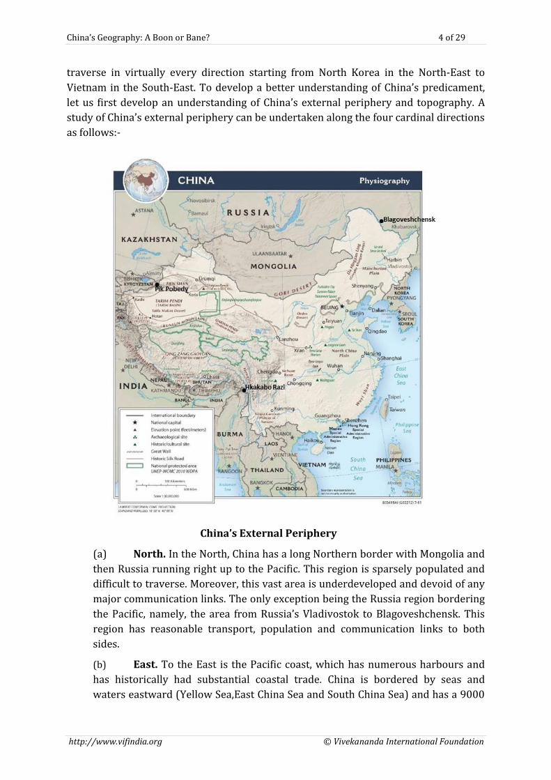
traverse in virtually every direction starting from North Korea in the North-East to
Vietnam in the South-East. To develop a better understanding of China’s predicament,
let us first develop an understanding of China’s external periphery and topography. A
study of China’s external periphery can be undertaken along the four cardinal directions
as follows:-
China’s External Periphery
(a) North. In the North, China has a long Northern border with Mongolia and
then Russia running right up to the Pacific. This region is sparsely populated and
difficult to traverse. Moreover, this vast area is underdeveloped and devoid of any
major communication links. The only exception being the Russia region bordering
the Pacific, namely, the area from Russia’s Vladivostok to Blagoveshchensk. This
region has reasonable transport, population and communication links to both
sides.
(b) East. To the East is the Pacific coast, which has numerous harbours and
has historically had substantial coastal trade. China is bordered by seas and
waters eastward (Yellow Sea,East China Sea and South China Sea) and has a 9000
China’s Geography: A Boon or Bane? 5 of 29
http://www.vifindia.org © Vivekananda International Foundation
mile temperate coastline. Prior to the 19th century, China had not suffered any
naval threat and hence had little interest on building a navy. However, over the
last two centuries, major incursions into China have been through this very coast
viz by the Japanese and the British. Historically, despite having a long coastline,
China has never been a maritime power. But, with the increasing integration of
Chinese economywith that of the World, China has laid greater emphasis on the
development of its coastal regions. Apart from this it has also been slowly but
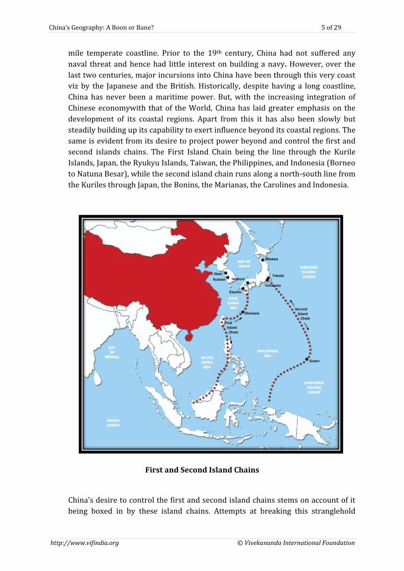
steadily building up its capability to exert influence beyond its coastal regions. The
same is evident from its desire to project power beyond and control the first and
second islands chains. The First Island Chain being the line through the Kurile
Islands, Japan, the Ryukyu Islands, Taiwan, the Philippines, and Indonesia (Borneo
to Natuna Besar), while the second island chain runs along a north-south line from
the Kuriles through Japan, the Bonins, the Marianas, the Carolines and Indonesia.
First and Second Island Chains
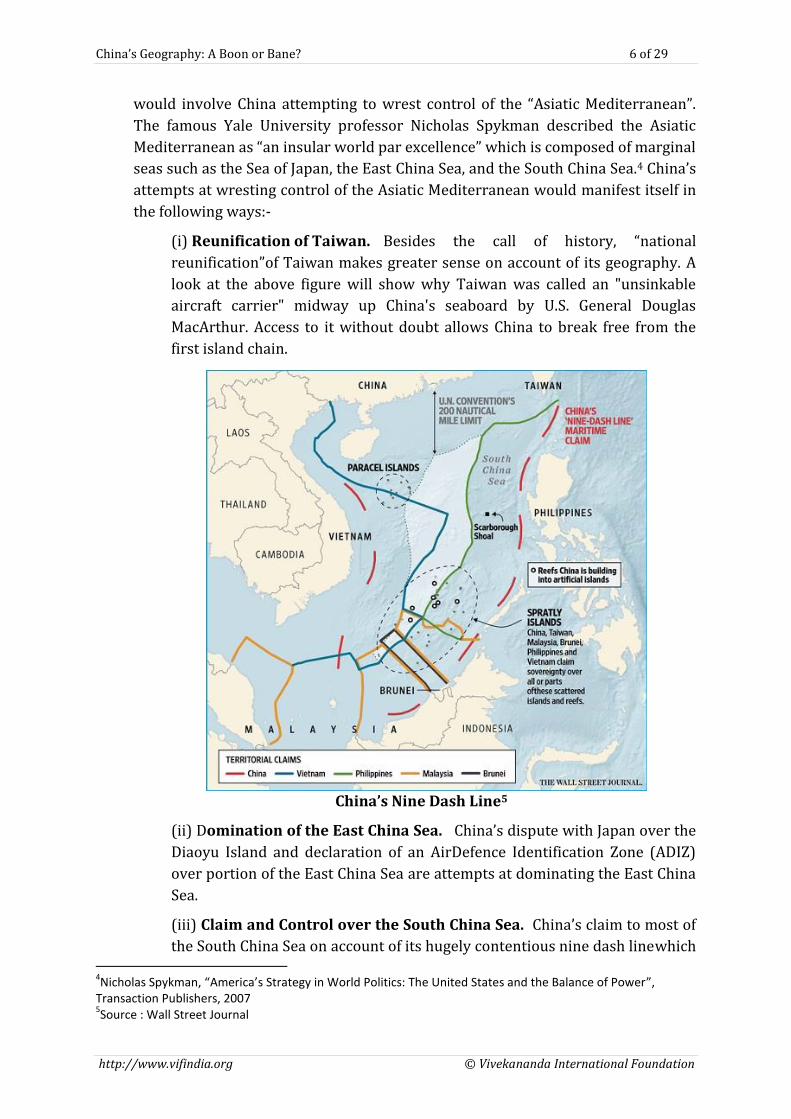
China’s desire to control the first and second island chains stems on account of it
being boxed in by these island chains. Attempts at breaking this stranglehold
China’s Geography: A Boon or Bane? 6 of 29
http://www.vifindia.org © Vivekananda International Foundation
would involve China attempting to wrest control of the “Asiatic Mediterranean”.
The famous Yale University professor Nicholas Spykman described the Asiatic
Mediterranean as “an insular world par excellence” which is composed of marginal
seas such as the Sea of Japan, the East China Sea, and the South China Sea.4 China’s
attempts at wresting control of the Asiatic Mediterranean would manifest itself in
the following ways:-
(i) Reunification of Taiwan. Besides the call of history, “national
reunification”of Taiwan makes greater sense on account of its geography. A
look at the above figure will show why Taiwan was called an "unsinkable
aircraft carrier" midway up China's seaboard by U.S. General Douglas
MacArthur. Access to it without doubt allows China to break free from the
first island chain.
China’s Nine Dash Line5
(ii) Domination of the East China Sea. China’s dispute with Japan over the
Diaoyu Island and declaration of an AirDefence Identification Zone (ADIZ)
over portion of the East China Sea are attempts at dominating the East China
Sea.
(iii) Claim and Control over the South China Sea. China’s claim to most of
the South China Sea on account of its hugely contentious nine dash linewhich 4Nicholas Spykman, “America’s Strategy in World Politics: The United States and the Balance of Power”,
Transaction Publishers, 2007 5Source : Wall Street Journal
China’s Geography: A Boon or Bane? 7 of 29
http://www.vifindia.org © Vivekananda International Foundation
is shown in the figure below is well known. If China were to be able to
control the South China Sea, besides negating the first island chain it would
also be able to dominate what most analysts refer to as the "second Persian
Gulf". This desire stems from what Nicholas Spykman calls the
"circumferential and transmarine expansion" which leads states to gain
control of adjacent seas. This as per him can be seen in Greece seeking
control over the Aegean, Rome over the Mediterranean, the United States
over the Caribbean - and now China over the South China Sea.6
(c) South. In the South, the border with Vietnam is the only border
readily traversable by large armies or capable of being utilised for mass
commerce. The rest of the southern border where Yunnan province meets Laos
and Myanmar is hilly jungle, difficult to traverse, with almost no major roads.
Significant movement across this border is almost impossible. Hkakabo Razi,
almost 19,000 feet high, marks the border between China Myanmar and India. At
this point, China’s southwestern frontier, anchored in the Himalayas, begins. More
precisely, it is where Tibet borders India and the two Himalayan states, Nepal and
Bhutan. This border runs in a long ark past Pakistan, Tajikistan and Kirgizstan,
ending at Pik Pobedy, a 25,000 feet mountain marking the border with China,
Kyrgyzstan and Kazakhstan. It is possible to pass through this border region with
difficulty; historically, parts of it have been accessible as a merchant route. On the
whole however, the Himalayas are a formidable barrier to substantial trade and
mass movements from North to South and vice versa.
(d) West. The one open passable corridor along the western border of China
is with Kazakhstan. This area is passable but has relatively little communication
routes as of now. This corridor is being developed as a main route between China
and the rest of Eurasia. The only problem is distance. The border with Kazakhstan
is almost thousand miles from the first tier of Han Chinese provinces, and the
route passes through sparsely populated Muslim territory of Xinjiang, a region
that has posed significant challenges to China. Historically, the Silk Road from
China ran through Xinjiang and Kazakhstan on its way west integrating the trading
communities of Europe and Far East7.
What though is most pertinent to note is that, barring India and Bhutan, China has
settled its territorial borders with all its other neighbours, sometimes even at a
disadvantage to itself. This gives China the ability to concentrate on its maritime
domain. At the same time though, if one ignores China’s maritime borders, China’s
interaction with the world is limited to a few areas only. As a result, despite containing a
fifth of the world’s population, China can either wall itself off from the rest of the
world(as it did prior to its economic boom) or conversely is forced to reach out to the
6NicholasSpykman, “America’s Strategy in World Politics: The United States and the Balance of Power”,
Transaction Publishers, 2007 7“The Geopolitics of China: A Great Power Enclosed”, Stratfor, March 2012,
https://www.stratfor.com/sample/analysis/geopolitics-china-great-power-enclosed
China’s Geography: A Boon or Bane? 8 of 29
http://www.vifindia.org © Vivekananda International Foundation
world across these limited access areas (as it is attempting now). However, this
notwithstanding, China’s geographical position gives it a distinct advantage. Sitting atop
the age old trade route, it enjoys a unique position of connecting energy rich CAR to the
Pacific Ocean. Geography provides China the unique opportunity of becoming both a
continental and maritime power
China’s Physical Topography
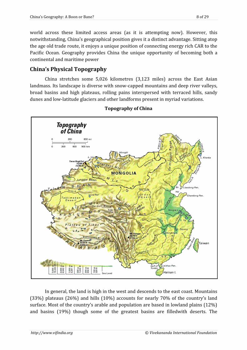
China stretches some 5,026 kilometres (3,123 miles) across the East Asian
landmass. Its landscape is diverse with snow-capped mountains and deep river valleys,
broad basins and high plateaus, rolling pains interspersed with terraced hills, sandy
dunes and low-latitude glaciers and other landforms present in myriad variations.
Topography of China
In general, the land is high in the west and descends to the east coast. Mountains
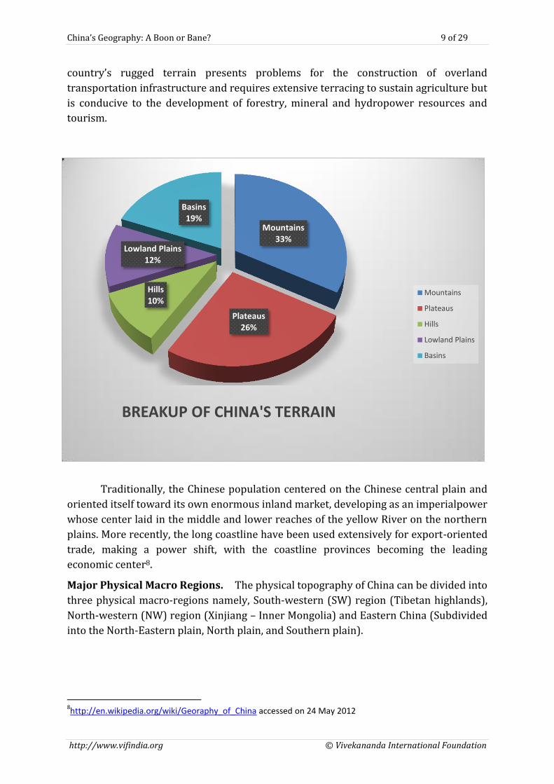
(33%) plateaus (26%) and hills (10%) accounts for nearly 70% of the country’s land
surface. Most of the country’s arable and population are based in lowland plains (12%)
and basins (19%) though some of the greatest basins are filledwith deserts. The
China’s Geography: A Boon or Bane? 9 of 29
http://www.vifindia.org © Vivekananda International Foundation
country’s rugged terrain presents problems for the construction of overland
transportation infrastructure and requires extensive terracing to sustain agriculture but
is conducive to the development of forestry, mineral and hydropower resources and
tourism.
Traditionally, the Chinese population centered on the Chinese central plain and
oriented itself toward its own enormous inland market, developing as an imperialpower
whose center laid in the middle and lower reaches of the yellow River on the northern
plains. More recently, the long coastline have been used extensively for export-oriented
trade, making a power shift, with the coastline provinces becoming the leading
economic center8.
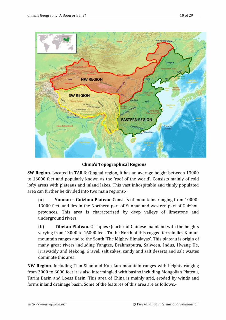
Major Physical Macro Regions. The physical topography of China can be divided into
three physical macro-regions namely, South-western (SW) region (Tibetan highlands),
North-western (NW) region (Xinjiang – Inner Mongolia) and Eastern China (Subdivided
into the North-Eastern plain, North plain, and Southern plain).
8http://en.wikipedia.org/wiki/Georaphy_of_China accessed on 24 May 2012
Mountains 33%
Plateaus 26%
Hills 10%
Lowland Plains 12%
Basins 19%
BREAKUP OF CHINA'S TERRAIN
Mountains
Plateaus
Hills
Lowland Plains
Basins
China’s Geography: A Boon or Bane? 10 of 29
http://www.vifindia.org © Vivekananda International Foundation
China’s Topographical Regions
SW Region. Located in TAR & Qinghai region, it has an average height between 13000
to 16000 feet and popularly known as the ‘roof of the world’. Consists mainly of cold
lofty areas with plateaus and inland lakes. This vast inhospitable and thinly populated
area can further be divided into two main regions:-
(a) Yunnan – Guizhou Plateau. Consists of mountains ranging from 10000-
13000 feet, and lies in the Northern part of Yunnan and western part of Guizhou
provinces. This area is characterized by deep valleys of limestone and
underground rivers.
(b) Tibetan Plateau. Occupies Quarter of Chinese mainland with the heights
varying from 13000 to 16000 feet. To the North of this rugged terrain lies Kunlun
mountain ranges and to the South ‘The Mighty Himalayas’. This plateau is origin of
many great rivers including Yangtze, Brahmaputra, Salween, Indus, Hwang He,
Irrawaddy and Mekong. Gravel, salt sakes, sandy and salt deserts and salt wastes
dominate this area.
NW Region. Including Tian Shan and Kun Lun mountain ranges with heights ranging
from 3000 to 6000 feet it is also intermingled with basins including Mongolian Plateau,
Tarim Basin and Loess Basin. This area of China is mainly arid, eroded by winds and
forms inland drainage basin. Some of the features of this area are as follows:-
China’s Geography: A Boon or Bane? 11 of 29
http://www.vifindia.org © Vivekananda International Foundation
(a) Tarim Basin. Between great Kunlun ranges (also known as the Pamirs of
the west) to the South and Tien Shan (celestial mountains) to the North lies
Tarim Basin with the average elevation of about 3000 feet. A number of rivers
rise from these mountain ranges and loose themselves in the Taklimakan desert,
one of the world’s most barren deserts, situated in this basin. Lop Nor, the
Chinese Nuclear blast sites lie in this area.
(b) Dzungarian Basin. To the North of Tien Shan mountains lies the
Dzungarian Basin. It consists of plain deserts with elevation of about 1500 feet
sloping to the South-West. Most parts of this basin are covered with Barchans i.e.
crescent shaped moving sand dunes.
(c) Tien Shan Mountains. This massive mountain range forms the North-
West boundary of China with Kazakhstan. With an average height of 13000 to
15000 feet, the western most part is covered with glaciers and is source of river
systems with vast drainage area. Lower slopes are characterised by large alpine
meadows and some of China’s best grazing grounds.
Schematic Representation of Mountains and Deserts in China9
9 Source: Asia for Educators, Columbia University, 2009, http://afe.easia.columbia.edu
China’s Geography: A Boon or Bane? 12 of 29
http://www.vifindia.org © Vivekananda International Foundation
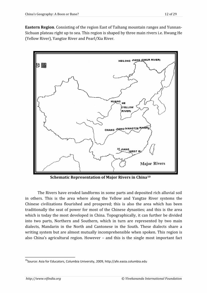
Eastern Region. Consisting of the region East of Taihang mountain ranges and Yunnan-
Sichuan plateau right up to sea. This region is shaped by three main rivers i.e. Hwang He
(Yellow River), Yangtze River and Pearl/Xia River.
Schematic Representation of Major Rivers in China10
The Rivers have eroded landforms in some parts and deposited rich alluvial soil
in others. This is the area where along the Yellow and Yangtze River systems the
Chinese civilizations flourished and prospered; this is also the area which has been
traditionally the seat of power for most of the Chinese dynasties; and this is the area
which is today the most developed in China. Topographically, it can further be divided
into two parts, Northern and Southern, which in turn are represented by two main
dialects, Mandarin in the North and Cantonese in the South. These dialects share a
writing system but are almost mutually incomprehensible when spoken. This region is
also China’s agricultural region. However – and this is the single most important fact
10
Source: Asia for Educators, Columbia University, 2009, http://afe.easia.columbia.edu
China’s Geography: A Boon or Bane? 13 of 29
http://www.vifindia.org © Vivekananda International Foundation
about China – it has about one-third the arable land per person as compared to the rest
of the world11. This aspect will be discussed further later.
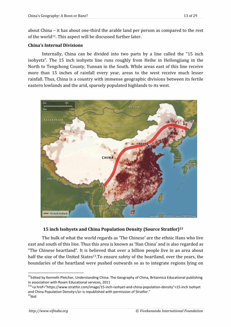
China’s Internal Divisions
Internally, China can be divided into two parts by a line called the “15 inch
isohyets”. The 15 inch isohyets line runs roughly from Heihe in Heilongjiang in the
North to Tengchong County, Yunnan in the South. While areas east of this line receive
more than 15 inches of rainfall every year, areas to the west receive much lesser
rainfall. Thus, China is a country with immense geographic divisions between its fertile
eastern lowlands and the arid, sparsely populated highlands to its west.
15 inch Isohyets and China Population Density (Source Stratfor)12
The bulk of what the world regards as ‘The Chinese’ are the ethnic Hans who live
east and south of this line. Thus this area is known as ‘Han China’ and is also regarded as
“The Chinese heartland”. It is believed that over a billion people live in an area about
half the size of the United States13.To ensure safety of the heartland, over the years, the
boundaries of the heartland were pushed outwards so as to integrate regions lying on
11
Edited by Kenneth Pletcher, Understanding China: The Geography of China, Britannica Educational publishing in association with Rosen Educational services, 2011 12
"<a href="https://www.stratfor.com/image/15-inch-isohyet-and-china-population-density">15-inch Isohyet and China Population Density</a> is republished with permission of Stratfor." 13
ibid
China’s Geography: A Boon or Bane? 14 of 29
http://www.vifindia.org © Vivekananda International Foundation
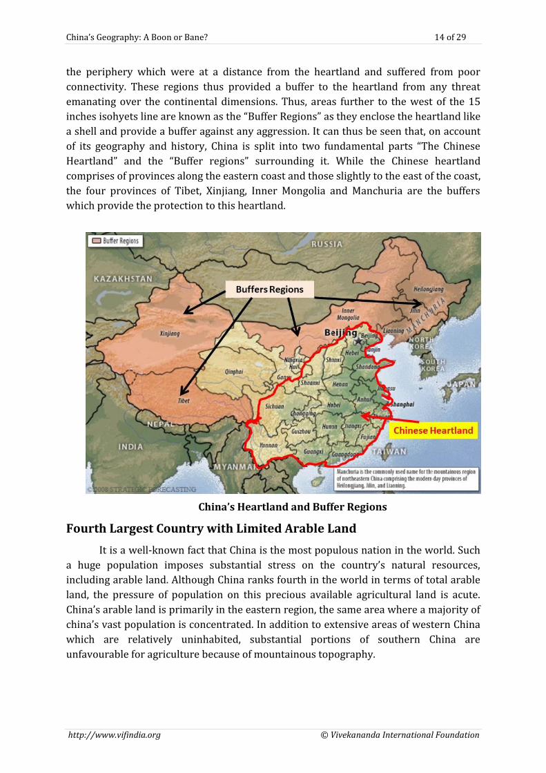
the periphery which were at a distance from the heartland and suffered from poor
connectivity. These regions thus provided a buffer to the heartland from any threat
emanating over the continental dimensions. Thus, areas further to the west of the 15
inches isohyets line are known as the “Buffer Regions” as they enclose the heartland like
a shell and provide a buffer against any aggression. It can thus be seen that, on account
of its geography and history, China is split into two fundamental parts “The Chinese
Heartland” and the “Buffer regions” surrounding it. While the Chinese heartland
comprises of provinces along the eastern coast and those slightly to the east of the coast,
the four provinces of Tibet, Xinjiang, Inner Mongolia and Manchuria are the buffers
which provide the protection to this heartland.
China’s Heartland and Buffer Regions
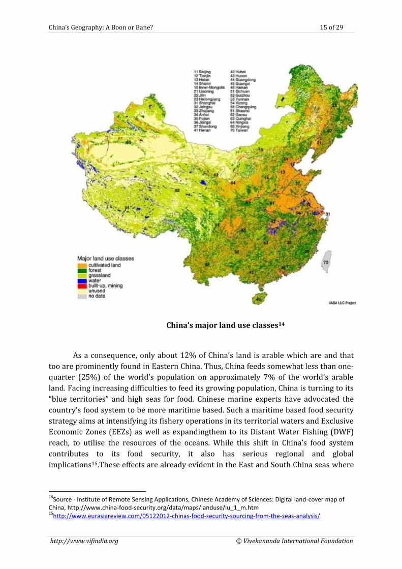
Fourth Largest Country with Limited Arable Land
It is a well-known fact that China is the most populous nation in the world. Such
a huge population imposes substantial stress on the country’s natural resources,
including arable land. Although China ranks fourth in the world in terms of total arable
land, the pressure of population on this precious available agricultural land is acute.
China’s arable land is primarily in the eastern region, the same area where a majority of
china’s vast population is concentrated. In addition to extensive areas of western China
which are relatively uninhabited, substantial portions of southern China are
unfavourable for agriculture because of mountainous topography.
China’s Geography: A Boon or Bane? 15 of 29
http://www.vifindia.org © Vivekananda International Foundation
China’s major land use classes14
As a consequence, only about 12% of China’s land is arable which are and that
too are prominently found in Eastern China. Thus, China feeds somewhat less than one-
quarter (25%) of the world’s population on approximately 7% of the world’s arable
land. Facing increasing difficulties to feed its growing population, China is turning to its
“blue territories” and high seas for food. Chinese marine experts have advocated the
country’s food system to be more maritime based. Such a maritime based food security
strategy aims at intensifying its fishery operations in its territorial waters and Exclusive
Economic Zones (EEZs) as well as expandingthem to its Distant Water Fishing (DWF)
reach, to utilise the resources of the oceans. While this shift in China’s food system
contributes to its food security, it also has serious regional and global
implications15.These effects are already evident in the East and South China seas where
14
Source - Institute of Remote Sensing Applications, Chinese Academy of Sciences: Digital land-cover map of China, http://www.china-food-security.org/data/maps/landuse/lu_1_m.htm 15
http://www.eurasiareview.com/05122012-chinas-food-security-sourcing-from-the-seas-analysis/
China’s Geography: A Boon or Bane? 16 of 29
http://www.vifindia.org © Vivekananda International Foundation
the China’s search for maritime based food is one of the contributors to it aggressively
seeking sovereignty rights in these disputed waters.
A Restless Thirsty Dragon
China’s Water Crisis. China is struggling to stave off a serious water crisis by 2030. It
is estimated that, with water consumption soaring, per capita water resources in China
will drop to 1,760 cubic meters, perilously close to the 1,700 cubic metres which is an
internationally recognized benchmark for water shortages. The gravity of the problem
lies in the fact that, though China has adequate water resources, these are unevenly
distributed with the northern parts being water deficient while the southern parts are
water rich16.
As a consequence, China despite being the source country of the Yangtze,
Mekong, Yarlung- Tsangpo, Indus, Irrawaddy, Sutlej and the Salween Rivers, has a
tendency of exercising a fair degree of hydro-hegemony. On this account, Chinese
statistics speak for themselves. Two thirds of China’s 669 cities suffer from water
shortage and over 300 million lack access to clean drinking water. This grim picture has
been painted as “wherever there is a river, there is no water; wherever there is water, it
is heavily polluted”. Today, mining and processing of coal and electricity generation,
which is concentrated up North, account for a fifth of the national water consumption. It
is estimated that by 2020, China’s growing dependence on coal for primary energy is
will grow by an additional billion metric tons annually thus representing a 30 per cent
increase. This will create a significant geographical headache for the government as,
while the coal reserves are concentrated in the dry northern provinces of Gansu,
Ningxia, Shaanxi, Xinjiang and Inner Mongolia, the water to develop them is in the south.
To overcome this looming water crisis, China has gone back to what Mao had
said of overcoming China’s water problems “Since the south has a great deal of water,
and the north very little, we should borrow some of it.”17China has thus embarked upon
ambitious projects of damming Chinese rivers with the twin aims of producing
Hydroelectricity and reducing the carbon foot print as well as diversion of water to its
Northern water starved areas. One of the major projects amongst these is the South to
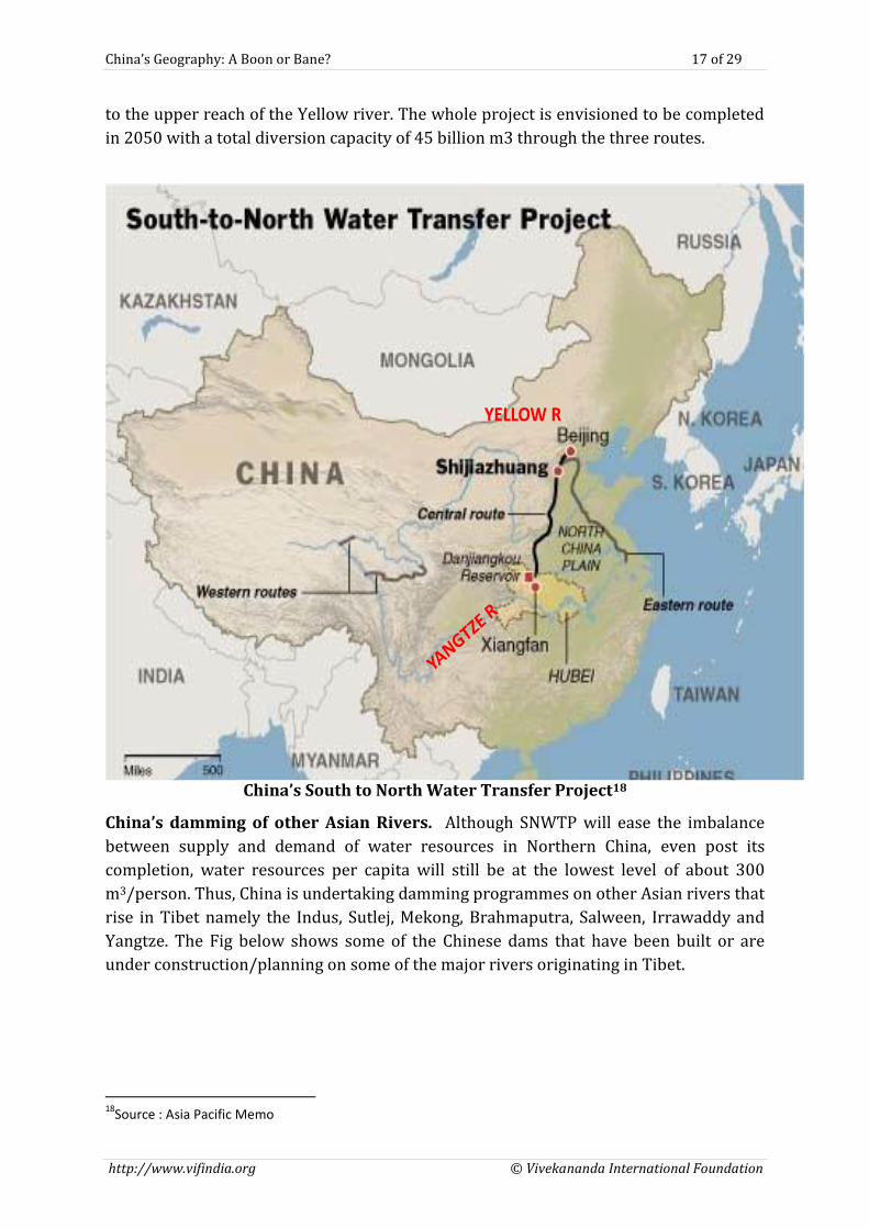
North Water Transfer Project (SNWTP) (nanshuibeidiaogongcheng).
South-North Water Transfer Project (SNWTP). The $62 Billion South-North Water
Transfer Project was launched in 2002 and is the largest water transfer system in the
world. It has three routes Eastern, Central and Western. The Eastern Route diverts
water from the lower reaches of the Yangtze River to the North, while the Central Route
mainly serves the domestic and industrial water requirements of Beijing, Tianjin and
cities in Hebei, Henan and Hubei provinces. The Western Route, which is in the
construction stage, diverts water from the upper reach tributaries of the Yangtze River
16
http://www.indepthnews.info/index.php/global-issues/983-china-prepares-to-avert-looming-water-crisis 17
Scott Moore, “China’s Massive Water Problem”, New York Times, March 2013, http://www.nytimes.com/2013/03/29/opinion/global/chinas-massive-water-problem.html?_r=0
China’s Geography: A Boon or Bane? 17 of 29
http://www.vifindia.org © Vivekananda International Foundation
to the upper reach of the Yellow river. The whole project is envisioned to be completed
in 2050 with a total diversion capacity of 45 billion m3 through the three routes.
YELLOW R
China’s South to North Water Transfer Project18
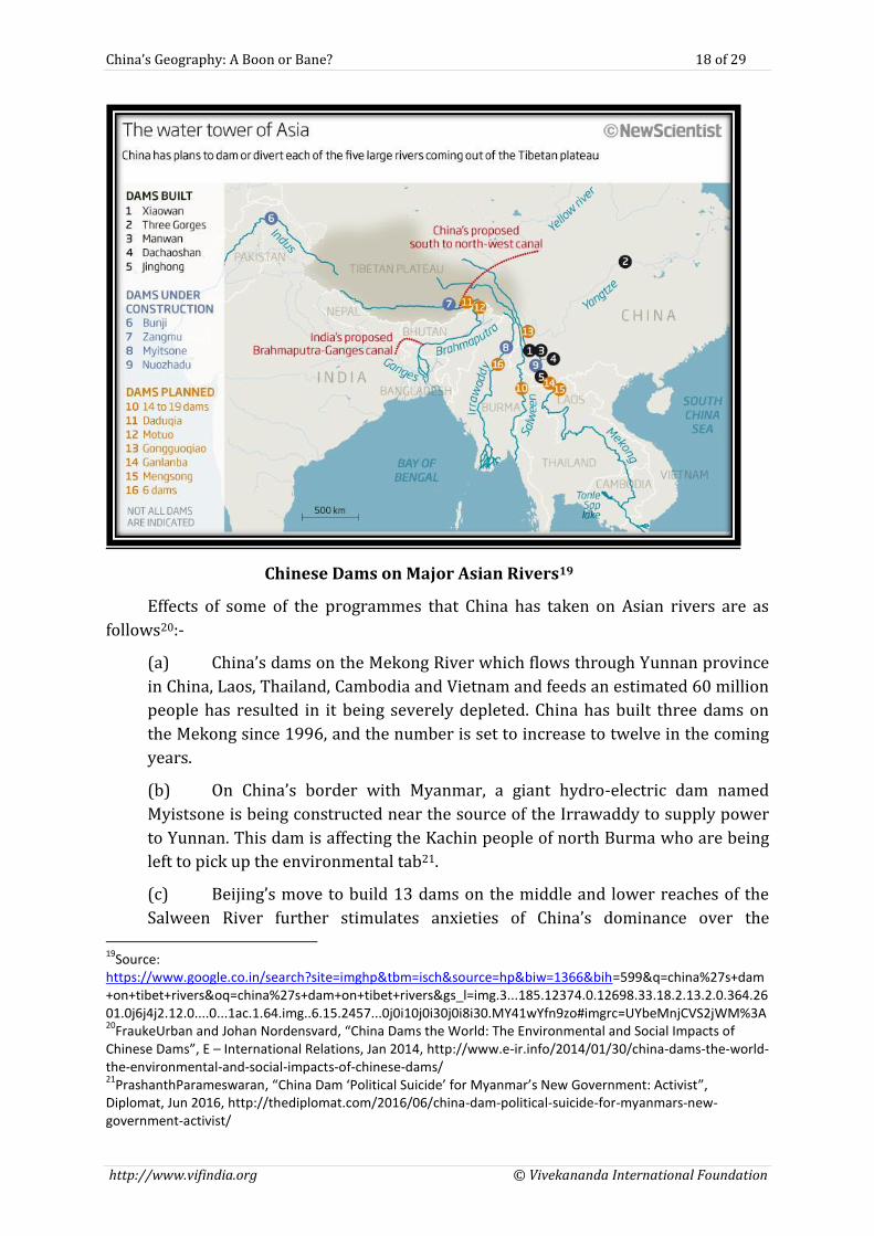
China’s damming of other Asian Rivers. Although SNWTP will ease the imbalance
between supply and demand of water resources in Northern China, even post its
completion, water resources per capita will still be at the lowest level of about 300
m3/person. Thus, China is undertaking damming programmes on other Asian rivers that
rise in Tibet namely the Indus, Sutlej, Mekong, Brahmaputra, Salween, Irrawaddy and
Yangtze. The Fig below shows some of the Chinese dams that have been built or are
under construction/planning on some of the major rivers originating in Tibet.
18
Source : Asia Pacific Memo
China’s Geography: A Boon or Bane? 18 of 29
http://www.vifindia.org © Vivekananda International Foundation
Chinese Dams on Major Asian Rivers19
Effects of some of the programmes that China has taken on Asian rivers are as
follows20:-
(a) China’s dams on the Mekong River which flows through Yunnan province
in China, Laos, Thailand, Cambodia and Vietnam and feeds an estimated 60 million
people has resulted in it being severely depleted. China has built three dams on
the Mekong since 1996, and the number is set to increase to twelve in the coming
years.
(b) On China’s border with Myanmar, a giant hydro-electric dam named
Myistsone is being constructed near the source of the Irrawaddy to supply power
to Yunnan. This dam is affecting the Kachin people of north Burma who are being
left to pick up the environmental tab21.
(c) Beijing’s move to build 13 dams on the middle and lower reaches of the
Salween River further stimulates anxieties of China’s dominance over the 19
Source: https://www.google.co.in/search?site=imghp&tbm=isch&source=hp&biw=1366&bih=599&q=china%27s+dam+on+tibet+rivers&oq=china%27s+dam+on+tibet+rivers&gs_l=img.3...185.12374.0.12698.33.18.2.13.2.0.364.2601.0j6j4j2.12.0....0...1ac.1.64.img..6.15.2457...0j0i10j0i30j0i8i30.MY41wYfn9zo#imgrc=UYbeMnjCVS2jWM%3A 20
FraukeUrban and Johan Nordensvard, “China Dams the World: The Environmental and Social Impacts of Chinese Dams”, E – International Relations, Jan 2014, http://www.e-ir.info/2014/01/30/china-dams-the-world-the-environmental-and-social-impacts-of-chinese-dams/ 21
PrashanthParameswaran, “China Dam ‘Political Suicide’ for Myanmar’s New Government: Activist”, Diplomat, Jun 2016, http://thediplomat.com/2016/06/china-dam-political-suicide-for-myanmars-new-government-activist/
China’s Geography: A Boon or Bane? 19 of 29
http://www.vifindia.org © Vivekananda International Foundation
hydrological contours of South Asia as downstream states, Myanmar and Thailand
do not possess the means to directly and physically influence the flow22.
(d) As far as Brahmaputra River (Tsang Po in Chinese) in concerned, a 38 GW
dam at Motuoat the Great Bend is planned with other large infrastructure- based
hydro projects which are set to majorly alter the riverscape23. Experts believe that
the 38 GW dam is not primarily designed to generate electrical power for Tibet as
there is no electrical load requirements in the south-eastern part of Tibet. It is felt
that this project has been designed with an eye on fuelling the Eastern economic
provinces of China.
(e) Brahmaputra Water Diversion. But, the real concern for the
downstream regions does not stem from generation of hydro-electricity but from
a proposal aimed at diverting 200 billion cubic meters of water from the
Brahmaputra to the Yellow River for easing existing water shortages in cities of
Shaanxi, Beijing and Tianjin in Northern China. This proposal is separate from the
great SNWTP Project. Although this project raises concerns, sceptics of the same
feel that the cost of diverting Brahmaputra’s water would be higher than the
common alternative of desalination of sea water. Therefore, China’s
implementation of thismassivediversion project is still not a certainty24.
From the above it evident that the prospects of a solution being found to China’s
water crisis looks to be extremely bleak. Thus, in the future, it is more than likely that
China’s relentless quest for water will lead to a greater level of hydro hegemony on its
part.
China’s Geographical Dilemma: “Be Rich” or “Maintain Control”
China is more enclosed than any other great power. The size of its population
coupled with its secure frontiers and relative availability of resources, allows it to
develop with minimal interaction with the rest of the world, as it did prior to the
19thCentury. However, an insularChina is a recipe for poverty. Given the ratio of arable
land to population, a self-enclosed China will always remain a poor China.
For China to prosper, it has to engage in trade. However such a trade comes with
its consequences. China’s mid-19th century trade with the British opened a new chapter
in its history. For the first time, the Pacific coast was the interface with the world not
Central Asia. This in turn, massively destabilized China. As trade between China and the
world intensified, the Chinese who were engaged in trading increased their wealth
dramatically. Those in the coastal provinces of China, the region most deeply involved in
trading, became relatively wealthy while the Chinese in the interior (not the buffer
22
Stephen C. McCaffrey &MpanziSinjela, (1998), The 1997 United Nations Convention on International Watercourses, American Journal of International Law 92, no.1, pp 97-107 23
Jonathan Watts, “Chinese Engineers propose world’s biggest hydroelectric project in Tibet”, The Guardian, May 2010, https://www.theguardian.com/environment/2010/may/24/chinese-hydroengineers-propose-tibet-dam 24
http:/goodpal.hubpages.com/hub/Hydro-Projects-in-Tibat-Thirsty-Dragon-Restless-Neighbors#
China’s Geography: A Boon or Bane? 20 of 29
http://www.vifindia.org © Vivekananda International Foundation
regions, which were always poor, but the non-coastal provinces of Han China) remained
poor subsistence farmers. More intense the trade, wealthier the coastal leadership and
greater the disparity between the regions.
However as trade increased, foreigners allied with Chinese coastal merchants
and politicians thus becoming more powerful than the central government. The worst
geopolitical nightmare of China came true. China fragmented, breaking into regions,
some increasingly under the control of foreigners, particularly foreign commercial
interests. On the whole, Beijing lost control over the regions.
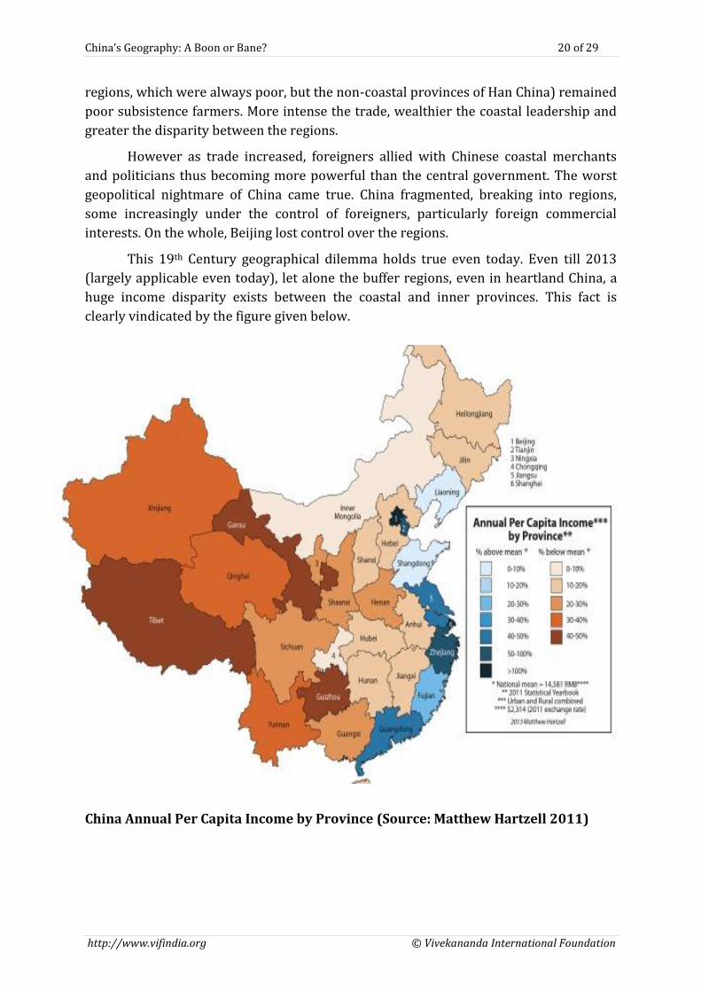
This 19th Century geographical dilemma holds true even today. Even till 2013
(largely applicable even today), let alone the buffer regions, even in heartland China, a
huge income disparity exists between the coastal and inner provinces. This fact is
clearly vindicated by the figure given below.
China Annual Per Capita Income by Province (Source: Matthew Hartzell 2011)
China’s Geography: A Boon or Bane? 21 of 29
http://www.vifindia.org © Vivekananda International Foundation
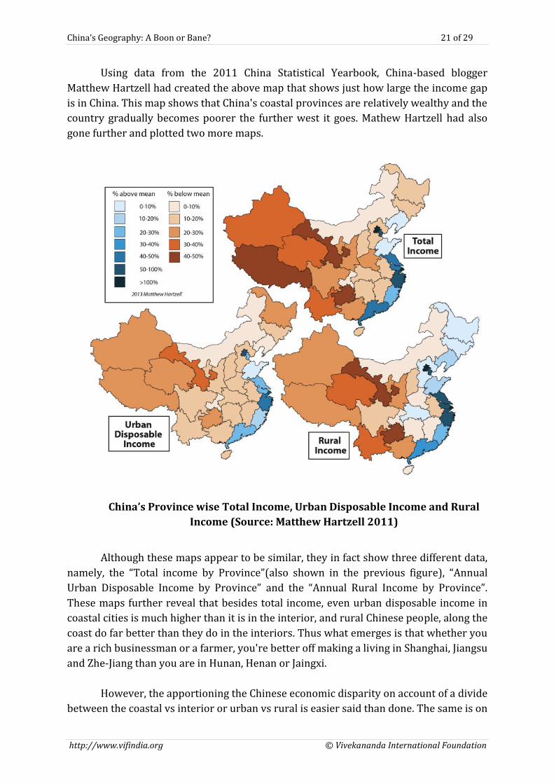
Using data from the 2011 China Statistical Yearbook, China-based blogger
Matthew Hartzell had created the above map that shows just how large the income gap
is in China. This map shows that China's coastal provinces are relatively wealthy and the
country gradually becomes poorer the further west it goes. Mathew Hartzell had also
gone further and plotted two more maps.
China’s Province wise Total Income, Urban Disposable Income and Rural
Income (Source: Matthew Hartzell 2011)
Although these maps appear to be similar, they in fact show three different data,
namely, the “Total income by Province”(also shown in the previous figure), “Annual
Urban Disposable Income by Province” and the “Annual Rural Income by Province”.
These maps further reveal that besides total income, even urban disposable income in
coastal cities is much higher than it is in the interior, and rural Chinese people, along the
coast do far better than they do in the interiors. Thus what emerges is that whether you
are a rich businessman or a farmer, you're better off making a living in Shanghai, Jiangsu
and Zhe-Jiang than you are in Hunan, Henan or Jaingxi.
However, the apportioning the Chinese economic disparity on account of a divide
between the coastal vs interior or urban vs rural is easier said than done. The same is on
China’s Geography: A Boon or Bane? 22 of 29
http://www.vifindia.org © Vivekananda International Foundation
account of its internal migration. It is estimated that over 100 million people internally
migrate each year within the country for a better living. While doing so a ‘Hukou’, a
household registration document that functions as an internal passport is required.
Chinese migrants are only eligible to retain social benefits in their city of origin.
Therefore, those who migrate internally are essentially undocumented workers and do
not count toward municipal economic statistics. Thus Chinese economic statistics don't
accurately account for internal migration. Hence the income of Beijing or Shanghai is
actually lesser than what appears simply because so many of its migrant workers
technically "live" elsewhere. That said simple statistics cannot be ignored. It is
estimated that in 2009, China’s 12 coastal provinces (out of 31) accounted for 65% of
the country’s GDP, and had a collective per capita GDP 50% higher than the national
average.25
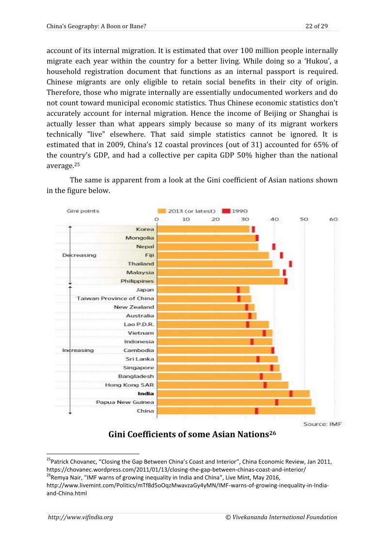
The same is apparent from a look at the Gini coefficient of Asian nations shown
in the figure below.
Gini Coefficients of some Asian Nations26
25
Patrick Chovanec, “Closing the Gap Between China’s Coast and Interior”, China Economic Review, Jan 2011, https://chovanec.wordpress.com/2011/01/13/closing-the-gap-between-chinas-coast-and-interior/ 26
Remya Nair, “IMF warns of growing inequality in India and China”, Live Mint, May 2016, http://www.livemint.com/Politics/mTf8d5oOqzMwavzaGy4yMN/IMF-warns-of-growing-inequality-in-India-and-China.html
China’s Geography: A Boon or Bane? 23 of 29
http://www.vifindia.org © Vivekananda International Foundation
The Gini Index is a statistical measure that is used to represent unequal
distributions, e.g. income distribution. Gini coefficient is a widely used measure of
inequality and takes into account income distribution among residents of a country. The
higher the Gini coefficient, the greater is the inequality. It can take any value between 1
and 100 points (or 0 and 1). The closer the value is to 100 the greater is the inequality.
40 or 0.4 is the warning level set by the United Nations. It is evident that from the
1990’s level, Chinese income disparities are much higher and at worrying levels.
As a consequence, China’s primary geopolitical dilemma is how to achieve its
China Dream without compromising on the authority of the CPC? The China dream
looks at raising the standard of living of all Chinese by promising prosperity for all. For
this to happen, China must engage in international trade. For it do so, it must use its
coastal cities as an interface with the world. When that happens, the coastal cities and
the surrounding regions become increasingly wealthy. The influence of foreigners over
this region increases and the interests of foreigners and the coastal Chinese provinces
start converging. As a consequence, they begin to compete with the interests of the
central government. This in turn weakens the central government and as a consequence
there is a threat of instability being caused in the Chinese heartland. The most
disturbing part is that an unstable heartland allows the buffer regions to spin out of
control. Thus, China’s geographical dilemma relates to engaging in international trade
and yet maintaining internal harmony. This fact has always been recognised and Beijing
has followed a major “Go West” campaign of public investments for the Far West. The
fact that this dilemma still exists was evident when, recently in Jul 2016, Chinese
President Xi Jinping, while presiding over a symposium on poverty alleviation in
Yinchuan, China's Ningxia Hui Autonomous Region had stressed upon the necessity of
pairing and cooperation between the eastern and western regions. Elaborating upon the
same he had brought out that, China has been using this strategy for the last 20 years
and the widening gap between the east and west had been curbed to a great extent due
to this. Also, "significant progress" in poverty alleviation of the poor western areas and
old revolutionary base areas had been made. He had therefore called for "Cooperation
between paired eastern and western regions in poverty alleviation to continue for a
long time".27
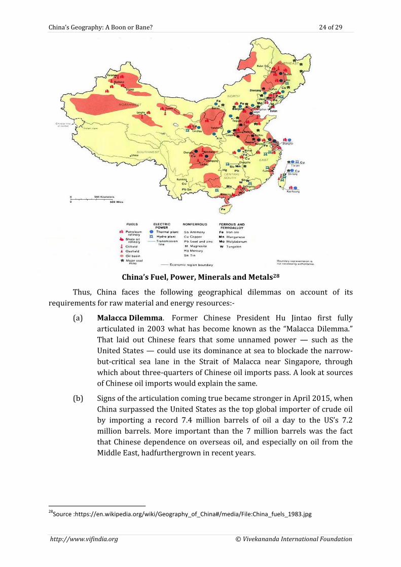
China’s Physical Resources. For many years the juggernaut of Chinese export oriented
economy required a continuous supply of raw material and energy resources. Of late,
though the requirements for the same have reduced, China still requires a sizeable
quantum of physical resources for its economic growth. Physically, China has been
gifted with adequate raw material. The problem though lies in its exploitation as, most
of the raw material and oil lies in the restive Xinjiang region where communication and
lack of water hinders its exploitation.
27
Huaxia, “Xi orders China's developed east to better aid poor west”, Xinhua, Jul 2016, http://news.xinhuanet.com/english/2016-07/21/c_135530889.htm
China’s Geography: A Boon or Bane? 24 of 29
http://www.vifindia.org © Vivekananda International Foundation
China’s Fuel, Power, Minerals and Metals28
Thus, China faces the following geographical dilemmas on account of its
requirements for raw material and energy resources:-
(a) Malacca Dilemma. Former Chinese President Hu Jintao first fully
articulated in 2003 what has become known as the “Malacca Dilemma.”
That laid out Chinese fears that some unnamed power — such as the
United States — could use its dominance at sea to blockade the narrow-
but-critical sea lane in the Strait of Malacca near Singapore, through
which about three-quarters of Chinese oil imports pass. A look at sources
of Chinese oil imports would explain the same.
(b) Signs of the articulation coming true became stronger in April 2015, when
China surpassed the United States as the top global importer of crude oil
by importing a record 7.4 million barrels of oil a day to the US’s 7.2
million barrels. More important than the 7 million barrels was the fact
that Chinese dependence on overseas oil, and especially on oil from the
Middle East, hadfurthergrown in recent years.
28
Source :https://en.wikipedia.org/wiki/Geography_of_China#/media/File:China_fuels_1983.jpg
China’s Geography: A Boon or Bane? 25 of 29
http://www.vifindia.org © Vivekananda International Foundation
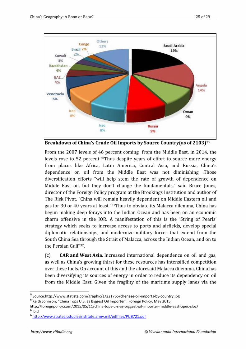
Breakdown of China's Crude Oil Imports by Source Country(as of 2103)29
From the 2007 levels of 46 percent coming from the Middle East, in 2014, the
levels rose to 52 percent.30Thus despite years of effort to source more energy
from places like Africa, Latin America, Central Asia, and Russia, China’s
dependence on oil from the Middle East was not diminishing .Those
diversification efforts “will help stem the rate of growth of dependence on
Middle East oil, but they don’t change the fundamentals,” said Bruce Jones,
director of the Foreign Policy program at the Brookings Institution and author of
The Risk Pivot. “China will remain heavily dependent on Middle Eastern oil and
gas for 30 or 40 years at least.”31Thus to obviate its Malacca dilemma, China has
begun making deep forays into the Indian Ocean and has been on an economic
charm offensive in the IOR. A manifestation of this is the ‘String of Pearls’
strategy which seeks to increase access to ports and airfields, develop special
diplomatic relationships, and modernize military forces that extend from the
South China Sea through the Strait of Malacca, across the Indian Ocean, and on to
the Persian Gulf”32.
(c) CAR and West Asia. Increased international dependence on oil and gas,
as well as China’s growing thirst for these resources has intensified competition
over these fuels. On account of this and the aforesaid Malacca dilemma, China has
been diversifying its sources of energy in order to reduce its dependency on oil
from the Middle East. Given the fragility of the maritime supply lanes via the
29
Source:http://www.statista.com/graphic/1/221765/chenese-oil-imports-by-country.jpg 30
Keith Johnson, “China Tops U.S. as Biggest Oil Importer”, Foreign Policy, May 2015, http://foreignpolicy.com/2015/05/11/china-tops-u-s-as-biggest-oil-importer-middle-east-opec-sloc/ 31
ibid 32
http://www.strategicstudiesinstitute.army.mil/pdffiles/PUB721.pdf
China’s Geography: A Boon or Bane? 26 of 29
http://www.vifindia.org © Vivekananda International Foundation
Indian Ocean and the Strait of Malacca in wartime, these factors make it more
important for China to control Central Asia, as it is both, a producer and a transit
region. Therefore, China has pursued the exploitation rights of several oil and gas
fields in Central Asia through bids and purchases. However as already stated,
despite attempts at diversification of energy sources China’s Malacca dilemma is
here to stay for some while.
China’s Geography: Inferences
From an analysis of China’s Geography the following inferences can be drawn:-
(a) China’s geographical position gives it a distinct advantage. Geography
provides China the opportunity to become both a continental and maritime
power.
(b) China, when it controls Tibet, Xinjiang, Inner Mongolia and
Manchuria, can insulate itself from the world. The unique geography of China
provides it with the wherewithal to shield itself from the outside influence. An
insulated China is easier to manage by the central authority. This aspect of China
can be seen throughout its existence; be it in the form of construction of Great
Wall of China or controlled trade with the outside world. In contemporary times,
this is also assuming the form of a great firewall around its internet services. It is
likely that, this trend will continue for the foreseeable future.
(c) However, for China to develop, it must engage in international
trade.At present it uses its coastal cities as an interface with the world. While
doing so the coastal cities and the surrounding region become increasingly
wealthy. As a consequence, the interests of the Chinese coastal provinces
compete with that of Beijing. In addition, income disparities between the Coast
and the Interiors keeps widening. Both of these could lead to unrest and
instability in Chinese Heartland. This is unacceptable to China. Maintaining the
unity of the heartland will remain a core Chinese geopolitical imperative.
(d) For control of the buffers, Han China has to be strong and united.
Presently Han China is strong and hence has been able to politically integrate all
its erstwhile buffer regions. However, on account of ethnic, economic and
regional disparities between the buffer regions and Mainland/Han China, the
buffer regions would continue to resist this integration. Thus the central theme
of the CPC’s internal policy will be a united Han China which can effectively
control its exterior buffer regions.The present stress on the dominance of
the CPC which pursues a ‘regional periphery’ policy is in consonance with
such a belief.
(e) From the above it emerges that, the primary Chinese geopolitical
imperative would be to find ways of engaging in trade and yet maintaining
Heartland unity thereby ensuring that the buffer regions remain firmly
under central control.
China’s Geography: A Boon or Bane? 27 of 29
http://www.vifindia.org © Vivekananda International Foundation
(f) China’s settlement of land borders with all but India gives it the ability to
concentrate on its maritime domain. However, the India factor and the restive
peripheral regions would necessitate the availability of a defence forces
component which has the ability to execute and win limited wars decisively as
well as respond to uncalled for situations in the peripheral regions at the earliest.
(g) Strategies which enable China to engage in trade with the world through
its western provinces (buffers) would serve a double purpose, firstly, it would
enhance the living standards of these provinces and secondly, it would allow
China to tighten its control over these buffers. China’s One Belt One Road
(OBOR) isan initiative/strategy launched with such a purpose.
(h) China’s quest for breaking free from the first and second island chains has
been severely dented by the Jul 2016 Permanent Court of Arbitration (PCA)
award. This award has clearly stated that there was no legal basis for China to
claim historic rights to resources within the sea areas falling within the ‘nine-
dash line’.33The PCA award further found that all of the high-tide features in the
Spratly Islands are legally “rocks” that do not generate an exclusive economic
zone or continental shelf as also the UNCLOS does not provide for a group of
islands such as the Spratly Islands to generate maritime zones collectively as a
unit.34 In fact it even went further to state that China’s large scale land
reclamation and construction of artificial islands at seven features in the Spratly
Islands has caused severe harm to the coral reef environment and that China has
violated its obligation under UNCLOS to preserve and protect the marine
environment with respect to fragile ecosystems and the habitat of depleted,
threatened, or endangered species.35 The PCA award notwithstanding, China’s
quest for breaking free from the first and second island chains will continue in
the near future through strategic, diplomatic, economic and military means. This
quest would involve the reunification of Taiwan and domination and subsequent
control of the East and South China seas. As regards the military dimension
necessitated by such a quest,China would have to develop a blue water navy
capability.
(i) Finding Alternates to the Paucity of Arable Land. China has almost
one third arable land per person as compared to the rest of the world. This
overriding reality of feeding its hungry mouths would in the years to come guide
future Chinese policies. China’s search for farm lands in Africa/Latin America
or its focus on Maritime food industry is a trend which would continue into
the future.
33
Permanent Court of Arbitration, Press Release, “The South China Sea Arbitration (The Republic of the Philippines v. The People’s Republic of China), The Hague, 12 Jul 2016, https://pcacases.com/web/sendAttach/1801 34
ibid 35
ibid
China’s Geography: A Boon or Bane? 28 of 29
http://www.vifindia.org © Vivekananda International Foundation
(j) Quenching the Dragon’s Thirst.Future Chinese generations would be
more thirty than their forefathers. Hence, taking advantage of being an upper
riparian state and home to some of the great Trans Asian Rivers, China has
embarked upon some ambitious projects of constructing dams on these rivers
with the twin aims of producing hydroelectricity and diverting waters to its
water starved Northern areas. Apart from its South to North Water Transfer
Project (SNWTP), China also has elaborate plans to dam some of the world’s
great rivers such as Mekong, Brahmaputra, Salween and Irrawaddy. Thus, in the
near future, Chinese hydro hegemony will continue unabated. Such an
approach could eventually result in a conflict of interests with its neighbours.
(k) China’s Appetite for Resources. China’s hunger for resources will force
it to look for new avenues of import and the necessity of securing the flow of
these to Chinese shores. Some likely ramifications of the same are as follows:-
(i) Its insatiable hunger for resources would cause China to seek
expansion/enhancement of influence not geographic (colonial) but in
terms of its ability to influence and extract its requirements related to
security, energy and economy. This could cause a conflict of interests with
the comity of Nations.
(ii) Integration of China with CAR by the way of multiple land routes
will continue. Apart from present route through Kazakhstan, it could
explore the possibility of another route through Afghanistan also. To
enable this, Chinese involvement in Afghanistan independent of Pakistan
is likely. China would also look to remain engaged with Afghanistan post
US withdrawal as when that happens. The prospects of the China Pakistan
Economic Corridor (CPEC) providing a secure corridor for oil and gas
outlet from the warm waters of Indian Ocean through the Gwadar port in
Pakistan would continue to be explored and worked upon.
(iii) In the decades to come, besides geostrategic requirements, energy
security would lead to continued Chinese Naval presence in the IOR.
Conclusion
Geography puts China in a Catch 22 situation. Its enviable position in the Asian
landmass gives it the ability of becoming both a continental and maritime power,
however, the same very geography creates internal dynamics which affect its stability.
Thus, if China can manage and control its internal contradictions and dynamics,
geography is a boon to it else, it’s a bane.
Image Source:
https://www.travelchinaguide.com
China’s Geography: A Boon or Bane? 29 of 29
http://www.vifindia.org © Vivekananda International Foundation
About the VIVEKANANDA INTERNATIONAL FOUNDATION
The Vivekananda International Foundation is an independent non-partisan
institution that conducts research and analysis on domestic and
international issues, and offers a platform for dialogue and conflict
resolution. Some of India’s leading practitioners from the fields of security,
military, diplomacy, government, academia and media fields have come
together to generate ideas and stimulate action on national security issues.
The defining feature of VIF lies in its provision of core institutional support
which enables the organization to be flexible in its approach and proactive
in changing circumstances, with a long-term focus on India’s strategic,
developmental and civilisational interests. The VIF aims to channelize fresh
insights and decades of experience harnessed from its faculty into fostering
actionable ideas for the nation’s stakeholders.
Since its establishment, VIF has successfully embarked on quality research
and scholarship in an effort to highlight issues in governance and
strengthen national security. This is being actualized through numerous
activities like seminars, round tables, interactive-dialogues, Vimarsh
(public discourse), conferences and briefings. The publications of the VIF
form the lasting deliverables of the organisation’s aspiration to impact on
the prevailing discourse on issues concerning India’s national interest.
VIVEKANANDA INTERNATIONAL FOUNDATION 3, San Martin Marg, Chanakyapuri, New Delhi – 110021
Phone: +91-11-24121764, 24106698 Email: [email protected], Website: http://www.vifindia.org
Follow us on twitter@vifindia