Embed Size (px)
Citation preview

China’s Constellation of Yaogan Satellites & the Anti-Ship Ballistic Missile – An Update
S. Chandrashekar and Soma Perumal
Jan
2015

ii
Executive Summary
With the recent launches of the Yaogan 20, 21, 22, 23, 24 and 25 satellites China has
augmented its advanced space capabilities to routinely identify, locate and track an Aircraft
Carrier Group (ACG) on the high seas. This space capability is an important component of an
Anti-Ship Ballistic Missile (ASBM) System that China has set up.
The current operational satellite constellation consists of ELINT satellites, satellites carrying
Synthetic Aperture Radar (SAR) sensors as well as satellites carrying optical imaging sensors.
Based on the orbit characteristics, their local time of equatorial crossing and other related
parameters, these satellites can be grouped into different categories that perform the
various functions for identifying, locating and tracking the ACG.
Yaogan 9 (Yaogan 9A, 9B, 9C), Yaogan 16 (16A, 16B, 16C), Yaogan 17 (17A, 17B, 17C),
Yaogan 20 (20A, 20B, 20C) and Yaogan25 (25A, 25B, 25C) are the five triplet cluster
equipped with ELINT sensors that provide broad area surveillance over the Oceans. With a
coverage radius of about 3500 Km, they provide the first coarse fix for identifying and
locating an ACG in the Pacific Ocean. Yaogan 20 and Yaogan 25 may be replacements for the
Yaogan 9 and the Yaogan 16 that may be nearing the end of their lives.
Yaogan 23, Yaogan 10, Yaogan 18, Yaogan 14 and Yaogan 21 are the current operational
satellites carrying a SAR sensor. With Local times of crossing of 02 00, 06 00, 10 00, 14 00
hours and 1730 hours, they provide all weather as well as day and night imaging capabilities
over the regions of interest.
Yaogan 11, Yaogan 4, Yaogan 24 and Yaogan 7 constitute the high resolution optical
satellites in the current constellation. The sensors they carry may have resolutions of
between 1 to 3 m. Their local times of crossing of 09 00, 11 00, 13 30, and 15 00 hours
respectively ensure favourable illumination conditions for their imaging missions.
Yaogan 8, Yaogan 19, Yaogan 22 and Yaogan 15 satellites with local times of crossing of 09
30, 10 30, 13 30 and 14 30 hours respectively are optical imaging satellites with medium
resolution (3 to 10 m) capabilities. They act as a broad area coverage complement for the
SAR as well as the high resolution optical imaging satellites.
The Yaogan 12 which replaced the Yaogan 5 has the orbital characteristics of a SAR mission
but its local time of crossing is 10 30 AM. This is very close to the 10 00 hours crossing time
of the Yaogan 18 SAR satellite. This could therefore be either a SAR mission or a high
resolution optical imaging mission.
Using typical sensor geometries and the two line orbital elements available from public
sources the ability of the current constellation to identify, locate and track the ACG was
simulated.

iii
Assuming that any three of the ELINT clusters are operational at any given point in time the
ELINT satellites typically make 18 contacts in a day with the moving target. The maximum
period for which the target remains outside the reach of the ELINT satellites is about 90
minutes in a day.
The SAR and the optical imaging satellites together typically provide 24 satellite passes over
the target.
About 16 targeting opportunities, during which the uncertainty in the target’s location is less
than 10 km, are available in a day.
The analysis and the simulation results suggest that China has in place an operational ASBM
system that can identify, locate, track and destroy an Aircraft Carrier in the Pacific Ocean.
This seems to be an important component of a larger Chinese Access and Area Denial
Strategy focused around a conflict over Taiwan.
S. Chandrashekar and Soma Perumal
1
International Strategic and Security Studies Programme | NIAS | Bangalore
China’s Constellation of Yaogan Satellites & the Anti-Ship Ballistic Missile
S. Chandrashekar and Soma Perumal1
1. Background
A major requirement for the operation of China’s Anti-Ship Ballistic (ASBM) is the
identification, location and tracking of an Aircraft Carrier Group (ACG) in the western Pacific
Ocean well before it reaches within striking distance of the Chinese mainland.2
The ASBM is a complex system with several high technology components.3 Apart from the
maneuverable missile with autonomous terminal guidance capability4 an Over the Horizon
(OTH) is an important component of the system.5 However, to be able to locate the ACG
well before it comes within the range of the OTH radar, an advanced space reconnaissance
and broad area surveillance capability is needed.
China has in place a constellation of dedicated Yaogan Satellites that performs the
identification, location and tracking function for the ASBM mission.6 Together with the OTH
radar they provide the vital C4ISR inputs necessary for a successful missile strike on a
moving Aircraft Carrier Group.
In the second half of 2014 the Chinese launched an additional six Yaogan satellites the
Yaogan 20, the Yaogan 21, the Yaogan 22, the Yaogan 23, the Yaogan 24 and the Yaogan
25 triplet. This brief provides an update on China’s current constellation of Yaogan
satellites for the ASBM mission.
2. The Current Constellation of Yaogan Satellites
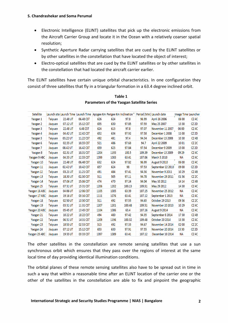
China has so far launched 25 Yaogan satellites. Table 17 lists all the 25 satellites along with
other relevant parameters.8
To keep the entire area of interest (in this case the western Pacific Ocean) under
surveillance the constellation will need three kinds of satellites:
1 S. Chandrashkar is JRD Tata Visiting Professor at ISSSP, NIAS. Soma Perumal is Adjunct Faculty at ISSSP, NIAS.
The cover image is from http://english.cntv.cn/2014/11/15/VIDE1416018241596981.shtml 2 For a detailed description of the ASBM system please see S. Chandrashekar et al “China’s Anti-Ship Ballistic
Missile – Game Changer in the Pacific Ocean”, National Institute of Advance Studies (NIAS) Report R5-11, November 2001 available at http://isssp.in/wp-content/uploads/2013/01/2011-november-r-5-chinas-anti-ship-ballistic-missile-report2.pdf 3 Figure 8, Reference 1, p 17.
4 See Reference 1 pp 16-29 and Annexure 2 pp 38–44 for details of the maneuver requirements and its
implications for the warhead. 5 For a description of the OTH radar please see Reference 1 pp 7-9 and Annexure 1 pp 34-37.
6 For an earlier description of the space constellation that covered it to the launch of Yaogan 11 see Reference
1 pp 9-14. 7 The Table provides the launch time in both Universal Time (UT) as well as China Standard Time (CST)
8 For more details see, http://www.zarya.info/Diaries/China/Yaogan/Yaoganprog.php
S. Chandrashekar and Soma Perumal
2
International Strategic and Security Studies Programme | NIAS | Bangalore
Electronic Intelligence (ELINT) satellites that pick up the electronic emissions from
the Aircraft Carrier Group and locate it in the Ocean with a relatively coarser spatial
resolution;
Synthetic Aperture Radar carrying satellites that are cued by the ELINT satellites or
by other satellites in the constellation that have located the object of interest;
Electro-optical satellites that are cued by the ELINT satellites or by other satellites in
the constellation that had located the aircraft carrier earlier.
The ELINT satellites have certain unique orbital characteristics. In one configuration they
consist of three satellites that fly in a triangular formation in a 63.4 degree inclined orbit.
Table 1
Parameters of the Yaogan Satellite Series
The other satellites in the constellation are remote sensing satellites that use a sun
synchronous orbit which ensures that they pass over the regions of interest at the same
local time of day providing identical illumination conditions.
The orbital planes of these remote sensing satellites also have to be spread out in time in
such a way that within a reasonable time after an ELINT location of the carrier one or the
other of the satellites in the constellation are able to fix and pinpoint the geographic
S. Chandrashekar and Soma Perumal
3
International Strategic and Security Studies Programme | NIAS | Bangalore
location of the carrier. Their local time of crossing the equator is an important parameter
that provides information on the sensor as well as the coverage of the satellite.
SAR sensors have the advantage that they can see through clouds and can also image
objects during night passes. Optical Imaging satellites on the other hand operate only during
daylight conditions and would not be able to function under cloudy conditions.
The ELINT satellites provide the coarse location of the carrier that is used to cue the
following imaging and SAR satellites to precisely locate and track the target in geographic
space.
Identifying the different kinds of satellites that make up the constellation and the coverage
pattern they provide gives us insights into the operational timeline of the space component
of China’s ASBM system. The current constellation will also include replacement satellites
for some of the earlier satellites that might have stopped working or completed their life in
orbit.
3. Chinese Launch Vehicle Performance Capabilities
The weights of the sensors to be carried on the satellite as well as the lifetime of the
satellite are the major determinants of the mass of the satellite. SAR sensors are in general
heavier than optical sensors and may also require more power for their operations. Sensors
may also have to be tilted either by moving the sensor or by tilting the satellite itself. These
will also have an impact on the mass of the satellite as well as the life of the satellite.9
Keeping in mind these considerations knowing the launcher that puts the satellite into orbit
provides additional information that helps categorize the sensors on the various Yaogan
satellites. The capabilities of the CZ 2C, CZ 2D, CZ 4B and CZ 4C launchers that have been
used for placing the various Yaogan satellites in sun synchronous orbits are 2100 Kg, 1150
Kg, 2230 Kg and 2950 Kg respectively.10
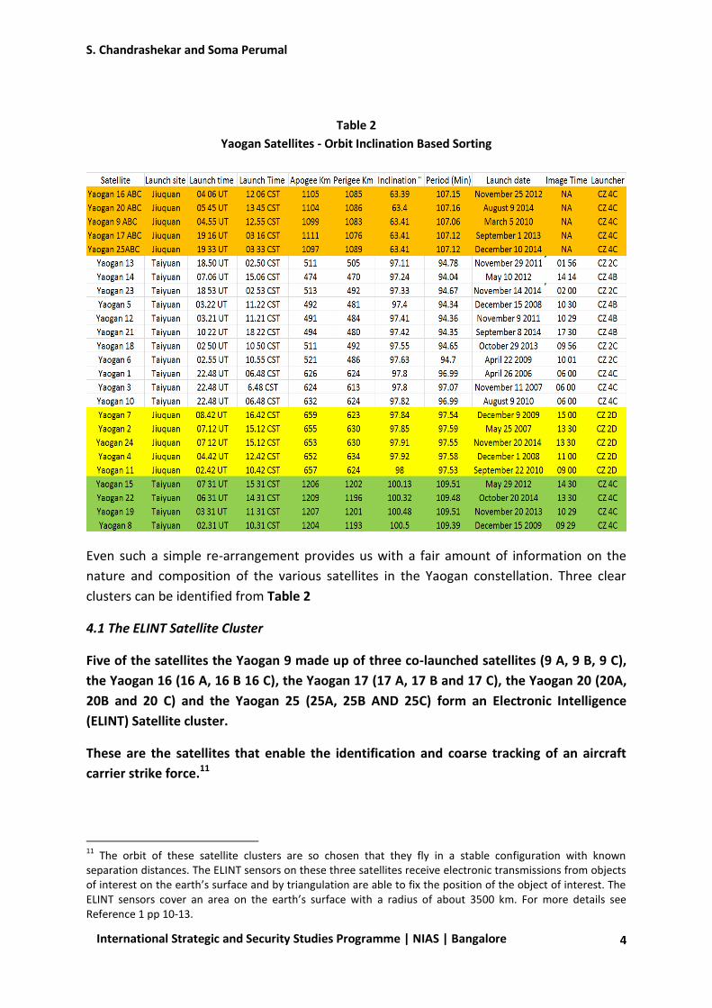
4. Patterns in Coverage
Table 2 provides the same data as in Table 1 but sorted in terms of increasing inclination of
the orbit.
9 Achieving a higher orbit may also require a bigger launcher.
10 China Academy of Launch Vehicle Technology (CALT) et al, “LM 3A Series Launch Vehicle User’s Manual,
Issue 2011, p 1-2.
S. Chandrashekar and Soma Perumal
4
International Strategic and Security Studies Programme | NIAS | Bangalore
Table 2
Yaogan Satellites - Orbit Inclination Based Sorting
Even such a simple re-arrangement provides us with a fair amount of information on the
nature and composition of the various satellites in the Yaogan constellation. Three clear
clusters can be identified from Table 2
4.1 The ELINT Satellite Cluster
Five of the satellites the Yaogan 9 made up of three co-launched satellites (9 A, 9 B, 9 C),
the Yaogan 16 (16 A, 16 B 16 C), the Yaogan 17 (17 A, 17 B and 17 C), the Yaogan 20 (20A,
20B and 20 C) and the Yaogan 25 (25A, 25B AND 25C) form an Electronic Intelligence
(ELINT) Satellite cluster.
These are the satellites that enable the identification and coarse tracking of an aircraft
carrier strike force.11
11
The orbit of these satellite clusters are so chosen that they fly in a stable configuration with known separation distances. The ELINT sensors on these three satellites receive electronic transmissions from objects of interest on the earth’s surface and by triangulation are able to fix the position of the object of interest. The ELINT sensors cover an area on the earth’s surface with a radius of about 3500 km. For more details see Reference 1 pp 10-13.

S. Chandrashekar and Soma Perumal
5
International Strategic and Security Studies Programme | NIAS | Bangalore
The launch of the Yaogan 20 on August 10 2014 and the recent launch of the Yaogan 25 in
December 2014 may be replacements for the Yaogan 9 and Yaogan 16 triplets that may be
reaching their end of life.
Apart from the five ELINT constellations (Yaogan 9, 16, 17, 20 and 25) the remaining 20
satellites are all in sun-synchronous orbit with altitudes ranging from about 470 km to 1200
km.
There are clear patterns among these 20 satellites that are evident from Table 2.
4.2 Broad Area Coverage Electro-Optical Imaging Satellite Cluster
Yaogan 8, Yaogan 15 Yaogan 19 and Yaogan 22 all exhibit a common pattern. They are all in
near circular 1200 km orbits, their inclinations are very close to each other and they are all
launched from Taiyuan with the same CZ 4C launcher.
Their orbit characteristics in conjunction with their equatorial crossing times of 09 30 hours,
10 30 hours, 13 30 hours and 14 30 hours suggest that these satellites carry Optical Imaging
sensors with a broad swath and with medium resolution of 3 to 10 m.12
Therefore we can surmise from this analysis that Yaogan 8, 15, 19 and 22 currently
provide large area optical coverage for the ASBM mission.13
4.3 High Resolution Electro-Optical Imaging Satellite Cluster
From Table 2 we can also see that Yaogan 11, Yaogan 4, Yaogan 24, Yaogan 2 and Yaogan
7 have similar orbits and are all launched from Jiaquan with the same CZ 2D launcher.14 All
of them are in orbits of 630 Km x 650 km. Their equatorial crossing times are 09.00 AM,
11.00 AM, 13.30 PM, 13 30 PM and 15.00 PM respectively. Taken together these appear to
be electro-optical imaging satellites that carry a high resolution sensor.15 From the
identical equatorial crossing times of 13 30 PM it is also clear that the Yaogan 24 is a
replacement for the Yaogan 2 which might be nearing the end of its life.
12
There are suggestions that these could also carry some kind of a SAR sensor. Though the launcher used can launch a big satellite (2950 kg) into a sun synchronous orbit, these satellites orbit at a much higher altitude than normal sun synchronous orbits. Reaching these orbits will reduce the mass of the satellite that can be placed in such an orbit. In the absence of any better information our view is that a meaningful SAR payload in a 1200 km orbit may be difficult to achieve even with the use of the CZ 4 C. 13
Based on comparisons with other satellites in similar orbits, the imaging sensors may have resolutions of 3 to 10 metres. The sensor may have a swath of about 100 km. By tilting the sensor suitably an area of 500 km on either side of the ground track may be reachable. Thus the satellite could image any 100 km swath within a 1000 km width. 14
The mass of these satellites based on the CZ 2D capabilities would be about 1200 Kg – a useful payload for a complement of optical sensors. 15
A typical sensor would be able to be tilted to cover about 300 km on either side of the ground trace of the satellite. Within this area of possible coverage the sensor would have a swath of about 25 to 30 km with a resolution of about 1 to 3 metres.
S. Chandrashekar and Soma Perumal
6
International Strategic and Security Studies Programme | NIAS | Bangalore
These satellites form the high resolution optical satellite cluster of the Yaogan series for the
ASBM mission.
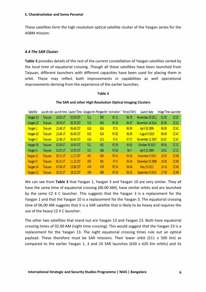
4.4 The SAR Cluster
Table 3 provides details of the rest of the current constellation of Yaogan satellites sorted by
the local time of equatorial crossing. Though all these satellites have been launched from
Taiyuan, different launchers with different capacities have been used for placing them in
orbit. These may reflect both improvements in capabilities as well operational
improvements deriving from the experience of the earlier launches.
Table 3
The SAR and other High Resolution Optical Imaging Clusters
We can see from Table 3 that Yaogan 1, Yaogan 3 and Yaogan 10 are very similar. They all
have the same time of equatorial crossing (06.00 AM), have similar orbits and are launched
by the same CZ 4 C launcher. This suggests that the Yaogan 3 is a replacement for the
Yaogan 1 and that the Yaogan 10 is a replacement for the Yaogan 3. The equatorial crossing
time of 06.00 AM suggests that it is a SAR satellite that is likely to be heavy and requires the
use of the heavy CZ 4 C launcher.
The other two satellites that stand out are Yaogan 13 and Yaogan 23. Both have equatorial
crossing times of 02.00 AM (night time crossing). This would suggest that the Yaogan 23 is a
replacement for the Yaogan 13. The night equatorial crossing times rule out an optical
payload. These therefore must be SAR missions. Their lower orbit (511 x 500 km) as
compared to the earlier Yaogan 1, 3 and 10 SAR launches (630 x 620 Km orbits) and its
S. Chandrashekar and Soma Perumal
7
International Strategic and Security Studies Programme | NIAS | Bangalore
launch by a lower capacity CZ 2C launcher suggests that this satellite carries a more
optimized SAR payload into a lower more refined orbit.16
Yaogan 23 (replacing Yaogan 13) and Yaogan 10 (replacing Yaogan 1 and 3) therefore appear
to be current SAR satellites that provide 02 00 AM and 06 00 AM SAR coverage.
The Table also reveals that Yaogan 18 and Yaogan 6 have orbital characteristics very similar
to Yaogan 13 and Yaogan 23. They are also launched by the same CZ 2 C launcher. Their
near identical equatorial crossing times of 09.56 AM and 10.01 AM shows that the Yaogan
18 is a replacement for the Yaogan 6 satellite. These may also carry the same improved SAR
sensor carried by the Yaogan 13 and Yaogan 23 satellites.
Yaogan 23 (replacing Yaogan 13) , Yaogan 10 (replacing Yaogan 1 and 3) and Yaogan 18
(replacing Yaogan 6) represent SAR satellites with equatorial crossing times of 02 00 AM, 06
00 AM and 10 00 AM spaced 4 hours apart.
The remaining four satellites Yaogan 5, 12, 14 and 21 also exhibit very similar orbital
characteristics and are also launched by the slightly higher capacity CZ 4 B launcher. The
orbits of these satellites are slightly lower than the orbits of the Yaogan 6, 13 18 and 23 SAR
satellites.
Yaogan 14 has an equatorial crossing time of 14 00 hours and Yaogan 21 an equatorial
crossing time of 17 30 hours. These are probably SAR satellites that provide a four hour
spaced coverage.
Taking an integrated look based both on both Table 2 and Table 3, Yaogan 23 (replacing
Yaogan 13) , Yaogan 10 (replacing Yaogan 1 and 3) , Yaogan 18 (replacing Yaogan 6) Yaogan
14 and Yaogan 21 represent SAR satellites with equatorial crossing times of 02 00 hours, 06
00 hours, 10 00 hours, 14 00 hours and 17 30 hours respectively. Their orbit spacing is such
that they provide a continuous all-weather as well as day night surveillance capability over
all parts of the Pacific Ocean that is needed for an ASBM mission.
Though Yaogan 5 and Yaogan 12 seem to be similar to Yaogan 14 and Yaogan 21 their
equatorial crossing times of 10 30 hours raises some questions.
Unlike the near four hour separation time between most of the other Yaogan SAR satellites
both of them have an equatorial crossing time of 10 30 hours. This is very close to the
equatorial crossing time of 10 00 hours of the Yaogan 18 SAR satellite. It is difficult to find a
reason as to why the Chinese would have two Yaogan SAR satellites that are spaced so close
to each other.
16
It is possible that Yaogan 1, 3 and 10 may have also carried an optical payload in addition to the SAR payload. This may account for the use of the very large CZ 4 C launcher.

S. Chandrashekar and Soma Perumal
8
International Strategic and Security Studies Programme | NIAS | Bangalore
It is possible that Yaogan 5 and Yaogan 12 are high resolution optical satellites that provide
high resolution imagery that complements the SAR imagery from the SAR constellation of
satellites. Since Yaogan 5 and Yaogan 12 have nearly identical equatorial crossing times of
10 29 AM and 10 30 AM, Yaogan 12 appears to be a replacement for Yaogan 5.
Taking into account the replacement of some of the earlier Yaogan satellites with the more
recent ones we can make the inference that Yaogan 23 with equatorial crossing time of
02.00 hours, Yaogan 10 with equatorial crossing time of 06 00 hours, Yaogan 18 with an
equatorial crossing time of 10 00 hours, Yaogan 14 with an equatorial crossing time of 14
00 and Yaogan 21 with an equatorial crossing time of 17 30 hours together comprise the
current cluster of SAR satellites. Their equatorial crossing times are spaced about four
hours apart and this is consistent with the near continuous coverage requirements of an
ASBM kind of use.
Yaogan 12 (which replaced the earlier Yaogan 5 satellite) could either be a SAR satellite or
a satellite that carries a high resolution optical payload.
5. Improvements in Satellite Capabilities
The data also suggests modifications to the sensor complement from the first generation of
SAR satellites to the subsequent generations. Yaogan 1, Yaogan 3 and Yaogan 10 (the first
generation SAR satellites from the data) are all launched by the CZ 4C launcher which has a
capacity to launch about 2950 Kg into a sun synchronous orbit.
The subsequent launches show lighter satellites. Yaogan 6, 13, 18 and 23 have been
launched by the CZ 2C while Yaogan 5, 12, 14 and 21has been launched by the CZ 4 B. The
CZ 2C has a capability to place a 2100 Kg payload in sun synchronous orbit whereas the CZ 4
B can place a slightly higher 2230 Kg payload in a similar orbit.
This suggests that the Chinese have either reduced the weight of the SAR payload
significantly in the later Yaogan satellites or that they have dropped some sensors from
the complement of sensors carried on the Yaogan 1, Yaogan 3 and Yaogan 10 satellites.17
The dropping of an electro-optical sensor from the complement of sensors flown on the
early Yaogan SAR missions appears to be a more likely explanation.
The change in the orbit parameters between the various SAR satellites also indicate a
progressive decrease in the average altitude of operation from about 625 Km to 515 Km
with more recent launches operating at about 480 Km. This decrease in altitude may also be
17
It is possible that the early Yaogan SAR satellites also carried some optical sensors and this could have resulted in a heavier satellite.

S. Chandrashekar and Soma Perumal
9
International Strategic and Security Studies Programme | NIAS | Bangalore
the reason for changing the launcher from the lighter CZ 2C launcher to the heavier CZ 4C
launcher.18
These changes in orbit and launchers do not seem to indicate major shifts in SAR
capabilities. They seem to reflect improvements in operations as the Chinese move towards
making their ASBM system operational.
6. Overall Assessment
Based on the analysis we can make the following inferences:
Yaogan 9, Yaogan 16, Yaogan 17, Yaogan 20 and Yaogan 25 form the ELINT cluster for the
ASBM mission; the Yaogan 20 and the Yaogan 25 may be replacements for the Yaogan 9
and Yaogan 16 satellite triplets that could be reaching the end of their lives.
Yaogan 15, Yaogan 19, Yaogan 8 and Yaogan 22 form a complement of Optical imaging
satellites with medium resolution (3 to 10 m) capabilities for the ASBM mission;
Yaogan 11, Yaogan 4, Yaogan 24 (replacing Yaogan 2) and Yaogan 7 form a cluster of high
resolution optical imaging satellites;
Yaogan 23 (replacing Yaogan 13), Yaogan 10 (replacement for the Yaogan 3 which
replaced the Yaogan 1), Yaogan 18 (replacement for the Yaogan 6), Yaogan 14 and Yaogan
21 are the current SAR satellites for the ASBM mission.
The Yaogan 12 which replaced the Yaogan 5 seems to be some kind of an anomaly. It has
the characteristics of the SAR missions but its equatorial crossing time of 10 30 AM that is
very close to the equatorial crossing time of 10 00 AM of the Yaogan 18 SAR satellite. It
could either be a SAR satellite or a satellite equipped with a high resolution electro-optical
that complements the SAR coverage.
7. Simulation Results
In order to provide a more nuanced understanding of the coverage pattern and the gaps in
the coverage of the current Yaogan constellation of satellites a simulation of the coverage
pattern for identifying, locating and tracking a ship approaching the Chinese mainland from
the Pacific Ocean was carried out. Using typical sensor geometries extrapolated from
current civilian satellites and the two line orbital elements available in the public domain the
capabilities of the current Yaogan constellation for identifying, locating and tracking of an
aircraft carrier in the Pacific Ocean were evaluated.19
18
Lowering the orbit will entail the loading of more fuel for maintaining the satellites orbit and the equatorial crossing time. 19
The two line orbital elements can be obtained from www.spacetrack.com
S. Chandrashekar and Soma Perumal
10
International Strategic and Security Studies Programme | NIAS | Bangalore
A brief summary of these preliminary simulation results are provided below.
The orbital planes of three operational ELINT satellite clusters (Yaogan 9 or Yaogan
20, Yaogan 16 or Yaogan 25 and Yaogan 17) are well spaced out and typically make
18 contacts with the moving target in a day.
The ELINT satellite pass durations vary, with the maximum pass duration being about
23 minutes.
The maximum period of non-coverage by an ELINT cluster for a typical target is
about 90 minutes.
These results indicate that the three ELINT clusters ensure persistent detection,
coarse location and coarse tracking of the Aircraft Carrier over the high seas. The
current ELINT clusters therefore provide China with a strong and robust ocean
surveillance capability over all ocean regions of the world including the Pacific.
The SAR and Optical Imaging satellites provide about 24 satellite passes during which
the target can be imaged. When these imaging opportunities are successful the
target can be located with an accuracy of about 100 metres.20
The current Yaogan constellation provides about 16 targeting opportunities for a
ballistic missile launch during which the uncertainty in the location of the carrier is
less than 10 Km.
These preliminary results suggest that China has in place a space-based surveillance system
that can identify, locate and track an Aircraft Carrier in the Pacific Ocean.
7. Conclusions
It appears from the above analysis that the Chinese have in place a robust space based
system that performs the location and tracking functions for the ASBM system. Figure 1
provides a time line of the equatorial crossing times for the Electro-Optical (EO) and SAR
satellites of this constellation.
20
This assumes that cloud cover does not come in the way of optical imaging. In reality cloud cover could be a serious factor that may reduce this number. Future simulations will take this into account. However even with only ELINT and SAR coverage it may be possible to identify, locate and track an ACG with sufficient accuracy for realizing the ASBM mission.

S. Chandrashekar and Soma Perumal
11
International Strategic and Security Studies Programme | NIAS | Bangalore
The Local Time of Crossing the equator is the horizontal coordinate. The vertical coordinate
first shows the average altitude of the satellite. The various satellites that operate at that
altitude along with the sensors they carry and their equatorial times of crossing can be read
off from the Figure.
As we can seem from Figure 1 there is SAR coverage at 02 00, 06 00, 10 00 and 14 00 and 17
30 hours.
High resolution optical imaging takes place at 09 00, 11 00, 13 30 and 15 00 hours.
To complement this high resolution capability of SAR and the optical sensors there is also
coverage with medium resolution optical imaging sensors at 09 30, 10 30, 13 30 and 14 30
hours.
Along with the very wide area coverage provided by the ELINT satellites, this analysis and
the simulation results provide substantive evidence that the Chinese would be able to locate
and track an aircraft carrier in the Pacific Ocean.
We can state with a fair degree of confidence that the Yaogan satellite constellation and its
associated ASBM system provide visible proof of Chinese intentions and capabilities to
keep ACG strike groups well away from the Chinese mainland.

S. Chandrashekar and Soma Perumal
12
International Strategic and Security Studies Programme | NIAS | Bangalore
Though the immediate purpose of the system is to deter the entry of a hostile aircraft
carrier fleet into waters that directly threatens its security interests especially during a
possible conflict over Taiwan, the same approach can be adopted to deter entry into other
areas of strategic interest.
Viewed from this perspective the Chinese do seem to have in place an operational
capability for denying or deterring access into areas which they see as crucial for
preserving its sovereignty and security.