Embed Size (px)
Citation preview
Maryland Journal of International Law
Volume 1 | Issue 1 Article 6
China and The Question Of Territorial SeaHungdah Chiu
Follow this and additional works at: http://digitalcommons.law.umaryland.edu/mjilPart of the Admiralty Commons
This Article is brought to you for free and open access by DigitalCommons@UM Carey Law. It has been accepted for inclusion in Maryland Journal ofInternational Law by an authorized administrator of DigitalCommons@UM Carey Law. For more information, please [email protected].
Recommended CitationHungdah Chiu, China and The Question Of Territorial Sea , 1 Md. J. Int'l L. 29 (1975).Available at: http://digitalcommons.law.umaryland.edu/mjil/vol1/iss1/6
CHINA AND THE QUESTION OF TERRITORIAL SEA
HUNGDAH CHIU*
1. Introduction
In recent years, the People's Republic of China (PRC) hasbecome an ardent supporter and champion of the claim for the200 nautical mile territorial sea right or maritime right' assertedprimarily by many Latin American countries. This problem, inthe PRC's view, is not only a problem concerning the law of thesea, but it is very significant in the struggle by the Third Worldcountries, with which the PRC identifies itself, against thehegemony of the two superpowers-the United States and theSoviet Union.
A recent secret educational document on international situa-tions distributed to the company level of the PRC army, viewedthe struggle for a 200 nautical mile territorial sea right as abasic indicator of the struggle against the superpowers inLatin America. The document observed:
In Latin America, which used to be called the back-yard of American imperialism, the fire has been lighted.Not long ago fourteen Latin American states jointlytook action to oppose the unreasonable method of limit-ing the breadth of the territorial sea by the two super-powers. They have insisted that American countrieshave the right to define the limit of their territorial seaand have firmly defended their 200 nautical mile terri-torial sea rights.2
At the Third United Nations Conference on the Law of theSea held at Caracas between June and August, 1974, the PRCactively supported the position of the Third World. In hispolicy speech delivered on July 2, the Leader of the PRC Dele-gation Chai Shu-fan said:
*Visiting Associate Professor of Law, University of Maryland School of Law; LL.B.,
1958, National Taiwan University; M.A. with honors, 1962, Long Island University; LL.M.,1962 and S.J.D., Harvard; Member, Panel on China and International Order, American So-ciety of International Law.
1 Until recently, the PRC referred to Latin American claims for 200 mile territorial sea,economic zone, or patrimonial sea generally as "ling-hai ch'uan" (territorial sea right). How-ever, recent PRC documents and press reports began to use the term "hai-yang ch'uan"(maritime right) to refer to such claims. For the PRC's views on the difference betweenterritorial sea or economic zone, see note 136 and accompanying text infra.
mCHINESE COMMUNIST DOCUMENT: OUTLINE OF EDUCATION ON SITUATION FOR COMPANIES6 (with English translation). Lesson I, at 2 (Chinese text) (Propaganda Division, Po-litical Department, Kunming Military Region ed., 1973, distributed by Institute of Interna-tional Relations, Taipei, 1974). I have translated the text from the Chinese.
30 THE INTERNATIONAL TRADE LAW JOURNAL
The new legal regime of the sea must accord with theinterests of the numerous developing countries, thebasic interests of the people of the world and the direc-tion in which the times are advancing.... Our commonlot and common tasks provide a firm foundation for ourunity in the fight. This is an important guarantee forour victory....Although we developing countries may have differencesof one kind or another on certain specific issues, it isfully possible and essential for us, on the premise ofmutual respect for sovereignty and of unity againsthegemonism, to work out a reasonable solutionthrough friendly consultations in a spirit of seekingcommon ground while reserving differences, and ofequality and mutual benefit.3
Paralleling its growing interest in the law of the sea, thePRC has quietly built its naval force in recent years. A recentstudy indicates that the PRC's navy is the world's third largest,with a strength of 150,000 officers and men and more than 100vessels in active service.4
In the past few years, the increase in the PRC's ocean-goingmerchant fleet has been dramatic. According to a reliable source,in 1961 the PRC fleet consisted of 141 ships totaling 696,000deadweight tons. By 1969, this had increased to 1.3 milliondeadweight tons, a rise of 85 percent, and by the latter part of1974 total deadweight tonnage was 2.5 million tons, an increaseof 92 per cent over the 1969 figure.5 It appears that the PRC isin the process of actively developing itself as a major maritimepower.
In view of the foregoing, the importance of studying the PRCattitude toward the law of the sea is apparent. This articleundertakes to study the PRC's view on one important aspect ofthe law of the sea-the question of territorial sea and its relatedproblems. Although some recent studies have been done on PRC'sterritorial sea practice, 6 they concentrate primarily on the 1958PRC Declaration on China's Territorial Sea and the practice
$At U.N. Conference on Law of the Sea, Chinese Delegation Leader Chai Shu-fan'sSpeech, 17 PEKING REVIEW 11, 14 (No. 28, July 12, 1974).
4See Uhlig, Red China's Navy is World's Third Largest, SEAPOWER 19-24 (Mar., 1973).It has 42 submarines, 4 destroyers, 20 frigates and escorts, 17 missile boats, 54 landingships and landing craft, and other vessels. THE STATESMAN'S YEARBOOK 1973-1974, at 816-817 (John Paxton ed. 110th ed. 1973).
3 Smith, Voyage of the Fenghuang Chinese Shipping Success, Hong Kong (UPI), TheDaily Record, Mar. 5, 1975, at 1, 7. See also I-CHIU-CH'I-SAN CHUNG-KUNG NiEN-PAO(Yearbook on Chinese Communism, 1973) 11-133 (Taipei, 1973).
6 E.g., Cheng Tao, Communist China and the Law of the Sea, 63 AM. J. INT'L L. 47-73(1969); HSIUNG, LAW AND POLICY IN CHINA'S FOREIGN RELATIONS 103-117 (1972).
PRC-TERRITORIAL SEA
before and immediately after this Declaration. Moreover, thesestudies pay only casual attention to pre-1949 China's practiceand totally ignore the view of the Republic of China (ROC) onTaiwan after 1949. This is a serious deficiency in view of theROC's strategic geographical location and its importance as aworld maritime power.
The ROC not only controls the strategic island of Taiwanwhich faces the mainland Chinese provinces of Chekiang,Fukien and Kwangtung, but also has a sizable navy, 7 ocean-going maritime fleet, deep-ocean fishery industry, and a signifi-cant expanding shipbuilding industry.8 In 1974, the ROC carriedon a two-way international trade of more than 12 billion USdollars and almost all import and export goods were trans-ported by maritime fleet.s
Until late 1971, the ROC government represented China atthe United Nations and its specialized or affiliated agencies. 10 Itrepresented China at the First and Second United Nations Con-ference on the Law of the Sea held separately in 1958 and 1960at Geneva. Furthermore, the pre-1949 Chinese practice, in-cluding that of the ROC, has had upon several occasions adirect bearing on the PRC's practice. For instance, the PRC'sextension in 1958 of its territorial sea to 12 nautical miles wasprompted by its attempt to exclude United States interventionduring its attempted capture of Quemoy, an offshore island heldby the ROC."1
The focus of this article is both historical and analytical. Itwill begin with the introduction of the regime of territorial seato China in the nineteenth century, analyze the ROC practiceboth before and after its removal to Taiwan, and finally ex-amine the PRC's practice and its attitude toward the recentdevelopment of the law of territorial seas and related problems.
Before proceeding to these problems, it would be helpful togive a general survey of physical features of China's coast and
7 In 1972, the ROC had 14 destroyers, 16 frigates, 3 escort vessels, 25 landing ships andother vessels. It had 88,000 naval officers and ratings and 34,000 marine officers and men.THE STATESMAN'S YrAaBOOK 1973-1974, supre note 4, at 824.
a See notes 59, 60, and 61. and accompanying text, infra.sChung-yang jih-pao (Central daily news), Jan. 4, 1975, at 1; 16 FEE CHINA WEEKLY
4 (No. 3, Jan. 19, 1975).a By Resolution 2758 (XXVI) adopted by the United Nations General Assembly on
October 25, 1971, the Assembly decided that the PRC government should represent China inthe United Nations and in all the organizations related to it. FRIEDMANN, LtssrrzYN, &PUGH, INTERNATIONAL LAW 26-27 (Supp. 1972). Since then, the PRC government hasrepresented China in all United Nations-affiliated or related organizations except the Inter-national Monetary Fund, International Finance Corporation, International Bank for Recon-struction and Development (World Bank), and International Development Association.
11 See notes 75-78 infra and accompanying text.
THE INTERNATIONAL TRADE LAW JOURNAL
adjacent sea-bed.1- China's continental coastline begins at themouth of the Yalu River on the Chinese-North Korean borderand ends at the Peilun River on the Chinese-North Vietnameseborder.. It is approximately 11,900 kilometers13 in length.Hanchow Bay divides China's coast into two parts. North of thebay the coast is sandy, with the exception of the rocky shores ofthe Shantung and Liaotung peninsula; south of the bay it ismostly rocky.
China has more than 3,500 islands, of which the two largestare Taiwan and Hainan. Most other islands are less than 1,000square kilometers. Over 2,900 islands (mostly of the rocky type)are scattered along the coasts south of the Hanchow Bay. Thecoastline of China's continental coast and islands has a totallength of 23,400 kilometers.
The seas facing China's coast include the Pohai (Gulf ofChili or Pohai) in the north, the Yellow Sea and the East ChinaSea in the middle, and the South China Sea in the south.
According to a report of the United Nations Economic Com-mission on Asia and the Far East (ECAFE) released in 1969,the seabed adjacent to the Chinese coast and beneath the Yellowand East China Seas has the following features:,
(1) The Yellow Sea area, comprising approximately 500,000square kilometers is a flat region with depths that averageabout 55 meters,15 and nowhere exceed 125 meters. The westernside is bordered by the combined deltas of the Yellow andYangtze Rivers plus the hilly projection of the Shantung Penin-sula. The eastern side of the Yellow Sea is hilly and fringed byhundreds of small rocky islands. Lowlands border the mouthsof the Han River of the Republic of Korea, the Yalu River ofNorth Korea, and the Liao River of China in the Gulf of Pohai.
(2) Immediately following this area is a large continentalshelf of approximately 110,000 square kilometers. At the norththe shelf takes the form of Tsushima Strait between Korea andJapan, a width of about 150 kilometers. The middle part of theshelf fronts the Yellow Sea, and the southern part borders theChinese mainland from the mouth of the Yangtze River tobeyond Taiwan Strait. The outer edge of the shelf is off theYangtze River where it reaches 450 kilometers; farther south-west the shelf narrows to about 125 kilometers in the TaiwanStrait.
2 The description is generally based on CHIAO-MIN HSIEH, ATLnA OF CHINA 19-20 (Saltered. 1973) and CHINA YEARBOK 1972-1973, at 47.
" One kilometer is about 3281 feet or five-eighths of a mile.14Emory, Geological Structure and Some Water Characteristics of the East China Sea
and the Yellow Sea, 2 TECH. BULL., ECAFE 13, 25, 26 (1969)."One foot is about 0.3048 meter.
PRC-TERITORIAL SEA
(3) At the edge of the continental shelf area is the OkinawaTrough. The deepest part, near the eastern part of Taiwanreaches 2,270 meters. East and south of the Trough are theRyukyu Islands.
In the South China Sea area, the continental shelf extendsfrom the Taiwan Strait to the Kwangtung Province, HainanIsland, and then to Vietnam. The width of the shelf is approxi-mately 200 kilometers in Kwangtung, then gradually narrowsto less than 100 kilometers in the southern part of Vietnam. Offthe 200 meter depth line of the shelf, the seabed abruptly dropsoff to abyssal plains. The Paracel and Spratly Islands, about 230nautical miles apart, sit mid-ocean where the depth drops im-mediately to almost 1,000 meters around the Paracels and about3,000 meters at some points around the Spratlies.16
2. The Introduction of theRegime of Territorial Sea to China
Throughout the long history of China, Chinese merchant andnaval vessels were quite active in the seas adjacent to the Chinesecoast. The Chinese navy in the Ming Dynasty (1368-1644) wasreported to make regular patrol for a long period in East ChinaSea and sailed as far as the present Tiao-yu-tai Islets (SenkakuGunto). 1
7 The Chinese government enacted various laws anddecrees concerning maritime matters. In the Ch'ing Dynasty,comprehensive provisions were enacted in the chapter on Mili-tary and Border Affairs of the Ch'ing Code for control of mari-time trade and of persons sailing to the sea, and for punishmentof crimes committed on the seas. 8
In the Ch'ing Code, a distinction was made in a number ofplaces between "nei-yang" (inner ocean) and "wai-yang" (outerocean). In an 1817 case concerning the ship Wabash commandedby Captain Gant (or C. L. Gratt) from Baltimore, Maryland,the Ch'ing government noted that although the "barbarianmerchant Ao-ti [Gant]" brought opium to China in violationof Chinese law, since the ship was anchored in the "outer ocean"and did not enter the Chinese port, the "barbarian merchant"should not be punished. On the other hand, several Chinese whotried to blackmail "the barbarian merchant" Ao-ti and his crew
is YA-KUANG Yu-Ti HsUCH-SHE, Chart of Atlas of Islands in South China Sea., inCHUNG-HUA JEN-MIN KuNG-Ho-Kuo FBN-SHENG TI-T'u (Atlas of the Provinces of thePeople's Republic of China) 41 (6th rev. ed. 1953).
1? See Map of Coastal Mountains and Sands, in CH'ou-HAi T'u-PiEN (Maps concerningsea defense) 20 (Hu Chung-hsien ed., 1562). The map was reproduced in Inoue, The His-tory and Sovereignty of the Tiaoyu Islands (Senkaku Gunto) (further study), CHUGOKU-xENKYU GEPPO (China Study Monthly), No. 292, at 8-9 (June, 1972).
Is See 3 TA-CH'INo Lu-LI Hui-T'UNG HsiN-TSUAN (Comprehensive New Edition of theCh'ing Code) 1711-1755 (authors unknown, 1872 edition was reprinted in Taipei, 1964).
THE INTERNATIONAL TRADE LAW JOURNAL
and robbed the ship and killed several crew members in the"outer ocean" were decapitated or otherwise severely punished. 9
China's reluctance to extend its jurisdiction over aliens to the''outer ocean" is somewhat similar to the Western practice ofthis period, based on the distinction between territorial sea andhigh sea.Y Research into Ch'ing history to date, however, hasnot revealed how the Chinese defined the extent of the "innerocean" and the method of its measurement. It appears that thispractice did not develop into a sophisticated regime similar tothat of the territorial sea in western international law.
By the middle of the nineteenth century a number of com-mercial treaties concluded by China with western powers madeexplicit reference, in general terms, to Chinese jurisdiction overits adjacent maritime belt. Aiticle 26 of the Sino-AmericanTreaty of Peace, Amity, and Commerce signed at Wang Hiyaon July 3, 1844, provided that "if the merchant-vessels of theUnited States, while within the waters over which the Chinesegovernment exercises jurisdiction, be plundered by robbers orpirates, then the Chinese local authorities, civil and military, onreceiving information thereof, will arrest the said robbers orpirates, and punish them according to law . . ." (Emphasisadded) .21 Similarly, Article 19 of the Treaty of Peace, Friend-ship and Commerce, between Great Britain and China, signedat Tientsin on June 26, 1856, also provided that "if any Britishmerchant vessel, while within Chinese waters, be plundered byrobbers or Pirates, it shall be the duty of the Chinese authoritiesto use every endeavour to capture and punish the .said robbersor Pirates . . ." (Emphasis added) .22 However, none of theseprovisions defined the extent of Chinese "waters," and theChinese apparently were unaware of the existence of a regimeof the territorial sea in international law until 1864, whenW. A. P. Martin translated Wheaton's Elements of InternationalLaw into Chinese.23
"See 1 CH'ING-TAI WAI-CrnAo SHIH-LIAO, CHIAoCHING CH'AO, TAO-KuANG CH'AO (His-torical Materials Concerning Foreign Relations in the Ch'ing Period, Chia-ch'ing Period,1796-1820, Tao-Kuang Period to 1831) 678-685 (Palace Museum ed. 1931-1933, Taipei re-printed ed. 1968). For an English summary of this ease, see 1 Lo-SHU Fu, A DOCUMEN-TARy CHRONICLE OF SINO-WESTERN RELATIONS (1644-1820) 408-413 (1966); 2 id. 621.
1 The jurisdiction over the Chinese involved in the same case apparently was based on thenationality principle and the locus criminus was not therefore relevant.- 6 TREATIES AND OTHER INTERNATIONAL AGREEMENTS OF THE UNITED STATES OF AMERICA
1776-1949, 658 (Bevins, comp.. 1971). Similar provisions were made in Article 26 of theTreaty of Peace, Amity, and Commerce between Sweden and Norway, and China, signedat Canton on March 20, 1847. 1 HERTSLET'S CHINA TREATIES 536 (3rd rev. ed., 1908).-2 Id. art. 25.n The relevant part of Wheaton concerning the breadth of territorial sea is as follows:"§6. Maritime territorial jurisdiction. The maritime territory of every State extends to the
ports, harbors, bays, mouths of rivers, and adjacent parts of the sea inclosed by headlands,belonging to the same State. The general usage of nations superadds to this extent of terri-torial jurisdiction a distance of a marine league, or as far as a cannon-shot will reachfrom the shore, along all the coasts of the State. Within these limits its rights of propertyand territorial jurisdiction are absolute, and exclude those of every other nation.
§7. Extent of the term coasts or shore. The term 'coasts' includes the natural appendagesof the territory which rise out of the water, although these islands are not of sufficient
PRC-TERRITORIAL SEA
With the translation of Wheaton into Chinese, China's con-ception of its territorial sea became more sophisticated. In1864, during the Prussian-Danish War, the Prussian ministerto China, von Rehfues, arrived in the Gulf of Chili (Pohai) on awarship. Finding three Danish merchant ships in the Gulf, hecaptured them. The Chinese government protested on the groundthat the capture was made within the Chinese "inner ocean" andsomewhat vaguely cited principles of international law containedin Wheaton's Chinese translation to support its argument. Sub-sequently, the Prussian Minister acknowledged the illegalityof the act, released two of the Danish ships, and paid compensa-tion for the third. In Prince Kung's memorial to the Emperor,he pointed out that "foreign countries always maintain that theocean 10 or more 1i [one 1i is about one-third of a mile] off thecoast, which cannot be reached by guns and batteries, is con-sidered the public area of all the countries and can be sailed andoccupied as one wishes."'24 This was an apparent reference tothe territorial sea and high sea in international law.
In 1874, when Chinese Viceroy Li Hung-chang sought tojustify Korea's (then a tributary state of China) action infiring upon a Japanese warship that appeared near the Koreancoast, one of the arguments he made was that, according tointernational law the width of the territorial sea was 10 1i (ap-proximately 3 nautical miles) and the Korean action wasa legitimate response to the infringement of Korean territorialsea.
2 5
Although Chinese knowledge concerning the Western conceptof a regime of the territorial sea was growing, the scope of theterritorial sea claimed by the Ch'ing remained unclear. In theSino-Mexico Treaty of Friendship, Commerce and Navigationsigned on December 14, 1899, the contracting parties, in Article11, agreed to consider "a distance of 3 marine leagues [approxi-mately 9 nautical miles], measured from the line of low tide, as
firmness to be inhabited or fortified; but it does not properly comprehend all the shoalswhich form sunken continuations of the land perpetually covered with water. The rule oflaw on this subject is. terrai dominium Ainitur, ubi funitur armorum vie; and since theintroduction of fire-arms, that distance has usually been recognized to be about three milesfrom the shore." H. WHEATON, ELEMENTS OF INTERNATIONAL LAW 233-234 (6th ed. 1855).This part was translated into Chinese in 2 WAN-KUo KUNG-FA (Laws and regulations ofall states) 67 (W.A.P. Martin trans. 1864).
"' 6 CH'OU-PAN I-Wu SHIH-MO (The Complete Account of our Management of BarbarianAffairs) 658 (Chuan 26, at 29-30, 33, [Peking, Palace Museum ed. 1930], Taipei reprinteded. 1963). See also id. 677 (Chuan 27, at 25-26). For a summary of the incident see also.TENG & FAIRBANK, CHINA'S RESPONSE TO THE WEST, A DOCUMENTARY SURVEY, 1839-1923,at 97-99 (1954); T.F. Tsiang. Bismarck and the Introduction of International Law intoChina, 15 THE CHINESE SOCIAL AND POLITICAL SCIENCE REVIEW 98-101 (No. 1, Apr., 1931).
2 See the minutes of the conversation between Li Hung-chang and the Japanese minister,Mori Arinori, annexed to the memorial submitted by the Tsungli Yamen to the Emperoron the Japanese intention to enter into friendly relations with Korea, dated Jan. 17, 1876,in I CH'ING KUANG-Hsu CH'AO CHUNG-JIH CHIAO-SHE SHIH-LIAO (Historical materialsrelating to Sino-Japanese relations during the reign of the Kuang-hsu Emperor) 8(Peiping, Palace Museum ed. 1932).
THE INTERNATIONAL TRADE LAW JOURNAL
the limit of their territorial waters for everything relating tothe vigilance and enforcement of the custom-house Regulationsand the necessary measures for the prevention of smuggling. 28
The implication of this article is not clear, and there is no otherevidence showing that the Ch'ing government had claimed a 9nautical mile territorial sea.
In 1908, in a case involving the capture of a Japanese ship,the Ta Tsu Maru, the Ch'ing government claimed that the shipwas arrested within 2 nautical miles of the Chinese coast.27 Itappears that China and Japan negotiated on the assumptionthat the generally accepted width of the territorial sea was 3nautical miles.
In neither of the above two cases, however, can it be said thatChina was explicitly claiming a territorial sea of specified width.Rather, China utilized newly understood western concepts to itsadvantage without wholly embracing them as policy. Therefore,it seems that despite the increasing sophistication of the Ch'ing'sunderstanding of the western concept of a regime of the terri-torial sea with clearly defined limits, the Ch'ing never definedfor itself its own territorial sea.
3. The Republic of China and theProblem of Territorial Sea
In the first year of the Republic of China (1912), the Chinesegovernment began seriously to consider the question of the widthof the territorial sea. At that time, the Ministry of the Navyexpressed its view to the Ministry of Foreign Affairs in a letterdated July 10:
Generally, the boundary of the territorial sea shouldbe limited to 3 nautical miles [off the coast]. How-ever, this limit was formulated according to the rangeof a cannon shot. Presently, the range of a cannon shotis much farther; therefore, Hall's public internationallaw book said that at the Paris International Law Con-ference, the majority of the members approved thetheory that the territorial sea should be extended to 6nautical miles.2
8 As a matter of fact, the farthest range35 1 HmrszLET's CHINA TREATIES. supra note 21 at 403-404. It was reported that in 1902
Mexico adopted the 3-mile territorial sea. 4 WHITEMAN, DIGEST OF INTERNATIONAL LAW14 (1965).
" See WAI-CHLAO TA TZ'U-TIEN (Great Dictionary of Diplomacy) 722-23 (1965); 4WHITEMAN. s Pr note 26. China subsequently released the ship for political reasons.
1 The relevant provision from Hall follows:"After being carefully studied and reported upon by a Committee of the Institut de Droit
International, the subject was exhaustively discussed by the Institut at its meeting in Paris,in 1894, the exceptionally large number of thirty-nine members being present. With regardto the necessity of ascribing a greater breadth than three miles of territorial water to thelittoral state there was no difference of opinion. As to the extent to which the marginal belt
PRC-TERRITORIAL SEA
of a cannon shot now can reach 10 nautical miles, so itseems that we should extend our territorial sea [to sucha width] so as to protect our maritime rights. 9
But, no decision was made on whether China should accept the3 nautical mile limit or should have a broader width of theterritorial sea.30
In 1921, the President of the Republic approved a proposalof the Ministry of Navy for setting up a Committee on MaritimeBoundary to discuss the question of China's territorial sea. Thecommittee decided at its fifth meeting, held on September 6,1921, that China should follow the practice of other countriesby prescribing its territorial sea as 3 nautical miles. 31 It isnot clear whether the President took any action on the decisionof the committee .32
It was not until the Nationalist government assumed thecommand of the Republic of China that China clarified its posi-tion on the territorial sea. At the 1930 Hague Conference onCodification of International Law, it took the position that thewidth of the territorial sea should be 3 nautical miles, meas-ured from the low-water marks along the coast.3 3 This positiondid not mean, however, that China was satisfied with the regimeof a 3 nautical mile territorial sea. On July 5, 1929, the Vice-Commander of the Navy and member of the Northeast (Man-churia) Political Council, General Shen Hung-lieh, sent an of-ficial communication to the Ministry of Foreign Affairs, pro-posing that the Chinese territorial sea should be prescribed as 12nautical miles and the Gulf of Pohai (Chili) as entirely China's
should be enlarged and the principle upon which enlargement should be based, the sameunanimity was not manifested; but ultimately it was resolved by a large majority that azone of six marine miles from low water mark ought to be considered territorial for allpurposes, and that in time of war a neutral state should have the right to extend thiszone, by declaration of neutrality or by notification, for all purposes of neutrality, to adistance from the shore corresponding to the extended range of cannon." A TREATISE ONINTERNATIONAL LAW 154 (6th ed. by Atlay, 1909).
'9 CHUNG-JIH YU-YEH CHIAO-SHa (Sino-Japanese Fisheries Negotiations) (June 2- Nov.19, 1912, Diplomatic Archives, Taipei, Academia Sinica). Cited also in KAN HUANG, CHUNG-HUA MIN-KUo Ti LING-HAI CH'I HSIANG KUAN CHIH-TU (The regime of territorial sea ofthe Republic of China) 5, 70 (1973).
M Before China joined the First World War on August 14, 1917, it enacted an "Act onNeutrality" which made a number of references to "ling-hai" (territorial sea) in its pro-visions, but the Act did not specify the width of China's territorial sea. In the applicationof the Act, it did not appear that there had been any significant cases between China andother countries concerning the width of China's territorial sea. For a summary of thecases contained in the diplomatic archives, see generally, KAN HUANG, supra note 29, at125-137.
3"The minutes of this meeting were sent to the Foreign Ministry on September 13, 1921.HAI-CHIEH T'Ao-LUN AN (Case concerning maritime boundary discussions) (July 2 - Nov.8, 1921, Diplomatic Archives. Taipei, Academia Sinica).
v-According to Pao Tsun-p'eng, a presidential decree on the boundary of territorial seawas promulgated in March, 1924. See his 2 CHUNG-Kuo HAI-CHUN SHIH (History of Chi-nese Navy) 523-524 (1970). However, he gave no reference to this decree and the authorcould not identify the source of this information.3' For conference documents concerning the width of territorial and the position of the
Chinese Delegation, see 24 AM. J. INT'L. L. 25, 27, 234-235, 254 (Supp. 1930).
THE INTERNATIONAL TRADE LAW JOURNAL
territorial sea as a matter of historical right.4 While the ForeignMinistry did not take action on the proposal of 12 nautical milesterritorial sea, it did instruct the Chinese delegate to the HagueConference to make clear, at the appropriate occasion, thatChina regarded the Gulf of Pohai as her territorial sea on his-torical grounds.3 5
In 1930, the Headquarters of the General Staff of the Na-tionalist Government prepared a draft proposal on the boundaryof the territorial sea and submitted it to the Executive Yuanin January, 1931.36 This was the first attempt by the Chinesegovernment to enact a comprehensive system of rules on theregime of the territorial sea. The document analysed in detailthe advantages and disadvantages of a limited or extended ter-ritorial sea and noted that a weak country with "a weak navalforce and a small number of commercial and fishing vesselsabsolutely does not dare to [encroach on] the territorial sea andthe adjacent high sea of a strong power.13 7 Moreover, since aweak country's "national power is not sufficient to protect itsrights within the territorial sea, it can only think of relying onpublic international law to deter a strong power's encroachmenton its fishery, to maintain its neutral rights in time of war andto facilitate its measures of sea defense. '
38 It concluded that it is
"advantageous for a weak country to support a regime of ex-tended territorial sea. '39 The Headquarters of the General Staff,therefore, proposed that China should have a 12 nautical mileterritorial sea. It also observed that by claiming a 12 nauticalmile territorial sea, China could claim the entire Gulf of Pohaias internal waters.
After seriously considering the matter, the Executive Yuantook a compromise approach to the question. In the Order Pre-scribing the Scope of the Territorial Sea as Three Nautical Milesin April, 1931, it explicitly provided that although China ac-cepted the 3 nautical mile territorial sea, it nevertheless claimeda 12 nautical mile limit for investigating smuggling.40 In 1934,a Customs Preventive Law was enacted which set the limit for
34 Official Communication from Shen Hung-lieh to the Ministry of Foreign Affairs, July6, 1929, on file in the Diplomatic Archives, Taipei, Academia Sinica." Correspondence between the Ministry of Foreign Affairs and Wu Chao-shu, Chief Chi-nese delegate to the Hague Codification Conference, March 14, 17, 19, 24, 26. 1930, on filein Diplomatic Archives, Taipei, Academia Sinica. The Hague Conference did not make anydecision on historical bays or gulfs, so the Chinese delegate did not raise the question ofthe Gulf of Pohai at the Conference. Telegram from Wu Chao-shu to the Ministry ofForeign Affairs, April 12, 1930. Id.
"On file in Diplomatic Archives, supra note 34. The exact dates of the draft and the sub-mission to the Executive Yuan cannot be determined.37 Id.
SId.29 Id.o For the text of the order, see 3 CHUNG-HUA MIN-Kuo FA-KUEI HUI-PIEN (Collection of
laws and decrees of the Republic of China) Part IV, NEI-CHENG (Internal affairs) 715(1934).
PRC-TERRITORIAL SEA
enforcing that law as 12 nautical miles off the coast.4 1 Althoughthe Republic of China has maintained this position since then,it has upon a number of occasions seriously considered ex-panding its territorial sea to 12 nautical miles.
After Japan surrendered to China and other Allied powers in1945, the Ministry of Internal Affairs invited various units ofthe government to discuss the question of the limit of the ter-ritorial sea. At that time, the Fishing Department of theMinistry of Agriculture and Forestry proposed that the terri-torial sea should be 12 nautical miles. The Executive Yuan gaveinstructions that the proposal should be "temporarily deferredfor consideration. 4 2 Two years later, however, in the Measureson Permitting Japanese Fishing Vessels to Fish in the HighSeas Off the Coast of China, Korea, and the Ryukyus, promul-gated jointly by the Ministry of Agriculture and Forestry andthe Ministry of Foreign Affairs on February 13, 1947'43 it wasexplicitly provided that Japanese fishing vessels should not fishwithin 12 miles of the Chinese coast. The decree seemed to indi-cate that in addition to customs preventive measures, Chinawould claim a 12 mile limit to protect its economic interests incoastal fishing.'4
When the United Nations International Law Commission be-gan to discuss the codification of the law of the sea, the ROCgovernment notified the Chinese member of the Commission,Dr. Shuhsi Hsu, that China preferred a 12 nautical mile ter-ritorial sea.4 5 At the 166th meeting held on July 17, 1952, Dr.Hsu said that he was convinced that a 12 mile limit of ter-ritorial sea was the best solution to the problem of delimitingthe territorial sea.46 On June 9, 1955, at the 308th meeting ofthe Commission, he proposed the following amendment to Ar-ticle 3 (Breadth of the Territorial Sea) of the Draft Articles onthe Law of the Sea:
The coastal State may, however, extend the terri-torial sea up to a limit of 12 nautical miles from thebaseline.
7
41 For relevant provisions of the law, see LAW AND REGULATIONS ON THE REGIME OF THE
TEFrToRAL SEA 113, U.N. Leg. Ser. ST./Lzo./SEZ. B/6 (1956).4CHANG PAO-SHU, HAT-YANG FA YEN-CHIu (Studies on the Law of the Sea) 39 (1957).43KUo-MIN CHEN-Fu KUNG-PAO (Gazette of the National Government), No. 2756, at 2
(Feb. 26, 1947).44 A United States Department of State study found that ROC practice in fact indicates
a claim to a 12 nautical mile exclusive fishing zone. OFFICE OF THE GEOGRAPHER, UNITEDSTATES DEPT. OF STATE, INT'L BOUNDARY STUDY: LIMITS IN THE SEAS (Ser. A) (herein-after cited as INT'L BOUNDARY STUDY), NATIONAL CLAIMS TO MARITIME JURISDICTION 18 (No.43 1972).
An official of the ROC Ministry of Economics said, on April 23, 1970, that the Chineseexclusive fishing zone is 12 nautical miles off the low water line of the coast. Chung-kuoShih-pao (China Times), April 24, 1970.
' CHANG PAO-SHU. supra note 42.' 11952] 1 Y.B. INT'L L. COMX'N 153, U.N. Doc. A/CN.4/SER.A/1952.
" [1955] 1 Y.B. INT'L L. COMM'N 152, U.N. Doc. A/CN.4/SER.A/1955.
THE INTERNATIONAL TRADE LAW JOURNAL
He observed that the 3 mile limit was not wide enough tosatisfy many states in the Far East and in Latin Americawhich, "although... like. . . China, had previously adopted the3 mile limit, now desired to extend their territorial sea be-yond 3 miles, partly in order to defend themselves againstsubversive activities and partly in order to protect their smallfishery industry against ruinous competition by well-organizedforeign fishing concerns.114
Ironically, Dr. Hsu's position ran counter to that of theUnited States, the ROC's friend and ally, and coincided withthat of the Soviet Union, the ROC's enemy at the time. There-fore, after repeated requests from the United States government,Dr. Hsu softened its position on the 12 nautical mile limit of theterritorial sea.49 At the 361st meeting of the Commission heldon June 6, 1956, he proposed the following compromise amend-ment to Article 3 of the Draft Articles:
1. The breadth of the territorial sea may be determinedby each coastal State in accordance with its economicand strategic needs within the limits of 3 and 12miles, subject to recognition by States maintaining anarrower belt.
2. In the event of disagreement, the matter shall bereferred to arbitration.50
The amendment was rejected by 9 votes to 3 with 2 abstentionsat the 363rd meeting of the Commission held on June 8, 1956.-1
In the Draft Articles concerning the Law of the Sea, adoptedby the Commission in 1956, there was no provision for thebreadth of the territorial sea; and the report to the GeneralAssembly merely noted that the Commission "considers thatinternational law does not permit an extension of the terri-torial sea beyond 12 [nautical] miles" and the breadth"should be fixed by an international conference. ' '
12 When the
Draft Articles were sent to member states of the United Nationsfor comments, the ROC government's comment on Article 3was essentially the same as that proposed by Dr. Hsu at theCommission in 1956. It said that the conference "may probablyestablish a maximum permissible breadth based on the findings
48 Mr. Hsu's statement at the 312th meeting of the Commission held on June 15, 1955.Id. 172-173.
49 CHANG PAO-SHU, supra note 42, at 76.5, [1956] 1 Y.B. INT'L L. COMM'N 163, Doc. A/CN.4/SEs.A/1956.51 Id. 181.52Int'l Law Comm'n Report, 17 U.N. GAOR, Supp. 9, U.N. Doc. A/3159 (1956); re-
printed in 51 AM. J. INT'L L. 154, 161 (1957).
PRC-TERRITORIAL SEA
of the International Law Commission [i.e., 12 nautical miles]and, at the same time, leave to each State the right of not recog-nizing the breadth fixed by any other State, which, though notexceeding the maximum permissible limit, is greater than thatof its own. '" 5 3
With respect to the method of delimiting the territorial seaprovided in Article 5 of the Draft Articles, the Chinese govern-ment, in principle, agreed that a straight baseline could be usedin delimiting the territorial sea. However, it was noted that amaximum permissible length of the straight baseline should beworked out to avoid confusion and dispute.5
4 Moreover, the ROCalso supported the idea that coastal states should have exclusivefishing rights in their contiguous zone.55
At the Geneva Conference on the Law of the Sea, held in thespring of 1958, the ROC did not make any proposal on the limitof the territorial sea, but it rejected the view that the terri-torial sea could be unilaterally delimited by a coastal state tomeet its particular needs. It observed that there must be aproper balance among three kinds of interests in deciding thelimit of the territorial sea: the justifiable needs of coastal States;the general interests of the international community; and theinterests of the maritime powers. The interests of coastal statesshould be given priority and then the general interest of theinternational community. The ROC also took the position thatthe interests of the maritime powers should not be overlooked,however, since many States whose maritime activities wereunderdeveloped, in addition to the landlocked countries, de-pended on these powers for essential services.56
In 1966-1967, several ministries and governmental agenciesof the ROC government again studied the questions of China'sterritorial sea, fishing zone, contiguous zone and continentalshelf. After receiving their report, the Executive Yuan madethe following decision at its 1075th meeting, held on June 20,1968:
531 U.N. CONF. ON THE LAW OF THE SEA, OFF. REC. 110 (1958). U.N. Doe. A/CoNF.13/37.
" Id. When the ROC government considered its comments on the Draft Articles on theLaw of the Sea, the Chinese fishery industry expressed the view that the straight baselinemethod in delimiting territorial sea should be adopted. See Our Fishing Industry's Recom-mendations on the Law of the Sea, 74 Yu-Yu (Friends of Fisherman) 13 (Aug. 10, 1956).Before 1958, almost all Chinese writers considered that territorial sea should be measuredfrom the low-water line along the coast.
561 U.N. CONr.. supra note 53.5 Statement of Mr. Hsueh at the First Committee on March 11, 1958. 3 U.N. CON?. ON
THE LAW OF THE SEA, Orr. REc. 29 (1958), U.N. Doe. A/CoNr. 13/39.At the Conference, the ROC voted against several proposals concerning the 12 nautical
mile limit, abstained on the Canadian amendment that the territorial sea could only beextended to 6 nautical miles, and voted for a United States proposal that the territorial seashould be 6 nautical miles. The United States proposal was rejected, having failed to obtainthe required two-thirds majority. Id. 175-180.

THE INTERNATIONAL TRADE LAW JOURNAL
(A) Concerning the question of the breadth of theterritorial sea, our country should have a flexible posi-tion, and take measures in response to the need of na-tional interest and international situation.
(B) Concerning the question of the breadth of thefishing zone, our country should prescribe a 12 nauticalmile limit in order to protect our fishing resources andin response to international trends. However, thislimit may be adjusted in response to the need of reci-procity in international relations.57
In the fall of 1969, the United States requested the ROC tocomment on a new US-USSR Draft Articles on the Law of theSea which provided, inter alia, that a coastal state may extendthe breadth of its territorial sea to 12 nautical miles and, fora state which has a narrower breadth of the territorial sea, mayestablish a fishing zone contiguous to its territorial sea. How-ever, the total breadth of the territorial sea and fisheries zoneshould not exceed 12 nautical miles. A preliminary study by theROC Foreign Ministry recommended that the ROC should acceptthis rule.58
From the preceding historical examination, it is clear that theROC has not been satisfied with the traditional 3 mile limitof the territorial sea. It has not, however, taken any action toextend the breadth of its own territorial sea beyond this limit.This cautious attitude may be due to two reasons. First, the ROChas close relations with the United States which, until recently,favored a limited territorial sea, while the Soviet Union, a coun-try hostile to the ROC, has always favored an extended terri-torial sea of 12 nautical miles. Therefore, the ROC has beenreluctant to take a position which would by necessary implicationsupport the Soviet Union and undermine the United States.
Second, since 1950, the effective area under ROC control hasbeen limited primarily to the Island of Taiwan at the same timethat the ROC has become a significant maritime power. It hasengaged in large-scale distant-water fishing, its fishing fleets op-erating from the Indian Ocean through the South Pacific and
61 Information supplied by a reliable source.58 Id. On December 4, 1970, the ROC delegate to the First Committee of the United Nations
General Assembly stated that "the Chinese delegation believes that the establishment of a12-mile limit for the territorial sea to be embodied in a new treaty, as announced byPresident Nixon in his declaration on United States ocean policy on 23 May 1970, is con-sonant with customary international law as expounded by the International Law Commis-sion in 1956." 25 GAOR First Comm., 1785th mtg., 8, U.N. Doe. A/C.1/PV.1785 (1970).In 1956, the International Law Commission stated "that international law does not permitan extension of the territorial sea beyond twelve miles." Report of the International LawCommission Concerning the Work of Its Eighth Session, Articles Concerning the Latw of theSea, art. 3, para. 2, 11 GAOR Supp. 9, U.N. Doc. A/3169 (1957); reprinted in 51 Am. J.INT'L LAW 161 (1957).
PRC-TERRITORIAL SEA
into the Atlantic. In 1973, its deep-sea fishing fleets caught about369,726 metric tons of fish, about half of its total fisheries pro-duction.59 As of the end of 1973, the ROC had a merchant fleetof 177 ships aggregating 2,148,238 dead weight tonnage(D.W.T.) and manned by 30,065 Chinese seamen.60 Finally, theROC's shipbuilding industry ranks 15th in the world-the Tai-wan Shipbuilding Corporation, since 1971, has had an annualproduction capacity of up to 250,000 D.W.T. in shipbuilding, andup to 1,500,000 D.W.T. in ship repairing.e1 As a major medium-size maritime power, the ROC would not be benefited from anexpanded territorial sea.
4. The People's Republic of China and the Question ofChina's Territorial Sea
Before 1958, the PRC's position on the scope of the territorialsea was unclear. On July 17, 1952, the Soviet member of theUnited Nations International Law Commission, F.I. Kozhevnikov,observed that the PRC government "has so far made no rulingon the width of its territorial waters. ' ' 62 Similarly, in June 1957,a PRC writer, Wei Wen-han also observed: 'The breadth of ourterritorial sea is not yet explicitly prescribed. However, at the1930 Hague [Codification] Conference, the representative of oldChina [ROC] did approve the 3 nautical mile breadth of terri-torial sea. '"3
A textbook on criminal law prepared by the Central Political-Legal Cadres School in Peking and published in September 1957generally observed that the territorial sea can be either 3or 12 nautical miles, but it did not specify whether Chinaadhered to the 3 or 12 nautical mile limit.64 With respect tothe method of delimiting the baseline of the territorial sea, the1957 criminal law textbook noted generally that "the borderlines[outer limit] of the [territorial sea] are to be drawn at a given
" CHINA YEARBOOK 1974, at 191.ld. 227-228.
"' CHINA YEARBOOK 1972-1973, at 15, 272."( (1952] 1 Y.B. INT'L LAW COMM'N, supra note 46, at 153.0 Wei Wen-han, Discussing the Question of the Width of the Territorial Sea, 3 FA HsUEH
(Science of Law) 25 (June 1, 1957).6 CHUNG-HuA JEN-MIN KuNO-Ho-Kuo HSING-FA TSUNG-TSE CHIANS-I (Lectures on the
General Principles of Criminal Law of the People's Republic of China) 36 (Chung-yangcheng-fa kan-pu hsueh-hsiao hsing-fa chiao-yen-shih [Teaching and Research Office forCriminal Law of the Central Political-Legal Cadre's School] ed. 1957) [hereinafter cited asLECTURES], translated in 1 COHEN AND CHIU, PEOPLE'S CHINA AND INTERNATIONAL LAW: ADOCUMENTARY STUDY 321 (1974). Only after the PRC had declared its intention to extendits territorial sea to twelve nautical miles on September 4, 1958 (see pp. 46-47 and note 75infra) did a Chinese writer write: "Although the Kuomintang [Nationalist Party] governmentonce formally announced by Executive Yuan order that the scope of territorial sea wasthree nautical miles, since the establishment of the People's Republic of China, it has neverrecognized the formerly prescribed three nautical mile limit. In fact, the organs concernedhave acted on the principle of broader width on concrete matters." Chou Keng-sheng, TheImportant Significance of Our Government's Declaration Concerning Territorial Sea, 18SHIH-CHIEH CHIH-SHIH 16 (Sept. 20, 1958).
THE INTERNATIONAL TRADE LAW JOURNAL
distance from the low-water marks of the sea coast."6 5 This is theso-called "normal baseline" method which was then used by mostcountries.
However, in 1957 and early 1958, Chinese writers began toquestion the wisdom of the traditional 3 nautical mile terri-torial sea and the use of the normal baseline method to delimit it.In Wei Wen-han's article, he observed: "How wide should thebreadth of our territorial sea be? This question should be decidedby jointly considering the concrete situation of our sea coast,national defense and security, and the welfare of the people. Theauthor cannot give a definite figure, but under no circumstancesshould it be less than 12 nautical miles."6 6 He also took note ofthe straight baseline method of delimiting territorial sea used byNorway and argued that the southern part of China's seacoastwas sufficiently indented and dotted with islands to justify ap-plication of the straight baseline method in delimiting territorialsea.67 Besides advocating an extended territorial sea and the useof straight baseline method for China, Wei went further bysuggesting that:
Outside the scope of our territorial sea, if there are fish-ing resources which have been fished by our people, ourcountry should, subject to freedom of navigation, claimrights or establish prohibited zones over these areas, orconclude agreements with the country or countries con-cerned to protect the right of our fishermen.6S
On December 13, 1957, a declaration was issued by Indonesiaon the territorial sea, containing three major points:
1. The territorial sea was to be extended from 3 to 12miles.
2. It was to be measured from straight baselines drawn fromthe outermost points of the outermost islands of thearchipelago.
3. Waters within the straight baselines would be internalwaters, but open to innocent passage of foreign ships .6
The application of the declaration would have included as in-ternal waters of Indonesia substantial areas between the islandsof Indonesian Archipelago hitherto considered high seas. TheNetherlands, United Kingdom, and other countries protested to
63 LECTURES, supra note 64, at 231.06 Wei Wen-han, supra note 63, at 25.6- Id. 26.68 id.I' Pengurnuman Penterintah Mengenai Wilajah Perairan Napara Republik Indonesia (Gov-
ernment Announcement of the Territorial Water of the Republic of Indonesia), Dec. 23,1957, 2 THE JAPANESE ANNUAL OF INTERNATIONAL LAW 218 (1958); the majority of thetext is also reprinted in 4 WHITEMAN, DIGEST OF INTERNATIONAL LAW 284 (1965).
PRC-TERRITORIAL SEA
the Indonesian government. The PRC, however, rushed to itsdefense. An article in the December 28, 1957, authoritativePeople's Daily, by "commentator," the pseudonym for a Commu-nist Chinese official, denounced the British and Dutch protests. Itargued that Indonesia is a country comprising more than threethousand islands and for reasons of security and prevention ofsmuggling, it is necessary to include waters between islands asinternal waters. It also referred to the British practice of extend-ing its jurisdiction to 24 nautical miles from the coast of St.Helena Island when Napoleon was held there.'0
Another article appeared in February, 1958, just a few weeksbefore the opening of the Geneva Conference on the Law of theSea, categorically rejecting as "totally groundless" the allegedUnited States and British claim that the 3 nautical mile ter-ritorial sea is a "norm of international law." It observed that"the practice of the great majority of states shows that thebreadth of territorial sea is freely decided by a state in accord-ance with its historical usage, economic interest, and [national]security." Although the article took note that there are differentmethods for measuring the baseline, it observed that "in practice,it is generally agreed that the baseline is the low-tide line." 7 1
Although the PRC was not invited to attend the Geneva Con-ference on the Law of the Sea, held from February 24 to April27, 1958, it appears that it watched closely the development of theLaw of the Sea before and during the Conference.7 2 Despite thefact that the Conference approved use of the straight baselinemethod in delimiting territorial sea 73 while failing to limit thebreadth of territorial sea to 6 nautical miles as proposed by theUnited States,'7 4 the PRC waited until the fall of 1958 to articu-late its claim of territorial sea.
On August 23, 1958, the PRC suddenly began a massive artil-lery bombardment of Quemoy, an ROC-held island off the main-land coast. Its air and naval forces soon joined the action. The
,OCommentator, Sovereignty Over Territorial Sea and "Freedom of the Sea," Jen-minjih-pao (People's Daily), Dec. 28, 1957, at 5.
7'Ch'en Kang, "Territorial Waters" and "Internal Waters." 3 SHIH-CHIEH CHIH-SHIH(World Knowledge) 31 (Feb. 5, 1958).
72 Draft Article of the Law of the Sea, Adopted by the United Nations International LawCommission, July, 1956 [1956] 2 Y.B. INT'L L. CoMw'x 253 (1956), was translated intoChinese and published in KUO-CHI KUNG-FA Ts'AN-K'AO WEN-CHIEN HSUAN-CHI (Compila-tion of the Reference Documents of International Law) 254 (high seas), 265 (territorialsea) (Wai-chiao hsueh-yuan [Institute of Diplomacy] ed. 1958). After the Conference, Com-munist Chinese writers frequently referred to the document of the Conference to supporttheir arguments. E.g. Chou Keng-Sheng, supra note 64, at 16.
U Convention on the Territorial Sea and the Contiguous Zone, Sept. 15, 1958, art. 4,[1964], 15 U.S.T. 1606, 1608, T.I.A.S. 5639; 516 U.N.T.S. 205, 209.
" See p. 41 & note 56 supra. It should be noted that the Convention of the Territorial Seaand the Contiguous Zone provided that "(t]he contiguous zone may not extend beyondtwelve [nautical] miles from the baseline from which the breadth of the territorial sea ismeasured." Id. art. 24, pars. 2, at 15 U.S.T. 1606, 1612, 516 U.N.T.S. 205, 220. This provi-sion seems to imply that the territorial sea may be extended beyond three miles, bt notbeyond twelve miles, leaving some room for a contiguous zone.
46 THE INTERNATIONAL TRADE LAW JOURNAL
United States gave the ROC force some limited logistic supportby escorting the ROC supply ships to the 3 mile limit offQuemoy. On September 4, the PRC issued the following declara-tion on China's territorial sea:
1. The breadth of the territorial sea of the People's Republicof China shall be twelve nautical miles. This provision ap-plies to all territories of the People's Republic of China,including the Chinese mainland and its coastal island, aswell as Taiwan and its surrounding islands, the PenghuIslands, the Tungsha Islands, the Hsisha Islands, theChungsha Islands, the Nansha Islands, and all other islandsbelonging to China which are separated from the mainlandand its coastal islands by the high seas.
2. China's territorial sea along the mainland and its coastalislands takes as its baseline the line composed of thestraight lines connecting base-points on the mainland coastand on the outermost of the coastal islands; the water areaextending twelve nautical miles outward from this baselineis China's territorial sea. The water areas inside the base-line, including Pohai Bay and the Chiungchow Strait, areChinese inland waters. The islands inside the baseline, in-cluding Tungyin Island, Kaoteng Island, the Matsu Islands,the Paichuan Islands, Wuchiu Island, the Greater andLesser Quemoy Islands, Tatan Island, Erhtan Island andTungting Island, are islands of the Chinese inland waters.
3. No foreign vessels for military use and no foreign aircraftmay enter China's territorial sea and the air space aboveit without permission of the Government of the People'sRepublic of China.While navigating Chinese territorial seas, every foreignvessel must observe the relevant laws and regulations laiddown by the Government of the People's Republic of China.
4. The principles provided in paragraphs 2 and 3 likewiseapply to Taiwan and its surrounding islands, the PenghuIslands, the Tungsha Islands, the Hsisha Islands, theChungsha Islands, the Nansha Islands, and all other is-lands belonging to China.The Taiwan and Penghu areas are still occupied by theUnited States by armed force. This is an unlawful en-croachment on the territorial integrity and sovereignty ofthe People's Republic of China. Taiwan, Penghu and suchother areas are yet to be recovered, and the Government ofthe People's Republic of China has the right to recover
PRC-TERRITORIAL SEA
these areas by all suitable means at a suitable time. Thisis China's internal affair, in which no foreign interferenceis tolerated.7
5
The Declaration included all ROC-held offshore islands withinPRC's territorial sea. The United States refused to recognize thisextension, saying it was an "attempt to cloak aggressive pur-poses.' '
7 On September 7, the United States Navy continued toescort ROC supply ships to 3 nautical miles from Quemoy. 7- ThePRC responded by issuing a serious warning on the same day,saying that "such an act, encroaching upon the sovereignty ofour country, is dangerous. ' ' 78
On October 6, 1958, the PRC Defense Minister Peng Tehhuiissued a statement to the "Taiwan compatriots" that it wouldsuspend the bombing of Quemoy for seven days, subject to thecondition that the U.S. would no longer provide naval escort forsupply ships to QuemoyY 9 On October 13, the suspension was ex-tended for another two weeks. On October 20, on the eve ofUnited States Secretary of State Dulles' visit to Taipei, PRCresumed its bombing of Quemoy on the ground that the "Taiwanauthorities" allowed United States naval escort in the Quemoy"sea area."80 A few days later, on October 25, 1958, PRC an-nounced an "even-day" cease-fire.8" This has been the militarysituation in the Taiwan Strait up to the present.
In PRC's legal circle, writers rushed to the defense of PRC'sextension of territorial sea and the adoption of the straightbaseline method. Their arguments are based primarily on twogrounds. In the first place, they argued that it is within the sov-ereign right of a state to decide the breadth of its territorial sea.This does not mean that a state can arbitrarily make such adecision. Professor Chou Keng-sheng was of the opinion that astate "has the right to decide the breadth of its territorial sea[by taking into consideration its] national defense, economicinterest, and geographical situation."' "8 Two other authors took amore restrictive view. Kuo Chi wrote that a state has the "sov-ereign right" to declare "a reasonable breadth of its territorialsea." s3 Similarly, Fu Chu also wrote that "the breadth of the
. 1 PEKING REVIEW 21 (No. 28, Sept. 9, 1958).' BARRACLOUGH. SURVEY OF INTERNATIONAL AFFAIRS, 1956-1958, at 568 (1962).
"Id. 569.5 CHUNG-HUA JEN-MIN KuNG-Ho-Kuo Tul-WAI KUAN-HsI WEN-CHIEN-CHI. (Collection
of Documents Relating to the Foreign Relations of the PRC) 169 (1959).nId. 175-176.s'Id. 181-182.81 Id. 182-183. During the "even-day" cease-fire, the PRC refrained from shelling Quemoy
on even-numbered days.12 Chou keng-sheng, supra note 64, at 16."Kuo Chi, Important Steps for Safeguarding the Sovereignty of the Country, 5 CIIENG-
FA YEN-CHIU (Studies in Political Science and Law) 9 (Oct. 14, 1958).
THE INTERNATIONAL TRADE LAW JOURNAL
territorial sea.., should be decided, within reasonable scope, inaccordance with the respective needs of [various] countries." 84
In the second place, they argued that the "three nautical milesterritorial sea" has never been a generally recognized principleof international law. They referred to the practice of states8 5 andthe discussions at the 1930 Hague Codification Conference,86 theUnited Nations International Law Commission S7 and the 1958Geneva Conference on the Law of the Sea.88
With respect to the use of straight baseline method in the PRCdeclaration, the PRC writers relied on the 1951 Anglo-NorwegianFisheries Case, decided by the International Court of Justice,89
the 1956 Draft Articles on the Law of the Sea, the 1958 GenevaConvention on the Territorial Sea and the Contiguous Zone, andthe practice of various States, 0 to justify the use of this methodin delimiting China's territorial sea. However, PRC writers failedto articulate why the Chinese coast would justify the use of thismethod.91
After the crisis over Quemoy. had passed, the United Statesarticulated its legal ground for challenging PRC's Declarationon China's Territorial Sea. In a speech delivered at the Washing-ton Chapter of the Federal Bar Association on November 20,1958, the Assistant Legal Adviser for Far Eastern Affairs ofthe State Department, Mr. Maurer, said:
FU CHU, KUAN-YU Wo-Kuo TI LING-HAI WEN-T'I (Concerning the Question of OurCountry's Territorial Sea) (1959), translated in I COHEN & CHIU, supra note 64, at 472.
5 E.g. Liu Tse-yung, A Major Step to Protect China's Sovereign Rights, 1 PEKING RE-VIEW 11 (No. 29, Sept. 16, 1958):
"According to data gathered by the Secretariat of the Geneva Conference on the Law ofthe Sea . . . 66 countries turned in reports on the present breadth of their territorial sea.
Twenty-one countries adhere to a breadth of three nautical miles . . . twelve have twelvenautical miles . . ." See also Fu CHU, supra note 84, at 470; Chou Keng-sheng, supra note64; Kuo Chi supra note 83, at 9.
. E.g. Liu Tse-yung, supra note 85, at 11:"This question [of the breadth of territorial sea] was discussed at the First (Hague)
Conference for the Codification of International Law in 1930. Owing to the insistence ofBritain and the United States on the three mile limit the Conference failed to reachagreement."
81 E.g., id. at 12:"The eighth session of the Commission (1956) declared in 'The Articles Concerning the
Law of the Sea' it adopted that 'the Commission recognizes that the international practiceis not uniform as regards the delimitation of the territorial sea' and 'considers that inter-national law does not permit an extension of the territorial sea beyond twelve miles.' Inother words, the Commission is of the opinion that a breadth of territorial sea not exceedingtwelve nautical miles is legitimate."
I E.g., Chou Keng-sheng, supra note 64:"It. is worth noting that at the Geneva Conference on the Law of the Sea convened in
February this year [19581, in view of the majority of representatives of states opposed tothe 3 nautical mile breadth, the conference could not hut . . . make concessions by proposinga six nautical mile breadth. Eight states, including the Soviet Union and the United ArabRepublic, proposed that each state has the right to decide the breadth of its territorial seawithin twelve nautical miles. The proposal was supported by a majority of the [participat-ing] states. However, none of the proposals at the Conference was adopted for failing toreceive the required two-thirds majority and therefore, the law of the sea conference stillcould not reach a conclusion on the breadth of territorial sea."
' [1951] I.C.J.116.o E.g., Fu CHU, supra note 84, at 480; Chou Keng-sheng, supra note 64, at 16; Kuo Chi
supra note 83, at 10.9
1E.g. Kuo Chi, supra note 83, at 10: "Our country's sea coast is indented and dotted
with many islands. It is obviously reasonable and necessary to adopt the straight baselinemethod." Chou Keng-sheng, supra note 64, at 14, wrote that the geographical situationof China's sea coast "is suitable for using the straight baseline."
PRC-TERRITORIAL SEA
In addition, the United States considers that interna-tional law recognizes only a 3-mile limit, that it is notpossible for a country, by unilateral action to take untoitself that which is the common property of all nations,and that this is, moreover, in violation of the univer-sally accepted principle of the freedom of the high seas.The United States' position finds support in the reportof the United Nations International Law Commission,wherein it is stated that 'international law does not re-quire states to recognize a breadth [of territorial sea]beyond 3 miles.'Further, a country is not free to choose whether itsterritorial sea will be measured from the low-watermark on the coast, which is the normal baseline, orwhether it will use straight baselines connecting salientpoints or offshore islands. While Article 4 of the GenevaConvention on the Territorial Sea and the ContiguousZone adopted by the recent Geneva Conference on Lawof the Sea permits the establishment of straight base-lines in localities where the coastline is deeply indentedand cut into or if there is a fringe of islands along thecoast in its immediate vicinity, it is clear that theChinese coast along which the straight lines describedin the statement of September 4 are drawn does notconform to the geographic conditions which are setforth in Article 4. There is even less legal basis fordrawing straight baselines from outermost points on agroup of islands and claiming waters thereby includedas internal waters. Similar attempts by other countriesto claim, as internal waters, large areas of high seaswithin group of islands or archipelagoes have beenprotested by many countries. The straight baselinesdescribed in the statement of September 4, 1958, areaccordingly regarded by the United States as completelyarbitrary and without any basis in recognized interna-tional law.92
Although the ROC has been allied with the United States since195413 and welcomed the United States' naval escort for its supplyships to 3 nautical miles off the coast of Quemoy, it was
92 The Legal Considerations Affecting the Status of Taiwan and the Offshore Islands,[1958] AMERICAN FOREIGN POLICY: CURRENT DOCUMENTS 1189. 1198. For a discussion of thePRC's Declaration on China's Territorial Sea, see Cheng Tao, supra note 6; Cheng Tao,The Law of the Sea, in LAW IN CHINESE FORIIGN POLICY: COMMUNIST CHINA AND SE-LECTED PROBLEMS OP INTERNATIONAL LAW 79. 82 (Shao-ehuan Leng and Hungdah Chiu eds.1972).
0 Mutual defense Treaty with the Republic of China, Dec. 2, 1954, [1955] 6 U.S.T. 433,T.I.A.S. No. 3178, 248 U.N.T.S. 213.
THE INTERNATIONAL TRADE LAW JOURNAL
silent on the legality of PRC's extension of the territorial seaand the use of straight baseline methods.9 4 This attitude wasunderstandable, as was discussed above, in that the ROC itself,on a number of occasions, was seriously considering extendingits territorial sea beyond 3 nautical miles and approved theuse of the straight baseline.
The post-1958 development on the Law of the Sea has beenfavorable to the PRC's position. Not only have more and morestates extended their territorial sea beyond the 3 nautical milelimit and used the straight baseline method,9 5 but the UnitedStates has also gradually come to recognize the legality of the12 mile territorial sea.96 In view of these recent developments, itis submitted that even if the PRC's claim of a 12 nauticalmile territorial sea in 1958 was of questionable legality in inter-national law, today the legality of such a claim appears beyonddoubt.
With respect to the PRC's use of the straight baseline methodin delimiting its territorial sea, the question does not concernthe legality of using such a method, which was accepted in the1958 Convention on the Territorial Sea, but rather whetherPRC's application to the Chinese coast conforms to the require-ments of that method. The answer to this question depends ona study of the actual straight baselines drawn by the PRC onthe Chinese coast. Unfortunately, although the 1958 GenevaConvention on the Territorial Sea and the Contiguous Zoneprovided in Article 4, paragraph 6, that "the coastal state mustclearly indicate straight baselines on charts, to which due pub-licity must be given," the PRC is not a party to the Conventionand so far has not made known how it drew straight baselineson the Chinese coast. The following descriptions of the PRC'sbaselines are primarily based on a study done by the Bureau ofIntelligence and Research of the State Department 7 and severalPRC publications.
Basically, it is observed by the State Department study thatthe PRC "appears to have taken a realistic and non-expansiveattitude in drafting its straight baseline. Rather than statingthat the lines join the outermost points of the outer islands, the
" The military spokesman of the ROC said at a press conference sponsored by the Gov-ernment Information Office on Sept. 5: "China's mainland is a part of the territory of theRepublic of China. All territorial sea [adjacent] to the mainland also belongs to the ROC."KAN HUANG, supra note 29, at 77.'5 INT'L BOUNDARY STUDY, sul'a note 44.9International Law and the Ocean, 62 DEp'T STATE BULL. 339 (No. 1603, Mar. 16, 1970)
(Address by John R. Stevenson, the State Department Legal Advisor, to the PhiladelphiaWorld Affairs Council and the Philadelphia Bar Association, Philadelphia, Feb. 18, 1970);United States Outlines Position on Limit of Territorial Sea. id. at 343 (Press Release No.64. Feb. 25, 1970). See p. 17 supra; p. 50 and note 172 infra; see generally. SWARZTRAUBER,THE THREE-MILE LIMIT Or TERRITORIAL SEAS 229-248 (1972).91 INT'L BOUNDARY STUDY. supra note 44. STRAIGHT BASELINES: PEOPLE'S REPUsLIC OF
CHINA 2 (No. 12, July, 1972).
PRC-TERRITORIAL SEA
declaration notes [in paragraph 2] that mainland points inter-vene." s,, Therefore, the PRC's declaration "would act to shortenthe length of straight baseline segments and hence to diminishthe claim to internal waters and to territorial sea."99
With respect to specific areas of sea coast, the Declarationmentioned a number of areas where the straight baseline methodis applicable. This question requires expansion.
Gulfs or Bays. The Declaration pointed out that the Gulf ofPohai (Pohai Bay or Gulf of Chili) is inside the baseline and isChina's internal waters. Geographically, Pohai is totally enclosedby the Chinese provinces of Shangtung, Hopeh and Liaoning andits mouth has a width of 45 nautical miles. However, the mouthis fringed with islands which constitute eight entrances, and thelargest entrance is the entrance between Liaotung Peninsula inthe north and Pei Huang Chen Island (Lao Tieh Shan Water-way), which has a breadth of 22.50 nautical miles. 1°o Article 7,paragraph 4, of the 1958 Geneva Convention on the TerritorialSea and the Contiguous Zone provides: "If the distance betweenthe low-water marks of the natural entrance points of a bay doesnot exceed 24 [nautical] miles, a closing line may be drawnbetween these two low-water marks, and the waters enclosedthereby shall be considered as internal waters."''0 Therefore, itis beyond doubt that the PRC can claim the Gulf of Pohai asinternal waters.70 2
Although the Declaration mentioned only the Gulf of Pohai, aPRC writer correctly pointed out that the reason for this is thatit is the largest bay of China.10 3 It does not mean that the PRCdoes not claim other bays as internal waters. It is impossible todescribe all other bays of China in an article of this nature, sodiscussion will be limited to two other large and famous bays-Hanchow Bay and the Gulf of Ch'u [Pearl] River Mouth.
In the central part of the Chinese coast, Hangchow Bay issituated between the coast of Kiangsu and Chekiang provinces.Its mouth has a width of approximately 50 nautical miles but isfringed with the Chou-shan and the Sheng-szu Archipelagoes.None of the distances between the islands exceeds 24 nautical
" Id.SId.
1' Fu CHU, supra note 84, at 484.2.1 Convention on the Territorial Sea and the Contiguous Zone, Sept. 15, 1958, art. 7, para.
4, [1964] 15 U.S.T. 1606, T.I.A.S. 5639, 516 U.N.T.S. 205, 210; FU CHU, supra note 84,at 483.
102 A PRC writer also claimed the Gulf of Pohai as an historical bay of China. Fu CHU,supra note 84, at 484; cf. p. 12 supra (ROC's position of the Gulf of Pohai). The validityof this argument is now of purely academic interest; it will not be discussed here. Earlyin this century some Chinese writers advocated the view of claiming the Gulf of Pohai asChina's territorial sea. See. e.g., The Theory of Claiming the Entire Gulf of Pohai asChina's Territorial Sea, 1 Ti-HSuEH TSA-CHIH (Geography Magazine) 43-44 (No. 5, June.1910); see also references cited in KAN HUANG stepro note 29, at 79-80.
1 FU CHU, supra note 84, at 484.
THE INTERNATIONAL TRADE LAW JOURNAL
miles. According to a State Department study, the PRC draws abaseline along the outermost islands of these two archipela-goes.1
04
Another important bay is the Gulf of Ch'u [Pearl] RiverMouth in the southern part of the Chinese coast. Like the abovestated two bays, the mouth of this bay is fringed with manyislands, including the British-ruled Hong Kong and adjacent is-lands. According to an undated notice issued by the PRC inmid-1960, it is stated that "the waterway west of the Chiapengand the Tankan islands at the mouth of the Pearl [Ch'u] Riveris part of China's inland [internal?] waters .... foreign vesselsare prohibited to sail in the waterways west of the ChiapengTankan islands."105 It is reasonably assumed that PRC has drawnstraight baselines connecting the outermost points of these is-lands. The lines would, however, enclose Macao as an enclavewithin PRC internal waters. The PRC might also have chosento enclose Hong Kong by continuing the Tankan line eastwardbut apparently has specifically not taken this action.10 6
Straits. The Declaration points out in paragraph 2 that theChiungchow strait is part of China's internal waters.1 07 Thestrait separates the Leichow (Luichow) Peninsula and HainanIsland and links the South China Sea with the Gulf of Tonkin.The distance between its natural entrance points is about 40miles long, and the narrowest width is 9.8 nautical miles.110 Byclaiming a 12 nautical mile territorial sea, the strait wouldbe part of PRC's territorial sea. However, the PRC was not satis-fied with such a claim and has gone further by claiming it asinternal waters. Fu Chu justified the PRC's claim by saying:"When a coastal state adopts the straight baseline method todelimit the breadth of its territorial sea, if a strait is inside thebaseline, then this strait should be the internal strait of thecoastal state. Our Chiungchow strait is this kind of strait be-cause it is situated inside the baseline of our territorial sea.' 0 °
However, in view of the fact that the strait was being used byforeign vessels as an international waterway, the PRC made a
114 See the map entitled "Taiwan to Korea" annexed to STRAIGHT BASELINES: THEPEOPLE'S REPUBLIC OF CHINA, supra note 97.
"s Id. 3.206 On April 21, 1968, two Americans, Mary Ann Harbert and Gerald Ross McLaughlin,
were arrested on their yacht by the PRC at Tankan (Tamkon) Island for "illegally intrud-ing into China's territorial waters." China's Organs of Dictatorship Dispose of Cases ofU.S. Culpvrits, 14 PEKING Rvvmw 23 (No. 51, Dec. 17, 1971). McLaughlin committed suicideon March 7, 1969, while under PRC confinement, and Harbert was released on Dec. 13,1971. Id. For a detailed account, see HARsERr. CAPTIVITY, How I SURVIVED 44 MONTHS AsA PRISONER OF THE RED CHINESE (1973) (as told to Einstein).1i Declaration on China's Territorial Sea, pp. 46-47 and note 75 supra.108 Kennedy, A Brief Geographical and Hydrographical Study of Straits which ConstituteRoutes for International Traffic, U.N. Doe. A/CoNP. 13/6 and Add. 1 (Oct. 23, 1957), in 1U.N. CONFERENCE ON THE LAW OF THE SEA 114, 125 (text), 162 (map), U.N. De. A/CONF. 13/37 (1958). The Chiungchow Strait is also known as the Hainan Strait." Fu CHU, supra note 84, at 486.
PRC-TERRITORIAL SEA
concession by allowing foreign non-military vessels to continueto pass through the strait if they comply with the PRC's "RulesRegulating Passage of Foreign Nonmilitary Vessels Throughthe Chiungchow Strait," promulgated on June 5, 1964.110 Ar-ticle 3 of the Rules defines the strait water area as being bounded"provisionally" by a line joining Mu-lan-tao lightpost (about20'9'37"P north latitude and 110041 ' east longitude) and Sheng-kou-hou-sha lightpost (about 20026 ' north latitude and110030'22"P east longitude) on the east and by a line joiningChiao-wei-chiao lightpost (about 20013'30" north latitude and109055'30"P east longitude) and the Lin-Kao-chiao lightpost(about 2000'22"t north latitude and 109042'6 " east longitude) onthe west. Presumably, these two lines are the straight baselinesfor the strait.
Another important strait is the Taiwan Strait which separatesthe mainland province of Fukien and the island province ofTaiwan. The widest distance of the strait is about 110 nauticalmiles, and the narrowest distance is about 70 nautical miles. ThePenghu (Pescadores) Archipelogo lies in the eastern side of thestrait, and the nearest distance between this Archipelago andTaiwan is less than 24 nautical miles. From the language in thedeclaration, it appears very clear that a separate straight base-line system would be drawn about the two island groups ofTaiwan and Penghu if they were placed under the control ofthe PRC. So far it appears that the PRC has not yet tried todraw a straight baseline for these ROC controlled islands, norhas it issued "serious warnings" when foreign warships enterthe sea area between 3 and 12 nautical miles off the coast ofthese islands.
South China Sea Islands. Paragraph 4 of the Declaration pro-vides that the straight baseline principle would be applied to thefour Chinese archipelagoes-, in the South China Sea: TheTungsha (Pratas), Hsisha (Paracel Islands), the Chungsha(Macclesfield Bank) and the Nansha (Spratly Islands). TheTungsha Islands under the control of the ROC is a small atolland its coast is not deeply indented. There appears no justifiablelegal ground to use the straight baseline principle here.112
The Chungsha Islands are submerged features which do notqualify as islands either geographically or legally. The questionof its territorial sea certainly does not exist. Moreover, it is
UORules Regulating Passage of Foreign Nonmilitary Vessels through the ChiungchowStrait. Jen-min jihopao (People's Daily), June 28, 1964, at 2.m Declaration on China's Territorial Sea, pp. 46-47 and note 75 supra.112 STRAIGHT BASEUNES: THE PEOPLE'S REPuBLIc OF CHINA, supra note 97, at 3.
THE INTERNATIONAL TRADE LAW JOURNAL
questionable whether a state can claim ownership over a mid-ocean sea-bed area.
The Spratly Islands are generally under the control of theROC, though it has been reported that the Philippines and SouthVietnam also occupy a few islets of this island group.1'" Thewhole group, including at least 98 islands, islets or shoals, iswidely spread between 11o30 ' and 40 north latitude and109°30 ' and 117o50' east longitude. The distance between thelargest island Taiping (Itu Aba) and the second largest islandNanwei (Spratly or Storm) is about 160 nautical miles, thoughmany islets intervene. A State Department study is of theopinion that "because of their small size and wide dispersion[the Spratlies would] defy any logical system of straight base-line."'1." However, it is submitted that the question of appli-cability of straight baseline to the Spratlies would much de-pend on the distance between islets or shoals of this group andpending a thorough investigation of the matter, it is difficult togive a definite answer.
The Paracel Islands, though claimed by the Republic ofVietnam for some time, is now totally under the control of thePRC."15 A State Department study based on warnings given bythe PRC against intrusions into claimed PRC territorial sea ofthe Paracels indicated several straight baselines on the easternside of the Paracels. 16 However, it is not clear how the PRCdraws other straight baselines on the western side of theParacels.
Although the PRC supported the Indonesian measures in 1957to draw baselines from the outermost points of the outermostislands of the Indonesian archipelago, it does not appear that itattempts to apply this so-called archipelago principle to China'sSouth China Sea islands. 11
It is impossible to describe how the PRC draws straight base-lines in other coastal areas of China. Therefore, a map based onall available information to this author was drawn to show the
" It was reported that the Philippines had occupied Nanshan, Thitu and Flat islands forsome time. The ROC had occupied the largest island, Taiping (Itu Aba), since 1951, andthe Republic of Vietnam has occupied the Nanwei Islands (Storm or Spratly) since early1974. See Chiu and Park, Legal Status of the Paracel and Spratly Islands, in OIL ANDASIAN RIVALs, Hearings before the Subcomm. on Asian and Pacific Affairs of the HouseComm. on Foreign Affairs. 93rd Cong., 1st and 2nd Sess., at 422 (1974).
1. STRAIGHT BASELINES: PEOPLE'S REPUBLIC O CHINA, supra note 97, at 4.2S The Republic of Vietnam occupied Robert and Prattle islands of the Paracel Island
group for some time, but, in January, 1974, the PRC drove out the Vietnamese occupationforce. See Chiu and Park, supra note 113, at 422.
16 See map entitled "People's Republic of China: Hypothetical Straight Baseline," an.nexed to STRAIGHT BASELINES: PEOPLE'S REPUBLIC OF CHINA, aupra note 97.
511, should be pointed out that both the PRC and the ROC maps have usually drawna boundary line outside the South China Sea Islands. This line is drawn for the purposeof identifying those islands as Chinese territory and does not mean that the sea areaswithin the boundary line are China's territorial or internal sea.
PRC-TERRITORIAL SEA
PRC's baselines of territorial sea for reference to readers.Whether these lines actually reflect the PRC's system of straightbaseline remains to be studied.
The breadth at which the PRC delimits its territorial sea, ofcourse, has a critical effect upon the existence of related legalrights such as the right of innocent passage by foreign vesselsand the right of overflight above the territorial sea by foreignaircraft. It is interesting, therefore, to examine the positiontaken by the 1958 Declaration with respect to these issues. Para-graph 3 of the Declaration provides for innocent passage bynon-military vessels, subject to observance of relevant laws andregulations." "' While, in principle, this provision is similar toArticle 17 of the 1958 Geneva Convention on the TerritorialSea, 1 9 whether in practice there is any discrepancy between thetwo would depend on the relevant laws and regulations of thePRC.120 The Declaration also denies the passage of militaryvessels through the territorial sea and the overflight of foreignaircraft through the airspace above the territorial sea unlesspermission is granted by the PRC.
It is generally recognized that foreign aircraft do not enjoythe right of innocent passage through the airspace above theterritorial sea.12 1 However, whether foreign warships are en-titled to enjoy the right of innocent passage through the terri-torial sea is controversial in international law. Article 23 of the1958 Geneva Convention on the Territorial Sea and the Contigu-ous Zone is unclear on this point. It provides: "If any warshipdoes not comply with the regulations of the coastal state con-cerning passage through the territorial sea and disregards anyrequest for compliance which is made to it, the coastal state mayrequire the warship to leave the territorial sea.' 122 Many Afro-Asian-Soviet bloc states have, on ratifying the Convention,made reservations asserting the coastal state's right to requirewarships to seek previous authorization before passing throughthe territorial sea. 23 The United States, while challenging thePRC's right to unilaterally extend its territorial sea to 12
"' Declaration on China's Territorial Sea, p. 22 and note 75 supra.' "Foreign ships exercising the right of innocent passage shall comply with the laws
and regulations enacted by the coastal state in conformity with [articles 14 through 17 ofthe Convention] .... " Convention on the Territorial Sea and the Contiguous Zone, Sept.15, 1958, art. 17, [1964] 15 U.S.T. 1606, 1611, T.I.A.S. 5639, 516 U.N.T.S. 205, 216.1" It is not clear whether the PRC has made known its pertinent laws and regulations,
if any exist, to the outside world. The official CHUNG-YANG JEN-MIN CHENG-Fu FA-LiNGHuI-PIEN (Collection of laws and decrees of the Central People's Government, 7 vols, 1950.1955) and CHUNG-HUA JEN-MIN KUNG-Ho-Kuo FA-KuE HuI-PIEN (Collection of Laws andRegulations of the People's Republic of China, 13 vols., 1956-1965) do not contain such lawsor regulations.
"'E.g., BISHOP, INTERNATIONAL LAW, CASES AND MATERIALS 427 (3rd ed. 1971).u2 Convention on the Territorial Sea and the Contiguous Zone, Sept. 15, 1958, art. 23,
(1964] 15 U.S.T. 1606, 1612, T.I.A.S. 5639, 516 U.N.T.S. 205, 220.1" FRIEDMANN, LISSITZYN, & PUGH, CASES AND MATERIALS ON INTERNATIONAL LAW 597
(1969).
THE INTERNATIONAL TRADE LAW JOURNAL
nautical miles, did not seem to protest PRC's measure for entryof military vessels into its territorial sea.12
4
It must be pointed out that the right of foreign warships toenter Chinese ports and territorial seas was considered by theChinese as an important item in the unequal treaties. 12 -5 As Presi-dent Chiang Kai-shek of the ROC observed:
The Treaties of Tientsin signed with Britain, theUnited States, France and Russia, permitted foreignwar vessels to enter any harbor and anchor at all treatyports.126 Other nations came to enjoy the same privi-lege by virtue of the most-favored-nation clause. Withterritorial waters and inland rivers thus opened toforeign war vessels, China could well be called 'a housewith gates wide open', and foreign powers were free todo whatever they liked. Inasmuch as the ports whereforeign nationals concentrated were generally citieseconomically well developed, and politically and cul-turally rather advanced, foreign naval forces in theevent of any incident could, by merely clearing theirdecks for action, readily intimidate the Chinese peopleand officials, the Central Government or the local au-thorities, into accepting whatever they demanded.Under pressure of this 'gun-boat policy' China couldonly do as she was bidden. 2 7
On January 11, 1943, a Treaty for the Relinquishment ofExtraterritorial Rights in China and the Regulations of RelatedMatters was signed between the United States and the ROC."The accompanying exchange of notes No. 1 explicitly providedfor the abrogation of special rights with regard to the entry ofAmerican naval vessels into Chinese waters."2 9 From then on,warships of China and the United States, when exchangingvisits, would be accorded reciprocal courtesies in accordancewith international usage. Afterwards, similar rights enjoyed bywarships of other countries were also abrogated. On October19, 1946, the ROC government promulgated Provisional Meas-ures Governing the Entry of Foreign Warships into Chinese
11 P. 47 and note 76 supra.Im Hungdah Chiu, Comparison of the Nationalist and Communist Chinese Views of Un-
equal Treaties, in CHINA'S PRACTICE OF INTERNATIONAL LAW: SOME CASE STUDIES 239, 250-251, 260 (J. Cohen ed. 1972).1
"0 E.g., Article 52 of the Sino-British Treaty of Tientsin (June 26, 1858), 1 H--STLET'SCHINA TREATIES 34 (3rd ed. 1908): "British ships of war coming for no hostile purpose,or being engaged in the pursuit of pirates, shall be at liberty to visit all ports within thedominions of the Emperor of China .... "
= CHIANG KAI-SHEK. CHINA'S DESTINY 60 (Wang Chung-hui trans. 1947).128 Treaty with the Republic of China for the Relinquishment of Extraterritorial Rights
in China and the Regulation of Related Matters, Jan. 11, 1943, 57 Stat. 767 (1943), T.S.No. 984.
Ifd. 789.
PRC-TERRITORIAL SEA
Territorial Seas and Ports,13 0 which provided that entry is sub-ject to prior permission.
No country appears to have protested the legality of themeasures.
5. The PRC and the Recent Development of the Regime of theTerritorial Sea, Economic Zone and Continental Shelf
After mid-1959, the PRC's interest in the question of the terri-torial sea appeared to be in decline. When the Second UnitedNations Conference on the Law of the Sea was held in thespring of 1960, the PRC seemed simply to ignore the Con-ference. It was neither reported in the authoritative People'sDaily nor commented upon in the legal or international affairsjournals such as Chen-fa-yen-chiu (Studies in political scienceand law), Shih-chieh chih-shih (World knowledge) or Kuo-chiiven-ti yen-chiu (Studies in international problems).
During the 1960's, the PRC's activities on the question of theterritorial sea continued to be very limited. Except for promul-gating the above-mentioned Rules concerning ChiungchowStrait,131 its activities were limited primarily to giving "seriouswarnings" to "American imperialism" for violating the PRC's"territorial sea." Taking the year of 1963 for example, the PRCgave fifteen "serious warnings" to the United States for allegedintrusions into its territorial sea by its warships or military air-crafts. It also gave five "serious warnings" for alleged intrusionsinto its "sea areas" (hai-yu) .132
Another significant action of the PRC was its strong protestagainst American proclamation of a "combat zone" off theVietnamese coast in 1965. On April 24, 1965, President Johnsondesignated Vietnam and the waters adjacent to it as "an areain which armed forces of the United States are and have beenengaged in combat."1 3 This "combat zone" extended eastwardlyto 1110 east longitude, which is about 9 nautical miles off thecoast of Triton (Chung-chien) Island of the Paracels (Hsisha) .34
The PRC responded by publishing an article by "Observer," apseudonym for a senior Communist Chinese official, denouncingthe act as "a menace to China's security and an encroachmenton China's sovereignty," because the zone "extends to the very
Z' See the translation of selected articles in LAW AND REGULATIONS ON THE REGIME OFTHE TERRITORIAL SEA 367, U.N. Legislative Series, ST/LEo/SEE. B/6, Dec. 1956.
2'B Rules Regulating the Passage of Foreign Nonmilitary Vessels through the ChiungchowStrait, supra note 110.
22See the listing of these serious warnings in I-CHIu LIU-SAN NIEN JEN-MIN JFH-PAoSo-YIN (Index of 1963 People's Daily) 288 (Jen-min jih-pao t'u-shu kuan ed. 1965). It isnot clear whether the term "sea areas" refers to PRC's internal waters, or to areas con-tiguous to the territorial sea.
U3 Exec. Order No. 11,216, 30 Fed. Reg. 5817 (1965)."4 Id.
THE INTERNATIONAL TRADE LAW JOURNAL
door of China and -even includes part of Chinese territorialwaters in the vicinity of China's Hsisha Islands."'' 5
Subsequently, the Republic of Vietnam (South Vietnam) de-clared a 3 nautical mile "defensive area" and a 12 nautical mile"supervisory belt" for the purpose of preventing "the infiltrationby sea of (Vietcong) personnel and supplies." It would "inspectand search" ships passing through these areas. This was de-nounced by the PRC's Political Science and Law Association asa measure instigated by "American imperialism . . ., infringingon the PRC's territorial sovereignty and freedom of navigationon the seas."' 3 6 It did not articulate why the Republic of Vietnamcould not extend its jurisdiction beyond 3 nautical miles off itscoast. Presumably, the PRC seemed to consider the Republic ofVietnam an American "puppet" and therefore had no legal rightto take such measures on behalf of Vietnam.'3 7
It was not until the early 1970's that the PRC gradually re-newed its interest in the question of the territorial sea and otherproblems relating to the law of the sea. The focal point of thePRC's present interest, however, is not primarily on China's ownterritorial sea problem but on supporting developing countries'desire to expand their territorial sea right or maritime right upto 200 nautical miles. 1 38 The first significant PRC action was aneditorial entitled "Support Latin American Countries' Struggleto Defend Their Territorial Sea Rights" appearing in the au-thoritative People's Daily on November 20, 1970."39 In the edi-torial, the PRC committed itself to support the 200 nautical milebreadth of territorial sea right claimed by Latin Americancountries by saying:
The Chinese people- ° regard the struggle of the LatinAmerican countries and people against U.S. imperialistaggression as their own struggle. They express firmsupport for the Latin American countries and peoplein their struggle against U.S. imperialist aggressionand in defense of the rights of territorial seas.' 4'
-5 Observer, Johnson Administration's Act of Piracy, Jen-min jih-pao (People's Daily)
May 2, 1965, at 2; translated in 8 PEKING REvrEw 23 (No. 19, May 7, 1965).13 Statement of Chinese Political Science and Law Association Condemning the Piratical
Acts of the Johnson Administration's Combat Area Declaration, 2. CsENG-FA YEN-CHIUI(Studies in Political Science and Law) 6 (1965), translated in 2 COHEN AND CHIU, supranote 64, at 1499.
ul On January 18, 1950, the Foreign Minister of the PRC notified the North VietnameseForeign Minister that the PRC "recognizes the Government of the Democratic Republic ofVietnam [North Vietnam] as the legal government representing the will of the Vietnamesepeople." 1 CHUNG-HUA JEN-MIN KUNO-Ho Kuo Tui-WAi KUAN-HSI WEN-CHIEN CHI,supra note 78, at 24 (1957).
m See note 1 supra, regarding the distinction between the use of the terms "territorialsea right" and "maritime right."
us Translated in 18 PEKING Rvi 7-8 (No. 13, Nov. 27, 1970).140 In the terminology of the PRC, "the Chinese People" means the government of
the PRC.2' Support Latin American Countries' Struggle to Defend their Territorial Sea Rights,
supra note 139. at S.
PRC-TERRITORIAL SEA
The PRC's support became increasingly official. For example,in mid-1971 when some Peruvian cabinet members visited thePRC, Premier Chou En-lai "reiterated the firm support of thegovernment of the People's Republic of China for Peru and otherLatin American countries in their struggle to persist in defend-ing their rights over 200 nautical mile territorial waters and theirmaritime jurisdiction. '1 2 Subsequently, the PRC included such acommitment in the documents establishing diplomatic relationswith several Latin American countries. Thus, in the joint com-munique announcing its establishment of diplomatic relationswith Peru on November 2, 1971, the PRC stated that it recog-nized "the sovereignty of Peru over the maritime zone adjacentto its coast within the limit of 200 nautical miles."1' 3 The jointcommunique announcing establishment of diplomatic relationswith Argentina on February 13, 1972, contained a similar dec-laration.1 44 It should be noted that the term "territorial sea" wasnot used in these documents.
Despite the PRC's support for a 200 nautical mile territorialsea right or maritime zone off the coast, it did not articulate itslegal grounds for supporting such a claim until it replaced theROC delegation at the United Nations and was elected to theUnited Nations Committee on the Peaceful Uses of the Seabedand the Ocean Floor Beyond the Limits of National Jurisdiction(hereinafter referred to as Seabed Committee). In his first speechbefore the Seabed Committee on March 3, 1972, the PRC repre-sentative An Chih-yuan attacked the hegemonism of the super-powers in attempting to limit the breadth of the territorial sea,and based the legality of the 200 mile extension on state sover-eignty:
The superpowers have tried hard to find pretexts ininternational law for their own defense. First, they as-serted that 'the breadth of the territorial seas of stateshas been defined by international law to be three nauti-cal miles.' Then, under the pressure of circumstances,they changed their tune and said that it should be 12nautical miles. By this they attempt to attack the LatinAmerican countries' proclamation of 200 nautical milesas 'violation of international law.' But this is of no avail.As everyone with some knowledge of international lawis aware, there has never been in history a unified andinternationally recognized breadth of territorial seas.
32 Peruvian Minister of Fisheries Visits China, 14 PEKING REVIEW 4 (No. 26, June 25,1971).1
" Joint Communique on Establishment of Diplomatic Relations between China and Peru.14 PEKING REvIEW 5 (No. 45, Nov. 5, 1971).
I" Diplomatic Relations Established between China and Argentina, 15 PEKING REVIEW 26(Nos. 7-8, Feb. 25, 1972).
THE INTERNATIONAL TRADE LAW JOURNAL
The breadth of the territorial sea of each country in theworld is determined by the country itself, and this iswithin its state sovereignty. With regard to the breadthof territorial seas of various countries in the world,there are at present more than ten different stipula-tions, ranging from 3 to 200 nautical miles. What is mostridiculous is that when a superpower says 3 nauticalmiles today, others must not say no; when tomorrow it,in collusion with the other superpower, says the breadthmust not exceed 12 nautical miles, others have again tofollow suit. By this logic, only the superpowers have thefinal say, while the other one hundred and scores ofcountries in the world can only submissively obey andlet themselves be trampled upon at will. Can this be'international law'! It is crude violation of the principleof state sovereignty. It is imperialist logic, pure andsimple ....
We hold that it is within each country's sovereigntyto decide the scope of its rights over territorial seas.All coastal countries are entitled to determine reason-ably the limits of their territorial seas and jurisdictionaccording to their geographical conditions, taking intoaccount the needs of their security and national eco-nomic interests and having regard for the requirementthat countries situated on the same seas shall define theboundary between their territorial seas on the basis ofequality and reciprocity.We maintain that all coastal countries have the right ofdisposal of their natural resources in their coastal seas,sea-bed, and the subsoil thereof so as to promote thewell-being of their people and the development of theirnational economic interests.1'4
The speech did not specify the exact limit of the breadth ofa country's territorial sea and only said that a country "(is)entitled to determine reasonably the limits of (its) territorialsea.. . ." However, a month later the authoritative People's Dailydefined the term "territorial sea" in its column on InternationalKnowledge as follows:
The territorial sea is a part of the sea area extended toa designated width from the low-water line or the se-lected baseline (called baseline of the territorial sea)
14 Speech by An Chih-Yuan, Representative of the PRC, at the U.N. Committee on thePeaceful Uses of the Sea-bed and the Ocean Floor Beyond the Limits of National Jurisdic-tion, Mar. 3, 1972, 11 INT'L LEGAL MATERIALS 654, 657, 660 (1972).
PRC-TERRITORIAL SEA
along the entire coast of a coastal state and is under thesovereign jurisdiction of that state. At present, thewidth of the territorial sea of coastal states (also calledlittoral states) of the world is extremely inconsistent.Their width starts from 3 nautical miles and may beextended to 4, 6, 10, 12, 18, 25, 30, 130 and up to 200nautical miles.240
The mentioning of 200 nautical miles in the above definitionof territorial sea may imply that the PRC considers that thisshould be the limit of the breadth of territorial sea.
At the United Nations, the PRC actively supports the claimfor 200 nautical mile maritime right,'4 which allows a state tocreate an exclusive economic zone beyond a country's territorialsea up to 200 nautical miles from the baseline of the territorialsea. On March 20, 1973, PRC Chief Representative Chung Yenspoke at the Subcommittee II of the Seabed Committee:
Owing to the fact that the breadth of the territorialsea varies with different countries, we consider that itis in the exercise of the sovereignty of a state to reason-ably define, in accordance with their specific conditionsand the need for the development of their naturaleconomies, the scope of their jurisdiction over economicresources beyond their territorial seas, using the namesof exclusive economic zone, continental shelf, patri-monial sea or fishing zone, etc. Neighbouring countriessituated in a common sea area should equitably allottheir limits of jurisdiction through consultations on thebasis of equality and mutual respect. 48
He explained the different legal status of the territorial sea andeconomic zone as follows:
Territorial sea is a part of the territory of a coastalstate over which it exercises complete sovereignty. Inthe case of an exclusive economic zone, the coastalstate mainly enjoys ownership over the economic re-sources therein, including living resources and sea-bednatural resources. . . .In order to protect, utilize, ex-plore and exploit the resources therein it is necessaryfor the coastal state to exercise exclusive jurisdiction
'4 Kno-eki chih-shih (International Knowledge), Jen-min jih-pao (People's Daily) Apr.
12, 1972, at 6, in 1 COHEN AND CHIu, stpra note 64, at 491.147 Supra note 1."A Speech by Chinese Chief Representative Chuang Yen at Subcommittee II, at 6
(People's Republic of China, Mission to the U.N., undated Press Release): summarized inChinese Delegate Chuang Yen Speaks at Subcommittee Meeting of U.N. Sea-bed Committee,RSINHUA WEEKLY 5 (No. 13, Mar. 26, 1973).
THE INTERNATIONAL TRADE LAW JOURNAL
over the area and the right to take necessary measuresand promulgate appropriate laws and regulations toprotect these resources against plunder, appropriation,destruction or pollution.... Other countries can engagein activities in the exclusive economic zone of a givencountry only when they have secured its consent byconcluding necessary agreements with it through con-sultations on an equal footing and on the basis of respectfor its sovereignty. Moreover, they should strictly ob-serve its relevant regulations and measures. They enjoythe convenience of normal navigation and overflightthrough its exclusive economic zone provided they donot prejudice its security, or affect its fishing activitiesand its exploration and exploitation of seabed resourcestherein.
149
With respect to the right of a land-locked country neighboring acoastal state, Chung Yen suggested that the latter "should, inprinciple, grant to its neighboring land-locked state common en-joyment in certain proportion of the rights of ownership andjurisdiction in its economic zone."150
It should be pointed out that the designation of a portion ofhigh sea contiguous to its territorial sea as a special zone similarto economic zone is not new to the PRC. In late December 1950,the PRC issued regulations that prohibited all fishing by trawl-ers, whether Chinese or foreign, in a zone that seemed to extendfrom China's Korean border to Chekiang Province and that ap-peared to be broader even than the 12 nautical mile territorial sealater claimed by the PRC in 1958..51 When on April 15, 1955, theChinese Fisheries Association (CFA) and its Japanese counter-part, the Japan-China Fishing Council (JCFC) concluded an "un-official agreement" on fishing in Yellow Sea and East China Sea,letters were exchanged between them in which the CFA notifiedthe JCFC of this trawler-prohibited zone as including the seaarea west of the line running from a point at 37020 ' N and123003 ' E to a point at 36049'10 , , N and 122043' E, then to apoint at 3501 ' N and 120038 ' E then to a point at 30044' N and123023 ' E, and finally to a point at 290 N and 122045' E. More-over, the same letter also notified the Japanese side that the PRChad designated the sea area west of the line running from a point
10 Id.IO Id. 7.M' Tao Cheng, The Law of the Sea, in LAW IN CHINESE FOREIGN POLICY: COMMUNIST
CHINA AND SELECTED PROBLEMS OF INTERNATIONAL LAW 93-94, 111 (1972), citing the Annexto the "Temporary Regulations Concerning Motorized Trawler Fishing in the East ChinaSea" issued by the Aquatic Products Control Board of the East China Military-PoliticalCommission on December 16, 1950, 2 HuA-TUNG CH'U TS'AI-CHENG CHING-CHI FA-LINGHUI-PIEN (Collection of laws and decrees of the East China area regarding financial andeconomic matters) 1333-1337 (PRC).
PRC-TERRITORIAL SEA
at 39O4548" N and 124010 , E to a point at 37o20' N and 123003'E as a military security zone. Japanese fishing boats "are notallowed to sail into this area without permission of the compe-tent department of the Chinese government."' 5 2 Both zones in-cluded a substantial portion of the high seas contiguous toChina's territorial sea even assuming at that time the PRC hadalready claimed a 12 nautical mile territorial sea. The Japaneseside accepted these measures on the understanding that they"are applicable to all boats irrespective of their nationality andare not merely intended for Japanese fishing boats."'1 3 On No-vember 9, 1963, similar letters were again exchanged betweenthe CFA and JCFC.154
Before the same Subcommittee, the PRC severely criticizedthe 1958 Geneva Conference on the Law of the Sea which adoptedthe four conventions on territorial sea, high sea, continentalshelf and conservation of fishing resources. The PRC repre-sentative Shen Wei-liang told the Subcommittee II of the SeabedCommittee on March 29, 1973:
It must be pointed out that, in 1958 when the First Con-ference on the Law of the Sea was held, many Asian andAfrican countries had not yet won independence. Asian,African and Latin American countries made up onlyabout half of the eighty-odd countries then par-ticipating in the Conference. And owing to manipulationby the imperialist powers, their many reasonable propo-sitions were not adopted. Thus, the four Geneva Con-ventions have completely failed to reflect truly thereasonable demands of the numerous developing coun-tries. In the decade and more since then, profoundchanges have taken place in the world situation. Allcountries, big or small, should be equal. Internationalaffairs should be settled by all countries through consul-tations on an equal footing. Opinions of the ThirdWorld should be fully respected. The representatives ofmany countries have now pointed out that the four Con-ventions do not meet the needs of our epoch and shouldbe rewritten.255
With respect to the 1958 Convention on the Territorial Seaand the Contiguous Zone, Shen Wei-liang was particularly un-
232 4 CHUNO-HUA JEN-MIN KUNG-Ho-Kuo T'IAO-YUEH-CH1 (Compilation of Treaties ofthe People's Republic of China) 280-281 (1958), trans. in 1 COHEN AND CHIU, supra 64,at 550.
"'Id. 282; 550.,1s For text, see 1 COHEN AND CHIU, supra note 64, at 549-551."' Press Release, People's Republic of China Mission to the United Nations [no date],
1.2. Whole speech summarized in Chinese Representative Speaks at Snb-committee of U.N.Sea-bed Committee. HSiNHUA WEEKLY 17-18 (No. 15, Apr. 9, 1973).
THE INTERNATIONAL TRADE LAW JOURNAL
happy about three articles of the Convention. First, Article 24,paragraph 2, which set the limit of contiguous zone so as not toexceed "twelve (nautical) miles from the baseline from whichthe breadth of the territorial sea is measured," was consideredby Shen as "a so-called legal basis" used by the superpowers(the United States and the Soviet Union) to oppose "the devel-oping countries in their struggle to defend their territorial searights" (i.e., to expand their territorial sea or contiguous zonebeyond 12 nautical miles.) Second, Shen said that Article 14 wasdrafted in such general terms that ships of all countries wouldenjoy the right of innocent passage through territorial seas, andtherefore, it "may be interpreted that foreign military shipsenjoy the same right." Finally, Shen said of Article 16 whichstipulates that there shall be no suspension of the innocent pas-sage of foreign ships through straits which are used for inter-national navigation, "this blatantly deprives coastal states withsuch straits of the right to exercise sovereignty over their ownterritorial seas," and allows "foreign warships and submarines(to) intrude unimpedely into the straits within the territorialsea limits of coastal states in disregard of their security."'156
On July 16, 1973, the PRC consolidated its above stated viewinto a working paper and submitted it to Subcommittee II of theSeabed Committee. 15 7 The paper is divided into three parts: 1.Territorial sea, 2. Exclusive Economic Zone or Exclusive FisheryZone, and 3. Continental Shelf.
The working paper provides that the territorial sea "as delim-ited by a coastal state by virtue of sovereignty," is "a specifiedarea of sea adjacent to its coast or internal waters, includingthe airspace over the territorial sea and its bed and subsoilthereof, over which it exercises sovereignty."R With respect tothe breadth of the territorial sea, it provides that a coastal state"is entitled to reasonably define the breadth . . . according to itsgeographical features and its needs of economic development andnational security," and that it should pay "due regard to thelegitimate interests of its neighboring countries and the con-venience of international navigation, and shall give publicitythereto."'159 Although the PRC working paper does not put a limiton the breadth of territorial sea, the second part of the workingpaper on the economic zone provides that the "outer limit of theeconomic zone may not, in maximum, exceed 200 nautical milesmeasured from the baseline of the territorial sea."160 Therefore,
1 Id. 2-3.57 U.N. Doe. A/A.C. 188/Sc. II/L.34 (1973), reprinted in 12 INT'L LEGAL MATERIALS
1231-1234 (1975).3= Id= Id.360Id. 2.
PRC-TERRITORIAL SEA
it may be reasonably concluded that the PRC considers themaximum breadth of the territorial sea should be 200 nauticalmiles.161
The working paper is silent on the use of the straight baselinemethod to delimit the territorial sea. In view of the PRC's prac-tice and the adoption of this method by the 1958 Convention onthe Territorial Sea and Contiguous Zone, this omission shouldnot be interpreted as a denial of the validity of the straight base-line method of delimitation. Although the PRC clearly acceptsthe notion that a country must publicize the delimitation of itsterritorial sea, what publication it considers adequate is unclear.If it considers that a state using the straight baseline should indi-cate the lines on charts and furnish them to other countries, it isclear the PRC's practice has not satisfied this condition. Althoughthe PRC announced its territorial sea breadth and the use of thestraight baseline method in 1958, it has never given due pub-licity of its straight baselines on charts.
The working paper provides with respect to islands that "inprinciple" a state's sovereign right to delimit its territorial seaapplies as well to islands as to mainland areas. A special rulehowever, is applicable to archipelagoes: "an archipelago or anisland chain consisting of islands close to each other may betaken as an integral whole in defining the territorial sea aroundit.,162
The working paper denies the right of passage through straitslying within a state's territorial sea regardless of the prior orexisting use of the strait for international navigation. Passageof foreign military vessels is subject to prior notification orapproval at the discretion of the coastal state. Although no pro-vision concerning the right of overflight above the territorial seais included in the paper, as such a right is not recognized incustomary international law, the omission cannot constitute PRCrecognition.
Part II of the working paper concerns the "exclusive economiczone or fishery zone." It is provided that "a coastal state may rea-sonably define an exclusive economic zone beyond and adjacent toits territorial sea in accordance with its geographical and geologi-cal conditions, the state of its natural resources and its needs ofnational economic development. '163 The limit of the zone is set asup to 200 nautical miles from the baseline of the territorial seawithin which the coastal state has ownership of all natural re-
261 Cf. supra note 146 and accompanying text.32 Supra note 157.1"6 Id. 2.
THE INTERNATIONAL TRADE LAW JOURNAL
sources, "including living and non-living resources of the wholewater column, seabed and its subsoil."''
The inclusion of the factor of the geological condition is appar-ently closely related to the problem of the continental shelf. ThePRC has defined the continental shelf as "the natural prolonga-tion of the continental territory."' 1" 5 Unless the delimitation ofthe economic zone takes into consideration this geological ele-ment, China would be forced to share the continental shelf withJapan in the Yellow and East China Seas in conformity with theequidistance rule, even though the shelf is the natural prolonga-tion of China's continental territory and not that of Japan.166
It should be noted that while the PRC working paper sets alimit upon the economic zone, no such limit was provided for thecontinental shelf. The working paper provides that "a coastalState may reasonably define, according to its specific geographicalconditions, the limits of the continental shelf under its exclusivejurisdiction beyond its territorial sea or economic zone" (Em-phasis added).17 Therefore, a state's continental shelf may ex-tend beyond 200 nautical miles from the baseline of theterritorial sea if its geographical conditions warrant such anextension. However, the superjacent waters of the continentalshelf beyond the territorial sea, the economic zone or the fisheryzone "are not subject to the jurisdiction of the coastal State."'16
In other words, such water areas are high seas.
With respect to the right of passage through the economiczone, the working paper provides that "the normal navigationand overflight on the water surface of and in the airspace abovethe economic zone by ships and aircraft of all States shall not beprejudiced."" 9 No provision was made for subjecting militaryvessels or military aircraft to a requirement of prior notice orpermission. Presumably, their right of passage is the same asnon-military ships or aircraft.
Other provisions in the working paper generally reflected thePRC position on the economic zone as stated by the PRC dele-gate at the Seabed Committee.170 The above rules concerning
i" Id.'Old. 3.'"The PRC has not yet articulated its claim on the continental shelf of the Yellow Sea
and the East China Sea. However, the ROC deposited its instrument of ratification of the1958 Convention on the Continental Shelf on Oct. 12. 1970 with the reservation to Article6 "that the boundary of the continental shelf appertaining to two or more States whosecoasts are adjacent to and/or opposite each other shall be determined in accordance withthe principle of the natural prolongation of their land territories." 10 INT'L LEGAL MA-TURALS 452 (1971). The seaward limit of the five "sea-bed reserve areas" promulgated bythe ROC on October 16, 1970, is approximately coincident with the 200-meter contour line.Chung-yang jib-pso (Central Daily News), Oct. 16, 1970.
ml Supra note 157, at 3.Is Id.'Old. 4.I"oSee. aupra note 148 and accompanying text.
PRC-TERRITORIAL SEA
economic zone will, mutatis mutandis, apply to the exclusivefishing zone.
A question closely related to the economic zone is the carryingout of scientific research in this area. The extension of the scopeof the territorial sea or economic zone up to 200 nautical mileswould necessarily include a large part of the ocean formerlyconsidered a high seas area freely accessible for scientific re-search. According to the PRC these areas would no longer beaccessible without restriction for scientific research under a 200mile regime. The PRC supported the view of many developingcountries that no freedom of scientific research in either terri-torial sea or economic zone exists. In a working paper on marinescientific research submitted to the Subcommittee III of theSeabed Committee on July 19, 1973, it is provided:
To conduct marine scientific research in the sea areawithin the national jurisdiction of a coastal State, priorconsent of the coastal State concerned must be sought,and the relevant laws and regulations of the coastalState must be observed.A coastal State is entitled to take part in the scientificresearch work conducted by other States in the sea areawithin its national jurisdiction and to receive data andresults obtained in such work. The publication andtransfer of such data and results are subject to the priorconsent of the coastal State concerned. 17'
The above were the positions of the PRC before the opening ofthe Third United Nations Conference on the Law of the Sea.
6. The PRC and the Third United Nations Conferenceon the Law of the Sea
The Third United Nations Conference on the Law of the Seawas held in Caracas, Venezuela, between June 20 and August 29,1974. The position of the PRC on the territorial sea and eco-nomic zone was essentially the same as that stated above. ThePRC was strongly opposed to the position of the United Statesand the Soviet Union on the breadth of territorial sea, the rightsand duties of the coastal state over the economic zone, and thequestion of passage through straits for international navigation.
At the conference, the United States, the principal supporterof the principle of a "package" settlement, was willing to ac-cept "a maximum outer limit of 12 nautical miles for the terri-
171 U.N. Doe. A/Ac. 138/Sc. III/L.42 (1978). See also Shen Wei-Hang's speech at Sub-
committee III of the Seabed Ccr.mittee held on April 2, 1973 in Press Release, People'sRepublic of China Mission to the United Nations (no date).
THE INTERNATIONAL TRADE LAW JOURNAL
torial sea and of 200 miles for the economic zone ... conditionalon a satisfactory overall treaty package, and, more specifically,on provisions for unimpeded transit of international straits anda balance between coastal state rights and duties within the eco-nomic zone."'' 7 As regards the rights of other states in a coastalstate's economic zone, the United States held the view that no"unjustifiable interference" with navigation and overflight bythe coastal state is permitted and that insofar as a coastal statedoes not fully utilize its fishery resources, it must "permit foreignfishing."1- With respect to the question of scientific research inthe economic zone, the United States supported a proposal toobligate the state conducting the research to notify the coastalstate, provide for its participation, and to insure sharing of thedata and assistance in interpreting such data. 17
4 The Soviet posi-tion on the above questions was essentially the same as that ofthe United States.175
The PRC's position on the delimitation of the territorial seaand the exclusive jurisdiction of the coastal state over its eco-nomic zone flatly contradicted that of the United States and theSoviet Union. 76 In particular, with respect to coastal statecontrol over fisheries and scientific research in the economiczone, PRC delegate Ling Ching said the following at the Con-ference's Second Committee meeting on August 1, 1974:
We are of the opinion that a coastal state may, inaccordance with its wishes and needs, allow foreignfishermen to fish in the sea areas under its jurisdictionby bilateral or regional agreements, since it is a matterof the exercise of sovereignty by the coastal state andshould be decided by the coastal state itself. But it mustnot be provided beforehand that the coastal state havethe 'obligation' to grant foreign states any suchrights ....
,72 Statement by Ambassador Stevenson to the Third United Nations Conference on theLaw of the Sea at Caracas, July 11, 1974, in DEPT. OF STATE, LAW OF THE SEA: THIEDUNITED NATIONS CONFERENCE 9. See also, Statement by J. N. Moore before the Sabcom-mittee on Immigration, Citizenship. and International Law of the House Committee on theJudiciary, March 14, 1974. Id. 3.
21 See, U.S. Draft Articles on Economic Zone and Continental Shelf, arts. 8, 13, U.N.Doe. A/CONF. 62/C.2/L.47 (1974); reprinted in DEPT. OF STATE, supra note 172, at 26-30.
1' Statement by Ambassador Stevenson, Committee III, July 19, 1974, in DEPT. OF STATE,supra note 172, at 18-21.
"7 For the Soviet position, see generally, Kovalyov. Territorial Waters and InternationalLaw. 1974 J. INT'L AFFAIRS No. 36, at 41-46: Igorev, The Law of the Sea Conference, 1974Now TIMEs No. 36, at 10-11.
1 Concerning the width of the territorial sea, the PRC took the position that the"coastal states are entitled to reasonably define their territorial sea of an appropriatebreadth" and that its "maximum limit" should be "decided upon by all countries jointlyon an equal footing." Speech by Chai Su-fan, Leader of the PRC delegation, before PlenarySession, in At the Conference on the Law of the Sea. Chinese Delegation Leader Chai Shu-fan's Speech, 17 PEKING REVIEW 13 (No. 28, 1974).
PRC-TERRITORIAL SEA
The superpowers do not recognize the exclusive juris-diction of the coastal state over the entire economiczone. Both of them proposed that coastal state jurisdic-tion should be subject to 'international standards,'should be 'in conformity with the recommendations ofthe competent international organization,' and shouldeven be 'in compliance with any internationally agreedrules.' Recently, a superpower, after listing a series ofcoastal state 'duties' in respect of the economic zone,went so far as to openly indicate that the coastal statemay not regulate scientific research and prevention ofvessel-based pollution in the economic zone. 1' 77
A natural consequence of increasing the maximum width ofterritorial sea to 12 nautical miles is to make many straits usedfor international navigation the territorial sea of the coastalstate or states. A study prepared by the United States Depart-ment of State indicates that more than 100 world straits areaffected by a 12 mile territorial sea.178 While many maritimepowers, including the United States and the Soviet Union, werewilling to agree to increase the maximum limit of the territorialsea to 12 nautical miles, they insisted on a guarantee of thefreedom of navigation through straits used for internationalnavigation but lying within the newly extended limits of theterritorial sea. 179
At the plenary meetings of the Conference's Second Commit-tee held on July 22 and 23, 1974, the Sultanate of Oman sub-mitted a proposal entitled "Navigation Through the TerritorialSea, Including Straits Used for International Navigation.' °
According to this proposal a strait, though lying within the limitof the territorial sea and used for international navigation,retains its legal status as territorial sea. The right of passageof foreign merchant ships is generally guaranteed, but withrespect to the passage of military ships, the proposal providedthat in view of the fundamental rights of a sovereign state "thecoastal state may require prior notification to or authorizationby its competent authorities for passage of foreign warshipsthrough its territorial sea, in conformity with regulations inforce in such a state."'Is At the same time, the Soviet Union also
I7 At the U.N. Coferenlce o7 the Law of the Sea. China Supports 200-mile Sea Limitand Exclusive Economic Zone, 17 PEKING REVIEW 6 (No. 33, Aug. 16, 1974).
HI OFFICE OF THE GEOGRAPHER, DEPT. OF STATE, WORLD STRAITS AFFECTED BY A TWELVE
MILE TERRITORIAL SEAVME.g.. Statement by J. N. Moore, Committee II, July 22, 1974, in DEPT. OF STATE,
supra note 172, at 21-24.'"See U.N. Doe. A/CoNF.62/C.2/L.16, in THIRD U.N. CONF. ON THE LAW OF THE SEA,
OFF. REC. 192 (1975).Is' Id. at 194.

THE INTERNATIONAL TRADE LAW JOURNAL
submitted a proposal entitled "Draft Articles on Straits Usedfor International Navigation" to the Second Committee, whichprovided, inter alia, for the "enjoyment of the equal freedom ofnavigation (as that of the case on the high seas) for the pur-pose of transit passage through such straits" by all s.hips.'18 -
On July 23, 1974, Deputy Leader of the Chinese DelegationLing Ching commented on the above two proposals at the Sec-ond Committee. He said:
The Chinese Delegation has consistently held that,on the premise that the sovereignty of the strait state isfully respected, the needs of international navigationmust be taken into consideration and all necessary andreasonable measures adopted so as to safeguard inter-national transport and trade against impediment ...
The passage of foreign military vessels is, however,entirely different in nature from that of foreign mer-chant vessels, and should be strictly distinguished fromthe latter.
The superpowers, however, have always tried theirbest to obliterate this distinction under the smokescreenof 'all ships' and have fabricated all sorts of pretexts inan attempt to impose on other states their propositionof free passage through straits by warships. .... 183
With respect to the so-called package settlement-that is,some states suggested that their acceptance of some aspects ofthe law of the sea such as economic zone is contingent upon then- er states' acceptance of free passage through straits by allships, including warships-Ling Ching said that the interrela-tions between various aspects of the law of the sea must neverbe accommodated at the expense of the sovereignty of the statesconcerned and the interests of international peace and security.He said:
Any attempt to give 'recognition' to the legitimate de-mands of the developing countries, such as the economiczone, etc., in exchange for 'free passage through straits'by military ships will definitely not be tolerated.'8
When the Conference ended on August 29, it had not adopteda new convention on the law of the sea. Therefore, the Con-
M U.N. Doc. A/CONF.62/C.2/L.11, supra note 180, at 189.13 U.N. Conference on Law of the Sea, Debate on the Question of Straits for International
Navigation, 17 PEKING REViEw 10 (No. 31, Aug. 2. 1974).JbiId.
PRC-TERRITORIAL SEA
ference recommended to the General Assembly of the UnitedNations that another session of up to eight weeks be held atGeneva from March 17 to May 3 or 10, 1975, and it agreed thatits final session-for which it did not specify a date-shouldbe held in Caracas to sign the documents which would emerge.18 5
In view of this development, at the time of this writing inDecember 1974, it is impossible to make a thorough coverage ofthe PRC's participation at the unfinished Third United NationsConference on the Law of the Sea.
7. Concluding Observations
Although China became acquainted with the regime of terri-torial sea in the mid-nineteenth century, it did not articulate itsposition on the breadth of the territorial sea until the early1930s. China's practice prior to that time indicated that it didin fact respect a three nautical mile territorial sea. As a countrywith a negligible naval force and backward fishing industry,China could not fully protect its national interests and securityby accepting the three mile limit, however. Both before andafter its removal to Taiwan, the ROC government has neverbeen satisfied with this limit. Due to the fact that China con-sistently relied upon support from the United States and GreatBritain in the face of constant Japanese aggression, China wasreluctant to challenge the then prevailing practice, supported bythe United States, Great Britain, and many other maritimepowers, of a three nautical mile limit. In addition, the ROC, con-sistently claiming to be the only legal government of China,could not disregard the interest of China as a whole, and it istoo obvious that before the mainland becomes a significantmaritime power, an extended territorial sea would better serveits interests. Since 1950, however, the ROC itself has become amedium size maritime power and would no longer benefit froman extended territorial sea.
When the PRC government gained control of mainland Chinain late 1949, it apparently faced a similar dilemma. To protectits national interests and security it was certainly desirable forthe PRC to extend its territorial sea beyond the three nauticalmile limit, but it was necessary to take into serious considerationthe possible reaction of maritime powers, especially the UnitedStates and the United Kingdom, if such a measure were taken.Consequently, the PRC was very cautious in approaching this
Sec 11 U.N. MONTHLY CHRONICLE 110-111 (No. 8, Aug.-Sept. 1974). This session hassubsequently concluded without agreement and another session will be held in New York inearly 1976.
72 THE INTERNATIONAL TRADE LAW JOURNAL
objective. It was not until September, 1958, that the PRC finallyextended its territorial sea to twelve nautical miles. By that time,the traditional three-nautical mile rule had already been seriouslychallenged at the 1958 First United Nations Conference on theLaw of the Sea, and by the practice of some states. When thePRC took action to extend its territorial sea, it also mobilized itslegal scholars to defend its position and as a result, the questionof territorial sea became, with the exception of the legal statusof Taiwan, the most widely discussed topic in the PRC's litera-ture of international law.
In recent years, the PRC has approached the question of theterritorial sea and its related problems not primarily from theconsideration of China's national interests, but rather as ameans of supporting the opposition of Third World countries tothe "hegemony" of the two superpowers, the United States andthe Soviet Union. However, there are many Third World coun-tries and their views and interests are not necessarily the sameon all major issues of the territorial sea. The PRC's position oneach issue seems to reflect a degree of consensus among the ThirdWorld countries. If the great majority of these countries takesa similar position toward a particular issue, the PRC also takesthat position regardless of the fact that in the long run it mayhave a detrimental effect on its increasingly developed navalpower and maritime merchant fleet. Its position on passagethrough a strait used for international navigation lying withinthe territorial sea of a coastal state is an example. The PRCsupported the proposal that a coastal state may subject thepassage of military vessels to prior notification or consent. 18 6
With respect to issues which are controversial among theThird World countries, the PRC is taking a flexible and generalposition. Thus, on the question of the breadth of territorial sea,the PRC takes the position that a coastal state may define areasonable limit of territorial sea and the maximum limit shouldbe decided by all countries concerned. The PRC has not yetdisclosed its position on the exact limit of the "maximum limit,"
13 See note 123 supra, and accompanying text. In August 1967, the United States coastguard icebreakers informed the Soviet Union that they intended to pass the Vil'kitskiistraits which are entirely within the Soviet 12 mile territorial sea, but between two partsof the high seas used for international navigation. The Soviet Ministry of the MaritimeFleet immediately sent a radio message to United States ships which said:
Vil'kitskii straits are within USSR territorial waters. Therefore sailing of any foreignnavy ships in the straits is subject to regulations of safety of USSR frontiers. Forpaspsing the straits according to the above regulations military ships must obtain pre-liminary permission of the USSR Government through diplomatic channels one monthbefore expected date of passage.
In view of the Soviet objection to free passage, the United States found it necessary tocancel the proposed passage. See W. E. BuTL, THE SOVIET UNION AND THE LAW OF THESEA 66-70 (1971).
PRC-TERRITORIAL SEA 73
thus avoiding having to take sides with either those ThirdWorld countries favoring a twelve mile limit or those whichoppose such a limit. With respect to the question of the interestof land-locked countries in an extended territorial sea or eco-nomic zone of neighboring coastal countries, the PRC took asimilar position by saying that they should "enjoy reasonablerights and interests in the economic zones of neighboring coastalstates and have the right of transit through the territory andterritorial seas of the latter and other sea areas. 187
sI" See, Chinese Delegation Leader Chai Shu-fan's Speech, supra note 176.
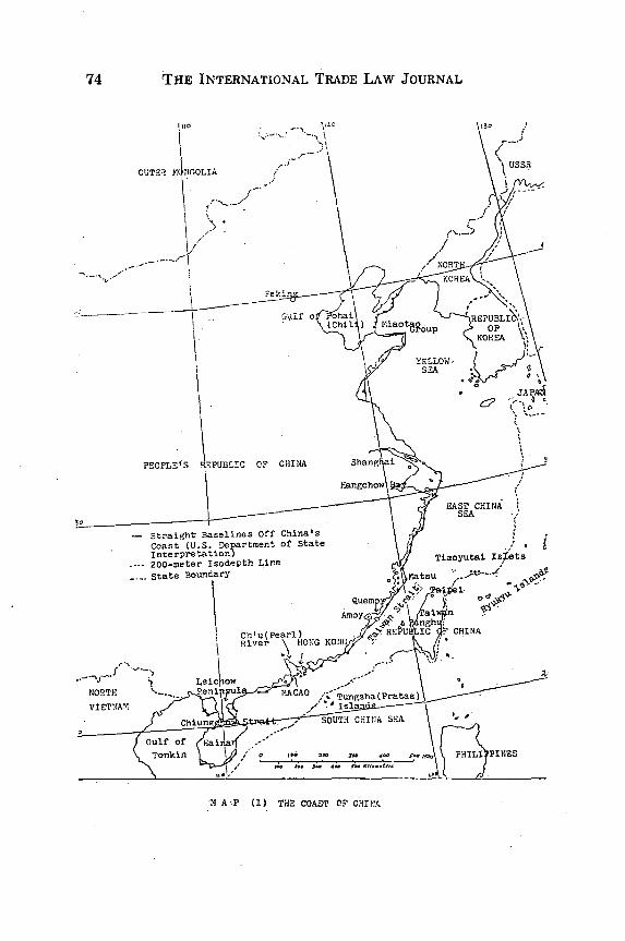
THE INTERNATIONAL TRADE LAW JOURNAL
OUTE'l r4NrOLIA
Gulf
PEOPLE"S OF CHINA
- Straight Baselilnes Off China's
Coast (U.S. Department of StateInterpretation)
---- 200-meter Isodepth Lire
State Boundary
Chlu(Pearl)River HONG
NORTH e /l MACAO
VIETNAM -
"M AP (1) THE COAST OF CHINA
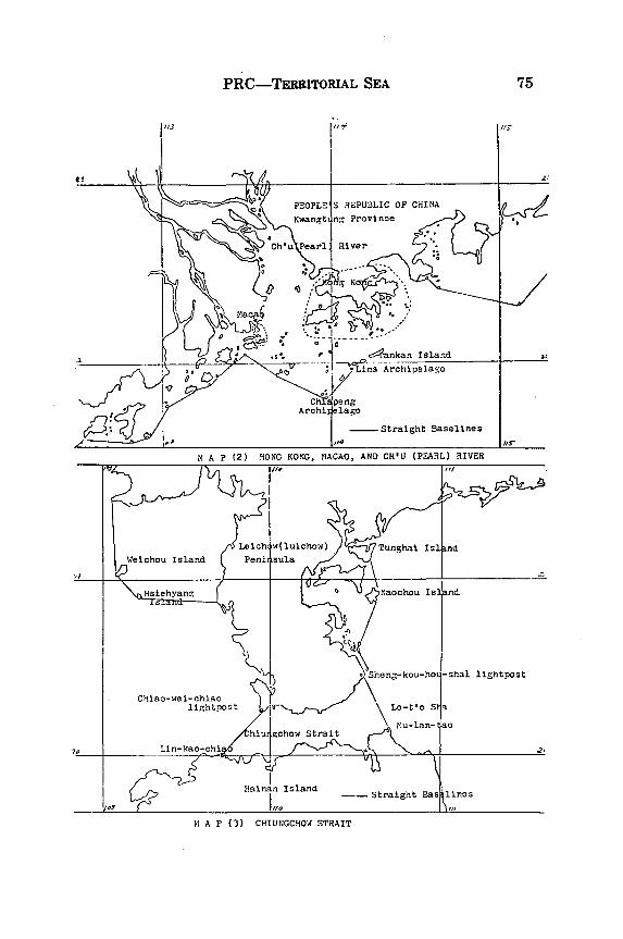
PRC-TERRITORIAL SEA
Archi elago
_-Straight Baselines
M1 A P (2) HONG KONG, MACAO, AND CH'IU (PeARL) RIVER
M A P (3) CHIUNGCHO4 STRAIT
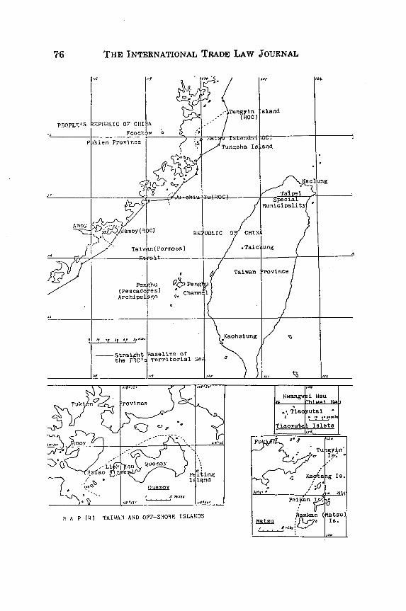
THE INTERNATIONAL TRADE LAW JOURNAL
M A P (4) TAIWAN AND OFF-SHORE ISLANDS
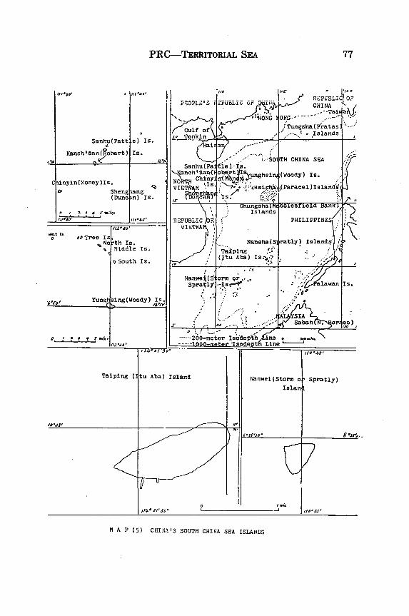
PRC-TERRITORIAL SEA
Sanhu(Patt
Kanchlikan(Robert)
.e) Is.
Is.
Ciinyin(Money)Is.
0 Sheng iang(Dune n) Is.
Po Tr S.
'0 rth Is.Middle Is.
vSouth Is.
' r Yunl sing (Woody) Is.:
0 - ~ ~ ! I ; , / -j , . - 1 ' .
Taiping (:
PEOPLE'S "PUBLI O
. Tnnk n
R) PuBSLJ)OFC H I NA a•R -- -- --.... .
:;Tungsha(,P .atas... 'Islands
Ia
ah a , .SO H CHINA SEASanhu(Patfle )I
a NOaH Ch btl nr y s g n
(Woody) Is.VI'TA %Is. <...'Hsi . (Paracel)Island
tChungsria(Mec soerie1Lc bank)' " IslandsjREPUBLIC A PHILIPPINES
,J,:. Nansha(S ratly) Islands" N
Taiping(Itu Aba) Is.-,*? .. -
Nanwei(S orm or... la.an Is.Spra~l --' s.-=l ° ": I--- --- n Is.
S IA- . .. Sabah or o)
.... .200-meter Is inddep oe
SIOO-meter Isodept Line
#1IIi
tu Aba) Island
1-
5i
Nanwei(Storm o Spratly)
IsIanl
il,'3~,. 7
M A P (5) CHINA'S SOUTH CHINA SEA ISLANDS
# I Ill "lii
! ll Wilfo,