Embed Size (px)
Citation preview
OVERALL ROAD EVALUATION
PREPARED FOR
WEST VINCENT TOWNSHIP
CHESTER COUNTY, PA
Submitted by
1033 South Hanover Street, Suite 300
North Coventry, PA 19465
P: 610.705.4500 F: 610.705.4900
www.cedarvilleeng.com
File No. WVT 16-069
June 23, 2016
Sustaining Communities by Design


TABLE OF CONTENTS
1
Table of Contents I. Executive Summary ........................................................................................................................................... 3
II. West Vincent Township Road System .............................................................................................................. 5
III. Overview of Paved Roads .................................................................................................................................. 6
A. Composition of a New Road ..................................................................................................................................... 6
1. Subgrade ................................................................................................................................................................ 6
2. Subbase .................................................................................................................................................................. 6
3. Base ........................................................................................................................................................................ 6
4. Binder...................................................................................................................................................................... 6
5. Wearing ................................................................................................................................................................... 6
6. Joint Seal ................................................................................................................................................................ 6
B. Composition of Existing Roads ................................................................................................................................. 6
C. Surface Water and Drainage .................................................................................................................................... 7
D. Subsurface Moisture and Drainage ......................................................................................................................... 7
E. Base Failure .............................................................................................................................................................. 8
F. Winter Maintenance ................................................................................................................................................. 8
G. Pavement Maintenance ........................................................................................................................................... 8
IV. Gravel Roads ................................................................................................................................................... 10
A. Composition ........................................................................................................................................................... 10
1. Subgrade ............................................................................................................................................................. 10
2. Aggregate (gravel or stone) ................................................................................................................................ 10
B. Surface Water and Drainage ................................................................................................................................. 10
C. Winter Maintenance .............................................................................................................................................. 11
D. Tools for Maintenance and Repairs ...................................................................................................................... 11
1. Roller .................................................................................................................................................................... 11
2. Shoulder Grading and Material Recovery .......................................................................................................... 11
V. Inspection Procedures .................................................................................................................................... 12
VI. Road Surface Conditions ................................................................................................................................ 13
A. Horseshoe TR ......................................................................................................................................................... 13
B. School House LA .................................................................................................................................................... 13
C. Kimberton RD ......................................................................................................................................................... 13
D. Art School RD ......................................................................................................................................................... 13
E. Flint RD ................................................................................................................................................................... 13
TABLE OF CONTENTS
2
F. Hilltop RD ................................................................................................................................................................ 13
G. Shady LA ................................................................................................................................................................. 13
VII. Critical Structure issues ................................................................................................................................. 14
A. French Creek Road - Arch structure failure .......................................................................................................... 14
B. Hollow Road ........................................................................................................................................................... 14
C. Jaine Lane – Twin 48-inch culverts ...................................................................................................................... 15
D. Jaine Lane – Birch Run Intersection North .......................................................................................................... 15
E. Flowing Springs Road ............................................................................................................................................ 17
F. Green Lane ............................................................................................................................................................. 19
G. Davis Lane .............................................................................................................................................................. 20
H. Schoolhouse Lane.................................................................................................................................................. 21
I. Hilltop Road ............................................................................................................................................................ 21
J. Sheeder Mill Road .................................................................................................................................................. 22
K. Art School Road ...................................................................................................................................................... 23
L. Fellowship Road ..................................................................................................................................................... 23
M. Flint Road ............................................................................................................................................................... 23
N. Horseshoe Trail ...................................................................................................................................................... 23
O. Miller Road ............................................................................................................................................................. 23
P. Bartlett Lane Erosion ............................................................................................................................................. 24
VIII. Conclusion ....................................................................................................................................................... 24
Attachments:
A. West Vincent Road Program Map
B. West Vincent Road Conditions Map
C. Select Culvert Locations Map
D. Table of Field Survey Notes
3
I. Executive Summary
West Vincent Township owns and maintains 47.5 miles of roadway. Twenty seven percent (27%) of those are
gravel roads, and seventy three percent (73%) are paved.
The Township authorized a road inspection and evaluation, performed by CEDARVILLE Engineering Group in
2016. All Township roads were inspected in April and May of 2016. This report reflects conditions at the time of
inspection.
Investing in regular road maintenance such as sealing cracks, chip sealing roads, and micro-surfacing streets
prolongs the life of roads, and prevents the much greater expenditures that will result if roads are not provided
with such maintenance at regular intervals. It is recommended the Township continue the program of sealing
roads at a rate of 5 to 7 miles annually, at a current cost of about $31,000 / mile.
About 5 miles of paved roadways are in very poor condition, requiring significant investment to rebuild or
significantly improve these roads before they enter the annual maintenance program. This includes portions of
the following roads: Horseshoe Trail, Schoolhouse Lane, Kimberton Road, Art School Road, Flint Road, Hilltop
Road and Shady Lane. The projected investment to improve the paved surface for all these roads is $2.9 million.
Gravel roads in the Township had been recently regraded at the time the inspection was performed. The
cartway conditions were generally smooth at the time, but there was a consistent notation that the roadside
ditches required cleaning and grading. In many instances, the ditches contained gravel intended for the
cartway. The report describes maintenance equipment that the Township may wish to consider to further
improve the effectiveness of gravel road maintenance.
Jaine Lane near Birch Run Road is a location with significant problems, and larger rain events can cause
significant street erosion resulting in quantities of gravel being washed onto Birch Run Road, onto private
properties and into waterways. Recommendations in section VII of this report include work that can be
completed this year to stabilize the cartway, and the procedures that must be undertaken for the long term
solutions and drainage improvements.
Numerous other structures that cross under Township roads are in urgent need of repair or replacement. This
report can be referenced as a basis for budgeting and prioritizing projects over the next 5 to 10 years.

4
5
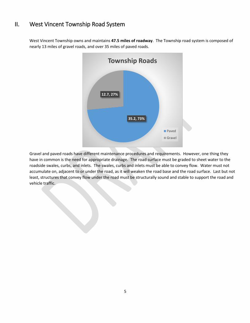
II. West Vincent Township Road System
West Vincent Township owns and maintains 47.5 miles of roadway. The Township road system is composed of
nearly 13 miles of gravel roads, and over 35 miles of paved roads.
Gravel and paved roads have different maintenance procedures and requirements. However, one thing they
have in common is the need for appropriate drainage. The road surface must be graded to sheet water to the
roadside swales, curbs, and inlets. The swales, curbs and inlets must be able to convey flow. Water must not
accumulate on, adjacent to or under the road, as it will weaken the road base and the road surface. Last but not
least, structures that convey flow under the road must be structurally sound and stable to support the road and
vehicle traffic.
35.2, 73%
12.7, 27%
Township Roads
Paved
Gravel
6
III. Overview of Paved Roads A. Composition of a New Road
New roads built as part of a land development or subdivision are built in layers. Each road design is
different, but will commonly use a combination of some or all of these layers;
1. Subgrade
The bottom layer is subgrade, usually the existing underlying soil that has been graded and
compacted to accept the stone and pavement of the proposed road. It is important that the soil
is properly compacted and structurally capable of supporting the roadbed. Some soils, such as
those that are not well drained and/or high in organic material, exhibit properties that are not
suitable for supporting a road. In cases where soils are not suitable, the soils can be modified
with additives and/or provided extra support with geotextile fabric before road construction
continues. If the subgrade is not suitable, the result will be pavement failure, including rutting
and potholes.
2. Subbase
Subbase is commonly composed of aggregate (stone). In current designs, it is generally a type
2A aggregate placed 4 to 6 inches thick and rolled for compaction.
3. Base
The base layer in roads built today is a bituminous pavement composed of larger stones (25
mm) blended in an emulsion. It is commonly placed 4 or more inches thick.
Decades ago, another common base was constructed of interlocking stone. Fine stones were
placed in a layer, then large stones, then fine stones swept in overtop to lock the base. We
often see this in roads built in the 1960’s or 1970’s, but it is a labor intensive process and
therefore rarely used today.
4. Binder
The next layer is also bituminous, and includes slightly smaller stones than the base layer (19
mm). This layer is placed 2 to 3 inches thick.
5. Wearing
The top layer on a new street is called the wearing course. The bituminous emulsion coats small
stones (9.5 mm), and is placed 1½ to 2 inches thick.
6. Joint Seal
All pavement joints, curb lines, and places where pavement abuts inlets and utility structures
should be sealed with a rubberized emulsion to seal the joint. The seal is intended to prevent
water from entering the pavement, and along curb lines has the added benefit of preventing
accumulation of silt and growth of weeds.
B. Composition of Existing Roads
Some local roads in this region constructed in the 1960’s through the 1980’s were properly constructed
with a prepared subbase, base and surface courses. With age, roads may show pavement distress from
7
decades of loading and become more brittle due to oxidation. However, if they have a good foundation,
a road maintenance program can extend their service life for decades to come.
Unfortunately, many local roads in rural Pennsylvania communities began as dirt pathways, evolved to
gravel roads, and were eventually surfaced with bituminous material. The term “pie crust pavement” is
used to describe roads that evolved through addition of surface material without underlying design and
construction. To determine the composition of these roads, it is often necessary to take a core sample.
They may not have adequate subbase, base, or bituminous material to support the traffic loads they
serve, resulting in pavement failures. When pavement failure is the result of a subbase or base problem,
simply putting another layer on the top is a short-term fix and ultimately a waste of resources, as the
underlying failure will reflect through the pavement structure in one to three years.
C. Surface Water and Drainage
Surface water is primarily rainfall and runoff. On new streets, pavements are built with a cross-slope so
that water will run to the side of the road during a rainstorm. A standard cross-slope for a paved road is
2% or ¼-inch per foot. Ideally, water is sheeted off the surface by cross-slope and carried in a roadside
swale, gutter, or storm drain to suitable drainage facilities.
When surface water ponds on the road surface, numerous problems result. Immediate concerns
include loss of vehicular control resulting from ponded water, winter icing, and loss of friction
(hydroplaning). Water that does not drain from the pavement surface will settle into voids in the
pavement and cause pavement failure, especially when combined with freeze-thaw cycles common in
our region.
Roadside ditches or swales are an economical way to convey flow along the road toward the nearest
waterway. However, roadside ditches require regular maintenance to maintain capacity and prevent
damage to the adjacent pavement. Roadside ditches require frequent mowing, cleaning, inspection and
regrading by experienced road crew personnel. Areas of erosion must be stabilized to halt pavement
damage and undermining. Grading must provide positive drainage to prevent accumulation of stagnant
water along the edge of the road bed.
Roadside ditches require frequent mowing, cleaning, inspection and regrading by experienced road crew
personnel. Areas of erosion must be stabilized to halt pavement damage and undermining. Grading
must provide positive drainage to prevent accumulation of stagnant water along the edge of the road
bed.
When waterways intersect the road, bridges or culverts are necessary to convey the flow under the
road. These crossings are subject to hydraulic forces, traffic loads, erosive forces, corrosion, and traffic
vibrations. Regular inspection, repair and replacement can become a significant component of road
work in a municipality.
D. Subsurface Moisture and Drainage
Underground springs or high groundwater tables can saturate the base. Water can also move laterally
through wet soil conditions during the spring thaw or seasonal wetness.

8
E. Base Failure
Some types of soils lose their stability when moist. One can easily think about walking across a firm clay
soil when it is dry, and sinking in the mud when it is wet. When a vehicle drives on flexible pavement,
the loads are transferred through the pavement layers, as depicted below.
The flexible pavement cannot support much loading without an underlying base. If the base deforms
with load, vehicle loading will cause the pavement to either sink (rut) down to the new subgrade level,
or fracture (crack) under the stress.
Base failure generally requires full depth excavation and material replacement. In some instances,
installation of pavement base drains or underdrains can help to reduce moisture problems with the
base.
F. Winter Maintenance
Paved roads can be plowed to remove snow from the surface, and treated with deicing agents and
cinders to improve traction during winter weather.
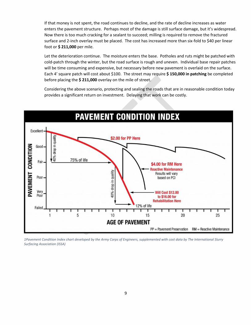
G. Pavement Maintenance
Establishing an ongoing pavement maintenance program is an excellent investment for a municipality,
because rebuilding a road after it fails is extremely expensive.
Consider a road in fairly good condition, with a few surface cracks and the surface pavement is lightly
aged and oxidized. Application of double chip seal or micro-surfacing to that road surface will not add
structural value, but will seal it against moisture penetration, provide increased skid resistance, provide
a surface for the plow blade to scrape without dislodging stone from the wearing course, and provide
another 5 to 8 years of service life before the road returns to the same quality. In round numbers, that
seal would cost about $6 per linear foot of road, or about $ 31,000 per mile.
9
If that money is not spent, the road continues to decline, and the rate of decline increases as water
enters the pavement structure. Perhaps most of the damage is still surface damage, but it’s widespread.
Now there is too much cracking for a sealant to succeed; milling is required to remove the fractured
surface and 2-inch overlay must be placed. The cost has increased more than six-fold to $40 per linear
foot or $ 211,000 per mile.
Let the deterioration continue. The moisture enters the base. Potholes and ruts might be patched with
cold-patch through the winter, but the road surface is rough and uneven. Individual base repair patches
will be time consuming and expensive, but necessary before new pavement is overlaid on the surface.
Each 4’ square patch will cost about $100. The street may require $ 150,000 in patching be completed
before placing the $ 211,000 overlay on the mile of street.
Considering the above scenario, protecting and sealing the roads that are in reasonable condition today
provides a significant return on investment. Delaying that work can be costly.
1Pavement Condition Index chart developed by the Army Corps of Engineers, supplemented with cost data by The International Slurry Surfacing Association (ISSA)
10
IV. Gravel Roads A. Composition
Gravel Roads are composed of the earthen subgrade with aggregate on top. A correctly constructed
gravel road is provided with cross-slope or crown, and drained with roadside swales or similar drainage
conveyance systems.
1. Subgrade
The bottom layer is subgrade, usually the existing underlying soil that has been graded and
compacted to accept the stone of the proposed road. It is important that the soil is properly
compacted and structurally capable of supporting the roadbed. Some soils, such as those that
are not well drained and/or high in organic material, exhibit properties that are not suitable for
supporting a road. In these cases, the subgrade should be evaluated to determine the
appropriate treatment or treatments necessary to improve the material load capacity. Methods
may include material excavation and replacement, amendment of the soils with hydrated lime
or cementitious materials, or application of geotextile materials.
2. Aggregate (gravel or stone)
Proper surface aggregate should be selected to maximize performance of gravel roads. Some
gravel roads are constructed with two layers of aggregate; a base and a surface course. In such
cases, the base has a larger stone size than the surface. In most gravel roads in West Vincent
Township and other localities, only surface aggregate is applied.
Surface aggregate should include the appropriate gradation, including a certain percentage of
fines. Pennsylvania has a specification for aggregate for gravel roads, termed “DSA” or Driving
Surface Aggregate, but few local suppliers. The stone in DSA is all smaller than 1½ inches and
most of it is smaller than ¾ inches. Another specification sometimes used by local road
departments is “2A modified.” While no longer an accepted PennDOT specification, it is still
familiar in the industry as 2A aggregate with fines. The current PennDOT 2A specification does
not include as many fines, and is not recommended for surfacing gravel roads.
It is my understanding the Township is currently using recycled pavement material, which has
some benefits and is often less expensive than quarry stone. Recycled pavement can have
variable properties depending on the amount and age of bituminous material in the product.
B. Surface Water and Drainage
Gravel roads must be graded with a crown or cross-slope so that water will not pool on the surface. The
recommended cross-slope for a gravel road is 4% or ½-inch per foot. Water that falls on a gravel road
should be sheeted off the surface by cross-slope and carried in a roadside swale, gutter, or storm drain
to suitable drainage facilities.
Water ponding on the road surface of a gravel road will lead to surface failure, reflected as depressions
or potholes in the road.
An experienced road crew will watch for signs of erosion on the road surface. If water begins to form a
channel on the road surface, it can rapidly evolve into a more serious erosion problem and road failure.
Gravel roads require diligent road inspections and observations after each storm event.

11
Roadside ditches require regular maintenance. On gravel roads, the maintenance is more intensive, as
gravel removal from the ditches becomes a component of the work. Gravel can wash into the ditches
with a rain event, be relocated toward the ditches by vehicle tires, and can even be pushed into ditches
by the grader during road maintenance operations.
C. Winter Maintenance
Plowing gravel roads presents challenges. Unless the ground is hard frozen, the operator often has to
choose between using the plow to scrape all the snow off the surface and potentially plow the gravel off
to the edge of the road in the snowbank, or set the plow blade above the road to preserve the gravel.
D. Tools for Maintenance and Repairs
Our May 2016 inspection suggests the public works crew does an excellent job of regrading and
restoring the roads after a storm event. The grader work was smooth and consistent, with very little
wash boarding.
It is our understanding the Township recently invested in scarifier teeth for the moldboard blade.
Scarifier teeth allow the equipment to cut into the top inches of the surface to optimize regrading, and
were a wise investment.
Two tools may further improve the work being done, and should be considered for municipal
investment if gravel roads will continue to be a significant component of the infrastructure.
1. Roller
Pneumatic or rubber tired rollers are preferred for gravel road compaction. The Township could
rent a roller, to follow the grader. However, to save on labor cost, ensure the equipment is
available when needed, and improve operational efficiency, the rollers that attach to the grader
should be considered.
Purchased new, a roller that attaches to a grader may cost about $20,000.
2. Shoulder Grading and Material Recovery
Maintaining roadside ditches and swales is a key to preserving gravel roads. In West Vincent
Township, the gravel road surface is often pushed into the ditches by traffic and by re-grading
operations. There are tools available, such as recovery disks that attach to the grader. This tool
will recover material and shape the ditch.

12
Purchased new, this piece of equipment may cost $7,000. Additional costs may be incurred if
the grader does not currently have the proper connecting hitch. This type of equipment can
also be purchased for use with a tractor (instead of a grader) for roughly $11,000.
V. Inspection Procedures Inspections were performed between April 21 and May 17, 2016. Inspection notes provide a record of road
conditions specific to the window of time described.
Heavy rains in February and March of 2016 had caused significant damage to local roads and drainage facilities,
and the Township Public Works Department had recently worked most of the gravel roads with a grader to
restore the roads to drivable conditions. The inspection report represents a moment in time on a dynamic road
system. The condition of the roads, and particularly the gravel roads, is ever changing.
Each Township owned road in West Vincent Township was driven. For each road the following was noted:
Road name
Road length
Road surface (gravel or paved)
Approximate cartway width
A subjective condition score, based upon visual appearance of surface and smoothness of ride. Scores
ranged from 1 to 10, with 10 being a road in near perfect condition.
Approximate locations where road surface or condition changed.
Results of visual inspection of significant cross-pipes or drainage structures.
Observations of severe or unusual erosion relating to drainage along or under the roadway.

13
VI. Road Surface Conditions The paved West Vincent Township roads noted to have the worst surface condition are listed below;
A. Horseshoe TR About 0.7 mile of Horseshoe Trail, between St Matthews and Fellowship Roads, is in very poor condition. Township employees have placed over 100 tons of cold patch material in the past year to keep this road passable.
Extensive base repairs are needed in advance of mill and overlay. Improving this portion of road is expected to cost $247,000
B. School House LA The section of School House Lane between Hollow Road and Flowing Springs is in very poor condition. Following drainage improvements, paving reconstruction and overlay is recommended.
Recycling and/or rebuilding this section of School House Lane would cost roughly $111,000. Drainage improvements that must precede pavement work could add another $50,000 to the project cost.
C. Kimberton RD More than 7000 feet in length, this road requires drainage improvements to carry water away from the pavement base, and full depth reconstruction including base stabilization.
The cost to rebuild over 1⅓ mile of roadway may exceed one million dollars. Core samples and a project specific review of the scope of improvements should be undertaken to determine the most cost-effective approach to improving this road.
D. Art School RD The worst section of Art School Road is over 1700 feet in length.
Recycling and rebuilding of the worst portion of Art School Road is expected to cost $250,000.
E. Flint RD Flint Road should be rebuilt with drainage improvements and profile adjustments.
Reconstruction of Flint Road is expected to cost $650,000.
F. Hilltop RD About 1¼ mile of Hilltop Road is in very poor condition.
Extensive base repairs, followed by mill and overlay, would represent an investment of about $400,000.
G. Shady LA Shady Lane is less than 2000 feet in length. Core samples should be taken to determine if it is a candidate for recycling and overlay.
Recycling and/or rebuilding Shady Lane is expected to cost $260,000.
Total: $2,900,000
A tabulation of the costs discussed above reveals that 5 miles of paved Township roads are due for $2,900,000
investment in the paved surface. That represents about 14% of the paved roads in the Township.
In contrast to the problems detailed above, the investment the Township has made in chip seal applications to
maintain road conditions has prolonged the service life of other Township roads. Twenty-five miles of paved
Township roads (71%) were rated with a score of 6 or better. It is recommended that the Township continue to
14
chip seal paved roads to prolong service life. A plan to chip seal 5 to 7 miles of paved roads per year will result in
all roads receiving maintenance every 5 to 7 years, prolonging the life of the road and reducing the need for
patching, repaving and future full depth reconstruction projects.
Two of the gravel roads are prime candidates for paving at this time. The first is St. Andrews, reported to have
higher traffic volumes resulting in wash boarding of the road and increased maintenance and material needs.
The other is Dewees Lane, which now has a very short section of gravel. In June of 2016, West Pikeland
Township paved the portion of Dewees Lane on the township boundary. Paving this remaining short gravel
section would be a logical course to provide consistency to the road surface and road maintenance procedures.
Adequacy of drainage facilities should be reviewed prior to paving.
VII. Critical Structure issues Issues most critical to the Township road system include structural stability of the roads at stream and waterway
crossing, condition of roadside drainage conveyances, and condition of the pavement.
A. French Creek Road - Arch structure failure
Road closed. Survey, evaluation of repair and permitting requirements underway.
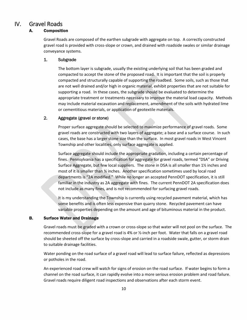
B. Hollow Road
Slab Span Structure, approx. 15-foot span. Significant deterioration.
This structure should be evaluated by a qualified structural engineer for safety, stability, and
recommended repair measures.

15
C. Jaine Lane – Twin 48-inch culverts
Twin 48-inch culverts are corroded and must be replaced. Pavement is recommended for stabilization
over the surface of the crossing, and adjacent to the crossing for bypass flow during large storm events.
The Township will need to obtain a General Permit (GP-11) from the Pennsylvania Department of
Environmental Protection to replace these culvert pipes. Concrete Headwalls on either side are
recommended. The replacement pipes can be concrete or, if concrete headwalls are used, HDPE pipe.
An increase in pipe diameter is suggested, as the invert of the replacement pipe must be set 12 inches
below the existing streambed elevation. The road surface should be paved at the crossing and
approaching the crossing. Careful attention should be given to profile grading; ideally the road grade
adjacent to the crossing would be lower than the surface grade at the crossing. If a storm event exceeds
the capacity of the pipes, flow over the paved approach is less likely to cause significant erosion and
damage to the cartway. However, significant changes in the roadbed elevation should be avoided, as
significant changes to grades of approaches are not permitted by GP-11. The preliminary construction
cost estimate for installing headwall, 60” concrete pipes, and paving 400 LF of Roadway at current prices
is $100,000.
D. Jaine Lane – Birch Run Intersection North
This section of gravel road climbs upward from Birch Run Road. Stormwater runoff carries the surface
gravel to the roadside ditch and conveys it rapidly down the slope. The flow combines with runoff
exiting the woodlands in a swale, resulting in a torrent of water and gravel flowing toward Birch Run in a
major storm event. The Public Works Department has made efforts to capture some of this flow by
installing type M inlets in the roadside swale to carry the water away, but the inlet grates becomes
choked with gravel, which reduces the effectiveness of these structures.

16
Resolution of the problems in this location will require a drainage improvement and paving project.
Birch Run is a State road, so any improvements that impact Birch Run Road will require review and
approval (Highway Occupancy Permit) from the Pennsylvania Department of Transportation.
Resolution will require installation of additional drainage facilities to capture flows on the west
(upslope) side of the road, particularly the natural swale that intersects the roadside. The pond
overflow needs to be incorporated into the design, and the existing drainage structure under Birch Run
Road must be supplemented or replaced. The road surface should be paved to the top of the slope, and
the swale analyzed to determine the appropriate lining to achieve stabilization.
Existing Drainage Structure under Birch Run Road
Pond Overflow
17
To implement improvements, it will be necessary to obtain a topographical, location and property line
survey to establish existing features, elevations and the extent of available rights-of-way. Drainage
facilities must be designed, and an intersection plan prepared for submission to the Pennsylvania
Department of Transportation. Concurrently, an application should be made to Pennsylvania DEP for a
general permit for the outfall structure. We note that the Township has already invested in 38” x 60”
Oval Concrete Pipe, inlets and endwalls for this project that must be reflected in the project design plan.
Jaine Lane should be paved from Birch Run Road north to the top of the hill. A base course of pavement
could be placed this year to stabilize the cartway, but the design and PennDOT permitting of a
stormwater solution will take a bit longer and would likely be a 2017 project. The ditch along the side of
Jaine Lane should be stabilized concurrent with paving operations. Rip-rap lining may be suitable to
stabilize this swale for much of length of the hillside, excepting the area nearest the intersection that
must be addressed with drainage facility and structure design.
The preliminary construction cost estimate for installing a base course of pavement on ±1800 LF Jaine
Lane and lining the swale is $200,000. The additional cost of work to install drainage facilities and apply
the wearing course of pavement would be estimated after plan development.
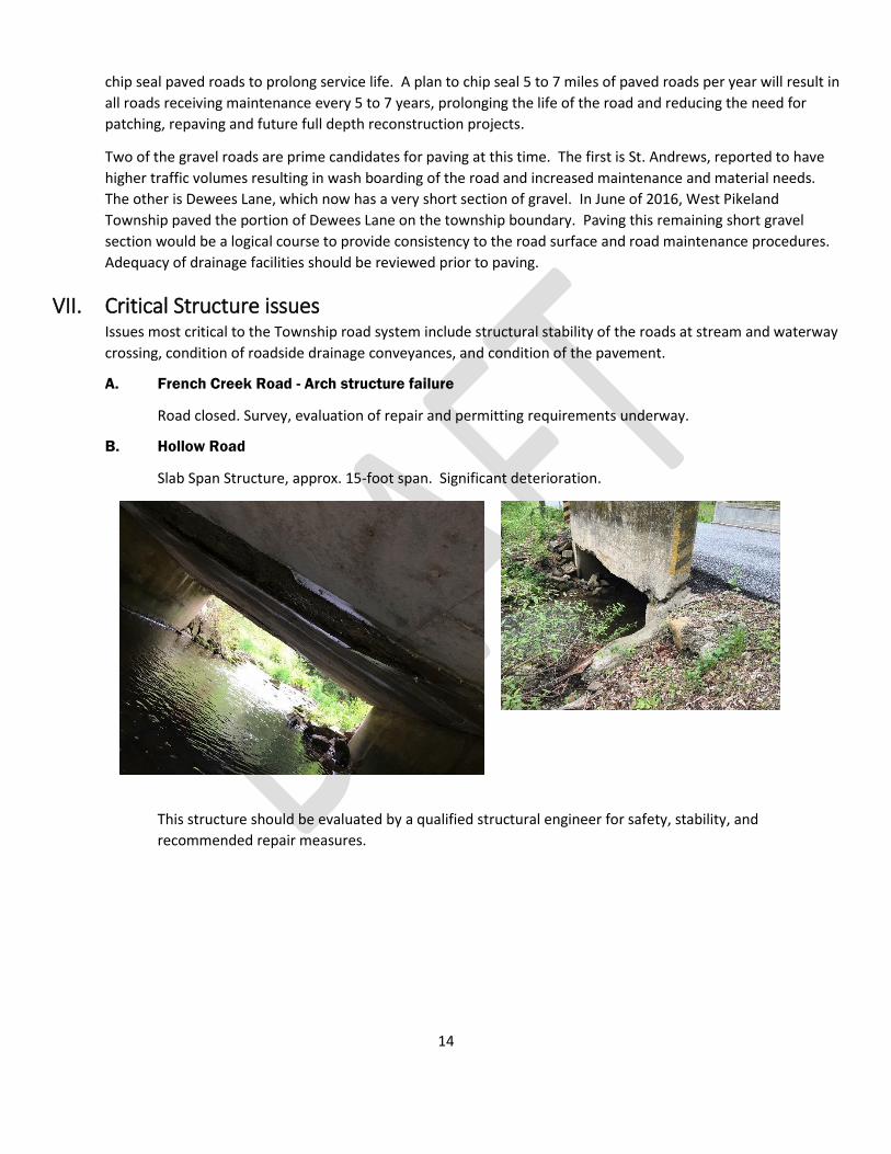
E. Flowing Springs Road
The headwalls for these twin 30-inch concrete culverts are in poor condition. The parapet walls have
crumbled and will not provide any barrier between a vehicle and a 3 or 4 foot drop-off. The walls may
soon be insufficient to hold the edge of the road surface.
At a minimum, a stone mason should be employed to reset and mortar the stones.

18
Flowing Springs Road: The mill race headwall, pictured here, is not secured to the HDPE pipe, resulting in a hole behind the headwall along the road edge.
Flowing Springs Road: The road edge on the other side of the mill race crossing is damaged, and it is clear this area was previously and recently patched. The location warrants further evaluation to determine if stream bank stabilization would better direct and control Birch Run flows, or if further road and drainage improvements are warranted in this area.

19
F. Green Lane
Erosion problem at the 36-inch pipe crossing near Hilltop Road may be improved by regrading to remove
stone windrows.
Since the date of inspection, the Public Works Department has performed some manual grading to
redirect the upslope. This is a constant maintenance issue, and the Township should consider extending
the pipe and/or adding headwalls to each end to provide stability to the road surface.
Erosion problems evident at the each end of the 36-inch concrete pipe near the intersection with
Bartlett Lane are scheduled to be addressed by the Public Works Department this season, by extending
the pipe length and stabilizing the pipe entrance and exit with riprap.

20
G. Davis Lane
6 foot diameter pipe is rotted out, steel plates on surface suggest roadbed failure. This pipe should be
replaced.
Just south of the 6 foot pipe is an unprotected drop at the edge of the roadway. Sixty feet or more of guiderail should be installed in this location.

21
H. Schoolhouse Lane
Schoolhouse Court north of Flowing Springs Road is in poor condition. Only about 17 feet wide, the road
width is constrained by existing drainage facilities. Steep drops adjacent to the road edge due to culvert
crossing and ditch erosion are unprotected. In addition, the Public Works Department advises a winter
spring appears about 40 feet north of the existing 30-inch culvert, creating an icing problem.
The existing 30-inch culvert should be extended and endwalls provided. Following survey establishment
of the limits of the road right-of-way, the roadside northeast of the culvert should be graded to provide
a swale that will convey flow from the winter spring away from the cartway and toward the waterway.
On the east edge of the road between Flowing Springs Road and the 30” culvert, a pipe discharges flow
from the PennDOT maintained road to the shoulder of Schoolhouse Lane. Ideally, storm piping should
be installed from Flowing Springs to the culvert crossing. Alternately, if enough right-of-way is available,
the flow could be conveyed in a rip-rap lined swale, with ample shoulder between the cartway and rip-
rap lined swale for vehicular safety.
I. Hilltop Road
A 24-Inch corrugated metal pipe with concrete headwalls located near Shady Lane has a corroded
bottom and should be replaced.
The bottom of a 32-inch metal pipe with a 4-foot corrugated metal extension is corroded, and has
insufficient cover. The structure should be replaced. The new structure should be provide no less than
12 inches cover, or more as required to meet pipe manufacturer recommendations for H20 loading. If
adjacent grades do not allow installation of a replacement 32-inch pipe with cover, two 24-inch
diameter pipes would provide similar capacity to one 32-inch pipe.
Two 15-inch corrugated metal cross pipes have insufficient cover and the downstream ends are crushed.
These pipes should be replaced and adequate cover provided.

22
J. Sheeder Mill Road
North of Flowing Springs Road water crosses under Sheeder Mill Road in a structure that is a
combination of a stone arch and a 21-inch diameter concrete pipe (RCP). The pavement is depressed
and broken in the vicinity of the pipe. The property owner confirmed that flow overtops the road in this
location, and he has created a defined spillway with his walkway to direct the overflow back to the
waterway. This structure should be evaluated for replacement.
Further north on Sheeder Mill Road, a 24-inch diameter RCP conveys flow under the road. The east
edge of the road has a steep drop protected by guiderail, but the ground under the guiderail is eroded
and washed away, compromising the stability of the guiderail and eventually the roadbed. The area
should be stabilized with grouted rip-rap or gabion baskets.
23
K. Art School Road
The 36-inch pipe north of Horseshoe Trail is failing from corrosion. Replacement is recommended.
L. Fellowship Road
A metal arch plate structure carries the road over a stream that crosses Fellowship Road south of
Horseshoe trail. This arch structure has concrete footers, and the stream has scoured under the footers.
The paved road surface exhibits a slight depression. This structure should be further evaluated; scour
protection may be required.
M. Flint Road
Flint Road has at least two steel cross pipes that are crushed or failed. In addition to the failed steel
pipes, the road has concrete and HDPE cross pipes with little or no cover. The road pavement is in very
poor condition. Replacement of the failed culverts is recommended concurrent with road reprofiling
(raising the elevation and thickness) to achieve adequate cover over these cross-pipes.
N. Horseshoe Trail
The cable guiderail in the vicinity of twin 7-foot cross pipes east of Chester Springs Road has fallen and
should be repaired or replaced.
O. Miller Road
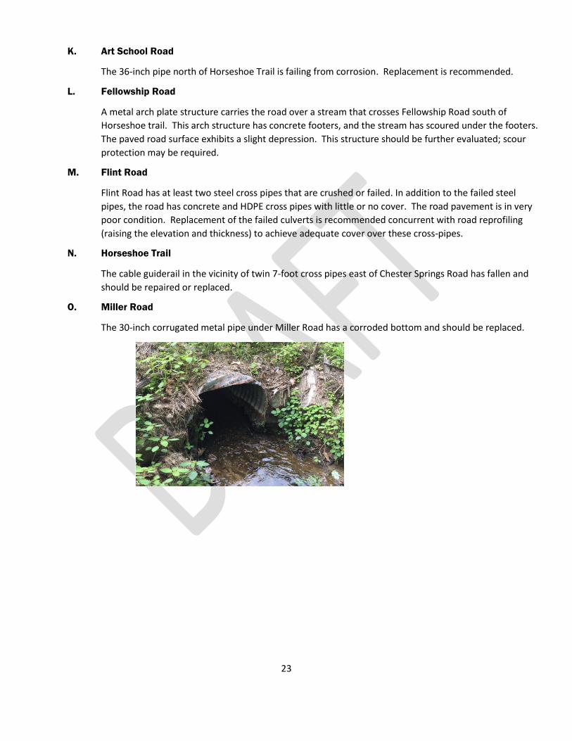
The 30-inch corrugated metal pipe under Miller Road has a corroded bottom and should be replaced.

24
P. Bartlett Lane Erosion
The discharge from a 24-inch HDPE pipe under Bartlett Lane is causing extreme erosion, pictured below.
Upon request, CEDARVILLE Engineering can evaluate the flow and velocity in the location and provide
recommendation on energy dissipation and stabilization for this outfall.
VIII. Conclusion
West Vincent Township owns and maintains 47.5 miles of roadway. Roadway maintenance is a principal
responsibility of a Pennsylvania Municipal Government, and one of its greatest expenses. A proactive approach
to pavement maintenance will ultimately provide cost savings for the Township, but there are many structural
issues that require significant investment at this time. Concurrently, maintenance practices must continue so
that roads that are in acceptable condition today do not deteriorate.
The information in this report should provide information useful to municipal officials as they make decisions
about expenditures for the safety, welfare and benefit of Township residents. The attached tables provide an
overview of the road conditions and notes associated with this report.

Hilltop RD
Sheed
er Mill
RD
Beaver H
ill RD
Beaver Hill RD
Jaine LA
Flowing Springs RD
Hilltop RD
Horseshoe TR
Bartl
ettLA
Horseshoe TR
Potts
town P
K
Black Horse
RD
Fello
wship
RD
Art School RD
S Chester Springs RD
S Ches
ter Sp
rings
RD
Eagle Farms RD
Dewees LA
Miller RD
Kimb
erton
RD
WARWICKTOWNSHIP
EASTVINCENT
TOWNSHIP
SOUTHCOVENTRYTOWNSHIP
EAST PIKELANDTOWNSHIP
EASTNANTMEALTOWNSHIP
CHARLESTOWNTOWNSHIP
WESTPIKELANDTOWNSHIP
UPPER UWCHLANTOWNSHIP
BIRCH RUN
BLAC
KHO
RSECR
EEK
PI NE CRE EK
B IRCH RUN
BIRCH RUN
FRENCH CREEK
FRENCH CREEK
Conestoga RD
Chester
Spring
s RD
Hollow RD
Hollow RD
Pottstow nPK
Saint Matthews RD
Saint Mat thews RD
Saint Matthews RD
Pughtown RD
Pughtown RD
Birchrun RD
French Cree
kRD
Pottstown PK
Flowing Springs RD
Birch
runRD
Birchrun RD
Birchrun R D
Horseshoe TR
Conestoga RD
Conestoga RD
Saint Matthews RD
RedBone RD
Rosewood DRHoundstooth CI
Carriage LA
Shawnee CTJuniper AV
SweetBirch LA
Gregory WYLauren LA
ClarksonDR
Shannon DRSundance
DR
SaintAnthony
LA
WatchHill LA
3.
3
1.
1
2.
2
4.
4
Jaine LA
PlumLA
Rache
lDR
HeidiLA
Brian WY
Hilltop RD
Saint Matthews RD
Oneida
CT
ForestGlen DR
Kyle DR
Re d Fox
LA
WetherillLA
MarigoldCT
Fox Run
RD
Brighton
WY
Adelphia LA
Dewees
LA
SenecaCT
Saint Andrews LA
Springlea LA
Laymens WY
S IroquoisLA
Douglass LA
NIroquois LA
Lobella CT
PinehurstDR
Lily PondLALinden AV Houndstooth LA
Kimberbrae DR
Lexin
gton
BL
Wyndemere Lak e D R
Mill RD
Malehorn RD
Hunt
H illRD
Markleys Corner RD
ArtSch
ool RD
Shady LA
Flowing Springs RD
Cedar LA
Phillips LA
Nantmeal RD
Bertolet Schoo
l RD
Fairmont DR
Wind
gate
DR
SBeav
erHil
l RD
Shee
der M
illRD
Cooks Glen RD
Buttonw
oodLA
Westover LA
French Creek RD
Black Horse RD
Flint RD
Miller RD
Horseshoe TR
Hollow RD
Eagle Farms RD
Daniel DR
FellowshipRD
Bartlett LA
Barrington LA
Ford
RD
Pine DR
S Che
ster S
pring
s RD
Scho
olHo
use L
A
Kimbe
rtonRD
Beaver
HillRD
Davis LA
Green LA
Saw Mill RD
¯
WES
T VIN
CENT
TOW
NSHI
PPE
NNSYL
VANI
A
ROAD
PROG
RAM
1 inch = 1,200 feet
REVI
SIONS
SCALE:
1 OF 1
CHES
TER C
OUNT
Y, PA
DRAWN BY: BU
CHECKED BY: BU
DATE
: 04/
20/2
016
729 St
. Matt
hews
Road
Chest
er Sp
rings,
PA 19
425610
-458-1
601
04/2
5/20
16BH
06/0
9/20
16BE
U
NOTES:1. Parcels and base road layer provided by the Chester County GIS (2016).2. Road data (i.e. observations, recommendations, road score, culvert conditions, etc.) collected by CEDARVILLE in May 2016.
DISCLAIMER:This product is for informational purposes and may not have been prepared for, or be suitable for legal, engineering, or surveying purposes. Users of this information should review or consult the primary data and information sources to ascertain the usability of the information. 0 1,200 2,400600 Feet
CONTOURS (10-FT INTERVAL)
TOWNSHIP GRAVEL ROADSPRIVATE ROADS
WATERBODIESSTREAMS
MUNICIPAL BOUNDARIES
STATE ROADS
TOWNSHIP PAVED ROADSLEGEND

WARWICKTOWNSHIP
EASTVINCENT
TOWNSHIP
SOUTHCOVENTRYTOWNSHIP
EAST PIKELANDTOWNSHIP
EAST NANTMEALTOWNSHIP
CHARLESTOWNTOWNSHIP
WEST PIKELANDTOWNSHIP
UPPERUWCHLANTOWNSHIP
BLAC
KHOR
SEC
REE
K
FRENCHCREE K
PINECREEK
BIRCHRUN
BIRC
H
RUN
FRENCHCREEK
Red Bone RD
Rosewood DR
Houndstooth CI
Carr iageLA
Shawnee CT
Juniper AV
Sweet Birch LA
Jaine
LA
Plum LA
Gregory WY
Rachel
DR
Heidi LA
Brian WY
Hilltop RD
Lauren LA
ClarksonDR
Saint Matthe wsRD
OneidaCT
ForestGlen DR
Ky leDR
Red Fox LA
Weth erill LA
ShannonDR
Marigold CT
Fo x
Run
RD
Bright onWY Sc
hool
Hous
eLA
Ade lphia LA
Dewee
s LA
Seneca
CT
Sundance DR
Saint
Anthony
LA
Saint
Andrews LA Spr i nglea
LA
LaymensWY
SIroquoisLA
Douglass LA
NI roquois
LA
Lobella CT
Pine
hurst
DR
Lily PondLALinden AV
Houndstooth
LA
Kimberbrae
DR
Lexin
g ton
BL
FellowshipRD
Wyndemer e
LakeDR
Mill R D
Malehorn RD
Hunt HillRD
Markleys Corner
RD
Art Scho
ol RD
Shady LA
Flowing Springs RD
Cedar LA
Phillips LA
Bartlet
t LA
Nantmeal RD
Ford
RD
Pine DR
Bertolet Scho
ol RD
S Chest
erSp
rings
RD
Fairmont DR
Wind
ga
te DR
SBeav
erHil
l RD
Shee
der Mill
RD
Cooks Glen RD
Kimbe
rton
RD
Bea
ver Hill RD
Butto
nwood LA
WestoverLA
French Creek RD
Black Horse RD
Flint RD
Davis L
A
Miller RD
Horseshoe TR
Gree
n LA
Hollow
RD
Saw
Mill R
D
Eagle Farms RD
Watch Hill LA
Daniel DR
Barrington LA
N Iroquois
LA
11. 11
3.
3
13.13
1.
1
4.
4
12.
12
2.
2
9.
9
10.
10
7.
7
5.
5
6.
6
14.14
8.
8
Cheste
r Spri
ngs R
D
Pughtown RD
Horseshoe TR
Conestoga RD
Potts
town P
K
F lowing Spring s RD
Birchrun RD
Saint Matthews RD
Hollo
w RD
¥
DRAWN BY: BU0 1,500 3,000750
Feet
1 inch = 2,750 feet
CEG Proj #: WVT-16-069
Date: 06/09/2016
ROAD
PROG
RAM
CEDARVILLEEngineering Group, LLC
NOTES:1. Parcels and base road layer provided by the Chester County GIS (2016).2. Road data (i.e. observations, recommendations, road score, culvert conditions, etc.) collected by CEDARVILLE in May 2016.3. Road scores were assigned based on a 1 to 10 rating scalereflecting general road condition and need of repair.
DISCLAIMER:This product is for informational purposes and may not have been prepared for, or be suitable for legal, engineering, or surveying purposes. Users of this information should review or consult the primary data and information sources to ascertain the usability of the information.
LEGEND
STREAMS
8 - 10
PARCELSMUNICIPAL BOUNDARIES
WEST
VINC
ENT T
OWNS
HIP
CHES
TER
COUN
TY, P
ENNS
YLVA
NIA
Revisions:
WATERBODIES
STATE ROADS
6 - 7.5
ROAD
COND
ITION
(M
AY 20
16)
TOWNSHIP PAVED ROAD CONDITION TOWNSHIP GRAVEL ROAD CONDITION
6 - 7.54 - 5 4 - 50 - 3
8 - 10

_̂
_̂
_̂
_̂
_̂̂_
_̂_̂_̂̂_
_̂
_̂
_̂ _̂ _̂
_̂
_̂
_̂
_̂
_̂̂_
_̂
_̂
_̂
_̂
S. Be
aver
Hill R
D
9
15.
11.9.
12.
16.
13.14.
10.
Daniel DR
Watch Hill LAS Beaver Hill RD
Art School RD
Adelphia LA
Kyle DRGregory WY
Houndstooth CI
7.5.
2.4.
8.6.
1.3.
Fairmont DRSundance DR
Red Fox LAPlum LA
Sweet Birch LAJuniper AV
Shawnee CTRosewood DR
WARWICKTOWNSHIP
EASTVINCENT
TOWNSHIP
SOUTHCOVENTRYTOWNSHIP
EAST PIKELANDTOWNSHIP
EAST NANTMEALTOWNSHIP
CHARLESTOWNTOWNSHIP
WEST PIKELANDTOWNSHIP
UPPERUWCHLANTOWNSHIP
Slab Span Bridge
Stone Arch
Stone Arch
Conspan Bridge
BridgeMill Race48in
SteamPipe
36inHDPE
15in CMP
15in CMP32inSteamPipe
24in CMP
24in CMP
72inSteamPipe (2) 30in
RCP
18in CMP
19inSteel
36in CMP
24inHDPE
15inSteel
48in Steam Pipe
30in CMP
24in RCP
30in RCP
36in RCP
RedBone
RD
Carr iageLA
Jaine LA
Rachel
DR
Heidi LA
Brian WY
Hilltop RD
Laur
enLA
ClarksonDR
Marg aretDR
Saint Matthews RD
OneidaCT
ForestGlen DR
Weth erill LA
ShannonDR
Marigold CT
Fo x
Run
RD
Bright onWY
Dewee
s LA
Seneca
CT
Saint
Anthony
LA
Saint
Andrews LA Spr i nglea
LA
LaymensWY
S Iroquo isLA
Douglass LA
NI roquois
LA
Lobella C T
Pine
hurst
DR
Lily PondLALinden AV
Houndstooth
LA
Kimberbrae
DR
Lexin
g ton
BL
Wyndemere
LakeDR
Mill RD
Malehorn RD
HuntHillRD
Markleys Corner
RD
ArtScho
ol RD
Shady LA
Flowing Springs RD
Cedar LA
Phillips LA
Nantmeal RD
Horseshoe TR
Bertolet S choo
l RD
Windga
teDR
Shee
der M
ill RD
Cooks Glen RD
Buttonw
ood LA
Westover LA
French Creek RD
Black Horse RD
Flint RD
Miller RD
Horseshoe TR
Hollow
RD
Eagle Farms RD
Scho
olHo
useL
A
Fellowship RD
Bartle
tt LA
Barrington LA
Ford
RD
Pine DR
S Che
ster S
pring
s RD
Kimbe
rton RD
Beaver
Hill RD
Davis LA
Green LA
Saw Mill RD
3
10
1
6
8
4
1413
2
16
5
12
7
11
15
BLAC
KHOR
SEC
REE
K
FRENCHCREE K
PINECREEK
BIRCHRUN
BIRC
H
RUN
FRENCHCREEK
Cheste
r Spri
ngs R
D
Pughtown RD
Horseshoe TR
Conestoga RD
Potts
town P
K
F lowing Spring s RD
Birchrun RD
Saint Matthews RDHollo
wRD
¥
DRAWN BY: BU0 1,500 3,000750
Feet
1 inch = 2,750 feet
CEG Proj #: WVT-16-069
Date: 06/09/2016
ROAD
PROG
RAM
CEDARVILLEEngineering Group, LLC
NOTES:1. Parcels and base road layer provided by the Chester County GIS (2016).2. Road data (i.e. observations, recommendations, road score, culvert conditions, etc.) collected by CEDARVILLE in May 2016.3. Culverts and bridges in poor condition should be replaced orrepaired as applicable, as soon as possible.
DISCLAIMER:This product is for informational purposes and may not have been prepared for, or be suitable for legal, engineering, or surveying purposes. Users of this information should review or consult the primary data and information sources to ascertain the usability of the information.
WEST
VINC
ENT T
OWNS
HIP
CHES
TER
COUN
TY, P
ENNS
YLVA
NIA
Revisions:
SELE
CT CU
LVER
T LOC
ATIO
NS(M
AY 20
16)
LEGEND
STREAMS
TOWNSHIP PAVED ROADS
PARCELSMUNICIPAL BOUNDARIES
WATERBODIES
STATE ROADSTOWNSHIP GRAVEL ROADS
SELECT CULVERTS AND BRIDGES _̂
ROAD LABEL KEY

West Vincent Township Road Program
Field Survey Notes
Road Name WIDTH
Length
(ft)
Road
Score
Road
Surface
Type Notes Rec
ent
Ch
ip
Seal
Rec
ent
Ove
rlay
Dit
ch C
lean
/
Gra
din
g
Cro
ss-p
ipe
Rep
airs
Dra
inag
e
Imp
rove
men
t
Pro
ject
s
Scar
ify
and
regr
ade
Mis
c
Mai
nte
nan
ce
Cra
ck
Seal
Double
Chip
Seal
Overlay
Mill
and
Overlay
Fabric a
nd
Overlay
Recycle
/re
build
Base
Repair
Constr
uct
Paved
Road
Adelphia LA 25 827 6 paved cracked, alligatored, chip seal recommended $5,500
Art School RD 16 1757 3 paved base failure - recycle/rebuild road X $251,500
Art School RD 22 1552 6 paved
cracked, alligatored, pot hole patch and chip seal recommended (above Horseshoe
Tr.) $10,000 $3,500
Barrington LA 25 2190 8 paved no action required
Bartlett LA 16 3919 4 gravel past soy oil stabilization. Needs ditch work/ definition X X
Bartlett LA 25 2019 9 paved no action required
Beaver Hill RD 14 7 paved no action required
Beaver Hill RD 14 14129 7 gravel water bars on gravel hill work well
Bertolet School RD 18 2494 8 gravel steep drop next to road
Black Horse RD 17 5659 6 gravel clean ditches X
Black Horse RD 20 1075 10 paved west of Route 100 x
Brian WY 26 476 9 paved concrete gutters
Brighton WY 24 710 9 paved recent tar + chip x
Buttonwood 16 3,462 5 paved
Low areas near bridge are heavily patched, need base repair/reconstruction.
Remaining needs patching, chip seal. Grade ditches to improve drainage; high
grass edges keeping water on cartway. x $22,000 $10,500
Carriage LA 24 280 8 paved recent tar + chip, some cracking x $1,000
Cedar LA 17 1999 9 paved recent tar + chip x
Clarkson DR 20 531 6 paved alligatored $3,500
Cooks Glen RD 18 2963 8 paved recent tar + chip; needs turn-around x
Daniel DR 20 909 8 paved needs crack seal $3,000
Davis LA 11 4827 6 gravel clear/define ditches x
Dewees LA 17 930 3 paved very rough ride. Since our inspection, West Pikeland has paved this section of road.
Dewees LA 15 1716 5 gravel /millings
more than half this length was paved in June 2016 by neighboring West Pikeland
Township. The Township should consider paving the remaining length. $169,500
Dewees LA 21 1219 9 paved Adelphia to Conestoga
Douglass LA 23 1201 9 paved no action required
Eagle Farms RD 24 8175 9 paved
Thru Toll Bros is good. Leaving Toll toward Chester Springs Rd. base failure. Fix
before dedication.
Fairmont DR 25 2738 9 paved no action required
Fellowship RD 19 4475 7 paved N of Westover Ln, chip seal ravelling, needs another chip seal $29,000
Fellowship RD 18 1446 9 paved south of Westover Ln
Flint RD 16 4634 3 paved patched. Rebuild/recycle and top with profile adjustments $662,500
Flowing Springs RD 18 4409 5 paved
base repairs, edge erosion near Jaine, clean ditch define near 2530 on North side,
base repair N side east of Saw Mill x $28,000 $3,500
Flowing Springs RD 17 1943 7 paved west of Hollow Road
Flowing Springs RD 18 5064 7.5 paved
west of sawmill recent chip seal 30" RCP HW repointing needed in next few years
ditch erosion from 2877 toward Hilltop, North side x x
Ford RD 16 2231 7 gravel clean ditches
Forest Glen DR 20 566 8 paved recent chip seal x
Fox Run RD 20 680 8 paved recent chip seal, slight ravelling in cul-de-sac bulb x
French Creek RD 16 2452 4 paved
north of bridge out; drainage improvements needed. Patched, alligatored, exhibits
base failures. x $64,500 $64,500
French Creek RD 16 4554 7 gravel west of Pughtown, some millings. Gravel in ditches. x
Green LA 10 to 16 5782 5 gravel 5 before Bartlett, 7 between Bartlett and Birch Run x
Gregory WY 20 436 8 paved edges broken, needs crack seal $1,500
Heidi LA 20 459 8 paved edges broken $1,500
Hilltop RD 16 6540 3 paved South of Flowing Springs base repairs needed. Pavement worse near 1303 $252,000 $140,000
Hilltop RD 13 4004 5 gravel eroded edges x
1 of 3

West Vincent Township Road Program
Field Survey Notes
Road Name WIDTH
Length
(ft)
Road
Score
Road
Surface
Type Notes Rec
ent
Ch
ip
Seal
Rec
ent
Ove
rlay
Dit
ch C
lean
/
Gra
din
g
Cro
ss-p
ipe
Rep
airs
Dra
inag
e
Imp
rove
men
t
Pro
ject
s
Scar
ify
and
regr
ade
Mis
c
Mai
nte
nan
ce
Cra
ck
Seal
Double
Chip
Seal
Overlay
Mill
and
Overlay
Fabric a
nd
Overlay
Recycle
/re
build
Base
Repair
Constr
uct
Paved
Road
Hilltop RD 16 487 9 paved just South of Hunt Hill
Hollow RD 18 6570 7 paved
base repair needed near "STOP AHEAD" sign. Surface ravelling from #1211 to 1104.
Trench settled over 24" HDPE near #1104. More ravelling near south pond x $42,000 $5,500
Horseshoe TR 20 3692 3 paved St Mathews to Fellowship $142,000 $105,500
Horseshoe TR 18 4178 8 paved Fellowship to Brighton, recent chip seal x
Horseshoe TR 20 5160 8 paved South of St Matthews x
Horseshoe TR 18 3112 9 paved W of Bartlett, recent chip seal x
Houndstooth CI 10 226 8.5 paved no action required
Houndstooth LA 24 1363 8.5 paved recent chip seal
Hunt Hill RD 20 1645 9 paved no action required
Jaine LA 12 to 18 8243 4 gravel
Recommend paving 1800 feet N and 400 feet S of Birch Run Rd. Recommend paving
downslope toward Flowing Springs to resolve erosion. x x $653,500
Jaine LA 18 400 5 paved add drainage facilities x x $10,500 $10,500
Juniper AV 25 341 9 paved curbed
Kimberbrae DR 26 1383 9 paved concrete gutters. Epoxy repairs and joint seal needed at gutters. x $4,500
Kimberton RD 17 7105 2 paved base failures - rebuild/recycle x $1,016,000
Kimberton RD 17 3192 8 paved no action required
Kyle DR 20 602 9 paved no action required
Lauren LA 20 509 8 paved edges cracked x $1,500
Laymens WY 20 1020 8 paved concrete gutter. Some settlement evident at inlets
Lexington BL 24 1423 9 paved curbed
Lily Pond LA 20 1327 9 paved concrete curb and gutter
Linden AV 25 1354 9 paved curbed
Lobella CT 26 1273 9 paved Belgian Block curb
Malehorn RD 19 1520 8 paved recent chip seal x
Marigold CT 21 668 8 paved some cracks $2,000
Markleys Corner RD 10 1666 7 gravel needs ditch cleaning x
Mill RD 12 1475 6 gravel no turn-around
Miller RD 18 5032 8 paved recent chip seal. Pavement pocked, cracked atop 30" CMP x
N Iroquois LA 21 3780 9 paved broken edges, edge backfill suggested x $12,500
Nantmeal RD 20 510 2 paved
Y near horse show grounds between Nantmeal and Route 100 needs base repairs
and overlay. It is our understanding this section may be abandoned following
construction of proposed land development at this intersection. $73,000
Nantmeal RD 21 2128 6 paved open center joint to seal, base repair edges $13,500 $26,500
Oneida CT 21 559 8 paved needs crack seal $2,000
Phillips LA 22 2015 8.5 paved tar and chip 2015 per Marc, some cracks x
Pine DR 19 2339 7 paved base failure first ±80 feet. Otherwise good, some crack seal needed. $7,500 $2,000
Pinehurst DR 25 2869 9 paved curbed
Plum LA 25 416 9 paved curbed
Rachel DR 23 451 9 paved recent chip seal, ravelling in front of #1 x
Red Bone RD 14 153 7 gravel "Y" at edge of twp. Steep.
Red Fox LA 20 621 8 paved no action required
Rosewood DR N 25 212 9 paved curbed
Rosewood DR S 25 212 9 paved curbed
S Beaver Hill RD 18 2851 5 paved
Alligatored. Candidate for fabric and overlay after cross-pipe repairs 18" CMP
from inlet near drive for 1448/1456 has inadequate cover and is crushed. Near
intersection with Flowing Springs, regrading is needed to direct flow to drainage
structures, cover exposed pipe. x x x $94,000 $3,500
S Chester Springs RD 16 8 paved recent chip seal, one "pothole" x
S Chester Springs RD 15 8 paved
South of St Mathews, some cracking then recent pavement approaching Eagle
Farms. Road blocked near Eagle Farms, no turn-around. x
2 of 3
West Vincent Township Road Program
Field Survey Notes
Road Name WIDTH
Length
(ft)
Road
Score
Road
Surface
Type Notes Rec
ent
Ch
ip
Seal
Rec
ent
Ove
rlay
Dit
ch C
lean
/
Gra
din
g
Cro
ss-p
ipe
Rep
airs
Dra
inag
e
Imp
rove
men
t
Pro
ject
s
Scar
ify
and
regr
ade
Mis
c
Mai
nte
nan
ce
Cra
ck
Seal
Double
Chip
Seal
Overlay
Mill
and
Overlay
Fabric a
nd
Overlay
Recycle
/re
build
Base
Repair
Constr
uct
Paved
Road
S Chester Springs RD 18 9843 9 paved From Conestoga southrecent overlay (wearing course) x
S Iroquois LA 21 1173 9 paved broken edges, edge backfill suggested x $4,000
Saint Andrews LA 19 2360 5 gravel washboard gravel. Grade and ditch clean. Additional grading since inspciton x x
Saint Andrews LA 19 1011 6 paved cracked and alligatored, chip seal recommended $6,500
Saint Anthony LA 25 947 7.5 paved crack seal or chip seal recommended $6,000
Saint Matthews RD 14 1444 6 gravel recent chip seal, ditches need cleaning x x
Saint Matthews RD 14 545 8 paved needs crack seal $2,000
Saw Mill RD 15 6845 7 gravel need ditches defined x
School House LA 17 776 2 paved
north of Flowing Springs. Spring surfaces in winter 40 feet north of 30" pipe, creates
icing problem. Need culvert extension, endwalls for 30" pipe, solve drainage ditch
problem from Flowing Springs x $111,000
School House LA 19 3126 4 paved
south of Flowing Springs. East side, South of 1275, ditch empties onto cartway.
Clogged driveway pipe on curve approaching St. Matthews. Road has clay base. x $103,000 $3,500
Seneca CT 21 934 9 paved no action required
Shady LA 17 1819 3 paved patched, cracked; rebuild/recycle and overlay, grade ditches $260,000
Shannon DR 24 662 8 paved no action required
Shawnee CT 21 316 9 paved crack seal recommended at intersection
Sheeder Mill RD 18 4398 5 paved
south of Hilltop Rd, base repairs and chip seal recommended after drainage is
resolved. $28,000 $116,000
Sheeder Mill RD 18 2863 8 paved North of Hilltop Rd. Crack seal or chip seal recommended $18,500
Springlea LA 20 1012 7 paved concrete gutter. Cracked, some areas alligator, long patch in center of road $6,500
Sundance DR 25 940 9 paved curbed
Sweet Birch LA 25 367 9 paved Belgian Block curb
Watch Hill LA 18 123 7 paved some cracking $500
Westover LA 19 3627 8 paved no action required
Wetherill LA 24 657 10 paved tar and chip 2015 per Marc x
Windgate DR 25 2839 9 paved curbed
Wyndemere Lake DR 24 1473 9 paved recent chip seal, needs to be swept. Settled near 24" CMP. x x
Totals: $43,500 $219,000 $75,000 $394,000 $197,000 $2,374,000 $495,000 $823,000
$4,620,500All Preliminary Construction Cost Estimates have been prepared with 2016 Unit Pices and Costs
3 of 3


![[XLS] · Web viewadd corps SMITH TWP-UNION LSD SOMERSET TWP-BARNESVILLE EVSD UNION TWP-ST CLAIRSVILLE RICHLAND CSD UNION TWP-UNION LSD UNION TWP-MORRISTOWN CORP WARREN TWP-BARNESVILLE](https://img.pdfslide.us/doc/110x75/5b3485b47f8b9a6b548c3425/xls-web-viewadd-corps-smith-twp-union-lsd-somerset-twp-barnesville-evsd-union.jpg)