1
Onward Travel Information i Chelsfield Station – Zone 6 Day buses Bus route Towards Bus stops R1 Green Street Green St Paul’s Cray R3 Locksbottom Other buses Bus route Towards Bus stops 654 Addington Village Orpington Destination Bus routes Bus stops Destination Bus routes Bus stops Destination Bus routes Bus stops B Bucks Cross Road R3 C Charterhouse Road R3 Chesham Avenue R3 R1 Cray Avenue R1 Five Bells R3 Crofton Lane R3 Crofton Road R3 Crofton School R3 E Eton Road Repton Road R1 F Faringdon Road R3 G Glentrammon Road R1 Green Street Green R1 High Street, Farnborough Hill and Worlds End Lane J Jubilee Road R3 L Locksbottom R3 Princess Royal University Hospital M Maypole Bo Peep R3 Maypole Road R3 O Orpingtonn and Bus Station R1 R3 Orpington Carlton Parade, R1 Walnuts Centre (High Street) R3 and War Memorial Orpington High Street R1 Broomhill Road and Goodmead Road R3 Oxhawth Crescent R3 P Petts Woodn and Library R3 Petts Wood Road R3 Poverest Road R3 Princess Royal University Hospital R3 R Repton Road R1 S St Mary Crayn R1 St Paul’s Cray Grovelands R1 St Paul’s Wood Hill R1 3 R Sevenoaks Road Hillcrest Road R1 Station Road Tubbenden Lane R1 3 R W Whitebeam Avenue R3 Windsor Drive R1 Key n Connections with National Rail 0 0 Monday to Friday peak times only 1 4 2 5 3 6 Red discs show the bus stop you need for your chosen bus service. The disc appears on the top of the bus stop in the street (see map of town centre in centre of diagram). Ú r Where to buy your tickets You can pay for fares using your Oyster Card or contactless payment card. You can top-up your Oyster Card at any shop, station or online. Chelsfield Village Five Bells Bucks Cross Road Maypole Road Maypole Bo Peep Jubilee Road Hail & Ride section Hail & Ride section Charterhouse Road Haileybury Road Charterhouse Road Cheltenham Road Charterhouse Road Sevenoaks Road Sevenoaks Road Hillcrest Road Orpington War Memorial (Sevenoaks Road) Orpington War Memorial (High Street) Station Road Tubbenden Lane Orpington Bus Station Orpington Orpington Walnuts Centre (High Street) Orpington High Street Broomhill Road Orpington High Street Goodmead Road Orpington Carlton Parade Poverest Road Petts Wood Road Petts Wood Petts Wood Library Faringdon Avenue Whitebeam Avenue Crofton School Crofton Lane Crofton Road Locksbottom Princess Royal University Hospital Windsor Drive High Beeches Windsor Drive Woodlands Road Glentrammon Road Vine Road Glentrammon Road Highfield Avenue Green Street Green Farnborough Hill Green Street Green High Street Green Street Green Worlds End Lane Eton Road Repton Road Repton Road Sandhurst Road Repton Road Cheltenham Road Repton Road Cranleigh Close Cray Avenue St Mary Cray St Paul’s Wood Hill Chipperfield Road St Paul’s Cray Midfield Way St Paul’s Cray Grovelands R3 R1 R1 R3 PETTS WOOD LOCKSBOTTOM ST MARY CRAY ORPINGTON GREEN STREET GREEN ST PAUL’S CRAY The yellow tinted area includes every bus stop up to about one-and-a-half miles from Chelsfield. Main stops are shown in the white area outside. Orpington Sports Club Lilly’s Wood Chels eld Green C OU R T R OA D ( OR P I NG T ON BY- PA S S) C H A R T E R H O U S E R O A D E T ON R O A D T HE HI GH W A Y WA R R E N WINDSOR DR WA R R E N R O A D C H E L S F IE L D L A N E SKIBBS L AN E C H URCH R OAD MALVE RN R O A D S TOWE ROAD W I N C H E S TER RO A D A B I N G D O N W A Y RE P T O N R O A D S TIRLI N G D R R OA D Tennis Courts School School Post Of ce Chelsfield © Transport for London Information correct from February 2015 A C1 Abbey Close B1 Abingdon Way B2 Albert Road A2 Amberley Close C1 Ampleforth Close B2 Arundel Drive B2 Aspen Close A2 Atkinson Close B A2 Beblets Close A2 Brackens, The C A1 Cardinham Road B1 Charterhouse Road A2 Chestnut Close A2 Cloonmore Avenue C1 Court Road (Orpington Bypass) B1 Crown Close B2 Crown Road D B2 Daleside B2 Daleside Close A3 Dowlerville Road E A2 Edgewood Drive B2 Edith Road B1 Eton Road T A1 Tregony Road A1 Trenear Close V A1 Vancouver Close A3 Vine Road W A3 Waring Close A3 Waring Drive A2 Warnford Road B2 Warren Drive A2 Warren Gardens B2 Warren Road C1 Winchester Road B2 Windsor Drive C2 Woodlands, The A3 Woodlands Road B2 Woodside F A2 Fir Tree Close A2 Foxbury Close A2 Foxbury Drive A2 Fox Close A2 Fuller Close G A3 Glentrammon Road C1 Goddington Lane B2 Goldfinch Close H B1 Haileybury Road B1 Harrow Gardens A1 Hellegan Close B2 High Beeches A2 Highfield Avenue C2 Highway, The A1 Holywell Close B3 Homestead Road J A3 Julian Road K B2 Knights Ridge L A2 Linden Close A3 Linslade Road M B1 Magdelan Grove B1 Malvern Road A2 Martindale Avenue C3 Meadows, The B2 Meadway, The A3 Moat Close N A1 Newlyn Close O C3 Oxenden Wood Road P A1 Padstow Close A1 Penhale Close A3 Pinchbeck Road R A2 Rawlings Close B2 Repton Road B3 Retreat, The B1 Roedean Close B2 Russett Close S C1 Saltwood Close A1 Sandhurst Road B2 Spring Gardens B2 Station Approach A3 Steep Close B2 Stirling Drive C1 Stowe Road B2 Aspen Spring B2 Chelsfield, The B2 Chelsfield Community Centre C2 Chelsfield Green B2 Chelsfield Methodist Church B3 Chelsfield Park LTC B2 Chelsfield Surgery B1 Christ Church Orpington A2 Glentrammon Recreation Ground B3 High Beeches C1 Highway Primary School, The A1 Orpington Hospital A3 St. Mary’s Church C1 Westcombe Park RFC & Orpington Sports Club © Crown copyright and database rights 2016 Ordnance Survey 100035971/021 © Copyright Transport for London 2016 Street finder Landmark finder Top up your Oyster pay-as-you-go credit or buy Travelcards and bus & tram passes at around 4,000 shops across London Key National Rail station National Rail station entrance Bus stop Car park 42 98 37 1 115 117 112 10 19 27 18 2 19 14 4 1 1 3 10 15 165 118 26 2 1 167 126 185 1 128 58 69 73 58 54 35 30 75 87 138 63 89 103 43 28 398 48 18 1 368 8 2 13 12 2 47 1 144 182 146 203 351 1 2 147 149 9 25 178 1 2 173 226 201 240 1 2 4 215 31 55 52 55 57 253 69 82 70 71 60 55 49 48 7 10 9 12 18 1 2 21 1 11 10 9 5 4 10 1 38 32 109 45 294 82 2 1 256 99 76 29 121 8 74 79 30 77 70 62 7 8 2 52 15 11 20 34 26 13 215 2 1 25 24 187 130 28 25 175 173 46 4 2 120 12 10 11 5 11 2 35 35 32 40 9 34 12 15 145 159 1 15 128 135 24 5 10 41 20 69 13 110 79 115 70 15 12 67 35 50 3 48 56 11 4 33 13 20 3 6 79 26 25 48 83 64 35 71 43 80 45 2 25 134 131 1 2 114 2 2 20 2 14 6 11 9 1 9 10 21 34 13 36 2 157 1 76 130 3 2 128 67 56 39 131 40 67 15 44 2 10 14 12 37 54 1 34 21 16 1 2 18 21 74 1 1 15 11 86 14 13 18 102 5 2 10 3 104 18 5 155 71 19 44 4 21 50 83 44 70 91 5 172 15 1 98 93 24 45 112 164 123 15 16 39 37 32 37 1 38 34 12 32 10 45 1 50 47 52 61 76 1 65 1 5 51 6 48 11 26 4 32 1 8 131 157 164 24 45 45 52 15 145 24 6 203 167 165 118 8 3 1 1 2 54 109 Glentrammon Recreation Ground High Beeches Aspen Spring Chelsfield Green ASPEN CLOSE R U S S E T T C L OS E KNIGHTS RIDGE FOXBURY CLOSE CHESTNUT CLOSE MARTINDALE AVENUE BEBLETS CLOSE ATKINSON CLOSE LINDEN CLOSE A M BE R L E Y C L OS E CROWN CLOSE ARUNDEL DRIVE A R U N D E L D R I V E A R U N D E L D R I V E MAL VE R N R O A D WINCHESTER ROAD A M P L E F O R T H C L O S E STOWE ROAD M A G D E L A N G R O V E H A R R O W G A R D E N S A B I N G D O N W AY ABINGDON WAY R O E D E A N C L O S E W I N C H E S T E R R O A D M A L V E R N R O A D S T O W E R O A D SALTWOOD CLOSE G O D D I N G T O N L A N E ABBEY CLOSE T H E B R A C K E N S JULIAN ROAD DALESIDE DALESIDE CLOSE G O L D F I N C H C L O S E HIGH BEECHES DALESIDE WOODSIDE THE RETREAT WOODSIDE H I GH B E E C H E S WARREN DRIVE SPRING GARDENS S P R I N G G A R D E N S STIRLING DRIVE H O M E S T E A D R O A D S TA T I O N A P P R O A C H THE MEADWAY THE WOODLANDS OXENDEN WOOD ROAD THE WOODLANDS THE MEADOWS WOODLANDS ROAD D O WL E R V I L L E R O A D M O A T C L O S E VINE R O A D W O O D L A N D S R O A D LINSLADE ROAD JULIAN ROAD W A R I N G D R I V E WARING CLOSE WARING DRIVE FOXBURY DRIVE STEEP CLOSE FOXBURY DRIVE H I G H F I E L D AV E N U E EDGEWOOD DRIVE EDGEWOOD DRIVE FOX CLOSE FULLER CLOSE G O L D F I N C H C L O S E HIGHFIELD AVENUE FIR TREE CLOSE W A R N F O R D R OA D R AW L I N G S C L O S E WARREN GARDENS WARNFORD ROAD ALBERT ROAD WAR R E N R O A D WAR R E N R O A D WARRE N R O A D C L OO NM OR E A VE NUE CROWN ROAD EDITH ROAD C L O O N MO R E AV E N U E C L OONMO R E AV E N U E H O L Y WE L L C L O S E V A NC O U V E R C L O S E P E N H A L E C L O S E P E N H A L E C L O S E T R E G O N Y R O A D T R E G O N Y R O A D T R E N E A R C L O S E HAILEYBURY ROAD CARDINHAM ROAD N E W L Y N C L O S E T R E G O N Y R O A D SANDHURST ROAD P A D S T O W CL O S E H E L L E G A N C L O S E PINCHBECK ROAD HOMESTEAD ROAD R E P T O N R O A D R E P T O N R O A D T HE H I G H W A Y ETON ROAD ETON ROAD THE HIGHWAY C O U R T R O A D ( O R P I N G T O N BYPASS ) C H A R T E R H O U S E R O A D C H A R T E R H O U S E R O A D WINDSOR DRIVE W A R R E N R O A D WINDSOR DRIVE WARREN ROAD T HE H I G H W A Y WARREN ROAD G L E N T R A M M O N R O A D W I N D S O R D R I V E G L E N T R A M M O N R O A D W ARREN ROAD R E P T O N R OAD Playground Sports Ground Tennis Courts Tennis Court Tennis Court Chelsfield Park LTC Chelsfield Surgery Chelsfield Community Centre Chelsfield Methodist Church The Chelsfield The Highway Primary School Westcombe Park RFC & Orpington Sports Club Christ Church Orpington St. Mary’s Church Orpington Hospital Orpington Hospital Chelsfield Chelsfield ield elsfie he C Ch Che Che n ng Godd ngton Goddington FI FI FI D D LSFI L FIELD EL 73 58 CHEL I I V V V E E E 2 120 12 0 15 48 26 25 134 131 1 2 114 2 71 83 70 34 12 1 5 51 6 A B C 1 2 3 N N N 31 31 8 32 50 Orpington Chelsfield DR NR TFL32149.10.16 (T) Scan this code with your mobile to take this poster with you. Every effort has been made to ensure all information is correct at time of print. We can not be held liable for any errors or omissions that may have occurred. For any feedback, please e-mail [email protected]. Local Area Map Bus Map CI • OTI • CLD • V7 • 1016 National Rail Enquiries Transport for London Taxis nationalrail.co.uk Online www Social facebook.com/nationalrailenq @nationalrailenq NRE App Free National Rail Enquiries app for iOS and Android www.tfl.gov.uk Online www 0343 222 1234 For train times and fares. Calls from landlines are typically charged between 2p and 10p per minute and calls from mobiles typically cost between 10p and 40p per minute. Connections charges may apply. 24 hour Travel Information Contact Centre 03457 48 49 50 Calls cost no more than calls to geographic numbers (01 or 02) and may be recorded Traintracker TM Text 8 49 50 Text station name to the above number for live departure and arrival times direct to your mobile. TrainTrackerTM texts cost 25p for each succesful response (plus usual text costs). Book a London Taxi Dial-A-Cab – 020 7253 5000 Radio Taxis – 020 7272 0272 There is a charge when booking by phone, and other terms and conditions may vary, so please check when booking. £15 off your first ride * Sign up with the code NRUK at uber.com/app *T&Cs Apply

Chelsfield Station – Zone 6 Onward Travel Information · Chelsfield Station – Zone 6 Day buses Bus route Towards Bus stops R1 Green Street Green St Paul’s Cray R3 ... A2 Mndale

Embed Size (px)

Citation preview

Onward Travel Informationi Chelsfield Station – Zone 6

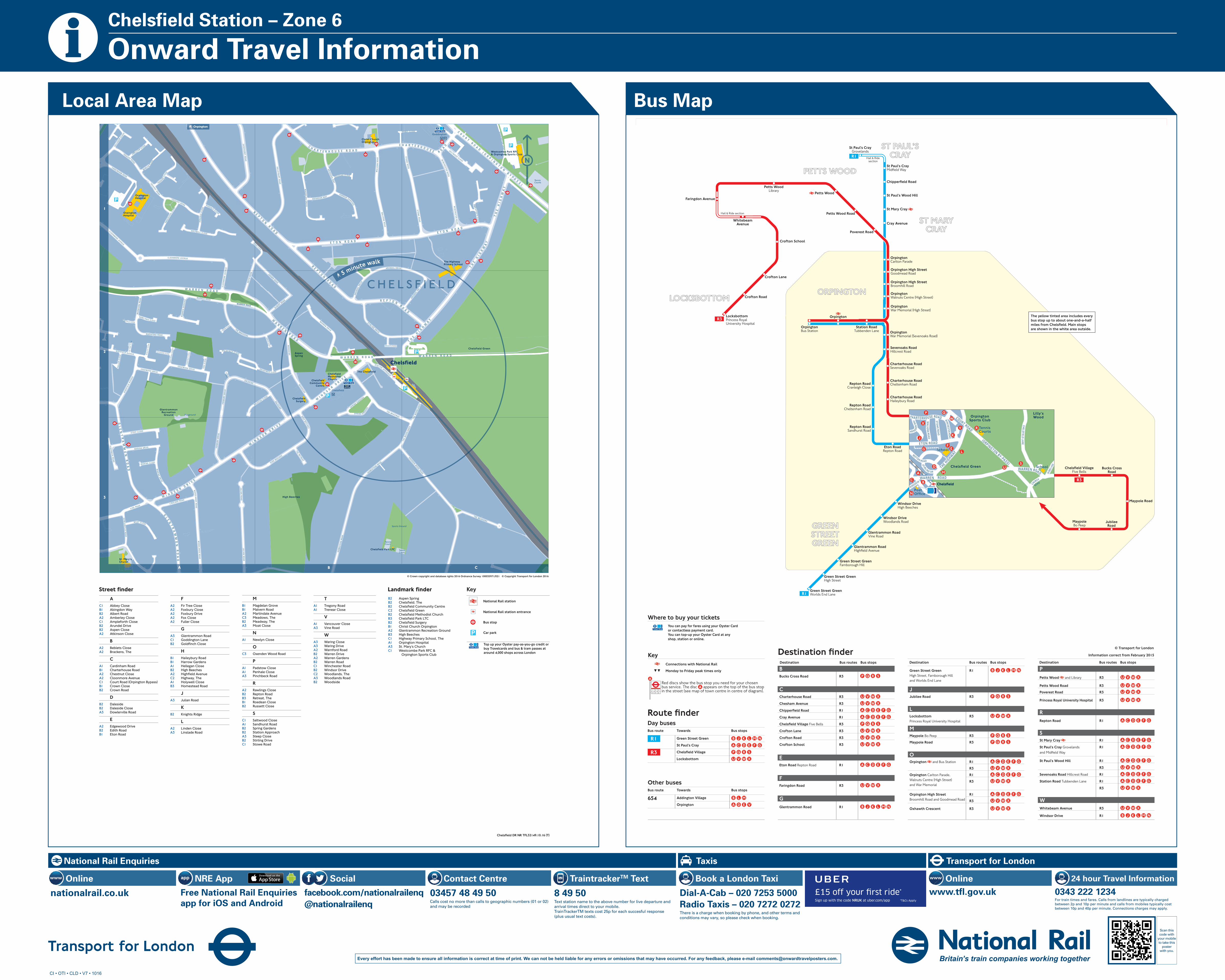
Day busesBus route Towards Bus stops

R1 Green Street Green

St Paul’s Cray

R3

Locksbottom

Other busesBus route Towards Bus stops

654 Addington Village

Orpington

Destination Bus routes Bus stopsDestination Bus routes Bus stops Destination Bus routes Bus stops

B Bucks Cross Road R3

CCharterhouse Road R3

Chesham Avenue R3

R1

Cray Avenue R1

Five Bells R3

Crofton Lane R3

Crofton Road R3

Crofton School R3

EEton Road Repton Road R1

FFaringdon Road R3

GGlentrammon Road R1

Green Street Green R1 High Street, Farnborough Hilland Worlds End Lane

J Jubilee Road R3

LLocksbottom R3 Princess Royal University Hospital

M Maypole Bo Peep R3

Maypole Road R3

OOrpingtonn and Bus Station R1 R3

Orpington Carlton Parade, R1 Walnuts Centre (High Street) R3 and War Memorial

Orpington High Street R1 Broomhill Road and Goodmead Road R3

Oxhawth Crescent R3

PPetts Woodn and Library R3

Petts Wood Road R3

Poverest Road R3

Princess Royal University Hospital R3

RRepton Road R1

SSt Mary Crayn R1

St Paul’s Cray Grovelands R1

St Paul’s Wood Hill R1

3R

Sevenoaks Road Hillcrest Road R1

Station Road Tubbenden Lane R1

3R

WWhitebeam Avenue R3

Windsor Drive R1

Key n Connections with National Rail

0 0 Monday to Friday peak times only

14

25

36

Red discs show the bus stop you need for your chosenbus service. The disc appears on the top of the bus stopin the street (see map of town centre in centre of diagram).

Ú

rr

Where to buy your ticketsYou can pay for fares using your Oyster Cardor contactless payment card.You can top-up your Oyster Card at anyshop, station or online.

Chelsfield VillageFive Bells

Bucks CrossRoad

Maypole Road

MaypoleBo Peep

JubileeRoad

Hail & Ride section

Hail & Ridesection

Charterhouse RoadHaileybury Road

Charterhouse RoadCheltenham Road

Charterhouse RoadSevenoaks Road

Sevenoaks RoadHillcrest Road

OrpingtonWar Memorial (Sevenoaks Road)

OrpingtonWar Memorial (High Street)

Station RoadTubbenden Lane

OrpingtonBus Station

Orpington

OrpingtonWalnuts Centre (High Street)

Orpington High StreetBroomhill Road

Orpington High StreetGoodmead Road

OrpingtonCarlton Parade

Poverest Road

Petts Wood Road

Petts Wood

Petts WoodLibrary

Faringdon Avenue

WhitebeamAvenue

Crofton School

Crofton Lane

Crofton Road

LocksbottomPrincess RoyalUniversity Hospital

Windsor DriveHigh Beeches

Windsor DriveWoodlands Road

Glentrammon RoadVine Road

Glentrammon RoadHighfield Avenue

Green Street GreenFarnborough Hill

Green Street GreenHigh Street

Green Street GreenWorlds End Lane

Eton RoadRepton Road

Repton RoadSandhurst Road

Repton RoadCheltenham Road

Repton RoadCranleigh Close

Cray Avenue

St Mary Cray

St Paul’s Wood Hill

Chipperfield Road

St Paul’s CrayMidfield Way

St Paul’s CrayGrovelands

R3

R1

R1

R3

PETTS WOOD

LOCKSBOTTOM

ST MARYCRAY

ORPINGTON

GREENSTREETGREEN

ST PAUL’SCRAY

The yellow tinted area includes everybus stop up to about one-and-a-half miles from Chelsfield. Main stops are shown in the white area outside.

OrpingtonSports Club

Lilly’sWood

Chelsfield Green

COURT ROAD (ORPINGTON BY-PASS)

C HARTERHO USE ROAD

ETON ROAD

THE HIG

HWAY

WARREN

WINDSOR DR

WARREN ROAD

CHELSFIELD

LAN

E

SKIB

BS LA

NE

CH

URCH

ROAD

MA

LVERN

ROA

D

STO

WE RO

AD

WINCHESTER ROAD

ABIN G DO

N W

AY

REPTON R OAD

STIRLING DR

ROAD

TennisCourts

School

School

PostOffice

Chelsfield

CHELSFIELD DR (BRO) TFL 29536.03.15 (T)

© Transport for London

Information correct from February 2015

A C1 Abbey Close B1 Abingdon Way B2 Albert Road A2 Amberley Close C1 Ampleforth Close B2 Arundel Drive B2 Aspen Close A2 Atkinson Close

B A2 Beblets Close A2 Brackens, The

C A1 Cardinham Road B1 Charterhouse Road A2 Chestnut Close A2 Cloonmore Avenue C1 Court Road (Orpington Bypass) B1 Crown Close B2 Crown Road

D B2 Daleside B2 Daleside Close A3 Dowlerville Road

E A2 Edgewood Drive B2 Edith Road B1 Eton Road

T A1 Tregony Road A1 Trenear Close

V A1 Vancouver Close A3 Vine Road

W A3 Waring Close A3 Waring Drive A2 Warnford Road B2 Warren Drive A2 Warren Gardens B2 Warren Road C1 Winchester Road B2 Windsor Drive C2 Woodlands, The A3 Woodlands Road B2 Woodside

F A2 Fir Tree Close A2 Foxbury Close A2 Foxbury Drive A2 Fox Close A2 Fuller Close

G A3 Glentrammon Road C1 Goddington Lane B2 Goldfinch Close

H B1 Haileybury Road B1 Harrow Gardens A1 Hellegan Close B2 High Beeches A2 Highfield Avenue C2 Highway, The A1 Holywell Close B3 Homestead Road

J A3 Julian Road

K B2 Knights Ridge

L A2 Linden Close A3 Linslade Road

M B1 Magdelan Grove B1 Malvern Road A2 Martindale Avenue C3 Meadows, The B2 Meadway, The A3 Moat Close

N A1 Newlyn Close

O C3 Oxenden Wood Road

P A1 Padstow Close A1 Penhale Close A3 Pinchbeck Road

R A2 Rawlings Close B2 Repton Road B3 Retreat, The B1 Roedean Close B2 Russett Close

S C1 Saltwood Close A1 Sandhurst Road B2 Spring Gardens B2 Station Approach A3 Steep Close B2 Stirling Drive C1 Stowe Road

B2 Aspen Spring B2 Chelsfield, The B2 Chelsfield Community Centre C2 Chelsfield Green B2 Chelsfield Methodist Church B3 Chelsfield Park LTC B2 Chelsfield Surgery B1 Christ Church Orpington A2 Glentrammon Recreation Ground B3 High Beeches C1 Highway Primary School, The A1 Orpington Hospital A3 St. Mary’s Church C1 Westcombe Park RFC & Orpington Sports Club

© Crown copyright and database rights 2016 Ordnance Survey 100035971/021   © Copyright Transport for London 2016

Street finder Landmark finder

Top up your Oyster pay-as-you-go credit or buy Travelcards and bus & tram passes at around 4,000 shops across London

Key

National Rail station

National Rail station entrance

Bus stop

Car park

42

98

37

1

115

117

112

10

1927

18

2

19

14

4

1

1

3

10

15

165

118

26

2 1

167

126

185

1

128

58

69

7358

54

3530

75

87 138

63 89

103

43 28

398

48

18

1

368

8

2

13

12

2

47

1

144

182146

203

351

1

2

147

149

925

178

1

2

173

226201

240

1

2

4

215

31

55

52

55

57

253

69

82

70

71

60

55

49

48

7

10

9

12

181

2

21

1

1110

9

5

410

1

3832

10945

294 82

2 1

256 9976

29

121

8

74

79

30

7770

62

7 8

2

5215

11

20

34

26

13

215

2

1

25

24

187

130

28

25

175

173

464

2

120

12

1011

5

112

35

35

32

40

9

34

12

15

145

159 1

15

128

135

24

5

1041

2069

13

110 79

115

70

1512

67

35

50

33

48

56

114

33

13

20

3

6

79

26

25

48

83

64

35

71

43

80

45

2

25

134 131

1 2

114

2

2

20

2

14

6

11

9

1

9

10 21

34

13

36

2

157

1

76

130

3 2

128

67

56

39

131

40

67

15

44

2

10

14

1237

54

1

34

21

16

1

2

18

21

74

1

1

15

11

86

14

13

18

102

5

2

10

3

104

18

5

155

71

19

44

4

21

50

83

44

70

91

5

172

15

1

98

9324 45

112

164

123

15

16

3937

32

37

1

38

34

12

32

10

45

1

5047

5261

76

1

65

1

5

51

6

48

1126

4

32

109

128 131

157

164

24 4545

52

115

145

24

146

203

167

165

118118

368

138

1

2

54

109

GlentrammonRecreation

Ground

High Beeches

AspenSpring

Chelsfield Green

AS

PEN

CLO

SE R U S S

ET T C L O S E

K N I G H T S R I D G E

FOXB

URY

C LOSE

CH

ES

TN

UT

CLO

SE

MA

RT

IND

ALE

AV

EN

UE

BE

BLE

TS

CLO

SE

AT K I N S O N C L O S E

L I N D E N C L O S E

A M B E R L E Y C L O S E

CROWN C LOSE

ARUNDE L D

R I VE

AR

UN

DE L

DR I V

E

A R U N D E L D R I V E

MA

LVE

RN

RO

AD

WIN

CH

ES

TE

R R

OA

D

AM

PL EF O

RT

H C

LOS

E

ST

OW

E R

OA

D

MA

GD

ELA

N G

RO

VE

H A R R O W G A R D ENS

A B I N G D O N W AY

AB

ING

DO

N W

AY

R O E D E A N C L O S E

WIN

CH

EST ER

RO

AD

MA

LVE

RN

RO

AD

ST

OW

E R

OA

D

S A LT WO O D C L O S E

GO

DD

ING

TO

N LA

NE

A B B E Y C L O S E

T HE B R A C K E N S

JU

LIAN

RO

AD

D A L E S I D E

D A L E S I D E C L O S E

G O L D F I N C H C L O S E

H I G H B E E C H E S

DA

LES IDE

WO

OD

SID

E

T HE R E TREAT

WO

OD

S IDE

HIG

H B

E ECH

E S

WA R R E N D R I V E

S P R I N G GA R D E N S

S P R I N G G ARDENS

S T I R L I N G D R I V E

HOME ST E A D R

O A D

S TAT I O N A P PROAC H

T H E M E A D WAY

THE

WO

OD

LAN

DS

OXENDEN

WOOD ROAD

THE

WO

OD

LAN

DS

T H E M E A D O W S

WO

OD

LAN

DS

RO

AD

DO

WL E

RV

IL LE R

OA

D

M O AT C L O S E

V I N E R O A D

WO

OD

L AN

DS

RO

AD

L I N S L A D E R O A D

JU

LIAN

RO

AD

WA

RI N

G D

RI VE

W A R I N G C L O S E

W A R I N G D R I V E FOX

BU

RY

DR

I VES T E E P C L O S E

FOX

BU

RY

DR

I VE

HI G

HF I

E LD

AV

ENU

E

E D G E W O O D D R I V E

E D G E W O O D D R I V E

FOX

CLO

SE

FUL L

ER

CLO

SE

G O L D F I N C H C L O S E

H I G H F I E L D A V E N U E

FIR

TR

EE

CLO

SE

W A R N F O R D R O A D

R A W L I N G S C L O S E

WA

RR

EN

GA

RD

EN

S

WA

RN

FOR

D R

OA

D

A L B E R T RO A D

W A R R E N R O A DW A R R E N R O A D

W A R R E N R O A D

CLO

ON

MO

RE

AV

EN

UE

C ROWN ROADED

ITH

RO

AD

C L O O N M O R E A V E N U E

C LOON MOR E AV ENU E

H O LY W E L L C L O S E

VAN

COU

VER CLO

SE

PE

NH

AL E

CLO

SE

P E N H A L E C L O SE

T R E G O N Y R O A D

TREGO

NY ROAD

T R E NEAR C

LOS E

HA

ILEY

BU

RY

RO

AD

C A R D I N H A M R O A D

N E W LY N CLO

SET R EG O N Y R O AD

SA

ND

HU

RS

T R

OA

D

PA D S T O W CL O SEH

EL LEG

AN

CLOSE

PIN

CH

BE

CK

RO

AD

HO

ME

ST

EA

D R

OA

D

R E P T O N RO

AD

RE

PT

ON

RO

AD

TH

E H

IG

HW

AYE T O N R O A D

E T O N R O A D

TH

E

HI

GH

WA

Y

CO

UR

T R

OA

D ( O

RP

I NG

TO

N B

YP

AS

S)

C H A R T E R H O U S E R OA

DCH A R T E R H O U S E R O A D

WI N

DS O

R DR I V E

W

AR

RE

N R

OA

D

WI N

DS

OR

DR

I VE

W A R R E N R O A D

TH

E H

I GH

WA

Y

W A R R E N R O A D

GL

EN

TR

AM

MO

N

RO

AD

W I N D S O R D R I V E

GL

EN

TR

AM

MO

N

RO

AD

W A R R E N R O A D

RE

PT

ON

RO

AD

Playground

Sports Ground

TennisCourts

TennisCourt

TennisCourt

Chelsfield Park LTC

ChelsfieldSurgery

ChelsfieldCommunity

Centre

ChelsfieldMethodistChurch

The Chelsfield

The HighwayPrimary School

Westcombe Park RFC& Orpington Sports Club

Christ ChurchOrpington

St. Mary’sChurch

OrpingtonHospital

OrpingtonHospital

ChelsfieldChelsfield

ChelsfieldChelsfieldChelsfieldChelsfieldChelsfieldChelsfieldChelsfieldChelsfield

GoddingtonGoddingtonGoddingtonGoddingtonGoddingtonGoddingtonGoddingtonGoddington

C H E L S F I E L DC H E L S F I E L DC H E L S F I E L DC H E L S F I E L DC H E L S F I E L DC H E L S F I E L DC H E L S F I E L DC H E L S F I E L DC H E L S F I E L D73C H E L S F I E L D7358C H E L S F I E L D58C H E L S F I E L DIC H E L S F I E L DIIC H E L S F I E L DI VC H E L S F I E L DVVC H E L S F I E L DVVC H E L S F I E L DVEC H E L S F I E L DEEC H E L S F I E L DEEC H E L S F I E L DE

2

120

12

10

15

48

26

25

134 131

1 2

114

2

71

83

70

34

12

1

5

51

6

A B C

1

2

3

NNN

3131

8

32

50 Orpington

Chelsfi eld DR NR TFL32149.10.16 (T)

Scan this code with

your mobile to take this

poster with you.

Every effort has been made to ensure all information is correct at time of print. We can not be held liable for any errors or omissions that may have occurred. For any feedback, please e-mail [email protected].

Local Area Map Bus Map

CI • OTI • CLD • V7 • 1016

National Rail Enquiries Transport for London Taxis

nationalrail.co.uk

Onlinewww Social

facebook.com/nationalrailenq@nationalrailenq

NRE App

Free National Rail Enquiries app for iOS and Android

www.tfl.gov.ukOnlinewww

0343 222 1234For train times and fares. Calls from landlines are typically charged between 2p and 10p per minute and calls from mobiles typically cost between 10p and 40p per minute. Connections charges may apply.

24 hour Travel InformationContact Centre

03457 48 49 50Calls cost no more than calls to geographic numbers (01 or 02) and may be recorded

TraintrackerTM Text

8 49 50Text station name to the above number for live departure and arrival times direct to your mobile. TrainTrackerTM texts cost 25p for each succesful response (plus usual text costs).

Book a London Taxi

Dial-A-Cab – 020 7253 5000Radio Taxis – 020 7272 0272There is a charge when booking by phone, and other terms and conditions may vary, so please check when booking.

£15 off your �rst ride*

Sign up with the code NRUK at uber.com/app *T&Cs Apply

C

M

Y

CM

MY

CY

CMY

K

UK-NUP-NRUK-126x38mm-r1.pdf 2 27/09/2016 11:42