Embed Size (px)
Citation preview
Charmouth Neighbourhood Plan
Strategic Environmental Assessment
Screening Report
November 2018
Charmouth Neighbourhood Plan SEA Screening Report
CONTENTS
1. Introduction .................................................................................................................................... 1
2. Legislative background to Strategic Environmental Assessment ................................................... 2
3. The Charmouth Neighbourhood Plan ............................................................................................. 3
The Characteristics of the Charmouth Neighbourhood Plan Area ..................................................... 3
The Objectives of the Charmouth Neighbourhood Plan..................................................................... 5
Scope of the Charmouth Neighbourhood Plan ................................................................................... 6
4. SEA screening of the Charmouth Neighbourhood Plan .................................................................. 7
Is the Charmouth Neighbourhood Plan likely to have a significant effect on the environment? ...... 8
5. Conclusion ..................................................................................................................................... 14
Appendix A: Consultation Responses ................................................................................................... 15

Charmouth Neighbourhood Plan SEA Screening Report
1
1. INTRODUCTION
The purpose of this report is to determine whether or not the Charmouth Neighbourhood
Plan requires a Strategic Environmental Assessment (SEA) through a process known as SEA
screening.
The SEA screening was consulted upon between 26th
September and 24th
October 2018 with
the statutory consultation bodies, which include Natural England, Historic England and
Environment Agency, in accordance with regulation 9(2) of the Environmental Assessment
of Plans and Programmes Regulations (2004). The responses are presented in Appendix A.
This document presents the final SEA screening report following the consultation. It
provides an outline of the emerging Charmouth Neighbourhood Plan and environmental
characteristics of the plan area, explains the legislative background to SEA screening, before
providing an account of the SEA screening exercise for the Charmouth Neighbourhood Plan.
This report meets the requirements of European Directive 2001/42/EC on the Assessment of
the Effects of Certain Plans and Programmes on the Environment and the Environmental
Assessment of Plan and Programmes Regulations (2004).

Charmouth Neighbourhood Plan SEA Screening Report
2
2. LEGISLATIVE BACKGROUND TO STRATEGIC ENVIRONMENTAL
ASSESSMENT
European Directive 2001/42/EC on the Assessment of the Effects of Certain Plans and
Programmes on the Environment (‘SEA Directive’) introduces the need to undertake a
strategic environmental assessment (‘SEA’) during the development of some plans and
programmes. The main purpose of SEA, according to Article 1 of the SEA Directive, is:
“to provide for a high level of protection of the environment and to
contribute to the integration of environmental considerations into the
preparation and adoption of plans and programmes with a view to
promoting sustainable development”.
The SEA Directive is transcribed into UK law through the Environmental Assessment of Plans
and Programmes Regulations 2004, which establishes the requirement to undertake a
sustainability appraisal (‘SA’) for some documents used for planning purposes. The SA
process incorporates the requirement for SEA, but typically has a broader scope and
considers the social and economic issues in addition to the environmental effects.
The requirement to undertake an SA of supplementary planning documents (SPD) was
removed by the Planning Act 2008. However, the need to establish whether the planning
document requires an SEA, through the SEA Directive, remains.
Articles 2 and 3 of the SEA Directive explain which plans and programmes require SEA. The
Government’s Planning Practice Guidance suggests that an SPD will only require an SEA “in
exceptional circumstances…if they are likely to have significant environmental effects that
have not already have been assessed during the preparation of the Local Plan”.
The Neighbourhood Planning (General) (Amendment) Regulations 2015 amends the
Neighbourhood Planning (General) Regulations 2012 to provide clarification on the SEA
related documents which must be submitted alongside neighbourhood planning proposals.
Regulation 2(4) of the amendment regulations 2015 adds to the list of documents that a
neighbourhood planning group must submit to a local planning authority with a proposal for
a neighbourhood plan, which is presented in regulation 6 of the Neighbourhood Planning
Regulations 2012. The additional document which must be submitted is either an
environmental report, should an SEA be required, or a statement of reasons why an
environmental assessment is not required.

Charmouth Neighbourhood Plan SEA Screening Report
3
3. THE CHARMOUTH NEIGHBOURHOOD PLAN
THE CHARACTERISTICS OF THE CHARMOUTH NEIGHBOURHOOD PLAN AREA
The Charmouth Neighbourhood Plan occupies an area of approximately 2km2 (200ha) and
comprises the village of Charmouth and a section of coastline which forms the southern
plan boundary.
The coastal village of Charmouth sits at the mouth of the River Char, which passes along the
eastern side of Charmouth, and according to the 2011 Census has a population of
approximately 1,352 residents1.
The census also indicates that there were approximately 933 residential properties within
Charmouth and its surroundings, the majority of which are owner occupied (72.4%).
The Charmouth Neighbourhood Plan area and surrounding areas include a number of
environmental designations, some of which are of international importance, indicating the
importance and sensitivity of the plan area from an environmental perspective (Figure 3.1).
Figure 3.1: Environmental designations within the Charmouth Neighbourhood Plan area
© Crown Copyright and database right (2018). Ordnance Survey Licence number 100024307. © and Database
rights Environment Agency 2016. All rights reserved. Some of the information within the Flood Map is based in
part on digital spatial data licensed from the Centre for Ecology and Hydrology © NERC. © Historic England
2016. © Crown Copyright. All rights reserved 2016
1 According to the 2011 census
Charmouth Neighbourhood Plan SEA Screening Report
4
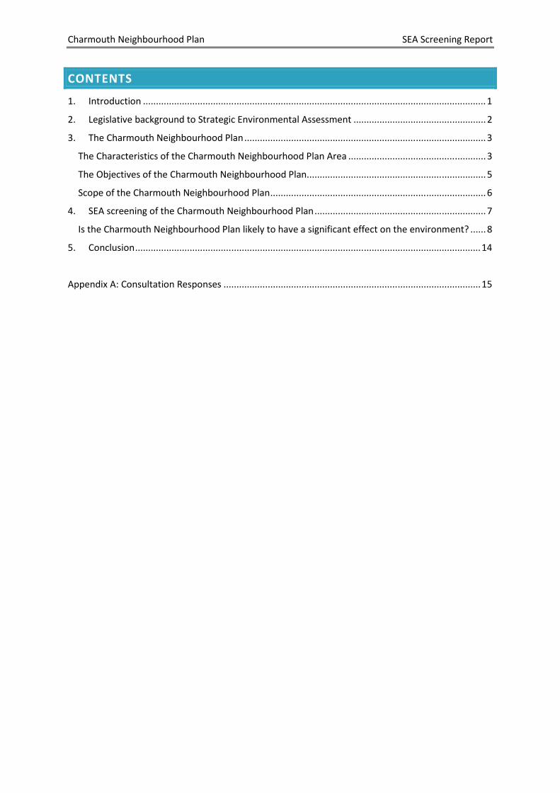
Legend
The wildlife designations within the Charmouth Neighbourhood Plan area include the
Sidmouth to West Bay Special Area of Conservation (SAC) and West Dorset Coast Site of
Special Scientific Interest (SSSI), which occupy the coastal section of the plan area. The
undercliffs which offer a range of habitats and support a number of rare plants and animals
and the areas adjoining the coastline include large areas of herb rich grassland of a type
now very restricted in occurrence. In addition to their ecological importance, the cliffs are
internationally important geological sites, particularly famous for its fossil reptiles.
The areas to the north of the plan area include Sites of Nature Conservation Interest (SNCI)
which are areas of local rather than national or international wildlife importance (Figure
3.2).
Figure 3.2: The Sites of Nature Conservation Interest (SNCI) to the north of the Charmouth
Neighbourhood Plan area
Name of SNCI Distance
from NP area
Area Description
Hogchester Farm 470m to the
north
1.7ha A mosaic of habitats with wet grassland,
mire, dry grassland & birch
Hole Common 860m to the
northwest
26.6ha An area of plantation woodland with a
varied flora.
Catherston Brook 280m to the
north
1.35ha A river corridor with an abundance of wild
daffodil
Catherston Coppice 455m to the
northeast
3.5ha An area of deciduous woodland with a
good flora
The coastal areas of the Charmouth Neighbourhood Plan are within the Dorset and East
Devon World Heritage Site. This recognises the worldwide importance of the coastline
within the plan area in terms of its outstanding geological and geomorphological value.

Charmouth Neighbourhood Plan SEA Screening Report
5
Charmouth is within the Dorset Area of Outstanding Natural Beauty, reflecting the
particularly high quality of the landscape in this area.
The northern area of Charmouth includes the Charmouth Conservation Area. In addition
there are approximately 33 Listed Buildings, 32 of which are Grade II Listed Buildings, and
the Queens Armes Hotel is a Grade II* Listed Building.
In addition to the environmental designations, the plan area includes areas of land
instability towards the south of the plan area, and a high risk flood zone on the eastern side
of the plan area (Figure 3.4).
Figure 3.4: Areas of flood risk and land instability within the Charmouth Neighbourhood Plan
area
© Crown Copyright and database right (2018). Ordnance Survey Licence number 100024307. © and Database
rights Environment Agency 2016. All rights reserved. Some of the information within the Flood Map is based in
part on digital spatial data licensed from the Centre for Ecology and Hydrology © NERC. © Historic England
2016. © Crown Copyright. All rights reserved 2016
Legend
THE OBJECTIVES OF THE CHARMOUTH NEIGHBOURHOOD PLAN
The Charmouth Neighbourhood Plan has the following vision statement:
• to further enhance Charmouth as a friendly, vibrant community;
Charmouth Neighbourhood Plan SEA Screening Report
6
• to protect is unique qualities, including its natural beauty, local history and
jurassic coastline;
• to maintain its ability to be self-sustaining by supporting retail units, local
businesses and amenities in the village;
• to keep its village feel but encourage a small affordable housing development,
particularly for families;
• to continue to attract tourists and visitors and offer good facilities but avoid
being over-commercial; and
• to meet the everyday needs of our residents
The policy objectives of the Charmouth Neighbourhood Plan are as follows:
• to protect the area’s unique qualities, including its natural beauty, local history
and jurassic coastline;
• to retain the range of shops, services and facilities that help the village be self-
sustaining, without becoming over-commercialised; and
• to bring forward one or two small-scale schemes for affordable housing, that will
meet the needs of local residents.
SCOPE OF THE CHARMOUTH NEIGHBOURHOOD PLAN
The Charmouth Neighbourhood Plan is at an early stage of development, with evidence
currently being collected to facilitate the development of the plan.
Whilst specific details of the contents of the plan are not known at this stage, early
indications are that the Charmouth Neighbourhood Plan will not allocate sites for
development. Instead, the Charmouth Neighbourhood Plan will pursue policies that
support a small development of affordable/social rent housing specifically aimed for
young families/young people.
Charmouth Neighbourhood Plan SEA Screening Report
7
4. SEA SCREENING OF THE CHARMOUTH NEIGHBOURHOOD PLAN
This Chapter provides an account of the SEA screening exercise for the Charmouth
Neighbourhood Plan.
Articles 2 and 3 of the SEA Directive provide the legislative framework for defining the types
of plan and programme that require SEA.
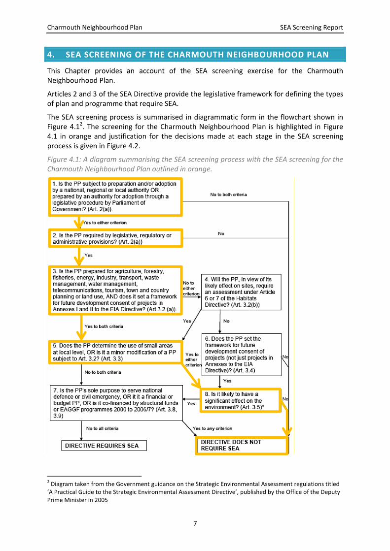
The SEA screening process is summarised in diagrammatic form in the flowchart shown in
Figure 4.12. The screening for the Charmouth Neighbourhood Plan is highlighted in Figure
4.1 in orange and justification for the decisions made at each stage in the SEA screening
process is given in Figure 4.2.
Figure 4.1: A diagram summarising the SEA screening process with the SEA screening for the
Charmouth Neighbourhood Plan outlined in orange.
2 Diagram taken from the Government guidance on the Strategic Environmental Assessment regulations titled
‘A Practical Guide to the Strategic Environmental Assessment Directive’, published by the Office of the Deputy
Prime Minister in 2005

Charmouth Neighbourhood Plan SEA Screening Report
8
Figure 4.2: a summary of the justification made for the decisions during the SEA screening
for the Charmouth Neighbourhood Plan.
Question in SEA screening flow chart
(Figure 4.1)
Response
1. Is the PP subject to preparation and/or
adoption by a national, regional or local
authority OR prepared by an authority for
adoption through a legislative procedure by
Parliament of Government?
YES
The intention is for the Charmouth
Neighbourhood Plan to be adopted by West
Dorset District Council, a local authority,
through a legislative procedure.
2. Is the PP required by legislative, regulatory or
administrative provisions?
YES
The Charmouth Neighbourhood Plan would be
a Statutory document, prepared in accordance
with the Neighbourhood Planning (General)
Regulations 2012 as amended.
3. Is the PP prepared for agriculture, forestry,
fisheries, energy, industry, transport, waste
management, water management,
telecommunications, tourism, town and
country planning or land use, AND does it set a
framework for future development consent of
projects in Annexes I and II to the EIA
Directive?
YES
The Charmouth Neighbourhood Plan is a
document prepared for town and country
planning purposes, and may indicate where
future development which falls under Annex II
of the EIA Directive which includes urban
development projects under paragraph 10(b).
5. Does the PP determine the use of small areas
at local level, OR is it a minor modification of a
PP subject to Art. 3.2?
YES
The Charmouth Neighbourhood Plan
determines the use of small areas at a local
level.
8. Is it likely to have a significant effect on the
environment (Article 3.5)?
NO
Justification for this decision is given later in
this chapter.
IS THE CHARMOUTH NEIGHBOURHOOD PLAN LIKELY TO HAVE A SIGNIFICANT EFFECT
ON THE ENVIRONMENT?
The final question in the SEA screening process presented in Figures 4.1 and 4.2 for the
Charmouth Neighbourhood Plan was question 8: Is it likely to have a significant effect on the
environment?
In asking this question, the SEA Directive refers to Article 3.5, which states that the relevant
criteria in Annex II of the SEA Directive shall be taken into account when determining
whether there are likely to be significant effects. Therefore, the criteria in Article 3.5 have
been taken into consideration when determining whether the Charmouth Neighbourhood
Plan requires SEA, as presented in Figure 4.3.

Charmouth Neighbourhood Plan SEA Screening Report
9
Figure 4.3: The assessment of the likely significance of effects of the Charmouth
Neighbourhood Plan (Taken from Annex II of the SEA Directive)
Criteria in Annex II of the
SEA Directive
Response Is there a
significant
effect?
(1) Characteristics of the plan and programmes, having regard, in particular, to:
a) The degree to which
the plan or
programme sets a
framework for
projects and other
activities, either with
regard to the location,
nature, size, and
operating conditions
or by allocating
resources.
The framework for development projects within
the Charmouth Neighbourhood Plan area is set by
the West Dorset, Weymouth & Portland Local Plan
(‘Local Plan’), which provides the overarching
policy for the location, size and nature of
development projects in this area. The Charmouth
Neighbourhood Plan builds upon this framework
by providing further details of the development
projects within this area.
No
b) The degree to which
the plan or
programme influences
other plans or
programmes including
those in a hierarchy.
The Charmouth Neighbourhood Plan will be
adopted alongside its parent document, the Local
Plan. It will expand upon the existing policies in the
Local Plan and provide supplementary information
on a local scale rather than influencing the Local
Plan.
No
c) The relevance of the
plan or programme
for the integration of
environmental
considerations in
particular with a view
to promoting
sustainable
development.
Any development which comes forward in
Charmouth will be subject to the environmental
considerations of the Local Plan in addition to the
neighbourhood plan, the aim of which is to
achieve sustainable development. No
d) Environmental
problems relevant to
the plan or
programme.
The environmental problems within the
Charmouth Neighbourhood Plan area are not
considered exclusive to the area, and are similar to
those considered and addressed in the Local Plan.
The environmental problems for the Charmouth
neighbourhood plan include flooding, land
instability, and the impacts of new development
upon the landscape, wildlife, areas of geological
interest and heritage assets.
No

Charmouth Neighbourhood Plan SEA Screening Report
10
e) The relevance of the
plan or programme
for the
implementation of
community legislation
on the environment
(e.g plans and
programmes linked to
waste management or
water protection).
The implementation of community legislation is
unlikely to be significantly compromised by the
Charmouth Neighbourhood Plan.
No
(2) Characteristics of the effects and of the area likely to be affected, having regard, in
particular, to:
a) The probability,
duration, frequency,
and reversibility of the
effects.
It is anticipated that the plan period will run until
2031. Whilst some effects of the plan may be
irreversible, it is not considered probable that the
plan will have significant effect since it is looking to
bring forward one or two small scale affordable
housing schemes which ensuring that the
environment is protected.
No
b) The cumulative nature
of the effects.
The coastal town of Lyme Regis is located
approximately 2km to the west of the plan area.
The Local Plan allocates land for approximately 90
homes in Lyme Regis over the period until 2031, a
limited amount of development in reflection of the
planning constraints in this area.
The Upper Marshwood Vale Neighbourhood Plan
area and Bridport Neighbourhood Plan area are
located approximately 3.4km to the northeast and
4.3km to the east of the plan area, respectively.
The Bridport Neighbourhood Plan does not
allocate land for additional development. The
Upper Marshwood Neighbourhood Plan is at an
early stage of development and there is no clear
indication of its content.
Since the Charmouth Neighbourhood Plan will not
allocate land for development, and the
development proposed in the surrounding areas is
not extensive in scale, it is considered unlikely that
cumulative effects will result from the
development.
No
c) The transboundary
nature of the effects.
The transboundary impacts, beyond the
Charmouth Neighbourhood Plan area, are unlikely No

Charmouth Neighbourhood Plan SEA Screening Report
11
to be significant in light of the nature and scale of
the proposals.
d) The risks to human
health or the
environment (e.g due
to accidents).
The Charmouth Neighbourhood Plan is unlikely to
introduce significant risks to human health and the
environment, for example due to accidents, in light
of the scale and type the development.
No
e) The magnitude and
spatial extent of the
effects (geographical
area and size of the
population likely to be
affected).
The Charmouth Neighbourhood Plan area occupies
approximately 2km2 and holds a population of
approximately 1,352 people according to the 2011
census. The spatial extent of the Charmouth
Neighbourhood Plan area and the magnitude of
the population affected are not considered of a
significant scale for the purposes of SEA.
No
f) The value and
vulnerability of the
area likely to be
affected due to:
i) Special natural
characteristics
or cultural
heritage
The Charmouth Neighbourhood Plan area and its
surroundings contain environmental designations
which reflect its special natural characteristics and
rich cultural heritage.
The special natural characteristics of the plan area
include the Dorset Area of Outstanding Natural
Beauty, an area of national importance for
landscape which occupies the entire plan area. The
Dorset AONB designation may be vulnerable to
new development, which has the potential to
compromise the special qualities of this
designation.
Other special natural characteristics within the
plan area include European and national wildlife
designations, which are sites of great ecological
importance in addition to being internationally
important geological sites. The Sidmouth to West
Bay Special Area of Conservation (SAC) and West
Dorset Coast Site of Special Scientific Interest
(SSSI) occupy the coastal areas on the southern
boundary of the neighbourhood plan area. These
sites may be vulnerable to new development.
The areas surrounding the neighbourhood plan
area also include Sites of Nature Conservation
Importance (SNCI) which are of local importance
to wildlife and are therefore less sensitive than the
national wildlife designations. These sites are
unlikely to be vulnerable to due to their distance
from the plan area and the small scale
development which the neighbourhood plan
No

Charmouth Neighbourhood Plan SEA Screening Report
12
intends to bring forward.
The cultural heritage within the plan area include
the Charmouth Conservation Area and
approximately 33 Listed Buildings (including the
Grade II* listed Queens Armes Hotel). These
heritage assets of national importance may be
vulnerable to new development, both directly and
through impacts upon their setting.
In addition, the coastal areas of the Charmouth
Neighbourhood Plan are within the Dorset and
East Devon World Heritage Site. This recognises
the worldwide value of the coastline within the
plan area in terms of its outstanding geological and
geomorphological value.
ii) Exceeded
environmental
quality
standards or
limit values
The Charmouth Neighbourhood Plan is unlikely to
result in the exceedance of environmental quality
standards, such as those relating to air, water and
soil quality, due to the nature and scale of the
development.
No
iii) Intensive land-
use
The Charmouth Neighbourhood Plan is unlikely to
bring forward development of an extent which
would result in a significant intensification of land
use in light of the scale of development.
No
g) The effects on areas
or landscapes which
have a recognised
national, Community
or international
protection status.
The environmental designations within the
Charmouth Neighbourhood Plan area and it’s
surrounding areas of national, community or
international protection status include:
• Dorset Area of Outstanding Natural Beauty;
• World Heritage Site;
• Special Area of Conservation;
• Site of Special Scientific Interest;
• Conservation Area; and
• Listed Buildings (Grade II and II*).
The Charmouth Neighbourhood Plan area is within
the Dorset Area of Outstanding Natural Beauty, in
recognition of the national importance for
landscape of this area. The Charmouth
Neighbourhood Plan will not allocate land for
development and includes the following policy
objective: “to protect the area’s unique qualities,
including its natural beauty…”. In addition, policy
ENV1(i) of the Local Plan will prevent development
which results in harm to the character of the
No
Charmouth Neighbourhood Plan SEA Screening Report
13
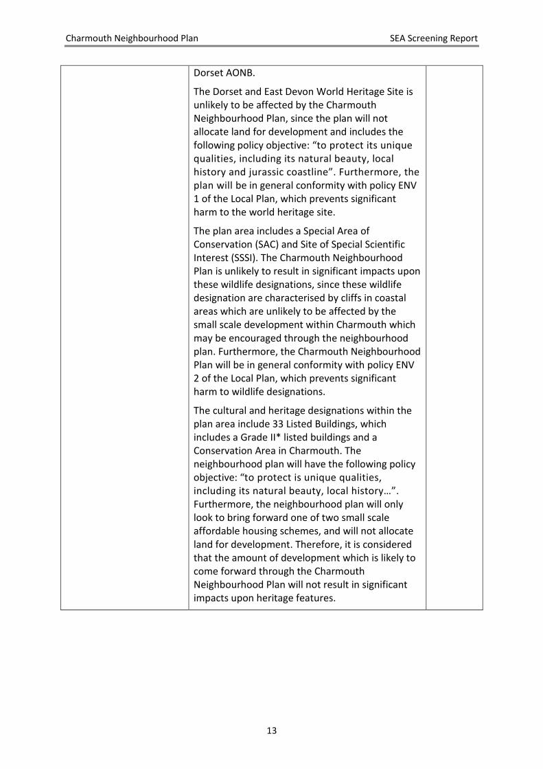
Dorset AONB.
The Dorset and East Devon World Heritage Site is
unlikely to be affected by the Charmouth
Neighbourhood Plan, since the plan will not
allocate land for development and includes the
following policy objective: “to protect its unique
qualities, including its natural beauty, local
history and jurassic coastline”. Furthermore, the
plan will be in general conformity with policy ENV
1 of the Local Plan, which prevents significant
harm to the world heritage site.
The plan area includes a Special Area of
Conservation (SAC) and Site of Special Scientific
Interest (SSSI). The Charmouth Neighbourhood
Plan is unlikely to result in significant impacts upon
these wildlife designations, since these wildlife
designation are characterised by cliffs in coastal
areas which are unlikely to be affected by the
small scale development within Charmouth which
may be encouraged through the neighbourhood
plan. Furthermore, the Charmouth Neighbourhood
Plan will be in general conformity with policy ENV
2 of the Local Plan, which prevents significant
harm to wildlife designations.
The cultural and heritage designations within the
plan area include 33 Listed Buildings, which
includes a Grade II* listed buildings and a
Conservation Area in Charmouth. The
neighbourhood plan will have the following policy
objective: “to protect is unique qualities,
including its natural beauty, local history…”.
Furthermore, the neighbourhood plan will only
look to bring forward one of two small scale
affordable housing schemes, and will not allocate
land for development. Therefore, it is considered
that the amount of development which is likely to
come forward through the Charmouth
Neighbourhood Plan will not result in significant
impacts upon heritage features.
Charmouth Neighbourhood Plan SEA Screening Report
14
5. CONCLUSION
The SEA screening exercise explained in this report concludes that the Charmouth
Neighbourhood Plan is unlikely to result in significant environmental impacts, largely due to
the plan not allocating land for additional housing and the environmental protection
provided by the existing policy in the West Dorset, Weymouth & Portland Local Plan.
The consultation bodies, which comprise Natural England, Historic England, and the
Environment Agency, were consulted on the SEA screening report in accordance with
regulation 9(2) of the Environmental Assessment of Plans and Programmes Regulations
(2004).
The statutory consultees concurred with the findings of this SEA screening report (see
Appendix A). Therefore, in conclusion, an SEA will not be required for the Charmouth
Neighbourhood Plan.

Charmouth Neighbourhood Plan SEA Screening Report
15
APPENDIX A: CONSULTATION RESPONSES
1
Oliver Rendle
From: Holm, Michael <[email protected]>Sent: 25 October 2018 17:05To: Oliver RendleSubject: RE: Strategic Environmental Assessment Screening Report: Charmouth Neighbourhood
Plan
Dear Oliver I was hoping to come back with a more detailed response, but I have won’t have time. I have reviewed the document and agree with the conclusions that SEA is not required for this plan.
Yours sincerely
Planning Advisor for Dorset and South Somerset
Direct Dial: 02030 259358
Internal: 59358
Email: [email protected]
The Environment Agency has an email file transfer limit of 8MB. If you wish to send large files to my
team please reply to our [email protected]/[email protected] in –
box and request a Sharefile link to be emailed to you. With this you can upload files of larger sizes to us.
From: Oliver Rendle [mailto:[email protected]]
Sent: 26 September 2018 10:48
To: '[email protected]' <[email protected]>;
'[email protected]' <[email protected]>;
'[email protected]' <[email protected]>; Holm, Michael
Cc: Nick Cardnell <[email protected]>
Subject: Strategic Environmental Assessment Screening Report: Charmouth Neighbourhood Plan
Dear All, I am writing to consult you on the attached Strategic Environmental Assessment (SEA) screening report for the Charmouth Neighbourhood Plan (attached), in accordance with Article 3.6 of European Directive 2001/42/EC. Please can you respond by Wednesday 24th October 2018 to allow for your responses to be taken into account and a decision to be made regarding the need for SEA. Please don’t hesitate to contact me if you have any questions about this, Best wishes, Oliver Rendle

1
Oliver Rendle
From: Stuart, David <[email protected]>Sent: 25 October 2018 10:28To: Oliver RendleCc: Nick CardnellSubject: Strategic Environmental Assessment Screening Report: Charmouth Neighbourhood Plan
Dear Oliver Thank you for your consultation on the SEA Screening Opinion for the emerging Charmouth Neighbourhood Plan. We note that a version of the Plan is not available as part of this consultation and having looked at the Plan website it appears that one is not available there either. We are therefore dependent on the Report supplied for our sole briefing on and understanding of the content of the Plan. The main issue for consideration is that it is stated that the community apparently does not propose for the Plan to allocate sites for development. We assume this will include all types of development – ie employment as well as housing. On this basis, we have no objection to the conclusion that an SEA will not be required. At the same time we would recommend monitoring of the preparation of the Plan, to help verify an initial SEA Screening decision and in case emerging contents suggest that a review may be necessary at some point. Generally, we would prefer it if more evidence could be available to support such exercises at the time of consultation with us. This would help us better understand the basis upon which SEA Screening Reports have been prepared and allow us to engage in our own assessment of the extent to which significant environmental effects upon the historic environment might be likely. This in turn would help us to better advise your authority on its decision. Kind regards David David Stuart | Historic Places Adviser South West Direct Line: 0117 975 0680 | Mobile: 0797 924 0316 Historic England | 29 Queen Square | Bristol | BS1 4ND https://historicengland.org.uk/southwest
We are the public body that helps people care for, enjoy and celebrate England's spectacular historic environment, from beaches and battlefields to parks and pie shops. Follow us: Facebook | Twitter | Instagram Sign up to our newsletter
We're creating a list of the 100 places which tell England's remarkable story and its impact on the world; listen to our podcasts to see what's made the list. A History of England in 100 Places sponsored by Ecclesiastical.
This e-mail (and any attachments) is confidential and may contain personal views which are not the views of Historic England unless specifically stated. If you have received it in error, please delete it from your system and notify the sender immediately. Do not use, copy or disclose the information in any way nor
1
Oliver Rendle
From: Greaves, Emily (NE) <[email protected]>Sent: 24 October 2018 13:03To: Oliver RendleSubject: FAO Olly Rendle; 259733 SEA Screening opinion - Charmouth NP
Good afternoon Oliver,
Our reference: 259733
Proposal: Charmouth Neighbourhood Plan SEA Screening opinion
Location: Charmouth
Thank-you for your consultation regarding the SEA Screening Report for Charmouth Neighbourhood Plan.
Having reviewed the report, Natural England agrees with the conclusion that the Neighbourhood Plan is not likely to
result in a likely significant effect on the designated wildlife sites and does not require an Strategic Environmental
Assessment.
If you have any queries relating to this advice, please contact me on the number below.
Kind regards,
Emily
Emily Greaves
Sustainable Development Adviser
Area 13 - Dorset, Hampshire & IoW
Natural England
020802 69986
07747 780783
Eastleigh House, Upper Market Street, Eastleigh, SO50 9YN
www.naturalengland.org.uk
We are here to secure a healthy natural environment for people to enjoy, where wildlife is protected and England's traditional landscapes are safeguarded for future generations. In an effort to reduce Natural England's carbon footprint, I will, wherever possible, avoid travelling to meetings and
attend via audio, video or web conferencing Natural England offers two chargeable services – The Discretionary Advice Service (DAS) provides pre-application, pre-determination and post-consent advice on proposals to developers and consultants as well as pre-licensing species advice and pre-assent and consent advice. The Pre-submission Screening Service (PSS) provides advice for protected species mitigation licence applications. These services help applicants take appropriate account of environmental considerations at an early stage of project development, reduce uncertainty, reduce the risk of delay and added cost at a later stage, whilst securing good results for the natural environment.
This email and any attachments is intended for the named recipient only. If you have received it in error you
have no authority to use, disclose, store or copy any of its contents and you should destroy it and inform the
sender. Whilst this email and associated attachments will have been checked for known viruses whilst
within the Natural England systems, we can accept no responsibility once it has left our systems.
Communications on Natural England systems may be monitored and/or recorded to secure the effective
operation of the system and for other lawful purposes.