Embed Size (px)
Citation preview
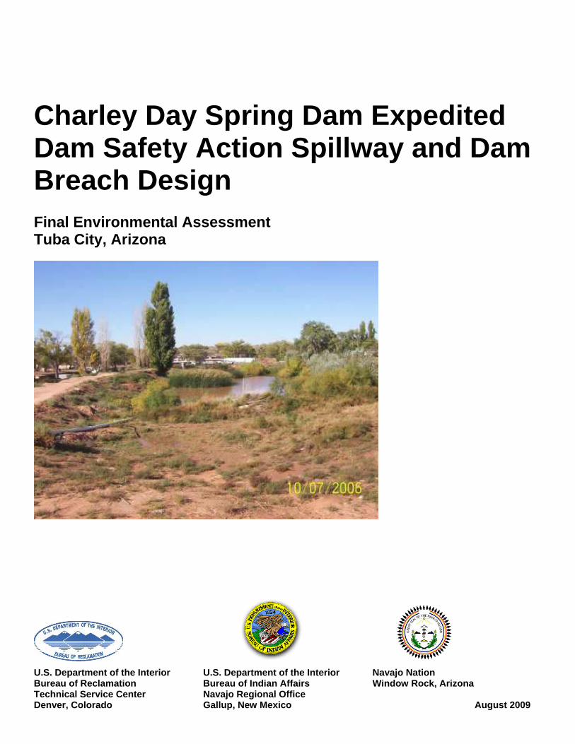
Charley Day Spring Dam Expedited Dam Safety Action Spillway and Dam Breach Design Final Environmental Assessment Tuba City, Arizona
U.S. Department of the Interior U.S. Department of the Interior Navajo Nation Bureau of Reclamation Bureau of Indian Affairs Window Rock, Arizona Technical Service Center Navajo Regional Office Denver, Colorado Gallup, New Mexico August 2009
Mission Statements The mission of the Department of the Interior is to protect and provide access to our Nation’s natural and cultural heritage and honor our trust responsibilities to Indian Tribes and our commitments to island communities. The mission of the Bureau of Reclamation is to manage, develop, and protect water and related resources in an environmentally and economically sound manner in the interest of the American public.
U.S. Department of the Interior U.S. Department of the Interior Navajo Nation Reservation Bureau of Reclamation Bureau of Indian Affairs Window Rock, Arizona Technical Service Center Navajo Regional Office Denver, Colorado Gallup, New Mexico August 2009
Charley Day Spring Dam Expedited Dam Safety Action Spillway and Dam Breach Design Final Environmental Assessment Tuba City, Arizona Prepared by Bureau of Reclamation Technical Service Center And Bureau of Indian Affairs Navajo Regional Office In cooperation with Navajo Nation

SUMMARY This is an Expedited Dam Safety Action on a relatively small reservoir on the Navajo Nation Reservation in Tuba City, Arizona. This Environmental Assessment (EA) evaluates the environmental impacts of the Charley Day Spring Dam modifications to address the Safety of Dams structural deficiencies identified in the Charley Day Spring Dam Comprehensive Dam Review (CDR; Bureau of Reclamation 2006a) and safety concerns for residents below the dam. The CDR explicitly states that based on Bureau of Indian Affairs (BIA) criteria, Charley Day Spring Dam has an unacceptably high probability of both overtopping failure and seepage-related failure in a flood event. Floodflows could impact residences or schools located immediately below the dam (Bureau of Reclamation 2006b). The total Population-At-Risk is estimated to be approximately 40 persons (Bureau of Reclamation 2006a), and therefore the No Action Alternative is not acceptable. The preferred alternative and only suitable alternative at this time (Alternative 1) is to excavate a channel in an easterly direction in the left abutment area that is sufficient to ensure that the water level in the reservoir will not rise above safe levels if a 700-year-recurrence-interval flood event occurs. This work would be performed as part of the deficiency verification analysis for Charley Day Spring Dam (Bureau of Reclamation 2008) which outlines the extent of dam repairs needed to make it safe. The designed spillway would be considered temporary until a permanent solution can be implemented. This document has been prepared according to guidance provided by the Navajo Regional Office (Bureau of Indian Affairs 2005). Reclamation and BIA are joint-lead federal agencies in cooperation with the Navajo Nation for this project. This EA fulfills the requirements of the National Environmental Policy Act, the National Historic Preservation Act, the Endangered Species Act, Clean Water Acts, and several others as requested by the BIA (2005). The Navajo Nation Natural Heritage Program provided information on “species of concern” from the Navajo Nation, Department of Fish and Wildlife. Specific information concerning the original design and construction of Charley Day Spring Dam are not available; however, it is believed that the dam is a homogeneous earth-filled embankment that was built in 1940 (Bureau of Reclamation 2006a). The dam has no spillway, and its outlet works have been abandoned and are inoperable. The downstream end of the outlet works are covered by a berm that reportedly was constructed 15–20 years ago. Charley Day Spring Dam is approximately 15 feet (ft) high, with a crest length of 700 ft. Its crest elevation varies, but is roughly 4,995 ft at its lowest point. The design engineer roughly estimates that the reservoir occupies a maximum 3.5 acres; and normal pool capacity is about 13.5 acre-ft. The dam embankment consists of fine sand with silt and is viewed to be highly erodible.
iii

iv
Impacts to threatened and endangered species, local businesses, cultural resources, and other environment concerns were assessed and found to be minimal if appropriate Federal and Tribal regulations are followed and no unknown concerns are discovered during excavation. A summary table comparing impacts among alternatives is provided in Chapter 3. To assure environmental, cultural, and safety management during construction, flexible contracts should be written with contract specifications for known concerns and unknown contingencies. If any cultural resources were discovered, the project would halt until appropriate consultations with historic preservation officers were completed. If hazardous materials were encountered or if environmental or safety concerns arose, appropriate personnel would be dispatched promptly to assess and deal with the concerns at the time of discovery. If concerns could not be solved promptly under the flexible contracts and the spillway and channel construction was delayed, an alternative option to reroute storm flows in a similar and slightly altered direction would be assessed at that time.
Charley Day Spring Dam Expedited Dam Safety Action Spillway and Dam Breach Design
Final Environmental Assessment
Contents Page
SUMMARY .................................................................................................. iii
1.0 PURPOSE AND NEED ................................................................... 1 1.1 Project Location and Environmental Setting ............................... 3 1.2 Compliance with Environmental Statutes.................................... 6
1.2.1 National Historic Preservation Act of 1966, as Amended in 1992 ............................................................................... 6
1.2.2 Endangered Species Act of 1973 ....................................... 6 1.2.3 National Environmental Policy Act of 1969...................... 6 1.2.4 Clean Water Act of 1972 – Section 401 ............................ 7 1.2.5 Clean Water Act – Section 402.......................................... 7 1.2.6 Clean Water Act of 1972 – Section 404 ............................ 7 1.2.7 Noxious Weed Control Act................................................ 8 1.2.8 Soil Disturbance Reclamation Plan ................................... 8 1.2.9 Clean Air Act of 1972........................................................ 8 1.2.10 Executive Order 11990, Protection of Wetlands ............... 8 1.2.11 Resource Conservation and Recovery Act ........................ 9 1.2.12 Comprehensive Environmental Response, Compensation,
and Liability Act; Superfund Amendments and Reauthorization Act of 1986.............................................. 9
1.2.13 Toxic Substances Control Act ........................................... 10
2.0 ALTERNATIVES............................................................................ 11 2.1 No Action Alternative.................................................................. 11 2.2 Alternative 1: Implement Spillway............................................. 11
3.0 AFFECTED ENVIRONMENT AND ENVIRONMENTAL CONSEQUENCES OF PROPOSED ACTION ............................ 19
3.1 Resources Potentially Affected by Proposed Action ................... 21 3.1.1 Visual ................................................................................. 21 3.1.2 Air Quality ......................................................................... 21 3.1.3 Noise, Traffic, and Safety .................................................. 21 3.1.4 Hydrology .......................................................................... 22 3.1.5 Water Quality..................................................................... 23 3.1.6 Biological Resources ......................................................... 23 3.1.7 Hazardous Material and Solid Waste................................. 28 3.1.8 Historic and Cultural Resources ........................................ 29 3.1.9 Social and Economic.......................................................... 30 3.1.10 Indian Trust Assets ............................................................ 31 3.1.11 Environmental Justice........................................................ 31 3.1.12 Recreation .......................................................................... 32 3.1.13 Resource and Land Use ..................................................... 32
v
Charley Day Spring Dam Expedited Dam Safety Action Spillway and Dam Breach Design Final Environmental Assessment
vi
Contents – continued
4.0 CUMULATIVE IMPACTS ............................................................ 33
5.0 CONSULTATION AND COORDINATION................................ 35 5.1 List of Preparers........................................................................... 36 5.2 Distribution List ........................................................................... 36
6.0 LITERATURE CITED ................................................................... 39 APPENDIX A Army Corps of Engineers letter on jurisdictional waters of
United States APPENDIX B Letter from the Navajo Nation, Department of Fish and Wildlife APPENDIX C Field Exploration Request APPENDIX D Concurrence from Navajo Nation Historic Preservation
Department
Tables Tables 1 Summary of Probable Maximum Flood results ................................. 2 2 Summary comparison of impacts among the alternatives for
Charley Day Spring Dam................................................................... 19 3 Federal status of listed species and species of concern in Coconino
County, Arizona................................................................................. 26 Figures Figures 1 Aerial map of project area showing direction of flooding in the
event of dam failure and the direction of flow for the proposed spillway.............................................................................................. 1
2 Location of Charley Day Spring Dam and Reservoir (from “Tuba City, AZ” quad), T32N, R11E, Section 20 ............................. 4
3 Charley Day Spring Reservoir upstream of Tuba City, Arizona ....... 5 4 Conceptual design of proposed project outlining project area........... 13 5 Locations of soil testing pits .............................................................. 16
Charley Day Spring Dam Expedited Dam Safety Action Spillway and Dam Breach Design
Final Environmental Assessment
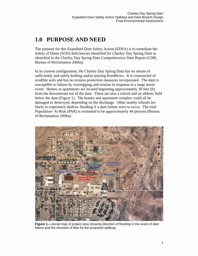
1.0 PURPOSE AND NEED The purpose for this Expedited Dam Safety Action (EDSA) is to remediate the Safety of Dams (SOD) deficiencies identified for Charley Day Spring Dam as identified in the Charley Day Spring Dam Comprehensive Dam Report (CDR; Bureau of Reclamation 2006a). In its current configuration, the Charley Day Spring Dam has no means of sufficiently and safely holding and/or passing floodflows. It is constructed of erodible soils and has no erosion protection measures incorporated. The dam is susceptible to failure by overtopping and erosion in response to a large storm event. Homes or apartments are located beginning approximately 30 feet (ft) from the downstream toe of the dam. There are also a school and an athletic field below the dam (Figure 1). The homes and apartment complex could all be damaged or destroyed, depending on the discharge. Other nearby schools are likely to experience shallow flooding if a dam failure were to occur. The total Population- At-Risk (PAR) is estimated to be approximately 40 persons (Bureau of Reclamation 2006a).
Figure 1.—Aerial map of project area showing direction of flooding in the event of dam failure and the direction of flow for the proposed spillway.
1
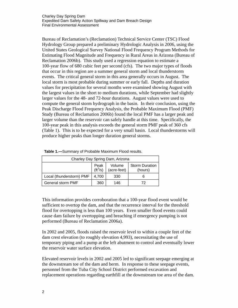
Charley Day Spring Dam Expedited Dam Safety Action Spillway and Dam Breach Design Final Environmental Assessment Bureau of Reclamation’s (Reclamation) Technical Service Center (TSC) Flood Hydrology Group prepared a preliminary Hydrologic Analysis in 2006, using the United States Geological Survey National Flood Frequency Program Methods for Estimating Flood Magnitude and Frequency in Rural Areas in Arizona (Bureau of Reclamation 2006b). This study used a regression equation to estimate a 100-year flow of 680 cubic feet per second (cfs). The two major types of floods that occur in this region are a summer general storm and local thunderstorm events. The critical general storm in this area generally occurs in August. The local storm is most probable during summer or early fall. Depths and duration values for precipitation for several months were examined showing August with the largest values in the short to medium durations, while September had slightly larger values for the 48- and 72-hour durations. August values were used to compute the general storm hydrograph in the basin. In their conclusion, using the Peak Discharge Flood Frequency Analysis, the Probable Maximum Flood (PMF) Study (Bureau of Reclamation 2006b) found the local PMF has a larger peak and larger volume than the reservoir can safely handle at this time. Specifically, the 100-year peak in this analysis exceeds the general storm PMF peak of 360 cfs (Table 1). This is to be expected for a very small basin. Local thunderstorms will produce higher peaks than longer duration general storms.
Table 1.—Summary of Probable Maximum Flood results.
Charley Day Spring Dam, Arizona Peak
(ft3/s) Volume
(acre-feet)Storm Duration
(hours) Local (thunderstorm) PMF 4,700 330 6 General storm PMF 360 146 72
This information provides corroboration that a 100-year flood event would be sufficient to overtop the dam, and that the recurrence interval for the threshold flood for overtopping is less than 100 years. Even smaller flood events could cause dam failure by overtopping and breaching if emergency pumping is not performed (Bureau of Reclamation 2006a). In 2002 and 2005, floods raised the reservoir level to within a couple feet of the dam crest elevation (to roughly elevation 4,993), necessitating the use of temporary piping and a pump at the left abutment to control and eventually lower the reservoir water surface elevation. Elevated reservoir levels in 2002 and 2005 led to significant seepage emerging at the downstream toe of the dam and berm. In response to these seepage events, personnel from the Tuba City School District performed excavation and replacement operations regarding earthfill at the downstream toe area of the dam.
2

Charley Day Spring Dam Expedited Dam Safety Action Spillway and Dam Breach Design
Final Environmental Assessment
Removal of material from the downstream toe area shortens seepage paths, increases hydraulic gradients, and therefore increases the likelihood of occurrence of this failure mode. Even though the excavated material is rapidly replaced with dry earthfill, failure could occur in the interim due to this excavation work (Bureau of Reclamation 2006a). Currently, there is an inability to control reservoir levels in severe flood events; this is the key issue at Charley Day Springs Dam. With the above-listed issues, this project is in need of an EDSA. To provide safe passage of floodflows, construction of a partial breach and spillway channel from the left abutment are the only feasible alternatives at this time. This is a temporary solution to meet the EDSA. A permanent solution is planned over the next decade and details are not yet known. Details of the temporary project construction are described under Section 2.0 Alternatives.
1.1 Project Location and Environmental Setting
Charley Day Spring Dam is an isolated dam located on the northeast side of Tuba City, Arizona, on the Navajo Indian Reservation (Figure 2), approximately 80 miles north of Flagstaff, Arizona. Charley Day Spring Dam is located on the Colorado Plateau in north central Arizona. This portion of Arizona, from the Grand Canyon to the Four Corners area, is called Great Basin Desert or Navajoan Desert.
This plateau, a topographic subdivision within the Colorado Plateau, is a relatively barren, rocky upland surface mantled with shifting sand dunes. The project area is approximately 4,940 ft in elevation. The plant communities are either desert scrub or desert grasslands. Within the project area, this plant community is evident only on a slight rise formed by exposed Navajo sandstone and deposits of sandy-silty soil along the east side of Charley Day Spring Reservoir.
The drainage for Charley Day Spring Reservoir is estimated to occupy an area of approximately 0.73 square miles (mi2) or 470 acres (Bureau of Reclamation 2006b). Impervious areas in the watershed are less than 1 percent of the total area. Approximately 1,200 ft east by southeast of the reservoir, the terrain gradually drops off into wide, valley-like trough that contains robust and widespread stands of four-wing saltbush. Upland vegetation in the project area has been degraded by chronic pedestrian and vehicle use.
Drainage area is defined in the Site Inspection Report (Bureau of Reclamation 2004). Charley Day Spring Reservoir is fed by rainfall runoff and water from Charley Day Spring located about 600 ft upstream of the right abutment of the
3

Charley Day Spring Dam Expedited Dam Safety Action Spillway and Dam Breach Design Final Environmental Assessment
Project Area
Figure 2.—Location of Charley Day Spring Reservoir (from “Tuba City, AZ” quad), T32N, R11E, Section 20. Project area is outlined in red.
dam. At the right abutment, a small storm water diversion ditch captures runoff from a residential area and diverts it to the reservoir. It is not located along any stream or other waterway. The nearly constant water from the spring flows through a 4-inch pipe extending approximately 75 yards (yd) from the spring to the reservoir. On average, the pipe discharges less than 0.5 cfs water into the northwest side of the reservoir (Nixon 2006, personal communication).
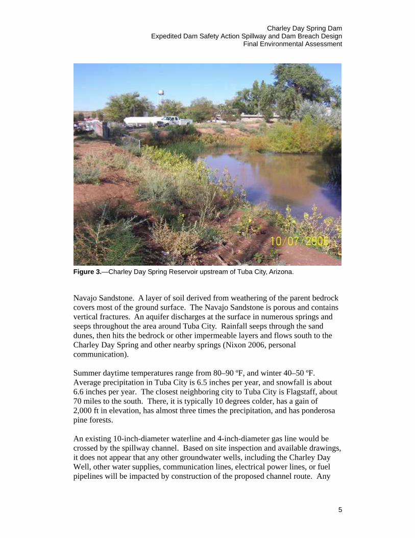
Charley Day Spring Reservoir is surrounded by urban developments (residential developments and schools) on three sides (Figure 3). There are no discernible connections to tributaries or interstate waters (Appendix A), and currently, the only release of water from Charley Day Spring Dam is by means of seepage and evaporation. When needed, the Navajo Nation Department of Water Resources pumps out water when its elevation gets too high (Helton 2006). Charley Day Spring has developed as a result of groundwater running from extensive sand dunes beginning about a mile north of Tuba City. The ground gradually slopes generally to the south (Nixon 2006, personal communication). The Tuba City area is underlain by an extensive area of bedrock known as the
4
Charley Day Spring Dam Expedited Dam Safety Action Spillway and Dam Breach Design
Final Environmental Assessment
Figure 3.—Charley Day Spring Reservoir upstream of Tuba City, Arizona.
Navajo Sandstone. A layer of soil derived from weathering of the parent bedrock covers most of the ground surface. The Navajo Sandstone is porous and contains vertical fractures. An aquifer discharges at the surface in numerous springs and seeps throughout the area around Tuba City. Rainfall seeps through the sand dunes, then hits the bedrock or other impermeable layers and flows south to the Charley Day Spring and other nearby springs (Nixon 2006, personal communication). Summer daytime temperatures range from 80–90 ºF, and winter 40–50 ºF. Average precipitation in Tuba City is 6.5 inches per year, and snowfall is about 6.6 inches per year. The closest neighboring city to Tuba City is Flagstaff, about 70 miles to the south. There, it is typically 10 degrees colder, has a gain of 2,000 ft in elevation, has almost three times the precipitation, and has ponderosa pine forests. An existing 10-inch-diameter waterline and 4-inch-diameter gas line would be crossed by the spillway channel. Based on site inspection and available drawings, it does not appear that any other groundwater wells, including the Charley Day Well, other water supplies, communication lines, electrical power lines, or fuel pipelines will be impacted by construction of the proposed channel route. Any
5
Charley Day Spring Dam Expedited Dam Safety Action Spillway and Dam Breach Design Final Environmental Assessment water pipelines, natural gas pipelines, communication cables, or electrical lines will be rerouted temporarily if accommodating excavation around any existing utilities is not possible.
1.2 Compliance with Environmental Statutes
1.2.1 National Historic Preservation Act of 1966, as Amended in 1992 The National Historic Preservation Act (NHPA) establishes the Federal policy concerning the protection of historic properties. Federal agencies are required to carry out all activities under NHPA in cooperation with States, Tribes, and local governments. The Act designates the State Historic Preservation Officer (SHPO) as the responsible entity in each State and the Tribal Historic Preservation Officer (THPO) as the responsible entity in each Tribe for administering programs under NHPA. The Act also creates the Advisory Council on Historic Preservation (ACHP) to serve as the advisory body to the Executive Branch on historic preservation issues. Section 106 of the Act requires Federal agencies to consider the effects of their undertakings on historic resources and to give the SHPO and/or THPO and the ACHP reasonable opportunity to comment on the effects of those undertakings. Finally, the 1992 amendments require the Federal agency to consider the impacts of undertakings on properties of traditional religious and cultural importance to American Indians and to involve American Indian Tribes to participate in the consultation process, should such resources be affected.
1.2.2 Endangered Species Act of 1973 The Endangered Species Act (ESA) of 1973 as amended requires Federal agencies to consult with the U.S. Fish and Wildlife Service (USFWS) for federally listed threatened and endangered species identified to exist or potentially exist in the project area. During consultation with The Navajo Nation Department of Fish and Wildlife on July 21, 2009, it was determined that “the project is not expected to affect any federally listed species or significantly impact any tribally listed species or other species of concern” (see Consultation and Coordination Section below and Appendix B).
1.2.3 National Environmental Policy Act of 1969 All Federal agencies are required to consult with other involved Federal agencies and to employ systematic and interdisciplinary techniques in planning and decision making. The National Environmental Policy Act (NEPA) requires a full and honest disclosure of all environmental impacts associated with the proposed alternatives.
6
Charley Day Spring Dam Expedited Dam Safety Action Spillway and Dam Breach Design
Final Environmental Assessment
This Environmental Assessment (EA) has been prepared in compliance with NEPA. The Draft EA was distributed to those entities displayed in the distribution list below and the EA was made available on Reclamation’s website at http://www.usbr.gov\LC\Phoenix for public review with a comment deadline of August 28, 2009. No comments were received.
1.2.4 Clean Water Act of 1972 – Section 401 Section 401 of the Clean Water Act, is administered by the Navajo Nation. The Navajo Nation has authority to grant or deny certification for a federally permitted or licensed activity that may result in a discharge to the waters of the United States. The Charley Day Spring Reservoir is an isolated, intrastate water. It is not a jurisdictional water of the United States, and is therefore not subject to the Clean Water Act (see Consultation and Coordination section below, and Appendix A). The Navajo Nation Environmental Protection Agency (NNEPA) has determined that because this activity does not require a 404 Permit of any kind from the Corps of Engineers (COE) (see Section 1.2.6 below), a 401 Certification is not required from the Navajo Nation (Rich 2009).
1.2.5 Clean Water Act – Section 402 Section 402 of the Clean Water Act requires that any party that discharges or affects the discharge of any pollutant into waters of the United States gets a permit for that activity. A Storm Water Pollution Prevention Plan (SWPPP) and a permit from the U.S. Environmental Protection Agency (EPA) are required for storm water discharge if the proposed activity has potential to disturb surfaces of one acre or more. The small storm water diversion ditch near the right abutment that captures runoff from a residential area and diverts it to Charley Day Reservoir will not be altered. The Bureau of Indian Affairs (BIA) Force Account Group is responsible for obtaining all pertinent permits. The contracting construction company would comply, as necessary, if the proposed activity has the potential to disturb surfaces of 1 acre or more.
1.2.6 Clean Water Act of 1972 – Section 404 Section 404 of the Clean Water Act of 1972, as amended, is administered by the COE with oversight from the EPA. All activities involving the placement of dredged or fill materials into waters of the United States, including wetlands, are subject to the COE permitting process. On November 21, 2006, a letter was sent by Reclamation requesting jurisdictional determination to the COE, Los Angeles District, as to whether or not a 404 permit is necessary for this project. The COE responded with a letter dated January 26, 2007, that the Charley Day Spring Dam was not a jurisdictional water of the United States, and that a Clean Water Act Section 404 permit was not required for
7
Charley Day Spring Dam Expedited Dam Safety Action Spillway and Dam Breach Design Final Environmental Assessment this project (Appendix A). The BIA Force Account Group is responsible for obtaining any pertinent permits.
1.2.7 Noxious Weed Control Act The Noxious Weed Control and Eradication Act of 2004, and amendment to the Plant Protection Act of 2000, was signed by President Bush into law on October 30, 2004. This Act requires the Secretary of Agriculture to establish a program assisting weed management entities to control or eradicate noxious weeds on public and private land. A listing of invasive/non-native plant species and management recommendations may be obtained by the BIA prior to construction by the contracting agency which is the Navajo Nation.
To minimize introduction of vegetative invasive species, construction equipment would be washed and decontaminated off site before entering the project area. Vehicle tires would be cleaned to prevent spread of noxious weeds. Invasive plant species such as salt cedar (Tamarix spp.) found on site would be treated with herbicides and eliminated to prevent spreading during excavation.
1.2.8 Soil Disturbance Reclamation Plan If the proposed action involved significant surface disturbance, i.e., grading or earthmoving activities, the Range Conservation Officer of the Navajo Nation Department of Agriculture would be contacted for a seed mixture and a reclamation plan prior to excavation.
1.2.9 Clean Air Act of 1972 The Clean Air Act requires that any Federal entity engaged in an activity that may result in the discharge of air pollutants must comply with all applicable air pollution control laws and regulations (Federal, State, or local). The Act requires the EPA to publish national primary standards to protect public health and more stringent national secondary standards to protect public welfare. States and local governments are responsible for the prevention and control of air pollution. Construction contractors would ensure that compliance with these laws and regulations is achieved.
1.2.10 Executive Order 11990, Protection of Wetlands Executive Order 11990 directs each Federal agency to provide leadership and take action to minimize the destruction, loss or degradation of wetlands, and to preserve and enhance the natural and beneficial values of wetlands in carrying out agency duties and responsibilities. Executive Orders represent administrative policy and do not have the force of law that comes with delegation of authority provided by Congress.
8
Charley Day Spring Dam Expedited Dam Safety Action Spillway and Dam Breach Design
Final Environmental Assessment
Consultation with The Navajo Nation Department of Fish and Wildlife on October 31, 2006, determined potential impacts to wetlands should also be evaluated (Appendix B). A letter from the Army Corps of Engineers, Arizona-Nevada Area Office (Appendix A), indicated that the wetlands at Charley Day Spring Dam were not defined wetlands or under the jurisdiction of waters of the United States. To maintain the existing wetland habitat, Charley Day Spring Reservoir would not be completely drained. Water level at Charley Day Spring Dam impoundment after construction would remain as under normal conditions up to the spillway height.
1.2.11 Resource Conservation and Recovery Act The Resource Conservation and Recovery Act (RCRA) is an amendment to the 1976 Solid Waste Disposal Act. The goals of RCRA are to ensure that wastes are managed in an environmentally sound manner and to protect human health and the environment from the potential hazards of waste disposal. Also included in the RCRA is the purpose to reduce the amount of waste generated and to conserve energy and natural resources. Essentially, the RCRA requires that proper management tactics be immediately installed by the contracted construction agency to ensure minimal contamination by any and all hazardous waste materials found, used and/or created in connection with the project. Any and all non-hazardous solid wastes found, used and/or created at the project or proposed project site must be immediately stored and disposed of properly by the contracted construction agency according to Federal regulations.
1.2.12 Comprehensive Environmental Response, Compensation, and Liability Act; Superfund Amendments and Reauthorization Act of 1986
The Comprehensive Environmental Response, Compensation, and Liability Act (CERCLA), commonly known as Superfund, was enacted by Congress on December 11, 1980. This law created a tax on the chemical and petroleum industries and provided broad Federal authority to respond directly to releases or threatened releases of hazardous substances that may endanger public health or the environment. CERCLA also enabled the revision of the National Contingency Plan (NCP). The NCP provided the guidelines and procedures needed to respond to releases of hazardous substances, pollutants, or contaminants. CERCLA was amended by the Superfund Amendments and Reauthorization Act (SARA) on October 17, 1986. SARA reflected EPA’s experience in administering the complex Superfund program during its first 6 years and made several important changes and additions to the program including: stressing the importance of permanent remedies and innovative treatment technologies in cleaning up hazardous waste sites, increased State involvement in every phase of the Superfund program, increased the focus on human health problems posed by
9
Charley Day Spring Dam Expedited Dam Safety Action Spillway and Dam Breach Design Final Environmental Assessment
10
hazardous waste sites, and greatly increased the size of the trust fund for clean-up efforts. The Charley Day Spring Dam project would not require CERCLA-SARA actions, however, as required, any proposed user or operator involved in an acquisition of property shall undergo and Environmental Site Assessment (ESA) Phase I or Phase II. This is for protection of the future “innocent land owner” to determine and document a recognized environmental condition (presence of hazardous substance or petroleum waste) on the property while performing an appropriate inquiry. This would be conducted by the contractor or subcontractors prior to project construction.
1.2.13 Toxic Substances Control Act Contracting agencies would follow protocol according to CERCLA-SARA and RCRA during the course of construction in the case of encountering any toxic substances in the project area.
Charley Day Spring Dam Expedited Dam Safety Action Spillway and Dam Breach Design
Final Environmental Assessment
2.0 ALTERNATIVES
2.1 No Action Alternative
The No Action Alternative would entail leaving the dam in its current state. Under this alternative the reservoir has a decreased level of flood protection. In its current configuration, the Charley Day Spring Dam has no means of sufficiently and safely holding and/or passing floodflows. It is constructed of erodible soils, and has no erosion protection. The dam is susceptible to failure by overtopping and erosion in response to a large storm event. The flood risk to residents below the reservoir would continue to exist under this alternative. Should the dam fail, homes and an apartment complex would be damaged or destroyed, depending on the discharge. Nearby schools are likely to experience shallow flooding if a dam failure were to occur. The PAR is estimated to be approximately 40 persons (Bureau of Reclamation 2006a). Currently, there is an inability to control Charley Day Reservoir levels in flood events.
2.2 Alternative 1: Implement Spillway
The only immediate option available to deal with the imminent danger of a breach of the dam is to excavate a spillway and channel from the left abutment of the dam in an easterly direction that is sufficient to ensure that the water level in the reservoir will not rise above safe levels (Bureau of Reclamation 2006a). No other alternatives were addressed as this dam is relatively small, and there were no other viable options available to meet the immediate purpose and need of the project. This is a temporary solution, but a permanent solution is planned over the next decade. The estimated project footprint, including the construction boundary to be used by heavy equipment, is outlined in Figure 4. The purpose of the spillway is to convey water from the Charley Day Spring Reservoir to the east into a large natural drainage wash. The temporary spillway would consist of an excavated channel and an earthfill dike. The excavated channel would start within the reservoir at elevation 4,988.5 and continue through the abandoned partially eroded airstrip pavement and then to the natural drainage (topography furnished by BIA and source of information noted from Arizona Engineering Company in 2002). The excavated channel would have a bottom width of 15 ft with both sides sloped at 2:1 (H:V). A dike would be constructed on the south side of the spillway channel at a point 36 ft south of the excavated channel (center to center) and 516 ft from the beginning of the excavated channel. From its point of
11

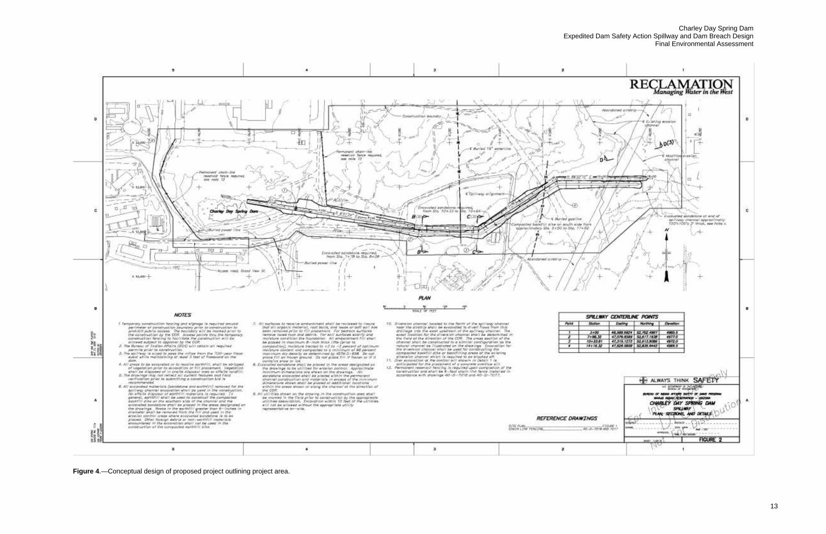
Charley Day Spring Dam Expedited Dam Safety Action Spillway and Dam Breach Design
Final Environmental Assessment
13
Figure 4.—Conceptual design of proposed project outlining project area.


Charley Day Spring Dam Expedited Dam Safety Action Spillway and Dam Breach Design
Final Environmental Assessment
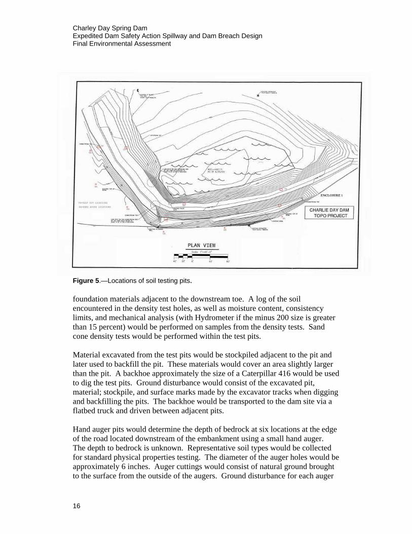
beginning, the dike would proceed along the south side of the channel and run 86 ft east (93°), and 143 ft northeast (45°), and then 94 ft east (90°) to its end for a total length of 323 ft. The top of the dike would be 6 ft above the channel invert minimum throughout its length, the top width at 8 ft, and the side slopes at 3:1. The dike would have side slopes at 2:1. The spillway would discharge water to the east, away from schools, housing, and other developed areas. The overall length of the temporary spillway (both channel and dike) would be approximately 1,700 ft as measured along the water flow line. The dike would be built with the earthfill excavated from the channel and the height of the dike would be increased as necessary to accommodate the full volume excavated. The rock excavated from the bottom of the channel would be used to armor the last 150 ft of the spillway channel and the north side of the dike, with priority given to areas more likely to initiate erosion. Average berm height is estimated to be 3–4 ft or greater with a top width of 8 ft and side slopes of 2:1. Small floodflows would be channeled to the east and around the end of the dike to the existing large natural wash. Larger floodflows would eventually follow the natural drainage and continue flowing to the south. Two utility lines would be crossed by the spillway channel. One utility line is a 10-inch-diameter asbestos concrete (AC) water line constructed with 13-foot-long segments which are connected with AC couplings. The second utility line is a 4-inch-diameter gas line which is constructed of high density polyethylene (HDPE) pipe. The utility lines would be replaced and constructed in accordance with the Navajo Tribal Utility Authority’s (NTUA) requirements. The water line could be shut down for durations of up to 2 weeks during construction. The gas line is not currently serving anyone and could be turned off while work was performed in that area. Reclamation, in cooperation with the BIA (lead agency), would also conduct preliminary field investigations and testing at the Charley Day Spring Dam at the same time as spillway construction. The Field Exploration Request is provided in Appendix C. The proposed activities would include two types of testing methods: the drilling of six test pits, and six hand auger pits. Figure 5 shows the locations of the soil testing pits. The sampling of the test pits would involve excavation of three test pits on the dam crest and three test pits near the downstream toe of the embankment to gather data to evaluate the embankment and foundation material properties. Results obtained from in-place procedures would be compared to laboratory standard proctor results. Each test pit would be approximately 4 ft wide, 4 ft long, and 3 ft deep. An in-place density test would be performed at approximately 3 ft below the surface of the embankment crest and 3 ft below
15
Charley Day Spring Dam Expedited Dam Safety Action Spillway and Dam Breach Design Final Environmental Assessment
Figure 5.—Locations of soil testing pits. foundation materials adjacent to the downstream toe. A log of the soil encountered in the density test holes, as well as moisture content, consistency limits, and mechanical analysis (with Hydrometer if the minus 200 size is greater than 15 percent) would be performed on samples from the density tests. Sand cone density tests would be performed within the test pits. Material excavated from the test pits would be stockpiled adjacent to the pit and later used to backfill the pit. These materials would cover an area slightly larger than the pit. A backhoe approximately the size of a Caterpillar 416 would be used to dig the test pits. Ground disturbance would consist of the excavated pit, material; stockpile, and surface marks made by the excavator tracks when digging and backfilling the pits. The backhoe would be transported to the dam site via a flatbed truck and driven between adjacent pits. Hand auger pits would determine the depth of bedrock at six locations at the edge of the road located downstream of the embankment using a small hand auger. The depth to bedrock is unknown. Representative soil types would be collected for standard physical properties testing. The diameter of the auger holes would be approximately 6 inches. Auger cuttings would consist of natural ground brought to the surface from the outside of the augers. Ground disturbance for each auger
16
Charley Day Spring Dam Expedited Dam Safety Action Spillway and Dam Breach Design
Final Environmental Assessment
17
hole would consist of an area approximately 5 by 5 ft to place drill cuttings. Each auger hole would be backfilled with cuttings mixed with water and cement. The general quantities for earthmoving activities and other work associated with this project are as follows:
Excavation of earthfill materials 6,500 cu. yd Excavation of sandstone 1,500 cu. yd Place compacted backfill in dike 6,500 cu. yd Place excavated sandstone for erosion protection 1,500 cu. yd Place unreinforced concrete for spillway control sill 20 cu. yd Chain link fencing 1,400 lin. ft Remove and dispose of existing asphalt pavement 10, 000 sq. ft
Furnish and install: ductile iron pipe 150 lin. ft
2 gate valves connections for water line
The design of this alternative is sufficient to accommodate hydrologic events and ensure that the water level in the reservoir will not exceed safe levels (approximately 4,993.5 elevation) in the event of a 700-year flood, and that all flows will travel through the channel. This is above the existing dead pool elevation and 3 feet below the existing dam crest. These modifications are designed to remove the existing potential hazard to the urban residences and schools located immediately downstream of the dam but will not affect the current reservoir level under non-flood conditions (Bureau of Reclamation 2006a). Erosion within the spillway channel is anticipated for larger discharges, but the spillway is designed to prevent releasing of water towards the schools or populated areas.

Charley Day Spring Dam Expedited Dam Safety Action Spillway and Dam Breach Design
Final Environmental Assessment
3.0 AFFECTED ENVIRONMENT AND ENVIRONMENTAL CONSEQUENCES OF PROPOSED ACTION
The primary issues associated with this project include the following:
• Potential loss or damage to property of local residents during significant flood events.
• Potential loss of life especially during a significant flood event and/or dam failure.
• Adverse visual impacts associated with dam or diversion failure. • Increase in noise, traffic, emissions, and safety concerns related to
construction. • Altered flood routing; floodflows would be routed through the spillway
and into the east area away from residences and schools. • Propane storage yard just downstream to the west of dam could be
damaged or destabilized in the event of breech of dam. A summary of impacts associated with dam modification and construction are compared between alternatives in Table 2. Table 2.—Summary comparison of impacts among the alternatives for Charley Day Spring Dam.
Issues No Action Alternative 1
Visual No impact. If dam failed, temporary disturbance downstream would affect visual quality.
Short-term disturbance and presence of heavy equipment associated with soil testing and construction. Temporary fencing of construction area and mud flats after draining.
Air Quality No foreseeable impacts. Short-term dust and exhaust emissions from soil testing and construction activities. Emission standards would not be exceeded, and roads would be watered to control dust, if needed. Temporary lake decay odors may result after bottom sediments were exposed during draining.
Noise, Traffic, and Safety
No foreseeable impacts. Temporary increase in noise and traffic due to test pit drilling and construction. Jack hammers used during business hours. No structures near dam to be impacted.
19
Charley Day Spring Dam Expedited Dam Safety Action Spillway and Dam Breach Design Final Environmental Assessment
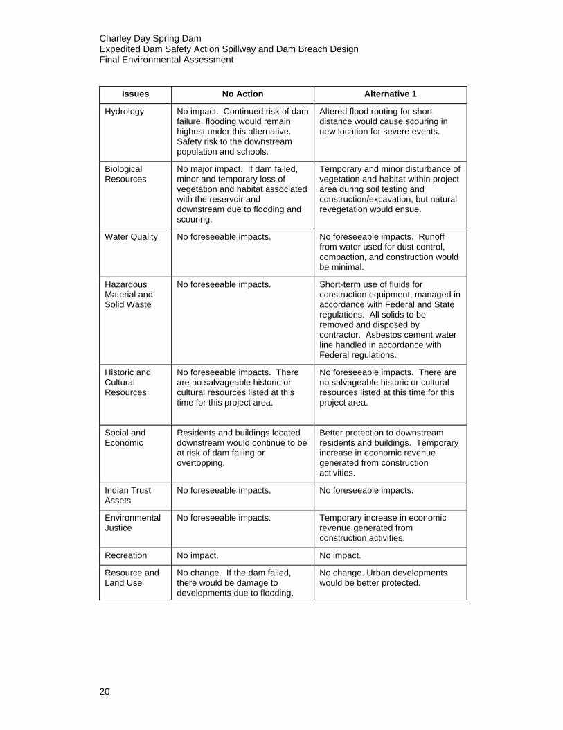
Issues No Action Alternative 1
Hydrology No impact. Continued risk of dam failure, flooding would remain highest under this alternative. Safety risk to the downstream population and schools.
Altered flood routing for short distance would cause scouring in new location for severe events.
Biological Resources
No major impact. If dam failed, minor and temporary loss of vegetation and habitat associated with the reservoir and downstream due to flooding and scouring.
Temporary and minor disturbance of vegetation and habitat within project area during soil testing and construction/excavation, but natural revegetation would ensue.
Water Quality No foreseeable impacts. No foreseeable impacts. Runoff from water used for dust control, compaction, and construction would be minimal.
Hazardous Material and Solid Waste
No foreseeable impacts. Short-term use of fluids for construction equipment, managed in accordance with Federal and State regulations. All solids to be removed and disposed by contractor. Asbestos cement water line handled in accordance with Federal regulations.
Historic and Cultural Resources
No foreseeable impacts. There are no salvageable historic or cultural resources listed at this time for this project area.
No foreseeable impacts. There are no salvageable historic or cultural resources listed at this time for this project area.
Social and Economic
Residents and buildings located downstream would continue to be at risk of dam failing or overtopping.
Better protection to downstream residents and buildings. Temporary increase in economic revenue generated from construction activities.
Indian Trust Assets
No foreseeable impacts. No foreseeable impacts.
Environmental Justice
No foreseeable impacts. Temporary increase in economic revenue generated from construction activities.
Recreation No impact. No impact.
Resource and Land Use
No change. If the dam failed, there would be damage to developments due to flooding.
No change. Urban developments would be better protected.
20
Charley Day Spring Dam Expedited Dam Safety Action Spillway and Dam Breach Design
Final Environmental Assessment
3.1 Resources Potentially Affected by Proposed Action
3.1.1 Visual Affected Environment The reservoir is situated in arid desert grasslands interspersed with rural residential subdivisions. Environmental Consequences No Action Alternative There would be no impact to visual aesthetics under the No Action Alternative. If the dam failed, the empty reservoir and disturbed area downstream of the dam would be visually unappealing. Alternative 1 There would be a temporary negative impact to visual quality due to heavy construction equipment and disturbance around the dam and residences downstream. These impacts would be short term and would occur in small, localized areas.
3.1.2 Air Quality Affected Environment Air quality in the area is generally good. Vehicles using the highway and roads near the dam may create some exhaust and dust. Environmental Consequences No Action Alternative There would be no impacts to air quality if no action were taken. Alternative 1 Test pit drilling and construction activities would cause short-term dust generation and equipment emissions. National Ambient Air Quality standards are not expected to be exceeded. Any impacts associated with dust generation would be mitigated with the use of water trucks.
3.1.3 Noise, Traffic, and Safety Affected Environment Noise levels reflect the rural setting. The town of Tuba City, population of approximately 8,000, is the nearest development. Most noise in the area is associated with highway traffic and local construction. Traffic levels are typical of secondary highways. There is ongoing commercial construction currently underway near the main street about four blocks away.
21
Charley Day Spring Dam Expedited Dam Safety Action Spillway and Dam Breach Design Final Environmental Assessment Environmental Consequences No Action Alternative Noise and traffic levels would not be affected under the No Action Alternative. Public safety would still be a concern for downstream residents. Alternative 1 Test pit drilling and modifications to the dam would cause a temporary increase in noise and traffic associated with construction activities. There are few structures located near the dam that would be affected by noise from the construction. The contractor would notify the trailer park residents, school housing, Indian Health Services, Navajo police, and other Tuba City officials before using loud equipment or potential blasting of sandstone rock. If blasting occurs, blast mats would be used to prevent fly rock from impacting local residences. Trucks hauling construction equipment and riprap, sand and gravel and fill material would contribute to traffic, and thus public safety concerns, in town. Relatively small quantities of material may be required from outside sources; consequently, the increase in traffic due to trucks hauling material would be minimal. Excavation could potentially cause poisonous snakes to move from the excavation area into space occupied by humans.
3.1.4 Hydrology Affected Environment The reservoir is roughly estimated to occupy 2.5 acres at the normal pool level. Charley Day Spring Dam is approximately 15 ft high, with a crest length of 700 ft. The purpose for the reservoir is primarily flood control. The affected environment would include the risk of flooding and destruction of the high school and rural subdivisions downstream. Environmental Consequences No Action Alternative There would be no immediate effect to hydrology under the No Action Alternative. Taking no action does, however, increase the likelihood of overtopping or dam failure and the associated flooding downstream. Alternative 1 Altered flood routing for a short distance would cause scouring in new locations for severe events. The safe passage of floodflows would be provided by the construction of a new spillway and partial dam breach on the left abutment. Implementing the proposed action would ensure that the water level in the reservoir would not exceed safe levels in the event of an occurrence of the 700-year-recurrence-interval flood, and that flows through the spillway channel would
22
Charley Day Spring Dam Expedited Dam Safety Action Spillway and Dam Breach Design
Final Environmental Assessment
not impact residences or schools located immediately downstream of the dam (Bureau of Reclamation 2006a).
3.1.5 Water Quality Affected Environment The affected environment for water quality would include Charley Day Spring Reservoir and the potential spillway release system. Charley Day Spring Reservoir is fed by rainfall runoff and water from Charley Day Spring located about 600 ft upstream of the right abutment of the dam. At the right abutment, a small storm water diversion ditch captures runoff from a residential area and diverts it to the reservoir. It is not located along any stream or other waterway. Environmental Consequences No Action Alternative Existing conditions would prevail into the foreseeable future. There are currently no foreseeable impacts concerning water quality for this project under the No Action Alternative. Alternative 1 Constructing the spillway would divert normal spring flow and storm runoff to the east of the reservoir. Turbid storm flows would quickly dissipate by seepage into the ground and evaporation. Large floodflows would follow the natural drainage and continue to the south. Runoff from water used during construction for compaction and dust control should be minimal.
3.1.6 Biological Resources Affected Environment In 2006, a biological site survey was performed by John McGlothlen of the Bureau of Reclamation, Phoenix Area Office, who was familiar with the area and species of concern. His findings are outlined below. Vegetation The project area occurs within Great Basin desertscrub as described by Brown (1994). Major plant dominants consist of shadscale (Atriplex confertifolia) and four-wing saltbush (Atriplex canescens), joined by plants of lesser extent including greasewood (Sarcobatus vermiculatus), prickly pear (Opuntia spp.), broom snakeweed (Gutierrezia sarothrae), and Torrey joint-fir (Ephydra torreyana). Within the project area, this plant community is evident only on a slight rise formed by exposed Navajo sandstone and deposits of sandy-silty soil along the east side of Charley Day Spring Reservoir. Approximately 1,200 ft east/southeast of the reservoir, the terrain gradually drops off into a wide, valley-like trough that contains robust and widespread stands of four-wing saltbush.
23
Charley Day Spring Dam Expedited Dam Safety Action Spillway and Dam Breach Design Final Environmental Assessment Upland vegetation in the project area has been degraded by chronic pedestrian and vehicle use. Plant density is generally low. The banks of Charley Day Spring Reservoir are vegetated with scattered willow (Salix spp.), saltcedar (Tamarix ramosissima), Russian olive (Elaeagnus angustifolia), and Fremont cottonwood (Populus fremontii). Cattail (Typha spp.) occurs within the shallow margins of the reservoir. Several species of non-native plants dominate the embankment of Charley Day Spring Dam including Russian thistle (Salsola kali) and camelthorn (Alhagi pseudoalhagi). Wetland conditions persist along the upper margins of the reservoir. Species of grasses, sedges, and forbs are interspersed among open stands of woody riparian vegetation noted above. This area is outside the potential impact area for construction. Per the Navajo Nation, Department of Fish and Wildlife, the project area is classified as “Community Development” and does not fall within any sensitive wetland areas (http://www.nndfw.org/zones/pdf/tubacity.pdf). The landscape to the north, west, and south of the reservoir typifies an urban setting defined by residential properties, schools, streets, and parking lots. Vegetation on these adjoining sites represents a highly manipulated mosaic of native and non-native species. Wildlife Relatively common herptofauna of Great Basin desertscrub in eastern Coconino County include Mexican spadefoot (Spea multiplicata), red-spotted toad (Bufo punctatus), eastern collard lizard (Crotaphytus bicinctores), common lesser earless lizard (Holbrookia maculata), ornate tree lizard (Urosaurus graciosus), common side-blotched lizard (Uta stansburiana), plateau lizard (Sceloporus tristichus), desert spiny lizard (Sceloporus magister), plateau striped whiptail (Aspidoscelis arizonae), gophersnake (Pituophis catenifer), and prairie rattlesnake (Crotalus viridis) (Brennan and Holycross 2006). The diversity of herptiles in the colder Great Basin Desert is less than other deserts in Arizona. Common mammals include coyote (Canis latrans), desert cottontail (Sylvilagus audubonii), black-tailed jack rabbit (Lepus californicus), Ord’s kangaroo rat (Dipodomys ordii), western harvest mouse (Reithrodontomys megalotis), white-tailed antelope squirrel (Ammospermophilus luecurus), Apache pocket mouse (Perognathus apache), white-throated wood rat (Neotoma albigula), and Botta’s pocket gopher (Thomomys bottae) (Hoffmeister 1986). Avian diversity and density is typically low in Great Basin desertscrub (Wiens and Rotenberry 1981). This is most likely due to its structural and floristic simplicity (MacArthur and MacArthur 1961, Rotenberry 1985, Wiens and Rotenberry 1981). Species that are typical in non-sagebrush associations include Brewer’s sparrow (Spizella breweri), horned lark (Eremophilia alpestris), lark
24

Charley Day Spring Dam Expedited Dam Safety Action Spillway and Dam Breach Design
Final Environmental Assessment
sparrow (Chondestes grammacus), and loggerhead shrike (Lanius excubitor) (Marjorie et al. 1999). Waterfowl and marsh birds such as mallard (Anas platyrhynchos) and American coot (Fulica americana) are known to frequent Charley Day Spring Reservoir. In addition, the reservoir provides a water source that can be important to certain resident bird species, especially doves and house finches (Carpodacus mexicanus) (Lynn et al. 2006). Special Status Species Federal agencies are required by Section 7 of the ESA to assess the potential effects of proposed actions on federally protected species and designated critical habitat. The USFWS website was accessed in August 2009 (http://arizonaes.fws.gov). They have listed 22 species that are endangered (E), threatened (T), or have candidate (C) status in Coconino County (Table 3). Threatened status means that a species is likely to become endangered if it is not protected. Endangered means that a species is in immediate danger of becoming extinct and needs protection to survive. Two sensitive plant species are protected under conservation agreements (CA) in areas where they occur on federally administered lands. Species of concern identified on the Navajo Nation Endangered Species List (NESL) consist of protected, candidate, and rare or sensitive species including certain native species and species of economic or cultural significance. In general, the NESL includes species afforded protection under the ESA, Migratory Bird Treaty Act, and Eagle Protection Act. A sensitive species survey of the project area was conducted on October 27, 2006. No sensitive species were identified in the survey. The occurrence of special status species is unlikely due to the lack of suitable habitat and/or because the current range for the species is outside the project area. No critical habitat occurs within or adjacent to the project area. If endangered species are found in the mud of the Charley Day Spring Dam impoundment lakebed, agency personnel will relocate those species to alternative habitat or find an alternative solution such as maintenance of a wetted area.
25
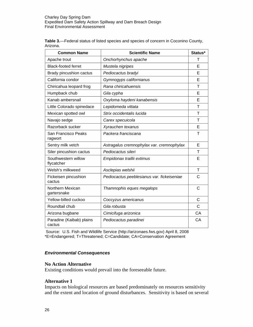
Charley Day Spring Dam Expedited Dam Safety Action Spillway and Dam Breach Design Final Environmental Assessment Table 3.—Federal status of listed species and species of concern in Coconino County, Arizona.
Common Name Scientific Name Status* Apache trout Onchorhynchus apache T Black-footed ferret Mustela nigripes E Brady pincushion cactus Pediocactus bradyi E California condor Gymnogyps californianus E Chiricahua leopard frog Rana chiricahuensis T Humpback chub Gila cypha E Kanab ambersnail Oxyloma haydeni kanabensis E Little Colorado spinedace Lepidomeda vittata T Mexican spotted owl Strix occidentalis lucida T Navajo sedge Carex specuicola T Razorback sucker Xyrauchen texanus E San Francisco Peaks ragwort
Packera franciscana T
Sentry milk vetch Astragalus cremnophylax var. cremnophylax E Siler pincushion cactus Pediocactus sileri T Southwestern willow flycatcher
Empidonax traillii extimus E
Welsh’s milkweed Asclepias welshii T Fickeisen pincushion cactus
Pediocactus peeblesianus var. fickeiseniae C
Northern Mexican gartersnake
Thamnophis eques megalops C
Yellow-billed cuckoo Coccyzus americanus C Roundtail chub Gila robusta C Arizona bugbane Cimicifuga arizonica CA Paradine (Kaibab) plains cactus
Pediocactus paradinei CA
Source: U.S. Fish and Wildlife Service (http://arizonaes.fws.gov) April 8, 2008 *E=Endangered; T=Threatened; C=Candidate; CA=Conservation Agreement Environmental Consequences No Action Alternative Existing conditions would prevail into the foreseeable future. Alternative 1 Impacts on biological resources are based predominately on resources sensitivity and the extent and location of ground disturbances. Sensitivity is based on several
26
Charley Day Spring Dam Expedited Dam Safety Action Spillway and Dam Breach Design
Final Environmental Assessment
criteria including rarity, legal protection, and perceived cultural importance of the resource. A low impact would result when the proposed action is expected to affect common vegetation and wildlife in a relatively small area, with little or no adverse affect on special status species or unique habitat. Vegetation Plant density is low along most of the proposed spillway alignment, consequently only a small amount of desert scrub vegetation would be permanently affected by construction. No significant riparian or aquatic vegetation is within the construction impact area. In the immediate vicinity of construction, vegetation would be affected by excavation, trampling, and compaction of soils. Existing roads would be utilized to the extent possible to limit excessive disturbance. Following construction, areas disturbed by project construction would be re-graded to match the existing topography, and the affected area would be rehabilitated as appropriate to stabilize soils and minimize potential soil erosion and resultant indirect effects to vegetation. In order to prevent the spread of noxious weed seeds during soil testing, all drilling equipment would be cleaned prior to entering the project area and again after the drilling/boring at the site was completed. Because of the low sensitivity of habitats throughout the project area, coupled with the relatively small amount of vegetation loss, the majority of direct and residual impacts on vegetation are anticipated to be low. Wetland resources associated with the upper margins of the reservoir would not be affected by construction. Wildlife Impacts to terrestrial wildlife from construction of the spillway would be low. There would be potential minor loss of small mammals (primarily rodents) and reptiles during construction and a permanent loss of habitat along the spillway alignment. Avian species and larger mammals would be capable of avoiding the area during construction. Habitat loss for these species would be negligible. Of concern is the movement of poisonous reptiles (rattlesnakes) during project construction and intermittently during major rainstorm events that wet the channel. If there is excessive snake movement and this becomes an issue of concern, the community would be alerted to the potential for more snake movement via local media (newspaper, radio, and community meeting announcements). If there was objection, spotted or captured reptiles would be relocated or disposed of by trained animal control handlers. Increased noise and activity levels associated with construction could temporarily preclude use of the reservoir by waterfowl and marsh birds. Water-dependent avifauna displaced by construction could use other water bodies near the project
27
Charley Day Spring Dam Expedited Dam Safety Action Spillway and Dam Breach Design Final Environmental Assessment area, such as Pasture Canyon Reservoir. Potential impact on water-dependent avifauna is considered low. Special Status Species No special status species were identified in the project area. On July 21, 2009, the Navajo Nation, Department of Fish and Wildlife, concluded the “project is not expected to affect any federally listed species or significantly impact any tribal listed species or other species of concern” (Appendix B).
3.1.7 Hazardous Material and Solid Waste Affected Environment There is a propane storage yard just downstream to the west of the dam. A utility line consisting of a 10-inch-diameter asbestos concrete (AC) water line and a 4-inch-diameter gas line constructed of high density polyethylene (HDPE) pipe would be crossed by the spillway channel. No other sites contaminated with hazardous waste are known to occur within the area potentially affected by the project. Use, storage, and disposal of hazardous materials and solid waste associated with construction have the potential to adversely affect the environment if these materials are improperly managed. In general, most potential concerns are associated with the release of hazardous materials to the environment. Direct impacts of such releases would include contamination of soil, water, and vegetation, which could result in indirect impacts to wildlife, aquatic life, and humans. Non-hazardous solid waste disposal includes proper disposal of potential asphalt, concrete, rebar, pipes, or other trash potentially found in the airstrip that would be cut through during excavation of the channel. Environmental Consequences No Action Alternative Existing conditions would prevail into the foreseeable future. The propane storage yard could become damaged or destabilized in the event of dam failure. Alternative 1 The propane storage yard downstream of the dam should not be disrupted during the construction of the spillway. The contracted construction agency would monitor the construction area for underground storage tanks during excavation, and if found, proper tactics will be followed to ensure the safety of the storage tanks and the surrounding environment. The water and gas lines would be replaced and constructed in accordance with NTUA specifications and standards and Federal regulations. All utilities would be turned off prior to performing any work on the utility lines. The handling and
28
Charley Day Spring Dam Expedited Dam Safety Action Spillway and Dam Breach Design
Final Environmental Assessment
disposal of asbestos-containing material will be conducted by contractor(s) certified for that type of work. Prior approval and grant of easement would be obtained from NTUA for construction work within the utility right of way. NTUA has participated in design development and review and will provide approval before any work commences. The project would require the short-term use of limited quantities of fuels, lubricants, and other fluids that would be used to power and operate construction equipment. These materials would be managed in accordance with Federal and State regulations. Any spills or leaks of hazardous material would require immediate corrective action and cleanup to minimize the impact on sensitive resources. If onsite storage occurs, lubricants and fuel would be placed in temporary, clearly marked aboveground containers, which would be provided with secondary containment. Any soil contaminated by fuel or oil would be removed and disposed of by a contractor to an appropriately permitted disposal facility. Minor amounts of non-hazardous solid wastes would be generated by construction. These wastes would be disposed of in a state-approved solid waste landfill. Excess or unused quantities of hazardous materials would be removed upon project completion. Although hazardous waste generation is not anticipated, any such wastes produced by the project would be properly containerized, labeled, and transported to an appropriately permitted hazardous waste disposal facility in accordance with federal and state regulations. Human waste from mobile bathroom facilities provided for construction workers will be disposed properly during the project.
3.1.8 Historic and Cultural Resources Affected Environment Cultural resources as defined in the NHPA are archaeological, historical, or architectural sites, buildings, structures, objects, and districts or properties of traditional religious and cultural importance to Native Americans. Cultural resources on public lands or those affected by federally funded or permitted projects are protected and governed by a number of Federal laws, regulations, and guidelines.
The project area where the dam modifications would occur has been severely impacted by erosion and construction-related disturbance over the years. Although a few isolated prehistoric artifacts can be found in the area, the impacts have essentially removed any cultural remains that may have been there at one time (Appendix D).
29
Charley Day Spring Dam Expedited Dam Safety Action Spillway and Dam Breach Design Final Environmental Assessment There are no known historic or cultural resources listed at this time for this project area. Environmental Consequences No Action Alternative There would be no foreseeable impacts associated with the no action alternative. There are no known historic or cultural resources listed at this time for this project area. Alternative 1 There would be no foreseeable impacts associated with the proposed action. There are no known historic or cultural resources listed at this time for this project area. Should evidence of possible scientific, prehistorical, historical, or archeological data be discovered during the course of this action, work would cease at that location and the area archaeologist would be notified by telephone immediately, with the location and nature of the findings. Care would be exercised so as not to disturb or damage artifacts or fossils uncovered during operations, and the proponents would provide such cooperation and assistance as may be necessary to preserve the findings for removal or other disposition by the government. Inadvertent discovery of human remains on Federal or Tribal lands requires immediate telephone notification of the inadvertent discovery, with written confirmation, to the responsible Federal agency official with respect to Federal lands, and, with respect to Tribal lands, to the responsible Indian tribe official. The requirement is prescribed under the Native American Graves Protection and Repatriation Act (P.L. 101-601: 104 Stat. 3042) of November 1990 and National Historic Preservation Act, Section 110(a)(2)(E)(iii) (P.L 102-575, 106 Stat. 4753) of October 1992.
3.1.9 Social and Economic Affected Environment The town of Tuba City has a population of approximately 8,000 with an unemployment rate of 14.3 percent. There are approximately 40 persons living downstream of the dam who were determined to be at risk should the dam fail. Environmental Consequences No Action Alternative Under the No Action Alternative, the downstream population would continue to be at risk of severe flood events. There would be no other impacts that would readily affect socioeconomics, however, if structural deficiencies were not addressed, security of the people living downstream and safety of the schools would be of concern. If the dam were to fail, structures and lives would be at risk and/or could be lost.
30
Charley Day Spring Dam Expedited Dam Safety Action Spillway and Dam Breach Design
Final Environmental Assessment
Alternative 1 Construction associated with modifications to Charley Day Springs Dam would provide short term employment to local residents and an increase in the local economy. The influx of contractors along with temporary employment of local residents would provide a boost to the local economy, however this would not be a long-term benefit. To address safety issues prior to the implementation of dam modifications, Navajo Nation will temporarily relocate downstream residents until completion of the project.
3.1.10 Indian Trust Assets Affected Environment Indian Trust Assets (ITAs) are defined as legal interests in property held in trust by the United States for Indian tribes or individuals. Examples of ITAs are lands, minerals, timber, hunting and fishing rights, water rights and in-stream flows. As the representative of the Secretary of the Interior, Reclamation and BIA must evaluate whether this action may affect ITAs. Environmental Consequences No Action Alternative There would be no effect to ITAs should no action be taken. Alternative 1 ITAs are not expected to be affected by this project.
3.1.11 Environmental Justice Affected Environment Environmental justice policy requires that direct or indirect effects of the proposed project on minority or low-income populations and communities, including equity in the distribution of the projects benefits and risks, be defined and evaluated during scoping and project planning processes. Executive Order 12898 requires Federal agencies to consider whether impacts of their actions place an undue burden on low-income or minority populations in relation to the environment or human health. The Tuba City has a population of approximately 8,000 people, of which 93.3 percent are Native American. Environmental Consequences No Action Alternative Any negative effects of the No Action Alternative would not be borne disproportionately by any low-income or minority population.
31
Charley Day Spring Dam Expedited Dam Safety Action Spillway and Dam Breach Design Final Environmental Assessment
32
Alternative 1 This action would provide short-term employment and an increase in the Tuba City, Arizona, economy related to the construction of the spillway of Charley Day Spring Dam. The influx of tribal contractors and short-term employment of local residents would provide a temporary boost to the local economy.
3.1.12 Recreation Affected Environment The reservoir is not considered a recreational site. It does not retain enough water for fish or boating activities. Environmental Consequences No Action Alternative There would be no affect on recreation to the Charley Day Springs Dam. Alternative 1 Recreation should not be affected by implementation of this project.
3.1.13 Resource and Land Use Affected Environment Charley Day Spring Dam is situated in an urban setting with residential properties, schools, streets, and parking lots located to the north, west, and south. Sheep and cattle grazing occurs in the surrounding area, which is a relatively barren, rocky upland surface mantled with shifting sand dunes. The project area experiences high pedestrian and vehicle use and the area in the immediate vicinity of the dam has been disturbed by past construction and associated equipment. Environmental Consequences No Action Alternative There would be no change to resource and land use if no action were taken. However, if the dam should fail, there would be considerable damage to developments due to flooding. Alternative 1 The proposed project would not affect current resource and land use in the area. The soils and vegetation within the project area are already degraded, therefore construction would not impact these resources any further. The area would be regraded and revegetated as appropriate. The improved spillway would be a benefit to the urban setting, providing a safer environment and decreasing the potential for damage to buildings and other developments.
Charley Day Spring Dam Expedited Dam Safety Action Spillway and Dam Breach Design
Final Environmental Assessment
4.0 CUMULATIVE IMPACTS This is a small scale and relatively small project in a predominately urban development. It is also a dam safety project and not intended to increase or provide any increased development or growth as a result of the project. This project is intended to prevent additional storage behind the dam and redirect reservoir inflow away from the high school and downstream population and into an existing drainage. Any future federally funded projects will undergo their own environmental assessment and cumulative impacts will be reassessed at that time. A future permanent design is not available at this time.
33

Charley Day Spring Dam Expedited Dam Safety Action Spillway and Dam Breach Design
Final Environmental Assessment
5.0 CONSULTATION AND COORDINATION
During the development and final design of this EA, Reclamation staff consulted and coordinated with various agencies and interested parties. Consultation and coordination would continue throughout the finalization of the project. This project is a Federal project funded by Federal monies. Other coordination and consultation contracts are listed below. Unless otherwise stated, no significant issues with the below listed contacts were identified during the consultation and coordination process. Reclamation requested a list of species of concern to the Navajo Nation that might be affected by the proposed action of Charley Day Spring Dam, Tuba City, Arizona. The Navajo Nation, Department of Fish and Wildlife (Navajo Nation Natural Heritage Program) responded in a letter to Reclamation’s letter of request on July 21, 2009 (Appendix B). The Navajo Nation responded, “The project is not expected to affect any federally listed species or significantly impact any tribally listed or other species of concern.” However, it was stated that potential impacts to wetlands should be evaluated, and when wetlands are present, potential impacts must be addressed. Wetland conditions persist along the upper margins of Charley Day Spring Reservoir. This area is outside the potential impact area for construction (see Section 3.1.6). Reclamation contacted the COE on November 21, 2006, to request a jurisdictional determination of the Charley Day Spring Reservoir (Appendix A). The COE determined that this reservoir is isolated and has no discernible connection to any interstate waters and is therefore not a water of the U.S. In August 2009 the USFWS website was consulted (http://arizonaes.fws.gov). The USFWS lists 21 species that are endangered , threatened, or have candidate status in Coconino County (Table 3). No federally listed special status species are known to occur within the project area. On August 12, 2009 the Draft Environmental Assessment was distributed to all on the distribution list via FedEx Overnight shipment. The deadline to respond was August 28, 2009. No comments were received.
35
Charley Day Spring Dam Expedited Dam Safety Action Spillway and Dam Breach Design Final Environmental Assessment
5.1 List of Preparers
Yvonne Bernal, Natural Resources Specialist, TSC John McGlothlen, NEPA Specialist, Reclamation Rebecca Siegle, Contractor to Reclamation Chelsie Morris, Fish Biologist, TSC Chuck Nixon, Civil Engineer, BIA Navajo Region Water Resources and Safety of
Dams Doug Stanton, Civil Engineer, TSC
5.2 Distribution List
U.S. Fish and Wildlife Service Southwest Region 2 Phoenix Main Office 2321 W. Royal Palm Road Suite 103 Phoenix, AZ 85021 Navajo Nation Natural Heritage Program Department of Fish and Wildlife Attn: Lane Cole East Morgan Blvd. Window Rock, AZ 86515 Navajo Nation Environmental Protection Agency ATTN: Rita Whitehorse-Larsen Building #2695 Window Rock Blvd Window Rock AZ 86515 Navajo Nation Historic Preservation Office Attn: Ron Moldonado Navajo Blvd. W-008-247 Window Rock, AZ 86515 Tuba City Unified School District #15 67 Fir St Tuba City, AZ 86045
36
Charley Day Spring Dam Expedited Dam Safety Action Spillway and Dam Breach Design
Final Environmental Assessment
37
Bureau of Indian Affairs Western Regional Office Attn: Environmental Services 400 N 5th St, 12th Fl Two Arizona Center Phoenix, AZ 85004 To’Nanees’Dizi (Tuba City) Chapter 220 S. Main Street Tuba City, AZ 86045 Brenda Hatathlie-Jones Navajo Nation Safety of Dams Navajo Rt 12, NTUA Rd Bldg F004-118 Fort Defiance, AZ 86504 Navajo Nation Department of Water Resources Care of Navajo Nation Safety of Dams Navajo Rt 12, NTUA Rd Bldg F004-118 Fort Defiance, AZ 86504 Bureau of Indian Affairs Navajo Regional Office Mailcode N620 301 W Hill St Gallup, NM 87301 Navajo Tribal Utility Authority Edge Water Drive Attn: Chester Whiterock Sr. Tuba City, AZ 86045 Navajo Route N12 Navajo Tribal Utility Authority Central Warehouse Attn: Wally Chief Fort Defiance, AZ 86504

Charley Day Spring Dam Expedited Dam Safety Action Spillway and Dam Breach Design
Final Environmental Assessment
6.0 LITERATURE CITED Bureau of Indian Affairs. 2005. Environmental assessment document content
and format. IAM Part 59, Chapter 3. Navajo Regional Office, Division of Environmental, Cultural, and Safety Management, Gallup, New Mexico.
Bureau of Reclamation. 2008. Deficiency verification analysis - report of
findings, Charley Day Spring Dam, Navajo Indian Reservation, Arizona. U.S. Department of the Interior, Bureau of Reclamation, Technical Service Center, Denver, Colorado, and U.S. Department of the Interior, Bureau of Indian Affairs, Safety of Dams Program.
Bureau of Reclamation. 2006a. Charley Day Springs Dam, comprehensive dam
review. Prepared for the Bureau of Indian Affairs – Safety of Dams Program, Navajo Region, Navajo Indian Reservation.
Bureau of Reclamation. 2006b. Probable Maximum Flood (PMF) Study,
Charley Day Spring Dam, Navajo Indian Reservation, Arizona. Prepared for Bureau of Indian Affairs Safety of Dams Program, Southwest Region.
Bureau of Reclamation. 2004. Unpublished. Charley Day Dam, site inspection
report. Bureau of Indian Affairs, Safety of Dams Program, Navajo Region. Department of the Interior, Bureau of Reclamation, Technical Service Center, Denver, Colorado.
Brennan T.C. and A.T. Holycross. 2006. A field guide to amphibians and
reptiles in Arizona. Arizona Game and Fish Department. Phoenix, Arizona. 150 pp.
Brown, D.E. 1994. Biotic Communities of the American Southwest - United
States and Mexico. University of Utah Press. Salt Lake City, Utah. 342 pp. Helton, Tim. 2006. Personal communication. Engineering Technician, Navajo
Nation Department of Water Resources. Hoffmeister D.F. 1986. Mammals of Arizona. Arizona Game and Fish
Department and University of Arizona Press. 602 pp. Lynn, J.C., C.L. Chambers and S.S. Rosenstock. 2006. Use of wildlife water
development by birds in southwest Arizona during migration. Wildlife Society Bulletin 34:592–601.
39
Charley Day Spring Dam Expedited Dam Safety Action Spillway and Dam Breach Design Final Environmental Assessment
40
MacArthur, R.H. and J.W. MacArthur. 1961. On bird species diversity. Ecology 42:594–598.
Marjorie, J.L., C.J. Beardmore and T.E. Corman. 1999. Arizona partners in
flight bird conservation plan. Arizona Game and Fish Department Technical Report 142. Phoenix, Arizona. 346 pp.
Nixon, Charles. 2006. Personal communication. Civil Engineer, Bureau of
Indian Affairs, Navajo Region Water Resources and Safety of Dams, Gallup, New Mexico.
Rich, E. 2009. Email dated July 20, 2009. Senior Hydrologist, Navajo Nation
EPA NPDES/Water Quality Program. Western Office, Tuba City, Arizona.
Rotenberry, J.T. 1985. The role of habitat in avian community composition: physiognomy or floristics. Oecologia 67:213–217.
U.S. Fish and Wildlife Service. 2006. Arizona Ecological Services Field Office,
Southwest Region 2. http://arizonaes.fws.gov. Wiens, J.A. and J.T. Rotenberry. 1981. Habitat associations and community
structure of birds in shrubsteppe environments. Ecological Monographs 51:21–41.
APPENDIX A Army Corps of Engineers Letter on
Jurisdictional Determination for Waters of the United States

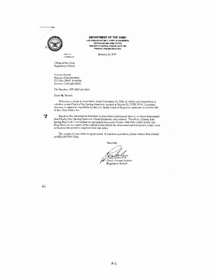
A-1


APPENDIX B
Letter from the Navajo Nation, Department of Fish and Wildlife

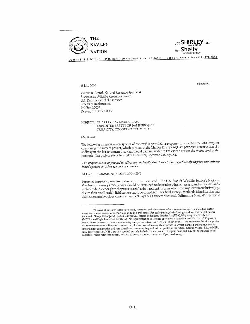
B-1
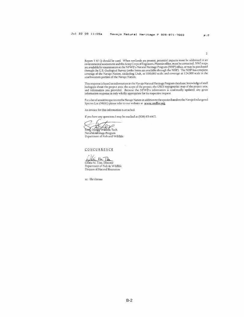
B-2

APPENDIX C
Field Exploration Request

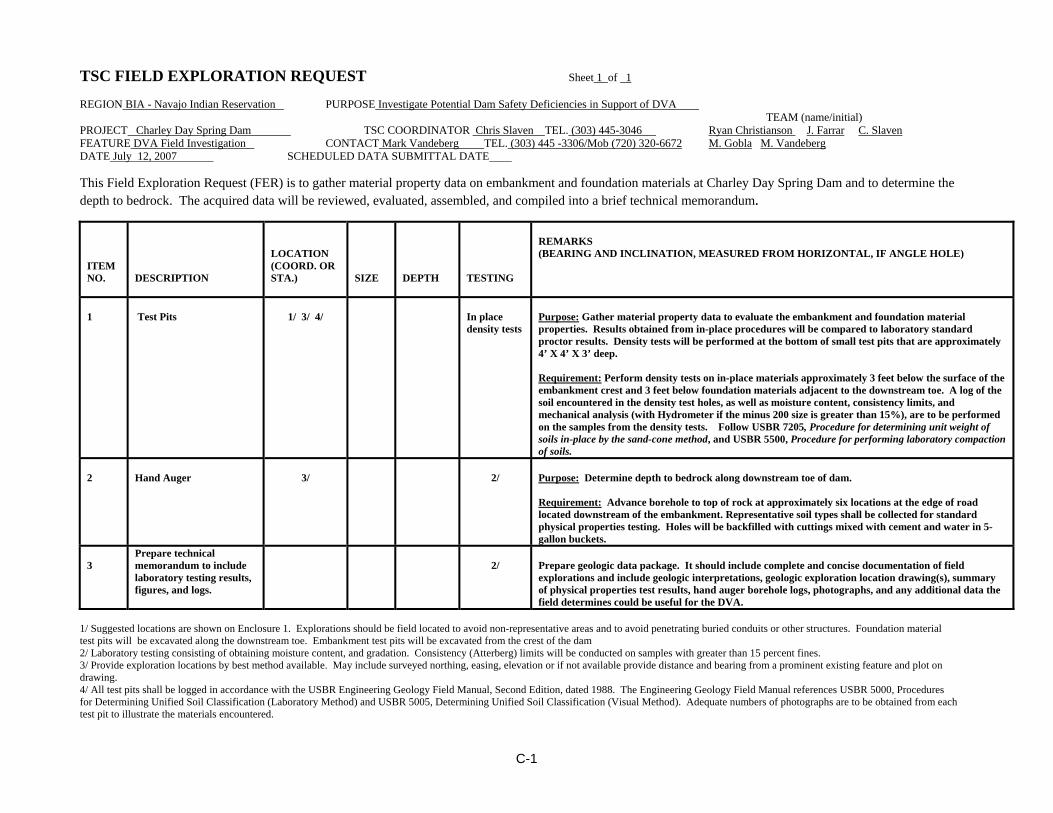
C-1
TSC FIELD EXPLORATION REQUEST Sheet 1 of 1 REGION BIA - Navajo Indian Reservation PURPOSE Investigate Potential Dam Safety Deficiencies in Support of DVA TEAM (name/initial) PROJECT Charley Day Spring Dam TSC COORDINATOR Chris Slaven TEL. (303) 445-3046 Ryan Christianson J. Farrar C. Slaven FEATURE DVA Field Investigation CONTACT Mark Vandeberg TEL. (303) 445 -3306/Mob (720) 320-6672 M. Gobla M. Vandeberg DATE July 12, 2007 SCHEDULED DATA SUBMITTAL DATE This Field Exploration Request (FER) is to gather material property data on embankment and foundation materials at Charley Day Spring Dam and to determine the depth to bedrock. The acquired data will be reviewed, evaluated, assembled, and compiled into a brief technical memorandum.
ITEM NO.
DESCRIPTION
LOCATION (COORD. OR STA.)
SIZE
DEPTH
TESTING
REMARKS (BEARING AND INCLINATION, MEASURED FROM HORIZONTAL, IF ANGLE HOLE)
1
Test Pits
1/ 3/ 4/
In place density tests
Purpose: Gather material property data to evaluate the embankment and foundation material properties. Results obtained from in-place procedures will be compared to laboratory standard proctor results. Density tests will be performed at the bottom of small test pits that are approximately 4’ X 4’ X 3’ deep. Requirement: Perform density tests on in-place materials approximately 3 feet below the surface of the embankment crest and 3 feet below foundation materials adjacent to the downstream toe. A log of the soil encountered in the density test holes, as well as moisture content, consistency limits, and mechanical analysis (with Hydrometer if the minus 200 size is greater than 15%), are to be performed on the samples from the density tests. Follow USBR 7205, Procedure for determining unit weight of soils in-place by the sand-cone method, and USBR 5500, Procedure for performing laboratory compaction of soils.
2
Hand Auger
3/
2/
Purpose: Determine depth to bedrock along downstream toe of dam. Requirement: Advance borehole to top of rock at approximately six locations at the edge of road located downstream of the embankment. Representative soil types shall be collected for standard physical properties testing. Holes will be backfilled with cuttings mixed with cement and water in 5-gallon buckets.
3
Prepare technical memorandum to include laboratory testing results, figures, and logs.
2/
Prepare geologic data package. It should include complete and concise documentation of field explorations and include geologic interpretations, geologic exploration location drawing(s), summary of physical properties test results, hand auger borehole logs, photographs, and any additional data the field determines could be useful for the DVA.
1/ Suggested locations are shown on Enclosure 1. Explorations should be field located to avoid non-representative areas and to avoid penetrating buried conduits or other structures. Foundation material test pits will be excavated along the downstream toe. Embankment test pits will be excavated from the crest of the dam 2/ Laboratory testing consisting of obtaining moisture content, and gradation. Consistency (Atterberg) limits will be conducted on samples with greater than 15 percent fines. 3/ Provide exploration locations by best method available. May include surveyed northing, easing, elevation or if not available provide distance and bearing from a prominent existing feature and plot on drawing. 4/ All test pits shall be logged in accordance with the USBR Engineering Geology Field Manual, Second Edition, dated 1988. The Engineering Geology Field Manual references USBR 5000, Procedures for Determining Unified Soil Classification (Laboratory Method) and USBR 5005, Determining Unified Soil Classification (Visual Method). Adequate numbers of photographs are to be obtained from each test pit to illustrate the materials encountered.


APPENDIX D
Concurrence from Navajo Nation Historic Preservation Department

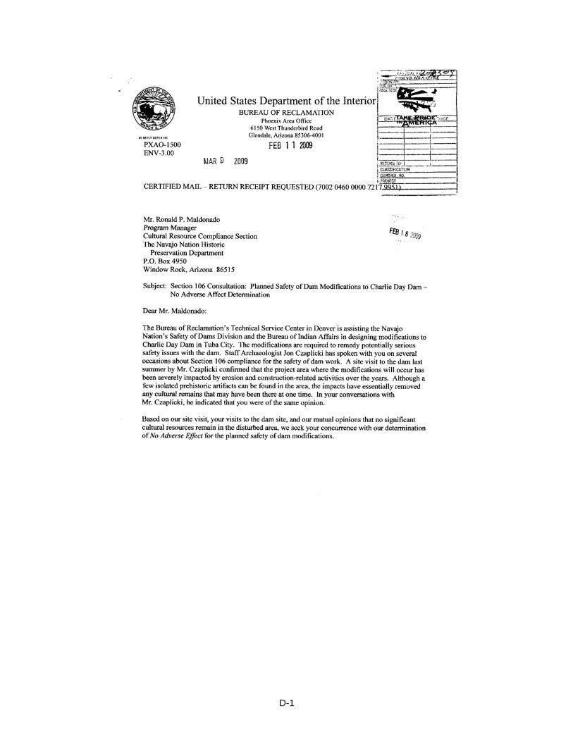
D-1
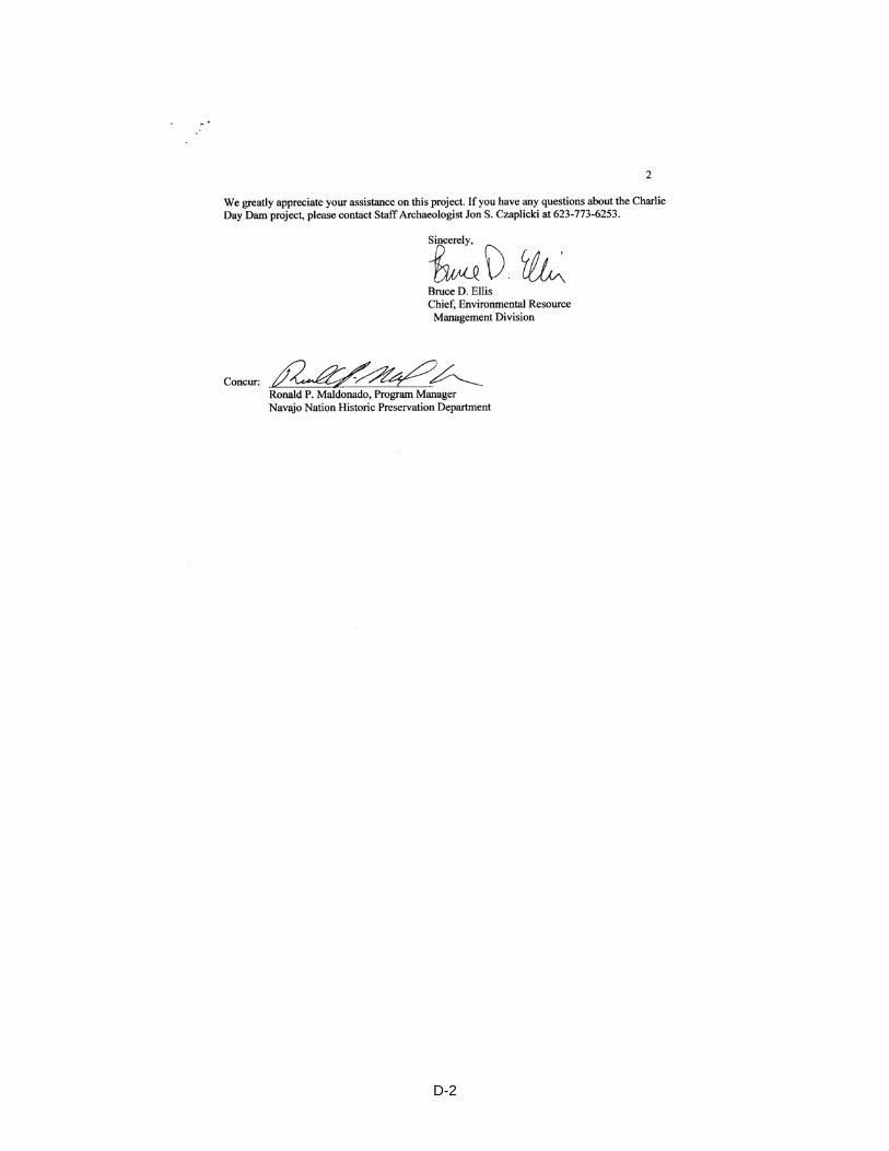
D-2