Embed Size (px)
Citation preview
CHARACTERIZATION OF THREE DAKOTA SKIPPER SITES IN MINNESOTA
Prepared for the U.S. Fish and Wildlife Service
by Robert Dana, Ph.D.
Minnesota Department of Natural Resources Natural Heritage and Nongame Research Program
St. Paul, MN
22 December 1997
1997, Minnesota Department of Natural Resources
Page 1
Abstract
A meeting to develop a prelisting recovery strategy for the Dakota skipper (Hesperia dacotae) was held June 29-30, 1995, at Fort Snelling, Minnesota. During this meeting, Hole-in-the-Mountain Prairie, Prairie Coteau Scientific and Natural Area Valley, and Felton Prairie were identified as sites having the highest probability of supporting viable populations of the species within Minnesota, and thus the most important for the long-term security of the species in the state. It was agreed that a priority action for prelisting recovery would be the characterization of these and other likely viable sites within the species’ range. This report characterizes each of the three priority Dakota skipper sites in terms of landform and topography, soils, vegetation, and land use. Further, the report characterizes the Dakota skipper populations at each site in terms of history of information, distribution within the site, habitat preferences, population size and dynamics, threats, and a prognosis for each site. A map of each site is also provided, indicating the extent of managed areas and the approximate limit of actual or potential Dakota skipper habitat within each site.
Hole-in-the-Mountain Prairie Lincoln County, Minnesota
South of the town of Lake Benton SITE DESCRIPTION Landform and Topography Hole-in-the-Mountain Prairie is within the Bemis moraine, which forms the crest of the Coteau des Prairies, a regional highland feature in southwestern Minnesota and northeastern South Dakota. This massive ridge, deposited by the Des Moines lobe, marks the limit of Wisconsinan glaciation in southwest Minnesota. The site comprises much of a local area of very sharp relief associated with a large valley 1-1.5 km wide and 40-50 m deep formed when glacial meltwater breached the moraine. The valley depth gradually decreases southward as the morainic deposit thins. Lake Benton lies in the old valley bottom on the inner side of the Bemis moraine. The sides of the valley have been deeply dissected by dendritic growth of tributary ravines, creating a band of broken topography about 3 km wide and more than 10 km long. Slopes on either side of the 0.5-km wide valley floor are complex and typically short and steep (25-40 per cent). The surrounding landscape is undulating to gently rolling.
Page 2 Soils Soils of the slopes of Hole-in-the-Mountain Prairie are excessively drained, calcareous loams formed in Des Moines lobe till. The parent loam and clay loam till is very stony, and the surface is strewn with stones ranging in size up to large boulders. A thin mantle of loess is present on the level uplands, especially southwards, but very little of this escaped conversion to cropland. Poorly drained and very poorly drained silty clay loams occupy the valley floor (Soil Conservation Service Staff 1970). Vegetation Dry and dry-mesic prairie occupies most of the slopes within Hole-in-the-Mountain Prairie, although bur oak-basswood-green ash woodland and forest are present in a number of ravines at the north end of the valley. Much of the valley bottom has been cultivated at some time, but there are remnant areas of wet prairie, wet meadow, and shallow marsh. Since settlement of the area more than a century ago all of the upland prairie has been used to pasture domestic livestock, both cattle and sheep, though probably mostly the former. Grazing has recently been discontinued on a number of tracts within the site, the earliest one about two decades ago, and periodic prescribed burning instituted. As only the upland prairie provides habitat for the Dakota skipper, no further details are provided here for the woodland and wetland vegetation. Where least degraded by overgrazing, the prairie is dominated by the mid-height grasses little bluestem (Schizachyrium scoparium), side-oats grama (Bouteloua curtipendula), prairie dropseed (Sporobolus heterolepis), and porcupine grass (Stipa spartea). The tallgrass big bluestem (Andropogon gerardii) is also common but generally of low stature in the drier habitat. Important secondary grasses and sedges, mostly low-height forms, include prairie junegrass (Koeleria macrantha), Wilcox’s panic grass (Panicum wilcoxianum), plains muhly (Muhlenbergia cuspidata), slender wheatgrass (Agropyron trachycaulum), and sun sedge (Carex heliophila). Needle-and-thread grass (Stipa comata) and blue grama (Bouteloua gracilis) are common on the driest exposures. Forb species richness and abundance are high; among the more common species are pasque flower (Pulsatilla nuttalliana), blue-eyed grass (Sisyrinchium campestre), hoary puccoon (Lithospermum canescens), purple prairie clover (Petalostemon purpureum), standing milk vetch (Astragalus adsurgens), prairie ragwort (Senecio plattensis), sneezewort aster (Solidago ptarmicoides), purple coneflower (Echinacea angustifolia), goldenrods (Solidago spp.), especially gray (S. nemoralis), stiff (S. rigida), and Missouri (S. missouriensis), dotted blazing star (Liatris punctata), rough blazing star (Liatris aspera), and asters (Aster spp.). Leadplant (Amorpha canescens) and prairie rose (Rosa arkansana) are common low shrubs. Lower slopes and other more mesic sites support taller stature prairie dominated by big bluestem, indian grass (Sorghastrum nutans), side-oats grama, and porcupine grass. The forbs white camas (Zigadenus elegans) and wood lily (Lilium philadelphicum) are more common here than in the drier prairie. Wolfberry (Symphoricarpos occidentalis) is the most common low shrub. Foliage canopy height is generally 25-40 cm, but up to 60 cm in mesic areas.
Page 3 Where the prairie is more damaged by overgrazing the exotics Kentucky bluegrass (Poa pratensis) and Canada bluegrass (P. compressa) are major to dominant species, often along with smooth brome (Bromus inermis) and quack grass (Agropyron repens). Native forb species richness and diversity decline, with goldenrods becoming the major species. Exotic thistles, notably musk and plumeless thistle (Carduus nutans and C. acanthoides) can be common. Wolfberry may dominate more mesic habitat. Where herbicides have been used for weed or brush control, the native forb component may be very poor. Foliage height is often less than 10 cm in heavily grazed pastures. Land Use A sizeable fraction of the upland prairie within Hole-in-the-Mountain Prairie is protected as a natural area preserve by The Nature Conservancy and managed for the prairie natural community with prescribed burning. This includes most of the least degraded prairie here. Another significant fraction is owned by the Minnesota Department of Natural Resources and managed as wildlife habitat with prescribed burning. The prairie within the Wildlife Management Areas has generally been more degraded by overgrazing. There is a small amount of prairie within Hole-in-the-Mountain County Park but this has not been managed for prairie values. Most of the park is wooded. The remainder of prairie within the site (probably about half on an areal basis) is privately owned and most is used as livestock pasture on a regular basis, although a couple of tracts have been idle for a number of years. DAKOTA SKIPPER POPULATION History of Information The presence of the Dakota skipper at Hole-in-the-Mountain Prairie has been known since at least 1967 (R. Huber, personal communication). Observations have been repeated at frequent intervals, continuing up to the present. In the years 1978-1983 Robert Dana conducted an intensive study of the species within a tract owned by The Nature Conservancy, including daily mark-recapture sampling during the entire adult flight period 1979-1981 (Dana 1991). Most of the observations of the species have been from this same tract, but Dana conducted some sampling elsewhere in the site during the years of his research. In 1995 and 1996 Dennis Schlicht made counts along marked transects established within the original TNC preserve as well as in prairie subsequently added to it as part of a project to test monitoring protocols (Schlicht 1997). Also in 1996 James Reiser independently spent several hours over two days conducting counts of the species along his own informal transects in the same areas (Reiser 1997).
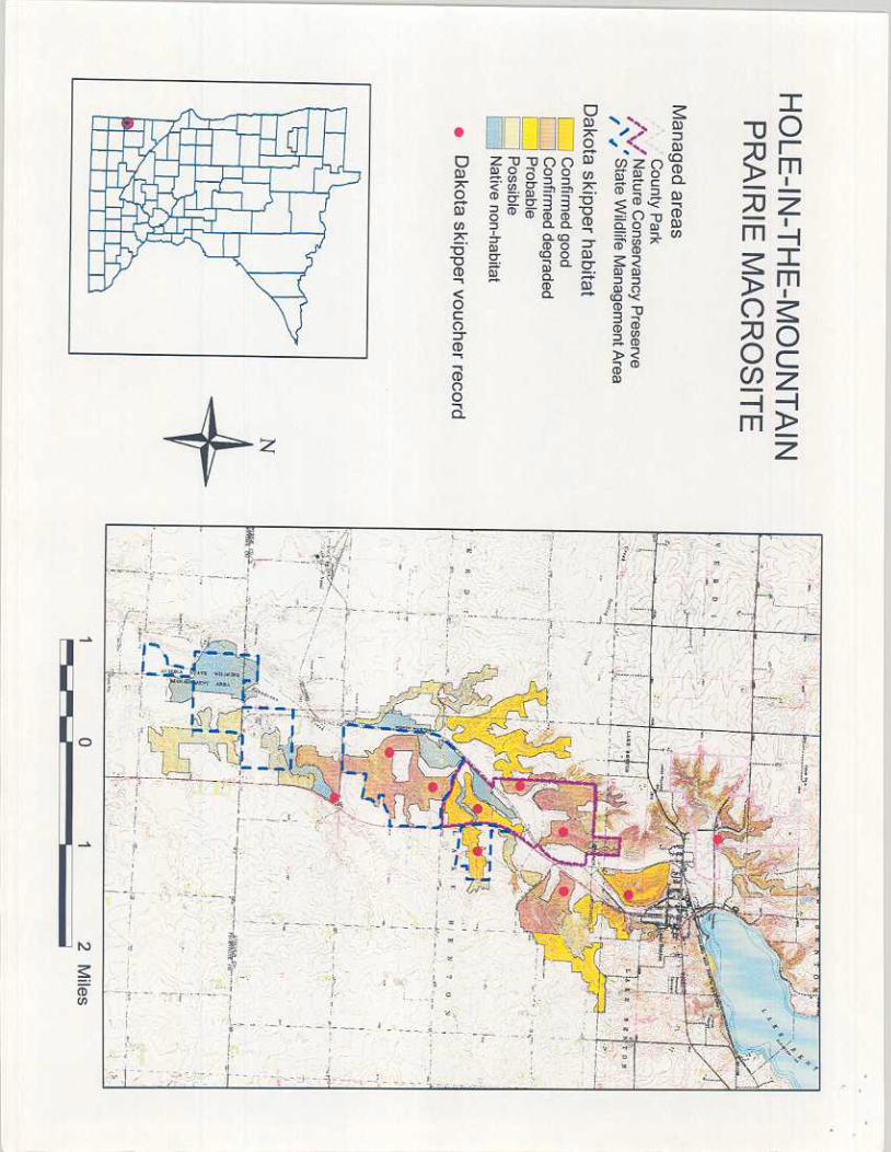
Page 4 Distribution within Site During his work in Hole-in-the-Mountain Prairie, Dana found the Dakota skipper to be common throughout the hill prairie habitat in the SE 1/4 Sec. 19, and less common along the ravine east of this in Sec. 20 (Dana 1991). It was also widespread on the prairie slopes in Sec. 30, but uncommon. This area was being heavily grazed at that time. He also found the skipper present but uncommon in pastured prairie in the SE 1/4 Sec. 17, the W1/2 NE 1/4 Sec. 19, and the W1/2 SW1/4 Sec. 17 and E1/2 SE 1/4 Sec. 18. It was similarly uncommon in ungrazed hill prairie in the NE1/4 Sec. 17 west of Highway 75 continuing up into the south part of Sec. 8 just south of the town of Lake Benton. Dana found the skipper to be very rare in the NE1/4 Sec. 7 (Dana field notes; these observations are summarized by data in the Natural Heritage Information System rare features database). In 1995 and 1996 Schlicht found the skipper present but scarce in the SE1/4 Sec. 18, now TNC preserve and no longer grazed, and fairly common in the original preserve in the SE1/4 Sec. 19 (Schlicht 1997). Reiser, however, reported similar densities for both areas in 1996 (Reiser 1997). This evidence indicates that the Dakota skipper is widespread in the site and may well occur throughout. A large unexplored area with at least the potential for the skipper is in the W1/2 Sec. 19 and the adjoining E1/2 Sec. 24 of the next township west, continuing south into the E1/2 Sec. 25. A second, mostly unexplored area is in Secs. 5, 6, and N1/2 Sec. 8. There are early records of the species from the NE1/4 Sec 31, but otherwise there has been no investigation of potential habitat south of County Highway 9. Significant uninvestigated habitat continues for at least two miles south of this, based on airphoto interpretation. Habitat Preferences Dry-mesic prairie dominated by midheight grasses seems clearly to be the preferred habitat of the species. Adult activities are concentrated in this habitat, and Dana reported fairly strong observational evidence that this is the preferred habitat for oviposition and thus larval development as well. Adult nectar sources are crucial, and this type of prairie contains an abundance of good ones, notably narrow-leaved purple coneflower and stiff milkvetch. Livestock grazing reduces skipper numbers in direct proportion to intensity. This may be due mostly to the reduction in flower availability, but the change in vegetation structure may also influence adult behavior. Nothing is known about the effects of grazing on larval survival. Where long-term overgrazing has altered species composition, replacing natives with introduced cool-season species such as bluegrasses and smooth brome and greatly reducing floral diversity, even release from grazing pressure does not restore acceptable habitat.
Page 5 Population Size and Dynamics Dana derived total adult generation size estimates from two of the three years of mark-recapture sampling of approximately 2000-3000 insects for the preserve in the SE1/4 Sec. 19. Unfortunately, no standard error estimate is possible. Capture rates at the peak of adult numbers during each year’s flight were 8-12 insects per hour. Densities appeared to be similar in other years as well. In the other parts of the site that were investigated during this period, densities appeared to be much lower. Schlicht reported peak counts along transects in the original preserve tract in Sec. 19 of 18 per hour in 1995, but only about 5 per hour in 1996. His counts along the transect in Sec. 18 were only 2 per hour in 1995 and 0 in 1996. Reiser reported one-time 1996 counts along his transect in the original preserve of approximately 5 per hour (done on the same day as Schlicht’s) and 2 per hour in the Sec. 18 addition two days later. Although Dana did not observe significant year-to-year variations in abundance during his 5 years of observation, the ‘95-’96 data suggest that substantial variation may occur. More research on this is needed. It is probably safe to infer that at least in good years the site supports the production of a few thousand adults each year. No long-term decline since Dana’s work is indicated. The insects here probably constitute a single population, although there may be a weak deme structure based on topography and land use. Dana documented reduced rates of movement across a small valley within the site compared with movements through uninterrupted habitat. Thus rates of exchange across the main valley may be rather low. Roads and crop fields may impede movements up and down either side of the valley. Threats The principal threat at Hole-in-the-Mountain Prairie is probably the use of herbicides for weed and brush control in privately owned pastures. Further degradation caused directly by overgrazing remains a threat also. As long as these tracts are heavily grazed they will support only low densities of skippers. In the past County Park staff were mowing some of the prairie in that unit during the skipper’s flight period, which deprives it of nectar sources and favors exotic bluegrass. Spruce were also planted in the prairie along one of the boundary lines. Green ash (Fraxinus pennsylvanica) and box elder (Acer negundo) are naturally invading some areas in the park. This is also a threat in some ungrazed privately owned prairie close to the town and could become a larger problem if more pastures are left idle and no burning instituted. Excavation for construction material is a possible threat, although its magnitude is unknown. Similarly unknown is the amount of habitat damage or destruction that will result from the construction of the planned wind-power facilities around the site. Conversion of additional prairie to cropland is at most a minor threat at present. Prescribed burning may pose a threat if burn units and rotations are poorly designed. An important unknown is whether complete absence of grazing may eventually lead to habitat changes unfavorable to the skipper.
Page 6 Prognosis Between the natural area preserve and the state wildlife management areas, enough prime habitat is protected to provide considerable security to the Dakota skipper at Hole-in-the-Mountain Prairie. This cannot be quantified, however. Additional acquisition and management would be advisable to make long-term viability a certainty. In particular, prairie in the SE 1/4 of Sec. 17 and the N ½ of the NE 1/4 of Sec. 20, and in the W ½ of Sec. 19 should be priorities. The massive knob immediately south of town in Sec. 8 and Sec. 17 is also excellent habitat, although the proximity of houses will create management problems. A possible alternative to acquisition would be easements that conveyed some power to regulate grazing intensity and weed management practices. If the state wildlife management areas are to contribute to the viability of the skipper, management needs to be consistent with this objective. In particular, the use of fire has to be carefully planned to minimize risk of eliminating the insect from these tracts. Managers may need some education to assure this.
Page 8
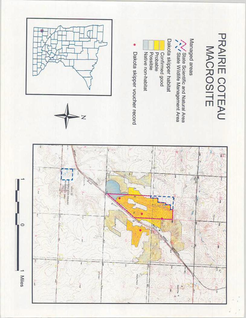
Prairie Coteau Scientific and Natural Area Valley Pipestone County, Minnesota
Between the towns of Holland and Ruthton SITE DESCRIPTION Landforms and Topography Prairie Coteau Scientific and Natural Area Valley is also on the Bemis moraine, about 17 km southeast of Hole-in-the-Mountain. It consists of a similar, though a bit smaller, valley feature in the outer half of the moraine. Total relief is again in the 40-50 m range, with 25-40 per cent slopes predominating. This area of broken topography is about 1 km wide and about 5 km long. Soils Soils at Prairie Coteau Scientific and Natural Area Valley are similar to those at Hole-in-the-Mountain, although there is some gravelly loamy coarse sand formed in glacial outwash in addition to the finer textured loams formed in till (Soil Conservation Service Staff 1976). Vegetation Dry and dry-mesic prairie similar to that at Hole-in-the-Mountain occurs on the steeper slopes of Prairie Coteau Scientific and Natural Area Valley. There is perhaps more tallgrass mesic prairie on gentler footslopes here than at the former site. As at Hole-in-the-Mountain, all of this site has been grazed by domestic livestock beginning with settlement more than a century ago. The species composition of the prairie here similarly reflects the different grazing histories of the various tracts within the site. Grazing has been discontinued on several tracts as these have been acquired by the State Scientific and Natural Area Program, the earliest in 1986, and periodic prescribed burning begun. Nearly all of the undulating upland above the slopes has been cultivated, including some of the wider ridge tops within the site, as has some of the mesic footslope zone. Where no longer cultivated these old fields are dominated by exotic grasses, notably Kentucky and Canada bluegrasses, quack grass, and smooth brome, although some of these areas have recently been planted with native prairie species. Wet prairie and sedge meadow occupy the valley bottom towards the south end of the site, but the highway and railroad that follow the valley have destroyed most of this in the narrower upper valley. There are no wooded areas in this site. Land Use A significant fraction of Prairie Coteau Scientific and Natural Area Valley is a State Scientific and Natural Area, including much of the least degraded prairie. There are two small Wildlife Management Areas owned by the Minnesota DNR, only one of which includes any prairie. All of the rest is private land, most of which is regularly pastured.
Page 9 DAKOTA SKIPPER POPULATION History of Information The Dakota skipper was first documented at Prairie Coteau Scientific and Natural Area Valley in 1978 (R. Huber, personal communication), with observations continuing at irregular intervals thereafter. In 1988 and 1989 Gerald Selby conducted an intensive, season-long study of several prairie butterflies including this species within the Prairie Coteau Scientific and Natural Area (Glenn-Lewin and Selby 1989). No mark-recapture sampling was conducted, but counts along marked transects were repeated at frequent intervals throughout the flight period. In 1995 and 1996 Schlicht counted Dakota skippers along Selby’s transects on three dates during the flight period each year (Schlicht 1997). Distribution within Site All observations of the Dakota skipper at Prairie Coteau Scientific and Natural Area Valley have been within the Scientific and Natural Area in the east half of Sec. 32 and the southeast quarter of Sec. 29 except for 1978 observations by Dana (field notes, but data in the NHIS rare features database) in the northwest quarter of Sec. 33 (ungrazed at the time). Adults have been found throughout the Scientific and Natural Area except the old fields and valley bottom areas. The butterfly probably occurs widely elsewhere in the site, although there have been no investigations since 1978 to confirm this. Most of the habitat outside the SNA is pastured and densities are probably low. The most promising areas are in Sections 28 and 33, with some possible habitat in the northeast quarter Sec. 29 and the southwest quarter Sec. 30, as well as in Sections 5 and 6 of the township below. Habitat Preferences Adults are most frequently found in the same type of habitat at Prairie Coteau Scientific and Natural Area Valley as at Hole-in-the-Mountain, namely, dry and dry-mesic prairie on slopes. Selby’s data from a fairly dense grid of transects demonstrate this very clearly. Population Size and Dynamics No attempt to determine population size has ever been undertaken at Prairie Coteau Scientific and Natural Area Valley . Both Selby and Schlicht generated indices of abundance, but differences in the way data were recorded make comparisons difficult. Schlicht reported very low counts for 1995 (3 adults during nearly 4 hours of sampling on the peak date), and slightly higher but still low counts for 1996 (14 adults in a little more than 4 hours on the peak date). Selby reported much higher peak numbers in both 1988 and 1989, but he did not report actual sampling times. For example, he recorded a high of 26 adults in one sampling unit in 1988; if the time spent sampling was about 2 hours (Selby, personal communication) this gives a rate of 13 per hour. The maximum rate in this same unit was also about 13 per hour in 1989. Selby netted most individuals to verify identification, and presumably his rate would have been higher had he simply counted on sight.

Page 10 At least during Selby’s work at this site Dakota skipper densities appear to have been comparable to those observed by Dana at the TNC preserve within the Hole-in-the-Mountain site. Because the Prairie Coteau site is smaller than Hole-in-the-Mountain, the total population here was probably smaller than at the latter site, but it still may have exceeded a thousand adults. Schlicht’s results suggest smaller numbers in 1995 and 1996, but it is impossible to determine whether this represents a temporary depression or a long-term trend. As at the Hole-in-the-Mountain site, the skippers here probably constitute a single population, although again there may be a weak deme structure. In particular, the highway-railroad corridor along the bottom of the valley may form a fairly strong impediment to movement from one side to the other. Threats The threats at Prairie Coteau Scientific and Natural Area Valley are largely the same as at Hole-in-the-Mountain. A greater proportion of potential habitat is still private and being pastured than at the former site. Prognosis The current SNA boundary does not encompass enough habitat to provide long-term security for the skipper at Prairie Coteau Scientific and Natural Area Valley . The total area is not large, but more important, there is not a sufficient natural fire break within the SNA to prevent accidental burning of the entire unit. At present this would not be catastrophic because the skipper occupies some habitat outside the SNA and will recolonize it. But there is no assurance that this situation will persist indefinitely. The highest priority is to protect additional prairie in Sec. 33 on the east side of the valley. Slightly lower priority targets would be the northwest corner of Sec. 33 on the west side of the valley, the SW 1/4 Sec. 28, and the SE 1/4 Sec. 31. Other areas that should be protected are the SW 1/4 Sec. 31, the S ½ of the N ½ Sec. 28, and the S ½ of the S ½ Sec. 28 on the east side of the valley.
Page 12
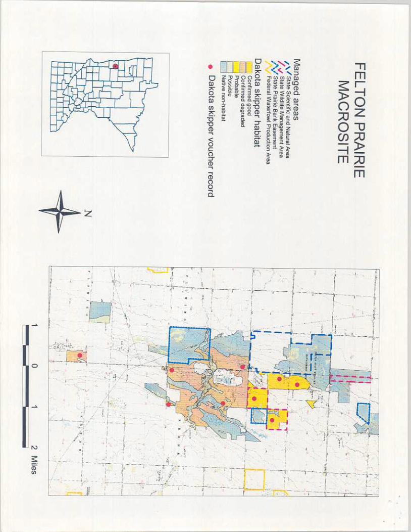
Felton Prairie Clay County, Minnesota
Seven kilometers southeast of the town of Felton SITE DESCRIPTION Landform and Topography Felton Prairie is within the interbeach zone of the Agassiz Lacustrine Plain, rising stepwise from the lake plain margin through a series of ancient shorelines. The highest of these, on the east side of the site, is about 50 m higher than the lake plain on the west side, a distance of about 4 km. There are three major shorelines within the site. From north to south the site is approximately 8 km. Overall, the landscape is gently undulating, with a sharper break at one of the shorelines, a wave cut scarp 6-7 m high. A small creek drains across the site in a narrow, trench-like valley incised as much as 9 m below the surrounding surface. A couple of other smaller, intermittent streams provide similar, though less pronounced, local relief. Soils Along the western side of Felton Prairie below the lowest shoreline, very poorly drained and poorly drained soils formed in loamy to sandy lacustrine sediment predominate. East of this, well drained to excessively drained loamy sands, sands, and sandy loams formed in shoreline deposits are the major soils; on the beach ridges these are coarse-textured and very gravelly. Poorly drained loams occur in low places between beach ridges. Most of these soils can be characterized as calcareous. There are several large areas of very wet organic soils over zones of groundwater discharge associated with the lowest shorelines (Soil Conservation Service Staff 1982). Vegetation Dry and dry-mesic prairie covers a high proportion of Felton Prairie above the lowest shoreline; these with mesic prairie strongly predominate in this part of the site. Wet prairie and meadow are major types on the west side of the site, with calcareous seepage fen, shrub swamp, and marsh in the groundwater discharge areas. Probably all of this site has been used as pasture for domestic livestock, including sheep, at some time since settlement (Braker 1985). A large proportion continues to be grazed, but there are several significant tracts that have not been grazed for decades. As only the drier prairie is habitat for the Dakota skipper, more detailed description is limited to it.
Page 13 The dry-mesic prairie is physiognomically and compositionally very similar to that at the previous sites. The least degraded examples are dominated by mid-height grasses and sedges. These include little bluestem, prairie dropseed, porcupine grass, prairie junegrass, side-oats grama, and sun sedge. There is a rich forb component; some commoner ones are pasque flower, heart-leaf alexanders (Zizia aptera), hoary puccoon, white camas, northern bedstraw (Galium boreale), buffalo bean (Astragalus crassicarpus), purple prairie clover, white prairie clover (P. candidum), stiff milk vetch, prairie ragwort, purple coneflower, dotted and rough blazing stars, missouri, gray, and stiff goldenrods, and silky aster (Aster sericeus). Leadplant is a common low shrub. In the gravelly dry prairie on beach-ridge crests and shoreline scarps blue grama and needle-and-thread grass are major constituents, along with the grasses of dry-mesic prairie. Also common and distinctive are plains muhly grass, sand reed grass (Calamovilfa longifolia), and thread-leaf sedge (Carex filifolia). Most of the forb species of dry-mesic prairie are also present here, along with several distinctive additions, including field chickweed (Cerastium arvense), narrow-leaved puccoon (Lithospermum incisum), fringed sagewort (Artemisia frigida), green sagewort (Artemisia dracunculus),and blanket flower (Gaillardia aristata). In mesic prairie the tallgrass species big bluestem and Indian grass become increasingly important, and wolfberry is patchily common. Kentucky and Canada bluegrasses are the only significant exotics, and although common they remain a subordinate component. The short grasses, especially blue grama and the exotic bluegrasses are more important, and forb diversity is reduced in moderately heavily grazed examples of dry and dry-mesic prairie. Mesic prairie in actively pastured tracts is generally quite degraded, with exotics such as Kentucky bluegrass, quackgrass, and clovers (Trifolium spp.) often dominant. Old-field areas are mostly bluegrasses, quack grass, and smooth brome, with goldenrods, especially Canada goldenrod (Solidago canadensis), and heath aster (Aster ericoides) the most common forbs. Land Use One 65-ha tract of Felton Prairie containing about 50 ha of good upland prairie is owned by The Nature Conservancy and dedicated as a State SNA. Another tract of the same size is owned by Clay County and dedicated as an SNA under a 10-year lease to the state. These tracts are managed with prescribed burning. The county owns another large tract that includes ca. 100 ha of good upland prairie; this is partly mowed for hay in late summer. There is a large, active gravel pit situated in this tract in what was originally upland prairie. These three tracts comprise all of the good quality upland prairie in the site. The large state Wildlife Management Area on the west side of the site includes no good upland prairie. All of the remaining upland prairie in the site is within a large property managed as a cattle ranch. This is all subject to moderately heavy grazing and somewhat degraded. A large, active gravel pit and a smaller, abandoned one lie in the middle of the upland prairie within the ranch. The SNA program owns a Prairie Bank easement on ca. 200 ha of wet prairie and seepage fen within the ranch.
Page 14 DAKOTA SKIPPER POPULATION History of Information The skipper was first documented at Felton Prairie in 1965 (R. Huber, personal communication). Observations have continued at frequent intervals in the years since. In 1985 Nancy Braker conducted a season-long survey of the butterflies throughout the upland portions of the site (Braker 1985). Dennis Schlicht conducted transect counts at this site as at the other two in 1995 and 1996 (Schlicht 1997). Distribution within Site Braker found the skipper to be nearly ubiquitous in the ungrazed upland prairie north of the ranch at Felton Prairie, although adults tended to be most dense on shoreline slopes. She found it very scarce but widely distributed within the ranch on upland sites. Schlicht placed a transect in each of the ungrazed tracts north of the ranch and one within the ranch, and observed the skipper on all. Consistently with Braker’s observations, he reported a much lower density along the ranch transect than along the others. Habitat Preferences Dry-mesic and dry prairie is clearly the preferred habitat at Felton Prairie. The very low densities of adults in the grazed prairie strongly suggest that moderately heavy grazing produces unfavorable conditions for the skipper. As already noted, Braker found densities in the ungrazed prairie to be greatest in association with local topographic relief produced by beach ridges or other shoreline features. She also found densities to be lower in a tract that had not been hayed or burned for a number of years than in the tracts where these activities had recently occurred. The heavy thatch accumulation and the low production of flowers in the undisturbed tract are both possible factors in the reduced attractiveness of this prairie. Population Size and Dynamics No population estimation has ever been attempted at Felton Prairie. Braker mapped her observations but combined all days on one map. No peak rate of encounter can be derived from her report. It is clear, however, that she found the species to be common in the burned and mowed prairie, and even moderately so in the undisturbed. Schlicht reported an average encounter rate of 11 per hour in the ungrazed tracts at the peak in 1995, but only 2 per hour along the ranch transect. In 1996 he recorded an average of 42 skippers per hour in the ungrazed prairie on the peak day, and about 10 per hour in the ranch. These numbers indicate a very strong population in 1996, and a good one in 1995. The also reinforce the evidence from his counts at the other sites that populations can experience significant size fluctuations. There is no evidence of a long-term trend. It seems clear that the insects here all belong to a single population.
Page 15 Threats The principal threat to the prairie and the Dakota skipper at Felton Prairie is gravel mining. The county pit has been expanding a few acres per year for a number of years, gradually reducing prime-quality habitat. The pit on the ranch also continues to expand. There is a large pit on state land on the east side of the county land and another, smaller one on private land, also on the east side of the county land. It is reasonable to infer that exploitable aggregate deposits underlie most of the upland prairie within the site. The demand from the Fargo-Moorhead area for aggregate will increase, putting additional pressure on the site. Activities associated with the gravel mining have negatively affected neighboring prairie; for example, a haul road was recently constructed across excellent prairie on the county land, and a small amount of prairie on the SNA leased from the county was destroyed accidentally by the pit on private land just north of this. If grazing intensity were to increase the habitat on the ranch would become even less productive, although there seems to be no immediate threat of this happening. Reduction in grazing pressure would presumably result in an increase in the total skipper population in the site, as much of the drier prairie would recover favorable qualities rather quickly. As at the other sites, injudicious use of prescribed burning (burning too much or too frequently to allow for recovery between burns), poses a threat, but the size and quality of the site provide considerable buffer against this. Prognosis The Dakota skipper population at Felton Prairie is not secure. The only fully protected tract is the quarter section (65 ha) owned by TNC. The protection of the other quarter section presently dedicated as a Scientific and Natural Area is at the sufferance of the county; there is no formal long-term commitment to preserving the prairie on this tract. But even assuming the county’s continuing agreement to the lease arrangement with the SNA program, it is not possible to feel confident about the security of the skipper population. The TNC tract is not prime habitat (more mesic and wet-mesic prairie than dry-mesic) and an accidental burn of the whole tract is an easy possibility. The same is true for the other SNA quarter section, and although these two units are not contiguous along any boundary they do have a common corner, and fire could from spread from one to the other across hayland that adjoins them both. As long as the prairie on the rest of the county land remains intact this scenario does not threaten catastrophe, but there is no assurance of this. As already mentioned, the county extracts gravel from this property, destroying several acres of prairie each year. The ranch should not be counted on to provide a reliable buffer against extirpation from the currently protected prairie. Under present land use this property may be a population sink for the skipper rather than a source. In any event, the rarity of the skipper here will make recolonization of the other tracts a slow process. The highest priority here should be to secure permanent protection for all remaining county-owned prairie, both the completely unprotected tract as well at the unit leased to SNA. Developing arrangements with the ranch owner to reduce grazing intensity there should be a second priority. Determination of the probable extent of future gravel mining in the ranch should be attempted, and if necessary, some means of limiting the amount of habitat destruction should be sought.
Page 17
Bibliography Braker, Nancy, compiler. 1985. Felton Prairie. Unpublished report submitted to The Nature
Conservancy and the Minnesota Department of Natural Resources, Natural Heritage Program. 111 pp + appendices.
Dana, Robert P. 1991. Conservation Management of the Prairie Skippers Hesperia dacotae and
Hesperia ottoe: Basic Biology and Threat of Mortality During Prescribed Burning in Spring. Station Bulletin 594-1991. Minnesota Agricultural Experiment Station, University of Minnesota, St. Paul, MN. 63 pp.
Glenn-Lewin, David C., and Gerald Selby. 1989. A Systematic Inventory, Population
Monitoring Program, and Ecological Study of Rare Lepidoptera at the Prairie Coteau Scientific and Natural Area (SNA), Pipestone County, Minnesota. Final Report-December 1989. 49 pp + appendices (unpublished report to the Natural Heritage and Nongame Research Program, Minnesota Dept. of Natural Resources, St. Paul, MN)
Reiser, James M. 1997. A Survey of 19 Nature Conservancy Preserves to Determine Butterfly
Species Composition and the Presence or Absence of Five Target Species: Hesperia dacotae, Hesperia ottoe, Oarisma powesheik, Poanes viator and Speyeria idalia in 1995 and 1996. Final Report-April 1997. (unpublished report to The Nature Conservancy)
Schlicht, Dennis. 1997. Population Monitoring for Prairie Butterflies in Minnesota: Final Report-
March 30, 1997. 25 pp + maps, data sheets. (unpublished report to the Natural Heritage and Nongame Research Program, Minnesota Dept. of Natural Resources, St. Paul, MN).
Soil Conservation Service Staff. 1970. Soil Survey of Lincoln County, Minnesota. U.S. Dept. of
Agriculture Soil Conservation Service and the Minnesota Agricultural Experiment Station. U.S. Government Printing Office, Washington, D.C.
Soil Conservation Service Staff. 1976. Soil Survey of Pipestone County, Minnesota. U.S. Dept.
of Agriculture Soil Conservation Service and the University of Minnesota Agricultural Experiment Station. U.S. Government Printing Office, Washington, D.C.
Soil Conservation Service Staff. 1982. Soil Survey of Clay County, Minnesota. U.S. Dept. of
Agriculture Soil Conservation Service and the Minnesota Agricultural Experiment Station. U.S. Government Printing Office, Washington, D.C.