Embed Size (px)
Citation preview
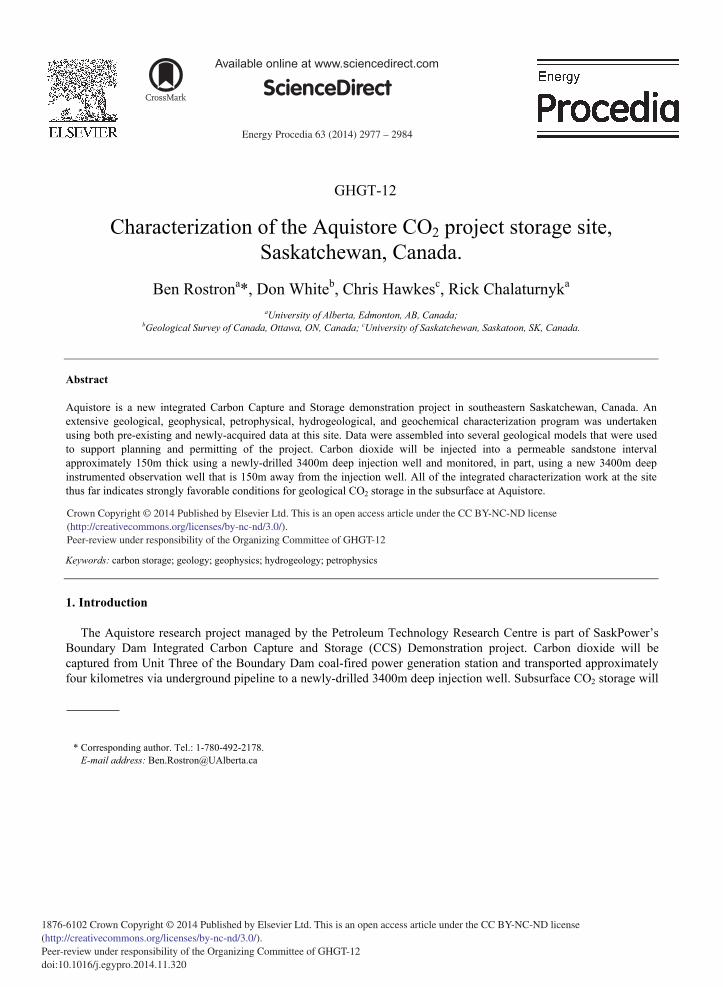
Energy Procedia 63 ( 2014 ) 2977 – 2984
Available online at www.sciencedirect.com
ScienceDirect
1876-6102 Crown Copyright © 2014 Published by Elsevier Ltd. This is an open access article under the CC BY-NC-ND license (http://creativecommons.org/licenses/by-nc-nd/3.0/).Peer-review under responsibility of the Organizing Committee of GHGT-12doi: 10.1016/j.egypro.2014.11.320
GHGT-12
Characterization of the Aquistore CO2 project storage site, Saskatchewan, Canada.
Ben Rostrona*, Don Whiteb, Chris Hawkesc, Rick Chalaturnyka aUniversity of Alberta, Edmonton, AB, Canada;
bGeological Survey of Canada, Ottawa, ON, Canada; cUniversity of Saskatchewan, Saskatoon, SK, Canada.
Abstract
Aquistore is a new integrated Carbon Capture and Storage demonstration project in southeastern Saskatchewan, Canada. An extensive geological, geophysical, petrophysical, hydrogeological, and geochemical characterization program was undertaken using both pre-existing and newly-acquired data at this site. Data were assembled into several geological models that were used to support planning and permitting of the project. Carbon dioxide will be injected into a permeable sandstone interval approximately 150m thick using a newly-drilled 3400m deep injection well and monitored, in part, using a new 3400m deep instrumented observation well that is 150m away from the injection well. All of the integrated characterization work at the site thus far indicates strongly favorable conditions for geological CO2 storage in the subsurface at Aquistore. © 2013 The Authors. Published by Elsevier Ltd. Selection and peer-review under responsibility of GHGT.
Keywords: carbon storage; geology; geophysics; hydrogeology; petrophysics
1. Introduction
The Aquistore research project managed by the Petroleum Technology Research Centre is part of SaskPower’s Boundary Dam Integrated Carbon Capture and Storage (CCS) Demonstration project. Carbon dioxide will be captured from Unit Three of the Boundary Dam coal-fired power generation station and transported approximately four kilometres via underground pipeline to a newly-drilled 3400m deep injection well. Subsurface CO2 storage will
* Corresponding author. Tel.: 1-780-492-2178.
E-mail address: [email protected]
Crown Copyright © 2014 Published by Elsevier Ltd. This is an open access article under the CC BY-NC-ND license (http://creativecommons.org/licenses/by-nc-nd/3.0/).Peer-review under responsibility of the Organizing Committee of GHGT-12
2978 Ben Rostron et al. / Energy Procedia 63 ( 2014 ) 2977 – 2984
be monitored, in part, using an additional new 3400m deep instrumented observation well that is 150m away from the injection well. Aquistore will provide ‘slipstream’ CO2 injection capacity between the commercial scale CO2 capture plant and active EOR operations contracted to use the majority of the captured CO2.
An extensive geological, geophysical, hydrogeological, and geochemical characterization program was
undertaken at this site using both pre-existing and newly-acquired data. Characterization efforts were undertaken prior to, during the drilling of the deep injection and monitoring wells, and afterwards. The perforated injection horizon(s) are within regionally-extensive permeable sandstones approximately 150m thick belonging to the Winnipeg and Deadwood formations. These are situated just above the crystalline Precambrian basement at the base of the Phanerozoic sedimentary section. At the Aquistore site in southeastern Saskatchewan the injection horizons are over 3200m below the surface with numerous thick low-permeability seals above.
Characterization activities were undertaken to determine the geological integrity of the site; to provide
background data for Risk Assessment studies; and for Measurement, Monitoring, and Verification of CO2 storage.
2. Characterization activities
Characterizing the Aquistore injection site and surrounding area was undertaken in broadly three stages: prior to drilling (including site selection); during drilling; and post-drilling the injection and monitoring wells, (including near-surface baseline monitoring). Activities undertaken during each of these stages are summarized below.
2.1. Pre-drill (including site selection)
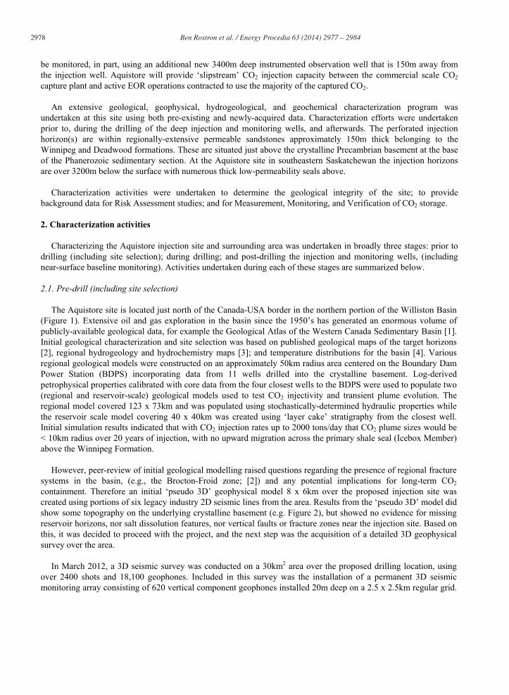
The Aquistore site is located just north of the Canada-USA border in the northern portion of the Williston Basin (Figure 1). Extensive oil and gas exploration in the basin since the 1950’s has generated an enormous volume of publicly-available geological data, for example the Geological Atlas of the Western Canada Sedimentary Basin [1]. Initial geological characterization and site selection was based on published geological maps of the target horizons [2], regional hydrogeology and hydrochemistry maps [3]; and temperature distributions for the basin [4]. Various regional geological models were constructed on an approximately 50km radius area centered on the Boundary Dam Power Station (BDPS) incorporating data from 11 wells drilled into the crystalline basement. Log-derived petrophysical properties calibrated with core data from the four closest wells to the BDPS were used to populate two (regional and reservoir-scale) geological models used to test CO2 injectivity and transient plume evolution. The regional model covered 123 x 73km and was populated using stochastically-determined hydraulic properties while the reservoir scale model covering 40 x 40km was created using ‘layer cake’ stratigraphy from the closest well. Initial simulation results indicated that with CO2 injection rates up to 2000 tons/day that CO2 plume sizes would be < 10km radius over 20 years of injection, with no upward migration across the primary shale seal (Icebox Member) above the Winnipeg Formation.
However, peer-review of initial geological modelling raised questions regarding the presence of regional fracture
systems in the basin, (e.g., the Brocton-Froid zone; [2]) and any potential implications for long-term CO2 containment. Therefore an initial ‘pseudo 3D’ geophysical model 8 x 6km over the proposed injection site was created using portions of six legacy industry 2D seismic lines from the area. Results from the ‘pseudo 3D’ model did show some topography on the underlying crystalline basement (e.g. Figure 2), but showed no evidence for missing reservoir horizons, nor salt dissolution features, nor vertical faults or fracture zones near the injection site. Based on this, it was decided to proceed with the project, and the next step was the acquisition of a detailed 3D geophysical survey over the area.
In March 2012, a 3D seismic survey was conducted on a 30km2 area over the proposed drilling location, using
over 2400 shots and 18,100 geophones. Included in this survey was the installation of a permanent 3D seismic monitoring array consisting of 620 vertical component geophones installed 20m deep on a 2.5 x 2.5km regular grid.
Ben Rostron et al. / Energy Procedia 63 ( 2014 ) 2977 – 2984 2979
Results from the 3D survey were processed and depth-migrated (e.g., Figure 3) and used for the geological prognosis for drilling the injection well at the site.
Figure 1. Location of the Aquistore project site. Carbon dioxide will be pipelined from SaskPower’s Boundary Dam coal-fired power plant to the
CO2 injection well.

2980 Ben Rostron et al. / Energy Procedia 63 ( 2014 ) 2977 – 2984
Figure 2. Elevation of the Top of the Precambrian crystalline basement, as interpreted from ‘pseudo 3D’ seismic. The proposed injection site is at
the centre of the map. Each green numbered block is 1.6km square.
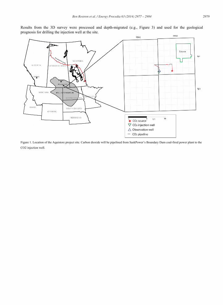
Ben Rostron et al. / Energy Procedia 63 ( 2014 ) 2977 – 2984 2981
Figure 3. Interpreted vertical West-East section from the 3D seismic survey showing approximately 150m of continuous reservoir/injection
horizon, and multiple, thick, overlying caprocks. Location of the injection and monitoring wells.
2.2. Drilling
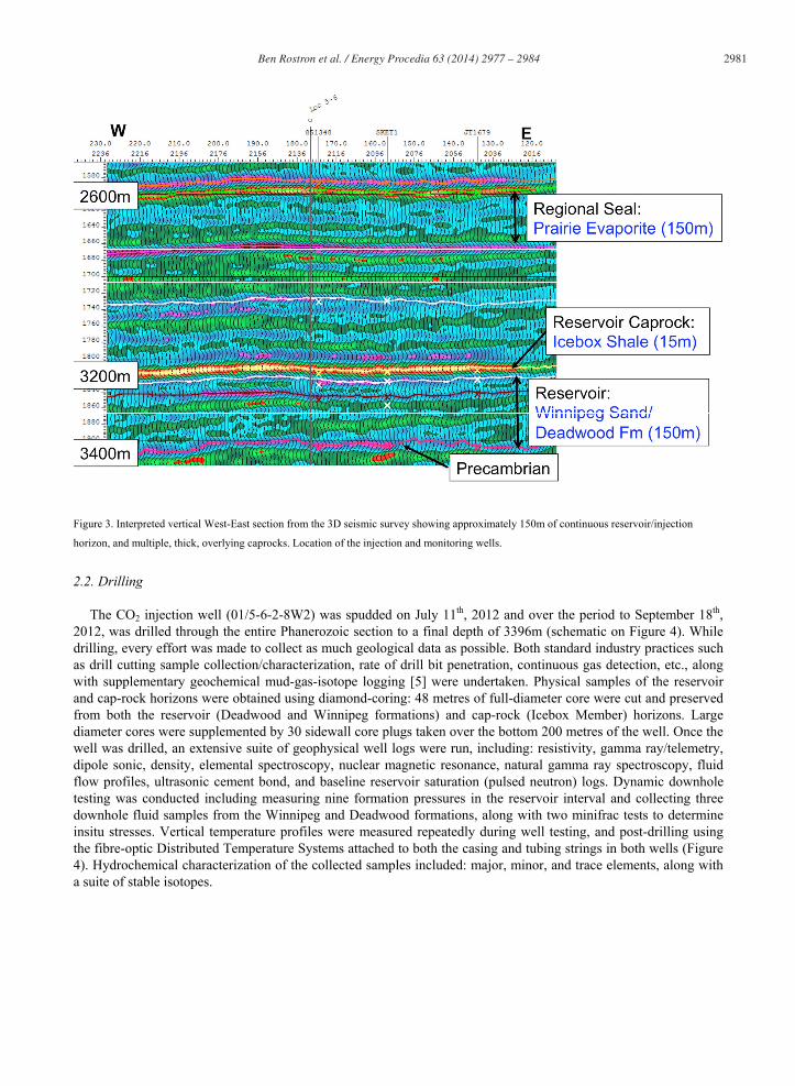
The CO2 injection well (01/5-6-2-8W2) was spudded on July 11th, 2012 and over the period to September 18th, 2012, was drilled through the entire Phanerozoic section to a final depth of 3396m (schematic on Figure 4). While drilling, every effort was made to collect as much geological data as possible. Both standard industry practices such as drill cutting sample collection/characterization, rate of drill bit penetration, continuous gas detection, etc., along with supplementary geochemical mud-gas-isotope logging [5] were undertaken. Physical samples of the reservoir and cap-rock horizons were obtained using diamond-coring: 48 metres of full-diameter core were cut and preserved from both the reservoir (Deadwood and Winnipeg formations) and cap-rock (Icebox Member) horizons. Large diameter cores were supplemented by 30 sidewall core plugs taken over the bottom 200 metres of the well. Once the well was drilled, an extensive suite of geophysical well logs were run, including: resistivity, gamma ray/telemetry, dipole sonic, density, elemental spectroscopy, nuclear magnetic resonance, natural gamma ray spectroscopy, fluid flow profiles, ultrasonic cement bond, and baseline reservoir saturation (pulsed neutron) logs. Dynamic downhole testing was conducted including measuring nine formation pressures in the reservoir interval and collecting three downhole fluid samples from the Winnipeg and Deadwood formations, along with two minifrac tests to determine insitu stresses. Vertical temperature profiles were measured repeatedly during well testing, and post-drilling using the fibre-optic Distributed Temperature Systems attached to both the casing and tubing strings in both wells (Figure 4). Hydrochemical characterization of the collected samples included: major, minor, and trace elements, along with a suite of stable isotopes.
2982 Ben Rostron et al. / Energy Procedia 63 ( 2014 ) 2977 – 2984
Figure 4. Schematic of the 01/5-6-2-8W2 injection well. Approximate locations of major geological units are indicated (left) drawn to vertical
depth scale.
One week after completion of the injection well, the drill rig was moved 150m northeast (Figure 1) and over the period October 1st to November 9th, 2012 the observation well (41/5-6-2-8W2) was drilled 3400m deep through the entire Phanerozoic section (schematic on Figure 5). A similar suite of geophysical well logs was collected from the observation well as was the injection well.
After their interpretation, geological, hydraulic, and petrophysical data collected during the drilling and well
evaluation were incorporated into a revised geological model of the Aquistore site.
2.3. Post drilling activities - downhole
Subsequent geological information was obtained between, and around, the newly-drilled wells via two different downhole seismic surveys conducted as part of baseline surveys to start the CO2 Measurement, Monitoring, and Verification (MMV) program at the site. The first (February, 2013), was a crosswell seismic survey between the two wells over the interval 3100 to 3400m that provided detailed (metre-scale) tomography of the geology between the wells. The second survey (Fall, 2013) was a 3D vertical seismic profile (VSP) that utilized both a conventional 60-level, three-component geophone over the interval 2550-3400m and the well-installed optical fibre system. The 3D VSP provided subsurface information between the resolution the detailed scale from the crosswell survey, and the standard surface 3D seismic survey conducted previously [6].

Ben Rostron et al. / Energy Procedia 63 ( 2014 ) 2977 – 2984 2983
Figure 5. Schematic of the 01/5-6-2-8W2 observation well. Approximate locations of major geological units are indicated (on left) drawn to vertical depth scale. MMV instrumentation not shown to scale.
2.4. Post drilling activities – shallow subsurface
In addition to efforts aimed at characterizing the deep subsurface, there was an extensive effort focused on understanding the shallow subsurface environment at the site. As part of Aquistore’s MMV program, there were three types of baseline MMV surveys related to characterization: soil gas; atmospheric; and shallow groundwater installation and sampling programs. For soil gas, 50 semi-permanent soil gas probes were installed at shallow depths (less than two metres) at 46 different locations across the site to measure a wide range of gaseous and hydrocarbon compounds, and to provide samples for isotopic analysis. Atmospheric gas samples were collected around the area, including fixed-point time series surveys, and spatial surveys, with all samples analyzed for CO2, hydrocarbons, and stable isotopes.
A groundwater monitoring network [7] was created, consisting of over 40 monitored wells: six nearby domestic
water source wells; approximately 15 SaskPower pre-existing groundwater monitoring wells; and 20 shallow (<42m deep) groundwater wells drilled for specifically for the project and co-located with other MMV instrumentation (e.g., tiltmeters, Global Positioning System, and inSar). From these shallow groundwater wells, geological cross-sections, groundwater levels, and hydrochemistry are being used to develop a baseline hydrogeological and hydrochemical understanding of the Aquistore site.
2984 Ben Rostron et al. / Energy Procedia 63 ( 2014 ) 2977 – 2984
3. Conclusions
Multiple characterization techniques have been applied to develop a detailed picture of the geological and geochemical conditions at the Aquistore site. All of the integrated characterization thus far indicate strongly favorable conditions for geological storage at the site: the injection reservoir (Winnipeg and Deadwood formations) appears to be continuous and contain multiple highly-permeable intervals; the regional sealing formation (Icebox Member) and secondary sealing formations (Prairie Formation and Colorado Group) are continuous through out the area; there are no significant faults in the immediate area of the storage site; and the shallow groundwater and soil gas horizons do not appear to be hydraulically connected to the deep injection horizons in the subsurface. Additional characterization work has been undertaken as part of baseline studies for the MMV program, which is the next step in the project.
References
[1] Mossp GD, Shetsen I, editors. Geological atlas of the Western Canada Sedimentary Basin. Canadian Society of Petroleum Geologists and Alberta Research Council; 1995.
[2] Kreis LK, Haidl FM, Nimigeers AR, Ashton KE, Maxeiner RO, Coolican J. Lower Paleozoic Map Series – Saskatchewan. Saskatchewan Industry and Resources, Miscellaneous Report 2004-8; 2004.
[3] Palombi D, Rostron BJ. Regional hydrogeological characterization of the northeastern margin of the Williston Basin. Saskatchewan Ministry of the Economy, Saskatchewan Geological Survey, Open File 2010-45/Manitoba Innovation, Energy and Mines, Manitoba Geological Survey, Open File OF2011-3; 2013.
[4] Bachu S, Burwash RA. Geothermal regime in the Western Canada Sedimentary Basin. In: Mossp GD, Shetsen I, editors. Geological atlas of the Western Canada Sedimentary Basin. Canadian Society of Petroleum Geologists and Alberta Research Council; 1995. p. 447-454.
[5] Skoreyko D, Klappstein G, Rostron B, Muehlenbachs K. Carbon isotope mud-gas depth profile for MMV at the Aquistore project, Saskatchewan, Canada. Proceedings of the 12th International Conference on Greenhouse Gas Technologies, Energy Procedia 2014; this volume.
[6] White DJ, Roach LAN, Roberts B, Daley, TM. Initial results from seismic monitoring at the Aquistore CO2 storage site, Saskatchewan, Canada. Proceedings of the 12th International Conference on Greenhouse Gas Technologies, Energy Procedia 2014; this volume.
[7] Klappstein G, Rostron, B. Shallow hydrogeological and hydrochemical characterization of the Aquistore CO2 sequestration site in Estevan, Saskatchewan, Canada. Proceedings of the 12th International Conference on Greenhouse Gas Technologies, Energy Procedia 2014; this volume.