Embed Size (px)
Citation preview

REMOTE SENS. ENVIRON. 37:167-180 (1991)
Characterization of Semivegetated Salt-Affected Soils by Means of Field Remote Sensing
Tibor T&h and Ferenc Csillag Research institute for Soil Science and Agricultural Chemistry, Hungarian Academy of Sciences, Budapest
Larry L. Biehl Department of Electrical Engineering, Purdue University
Erika Miche’li Agricultural University, God&Y, Hungary
M any recent attempts to map soils and related ecological phenomena are concerned with spatial patterns. There is a large diversity of approaches to determine 1) the actual parameters to be measured, 2) the most informative categories to be formed based on them, and depending on both of the above, 3) the sampling locations and 4) the resolu- tion of the map. This paper reports a field remote sensing project to meet the requirements of a de- tailed botanical and soils survey to understand salinity status of the Hortobcigy region in east Hungary. The problem of association-level recogni- tion of land cover is addressed in terms of quantita- tive description and ground resolution. It is con- cluded that the most characteristic six to seven vegetation association types are well identi$able based on their TM spectra using discriminant anal- ysis / nonhierarchical clustering with hay-meter ground resolution.
Address correspondence to Ferenc Csillag, Geography Depart- ment, Syracuse University, Syracuse, NY 13244-1160.
Received 6 August 1990; revised 27 April 1991.
0034-4257/ 91/$3.50 @Else&r Science Publishing Co. Inc., 1991 655 Avenue of the Americas, New York, NY 10010
1. INTRODUCTION
In most parts of the world salinity is one of the principal causes of soil degradation, with a conse- quent reduction in biomass production. According to some estimates, salt-affected soils cover as much as 7% of the global land area (Szabolcs, 1979). These soils lie primarily in arid and semiarid regions, but there are also important salt-affected areas in subhumid and coastal zones. Some of the most unfavorable properties of these soils include high salt content, poor structure, limited microbial activity, low percolation rates, low fertility, and other characteristics, which restrict plant growth and human settlement. In many areas of the world, the use of otherwise potentially arable land for
agriculture, forestry, and pasture is severely lim- ited because of the salt content of the soils and/or the high ionic concentration of irrigation water. Since the capacity of soils to support plant growth in turn is the product of the interactions of organic and inorganic materials and energy cycles under specific environmental conditions, the practice of sustainable biomass production is impossible with-
167
168 Tdth et al.
out understanding these processes that can lead to adequate technical management.
In Hungary, salinization and alkalization have some specific and/or unique features. There are many types of salt-affected soils because of the evolution of the Carpathian Basin, which has hy- drologically closed characteristics rather than arid or semiarid conditions. The source of sodium salts is mainly subsurface water and the dominant forms of salt accumulation are Na2CO a and NaHCO 3. The main limiting factor to the productivity of salt-affected soils is closely related to water man- agement, which manifests itself in extremes of excess water (ponds) or drought. These conditions result from a combination of factors, including high clay content, predominance of swelling clays, poor structural conditions, and high sodium satura- tion on the cation exchange complex. A significant part of the salt-affected soils in Hungary have natural vegetation cover and occur in National Parks with protected ecosystems. However, salt- affected soils under cultivation comprise 10% of the agricultural land of the country. Therefore, the possibility for the characterization of salt-affected soils and processes related to them is of special scientific interest.
During the past several decades scientists in numerous countries have made significant im- provements in the capability to characterize, de- scribe, and classify salt-affected soils (Szabolcs, 1981; Bresler et al., 1982). Diagnostic systems have been developed from field and laboratory studies to identify and distinguish soils (U.S. Salinity Laboratory Staff, 1954; Szabolcs et al., 1966; Kovda et al., 1973) and ecosystems (Bodrogk6zy, 1965). Recently Szil~gyi and Baumgardner (1991) reported the use of high resolution laboratory spectral measurements to identify salinity status of soils. Spatial extension of local characteristics has also received considerable attention (Webster et al., 1989; Csillag and Kert6sz, 1989). Especially these two latter technical achievements are of specific interest here that provide entirely new possibilities for detailed quantitative regional sur- vey: field remote sensing and geostatistics.
This paper is the first report on our compara- tive studies on the characterization of salt-affected soils developed under different conditions. In Sec- tion 2 we describe in some detail the Hortob~igy region, one of our Hungarian test sites, with natu- ral environmental conditions generalized. Special attention is paid to characteristic variables, diag-
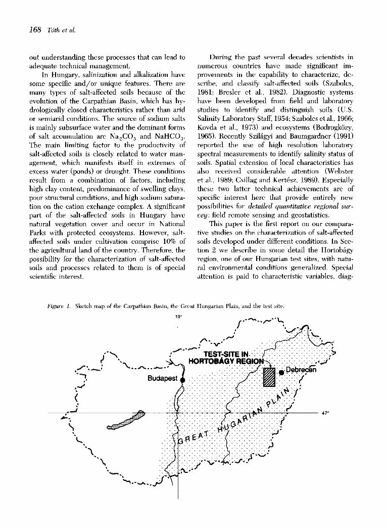
Figure 1. Sketch map of the Carpathian Basin, the Great Hungarian Plain, and the test site.
1 9 ° j"~'-'"~.~:~. i , / ~ " ' v " " . . ' . ' . ' . . ;
e ,_ ~ H O R T O B A G Y ~ G ~ ' . ~ : " : ' ; ' :" ;" : : • : . ~ : ' ~ , ~ : - - - , " - - ^ . . . . " - ~ . .. :.:::::::: :.J.. :~: , : .o .eb. r.e.c~o
f :. ~ ::::::::::::::::::::::::::::::::::::::
~ . . ~ . . . - . . . . @0.-. . . - . - . - . . . :.~: " :::¢~:~:~~:~::.7.:::::::::~ ~'~ ." .'.'~.I.~'~." .'.'.' .'.'. '. '}". ' ." .'.'.'. ".'. "L
\..... : :~ i ; t "~''~L''''~ -,,.-,,,...Z-'\ 1
Spectral Characterization of Semivegetated Salt-Affected Soils 169
nostic conditions of plants and soils, as well as to sampling strategy. Then, the possibilities of spec- tral characterization of salt-affected soils are briefly discussed. In Section 4 our classification results are summarized based on spectral and botanical sampling and statistical analysis. It is concluded that salt-affected soil conditions under natural veg- etation is well recognizable in good coincidence with botanical classification of associations.
2. ENVIRONMENTAL CONDITIONS OF THE HORTOB/~GY REGION
Geological and Geomorphological Conditions
The origin of the Great Hungarian Plain (Fig. 1) is closely related to the Alpine orogenesis that led to the formation of the Carpathian Basin around the end of the Miocene (Stegena et al., 1975). In the Pliocene the basin, the Sarmathian (Pannonian) Sea, was reduced to a lake without any outlet. By the end of the Tertiary, this Pannonian Sea and the lakes derived from it were filled up, their sediments becoming covered with those of subse- quently formed lakes and rivers, the thickness of the latter layers amounting to several hundred meters in some places. During the Quaternary, the glaciers of the Carpathians did not extend into the Plain; this latter was, however, strongly influenced by the glacial era.
The characteristic soil-forming loess material of the Plain is a product of that period. Water, too, is a decisive factor in the formation of parent material. The kind of loess that was formed under its influence is denoted as lowland loess or infu- sion loess. During the glacial epoch and in subse- quent times the Plain became filled up with river
sediments, a process which continues. The Great Hungarian Plain, formed at the end of the Tertiary and in the Quaternary, is rather homogeneous. Its height above the sea level varies from 85 m to 120 m. It is divided into smaller basins occupied by continuous areas of alkali soils. Their height above the sea-level varies in different parts as follows: Danube Valley 95-97 m, Hortob~gy 90 m, Nagykuns~g 88 m, and, along the lower regions of the Tisza River, 80-82 m.
Meterological Conditions
The Great Hungarian Plain is the hottest and dryest region of the Carpathian Basin which is otherwise characterized by temperate climate. In the central region, where our study sites are located, data describing annual averages and dy- namism is summarized in Table 1.
Hydrological Conditions
The Great Hungarian Plain is a basin filled up with sediments deposited by rivers and wind. Therefore, the position of surface waters had an important impact on soil formation. These rivers, as typical lowland rivers, affected a vast territory by the periodic floods, creating huge marshlands. According to their origin, sediments deposited from the rivers differ much and the base materials of soil formation reflect these differences.
In the formation of salt affected soils a decisive role is played by saline groundwater, so that the different types of salt-affected soils in the Hungar- ian soil classification system are closely related to distinct groundwater table depths. There are re- gional differences in the composition and concen-
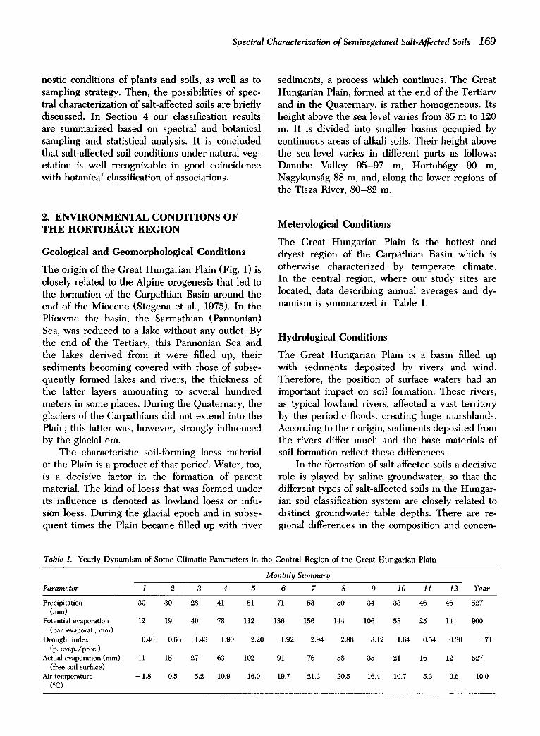
Table I. Yearly D y n a m i s m of Some Climatic Parameters in the Central Region of the Great Hungar ian Plain
Monthly Summary
Parameter i 2 3 4 5 6 7 8 9 10 11 12 Year
Precipitation 30 30 28 41 51 71 53 50 34 33 46 46 527 (mm)
Potential evaporation 12 19 40 78 112 136 156 144 106 58 25 14 900 (pan evaporat., mm)
Drought index 0.40 0.63 1.43 1.90 2.20 1.92 2.94 2.88 3.12 1.64 0.54 0.30 1.71 (p. evap./prec.)
Actual evaporation (mm) 11 15 27 63 102 91 76 58 35 21 16 12 527 (free soil surface)
Air temperature - 1.8 0.5 5.2 10.9 16.0 19.7 21.3 20.5 16.4 10.7 5.3 0.6 10.0 (*C)

170 T6th et al.
tration of groundwater that resulted in the wide variety of salt affected soils.
Soil Conditions
According to the general classification of soils, there are soils of the Atlantic region (brown forest soils) in the hilly marginal regions of the plain and there are soils of the steppe region (cheruozems) in the inner plateaus of the plain. Important azonal soils are the salt-affected soils and meadow soils which, together with the intrazonal alluvial soils, form a chain of these soil types. According to the difference in parent material, the salt-affected soils of Hungary may be divided into two categories: 1) calcareous sodic alkali soils and 2) noncalcare- ous alkali soils. The latter, the subject of our studies, is characterized by high clay-content and unfavorable hydrophysical properties, high ESP (exchangeable sodium percentage) and high pH in the columnar B horizon and, as a rule, low salt content. The unfavorable properties that limit the fertility of these soils are the consequence of the high clay content, high ESP, high pH and the resulting special moisture regime. The climatic conditions, for example, the unequal distribution of the precipitation, the high aridity index, and the high fluctuating saline groundwater, call for a complex approach for improvement.
Groundwater
The Great Hungarian Plain consists of a variable layered and textured deep aquifer where the groundwater table varies between 0.5 m and 4.0 m below the surface, with an average fluctuation of 0.5-2.0 m. The shallow water table often causes
water-logging on the lower parts of the fields. Surface water ponding appear also on the low-lying, low permeability plots at the end of winter, after snow melt and/or during high-pre- cipitation periods. The high salt content of the groundwater and its high Na÷/(Ca ++ +Mg ÷+) ratio result in salinization and alkalinization of the soils.
Ecological/Botanical Site Characteristics
Our studies were carried out in Hortob~igy, one of the most peculiar European scenes of nature. The almost treeless and flat area (ca. 2300 km 2) is covered by extensive rangelands, marshes, aban- doned water courses, fishponds, reeds, meadows, and some woody patches.
The area was filled up in the Pleistocene by ca. 100-200 m thick river sediments and on this sediment approximately 4-5 m of loess or "meadow clay" were deposited. The latter accu- mulated in the more or less closed lateral courses of the river Tisza. Both materials have fine parti- cles. Hortob~gy earlier, in historical times, was regularly inundated by the river Tisza, and had marshy and open forest vegetation with grassland between them. The formation of szik soil (typically solonetz) began probably in the hazelnut period of the Pleistocene era by the concentration of sodium salts transported to the surface layers by ground- water. The area was first deforested and then regulated by building dams and canals, but to- gether with drying the area of the particular salt- affected ("szik") soils extended considerably.
There is an overall tendency in the Great Hungarian Plain that on higher locations there are chernozems, lower meadow-chernozems, while in
Table 2. The Occurrence of the Main Types of Surf~tce Elements, Groundwater Levels, Plant Associations, and Soil Types in the Studied Area (after Varga et al., 1982)
Surface Element Erosion Form Association Soil type
Loess Plateau No Cynodonti-Poetum Meadow chernozem augustifoliae ~
Grassy lower place Slight Achilleo-Festucetum (Steppizing) pseudovinae meadow solonetz
Wormwoody rangeland Torn Artemisio-Festucetum Meadow solonetz grasscover pseudovinae
Bare spot No A horizon Camphorosmetum annuae Decapitated on lower part meadow solonetz
Bare spot on lower 1-2 cm of A Puccincllietum limosae Solonchaky decapitated temporary, water course solonetz
"Note: in places not severely affected by pasturing the original Salvio-Festucetum sulcatae (loess rangeland) remained.
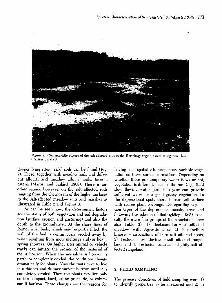
Spectral Characterization of Semivegetated Salt-Affected Soils 1 71
7
Figure 2. Characteristic picture of the salt-affected soils in the Hortob~gy region, Great Hungarian Plain ("Szikes puszta").
deeper lying sites "szik" soils can be found (Fig. 2). These, together with meadow soils and differ- ent alluvial and meadow alluvial soils, form a catena (Marosi and Szil~rd, 1968). There is an- other catena, however, on the salt affected soils ranging from the chernozem of the higher surfaces to the salt-affected meadow soils and marshes as illustrated in Table 2 and Figure 3.
As can be seen now, the determinant factors are the status of both vegetation and soil degrada- tion (surface erosion and pasturing) and also the depth to the groundwater. At the shore lines of former river beds, which may be partly filled, the wall of the bed is continuously eroded away by water resulting from snow meltings and//or heavy spring showers. On higher sites animal or vehicle tracks can initiate the erosion of the material of the A horizon. When the nonsaline A horizon is partly or completely eroded, the conditions change dramatically for plants. Now the roots have to live in a thinner and thinner surface horizon until it is completely eroded. Then the plants can live only on the compact, hard, saline prismatic, or colum- nar B horizon. These changes are the reasons for
having such spatially heterogenous, variable vege- tation on these surface formations. Depending on whether there are temporary water flows or not, vegetation is different, because the rare (e.g., 2-3) slow flowing water periods a year can provide sufficient water for a good grassy vegetation. In the depressional spots there is bare soil surface with scarce plant coverage. Disregarding vegeta- tion types of the depressions, marshy areas and following the scheme of Bodrogk6zy (1965), basi- cally there are four groups of the associations (see also Table 3): 1) Beckmannion = salt-affected meadow with Agrostis alba; 2) Puccinellion limosae = associations of bare salt affected spots; 3) Festucion pseudovinae = salt affected range- land; and 4) Festucion sulcatae = slightly salt af- fected rangeland.
3. F I E L D SAMPLING
The primary objectives of field sampling were 1) to identify properties to be measured and 2) to

172 T6th et al.
SOILS AND VEGETATION - IN TIME AND SPACE (Hortob~.gy Region)
ASSOCIATION Salvlo-Festucetum s. .:'-~'-~', Achilleo-Feltucetum p.
T . % . . . . . . . . . . ,% Artemisio-Feotucetum p. A / = 40 cm "%'.::...
| '.,~, c = ~ = m e t u m =. %~, , P u c c l n e l l l e t u m I. ~ u m -
. . . . . . . . . . . . . . . . . . . . . . . . . . . . . . . . . . . . . . . . . . . ~ " " i " ~ % = "k = ~ = " " - ' t ' " "~ = "= "= - ~.= "5= ~.= - ~ I J " ~.R~I|NnWATI::I: . . . . . , , ' . , . . . - r . , ' , . . . . ' , e , , - . , - , ¢ , , . , , . . . - . , ' , , P , e , , , , , P , , . . . . . . . . . ~ - .,..,..= . . . . . . . . . . . . . . ,~,~, ~ / ` / / ` ` ~ / / / / / / / / / / ` / . / / ~ / ` / / / / / / / / / / ~ / . / / 1 ` / / / / / / / / / / / / / / / / / - ` / / / ` / / / / / / / / / ` / / ` / / / / / / / / / / / / / / ` / / ` ~ / . . ~ / - / / / / / / / ` / / / ~ `~P<~ / / / / / ` ~ `~ . / / ` . / / / .
l l * . - - I
SOIL TYPE meadow chernozern
~'i~:"%%~..,.,,,% deep meadow Iolonetz
A / = 40 em - : . . . , shallow n'=madow solonetz
l crusty meadow solonetz %,
........................................... %;., .~,. - ; - ; - ; - ~ . . rnllrlflt-rmmdow l o b GROUNDWATER - . ~ - • . . . . . J , e . . ; , . ; . , , . , , , , i ~ r ; e , , ' : e ; , : : ; ~ ; ~ ; ~ ; ~ ; ~ # ~ . I l l k . ' l
"m. t . ~ v I / / / / / / / / / / / / / / ~ / / ~ ; ~ / / / / / / / / / / / / / / / / / / / / / / / / / / / / / / / / / / / / / / / / / / / / / / / / / / / / / / / / / / / / / / / / / / / / / / / / / ~ 7 ~ / . ` ( ) ~ ` ~ / / ~ s ~
EROSION no erosion r~z.,L,.,.:, slight / """'" :"'~% medium
A~ = 40 cm %1,-:.,,, • "m
",~., strong ........................................... ;.. temporary water course accumulation
Q= . • • • • • •
"%,.,r .,r.d.~%,
Figure 3. An illustrative summary of the environmental conditions of the study area (see Table 2 and text for details).
determine the most informative categories to char- acterize our test sites as well as extended regions. Therefore, large amounts of botanical and soil data were collected to set up a kind of standard of "szikes puszta" (salt-affected steppe), a reference in further investigations, spatial extension, and regional mapping.
Two additional technical problems had to be solved during sampling design: 1) sampling loca- tions and 2) spatial resolution. Based on intensive previous botanical studies and reports of spatial heterogeneity (Rajkai et al., 1989a), 50 cm × 50 cm quadrat sampling was carried out along 10-50-m- long transects. Nested sampling design was ap- plied, that is, where sampling locations are clus- tered by their distances in order to equally cover
large and small lags. These values are the result of detailed analysis of variance of vegetation and soil parameters like pH, ESP, salt content, and their geostatistical evaluation, along with large scale aerial survey of vegetation cover as related to 10-200 cm quadrat sampling botanical pilot stud- ies (Rajkai et al., 1989b; Kert~sz, 1990).
Coenological Data
In order to set up the above-described "standard" characteristics in quantitative terms, very broad groups of environmental attributes have to be taken into consideration. These are summarized in Table 4. With four associations of the toposequence (Fig. 3) in the focus of our interest, the "szikes puszta"
Spectral Characterization of Semivegetated Salt-Affected Soils 1 73
Table 3. Correlation of the Main Types of Vegetation and Genetic Soil Types in the Northern Hortoba'gy (According to Bodrogk6~y, 1965.)
Vegetation Soil Type (Federation, (Subtype, Association) Variant)
Beckmannion erucaeformis Puccinellion limosae
Puccinellietum limosae Characteristic species: Puccinellia limosa, Nostoc commune, Myosurus minimus etc.
Camphorosmetum annuae Characteristic species: Camphorosma annua, Matricaria chamomilla
Festucion pseudovinae
Artemisio-Festucetum pseudovineae Characteristic species: Festuca pseudovina, Artemisia santonicum ssp. patens, Gypsophila muralis
Achilleo-Festucetum pseudovinae Characteristic species:
Festuca pseudovina, Achillea setacea, Trifolium angulatum Festucion sulcatae
Solonetzized meadow soil Meadow solonetz Slightly solonchakized
crusty meadow solonetz
Highly solochakized crusty meadow solonetz
Steppizing meadow solonetz
Moderately leached crustily steppizing meadow solonetz
Moderately steppizing meadow solonetz
Meadow chernozem of higher salinity in greater depth
Table 4. Environmenta l Attr ibutes of the Salt-Affected Steppe ("Szikes Puszta") (Based Partly on Bodrogk6~y, 1965)
Achilleo Artemisio Major Associations Festucetum Festucetum Camphorosmetum Puccinellietum Attributes (A-F) (ArF) (C) (P)
Typical phyytogeographic area Euro-Asian Pontusian-Pannonic Pannonic Typical life form Hemicryptophyte Therophyte Hemicryptophyte Preference for
Temperature Slightly cryotolerant Thermophile Wetness Dry habitat Slightly moist Dry habitat Indifferent
with temp. waterlogging habitat Soil reaction Acidic Slightly acidic Alkaline Slightly alkaline Salt concentration Halotolerant Halophile Soil Nitrogen Slightly fertilized Unfertilized Slightly fertilized
Total plant coverage (%) 96 90 57 43 No. of species with constancy ~ > 2 15 9 3 5 Species with constancy of 5
Artemisia maritima Champhorosma annua Festuca pseudovina Kochia prostrata Poa bulbosa sp. vivipara Puccinellia limosa Scorzonera cana
Thickness of A horizon Exchangable Na (%) (ESP) pH Total salt (%) Texture of surface
+ +
+ +
30-50 7-15 0 0-10 25 41 86 58 7.6 8.6 8.9 9.3
0.01 0.12 0.29 0.11 Loam Loam Clay-loam Clay
aNote: Constancy is an integer between 0 (0%) and 5 (100%) showing the relative occurrence of one plant species in a series of survey.
174 T6th et al.
can be characterized as follows. The Achilleo- Festucetum pseudovinae is situated in an interme- diate position between the higher lying (non-salt- affected) loess-steppe vegetation and the saline spots. The Artemisio-Festucetum pseudovinae is the characteristic association of the microerosion plateaus. On the bare spots Camphorosmetum an- nuae is thriving and on the areas with temporary water standing Puccinellietum limosae association is found.
There is a close relation between the (genetic) soil type and the plant association dwelling on it. As erosion develops, the relief changes the thick- ness of horizon A, thus changing the surface prop- erties of soils as well. As a consequence of the different extent of horizon A removal, the condi- tions for water supply differ much in the different stages of the erosion. For the four types of plant associations the most important species, the eco- logical characteristics and soil parameters are sum- marised in Table 4 (species, ecology, soils). There is an overall tendency of decreasing plant diversity and coverage when moving down the slope, though Puccinellietum 1. is expected to have generally higher coverage than Champhorosmetum a. The ratio of the coverage of the four different types of vegetation in a given area is rather variable, from 1:9 :1 :3 to 10:2:1:5, etc.
Based on the relative abundancy of the most dominant species in each association the ecological requirements of the associations were expressed
based on the weighted ecological requirements of the individual species (Table 4). Comparing the relative requirements for temperature, there is a sharp difference between the high lying associa- tions and the thermophile low lying semivegetated ones. The Camphorosmetum a. differs much from the Puccinellietum 1. with respect to the require- ments for d ry /wet soil. As discussed above, the plants of PuccineUietum require much water. The Camphorosmetum annuae is characterized with very moderate N requirement, but the associations of closed grassland require much higher N. There is a tendency of stronger and stronger halophile character with decreasing N and decreasing height. There is one outstanding association among the associations studied with respect to life forms: The Camphorosmatum a., occurring in the spots of most adverse circumstances are overwhelmingly annual ones.
The idealized scheme must not be thought to be universal not even on the Hungarian alkali soils. When the salt concentration and /o r salt composition of the soil is different, there might be other associations involved. However, for the sake of this study, we consider this description as a "standard," and all other sites will be character- ized by their deviations. The toposequence pre- sented here can be both a scheme for erosion from Salvio-Festucetum s. or Cynodonti-Poetum a. to Camphorosmetum a. and a scheme for accumula- tion from PuccineUietum 1. through Artemisio-
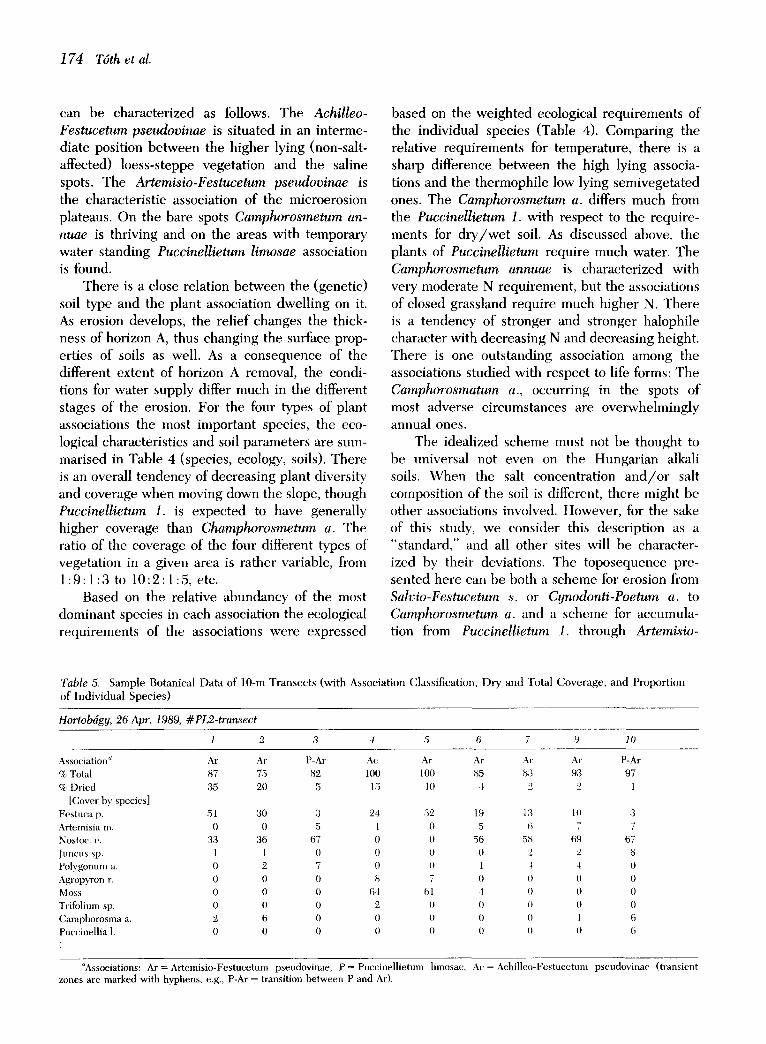
Table 5. S a m p l e B o t a n i c a l D a t a of 1 0 - m T r a n s e c t s ( w i t h A s s o c i a t i o n C l a s s i f i c a t i o n , D r y a n d To ta l C o v e r a g e , a n d P r o p o r t i o n
o f I n d i v i d u a l S p e c i e s )
Hortobdgy, 26 Apr. 1989, # PL2-transect
1 2 ,3 4 5 6 7 9 10
Association" Ar Ar P-Ar Ac Ar Ar Ar Ar P-Ar
% Total 87 75 82 100 100 85 8:3 93 97
% Dried 35 20 ,5 15 10 4 2 2 1
[Cover by species] Fes tuca p. 51 30 3 24 32 19 1:3 10 3 Artemisia m. 0 0 5 l () 5 6 7 7 Nostoc. c. 33 36 67 0 0 56 58 69 67 Jtmcus sp. 1 1 0 0 0 0 2 2 8 Polygonum a. 0 2 7 0 () 1 1 4 0 Agropyron r. 0 0 0 8 7 0 0 0 0 Moss 0 0 0 64 61 4 0 0 0 Trifolium sp. 0 0 0 2 0 0 0 0 0 Camphorosma a. 2 6 0 0 0 0 0 1 6 Puccinell ia 1. 0 0 0 0 0 0 0 0 6
aAssociations: Ar = Artemis io-Festucetum pseudovinae, P = Puccinel l ie tum limosae, Ac = Achi l leo-Festucetum pseudovinae ( transient zones are marked with hyphens, e.g., P-At = transition be tween P and Ar).

Spectral Characterization of Semivegetated Salt-Affected Soils 175
Festucetum p. to AchiUeo-Festucetum p. In the end of the succession line stands a forest associa- tion of the salt-affected steppes• But since the dry matter of the grass associations cannot accumulate, there is at present no perspective for further suc- cession. The erosion processes are accelerated by thrashing and grazing. As a consequence of the disturbance, species diversity is decreasing.
The sampling sites were selected on the basis of representativity, that is, these sites are to repre- sent variations of the parameters that are de- scribed above and are subject of subsequent analy- sis. There were more than 50 locations selected for field sampling, where measurements were com- pleted along transects (Table 5, for example).
Spectral Reflectance Data
Spectral data collection was adjusted to the diag- nostic findings of preliminary botanical analysis. For measurements of the reflectance factor an
EXOTECH-100 multiband radiometer was used with TM filters [TM1 (450-520 nm), TM2 (520-600 nm), TM3 (630-690 nm), TM4 (760-900 nm)] and a painted barium-sulfate panel was used for calibration (Robinson and Biehl, 1979). At some sites a Barnes eight-band portable spectrometer was also used to cover the whole TM spectrum. In order to collect information from surfaces compa- rable to botanical samples, the equipment was man-mounted at a height of about 120 cm with 15 ° field of view. Since collection of spectral data is much less cumbersome that that of botanical ones, spectral measurements were made at not only locations of botanical sampling, but at equidistant 1-m increments along the transect (Fig. 4).
Spectral reflectance was hypothetized to re- flect variations of vegetation cover. There is quite a long history in remote sensing of using vegeta- tion as an indicator of environmental conditions (Carnegie et al., 1983; Hardisky et al., 1983). In our case, however, the study focused on a complex phenomenon (i.e., salt-affected soils) at a high
Figure 4. Sample spectral and botanical data along 50 m transect. (there are 105 points all together, of which at 60 sites both data were collected. Three major associations are represented on the figure: Artemisio-Festucetum, Puccinellietum limosa, and Camphorosmetum annuae; their symbols are not scaled on the vertical axis just to guide the eye.)
SPECTRAL AND BOTANICAL DATA
l 40 ' \
i h
35 , , , i t • i
Q • t • i . - I I t ~ I • t
30 " . . . . . . . . . I t I t I I I % i I
I e I ~ e
25 , , , , . . . . . . , ~ • i o I ' , I I I
', t e i ,t *- e i e
2o ' \.: ' i :
5 i i i i i 1
0 5 10
I i u l
o I - " t
J i u t J i
i #
×,
i I
e t e
i i t
s i i a ~ i
- - , :', : ' , ; ' , : , : • i t i , I t
• i t • ; i , , , , . , , : l a ~ s
i e ~s I
: : ' , ,Ik x •
~ . , , H . . . • ' ' • "
i i
15 20 25 30 35 40 45 50
D I S T A N C E A L O N G T R A N S E C T ( m )
.................... TM 2 • A r
T M 3 X P
. . . . . . . . . . T M 4 -F C
] 76 T6th et al.
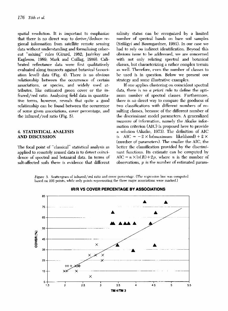
spatial resolution. It is important to emphasize that there is no direct way to der ive/deduce re- gional information from satellite remote sensing data without understanding and formalizing coher- ent "mixing" rules (Girard, 1982; Jasinksy and Eagleson, 1989; Mark and Csillag, 1989). Cali- brated reflectance data were first qualitatively evaluated along transects against botanical (associ- ation level) data (Fig. 4). There is no obvious relationship between the occurrence of certain associations, or species, and widely used at- tributes, like estimated green cover or the in- frared/red ratio. Analyzing field data in quantita- tive terms, however, reveals that quite a good relationship can be found between the occurrence of some given associations, cover percentage, and the infrared/red ratio (Fig. 5).
4. STATISTICAL ANALYSIS AND DISCUSSION
The focal point of "classical" statistical analysis as applied to remotely sensed data is to detect coinci- dence of spectral and botanical data. In terms of salt-affected soils there is evidence that different
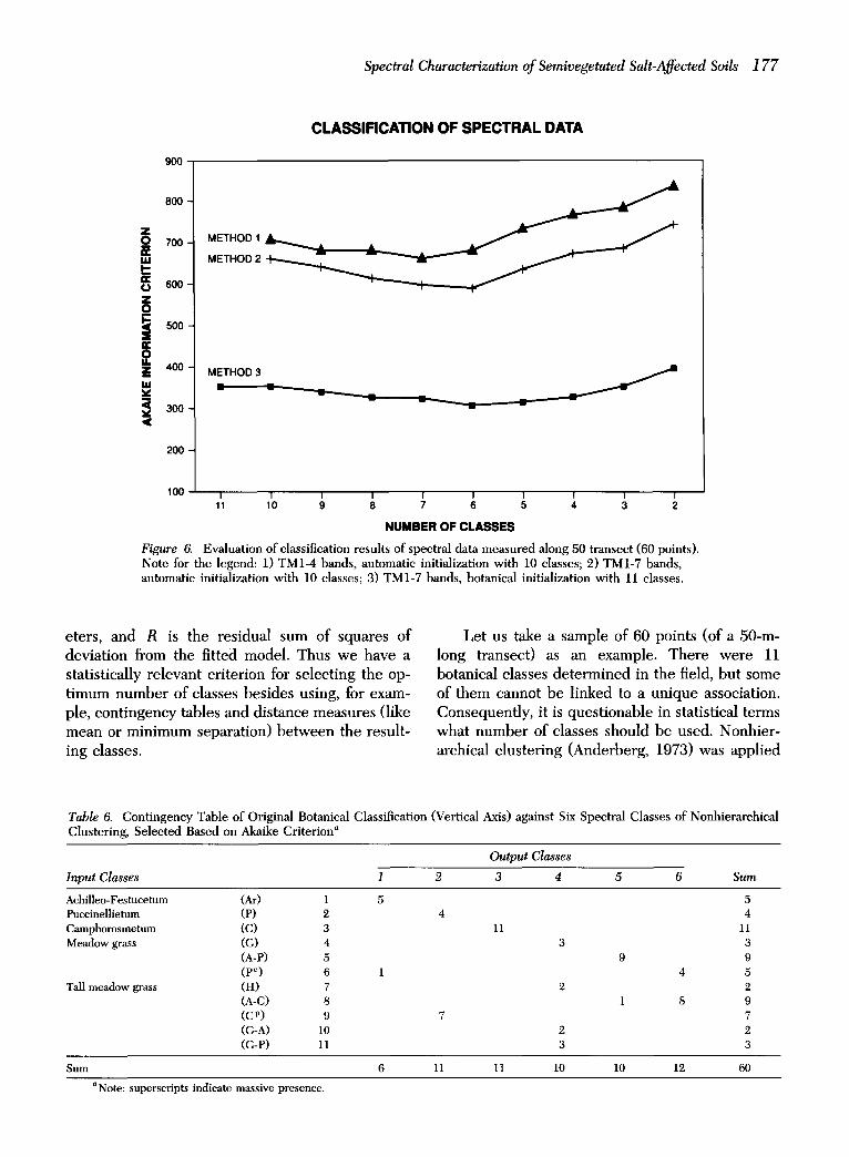
salinity status can be recognized by a limited number of spectral bands on bare soil samples (Szil~gyi and Baumgardner, 1991). In our case we had to rely on indirect identification. Beyond this obvious issue to be addressed, we are concerned with not only relating spectral and botanical classes, but characterizing a rather complex terrain as well. Therefore, even the number of classes to be used is in question. Below we present our strategy and some illustrative examples.
If one applies clustering on coincident spectral data, there is no a priori rule to define the opti- mum number of spectral classes. Furthermore, there is no direct way to compare the goodness of two classifications with different numbers of re- sulting classes, because of the different number of the discriminant model parameters. A generalized measure of information, namely the Akaike infor- mation criterion (AIC) is proposed here to provide a solution (Akaike, 1973). The definition of AIC is AIC = - 2 X In(maximum likelihood) + 2 x (number of parameters). The smaller the AIC, the better the classification provided by the discrimi- nant functions. Its estimate can be computed by AIC = n X l n ( R ) + 2 p , where n is the number of observations, p is the number of estimated param-
Figure 5. Scattergram of infrared/red ratio and cover percentage. (The regression line was computed based on 105 points, while only points representing the three major associations were marked.)
IRIR VS COVER PERCENTAGE BY ASSOCIATIONS
A
E m ) 0 0
85
75 -
65
55
45-
35 -
25
15-
x
×
X
5 1.5 2 2 5 3
A
I I
5.5
TM 4/ ' rM 3
Spectral Characterization of Semivegetated Salt-Affected Soils 177
METHOD 12 METHOD
CLASSIFICATION OF SPECTRAL DATA
800
9O0
E 2 z 4oo
m
<
200
100
Figure 6.
METHOD 3
I 1 I I 1 I I I f I 11 10 9 8 7 6 5 4 3 2
NUMBER OF CLASSES
Evaluation of classification results of spectral data measured along 50 transect (60 points). Note for the legend: 1) TM1-4 bands, automatic initialization with 10 classes; 2) TM1-7 bands, automatic initialization with 10 classes; 3) TM1-7 bands, botanical initialization with 11 classes.
eters, and R is the residual sum of squares of deviation from the fitted model. Thus we have a statistically relevant criterion for selecting the op- timum number of classes besides using, for exam- ple, contingency tables and distance measures (like mean or minimum separation) between the result- ing classes.
Let us take a sample of 60 points (of a 50-m- long transect) as an example. There were 11 botanical classes determined in the field, but some of them cannot be linked to a unique association. Consequently, it is questionable in statistical terms what number of classes should be used. Nonhier- archical clustering (Anderberg, 1973) was applied
Table 6. Contingency Table of Original Botanical Classification (Vertical Axis) against Six Spectral Classes of Nonhierarchical Clustering, Selected Based on Akaike Criterion a
Output Classes
Input Classes 1 2 3 4 5 6 Sum
Achilleo-Festucetum Puccinellietum Camphorosmetum Meadow grass
Tall meadow grass
(Ar) 1 5 5 (P) 2 4 4 (C) 3 11 11 (G) 4 3 3 (A-P) 5 9 9 (P~) 6 I 4 5 (H) 7 2 2 (A-C) 8 1 8 9 (C v) 9 7 7 (G-A) l0 2 2 (G-P) 11 3 3
Sum 6 11 11 10 10 12 60
aNote: superscripts indicate massive presence.
178 T6th et al.
Table 7. Contingency Table of Spectral Classes of Nonhierarchical Clustering Ob- tained by Botanical Initialization (Horizontal Axis) against Result Obtained by Automatic Initialization (Vertical Axis)
Output Classes
Input Classes I 2 3 4 ,5 6 Sum
1 6 6 '2 9 9 3 10 10 4 11 1 12 5 ll II 6 12 1'2
Sum 6 l l l 1 l0 10 1,9 60
with optional initialization, using Mahalanobis dis- tance as the feature space metric and with various initial number of classes to search for the mini- mum value of the AIC (Fig. 6). The classification was based either on the categories defined by botanists (botanical initialization) or only by defining the number of classes to be separated (automatic initialization). Quite consistently, re- gardless of the initial number of classes and/or the kind of initialization, the minimum was reached at six to seven classes in all of our cases. The
analysis of the classification (Table 6) led to fur- ther encouraging conclusions, because the contin- gency table shows that the clustering procedure exhibits class consistency. In other words, this refers to the extent and nature of the hierarchical relationship between tile predefined (botanical) classes (Jardine and Sibson, 1977).
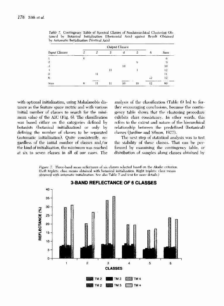
The next step of statistical analysis was to test the stability of these classes. That can be per- formed by examining the contingency table, or distribution of samples along classes obtained by
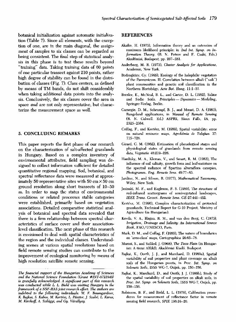
Figure 7. Three-band mean reflectance of six classes selected based oll the Akaike criterion. (Left triplets: class means obtained with botanical initialization. Right triplets: class means obtained with automatic initialization. See also Table 7 and text for more details.)
3oBAND REFLECTANCE OF 6 CLASSES 40-
35
.-,. 30
u,I 25 ¢..) Z
20 0 ug ..,.I 1 5 - I,i. u.I n,,
10-
2 3 4 5
CLASSES
~TM2 I T M 3 ~TM4
._______=w~__: TM 2 ~ TM 3 ~ TM 4
Spectral Characterization of Semivegetated Salt-Affected Soils 1 79
botanical initialization against automatic initializa- tion (Table 7). Since all e lements , with the excep- tion of one, are in the main diagonal, the assign- ment of samples to six classes can be regarded as be ing consistent. The final s tep of statistical analy- sis in this phase is to test these results beyond "training" data. Taking training data of 60 points of one particular t ransect against 210 points, rather high degree of stability can be found in the distri- but ion of classes (Fig. 7): Class centers, as defined by means of TM bands, do not shift considerably when taking additional data points into the analy- sis. Conclusively, the six classes cover the area in space and are not only representat ive, bu t charac- terize the measuremen t space as well.
5. CONCLUDING REMARKS
This paper reports the first phase of our research on the characterization of salt-affected grasslands in Hungary. Based on a complex inventory of environmental attributes, field sampling was de- s igned to collect information sufficient for detai led quanti tat ive regional mapping. Soil, botanical, and spectral reflectance data were measured at approx- imately 50 representa t ive sites with 50 cm × 50 cm ground resolut ion along short transects of 10 -50 m. In order to map the status of environmental conditions or related processes stable categories were established, primarily based on vegetat ion associations. Deta i led comparat ive statistical anal- ysis of botanical and spectral data revealed that there is a firm relationship b e t w e e n spectral char- acteristics of surface cover and their association- level classification. The next phase of this research is envis ioned to deal with spatial characteristics of the region and the individual classes. Unders tand- ing scenes at various spatial resolutions based on field remote sensing studies can contr ibute to the improvement of ecological monitoring by means of high resolution satellite remote sensing.
The financial support of the Hungarian Academy of Sciences and the National Science Foundation (Grant #INT-8721949) is gratefully acknowledged. A significant part of this research was conducted while L L Biehl was visiting Hungary in the framework of a NSF-HAS joint research effort. The authors are indebted to the following individuals: M. F. Baumgardner, K. Rajkai, S. Kabos, M. Kertdsz, L. Pdsztor, J. Szab6, L, Karas, M. Kirchoff, A. Szildgyi, and Gy. Vdrallyay.
REFERENCES
Akaike, H. (1973), Information theory and an extension of maximum likelihood principle; in 2nd Int. Symp. on In- formation Theory, (B. N. Petrov and F. Csaki, Eds.) Akad6miai, Budapest, pp. 267-281.
Anderberg, M. R. (1973), Cluster Analysis for Applications, Academic, New York.
Bodrogk6zy, Gy. (1965), Ecology of the halophilic vegetation of the Pannonicum. II. Correlation between alkali ("szik") plant communities and genetic soil classification in the Northern Hortob~igy, Acta Bot. Hung. 11:1-51.
Bresler, E., McNeal, B. L., and Carter, D. L. (1982), Saline and Sodic Soils. Principles--Dynamics--Modeling, Springer-Verlag, Berlin.
Carnegie, D. M., Schrumpf, B. J., and Mouat, D. A. (1983), Rangeland applications, in Manual of Remote Sensing (R. N. Colwell, Ed.) ASPRS, Sioux Falls, IA, pp. 2325-2384.
Csillag, F., and Kert6sz, M. (1989), Spatial variability: error on natural resource maps, Agrokdmia ds Talajtan 37: 715-726.
Girard, C. M. (1982), Estimation of phenological stages and physiological states of grasslands from remote sensing data, Vegetatio 48:219-226.
Hardisky, M. A., Klemas, V., and Smart, R. M. (1983), The influence of soil salinity, growth form and leaf-moisture on the spectral radiance of Spartina alterniflora canopies, Photogramm. Eng. Remote Sens. 49:77-83.
Jardine, N., and Sibson, R. (1977), Mathematical Taxonomy, Wiley, New York.
Jasinski, M. F., and Eagleson, P. S. (1989), The structure of red-infrared scattergrams of semivegetated landscapes, IEEE Trans. Geosci. Remote Sens. GE-27:441-452.
Kert6sz, M. (1990), Complex characterization of protected grasslands, Technical Report for G-10 Project, Ministry of Agriculture (in Hungarian).
Kovda, V. A., Hagan, R. M., and van den Berg, C. (1973), Irrigation, Drainage and Salinity: An International Source Book, FAO/UNESCO, Paris.
Mark, D. M., and Csillag, F. (1989), The nature of boundaries on 'area-class' maps, Cartographica 26:65-78.
Marosi, S., and Szil~rd, J. (1968), The Tisza Plain (in Hungar- ian: A tiszai Alf61d), Akad6miai Kiad6, Budapest.
Rajkai, K., Oertli, J. J., and Marchard, D. (1989a), Spatial variability of soil properties and plant coverage on alkali soils of the Hungarian puszta, in Proc. Int. Symp. on Solonetz Soils, ISSS WG-7, Osijek, pp. 150-156.
Rajkai, K., Marchard, D., and Oertli, J. J. (1989b), Study of the spatial variability of soil properties on alkali soils, in Proc. Int. Symp. on Solonetz Soils, ISSS WG-7, Osijek, pp. 150-156.
Robinson, B. F., and Biehl, L. L. (1979), Calibration proce- dures for measurement of reflectance factor in remote sensing field research, SPIE 196:16-26.

180 T6th et al.
Stegena, L., G~czy, B., and Horv~ith, F. (1975), Late Cenozoic evolution of the Pannonian Basin, Tectonophysics 26: 71-90.
Szabolcs, I. (1981), Landscape geochemistry of soil saliniza- tion and alkalization, Agrokdmia ds Talajtan 30 (Suppl. 47).
Szabolcs, I., Darab, K., and V~irallyay, G. (1966), Salt balance of irrigated soils, Beitr. Trop. Subtrop. Landw. Vet. Med. 4:123-135.
Szil~gyi, A., and Baumgardner, M. (1991), Salinity and spec- tral reflectance of soils, in Proc. ASPRS Annual Conven- tion, Baltimore, March, pp. 430-438.
U.S. Salinity Laboratory Staff (1954), Diagnosis and improve- ment of saline and alkali soils, USDA Handbook 60, U.S. Government Printing Office, Washington, DC.
Varga, Z-nC, Varga, Z., and Nyilas, I. (1982), Nyfr61apos-Nydri jdrds: Soils, Flora and Fauna (in Hungarian: Talaj, n6v~nyzet, ~llatviklg), Hortob~gy National Park Fubl., De- brecen.
Webster, R., Curran, P. J. and Munden, J. w. (1989), Spatial correlation in reflected radiation from the ground and its implications for sampling and mapping by ground-based radiometry, Remote Sens. Environ. 29:67-78.