Embed Size (px)
Citation preview
lable at ScienceDirect
Quaternary International 328-329 (2014) 94e106
Contents lists avai
Quaternary International
journal homepage: www.elsevier .com/locate/quaint
Characterization and dating of coastal deposits of NW Portugal(MinhoeNeiva area): A record of climate, eustasy and crustal upliftduring the Quaternary
Ricardo P. Carvalhido a,b,*, Diamantino I. Pereira a,c, Pedro P. Cunha d, Jan-Pieter Buylaert e,f,Andrew S. Murray f
aGeology Centre, University of Porto, PortugalbCentre for Environmental and Marine Studies, University of Aveiro, Portugalc Earth Sciences Department, University of Minho, PortugaldDepartment of Earth Sciences, IMAR-CMA, University of Coimbra, PortugaleCentre for Nuclear Technologies, Technical University of Denmark, Risø Campus, DenmarkfNordic Laboratory for Luminescence Dating, Department of Geoscience, Aarhus University, DTU Risø Campus, DK-4000, Denmark
a r t i c l e i n f o
Article history:Available online 18 February 2014
* Corresponding author. Geology Centre of the UnivAlegre, 687, 4169-007 Porto, Portugal.
E-mail address: [email protected] (R.P. Ca
1040-6182/$ e see front matter � 2014 Elsevier Ltd ahttp://dx.doi.org/10.1016/j.quaint.2014.01.025
a b s t r a c t
This study presents the characterization and numerical dating of Quaternary coastal deposits of NWPortugal, located between the mouths of the Minho and Neiva rivers. They record continental (smallalluvial fans and streams) and transitional (aeolian dunes, interdune ponds, estuary, sandy and gravellybeaches) paleoenvironments. Quartz and K-feldspar optically stimulated luminescence (OSL) dating isemployed as well as AMS 14C dating. A staircase of coastal terraces (abrasion shore platforms) wasidentified (altimetry, a.s.l.) and ascribed to the following probable Marine Isotope Stages (MIS): T1 e 20-18 m (MIS11); T2 e ca. 13 m (MIS9); T3 e 9.3e7.3 m (MIS7); T4 e 5.5e4.5 m (MIS5); T5 e 3.5e2.0 m(MIS5). The terraces have some preserved sedimentary facies that includes coeval beach sediments onthe lowest four. A late Pleistocene to Holocene sedimentary cover comprises four sub-units: a) the lowersub-unit, corresponding to ferruginous stream deposits and aeolian dunes dated ca. 67e61 ka (MIS4),probably related with sub-humid to arid mid-cold conditions; b) on the slopes, the lower sub-unit isoverlapped by sandy-silty colluvium and sandy alluvial deposits dated ca. 56e28 ka (MIS3) and probablyreflecting cold/mid-cold and wet/dry climate conditions; c) this sub-unit is topped by soliflucted lobesand sandy-silty/silty deposits recording cold and dry climate dated 20e13 ka (MIS2), and d) a top sub-unit dated to 16e18th century, recording Little Ice Age events, consisting of fluvial sediments coeval withtemperate climate evolving to aeolian dunes from the Maunder Minimum (cold windy dry conditions).
� 2014 Elsevier Ltd and INQUA. All rights reserved.
1. Introduction
The interpretation of coastal terrace staircases in relation tocausal mechanisms (eustasy, tectonics and climate) is still a subjectof discussion (e.g. Benedetti et al., 2009; Ristuccia et al., 2013).Within Iberia, the coastal terrace staircases located near themouths of rivers draining to the Atlantic Ocean could providesuitable archives to interpret the roles played by thesemechanisms.
The interest in the Quaternary evolution of Minho coast,northwestern Portugal, began with the study of river and marine
ersity of Porto, Rua do Campo
rvalhido).
nd INQUA. All rights reserved.
terraces by Choffat (1894), Pinto (1932), Berthois (1949), andZbyszewski (1958). Later, other studies were carried out by Alves(1989, 1995, 1996) and Meireles (1992). In the adjacent coastalareas of Galicia and Neiva-Aveiro, several studies on the Pleistoceneand Holocene deposits were also made: Granja (1990), Granja andCarvalho (1991, 1992, 1993, 1995), Carvalho et al. (1995, 2006),Granja and Groot (1996), Granja et al. (1996, 1999, 2008, 2010),Carvalho and Granja (1997, 2003), Groot and Granja (1998),Pérez-Alberti et al. (1998, 2009), Alonso and Pagés (2000, 2007),Blanco-Chao et al. (2002, 2003, 2007), Fábregas Valcarce et al.(2003), Araújo (2001, 2004, 2005, 2008), Araújo et al. (2003),Garcia-Amorena et al. (2007), Thomas et al. (2008), Araújo andGomes (2009) and Ribeiro et al. (2010, 2011).
This paper focuses on the geomorphological and sedimento-logical characteristics of a Pleistocene coastal terrace staircase of
R.P. Carvalhido et al. / Quaternary International 328-329 (2014) 94e106 95
NW Portugal, covered by extensive late Pleistocene to Holocenesedimentary units. The study area is located between the MinhoRiver mouth (N41�51054.2200; W8�51044.0200) and the Neiva Rivermouth (N41�36045.7700; W8�48’37.7200) (Fig. 1). The main purpose ofthis study of the PleistoceneeHolocene record is to: 1) give some ofthe first numerical ages for Pleistocene sequences in NW Portugal;2) contribute to the understanding of the evolution of coastalprocesses and coeval sedimentary and geomorphic controls, 3)identify the main climatic stages and 4) clarify the tectonic evolu-tion of the Minho region.
Fig. 1. Geomorphological map of NW Portugal coast, with location of the studied sites (adIsidoro e Âncora; 4) Forte do Cão/Gelfa; 5) Alcantilado de Montedor; 6) Cambôa do MarinRibeira de Portela e Areosa; 11) Galeão; 12) Ribeira de Anha e Cabedelo.
2. Geological setting
2.1. Regional lithology
In the study area, the most represented lithologies are thosebelonging to the metamorphic (mainly metapsamopelites, quartz-ites, metaconglomerates and micaschists) and magmatic base-ments (mainly granitoids). Pleistocene and Holocene sedimentaryunits are represented by siliciclastic fluvial, colluvial, aeolian,estuarine and beach deposits.
apted from Carvalhido, 2012). Sites: 1) Estrada Real; 2) S. Domingos e Moledo; 3) St.heiro - Montedor; 7) Canto Marinho; 8) S. Sebastião e Areosa; 9) Rego de Fontes; 10)
R.P. Carvalhido et al. / Quaternary International 328-329 (2014) 94e10696
2.2. Regional tectonics
Teixeira (1944) discussed the possibility that NW Portugal maycomprise three main fault blocks, the Galician, Minho and Douroblocks. During the Pliocene and the Quaternary, thewestern Iberianmargin underwent compressive deformation that changed fromNWeSE to WNWeESE (Rodrigues et al., 1992; Ribeiro et al., 1996;Andeweg, 2002; De Vicente et al., 2011). Cabral and Ribeiro(1988) and Cabral (1993, 1995) referred to a Quaternary Shmax atthewestern Iberianmargin fromWNW-ESE to EeWandNNWeSSEat inner areas. The regional late Variscan fault network has beenreactivated during the Alpine cycle as shown by the Gandra Fault (S.Pedro da Torre, Valença) (Pereira, 1989; Granja, 1990; Cabral, 1993,1995; Granja et al., 1999), oriented N10�W. This fault dips 60�Wandexhibits inverse movement. The Palaeozoic gneiss-granite overliesa fluvial deposit (50 m a.s.l.) considered as Pleistocene. Cabral(1995) suggested this structure is the south extension of the Tui-Caldas de Reyes Fault, controlling regional structures such as thePorriño basin and Louro valley. Santanach (1994) and De Vicenteand Vegas (2009) referred to the Tui-Caldas de Reyes as a sinis-tral strike-slip fault which has the same movement as the NNE-SSW system Vilariça and Verín-Penacova faults, that controlseveral tectonic basins (Pereira et al., 2000).
The analysis of aerial photography, DEM and related hill shademodels, complemented with field data also suggests severalprobable tectonic lineaments, representing two main systems:ENEeWSW/EeWand NNWeSSE/NeS/NNE-SSW. These faults wereinvolved in several geomorphological details of landscape, as sur-face tilting and dropping, fluvial captures and knickpoints, tectonicscarps, and river incision control (Carvalhido, 2012) (Fig. 1).
3. Geomorphological setting
The region shows a diversity of landforms that resulted from theaction of coastal, fluvial and continental processes, but also litho-logical and tectonic controls. The relief risesmore than 100m abovemean sea level (a.s.l.) (Araújo, 2004) and is organised into nuclei.These are more dispersed south of the Lima River (granite massifsof Galeão, Roques and S. Romão) and are more concentrated to thenorth. The tops of these massifs consist typically of planation sur-face remains: Arga surface (S1) 800e720 m; Sta. Luzia surface (S2)470e330 m; S. Mamede surface (S3) w270 m; Além do Rio surface(S4) w160 m and Faro de Anha surface (S5) w100 m a.s.l. (Fig. 1).
Developed at lower elevations, w70e75 m a.s.l., the Ola surface(S6) is distinguished from the Marginal Relief by a well-markedcliff, especially north of the Lima River where the Viana do Cas-telo massif rises abruptly at an elevation of 60 m a.s.l., with slopesabove 30% that in exceptional cases can reach 60%. South of LimaRiver, the main cliff of Galeão (slopes > 30%) also appears above60 m a.s.l., and faces the Lima valley. At S. Romão massif, the maincliff is an innermost orographic element, appearing usually be-tween 80 and 100m a.s.l., rarely at lower elevations. At an elevationofw50m a.s.l., the Vila Fria planation surface (S7) can be identified.
Despite the extensive outcrops across the study area, spreadingover more than 30 km of coastline, there are only a few depositsthat record the Quaternary evolution of this Atlantic margin. Giventhe geographical location of these deposits, it is assumed that therecent landscape evolution, particularly during the Little Ice Age(LIA), leading to the development of an extensive aeolian dunecover, contributed to the preservation of previous formations.However, the recent erosive evolution of the coast exposed animportant part of the sedimentary record.
Meireles (1992) and Meireles and Texier (2000) identified tenmarine terraces, not considering any duplication by active faults, asfollows (elevations a.s.l): M1 (100e140m), M2 (80e88m), M3 (63e
67 m), M4 (48e54 m), M5 (41e45 m), M6 (31e36 m), M7 (25e27 m), M8 (18e22 m), M9 (8e14 m) and M10 (3e5 m). These au-thors assigned the lower terraces M10 and M9b to the MIS5 andMIS7, respectively, and identified on the cover unit several colluvialintercalations (CA, CR1, CR2, CR3 and CR4), as well as lagoon anddune deposits.
In the study area, the cover unit is very extensive and is sandy-silty. It was firstly termed as “Sandy-silty Cover Fm.” by Berthois(1949) and Costa and Teixeira (1957), and subsequently referredin several other sheets of the 1/50,000 geological maps of Portugal(Teixeira et al., 1962; Teixeira and Assunção, 1963; Teixeira andMedeiros, 1965). This terminology had a wide acceptance amongthe scientific community (e.g. Carvalho, 1983, 1985; Alves, 1989,1996; Granja, 1990; Carvalho and Granja, 2003). Some authors asCarvalho and Granja (2003) and Araújo (2008) recognised that thisformation has not been the subject of extensive study, and that thegrain-size terminology used have contributed to errors in the ge-netic and age interpretations of distinct continental sub-units.
To date, there is very limited numerical age information forPleistocene sedimentary deposits in NW Portugal. Carvalho andGranja (1997) presented 14C ages of fluvial sands (13860 � 440 BP,Afife site) and from siliciclastic deposits (Montedor site)(>42370 BP). Ribeiro et al. (2011) recognised a thin layer of organic-rich mudstone dated 5880 � 60 BP, recording a continental char-acter that never had a direct connection to the sea.
4. Methods
The information presented here is derived from geomorpho-logical, stratigraphical, sedimentological, and chronological datausing a standard approach: a geomorphological study of the regioncomplemented by local detailed investigations and the generationof detailed maps using GIS; field descriptions and stratigraphiccorrelation of the sedimentary units; sedimentological character-ization of the deposits and numerical dating (OSL and 14C dating).Mapping of geomorphological features was undertaken in threestages: (1) field mapping onto topographical (1/25,000) andgeological (1/50,000) base maps; (2) analysis of 1/25,000 black/white aerial photographs and of a digital elevation model (DEM)based upon a 1/25,000 topographic database to improve the reso-lution of the fieldmapping; (3) ground truthing in the field to refinethe geomorphological map produced from remote sensing.
The geomorphological studies were done taking into accountthat neotectonic activity was responsible for terrace genesis. Thetectonic features in the area were identified by aerial photographs,DEM models and related hill shade models, and GIS lab work(geomorphic indexes). Field survey was focused on detailed alti-tude studies of local coastal platforms (w/DGPS) and fractureevolvement (e.g. slickensides traces).
The sites investigated consist of littoral outcrops but alsoquarries and excavations on beaches, coastal cliffs and hillsides. Theoutcrops were mainly located between the Lima River mouth andthe Minho River mouth, exposing the following terraces (alwayswith abrasion shore platforms): T2 (ca. 13 m) e sites 4 and 8; T3(7.3e9.3 m) e sites 1, 5 and 10; T5 (2.0e3.5 m) e sites 2, 3, 6, 7, 9and 12 (Fig. 1). Three outcrops were also studied at the Além do Riosurface (160 m), Faro de Anha surface (100 m) and Vila Fria surface(50 m) (Fig. 1), mainly consisting of sands on the top of thoseplanation surfaces.
Field work included stratigraphic logging and sedimentologicalcharacterization of the sedimentary deposits in order to obtain datasuch as depositional architecture, bedding, depositional facies,sediment colour, texture, maximum particle size, clast lithologyand fossil content (diatoms, dinoflagellates and macrofossils). Clastmacrofabrics were taken to provide palaeocurrent data inferred
R.P. Carvalhido et al. / Quaternary International 328-329 (2014) 94e106 97
from the direction of the maximum dip angle of quartzite cobblesor to give a periglacial flow indicator by measuring the major axisdirection of boulders (Trueba, 2006). Sediment samples werecollected from the sections described here and from moderndepositional environments for detailed particle analysis usingeither sieving at 2 Phi intervals (for sands) or a Sedigraph 5100 (formuddy samples). Particle size parameters were calculated using theGradistat program (Blott and Pye, 2001). The mineral compositionof the sand fraction was evaluated by observation with a binocularmicroscope. Age determination of the Pleistocene sections wasachieved by optically-stimulated luminescence (OSL) and AMSradiocarbon methods.
Where they were encountered, samples of charcoal were ana-lysed by accelerator mass spectrometry (AMS) by Beta Analyticlaboratories (FL, USA). The charcoal samples were collected fromsediment by manual picking with tweezers, labelled and saved onaluminium foil avoiding 14C cross contamination between samplesand with packaging material. As the samples were encrusted inclayed sediments, we pursued the matrix removal by physical pre-treatment using flotation on ultra-purified water and manual hu-mid sieving with a 180 mmASTM sieve. The samples were packagedin the aluminium foil, making a small airtight pouch labelled withthe sample code number. The results reported are conventionalradiocarbon ages (1 sigma). The calibrated date ranges have beencalculated by the maximum intercept method (Stuiver and Reimer1986), using the IntCal13 data set and Calib V7.0 program providedby the University of Washington Quaternary Isotope Lab (Reimeret al., 2013).
The radiocarbon dating method has significant upper and lowerlimits because the decay rate is logarithmic. It is not very accuratefor recent deposits where little decay has occurred, and the errorfactor may be larger than the date obtained (Ramsey, 2008). Thepractical upper limit, about 43,500 BP, is achieved when the activityof the material is statistically the same as the background, hencethis age should be reported as minimum.
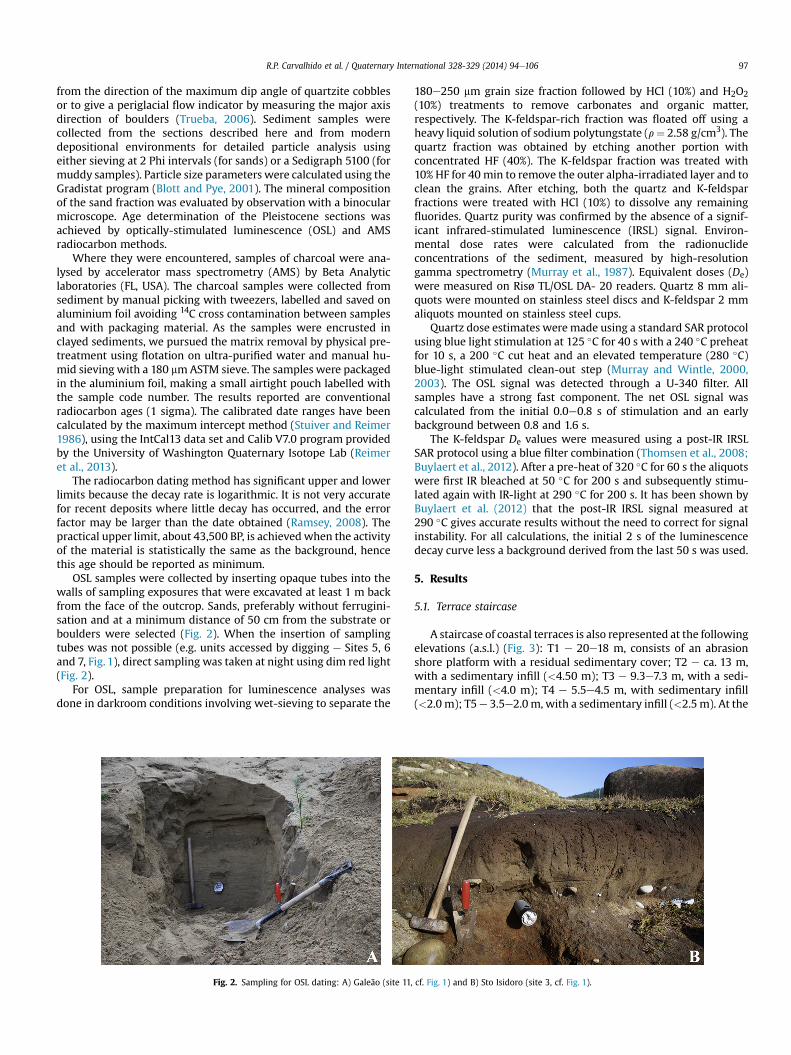
OSL samples were collected by inserting opaque tubes into thewalls of sampling exposures that were excavated at least 1 m backfrom the face of the outcrop. Sands, preferably without ferrugini-sation and at a minimum distance of 50 cm from the substrate orboulders were selected (Fig. 2). When the insertion of samplingtubes was not possible (e.g. units accessed by digging e Sites 5, 6and 7, Fig. 1), direct sampling was taken at night using dim red light(Fig. 2).
For OSL, sample preparation for luminescence analyses wasdone in darkroom conditions involving wet-sieving to separate the
Fig. 2. Sampling for OSL dating: A) Galeão (site 11,
180e250 mm grain size fraction followed by HCl (10%) and H2O2(10%) treatments to remove carbonates and organic matter,respectively. The K-feldspar-rich fraction was floated off using aheavy liquid solution of sodium polytungstate (r¼ 2.58 g/cm3). Thequartz fraction was obtained by etching another portion withconcentrated HF (40%). The K-feldspar fraction was treated with10% HF for 40 min to remove the outer alpha-irradiated layer and toclean the grains. After etching, both the quartz and K-feldsparfractions were treated with HCl (10%) to dissolve any remainingfluorides. Quartz purity was confirmed by the absence of a signif-icant infrared-stimulated luminescence (IRSL) signal. Environ-mental dose rates were calculated from the radionuclideconcentrations of the sediment, measured by high-resolutiongamma spectrometry (Murray et al., 1987). Equivalent doses (De)were measured on Risø TL/OSL DA- 20 readers. Quartz 8 mm ali-quots were mounted on stainless steel discs and K-feldspar 2 mmaliquots mounted on stainless steel cups.
Quartz dose estimates weremade using a standard SAR protocolusing blue light stimulation at 125 �C for 40 s with a 240 �C preheatfor 10 s, a 200 �C cut heat and an elevated temperature (280 �C)blue-light stimulated clean-out step (Murray and Wintle, 2000,2003). The OSL signal was detected through a U-340 filter. Allsamples have a strong fast component. The net OSL signal wascalculated from the initial 0.0e0.8 s of stimulation and an earlybackground between 0.8 and 1.6 s.
The K-feldspar De values were measured using a post-IR IRSLSAR protocol using a blue filter combination (Thomsen et al., 2008;Buylaert et al., 2012). After a pre-heat of 320 �C for 60 s the aliquotswere first IR bleached at 50 �C for 200 s and subsequently stimu-lated again with IR-light at 290 �C for 200 s. It has been shown byBuylaert et al. (2012) that the post-IR IRSL signal measured at290 �C gives accurate results without the need to correct for signalinstability. For all calculations, the initial 2 s of the luminescencedecay curve less a background derived from the last 50 s was used.
5. Results
5.1. Terrace staircase
A staircase of coastal terraces is also represented at the followingelevations (a.s.l.) (Fig. 3): T1 e 20e18 m, consists of an abrasionshore platform with a residual sedimentary cover; T2 e ca. 13 m,with a sedimentary infill (<4.50 m); T3 e 9.3e7.3 m, with a sedi-mentary infill (<4.0 m); T4 e 5.5e4.5 m, with sedimentary infill(<2.0 m); T5e 3.5e2.0m, with a sedimentary infill (<2.5m). At the
cf. Fig. 1) and B) Sto Isidoro (site 3, cf. Fig. 1).
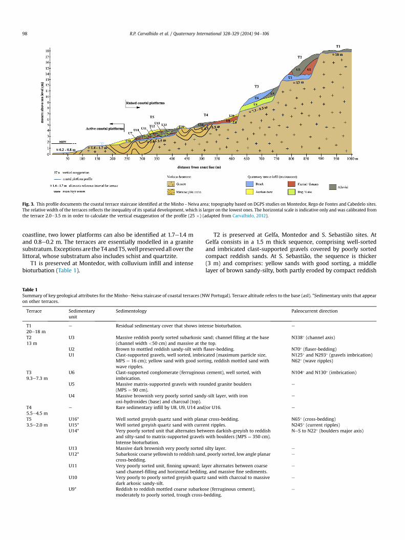
Fig. 3. This profile documents the coastal terrace staircase identified at the Minho - Neiva area; topography based on DGPS studies on Montedor, Rego de Fontes and Cabedelo sites.The relative width of the terraces reflects the inequality of its spatial development, which is larger on the lowest ones. The horizontal scale is indicative only and was calibrated fromthe terrace 2.0e3.5 m in order to calculate the vertical exaggeration of the profile (25 �) (adapted from Carvalhido, 2012).
R.P. Carvalhido et al. / Quaternary International 328-329 (2014) 94e10698
coastline, two lower platforms can also be identified at 1.7e1.4 mand 0.8e0.2 m. The terraces are essentially modelled in a granitesubstratum. Exceptions are the T4 andT5,well preservedall over thelittoral, whose substratum also includes schist and quartzite.
T1 is preserved at Montedor, with colluvium infill and intensebioturbation (Table 1).
Table 1Summary of key geological attributes for the MinhoeNeiva staircase of coastal terraces (Non other terraces.
Terrace Sedimentaryunit
Sedimentology
T120e18 m
e Residual sedimentary cover that shows int
T213 m
U3 Massive reddish poorly sorted subarkosic s(channel width <50 cm) and massive at th
U2 Brown to mottled reddish sandy-silt with fl
U1 Clast-supported gravels, well sorted, imbriMPS ¼ 16 cm); yellow sand with good sortwave ripples.
T39.3e7.3 m
U6 Clast-supported conglomerate (ferruginousimbrication.
U5 Massive matrix-supported gravels with rou(MPS ¼ 90 cm).
U4 Massive brownish very poorly sorted sandoxi-hydroxides (base) and charcoal (top).
T45.5e4.5 m
e Rare sedimentary infill by U8, U9, U14 and
T53.5e2.0 m
U16* Well sorted greyish quartz sand with planaU15* Well sorted greyish quartz sand with curreU14* Very poorly sorted unit that alternates betw
and silty-sand to matrix-supported gravelsIntense bioturbation.
U13 Massive dark brownish very poorly sortedU12* Subarkosic coarse yellowish to reddish sand
cross-bedding.U11 Very poorly sorted unit, finning upward; la
sand channel-filling and horizontal beddinU10 Very poorly to poorly sorted greyish quart
dark arkosic sandy-silt.U9* Reddish to reddish mottled coarse subarko
moderately to poorly sorted, trough cross-
T2 is preserved at Gelfa, Montedor and S. Sebastião sites. AtGelfa consists in a 1.5 m thick sequence, comprising well-sortedand imbricated clast-supported gravels covered by poorly sortedcompact reddish sands. At S. Sebastião, the sequence is thicker(3 m) and comprises: yellow sands with good sorting, a middlelayer of brown sandy-silty, both partly eroded by compact reddish
W Portugal). Terrace altitude refers to the base (asl). *Sedimentary units that appear
Paleocurrent direction
ense bioturbation. e
and; channel filling at the basee top.
N338� (channel axis)
aser-bedding. N70� (flaser-bedding)cated (maximum particle size,ing, reddish mottled sand with
N125� and N293� (gravels imbrication)N62� (wave ripples)
cement), well sorted, with N104� and N130� (imbrication)
nded granite boulders e
y-silt layer, with iron e
/or U16. e
r cross-bedding. N65� (cross-bedding)nt ripples. N245� (current ripples)een darkish-greyish to reddishwith boulders (MPS ¼ 350 cm).
NeS to N22� (boulders major axis)
silty layer. e
, poorly sorted, low angle planar e
yer alternates between coarseg, and massive fine sediments.
e
z sand with charcoal to massive e
se (ferruginous cement),bedding.
e
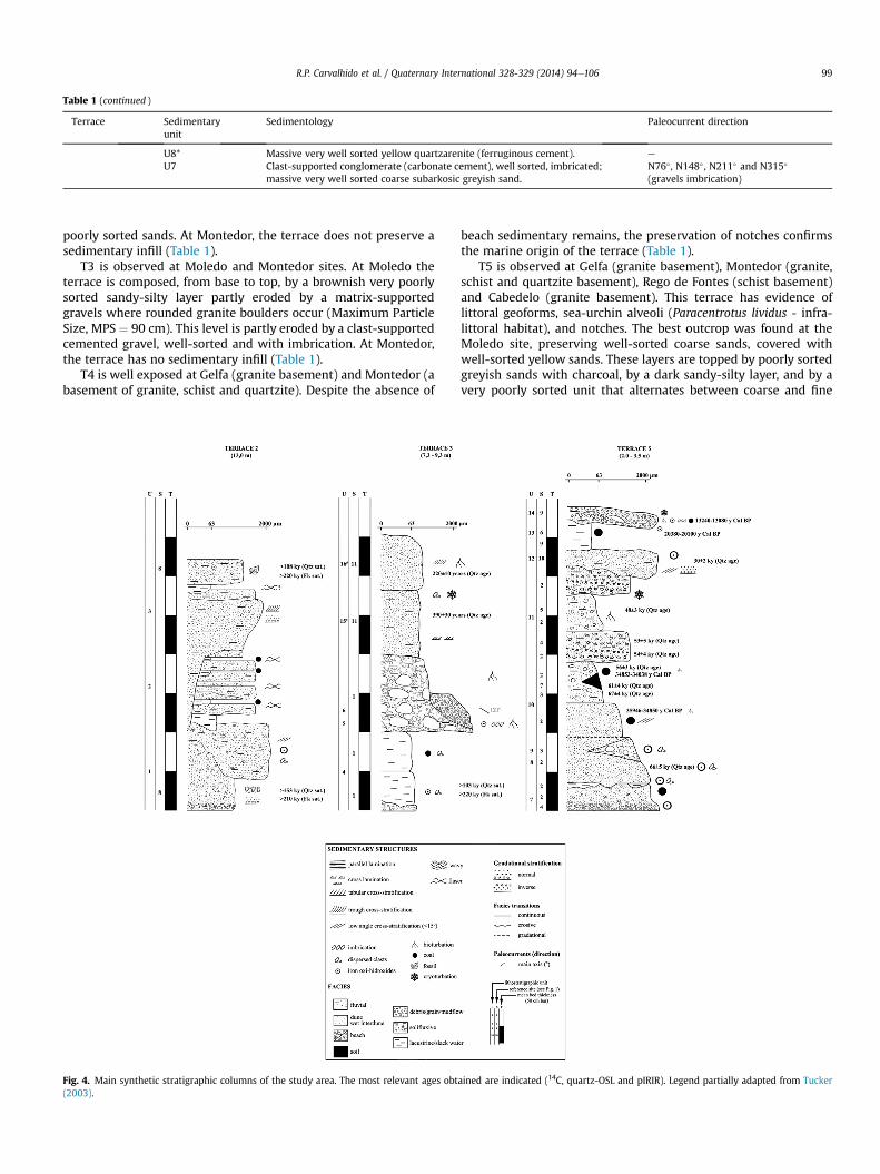
Table 1 (continued )
Terrace Sedimentaryunit
Sedimentology Paleocurrent direction
U8* Massive very well sorted yellow quartzarenite (ferruginous cement). e
U7 Clast-supported conglomerate (carbonate cement), well sorted, imbricated;massive very well sorted coarse subarkosic greyish sand.
N76� , N148� , N211� and N315�
(gravels imbrication)
R.P. Carvalhido et al. / Quaternary International 328-329 (2014) 94e106 99
poorly sorted sands. At Montedor, the terrace does not preserve asedimentary infill (Table 1).
T3 is observed at Moledo and Montedor sites. At Moledo theterrace is composed, from base to top, by a brownish very poorlysorted sandy-silty layer partly eroded by a matrix-supportedgravels where rounded granite boulders occur (Maximum ParticleSize, MPS ¼ 90 cm). This level is partly eroded by a clast-supportedcemented gravel, well-sorted and with imbrication. At Montedor,the terrace has no sedimentary infill (Table 1).
T4 is well exposed at Gelfa (granite basement) and Montedor (abasement of granite, schist and quartzite). Despite the absence of
Fig. 4. Main synthetic stratigraphic columns of the study area. The most relevant ages obt(2003).
beach sedimentary remains, the preservation of notches confirmsthe marine origin of the terrace (Table 1).
T5 is observed at Gelfa (granite basement), Montedor (granite,schist and quartzite basement), Rego de Fontes (schist basement)and Cabedelo (granite basement). This terrace has evidence oflittoral geoforms, sea-urchin alveoli (Paracentrotus lividus - infra-littoral habitat), and notches. The best outcrop was found at theMoledo site, preserving well-sorted coarse sands, covered withwell-sorted yellow sands. These layers are topped by poorly sortedgreyish sands with charcoal, by a dark sandy-silty layer, and by avery poorly sorted unit that alternates between coarse and fine
ained are indicated (14C, quartz-OSL and pIRIR). Legend partially adapted from Tucker
R.P. Carvalhido et al. / Quaternary International 328-329 (2014) 94e106100
sediments. Rego de Fontes and Montedor display the uppermostunit, a dark brownish very poorly sorted sandy-silty layer (Table 1).
A summary of the stratigraphy and sedimentary data of thestudied deposits is given by three main synthetic stratigraphiccolumns (Fig. 4). The thicknesses of the sedimentary units varyconsiderably, from 0.2e0.3 m to 1.5e2.0 m.
5.2. Numerical dating
For luminescence dating, fifteen sediment samples werecollected: (i) two samples from the T2 terrace, from the base (codePC5251) and top (code PC5252) of the terrace deposits (at the S.Sebastião site); (ii) one sample (code PC5253) from the T3 terrace(at the Estrada Real site); (ii) eight samples from the late Pleisto-ceneeHolocene cover unit (codes 102208, PC5243, PC5246,PC5247, PC5248, PC5249, PC5250 and PC5254), collected at severalsites; (iii) two samples from a historic fluvial-aeolian unit (codesPC5244, PC5245); (iv) two modern samples (codes 102209 and102210). The luminescence dating results are presented inTables 2e4.
Table 2Burial depth, radionuclide concentrations and water content used for dose rate calculati
Sampling site & number (Fig. 1) Field code Lab code Burialdepth (cm)
238U (Bq kg
Estrada Real1
MB2.1SES PC5253 330 96 � 9
S. Domingos2
MOL 0 PC5249 245 137 � 8MOL 170 PC5248 110 56 � 9
Sto. Isidoro3
VPA 2 PC5246 70 43 � 7
Forte do Cão4
GELFA 1.2 102208 100 37 � 6
Alcantilado de Montedor5
MALC52 PC5250 50 93 � 9
Cambôa do Marinheiro6
MD-50 PC5247 50 44 � 7
Canto Marinho7
CM105 PC5243 100 40 � 7
S. Sebastião8
CP1 PC5251 400 45 � 6CP5 PC5252 280 75 � 10
Rego de Fontes9
PNB1 PC5254 140 51 � 7
Galeão10
GAL50.1 PC5245 350 37 � 8GAL100 PC5244 50 28 � 8
Cabedelo11
RIC-PRAIA 102209 30 34 � 6RIC-DUNA 102210 30 32 � 6
Table 3Summary of quartz optically stimulated luminescence. *Natural signals were in saturatio
Sampling site &number (Fig. 1)
Field code Lab code Geographiccoordinates
Sedimentary facies Plataltit
Estrada Real1
MB2.1SES PC5253 41�50030.7500N8�52015.4900W
Silty sand, palustrine 8
S. Domingos2
MOL 0 PC5249 41�5001.4200N8�52030.3200W
Aeolian sand 3MOL 170 PC5248 Silty sand, fluvial 3
Sto. Isidoro3
VPA 2 PC5246 41�49042.3300N8�52030.8700W
Sandy silt, wet interdune 2
Forte do Cão4
GELFA 1.2 102208 41�47047.2500N8�52015.2600W
Sandy silt, fluvial 13
Alcantiladode Montedor
5
MALC52 PC5250 41�44058.8200N8�52046.7400W
Sandy silt, palustrine 2
Cambôado Marinheiro
6
MD-50 PC5247 41�44044.9500N8�52037.2000W
Wet interdune sand 2
CM105 PC5243 Muddy sand, fluvial 2
There is some evidence that quartz OSL gives accurate resultsup to 150e200 Gy (e.g. Murray and Funder, 2003; Murray et al.,2007). Beyond this dose limit the reliability of quartz equivalentdoses is questionable. The samples with quartz De values>>200 Gy were dated using the pIRIR290 SAR protocol. However,the pIRIR290 signal was also very close to saturation. Hence, weestimated the dose at 86% of the saturation level of the doseresponse curve and the resulting ages are considered minimumvalues (>220 ka).
The subunits identified on the late PleistoceneeHolocene coverunit (covering basement slopes and the T4 and T5 terraces) weredated (quartz-OSL ages and AMS 14C ages from charcoal samples eTable 5): stream deposits and aeolian dune sands dated ca. 67e61 ka; sandy-silt to silty colluvium deposits were dated to 56e13 ka. Samples from Galeão (site 10, Fig. 1) with ages 0.22 � 0.01 kaand 0.39 � 0.03 ka, refer to historic fluvio-aeolian sediments thatcorrelate with the Little Ice Age climatic event. These sedimentswere sampled at Vila Fria Surface (w50 m a.s.l.) and Faro de AnhaSurface (w100 m a.s.l.) but the sub-unit can also be found at higherand lower altitudes.
on of the luminescence samples.
�1) 226Ra (Bq kg�1) 232Th (Bq kg�1) 40K (Bq kg�1) Water content(field, saturation) (%)
85 � 1 64 � 1 841 � 16 13 (13, 30)
49 � 1 21 � 1 549 � 12 16 (16, 24)39 � 1 33 � 1 1126 � 22 13 (13, 32)34 � 1 23 � 1 811 � 18 12 (11, 28)
44 � 1 64 � 1 391 � 10 12 (12, 44)
65 � 1 73 � 1 652 � 15 10 (6, 26)
50 � 1 55 � 1 544 � 13 10 (10, 27)
35 � 1 47 � 1 640 � 16 8 (6, 25)
40 � 1 37 � 1 620 � 14 25 (37, 42)67 � 1 52 � 1 672 � 15 13 (13, 25)36 � 1 37 � 1 917 � 18 5 (3, 22)
38 � 1 45 � 1 512 � 12 6 (6, 27)21 � 1 25 � 1 562 � 14 6 (6, 24)29 � 1 37 � 1 558 � 11 10 (4, 25)36 � 1 51 � 1 603 � 11 8 (4, 28)
n (i.e. >86% of the saturation level of the dose response curve).
formude (m)
Terrace topaltitude (m)
Samplealtitude(m)
Quartz doserate (Gy/ky)
Quartzequivalentdose (Gy)
Quartzage (ky)
ProbableMIS age
.4 12.3 9.0 4.72 � 0.21 485 � 114* >103 � 25 7 (?)
.0 3.75 6.2 2.95 � 0.13 194 � 10 66 � 5 4
.0 6.2 5.1 4.45 � 0.19 239 � 12 54 � 4 3
.0 3.4 2.7 3.37 � 0.14 226 � 9 67 � 4 4
14.5 13.5 3.06 � 0.13 163 � 13 53 � 5 3
.7 4.5 4.0 4.34 � 0.19 209 � 10 48 � 3 3
.6 3.9 3.4 3.39 � 0.15 190 � 4 56 � 3 3
.0 3.2 2.2 3.49 � 0.15 212 � 8 61 � 4 3/4
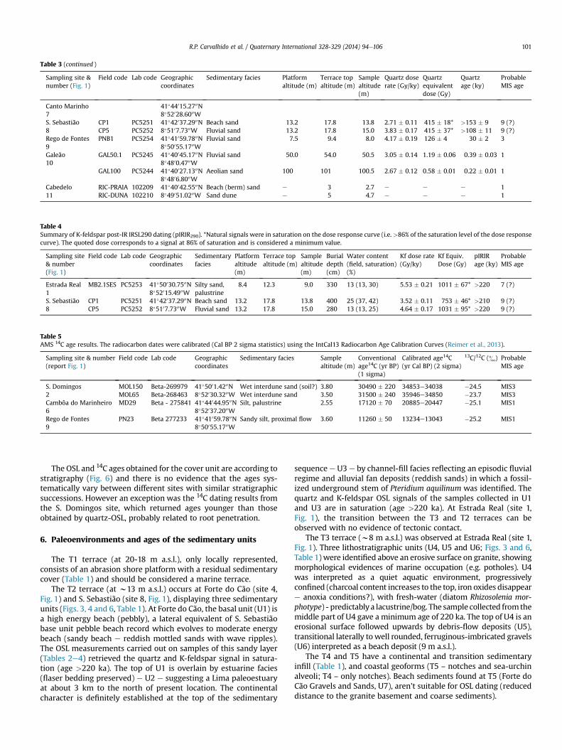
Table 3 (continued )
Sampling site &number (Fig. 1)
Field code Lab code Geographiccoordinates
Sedimentary facies Platformaltitude (m)
Terrace topaltitude (m)
Samplealtitude(m)
Quartz doserate (Gy/ky)
Quartzequivalentdose (Gy)
Quartzage (ky)
ProbableMIS age
Canto Marinho7
41�44015.2700N8�52028.6000W
S. Sebastião8
CP1 PC5251 41�42037.2900N8�5107.7300W
Beach sand 13.2 17.8 13.8 2.71 � 0.11 415 � 18* >153 � 9 9 (?)CP5 PC5252 Fluvial sand 13.2 17.8 15.0 3.83 � 0.17 415 � 37* >108 � 11 9 (?)
Rego de Fontes9
PNB1 PC5254 41�41059.7800N8�50055.1700W
Fluvial sand 7.5 9.4 8.0 4.17 � 0.19 126 � 4 30 � 2 3
Galeão10
GAL50.1 PC5245 41�40045.1700N8�4800.4700W
Fluvial sand 50.0 54.0 50.5 3.05 � 0.14 1.19 � 0.06 0.39 � 0.03 1
GAL100 PC5244 41�40027.1300N8�4806.8000W
Aeolian sand 100 101 100.5 2.67 � 0.12 0.58 � 0.01 0.22 � 0.01 1
Cabedelo11
RIC-PRAIA 102209 41�40042.5500N8�49051.0200W
Beach (berm) sand e 3 2.7 e e e 1RIC-DUNA 102210 Sand dune e 5 4.7 e e e 1
Table 4Summary of K-feldspar post-IR IRSL290 dating (pIRIR290). *Natural signals were in saturation on the dose response curve (i.e. >86% of the saturation level of the dose responsecurve). The quoted dose corresponds to a signal at 86% of saturation and is considered a minimum value.
Sampling site& number(Fig. 1)
Field code Lab code Geographiccoordinates
Sedimentaryfacies
Platformaltitude(m)
Terrace topaltitude (m)
Samplealtitude(m)
Burialdepth(cm)
Water content(field, saturation)(%)
Kf dose rate(Gy/ky)
Kf Equiv.Dose (Gy)
pIRIRage (ky)
ProbableMIS age
Estrada Real1
MB2.1SES PC5253 41�50030.7500N8�52015.4900W
Silty sand,palustrine
8.4 12.3 9.0 330 13 (13, 30) 5.53 � 0.21 1011 � 67* >220 7 (?)
S. Sebastião8
CP1 PC5251 41�42037.2900N8�5107.7300W
Beach sand 13.2 17.8 13.8 400 25 (37, 42) 3.52 � 0.11 753 � 46* >210 9 (?)CP5 PC5252 Fluvial sand 13.2 17.8 15.0 280 13 (13, 25) 4.64 � 0.17 1031 � 95* >220 9 (?)
Table 5AMS 14C age results. The radiocarbon dates were calibrated (Cal BP 2 sigma statistics) using the IntCal13 Radiocarbon Age Calibration Curves (Reimer et al., 2013).
Sampling site & number(report Fig. 1)
Field code Lab code Geographiccoordinates
Sedimentary facies Samplealtitude (m)
Conventionalage14C (yr BP)(1 sigma)
Calibrated age14C(yr Cal BP) (2 sigma)
13C/12C (&) ProbableMIS age
S. Domingos2
MOL150 Beta-269979 41�5001.4200N8�52030.3200W
Wet interdune sand (soil?) 3.80 30490 � 220 34853e34038 �24.5 MIS3MOL65 Beta-268463 Wet interdune sand 3.50 31500 � 240 35946e34850 �23.7 MIS3
Cambôa do Marinheiro6
MD29 Beta - 275841 41�44044.9500N8�52037.2000W
Silt, palustrine 2.55 17120 � 70 20885e20447 �25.1 MIS1
Rego de Fontes9
PN23 Beta 277233 41�41059.7800N8�50055.1700W
Sandy silt, proximal flow 3.60 11260 � 50 13234e13043 �25.2 MIS1
R.P. Carvalhido et al. / Quaternary International 328-329 (2014) 94e106 101
The OSL and 14C ages obtained for the cover unit are according tostratigraphy (Fig. 6) and there is no evidence that the ages sys-tematically vary between different sites with similar stratigraphicsuccessions. However an exception was the 14C dating results fromthe S. Domingos site, which returned ages younger than thoseobtained by quartz-OSL, probably related to root penetration.
6. Paleoenvironments and ages of the sedimentary units
The T1 terrace (at 20-18 m a.s.l.), only locally represented,consists of an abrasion shore platform with a residual sedimentarycover (Table 1) and should be considered a marine terrace.
The T2 terrace (at w13 m a.s.l.) occurs at Forte do Cão (site 4,Fig. 1) and S. Sebastião (site 8, Fig. 1), displaying three sedimentaryunits (Figs. 3, 4 and 6, Table 1). At Forte do Cão, the basal unit (U1) isa high energy beach (pebbly), a lateral equivalent of S. Sebastiãobase unit pebble beach record which evolves to moderate energybeach (sandy beach e reddish mottled sands with wave ripples).The OSL measurements carried out on samples of this sandy layer(Tables 2e4) retrieved the quartz and K-feldspar signal in satura-tion (age >220 ka). The top of U1 is overlain by estuarine facies(flaser bedding preserved) e U2 e suggesting a Lima paleoestuaryat about 3 km to the north of present location. The continentalcharacter is definitely established at the top of the sedimentary
sequence e U3 e by channel-fill facies reflecting an episodic fluvialregime and alluvial fan deposits (reddish sands) in which a fossil-ized underground stem of Pteridium aquilinum was identified. Thequartz and K-feldspar OSL signals of the samples collected in U1and U3 are in saturation (age >220 ka). At Estrada Real (site 1,Fig. 1), the transition between the T3 and T2 terraces can beobserved with no evidence of tectonic contact.
The T3 terrace (w8 m a.s.l.) was observed at Estrada Real (site 1,Fig. 1). Three lithostratigraphic units (U4, U5 and U6; Figs. 3 and 6,Table 1) were identified above an erosive surface on granite, showingmorphological evidences of marine occupation (e.g. potholes). U4was interpreted as a quiet aquatic environment, progressivelyconfined (charcoal content increases to the top, iron oxides disappeare anoxia conditions?), with fresh-water (diatom Rhizosolenia mor-photype) - predictablya lacustrine/bog. The sample collected fromthemiddle part of U4 gave a minimum age of 220 ka. The top of U4 is anerosional surface followed upwards by debris-flow deposits (U5),transitional laterally towell rounded, ferruginous-imbricated gravels(U6) interpreted as a beach deposit (9 m a.s.l.).
The T4 and T5 have a continental and transition sedimentaryinfill (Table 1), and coastal geoforms (T5 – notches and sea-urchinalveoli; T4 – only notches). Beach sediments found at T5 (Forte doCão Gravels and Sands, U7), aren't suitable for OSL dating (reduceddistance to the granite basement and coarse sediments).
R.P. Carvalhido et al. / Quaternary International 328-329 (2014) 94e106102
The youngest deposits (unit U9 to U16) cover mostly the T5 butrarely the T4 terrace platforms. Most dated layers cover the T5terrace and provide ages between 67 � 4 ka (OSL) (MIS4) and 13 kaCal BP (14C) (MIS2). The deposits that cover the T4 terrace aremainly gravity-dependent, such as aeolian dune deposits (Ronca deMontedor Sands, U8) and alluvial deposits (S. Domingos UpperSands, U11):
a) The Ronca de Montedor Sands (U8) and the Sto Isidoro Sands(U9) are ferruginous-cemented sands indicating warm sub-humid to arid environments that could have a probable ageof ca. 70e65 ka (possibly recording warm pulses observedduring MIS4; see NGRIP, 2004 or Desprat et al., 2005),consistent with aeolian dunes (U8) and fluvial (U9)environments;
b) The S. Domingos Sands and Silts (U10), the S. DomingosUpper Sands (U11) and the Ribeira de Portela Sands (U12)provided ages between 67 � 4 and 30 � 2 ka (MIS3). Theseunits show a progressive reduction of indirect marine influ-ence e wet interdune/interdune ponds (U10), grain-flow/mud-flows (cyclic) (U11) and fluvial deposits (U12). Deposi-tional conditions are marked by the availability of water,with increased energy towards the upper units. The S.Domingos Sands and Silts (U10) and the Ribeira de PortelaSands (U12) reveal climatic conditions favourable to eda-phogenesis (U10) and fluvial drainage reestablishment(U12), which may have occurred betweenz 32 andz 28 ka.This evidence agrees with Granja et al. (2008), who reportedsuccessions of small fluvial systems progressively covered bywet aeolian accumulations during the first half of MIS 3.Pérez-Alberti et al. (2009) described paleosols on the Gali-cian coast, dated between z 32 and z 25 ka. The radio-carbon dating on U10 was performed on charcoal samples(circular section, diameter up to 20 mm) retrieving youngerages than those provided by OSL dating obtained from thetop layer sequence (U11). Considering that U12 has a similarage and presents fluvial facies, we suggest the possibility thatthe charcoal is a plant rootlet intrusion related to an eda-phogenesis phase (DansgaardeOeschger event 7) prior to theonset of Heinrich Event 3 (H3) (c.f. Fig. 5a/5f);
c) Cambôa do Marinheiro Silts (U13) has been radiocarbondated between 20 and 13 ka cal BP (14C) (MIS2), indicatingsedimentary processes depending on liquid water scarcitydrainage. These processes relates to the installation andprogression of cold conditions arising from the last glacia-tion. The diffuse drainage conditions installed could havecontributed to the formation of highly confined lacustrinebodies, with marshy or boggy character, in shallow coastaldepressions of the Littoral Platform;
d) Rego de Fontes Gravels and Sands (U14) dated <13 ka cal BP(MIS2 and MIS1), match depositional paleoenvironmentsshowing some facies variability linked to fluctuation of wateravailability, responsible for poorly sorted deposits that variesbetween coarser - torrential regimes (grain-flow to debris-flow deposits) and fine grained - solifluction processes.
The historic units, Ribeira de Areia Sands (U15) and GaleãoSands (U16), have been dated from the late XVI century and the endof the XVIII century. Based on the s18O signal, these layers areassigned to the Little Ice Age climate crisis:
a) The U15 dated between 1590 and 1650 records the wateravailability typical of climate conditions that immediately pre-ceded the Maunder Minimum (Little Ice Age), matching fluvialsedimentation on the Ribeira da Areia stream. The top of this
unit shows evidence of cryoturbation, overlain by dune sands(U16). The cryoturbation was diagnosed by identification ofinvoluted 3A layers, interpreted as seasonally frozen ground orpermafrost (Vandenberghe classification e Vandenberghe,1988, 1992), with granite cryoclasts;
b) U16 records the Little Ice Age, matching cool and dry weatherconditions reflected in intense aeolian dynamics. This unit isassigned to a coastal aeolian dune environment during theDalton Minimum, between the early XVII century and the lateXIX century (zbetween 1780 and 1800) that promoted thedeposition of aeolian sands covering coastal terraces (Abreu,1987), Vila Fria Surface (w50 m a.s.l.), Faro de Anha Surface(w100 m a.s.l.) and Além do Rio Surface (w160 m a.s.l.).
Due to the fact that the beach unit (U7) that covers the T5terrace is not suitable for OSL dating and because the OSL samplescollected at the T3 and T2 marine terraces only provided a mini-mum age of 220 ka, precise numerical dating of the studied marineterraces was not achieved. Correlation between themarine terracesand Marine Isotopic Stages requires further substantiation, pre-sented in the following paragraphs.
The T5 and T4 shore platforms (at 2.0 - 3.5 m and 4.5e5.5 ma.s.l., respectively) correspond to MIS5 due to the geomorphic po-sition directly above the modern littoral and the presence of agravelly beach unit (U7) covered by aeolian dune deposits (U8)dated ca. 67 ka. The two platforms could represent a similar situ-ation as with contemporaneous shore platforms (mesotidalexposed Atlantic coast - inter-tidal platform at 0.2e0.8 m and high-tide platform at 1.4e1.7 m a.s.l.).
The T3 terrace might be ascribed to MIS7 because the shoreplatform could correlate with the high sea-level during 245e230 ka. The above lacustrine/bog unit (U4) could represent somesea level lower conditions during 230e220 ka (OSL minimum ageof 220 ka) and the upper beach unit (U6) as recording the high sea-level during 220e190 ka. This matches the peculiarity of MIS7 thathas two climatic optimums, MIS7.5 and MIS7.3, with similarinterstadial conditions. Between these optimums, climate degra-dation is observed (stadial conditions e MIS7.4), matching the bog(U4) and debris-flow (U5) deposits.
Based on the previous interpretations, the T2 and T1 marineterraces could correspond to MIS9 and MIS11 respectively, whichhave high sea level stands at ca. 325 ka and 400 ka, respectively. Thegeomorphic data available show no evidence of tectonic displace-ment between coastal platforms. The sedimentary units of thenorthern littoral of Portugal allowed insight about the Pleistocenepaleoenvironments (Fig. 6).
7. Neotectonics
The staircase of coastal terraces (shore platforms and sedimentspreserved) show no significant differences in the associated pale-oenvironments and vertical deformation since MIS5 (Eemian) inthe NW Iberian coast, between theMinhoeNeiva sector (this study)and the Minho-Cape Silleiro (Galicia, Spain) sector. Alonso andPagés (2000, 2007) noted four formations at the Galician coast:Castro de Fazouro Fm. (MIS5), interpreted as beach deposits restingon an abrasion shore platform 2e3 m (a.s.l.); Arnela Fm. and NóisFm. (MIS4eMIS3), correspond to classical slope deposits (soli-flucted lobes, debris flows and soils, but also peat and swamp de-posits); and Moreiras Fm. (MIS2) that represents environmentsfrom at least the Last Glacial Maximum and the beginning ofdeglaciation.
For the same time interval, the paleoenvironmental data avail-able at the southern adjacent coastal sector (Neiva-Aveiro sector)(e.g. Granja, 1990; Granja and Carvalho, 1991, 1992, 1993, 1995;
Fig. 5. Consistency between OSL ages, related sedimentary facies (middle Pleistocene to Holocene coastal units) and high-resolution stable isotope records from deep-sea core ofNorthwestern Iberia Margin, at Galician latitude (adapted from Desprat et al., 2005). For reference sample (e and f) see Tables 3e5. Radiocarbon ages are calibrated (Cal BP) using theIntCal13 Radiocarbon Age Calibration Curves (Reimer et al., 2013). All radiocarbon ages were converted in order to be comparable with OSL ages.
R.P. Carvalhido et al. / Quaternary International 328-329 (2014) 94e106 103
Carvalho et al., 1995; Granja and Groot, 1996; Granja et al., 1996,2008; Groot and Granja, 1998; Thomas et al., 2008) show impor-tant differences. Three litostratigraphic units preserved in thehigher shore platform (20e55 m a.s.l.) are described as beach en-vironments (MIS5) e Pinhote Conglomerate, Outeiro Conglomerateand Gatinheira-Góis Sands; and two formations in the lower shoreplatform (2e10 m a.s.l.) e Cepães Fm. (MIS3) described as beach/fluvial deposits, and the Aguçadoura Fm. as dune, beach and lagoondeposits (MIS1).
Based on the similarities found on paleoenviroments assigned toeach coastal terrace at Galicia and Minho, we propose that theBaiona-Minho (Galicia) and theMinhoeNeiva coastal areas acted asone tectonic block (Baiona-Neiva block), showing coeval neo-tectonic behaviour at least since MIS5. The remarkable differencesfound to southern adjacent area concerning the paleoenvironmentsand topography, in relation to the southern adjacent area, suggestdifferent neotectonics.
Using as geomorphic references the old planation surfaces, it issuggested that the S2andS3blockswereuplifted, controlledbyNWe
SE/NNWeSSE faults and a broad relief raising since the genesis of S4modelling (Carvalhido, 2012; Fig. 1). The geomorphological, strati-graphical, and dating data clarified the relive evolution of the coastalterrace staircase fromMiddle Pleistocene to Holocene. Assuming theproposed correlation between the marine terraces and MIS (T4 andT5eMIS5; T3eMIS7; T2eMIS9; T1eMIS11?), the average rate ofvertical deformation has been calculated as ca. þ0.05 mm/y (linearregression method, R2 >95%) for the last 400 ka. This agrees withCabral (1995) who estimated Piacenzian-Quaternary maximumvertical deformation to this sector of Portuguese littoral, as between0.03 and 0.05 mm/y. The partial vertical deformation has beendetermined for each coastal platformmodelling (matching techniquee Lajoie, 1986), ranging between �0.15 mm/y (MIS9 e MIS7.5)and þ0.26 mm/y (MIS6eMIS5e) (Carvalhido, 2012).
8. Conclusions
On the coastal zone of northern Portugal, a staircase of fiveterraces (abrasion shore platforms) was identified at the heights
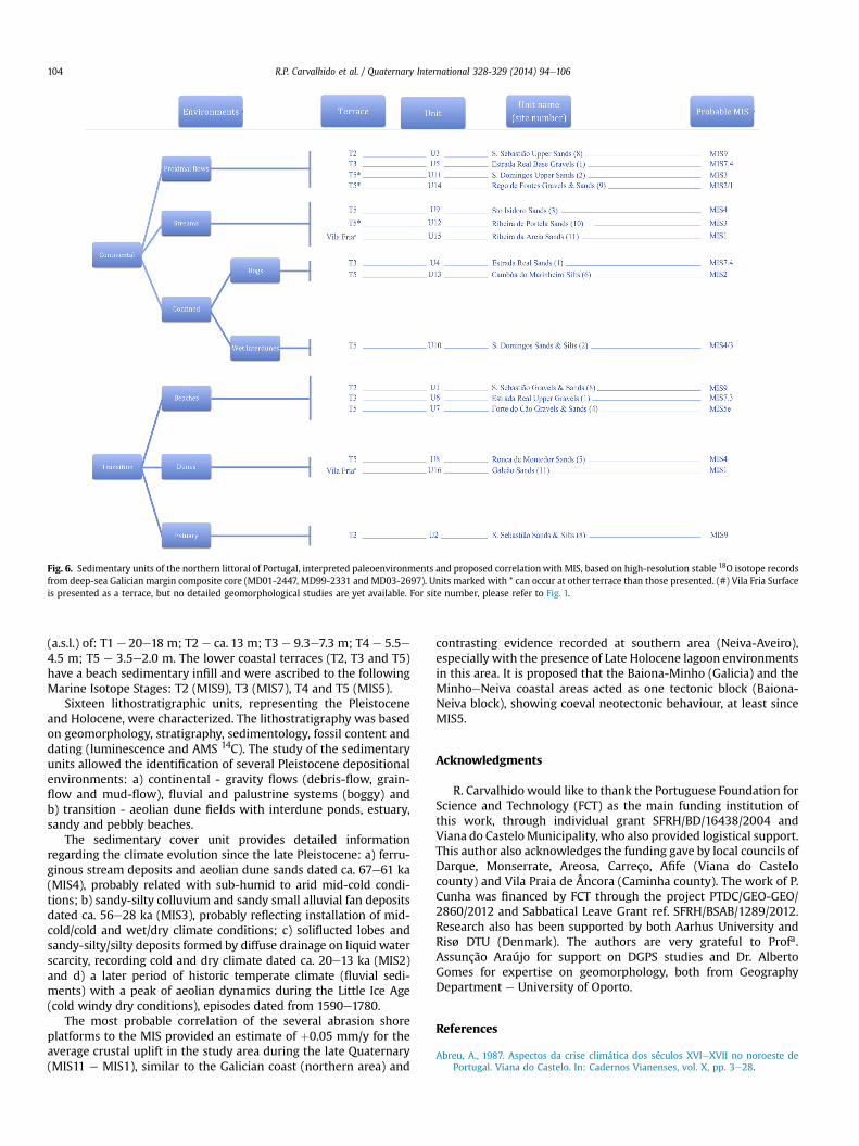
Fig. 6. Sedimentary units of the northern littoral of Portugal, interpreted paleoenvironments and proposed correlation with MIS, based on high-resolution stable 18O isotope recordsfrom deep-sea Galician margin composite core (MD01-2447, MD99-2331 and MD03-2697). Units marked with * can occur at other terrace than those presented. (#) Vila Fria Surfaceis presented as a terrace, but no detailed geomorphological studies are yet available. For site number, please refer to Fig. 1.
R.P. Carvalhido et al. / Quaternary International 328-329 (2014) 94e106104
(a.s.l.) of: T1 e 20e18 m; T2 e ca. 13 m; T3 e 9.3e7.3 m; T4 e 5.5e4.5 m; T5 e 3.5e2.0 m. The lower coastal terraces (T2, T3 and T5)have a beach sedimentary infill and were ascribed to the followingMarine Isotope Stages: T2 (MIS9), T3 (MIS7), T4 and T5 (MIS5).
Sixteen lithostratigraphic units, representing the Pleistoceneand Holocene, were characterized. The lithostratigraphy was basedon geomorphology, stratigraphy, sedimentology, fossil content anddating (luminescence and AMS 14C). The study of the sedimentaryunits allowed the identification of several Pleistocene depositionalenvironments: a) continental - gravity flows (debris-flow, grain-flow and mud-flow), fluvial and palustrine systems (boggy) andb) transition - aeolian dune fields with interdune ponds, estuary,sandy and pebbly beaches.
The sedimentary cover unit provides detailed informationregarding the climate evolution since the late Pleistocene: a) ferru-ginous stream deposits and aeolian dune sands dated ca. 67e61 ka(MIS4), probably related with sub-humid to arid mid-cold condi-tions; b) sandy-silty colluvium and sandy small alluvial fan depositsdated ca. 56e28 ka (MIS3), probably reflecting installation of mid-cold/cold and wet/dry climate conditions; c) soliflucted lobes andsandy-silty/silty deposits formed by diffuse drainage on liquid waterscarcity, recording cold and dry climate dated ca. 20e13 ka (MIS2)and d) a later period of historic temperate climate (fluvial sedi-ments) with a peak of aeolian dynamics during the Little Ice Age(cold windy dry conditions), episodes dated from 1590e1780.
The most probable correlation of the several abrasion shoreplatforms to the MIS provided an estimate of þ0.05 mm/y for theaverage crustal uplift in the study area during the late Quaternary(MIS11 e MIS1), similar to the Galician coast (northern area) and
contrasting evidence recorded at southern area (Neiva-Aveiro),especially with the presence of Late Holocene lagoon environmentsin this area. It is proposed that the Baiona-Minho (Galicia) and theMinhoeNeiva coastal areas acted as one tectonic block (Baiona-Neiva block), showing coeval neotectonic behaviour, at least sinceMIS5.
Acknowledgments
R. Carvalhido would like to thank the Portuguese Foundation forScience and Technology (FCT) as the main funding institution ofthis work, through individual grant SFRH/BD/16438/2004 andViana do CasteloMunicipality, who also provided logistical support.This author also acknowledges the funding gave by local councils ofDarque, Monserrate, Areosa, Carreço, Afife (Viana do Castelocounty) and Vila Praia de Âncora (Caminha county). The work of P.Cunha was financed by FCT through the project PTDC/GEO-GEO/2860/2012 and Sabbatical Leave Grant ref. SFRH/BSAB/1289/2012.Research also has been supported by both Aarhus University andRisø DTU (Denmark). The authors are very grateful to Profa.Assunção Araújo for support on DGPS studies and Dr. AlbertoGomes for expertise on geomorphology, both from GeographyDepartment e University of Oporto.
References
Abreu, A., 1987. Aspectos da crise climática dos séculos XVIeXVII no noroeste dePortugal. Viana do Castelo. In: Cadernos Vianenses, vol. X, pp. 3e28.
R.P. Carvalhido et al. / Quaternary International 328-329 (2014) 94e106 105
Alonso, A., Pagés, J.L., 2000. El registro sedimentario del final del Cuaternario en ellitoral noroeste de la Península Ibérica. Márgenes cantábrico y atlántico. Revistade la Sociedad Geológica de España 23 (1), 17e29.
Alonso, A., Pagés, J.L., 2007. Stratigraphy of Late Pleistocene coastal deposits innorthern Spain. Journal of Iberian Geology 33 (2), 207e220.
Alves, M.I., 1989. Aspectos mineralógicos da meteorização de xistos silúricos daregião minhota (NW dc Portugal), vol. 4. Geociências, Rev. Univ. Aveiro,pp. 107e122, 2.
Alves, M.I., 1995. Materiais Plio-Quaternários do Alto Minho. Produtos de meteor-ização e depósitos fluviais na bacia do rio Lima e região de Alvarães. Tese deDoutoramento. Univ. Minho, p. 277.
Alves, A.M.C., 1996. Causas e Processos da Dinâmica Sedimentar na Evolução Actualdo Litoral do Alto Minho. Tese de Doutoramento. Univ. Minho, p. 438.
Andeweg, B., 2002. Cenozoic Tectonic Evolution of the Iberian Peninsula, the Effectsand Causes of Changing Stress Fields. Vrije Universiteit, Amsterdam.
Araújo, M.A., 2001. Marine platforms from Oporto area (NW Portugal): tectonicsversus eustasy. In: Actas da V Reunião do Quaternário Ibérico, GTPEQ e AEQUA,Lisboa, pp. 178e181.
Araújo, M.A., 2004. O litoral norte de Portugal e os depósitos cenozóicos da regiãodo Porto: a tectónica e o eustatismo. In: Processos geomorfológicos y evolucióncostera, vol. 152. Publicacións da Universidade de Santiago de Compostela,pp. 271e293.
Araújo, M.A., 2005. Porto Littoral: the Influence of Tectonics in Seal Level Changesand Coastal Morphology. Seminário Sea Level Changes, pp. 29e33. Abstractsbook, Porto.
Araújo, M.A., 2008. Depósitos do Pleistocénico superior e do Holocénico na plata-forma litoral da região do Porto: a morfologia das plataformas de erosãomarinha e a tectónica recente. In: Estudos do Quaternário, vol. 5. APEQ, Braga,pp. 17e30.
Araújo, M.A., Gomes, A., 2009. The use of the GPS in the identification of fossil shoreplatforms and its tectonic deformation: an example from the Northern Portu-guese coast. Journal of Coastal Research SI 56 (Proceedings of the 10th Inter-national Coastal Symposium). Lisbon, Portugal.
Araújo, M.A., Gomes, A., Chaminé, H., Fonseca, P.E., Gama Pereira, L., Pinto deJesus, A., 2003. Geomorfologia e Geologia Regional do Sector de Porto-Espinho(W de Portugal). Implicações morfoestruturais na Cobertura Sedimentar Cen-ozóica, vol. 28. Cadernos do Laboratório Xeolóxico de Laxe, Coruña, pp. 79e105.
Benedetti, M.M., Haws, J.A., Funk, C., Daniels, J.M., Hesp, P.A., Bicho, N.F.,Minckley, T.A., Ellwood, B.B., Forman, S.L., 2009. Late Pleistocene raised beachesof coastal Estremadura, central Portugal. Quaternary Science Reviews 28, 3437e3447.
Berthois, L., 1949. Contribution à l’étude des limons de la région Nord du Portugal.In: Com. Serv. Geol. de Portugal, T, vol. XXIX, pp. 121e176. Lisboa.
Blanco Chao, R., Costa-Casais, M., Martínez Cortizas, A., Pérez-Alberti, A.,Threinhale, S., 2003. Evolution and inheritance of a rock coast: western Galicia,Northwestern Spain. Earth Surface Processes and Landforms 28, 757e775.
Blanco-Chao, R., Costa-Casais, M., Martinez Cortizas, A., Pérez-Alberti, A., VazquezPaz, M., 2002. Holocene evolution on Galician coast (NW Spain): an example ofparaglacial dynamics. Quaternary International 93e94, 149e159.
Blanco-Chao, R., Pérez-Alberti, A., Trenhaile, A., Costa-Casais, M., Valcarcel-Diaz, M.,2007. Shore platform abrasion in a para-periglacial environment, Galicia,northwestern Spain. Geomorphology 83, 136e151.
Blott, S.J., Pye, K., 2001. GRADISTAT: a grain size distribution and statistics packagefor the analysis of unconsolidated sediments. Earth Surface Processes andLandforms 26, 1237e1248.
Buylaert, J.-P., Jain, M., Murray, A.S., Thomsen, K.J., Thiel, C., Sohbati, R., 2012.A robust feldspar luminescence dating method for Middle and Late Pleistocenesediments. Boreas 41, 435e451.
Cabral, J., 1993. Neotectónica de Portugal Continental. Tese de Doutoramento.Departamento de Geologia, Universidade de Lisboa, p. 435.
Cabral, J., 1995. Neotectónica em Portugal Continental, vol. 31. Memórias Inst. Geol.Mineiro, p. 265.
Cabral, J., Ribeiro, A., 1988. Carta Neotectónica de Portugal Continental, Esc. 1:1 000000. Geological Survey of Portugal, Lisboa.
Carvalhido, R., 2012. O Litoral Norte de Portugal (MinhoeNeiva): evolução paleo-ambiental quaternária e proposta de conservação do património geo-morfológico. Tese de Doutoramento. Universidade do Minho, p. 561.
Carvalho, G.S., 1983. Consequências do frio durante o Quaternário na faixa litoral doMinho (Portugal), vol. 5. Cuad. Lab. Xeolóxico Laxe, A Coruña, pp. 365e380.
Carvalho, G.S., 1985. Novos índices de ambiente periglaciar no litoral do Minho. In:Actas I Reunião do Quaternário Ibérico, vol. I, pp. 27e36 (Lisboa).
Carvalho, G.S., Granja, H.M., 1997. Terraços versus litostratigrafia e geocronologia doPlistocénico e do Holocénico da zona costeira do Minho (Portugal). Estudos doQuaternário n� 1. Edições Colibri, Braga, pp. 25e40.
Carvalho, G.S., Granja, H.M., 2003. As mudanças da zona costeira pela interpretaçãodos sedimentos plistocénicos e holocénicos (metodologia aplicada à zonacosteira do noroeste de Portugal). Revista da Faculdade de Letras e Geografia, ISérie 19, 225e236 (Porto).
Carvalho, G.S., Granja, H.M., Senos Matias, M., Moura, R., 1995. Prospecção geofísicae indicadores de neotectónica na zona costeira do noroeste de Portugal, a nortedo Furadouro. Memorias do Museu e Laboratório Mineralógico e Geológico 4,401e404 (Universidade do Porto).
Carvalho, G.S., Granja, H.M., Loureiro, E., Henriques, R., 2006. Late Pleistocene andHolocene environmental changes in the coastal zone of Northwestern Portugal.Journal of Quaternary Science 21, 859e877.
Choffat, P., 1894. Preuves du déplacement de la ligne du rivage de l’océan à Viana doCastelo. Boletim da Sociedade de Geografia de Lisboa vol. 13a (12).
Costa, J., Teixeira, C., 1957. Carta geológica de Portugal na escala 1:50000. Noticiaexplicativa da folha 9C e Porto. Serviços Geológicos de Portugal.
De Vicente, G., Vegas, R., 2009. Large-scale distributed deformation controlledtopography along the western Africa-Eurasia limit: tectonic constrains. Tecto-nophysics 474, 124e143.
De Vicente, G., Cloetingh, S., Van Wees, J., Cunha, P., 2011. Tectonic classification ofCenozoic Iberian foreland basins. Tectonophysics 502, 38e61.
Desprat, S., Sanchez-Goni, M.F., Turon, J.L., McManus, J.F., Loutre, M.F., Duprat, J.,Malaize, B., Peyron, O., Peypouquet, J.P., 2005. Is vegetation responsible forglacial inception during periods of muted insolation changes? Quaternary Sci-ence Reviews 24, 1361e1374.
Fábregas Valcarce, R., Martinez Cortizas, A., Blanco Chao, R., Chesworth, W., 2003.Environmental change and social dynamics in the second-third millennium BCin NW Iberia. Journal of Archaeological Science 30, 859e871.
Garcia-Amorena, I., Manzaneque, F., Rubiales, J., Granja, H., Carvalho, G., Morla, C.,2007. The Late Quaternary coastal forests of western Iberia: a study of theirmacroremains. Palaeogeography, Palaeoclimatology, Palaeoecology 254, 448e461.
Granja, H., 1990. Repensar a Geodinâmica da Zona costeira: o Passado e o Presente:Que Futuro?. Tese de doutoramento Universidade do Minho, p. 347.
Granja, H., Carvalho, G., 1991. Uma síntese das investigações geomorfológicas nazona costeira do Noroeste de Portugal. In: Conferência sobre Problemas ePotencialidades do Litoral Português. Associação Portuguesa de Geógrafos,Lisboa, pp. 89e95.
Granja, H., Carvalho, G., 1992. Dunes and Holocene deposits of the coastal zone ofPortugal, north Mondego cape. In: Carter, R., Curtis, T., Sheehy-Skeffington, M.(Eds.), Coastal Dunes (Geomorphology, Ecology and Management for Conser-vation). Balkema, Rotterdam, pp. 43e50.
Granja, H., Carvalho, G., 1993. As datações pelo radiocarbono e o Plistocénico Hol-océnico da zona costeira do NO de Portugal (Síntese de conhecimentos). In:Actas da 3a Reun.Quatern.Ibérico, pp. 383e393.
Granja, H., Carvalho, G., 1995. Sea-level changes during the Pleistocene-Holocene inthe NW coastal zone of Portugal. Terra Nova 7, 60e67.
Granja, H., Groot, T., 1996. Sea-level rise and Neotectonism in a Holocene coastalenvironment at Cortegaça Beach (NW Portugal): a case study. Journal of CoastalResearch 12 (1), 160e170.
Granja, H., Carvalho, G., De Groot, T., Soares, A., Parish, R., 1996. Geochronology andrecent geomorphological evolution of northwest coastal zone of Portugal. In:Taussik, J., Michell, J. (Eds.), Partnership in Coastal Zone Management. Littoral96: Proceedings of the 3rd International Symposium (Portsmouth, UK, EURO-COAST). Samara Publishing Ltd, Cardigan, pp. 297e308.
Granja, H., Ribeiro, I., Carvalho, G., Matias, M., 1999. Some neotectonic indicators inQuaternary formations of the northwest coastal zone of Portugal. Physics andChemistry of the Earth (A) 24 (4), 323e336.
Granja, H., De Groot, T., Costa, A., 2008. Evidence for Pleistocene wet aeolian duneand interdune accumulation, S. Pedro da Maceda, north-west Portugal. Sedi-mentology 55, 1203e1226.
Granja, H., Rocha, F., Matias, M., Moura, R., Caldas, F., Marques, J., Tareco, H., 2010.Lagoa da Apúlia: a residual lagoon from Late Holocene (NW coastal zone ofPortugal). Quaternary International 221, 46e57.
Groot, T., Granja, H., 1998. Coastal environments, sea levels and neotectism fromcored boreholes (Northwest Portugal): preliminary results. Journal of CoastalResearch 26, 115e124.
Lajoie, K., 1986. Coastal tectonics. In: Active Tectonics. Studies in Geophysics Series,Geophysics Research Forum. National Academy Press, pp. 95e124.
Meireles, J., 1992. As indústrias líticas pré-históricas do litoral minhoto. Contextocronoestratigráfico e Paleoambiental. Tese de Doutoramento. Universidade doMinho, p. 763.
Meireles, J., Texier, J., 2000. Etude morphostratigraphique dês dépôts littoraux duMinho (NW du Portugal). Quaternaire 11, 21e29.
Murray, A.S., Funder, S., 2003. OSL dating of a Danish Eemian coastal marine de-posit: a test of accuracy. Quaternary Science Reviews 22, 1177e1183.
Murray, A.S., Wintle, A.G., 2000. Quartz OSL: effects of thermal treatment and theirrelevance to laboratory dating procedures. Radiation Measurements 32, 387e400.
Murray, A.S., Wintle, A.G., 2003. The single aliquot regenerative dose protocol:potential for improvements in reliability. Radiation Measurements 37, 377e381.
Murray, A.S., Marten, R., Johnston, A., Martin, P., 1987. Analysis fornaturally occurring radionuclides at environmental concentrations bygamma spectrometry. Journal of Radioanalytical and Nuclear Chemistry 115,263e288.
Murray, A.S., Svendsen, J.I., Mangerud, J., Astakhov, V.I., 2007. Testing the accuracy ofquartz OSL dating using a known-age Eemian site on the river Sula, northernRussia. Quaternary Geochronology 2, 102e109.
NGRIP Members, 2004. High-resolution record of Northern Hemisphere climateextending into the Last Interglacial period. Nature 431, 147e151.
Pereira, E., 1989. Folha 1-Minho e Carta geológica de Portugal à escala 1:200.000.Geological Survey of Portugal.
Pereira, D.I., Alves, M.I., Araújo, M.A., Cunha, P.P., 2000. Estratigrafia e interpretaçãopaleogeográfica do Cenozóico continental do norte de Portugal. Ciências daTerra 14, 73e82.
Pérez-Alberti, A., Blanco Chao, R., Costa Casais, M., 1998. Depósitos sedimentariosantiguos en la costa atlántica gallega: tipología, localización y área fuente. Un
R.P. Carvalhido et al. / Quaternary International 328-329 (2014) 94e106106
análisis comparativo. In: Ortiz, A., Franch, F. (Eds.), Investigaciones Recientes dela Geomorfología Español. Universitat de Barcelona, Huesca, pp. 341e346.
Pérez-Alberti, A., Blanco Chao, R., Otero, M., García, I., López Bedoya, J., ValcarcelDíaz, M., 2009. Cambios ambientais detectados na costa de Galicia durante oplistoceno e holoceno e dinámica actual. In: Evidencias e impactos do cambioclimatico en Galicia. Xunta de Galicia, Santiago de Compostela, pp. 543e560.
Pinto, S., 1932. Notas para um plano de estudos geológicos entre Minho e Lima, vol.1. Anuário do Distrito de Viana do Castelo.
Ramsey, C., 2008. Radiocarbon dating: revolutions in understanding. Archaeometry50, 249e275.
Reimer, Paula J., Bard, Edouard, Bayliss, Alex, Beck, J Warren, Blackwell, Paul G.,Bronk Ramsey, Christopher, Buck, Caitlin E., Cheng, Hai, Edwards, R Lawrence,Friedrich, Michael, Grootes, Pieter M., Guilderson, Thomas P., Haflidison, Haflidi,Hajdas, Irka, Hatté, Christine, Heaton, Timothy J., Hoffmann, Dirk L., Hogg, AlanG., Hughen, Konrad A., Kaiser, K Felix, Kromer, Bernd, Manning, Sturt W.,Niu, Mu, Reimer, Ron W., Richards, David A., Scott, E Marion, Southon, John R.,Staff, Richard A., Turney, Christian SM., van der Plicht, Johannes, 2013. IntCal13and Marine13 radiocarbon age calibration curves 0e50,000 years cal BP.Radiocarbon 55, 1869e1887.
Ribeiro, A., Cabral, J., Baptista, R., Matias, L., 1996. Stress pattern in Portugal main-land and the adjacent Atlantic region, West Iberia. Tectonics 15, 641e659.
Ribeiro, H., Jesus, A., Mosquera, D., Abreu, I., Romani, J., Noronha, F., 2010. Estudo deum terraço de Lavadores. Contribuição para a dedução das condições paleo-climáticas no Plistocénico médio. Revista Electrónica de Ciências da Terra 21, 1.
Ribeiro, H., Bernal, A., Flores, D., Pissarra, J., Abreu, I., Romani, J., Noronha, F., 2011.A multidisciplinary study of an organic-rich mudstone in the Middle Holoceneon the northern coast of Portugal. Comunicações Geológicas 98 (1), 93e98.LNEG.
Ristuccia, G., Stefano, A., Gueli, A., Monaco, C., Stella, G., Troja, S., 2013. OSL chro-nology of Quaternary terraced deposits outcropping between Mt. Etna volcanoand the Catania Plain (Sicily, southern Italy). Physics and Chemistry of the Earth58e60, 1e88.
Rodrigues, A., Dias, J., Ribeiro, A., 1992. First Appraisal of active faults in the NorthPortuguese Continental Shelf. Gaia 4, 25e30.
Santanach, P., 1994. Las Cuencas Terciarias gallegas en la ter- minacio
n occidental delos relieves pirenaicos, vol. 19. Cuadernos Laboratorio Xeolo
xico de Laxe,pp. 57e71.
Stuiver, M., Reimer, P.J., 1986. A computer program for radiocarbon age calibration.In: Stuiver, M., Kra, R. (Eds.), Proceedings of the 12th International 14C Con-ference. Radiocarbon, 28(2B): pp. 1022e1030.
Teixeira, C., 1944. Tectónica plio-pleistocénica do noroeste peninsular. Boletim daSociedade Geológica de Portugal IV (IeII), 19e40.
Teixeira, C., Assunção, C., 1963. Carta geológica de Portugal na escala 1:50000.Noticia explicativa da folha 13C - Ovar. Serviços Geológicos de Portugal.
Teixeira, C., Medeiros, A., 1965. Carta geológica de Portugal na escala 1:50000.Noticia explicativa da folha 9A - Póvoa do Varzim. Serviços Geológicos dePortugal.
Teixeira, C., Correia, J., Assunção, C., 1962. Carta geológica de Portugal na escala 1:50000. Noticia explicativa da folha 13A - Espinho. Serviços Geológicos dePortugal.
Thomas, P.J., Murray, A.S., Granja, H.M., Jain, M., 2008. Optical dating of late Qua-ternary coastal deposits in northwestern Portugal. Journal of Coastal Research24 (2B, Suppl.), 134e144.
Thomsen, K.J., Murray, A.S., Jain, M., Bøtter-Jensen, L., 2008. Laboratory fading ratesof various luminescence signals from feldspar-rich sediment extracts. RadiationMeasurements 43, 1474e1486.
Trueba, J., 2006. El Macizo Central de los Picos de Europa: geomorfología y susimplicaciones geoecológicas en la alta montaña cantábrica. Tese de Doutor-amento. Universidad de Cantábria, Santander, p. 819.
Tucker, M., 2003. Sedimentary Rocks in the Field. In: The Geological Field GuideSeries. Wiley, Chichester, p. 234.
Vandenberghe, J., 1988. Cryoturbations. In: Clark, M.J. (Ed.), Advances in PeriglacialGeomorphology. John Wiley and Sons Ltd., Chichester, pp. 179e198.
Vandenberghe, J., 1992. Cryoturbations: a sediment structural analysis. Permafrostand Periglacial Processes 3, 343e351.
Zbyszewski, G., 1958. Le Quaternaire du Portugal. Boletim da Sociedade Geológicade Portugal XIII (IeII), 2e227.