Embed Size (px)
Citation preview
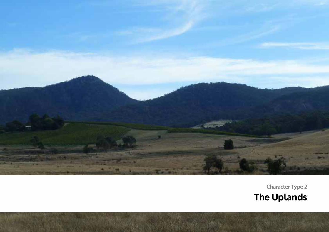
Character Type 2
The Uplands
141
DPCD South West Victoria Landscape Assessment Study | The UPLAnDS
© 2013
Logo is at twice the size for the footer
Defined by topography, this diverse Character Type rises dramatically to the north of the flat volcanic plain, stretching from near the Grampians Ranges in the west to the edge of the study area at Bacchus Marsh in the east. Fingers of the Victorian Uplands weave with the adjacent Goldfields region along this northern edge to form a rugged landscape of undulating hills and fertile agricultural valleys. Granitic intrusions have formed steeply sloping peaks and ridges, some of which are carpeted in vegetation at higher elevations. Plateaus that are cut by deep river gorges create dramatic landscape features to the south.
While the Uplands are largely cleared for agriculture they also support numerous large areas of public land, including Parks, Reserves and State Forests which contain a wealth of vegetation including wet and dry forests, Box-Ironbark woodlands and endangered grasslands. This is an area of contrasting topography, picturesque vineyards, lush forests, rolling agriculture and residential enclaves.
Within Character Type 2, 16 distinctive Character Areas have been determined and will be discussed in more detail within the Character Area Papers.
2.1 Forested Hills
2.2 Residential Forest Edges
2.3 Cleared Pastures
2.4 Fertile Valleys
2.5 Plateaus & Gorges
2.6 Brisbane Ranges
2.7 You Yangs
2.8 Creswick Forests & Hills
2.9 Rural Living
2.10 Valley Views
2.11 Central Forested Uplands
2.12 Island Uplands
2.13 Eastern Pyrenees
2.14 Southern Pyrenees Rises
2.15 Upland Interface
2.16 Mount Cole Creek
2 The Uplands
Lal lal gorge cuts deep into the terrain
The Uplands Character Type, defined by topography, rises from the surrounding Volcanic Plains (above: Mount Cole)
142
DPCD South West Victoria Landscape Assessment Study | The UPLAnDS
© 2013
Logo is at twice the size for the footer
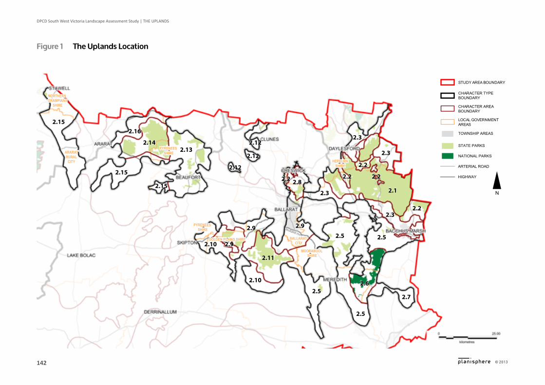
Figure 1 The Uplands location
2.1
2.3
2.3
2.12
2.12
2.12
2.132.14
2.15
2.15
2.152.16
2.3
2.6
2.7
2.5
2.5
2.92.9
2.11
2.10
2.10 2.9
2.5
2.22.2
2.2
2.22.3
2.5
2.2 2.8
Midland Hwy
NORTHERN GRAMPIANS
SHIRE
ARARATRURAL
CITY
PYRENEES SHIRE
PYRENEES SHIRE
GOLDEN PLAINS SHIRE BALLARAT CITY
HEPBURNSHIRE
MOORABOOL SHIRE
LOCAL GOVERNMENT AREAS
CHARACTER AREA BOUNDARY
NATIONAL PARKS
CHARACTER TYPE BOUNDARY
STATE PARKS
HIGHWAY
ARTERIAL ROAD
STUDY AREA BOUNDARY
N
TOWNSHIP AREAS
143
DPCD South West Victoria Landscape Assessment Study | The UPLAnDS
© 2013
Logo is at twice the size for the footer
Key Features ▪ Diverse topography, from undulating plains and river
valleys to steep gorges and forested escarpments ▪ Large areas of public land including Lerderderg State
Park, Wombat State Forest, Brisbane Ranges National Park and many other Bushland Reserves
landscape Characteristics
landformThis landscape Character Type has a highly diverse topography that contrasts with the adjacent volcanic plains. This interface forms part of the southern reaches of the rugged, mountainous regions of the Great Dividing Range. Wind swept plateaus incised with deep valleys and gorges penetrate the landscape to the south while at lower elevations there are undulating plains. To the west, the distinctive formations of Mounts Buangor (990m), Mount Cole and Mount Langi Ghiran form the southern reaches of the Pyrenees Ranges. “Island” uplands (such as Mount Bolton) protrude from the northern section of the Volcanic Plain, with distinctive granite formations jutting out on the upper slopes.
Waterform The crest of the Great Dividing Range forms the catchment divide between the north and south flowing rivers across much of western Victoria. Rivers that cut through the Uplands landscape have created steep gorges and gentle valleys. The Moorabool, Werribee and Lerderderg Rivers flow to the south, while the Loddon, Coliban and Campaspe rivers flow to the north. Mineral springs and scenic waterfalls occur within the forests.
Large reservoirs such as Lal Lal, Pykes Creek and Bostock have been created by damming watercourses that traverse the bottoms of the gorges.
Vegetation Large areas of state forest and conservation reserve are dispersed across this Character Type, often covering landscape features and river catchments such as steep hills and mountainous areas. While large areas have been cleared for agriculture and grazing, there are many remnants of original vegetation communities contained within the forests. Many of these contain coppiced trees that have re-grown from a history of timber logging, with thinner trunks which the original vegetation would have had.
Windswept plateaus contain shelterbelts of Radiata Pine along paddock edges and property boundaries. Monocultural plantations are prevalent through forested areas including near Mount Lonarch, Creswick and Wombat State Forests, and on the volcanic slopes of Mount Franklin.
land Use & Built Form The majority of the land in this area is private freehold dominated by agriculture. Built form consists of agricultural buildings which are sited away from the immediate roadside within paddocks. Residential dwellings are generally single storey, smaller subdivisions appear close to settlements where buildings are sited adjacent to roadsides. In more rural locations buildings are set back from roadsides and are often screened by vegetation.
Much of the landscape has been preserved in state forests and conservation reserves, however some of the vegetated hill slopes have been cloaked with plantations, particularly around the Mount Lonarch and Creswick regions.
A number of wind farms have been proposed and installed in recent years.
144
DPCD South West Victoria Landscape Assessment Study | The UPLAnDS
© 2013
Logo is at twice the size for the footer
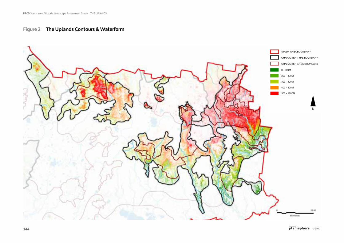
0 - 200M
500 - 1200M
CHARACTER AREA BOUNDARY
400 - 500M
CHARACTER TYPE BOUNDARY
200 - 300M
300 - 400M
STUDY AREA BOUNDARY
N
Figure 2 The Uplands Contours & Waterform
145
DPCD South West Victoria Landscape Assessment Study | The UPLAnDS
© 2013
Logo is at twice the size for the footer
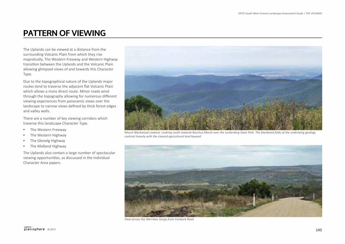
The Uplands can be viewed at a distance from the surrounding Volcanic Plain from which they rise majestically. The Western Freeway and Western Highway transition between the Uplands and the Volcanic Plain allowing glimpsed views of and towards this Character Type.
Due to the topographical nature of the Uplands major routes tend to traverse the adjacent flat Volcanic Plain which allows a more direct route. Minor roads wind through the topography allowing for numerous different viewing experiences from panoramic views over the landscape to narrow views defined by thick forest edges and valley walls.
There are a number of key viewing corridors which traverse this landscape Character Type.
▪ The Western Freeway ▪ The Western Highway ▪ The Glenelg Highway ▪ The Midland Highway
The Uplands also contain a large number of spectacular viewing opportunities, as discussed in the individual Character Area papers.
paTTern oF VieWing
View across the Werribee Gorge from Ironbark Road
Mount Blackwood Lookout: Looking south towards Bacchus Marsh over the Lerderderg State Park. The blanketed folds of the underlying geology contrast heavily with the cleared agricultural land beyond
146
DPCD South West Victoria Landscape Assessment Study | The UPLAnDS
© 2013
Logo is at twice the size for the footer
Landscape values include aesthetic (visual and non-visual), historic, environmental, scientific, social and other values. It is acknowledged that many of the values overlap (i.e. a place or item may have historic and social value), but they are generally only listed once. A range of sources have been used to identify the landscape values of the Uplands, such as the field survey, existing studies and documentation, and community consultation.
historic ▪ State significant Brisbane Ranges, listed by the
National Trust due to Rowsley fault’s distinguishable escarpment & significant vegetation
▪ Lerderderg State Park, listed by the National Trust as state significant because of its landscape & gold mining remains
▪ Gold mining remains, a legacy of Victoria’s gold mining heritage
▪ Mount Buninyong, registered on the Register of the National Estate due to its high geological & geomorphological significance & being an excellent example of a composite volcano
▪ Mount Clear mining landscape, characterised by ridge lines, creek banks, quartz veins & modifications due to gold mining, listed on the Heritage Inventory
▪ Unique Aboriginal rock art sites at Langi Ghiran State Park
▪ Other evidence of Aboriginal land use including scarred trees & mounds
▪ Eureka Stockade Gardens, listed on National Heritage List for its association with the Eureka Stockade Rebellion, 1854
landsCape ValUeslandsCape ValUes ▪ Massacres & killings of Aborigines occurred in the
Type mostly between Hamilton, Horsham & Ballarat in the early-mid 1800s
environmental/scientific ▪ Mount Bolton, a unique landscape characterised by
granite outcrops & remnant mature forest ▪ Mineral springs & groundwater ▪ Brisbane Ranges National Park & Lerderderg, Langi
Ghiran & Mount Buangor State Parks, protected areas on the IUCN list Category II (National Park) & protected by National Parks Act 1975
▪ Stony Creek (Durdiwarrah) Reference Area ▪ Many reserves which are protected areas on the
IUCN list ▪ Werribee Gorge ▪ Locally significant water bodies, wetlands &
watercourses ▪ Significant flora & fauna including River Red Gums,
koalas & Melton Mallee at Long Forest
social ▪ Ferntree & Cascade Falls, Mount Buangor State Park,
tourist attractions ▪ Goldfields Touring Route between Clunes /
Castlemaine & Stawell via Creswick, Daylesford & Ballarat
▪ Great Southern Touring Route between Stawell & Melbourne
▪ Agriculture, also valued for economic reasons
147
DPCD South West Victoria Landscape Assessment Study | The UPLAnDS
© 2013
Logo is at twice the size for the footer
landscape MorphologyThe Uplands Landscape Character Type was home to numerous different Aboriginal tribes, the Watha Warrung to the north, the Gulidjan at the centre, and the Djargurd Wurrung to the south east. The Aboriginal people have a long history of occupation of these lands, with the oldest known settlement in the adjacent Grampians (Gariwerd) dated at 22,000 before present.
In the late 1830’s European settlers took up land in the area. They cleared the more fertile valleys and plains of native vegetation for agriculture. Where the land was unsuitable for agriculture due to its topography timber harvesting was pursued.
The 1850s goldrush attracted a new wave of immigration and during this period the Aboriginal people saw large numbers of European and Chinese people camping on their land in search for gold. The gold rush period saw intensive logging to support the construction of tunnel supports, sleepers for tramways, fuel and other wood products.
After the first and second world wars the upland area became home to a number of soldiers. The returned soldiers and gold rush settlers were quick to realise the value of the land on which they were living and intensively exploited it for timber, firewood, gold, and until recently, woodchips.
Change in The landsCape
This changing land use has seen the Uplands, which at one time supported woodlands and dry grassy forest complexes, becoming heavily cleared especially on the lower slopes.
There is now a greater emphasis on conservation and management with a number of community groups having been established to protect the landscape. The Uplands now attracts numerous tourists to the wineries, parks, townships and reserves.
sensitivity to ChangeThe undulating to hilly topography and vegetation cover of the area allows development to be absorbed without undue visual interference.
Development on hillsides or ridges however, has the potential to be highly visible.
anticipated landscape Change ▪ Due to the proximity of this Landscape Character
Type to Melbourne, it is anticipated that the expected increase in Victoria’s population will be a driver of land use change.
▪ Reduction in grazing and an increasing demand for “lifestyle” properties near regional centres has meant changing land use priorities which may continue.
▪ Scattered remnant vegetation has regenerated in some areas as previous grazing activities have declined.
▪ New property owners interested in nature conservation may demand information and advice on environmental management and enhancement.
▪ An increase in enterprises such as viticulture and olives.
▪ An increasing influx of people onto small land holdings, previously used for broad scale agriculture
▪ New bushfire regulations may lead to an increased clearing of vegetation around properties
▪ A number of wind farm applications have been proposed and approved which will dramatically alter the appearance of the landscape
▪ The State Governments planning zones review may lead to an increase in tourism, retail and accommodation uses in rural areas, a potential increase in rural living density and a potential increase in smaller lots and dwellings in the farming zone.
148
DPCD South West Victoria Landscape Assessment Study | The UPLAnDS
© 2013
Logo is at twice the size for the footer
▪
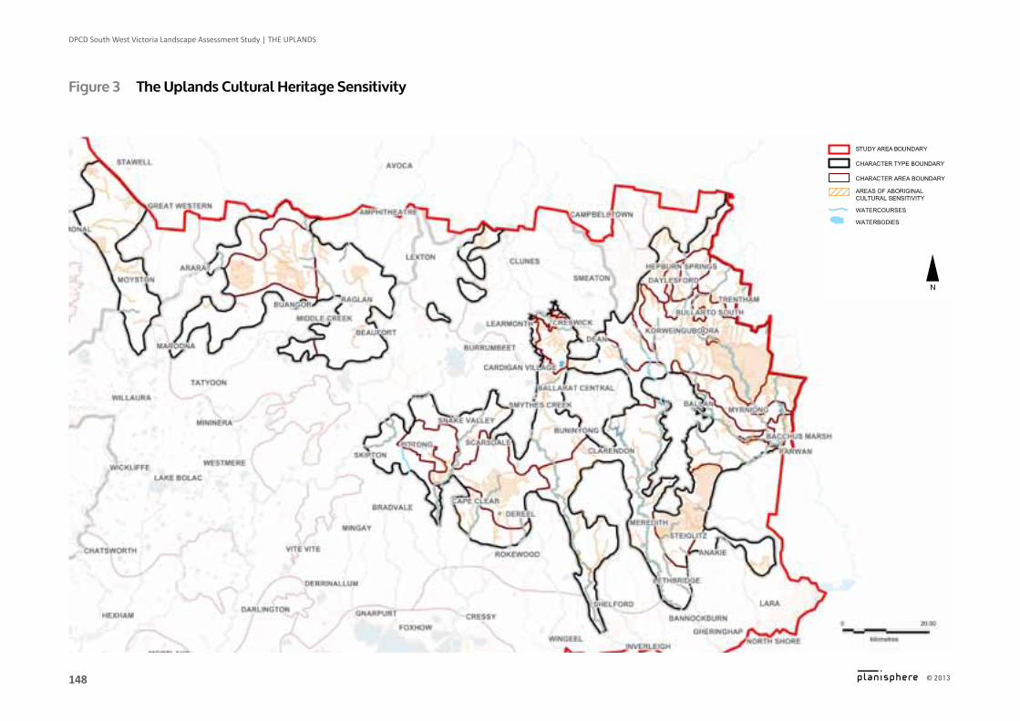
Figure 3 The Uplands Cultural heritage sensitivity
CHARACTER AREA BOUNDARY
AREAS OF ABORIGINAL CULTURAL SENSITIVITY
CHARACTER TYPE BOUNDARY
STUDY AREA BOUNDARY
N
WATERCOURSES
WATERBODIES
149
DPCD South West Victoria Landscape Assessment Study | The UPLAnDS
© 2013
Logo is at twice the size for the footer
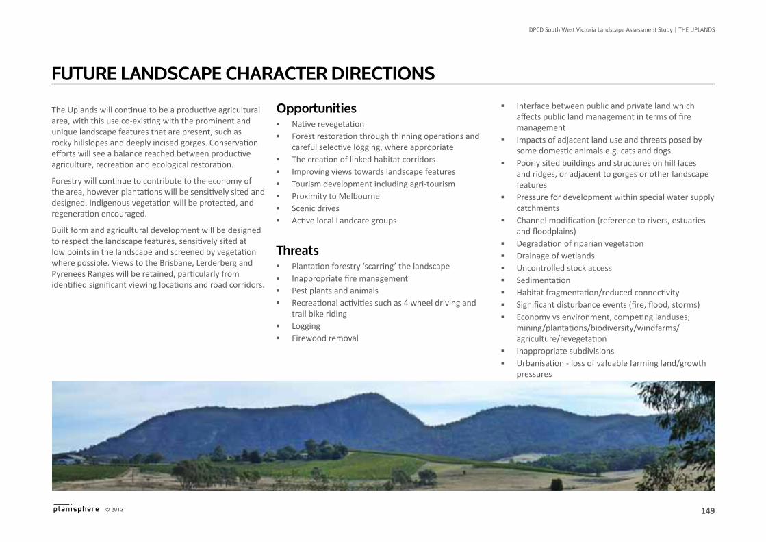
The Uplands will continue to be a productive agricultural area, with this use co-existing with the prominent and unique landscape features that are present, such as rocky hillslopes and deeply incised gorges. Conservation efforts will see a balance reached between productive agriculture, recreation and ecological restoration.
Forestry will continue to contribute to the economy of the area, however plantations will be sensitively sited and designed. Indigenous vegetation will be protected, and regeneration encouraged.
Built form and agricultural development will be designed to respect the landscape features, sensitively sited at low points in the landscape and screened by vegetation where possible. Views to the Brisbane, Lerderberg and Pyrenees Ranges will be retained, particularly from identified significant viewing locations and road corridors.
FUTUre landsCape CharaCTer direCTions
opportunities ▪ Native revegetation ▪ Forest restoration through thinning operations and
careful selective logging, where appropriate ▪ The creation of linked habitat corridors ▪ Improving views towards landscape features ▪ Tourism development including agri-tourism ▪ Proximity to Melbourne ▪ Scenic drives ▪ Active local Landcare groups
Threats ▪ Plantation forestry ‘scarring’ the landscape ▪ Inappropriate fire management ▪ Pest plants and animals ▪ Recreational activities such as 4 wheel driving and
trail bike riding ▪ Logging ▪ Firewood removal
▪ Interface between public and private land which affects public land management in terms of fire management
▪ Impacts of adjacent land use and threats posed by some domestic animals e.g. cats and dogs.
▪ Poorly sited buildings and structures on hill faces and ridges, or adjacent to gorges or other landscape features
▪ Pressure for development within special water supply catchments
▪ Channel modification (reference to rivers, estuaries and floodplains)
▪ Degradation of riparian vegetation ▪ Drainage of wetlands ▪ Uncontrolled stock access ▪ Sedimentation ▪ Habitat fragmentation/reduced connectivity ▪ Significant disturbance events (fire, flood, storms) ▪ Economy vs environment, competing landuses;
mining/plantations/biodiversity/windfarms/agriculture/revegetation
▪ Inappropriate subdivisions ▪ Urbanisation - loss of valuable farming land/growth
pressures ▪ Growth pressures along ridgeline areas and in close
proximity to State Parks/Forests ▪ Rezoning of land from Farming Zone to Residential 1
Zone
150
DPCD South West Victoria Landscape Assessment Study | The UPLAnDS
© 2013
Logo is at twice the size for the footer
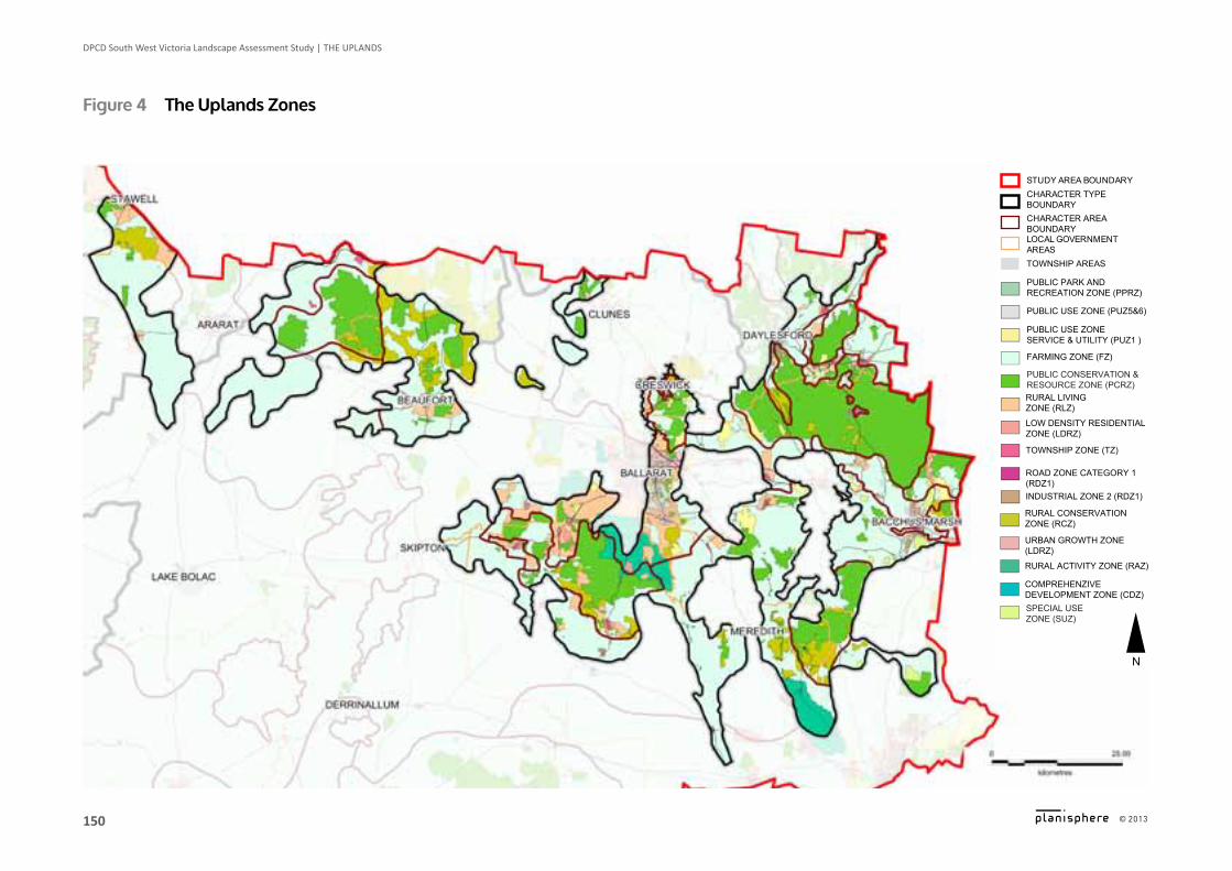
Figure 4 The Uplands Zones
ROAD ZONE CATEGORY 1 (RDZ1)
FARMING ZONE (FZ)
LOCAL GOVERNMENT AREASTOWNSHIP AREAS
TOWNSHIP ZONE (TZ)
PUBLIC USE ZONE SERVICE & UTILITY (PUZ1 )
CHARACTER AREA BOUNDARY
LOW DENSITY RESIDENTIAL ZONE (LDRZ)
PUBLIC USE ZONE (PUZ5&6)
CHARACTER TYPE BOUNDARY
RURAL LIVING ZONE (RLZ)
PUBLIC PARK AND RECREATION ZONE (PPRZ)
STUDY AREA BOUNDARY
N
INDUSTRIAL ZONE 2 (RDZ1)
COMPREHENZIVE DEVELOPMENT ZONE (CDZ)
RURAL ACTIVITY ZONE (RAZ)
URBAN GROWTH ZONE (LDRZ)
RURAL CONSERVATION ZONE (RCZ)
PUBLIC CONSERVATION &RESOURCE ZONE (PCRZ)
SPECIAL USE ZONE (SUZ)
151
DPCD South West Victoria Landscape Assessment Study | The UPLAnDS
© 2013
Logo is at twice the size for the footer
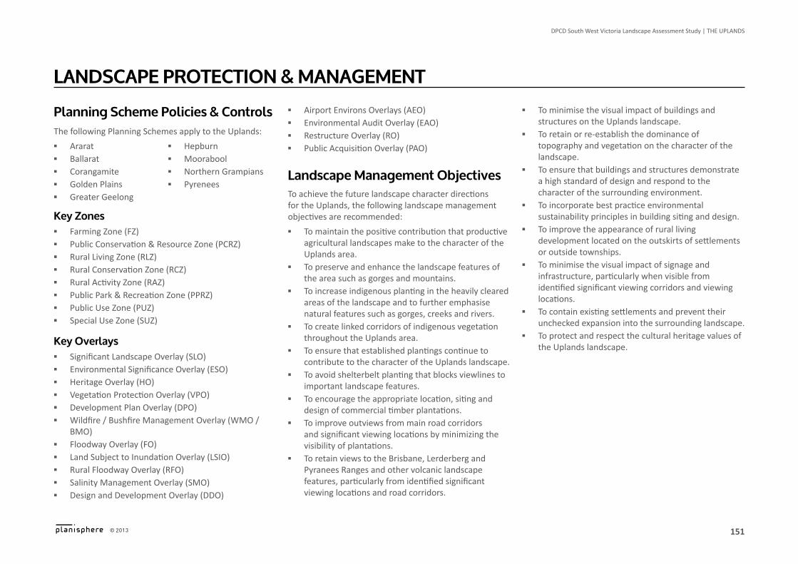
planning scheme policies & ControlsThe following Planning Schemes apply to the Uplands:
▪ Ararat ▪ Ballarat ▪ Corangamite ▪ Golden Plains ▪ Greater Geelong
▪ Hepburn ▪ Moorabool ▪ Northern Grampians ▪ Pyrenees
Key Zones ▪ Farming Zone (FZ) ▪ Public Conservation & Resource Zone (PCRZ) ▪ Rural Living Zone (RLZ) ▪ Rural Conservation Zone (RCZ) ▪ Rural Activity Zone (RAZ) ▪ Public Park & Recreation Zone (PPRZ) ▪ Public Use Zone (PUZ) ▪ Special Use Zone (SUZ)
Key overlays ▪ Significant Landscape Overlay (SLO) ▪ Environmental Significance Overlay (ESO) ▪ Heritage Overlay (HO) ▪ Vegetation Protection Overlay (VPO) ▪ Development Plan Overlay (DPO) ▪ Wildfire / Bushfire Management Overlay (WMO /
BMO) ▪ Floodway Overlay (FO) ▪ Land Subject to Inundation Overlay (LSIO) ▪ Rural Floodway Overlay (RFO) ▪ Salinity Management Overlay (SMO) ▪ Design and Development Overlay (DDO)
landsCape proTeCTion & ManageMenT ▪ Airport Environs Overlays (AEO) ▪ Environmental Audit Overlay (EAO) ▪ Restructure Overlay (RO) ▪ Public Acquisition Overlay (PAO)
landscape Management objectivesTo achieve the future landscape character directions for the Uplands, the following landscape management objectives are recommended:
▪ To maintain the positive contribution that productive agricultural landscapes make to the character of the Uplands area.
▪ To preserve and enhance the landscape features of the area such as gorges and mountains.
▪ To increase indigenous planting in the heavily cleared areas of the landscape and to further emphasise natural features such as gorges, creeks and rivers.
▪ To create linked corridors of indigenous vegetation throughout the Uplands area.
▪ To ensure that established plantings continue to contribute to the character of the Uplands landscape.
▪ To avoid shelterbelt planting that blocks viewlines to important landscape features.
▪ To encourage the appropriate location, siting and design of commercial timber plantations.
▪ To improve outviews from main road corridors and significant viewing locations by minimizing the visibility of plantations.
▪ To retain views to the Brisbane, Lerderberg and Pyranees Ranges and other volcanic landscape features, particularly from identified significant viewing locations and road corridors.
▪ To minimise the visual impact of buildings and structures on the Uplands landscape.
▪ To retain or re-establish the dominance of topography and vegetation on the character of the landscape.
▪ To ensure that buildings and structures demonstrate a high standard of design and respond to the character of the surrounding environment.
▪ To incorporate best practice environmental sustainability principles in building siting and design.
▪ To improve the appearance of rural living development located on the outskirts of settlements or outside townships.
▪ To minimise the visual impact of signage and infrastructure, particularly when visible from identified significant viewing corridors and viewing locations.
▪ To contain existing settlements and prevent their unchecked expansion into the surrounding landscape.
▪ To protect and respect the cultural heritage values of the Uplands landscape.
152
DPCD South West Victoria Landscape Assessment Study | The UPLAnDS
© 2013
Logo is at twice the size for the footer
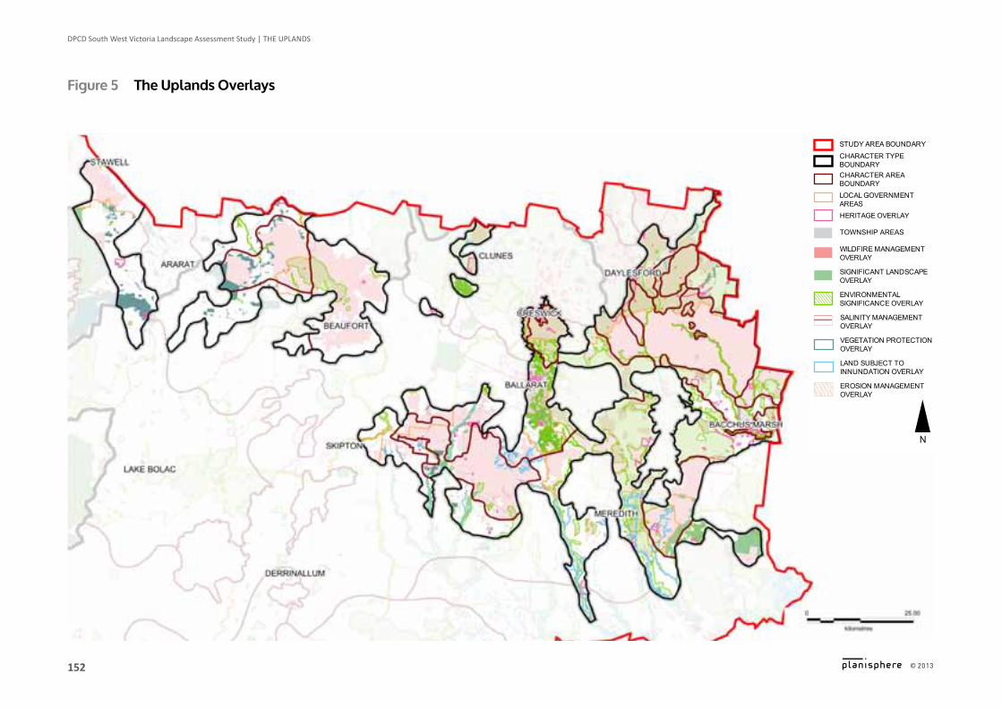
Figure 5 The Uplands overlays
EROSION MANAGEMENT OVERLAY
ENVIRONMENTAL SIGNIFICANCE OVERLAY
LOCAL GOVERNMENT AREAS
LAND SUBJECT TO INNUNDATION OVERLAY
SIGNIFICANT LANDSCAPE OVERLAY
CHARACTER AREA BOUNDARY
VEGETATION PROTECTION OVERLAY
WILDFIRE MANAGEMENT OVERLAY
CHARACTER TYPE BOUNDARY
SALINITY MANAGEMENT OVERLAY
HERITAGE OVERLAY
TOWNSHIP AREAS
STUDY AREA BOUNDARY
N
153
DPCD South West Victoria Landscape Assessment Study | The UPLAnDS
© 2013
Logo is at twice the size for the footer
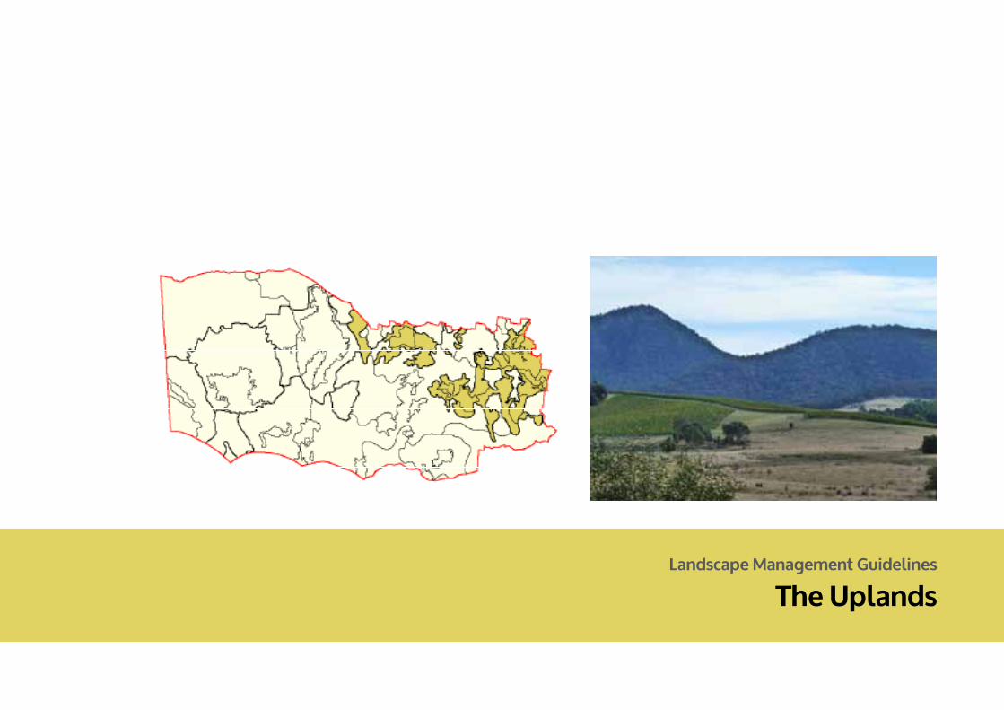
Landscape Management Guidelines
The Uplands
155
DPCD South West Victoria Landscape Assessment Study | LANDSCAPE MANAGEMENT GUIDELINES
THE UPLANDS
© 2013
Logo is at twice the size for the footer
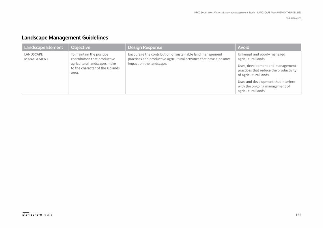
Landscape Management Guidelines
Landscape Element Objective Design Response AvoidLandscape management
To maintain the positive contribution that productive agricultural landscapes make to the character of the Uplands area.
Encourage the contribution of sustainable land management practices and productive agricultural activities that have a positive impact on the landscape.
Unkempt and poorly managed agricultural lands.
Uses, development and management practices that reduce the productivity of agricultural lands.
Uses and development that interfere with the ongoing management of agricultural lands.
156
DPCD South West Victoria Landscape Assessment Study | LANDSCAPE MANAGEMENT GUIDELINES
ThE UPLANDS
© 2013
Logo is at twice the size for the footer
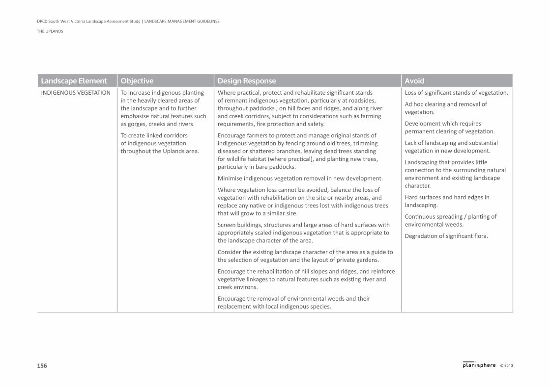
Landscape Element Objective Design Response AvoidIndIgenous VegetatIon To increase indigenous planting
in the heavily cleared areas of the landscape and to further emphasise natural features such as gorges, creeks and rivers.
To create linked corridors of indigenous vegetation throughout the Uplands area.
Where practical, protect and rehabilitate significant stands of remnant indigenous vegetation, particularly at roadsides, throughout paddocks , on hill faces and ridges, and along river and creek corridors, subject to considerations such as farming requirements, fire protection and safety.
Encourage farmers to protect and manage original stands of indigenous vegetation by fencing around old trees, trimming diseased or shattered branches, leaving dead trees standing for wildlife habitat (where practical), and planting new trees, particularly in bare paddocks.
Minimise indigenous vegetation removal in new development.
Where vegetation loss cannot be avoided, balance the loss of vegetation with rehabilitation on the site or nearby areas, and replace any native or indigenous trees lost with indigenous trees that will grow to a similar size.
Screen buildings, structures and large areas of hard surfaces with appropriately scaled indigenous vegetation that is appropriate to the landscape character of the area.
Consider the existing landscape character of the area as a guide to the selection of vegetation and the layout of private gardens.
Encourage the rehabilitation of hill slopes and ridges, and reinforce vegetative linkages to natural features such as existing river and creek environs.
Encourage the removal of environmental weeds and their replacement with local indigenous species.
Loss of significant stands of vegetation.
Ad hoc clearing and removal of vegetation.
Development which requires permanent clearing of vegetation.
Lack of landscaping and substantial vegetation in new development.
Landscaping that provides little connection to the surrounding natural environment and existing landscape character.
Hard surfaces and hard edges in landscaping.
Continuous spreading / planting of environmental weeds.
Degradation of significant flora.
157
DPCD South West Victoria Landscape Assessment Study | LANDSCAPE MANAGEMENT GUIDELINES
THE UPLANDS
© 2013
Logo is at twice the size for the footer
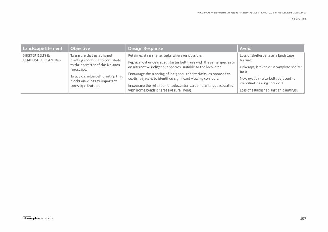
Landscape Element Objective Design Response AvoidsheLter beLts & estabLIshed pLantIng
To ensure that established plantings continue to contribute to the character of the Uplands landscape.
To avoid shelterbelt planting that blocks viewlines to important landscape features.
Retain existing shelter belts wherever possible.
Replace lost or degraded shelter belt trees with the same species or an alternative indigenous species, suitable to the local area.
Encourage the planting of indigenous shelterbelts, as opposed to exotic, adjacent to identified significant viewing corridors.
Encourage the retention of substantial garden plantings associated with homesteads or areas of rural living.
Loss of shelterbelts as a landscape feature.
Unkempt, broken or incomplete shelter belts.
New exotic shelterbelts adjacent to identified viewing corridors.
Loss of established garden plantings.
158
DPCD South West Victoria Landscape Assessment Study | LANDSCAPE MANAGEMENT GUIDELINES
ThE UPLANDS
© 2013
Logo is at twice the size for the footer
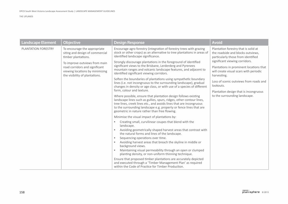
Landscape Element Objective Design Response AvoidpLantatIon forestry to encourage the appropriate
siting and design of commercial timber plantations.
To improve outviews from main road corridors and significant viewing locations by minimizing the visibility of plantations.
Encourage agro forestry (integration of forestry trees with grazing stock or other crops) as an alternative to tree plantations in areas of identified landscape significance.
Strongly discourage plantations in the foreground of identified significant views to the Brisbane, Lerderderg and Pyrenees mountain ranges and volcanic landscape features, and adjacent to identified significant viewing corridors.
Soften the boundaries of plantations using sympathetic boundary lines (i.e. not incongruous to the surrounding landscape), gradual changes in density or age class, or with use of a species of different form, colour and texture.
Where possible, ensure that plantation design follows existing landscape lines such as gullies, spurs, ridges, other contour lines, tree lines, creek lines etc., and avoids lines that are incongruous to the surrounding landscape e.g. property or fence lines that are geometric in nature rather than free flowing.
Minimise the visual impact of plantations by:
▪ Creating small, curvilinear coupes that blend with the landscape.
▪ Avoiding geometrically shaped harvest areas that contrast with the natural forms and lines of the landscape.
▪ Sequencing operations over time. ▪ Avoiding harvest areas that breach the skyline in middle or
background views. ▪ Maintaining visual permeability through an open or clumped
planting density, or non-uniform thinning technique.
Ensure that proposed timber plantations are accurately depicted and executed through a ‘Timber Management Plan’ as required within the Code of Practice for Timber Production.
Plantation forestry that is solid at the roadside and blocks outviews, particularly those from identified significant viewing corridors.
Plantations in prominent locations that will create visual scars with periodic harvesting.
Loss of scenic outviews from roads and lookouts.
Plantation design that is incongruous to the surrounding landscape.
159
DPCD South West Victoria Landscape Assessment Study | LANDSCAPE MANAGEMENT GUIDELINES
THE UPLANDS
© 2013
Logo is at twice the size for the footer
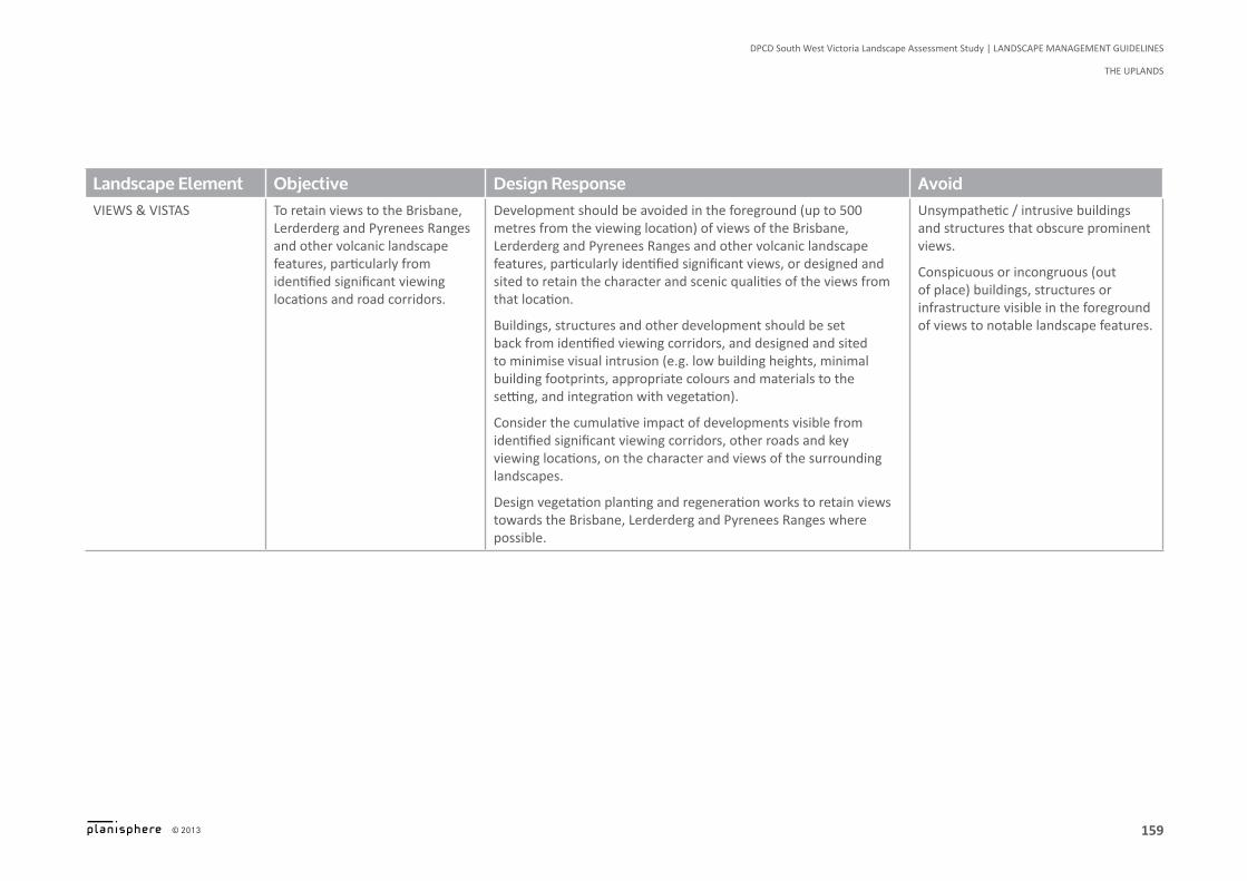
Landscape Element Objective Design Response AvoidVIews & VIstas To retain views to the Brisbane,
Lerderderg and Pyrenees Ranges and other volcanic landscape features, particularly from identified significant viewing locations and road corridors.
Development should be avoided in the foreground (up to 500 metres from the viewing location) of views of the Brisbane, Lerderderg and Pyrenees Ranges and other volcanic landscape features, particularly identified significant views, or designed and sited to retain the character and scenic qualities of the views from that location.
Buildings, structures and other development should be set back from identified viewing corridors, and designed and sited to minimise visual intrusion (e.g. low building heights, minimal building footprints, appropriate colours and materials to the setting, and integration with vegetation).
Consider the cumulative impact of developments visible from identified significant viewing corridors, other roads and key viewing locations, on the character and views of the surrounding landscapes.
Design vegetation planting and regeneration works to retain views towards the Brisbane, Lerderderg and Pyrenees Ranges where possible.
Unsympathetic / intrusive buildings and structures that obscure prominent views.
Conspicuous or incongruous (out of place) buildings, structures or infrastructure visible in the foreground of views to notable landscape features.
160
DPCD South West Victoria Landscape Assessment Study | LANDSCAPE MANAGEMENT GUIDELINES
ThE UPLANDS
© 2013
Logo is at twice the size for the footer
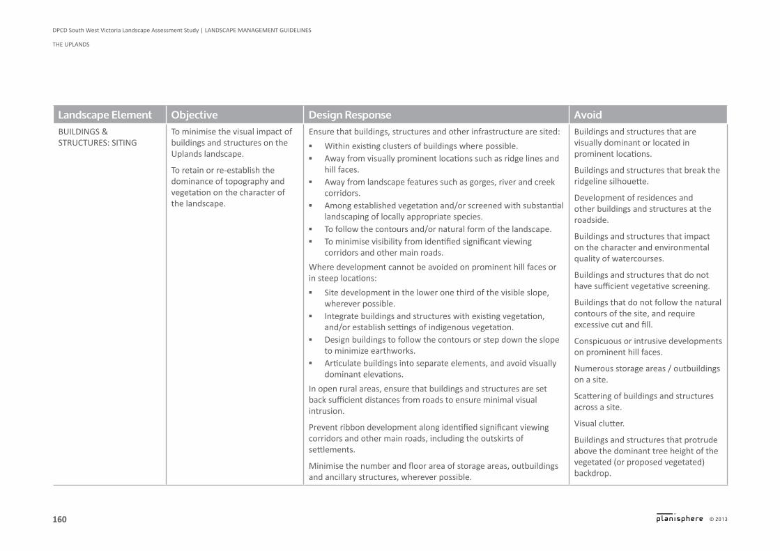
Landscape Element Objective Design Response AvoidbuILdIngs & STRUCTURES: SiTiNg
To minimise the visual impact of buildings and structures on the Uplands landscape.
To retain or re-establish the dominance of topography and vegetation on the character of the landscape.
Ensure that buildings, structures and other infrastructure are sited:
▪ Within existing clusters of buildings where possible. ▪ Away from visually prominent locations such as ridge lines and
hill faces. ▪ Away from landscape features such as gorges, river and creek
corridors. ▪ Among established vegetation and/or screened with substantial
landscaping of locally appropriate species. ▪ To follow the contours and/or natural form of the landscape. ▪ To minimise visibility from identified significant viewing
corridors and other main roads.
Where development cannot be avoided on prominent hill faces or in steep locations:
▪ Site development in the lower one third of the visible slope, wherever possible.
▪ integrate buildings and structures with existing vegetation, and/or establish settings of indigenous vegetation.
▪ Design buildings to follow the contours or step down the slope to minimize earthworks.
▪ Articulate buildings into separate elements, and avoid visually dominant elevations.
in open rural areas, ensure that buildings and structures are set back sufficient distances from roads to ensure minimal visual intrusion.
Prevent ribbon development along identified significant viewing corridors and other main roads, including the outskirts of settlements.
Minimise the number and floor area of storage areas, outbuildings and ancillary structures, wherever possible.
Buildings and structures that are visually dominant or located in prominent locations.
Buildings and structures that break the ridgeline silhouette.
Development of residences and other buildings and structures at the roadside.
Buildings and structures that impact on the character and environmental quality of watercourses.
Buildings and structures that do not have sufficient vegetative screening.
Buildings that do not follow the natural contours of the site, and require excessive cut and fill.
Conspicuous or intrusive developments on prominent hill faces.
Numerous storage areas / outbuildings on a site.
Scattering of buildings and structures across a site.
Visual clutter.
Buildings and structures that protrude above the dominant tree height of the vegetated (or proposed vegetated) backdrop.
161
DPCD South West Victoria Landscape Assessment Study | LANDSCAPE MANAGEMENT GUIDELINES
THE UPLANDS
© 2013
Logo is at twice the size for the footer
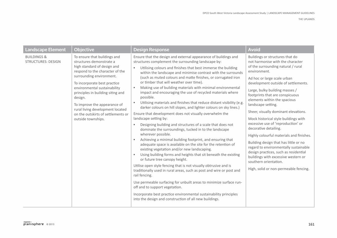
Landscape Element Objective Design Response AvoidbuILdIngs & STRUCTURES: DESigN
To ensure that buildings and structures demonstrate a high standard of design and respond to the character of the surrounding environment.
To incorporate best practice environmental sustainability principles in building siting and design.
To improve the appearance of rural living development located on the outskirts of settlements or outside townships.
Ensure that the design and external appearance of buildings and structures complement the surrounding landscape by:
▪ Utilising colours and finishes that best immerse the building within the landscape and minimise contrast with the surrounds (such as muted colours and matte finishes, or corrugated iron or timber that will weather over time).
▪ Making use of building materials with minimal environmental impact and encouraging the use of recycled materials where possible.
▪ Utilising materials and finishes that reduce distant visibility (e.g. darker colours on hill slopes, and lighter colours on sky lines.)
Ensure that development does not visually overwhelm the landscape setting by:
▪ Designing building and structures of a scale that does not dominate the surroundings, tucked in to the landscape wherever possible.
▪ Achieving a minimal building footprint, and ensuring that adequate space is available on the site for the retention of existing vegetation and/or new landscaping.
▪ Using building forms and heights that sit beneath the existing or future tree canopy height.
Utilise open style fencing that is not visually obtrusive and is traditionally used in rural areas, such as post and wire or post and rail fencing.
Use permeable surfacing for unbuilt areas to minimize surface run-off and to support vegetation.
incorporate best practice environmental sustainability principles into the design and construction of all new buildings.
Buildings or structures that do not harmonise with the character of the surrounding natural / rural environment.
Ad hoc or large scale urban development outside of settlements.
Large, bulky building masses / footprints that are conspicuous elements within the spacious landscape setting.
Sheer, visually dominant elevations.
Mock historical style buildings with excessive use of ‘reproduction’ or decorative detailing.
Highly colourful materials and finishes.
Building design that has little or no regard to environmentally sustainable design practices, such as residential buildings with excessive western or southern orientation.
High, solid or non-permeable fencing.
162
DPCD South West Victoria Landscape Assessment Study | LANDSCAPE MANAGEMENT GUIDELINES
ThE UPLANDS
© 2013
Logo is at twice the size for the footer
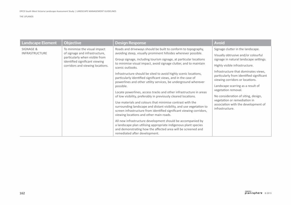
Landscape Element Objective Design Response AvoidsIgnage & Infrastructure
To minimise the visual impact of signage and infrastructure, particularly when visible from identified significant viewing corridors and viewing locations.
Roads and driveways should be built to conform to topography, avoiding steep, visually prominent hillsides wherever possible.
group signage, including tourism signage, at particular locations to minimise visual impact, avoid signage clutter, and to maintain scenic outlooks.
infrastructure should be sited to avoid highly scenic locations, particularly identified significant views, and in the case of powerlines and other utility services, be underground wherever possible.
Locate powerlines, access tracks and other infrastructure in areas of low visibility, preferably in previously cleared locations.
Use materials and colours that minimise contrast with the surrounding landscape and distant visibility, and use vegetation to screen infrastructure from identified significant viewing corridors, viewing locations and other main roads.
All new infrastructure development should be accompanied by a landscape plan utilising appropriate indigenous plant species and demonstrating how the affected area will be screened and remediated after development.
Signage clutter in the landscape.
Visually obtrusive and/or colourful signage in natural landscape settings.
Highly visible infrastructure.
infrastructure that dominates views, particularly from identified significant viewing corridors or locations.
Landscape scarring as a result of vegetation removal.
No consideration of siting, design, vegetation or remediation in association with the development of infrastructure.
163
DPCD South West Victoria Landscape Assessment Study | LANDSCAPE MANAGEMENT GUIDELINES
THE UPLANDS
© 2013
Logo is at twice the size for the footer
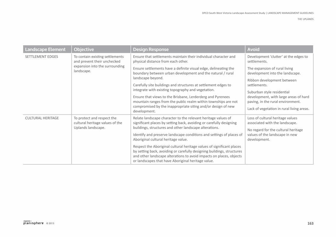
Landscape Element Objective Design Response AvoidsettLement edges To contain existing settlements
and prevent their unchecked expansion into the surrounding landscape.
Ensure that settlements maintain their individual character and physical distance from each other.
Ensure settlements have a definite visual edge, delineating the boundary between urban development and the natural / rural landscape beyond.
Carefully site buildings and structures at settlement edges to integrate with existing topography and vegetation.
Ensure that views to the Brisbane, Lerderderg and Pyrenees mountain ranges from the public realm within townships are not compromised by the inappropriate siting and/or design of new development.
Development ‘clutter’ at the edges to settlements.
The expansion of rural living development into the landscape.
Ribbon development between settlements.
Suburban style residential development, with large areas of hard paving, in the rural environment.
Lack of vegetation in rural living areas.
cuLturaL herItage To protect and respect the cultural heritage values of the Uplands landscape.
Relate landscape character to the relevant heritage values of significant places by setting back, avoiding or carefully designing buildings, structures and other landscape alterations.
identify and preserve landscape conditions and settings of places of Aboriginal cultural heritage value.
Respect the Aboriginal cultural heritage values of significant places by setting back, avoiding or carefully designing buildings, structures and other landscape alterations to avoid impacts on places, objects or landscapes that have Aboriginal heritage value.
Loss of cultural heritage values associated with the landscape.
No regard for the cultural heritage values of the landscape in new development.


![East Grampians Health Service [Ararat and Willaura]...East Grampians Health Service [Ararat and Willaura] Adult Inpatient Created on 04 June 2019 All results are weighted by age and](https://img.pdfslide.us/doc/110x75/60c22e0249d1282384710aab/east-grampians-health-service-ararat-and-willaura-east-grampians-health-service.jpg)