Embed Size (px)
Citation preview
BETS Euroconsult Mott MacDonald Socioconsult
Char Development and Settlement Project Phase IV Bangladesh
Feasibility study on the development of a cluster of island chars in the Lower Meghna in Bhola - and
Noakhali Districts
Char Kola Toli
Integrated Main Report
September 2016
Government of Bangladesh / IFAD / Government of the Netherlands
Implementing Government Agencies:
Bangladesh Water Development Board (BWDB)
Ministry of Land (MoL)
Local Government Engineering Department
(LGED)
Department of Public Health Engineering (DPHE)
Department of Agriculture Extension (DAE)
Forest Department (FD)
and NGOs

BETS Euroconsult Mott MacDonald Socioconsult
CDSP IV Feasibility Study Cluster of Island Chars – Char Kola Toli Integrated Main Report
i
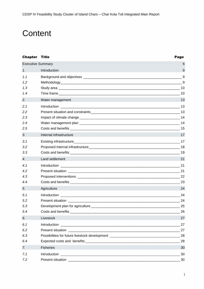
Content
Chapter Title Page
Executive Summary 6
1. Introduction 9
1.1 Background and objectives ____________________________________________________ 9
1.2 Methodology ________________________________________________________________ 9
1.3 Study area ________________________________________________________________ 10
1.4 Time frame ________________________________________________________________ 10
2. Water management 13
2.1 Introduction _______________________________________________________________ 13
2.2 Present situation and constraints _______________________________________________ 13
2.3 Impact of climate change _____________________________________________________ 14
2.4 Water management plan _____________________________________________________ 14
2.5 Costs and benefits __________________________________________________________ 15
3. Internal infrastructure 17
3.1 Existing infrastructure ________________________________________________________ 17
3.2 Proposed internal infrastructure ________________________________________________ 18
3.3 Costs and benefits __________________________________________________________ 19
4. Land settlement 21
4.1 Introduction _______________________________________________________________ 21
4.2 Present situation ___________________________________________________________ 21
4.3 Proposed interventions ______________________________________________________ 22
4.4 Costs and benefits __________________________________________________________ 23
5. Agriculture 24
5.1 Introduction _______________________________________________________________ 24
5.2 Present situation ___________________________________________________________ 24
5.3 Development plan for agriculture _______________________________________________ 25
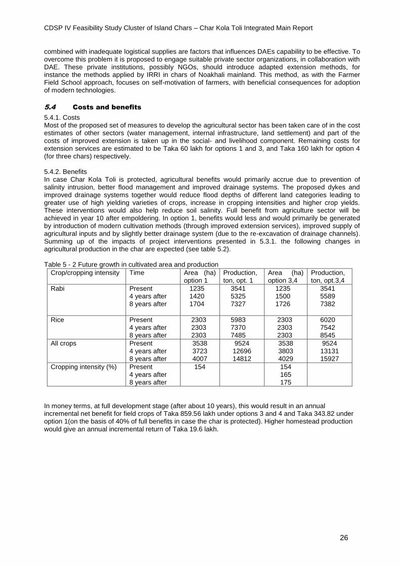
5.4 Costs and benefits __________________________________________________________ 26
6. Livestock 27
6.1 Introduction _______________________________________________________________ 27
6.2 Present situation ___________________________________________________________ 27
6.3 Possibilities for future livestock development _____________________________________ 28
6.4 Expected costs and benefits __________________________________________________ 28
7. Fisheries 30
7.1 Introduction _______________________________________________________________ 30
7.2 Present situation ___________________________________________________________ 30
CDSP IV Feasibility Study Cluster of Island Chars – Char Kola Toli Integrated Main Report
ii
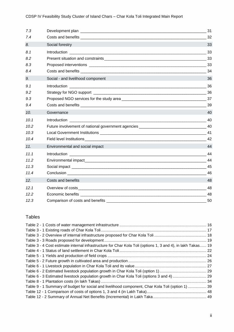
7.3 Development plan __________________________________________________________ 31
7.4 Costs and benefits __________________________________________________________ 32
8. Social forestry 33
8.1 Introduction _______________________________________________________________ 33
8.2 Present situation and constraints _______________________________________________ 33
8.3 Proposed interventions ______________________________________________________ 33
8.4 Costs and benefits __________________________________________________________ 34
9. Social - and livelihood component 36
9.1 Introduction _______________________________________________________________ 36
9.2 Strategy for NGO support ____________________________________________________ 36
9.3 Proposed NGO services for the study area _______________________________________ 37
9.4 Costs and benefits __________________________________________________________ 39
10. Governance 40
10.1 Introduction _______________________________________________________________ 40
10.2 Future involvement of national government agencies _______________________________ 40
10.3 Local Government Institutions _________________________________________________ 41
10.4 Field level Institutions ________________________________________________________ 42
11. Environmental and social impact 44
11.1 Introduction _______________________________________________________________ 44
11.2 Environmental impact ________________________________________________________ 44
11.3 Social impact ______________________________________________________________ 45
11.4 Conclusion ________________________________________________________________ 46
12. Costs and benefits 48
12.1 Overview of costs ___________________________________________________________ 48
12.2 Economic benefits __________________________________________________________ 48
12.3 Comparison of costs and benefits ______________________________________________ 50
Tables
Table 2 - 1 Costs of water management infrastructure ................................................................................ 16 Table 3 - 1 Existing roads of Char Kola Toli ................................................................................................. 17 Table 3 - 2 Overview of internal infrastructure proposed for Char Kola Toli ................................................ 18 Table 3 - 3 Roads proposed for development .............................................................................................. 19 Table 3 - 4 Cost estimate internal infrastructure for Char Kola Toli (options 1, 3 and 4), in lakh Takas ...... 19 Table 4 - 1 Status of land settlement in Char Kola Toli ................................................................................ 22 Table 5 - 1 Yields and production of field crops ........................................................................................... 24 Table 5 - 2 Future growth in cultivated area and production ........................................................................ 26 Table 6 - 1 Livestock population in Char Kola Toli and its value .................................................................. 27 Table 6 - 2 Estimated livestock population growth in Char Kola Toli (option 1) ........................................... 29 Table 6 - 3 Estimated livestock population growth in Char Kola Toli (options 3 and 4) ............................... 29 Table 8 - 1 Plantation costs (in lakh Takas) ................................................................................................. 34 Table 9 - 1 Summary of budget for social and livelihood component, Char Kola Toli (option 1) ................. 39 Table 12 - 1 Comparison of costs of options 1, 3 and 4 (in Lakh Taka)....................................................... 48 Table 12 - 2 Summary of Annual Net Benefits (Incremental) in Lakh Taka ................................................. 49

CDSP IV Feasibility Study Cluster of Island Chars – Char Kola Toli Integrated Main Report
iii
Table 12 - 3 Results of Economic Analysis .................................................................................................. 50 Table 12 - 4 Results of Sensitivity Analysis for option 1 ............................................................................... 50 Table 12 - 5 Results of Financial Analysis .................................................................................................... 50 Table 12 - 6 Detailed Project Costs (Financial) for option 1 ......................................................................... 52
Figures
Figure 1.1 Overview map of the study area of three chars: Char Kola Toli, Dhal Char and Char Mozammel
...................................................................................................................................................................... 11 Figure 1.2 Map of Char Kola Toli ................................................................................................................. 12
Annexes
Annex 1. Terms of Reference 53
Appendices (separate documents)
Feasibility Study of Cluster of Chars (Char Kola Toli), Development Design Consultants Ltd. (DDC)/
Institute of Water Modelling (IWM), September 2016.
CDSP IV Feasibility Study Cluster of Island Chars, TA-contribution, Euroconsult Mott MacDonald/ BETS/
Socioconsult, September 2016.
CDSP IV Feasibility Study Cluster of Island Chars – Char Kola Toli Integrated Main Report
iv
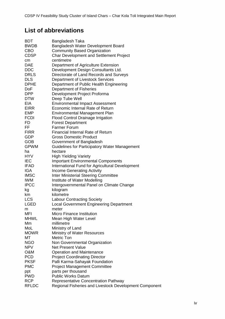
List of abbreviations BDT Bangladesh Taka BWDB Bangladesh Water Development Board CBO Community Based Organization CDSP Char Development and Settlement Project cm centimetre DAE Department of Agriculture Extension DDC Development Design Consultants Ltd. DRLS Directorate of Land Records and Surveys DLS Department of Livestock Services DPHE Department of Public Health Engineering DoF Department of Fisheries DPP Development Project Proforma DTW Deep Tube Well EIA Environmental Impact Assessment EIRR Economic Internal Rate of Return EMP Environmental Management Plan FCDI Flood Control Drainage Irrigation FD Forest Department FF Farmer Forum FIRR Financial Internal Rate of Return GDP Gross Domestic Product GOB Government of Bangladesh GPWM Guidelines for Participatory Water Management ha hectare HYV High Yielding Variety IEC Important Environmental Components IFAD International Fund for Agricultural Development IGA Income Generating Activity IMSC Inter Ministerial Steering Committee IWM Institute of Water Modelling IPCC Intergovernmental Panel on Climate Change kg kilogram km kilometre LCS Labour Contracting Society LGED Local Government Engineering Department m meter MFI Micro Finance Institution MHWL Mean High Water Level Mm millimetre MoL Ministry of Land MOWR Ministry of Water Resources MT Metric Ton NGO Non Governmental Organization NPV Net Present Value O&M Operation and Maintenance PCD Project Coordinating Director PKSF Palli Karma-Sahayak Foundation PMC Project Management Committee ppt parts per thousand PWD Public Works Datum RCP Representative Concentration Pathway RFLDC Regional Fisheries and Livestock Development Component
CDSP IV Feasibility Study Cluster of Island Chars – Char Kola Toli Integrated Main Report
v
SFG Social Forestry Group TA Technical Assistance TBA Traditional Birth Attendant Tk Taka TSP Triple Super Phosphate TUG Tube well User Group Unesco-IHE Institute of Water Education UP Union Parishad WARPO Water Resources Planning Organization WMG Water Management Group WMO Water Management Organization
yr year

CDSP IV Feasibility Study Cluster of Island Chars – Char Kola Toli Integrated Main Report
6
Executive Summary
1. Area: Land emerged in the early 1980s northwest of Hatiya Island. Forest Department started plantation of mangroves in the early 1990s. The land formation continued by fresh deposits of sediment. Currently the gross area is 2,523 ha. The largest part (91%) is used for agriculture; infrastructure covers 4%, water bodies 3% and forest 2%.
2. Population: Settlers started to migrate into the area in 2001, removing the trees planted by the Forest Department and occupying the land without a land title. Total current population is nearly 15,000, settled in 2,866 households. Main occupations are farming, non-farm daily labor, fisheries and small business. Nearly 64% of the households has food security for a period of six months or less.
3. Physical conditions: Nearly 90% of the area has an elevation between 1 m. and 3 m. PWD. Less than 1% is between 3 and 4 m. and 10% is lower than 1.5 m. The area is unprotected. Tidal movements deposit sediments on the char surface, with an average of 4-5 cm per year.
4. Integrated program: The study proposes to initiate a CDSP-type of project in the area. This means a multi-sectoral and multi-agency development program, with a distinct role for both government agencies and NGOs. The program should cover the following fields: water management (Chapter 2), internal infrastructure (Chapter 3), land settlement (Chapter 4), agriculture (Chapter 5), livestock (Chapter 6), fisheries (Chapter 7) and social forestry (Chapter 8). In addition it is advised to have a specific social- and livelihood component (Chapter 9). Such an approach requires specific governance related arrangements (Chapter 10). The integrated approach follows the principles of Integrated Coastal Zone Management, as reflected in the Coastal Zone Policy of Bangladesh.
5. Water management, present situation: The char is inundated twice a day during high tide, especially in monsoon time. Only less than 1% of the area stays flood free during monsoon time, with an average inundation depth of 1 m. The water comes from all sides, but stays only for 2.5 to 3 hours. There is no stagnant water. Mean high water level during monsoon time is 2.68 m. PWD in that part of the Lower Meghna. At that land level no further significant sedimentation of the land surface can be expected and thus land levels would be high enough to protect the char by constructing a polder.
6. Water management, planning options: There are two basic options for water management: leave the char unprotected and allow further natural sedimentation until land levels reach MHWL in monsoon time (estimated to happen only in 15 year time, beyond the period of a new project); or increase land levels mechanically by deposition of dredging spoils on the land (so construction of embankments could start within the presumed project period). A cost-benefit analysis has indicated that the latter option is financially and economically not feasible, mainly because of the additional dredging costs. It is recommended to leave the char unprotected. The proposed intervention is in that option limited to re-excavation of channels with a total length of 20.1 km. The presentation of the future scenarios in the various sectors below (6 to 10) are based on the recommended option, which is to leave the char unprotected and allow further natural sedimentation. In the report itself consequences and costs of other options have been elaborated upon for each of the sectors.
7. Internal infrastructure: The area has presently hardly any infrastructure. The earthen roads are not well maintained and motorcycles and cycles can ply only in the dry season. There are 30 deep tube wells, one cyclone shelters, 15 mosques, 15 schools and madrasas, five small bazaars and one Asrayan (clustered village) complex. It is proposed to upgrade the existing rural roads and construct new ones (total 18 km.), including nine culverts. The plan provides for six cyclone shelters, 200 deep tube wells and 3,000 pit latrines. Also four public toilets, five community ponds, five rainwater harvesting schemes and one killa are proposed.
8. Land settlement: None of the 2,866 households living in the area have a title on the land they occupy. The whole area is khas (state) land. Taking into account ancestral and miscellaneous claims, and the land required for additional infrastructure (experience shows this will be about 25% of the land), nearly 5,000 acres would be available for distribution among them. This means
CDSP IV Feasibility Study Cluster of Island Chars – Char Kola Toli Integrated Main Report
7
that each household already settled in the char could receive a title on about 1.3 acres of land, less than the legal maximum of 1.5 acres.
9. Agriculture: Present cropping intensity is 156% with the aman rice as dominant crop, with yields between 2.5 to 3 tons per hectare. The second crop is grown in rabi season. There is no aus cultivation. Agriculture production is impeded by tidal flooding and flash floods, high water- and soil salinity, and high soil moisture in the pre-rabi period. There is a lack of support services and an inadequate marketing system. Main elements in the proposed development plan are improvement of water management (only by re-excavation of drainage channels), introduction of modern technologies (such as improve varieties and better cultivation methods), providing land titles (see 6 above), construction of community ponds to increase irrigation possibilities and strengthening extension services. The Department of Agriculture Extension has to expand their services to the area, while NGOs can support households in homestead agriculture. The plans for the road network will facilitate marketing of produce. The combination of these measures is expected to an increase in overall production through improving the yields.
10. Livestock: Nearly all households are involved in some form of livestock rearing. As far as the large ruminants are concerned more than 90% rear birds, 52% of families have one or more cows, 34% have goats and 30% have bulls. Major constraints encountered are lack of knowledge, diseases, shortage of feed, theft, poor genetic quality of animals, inadequate marketing facilities, housing of ruminants and availability of drinking water. Improvement of extension services is a major part of the proposed development plan. It is recommended not to rely only on the services of the Department of Livestock Services, but to engage a NGO to develop semi-skilled manpower and employ a veterinary doctor. The Department should facilitate the supply of drugs and vaccines. The expected growth in agricultural production will improve the supply of fodder (crop residues); this can be further enhanced by including more leguminous crops in the farming system and by planting of trees with protein reach leafs. Simple collective rainwater harvesting devices could address the shortage of drinking water for large ruminants. It is critical that livestock rearing households organize themselves in order to make collective bargaining possible. to reduce the risk of being exploited by the middlemen. The groups can establish direct contacts with sellers of inputs and with buyers of livestock products.
11. Fisheries: About 17% of households are directly depending on fisheries for their livelihood. They are involved in fishing in closed water bodies (ponds, ditches), in wild fisheries (khals and floodplains), or in fishing outside the area (Meghna estuary). There are two large fish farms in Char Kola Toli, still on the way of developing their full potential. The main constraints for fisheries are the limited number of ponds, tidal flooding, insufficient input supplies and extension services, and adverse marketing conditions. More intensive cultivation methods and improved extension services by engaging a NGO are essential components of the proposed development plan. Establishment of a fish hatchery in the area would address the demand for fingerlings. This hatchery could supply adjacent chars as well. If the area is left unprotected, pond cultivation will still improve (due to better extension services) and larger capacity of channels). Wild fisheries in open water bodies will not be hampered and will benefit from the larger capacity of the re-excavated channels.
12. Social forestry: Forestry development started by the Forest Department in the early 1990s but immigration of settlers, starting in 2001, led to complete deforestation. At present forest in the char is limited to homesteads and scattered trees can be found on public grounds. There is a huge demand for fuel wood. It is recommended that the Department renews its presence with a substantial forestry program with mangrove plantations on the newly formed mudflats, with foreshore plantation between the mudflats and the mature land; and with strip plantation along all the roads. NGOs should be given the responsibility to promote and support agro-forestry on homesteads. It is standing policy in Bangladesh to apply the social forestry approach. Men and women from the area, organized in Social Forestry Groups, are involved in planning, implementation and maintenance of the forestry schemes and are rewarded though benefit sharing arrangements.
13. Social and livelihood component: Although many of the proposed activities have a distinct social impact and will favourably influence the livelihoods of the settled families, it is recommended to emphasize the importance of these aspects by a specific social and livelihood component, to be carried out by NGOs, as is the case in CDSP IV. The strategy is basically to render micro-finance services targeted at women (better credit facilities will stimulate productive pursuits) and to provide social and economic services that are not being delivered by the government at this early stage of development of the area. Subjects to be covered are: group formation (exclusively women) and micro finance; health and family planning; education; water and sanitation; homestead agriculture and value chain development; livestock development; fisheries; legal and human rights; disaster management; and awareness on the environment and
CDSP IV Feasibility Study Cluster of Island Chars – Char Kola Toli Integrated Main Report
8
on climate change. It is foreseen, with a view on the size of the area and of the population, that establishment of two branch offices is required, preferably by one NGO.
14. Governance: As indicated earlier, it is recommended to frame the multi-sector interventions in a multi-agency program. As in CDSP III and IV, it is recommended that the following six partner agencies participate: Bangladesh Water Development Board, Local Government Engineering Department, Department of Public Health Engineering, Ministry of Land, Department of Agriculture Extension and Forestry Department. An Inter-Ministerial Steering Committee and a Project Management Committee would function as coordination mechanisms. The Department of Livestock Services and the Department of Fisheries would support the program through training efforts and supply of inputs. The private sector would have also a role in input supply and in marketing of crops, fish and livestock products, and possibly in the establishment of a hatchery. The involvement of NGOs was explained in the previous section. Important is the support and active involvement of local government institutions, especially at the level of the Union Parishad. The significance of field level institutions for a successful char development program can hardly be underestimated. That is why much attention will be given to the formation and support of Water Management Organizations, Farmer’s Forums, Social Forestry Groups, Tube well User Groups and micro-finance groups. As much as practically possible, Labour Contracting Societies will be engaged for earth work.
15. Environmental impact: Leaving the char unprotected in the foreseeable future will have a positive impact with regard to further sedimentation and thus higher land levels of parts the char. On the other hand, tidal flooding will continue and soil salinity will not be abated and quality of water, especially salinity, will not be improved either. Not protecting the char would be good for the status of flora, fauna and wildlife. But the environment for productive purposes, in particular agriculture and aquaculture, will not be enhanced, although wild fisheries will continue to be a source of income. The conclusion is justified that not protecting the char will not have such significant negative impact on the environment, that this options should be discarded. Mitigation measures and monitoring are however necessary.
16. Social impact: The social impact of the proposals would in general be favorable. Physical security for the settlers would improve (cyclone shelters, roads, skills in disaster management). The modest increase in local production and the economic development in general will increase and diversify the income streams and will open up employment opportunities. The higher production in agriculture, fisheries and livestock are bound to decrease the periods of food shortages of large sections of the population. It is expected that more service providers, both from the government and from the private sector, will be encouraged to come to the area because of the economic development and the better communication network. Health status will be improved by the improved food security, including a higher availability of high protein food, as well as by the targeted interventions of the social- and livelihood component. That component will increase the access for children to primary education. The cyclone shelters can serve as school buildings. The social position of settlers will be enhanced, especially for women (land titles, participation in field level institutions).
17. Costs and benefits: Comparing costs and benefits for the recommended option (leaving Char Kola Toli unprotected) the economic internal rate of return (EIRR) would be 35,06% and the financial rate of return (FIRR) 13.37%. Both are above the opportunity costs of Bangladesh of 12%. This option is economically and financially sustainable. Other options (establishment of a polder by increasing levels through deposit of dredging spoils) score much lower internal rates, below the required standards. Total costs for the recommended option (option 1) are estimated to be Taka 5,626.3 lakh, which is equal to Euro 6,262,072 or US$ 6,987,865 at the exchange rates of 19 September 2016.

CDSP IV Feasibility Study Cluster of Island Chars – Char Kola Toli Integrated Main Report
9
1. Introduction
1.1 Background and objectives
The Inception Report of the Char Development and Settlement Project (CDSP) - IV states that the project will undertake three feasibility studies in areas where in the future development programmes for chars might take place. It further states that these future areas have to be located within the overall study area, essentially the central, dynamic part of the coastal zone of Bangladesh. This area is bordered in the east by the outfall of the Muhuri River and the Chittagong coastline. In the west, the border is formed by the Tetulia River which is on the west of Island of Bhola (Bhola District). In the north, the area follows the coastline of Feni, Noakhali and Lakshmipur Districts. After a rigorous process of selection, the BWDB and the Development Partners (Government of The Netherlands and IFAD) decided to take up Cluster of Chars (Char Pollabi, Char Banani, Char Akram Uddin, Char Alauddin, Char Khondakhar) in the district of Noakhali as the first of the series of anticipated three feasibility studies. The report on this cluster of chars was completed in January 2015. Subsequently, for the second series of feasibility studies three island chars in the lower Meghna: Dhal Char, Char Kola Toli and Char Moazammel have been selected. The chars are located in Noakhali District and Bhola District. The present report represents the study on Char Kola Toli. The Terms of Reference can be found in Annex 1. The main objective of the study is to assess the technical, economic, social and environmental feasibility of developing the chars in the study area. The aim is to present the feasibility study report to the Government of Bangladesh and to development partners (international donor agencies) in order to ascertain whether the proposed development plans are feasible out of a policy point of view and subsequently to secure funds and technical support necessary for the implementation of the proposed package of interventions.
1.2 Methodology
The overall coordination of the feasibility study was in the hands of the Technical Assistance (TA) team of CDSP IV, under responsibility of the Project Management Committee (PMC), chaired by the Project Coordinating Director (PCD) of the Bangladesh Water Development Board. The Terms of Reference for the study were drafted by the TA team and approved by PCD and PMC. The study is financed by funds from the TA-budget. The responsibility of actually undertaking the study has been split up. The major part has been sub-contracted to a consortium of a Bangladeshi firm and institute: Development Design Consultants Ltd. (DDC) and the Institute of Water Modelling (IWM). The DDC/IWM consortium covered water management, internal infrastructure, agriculture, livestock, fisheries, forestry, environmental impact and the cost-benefit analysis. The TA-team itself took up the task to prepare the parts of the study on the social- and livelihood/NGO component, and the parts on land settlement, governance and social impact. The report of DDC and IWM, and the reports of the TA-team form Appendices to this Main Report. This Main Report integrates all different sections and is a great deal shorter than the combined original reports. It provides a comprehensive presentation of the main findings and conclusions.. The methodology of preparing the reports basically followed four phases: establishing base-line conditions and constraints; identification of interventions; analysis of impact; formulating the overall proposed plan. The information was obtained through both primary and secondary data collection. The DDC/IWM report gives an overview of all field surveys that have been undertaken. The field work of the study was carried out in the period from mid-February to December 2015.

CDSP IV Feasibility Study Cluster of Island Chars – Char Kola Toli Integrated Main Report
10
1.3 Study area
1.3.1. Main characteristics Char Kola Toli emerged in the early 1980s in the lower Meghna, north-west of Hatiya Island. The Forest Department started afforestation soon after. People from adjacent areas in Bhola and Noakhali Districts started to settle in the char 10-12 years back. It is a char island with an area of about 2.500 ha. The average land level is 2.25 m PWD (Public Works Datum). Around 90% of the area lies between 1.5 to 3.00 m PWD, while 10% is below 1.5 m PWD. Less than 1% area of this char is between 3.0 to 4.0 m PWD. The char has an inverted saucer shape, with in general a slope from east to west. Major land use of the char is agriculture, particularly crop production, which covers about 2,304 ha (91%). Forest covers about 2% area of the char. Natural water bodies such as rivers and creeks take about 62 ha (or 3% of the area); 1.0 ha is under a fisheries project. Infrastructure including homesteads, schools, madrasas, cyclone shelters, rural roads and mosques cover about 95 ha or 4% of the area.
Char Kola Toli is part of Monpura Union of Monpura Upazila, District.
1.3.2. Population Around 2,866 households are living in the area as per local information. The population stands at 14,731, which means the average household has 5.14 members. The people migrated to the char from adjacent areas in Bhola District and from Hatiya Upazila in Noakhali District. The migration started in 2001. The majority, nearly 60% of households, arrived in the period 2006-2010. Of the population, 43% is younger than 15 years, 29% between 16 and 34, 23% between 35 and 59 and 5% is over 60 years old. Sex ratio male:female is 108:100. About one quarter of the population above five years is illiterate. 1.3.3. Occupational pattern, income and expenditures Around 40% of all household heads are involved in farming, followed by about one quarter that generates income through non-farm daily labour. Fishermen (a little over 17%) and small business men (nearly 9%) form in size the next occupational groups. Around 9% has other jobs, such as sharecropper and salaried service. Small business/petty trade and remittances by family members working on the mainland were the most important sources of income for the high income (over Taka 60,000 per year) group households (60%), followed by farming (34.5 % households, with income between Taka 24,000 and 60,000). To the lowest income group (less than Taka 24,000) of around 5%, belonged daily labourers, fishermen, small farmers and households involved with livestock. For a majority of households (more than 60%), food was the biggest expenditure item (around 25% of all expenditures). This was followed by agricultural inputs and clothing. Other significant items were education and medical treatment. 1.3.4. Status of food security Of all households settled in Char Kola Toli, 12.8% reported they had enough food for only 3 months of the year. Just over one half (51%) had food security for six months and another 18.5 % for nine months. Just 17.4% had enough food throughout the year, while no households reported surplus food. The households with the least food security produced 50% of the food themselves and bought 50% from the market. Households with the greatest food security only bought 5% from the market and produced 95% themselves.
1.4 Time frame
1.4.1. Lead time to implementation The current intention is that CDSP IV runs till September 2018. This would mean that in case there is a next phase (CDSP V), that program will not start before the end of 2018. The possible implementation of the package of interventions proposed in this study will be roughly two and a half years after the study has been completed. In this period a number of important variables might change. Factors that will have a significant effect are, for instance, the expected growth in the number of households and overall population and the extent of sedimentation. Also the inflation of in particular construction costs has to be taken into account. 1.4.2. Long term time frame Due to the dynamic nature of the natural environment in coastal areas, in particular the central part formed by the Meghna estuary, the feasibility studies of CDSP have taken a time frame of 20 years, ten years shorter than the often used 30 years period. This basically means that the cost benefit analysis is based on the assumption that project interventions initiated by the project will be operational for 20 years (as for
CDSP IV Feasibility Study Cluster of Island Chars – Char Kola Toli Integrated Main Report
11
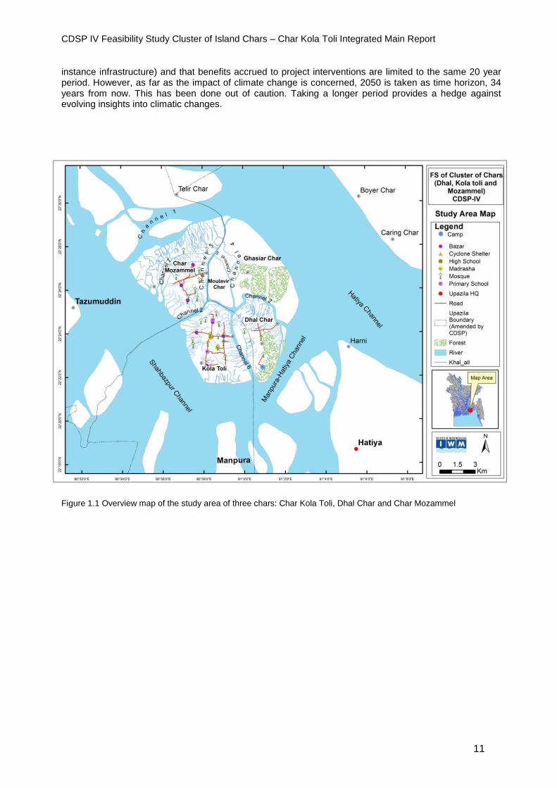
instance infrastructure) and that benefits accrued to project interventions are limited to the same 20 year period. However, as far as the impact of climate change is concerned, 2050 is taken as time horizon, 34 years from now. This has been done out of caution. Taking a longer period provides a hedge against evolving insights into climatic changes.
Figure 1.1 Overview map of the study area of three chars: Char Kola Toli, Dhal Char and Char Mozammel

CDSP IV Feasibility Study Cluster of Island Chars – Char Kola Toli Integrated Main Report
12
Figure 1.2 Map of Char Kola Toli
CDSP IV Feasibility Study Cluster of Island Chars – Char Kola Toli Integrated Main Report
13
2. Water management
2.1 Introduction
Water management is a crucial factor in CDSP projects because it is directly related to vital aspects of people’s livelihoods as safety, food security and further economic development. That is certainly the case for Char Kola Toli, with its vulnerable location in the lower Meghna. That is why water management is dealt with so early in this feasibility study. It sets the stage for the possibilities for development in other fields such as agriculture, livestock, fisheries and forestry, all of great importance in livelihoods of char settlers. This chapter starts with explaining the present situation (in 2.2) in terms of a number of essential variables. It continues with assessing the options for a future scenario in order to come to a water management plan (2.3), taking into account the consequences of climate change. The chapter closes with an overview of the costs of the proposed water management interventions and of the benefits they will generate (2.4).
2.2 Present situation and constraints
2.2.1. Main features of present situation - Area and land levels: The gross area of Char Kola Toli is 2,523 ha. Land levels vary from 0 to 4 m PWD. About 60% is lower than 2.25 m PWD, while a sizable portion (30%) is between 2.25 and 2.50 m. The remaining 105 ha has a level between 2.5 and 4 m PWD. Roughly 95% of the char is between 0 and 2.68 m PWD (2.68 m is the mean high water level at monsoon time, the level that indicates the land is mature, in the sense that no further siltation will occur). - Rainfall: The two nearest stations where rainfall is measured are at Hatiya (covering 65% of the study area) and at Ramgati. Average annual rainfall over the last 50 years for Hatiya station was 3,079 mm. The maximum daily rainfall (2.33 year return period) was 176 mm, with 3 days and 5 days consecutive rainfall of 309 mm and 392 mm respectively. For Ramgati average annual rainfall was 3,706 mm, maximum daily rainfall 140 mm, with consecutive 3 days and 5 days rainfall of 302 mm and 411 mm. - Tidal characteristics: The tidal range during monsoon level varies from -0.80 m to 3.5 m, and during dry season from -0.50 to 2.75 m. The mean high water level (MHWL) during spring tide in monsoon time is 3.20 PWD and during neap tide about 2.20 m. As said, MHWL during monsoon time can be taken as 2.68 m. - Inundation and drainage: As Table 2.1 is showing, in the present condition only 0.27% of the area of Char Kola Toli is flood free during the monsoon season. The largest part of the char 83.5% has an inundation between 0.90 m and 1.80 m, and 14% between 1.80 m and 3.60 m. In the dry season, the low lying sections of the char become flooded at spring tide. The char is inundated twice per day during high tide, in particular in monsoon time. The water comes from all sides, but only stays for 2,5 to 3 hours. There is no stagnant water. This quick run-off makes the char flood free during low tide. - Salinity: Average water salinity levels are higher in the dry season than in monsoon time. Influence from sea salinity is highest during period with low discharge from the Ganges-Meghna-Brahmaputra river system in winter, and drops when upstream flow increases in May. In January salinity varies from 8 to 10 ppt, with a peak of 14 ppt at spring tide. In the months of March and April and the first part of May, salinity rises to 15-18 ppt, but then falls sharply to 4-7 ppt when the pre-monsoon rains set in. In June salinity drops to a concentration of below 1 ppt. - Stability: Stability of the area is an essential variable for a decision to start a significant development program. Based on satellite images, Kola Toli had an area of 1,960 ha in 1996 (2,524 ha at present).
CDSP IV Feasibility Study Cluster of Island Chars – Char Kola Toli Integrated Main Report
14
Between 1967 and 2000 it lost 106 ha to erosion, mostly in the southern part along the Monpura-Hatiya channel, but also in the north along the channel between Char Kola Toli and Char Mozammel. Afterwards, up to 2011, a pattern of accretion can be observed, resulting in an increase in area of 965 ha. The latest image of 2015 shows a little bit erosion in the southwestern part. But during a field visit, no erosion at that side of the char was detected, only submersible chars. After studying the series of satellite images, field observations and opinion of local stakeholders, the opinion is that the char is stable and that further natural accretion can be expected. -Rate of sedimentation: To come to an estimate of the rate of sedimentation, field tests were done (measuring cross sections of khals) and a desk study was undertaken. A 10 year model-study of IWM/ Unesco-IHE concluded that average annual sedimentation rate in the study area was 4 cm. The field tests provided a similar result. 2.2.2. Major constraints The major features of the area as summarized in 2.2.1 and views from the population point to the main water management related bottlenecks in Char Kola Toli. Land levels are relatively low. The char is still in a development phase, with more than 90% with a land level lower than MHWL in monsoon time. Only a fraction of the area stays flood free in monsoon time. Salinity levels of water show a great range from less than 1 ppt in June to nearly 20 ppt in the beginning of May.
2.3 Impact of climate change
While assessing the impact of climate change on the physical conditions of the chars in the Lower Meghna, especially the Representative Concentration Pathways (RCP) of the IPCC have been used. Projections of precipitation for the year 2050 show dramatic increases in rainfall during the monsoon season, in particular in the months from July to October, ranging from nearly 17% more precipitation in July to nearly 27% in September. The increase in wind speed in 2050 is project to be 8%. The feasibility study has assumed that global sea level rise will be 24 cm in 2050, relative to 2015, based on IPCC scenarios (RCP 8.5). The likely rate of land subsidence is taken as 10 mm a year (same assumption is used by the Coastal Embankment Improvement Project). The sedimentation rate for the study period is estimated to be 4 cm a year, based on field tests and a Unesco/ IHE model study. The relative mean sea level rise for 2050 (35 years from now, beyond the 20 year time horizon of this study) is estimated to be - 1 cm (or 0 cm). This is the product of global sea level rice of 24 cm, plus land subsidence of 35 cm, minus sedimentation of 60 cm (4 cm for a period of 15 years). The abovementioned assumed changes in a number of essential variables have been an input in the drainage model applied for the study. This model supported the selection of planning options and the designs of the water management related structures.
2.4 Water management plan
2.4.1. Planning options The study area is vulnerable to tidal inundation, storm surges, salinity, climate change, in particular sea level rise. After analysis of primary and secondary data and discussions with various stakeholders, four potential options were identified for addressing these vulnerabilities and for developing Char Kola Toli. Essential criteria in the selection were the current land levels and the Mean High Water Level during monsoon time. Beyond MHWL in monsoon time no significant sedimentation of the area will take place. The four options are as follows:
- Option 1: Leaving the char unprotected Allow natural sedimentation to raise the land levels up to the MHWL in monsoon time. No construction of embankment and water control structures. Development efforts focused on limited growth of productive sectors as agriculture, fisheries and livestock, on social forestry, on development of internal infrastructure (road network, tube wells for drinking water and sanitary latrines, cyclone shelters) and on further enhancement of livelihoods with the assistance of NGOs.
- Option 2: Construction of polder after maturing of char Construction of a polder through natural sedimentation, if indeed land levels have achieved MHWL in monsoon time. If this can be achieved within the project period, embankments and water management

CDSP IV Feasibility Study Cluster of Island Chars – Char Kola Toli Integrated Main Report
15
structures can form a part of the future project. In addition, the same internal infrastructure and socio-economic interventions as in option 1. - Option 3: Acceleration of land level increase through dredging Raising of land levels to MHWL in monsoon time, through mechanized sand deposition (dredging surrounding rivers and pumping fill material on the land); after MHWL is reached, construction of embankment with water control structures; development of agriculture, fisheries and livestock and social forestry in a protected area; other development activities as in option 1. -Option 4: Make one polder of three island chars Same approach as in option 3, but establishing one polder with the two other study areas (Dhal Char and Char Mozammel) by building cross dams between the chars and subsequently build an embankment around all three chars. Further development program as in option 3.
2.4.2. Selection of options Due to the impact of climate change (resulting in a relative mean sea level rise of 19 cm in 2050, the inundation of the char will worsen in the long run, if the char is indeed left unprotected for such a long time (as in option 1). But during a new project (roughly 2019 to 2025) meaningful development efforts can be initiated. Char Kola Toli can be embanked as soon as land levels reach MHWL in monsoon time (option 2). It is estimated that this process will take about 15 years, which means that construction of a polder would be well beyond the timeframe of a new project. Option 2 is technically feasible, but is not further considered because it is not feasible in terms of inclusion in a project that would succeed CDSP IV. Although option 3 (accelerating increase of land levels by deposition of dredging spoil) has practically a number of unresolved issues, it is most probably technically feasible. But it is as yet not known whether the additional costs of dredging would make this option not viable out of economic and financial perspective. The same applies to option 4 (which is using dredging to help enhance land levels and construct one embankment around three chars, instead of establishing three separate polders. Summarizing the assessment of the options: Option 1 is obviously technically feasible but would over an extended period worsen the water management situation; Option 2 is technically, and probably financially and economically feasible, but is not feasible given the project time frame. Option 2 can for all practical purposes be discarded. Options 3 and 4 are probably technically feasible, but the financial and economic feasibility is doubtful, given the additional costs of dredging. But these options can as yet not been discarded. 2.4.3. Proposed interventions - Option 1: No water management interventions are planned under this option. The char will stay unprotected to allow further sedimentation. Excavation of existing channels is proposed to further accelerate drainage after tidal flooding (11 khals with total length 20.1 km, volume of excavation 137.900 cubic meters). As mentioned above, there are no serious water logging issues at the moment. - Option 2: This option has been discarded, because required land levels (2.68 m) would only be reached around 2030, far beyond the time frame of a new project. -Option 3: Protection of Char Kola Toli under this option would require a sea facing embankment of 8.98 km and internal embankments of in total 7.54 km. Ten one-vent water control structures have to be built and re-excavation of 11 khals of in total around 20.10 km has to be carried out. Total quantity of dredging to raise land levels with an average of 27 cm is nearly 4 million cubic meter. In addition, two buildings for Water Management Groups would be constructed. -Option 4: Interventions under option 4 (one polder area encompassing three chars) are not serving Char Kola Toli only, but also Char Mozammel and Dhal Char. For this option nearly 11 million cubic meters of dredge filling is required (for Char Kola Toli and Char Mozammel). A sea facing embankment of 19.6 km and internal embankments of 29.73 km are required, plus two cross dams. Water control structures with in total 27 vents have to be constructed. Six WMG buildings are includes as well.
2.5 Costs and benefits
2.5.1. Costs
- Option 1: Costs of re-excavation of drainage channels will be Taka 206.79 lakh.
CDSP IV Feasibility Study Cluster of Island Chars – Char Kola Toli Integrated Main Report
16
- Option 2: Option 2 is not applicable in case of Char Kola Toli.
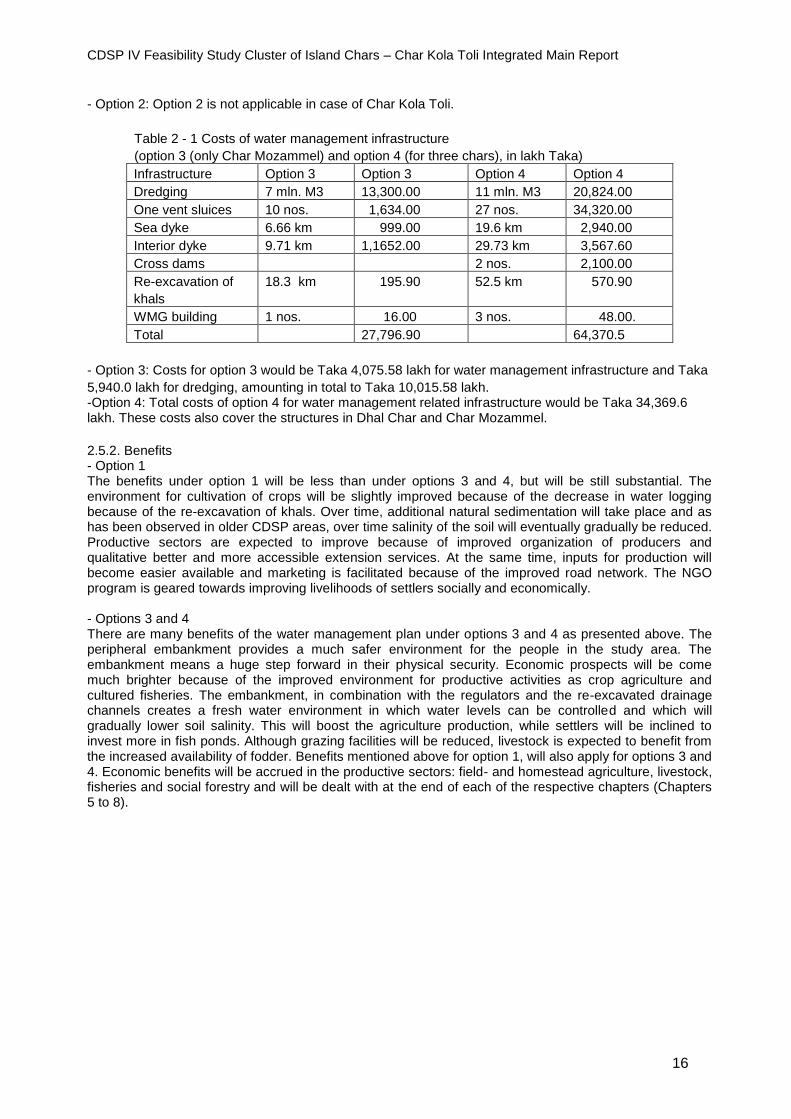
Table 2 - 1 Costs of water management infrastructure
(option 3 (only Char Mozammel) and option 4 (for three chars), in lakh Taka)
Infrastructure Option 3 Option 3 Option 4 Option 4
Dredging 7 mln. M3 13,300.00 11 mln. M3 20,824.00
One vent sluices 10 nos. 1,634.00 27 nos. 34,320.00
Sea dyke 6.66 km 999.00 19.6 km 2,940.00
Interior dyke 9.71 km 1,1652.00 29.73 km 3,567.60
Cross dams 2 nos. 2,100.00
Re-excavation of
khals
18.3 km 195.90 52.5 km 570.90
WMG building 1 nos. 16.00 3 nos. 48.00.
Total 27,796.90 64,370.5
- Option 3: Costs for option 3 would be Taka 4,075.58 lakh for water management infrastructure and Taka
5,940.0 lakh for dredging, amounting in total to Taka 10,015.58 lakh. -Option 4: Total costs of option 4 for water management related infrastructure would be Taka 34,369.6 lakh. These costs also cover the structures in Dhal Char and Char Mozammel.
2.5.2. Benefits - Option 1 The benefits under option 1 will be less than under options 3 and 4, but will be still substantial. The environment for cultivation of crops will be slightly improved because of the decrease in water logging because of the re-excavation of khals. Over time, additional natural sedimentation will take place and as has been observed in older CDSP areas, over time salinity of the soil will eventually gradually be reduced. Productive sectors are expected to improve because of improved organization of producers and qualitative better and more accessible extension services. At the same time, inputs for production will become easier available and marketing is facilitated because of the improved road network. The NGO program is geared towards improving livelihoods of settlers socially and economically. - Options 3 and 4 There are many benefits of the water management plan under options 3 and 4 as presented above. The peripheral embankment provides a much safer environment for the people in the study area. The embankment means a huge step forward in their physical security. Economic prospects will be come much brighter because of the improved environment for productive activities as crop agriculture and cultured fisheries. The embankment, in combination with the regulators and the re-excavated drainage channels creates a fresh water environment in which water levels can be controlled and which will gradually lower soil salinity. This will boost the agriculture production, while settlers will be inclined to invest more in fish ponds. Although grazing facilities will be reduced, livestock is expected to benefit from the increased availability of fodder. Benefits mentioned above for option 1, will also apply for options 3 and 4. Economic benefits will be accrued in the productive sectors: field- and homestead agriculture, livestock, fisheries and social forestry and will be dealt with at the end of each of the respective chapters (Chapters 5 to 8).
CDSP IV Feasibility Study Cluster of Island Chars – Char Kola Toli Integrated Main Report
17
3. Internal infrastructure
3.1 Existing infrastructure
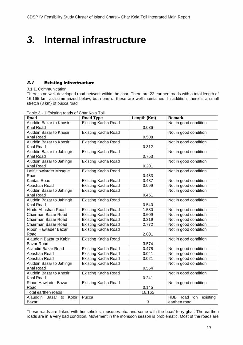
3.1.1. Communication There is no well-developed road network within the char. There are 22 earthen roads with a total length of 16.165 km, as summarized below, but none of these are well maintained. In addition, there is a small stretch (3 km) of pucca road.
Table 3 - 1 Existing roads of Char Kola Toli
Road Road Type Length (Km) Remark
Aluddin Bazar to Khosir Khal Road
Existing Kacha Road 0.036
Not in good condition
Aluddin Bazar to Khosir Khal Road
Existing Kacha Road 0.508
Not in good condition
Aluddin Bazar to Khosir Khal Road
Existing Kacha Road 0.312
Not in good condition
Aluddin Bazar to Jahingir Khal Road
Existing Kacha Road 0.753
Not in good condition
Aluddin Bazar to Jahingir Khal Road
Existing Kacha Road 0.201
Not in good condition
Latif Howlarder Mosque Road
Existing Kacha Road 0.433
Not in good condition
Karitas Road Existing Kacha Road 0.487 Not in good condition
Abashan Road Existing Kacha Road 0.099 Not in good condition
Aluddin Bazar to Jahingir Khal Road
Existing Kacha Road 0.461
Not in good condition
Aluddin Bazar to Jahingir Khal Road
Existing Kacha Road 0.540
Not in good condition
Hindu Abashan Road Existing Kacha Road 1.580 Not in good condition
Chairman Bazar Road Existing Kacha Road 0.609 Not in good condition
Chairman Bazar Road Existing Kacha Road 0.319 Not in good condition
Chairman Bazar Road Existing Kacha Road 2.772 Not in good condition
Ripon Hawlader Bazar Road
Existing Kacha Road 2.001
Not in good condition
Alauddin Bazar to Kabir Bazar Road
Existing Kacha Road 3.574
Not in good condition
Allaudin Bazar Road Existing Kacha Road 0.478 Not in good condition
Abashan Road Existing Kacha Road 0.041 Not in good condition
Abashan Road Existing Kacha Road 0.021 Not in good condition
Aluddin Bazar to Jahingir Khal Road
Existing Kacha Road 0.554
Not in good condition
Aluddin Bazar to Khosir Khal Road
Existing Kacha Road 0.241
Not in good condition
Ripon Hawlader Bazar Road
Existing Kacha Road 0.145
Not in good condition
Total earthen roads 16.165
Alauddin Bazar to Kobir Bazar
Pucca 3
HBB road on existing earthen road
These roads are linked with households, mosques etc. and some with the boat/ ferry ghat. The earthen roads are in a very bad condition. Movement in the monsoon season is problematic. Most of the roads are
CDSP IV Feasibility Study Cluster of Island Chars – Char Kola Toli Integrated Main Report
18
inundated during high tide. Motor cycles and bicycles can only ply during the dry season. The roads are shown in Fig 1.2. 3.1.2 Water supply and sanitary facilities There are about 30 deep tube wells in Char Kola Toli. The tube wells are the main source of drinking water. There are only a few ponds. Sanitary facilities in the char are almost nil. Most of the households are using kacha latrines. Very limited households are using single pit latrines. 3.1.3 Cyclone shelter At present there is one cyclone shelter in the char, constructed by LGED. Another one is under construction, also by LGED. 3.1.4 Other infrastructure There are 15 mosques, five bazars, six primary schools and madrasas, and an Asryan cluster village in the char.
3.2 Proposed internal infrastructure
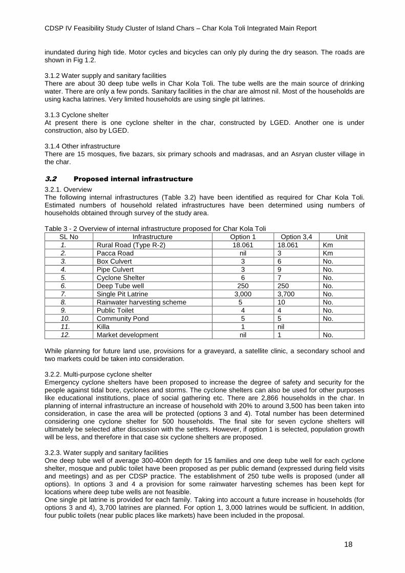
3.2.1. Overview The following internal infrastructures (Table 3.2) have been identified as required for Char Kola Toli. Estimated numbers of household related infrastructures have been determined using numbers of households obtained through survey of the study area. Table 3 - 2 Overview of internal infrastructure proposed for Char Kola Toli
SL No Infrastructure Option 1 Option 3,4 Unit
1. Rural Road (Type R-2) 18.061 18.061 Km
2. Pacca Road nil 3 Km
3. Box Culvert 3 6 No.
4. Pipe Culvert 3 9 No.
5. Cyclone Shelter 6 7 No.
6. Deep Tube well 250 250 No.
7. Single Pit Latrine 3,000 3,700 No.
8. Rainwater harvesting scheme 5 10 No.
9. Public Toilet 4 4 No.
10. Community Pond 5 5 No.
11. Killa 1 nil
12. Market development nil 1 No.
While planning for future land use, provisions for a graveyard, a satellite clinic, a secondary school and two markets could be taken into consideration.
3.2.2. Multi-purpose cyclone shelter Emergency cyclone shelters have been proposed to increase the degree of safety and security for the people against tidal bore, cyclones and storms. The cyclone shelters can also be used for other purposes like educational institutions, place of social gathering etc. There are 2,866 households in the char. In planning of internal infrastructure an increase of household with 20% to around 3,500 has been taken into consideration, in case the area will be protected (options 3 and 4). Total number has been determined considering one cyclone shelter for 500 households. The final site for seven cyclone shelters will ultimately be selected after discussion with the settlers. However, if option 1 is selected, population growth will be less, and therefore in that case six cyclone shelters are proposed. 3.2.3. Water supply and sanitary facilities One deep tube well of average 300-400m depth for 15 families and one deep tube well for each cyclone shelter, mosque and public toilet have been proposed as per public demand (expressed during field visits and meetings) and as per CDSP practice. The establishment of 250 tube wells is proposed (under all options). In options 3 and 4 a provision for some rainwater harvesting schemes has been kept for locations where deep tube wells are not feasible. One single pit latrine is provided for each family. Taking into account a future increase in households (for options 3 and 4), 3,700 latrines are planned. For option 1, 3,000 latrines would be sufficient. In addition, four public toilets (near public places like markets) have been included in the proposal.

CDSP IV Feasibility Study Cluster of Island Chars – Char Kola Toli Integrated Main Report
19
3.2.4. Rural Roads Rural roads will improve communication within the project area. The proposed new roads and to be developed existing roads are R-2 type LGED standard: crest width 3.7m, side slope 2:1, crest level 5.50 m PWD. Table 3 - 3 Roads proposed for development
Existing Roads and Proposed Roads Road Type (R-2) Length (km)
Aluddin Bazar to Khosir Khal Road Earthen Kacha Road 1.754
Latif Howlarder Mosque Road Earthen Kacha Road 0.433
Karitas Road Earthen Kacha Road 0.487
Hindu Abashan Road Earthen Kacha Road 1.580
Alauddin Bazar to Kabir Bazar Road Earthen Kacha Road 3.876
Alauddin Bazar Road Earthen Kacha Road 0.477
Aluddin Bazar to Jahingir Khal Road Earthen Kacha Road 2.544
Chairman Hawlader Bazar Road Earthen Kacha Road 4.336
Ripon Hawlader Bazar Road Earthen Kacha Road 2.574
Total length of Kota Toli Char’s Road Earthen Kacha Road 18.061
The exact location of the roads will ultimately be decided after discussion with the settlers. 3.2.5. Culverts The road alignment has been set in such a way that the number of box culverts/ pipe culverts is minimized. Provision for options 3 and 4 of six box culverts and nine pipe culverts have been kept for cross drainage. For option 1, three box- and three pipe culverts are proposed. They will be located at appropriate places having the view of the settlers. 3.2.6. Ponds Five community ponds have been proposed, as the few existing ponds in the area are inadequate. 3.2.7. Cluster village Char Kola Toli has one Asrayan village. But during field visits and meetings with the local people of the area it became apparent that they are interested to live in independent houses rather than living in a cluster village. As such provision for cluster villages has not been included.
3.3 Costs and benefits
3.3.1. Cost estimate Table 3 - 4 Cost estimate internal infrastructure for Char Kola Toli (options 1, 3 and 4), in lakh Takas
Infrastructure Option 1 Options 3,4 Cost (Lac Tk.)
Total Cost Option 1
Total costs Options 3,4
Rural Road (Type R-2)
18.06 18.06 km 20.00 361.2 361.30
Box Culverts 3 6 35.0 105.00 210.00
Pipe Culverts 3 9 4.00 12.00 36.00
Multi-purpose Cyclone Shelter
6 7 200.00 1,200.00 1,400.00
Deep Tube well 250 250 1.00 250.00 250.00
Single pit Latrine 3,000 3700 0.05 150.00 185.00
Public Toilets 4 13.00 52.00
Rain Water Harvesting Schemes
5 10 1.00 5.00 10.00
Community Pond 5 5 10.0 50.00 50.00
Pucca road 3 km 75 225.00
Market development 1 75 75.00
Killa 1 40.00
Total 2,173.20 2,854.20

CDSP IV Feasibility Study Cluster of Island Chars – Char Kola Toli Integrated Main Report
20
3.3.2. Benefits The upgraded and expanded road network will contribute to the greater safety of the char population by enhancing the possibilities for them to go to safer places. At the same time the roads will stimulate economic activities and thus promote the general economic uplift of the area. Markets, workshops and shops will emerge, providing employment opportunities and income for the settlers. The cyclone shelters obviously increase the security of the population, while the possibility of establishing schools in the buildings increases the educational opportunities, especially for children. The deep tube wells will improve the health status of the population and will lessen the daily workload of the women. Sanitary facilities have a direct positive health impact. These benefits of the development of internal infrastructure have only an indirect economic impact and cannot easily be quantified in terms of money.

CDSP IV Feasibility Study Cluster of Island Chars – Char Kola Toli Integrated Main Report
21
4. Land settlement
4.1 Introduction
Land settlement is an essential component of the CDSP-project, right from the start of CDSP I in 1994. The ultimate aim of this component is to provide hitherto landless households with a title on the land in newly developed chars. Since that first phase a total of almost 27,000 khatians (land title documents) have been distributed by the Ministry of Land in the framework of CDSP. Monitoring exercises indicate that over a period of on average 12 years, 80% of the original settles still lived in the area and of the, 85% still had their original allocation of land. Providing a title, directly contributes to the main objective of CDSP: improving the livelihoods of settlers in coastal char areas. It considerably broadens the asset base of the households. The legal security that the document gives to the settlers will stimulate them to invest in their newly acquired land, which will have a positive effect on the agricultural production. Being landowners, the social status of the households is enhanced and the self-confidence of the settlers is increased. Families in these new chars come from different areas, often from locations where erosion occurred and land was lost. Or they migrated because they had to sell their previously owned land due to their distressed circumstances. In many cases, migration to new lands will mean they are being controlled by powerful jotdars, seldom using or threatening with force by their bahinis. According to Government regulations, newly emerged land has to be distributed to the landless (Policy for settlement of agricultural khas land of 1997), including a title on the land to a maximum of 1.5 acre per household. It is the task of the Government to apply the law and initiate and complete the process of land settlement (providing eligible households with a title). The Ministry of Land is one of the six partner implementing agencies of CDSP. In the project, innovative procedures are followed which brings the whole settlement process closer to the people, is more transparent, shorten the duration and make it far less costly for the settlers.
4.2 Present situation
4.2.1. The study area
The size of Char Kola Toli is 6,232 acre (2,523 ha). The number of households at the time of the study stands at 2,866. This figure is based on records of various Ministry of Land offices, among them Union Council offices, and on discussions with local representatives. All of the area of Char Kola Toli is part of Monpura Upazilla under Bhola District. There are several boundary disputes between Tazumuddin Upazilla and Monpura Upazillas regarding the boundary line. Some court cases are pending in the local courts to ascertain the actual location of the line. Though there is rivalry between the inhabitants of the two Upazillas, the local people are amicably maintaining the boundary. Therefore, most probably the local settlers will not hinder the land settlement process in Char Kola Toli. Nevertheless, before settlement works starts there, the boundary issue should be resolved through an initiative taken by the District administration of Bhola and the Ministry of Land.
CDSP IV Feasibility Study Cluster of Island Chars – Char Kola Toli Integrated Main Report
22
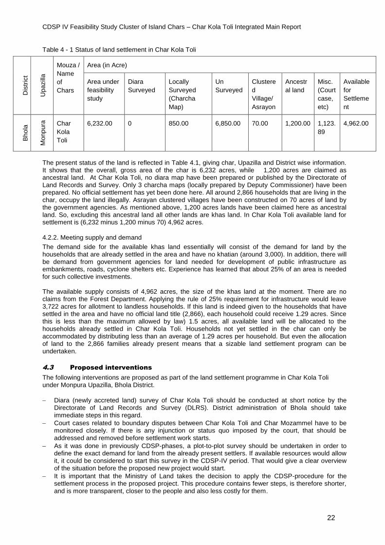
Table 4 - 1 Status of land settlement in Char Kola Toli
The present status of the land is reflected in Table 4.1, giving char, Upazilla and District wise information. It shows that the overall, gross area of the char is 6,232 acres, while 1,200 acres are claimed as ancestral land. At Char Kola Toli, no diara map have been prepared or published by the Directorate of Land Records and Survey. Only 3 charcha maps (locally prepared by Deputy Commissioner) have been prepared. No official settlement has yet been done here. All around 2,866 households that are living in the char, occupy the land illegally. Asrayan clustered villages have been constructed on 70 acres of land by the government agencies. As mentioned above, 1,200 acres lands have been claimed here as ancestral land. So, excluding this ancestral land all other lands are khas land. In Char Kola Toli available land for settlement is (6,232 minus 1,200 minus 70) 4,962 acres.
4.2.2. Meeting supply and demand
The demand side for the available khas land essentially will consist of the demand for land by the households that are already settled in the area and have no khatian (around 3,000). In addition, there will be demand from government agencies for land needed for development of public infrastructure as embankments, roads, cyclone shelters etc. Experience has learned that about 25% of an area is needed for such collective investments. The available supply consists of 4,962 acres, the size of the khas land at the moment. There are no claims from the Forest Department. Applying the rule of 25% requirement for infrastructure would leave 3,722 acres for allotment to landless households. If this land is indeed given to the households that have settled in the area and have no official land title (2,866), each household could receive 1.29 acres. Since this is less than the maximum allowed by law) 1.5 acres, all available land will be allocated to the households already settled in Char Kola Toli. Households not yet settled in the char can only be accommodated by distributing less than an average of 1.29 acres per household. But even the allocation of land to the 2,866 families already present means that a sizable land settlement program can be undertaken.
4.3 Proposed interventions
The following interventions are proposed as part of the land settlement programme in Char Kola Toli under Monpura Upazilla, Bhola District.
Diara (newly accreted land) survey of Char Kola Toli should be conducted at short notice by the Directorate of Land Records and Survey (DLRS). District administration of Bhola should take immediate steps in this regard.
Court cases related to boundary disputes between Char Kola Toli and Char Mozammel have to be monitored closely. If there is any injunction or status quo imposed by the court, that should be addressed and removed before settlement work starts.
As it was done in previously CDSP-phases, a plot-to-plot survey should be undertaken in order to define the exact demand for land from the already present settlers. If available resources would allow it, it could be considered to start this survey in the CDSP-IV period. That would give a clear overview of the situation before the proposed new project would start.
It is important that the Ministry of Land takes the decision to apply the CDSP-procedure for the settlement process in the proposed project. This procedure contains fewer steps, is therefore shorter, and is more transparent, closer to the people and also less costly for them.
Dis
tric
t
Upazill
a
Mouza /
Name
of
Chars
Area (in Acre)
Area under
feasibility
study
Diara
Surveyed
Locally
Surveyed
(Charcha
Map)
Un
Surveyed
Clustere
d
Village/
Asrayon
Ancestr
al land
Misc.
(Court
case,
etc)
Available
for
Settleme
nt
Bho
la
Monp
ura
Char
Kola
Toli
6,232.00 0 850.00 6,850.00 70.00 1,200.00 1,123.
89
4,962.00

CDSP IV Feasibility Study Cluster of Island Chars – Char Kola Toli Integrated Main Report
23
4.4 Costs and benefits
4.4.1. Costs The implementation of the land settlement component of the proposed project will be the responsibility of the Ministry of Land. NGOs however could assist in informing the settlers about their land rights and about the settlement procedures. The Ministry of Land has to make staff available for the implementation, belonging to offices at different levels of the Ministry. The Ministry might appoint additional staff for the purpose, for the project period as it was done in CDSP-III and CDSP-IV. So extra costs would be involved, which can be covered under the GoB project budget of the Ministry of Land. The plot-to-plot survey will bring extra costs as well. With a view on the size of the project area and the experiences to date, it can be estimated that about Taka 8 million is required for the survey. Under the responsibility of the Ministry of Land a number of households have to be resettled, because they have settled in areas where infrastructure will be built. Costs involved with the resettlement can roughly be estimated to be Taka 8 million. Total costs are estimated to be Taka 16 million or 160 lakh. 4.4.2. Benefits It is difficult to translate the benefits of the land settlement efforts into a particular amount in Takas. Experiences have shown that the provision of land titles contributes to an economic and social transformation of the communities concerned. The security that they indeed own the land, will lead to extra investments in the land and presumably to higher production levels. There will be less sharecropping arrangements in favor of more own cultivation. Immaterial benefits are the enhancement of the social status and increase in self-confidence. As can be witnessed in areas where CDSP has been operational, prices of land will considerably go up, further strengthening the asset-base and making it easier to obtain loans, if needed.
CDSP IV Feasibility Study Cluster of Island Chars – Char Kola Toli Integrated Main Report
24
5. Agriculture
5.1 Introduction
Agriculture is the main source of livelihood in Char Kola Toli. About 40% of the settlers are directly involved with farming. Crop agriculture covers more than 90% of the area. The proposed package of water management interventions is expected to have a positive influence on the agricultural sector, including homestead gardening. In option 1(leaving the char unprotected for the time being) agriculture will mostly benefit from improved extension services, input supply and possibilities for marketing (also by the enhanced road network). The re-excavation of khals will have a minor impact. Under options 3 and 4 (constructing a polder) the impact will be much more significant. It will protect crops from tidal flooding, increase the availability of fresh water and over time decrease the salinity of the soil. In this chapter, the current situation is presented (5.2) and for both water management options a future scenario is described (5.3). The chapter ends with an assessment of the costs of the proposed actions as well as the benefits.
5.2 Present situation
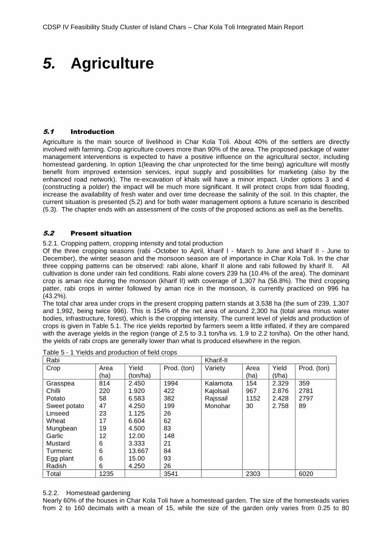
5.2.1. Cropping pattern, cropping intensity and total production Of the three cropping seasons (rabi -October to April, kharif I - March to June and kharif II - June to December), the winter season and the monsoon season are of importance in Char Kola Toli. In the char three copping patterns can be observed: rabi alone, kharif II alone and rabi followed by kharif II. All cultivation is done under rain fed conditions. Rabi alone covers 239 ha (10.4% of the area). The dominant crop is aman rice during the monsoon (kharif II) with coverage of 1,307 ha (56.8%). The third cropping patter, rabi crops in winter followed by aman rice in the monsoon, is currently practiced on 996 ha (43.2%). The total char area under crops in the present cropping pattern stands at 3,538 ha (the sum of 239, 1,307 and 1,992, being twice 996). This is 154% of the net area of around 2,300 ha (total area minus water bodies, infrastructure, forest), which is the cropping intensity. The current level of yields and production of crops is given in Table 5.1. The rice yields reported by farmers seem a little inflated, if they are compared with the average yields in the region (range of 2.5 to 3.1 ton/ha vs. 1.9 to 2.2 ton/ha). On the other hand, the yields of rabi crops are generally lower than what is produced elsewhere in the region.
Table 5 - 1 Yields and production of field crops
Rabi Kharif-II
Crop Area (ha)
Yield (ton/ha)
Prod. (ton) Variety Area (ha)
Yield (t/ha)
Prod. (ton)
Grasspea Chilli Potato Sweet potato Linseed Wheat Mungbean Garlic Mustard Turmeric Egg plant Radish
814 220 58 47 23 17 19 12 6 6 6 6
2.450 1.920 6.583 4.250 1.125 6.604 4.500 12.00 3.333 13.667 15.00 4.250
1994 422 382 199 26 62 83 148 21 84 93 26
Kalamota Kajolsail Rajssail Monohar
154 967 1152 30
2.329 2.876 2.428 2.758
359 2781 2797 89
Total 1235 3541 2303 6020
5.2.2. Homestead gardening Nearly 60% of the houses in Char Kola Toli have a homestead garden. The size of the homesteads varies from 2 to 160 decimals with a mean of 15, while the size of the garden only varies from 0.25 to 80
CDSP IV Feasibility Study Cluster of Island Chars – Char Kola Toli Integrated Main Report
25
decimal. About 63% households have a small ditch in the homestead which is really a borrow pit constructed during raising the plinth level of their houses. This ditch is the source of water for domestic usage and for watering the gardens. Size of these ponds varies from 1 to 320 decimals with a mean of 13. The gardens are used for raising homestead crops such as beans of various kinds, egg plants, tomatoes, amaranths and other leafy vegetables. Some of the houses are better developed with fruit – and timber trees, such as banana, custard apple, papaya and mahogoni. Besides crops, a large majority of homestead dwellers are rearing poultry, goat and/or sheep and cattle. The work involved is particularly done by women.
None of the households keep record of homestead production. The interviewers helped them to recall annual gross income. The average annual income from homestead of vegetables was Taka 2,207, from fruits Taka 1,867 and from timber Taka 22,520. For eggs, milk and meat, the combined income was around Taka 21,000.
5.2.3. Present status of extension services, input supply, credit supply and marketing DAE staff once in a while visits the char to demonstrate new varieties of rice. The impact of those irregular visits on the technology adoption process is low, probably also due to the method of extension with low participation from the side of the farmers. There is no registered dealer in agricultural inputs in the locality. A few farmers act as sub-dealer for registered dealers at Upazila headquarters. Most farmers use their own seeds for crops, or buy seeds from the neighbours. Around 90% of farmers use fertilizer for cultivation of rabi crops and aman rice. But use of urea and TSP is sub-optimal. There is a serious dearth of organic manure. It is mainly used in homestead gardens or in the fields immediately surrounding the homestead.
About 40% of farmers reported taking loans from NGOs, but these loans are mainly used for non-farm purposes. Another 46% are receiving credit from banks elsewhere in the Upazila.
There is no storage facility in the char. Farmers sell their products, mainly rice, just after harvest to middlemen coming from Tajumuddin Upazila of Bhola and Boyer Char of Noakhali. Other products are sold in the markets around the place of production for local consumption.
5.2.4. Constraints Farmers had difficulty identifying constraints in cultivation methods, because of ignorance of the availability of more modern farming methods. They did however voice several hindrances caused by the physical environment. The four most mentioned constraints were tidal flooding, high soil and water salinity, flash floods and high soil moisture in the pre-rabi period. Other factors that are negatively influencing agricultural production are the inadequate extension services, the limited availability of credit, the lack of land titles and consequently the reluctance to invest.
5.3 Development plan for agriculture
5.3.1. Overview of suggested interventions - Protecting the area by embankments: This is a part of options 2 (already discarded) and options 3 and 4. The creation of a polder would result in gradual reduction of the soil salinity and increase the availability of fresh water. On a greater area rabi crops could be grown. Tidal flooding in the monsoon would be prevented and water levels could be controlled. This is expected to boost aman production, among others by introduction of high yielding rice varieties and the cultivation of an aus rice crop, as can be seen in older CDSP areas. - Enhance drainage capacity: This is a part of the options under which a polder is constructed, but also of the option of leaving the char unprotected (re-excavation of drainage channels). This will benefit standing aman crops. It will enhance the possibilities for rabi crops due to the fact that the soil will dry faster after harvesting aman rice. It has to be mentioned that water logging is not seen as a major issue in Char Kola Toli. - Introduction of modern agricultural technologies: improved crop varieties suitable for coastal areas including HYV rice and modern cultivation methods (land management geared toward reducing soil salinity, rice-fish culture, integrated crop-livestock system). - Providing individual land titles: This forms part of the proposed package (see chapter 4). After receiving their land title, farmers are expected to be more inclined to invest in agriculture. - Construction of community ponds: Well-located community ponds with proper dimensions could boost the rabi crop production significantly. This forms part of the proposed internal infrastructure (see chapter 3). Another option would be to design and construct control devices in internal khals, for storage of water. Using groundwater for irrigation is no option in coastal areas. - Strengthening extension services: As mentioned earlier, DAE only provides extension services to a limited extent. The number of available staff, the difficult communication with isolated char islands,
CDSP IV Feasibility Study Cluster of Island Chars – Char Kola Toli Integrated Main Report
26
combined with inadequate logistical supplies are factors that influences DAEs capability to be effective. To overcome this problem it is proposed to engage suitable private sector organizations, in collaboration with DAE. These private institutions, possibly NGOs, should introduce adapted extension methods, for instance the methods applied by IRRI in chars of Noakhali mainland. This method, as with the Farmer Field School approach, focuses on self-motivation of farmers, with beneficial consequences for adoption of modern technologies.
5.4 Costs and benefits
5.4.1. Costs Most of the proposed set of measures to develop the agricultural sector has been taken care of in the cost estimates of other sectors (water management, internal infrastructure, land settlement) and part of the costs of improved extension is taken up in the social- and livelihood component. Remaining costs for extension services are estimated to be Taka 60 lakh for options 1 and 3, and Taka 160 lakh for option 4 (for three chars) respectively.
5.4.2. Benefits In case Char Kola Toli is protected, agricultural benefits would primarily accrue due to prevention of salinity intrusion, better flood management and improved drainage systems. The proposed dykes and improved drainage systems together would reduce flood depths of different land categories leading to greater use of high yielding varieties of crops, increase in cropping intensities and higher crop yields. These interventions would also help reduce soil salinity. Full benefit from agriculture sector will be achieved in year 10 after empoldering. In option 1, benefits would less and would primarily be generated by introduction of modern cultivation methods (through improved extension services), improved supply of agricultural inputs and by slightly better drainage system (due to the re-excavation of drainage channels). Summing up of the impacts of project interventions presented in 5.3.1. the following changes in agricultural production in the char are expected (see table 5.2). Table 5 - 2 Future growth in cultivated area and production
In money terms, at full development stage (after about 10 years), this would result in an annual incremental net benefit for field crops of Taka 859.56 lakh under options 3 and 4 and Taka 343.82 under option 1(on the basis of 40% of full benefits in case the char is protected). Higher homestead production would give an annual incremental return of Taka 19.6 lakh.
Crop/cropping intensity Time Area (ha) option 1
Production, ton, opt. 1
Area (ha) option 3,4
Production, ton, opt.3,4
Rabi Present 4 years after 8 years after
1235 1420 1704
3541 5325 7327
1235 1500 1726
3541 5589 7382
Rice Present 4 years after 8 years after
2303 2303 2303
5983 7370 7485
2303 2303 2303
6020 7542 8545
All crops Present 4 years after 8 years after
3538 3723 4007
9524 12696 14812
3538 3803 4029
9524 13131 15927
Cropping intensity (%) Present 4 years after 8 years after
154
154 165 175
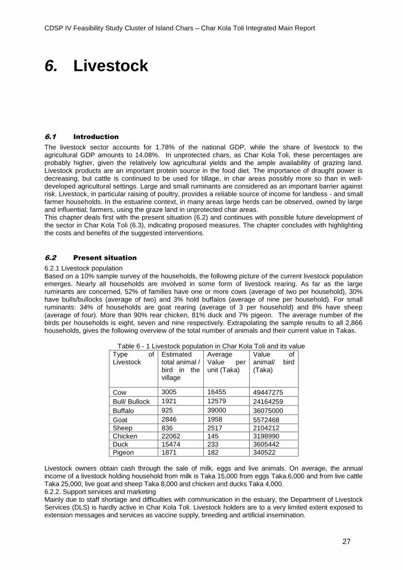
CDSP IV Feasibility Study Cluster of Island Chars – Char Kola Toli Integrated Main Report
27
6. Livestock
6.1 Introduction
The livestock sector accounts for 1.78% of the national GDP, while the share of livestock to the agricultural GDP amounts to 14.08%. In unprotected chars, as Char Kola Toli, these percentages are probably higher, given the relatively low agricultural yields and the ample availability of grazing land. Livestock products are an important protein source in the food diet. The importance of draught power is decreasing, but cattle is continued to be used for tillage, in char areas possibly more so than in well-developed agricultural settings. Large and small ruminants are considered as an important barrier against risk. Livestock, in particular raising of poultry, provides a reliable source of income for landless - and small farmer households. In the estuarine context, in many areas large herds can be observed, owned by large and influential; farmers, using the graze land in unprotected char areas. This chapter deals first with the present situation (6.2) and continues with possible future development of the sector in Char Kola Toli (6.3), indicating proposed measures. The chapter concludes with highlighting the costs and benefits of the suggested interventions.
6.2 Present situation
6.2.1 Livestock population Based on a 10% sample survey of the households, the following picture of the current livestock population emerges. Nearly all households are involved in some form of livestock rearing. As far as the large ruminants are concerned, 52% of families have one or more cows (average of two per household), 30% have bulls/bullocks (average of two) and 3% hold buffalos (average of nine per household). For small ruminants: 34% of households are goat rearing (average of 3 per household) and 8% have sheep (average of four). More than 90% rear chicken, 81% duck and 7% pigeon. The average number of the birds per households is eight, seven and nine respectively. Extrapolating the sample results to all 2,866 households, gives the following overview of the total number of animals and their current value in Takas. Table 6 - 1 Livestock population in Char Kola Toli and its value
Type of Livestock
Estimated total animal / bird in the village
Average Value per unit (Taka)
Value of animal/ bird (Taka)
Cow 3005 16455 49447275
Bull/ Bullock 1921 12579 24164259
Buffalo 925 39000 36075000
Goat 2846 1958 5572468
Sheep 836 2517 2104212
Chicken 22062 145 3198990
Duck 15474 233 3605442
Pigeon 1871 182 340522
Livestock owners obtain cash through the sale of milk, eggs and live animals. On average, the annual income of a livestock holding household from milk is Taka 15,000 from eggs Taka.6,000 and from live cattle Taka 25,000, live goat and sheep Taka 8,000 and chicken and ducks Taka 4,000. 6.2.2. Support services and marketing Mainly due to staff shortage and difficulties with communication in the estuary, the Department of Livestock Services (DLS) is hardly active in Char Kola Toli. Livestock holders are to a very limited extent exposed to extension messages and services as vaccine supply, breeding and artificial insemination.
CDSP IV Feasibility Study Cluster of Island Chars – Char Kola Toli Integrated Main Report
28
The marketing system of livestock products is not organized. Milk marketing is usually done through middlemen. Individual farmers sell their milk etc. directly to the vendor. A litre of milk is sold at Taka 40-50. The vendors transport the raw milk to a nearby bazaar on the mainland. There the milk is processed into final products as ghee, cheese, curd. Also the sale of live cattle is channelled through tradesmen. The market situation for eggs has deteriorated. Eggs are much harder to sell than a few years ago. Large commercial poultry farms on the mainland fulfil the demand of the cities. 6.2.3. Constraints The sample survey shows that major constraints encountered by the livestock holding households are lack of knowledge (mentioned by 32%), diseases (26%), shortage of feed (13%), theft (13%), poor genetic quality of animals (10%) and marketing (6%). In group discussions another two issues were brought forward: housing of ruminants and availability of drinking water.
6.3 Possibilities for future livestock development
6.3.1Measures addressing the constraints - Extension services: Instead of solely relying on the services of DLS, it is recommended to engage NGOs to develop semi-skilled manpower (Livestock Field Workers and Poultry Workers) within communities. After training, in which DLS could play a role, these workers can render extension services on husbandry practices, primary animal health care and immunization. - Treatment of diseases: It is recommended to instruct the engaged NGO to appoint a veterinary doctor who can organize weekly mobile clinics (also in the adjacent chars), assisted by the NGO workers. An arrangement with DLS should be entered into to channel the supply of drugs and vaccines through this veterinarian and these workers and to establish a cool chain. - Training of farmers: A Livestock Farmer Field School method of training of livestock owners should be introduced with the assistance from DLS. Such a system would create linkages between the settlers and DLS staff. The aim is to develop skills and to reduce the knowledge gap. - Supply of fodder: In case the project area will become a polder (options 3 and 4), free grazing facilities will be reduced. On the other hand the cropping intensity will be increased and this will make available more crop residues for the cattle population. As a result the growth rate with project condition will be higher till the optimum herd size is stabilized. But also if the char is left unprotected (option 1), availability of fodder can be stimulated by including more leguminous and salt tolerant fodder crops (such as cow peas and grass peas) in the farming system. Plantation of trees with protein rich leafs, promotion of urea treatment of straw and use of molasses blocks are additional measures to improve the nutrition of animals. - Improved marketing: It is critical that livestock rearing households organize themselves in order to make collective bargaining possible, to reduce the risk of being exploited by the middlemen. The groups can establish direct contacts with sellers of inputs and with buyers of livestock products. They could control the quality of the livestock workers and maintain contact with DLS. They also could introduce milk chilling vats (running on solar power or diesel), which would facilitate the sale of products to more distant markets. - Shelter: Establishment of a community livestock shelter might be considered. Construction of killas is recommended, especially under option 1. - Drinking water: Simple collective rainwater harvesting devices could address the shortage of drinking water for buffaloes and cattle. In case tube wells are established (a part of the proposed infrastructure package), animals could be allowed to use water from a number of shallow wells.
6.4 Expected costs and benefits
6.4.1. Costs The core of the proposed development program is formed by an improvement of extension- and support services. NGOs are expected to take play a major role in these efforts. The costs of the involvement of NGOs are already included in the cost estimated of the social- and livelihood component (see Chapter 9). For other support services a provision of Taka 45 lakh has been taken up in the cost estimate for options 2 and 3, and Taka 130 lakh for option 4 (all three chars). In the estimates for internal infrastructure (Chapter 3), a provision is made for a killa.
6.4.2. Benefits The growth of the livestock sector in estuarine areas Is expected to be higher than the national growth rate because of the specific environmental conditions, among them the availability of natural resources as grazing grounds. The lack of a range of other employment opportunities is a factor as well. This growth can be stimulated further if the proposed measures (see 6.3.1) are indeed introduced, as is shown in Table 6.2 below. Preventable mortality and morbidity of animals would be reduced, while marketing possibilities are

CDSP IV Feasibility Study Cluster of Island Chars – Char Kola Toli Integrated Main Report
29
expected to be greater. More fodder is produced, in particular in case of options 3 and 4. Numbers of livestock is expected to grow, in option 1 less so than if Char Kola Toli is protected. The projected growth is expected to stabilize after about six years. Of course the projected growth rates are rough but at the same time reasoned estimates. If these rates are applied on the current livestock population, the future scenario would be as represented in tables 6.2 and 6.3 for the different options. Table 6 - 2 Estimated livestock population growth in Char Kola Toli (option 1)
Type of animal
Estimated
Annual Growth Rate (%)
2015 2016 2017 2018 2019 2020 2021 2022 2023 2024
Cattle 1 4926 4975 5025 5075 5126 5177 5229 5281 5334 5387
Buffalo 1 925 934 944 953 963 972 982 992 1002 1012
Goat 2.5 2846 2917 2990 3065 3141 3220 3300 3383 3468 3554
Sheep 2.5 836 857 878 900 923 946 970 994 1019 1044
Chicken 3
22062 22724 23406 24108 24831 25576 26343
27133
27947 28786
Duck 4
15474 16093 16576 17073 17585 18113 18656
19216
19792 20386
Table 6 - 3 Estimated livestock population growth in Char Kola Toli (options 3 and 4)
Type of animal
Estimated
Annual Growth Rate (%)
2015 2016 2017 2018 2019 2020 2021 2022 2023 2024
Cattle 2.5 4926 5049 5175 5305 5437 5573 5713 5855 6002 6152
Buffalo 2.5 925 948 958 967 977 987 996 1006 1017 1027
Goat 3 2846 2931 3019 3110 3203 3299 3398 3500 3605 3713
Sheep 3 836 861 887 914 941 969 998 1028 1059 1091
Chicken 5
22062 23165 24323 25540 26816 28157 29565
31043
32596 34225
Duck 5
15474 16248 17060 17913 18809 19749 20737
21773
22862 24005
Net incremental benefits per year at full development, i.e. after 10 years, are estimated to be Taka 164.05
lakh for options 3 and 4, and 80% of that, Taka 131.24 lakh, for option 1.
CDSP IV Feasibility Study Cluster of Island Chars – Char Kola Toli Integrated Main Report
30
7. Fisheries
7.1 Introduction
Bangladesh wide the fish production is on the rise, currently representing 3,7% of GDP and 22,6% of the agricultural part in GDP. It gives employment to over 17 million people and has become a vital component of the country’s export. Equally, aquaculture in ponds and fisheries in canals, rivers and in the Meghna estuary are important activities for the char population. These activities are a source of income and employment and It provides them with a welcome source of protein in their diet. Many of the settlers in the new chars were fishermen before and they like to work again in their old trade. Wild fisheries and aquaculture is essential in improving livelihoods in the context of coastal chars. In Char Kola Toli, about 17% of households are dependent on fisheries for their livelihood. This chapter first looks into the present situation of fisheries in Char Kola Toli (7.2.) and shifts then in 7.3 to possibilities for development, within the framework of the water management options presented in Chapter 2. The chapter concludes with the costs of the proposed development measures, and with the benefits (7.4.).
7.2 Present situation
7.2.1. Closed water fisheries
Closed water bodies are basically ponds and ditches. They can be considered a by-product of house building. They form the borrow pits of making raised homestead platforms for a house, courtyard and garden. Nearly 27% of households reported that private ponds were fishing ground for them. Total area of ponds and ditches in Char Kola Toli is estimated to be 33 ha. These water bodies produced 14 metric tons (MT) of fish, which means about 425 kg per ha per year. Total catch ponds and ditches is negatively influence by tidal floods and storm surges. Two large privately owned fish farms are present, close to Char Kola Toli bazaar. The farms have already started aquaculture activities, but have yet to be organized to reach their full potential. The biggest farm covers an area 8.5 acre. Bagda, golda, tilapia and major carps are grown following a very traditional method. Some ponds are used to rear juveniles of wild fish species and prawns, naturally stocked during flood. The farms procure post larvae of bagda from Cox`s Bazar and fries of major carps and other varieties of fish from hatcheries at Feni and, Comilla.
7.2.2. Capture fisheries in khals, floodplains and outside the study area Open, wild inland fisheries is practiced in khals (total area of 54 ha) and on floodplains (3.5 ha). These water bodies are stocked with wild sources during tides and floods. Wild fisheries in khals amounted to an annual production of about 18.5 MT of fish. This means that yield per ha is nearly 340 kg. Floodplains produce 600 kg per year, with a yield of about 176 kg/ha. About 38% of households use khals (35%) and floodplains (3 %) as their primary fishing ground. Another 24% of households said that the Meghna estuary was their most important fishing ground.
7.2.3. Total current fish production The total annual marketable fish production of Char Kola Toli is estimated to be 52.5 ton. The average price for big fish was Taka 266 per kilo and for small fish Taka 102 per kilo.
7.2.4. Constraints Fisheries in Char Kola Toli have to deal with a series of impediments. The number of ponds is limited, which constraints the fish production through aquaculture. Ponds are damaged and fish gets lost by tidal surges, overtopping the little dykes protecting the ponds. Extension services are scarcely available. Staff of the Department of Fisheries hardly ever visit the char. Supply of inputs, such as fry and fingerlings, is highly inadequate. Most inputs carry a high price. There is a lack of credit facilities. Transport of fish for
CDSP IV Feasibility Study Cluster of Island Chars – Char Kola Toli Integrated Main Report
31
marketing is difficult due to lack of a proper road network and supply of ice. There is a depot for collecting fish. From this depot fishes are transported to different places for marketing. Fish is sold to traders or to whole sale markets in Monpura. Fish caught in the estuary is usually brought to Steamer Ghat near Boyer Char.
7.3 Development plan
7.3.1. Consequences of water management interventions Ultimate selection of water management option obviously has consequences for the possibilities of further development of the fisheries sector. In case a polder will be constructed in Char Kola Toli (options 3 and 4) open fisheries in khals and on floodplains will be affected. On the one hand, fish can no longer enter freely into the khals and plains because of the embankment and regulators (which can be mitigated by making fish friendly structures). But on the other hand khals will be deepened by re- excavation, increasing the volume of water available for fish. Fish production through aquaculture will increase because the ponds will be flood free. The improved physical environment will encourage pond owners to adopt more intensive methods of culture. Fishing in the Meghna estuary will not so much be affected, although boats can no longer be taken inland for shelter and repairs. If the char will be left unprotected (under option 1), enhancement of fisheries has to be achieved through improved extension services, input supplies and marketing facilities. Inland fisheries will further benefit from re-excavation of khals. 7.3.2. Development of aquaculture based fisheries As just mentioned, protection of the area will stimulate further development of aquaculture. Introduction of improved methods of pond management will however require extension efforts and better input supplies. Semi-intensive or intensive models differ with traditional models in matters of stocking fingerlings and use of other inputs, such as fertilizers and feed. Prescribed number of fingerlings and quantities of inputs need to be applied. The distinguishing feature of the intensive method of production is the higher rate of stocking and the application of prepared feed. In a protected area, average annual production rate of household ponds can be increased to 2,000 kg/ha (from the present 428 kg/ha) using intensive methods of fish culture. This would result in an annual overall production of 66 MT compared to the 14 MT at present. It is estimated that about 30% of ponds in Char Kola Toli could be brought under prawn (golda) culture, a very valuable product. If no embankments are built, pond aquaculture will still be improved due to the better extension services, input supplies and marketing possibilities. Increase is estimated to be 10-20%, which means from 428 kg/ha to 470-510 kg/ ha, or roughly an increase of annual production from 14 MT to 16 MT. 7.3.3. Development of fisheries in open water bodies Khals will be re-excavated for improvement of drainage systems. If a polder is constructed, the re-e xcavated khals will retain water during the dry period (December to April) with the support of water control structures. This will create a better habitat for increasing natural fish production in the khals, provided no serious obstructions are made to movement of brood fish and shrimp species through the structures. Khals can even be used for aquaculture, if intelligent use is made of the water control structures and with support of rather simple devices as khattas from branches of tress to divide khals into sections. In such a way, khals can be stocked with fish and prawns. It is expected that khal fisheries production will increase from present level of340 kg/ ha/ yr to 800 kg/ ha/ yr in case peripheral embankments are built. However, fisheries on floodplains would no longer be possible. Overall annual production would grow from 19 MT to 43 MT. If the option is selected to leave Char Kola Toli unprotected so further sedimentation can take place, the open fisheries will benefit from the project because channels will be re-excavated and will thus have more capacity to have fish and because of the improved extension services and marketing system (see below). An increase in production in khals of 10-20% can be expected, that is between 370 and 420 kg/ha per year. Flood plains fisheries would continue. Overall production from open water bodies would increase from 19 MT to 22 MT per year. 7.3.4. Extension services and marketing system. As is proposed in the case of livestock, a NGO might be engaged to take care of extension services and training. This can be successfully done if a fruitful cooperation with the Department of Fisheries is established, for instance in the fields of training and input supplies. Demonstration ponds should be used as one of the methods of dissemination of good practices. Experiences in CDSP and the Greater Noakhali Aquaculture Extension Project should be utilized. The NGO should be asked also to assist households in
CDSP IV Feasibility Study Cluster of Island Chars – Char Kola Toli Integrated Main Report
32
organizing groups so collective bargaining with middle men can be initiated, for the sale of fish and procurement of input supplies. 7.3.5. Establishment of fish hatchery High quality fish seed is the most important requirement for aquaculture development. There is bright prospect for setting up a major carp hatchery in the study area to meet the future demand for fry/fingerlings of private ponds, community ponds and big fish farms. Also adjacent chars could be served from this hatchery. The Department of Fisheries should take the initiative for the establishment of such a hatchery in partnership with the private sector, preferably involving one of the already present large fish farms. Involvement of private sector parties would enhance the chances on proper operation and maintenance and thus on the sustained supply of good quality fish fry. Estimated costs of the hatchery are roughly Taka 8.5 million.
7.4 Costs and benefits
7.4.1. Costs
The additional costs of better extension services are in fact taken up in the budget for the social- and livelihood program, since the NGOs are expected to take the lead in this respect. Only for options 3 and 4 a provision of Taka 35 lakh and Taka 105 lakh (three chars) for additional expenditures. The cost of the proposed hatchery is not included in the overall project cost estimate, because it is assumed that this hatchery will be established by the private commercial sector.
7.4.2. Benefits
The incremental fisheries production would come from capture fisheries in the re-excavated khals and from the floodplain, as well as from aquaculture in individual – and community ponds and large fish farms in the study area (if the char is protected by embankments). Fisheries annual net benefits from different production systems at full development level is expected to occur in the 8th year of project life. Under options 3 and 4, incremental benefits from fisheries in open water bodies are estimated to be Taka 49.14 lakh per year, and for closed water bodies Taka 62.14 lakh. If the char is not protected, the additional income will be very modest and is not reflected in the cost-benefit analysis.
CDSP IV Feasibility Study Cluster of Island Chars – Char Kola Toli Integrated Main Report
33
8. Social forestry
8.1 Introduction
The benefits of forestry development can broadly be divided into three groups: greater safety, improved ecological conditions and a better economic situation for the char settlers. These beneficial functions of forestry make forestry development an essential element of any development package, especially for a vulnerable area as Char Kola Toli, being an island char. There is ample empirical evidence that plantations along the coast have enhanced the protection against storm surges and tidal bores. Devastation of infrastructure and loss of lives have been much smaller in areas with a forest belt. Houses on homesteads with trees suffer less damage from storms. Coastal forests, in particular mangroves, further stabilize the newly emerged areas. They stimulate biodiversity and conserve coastal ecosystems. Trees have a dampening impact on soil erosion, while organic matters are contributing to the fertility of coastal soils. Forests provide timber for building houses and fuel for cooking purposes. In addition, trees give fruits for human consumption, medicinal herbs, and fodder for animals. By participating in social forestry activities, settlers generate an extra stream of income.
8.2 Present situation and constraints
8.2.1. Present coverage of forest in the study area In the 1990s the char was covered by mangrove forests, but they disappeared gradually by the encroachment of settlers. The char is now not protected any greenbelt around it, so is it very much open to natural hazard like cyclonic storms and water surges. Hardly any forest can be found in Char Kola Toli. The present coverage of vegetation can mainly be found in the homesteads and scattered trees on public grounds. A survey showed that nearly all people are interested in further tree plantations. 8.2.2. Constraints for forestry development Due to the encroachment of the mangrove forests, which started around 2003, the relation between the population and the Forest Department has often been tense in the past. This has to change in order to implement a forest development program. The lack of a title on the land that people now occupy makes people reluctant to invest in more trees on their homesteads. Grazing of cattle is another impediment: more forests might imply loss of grazing grounds, while ruminants damage young trees. There is a huge demand for fuel wood (mainly cow dung and straw are sources of fuel). The char is not very old, so there is a crisis of mother trees as a source of seeds. Seeds are to be collected from nearby Monpura or from the main land. Shortage of seeds is a constraining factor.
8.3 Proposed interventions
8.3.2. Following the social forestry approach The government has enacted specific Social Forestry Rules in 2004, amended in 2010. Essential elements in the social forestry approach are the participation of local people in planning and implementation of forestry development activities, the formation of Social Forestry Groups as institutions to realize such participation and agreements between governmental agencies and the Social Forestry Groups on sharing of the benefits of forestry development. The social forestry approach actually adds a fourth benefit of forestry development. It provides employment to the people, and it enhances their self-confidence and self-esteem by acquiring skills and knowledge. Social forestry can contribute to the homogeneity of communities.
The Forest Department has to apply the social forestry approach in Char Kola Toli. Social Forestry Groups will be formed (see also Chapter 10). The Department is expected to enter into agreements with these SFGs determining the sharing of benefits. For different type of activities (as for example agro-forestry, road/ embankment/ khal plantations, and foreshore plantation) different sharing arrangements will be applicable. For strip plantations along roads etc. for instance, the distribution of benefits would be
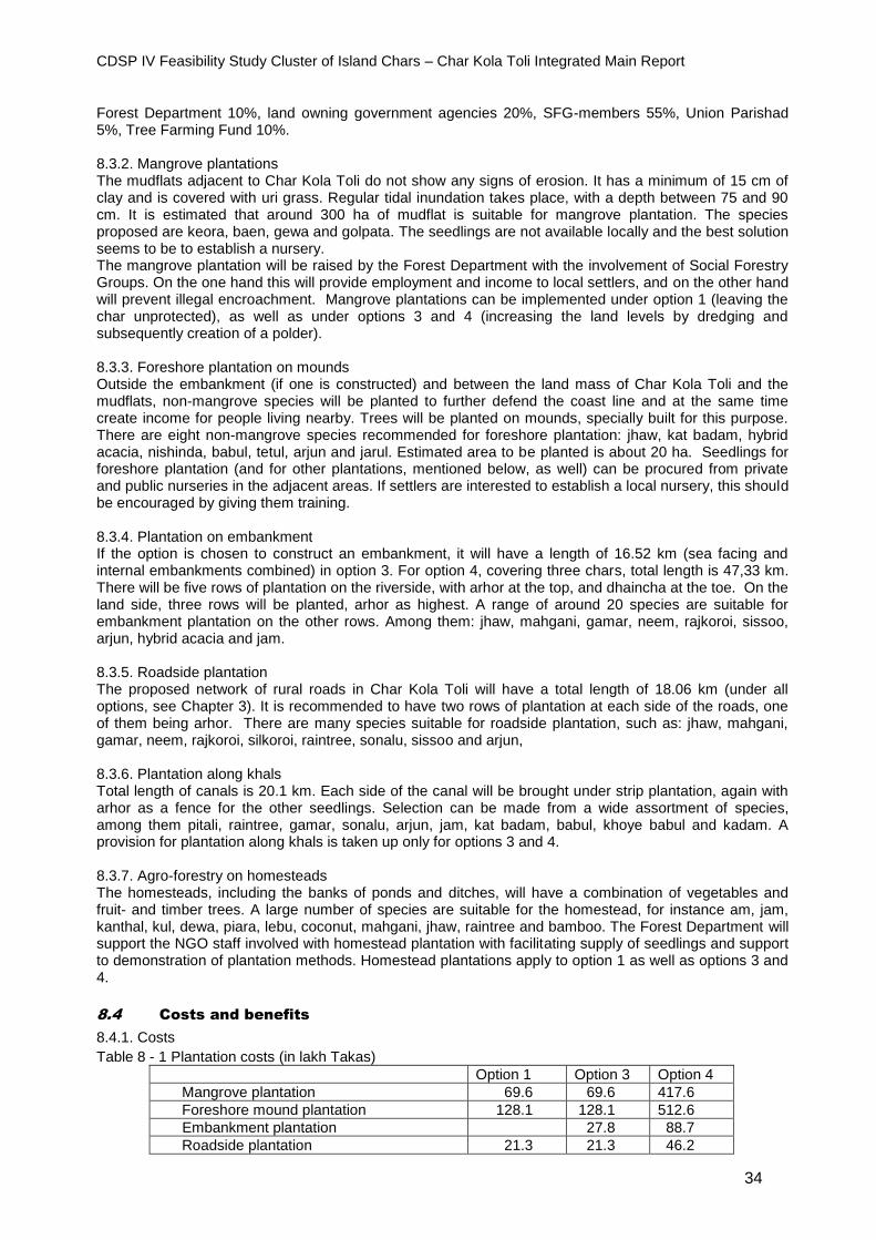
CDSP IV Feasibility Study Cluster of Island Chars – Char Kola Toli Integrated Main Report
34
Forest Department 10%, land owning government agencies 20%, SFG-members 55%, Union Parishad 5%, Tree Farming Fund 10%. 8.3.2. Mangrove plantations The mudflats adjacent to Char Kola Toli do not show any signs of erosion. It has a minimum of 15 cm of clay and is covered with uri grass. Regular tidal inundation takes place, with a depth between 75 and 90 cm. It is estimated that around 300 ha of mudflat is suitable for mangrove plantation. The species proposed are keora, baen, gewa and golpata. The seedlings are not available locally and the best solution seems to be to establish a nursery. The mangrove plantation will be raised by the Forest Department with the involvement of Social Forestry Groups. On the one hand this will provide employment and income to local settlers, and on the other hand will prevent illegal encroachment. Mangrove plantations can be implemented under option 1 (leaving the char unprotected), as well as under options 3 and 4 (increasing the land levels by dredging and subsequently creation of a polder). 8.3.3. Foreshore plantation on mounds Outside the embankment (if one is constructed) and between the land mass of Char Kola Toli and the mudflats, non-mangrove species will be planted to further defend the coast line and at the same time create income for people living nearby. Trees will be planted on mounds, specially built for this purpose. There are eight non-mangrove species recommended for foreshore plantation: jhaw, kat badam, hybrid acacia, nishinda, babul, tetul, arjun and jarul. Estimated area to be planted is about 20 ha. Seedlings for foreshore plantation (and for other plantations, mentioned below, as well) can be procured from private and public nurseries in the adjacent areas. If settlers are interested to establish a local nursery, this should be encouraged by giving them training. 8.3.4. Plantation on embankment If the option is chosen to construct an embankment, it will have a length of 16.52 km (sea facing and internal embankments combined) in option 3. For option 4, covering three chars, total length is 47,33 km. There will be five rows of plantation on the riverside, with arhor at the top, and dhaincha at the toe. On the land side, three rows will be planted, arhor as highest. A range of around 20 species are suitable for embankment plantation on the other rows. Among them: jhaw, mahgani, gamar, neem, rajkoroi, sissoo, arjun, hybrid acacia and jam. 8.3.5. Roadside plantation The proposed network of rural roads in Char Kola Toli will have a total length of 18.06 km (under all options, see Chapter 3). It is recommended to have two rows of plantation at each side of the roads, one of them being arhor. There are many species suitable for roadside plantation, such as: jhaw, mahgani, gamar, neem, rajkoroi, silkoroi, raintree, sonalu, sissoo and arjun, 8.3.6. Plantation along khals Total length of canals is 20.1 km. Each side of the canal will be brought under strip plantation, again with arhor as a fence for the other seedlings. Selection can be made from a wide assortment of species, among them pitali, raintree, gamar, sonalu, arjun, jam, kat badam, babul, khoye babul and kadam. A provision for plantation along khals is taken up only for options 3 and 4. 8.3.7. Agro-forestry on homesteads The homesteads, including the banks of ponds and ditches, will have a combination of vegetables and fruit- and timber trees. A large number of species are suitable for the homestead, for instance am, jam, kanthal, kul, dewa, piara, lebu, coconut, mahgani, jhaw, raintree and bamboo. The Forest Department will support the NGO staff involved with homestead plantation with facilitating supply of seedlings and support to demonstration of plantation methods. Homestead plantations apply to option 1 as well as options 3 and 4.
8.4 Costs and benefits
8.4.1. Costs
Table 8 - 1 Plantation costs (in lakh Takas)
Option 1 Option 3 Option 4
Mangrove plantation 69.6 69.6 417.6
Foreshore mound plantation 128.1 128.1 512.6
Embankment plantation 27.8 88.7
Roadside plantation 21.3 21.3 46.2

CDSP IV Feasibility Study Cluster of Island Chars – Char Kola Toli Integrated Main Report
35
Canal bank plantation 22.2 57.9
Homestead plantation 5.4 11.8
Public/community Institutions plantation 0.1 0.3
Capacity building, mobilization 8.9 37.6
Total amount 219.0 283.4 1,172.8
8.4.2. Benefits
Revenue will be generated by sale of wood and fruits of plantation trees. The program participants, members of SFGs, will provide labour in the nursery and during plantation on basis of benefit sharing arrangements. In addition to these financial benefits, the people and the area will benefit from the forestry development program as proposed here, because of the function of forests in char areas related to safety, social relations and the ecology, as described earlier in 8.1.1. It is expected that most revenue can be obtained in the period from five years to 15 years after plantation. Estimated annual incremental income in that period amounts to Taka 254.93 lakh in case the char is left unprotected (option 1) and to Taka 812.22 if a polder is established.
CDSP IV Feasibility Study Cluster of Island Chars – Char Kola Toli Integrated Main Report
36
9. Social - and livelihood component
9.1 Introduction
9.1.1. The need of a separate component Many of the proposed interventions with regard to water management and productive sectors will have a significant impact on the social and livelihood situation of the char settlers,. Still it was felt that an additional component specially geared towards social needs not dealt with by the other components (such as health, education, disaster preparation) was warranted. This component could also support activities that have already been dealt with in other chapters (for instance livestock, fisheries, drinking water and sanitation). Following the practice in CDSP IV, it is proposed that this social and livelihood cluster is implemented by NGOs. This component is feasible for implementation under all proposed water management options, although the number of households will probably be smaller when the char is left unprotected. Below the number of households, and consequently the required inputs, are based on option 1. In case option 3 or 4 is selected, these numbers needs revision. The costs of the social and livelihood program do not have any influence on the cost- benefit analysis given in Chapter 12. 9.1.2. Present situation In Char Kola Toli only one NGO has been operational (Muslim Aid), working on rural roads and distribution of sanitary latrines. Compared to the demand from the settlers for social services, this is quite insufficient. There is no Micro Finance Institution (MFI) working in the area. There are no health care related government services. In terms of provision of health care, there are actually only the medicine shops. But the sellers have had no training in treatment of human diseases or family planning, immunization or nutrition. There are no government or NGO schools. There are a few madrasas with usually only students that live nearby. There is no organization involved with legal and human rights. The same can be said about disaster preparedness. As already indicated in other chapters there is only a marginal involvement from government institutions in productive sectors as agriculture, livestock, fisheries and forestry.
9.2 Strategy for NGO support
9.2.1. Objectives The social and livelihood component would have the following objective: providing essential services to support poverty reduction, both in an economic (productive) and social sense (such as health, education, disaster management and household-level climate change adaptation), that cannot be provided by government agencies at this early stage of development of Char Kola Toli. NGOs can provide the following services: delivering micro-finance services, which will enable poor people to take advantage of the improved environment and infrastructure; supporting the activities of government implementing agencies, such as for water and sanitation, where the NGO can form tube well user groups and organize the installation of latrines; promoting human rights and legal awareness, especially for women. 9.2.2. Subjects to be covered The social and livelihood support program has been divided into the following sub-components: a) Group formation, micro-finance and capacity building b) Health and family planning c) Education d) Water and sanitation e) Homestead agriculture and value chain development f) Poultry and livestock g) Fisheries and aquaculture h) Legal and human rights i) Disaster management j) Awareness on environment and climate change
CDSP IV Feasibility Study Cluster of Island Chars – Char Kola Toli Integrated Main Report
37
9.2.3. Number of NGOs Based on the estimate of the current population and the expected migration of more settlers in the years to come, it is the intention to support the establishment of two branch offices in the area. Future number of households will be around 3,000, with a population of about 15,000 (in case of option 1). These offices will each serve a particular part of the char, each part with an estimated 7,500 people. As far as the number of NGOs is concerned, the best solution would be to have one NGO that is operational in both Char Kola Toli and in Dhal Char.
9.3 Proposed NGO services for the study area
As indicated under 9.2.2, the proposed program will have 10 components, covering the subjects mentioned in 9.2.2. Below, the intended activities will be dealt with component wise. 9.3.1. Group formation, micro-finance and capacity building As well as paying for the cost for group formation, it is proposed to fund capacity building of group members/ clients and NGO micro-finance staff. Since the micro-finance in the project areas will be new, it will be important for members to learn about micro-credit management, micro-credit discipline, rules and regulations, and to have a basic knowledge of management of Income Generating Activities (IGA). Organizing women char dwellers into NGO groups will be the main institutional platform for offering financial services (savings and credit) and for delivering other services. Micro-finance and other development services are expected to continue even after the end of the project. Projections for group formation are based on an estimated population of 3,000 households in the project. This is higher than the estimate of the present number of households, but it takes into account the expected increase in the period between the time of this study and actual implementation. Also during the project period itself a further increase can be expected. It is assumed one woman from each household will become a member of a group based around micro-finance. Assuming an average group has 25 members, a total of 120 groups will be needed. As a regular activity the NGO will mobilize group member savings and use a part of this fund to lend out as micro-credit to the group members. The selected NGO must be able to mobilize resources from institutions like PKSF, the major institutional lender for micro-credit in the country. Capacity building will focus on both NGO staff as well as the members of the groups. 9.3.2. Health and family planning The findings of review of the health and family planning aspects during the preparatory missions in the area as well as experience of the on-going CDSP IV project reveal critical health and family planning challenges and concerns of the char dwellers. Activities will focus on training, especially Health and Family Planning Facilitators (who will form the backbone of the component) and Traditional Birth Attendants (15 in each NGO branch); clinical services (each branch will have a clinic manned by a Medical Assistant); distribution of medicines, contraceptives and TBA-kits; awareness raising and linkages with other health programs, in particular the vaccination program. 9.3.3. Education Human resource development is at the core of Bangladesh's development efforts and access to quality education is critical to poverty reduction and economic development. In the previous phases of CDSP there was no arrangement to implement an educational program. Children of school going age cannot go to school due to lack of available educational institutions and are deprived from at least primary education. A high rate of illiteracy is hindering development initiatives. In the study area there are no government or NGO schools. Among others, activities will include establishment of non-formal schools, supply of logistics (books, pencils etc.), advance money for housing, one teacher for each school, training for NGO-staff. The aim is to establish 15 non formal primary schools in each NGO branch, so 30 schools in total in case of Char Kola Toli.
9.3.4. Water and sanitation It is proposed to install 200 DTWs in the project area (under option 1, see Chapter 3). Also, every household will receive a latrine under the project. Both interventions are to be implemented by DPHE. The role of the NGO will be to assist DPHE to: (i) select sites for DTW installation, select and form water (tube-well) user groups, collect their contributions, train representatives of user-groups on repair and maintenance of tube-wells; (ii) facilitate distribution and installation of latrines; and (iii) provide training to NGO staff (the NGO staff will provide training to the members of the tube well user group on health and hygiene).
CDSP IV Feasibility Study Cluster of Island Chars – Char Kola Toli Integrated Main Report
38
9.3.5. Homestead agriculture and value chain development While DAE will implement a component aimed at developing field crops, the NGO will focus on homestead agriculture (fruits and vegetables). They will also promote tree (fruit and timber) nurseries operated by NGO group members and promote planting of trees around homesteads. The focus of the activities will be promotion of new and improved varieties and technologies through training and high value crop demonstrations. An Agriculture Coordinator will be appointed in each NGO branch office. Training of farmers, demonstrations and dissemination will be the main activities. In respect of value chain development, crop and non-crop products will be identified through rapid assessment of their potential for creating employment, and increasing sales and income. The products could be high value new vegetables, fisheries and livestock, any non-crop processed food and non-food items with good potential in the area. The intention is that each branch implements one value chain development activity each year for five years. A lump-sum amount of Tk100,000 is allocated for each value chain development project.
9.3.6. Livestock In previous CDSP phases, livestock development did not form a part of the project. The Danida supported Regional Fisheries and Livestock Development project (RFLDC) was operational at the same in the same areas and took care of the livestock sector. Because the Danish program has ceased to exist, it is proposed to make the NGO responsible for livestock development, including poultry. Important activities will be conducting a baseline survey; the selection and training of Poultry Workers and Livestock Field Workers; training of farmers and extension services (on rearing of cattle, sheep goats and poultry, animal diseases, fodder cultivation etc.); supply and preservation of vaccines (to be collected from the Department of Livestock Services and other available sources) and medicines. See also Chapter 6 for more information on the livestock sector. The NGO will have one specialized staff member.
9.3.7. Fisheries As in the case of livestock, it is proposed to entertain fisheries activities, in particular aquaculture, through the NGO. Major activities will be making a baseline survey; selection and training of farmers; distribution of inputs. The training will focus on selection of species and feed, pond management, raising and distribution of fingerlings and demonstration. The NGO will appoint a fisheries coordinator. See chapter 7 on more information on fisheries.
9.3.8. Legal and human rights Experience in CDSP-IV areas shows that settlers lack good knowledge about property rights, especially about land rights and about family laws (marriage law, registration etc). That places settlers in a vulnerable position regarding getting ownership of land, the most valued asset. Besides, women rights issues within the family and rights issues in the wider society need to be addressed. The objective of the sub-component is to inform the group members and community about several critical laws, human rights issues through training and other awareness raising activities. Apart from group members, male household members will be trained on legal and human rights issues. This activity will benefit from links to agencies that promote human and legal rights. With regard to the land rights and procedures to obtain a land title, close cooperation will be pursued with the Ministry of Land. Training of group members will be the most important intervention. In groups that have received training, a Law Implementation Committee will be formed. Two Legal and Human Rights promoters will be selected for each branch.
9.3.9. Disaster management The remote coastal project area is specifically vulnerable to natural disasters as cyclones and storm surges. The emphasis will be on awareness on preparedness, disaster management, and mitigation issues. Training, followed-up by refresher courses, will be imparted to selected group members. NGO-staff will be trained as well. A relation will be developed with the Union Disaster Management Committee and the Red Crescent by having annual meetings. Each branch will have a coordinator for this sub-component.
9.3.10. Awareness on Environment and Climate Change Its location in the exposed coastal zone makes Char Kola Toli especially vulnerable to climatic risk (see also Chapter 2). An essential strategy to mitigate the consequences of this global phenomenon is to assist local communities in adaptation to the gradually evolving changes in circumstances. The situation fully justifies efforts to raise awareness about climate change and the environment. The focus will be on training of selected (about 10%) group members that can form a skilled cadre with the task of dissemination of knowledge and information to the community. Some rather basic measures will be

CDSP IV Feasibility Study Cluster of Island Chars – Char Kola Toli Integrated Main Report
39
promoted such as improved cooking stoves, raising of plinths, strengthening of houses and planting of protective trees on the homestead.
9.4 Costs and benefits
9.4.1. Costs
Table 9 - 1 Summary of budget for social and livelihood component, Char Kola Toli (option 1)
Sl No
Sub- components
Total
A Supervision and management cost
A.1 Supervision and management cost for coordination office 15,516,400
A.2 Supervision and management cost for branch office 17,980,281
A.3 Grand total -50% of Char Kola Toli 7,234,483
Total A: Supervision and management cost 40,731,164
B Group formation and microfinance
B.1 Support for group formation 8,479,000
B.2 Beneficiary capacity building MF group members only 24,149,150
B.3. Beneficiaries risk fund (credit insurance) 400,000
Total B: Group formation and microfinance 33,028,150
C Programme activities
C.1 Health and family planning 27,831,520
C.2 Water and sanitation program 11,441,657
C.3 Disaster management program 10,073,367
C.4 Legal and human rights 8,087,875
C.5 Value chain development 1,100,000
C.6 Homestead developmentt 9,815,261
C.7 Education 62,497,632
C.8 Climate change and adaptation 21,990,007
C.9 Poultry and livestock program 15,222,207
C.10 Fisheries development 8,916,357
C Total of programme activities (3 to 10) 176,975,882
D Grand Total (A+B+C) 250,735,196
9.4.2. Benefits
It is expected that the social- and livelihood component will lead to both social and economic beneficial results for the settlers in the study area. Because the groups to be formed by the NGO consist exclusively of women, the proposed activities will in particular support the improvement of the status of women. The training in legal and human rights can further strengthen their position. The health- and education sub-components will improve the health status and will increase the access for children to primary education. The support from the NGO for the formation of Tube well User Groups and the training in hygiene subjects will also contribute to better health conditions. The support in selection of sites will facilitate the installation of tube wells, which will lessen the burden of women in their daily task of collecting water. The attention for disaster management will enhance the physical security of the people in emergencies, and can be seen as complementary to other measures such as the establishment of cyclone shelters, improved road network and the protective embankment. The economic benefits are generated by the involvement of the NGO in homestead agriculture, fisheries and livestock, and in the income generating activities for women. Households will generate more income through these activities, and this will contribute to the general economic uplift of the char.
CDSP IV Feasibility Study Cluster of Island Chars – Char Kola Toli Integrated Main Report
40
10. Governance
10.1 Introduction
In the subsequent CDSP projects, it was recognized that improving livelihoods of households in vulnerable areas as the chars in the exposed coastal zone, cannot be achieved by one type of interventions undertaken by one institution. To be effective, it needs a multi-sectoral and multi-institutional approach. This is completely in line with the Coastal Zone Policy and the Coastal Development Strategy, adopted by the Bangladesh government. This chapter will focus on the governance aspects of such an approach. It deals with the organizations that would be involved in the further planning and implementation of the package of activities as proposed in this study report. These organizations are positioned at different levels: national, local and field level. The next section dwells on the proposed future involvement of national stakeholders and the coordination among them. The local government bodies in can be found in10.3 and the community based organizations in 10.4. As in most of the coastal char areas, the institutional landscape in Char Kola Toli is empty. The fact that the char is an island in the lower Meghna and therefore difficult to reach is an important reason that the presence of national institutions is hardly felt. In the early 1990s the Forest department started with afforestation of the char, but ultimately had to withdraw because the illegal encroachment of settlers. None of the other national technical oriented agencies important for CDSP, as BWDB, LGED, DPHE and DAE are active in the char. Also the Ministry of Land did not implement any activities. No diara map has been prepared, no land titles were distributed. Only one NGO, from another char, was involved in some road construction and installing of tube wells and latrines. This chapter deals with the institutions at national - (10.2), local - (10.3) and community (10.4) level that will be involved in implementing the proposed package of development efforts, explaining their tasks and responsibilities, largely based on the experience in previous phases of CDSP have shaped the
10.2 Future involvement of national government agencies
10.2.1. Bangladesh Water Development Board (BWDB) BWDB will be entrusted to construct all water management related infrastructure, like embankments and sluices (if the option is selected to construct a polder), drainage channels and information centres for WMOs. BWDB is also responsible for major maintenance of the water management infrastructure (also for structures built in previous CDSP phases). It will be the responsibility of BWDB to form, train, register and provide assistance to formation, training and support of WMOs. This has to be done in accordance with National Water Policy and the Guidelines for Participatory Water Management (GPWM), including the Participatory Water Management Rules of 2014. In order to establish the WMOs as leading CBOs, BWDB needs to make effective efforts to develop their capacities in discharging their due responsibilities as laid down in aforementioned government documents. There is no doubt this will be a challenging task for BWDB. Experience gained over the years in previous CDSP phases has learned that much of the work involved falls on the shoulders of the technical assistance team, not so much on those of the BWDB staff. 10.2.2. Local Government Engineering Department (LGED) Like the current arrangement in CDSP, LGED has the mandate to construct much of the internal infrastructure such as the proposed rural roads, culverts, cyclone shelters and community ponds (see Chapter 3). LGED will extend their cooperation to Water Management Organizations in developing relevant maintenance plans for the new infrastructure. LGED will be responsible for major maintenance works, also in older CDSP areas. 10.2.3. Department of Public Health Engineering (DPHE) The responsibility of DPHE will be to construct the infrastructure related to water and sanitation, like deep tube wells, toilets, rain water harvesting schemes and public toilets (described in Chapter 3). DPHE will
CDSP IV Feasibility Study Cluster of Island Chars – Char Kola Toli Integrated Main Report
41
involve contractors as well as LCSs where feasible. DPHE will work closely with NGOs that are organizing and supporting tube well user groups. DPHE will install tube wells in locations selected by the settlers with the assistance of NGOs. These NGOs will also collect contributions from households for the installation costs. 10.2.4. Ministry of Land (MoL) The concerned District and Upazila administrations will implement the land settlement program on behalf of the Ministry of Land. The following the process and procedures practiced in CDSP projects will be followed. Accordingly, information dissemination meetings will be organized in Char Kola Toli to inform the settlers about the steps to be taken in the settlement process. An NGO will be involved in providing information on the land rights of the population. The Ministry of Land will initiate a plot to plot survey to make an inventory of the actual situation and to identify the households that are landless and indeed qualify to participate in the official settlement. Those settlers will subsequently follow the other phases in the procedure that is ultimately aimed at distribution of titles on maximum 1.5 acres of land. More information on land settlement in Char Kola Toli is given in Chapter 4. 10.2.5. Department of Agricultural Extension (DAE) Low productivity of crop land is typical for new char areas. Lack of information on suitable crop varieties and on modern cultivation technologies are factors that impede improvements in production. The task of DAE will be to provide extension services and training for farmers. In order to reach out to remote areas as the island chars in the lower Meghna, DAE will have to make sufficient field staff available and provide its staff with the required logistical support. The Department will, with NGO assistance, form Farmers Forums (FF). Extension efforts will apply the Farmer Field School methodology, with a high degree of participation from the farmers. DAE can play a vital role in developing the capacities of FFs in developing backward and forward linkages with other market forces at local levels. 10.2.6. Department of Forest (FD) The Forest Department will be responsible for all plantation activities, such as mangrove plantation on mudflats, plantation along roads and khals and on the terrain of public places as cyclone shelters, schools and mosques (see chapter 8). It will in a sense restart its presence in the char by applying the social forestry approach. Social Forestry Groups will be formed. The Department will have the task to form, train and support these groups. The Department will work closely together with the NGO on homestead forestry. 10.2.7. Departments of Livestock (DLS) and Department of Fisheries (DoF) The Department of Livestock and the Department of Fisheries will not belong to the group of abovementioned six implementing agencies of the proposed project. They will however provide assistance by providing support to the NGO working in Char Kola Toli. This support will take place at Upazila- and Union level and will evolve around facilitating provision of input supplies and extension. 10.2.8 Coordination Based on the experience of successive CDSP-I, II, III and on-going IV phase, a sort of “best practice” with regard to successful coordination and cooperation among the different implementing agencies has emerged over the years. Based on the principle of common planning and sectoral implementation, an integrated administrative model has been established, that has proven to be successful. The core of the model is to have one overall project concept paper as an umbrella, followed by individual development project pro-formas (DPPs) for each of the individual partner agencies. An Inter-Ministerial Steering Committee (IMSC) forms the policy level forum, while the Project Management Committee (PMC) forms the regular coordinating platform for implementing and review all progress, problems and bottlenecks. Different phases of CDSP demonstrated the success of this coordination model particularly at national- and project level. There is scope of exploring ways to improve the coordination among different partner agencies at the level of the Union Parishad. Strengthening coordination with Union Parishad requires capacity development, which will form a part of the total proposed package of activities.
10.3 Local Government Institutions
10.3.1. Present situation Char Kola Toli is located in Bhola District. It is located in one Union, Monpura no. 1 and in one Upazila, Monpura. The char covers two mouzas, Kola Toli and Khalequenagar. CDSP has no yet been operational in Bhola District and consequently the administration of Bhola District and the Upazila and Union administrations are not familiar with the integrated development approach of CDSP. It is necessary that workshops are organized to inform administration staff members and elected Parishad members about

CDSP IV Feasibility Study Cluster of Island Chars – Char Kola Toli Integrated Main Report
42
the concept of integrated development and the way it is practiced in the context of CDSP. Also the history of CDSP its achievements in other Districts should be on the agenda of these workshops. 10.3.2. Future scenario In future char development programs, strengthening of the local government institutions, in particular the Union Parishads will need to be one of the important institutional development interventions. In case of Char kola Toli it is the UP of Monpura Union no. 1. The UP is expected to provide and coordinate support to the WMOs, and to be involved in the annual maintenance program for their area. The UP has an important role in developing the linkage between WMOs and other field level institutions (WMOs, FFs, SFGs, TUGs, microfinance groups etc.), government implementing agencies, NGOs and other service providers. UPs are indeed pivotal in assessing the local needs and planning of activities in consultation with other stakeholders, and monitoring the progress.
10.4 Field level Institutions
10.4.1. Present situation Apart from a number of mosque and market committees, there are currently no field level groups in Char Kola Toli. So there is no institutional capacity at field level to plan for and participate in a multi-sectoral development effort as is proposed in this report. It is therefore absolutely vital that such capacity is established and fostered in order to make the program successful. The sections below describe which field level institutions should be formed. This is largely based on the experiences of CDSP’s ongoing and previous phases. In addition to the groups mentioned below, under the proposed social and livelihood program, implemented by NGOs, micro-finance groups will be formed, consisting exclusively of women. 10.4.2. Water Management Organizations (WMOs) Participatory water management will be the focal feature for the proposed char development program. In turning this concept into practice, “Guidelines for Participatory Water Management (GPWM)” as approved by the Ministry of Water Resources (MOWR) in 2001 and the “Participatory Water Management Rules-2014” will be the guiding documents. During the field level consultation with local people, they expressed their interest on the formation of water management organizations. It is proposed to form five Water Management Groups in Char Kola Toli, based on a preliminary assessment of hydrological boundaries. This number can later be adjusted. Following the 2014 rules, 55% of all households have to be registered in the WMGs. It is the intention to have at least 50% female members in each WMG, and 30% in the management committees. 10.4.3. Tube Well Users Groups (TUG) Tube Well Users Groups will be formed in collaboration with NGOs for all deep tube wells. The members of the TUG will be exclusively women, with an average of 15 in each group. It is earlier proposed (see Chapter 3) that around 200 deep tube wells will be required for Char Kola Toli, which means that about 200 TUGs will have to be formed. 10.4.4. Labour Contracting Societies (LCSs) Labour Contracting Societies maybe engaged for earth works for construction of roads, markets etc., as an alternative to contractors. LCSs can also be involved all sorts of maintenance works and with the production of single pit latrines, as experienced in CDSP IV. The concept of LCS is to form a group of poor people from the operational area who are mainly dependent for livelihood on manual labour. If it is socially acceptable in Char Kola Toli, then women LCSs can also be formed as was practiced in CDSP III and IV. According to the procedure, LCSs can be treated as D-class contractors by the public implementing agencies and the necessary work orders can be issued without inviting any tenders. The size of the LCS may vary, based on the nature and volume of works to be implemented. It has been demonstrated in many government projects that a LCS can be an effective vehicle to provide project benefits directly to poor sections of the population by creating additional income and employment. In the GPWM and PWMR it is mentioned that at least 25% of earth works will have to be executed by engaging LCS. In CDSP LCS are generally organized by the WMOs. LCS will be engaged by the implementing agencies, in particular by BWDB and LGED, and to a lesser extent by DPHE and Forest Department. 10.4.5. Farmers Forum The group approach will be followed in all agricultural extension activities in line with the DAE policy. A farmer’s forum is a group of settlers whose main occupation is farming and interested in new technologies, willing to participate in all agricultural activities (crop production, demonstration, field days and exposure visit/ motivation tour). The size of each farmer’s forum will be around 45 members on average where women participants will be at least 40%. It will be decided at a later stage exactly how
CDSP IV Feasibility Study Cluster of Island Chars – Char Kola Toli Integrated Main Report
43
many FFs will be formed in this char. But based on the current population of Char Kola Toli, it can be estimated that about 14 FFs will be required. 10.4.6. Social Forestry Group (SFG) In order to ensure the community participation in the afforestation activities, a social forestry approach will be followed through which the settlers will be involved in planning, implementation, monitoring, maintenance and management of the plantation. For this purpose, Social Forestry Groups will be formed for every 2 km of roadside plantation, 1.5 km of embankment plantation, 10-20 ha of foreshore plantation and 20-30 ha of mangrove plantation. Each group will have around 20-30 members with roughly 70% men and 30% women.
CDSP IV Feasibility Study Cluster of Island Chars – Char Kola Toli Integrated Main Report
44
11. Environmental and social impact
11.1 Introduction
In the previous chapters (2 to 10), an outline has been presented of the present situation and of the proposed measures (with basically two options: leaving the char area unprotected and protecting the area through a peripheral embankment). The chapters covered water management, internal infrastructure, land settlement, agriculture, fisheries, livestock, social forestry, institutions and NGO support. The present chapter dwells on the impact of the combined proposed interventions. Section 11.2 deals with the impact on the environment. In the last section (11.3) the influence of the proposed package of interventions on the social situation of the char dwellers is looked at.
11.2 Environmental impact
11.2.1. Methodology of assessment Environmental assessment is a regulatory requirement (Environmental Conservation Policy, 1992, Environmental Conservation Rule, 1997). In carrying out the assessment, the standard code of practice was applied. The Guidelines of the Department of Environment and the Guidelines for Environmental Assessment of Water Management (FCDI) Projects of WARPO of 2005 were followed, while Technical Report no. 19 of CDSP-II was consulted.
The EIA started with review of available relevant literature, guidelines and other related studies and data sources. Field visits were undertaken by the study team to identify key environmental issues and to collect information on the Important Environmental Components (IECs). During field visits, consultations with different stakeholders such as governmental and non-governmental agencies as well as the char settlers were held to identify important issues and concerns. Impacts of proposed interventions formed a part of the discussions. Consultations were conducted through Focus Group Discussions and interviews with key informants.
After field data collection, scoping, bounding and environmental assessment were carried out. The impact assessment was done with the establishment of scenarios for the two options: leaving the char unprotected and construction of embankment and drainage works. The EIA led to the identification of potential environmental impacts due to proposed activities and suggested feasible remedial measures included in the Environmental Management Plan (EMP). 11.2.2. Summary of the assessment The EIA led to the identification of potential environmental impacts and suggested feasible remedial measures included in the EMP. Leaving the char unprotected in the foreseeable future (water management option 1) will have a positive impact with regard to further sedimentation and thus higher land levels of parts the char. On the other hand, tidal flooding will continue and soil salinity will not be abated and quality of water, especially salinity, will not be improved either. Not protecting the char would be good for the status of flora, fauna and wildlife. But the environment for productive purposes, in particular agriculture and aquaculture, will not be enhanced, although wild fisheries will continue to be a source of income. The EIA shows that the proposed options 3 and 4 (increasing land levels by dredging and subsequently construction of a polder over time) will have positive impacts on most of the important environmental components including prevention of flood and salinity. Soil salinity will be reduced over time, while tidal flooding will be prevented. This will result in an improvement in land types and land use. Drainage will be improved as well and availability of fresh water in type char will increase. However, embankments will prevent further sedimentation of the char, and thus a further increase in average land levels. It will have a beneficial effect on flora, bur fauna and wildlife will suffer. Possibilities for an increase of productivity in crop agriculture, homestead gardening, forestry and aquaculture will be significant. Wild fisheries will be

CDSP IV Feasibility Study Cluster of Island Chars – Char Kola Toli Integrated Main Report
45
negatively influenced. But it has to be mentioned that the environmental impact of dredging has not been a part of the environmental assessment. The conclusion is justified that neither of the options has such significant negative impact on the environment (but with uncertainty on the impact of increasing land levels by dredging), that the options should be discarded. Mitigation measures and monitoring are however necessary. 11.2.3. Mitigation measures and monitoring An Environmental Management Plan (EMP) has been prepared with the following main elements (most of them meant for the options leading to protection): compensation for land acquisition; standard construction practices to keep adverse impacts of construction activities to a minimum; appropriate site selection of embankment and other public infrastructure to minimize loss of agricultural land; increased use of mulches and organic fertilizer; further promotion of integrated pest management; appropriate O&M measures to combat siltation of khals and rivers; construction of fish friendly regulators. Regular monitoring of the following variables is proposed: breaches in embankment; flooding, erosion/ sedimentation of channels; surface water quality incl. salinity; soil fertility and - salinity; groundwater table; crop production and damage to crops; fish production. Cost of the environmental mitigation, enhancement and monitoring activities is estimated to be Taka 14.4 million per year.
11.3 Social impact
11.2.1. Introduction Based on evidence in areas where CDSP has applied a similar approach in the past, the impact of the combination of CDSP-type interventions as proposed in this document on the socio-economic situation of the people in the areas concerned is considerable. Data collected through monitoring and other survey methods in CDSP-I, II, III and IV areas justify the conclusion that those interventions will lead to a transformation in the social and economic circumstances. This transformation can best be summarized as more security and less vulnerability. There is no reason to suppose that this will be much difference in the area of Char Kola Toli. 11.2.2. Physical and legal security Settlers will experience a greater physical security due to the construction of a protective embankment (if that option is selected), cyclone shelters and a foreshore- and mangrove protective belt. Roads will shorten the time to reach a cyclone shelter if a storm surge strikes the area. The physical security is further enhanced by the improved law and order situation, as has been the case in earlier phases of CDSP. The official titles on land possession, to be provided through the land settlement program will give security in a legal sense. At the same time this will encourage farmers to invest in their land, increasing the chances of higher production. 11.2.3. Economic and food security The economic benefits, leading to more security in an economic sense, have been elaborated in other sections of this document. It can be added here that access to markets to sell the produce that is not consumed inside the area will be improved and will probably lead to better prices. Previous CDSP areas also show a sharp increase in the number of markets in the area itself increasing the access to imported goods. This in many cases has also lead to lower prices of these goods because of lower transportation costs and competition. The upswing of local production and the greater accessibility will lead to an increase in employment opportunities. A sample survey conducted among the households in CDSP-I, II, III and IV areas shows that food security has improved significantly with an overall decline in the number of households that experience some periods of food shortage. Also the average number of months of food shortage has fallen. The most critical months are October/November followed by July/August. This positive development is largely due to the increase in agricultural production and the increased employment opportunities. 11.2.4. Delivery of services The general development of char areas have led, as was demonstrated in previous CDSP phases, to establishment of service delivery mechanism, from the government, from NGOs and from the private commercial sector. The government has expanded its presence in those char areas by introducing
CDSP IV Feasibility Study Cluster of Island Chars – Char Kola Toli Integrated Main Report
46
educational institutions, cluster villages (as Asrayan in Char kola Toli) and health services, as well as by maintaining law and order to a higher degree. The impetus in economic development will stimulate banks to open branches, while shops will be established, for instance selling agricultural inputs. 11.2.5. Health and education Although CDSP type package of interventions do not have a specific orientation towards delivery of health - and education services, actually this is limited to parts of the proposed NGO-program, the health and education situation will indirectly be benefitted from the proposed package. The cyclone shelters that will be constructed are multifunctional and can be used as school as well. It is common practice in char areas that primary schools are established in these shelters. It takes usually some time between completion of construction and completion of all the formalities to have a government school in the building. The proposed project could assist by facilitating this process. There are a few examples that cyclone shelters are used as health units. Health of the settlers will be improved by the supply of safe drinking water through the provision of deep tube wells and by the provision of sanitary latrines. Also the greater variety in agricultural produce especially vegetables and the expected increased supply of fish and dairy products will benefit the health situation. 11.2.6. Social position of settlers The institutional development efforts of the project through the establishment of a series of field level, community based organizations will lead to a greater cohesion among the households. Helped by the economic uplift this will lead to more vibrant and resilient char communities. The project will strengthen the position of the settlers in the struggle over control of natural resources. The provision of a title on land is of course a prime example. The formation of Water Management Groups will enhance the fair and equitable way of using water resources. Social forestry activities promote equity in the sharing of benefits of public land. This will all lead to an increased self-confidence of the local people. This is further enhanced by the fact that settlers will no longer be controlled by jotdars or bahinis that were involved in the illegal settlement after migration into the newly emerged lands. 11.2.7. Gender issues It is expected that the proposed project will have an impact on the lives of women in a practical sense, but at the same time will also enhance their social position and status. The increased employment opportunities within their own areas will reduce the relatively high number of female headed households. Seasonal outmigration will become less necessary, which means that men can stay more with their families. This should lessen the burden of work on the women. They will also benefit in a practical manner by the fact that tube wells for safe drinking water will be dramatically increased, shortening the average time women have to spent on collecting safe water. Through the envisaged training and credit facilities supplied by NGOs combined with the general economic uplift, possibilities of employment for women will be enhanced. Women have greater possibility to create their own stream of income. The proposed project will encourage an active and more equal participation of women in groups such as the Water Management Organizations (WMOs), Farmers Forum (FFs), Social Forestry Groups (SFGs) and Labour Contracting Societies (LCSs). The Tube well Users Groups (TUGs) and NGOs microfinance groups will consist exclusively of women. The experience in other areas have learnt that such participation will increase the ability of the women to speak out, both in their own households as in public matters. The khatians (land title document) will be signed by both the husband and wife (actually it is CDSP’s policy to have the women signs first). This fully recognizes a women’s right on land. It will considerably strengthen their asset base and economic security, and indeed increase their bargaining power within their own households. Considering all these developments, it is justified to expect that the social position and status of women will be strengthened in case the proposed project is implemented.
11.4 Conclusion
The environmental assessment has indicated that the implementation of the interventions as proposed in this report, independent of which water management option is ultimately chosen, will not lead to a significant negative impact on the environment in the area (with uncertainty about the impact of dredging in options 3 and 4). In order to mitigate any adverse influences, the Environmental Management Plan hast to be made a fully integrated part of further project documents, such as the project proforma, tender document. The proposed program would have an important and favourable impact on the social and economic situation of the char settlers. The assessment makes clear that on essential issues as physical and economic security, health and education, delivery of services, and gender, the proposed interventions will

CDSP IV Feasibility Study Cluster of Island Chars – Char Kola Toli Integrated Main Report
47
have a positive influence, often in a significant manner. Empirical evidence from areas where previous CDSP phases were operational, reinforce such expectations. In case the implementation itself has adverse consequences for families, for instance through loss of land and relocation because of infrastructure development, the compensation component of the EMP can provide support.
It is realistic to assume that the proposed package of interventions can pass the clearance procedure successfully.
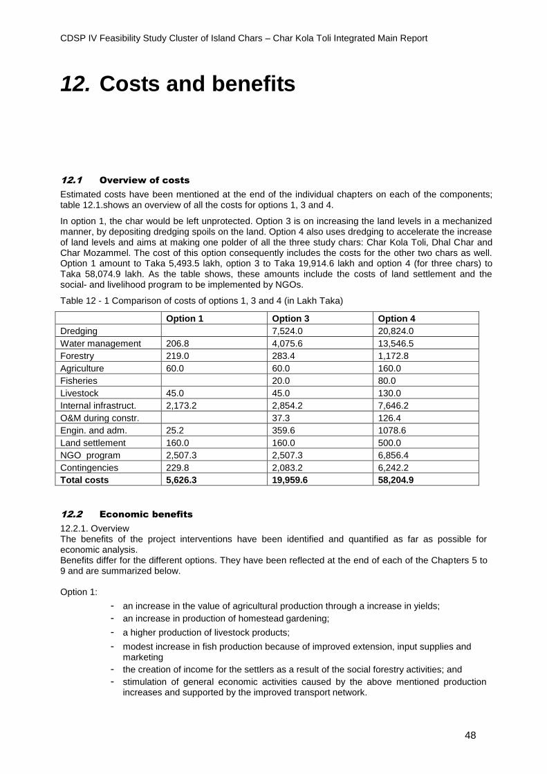
CDSP IV Feasibility Study Cluster of Island Chars – Char Kola Toli Integrated Main Report
48
12. Costs and benefits
12.1 Overview of costs
Estimated costs have been mentioned at the end of the individual chapters on each of the components; table 12.1.shows an overview of all the costs for options 1, 3 and 4.
In option 1, the char would be left unprotected. Option 3 is on increasing the land levels in a mechanized manner, by depositing dredging spoils on the land. Option 4 also uses dredging to accelerate the increase of land levels and aims at making one polder of all the three study chars: Char Kola Toli, Dhal Char and Char Mozammel. The cost of this option consequently includes the costs for the other two chars as well. Option 1 amount to Taka 5,493.5 lakh, option 3 to Taka 19,914.6 lakh and option 4 (for three chars) to Taka 58,074.9 lakh. As the table shows, these amounts include the costs of land settlement and the social- and livelihood program to be implemented by NGOs.
Table 12 - 1 Comparison of costs of options 1, 3 and 4 (in Lakh Taka)
Option 1 Option 3 Option 4
Dredging 7,524.0 20,824.0
Water management 206.8 4,075.6 13,546.5
Forestry 219.0 283.4 1,172.8
Agriculture 60.0 60.0 160.0
Fisheries 20.0 80.0
Livestock 45.0 45.0 130.0
Internal infrastruct. 2,173.2 2,854.2 7,646.2
O&M during constr. 37.3 126.4
Engin. and adm. 25.2 359.6 1078.6
Land settlement 160.0 160.0 500.0
NGO program 2,507.3 2,507.3 6,856.4
Contingencies 229.8 2,083.2 6,242.2
Total costs 5,626.3 19,959.6 58,204.9
12.2 Economic benefits
12.2.1. Overview The benefits of the project interventions have been identified and quantified as far as possible for economic analysis. Benefits differ for the different options. They have been reflected at the end of each of the Chapters 5 to 9 and are summarized below. Option 1:
- an increase in the value of agricultural production through a increase in yields;
- an increase in production of homestead gardening;
- a higher production of livestock products;
- modest increase in fish production because of improved extension, input supplies and marketing
- the creation of income for the settlers as a result of the social forestry activities; and
- stimulation of general economic activities caused by the above mentioned production increases and supported by the improved transport network.
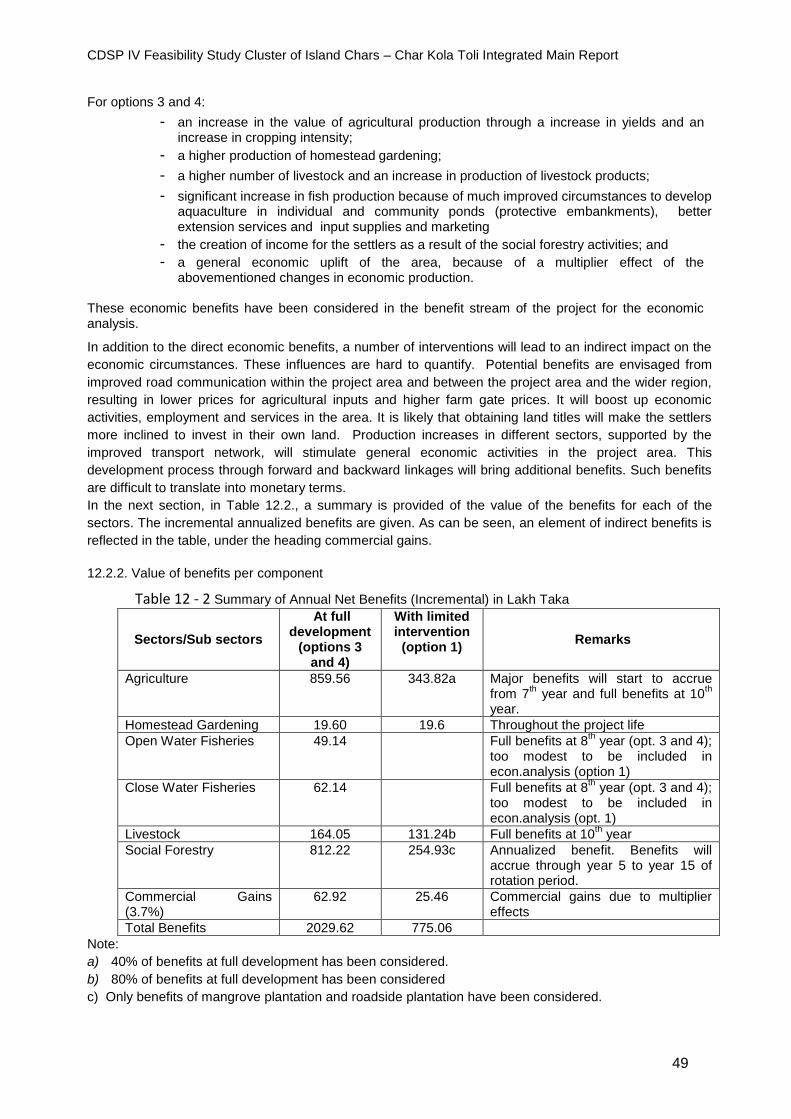
CDSP IV Feasibility Study Cluster of Island Chars – Char Kola Toli Integrated Main Report
49
For options 3 and 4:
- an increase in the value of agricultural production through a increase in yields and an increase in cropping intensity;
- a higher production of homestead gardening;
- a higher number of livestock and an increase in production of livestock products;
- significant increase in fish production because of much improved circumstances to develop aquaculture in individual and community ponds (protective embankments), better extension services and input supplies and marketing
- the creation of income for the settlers as a result of the social forestry activities; and
- a general economic uplift of the area, because of a multiplier effect of the abovementioned changes in economic production.
These economic benefits have been considered in the benefit stream of the project for the economic analysis.
In addition to the direct economic benefits, a number of interventions will lead to an indirect impact on the
economic circumstances. These influences are hard to quantify. Potential benefits are envisaged from
improved road communication within the project area and between the project area and the wider region,
resulting in lower prices for agricultural inputs and higher farm gate prices. It will boost up economic
activities, employment and services in the area. It is likely that obtaining land titles will make the settlers
more inclined to invest in their own land. Production increases in different sectors, supported by the
improved transport network, will stimulate general economic activities in the project area. This
development process through forward and backward linkages will bring additional benefits. Such benefits
are difficult to translate into monetary terms.
In the next section, in Table 12.2., a summary is provided of the value of the benefits for each of the
sectors. The incremental annualized benefits are given. As can be seen, an element of indirect benefits is
reflected in the table, under the heading commercial gains.
12.2.2. Value of benefits per component
Table 12 - 2 Summary of Annual Net Benefits (Incremental) in Lakh Taka
Sectors/Sub sectors
At full development
(options 3 and 4)
With limited intervention
(option 1) Remarks
Agriculture 859.56 343.82a Major benefits will start to accrue from 7
th year and full benefits at 10
th
year.
Homestead Gardening 19.60 19.6 Throughout the project life
Open Water Fisheries 49.14 Full benefits at 8th year (opt. 3 and 4);
too modest to be included in econ.analysis (option 1)
Close Water Fisheries 62.14 Full benefits at 8th year (opt. 3 and 4);
too modest to be included in econ.analysis (opt. 1)
Livestock 164.05 131.24b Full benefits at 10th year
Social Forestry 812.22 254.93c Annualized benefit. Benefits will accrue through year 5 to year 15 of rotation period.
Commercial Gains (3.7%)
62.92 25.46 Commercial gains due to multiplier effects
Total Benefits 2029.62 775.06
Note:
a) 40% of benefits at full development has been considered.
b) 80% of benefits at full development has been considered
c) Only benefits of mangrove plantation and roadside plantation have been considered.
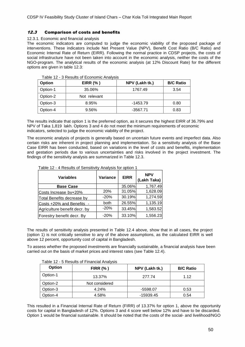
CDSP IV Feasibility Study Cluster of Island Chars – Char Kola Toli Integrated Main Report
50
12.3 Comparison of costs and benefits
12.3.1. Economic and financial analysis The economic indicators are computed to judge the economic viability of the proposed package of interventions. These indicators include Net Present Value (NPV), Benefit Cost Ratio (B/C Ratio) and Economic Internal Rate of Return (EIRR). Following the normal practice in CDSP projects, the costs of social infrastructure have not been taken into account in the economic analysis, neither the costs of the NGO-program. The analytical results of the economic analysis (at 12% Discount Rate) for the different options are given in table 12.3:
Table 12 - 3 Results of Economic Analysis
Option EIRR (% ) NPV (Lakh tk.) B/C Ratio
Option-1 35.06% 1767.49 3.54
Option-2 Not relevant
Option-3 8.95% -1453.79 0.80
Option-4 9.56% -3567.71 0.83
The results indicate that option 1 is the preferred option, as it secures the highest EIRR of 36.79% and NPV of Taka 1,819 lakh. Options 3 and 4 do not meet the minimum requirements of economic indicators, selected to judge the economic viability of the project.
The economic analysis of projects is generally based on uncertain future events and imperfect data. Also certain risks are inherent in project planning and implementation. So a sensitivity analysis of the Base Case EIRR has been conducted, based on variations in the level of costs and benefits, implementation and gestation periods due to various uncertainties and risks involved in the project investment. The findings of the sensitivity analysis are summarized in Table 12.3.
Table 12 - 4 Results of Sensitivity Analysis for option 1
Variables
Variance
EIRR
NPV
(Lakh Taka)
Base Case 35.06% 1,767.49
Costs Increase by+20% 20% 31.05% 1,628.09
Total Benefits decrease by 20%
-20% 30.19% 1,274.59
Costs +20% and Benefits -20%
both 26.55% 1,135.19
Agriculture benefit decr. by 20% - 20%
-20% 33.45% 1,583.52
Forestry benefit decr. By 20%
-20% 33.10% 1,556.23
The results of sensitivity analysis presented in Table 12.4 above, show that in all cases, the project (option 1) is not critically sensitive to any of the above assumptions, as the calculated EIRR is well above 12 percent, opportunity cost of capital in Bangladesh.
To assess whether the proposed investments are financially sustainable, a financial analysis have been carried out on the basis of market prices and interest rates (see Table 12.4).
Table 12 - 5 Results of Financial Analysis
Option FIRR (% ) NPV (Lakh tk.) B/C Ratio
Option-1 13.37% 277.74 1.12
Option-2 Not considered
Option-3 4.24% -5598.07 0.53
Option-4 4.58% -15939.45 0.54
This resulted in a Financial Internal Rate of Return (FIRR) of 13.37% for option 1, above the opportunity costs for capital in Bangladesh of 12%. Options 3 and 4 score well below 12% and have to be discarded. Option 1 would be financial sustainable. It should be noted that the costs of the social- and livelihood/NGO
CDSP IV Feasibility Study Cluster of Island Chars – Char Kola Toli Integrated Main Report
51
program and of the land settlement activities have not been included in the calculation of the FIRR. But the cost of support services in agriculture and livestock have been taken up.
12.3.2. Conclusion Based on the results of the economic -, financial - and sensitivity analysis, it can be concluded that for Char Kola Toli option 1 is the recommended option for implementation. Leaving the char unprotected (until about 2030) and implementing a development package including land settlement, internal infrastructure, agriculture, livestock, fisheries, social forestry and a social and livelihood program (through NGOs) is economically and financially viable. The detailed budget for the recommended option is provided in the next section.
12.3.3. Detailed budget for recommended option As shown in table 12.6, the total costs of investments for option 1 are estimated to be Taka 2,959 lakh. To this amount the costs of land settlement (Taka 160 lakh, see Chapter 4) and the social- and livelihood program (Taka 2,507.3 lakh, see Chapter 9) have to be added. Overall project costs for option 1 would thus be Taka 5,626.3 lakh. This equals Euro 6,262,072 or US$ 6,987,865 at the exchange rates of 19 September 2016.
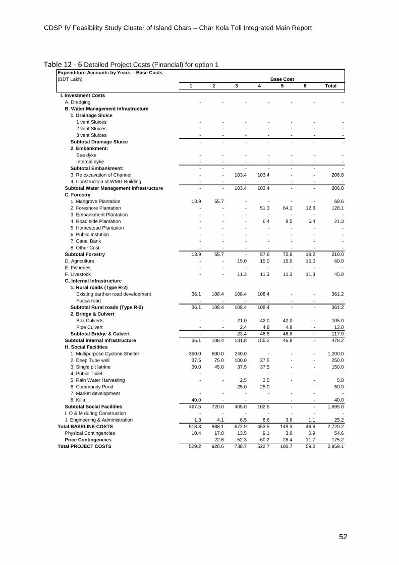
CDSP IV Feasibility Study Cluster of Island Chars – Char Kola Toli Integrated Main Report
52
Table 12 - 6 Detailed Project Costs (Financial) for option 1 Expenditure Accounts by Years -- Base Costs
(BDT Lakh) Base Cost
1 2 3 4 5 6 Total
I. Investment Costs
A. Dredging - - - - - - -
B. Water Management Infrastructure
1. Drainage Sluice
1 vent Sluices - - - - - - -
2 vent Sluices - - - - - - -
3 vent Sluices - - - - - - -
Subtotal Drainage Sluice - - - - - - -
2. Embankment:
Sea dyke - - - - - - -
Internal dyke - - - - - - -
Subtotal Embankment: - - - - - - -
3. Re excavation of Channel - - 103.4 103.4 - - 206.8
4. Construction of WMG Building - - - - - - -
Subtotal Water Management Infrastructure - - 103.4 103.4 - - 206.8
C. Forestry
1. Mangrove Plantation 13.9 55.7 - - - - 69.6
2. Foreshore Plantation - - - 51.3 64.1 12.8 128.1
3. Embankment Plantation - - - - - - -
4. Road side Plantation - - - 6.4 8.5 6.4 21.3
5. Homestead Plantation - - - - - - -
6. Public Instution - - - - - - -
7. Canal Bank - - - - - - -
8. Other Cost - - - - - - -
Subtotal Forestry 13.9 55.7 - 57.6 72.6 19.2 219.0
D. Agriculture - - 15.0 15.0 15.0 15.0 60.0
E. Fisheries - - - - - - -
F. Livestock - - 11.3 11.3 11.3 11.3 45.0
G. Internal Infrastructure
1. Rural roads (Type R-2)
Existing earthen road development 36.1 108.4 108.4 108.4 - - 361.2
Pucca road - - - - - - -
Subtotal Rural roads (Type R-2) 36.1 108.4 108.4 108.4 - - 361.2
2. Bridge & Culvert
Box Culverts - - 21.0 42.0 42.0 - 105.0
Pipe Culvert - - 2.4 4.8 4.8 - 12.0
Subtotal Bridge & Culvert - - 23.4 46.8 46.8 - 117.0
Subtotal Internal Infrastructure 36.1 108.4 131.8 155.2 46.8 - 478.2
H. Social Facilities
1. Multipurpose Cyclone Shelter 360.0 600.0 240.0 - - - 1,200.0
2. Deep Tube well 37.5 75.0 100.0 37.5 - - 250.0
3. Single pit latrine 30.0 45.0 37.5 37.5 - - 150.0
4. Public Toilet - - - - - - -
5. Rain Water Harvesting - - 2.5 2.5 - - 5.0
6. Community Pond - - 25.0 25.0 - - 50.0
7. Market development - - - - - - -
8. Killa 40.0 - - - - - 40.0
Subtotal Social Facilities 467.5 720.0 405.0 102.5 - - 1,695.0
I. O & M during Construction - - - - - - -
J. Engineering & Administration 1.3 4.1 6.5 8.6 3.6 1.1 25.2
Total BASELINE COSTS 518.8 888.1 672.9 453.5 149.3 46.6 2,729.2
Physical Contingencies 10.4 17.8 13.5 9.1 3.0 0.9 54.6
Price Contingencies - 22.6 52.3 60.2 28.4 11.7 175.2
Total PROJECT COSTS 529.2 928.6 738.7 522.7 180.7 59.2 2,959.1
CDSP IV Feasibility Study Cluster of Island Chars – Char Kola Toli Integrated Main Report
53
Annex 1. Terms of Reference
Feasibility Study Cluster of Chars, Char Kola Toli
1. Introduction
1.1. Background
The Inception Report of CDSP IV states that the project will undertake feasibility studies in areas where in
future char development programmes might take place. These future areas have to be located within the
overall study area, essentially the central, dynamic part of the coastal zone of Bangladesh. This area is
bordered in the east by the outfall of the Muhuri River and the Chittagong coastline. In the west the border
is formed by the Tetulia River. In the north, the coastline of Feni, Noakhali and Lakshmipur Districts is
followed. After a process of selection, the concerned authorities decided to take Dhal Char and Char Kola
Toli as areas for the second in the series of feasibility studies. During preliminary visits to these chars it
was discovered that Char Mozammel forms part of the same cluster of islands as Dhal Char and Kola Toli
and has a similar pattern of habitation and activities, hence it was decided to include it in the study as well.
Ghasiar Char and Moulovi Char are also in the same cluster, but the first one is protected forest area and
the latter is under severe erosion. The assessment of the stability shall include the whole cluster of chars.
Estimated total area of the 3 chars of the study area, i.e. Dhal, Kola Toli and Mozammel is about 5500 Ha,
see attached map.
The three chars in question, Dhal Char, Char Kola Toli and Char Mozammel, are distinctly different areas,
separated by rivers. The larger part of Dhal Char is located in Hatiya Upazila, Noakhali District, Chittagong
Division, while a small part of Dhal Char and the whole of Char Kola Toli forms part of Monpura Upazila,
Bhola District, Barisal Division and Char Mozammel is under Upazila Tozimuddin, (Dolichadpur Union),
Bhola District. The chars have their own distinct physical characteristics and have different degrees of
development. These Terms of Reference, and consequently the feasibility study reports themselves, will
have three clearly separate parts, one devoted to Dhal Char, one to Char Kola Toli and another devoted
to Char Mozammel.
1.2. Objectives
The objective of the feasibility study is to prepare a report which will be submitted to the concerned
authorities for their consideration whether the required means will be made available to implement and
facilitate the interventions recommended in the study. The study therefore has to fulfil the standard rules
and guidelines applied by the Bangladesh government in such cases. The study will develop a set of
interventions that will contribute to the overall objective of CDSP: to reduce poverty and hunger for poor
people living on newly accreted coastal chars, which would be achieved via improved and more secure
livelihoods.
1.3. Methodology
The preparation of the study should follow these general phases: - establishing base-line conditions - identification of possible interventions that will contribute to the abovementioned overall objective - analysis of impacts and costs of the interventions - formulating the overall proposed plan, setting priorities with regard to activities and time tables.
The preparation should adapt as much as possible a participative approach, especially with regard to the
identification and prioritisation of activities. At different stages both the local population and the concerned
institutions should be informed about the progress of the work. More methodological issues are included
in chapter 2 on the detailed activities to be undertaken.

CDSP IV Feasibility Study Cluster of Island Chars – Char Kola Toli Integrated Main Report
54
These Terms of Reference cover the overall feasibility study. However, a part of the study will be carried
out by a Bangladeshi firm or institute, to be sub-contracted by the project, while another part will be done
by the Technical Assistance team (TA team). Below, in the headings of the various sections on the
subjects to be covered, it is indicated whether that section will be taken care of by the sub-contracted firm
or institute, or by the TA team. Based on these overall Terms of Reference, specific Terms of Reference
for the sub-contracted firm or institute and for the TA team are available. If required, the TA team can hire
additional staff on a short term basis to support the study activities.
The duration of the study will be not more than 12 months.
2. Study area and activities
Char Kola Toli
A.1. Study area
Char Kola Toli is located in the lower Meghna, north west of Hatiya island. The whole char is under Monpura Upazila (Monpura Union), Bhola District. It is a char island, with an estimated size of the mature part of 2,000 ha. No information on land levels is available. Approximately 5,000 households are present in the area with a population of probably around 25,000. Preliminary investigations show that area is mostly khas land. The main sources of income of the people are farming, fishing a livestock.
A.2 Activities
A.2.1. Main features of study area and population (sub-contracted firm)
An overall picture of the present physical features of the area and the current population in the area
should be presented, including the following elements:
- short description of the development of the char since its emergence - land levels and land use (see also under 2.2) - total population, with number of households and average household size; this should be based on
a sample survey of approximately 10% - the sample survey should also contain questions on main occupations and sources of livelihood of
the settlers, landholdings and land tenure system, law and order situation - the survey should cover as well the status of food security in terms of the number of months that
food is available for the different social strata.
This activity should be implemented directly after the start of the assignment.
A.2.2. Water management (sub-contracted firm)
The following tasks should be performed as far as water management (and related to that, land
suitability) is concerned:
- Make a basic topographic and drainage map for the present situation, based on existing
information available with CDSP IV and new topographic (land levels) and hydrographic (cross
section khals) measurements. Observations during field visits and interviews will add to the
understanding of the area. This map should clearly identify the drainage units in the considered
area, the drainage network, the depth-duration characteristics of the drainage congested areas (if
any) and the origin and destination of the drainage waters. Design drainage discharges for each
of the drainage units should be established. The scale of the map should be 1:15000, while the
map should show contour-lines with contour-intervals of 10 cm.
CDSP IV Feasibility Study Cluster of Island Chars – Char Kola Toli Integrated Main Report
55
- Map the present salinity situation: intrusion and duration of the presence of saline water for
concentrations above a selected concentration for rice tolerance (e.g. 8 dS/m). Salinity intrusion is
for local settlers a bigger problem than drainage congestion.
- Make flood maps: depth and duration of tidal flooding in critical periods for agricultural practices
(for instance transplanting of T. Aman).
- In order to obtain a first impression of the groundwater situation, collect and analyse samples of
water produced by the few existing tube wells.
- Based on the above maps and established drainage patterns and discharges: identify bottlenecks
and develop interventions (such as, for instance, drainage works and possibly embankments), to
overcome these bottlenecks. Give particular attention to the issue of salinity intrusion. Designing
an optimal internal drainage system might include shifting the present boundaries with adjacent
drainage units, shortening of drainage channels, and cutting across boundaries of drainage units
(drainage from and towards other drainage units).
- Make an assessment of the stability of Char Kola Toli (accretion and erosion patterns); this
assessment should cover the development over the last 20 years and a projection for the next 20
years.
- In case any embankment is proposed, the issue has to be discussed with the Project Coordinating
Director, CDSP IV and Team Leader of the Technical Assistance team. If they agree to continue
with the idea of embankment construction, type and height of embankments have to be
established taking into account BWDB practices and experiences. Also the results of the latest
relevant climate change studies have to be considered. If the impression obtained during a field
visit is indeed correct, the main purpose of an embankment would be protection of life and
property and combating salinity intrusion.
- Make a map clearly showing the location of the proposed interventions, including the drainage
network
- Prepare drainage, salinity and flood maps for the situation with interventions.
- Based on the above information: make land suitability maps, indicating the potential for certain
cropping patterns and corresponding yields. The practice of agricultural zoning maps applied in
CDSP III and IV should be given attention.
- For each type of water management structure a conceptual design and drawing should be
produced.
- A cost-estimate of all proposed water management interventions should be made (with reference
to section 2.14 on cost/benefit analysis); this cost-estimate should take into consideration the
increase in rates that is likely to occur in the period till actual implementation of the study
recommendations.
A.2.3. Internal infrastructure (sub-contracted firm)
Although there is not much significant internal infrastructure present in the char, the study team should
start with making an inventory and continue with preparing a plan for the development of public
infrastructure for the char. The most important type of internal infrastructure for char areas are: - transport related infrastructure as roads, bridges and culverts - social and economic infrastructure such as multipurpose cyclone shelters, deep tubewells,
sanitary facilities, community ponds, killas and, if required, clustered villages and markets.
The infrastructure should be planned for a population that can be expected in future. The size of the
future population can be estimated by dividing the total area of khas land available for settlement of
landless households by 1.5 acre, being the maximum allocation for each household.
- An estimate of the total numbers of each of the structures should be made. The location of all
structures should be clearly identified on a map. The map should also show the proposed road
network.
CDSP IV Feasibility Study Cluster of Island Chars – Char Kola Toli Integrated Main Report
56
- For each type of infrastructure a conceptual design and drawing should be produced.
- The costs of the proposed infrastructure should be estimated (see 2.14), taking into account
increase in rates in the period until implementation will take place.
A.2.4. Land settlement (TA team)
The work on land settlement should focus on the issue of supply and demand: how much khas land is
available for distribution among landless households, versus the demand for land from households
that have already settled in the area, based on a maximum allotment of 1.5 acre per household. Initial
information shows that all land in Char Kola Toli is khas land.
The following activities have to be undertaken: - report on the present status of land settlement; provide mouza-wise information on the total area
of the mouza, the area that has already been officially settled, the area that is in process of settlement, and the balance of land that is available for future settlement; please note that experience in previous CDSP-projects have indicated that around 20-25% of land is required for public infrastructure, and thus cannot be used for settlement of households
- determine the number of households already settled in the char that have as yet no official land title
- determine the possibility of providing the already settled households that have no legal land title with a plot of 1.5 acre
- assess the possibility of settling additional households that are as yet not present in the area.
In addition, a plan for future activities should be developed aimed at facilitating the settlement
process. This plan will include an estimate of the involved costs (see 2.14).
A.2.5. Agriculture (sub-contracted firm)
For agriculture, the team is required to: - map the existing cropping pattern, cropped area (cropping intensity) and yields for each of the
crops grown in the field; - describe the present status of homestead gardening - analyse the present methods of cultivation, including an assessment of the status of the practice
and adoption of modern technologies - investigate salinity levels (ECE ds/m) of soil and water and their impact on crop production - assess the status of present small scale (such as from ponds) irrigation practices and the future
scope for irrigated agriculture - analyse the support system, including the extension services currently provided and the supply of
agricultural inputs - assess the current practice of selling agricultural produce - analyse the main factors hampering agricultural production, including at homesteads - develop recommendations to make the cropping patterns more suitable to the char environment,
and to increase the cropping intensity and yields; give attention to the possible impact of climate change on coastal agriculture;
- also formulate recommendations for homestead gardening - make a projection of future cropping intensity and yields, taking into account the suggested
interventions with regard to water management (see 2.2) and the interventions recommended in this section; while making this projection, makes use of information on results in previous CDSP areas, these are well documented in a number of CDSP-Technical Reports
- make an estimate of the costs of the recommendations for field agriculture and homestead gardening (with reference to the required cost/benefit analysis, see 2.14)
- determine the difference in production and value of that production between the situation before and after the proposed interventions (including the ones related to water management, if any, see 2.2) for field agriculture and homestead gardening (see 2.14).
A.2.6. Livestock (sub-contracted firm)
With regard to livestock activities in the area, the study will:
CDSP IV Feasibility Study Cluster of Island Chars – Char Kola Toli Integrated Main Report
57
- review the present situation of the livestock sector (poultry, small ruminants, cattle), including the role of livestock in the household economy
- analyse the production and marketing systems and identify the bottlenecks that impede further development of the sector
- describe the present status of diseases and their treatment - prepare a plan with recommendations for measures to be taken in support of livestock activities in
the char - estimate the costs of the proposed measures regarding livestock development (see cost
benefit/analysis in 2.14) - make an estimate of the increase in livestock production and its value after introduction of the
proposed measures (see 2.14).
A.2.7. Fisheries and aquaculture (sub-contracted firm)
This part of the study has to focus on:
- an assessment of the importance of fisheries and aquaculture for the livelihood of settlers in Char Kola Toli
- an analysis of the current production systems (inland fisheries, marine fisheries, aquaculture in ditches and ponds)
- an analysis of the present marketing system (if applicable) - the development of possible interventions to develop the sector, including the provision of
extension services - an assessment of the impact of the proposed water management interventions, if any (see 2.2) on
fisheries and aquaculture - estimate the costs of the proposed interventions (see cost/benefit analysis 2.14). - make an estimate of the difference in fish production and its value between the situation before
and after the proposed interventions (see 2.14).
A.2.8. Social forestry (sub-contracted firm)
Forestry has multiple functions in char development (stabilisation of land, buffer against tidal surges
and storms, promotion of bio-diversity, income creation through involvement of local population). The
following tasks have to be undertaken in the framework of this study:
- describe briefly the forestry situation since the emergence of the char area and elaborate upon the present status of forest in the char by making an inventory of the forestry coverage and the presence of any social forestry activities
- analyse the bottlenecks that have adversely influenced forestry development - prepare a forestry development plan for the char area, including road plantation, plantation in
homesteads, plantation on the grounds of public institutions, embankment- and foreshore plantation (if applicable); the plan should also assess the possibilities of mangrove plantations on land emerging in areas adjacent to or close to Char Kola Toli.
- make an estimate of the costs of the proposed development plan (see cost/benefit analysis in 2.14)
- make an estimate of the additional production of forest products and its value due to the proposed development plan and of the extra stream of income for the local settlers from their involvement in social forestry activities (with reference to 2.14).
A.2.9. NGO component (TA team)
The proposed interventions in the study area should contain a social- and livelihoods support
component, to be implemented by NGO’s. This NGO programme will cover the following fields:
- Group formation, micro-finance and capacity building - Health and family planning - Education - Water and sanitation - Homestead agriculture and value chain development - Poultry and livestock - Fisheries and aquaculture

CDSP IV Feasibility Study Cluster of Island Chars – Char Kola Toli Integrated Main Report
58
- Legal and human rights - Disaster management and climate change (see also 2.13.) - Climate change awareness.
The size of the programme should be based on the expected number of households that will be
settled in the study area (will be determined in section 2.4). An estimate of the costs of the overall
NGO component has to be made. The required overall cost/benefit analysis (see 2.14), has to
include the estimated costs of the economic oriented activities (homestead agriculture, poultry and
livestock, and fisheries and aquaculture).
A.2.10. Governance issues (TA team)
Governance related issues can be seen at three levels:
National government agencies: One of the striking features of CDSP is the fact that six governmental
departments (BWDB, LGED, DPHE, Ministry of Land, DAE, Forestry Department) share the
objectives of CDSP and closely cooperate and coordinate in undertaking activities. A key coordinating
mechanism is the Project Management Committee (in which all six departments are represented). It is
the intention that, in case the recommended interventions for Char Kola Toli are carried out, the
implementation will follow the same arrangement. If proposed activities are beyond the purview of the
six departments, the feasibility study team should suggest the modality of implementation. This will,
for instance, be the case for the fisheries and livestock sectors.
Local government level: The study should describe the involvement of local government bodies in the
proposed activities in Char Kola Toli. More specifically, these bodies are the Upazila Parishads of
Monpura and the Union Parishad of Monpura. The support of all councils would be vital for successful
implementation of project activities and should be ascertained. The role of the councils in the activities
should be defined.
Field level institutions: - An inventory should be made of the community based organisations that are already present and
active in Char Kola Toli. - A plan should be prepared, with a view on the proposed interventions in sections 2.2 to 2.8, of
either broadening and strengthening the existing institutions or forming new ones. For each of the types of the proposed institutions the number should be indicated, as well as the size in terms of specific n
- Number of members (gender specific) - Also, for each the role and responsibilities should be spelled out. Special attention should be
given to the involvement of the population in mangrove plantation and maintenance through the social forestry approach.
- Costs of all proposed interventions should be estimated (see 2.14).
A.2.11. Social impact and impact on livelihoods (TA team)
The feasibility study report will clearly indicate what the effect of the proposed intervention is on the
social and livelihood situation of the char settlers. One of the main aims of undertaking project activities
in Char Kola Toli is to contribute to a socio-economic transformation similar to what can be observed in
other CDSP areas. This change in livelihoods is well documented (see for instance Technical Report
no. 7 of CDSP III, December 2010, Impact of the Char Development and Settlement Projects I, II and
III). In describing and analysing the expected effects in the study area, the following elements have to
be highlighted:
- the economic benefits (see also section 2.14), including access to markets - the diversification in income - the employment opportunities - the level of poverty and food security - the access to social services

CDSP IV Feasibility Study Cluster of Island Chars – Char Kola Toli Integrated Main Report
59
- the change in security and vulnerability of the settlers - the position and status of women.
A.2.12. Environmental impact (sub-contracted firm)
A comprehensive Environmental Impact Assessment (EIA) is required for the development of Char
Kola Toli. This EIA shall be in accordance with the government guidelines, provided in the WARPO
Guidelines of 2005. Technical Report no. 19 of CDSP II, Guidelines for Environmental Impact
Assessment of CDSP activities, also gives valuable information. The scope of the work should include:
- review of existing information and identification of environmental issues related to CDSP type of activities
- description of the relevant institutional, legal and policy framework - collection of baseline data on the present environmental condition - analysis of the key environmental issues, with a view on the interventions
proposed in this feasibility study - analysis of possible, more environment-friendly alternatives - preparation of an Environment Management Plan, including a mitigation component - preparation of an Environmental Monitoring Plan - a cost-estimate of the Environmental Management Plan, of the mitigation measures and of the
Environmental Monitoring Plan should be included.
In a concluding section, the EIA should clearly state - the gains which justify implementation of the proposed interventions - an explanation of how the environmentally adverse effects could be minimized - provisions for proper follow-up surveillance and monitoring.
A.2.13. Impact of climate change (sub-contracted firm)
It is likely that climatic changes will have an impact on the situation on low-lying areas of coastal
Bangladesh. The feasibility study should make an effort to provide insight in what this impact would
mean for the proposed development activities in Char Kola Toli.
- The study should endeavour to reflect on, in general, the influence of climate change on the
situation in Char Kola Toli. The latest widely accepted reports should be used for this assessment. - More specifically, this section of the feasibility study report should dwell on the impact of climate
change on the sustainability (durability) of the proposed interventions (especially with regard to water management, if any, internal infrastructure, agriculture, livestock, aquaculture and forestry).
- In addition, concrete consequences for, for instance, design parameters for structures, selection of crop- and fish varieties and similar issues shall be described. On the subject of climate change, a time horizon of 50 years should be applied.
- Recommendations will be formulated if any special measures should be taken to support the settlers in Char Kola Toli to cope with the consequences of climate change. This could be in the range of raising awareness, support for community based adaptation to special institutional arrangements to deal with natural disasters (see also 2.9).
A.2.14. Costs and benefits: financial and economic analysis (sub-contracted firm)
An analysis of costs and benefits should be made, paying attention to the following issues.
As far as the cost side is concerned, the major cost components in the proposed package of interventions are:
- costs of water management related infrastructure as excavation of drainage channels and (possibly) construction of embankments and sluices
- cost of construction of economic activities related internal infrastructure as roads, bridges, culverts, killas and community ponds
- cost of construction of social facilities (cyclone shelters, deep tube wells, sanitary facilities) - operation and maintenance (O&M) costs in the period after project completion - costs of recommended interventions as far as agriculture, livestock, fisheries/aquaculture and
social forestry are concerned
CDSP IV Feasibility Study Cluster of Island Chars – Char Kola Toli Integrated Main Report
60
- costs of the land settlement plan - costs of institutional development measures.
As is normally the practice, the category of the abovementioned social infrastructure does not have to be taken into account in a cost-benefit analysis. With regard to the benefits, a distinction can be made between social and economic benefits. The social benefits are, among others: the increased physical security for the settlers by the construction of embankments (if any) and cyclone shelters, a great increase in access to drinking water and sanitary facilities; increased legal security by issuing of land titles to the char population. As economic benefits can be counted:
- an increase in the value of agricultural production through a higher cropping intensity and an increase in yields (see 2.5)
- an increase in production of homestead gardening (see 2.5) - a higher production of livestock products (see 2.6) - the creation of an additional stream of income through aquaculture in community ponds and
possibly individual ponds (see 2.7) - the creation of income for the settlers as a result of the social forestry activities (see 2.8) - a stimulation of general economic activities caused by the abovementioned production
increases and supported by the improved transport network (an effort should be made to quantify this benefit).
These economic benefits should form a part of the cost-benefit analysis.
Specific tasks that have to be performed are:
- make a selection of the costs that can reasonably be related to the economic benefits - calculate the total of these economy related investment costs - calculate the expected economic benefits - make an estimate of the expected O&M costs - make an estimate of O&M costs and of economic production in the present (without project)
situation - on the basis of these data calculate the Financial Internal Rate of Return (FIRR) and the
Economic Internal Rate of Return (EIRR)
Please note that the methodology applied should be acceptable for the Bangladesh authorities. In this
respect the Guidelines prepared by WARPO should be followed and conversion factors to come to
economic costs and benefits as approved by WARPO should be used. The economic life of the
proposed project should be assumed to be 20 years.
In CDSP, valuable reports have been published on the subject of cost/benefit analysis. It is strongly
recommended to consult these reports while implementing this part of the assignment. See for
instance
- Technical Report no. 26 (CDSP I), June 1999, The Costs and Benefits of Char Development - Technical Report no. 18 (CDSP II), September 2005, Cost benefit analysis - Feasibility study under CDSP III, Economic Analysis of Char Nangulia, Noler Char and Caring
Char, March 2008.
3. Staffing and organisation 3.1. Guidance and monitoring of the feasibility study team
Supervision of the feasibility study and coordination with other government institutions and non-governmental organisations will be in the hands of the CDSP IV Project Coordinating Director (of BWDB) and the Team Leader of the Technical Assistance team. The study will be carried out in close consultation and with full cooperation of the CDSP IV project staff, both from the government implementing agencies and the Technical Assistance team. At least once a month meetings will be held to monitor progress and more often when deemed necessary.
3.2. Staffing of the team

CDSP IV Feasibility Study Cluster of Island Chars – Char Kola Toli Integrated Main Report
61
The study will be carried out by a team of experienced professionals in the following areas (between brackets: maximum duration of their involvement, minimum educational requirement and reference to the description of their tasks):
- civil engineering/ water management and team leader (6 months / graduate engineer / see sections 2.2. and 2.3)
- hydraulic engineering and deputy team leader (6 months / graduate civil engineer / see sections 2.2 and 2.3)
- agriculture (3 months / master’s degree in agriculture / see section 2.4), - livestock expert (2 months / master’s degree in animal husbandry and veterinary science / see
section 2.5) - fisheries/aquaculture expert (2 months / master’s degree in fisheries / see section 2.6) - social forestry (2 months / master’s degree in forestry / see section 2.7) - environment (2 months / relevant master’s degree / see section 2.8) - climate change (1 month / relevant master’s degree or graduate engineering degree / see 2.9) - economic and financial issues and deputy team leader (4 months / master’s degree in
economics / see section 2.10). - socio economist/ sociologist (1 month / relevant master’s degree / see 2.1). All experts should have at least 15 years of experience in their respective fields and at least 10 years of experience in the coastal zone. In addition to the abovementioned 25 person months of professionals, technical assistants can be employed for the study to a maximum of 25 months.
3.3. Timing and reporting obligations of the study team
The start of the study is 1 December 2014; the duration will be not more than 12 months. The following reports have to be prepared:
- Inception Report, not later than one month after start of the assignment; the report will elaborate on methodologies and activities and provide detailed working schedules
- Interim Report, reflecting on the progress. It will contain the description and analysis of the present situation regarding all the subjects (including all relevant maps) and, if any, preliminary conclusions and recommendations; the Interim Report has to be submitted not later than four months after start of the assignment
- Draft Final Report; to be submitted not later than ten months after the start of the assignment - Final Report, in the 12
th month after start of the assignment.
All abovementioned reports should follow the structure of these Terms of Reference. The reports shall
be delivered digitally (2 copies) and as hard copies (50 copies).
3.4. Responsibilities of the CDSP IV Technical Assistance team
The Technical Assistance team of CDSP IV shall furnish all relevant data, maps and other information available to the feasibility study team. The Technical Assistance team will provide such assistance as is reasonably required by the feasibility study team for the purpose of implementing the activities under this Terms of Reference. The Technical Assistance team will closely monitor the progress. To this effect monthly (at least) meetings with the feasibility study team will be held. Experts from the Technical Assistance team will join members of the study team during selected field visits.
3.5. Responsibilities of the feasibility study team
The Water Management expert shall be appointed as Team Leader of the feasibility study team and
the hydraulic engineer and the socio economist as Deputy Team Leader for respectively the technical
and socio economical parts of the study. He or she will be responsible to the Project Coordinating
Director and the Team Leader of CDSP IV for the discharge of responsibilities of the feasibility study
team. No changes can be made in the composition of the feasibility study team, after the contract has
been awarded. In case, due to unforeseen circumstances, a team member has to be replaced, this
CDSP IV Feasibility Study Cluster of Island Chars – Char Kola Toli Integrated Main Report
62
can only be done with the approval of the Project Coordinating Director and the Team Leader of
CDSP IV.
The feasibility study team will open an office in Noakhali. Staff will be employed at that office
throughout the study period. The team will regularly consult with the Technical Assistance team. As
mentioned earlier, regular meetings (at least once a month) and joint field visits will be held.
Accurate and systematic records and accounts will be kept in respect of the services in such form and
detail as is customary in the profession and shall be sufficient to establish accurately the cost and
expenditures incurred for the services. Except with the prior written approval of the Team Leader and
Project Coordinating Director of CDSP IV the Consultant shall not assign or transfer the contract or
any part thereof nor engage any independent consultant or sub-contractors to perform any part of the
services other than the nominated personnel listed in the contract.
The feasibility study team will deliver all materials, including digital versions of all maps and reports, to
CDSP-IV upon completion of the assignment.