Embed Size (px)
Citation preview

Chapter SW
A SUMMARY OF TERTIARY COAL RESOURCES OF
THE WIND RIVER BASIN, WYOMING
By R.M. Flores and C. W. Keighin
in U.S. Geological Survey Professional Paper 1625-A
SW-ii
Contents
Introduction.........................................................................................................................SW-1
Stratigraphy.........................................................................................................................SW-1
Description of Coal Zone.................................................................................................SW-2
Coal Quality........................................................................................................................SW-3
Original Resources............................................................................................................SW-3
Production History............................................................................................................SW-3
Coal-bed Methane..............................................................................................................SW-4
Conclusions.........................................................................................................................SW-5
References ...........................................................................................................................SW-6
Figures
SW-1. Map showing locations of outcrops of the Fort Union Formation on the
periphery of the Wind River Basin, Wyoming.
SW-2. Generalized geologic map of the Wind River Basin.
SW-3. Generalized stratigraphic chart for the Paleocene Fort Union Formation.
SW-4. Cross section of the lower member of the Fort Union Formation and
associated thick coal beds.
SW-5. Total net-coal-thickness isopach map of the lower member of the Fort
Union Formation.
SW-iii
Figures—Continued
SW-6. Lithofacies and coal distribution in the Fort Union Formation along a south
to north line across the Wind River Basin.
SW-7. Total net-coal-thickness isopach map of the Shotgun Member, Fort Union
Formation, Wind River Basin.
SW-8. Lithofacies and coal distribution in the lower member and Shotgun Member
of the Fort Union Formation along a west to east cross section, Wind River
Basin.
SW-9. Summary of thermal maturity data to the base of the Paleocene Waltman
Shale Member of the Fort Union Formation, Wind River Basin.
SW-1
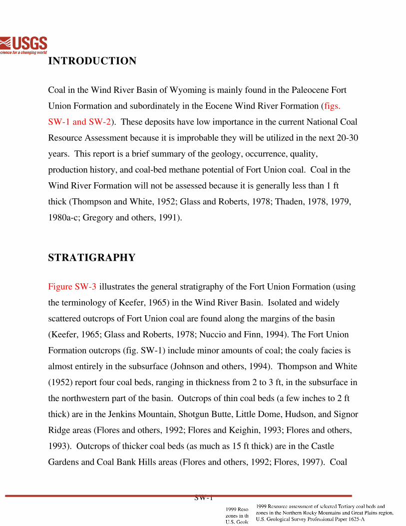
INTRODUCTION
Coal in the Wind River Basin of Wyoming is mainly found in the Paleocene Fort
Union Formation and subordinately in the Eocene Wind River Formation (figs.
SW-1 and SW-2). These deposits have low importance in the current National Coal
Resource Assessment because it is improbable they will be utilized in the next 20-30
years. This report is a brief summary of the geology, occurrence, quality,
production history, and coal-bed methane potential of Fort Union coal. Coal in the
Wind River Formation will not be assessed because it is generally less than 1 ft
thick (Thompson and White, 1952; Glass and Roberts, 1978; Thaden, 1978, 1979,
1980a-c; Gregory and others, 1991).
STRATIGRAPHY
Figure SW-3 illustrates the general stratigraphy of the Fort Union Formation (using
the terminology of Keefer, 1965) in the Wind River Basin. Isolated and widely
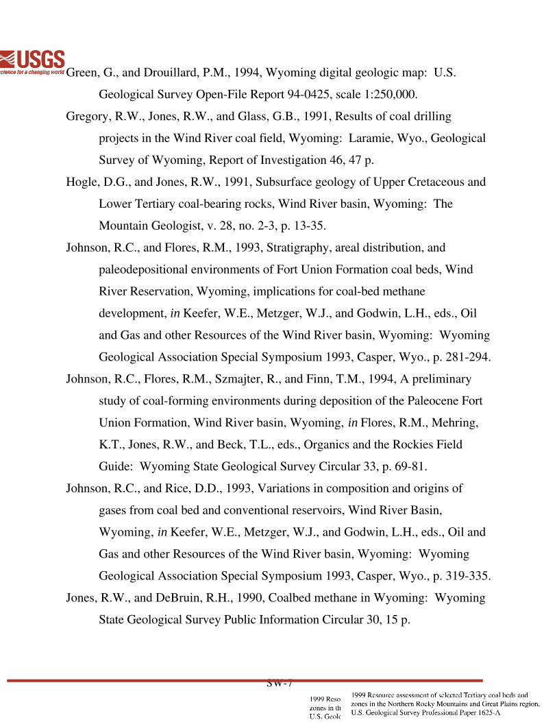
scattered outcrops of Fort Union coal are found along the margins of the basin
(Keefer, 1965; Glass and Roberts, 1978; Nuccio and Finn, 1994). The Fort Union
Formation outcrops (fig. SW-1) include minor amounts of coal; the coaly facies is
almost entirely in the subsurface (Johnson and others, 1994). Thompson and White
(1952) report four coal beds, ranging in thickness from 2 to 3 ft, in the subsurface in
the northwestern part of the basin. Outcrops of thin coal beds (a few inches to 2 ft
thick) are in the Jenkins Mountain, Shotgun Butte, Little Dome, Hudson, and Signor
Ridge areas (Flores and others, 1992; Flores and Keighin, 1993; Flores and others,
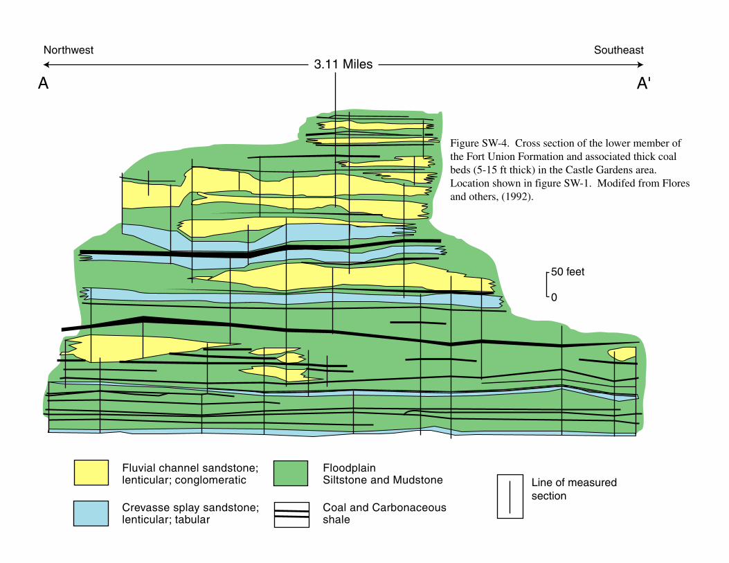
1993). Outcrops of thicker coal beds (as much as 15 ft thick) are in the Castle
Gardens and Coal Bank Hills areas (Flores and others, 1992; Flores, 1997). Coal

SW-2
beds are contained in the lower member and Shotgun Member of the Fort Union
Formation. (This terminology follows Keefer, 1965; “lower member” is an
informal term). A cross-section (A-A’) of the lower member and associated thick
coal beds (5-15 ft thick) in the Castle Gardens areas is shown in figure SW-4
(modified from Flores and others, 1992).
DESCRIPTION OF COAL ZONE
The Paleocene Fort Union Formation is considered a minor coal-bearing formation
in the Wind River basin; exposed coal is uncommon and thin, seldom reaching 3 ft
in thickness (Hogle and Jones, 1991). Woodruff and Winchester (1912) reported a
4.5-ft-thick Paleocene coal bed near Castle Gardens (fig. SW-5). However,
Johnson and Flores (1993), using geophysical logs, report that the Fort Union
Formation contains, in aggregate, more than 100 ft (net total) of coal in the western
part of the Wind River Basin. One coal bed in this coal zone is as much as 40 ft
thick. Recent work by Flores and others (1992), Flores and Keighin (1993), and
Flores (1997) shows coal beds 5-15 ft thick that are more than 2 mi in lateral extent.
A total net coal thickness isopach map of the lower member of the Fort Union
Formation, modified from Johnson and others (1994) to include coal-bed thickness
measurements from outcrops by Flores and others (1992), Flores and Keighin
(1993), Flores and others (1993), and Flores (1997), is shown in figure SW-5.
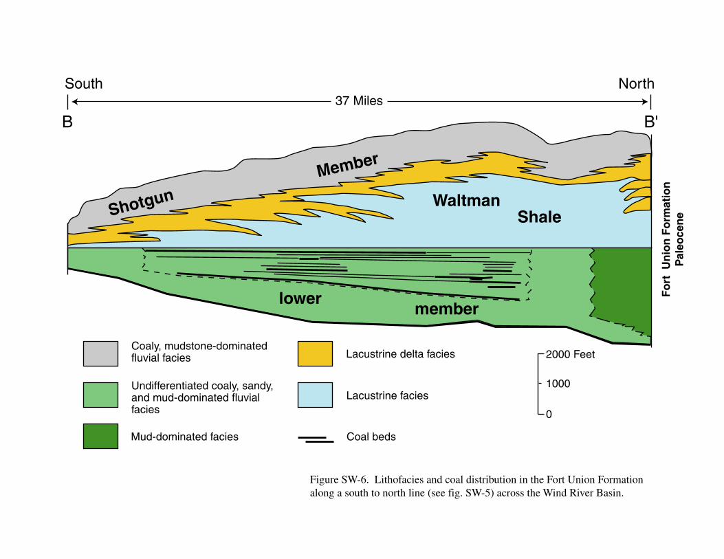
Lithofacies and coal-bed distribution in the Fort Union Formation along a south to
north cross section (B-B’) are shown in figure SW-6. The ovoid areal distribution
of the lower member coal beds across the east-central part of the Wind River Basin
was influenced by interchannel swamps related to east-northeast-flowing fluvial
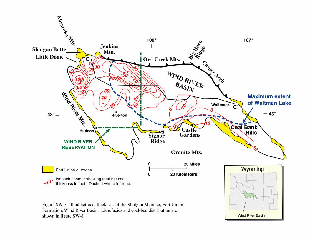
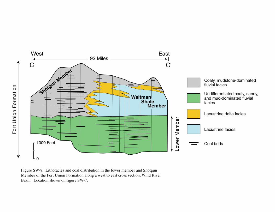
systems. A total (net) coal thickness isopach map of the Shotgun Member is shown

SW-3
in figure SW-7; lithofacies and coal-bed distribution are illustrated in cross section
C-C’ (fig. SW-8). The elongate areal distribution of the Shotgun Member coal beds
across the west-central part of the basin was controlled by shoreline transgression
accompanied by coastal regression of Waltman Lake.
COAL QUALITY
Tertiary coal in the Wind River Basin is generally considered to be subbituminous,
but no analyses are available to verify its rank or coal quality (Glass and Roberts,
1978; Glass, 1981). Thermal maturity levels (Ro = 0.36-0.55%) of surface samples
of Fort Union coal on the periphery of the basin are consistent with subbituminous
rank (fig. SW-9; Nuccio and Finn, 1994). Thermal maturity levels of Fort Union
coal may reach levels consistent with high volatile A bituminous rank (Ro as much
as 0.99%) in deeper parts of the basin (Nuccio and Finn, 1994; Nuccio and others,
1996; Rice, 1993).
ORIGINAL RESOURCES
Because of limited, no resource calculations have been made of potential coal
resources in the Fort Union Formation in the Wind River Basin.
PRODUCTION HISTORY
Coal mining in the Wind River Basin apparently started in approximately 1870, but
Tertiary coal appears to have mined only from the Arminto field (T. 34 N., R. 90
SW-4
W., sec. 4) in about 1900. There is apparently no record of the amount of coal
produced, but the quantity was probably very limited and for local use only.
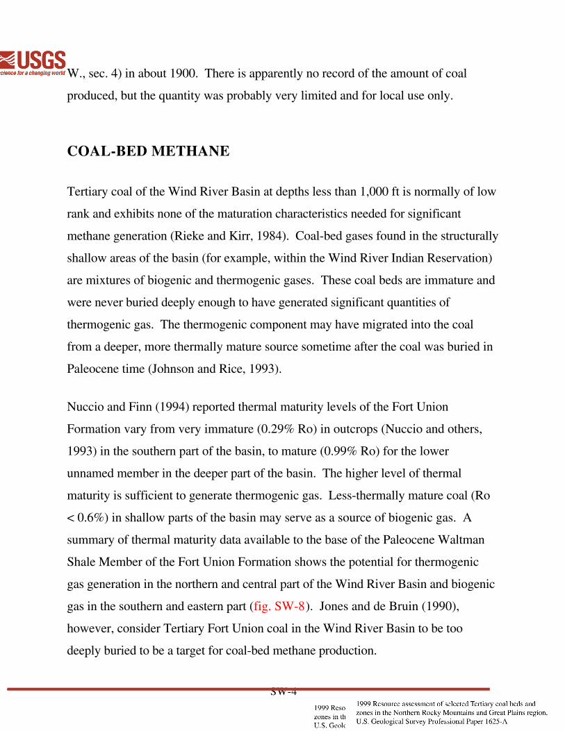
COAL-BED METHANE
Tertiary coal of the Wind River Basin at depths less than 1,000 ft is normally of low
rank and exhibits none of the maturation characteristics needed for significant
methane generation (Rieke and Kirr, 1984). Coal-bed gases found in the structurally
shallow areas of the basin (for example, within the Wind River Indian Reservation)
are mixtures of biogenic and thermogenic gases. These coal beds are immature and
were never buried deeply enough to have generated significant quantities of
thermogenic gas. The thermogenic component may have migrated into the coal
from a deeper, more thermally mature source sometime after the coal was buried in
Paleocene time (Johnson and Rice, 1993).
Nuccio and Finn (1994) reported thermal maturity levels of the Fort Union
Formation vary from very immature (0.29% Ro) in outcrops (Nuccio and others,
1993) in the southern part of the basin, to mature (0.99% Ro) for the lower
unnamed member in the deeper part of the basin. The higher level of thermal
maturity is sufficient to generate thermogenic gas. Less-thermally mature coal (Ro
< 0.6%) in shallow parts of the basin may serve as a source of biogenic gas. A
summary of thermal maturity data available to the base of the Paleocene Waltman
Shale Member of the Fort Union Formation shows the potential for thermogenic
gas generation in the northern and central part of the Wind River Basin and biogenic
gas in the southern and eastern part (fig. SW-8). Jones and de Bruin (1990),
however, consider Tertiary Fort Union coal in the Wind River Basin to be too
deeply buried to be a target for coal-bed methane production.

SW-5
CONCLUSIONS
Fort Union coal is not economically minable today because the thick deposits are
found only in the deep parts of the Wind River Basin, and they are not high enough
in quality (based on normal Tertiary coal quality) to warrant development of large
underground mines. However, thermogenic and biogenic gases from the Fort
Union coal in the deep and shallow parts of the basin may serve as potential coal-
bed methane resources. Much of the infrastructure for coal-bed methane
transportation, such as gas pipelines, is in place in the basin. Rail systems for coal
transportation from areas where the thickest coal accumulations exist is not
available.

SW-6
REFERENCES
Flores, R.M., 1997, Tectono-stratigraphic framework of the Fort Union in the Wind
River Basin: A window to the northern Rockies paleogeography: Wyoming
Geological Association Proceedings 1997 Field Conference, 3 p.
(unpaginated).
Flores, R.M, Clark, A.C., and Keighin, C.W., 1993, Architecture of Fort Union
paleovalley conglomerates related to aquifer potential in the western Wind
River Basin, in Keefer, W.R., Metzger, W.J., and Godwin, L.H., eds., Oil
and Gas and other Resources of the Wind River Basin Wyoming: Wyoming
Geological Association Special Symposium 1993, p. 143-162.
Flores, R.M., and Keighin, C.W., 1993, Reservoir anisotropy and facies
stratigraphic framework in the Paleocene Front Union Formation, western
Wind River Basin, Wyoming, in Keefer, W.R., Metzger, W.J., and Godwin,
L.H., eds., Oil and Gas and other Resources of the Wind River Basin
Wyoming: Wyoming Geological Association Special Symposium 1993, p.
121-141.
Flores, R.M., Keighin, C.W., and Nichols, D.J., 1992, Sedimentology,
conglomerate petrology, and palynostratigraphy of the Fort Union Formation
(Paleocene), Castle Gardens, Wind River basin, Wyoming, in K.A. Sundell
and T.C. Anderson eds., Road Log Volume for Rediscover the Rockies:
Casper, Wyo., Wyoming Geological Association, p. 21-27.
Glass, G.B., 1981, Coal deposits of Wyoming: Thirty-Second Annual Field
Conference—1981, Wyoming Geological Association, p. 181-236.
Glass, G.B., and Roberts, J.T., 1978, Update on the Wind River coal basin:
Wyoming Geological Association 30th Annual Field Conference, Casper,
Wyo., p. 363-377.
SW-7
Green, G., and Drouillard, P.M., 1994, Wyoming digital geologic map: U.S.
Geological Survey Open-File Report 94-0425, scale 1:250,000.
Gregory, R.W., Jones, R.W., and Glass, G.B., 1991, Results of coal drilling
projects in the Wind River coal field, Wyoming: Laramie, Wyo., Geological
Survey of Wyoming, Report of Investigation 46, 47 p.
Hogle, D.G., and Jones, R.W., 1991, Subsurface geology of Upper Cretaceous and
Lower Tertiary coal-bearing rocks, Wind River basin, Wyoming: The
Mountain Geologist, v. 28, no. 2-3, p. 13-35.
Johnson, R.C., and Flores, R.M., 1993, Stratigraphy, areal distribution, and
paleodepositional environments of Fort Union Formation coal beds, Wind
River Reservation, Wyoming, implications for coal-bed methane
development, in Keefer, W.E., Metzger, W.J., and Godwin, L.H., eds., Oil
and Gas and other Resources of the Wind River basin, Wyoming: Wyoming
Geological Association Special Symposium 1993, Casper, Wyo., p. 281-294.
Johnson, R.C., Flores, R.M., Szmajter, R., and Finn, T.M., 1994, A preliminary
study of coal-forming environments during deposition of the Paleocene Fort
Union Formation, Wind River basin, Wyoming, in Flores, R.M., Mehring,
K.T., Jones, R.W., and Beck, T.L., eds., Organics and the Rockies Field
Guide: Wyoming State Geological Survey Circular 33, p. 69-81.
Johnson, R.C., and Rice, D.D., 1993, Variations in composition and origins of
gases from coal bed and conventional reservoirs, Wind River Basin,
Wyoming, in Keefer, W.E., Metzger, W.J., and Godwin, L.H., eds., Oil and
Gas and other Resources of the Wind River basin, Wyoming: Wyoming
Geological Association Special Symposium 1993, Casper, Wyo., p. 319-335.
Jones, R.W., and DeBruin, R.H., 1990, Coalbed methane in Wyoming: Wyoming
State Geological Survey Public Information Circular 30, 15 p.
SW-8
Keefer, W.R., 1965, Stratigraphy and geologic history of the Uppermost
Cretaceous, Paleocene, and Lower Eocene rocks in the Wind River
basin, Wyoming: U.S. Geological Survey Professional Paper 495-
A, p. 1-77.
Nuccio, V.F., and Finn, T.M., 1994, Structural and thermal history of the Paleocene
Fort Union Formation, central and eastern Wind River Basin, with emphasis
on petroleum potential of the Waltman Shale Member, in Flores, R.M.,
Mehring, K.T., Jones, R.W., and Beck, T.L., eds., Organics and the Rockies
Field Guide: Wyoming State Geological Survey Public Information Circular
No. 33, p. 53-68.
Nuccio, V.F., Finn, T.M., and Johnson, R.C., 1996, Thermal maturity data used for
the assessment of gas resources in the Wind River Basin, Wyoming: U.S.
Geological Survey Open File Report 96-064, 57 p.
Nuccio, V.F., Finn, T.M., and Pawlewicz, M.J., 1993, Surface vitrinite reflectance
study of the Wind River basin, central Wyoming, in Keefer, W.R., Metzger,
W.J., and Godwin, L.H., eds., Oil and Gas and Other Resources of the Wind
River Basin Wyoming: Wyoming Geological Association Special
Symposium 1993, Casper, Wyo., p. 307-317.
Rice, D.D., 1993, Composition and origins of coal-bed gas, in Law, B.E., and Rice,
D.D., eds., Hydrocarbons from Coal: American Association of Petroleum
Geologists Studies in Geology no. 38, p. 159-184.
Rieke, H.H., and Kirr, J.H., 1984, Geologic overview, coal, and coal-bed methane
resources of the Wind River basin, Wyoming, in Rightmire, C.T., Eddy,
G.E., and Kirr, J.N., eds., Coalbed methane resources of the United States:
American Association of Petroleum Geologists Studies in Geology Series no.
17, p. 295-334.

SW-9
Thaden, R.E., 1978, Geologic map of the Bonneville quadrangle, Fremont County,
Wyoming: U.S. Geological Survey Geologic Quadrangle Map GQ-1439,
scale 1:24,000.
_____1979, Geologic map of the Lysite quadrangle, showing chronolithofacies and
coal beds in the Wind River Formation, Fremont County, Wyoming: U.S.
Geological Survey Geologic Quadrangle Map GQ-1511, scale 1:24,000.
_____1980a, Geologic map of the Birdseye Pass quadrangle, showing
chronolithofacies and coal beds in the Wind River Formation, Fremont and
Hot Springs Counties, Wyoming: U.S. Geological Survey Geologic
Quadrangle Map GQ-1537, scale 1:24,000.
_____1980b, Geologic map of the Gates Butte quadrangle, showing
chronolithofacies and coal beds in the Wind River Formation, Fremont
County, Wyoming: U.S. Geological Survey Geologic Quadrangle Map GQ-
1538, scale 1:24,000.
_____1980c, Geologic map of the Picard Ranch quadrangle, showing
chronolithofacies and coal beds in the Wind River Formation, Fremont
County, Wyoming: U.S. Geological Survey Geologic Quadrangle Map GQ-
1539, scale 1:24,000.
Thompson, R.M., and White, V.L., 1952, The coal deposits of the Alkali Butte, the
Big Sand Draw, and the Beaver Creek fields, Fremont County, Wyoming:
U.S. Geological Survey Circular 152, 24 p.
Woodruff, E.G., and Winchester, D.E., 1912, Coal fields of the Wind River region,
Fremont and Natrona Counties, Wyoming: U.S. Geological Survey Bulletin
471, p. 516-564.
0 20 Miles
20 Kilometers0
108° 107°
43°Riverton
Hudson
Waltman
WIND RIVER BASIN
JenkinsMtn.
Shotgun Butte
Little Dome
SignorRidge
Casper
Arch
Big
Hor
nR
idge
Owl Creek Mts.
43°
CastleGardens
Coal BankHills
Fort Union outcrops
Granite Mts.
Wind R
iver Mts.
Absaroka M
ts.
WIND RIVERRESERVATION
Figure SW-1. Map showing locations of outcrops of the Fort Union Formation on the periphery of the Wind River Basin, Wyoming. Approximate location of very limited mining of Fort Union coal from the Arminto field around the year 1900 is marked by . Section A-A' is shown in figure SW-4.*
*A A'
Wyoming
Wind River Basin

43°30'
42°30'
43°00'
108°00'108°30'107°00'107°30' 106°30'
Geology of the Wind River Basin
Alluvium
Fort Union Formation
Indian Meadows Formation
Wagon Bed Formation
Wind River Formation
Holocene and Quaternary
Eocene
Paleocene
Wyoming
Wind River Basin
0 25 Miles25
Figure SW-2. Generalized geologic map of the Wind River Basin showing distribution ofTertiary rocks. Adapted from Green and Drouillard, (1994).
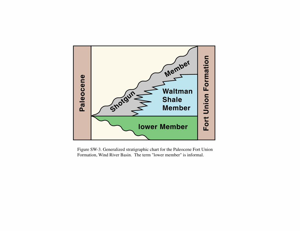
Figure SW-3. Generalized stratigraphic chart for the Paleocene Fort Union Formation, Wind River Basin. The term "lower member" is informal.
Fo
rt U
nio
n F
orm
atio
n
Pa
leo
ce
ne
lower Member
WaltmanShaleMember
Shotg
un
M
ember
50 feet
0
Fluvial channel sandstone; lenticular; conglomeratic
Crevasse splay sandstone;lenticular; tabular
FloodplainSiltstone and Mudstone
Coal and Carbonaceousshale
Line of measuredsection
Figure SW-4. Cross section of the lower member of the Fort Union Formation and associated thick coal beds (5-15 ft thick) in the Castle Gardens area. Location shown in figure SW-1. Modifed from Flores and others, (1992).
A
Northwest3.11 Miles
Southeast
A'

80
50
2010
30
30
40
90
0 10
1020
20
10
0?
300?
Granite Mts.
0 20 Miles
20 Kilometers0
108° 107°
43° Riverton
Hudson
Waltman
JenkinsMtn.
Shotgun Butte
SignorRidge
CastleGardens
Casper Arch
Big
Hor
nR
idge
Owl Creek Mts.
43°
Coal BankHills
Fort Union outcrops
Isopach contour showing total net coalthickness in feet. Dashed where inferred.
MerriamAnticline
Little Dome
Wind R
iver Mts. B
B'
WIND RIVERRESERVATION
Figure SW-5. Total net-coal-thickness isopach map of the lower member of the Fort Union Formation (modified from Johnson and others, 1994) that includes coal-bed thickness measurements from outcrops (Flores and others, 1992, 1993; Flores and Keighin, 1993; Flores, 1997). Lithofacies and coal-bed distribution along a south to north cross section are illustrated in figure SW-6.
10
10
Absaroka M
ts.
Wyoming
Wind River Basin
0
1000
2000 FeetCoaly, mudstone-dominatedfluvial facies
Undifferentiated coaly, sandy,and mud-dominated fluvialfacies
Lacustrine delta facies
Lacustrine facies
Fo
rt U
nio
n F
orm
atio
nP
aleo
cen
e
WaltmanShale
lowermember
Shotgun
Member
Mud-dominated facies Coal beds
Figure SW-6. Lithofacies and coal distribution in the Fort Union Formation along a south to north line (see fig. SW-5) across the Wind River Basin.
South37 Miles
North
B'B
1020
3040
30
20
40
100
0
0
1008060
50
40
2010
30
10
30 60
20
50
10
108° 107°
43° Riverton
Hudson
Waltman
WIND RIVER BASIN
JenkinsMtn.Shotgun Butte
Little DomeCasper Arch
Big
Hor
nR
idge
Owl Creek Mts.
43°
Maximum extentof Waltman Lake
Wind River M
ts.
C'
10
C
Figure SW-7. Total net-coal thickness of the Shotgun Member, Fort Union Formation, Wind River Basin. Lithofacies and coal-bed distribution are shown in figure SW-8.
0 20 Miles
20 Kilometers0
Absaroka M
ts.
10
SignorRidge
CastleGardens Hills
Granite Mts.
WIND RIVERRESERVATION
Coal Bank
Wyoming
Wind River Basin
Fort Union outcrops
Isopach contour showing total net coalthickness in feet. Dashed where inferred.
0
1000 Feet
Shotgun Member
WaltmanShale
Member
West East
Coaly, mudstone-dominatedfluvial facies
Undifferentiated coaly, sandy,and mud-dominated fluvialfacies
Lacustrine delta facies
Lacustrine facies
Coal beds
C C'
Fo
rt U
nio
n F
orm
ati
on
Lo
we
r M
em
be
rFigure SW-8. Lithofacies and coal distribution in the lower member and Shotgun Member of the Fort Union Formation along a west to east cross section, Wind River Basin. Location shown on figure SW-7.
92 Miles

0 20 Miles
20 Kilometers0
108° 107°
43°
Hudson
Waltman
WIND RIVER BASIN
JenkinsMtn.Shotgun Butte
Little Dome
SignorRidge
Casper Arch
Big
Hor
nR
idge
Owl Creek Mts.
43°
CastleGardens
Coal BankHills
Granite Mts.
Wind R
iver Mts.
WIND RIVER RESERVATION
1.10
0.6
0.6
0.73 0.73
Figure SW-9. Summary of thermal maturity data to the base of the Paleocene Waltman Shale Member of the Fort Union Formation, Wind River Basin. Modified from Nuccio and others, (1996).
Fort Union outcrops
Thermal maturity expressed asvitrinite reflectance levels (Ro)0.6
Riverton
Absaroka M
ts.
Wyoming
Wind River Basin