Embed Size (px)
Citation preview
1 5/22/2006
CHAPTER l INTRODUCTION
DESCRIPTION OF THE PARKWAY The American River Parkway is an open space greenbelt which extends approximately 29 miles from Folsom Dam at the northeast to the American River’s confluence with the Sacramento River at the southwest. There are several distinct areas of the Parkway, each having individual features which contribute to their separate identities. The Lower American River (LAR) is classified as a “Recreation” river within the State and Federal Wild and Scenic River Systems. The river is the central focus of the Parkway which provides enjoyment to residents and visitors of the Sacramento region. In fact, the American River Parkway is often referred to as “the jewel” of the Sacramento Region. Recreational activity is important in the maintenance of healthy lives. Residents in the Sacramento region are particularly fortunate in having easy access to the recreational opportunities that the Parkway provides. In addition, visitors to the Sacramento area can also take advantage of the natural, aesthetic and historical resources of the Parkway. While the importance of recreational opportunities is recognized, preserving the natural qualities of the Parkway resource is essential. The purpose of the Parkway Plan is to provide a guide to land use decisions affecting the Parkway; specifically addressing its preservation, use, development and administration. The Parkway Plan is a policy and action document. It is written to ensure preservation of the naturalistic environment while providing limited developments to facilitate human enjoyment of the Parkway. This Plan is the guiding policy document for the Parkway. It contains policy statements of a general and flexible nature. The American River Parkway is a regional open space greenbelt which crosses jurisdictional boundaries. The Parkway Plan addresses the entire length of the Parkway which includes areas in the unincorporated County, the City of Sacramento, the City of Rancho Cordova and the Lake Natoma portion of the Folsom Lake State Recreational Area. The County of Sacramento adopts the Parkway Plan as an element of its General Plan. The City of Sacramento and City of Rancho Cordova reference the Parkway Plan in their General Plans. The locally adopted Plan is then submitted to the State legislature for adoption through the Urban American River Parkway Preservation Act, Public Resources Code §5840. The Plan acts as an information document and an invitation for citizen participation in the planning process. It also provides basic policy guidance for the future of the Parkway. The Parkway Plan also acts as the management plan for the federal and state Wild and Scenic Rivers Acts, as described in Chapter 4 of this Plan.
2 5/22/2006
The County of Sacramento has the principal responsibility for administration and management of the American River Parkway as guided by the American River Parkway Plan. The American River Parkway Plan is defined to include the American River and adjacent floodplain, from the confluence with the Sacramento River up to Folsom Dam. The County of Sacramento, however, has day-to-day management responsibility for the portion of the Parkway from the Sacramento River confluence to Hazel Avenue, exclusive of the fish hatchery facilities. For the purposes of this Plan, the Lower American River (LAR) is defined to be from the confluence of the Sacramento River upstream to Hazel Avenue. There are several portions of the Parkway that are owned and/or managed by State and Federal land managers. California Exposition and State Fair (Cal Expo) owns the Cal Expo floodplain portion of the Parkway upstream of Capitol City Freeway, adjacent to the Cal Expo property landside of the levee. This portion of the Parkway is managed consistent with the Bushy Lake Preservation Act. Sacramento County Department of Regional Parks has managed this portion of the floodplain by agreement with Cal Expo. The portion of the Parkway from Hazel Avenue upstream to the Folsom Dam, known as Lake Natoma, is included here as well as being a part of the Folsom Lake State Recreation Area. Lake Natoma is administered by the California Department of Parks and Recreation or by the Federal land owning managers. Lake Natoma is patrolled by California State Park rangers and not by County Regional Parks rangers. THE PARKWAY GOALS AND CONCEPT The Parkway Concept can be summarized as follows: The American River Parkway is a unique regional facility which shall be managed to balance the goals of, a) preserving naturalistic open space and protecting environmental quality within the urban environment, and b) contributing to the provision of recreational opportunity in the Sacramento area. Overall guidance on the approach to preservation and management of the Parkway are embodied in both the Plan’s Goals and the Concept Policies. GOALS:
• To provide, protect and enhance for public use a continuous open space greenbelt along the American River extending from the Sacramento River to Folsom Dam.
• To provide appropriate access and facilities so that present and future generations can enjoy the amenities and resources of the Parkway which enhance the enjoyment of leisure activities.
• To preserve, protect, interpret and improve the natural, archaeological, historical and recreational resources of the Parkway, including an adequate flow of high quality water, anadromous and resident fishes, migratory and resident wildlife,
Comment [sw1]: Clarity of Parkway boundary and management responsibility added per UCAC.
3 5/22/2006
and diverse natural vegetation.
• To mitigate adverse effects of activities and facilities adjacent to the Parkway.
• To provide public safety and protection within and adjacent to the Parkway.
Concept Policies: The first set of policies sets forth the guiding concepts for management within the Parkway and the relationship of the surrounding region to the Parkway. These concept policies include: Balanced management: 1.1 - The American River Parkway is a unique regional asset that shall be managed to balance the goals of controlling flooding; preserving and enhancing native vegetation, native fish species, the naturalistic open space and environmental quality within the urban environment; maintaining and improving water flow and quality; providing adequate habitat connectivity and travel corridors to support migratory and resident wildlife; providing recreational opportunities; and ensuring public safety. Recreation: 1.2 - The Parkway shall be oriented to passive, unstructured water-enhanced recreation activities which are appropriate in a natural environment, and which are not normally provided by other County recreational facilities. To this end, development in the Parkway shall be minimal, and facilities which are primarily visitor attractions should be placed in less sensitive areas within the County Park system. Insofar as possible, development shall not occur in areas of natural ecosystems that are still relatively undisturbed. Resource protection: 1.3 – Limitation on the use of the Parkway through design and management tools to prevent overuse of the Parkway, and preserve the environmental quality, thereby ensuring the integrity of the Parkway for future users. Land Use: 1.4 – No existing publicly owned Parkway lands shall be disposed of through sale, lease, or de facto uses adverse to the goals and policies of this Plan, in order to assure the long-term protection and integrity of the present boundaries of the Parkway. Cooperation: 1.5 - Coordination and cooperation in Parkway planning and management is essential, especially in recognizing the many important roles of jurisdictions and agencies with regulatory responsibilities within the Parkway. The Parkway goals and concept policies collectively provide the foundation for the Parkway Plan and are further reflected in the goals, policies, and text of the Plan. The Parkway concept still holds true today and as a result, provides the basis for planning efforts for the American River Parkway.
4 5/22/2006
THE HISTORY OF THE PARKWAY PLAN As early as 1915, the City of Sacramento delineated a concept of the American River Parkway on a plan map. When the County Parks and Recreation Department was established by the Board of Supervisors in 1959, the Board directed the Parks and Recreation Department to initiate land acquisition proceedings for those lands adjacent to the American River. This action, which occurred prior to the County’s adoption of the Parkway concept in 1962, was in part due to the increasing feasibility of urban development close to the river. The completion of Folsom Dam in 1956 and the construction of the last segment of the levee system along the north side of the river upstream of the Cal Expo area contributed to the increased development directly adjacent to the river. The American River Parkway Plan was adopted in concept in 1962 by Sacramento County and incorporated into the Recreation Element of the County General Plan. Adopting the Parkway concept was a declaration of the County’s intent to preserve an open space greenbelt along the length of the American River in Sacramento County. This Plan was substantially revised in 1968 to include background information on the Parkway and policies for Parkway administration. A 1974 analysis of the Plan by the consulting firm Environmental Assessment Engineering was the first to include data on the Parkway environment and its use. Public hearings held during the analysis development invited citizen participation. The specific plan for the portion of the Parkway within the City of Sacramento’s jurisdiction was adopted by the City in 1975. The 1976 American River Parkway Plan, which was adopted as an element of the 1973 County General Plan, was developed using information from the previous plans, but attempted to develop a Parkway concept which took present and future needs into consideration. Like this Plan, the 1976 and 1985 Plans were policy documents with guidelines for the preservation, use, development and administration of the Parkway. The implementation section of the Plan, in conjunction with the policy statements, resulted in a strong guiding document for important land use decisions affecting the Parkway. The Parkway Plan was last updated in 1985. A working committee composed of representatives from various interest groups concerned with the Parkway developed the Plan over a period of approximately one year and focused its attention on identifying and resolving issues which occurred between 1976 and 1984. THE PLANNING PROCESS 2002-2006 Consideration for the update of the 1985 American River Parkway Plan began in June 2002 with stakeholder assessment to determine what issues Parkway stakeholders wanted to see addressed as part of the Update. The assessment identified five objectives for the 2006 Update:
Comment [sw2]: Updated per this Update Process
5 5/22/2006
1. Involve a representative group of Parkway stakeholders (the Update Citizens Advisory Committee) in working collaboratively to develop advisory recommendations for updating the Plan.
2. Incorporate the coordinated resource management approach and new scientific and technical information from the River Corridor Management Plan, consistent with the ’85 Parkway Plan, into policies and chapters relating to natural resources and flood control.
3. Conduct integrated area planning for the Cal Expo Floodplain and areas west of Highway Business 80 (Capitol City Freeway) and include three public workshops and outreach to engage adjacent communities.
4. Consider refining Parkway-wide policies to facilitate implementation of the updated area plans and to update other policies that are deemed to be priorities by the Citizens Advisory Committee in consultation with a team of technical advisers.
5. Explore funding options and make recommendations on how to grow and sustain funding for Parkway management, operations, capital improvements, land acquisition and restoration.
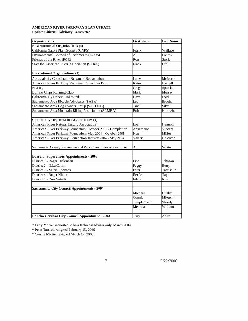
During the Update Process, Rancho Cordova representatives reflected their interest in updating area plans within their City limits. Further discussions with Rancho Cordova staff resulted in the decision to include the Goethe Park and Rossmoor Bar area plans as an additional scope and objective in the Update Process. Update Citizens Advisory Committee The Update Citizens Advisory Committee (UCAC) was formed to provide recommendations for an updated American River Parkway Plan to the County Board of Supervisors, Sacramento City Council and Rancho Cordova City Council. The Committee included representation of the Parkway’s diverse recreational, environmental, business and community interests. Members were jointly appointed by the Sacramento County Board of Supervisors and the Sacramento City Council. Please see Table 1-1 for the list of the twenty-four UCAC members and their organizations. The UCAC worked together from January 2004 – June 2006 to make consensus recommendations for updating the 1985 Parkway Plan. Project Management Team The American River Parkway Plan Update process was guided by a Project Management Team, consisting of agencies with jurisdiction or management responsibility within the Parkway. These agencies were: the County of Sacramento Department of Planning and Community Development acting as the lead agency, County of Sacramento Department of Regional Parks, California Exposition and State Fair (Cal Expo), City of Sacramento Department of Parks and Recreation, City of Sacramento Planning and Building Department, Sacramento Area Flood
6 5/22/2006
Control Agency (SAFCA), the Water Forum, City of Rancho Cordova and Cordova Recreation and Park District. American River Parkway Plan Update Recommendations The UCAC provided their recommendations for an Updated American River Parkway Plan in June 2006. Their recommendations resulted from six tours and / or public workshops, 33 UCAC meetings including public participation, staff input, technical presentations and public hearings. The hard work and knowledge of the UCAC and public participants made a considerable contribution to updating this plan. In particular, the UCAC members represented diverse Parkway interests which meant that developing consensus recommendations required great perseverance and dedication. Their interest in and love of the Parkway was the consistent common ground that was sustained throughout the process and serves as the basis for their recommendations.
7 5/22/2006
date Citizens' Advisory Committee
rganizations First Name Last Namenvironmental Organizations (4)lifornia Native Plant Society (CNPS) Frank Wallace
Environmental Council of Sacramento (ECOS) Al Freitasiends of the River (FOR) Ron Storkve the American River Association (SARA) Frank Cirill
Recreational Organizations (8)Accessability Coordinator Bureau of Reclamation Larry McIver *American River Parkway Volunteer Equestrian Patrol Katie Baygell
ating Greg Speicherffalo Chips Running Club Mark Murray
fornia Fly Fishers Unlimited Dave Fordacramento Area Bicycle Advocates (SABA) Lea Brooksacramento Area Dog Owners Group (SACDOG) Janel Silva
amento Area Mountain Biking Association (SAMBA) Bob Horowitz
Community Organizations/Committees (3)American River Natural History Association Lou Heinrich
merican River Parkway Foundation: October 2005 - Completion Annemarie Vincentmerican River Parkway Foundation: May 2004 - October 2005 Ken Millermerican River Parkway: Foundation January 2004 - May 2004 Valerie Holcomb
acramento County Recreation and Parks Commission: ex-officio Art White
Board of Supervisors Appointments - 2003strict 1 - Roger Dickinson Eric Johnsonstrict 2 - ILLa Collin Peggy Berrystrict 3 - Muriel Johnson Peter Tateishi *strict 4 - Roger Niello Renée Taylorstrict 5 - Don Notolli Eddie Kho
cramento City Council Appointments - 2004Michael GunbyConnie Miottel *Joseph "Ted" Sheedy Melinda Williams
ncho Cordova City Council Appointment - 2003 Jerry Ahlin
arry McIver requested to be a technical advisor only, March 2004* Peter Tateishi resigned February 15, 2006* Connie Miottel resigned March 14, 2006
AMERICAN RIVER PARKWAY PLAN UPDATEUp
OECa
FrSa
BoBuCaliSSSacr
AAA
S
DiDiDiDiDi
Sa
Ra
* L
CHAPTER 2 GOALS AND POLICIES
THIS CHAPTER IS A SUMMARY OF ALL PARKWAY POLICIES AND WILL BE COMPLETED
UPON FINAL APPROVAL OF THE CHAPTERS BY THE UCAC. This Plan is a policy document which provides guidelines for preservation, recreational use, development and administration of the American River Parkway. The following Goals and Policies shall be used to implement this Plan. GOALS * To provide, protect and enhance for public use a continuous open space greenbelt along
the American River extending f ran the Sacramento River to Folsom Dam; and * To provide appropriate access and facilities so that present and future generations can
enjoy the amenities arid resources of the Parkway which enhance the enjoyment of leisure activities; and
* To preserve, protect, interpret and improve the natural, archaeological, historical and
recreational resources of the Parkway, including an adequate flow of high quality water, anadromous and resident fishes, migratory and resident wildlife, and diverse natural vegetation; and
* To mitigate adverse effects of activities and facilities adjacent to the Parkway; and * To provide public safety and protection within and adjacent to the Parkway. POLICIES
1 5/22/2006
CHAPTER 3 RESOURCES OF THE PARKWAY
INTRODUCTION The purpose of this chapter is to identify valuable resources in the Parkway and to set forth policies for their preservation or protection, to provide technical background to better understand the types and functions of the resources that exist, and to outline the components of an educational program that would interpret these resources. The major headings in this chapter: Terrestrial Resources, Aquatic Resources, Human Historical and Interpretive Resources, and Aesthetic Resources, identify the resources and the protective measures for them. The Interpretive Resources section outlines the specific components of interpretive programs and an interpretive center, and discusses the need for a long range interpretive plan. The Parkway provides for critical flood control and natural resource corridors. BACKGROUND Physical Geography The Lower American River (LAR), having a drainage area of approximately 120 square miles, is characterized by a managed river flow, associated riparian vegetation, side channels and ponds. From just above the Nimbus Dam, the Lower American River emerges from the Sierra Nevada foothills into the rolling upland plain of the Sacramento Valley. The plain gradually flattens where it meets the alluvial floodplain of the Sacramento River. The floodplain of the Lower American River is bordered by high bluffs in its upper reaches, and by levees in its lower reaches. In the Folsom and Nimbus areas, large amounts of dredger tailings are scattered throughout the terrain. The tailings are remnants of gold mining operations and are composed of large boulders which may be covered with a thin layer of topsoil and arid, sparse vegetation. Effects of Early Settlement and Mining Between 1849 and 1909, hydraulic gold mining in the watershed of the North and Middle Forks of the American River caused an estimated 257 million cubic yards of sand, silt, and fine gravels to be deposited in the river. Some 5–30 feet of these materials were deposited on the bed of the LAR as a result of hydraulic mining and dredging. The deposition of sediments resulted in extensive sand and gravel bars in the lower river, overall aggradation (raising) of the channel and surrounding floodplain, and the covering of fish spawning gravels. During the mid-1800s, upstream access for migrating fish in the American River was impeded by dams constructed for mining debris containment, flood control, and diversions. Many of the dams constructed had inadequate or no passage systems (e.g., fish ladders) that would have allowed fish to migrate upstream. Changes to the planform of the river were carried out in the late 1800s. These changes included straightening and relocating the river channel near Sutter’s Landing Park at 28th and C Streets (old City dump) and moving the mouth of the river 0.5 mile north to its present location. From the late 1800’s to the mid-1900’s, large-scale dredge gold mining was conducted south of the river, downstream of Folsom. The excavation of shoreline gravel material in dredge mining
2 5/22/2006
operations drastically altered the topography (surface features) of the floodplain. In the 1920s, gravel bars were scraped to obtain aggregate for concrete production. As a result of dredge mining, large tracts of land were swept away, immense deposits were left in other areas, and the accumulation of mining debris resulted in the formation of new channels. By 1940 gravel bars as far downstream as Watt Avenue were affected.
These operations caused repeated destruction of the channel from 1900 to 1955. In the 1950’s and early 1960’s, gravel extraction activities were located immediately adjacent to the river upstream of the Interstate-80, Howe Avenue, and Watt Avenue bridges and at Arden Bar. Gravel extraction from elevated terraces at Sacramento Bar and Arden Bar caused the formation of ponds and debris mounds. These ponds are connected to the river and may trap fish at high flows, resulting in fish isolation, stranding and mortality.
Effects of Dams and Levees Construction of dams and levees has provided flood protection, water supply, hydropower generation, and recreation opportunities. However, these facilities have also had severe and unintended consequences on the vegetation, wildlife, fisheries, and aquatic habitat of the river. Dams, including Old Folsom Dam (completed in 1893), North Fork Debris Dam (completed in 1939), and the modern Folsom Dam and Nimbus Dam (part of the Central Valley Project completed in 1955), and the levee system were constructed, in part, to provide flood protection to the Sacramento metropolitan area, which was built largely in the river floodplain. The flood protection provided by these facilities has protected the city of Sacramento from numerous major floods and currently protects more than $30 billion in commercial, industrial, and public buildings as well as more than 400,000 people residing in the historic floodplain. In 1950, floods destroyed the fish ladder at the Old Folsom Dam, restricting fish to the lower 25 miles of the American River. Construction of Folsom and Nimbus dams in 1955 permanently blocked upstream migration of fish above the lower 23 miles of the American River, blocking about 70 percent of the spawning habitat (areas of the river where fish lay eggs) historically used by Chinook salmon and 100 percent of the spawning habitat historically used by steelhead. The Nimbus Fish Hatchery was specifically constructed to mitigate for lost salmonid (Chinook salmon and steelhead) habitat that was blocked by Nimbus and Folsom dams. Construction of the hatchery was completed in October 1955. Dam construction effectively cut off the supply of upstream sediments to the LAR, resulting in a deepening of the river channel since the 1950’s. In several locations, the channel has degraded to its previous bed elevation and it is thought that the mining debris that once filled the channel of the LAR has been completely removed by river flows and gravel mining. However, the surrounding floodplain remains at its post-mining elevation, thereby creating a strong differential between the hydrology and floodplain elevation. This disconnection of the river from its historic floodplain greatly constrains the natural maintenance, regeneration and expansion of riparian habitat. With reduced frequency of seasonal flooding and a deeper water table on the high floodplain, the riparian forest regenerates more slowly and some vegetation communities along the river have gradually changed to habitats that provide less value to wildlife and fish. These impacts coupled with reduced frequency of seasonal flooding and a deeper water table on
3 5/22/2006
the high floodplain have altered the vegetation communities along the river to habitats that provide less value to wildlife and fish. Sediment supply for the river is now derived from the surrounding river banks which increases erosion and leads to accelerated loss of valuable shaded riverine aquatic habitat (SRA), loss of soft bank and disrupting the natural recruitment process of in-stream woody material. In-stream woody material accumulates naturally in rivers and plays an important role in stream mechanics and fish habitat. Shaded riverine aquatic habitat (SRA) habitat provides multiple benefits to both fish and wildlife. In particular, it provides shade along the river to moderate water temperatures in the summer. Operation of Folsom and Nimbus dams has dramatically altered the LAR and its adjacent habitats by causing an overall decline in extremes of flow and temperature compared with historical conditions. Current LAR flows and temperatures are different than pre-dam conditions because river flows are managed by the Bureau of Reclamation to meet their multiple objectives, as listed in the first sentence of this section, as well as protecting fish and wildlife. In general, the timing of peak river flows has shifted from spring to early winter. Summer water temperatures have declined significantly as summer flows have increased to meet Bureau of Reclamation contractual obligations. This increased water flow is colder than natural flows would be without a dam, yet not cold enough for anadromous fish still in the river. Understanding the anthropogenic influences and how the conditions of the American River and the floodway have changed over time provides the knowledge to better manage the terrestrial and aquatic resources living in this dynamic system. 3.0 RESOURCES OF THE PARKWAY Terrestrial Resource Policies Terrestrial Resources of the Parkway 3.1 Any development of facilities within the Parkway, including but not limited to buildings,
roads, turfed areas, trails, bridges, tunnels, pipelines, overhead electrical lines, levees and parking areas, shall be designed and located such that any impact upon native vegetation is minimized and appropriate mitigation measures are incorporated into the project.
3.1.1 Parkway facilities are those necessary for the operations, management, and
permitted uses within the Parkway. 3.1.2 Development of non-Parkway facilities must have a compelling regional need, meet
all applicable statutory requirements and provide mitigation and enhancements to the Parkway’s natural, recreational, or interpretive resources.
3.2 Agencies managing the Parkway shall protect, enhance and expand the Parkway’s native
willow, cottonwood, and valley oak-dominated riparian and upland woodlands that provide important shaded riverine aquatic habitat (SRA), seasonal floodplain, and
Comment [SW1]: UCAC revised 10-3 meeting
4 5/22/2006
riparian habitats; and the native live oak and blue oak woodlands and grasslands that provide important terrestrial and upland habitats.
3.2.1 Vegetation plantings shall be consistent with the approved list of trees, shrubs,
and herbaceous plants native to the Parkway. This list shall be approved by the Recreation and Parks Commission, upon recommendation by the Director of the Department of Regional Parks, working in cooperation with resource and flood control managers, and organizations with native vegetation expertise. This list shall include species appropriate to the plant communities and habitats within the Parkway. Only plants on this approved list shall be planted within the Parkway, the exception being grass in permitted locations.
3.2.2 Native vegetation shall be reintroduced in areas of the Parkway where the
substrate will support it, especially in areas that have been disturbed by construction, past gravel mining and agricultural activity, except in sites of human historical value.
3.2.3 Non-native trees and shrubs can be beneficial for native wildlife or benign to the
ecosystem. Non-native trees and shrubs may be removed over time if they: a) constitute an hazard to the users of the Parkway, b) the removal is a part of the on-going normal maintenance practices of the
Parkway by its managers, or c) the vegetation was approved to be removed as a part of a discretionary
project in accordance with the policies of this Plan. 3.2.4 Agencies managing the Parkway shall remove invasive non-native vegetation
species that conflict with habitat management goals, recreation uses, flood control or water supply conveyance.
3.2.5 New turf planting and associated irrigation within the dripline of existing mature
native oaks shall be prohibited. Turf areas can be placed where there are immature native trees, provided the trees are not damaged by turf maintenance activities, such as summer watering, mowing, and string trimming.
3.3 The Parkway shall be managed to create habitat connectivity and wildlife travel corridors
that provide for the habitat needs of the endangered Valley Elderberry Longhorn Beetle (VELB) and other important native wildlife species, without compromising the integrity of flood control facilities, the flood conveyance capacity of the Parkway, or other Parkway management goals.
3.4 Management of the Parkway shall ensure the protection of the Parkway’s resources, its
environmental quality and natural values. A resource impact monitoring plan shall be developed that clearly defines criteria and standards to monitor, evaluate and protect the Parkway’s resources from overuse, and provides steps to be taken to restore areas that have been overused.
Comment [SW2]: UCAC revised 10-3 meeting.
Comment [SW3]: Revised per UCAC 10-3 meeting
5 5/22/2006
3.5 Agencies managing the Parkway should develop and implement an Integrated Vegetation and Wildlife Management Plan to accommodate native wildlife species and minimize adverse effects of non-native species.
3.6 Excavation of aggregate/soil material should not be permitted except as a part of a flood control, environmental restoration or recreation improvement project approved in accordance with the provisions of this Plan. Objectives of the project will:
a) result in a net improvement to the health of the Parkway ecosystems, b) not cause “harm” to the Parkway, c) utilize material within the Parkway, where feasible, prior to being transferred out
of the Parkway, and d) prohibit commercial mining.
Terrestrial Habitat Types and Wildlife The American River Parkway is rich in outdoor resources. Starting at the Folsom Dam and ending at the Sacramento River, the Parkway extends 29 miles, passing through six distinct vegetation units: riparian, freshwater marsh, oak woodland, grassland, oak grassland and shrub grassland. A great variety of plant and wildlife species inhabit these natural areas, offering opportunities for interpretation, personal observation, and discovery unparalleled in any other large urban area. These natural areas should be protected for the habitat they provide and the species that are able to exist within them. As documented in the River Corridor Management Plan, 2001, more than 220 bird and 30 mammal species have been observed in the Parkway, including 45 species of nesting birds. Habitats in the Parkway support resident and migratory wildlife and fish and are used as migration and travel corridors. The Parkway also supports habitat for several special-status species that have some form of legal protection. Special-status species include those that meet any of the following criteria:
• Listed or proposed for listing as Endangered or Threatened under the state California Endangered Species Act or federal Endangered Species Act of 1973;
• Actively nesting bird species listed under the Migratory Bird Treaty Act; • Species of Concern or Fully Protected species as listed under California State Fish and
Game Code; and • Species considered rare, endangered, or threatened by the scientific community.
Special-status species known to occur on the Parkway include the Valley Elderberry Longhorn Beetle (VELB) (Desmocerus californicus dimorphus), Bald Eagle (Haliaeetus leucoceephalus), Swainson’s Hawk (Buteo swainsoni), Bank Swallow (Riparia riparia), and nesting raptors such as White-tailed Kite, Great-horned owl, American Kestrel, and Red-shouldered Hawk. Of all these species, the VELB typically requires the most management attention. VELB lives its entire life on blue elderberry (Sambucus mexicana), a large shrub common to the riparian forests, grasslands, and oak woodlands throughout the Parkway. The USFWS requires consultation under the federal Endangered Species Act for any ground disturbing project or maintenance action- including mowing, removing weeds, planting trees, and repairing the bike trail- within 100 feet of an elderberry shrub. Consequently, in order to conduct routine maintenance and implement new Parkway improvements, the Parkway has developed policies and plans specifically more managing VELB habitat. Goethe Park has been federally designated as a
6 5/22/2006
“critical habitat” for the recovery of the Valley Elderberry Longhorn Beetle (VELB). Wildlife inhabiting the areas along the Lower American River are dependent upon the riparian vegetation growing in the area, vegetation diversity, microclimate conditions, and the availability of water, food and cover. In addition to the protected species mentioned previously, reference materials discussing riparian habitat within the Sacramento Valley periodically include information concerning the following rare, endangered or threatened animal species:
1. American, peregrine falcon (Falco peregrinus anatum) 2. California yellow-billed cuckoo (Coccyzus americanus occidentalis) 3. Giant garter snake (Thamnophis couchi gigas)
Siting of the named species is infrequent, due to the scarcity of their populations. Confirmed sitings of the California elderberry longhorn beetle and the Swainson’s hawk, or evidence of their existence, have been made in the Parkway. However, there is a need for much more research to determine whether additional endangered, threatened or rare species inhabit the Parkway. The State of California has given statutory protection (Fish and Game Code Section 3511) in the form of “Fully Protected” status to several species of birds which are considered to be of particular importance. Among the designated “Fully Protected” species is the Black - shouldered Kite, (formerly called White-tailed Kite), (Elanus Leucurus) which inhabits the Ancil Hoffman Park Nature Study Area, the Bushy Lake State Natural Preserve and other areas of the Parkway. The California Natural Diversity Data Base (CNDDB), a section of the California Department of Fish and Game Planning Branch, maintains an inventory of the confirmed sitings of endangered, threatened, and rare plant and animal species. The staff work closely with the Nature Conservancy and the California Native Plant Society, a nonprofit organization. These organizations are valuable resources and should be contacted on a regular basis to ensure the integrity of the habitat. The following narrative describes the types of habitats and species associated with riparian and upland ecosystems. These vegetation units and their associated wildlife comprise biotic communities which are the basis for land use in the Parkway. The land use categories for the Parkway are based upon the sensitivity of the associated biotic communities to human intrusion. As a result, the more sensitive biotic communities are generally placed in the Nature Study Area and Protected Area land use categories. Land use management decisions can then be made to enhance and support the associated terrestrial and aquatic species. Special Status Wildlife Species Special-status wildlife species, for our purposes here, include those species that are state or federally listed as endangered or threatened, are candidates for listing under CESA or ESA, are protected by the federal Migratory Bird Treaty Act, or are listed as species of concern by DFG or USFWS. Based on a search of the California Natural Diversity Data Base (CNDDB) and information provided by U.S. Fish and Wildlife Service, the threatened valley elderberry longhorn beetle (VELB) is the only federally listed terrestrial species with permanent residence in the Parkway. VELB is found only in association with its host plant, blue elderberry, which grows in several habitats throughout the Parkway. Nesting colonies of bank swallow, a state-listed threatened species, have been observed on steep unvegetated banks of the LAR at Goethe
7 5/22/2006
Bar, Sunrise Bar, and Cal Expo. Other listed species, such as bald eagle, are occasionally observed during migration or the winter months, but they are not known to nest in the Parkway. Several species of concern are known to nest in the Parkway, including white-tailed kite, Cooper’s hawk, burrowing owl, great blue heron, and great egret (all observed at Goethe Bar), and northwestern pond turtle (observed at the Nature Study Area in Ancil Hoffman Park). Other species of concern are occasionally observed in the Parkway while foraging, during migration, or during the winter months. Open Water The open water of the river, unvegetated shoreline, and gravel bars adjacent to the river channel and off-channel ponds provide resting and foraging areas for waterfowl, shorebirds, wading birds, belted kingfisher, black phoebe, and tree swallow. Aquatic mammals, including beaver, mink, and river otter, also use open water and adjacent riparian habitats as foraging areas and travel corridors. Open-water habitats also provide habitat for numerous resident and anadromous fish species, including Chinook salmon, steelhead, and American shad. Federal officials recently designated the American River and it’s tributaries as critical habitat for salmon and steelhead. Riparian The Riparian zone is found within the river floodplain. Cottonwoods and willows are predominate, attesting to the viability of these species to endure winter flooding. Shrub and vine thickets often grow immediately adjacent to sand bars or along the riverbank. The lush ground cover is essential to the survival of many species of wildlife and to the aesthetics of the riverside. The high value of this zone as a natural area dictates certain limits on the amount of human use. Cottonwood riparian forests are especially valuable to the riparian ecosystem because they are the largest and fastest growing tree species, and as the forest canopy dominants, they define the habitat and structure and quality for other plants and wildlife species. Floodplain riparian and wetland habitats in general, are important because they serve important ecosystem functions that benefit a large assemblage of native fish and wildlife species, including:
• seasonal refuge, spawning, and nursery habitat for native fish species, such as splittail, Chinook salmon and steelhead;
• food, cover, nesting and roosting habitat for permanent resident bird species, such as several species of raptors, California quail, scrub jays, spotted towhees, and numerous other passerine birds;
• food, cover and roosting habitat for migrating bird species and winter residents, such as hermit thrush, yellow-rumped warblers, and several species of sparrows
• food, cover, and breeding habitat for several mammal species, including ringtail, river otter, mule deer, coyote, bobcat, raccoon, beaver, and the occasional mountain lion; and
• food, cover, and breeding habitat for several reptile species, including common kingsnake, western rattlesnake, Pacific tree frogs, and western toads.
Riparian Forest Riparian forest consists of dense stands of trees that generally require flooding and sedimentation for regeneration. Riparian forests contain many of the same species as riparian scrub but are generally found in areas with less frequent flooding, scouring, and sedimentation and lower
8 5/22/2006
velocity flows, which allows forest structure to develop over time. Riparian forest along stream channels, sloughs, and pond shorelines provides important shaded riverine aquatic cover. The major types of riparian forest in the Parkway are cottonwood riparian forest, with the tree canopy dominated by cottonwood trees, and mixed riparian forest, where no single species dominates the overstory but which commonly contains cottonwood, willow, alder, Oregon ash, valley oak, and box elder. The Parkway contains approximately 660 acres of riparian forest. The largest contiguous patches are found in river miles 0 – 6, also defined as reach 1, especially near Discovery Park. Reach 2, river miles 6 – 12, has a relatively continuous cover of riparian forest in a narrow band along the LAR. Reach 3, river miles 12 – 23, has approximately 188 acres of riparian forest, but virtually all of it is situated on high-elevation floodplains that rarely receive inundation and are considered unlikely to regenerate. The floodplain surfaces in reach 1 supporting most of the cottonwood and mixed riparian woodlands are inundated only during extreme high flows on the LAR and Sacramento River, and many portions of reach 3 are no longer inundated during objective release flows. Of the 1,140 acres of riparian forest and scrub in the Parkway, only 286 acres (25%) are situated in lower portions of the floodplains that receive periodic inundation under the current water management regime. The potential loss of riparian habitat is most pronounced in reach 3 (river miles 12-23), where there are 460 acres of existing riparian forest and scrub but only 13 acres (3%) are periodically inundated, and only 22 acres of unoccupied floodplain habitat exists. To the extent these existing stands receive regular inundation required for regeneration will determine riparian habitat sustainability and existence in the Parkway. Riparian Scrub Riparian succession (the progressive replacement of one community by another) starts with the establishment of riparian scrub on bare sand, gravel bars, and other fresh sediment deposits. Riparian scrub consists of shrubs and small trees growing on gravel bars, recent alluvial sediment deposits, and near the edge of the low-flow channel and pond margins. Dominant species include narrow-leaved willow, Goodding’s black willow, alder, cottonwood, mugwort, and herbaceous weedy species such as perennial and annual grasses and mustards. The stature is usually low-growing and sparse because of frequent or recent scouring or flooding. The species composition is dominated by species that generally require flooding and recent sediment deposits for regeneration and are tolerant of inundation. Riparian scrub is typically found between gravel bars and low banks, where vegetation is typically low-growing and sparse because of scour or frequent flooding. Intermediate bank elevations that flood only during high-flow events also support riparian scrub dominated by willow, alder, and young cottonwood and may support denser riparian scrub that can ultimately develop into cottonwood or mixed riparian forest. There are 481 acres of riparian scrub distributed somewhat evenly throughout the Parkway. Some of the larger patches are located in the Discovery Park, California Exposition and State Fair, Goethe Bar, and Sunrise Bar subreaches.
9 5/22/2006
Riparian Forest and Scrub for Wildlife Riparian habitats adjacent to the river, tributary streams or sloughs support the greatest diversity of wildlife because they support a greater diversity of plant species and vegetative structure - and consequently a greater number of habitat niches and food resources for wildlife - than other habitats in the Parkway. Several species of raptors, including red-tailed hawks, red-shouldered hawks, Cooper’s hawks, and great horned owls, build their nests in the crowns of cottonwood, valley oak, and other large trees. Great blue herons, great egrets, snowy egrets, and black-crowned night herons nest in rookeries in large trees along the Lower American River. Natural cavities and woodpecker holes provide nesting sites for cavity-nesting species, including wood ducks, common mergansers, American kestrels, tree swallows, and western screech owls. Riparian scrub supports large numbers of insects and attracts passerine birds, including several species of warblers and hummingbirds. Mammals associated with these riparian habitats include ringtails, spotted and striped skunks, raccoons, beaver, coyote, and mule deer. Mountain lions are occasionally observed in the Parkway. Freshwater Marsh Marshland is a natural center of life in the Parkway. Cattails, rush and sedge are typically found along marsh peripheries, while the deeper water is commonly covered by water primrose. These wet areas are host to many animals which depend on the aquatic medium to support one or more phases of their life cycle. Water naturally attracts the more terrestrial vertebrates that feed on the vegetation or on the other creatures which abound here. Marshlands are excellent nature study areas. Freshwater marsh is associated with ponds and backwaters and provides resting and foraging areas for waterfowl, shorebirds, wading birds, red-winged blackbirds, and swallows. Marshes are also used by aquatic mammals, such as muskrat and mink, and provide foraging and breeding habitat for several species of aquatic reptiles and amphibians, including common garter snakes, Pacific tree frogs, and bullfrogs. Oak Woodland The Parkway includes heavily wooded areas consisting of Valley Oak, Blue Oak and Interior Live Oak with California Black Walnut and Cottonwood on wetter sites. Many animals live permanently along the edge of Oak Woodlands, while others frequent the area temporarily while on their annual migration. Because of its value as a wildlife sanctuary, this zone is generally protected from intensive human activity. Natural oak regeneration has not occurred to any great extent in the Central Valley for over 100 years because most suitable reproduction sites have been developed or are used in such a manner that reproduction does not occur. Upland habitats adjacent to floodplain riparian areas, including grasslands and oak woodlands, are important to ecosystem processes in the Parkway. They provide foraging and cover habitat for target species and provide refugia habitats (areas where species can take refuge) during flood events. Oak woodlands serve as a buffer between urban areas and riparian habitats, and most terrestrial target wildlife species rely on both upland and riparian habitat during their life cycles. There are two types of oak woodlands in the Parkway: 1) valley oak riparian woodland and 2) live oak and blue oak woodland. Valley oak riparian woodland occupies sites in the Parkway
10 5/22/2006
that rarely or never flood but have relatively shallow depths to perennially available groundwater, and live oak and blue oak woodland stands are above potential flooding. Both types of oak woodlands typically provide an open to moderate canopy cover (i.e., 30% to 50% closure) with a grass understory, although some midstory shrub species may be present (U.S. Fish and Wildlife Service 1991). The valley oak riparian woodlands are frequently associated with black walnut and blue elderberry and can have a dense understory of California grape, California rose, Dutchman’s pipevine, and other riparian-associated species. Common shrubs and small trees beneath the live oak and blue oak woodlands overstory include buckeye, toyon, California coffeeberry, and poison oak. Virtually all of the oak woodlands in the Parkway are located in reach 3, river mile 12-23. Oak woodlands in reach 3 provide the largest contiguous patches of forest or woodland habitat in the Parkway. The 3.5-mile-long Sunrise Bar area provides a nearly continuous band of woodland habitat and the interior portion of Goethe Bar contains the largest wooded habitat area in the Parkway and is associated with several special-status species occurrences. Oak woodlands, dominated by valley oak, interior live oak, and blue oak, with black walnut, blue elderberry, and other shrub species, are of great ecological importance because of their relative scarcity in the region and their high values to wildlife. A wide variety of mammals depend on oak woodlands, including mule deer, ringtail, gray fox, and western gray squirrel. Common bird species in this community include several species of owls, acorn woodpecker, California quail, wild turkey, and numerous passerine species. Several reptile and amphibian species are found in these woodland habitats, including western rattlesnake, southern alligator lizard, western fence lizard, and common kingsnake. Agriculture and Grasslands Areas dominated by nonnative vegetation in the Parkway are generally associated with areas of recent human disturbance that include: abandoned, fallow, and active agricultural fields, borrow pits, dredger mine tailings, levee slopes, and areas subject to periodic fire, frequent flood inundation, or scour. There are about 1,204 acres of grasslands and agricultural fields in the Parkway, with all but 12% located in reaches 1 and 3 (river miles 0-6 and 12-23). Grasslands and agricultural fields can provide important foraging habitats and upland refugia during flood events for many species of wildlife. However, 548 acres (46%) are dominated by yellow star-thistle, and extensive areas of reach 1, and especially within subreach 1d, are infested with nearly monotypic stands of pepperweed. Areas dominated by nonnative weeds prevent native plants from establishing, provide poor habitat quality for wildlife, and discourage recreational uses. Large areas of agricultural fields are found from Goethe Bar to Rossmoor Bar in reach 3 (river miles 12-23), and large grasslands are found in reach 1 (river miles 0-6). Most of the grassland areas in reach 1 occur below transmission lines, have other facilities or structures associated with them, or occur on private property. Annual grasslands provide habitat for meadow vole, garter snake, mice, jackrabbit, and gopher and foraging habitat for coyote, weasel, and raptors, including red-tailed hawks, American kestrels, and several species of owls. Grasslands infested with yellow star-thistle, pepperweed, and other nonnative plant species provide limited habitat value in their current state but could be suitable for restoring native grasses, which are an important habitat.
11 5/22/2006
Oak-Grassland The Oak-Grassland is the most botanically diverse unit along the river. It is a transition zone between Oak Woodland and Grassland, featuring many elements of each. Where topography and soil moisture are unsuitable for a solid stand of oaks, a less dense canopy is formed. This zone is becoming rare in California today. Shrub-Grassland This is an area of convergence between Grassland and Riparian lying within the river floodplain. The most obvious plant is Willow, but Coyote Bush and California brickellia are also scattered along the sandy beaches. As available river water seepage decreases, so does the density and vigorous growth of this vegetation type. The increase in sunlight, and greater development of soil allows Grassland plants to replace the more luxuriant Riparian understory. Oak and Shrub-Grassland may contain unique sites such as nesting areas, where isolation or protection are required. Non-native Invasive Species Nonnative invasive plant species occur throughout the Parkway, and infestations occur in every habitat type. Areas dominated by nonnative weeds prevent native plants from establishing, provide poor habitat quality for wildlife, and discourage recreational uses. Infestations of weed species increase hydraulic roughness during high-flow events, decrease the capacity of the floodway, and adversely affect bank erosion and sedimentation processes. Once invasive weeds are removed and native species are re-established, native vegetation is able to sustain itself through natural growth and regeneration. Intense initial removal of invasive plants, followed by active and passive restoration, and follow-up removal of weed seedlings has proven to be a successful strategy for restoring riparian forests, riparian scrub, and oak woodland habitats. Mature non-native species that are not invasive may be benign to the Parkway ecosystems and even provide habitat to native wildlife species. Proper identification and knowledge of the function of non-native species are critical in the management of natural resources. The single largest noxious weed infestation is yellow star-thistle, covering nearly half (an estimated 548 acres in 2001) of the agricultural fields and annual grasslands in the Parkway. Yellow star-thistle is intolerant of flooding and generally restricted to upland settings but can quickly reinvade and dominate sites within several years following a flood event. Pepperweed occupies extensive areas of abandoned agricultural fields with relatively moist soils and subject to periodic flooding in the first three miles of the Parkway upstream of the Sacramento River confluence. Other common invasive weeds in the Parkway include arundo, tamarisk, Spanish broom, fennel, French broom, mare’s tail, cocklebur, pyracantha, oleander, Pampas grass, rip-gut brome, foxtail brome, wild oaks, poison hemlock, red sesbania, and Himalayan blackberry. Chinese tallow tree, black locust, Siberian elm, Chinese elm, and tree-of-heaven are common invasive tree species. Several weed populations are considered to be rapidly expanding in the riparian vegetation of the Lower American River. In particular, red sesbania is expanding along shorelines of streams and ponds. Chinese tallow tree, another recent invader, is also expanding in riparian habitats, as are longer established invaders such as arundo, Pampas grass, Spanish broom, French broom, Himalayan blackberry, and tamarisk, which can rapidly colonize exposed bar surfaces and
12 5/22/2006
stream banks. Once invasive weeds are removed and native species are re-established, native vegetation is able to sustain itself through natural growth and regeneration. Intense initial removal of invasive plants, followed by active and passive restoration, and follow-up removal of weed seedlings has proven to be a successful strategy for restoring riparian forests, riparian scrub, and oak woodland habitats. Since 2001, the “Invasive Plant Management Plan” (IPMP) has been working towards eradication of all populations of arundo, tamarisk, French broom, Spanish broom, Scotch broom, Pampas grass, red sesbania, Chinese tallow tree, oleander, and pyracantha. In addition, 40 acres of yellow star-thistle will be converted to oak woodland with a native grass understory. The IPMP considers these species a high priority for removal because they rapidly colonize riparian habitats, degrade wildlife habitats, prevent natural regeneration of riparian forests, restrict recreation access, decrease floodway capacity, and increase bank erosion. Future phases of the IPMP may include eradication of pepperweed and invasive tree species such as tree-of-heaven, black locust, and elm, and restoration of native grasslands. In all programs of weed removal, re-establishment of native vegetation through active or passive restoration is considered the best long-term strategy for controlling and preventing re-colonization by invasive plants after the initial removal is complete. Native Plant Restoration The native riparian vegetation along the American River, in the Parkway, represents a plant community that is rapidly becoming rare in California. It is a rich community supporting a greater diversity of animal life than any other plant community in this State. There are unique opportunities for protection, enhancement and restoration of these threatened and valued areas of native vegetation. The area plan policies and implementation measures (Chapters II and XI) address this subject in further detail.
13 5/22/2006
AQUATIC RESOURCES
Aquatic Communities Policies
3.7 The Parkway shall be managed to preserve, protect and/or restore riparian and in-channel habitat necessary for spawning and rearing of fish species, including native Chinook salmon (fall-run), steelhead, and Sacramento splittail, and recreational non-native striped bass and American shad. Priority shall be on providing diversity and complexity of habitat, consistent with recreational safety needs.
3.8 It is the intent of this Plan that available water flows provide adequate seasonal
river flows and water temperatures to achieve and maintain viable populations and life stages of federal or state listed species, such as the Central Valley steelhead trout and species of primary concern including - naturally spawning: Chinook salmon (fall-run), Sacramento splittail; non-native American shad, striped bass; and their macroinvertebrate food sources in the Lower American River.
3.9 Responsible local and state agencies shall and federal agencies should discourage
introductions of invasive non-native aquatic plants and animals. 3.10 In-stream woody material shall be managed to provide fish habitat in the Lower
American River consistent with recreational safety needs. 3.11 Agencies managing the Parkway shall identify, enhance and protect:
a) areas where maintaining riparian vegetation will benefit the aquatic and terrestrial resources;
b) current shaded riverine aquatic habitat; and c) other areas that can support a shaded riverine aquatic habitat, as time and resources
permit, especially as associated with flood control or federally/state mandated species protection projects.
3.12 In order to reduce stranding and predation of anadromous fish, minor grading
and dredging should be conducted to provide positive drainage from floodplain ponds to the low flow channel of the American River.
Aquatic Communities - Background
As a highly managed river system, the flows of the Lower American River are controlled by releases from upstream reservoirs. Natural and human-induced processes have dramatically altered the hydrology, geomorphology, and riparian habitat value of the river system, particularly over the last 150 years. The aquatic communities policies provide guidance to protect the aquatic resources within a naturalized system that is greatly regulated. An integrated resource management approach will address the aquatic, terrestrial and riparian habitats in a manner that supports one another.
Comment [LK4]: Revised language per Ron Stork 5/18/06.
Comment [sw5]: UCAC/staff revised 10-3 meeting
Comment [sw6]: Revised 10-3 UCAC meeting
Comment [sw7]: Moved from Ch 5
14 5/22/2006
More than 40 species of native and nonnative fish have been documented in the Lower American River, including native fish that migrate up rivers from the ocean to lay and fertilize eggs in fresh water, such as fall-run Chinook salmon and steelhead. These species are called anadromous fish.
The LAR supports rich fish diversity, but the abundance of some individual species appears to be low. Of the 43 species that do or did occupy the river, 19 are considered numerous or common in certain portions of the LAR, nine are considered present or occasional, 14 are considered as few, uncommon, or rare, and one is now extinct. Twenty-two are believed to be non-anadromous species native to the LAR. In addition to Chinook salmon and steelhead, a few native species have been most abundant in surveys conducted in recent years, including Sacramento sucker, Sacramento pike-minnow, sculpins (prickly and riffle), tule perch, hardhead, and Pacific lamprey. Some non-native species such as small and large-mouth bass occur in abundance and are an important recreational resource for anglers.
Special Status Species
Several species of fish in the LAR are of primary concern because of their declining numbers, and/or their importance to recreational/commercial fisheries. Chinook salmon are a federal species of concern and steelhead are listed as “threatened” under the federal Endangered Species Act (ESA). Other recreationally and/or commercially important species include non-native striped bass, non-native American shad and native Sacramento Splittail. Management of the river to improve in-stream habitat and enhance these fisheries is a goal of many stakeholders, agencies and organizations in the Sacramento region. These five species are explained in further detail below.
Aquatic Habitat Geomorphic and hydrologic changes have impacted the aquatic and riparian habitat of the Lower American River. There has been an overall decrease in shaded riverine aquatic (SRA) habitat, a decrease in habitat complexity and diversity, a reduction in woody debris, and an increase in invasive exotic vegetation. The artificial levee system has caused localized bank erosion, incision, and general channelization of the river corridor. Modification of the spring and summer hydrograph from flow regulation has likely affected the potential for cottonwood regeneration. Reduction in the abundance of near-channel cottonwoods has reduced shaded channel surface. Large woody debris is noticeably deficient in many stretches of the Lower American River, particularly in upstream areas. Generally, shoreline habitat has undergone a trend toward simplification. Habitat quality, location, and availability; appropriate water temperatures (dam releases, cooling factors of shaded riverine aquatic habitat, seasonal timing); flow amounts (cubic feet per second) and seasonal timing of releases; food supply and rearing survivability, all contribute to the difficulty in providing appropriate habitat for the survival and sustainability of fisheries. Construction and operation of Folsom and Nimbus dams has dramatically altered the LAR and its adjacent habitats by causing an overall decline in extremes of flow and temperature compared with historical conditions. Current LAR flows and temperatures are different than pre-dam conditions since river flows are managed by the United States Bureau of
Comment [sw8]: General nexus statement added.
15 5/22/2006
Reclamation to meet multiple and often conflicting objectives. For example, significant flow releases from Folsom dam during the spring and summer periods to meet south of the Delta contractual obligations and Delta water quality regulatory standards often result in less than ideal spawning flows for Chinook salmon in the fall and steelhead in the winter. These same releases often deplete a limited coldwater supply from Folsom dam needed for steelhead rearing in the river during the summer and Chinook salmon spawning in the fall. Managing flow releases and cold water reserves to meet multiple objectives presents year-round resource conflicts that require the continuous involvement of state, federal and local management agencies, and stakeholders with an interest in the LAR Parkway.
Chinook Salmon
The LAR historically supported spring and fall-run Chinook salmon. By 1955, it is believed that American River spring-run Chinook salmon were extinct. Since that time fall-run Chinook salmon has been the dominant run.
Annual estimates of Chinook salmon that return to the LAR have been made by the California Department of Fish and Game since 1952. Through the 1990’s about 30,000 fish have returned to the river each fall to spawn. However, in recent years, returns of fall-run Chinook salmon to the LAR have reached to 100,000 or more fish. It is estimated that the LAR has contributed 23 percent of all fall-run Chinook salmon produced in the Central Valley between 1994 and 2004, supporting both recreational and commercial fisheries.
Several environmental conditions influence the in-stream production of fall-run Chinook salmon in the Lower American River. Flow, water temperature, substrate, and cover are believed to be the most important of those factors. Flow and water temperature have been identified as particularly critical factors for spawning, incubation and migration.
Fall-run Chinook salmon use the LAR during nearly every month of the year for the various stages of their lifecycle. The timing of fall-run Chinook salmon spawning is responsive to temperature changes in the Lower American River, which are affected by the operation of Folsom Reservoir and the quantity of cold water available in the Reservoir in the fall, as a consequence of summer operations. Initiation of spawning can vary from early October to mid-November, depending on the prevailing water temperature regime. Relatively warm water temperatures at the beginning of the fall-run Chinook salmon spawning season can delay the onset of spawning. for many years. Spawning typically does not occur until mean daily water temperatures decrease to about 60 °F. Also, Nimbus Hatchery data suggest that percent egg fertilization rapidly increases when daily median temperatures decline below 60 °F. In the last ten years, mean daily water temperatures at or below 60 °F in the upper reaches of the Lower American River have typically not occurred until the end of the first week of November, which has resulted in spawning delays and instances of pre-spawn mortality (adult fish dying before they are able to spawn).
When decreasing water temperature approaches 60 °F, female Chinook salmon begin to construct redds (egg nests), into which their eggs are eventually released and fertilized. Approximately 95 percent of the spawning occurs in the upper seven-mile portion of the river,
16 5/22/2006
(Ancil Hoffman Park area to the base of Nimbus Dam), although some redds have been documented below this river section.
For successful salmonid incubation, spawning gravels of adequate quantity and size are necessary. Spawning distribution (timing and location) also is influenced by flow conditions. Habitat availability and use are inversely related to, and directly affected by, flow conditions. Low flows are associated with an increase in redd superimposition. Low flows limit the available habitat below the water surface and therefore decreases the availability of acceptable spawning sites. Without appropriate spawning sites available, salmon will lay their eggs over previously laid eggs and superimpose their redds onto existing redds. Spawning may occur in appropriate numbers but the superimposition of redds will decrease redd survivability.
After emergence from the gravel, fry and juvenile salmon emigrate from the LAR to the ocean where they live the majority of their lives. The small salmon can often be seen along the shore as they make their way downstream to the Sacramento River. Most of the fall-run Chinook salmon returning to the LAR are three years old. Chinook salmon naturally die soon after they spawn. The river below the hatchery to Ancil Hoffman Park is closed to fishing during the spawning season to protect spawning fish and eggs. Figure 3-1 depicts the average life-cycle of the Chinook salmon.
Water temperature may also directly contribute to the triggering of seaward migration. Water temperature moderates emigration timing by controlling the rate of growth and physiologic development of juvenile salmonids.
Steelhead
The Lower American River originally supported summer-, fall-, and winter-run steelhead. Historically, nearly all steelhead spawning occurred upstream of what is now the Nimbus Dam. By 1955 and the completion of Nimbus and Folsom Dams, it was believed that summer-run steelhead were extinct from the American River. However, unsubstantiated reports from anglers indicate that remnant populations of summer-run steelhead may still exist in the river. Remnant populations of the fall-run and winter-run steelhead do still exist in the river.
Central Valley steelhead are listed as threatened under the federal Endangered Species Act, and their Evolutionarily Significant Unit (ESU) encompasses the Lower American River.
Flow and temperature conditions affect the lifestages of Lower American River steelhead. Cooler water temperatures upstream during the spring may be responsible for later steelhead emergence in upstream locations relative to downstream locations. Also, smaller average fish size in the uppermost reaches of the Lower American River after March may indicate later spawning, slower developmental rates, and later and protracted emergence due to water temperature differences. Generally, the larger the fish the better their chance of survival.
Summer water temperature appears to be the most important stressor affecting steelhead, because steelhead rear throughout the year in the Lower American River. Summer water temperatures frequently exceed those reported as suitable for juvenile steelhead rearing, which has been documented to result in poor health conditions (less resistance to disease and parasites) and a decrease in overall body condition, which can lead to lower survival rates.
17 5/22/2006
Adult steelhead migrate into the LAR to spawn. Not all steelhead die after spawning, unlike Chinook salmon. Those that do not die return to the ocean, and may return to the LAR to spawn again in future years. Juvenile steelhead typically rear in the LAR for one year before emigrating to the Pacific Ocean. As with fall-run Chinook salmon, the entire LAR is used by steelhead for one or more portions of their lifecycle. The peak of the upstream migration and spawning period occurs from December to March. (See Figure 3-2)
Sacramento Splittail
Historically, splittail inhabited Central Valley lowland rivers and lakes. Presently, adult splittail primarily inhabit the Delta, Suisun Bay, Suisun Marsh, and other parts of the Sacramento-San Joaquin estuary. Splittail are also known to inhabit the Sacramento River below Red Bluff Diversion Dam and the lower sections of its tributaries, including the Feather and American rivers. Little information regarding Sacramento splittail occurrence, abundance, or habitat utilization is available specifically for the LAR.
Prior to spawning, adult splittail apparently migrate upstream into freshwater areas. Changes in the timing, magnitude, and duration of high river flows and flooded areas are believed to affect when and where adults migrate, forage, and lay eggs. It is likely that the reproductive success of this species is tied to the timing and duration of flooding of the Yolo and Sutter bypasses and to flooding of areas along the major rivers of the Central Valley. Splittail larvae are believed to develop and grow in shallow, highly vegetated areas close to spawning areas, but move into deeper water as they mature. It appears that their downstream migration occurs during the spring and summer months. However, some juvenile splittail apparently rear in upstream habitats for up to a year before migrating downstream. It is believed that, if splittail spawn in the LAR, they do so in relatively low numbers and at downstream locations. Splittail are not harvested commercially, but support a small recreational fishery.
In 1999, the USFWS listed splittail as threatened under the federal Endangered Species Act. In September 2003, the USFWS published a “notice of removal” determination to remove the splittail as threatened under the Endangered Species Act based on its analysis of population information, threats to the species, and habitat-restoration and water-management actions being implemented to benefit Central Valley fish.
American Shad
American shad, a non-native species, was first introduced into California in 1871. American shad is another anadromous species, migrating from the ocean to freshwater to spawn. The introduced American shad rapidly became abundant, and by 1879 a commercial fishery had developed in California. Legislative action in 1957 terminated the commercial fishery in favor of a rapidly developing sport fishery. In recent years (1994-1999), American shad have been captured in the LAR during CDFG’s surveys. No specific estimates are available regarding the annual run size of American shad in the LAR.
Water temperature is apparently the most important factor influencing the timing of shad spawning. Optimum water temperatures for American shad spawning have not been determined for the LAR; however, optimum water temperatures for American shad spawning in the Feather River have been reported to range from 60 to 70 0F. Most of the eggs spawned in the LAR
probably do not hatch until they have drifted downriver and entered the Sacramento River. Recent collections of juvenile American shad by CDFG suggest however that juvenile American shad may rear in the LAR for relatively extended periods, and at least as far upstream as Watt Avenue.
The relative volume of river flow influences the size and location of American shad runs in the Sacramento River and its tributaries. Not all American shad die after spawning, unlike Chinook salmon. The number of American shad spawning in the LAR would be expected to vary as flows in the LAR change relative to the flows in the Sacramento River.
Striped Bass
Striped bass were introduced into California in 1879 and 1882, when shipments were released in the Sacramento-San Joaquin Estuary. The species rapidly became abundant and provided the basis for a commercial fishery by 1888. Striped bass remains an important sport fish with high recreational value and it also plays an important role as a top predator in the Bay-Delta ecosystem and its watershed. Limited information is available on striped bass presence and distribution in the LAR, based on previous surveys conducted by the USFWS. The USFWS’s Anadromous Fish Restoration Program (AFRP) has set a target for striped bass in the Central Valley at 2.5 million adults, approximately double the 1967-1991 average estimated abundance of striped bass in the Central Valley. Goals specific to the LAR have not been established by the AFRP.
Adult striped bass are present in the LAR throughout the year, with peak abundance occurring in the summer months. It is unknown, however, whether striped bass spawn in the LAR. Available information indicates that minimal, if any, spawning occurs in the LAR and that adult fish that enter the LAR probably spawned elsewhere, or not at all. The LAR apparently is a nursery area for young striped bass, with numerous schools of five-inch to eight-inch long fish reported in the river during the summer months. In addition, juvenile and sub-adult fish have been reported to be abundant in the LAR during the summer and fall.
Optimal water temperatures for juvenile striped bass rearing range from about 61 to 71 0F. The number of striped bass entering the LAR during the summer is believed to vary with river flows, water temperature, and food production. In any given year, the population of striped bass in the Delta is probably the greatest factor determining the number of striped bass in the LAR.
18 5/22/2006
19 5/22/2006
HUMAN HISTORICAL AND INTERPRETIVE RESOURCES 3.13 A long range interpretive program shall be managed for the Parkway to interpret all
currently recognized ecosystems and the three periods of human history. This program shall include at least the following components: signs, exhibits, nature trails, guided walks and tours, guided recreational activities, cultural and living history programs, community outreach, publications and media, and research. This program should serve all segments of the community and extend throughout the Parkway.
• A basic interpretive program should be provided at no charge to the public.
• Expanded programs, classes and workshops can be provided, which may be fee based.
• Expand interpretive and educational programs through collaboration with other educational service providers, such as schools, nonprofit organizations and environmental and educational groups.
3.13.1 All interpretive signs in the Parkway should be aesthetically compatible
with the natural environment. 3.14 Portions of the Parkway may be temporarily closed to certain uses in order to restore
habitat values, visual quality, and recreation opportunities, upon assessment that the environmental resources, aesthetics, or recreational setting of the Parkway have become degraded.
3.15 Archaeological resources and historical sites shall be preserved until determination of their historical importance can be made and decisions about their disposition are reached.
3.16 Where appropriate, areas which have been damaged by mining, flooding, or other adverse conditions should be reclaimed for recreational use consistent with this Plan and overall Parkway goals, or restored to a naturalistic condition as determined by the designated land use category.
3.17 No development shall occur within the boundaries of State-registered archaeological sites.
3.18 The development of interpretive centers and structures in the Parkway shall be compatible with the naturalistic and aesthetic qualities of the area.
3.19 Interpretive centers within the floodway should be constructed in a manner so as not to impede flood conveyance,
3.20 Interpretive service providers should develop a collaborative relationship with colleges and research related institutions for assistance with research and survey projects.
3.21 Sensitive cultural and natural features utilized for interpretation should be monitored for overuse and corrective action taken to ensure long-term protection.
3.22 All programs featuring a native culture should be handled sensitively, accurately and with the support of that culture group.
20 5/22/2006
HUMAN HISTORICAL RESOURCES There are three recognized periods of human history represented in the Parkway. These periods are: California Indian, Hispanic, and American. The earliest inhabitants of the American River and its tributaries were the ancestors of the modern Nisenan or Southern Maidu. Evidence of their culture can be found in the remains of villages, burial sites, and artifacts. While site locations are not made public in order to avoid vandalism, there is ample evidence of this culture, including archaeological studies and oral histories that provide a rich interpretive resource. The California Indian era is thought to have had continuous presence in California for at least 4,500 years, with fragmentary evidence as long ago as 12,000 years existing in the Sierra. The early inhabitants chose to live near a year-round supply of water at an elevation that would provide protection from seasonal floods. Their villages were also near oak groves that provided the important food supply of acorns. These first sites, however, may no longer be found near a present water course. Floods, silting, and the later shifting of the river, caused villages to move and be rebuilt to the variable river.
Nisenan The Nisenan were the southernmost of three groups known as the Maidu. Nisenan is a word meaning "from among us; of our side." The term "Nisenan" was first used in the literature by Stephen Powers in 1877 when he described the group. Anthropologists based names of Indian groups on linguistic differences, although in fact, the people lived in family groups that other cultures might consider to be only different villages. Boundaries The Nisenan occupied the area form the eastern side of the Sacramento River to the 3,000-foot level of the Sierra Nevada. Their territory extended from the Bear and Yuba rivers to the vicinity of the Cosumnes River, and included the entire American River drainage area. Although they may have used the higher areas in the Sierra for seasonal hunting, fishing and gathering, no permanent settlements are known above 3,000 feet. Settlements Villages in the valley were located near running water or permanent springs. To provide protection from seasonal flooding, the villages were built on natural knolls or on mounds constructed for house sites. Open country surrounding the village provided both habitat for large game animals and visibility in which to recognize approaching strangers. A small village consisted of three to seven houses and a total population of 15 to 25 individuals. Larger villages may have had over 500 inhabitants. Several villages may have clustered around a large village with a headman who was empowered to call on neighboring villages on matters of mutual concern. Sometimes feuds erupted over trespassing or hunting rights, prompting a family to move to another village. Villages moved in accordance with the seasons. There were summer villages and permanent village sites. A summer house was made of cut branches tied together and fastened to sapling posts, then covered with brush and often dirt. These summer shelters were built facing eastward to escape the heat of the hotter afternoon sun rays. The permanent village site would be located out of the flooding area, likely on bluffs, with the family shelters being partially subterranean. The Effie Yeaw Nature Center includes an
21 5/22/2006
example of a summer village. Two types of structures built in the villages were the hu and kum. The dwelling or hu was a dome-shaped structure built with a pole frame and covered with brush or tules and earth. These dwellings were 10 to 15 feet in diameter. The ceremonial house or kum was a larger semi-subterranean structure three-to-four feet in depth, built with heavy beams and covered by earth, tules and brush. These kums were only in larger villages, or were shared by a group of small villages. A third type of structure, the sweathouse, was also found in some areas. Subsistence The Nisenan were hunters, gatherers, and fisherman, and blessed with year-around food sources. In the winter, late fall, and early spring, all members of a village were gathered together, but in the summer and early fall, part of the population moved to foothills or mountains in search of food. The land occupied by the valley and hill Nisenan provided their entire food supply. The Nisenan living on the Lower American River supplied roots for baskets, fresh water mollusks, salmon, antelope meat, other dried fish, and white-oak acorns. In return the hill Nisenan provided dried deer and bear meat, hides, rabbit-skin blankets, black-oak acorns, sugar-pine nuts, Manzanita berries, tobacco, and the feathers of the red-shafted flicker and acorn woodpecker. Gathering acorns was a family or village-wide affair. Men would knock the acorns form the trees and women and children would gather them for storage in a granary. Later they would be removed, cracked on an acorn anvil, shelled, and ground into flour on a bedrock mortar. A soaproot brush would be used to control scattering. Tannins would be removed by leaching the acorn meal. The meal was then placed in a tightly woven basket and mixed with water to make a thick soup. Fire-heated stones were dropped into the water-tight baskets to cook the flour. Enough mush or soup was prepared to last several days. (Wilson, Towne). In addition to the closely woven, water tight baskets for cooking, they made large storage baskets, bowls, shallow trays, traps, cradles, hats and seed beaters. By combining different types of plants, they were able to make geometric designs in red, black, white, brown or tan. Weapons Bows were made from gray pine or cedar and were scraped and bound with deer sinew. The sinew was either pounded or soaked and chewed to make it soft enough to bind the bow. Arrows were made from hardwood or from a particular marsh plant, and usually had three feathers tied to the shaft. Points were made from obsidian, stone or chert. Spears, used only in war, were made from willow and obsidian points. The Missions The Mission period coincides with the era of Spanish control in California. At the onset, it was a time of exploration and trapping by different European groups. During this time there were scattered contacts with the local Indians on the American River. In the years
22 5/22/2006
between 1805 and 1817, a number of expeditions were led into the Sacramento valley. Perhaps the most significant occurrence during the Mission period was the malaria epidemic of 1830-1833. It first appeared in the Columbia River in 1830 and reached the Central Valley in 1833. It is thought to have been introduced by ships docking at Fort Vancouver and spread to California by trapping parties. Epidemics of malaria, measles, smallpox and other diseases to which the Indians did not have any resistance, wiped out more than half of the California Indians before they had even seen a white settler. The epidemics are estimated to have caused a 75% reduction in the native population of the Central Valley, leaving 20,000 persons dead in 1833. By 1849, diseases and the onslaught of gold miners and settlers decimated the valley Nisenan population on the American River. American Period 1850-1900 - present The American period begins with the Gold Rush and ends with the virtual disappearance of native culture in the Central Valley, by the end of the 19th century. Today, people are increasingly proud to have whatever California Indian heritage they may have. Though most are not living in their traditional lands along the American River drainage, the Nisenan Maidu continue to be a living culture. Archaeological Sites Forty archaeological sites have been recorded on the banks of the American River from its mouth to the junction of the middle and south forks, now inundated by Folsom Dam. These sites vary from large villages to bedrock mortar sites (grinding holes in the natural bedrock). The tribal territory of the Nisenan extended from a few miles south of the mouth of the American to above the mouth of the Feather River. In 2003, some 75,000 Indian artifacts and 45 parcels of human remains dating back more than 4,500 years were unearthed during a Sacramento City Hall expansion project. The artifacts were believed to have been from a sand dune village. Among them were fish weights, fish hooks and odd stones about two inches in diameter, and shaped like crescent moons. Archaeologists believe they would have been mounted on arrow shafts and used as a weapon to stun ducks.
The Hispanic era of California’s history includes the period of exploration of Northern California by fur traders and explorers such as Gabriel Moraga and Jedediah Smith. Jedediah Strong Smith and other American fur trappers passed through the Sacramento area in 1827-1828. Smith’s accounts of the quality and quantity of furs along the banks of the American River piqued the interest of the Hudson Bay Company, prompting them to send three expeditions to the region between 1828 and 1833. In August of 1839, Captain John Augustus Sutter arrived at his land grant on the American River to establish the colony of New Helvetia – the present day City of Sacramento. In the years following the 1844 expedition to the west, American emigrants began coming to California in ever-increasing numbers. For those following the central route of travel, Sutter’s Fort was their first encounter with civilization in California. The
23 5/22/2006
sight of the adobe-walled fort signaled the end of months of hardship, danger and deprivation. October 1846, the Donner-Reed party were trapped at the present Donner Lake. Of the four relief expeditions sent out to rescue the Donner-Reed party, two were from Sutter’s Fort. The first from Sutter’s Fort left on February 4, 1847. The last relief attempt occurred in April. Of the original 82 member Donner-Reed party, only 47 reached Sutter’s Fort alive. In January of 1847 American rule had come to California. January 1848, James Marshall discovered gold at Coloma while building a sawmill for Sutter. This began the onset of the Gold Rush period and the influx of settlements in California. What influx may have taken two centuries in New England or Pennsylvania, took less than two years in California. John Sutter’s settlement in Sacramento and subsequent role in the discovery of gold on the Upper American River highlight this era Written records and State Park resources aid interpretation of this colorful period of exploration and discovery. The American era begins with the gold rush and continues to our present day. The Gold Rush period began the onset of mining along the American River. Gold was found at Mississippi Bar in 1849. Downstream on the right bank, Sailor Bar became an active mining camp, named for two sailors who jumped ship to go prospecting and found gold there. The American River Ditch extended 39 miles from the mountains to Sailor and Mississippi bars, where the water was returned to the river. This ambitious project carried water, necessary to separate out the gold, from the north fork of the American river downstream. In 1851 miners formed the Natoma Water Company to meet their increased need for water. Discovered in later 1849 or early 1850, Negro Bar may have been the first gold mining site discovered on the river by African Americans, and as evidenced by surrounding areas such as Negro Flat, Negro Hill and Little Negro Hill. By the middle of 1850, few if any African Americans remained in the area as mining operations became more complex and large companies of miners took over. Even the name changed to “Long Island Bar” as was printed in the Placer Times, May 8, 1850. Also in 1850, the California State Legislature granted an official charter to Sacramento City and County. In 1855 a new mining technique was devised that would change not only the mining industry but the American river floodplain as well. Hydraulic mining was massively destructive to the land and required an immense amount of water. Ironically, this was the only new method of mining developed during the Gold Rush. As destructive as hydraulic mining was, literally able to blast away entire mountainsides, it was also very profitable. One company using 200 “inches” of water (a miner’s “inch” equals approximately 17,000 gallons of water over a 24-hour period) for 100 days, washed one million cubic yards of placer gavel and took out $32,000 worth of gold. Of this, $12,000 was pure profit. During this time, there was no system for restraining the accompanying debris or
Comment [sw9]: Current text
24 5/22/2006
“slickens” from the mines. The debris washed down the stream beds into the valley rivers below. River beds rose, natural banks no longer contained the rivers and the existence of Sacramento valley agriculture was threatened with suffocation under the huge mass of mining debris. The 1880’s saw several court cases regarding the impacts of mining debris in the rivers. In late November 1884, after several earlier court cases, the state Supreme Court decided, “No person, natural or artificial, has the right directly or indirectly to cover his neighbor’s land with mining debris.” (The Lower American River – Prehistory to Parkway, page 41.) A stroke of the judicial pen stopped hydraulic mining although the debris remained. Slickens continued to raise the American River bed until 1896. At that point, the natural scouring power of the river was able to lessen the debris. The aggradation of the floodplain continues to this day to affect Parkway vegetation’s regeneration and sustainability. Along the Parkway, dredger tailings and remnants of hydraulic mining equipment provide traces of the gold rush and mining activity. Remnants of farm buildings, fences and orchards are evidence of the agricultural development that followed the gold rush and in turn gave way to urban development. (Sources: 1) This information has been extracted from a book titled "The Lower American River - Prehistory to Parkway." It is a publication of the American River Natural History Association, 2005. The original edition was published in 1977, revised and updated in 1991, with the most recent updated and expanded edition published in 2005. 2) www.thefirstamericans.homestead.com/Maidu.html)
INTERPRETIVE RESOURCES Interpretation is the communication of information and values of a resource area to the visiting public, through the use of educational signs, exhibits and nature trails, guided walks and tours, publications and other media. This interpretation can be extended into the community through programs in schools and community events, through recorded media programs, and by sending interpretive exhibits to other communities. Interpretation or education is an essential element of this Plan. Interpretation increases people’s awareness of their surroundings, and helps them understand the value of the Parkway as open space and as a resource for natural and cultural history. Education about the measurable benefits the Parkway provides to the community, such as clean air and water, is also included. Interpretive services are a practical tool for park management, and enhance the enjoyment of visitors. Visitors who understand the components of the Parkway will likely become better stewards of the resource. Visitor centers and naturalists not only teach appreciation, but forestall inestimable damage to Parkway facilities. The opportunities for interpretation are limitless, but a successful and productive program requires planning, coordination, funding and staffing. The first known formal interpretation on the American River Parkway was done by Mrs. Effie Yeaw, a teacher and conservationist, starting in the 1950’s. With a small group of volunteers,
25 5/22/2006
Mrs.Yeaw took many school children on walks through Deterding Woods, which is now the Ancil Hoffman Park Nature Study Area. When the Woods were purchased by the County for inclusion into Ancil Hoffman Park, Mrs. Yeaw and the volunteers continued to offer guided tours. In 1976, the Nature Center was built to serve the growing program. It is named the “Effie Yeaw Nature Center”, in honor of the woman who inspired the program. This center is located in Ancil Hoffman Park adjacent to the Nature Study Area. The Effie Yeaw Nature Center (EYNC) facility consists of two buildings for indoor programs and classes, exhibits, and offices. Directly behind the facility a number of nature trails wind through the 77-acre Nature Study Area. The area surrounding the buildings is landscaped with plants native to the Parkway. The EYNC has received national recognition for the excellent service and programs it provides the region. Its outreach and on-site programs serve an eight-county area. Students from schools in every school district in the greater Sacramento region have been served by the EYNC’s programs. The award winning-exhibits created by the EYNC staff are borrowed by other museums and nature centers throughout California. The visitor sign-in book shows that many people from throughout the world visit the EYNC. In 1981 a group of citizens formed the American River Natural History Association (ARNHA) and incorporated as a non-profit, tax-exempt educational organization to aid and augment interpretation in the Parkway. The American River Natural History Association assists the interpretive program of the EYNC in the following ways:
• Provides volunteers to aid the interpretive programs of the EYNC, • Creates interpretive publications about the natural and cultural history of the American
River Parkway and the Sacramento Region, and • Contributes funds to support the Effie Yeaw Nature Center’ educational programs and
exhibits. In 1983 the American River Parkway Foundation incorporated as a non-profit, tax-exempt organization to support the preservation, maintenance, enhancement and appreciation of the American River Parkway in the following ways:
• Coordinates volunteer activities to help preserve and restore habitat • Coordinates the Great American River Clean Up - an annual clean up of the Parkway,
and • Raises funds to facilitate the addition of land to the Parkway
In addition, the Foundation completed construction of a visitor / volunteer center at the William Pond Recreation Area in 2005. Due to its location within the Parkway and its proximity to the Jedediah Smith Memorial Bike Trial, this facility serves as a communications conduit to the public about the Parkway and its resources. Components of an Interpretive Program The components of an interpretive program are: Signs, exhibits, nature trails, minor interpretive facilities, guided walks and tours, living history and cultural programs, guided recreational activities, community outreach, publications and other media, research, and interpretive centers.
26 5/22/2006
Signs should direct visitors to points of interest, explain park features and educate about the benefits the Parkway provides the community, such as clean air and water. Signs are also essential to make visitors aware of rules and regulations for proper conduct and resource protection by informing visitors of what they can and cannot do. Informational and interpretive signs asking visitors to conserve water, dispose of litter properly and help keep the storm drains free of pollutants also protect the Parkway. Exhibits and nature trails introduce visitors to natural and historical features. Exhibits range from major museum displays to small trailside shelters. Signs are used along nature trails, at overlooks, and turnouts to interpret natural and historical features. Exhibits and nature trails are needed in the Parkway to accommodate the high volume of use and to promote protection of the fragile landscape. All recognized ecosystems, including riparian and woodland systems and the associated native vegetation and wildlife, and the three periods of history should be covered. Minor Interpretive Facilities are small, low impact structures that support Parkway interpretive education. Examples of such structures are the tule huts on exhibit at the Effie Yeaw Nature Center, an overlook wildlife observation platform, a "ramada" shade structure that serves as an outdoor classroom, or a fire ring similar to or slightly larger than the one at Camp Pollock. These structures should be made of naturalistic materials and be designed to accommodate small to moderate size groups. Guided walks and tours provide an enjoyable learning experience for Parkway visitors. Educators find that the Parkway is an outdoor laboratory which can be supplemented by the formal indoor classroom. Tours should be provided for people of all age groups and abilities to the extent feasible. Walks and tours may be conducted by community groups and by County staff and individual or community group volunteers. Stewardship organizations can be important resources to assist Parkway Management staff to conduct interpretive walks for the general public. A basic purpose for interpretation of the natural and historical values in the Parkway is to create an understanding of the need for rules and regulations for the protection of these values. Living history and cultural programs that promote awareness of the three periods of history that are part of the Sacramento region’s past should be offered. Programs should be carefully researched and depict the time period accurately. It is important that the Nisenan culture be depicted as a living culture. Guided recreational activities provide the opportunity to educate an audience in conjunction with that recreational activity. For example, a naturalist can interpret the riparian habitat to an audience in a raft, or explain wildlife diversity while leading a group of cyclists on the bike trail. Community outreach is necessary to reach those who cannot come to the Parkway for on-site activities. It also promotes awareness of the interpretive programs available. Outreach programs are currently taken to schools throughout the greater Sacramento area. Publications and other media are a part of interpretive programs, and help to promote appropriate uses of the Parkway, and educate visitors. Research to expand the knowledge of the Parkway, as noted in the following section, should be
Comment [sw10]: Per Elmer Aldrich
27 5/22/2006
promoted with a major goal being the development of an annotated checklist of the plants and animals within the Parkway. Such information would serve as an interpretive resource, as well as a valuable management tool for guiding land use decisions. Presentations of the finding from the Parkway research projects and surveys are educational and should be offered in an evening or weekend program format to the public. An Interpretive Center is a building or complex of buildings containing facilities designed to accommodate functions, activities, events and displays which advance and support the fundamental interpretive and educational goals and policies of the American River Parkway Plan.
a. An Interpretive Center located within the confines of the American River Parkway must be considered as an integral part of the Parkway facilities subject to the goals and policies of the Parkway Plan.
b. The location of the Center must be determined based on: 1) an already well established access, 2) compatibility with adjacent uses and conditions, taking into consideration the Center's overall supporting infrastructure and 3) sensitivity to the impacts upon the adjacent community such as noise and traffic.
c. The architectural design of the Interpretive Center shall complement the Center's site surroundings. The structures shall be finished in earth tones and the building's material shall complement, to the greatest degree possible, adjacent land uses.
Additional information about interpretive program components is provided for in the implementation measures section (Chapter 11) of this Plan.
Long Range Interpretive Plan
In 1988 a long range interpretive plan called Interpretation 2000: a Master Plan for Regional Interpretive Areas, Facilities, Programs and Services was completed and adopted by the Board of Supervisors. This plan includes both long-term and short-term goals.
Interpretation 2000 includes 27 prioritized recommendations for the County Parks system in four areas: Land Acquisitions, Development (facilities, trails, signage, accessibility),Research-Evaluation, and Operations- Administration. Also discussed were coordinated interpretive services, community funding, staff training, staff salaries, collections conservation and management planning, resource protection, and publication development. Interpretation 2000 also includes an assessment of each individual county park site. Of the major objectives outlined in the plan, 21 of 27 have been accomplished since its adoption. Table 3-1 lists interpretive facilities and programs existing within the Parkway, and recommends additional facilities and programs that should be included in the interpretive plan. A basic program should serve all visitors regardless of their ability to pay for services. Special programs, classes and workshops could be provided and funded through fees. Interpretive programs can be expanded by encouraging educational programs in the Parkway by environmental and educational groups. As the interpretive program in the Parkway expands, care must be taken not, to impact any
28 5/22/2006
one area. Walks, guided tours, and programs should be spread throughout the Parkway, covering all ecosystems and serving all segments of the community
AESTHETIC VALUES The Parkway’s open spaces and natural resources provide Parkway users with a highly-valued natural setting and feeling of serenity, in the midst of a developed urban area. The Parkway’s aesthetic values are those unique intrinsic qualities that define the Parkway experience and stimulate the senses of those who use the Parkway. The personal nature of one’s experience in the Parkway makes it difficult to define and quantify the aesthetic values of the Parkway. For purposes of the Parkway Plan, it is important that these values are acknowledged. The following elements are valued aspects of the Parkway experience that should be considered as part of the aesthetic values of the Parkway:
• the clean, transparent waters of the American River, • the American River as a designated Wild and Scenic River, • the life that the river supports, such as mammals, fish, birds, beneficial insects,
vegetation, and other wildlife, • habitat diversity; riparian zone, woodland, upland, vegetation, • presence of wildlife and their movement, visibility, grace, sounds, • seasonal changes, • feeling of peace and tranquility experienced by the people who visit and use the Parkway, • feeling and experience of harmony that prevails between what is natural in the Parkway
and the animals that live in it, and • the land form, exposed geological compositions, • islands, • views of the river – at various flow levels, • views from within the Parkway at different vantage points, • views from the Parkway outward, and • noise. Enhancing the natural resources of the Parkway can also augment its aesthetic values. It is the intent of this Plan to protect and enhance the natural resources and aesthetic values of the Parkway.
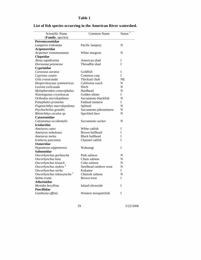
29 5/22/2006
Table 1
List of fish species occurring in the American River watershed.
Scientific Name (Family, species)
Common Name Status 1
Petromyzontidae Lampetra tridentata Pacific lamprey N Acipenseridae Acipenser transmontanus White sturgeon N Clupeidae Alosa sapidissima American shad I Dorosoma petenense Threadfin shad I Cyprinidae Carassius auratus Goldfish I Cyprinus carpio Common carp I Gila crassicauda Thicktail chub NE Hesperoleucaus symmetricus California roach N Lavinia exilicauda Hitch N Mylopharodon conocephalus Hardhead N Notemigonus crysoleucas Golden shiner I Orthodon microlepidotus Sacramento blackfish N Pimephales promelas Fathead minnow I Pogonichthys macrolepidotus Splittail N Ptychocheilus grandis Sacramento pikeminnow N Rhinichthys osculus sp. Speckled dace N Catostomidae Catostomus occidentalis Sacramento sucker N Ictaluridae Ameiurus catus White catfish I Ameiurus nebulosus Brown bullhead I Ameiurus melas Black bullhead I Ictalurus punctatus Channel catfish I Osmeridae Hypomesus nipponensis Wakasagi I Salmonidae Oncorhynchus gorbuscha Pink salmon N Oncorhynchus keta Chum salmon N Oncorhynchus kisutch Coho salmon N Oncorhynchus mykiss 2 Steelhead rainbow trout N Oncorhynchus nerka Kokanee I Oncorhynchus tshawytscha 3 Chinook salmon N Salmo trutta Brown trout I Atherinidae Menidia beryllina Inland silverside I Poeciliidae Gambusia affinis Western mosquitofish I
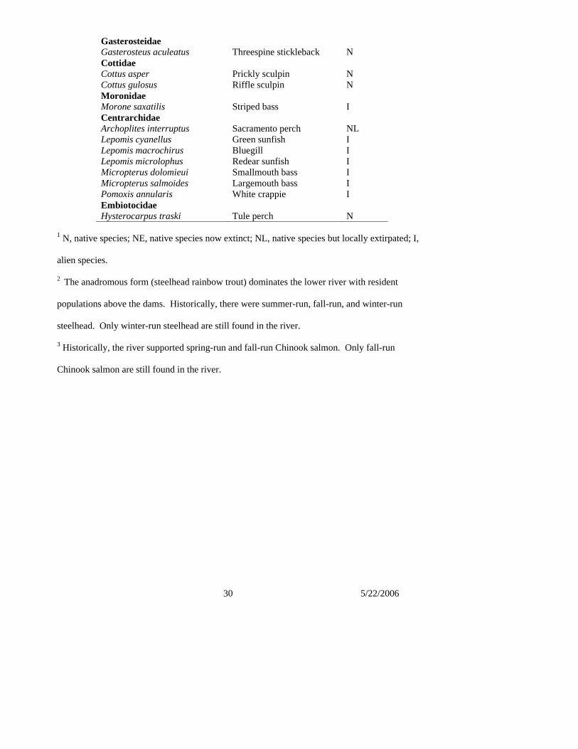
30 5/22/2006
Gasterosteidae Gasterosteus aculeatus Threespine stickleback N Cottidae Cottus asper Prickly sculpin N Cottus gulosus Riffle sculpin N Moronidae Morone saxatilis Striped bass I Centrarchidae Archoplites interruptus Sacramento perch NL Lepomis cyanellus Green sunfish I Lepomis macrochirus Bluegill I Lepomis microlophus Redear sunfish I Micropterus dolomieui Smallmouth bass I Micropterus salmoides Largemouth bass I Pomoxis annularis White crappie I Embiotocidae Hysterocarpus traski Tule perch N
1 N, native species; NE, native species now extinct; NL, native species but locally extirpated; I,
alien species.
2 The anadromous form (steelhead rainbow trout) dominates the lower river with resident
populations above the dams. Historically, there were summer-run, fall-run, and winter-run
steelhead. Only winter-run steelhead are still found in the river.
3 Historically, the river supported spring-run and fall-run Chinook salmon. Only fall-run
Chinook salmon are still found in the river.
1 5/22/2006
CHAPTER 4
WATER FLOWS, WATER QUALITY, AND FLOOD CONTROL
The Lower American River is a highly managed river system that has experienced dramatic changes in hydrology, geomorphology, and riparian habitat value over the last 150 years due to natural and human-induced processes. The lower river’s flows are controlled by releases from Folsom Reservoir and Lake Natoma and its channel is confined by state and federal levees in the first 12 miles moving upstream from the mouth of the Lower American River. The Parkway is a managed floodway that protects Sacramento from seasonal flooding and supports recreational use along with natural habitat areas. 4.0 Water Management Water Flow Policies
4.1 It is the intent of this Plan that available water flows protect the Lower American River ecosystems and recreational resources. These resources include water quality, appropriate water temperatures, waterway recreation, aesthetics, riparian vegetation, fisheries and other aquatic species, wildlife and other river-dependent features and activities. Flow policies shall include the minimum flows in the flow regime agreed to by the Department of the Interior and the Water Forum in 2005.1
4.2 Flow releases from Folsom Reservoir and Lake Natoma should be managed to
minimize fish isolation and redd stranding. 4.3 New surface water diversions that deplete flows in the Lower American River,
whether by execution of a new contract or new water right, to serve entities in counties outside the American River Watershed are inconsistent with this American River Parkway Plan.
Water Flows Flows on the Lower American River are controlled by the operation of Folsom Dam and Reservoir. Folsom Reservoir, Folsom Dam, Lake Natoma, and Nimbus Dam are a unit of the Central Valley Project (CVP) constructed by the U.S. Army Corps of Engineers (Corps) and operated by the U.S. Bureau of Reclamation (Reclamation). Folsom Reservoir provides flood protection for the Sacramento area, water supplies for irrigation, domestic, municipal, and industrial uses, hydropower, extensive water-related recreational opportunities, water quality control in the Bay-Delta, and maintenance of flows stipulated to protect fish, wildlife, and recreational considerations.
1 Note: This policy may need to be updated before the Parkway Plan is adopted to reflect changed status of the flow
regime agreement. The current agreement is interim while working on adoption of a complete flow management standard by the State Water Resources Control Board in the future.
Comment [LK1]: Revised 5/18 This policy was first proposed using “shall” language for both State and Federal policy. However, because it is unclear whether “shall” can be used in this instance for federal policy, Ron Stork recommends leaving this vague so that who it is binding upon (state and / or federal managers) can be determined by the courts if need be, rather than trying to make a legal determination now in this Plan.
2 5/22/2006
Lake Natoma serves as an afterbay to Folsom Reservoir, regulating fluctuating discharges and allowing dam operators to coordinate power generation and flows in the Lower American River channel during normal reservoir operations. Operation of Folsom and Nimbus dams has dramatically altered the Lower American River and its adjacent habitats by causing an overall decline in extremes of flow and temperature compared with historical conditions. Current Lower American River flows and temperatures are different than pre-dam conditions because river flows are managed by Reclamation to meet multiple objectives. In general, the timing of peak river flows has shifted from spring to early winter and summer water temperatures have declined significantly as summer flows increased, which can result in impacts to target fish species. In addition, when Folsom Reservoir and Lake Natoma must steeply increase and then decrease their releases in a short time period to accomplish an objective, for example, to meet Delta water quality needs, this can result in fish stranding and isolation. Reclamation operates under a state water right permit and fish protection requirements that were adopted in 1958 as State Water Resources Control Board (SWRCB) Decision 893. Biological, legal and institutional conditions have changed substantially since the SWRCB adopted this decision. The SWRCB and many diverse stakeholders involved in various American River actions have agreed that the conditions specified in D-893 are not sufficiently protective of the beneficial uses of the Lower American River, including its support of priority fish species and aquatic habitat. There are three key areas to managing the river to protect priority fish species, particularly Chinook salmon and steelhead, and river habitat:
• Improvements related to water temperatures and flow • Actions or projects to restore, maintain, and improve fish habitat, and • Reducing the impact of water supply diversions.
In the Lower American River, improvements related to flow and water temperatures are believed to have the greatest potential for improving the health of Chinook salmon, steelhead, and habitats. Water Forum The Water Forum is a diverse group of business and agricultural leaders, citizens groups, environmentalists, water managers, and local governments in the Sacramento Region that have joined to fulfill two co-equal objectives: provide a reliable and safe water supply for the region’s economic health and planned development to the year 2030; and preserve the fishery, wildlife, recreational, and aesthetic values of the Lower American River. In 2000, Water Forum members approved a comprehensive Water Forum Agreement, consisting of integrated actions necessary to provide a regional solution to potential water shortages, environmental degradation, groundwater contamination, threats to groundwater reliability, and limits to economic prosperity. The Water Forum Agreement allows the region to meet its needs
3 5/22/2006
in a balanced way through implementation of seven elements. One of these elements is an improved flow standard for the Lower American River Updated and Improved Flow Management Standard A flow standard for the LAR is being developed by the U.S. Bureau of Reclamation, the Water Forum and state and federal resource agencies. In 2005, Water Forum stakeholders, working with the U.S. Bureau of Reclamation and other federal and state agencies, agreed to a flow regime for the Lower American River and committed to reaching agreement on the other components of an improved flow management standard for the Lower American River.. The flow standard will be brought to the State Water Resources Control Board by the Water Forum and U.S. Bureau of Reclamation for adoption in 2006. Once adopted by the State Board, the flow standard will be incorporated as a flow policy in this management plan. An improved flow standard will include:
• Water flows, temperature, ramping flow rate and flow fluctuation criteria; • The establishment of a river management group consisting of water resource managers,
biologists, and interested stakeholders for Folsom Reservoir and Lower American River operations;
• A monitoring and evaluation program to report the resultant hydrologic and biologic conditions.
In 2005, Water Forum stakeholders, working with the U.S. Bureau of Reclamation and other federal and state agencies, agreed to a flow regime for the Lower American River and committed to reaching agreement on the other components of an improved flow management standard for the Lower American River. The final flow standard will be proposed to the SWRCB by the Water Forum. Water Quality Policies 4.4 Water quality in the Lower American River shall be maintained to provide for beneficial
uses of the river, including: municipal and domestic water supply; industrial service water supply; irrigation; water contact and non-contact recreation; freshwater habitat; migration of aquatic organisms; and spawning, reproduction, and/or early development of fish; and wildlife habitat.
4.5 Local, regional, state and federal agencies with jurisdiction over water quality of the
American River should work together to maintain and protect a high level of water quality, manage and monitor discharges, and enforce existing water quality regulations.
4.6 Due to the unique urban setting of the Lower American River, urban runoff containing a
variety of contaminants has the potential to further degrade the river and Parkway resources; therefore, agencies responsible for protecting water quality should take steps to minimize such contaminants.
4.7 Parkway managers should educate users on the proper disposal of litter within the
Comment [sw2]: Per UCAC add “responsible for protecting water quality. “ Specific agencies are described in the narrative.
Comment [MSOffice3]: Revised per UCAC to remove concessionaires to focus this policy on responsibility of Parkway managers
4 5/22/2006
Parkway. 4.8 Parkway concessionaires shall undertake programs and actions to educate their customers
regarding the proper disposal of litter in the Parkway, with emphasis on the need to utilize refuse containers at sites where customers enter and exit the water.
Historically, water quality conditions in the Lower American River were typically well within acceptable limits for water quality objectives and beneficial uses identified for the Lower American River, despite the contribution to the river of pollutants and other contaminants from urban runoff and stormwater discharges. However, the Lower American River’s water quality has reflected the influence of the same historical activities that have affected the river’s physical features, such as mining, dam and levee construction, agricultural development, and urbanization. Protection of water quality in the Lower American River is administered by local and state agencies. The Central Valley Regional Water Quality Control Board is the state agency responsible for permitting and enforcement of water quality. Responsible agencies and jurisdictions that discharge into the Lower American River include Sacramento County; the cities of Sacramento, Citrus Heights, Folsom and Rancho Cordova; Sacramento State University and the California State Exposition and Fair (Cal Expo). Under the federal Clean Water Act, states are required to develop a list of water quality limited segments. The waters on this list do not meet water quality standards and the law requires that states develop plans to address water quality limited segments. The Lower American River appears on California’s list of water quality limited segments for mercury, which is primarily a legacy of historical mining activity, and for toxicity, which results in part due to contaminants from urban runoff. All municipal stormwater, and applicable non-stormwater discharges are permitted through Regional Water Quality Control Board issued National Pollutant Discharge Elimination System (NPDES) Stormwater Permits. The County of Sacramento and the cities of Sacramento, Citrus Heights, Rancho Cordova and Folsom are co-permittees under permit # CAS082597. The permit specifies the stipulations under which stormwater may be discharged, including requirements such as public education, construction and industrial site inspection and discharge, creek and river monitoring. The existing permit is up for renewal in January of 2008. Most construction and industrial discharges are also permitted through the Statewide General Industrial and Construction Stormwater Discharge Permits. Infrequently, Lower American River water samples have exceeded the maximum limit for single samples for fecal coliform organisms (as indicators of potential pathogens, such as Cryptosporidium, Giardia, and viruses). There are many potential sources of fecal coliform organisms, including septic systems, human waste, domestic animals and wildlife. The exact pathogens can only be determined through testing. In addition, the Lower American River provides extensive recreational opportunities for urban residents. Recreational use of the Lower American River is protected by law under the National Wild and Scenic Rivers Act and appropriate use of the Parkway is encouraged by County of Sacramento and recognized by this Plan. However, recreational use also has the potential to place additional stress on natural resources. At times, use by anglers, boaters, swimmers,
Comment [MSOffice4]: Revised 10/06 per UCAC to focus on ensuring removal from take-outs and put-ins where concessionaires have more control and to express an affirmative action is required (shall undertake programs and actions), but not use the word "ensure," which the UCAC agreed could be unmanageable (e.g. how do concessionaires enforce compliance?)
Comment [MSOffice5]: Revised 10/05 Clarify that human waste is also a source and that the exact source requires testing.
5 5/22/2006
SCUBA divers, hikers, equestrians, and others strain river resources, native biota, and habitat. Such activities can lead to higher nitrate levels, the accumulation of garbage in the stream and riparian zone; and other sources of pollution associated with recreational use. Creating greater public awareness of the potential impacts of recreational use on water quality is an important strategy to reduce pollution. Educating all Parkway visitors about the proper disposal of litter is one important strategy to reduce potential impacts on water quality. Parkway managers should educate visitors about the need to dispose of litter and other materials in appropriate containers. In addition, concessionaires operating in the Parkway under agreement with the County of Sacramento can also play a vital role in Parkway stewardship by educating their customers and encouraging proper disposal of their customers’ litter. Conditions in the operating agreement should emphasize that sites under the direct control and/or influence of the concessionaire be free of litter at the close of each business day. It is also important to note that illegal use of the Parkway places additional stress on natural resources and can have a detrimental affect on water quality. Enforcing prohibitions against illegal activity is an important component of protecting Parkway resources. Standards and Monitoring In 1998, the Water Quality Control Plan for the Sacramento-San Joaquin River Basins was approved by the SWRCB, defining water quality objectives and standards for the waters of the Sacramento and San Joaquin river basins (including the Lower American River). The Lower American River has numerous beneficial uses, defined by state law as uses that may be protected against quality degradation. The Central Valley Regional Water Quality Control Board has defined the following existing and potential beneficial uses for the Lower American River:
• Municipal and domestic water supply; • Industrial service water supply; • Irrigation; • Power; • Water contact, canoeing and rafting, and other non-contact recreation; • Warm and cold freshwater habitat; • Migration of aquatic organisms (includes striped bass, sturgeon, shad, salmon, steelhead); • Spawning, reproduction, and/or early development of fish; and • Wildlife habitat.
Since 1992, the Sacramento Coordinated Monitoring Program (CMP), a partnership of the Sacramento Regional County Sanitation District with the City and County of Sacramento has conducted water quality monitoring to characterize water quality conditions in the Lower American River and Sacramento River. Before 1990, water quality monitoring was not conducted in the Lower American River in a consistent or comprehensive manner. The CMP
Comment [MSOffice6]: Revised 10/06 to that all users need to be educated re: disposal of litter, to restate the policy, and to emphasize a positive, stewardship role for Parkway concessionaires.
Comment [MSOffice7]: Revised 10/06 to include illegal activities.
6 5/22/2006
coordinates with and participates in other regional monitoring programs, including those managed by the Sacramento River Watershed Program (SRWP), the U.S. Geological Survey, and the California Regional Water Quality Control Board. Since 1992, the CMP has collected water samples from sites within the greater Sacramento County area to provide water quality data, including two sites on the LAR: one at Nimbus Dam and one at Discovery Park near the Lower American River’s confluence with the Sacramento River. The SRWP water quality-monitoring program includes three sites on the LAR: at the Fairbairn water treatment plant, at J Street, and at Discovery Park. Water and other environmental samples are collected on a regular basis throughout the year and analyzed from these locations by the SRWP as well as by its coordinating partners, such as the CMP. There are a number of federal and state laws, regulations, and regional plans that have established water quality standards applicable to the Lower American River or that could expand the role of resource agencies in water quality standards and permitting of facilities that discharge into surface waters, including the Lower American River. These include the federal Clean Water Act, the Endangered Species Act, the Magnuson-Stevens Fishery Conservation and Management Act, the California Toxics Rule, Biological Opinions by NOAA Fisheries and the USFWS, California SWRCB water quality plans, policies and regulations, the Bay-Delta Water Quality Plan, and the state’s Porter-Cologne Water Quality Control Act. Opportunities for Reducing Contaminants in Urban Runoff In recent years, improved knowledge of hydrology, greater environmental awareness and tighter regulatory limits have led to innovations in reducing urban run-off that make use of natural and planned features. These promising approaches include use of permeable paving materials to allow runoff to soak into groundwater; bio-filtration techniques, such as landscaped swales (shallow vegetated depressions) that filter sediments and pollutants from runoff and encourage infiltration to groundwater; treatment through water polishing wetlands or settling basins, diverting low flows which have the most concentrated contaminants, sometimes called “dry weather” flows, to the sanitary sewer for treatment; source control; and treatment through proprietary treatment devices or sand filters, etc. These solutions can be incorporated into land use, flood control and water resources planning through early involvement and collaboration on a watershed basis. It is the intent of this American River Parkway Plan that innovative approaches such as water polishing wetlands inside the Parkway not be used as a basis for planning to direct additional discharges into the Parkway, which could have an impact on aquatic or terrestrial resources. The intent is that these approaches be used as methods to reduce contaminants from existing discharges into the Lower American River. FLOOD CONTROL AND LEVEE PROTECTION Flood Control Policies 4.9 Flood management agencies should continue to maintain, and improve when required,
the reliability of the existing public flood-control system along the Lower American River to meet the need to provide a high level of flood protection to the heavily
Comment [slh8]: Per UCAC clarify intent

7 5/22/2006
urbanized floodplain along the Lower American River consistent with other major urban areas. This effort is expected to include raising and strengthening the levees as necessary to safely contain very high flows in the river (up to 160,000 cubic feet per second) for a sustained period.
4.10 Flood control projects, including levee protection projects and vegetation removal for
flood control purposes, shall be designed to avoid or minimize adverse impacts on the Parkway, including impacts to wildlife and wildlife corridors. To the extent that adverse impacts are unavoidable, appropriate feasible compensatory mitigation shall be part of the project. Such mitigation should be close to the site of the adverse impact, unless such mitigation creates other undesirable impacts.
4.11 Where feasible, multi-use buffers should be created on the land side of the levees,
including additional access points from public streets that enhance levee operation and maintenance activities, improve flood fight capabilities, provide opportunities to relocate or expand levees or supporting stability berms if required, and support recreational opportunities.
4.12 Vegetation in the Parkway should be appropriately managed to maintain the structural
integrity and conveyance capacity of the flood control system, consistent with the need to provide a high level of flood protection to the heavily urbanized floodplain along the Lower American River and in a manner that preserves the environmental, aesthetic, and recreational quality of the Parkway.
4.13 Flood control berms, levees and other facilities should be, to the extent consistent with
proper operation and maintenance of these facilities, open to the public for approved uses, such as hiking, biking and other recreational activities.
4.14 Public facilities and private encroachments that inappropriately constrain the operation
and maintenance of the flood-control system should be redesigned or relocated. 4.15 The flood control system should be maintained in a condition that ensures adequate flood
fighting capability, consistent with the demands of protecting a heavily developed floodplain.
4.16 Bank scour and erosion shall be proactively managed to protect public levees and
infrastructure, such as bridges, piers, and power lines, habitat and recreation resources. These erosion control projects, which may include efforts to anchor berms and banks with rock revetment, shall be designed to minimize damage to riparian vegetation and wildlife habitat, and should include a revegetation program that screens the project from public view, provides for a naturalistic appearance to the site, and restores affected habitat values.
4.17 Projects to address bank stabilization and erosion that is threatening privately-owned
structures shall secure appropriate permits. The engineering of these projects should give preference to biotechnical or non-structural alternatives, where feasible, over alternatives
Comment [slh9]: Per UCAC 4/17
8 5/22/2006
involving revetments, bank re-grading, or installation of river training structures. Use of rubble, gunnite, bulkheads and similar material in these projects is prohibited.
4.18 It is recognized that flood control agencies have the authority to take action(s) to prevent
or respond to flood emergencies occurring in or adjacent to the Parkway. In the event that these action(s) have an adverse impact on biological resources in excess of the estimated impacts of the projected flood damage to such resources, the agency(ies) undertaking the emergency work will implement feasible compensatory mitigation measures pursuant to Policy 3.10. Nothing in this Policy shall be construed to interfere with the existing authority of flood control agencies to prevent or respond to an emergency situation occurring in or adjacent to the Parkway.
Federal/State Flood Control System The Lower American River traverses a large floodplain covering over 100,000 acres east of the Sacramento River. Most of this floodplain has been extensively developed for urban use. These urban developments, which have a structural value in excess of $30 billion, are protected from flooding by Folsom Dam and the levee system running along the east side of the Sacramento River, the north and east sides of the Natomas Basin, and the north and south sides of the Lower American River. These facilities are part of a much larger Federal/State flood control system in the Sacramento Valley administered by the U. S. Army Corps of Engineers (Corps) and the California Reclamation Board (Reclamation Board). Along the Lower American River, the Federal/State levees extend from the mouth of the river to high ground about 13 miles to the east. The south side levee and the lower portions of the north side levees were constructed prior to the completion of Folsom Dam. These levees were designed to contain floods capable of producing peak flows up to 180,000 cubic feet per second (cfs) with three feet of freeboard between the water surface and the top of the levee. Toward this end, the north side levees were set back a considerable distance from the river channel. After the completion of Folsom Dam in 1956, the last segment of the Federal/State levee system was constructed along the north side of the river between Cal Expo and the Carmichael Bluffs. Relying on the regulating effect of the dam, this levee was placed relatively close to the river and the newly confined channel was designed to contain flows up to 115,000 cfs with at least five feet of freeboard, or 152,000 cfs with at least three feet of freeboard on both sides of the river. In the mid-1970’s, private developers constructed the south bank levee upstream of the Mayhew Drain to allow development of the adjoining floodplain. This levee was designed to contain a flow of about 130,000 cfs with three feet of freeboard. The flood of 1986 generated record rainfall and run-off in the American River watershed and exposed many deficiencies in the flood control system along the Lower American River. In the aftermath of the flood, Sacramento’s local elected officials formed the Sacramento Area Flood Control Agency (SAFCA) to work with the Army Corps and the Reclamation Board to provide the Sacramento area with at least a 200-year level of flood protection. In pursuit of this goal, SAFCA and its federal and state partners have developed a program of flood control
9 5/22/2006
improvements that includes: • Increasing the low-level discharge capacity of Folsom Dam so that dam operators can
use the storage space in the reservoir more efficiently for controlling large floods; • Insuring that flood operations at Folsom Dam, including advance releases, are consistent
with the flood control mission of the dam and public safety. • Increasing the height of the dam so that there is more reservoir storage space available
for controlling large floods; and • Raising and strengthening the levees along the Lower American River so that they can
safely convey very high flows in the river (up to 160,000 cubic feet per second) for sustained periods (36 hours or more).
This program of improvements has been approved in a series of actions by Congress and the State Legislature and is being implemented on a step-by-step basis. Pursuant to its authority under the California Water Code and its obligations under a series of operation and maintenance agreements with the Corps, the Reclamation Board regulates all activities that might affect the performance of the American River levees and the channel between them. This regulatory responsibility extends to the lands in the Parkway upstream of the levee system that are inundated by flows discharged from Folsom Dam within the design of the flood control operation. The State’s objective is to preserve the conveyance capacity of the flood control system by regulating encroachments on the floodway including engineered structures and vegetation. Engineered structures may include the levee system itself; bridge abutments and piers for highway, railroad and pedestrian bridges; buried and armored utility crossings; and recreation or urban developments, including buildings, hardened roadbeds, and retaining walls. These structures can confine the floodway, as in the case of the narrowing of the levee system upstream of the Cal Expo area, or act as a flow obstruction that may cause locally adverse hydraulic conditions. Vegetation represents a degree of hydraulic roughness, potentially impeding the flow of water and raising water surface elevations. Vegetation in the Lower American River has been affected by many factors, including deposition of hydraulic mining debris, removal for infrastructure and recreational development, wildland fire, invasion by nonnative species, thinning and clearing for maintenance of engineered structures, and re-vegetation/habitat restoration projects. Vegetation management needs are identified based on historical data, field observations, professional judgment, and hydraulic modeling. By agreement with the State, the American River levees are maintained by local districts. Reclamation District 1000 maintains the north levee of the American River in the Natomas Area. The American River Flood Control District maintains the remainder of the north levee and the south levee extending from the Mayhew Drain to the mouth of the river. The County of Sacramento maintains the privately constructed levee extending from Mayhew Drain to Grist Mill on the south side of the river. This levee is currently being incorporated into the Federal/State system. The local levee maintaining agencies act as first responders in carrying out the State’s responsibilities to regulate public use of the levees for hiking, biking, landscaping or other non-flood control purposes.
10 5/22/2006
Erosion Control Erosion of the berms and banks supporting the levees along the Lower American River is an ongoing threat to the stability of the flood control system that has been heightened by the need to convey very high flows through the system for sustained periods as part of the program to provide a high level of flood protection to the urbanized floodplain. This threat is further aggravated by the legacy of hydraulic mining in the watershed, the operation of Folsom Dam, and the urbanization of the protected floodplain. Hydraulic mining practices discharged massive amounts of sediment to the lower river causing a significant rise in the river bottom and surrounding floodplain. Regulation of these practices and the subsequent construction of Folsom Dam drastically reduced the rate of sediment transport and caused the lower river to scour the sediment deposits, steadily lowering the depth of the channel bottom until it reached more stable hard pan. This was accomplished shortly after the completion of Folsom Dam. Since then, the river has proceeded to widen its channel by scouring the sediments comprising its banks and berms. Throughout the lower portion of the Parkway, this pattern of erosion has produced a relatively narrow low flow channel that is confined by steep, often unstable banks that rise to an elevated, irregularly inundated floodplain. This erosion can threaten the stability of levees that have been placed relatively near the channel, such as on the north side of the river upstream of Cal Expo and on much of the south side of the river. Because these levees are hemmed in by urban subdivisions, flood managers must halt the erosion. Parkway managers also have an interest in protecting threatened berms that support remnant stands of cottonwood forest and provide recreational access to the river. The consequence of failing to protect these berms is evident on the south side of the river just upstream of the Capital Freeway. There, the high flows generated by the flood of 1986 removed a sizeable berm that once buffered the nearby levee, provided shaded riverine habitat and supported an informal recreational trail. In the aftermath of the flood, emergency repair crews restored the waterside slope of the levee by placing engineered rock extending from the top of the levee to the river channel, creating a large gap in the riparian corridor occupying this portion of the Parkway. Erosion is also a problem in some portions of the Parkway upstream of the levee system. Here, erosion threatens private structures that have been allowed to locate close to the river channel, rather than the stability of the levee system that protects the urbanized floodplain. Therefore, the policies governing the engineering and aesthetic aspects of these private erosion control projects are more restrictive. Erosion Control Program A major focus of flood management along the Lower American River is the development and implementation of an anticipatory erosion control program based on identifying and treating eroding sites before they become a critical threat to the levee system and ideally before the riparian corridor is lost. This program emphasizes early interventions, relying on methods of protection that minimize habitat impacts and reduce future costs. Toward this end, potential erosion sites must be regularly monitored and evaluated as to the likelihood of an unacceptable loss of material. When necessary to prevent such a loss, appropriate erosion control measures
11 5/22/2006
must be designed and constructed. Each project must consider the nature of the erosion threat and the most effective method for controlling erosion with the least damage to riparian vegetation, wildlife, and the aesthetics of the final product. Where there is a conflict between preservation of the natural environment and protecting threatened facilities and structures, it may be appropriate to relocate or acquire and remove the threatened facilities and structures. Erosion Control Measures The following is a brief description of the erosion control measures that could be implemented as part of the anticipatory erosion control program and their applicability to the Parkway. Revetments Revetments involve the use of engineered rock to armor eroding banks and levee slopes. Rock slope protection has been widely used in some areas of the Lower American River to ensure safe containment of very high flows in the river. When applied to waterside levee slopes, the environmental impacts of this measure can be minimized by covering the revetments with soil and planting the soil surface with native grasses. When applied to berms and banks, the impacts of this measure may be substantial, generating relatively high costs for onsite and offsite mitigation. Rock toe protection is less expensive and less environmentally detrimental than rock slope protection, but may require removal of large woody material from the channel bottom. This measure may be very effective where primary bank failure mechanism is mass failure due to an over-steep bank above an eroded toe. Access to such steep vegetated banks is difficult in many areas of the Lower American River and, where feasible, barge construction of toe protection projects should be considered. Low berm construction is an enlarged version of toe rock protection that permits construction access by reconstructing eroded berms for use as a waterside platform with a soil trench to provide planting medium. Because this method requires a substantial volume of engineered rock, it can be very expensive. Biotechnical Treatments These treatments involve the use of vegetation, woody material, and other organic substances to control erosion. Applications include using woody plants such as willows or other vegetation to stabilize the lower portion of an eroding bank; using fascines, brush clearing, or vegetated geogrids to increase the treated bank’s resistance to erosion; and constructing brush boxes employing bundles of woody material anchored to piers installed near the toe of an eroding bank to lessen the erosive effects of boat or wind generated waves. These measures are most effective when deployed with other bank stabilization techniques. However, because of their relatively low cost and secondary environmental benefits, biotechnical treatments may be widely applicable as preventive measures. Bank Re-grading Bank re-grading reduces erosion potential by lessening the steepness of the upper slope and reducing the weight of the slope over the toe of the bank. Although this may create more stable conditions for plantings, impacts are generally high because of the need to disturb existing vegetation and recreational facilities at the top of bank. Bank reconstruction repairs erosion damage with more erosion resistant soil material and is generally most useful in combination with other measures.
12 5/22/2006
River Training Structures River training structures, such as weirs and dikes, are designed to reduce flow velocities along the bank by pushing flows toward the center of the channel. These structures are adaptable for working around in-stream woody material, although access for construction and keying the structures into existing banks is difficult if the banks are steep and well vegetated. Such structures may raise navigation and recreational safety concerns and would need to be carefully designed to minimize or avoid any safety concerns. Hard points are used to harden bank lines at specific points or intervals to address isolated areas of erosion or bank failure. These structures may produce a more stable bank line if several are used in combination with vegetation. Non-Structural Methods Erosion can also be reduced by employing non-structural methods such as removing or relocating structures that are generating erosion or may be subject to erosion-related damage, or increasing the conveyance capacity of the channel in the vicinity of the area of erosion.
13 5/22/2006
WILD AND SCENIC RIVERS ACT (WSRA) Introduction The 23-mile portion of the American River that extends from below Nimbus Dam to the confluence with the Sacramento River has been designated as a Wild and Scenic River under both the State and Federal Wild and Scenic Rivers Acts. The river has a broad channel with riparian vegetation along the banks and is located within the American River Parkway corridor. River flows in this segment are affected by Folsom and Nimbus Dams and impacted by other man-made intrusions at several points along the river. State Wild and Scenic River System The California Legislature passed the State Wild and Scenic Rivers Act (WSRA) in 1972 (PRC Section 5093.50-5093.70). The legislature said that it was the State’s intent that “certain rivers which possess extraordinary scenic, recreation, fishery, or wildlife values shall be preserved in their free—flowing state, together with their immediate environment, for the benefit and enjoyment of the people of the State.” The Lower American River was included in the State Wild and Scenic River System in 1972 when the State Act was passed. Federal Wild and Scenic Rivers System The Federal Wild and Scenic Rivers Act was passed in 1968 and set forth a policy that certain selected rivers possess outstandingly remarkable values (ORVs): scenic, recreational, geologic, fish and wildlife, historic, and cultural. The Act set forth a policy that would preserve these rivers, or sections thereof, in their free-flowing condition to protect water quality and preserve the outstandingly remarkable values. The Lower American River was designated in 1981 by Cecil Andrus, Secretary of the Department of the Interior, under Section 2 (a)(ii) of the Wild and Scenic Rivers Act. Designating the Lower American River under the Federal Wild and Scenic Rivers Act results in a prohibition of Federal construction, assistance, or licensing of water projects adversely affecting the characteristics qualifying the river for the national system. The National Parks Service is currently the federal administering agency that has been delegated to make such consistency determinations for the Lower American River. Wild and Scenic River Planning and Management for the Lower American River Management and Administration: The County of Sacramento has the principal responsibility for administration and management of much of the American River Parkway, as guided by the American River Parkway Plan, although the small portions of the parkway that are part of the Folsom State Recreation area or are owned by the federal government are administered by the California Department of Parks and Recreation or by federal land managers.
14 5/22/2006
Prepared under the authority of the Urban American River Parkway Preservation Act (PRC Section 5840-5843), the American River Parkway Plan is the management plan for the American River Parkway. In 1977, the Resources Agency of the State of California finalized the state wild and scenic river management plan for the Lower American River. The Lower American River Waterway Management Plan incorporated the Parkway Plans adopted by the Sacramento County Board of Supervisors in April 1976 and the Sacramento City Council in September 1975. In his transmittal letter to the Governor, the Secretary of Resources, noted that this management plan was “the second in a series of plans being developed for California’s Wild and Scenic Rivers.” He then further noted:
The basic thrust of the Lower American River plan is to give State support and concurrence in the plans which have been adopted and are being implemented by the City and County of Sacramento. The plans by the City and County provided the basis for the State’s plan and have been made an integral part of the State’s plan.
The Parkway Plan continues to serve as the management plan for the Lower American River under the Wild and Scenic Rivers Act, providing management guidance and direction for state departments and agencies, as well as local governments, in carrying out their responsibilities under the State Wild and Scenic Rivers Act, as well as the Urban American River Parkway Preservation Act. State departments and agencies, as well as local governments, also have responsibilities to ensure that their actions are consistent with their responsibilities under the State Wild and Scenic Rivers Act. The Lower American River is also a state-managed federal 2(a)(ii) wild and scenic river. Management of this national wild and scenic river by Sacramento County is consistent with Federal law since these rivers “are to be permanently administered as wild, scenic or recreational rivers by an agency or political subdivision of the State...” Sacramento County is a political subdivision of the State of California. Although Federal administrative responsibilities are limited for 2(a)(ii) rivers, the American River Parkway Plan is also intended to provide guidance to the Federal wild and scenic river managers in carrying out their responsibilities under the National Wild and Scenic Rivers Act. Federal land managers also retain management authority for federally owned lands lands within the Parkway. The federal wild and scenic river manager also has a responsibility to ensure that federal actions involving water resources projects, At the time of adoption of this Plan, the National Park Service is the agency responsible to ensure that the protections under Section 7(a) of the federal Wild and Scenic Rivers Act (USC Title 16, Chapter 28), regarding the protection of Wild and Scenic Rivers from the harmful effects of proposed water resources projects, including modifications to the bed and banks of the river, are consistently applied on these rivers. The WSRA prohibits the Federal
15 5/22/2006
Energy Regulatory Commission (FERC) from licensing the construction of hydroelectric facilities on designated rivers and prohibits other federal agencies from assisting in the construction of any water resources project that would have a direct and adverse effect on the values for which a river was designated. The WSRA also includes a standard that governs water resources projects below or above a designated river. The types of water resources projects most commonly occurring on these rivers include road construction and reconstruction, bridge construction or replacement, bank armoring, and gravel extraction from riverbed or banks. Typically, projects subject to Section 7(a) will be triggered by a permit issued by the Army Corps of Engineers under Section 404 of the Clean Water Act or Section 10 of the Rivers and Harbors Act. Section 7(a) may also be triggered when a project is identified as impacting a designated Wild and Scenic River in the California Department of Fish and Game's Lake and Streambed Alteration (1601) permit application. Corridor Boundaries: The American River Parkway plan establishes boundaries for the Parkway. As noted in the Wild and Scenic Rivers Reference Guide developed by the Interagency Wild and Scenic River Coordinating Council, “establishing a boundary for a wild and scenic river is an important step in delineating the area which will receive the greatest effort in resource protection.” Consistent with that general principle, the principal focus of wild and scenic river management plans are on the management of lands and waters within the boundaries of a wild and scenic river. The 1977 State Lower American River Waterway Management Plan determined that “[t]he Planning Area for the designated Wild and Scenic River portion of the Lower American River is the same as the planning boundary shown on the Sacramento County American River Parkway Plan.” Boundaries adopted by the state wild and scenic river managers for joint state / federal rivers also generally serve to delineate the federal wild and scenic river corridor. This Parkway plan, and its updates, continues to serve the function of defining the wild and scenic river management corridor. Classification: The Lower American River has been classified as a “recreational” river in the state and federal wild and scenic river systems. Recreational rivers are defined as rivers “readily accessible by road or railroad, that may have some development along their shorelines, and that may have undergone some impoundment or diversion in the past.” Development plans for wild and scenic rivers must be consistent with a river’s classification. Extraordinary Values or Outstandingly Remarkable Values of the Lower American River In order to be eligible for inclusion in the State Wild and Scenic River System a river must “possess extraordinary scenic, recreational, fishery or wildlife values. Similarly, “certain selected rivers of the Nation which, with their immediate environments, possess outstandingly
Comment [sw10]: Added per input from NPS re: their role. 5/17/06 sw
16 5/22/2006
remarkable scenic, recreational, geologic, fish and wildlife, historic, cultural, or other similar values” are eligible for inclusion in the National Wild and Scenic River System. The extraordinary values of the Lower American River are its recreation and anadromous fishery. These values were identified as outstandingly remarkable values by federal wild and scenic river managers in 1980, serving as the basis for the acceptance of the Lower American River by the Secretary of the Interior. Recreational: The entire segment is located within the American River Parkway containing several major developed parks and paralleling bike, pedestrian and equestrian trails. The river provides opportunities for swimming, boating, fishing, and other day-use activities. In 1983, the river was determined to accommodate 250,000 recreation days of rafting and some 2.5 million recreation days for all uses of the river and corridor. It also provides a relatively pristine atmosphere from surrounding urban development. One of the compelling reasons for the Lower American River’s recreation “outstanding remarkable value” was the Parkway. Therefore, consistency determinations under Section 7 (a) of the federal Wild and Scenic Rivers Act may consider the direct, and indirect, effects of water resources projects on the bike, hiking or equestrians trails, or other parkway recreational uses. Fishery: The LAR supports an important anadromous fishery including Chinook salmon, steelhead trout, striped bass and American shad. Resident rainbow trout are present in the upper segment and a limited warmwater population of largemouth bass, various sunfish and catfish comprise the rest of the fishery. Salmon and steelhead both naturally spawn in the river and are released from the Nimbus Hatchery.
1 5/22/2006
CHAPTER 5 RECREATIONAL USE OF THE PARKWAY
The Parkway’s river corridor provides recreational opportunities not normally provided by other County recreational facilities, while preserving naturalistic open space and habitat within an urban area. Recreational use of the Parkway has many benefits. It encourages healthy lifestyles, increases visitors’ understanding of the natural environment, provides for alternate modes of transportation, builds community and family unity, stimulates local economic activity, and creates community support for parks and open space. The purpose of this section is to describe the permitted recreational activities and policies guiding the recreational uses of the Parkway. This section also describes prohibited activities and facilities, which provides further guidance to decision makers for interpretation and possible amendments to this Plan. The absence of an activity or facility from the latter list does not imply that the activity or facility is permitted.
This chapter describes the types of recreational uses permitted within the Parkway, while Chapter 8: Public Access and Trails describes the appropriate design, location, and purpose of public access and trail facilities that support the recreational activities. Together, these two chapters describe the recreational facilities available, how they are to be used, and locations where they are permitted.
5.0 Recreational Use of The Parkway
Permitted Recreational Activities and Facilities Permitted recreational activities in the Parkway are divided into five categories: Nature Appreciation, Recreational Enjoyment, Trails Recreation, Recreational Participation in Group Sports and Athletics, and Aquatic Recreation. Each of these categories is divided into an inclusive list of permitted recreational activities.
Nature Appreciation: This group of activities is generally passive, and requires little, if any, improvements in the Parkway. This group is permitted in the Nature Study, Protected, Limited Recreation and Developed Recreation land use categories.
5.1 Nature Appreciation permitted activities are:
a. Sightseeing, study and appreciation of natural features, man-made features, people, or events,
b. Painting and sketching, c. Photography, d. Reading and writing for pleasure.
Recreational Enjoyment: These activities depend on limited facilities in the outdoor environment for the enjoyment of the activities. Picnicking and day camp activities are permitted in the Developed Recreation land use category. Limited Recreation and Protected areas restrict these uses to limited family unit picnicking along trails, and in certain instances, limited educational or youth group overnight use. New picnic facilities would be included in updated area plans which would go through a public review process.
5.2 Recreational Enjoyment permitted activities are: picnicking, day camping and overnight camping.
5.3 Picnic facilities shall be installed in appropriate locations to accommodate user demand, but shall be limited in size to minimize the impact on other Parkway users, natural resources, and aesthetics.
2 5/22/2006
5.4 Day Camps are camps that provide activities for children during the daytime. Day camping shall be permitted for organized groups, by reservation, for the education and enjoyment of the Parkway’s natural resources.
5.5 Group overnight camping shall be limited to organized educational groups and youth groups, who have an educational or interpretive interest in the Parkway and its resources.
5.6 Group overnight camping shall be permitted in the County-operated portion of the Parkway, by reservation at the discretion of the Parkway Manager, but only in designated primitive camps. Individual (one to two persons) and family (three to ten persons) camping facilities are not permitted in the County-operated portion of the Parkway.
5.7 Permitted primitive camp sites currently exist at the Upper Sunrise Area, Sailor Bar and Goethe Park.
5.8 Overnight camping may be permitted in association with the programs at an interpretive center with permission from the Parkway Manager.
5.9 Overnight camping permit conditions shall address limitations to: levels of noise and light, campfires, hours of activity, avoiding possible conflicts with other Parkway permitted activities and events, and preventing negative impacts upon vegetation and wildlife.
5.10 Overnight camping in self-contained recreational vehicles may be permitted at Discovery Park and the CalExpo floodplain, consistent with the Bushy Lake Preservation Act, in association with special events and confined to existing parking areas.
5.11 Overnight camping by individuals (one to two persons) or family groups (three to ten persons) shall also be permitted in the family and individual campsites which are available upstream from Hazel Avenue, in the Folsom Lake State Recreation Area, operated by the California Department of Parks and Recreation.
This Plan permits primitive group overnight camping in three specific areas within the County managed portion of the Parkway, downstream from Hazel Avenue. These three sites are dispersed throughout the Parkway and are intended for the education and interpretive purposes of the Parkway’s natural resources. As such, these sites have been permitted in land use designations that can support small (eleven to twenty persons) and medium (twenty-one to forty persons) group sizes, yet are near to Nature Study areas that would have the greatest potential for educational and interpretive opportunities of the natural resources. The size of the camping group is permitted at the discretion of the Parkway Manager and dependent upon the permitted group sizes regulated by the land use designation. Illegal campsites are a significant issue addressed in detail in Chapter 9: Public Safety of this Plan. In brief, this Plan recognizes the public safety, recreation, and natural resource impacts of illegal camping and supports multi-agency, collaborative efforts to prevent the need to camp in the Parkway, increased enforcement of camping regulations, and restoration of areas impacted by illegal camping. At the time of the 2006 update of this Plan, the level of use of these three primitive camp sites did not warrant designating additional sites. However, levels of use could increase in the future. If additional primitive camp sites are desired in the future, they should be permitted and amended into the appropriate area plan, only if they meet the following criteria:
a. Near a Nature Study Area,
Comment [sw1]: Reorganized to provide a more linear flow.
3 5/22/2006
b. Located in a Protected Area or a Limited Recreation Area and isolated so that they do not compete with other Parkway uses,
c. Undeveloped, in that the sites should not have permanent restrooms or other facilities that would attract casual day users,
d. Accessible by vehicle for the transport of portable restrooms and for emergency access, and,
e. Have an educational or natural resource interpretive purpose.
There are two privately owned parcels in the Parkway where camping also occurs. The Boy Scouts of America own a parcel in the Discovery Park East area near the Twelfth Street Bridge, west of Highway 160, called Camp Pollock. This is a recognized, non-conforming use that includes camping activities. Campfire USA owns a parcel in the Goethe Park area. The use of these parcels is regulated by the zoning codes and General Plans of the appropriate local jurisdictions.
Trails Recreation: Activities involve recreational use of Parkway trails, access points and staging areas. Trails recreation is the most popular activity in the Parkway. The Jedediah Smith Memorial Trail is the primary recreational trail and runs along the entire length of the Parkway. It connects Discovery Park to Folsom Lake and provides an important bicycle commuter route. Although the trail is designated for bicycle and in-line skating use, it is also heavily used by hikers and runners. Additional bicycle trail segments have been constructed to provide supplemental trail connections and accesses. Trails Recreation permitted activities are: walking, hiking and running; horseback riding; bicycling and in-line skating. These activities are permitted in the Limited Recreation, Developed Recreation, and Protected land use categories. In Nature Study areas trail recreation activities are limited to pedestrian and equestrian use on designated trails only. Use of motor vehicles by the public is restricted to designated public access roads and parking lots. Chapter 8 – Public Access further describes trail use for emergency vehicles and access for persons with disabilities.
Walking, Hiking and Running
5.12 Walking, hiking and running are permitted activities on the pedestrian trail, equestrian/hiking trail, firebreaks and maintenance roadways, and other trails as designated and signed, throughout the Parkway.
5.13 A separate designated pedestrian trail shall be provided along the entire length of the Parkway. The pedestrian trail will be adjacent to the existing paved Jedediah Smith Memorial (bicycle) trail where practical given the width of the area and location of trees and other natural resources. New trail sections shall avoid heavily vegetated areas and low floodplain locations subject to frequent inundation. This trail shall not be paved; instead, it shall have a naturalistic design and surface that is stable, firm, and slip-resistant in order to support assistive devices for persons with disabilities.
Horseback Riding
5.14 Horseback riding shall occur only on designated equestrian/hiking trails and signage should specify that horses have the right of way. These trails should be kept separate from bicycle
4 5/22/2006
trails in order to avoid conflicts. Where practical, new trails should be combined with fire breaks.
In-line Skating 5.15 In-line skating is permitted on the Jedediah Smith Memorial (bicycle) trail.
Bicycling/ 5.16 Bicycle use is permitted on designated paved bike trails, paved and authorized unpaved public
access roads, in parking lots and on designated maintenance and emergency access roadways, subject to policies 5.17-5.17.1 and the conditions therein.
5.17 Off-pavement bicycle use may be permitted on existing or reconfigured maintenance and emergency roadways in the Woodlake and Cal Expo areas, at the discretion of the Parkway Manager, and as approved on locally adopted area plans, which requires a public approval process. Off-pavement bicycle use may be permitted under the following conditions:
a. Acquire additional stable and continued funding to support and monitor the use, b. Add natural buffers and design elements to minimize off-trail behavior and protect
sensitive habitat areas, c. Use only authorized maintenance and emergency roadways where appropriately signed and
designated, and d. Provide access points near clustered parking areas.
5.17.1 Off-pavement bicycle use may be further expanded to other areas of the Parkway after a three-year trial period and evaluation, subject to Parkway manager discretion. Locally adopted area plans shall be updated to reflect permitted areas of use, consistent with conditions 5.17 a-d.
The Cal Expo and Woodlake areas have more fire breaks and maintenance roadways than other areas of the Parkway. This creates a unique opportunity to reconfigure maintenance roads into loops that improve emergency access and facilitate recreational use. The existing firebreaks and maintenance roadways do not impact high recreational use areas, therefore, off-trail cycling on these roadways will not displace existing authorized Parkway users.
It has been determined that off-paved bicycle use of a limited number of designated, unpaved existing and reconfigured fire breaks and maintenance roadways may be allowable under conditions that include monitoring to assess impacts to both the environment and other users. This use must first be designated on an area plan through the public process for modifying area plans described in Chapter 11. Allowing this activity, subject to the conditions listed in this policy, in a limited area of the Parkway has been determined to be consistent with providing a balance between preserving naturalistic open space and providing recreational opportunity.
Recreational Participation in Group Sports and Athletics includes organized competitive activities which may be pursued at fixed locations in accordance with predetermined rules for recreational purposes. This group is only permitted in the Developed Recreation land use category.
5.17 Team game field sports includes soccer, baseball, football, lacrosse, rugby and similar games. Game fields should be associated with large picnic facilities on irrigated turf in Developed Recreation Areas. Game fields shall be multi-purpose in design, rather than exclusive to any one
Comment [slh2]: UCAC asked this be a separate policy not embedded in 5.15
Comment [slh3]: UCAC direction that this policy should clearly state where bicycling is permitted.
Comment [slh4]: Edits by staff to make sure the language in the narrative mirrors what the UCAC approved in the policy above.
5 5/22/2006
activity, and shall not include goal posts, backstops, bleachers, lighting, sound amplification or other permanent structures.
5.18 Outside Court Sports includes volleyball, badminton and other games which can be played on an outside grass or sand courts. These activities will normally occur near picnic facilities or on multi-purpose game fields.
5.19 New golf courses are not permitted in the Parkway because they require a dedication of large areas of land to exclusive single-purpose activity and involve substantial disruption to the land, vegetation and wildlife. The two golf courses are located in the Ancil Hoffman Park and in the Campus Commons area, which is downstream from the “H” Street Bridge on the north side of the river. The Ancil Hoffman Golf Course, the separate driving range at Ancil Hoffman County Park and the Campus Commons Golf Course are recognized non-conforming uses in the Parkway.
5.20 Archery facilities are recognized non-conforming uses. Discovery Park includes an archery range and a field archery course.
Aquatic Recreation includes activities which are dependent upon the American River for their execution and enjoyment. Access and facilities to support aquatic recreation are permitted in the Protected, Limited Recreation and Developed Recreation land use categories. In Protected Areas, all aquatic recreation activities are permitted except motorized boat launching.
The river supports a number of prized recreational anadromous fish, including steelhead, Chinook salmon, American shad, and striped bass. These fish are pursued from boats, the bank, and by wading. In addition, commercial guided fishing boats offer drift-fishing trips on the river. Populations of largemouth bass, bluegill, crappie, sunfish, catfish and other recreational fish, thrive in certain dredger tailing ponds where the water is deep enough to meet oxygen and temperature requirements. Fishing is permitted in these ponds, unless otherwise noted on an area plan.
5.21 Swimming, wading, snorkeling and scuba diving are activities that occur, although they are not encouraged due to swift currents, water temperatures, slippery and uneven ground, submerged debris and vegetation, and absence of lifeguard services.
5.22 Boating, canoeing, kayaking, rafting, sailing, motor boating, and similar activities are permitted Aquatic Recreation activities.
5.23 Fishing in the river is permitted year round in the Parkway, except during fall and early winter when the river is closed to protect spawning Chinook salmon as regulated by the Department of Fish and Game Code. This closure has generally occurred from just downstream of the Hazel Bridge to Ancil Hoffman Park.
5.24 The speed of motorboats, jet boats, and other powered vehicles shall be limited to 5 mph, in accordance with Sacramento County Code, Section 13.16.030.
5.25 The Park Ranger unit will monitor the boating speed of peace officers and other official boat users to ensure safe speeds near other Parkway users. Any visitor complaints will be forwarded to the appropriate agency.
6 5/22/2006
Prohibited Activities and Facilities
5.26 The following activities and facilities, which are incompatible with the Parkway, shall be prohibited:
5.26.1 Activities:
a. motor vehicles and scooters on trails, except for emergency and maintenance purposes,
b. hunting and target shooting of any kind, c. use of any of any fire arm, including air rifle, pellet guns, BB guns, paint ball, d. use of archery equipment for purposes other than target shooting in the designated
archery range at Discovery Park, e. tournament and league sports, f. motorized model airplane flying, g. rocket flying, h. dog training and field trials, i. gathering or collecting plants, except for approved research and
interpretive/educational purposes by designated personnel, or as authorized by designated personnel,
j. capturing animals, except for health safety purposes, k. hot air balloon launching or landing, l. helicopters, except for public safety purposes, m. hang gliders, n. tree swings, o. skim boards, body boards or other apparatuses tethered to a fixed object, often
obstructing the waterway, p. jumping or diving from bridges, and q. fireworks.
5.26.2 Facilities:
a. off-road vehicle courses, including off-road bicycle courses, b. permanent backstops, net poles, soccer goals, or goal posts, c. tennis courts and other surface courts, d. permanent bleachers, e. marinas and boat docks, except courtesy docks at the Discovery Park boat ramp, f. velodromes, g. new golf courses, h. horseshoe pits unless integrated into designated picnic facilities, i. frisbee golf courses, including disc golf courses, j. new archery facilities, k. swimming pools and fountains, l. permanent perimeter fences within the Parkway around recreational facilities, m. playground facilities and equipment, except when integrated into picnic facilities in
a visually unobtrusive manner, n. permanent stages, o. permanent lighting facilities, except security lights, and p. permanent sound amplification facilities.
7 5/22/2006
5.27 Existing incompatible activities and facilities shall be phased out as soon as possible, except for the Ancil Hoffman Golf Course and ancillary facilities, Campus Commons Golf Course, the archery range at Discovery Park, the Live Steamers Railroad in Rossmoor Bar, and Camp Pollock. Sacramento County Regional Sanitation owns a parcel in the Arden Bar Area that is a recognized non-conforming use within the Parkway. The following existing facilities and improvements are inconsistent with the Parkway Plan and should be phased out on a prioritized schedule, developed as part of the action plan. Once facilities are phased out, the site should be evaluated to determine the appropriate land use and compatible activities.
a. Bicycle motocross (BMX) use at Gristmill, Goethe Park, Mullaney Grove and Rossmoor Bar
b. Riverdale Mobilehome Park in the Discovery Park Area c. Bell Marine and Gardenland Mine materials processing and recycling facilities and
operations, d. Cement “lake” structure at Sailor Bar, e. Pump station at Goethe Park near Paul Hagan Park, f. Abandoned agricultural concrete dikes and reservoirs at Jacob Lane,
5.28 Provisions shall be made for the continued maintenance of Ancil Hoffman Golf Course and ancillary facilities, the Campus Commons Golf Course, the archery range at Discovery Park, and Camp Pollock.
5.29 Alcohol consumption is prohibited in designated areas within the Parkway. Areas of prohibition are regulated by County ordinance and should be signed accordingly.
Group Activities Group activities and events that are specifically approved by the Parkway Manager shall occur in a manner that minimizes impacts on other recreationists, natural resources and aesthetics in the Parkway.
5.30 Any medium or large group activity conducted on any designated pedestrian trail, equestrian/hiking trail, or bicycle trail shall be coordinated with the Parkway Manager, to minimize the impacts on other Parkway users.
5.31 Competitive group activities may be permitted on the bike trail and shall be limited to:
a. Fund raising by non-profit or charitable organizations with public and civic interests; or b. Competitive recreation for which no event entry fee is charged.
5.32 Competitive events on the bike trail shall not exceed one event per month.
5.33 Large special events may be permitted at Discovery Park on a periodic basis so long as natural resources are not degraded.
5.34 Small special events may be permitted in the Ancil Hoffman, Goethe, William B. Pond and Effie Yeaw Nature Center areas where events can be accommodated by existing facilities, so long as natural resources are not degraded.
5.35 Proper user education, facilities design, and directional signage should be used to prevent user
Comment [sw5]: Staff proposal that may be better supported by Reg. San. And the Sheriff’s dept. that is currently leasing the parcel. UCAC approved as: “g County Sherrif’s Department use of the Sacramento County Regional Sanitation parcel in Arden Bar.
8 5/22/2006
conflict, including conflicts between individual and group uses.
5.36 Recreational facilities shall be designed to blend into the surrounding natural environment.
Group Activities
Nearly any recreational activity that is permitted in the Parkway could involve a group activity. While group activities are a recognized use of the Parkway, large group activities may conflict with other activities in the Parkway, possibly to the exclusion of other Parkway users. For the purposes of this plan, a large group is defined as any organized group of over forty persons; a medium group is defined as any organized group of twenty-one to forty persons; and a small group is defined as any organized group of eleven to twenty persons; whether assembled for competitive or noncompetitive purposes.
The group activity policies in this plan give the Parkway Manager authority to actively manage group recreational use when necessary to avoid or minimize potential conflicts and protect Parkway resources. For example, user conflicts may be addressed by requiring certain groups to seek a permit that obligate them to protect Parkway resources and minimize impacts on other users.
Enforcement of policies should also be combined with Parkway user education to promote user safety and stewardship of the Parkway's natural resources. Successful education efforts in recent years include working with local nurseries to distribute pamphlets warning of harmful invasive plants, conducting outreach to recreational user groups to educate members on trail etiquette, and working with the media and the American River Parkway Foundation to encourage appropriate behavior and proper disposal of garbage on peak holidays. As recreational use of the Parkway grows, it will be important to build on these examples to create a strong, ongoing education and outreach program. The Parkway Manager should continue to partner with local organizations to leverage resources in implementing this program. SPECIAL EVENTS
Special Events in the Parkway are organized for the participation of the general public. Special events serve to introduce new users to the Parkway, potentially resulting in an expanded base of community awareness and long-term support for the Parkway. Events that help to educate and interpret the Parkway’s resources are particularly valuable as opportunities to increase visitors’ appreciation and understanding of the Parkway. Events also contribute to an important revenue stream that helps support on-going Parkway operations, maintenance, and programs. Additionally, there has been considerable community support for large events at the confluence of the two rivers. Historically, both small and large events have been held successfully in the Parkway at locations selected on the basis of the site’s ability to support the scope and scale of the event, and the ability to manage the event in a way that minimizes impacts to the Parkway’s natural setting, other Parkway visitors, and adjacent communities. These are important considerations in determining the appropriateness of an event, and whether or not it will be permitted.
The permit process for a special event includes measures to minimize impacts on other users and Parkway resources. (See Chapter 11 for discussion on permit processes.) These measures typically include steps to avoid closure of the bike trail and boat ramps, defining the size of the event area and amount of parking allowed, temporarily fencing the event area to regulate access, leaving portions of the park and
9 5/22/2006
parking areas available for other use during the event, regulating and enforcing amplified sound regulations, enforcement of alcoholic beverage regulations specified in the permit for the event, and advance notification regarding the date, time, and location of the event through signage and the media. This Parkway Plan also recommends that the permit process require: recycling; shuttle services and promoting bicycle use in order to reduce traffic congestion, and valet parking for bicycles.
Large Special Events
The Parkway is generally not oriented toward large special events; however, Discovery Park is capable of accommodating large special events due to its unique amenities, location and access routes. Discovery Park is located at the confluence of the American and Sacramento Rivers and is bordered to its south by an expanding urban core in the City of Sacramento. Its ability to support large events is supported by the service of on- and off-ramps of Interstate-5 at Richards Boulevard and Garden Highway, six restroom facilities, large parking capacity including unpaved overflow parking, significant parking availability outside of the Parkway, group picnic facilities, additional paved surfaces that can support additional temporary facilities, traffic circulation flow through the area with access into the Park from both the northern and southern sides, and the ability to utilize the amount of developed and limited recreation land uses. Additional unique factors that are provided include: reduced sound impacts as result of adjacency of Interstate-5 and the spatial distance to adjacent neighborhoods. Events should occur at a level and occasional frequency so as to not damage or degrade the natural resources.
The annual Salmon Festival is a recognized large event held at the State owned and managed Nimbus Fish Hatchery. Most of the event takes place on hatchery grounds, but some program elements occur in the Parkway, on the river and in Sailor Bar.
Small Special Events
Small special events of several hundred people may be held in the Ancil Hoffman, Goethe, William B. Pond and Effie Yeaw Nature Center areas. Small special events have included activities such as: the Renaissance Festival, Volunteer Recognition Events, Breakfast on the River (with the Sacramento Local Conservation Corps), Downriver Day and other fund raising events in support of the Department of Regional Parks programs and activities. Small special events are those that can be supported by the existing facilities of the area and do not require any facility development to support the event. The events should not impact the natural resources or other permitted uses. Where possible, the events should call attention to the resources of the Parkway and what they bring to enhance the event itself.
Planning For Increased Recreational Use
As the region grows and land uses adjacent to the Parkway become more densely developed, there will be greater numbers of Parkway users. Increased use could lead to detrimental impacts upon the natural resources and a less satisfying recreational experience. The amount and level of acceptable use for an area is often referred to as “carrying capacity.” In ecology, carry capacity is defined as the maximum number of individuals that a given environment can support without detrimental effects. Carrying Capacity is addressed in Chapter 7 of the Parkway Plan as land use designations are the primary tool to

10 5/22/2006
address acceptable levels and types of use. Each land use category describes the size of the anticipated user group for that land use area, which sets expectations regarding the intensity of recreational use consistent with its natural resources. Land uses also define the recreational activities and facilities that are permitted. Potential impacts associated with overuse can be reduced or avoided by implementing management actions. Use regulations and enforcement, user education, site investigations and monitoring, planning and proper design, and staff presence all contribute to minimizing the potential impacts visitors may have on park values.
Parkway Managers will require new resources and an increase in stable funding to implement these management actions as Parkway use increases over time. The recreational use policies in this chapter, along with the other policies in this Parkway Plan, provide a framework for ensuring that a balance can be attained between recreation and conservation without diminishing resource values. Robust implementation of the policies will need to include an effort to secure greater resources for the Parkway’s operation and maintenance.
1 5/22/2006
CHAPTER 6 NON-RECREATIONAL USE OF THE PARKWAY
6.0 Non-recreational Use of the Parkway 6.1 Commercial activities shall be permitted only if compatible with the goals of the Parkway, as
determined by this Plan.
6.1.1 Commercial activities shall not be permitted solely for the purpose of raising revenue to fund the management of the Parkway.
6.1.2 All proposed commercial activities, whether on land or water, shall be subject to review by the Parks and Recreation Department and the Recreation and Parks Commission. Final approval shall be by the Board of Supervisors.
6.1.3 The following criteria shall be considered during the review of commercial proposals:
a. Services or sales shall be necessary to the enhancement of permitted recreational activities.
b. Services or sales shall not attract customers who would not otherwise be Parkway users.
c. Services or sales shall be dependent upon the Parkway environment and be consistent with its stated purpose.
6.1.4 Commercial activities determined to be compatible with the goals of the Parkway shall only be considered for location in Developed Recreation Areas and only as an auxiliary component to permitted recreational or interpretive/educational facilities.
6.1.5 Commercial activities in association with special events, including the sale of food and beverage from mobile day-use units, will only be considered in fixed locations in association with a special event permit. Staff shall review each special event permit request on an individual basis to assess potential adverse impacts on the Parkway such as litter and other nuisances.
6.1.6 Proposed commercial activities shall be designated on appropriate area plans.
6.2 Caretaker facilities may be installed in Developed Recreation, Limited Recreation, and Recreation Reserve Areas whenever lack of surveillance is a problem.
6.3 Caretaker facilities shall be accessible by vehicle, but should not be highly visible to Parkway users. Location, architectural design and screening shall be considered in the placement of the facilities, and such facilities shall conform to the Combining Zone Ordinance policies for architectural standards and consistent with the visual impact policies herein.
6.4 New public utilities or similar public service facilities should be placed underground and the area revegetated with native plantings. If new public utilities or similar public service facilities in the Parkway must be placed above ground, impacts shall be minimized by clustering the facilities with
Comment [slh1]: This language was approved by the UCAC, but has been moved to this policy. (It was previously part of policy re: special events, which the UCAC felt was confusing. Per the UCAC, the term “commercial activity “ is used rather than the sale of food and beverage to allow for the sale of plants from the proposed Native Plant nursery.
Comment [slh2]: Revised to clarify that regulating commercial activities in association with special events is part of the special event permit process
2 5/22/2006
existing facilities and Parkway crossings, camouflaged with native tree and shrubbery plantings, and soundproofing pump stations, without increasing public safety risk.
6.5 New drainage outfalls, or improvements and expansions to existing outfalls shall be designed and built to minimize erosion, and to be visually unobtrusive and naturalistic in appearance. Culverts and gate valves, if necessary, shall be set back from the river if possible; if this is not possible, the outfall shall be integrated into a comprehensive grading and landscaping plan that screens the outfall, with native vegetation.
6.6 Agricultural activities that promote land stewardship, provide educational/interpretive services to Parkway users, or help to transition land to a restored state are consistent with the goals and policies of this Plan. 6.6.1. Agricultural activities in the Parkway should incorporate educational and interpretive
programs. Sustainable, organic and wildlife-friendly farming practices are preferred.
6.6.2 Agricultural activities may be used as a management tool on an interim basis to inhibit the spread of invasive species on land planned for restoration to a more naturalistic state.
6.6.3 It is the preference of this Plan that lands previously leased for agricultural purposes be converted to uses that improve wildlife habitat and ensure a wildlife corridor.
Non-Recreational Use: Although the American River Parkway is a public recreational area, certain activities and facilities occur which are not recreational in character. Some, but not all, of these activities and facilities are incidental to the recreational use of the Parkway. The purpose of this section is to identify non-recreational uses in the Parkway and to provide guidance in permitting or prohibiting those uses. Commercial Activities Commercial activities in the Parkway are intended to augment and improve Parkway visitor’s experience. The primary purpose of any permitted commercial activity should be consistent with the goals and policies of this Plan.
Commercial activities may be permitted in developed recreation areas as an auxiliary component of a permitted recreational facility or interpretive/educational facility. Commercial activities which occur on the Parkway are usually operated by private concession rather than by the County. A concession is a privately operated activity, usually for profit, which occurs on public domain by authorization of a responsible authority. A number of concessions have been awarded within the Parkway, including raft and canoe rentals, activities associated with the Ancil Hoffman Golf Course and operations of the Effie Yeaw Interpretive Center. Concessions are normally awarded when a desired activity or service can be accomplished more efficiently by a private entity than by the County.
Commercial activity by concession can be divided into two general groups: services and sales. Commercial services include such activities as garbage pickup, maintenance of grounds and structures, restoration planting and monitoring, professional instruction, rental and boarding of horses. Commercial sales include food and beverages, recreation equipment, “convenience items” and other recreational or educational/interpretive merchandise. In the future, commercial sales could also include a stand for
Comment [sw3]: Duplicated as 7.19 and 7.20.
Comment [slh4]: Added for consistency with policy 6.6.2 which was approved by the UCAC and allows ag use as an interim management tool to inhibit the spread of invasive species.
Comment [slh5]: UCAC direction to that the plan give preference to these types of farming, but not require them.
Comment [slh6]: Clarify the intent of interim use of ag, per UCAC
Comment [slh7]: New policy per direction of the UCAC
Comment [slh8]: Per the UCAC
3 5/22/2006
the sale of produce and/or plants at the proposed native plant nursery and organic farm in Goethe Ranch.
These two groups, service and sales, may occasionally overlap. For example, a raft rental may include the sale of food and beverage. Recommended criteria to facilitate determinations on the establishment of commercial activities in the Parkway are included in the implementation measures section (Chapter Eleven) of this Plan.
Commercial activities in the Parkway must be approved by the County Board of Supervisors. Vendor sales associated with special events may be approved by permission of the Parkway Manager as part of a special event permit. Further, while the sale of food and beverage in the Parkway may be considered for mobile day-use units in fixed locations as part of a special event permit, they shall not be permitted on a seasonal basis or as a regular facility or feature in the Parkway. Staff shall review each special event permit request on an individual basis to assess potential adverse impacts on the Parkway such as litter, nuisances, impacts upon the vegetation, wildlife or other permitted Parkway users. Caretakers
Caretaker facilities currently exist at Ancil Hoffman Park. Caretakers reside in the Parkway, usually in mobile quarters, in exchange for specified maintenance and surveillance responsibilities.
The use of caretakers should be considered wherever lack of surveillance is a problem. Caretakers are not presently acting in an enforcement capacity. Law enforcement is the responsibility of the rangers and other law enforcement agencies. Agriculture
Various forms of agricultural production have been occurring along the American River Parkway for the last half century. At the time of the 2006 update of this Plan, active agricultural leases exist in the Goethe Ranch and Rossmoor Bar areas of the Parkway.
Once only valued for food production, farms now are increasingly recognized as open space resources that can be compatible with wildlife and educate the urban public about agriculture and ecology. As farmland continues to disappear in the Sacramento region, the maintenance of model agriculture within the Parkway can help preserve the agricultural heritage of our region and serve as a valuable interpretive tool that brings together environmental, stewardship and food production activities unique to our river ecosystem. Farming in the Parkway should include an educational component, such as interpretive signage or farm tours, as a part of the lease agreement. Agriculture can also be used as a management tool to transition areas planned for restoration into a more naturalistic state. Actively farming the land can provide food for native wildlife and foraging species, while inhibiting the establishment of invasive non-native vegetation. Areas of the Parkway that are no longer in agricultural production should be restored in order to improve the habitat values of the area.
Comment [slh9]: Per the UCAC
Comment [sw10]: Revised this to balance the idea that farming can be compatible with Parkway goals, but also include the preference that former ag lands be restored
4 5/22/2006
Public Utilities
The Parkway, which extends approximately twenty-nine miles through an urban area, is crossed by electrical lines, sewer trunk lines, water lines, and other public utility facilities. Several pumping stations, including the Sacramento City Main Pumping Station, are located along the river. The use or modification of the existing facilities and the establishment of new facilities in the Parkway should be consistent with the goals and policies of this Plan. Public utilities can have a visual impact within the Parkway. Methods to reduce their visual impact are addressed in Chapter 7 – Land Use, policies 7.19 and 7.20. Local Drainage
The Parkway’s primary role is to provide a natural drainage course for the American River. The American River not only carries runoff from the Sierra Nevada Mountains, but also accepts runoff from the urban areas that it flows through. Local runoff is carried to the river by way of natural streams, underground culverts and lined channels. Local drainage outfalls to the river can be described a number of different ways: drainage cascading down open rock slopes, flowing from protruding culverts through gate valves and sometimes drainage flows through vegetation so dense that flows cannot be seen, only heard. Any modifications to existing drainage facilities or any additional drainage facilities constructed in the Parkway should be done so in a way that is consistent with the goals and policies of this Plan. Architectural Standards for Structures
Whether intended for recreational or non-recreational use, structures of any kind affect the character of the Parkway. A structure can be as small as a garbage can enclosure, or as large as a freeway crossing, yet each significantly affects the Parkway. In order to minimize their potential negative impacts, all structures in the Parkway should be consistent with the goals and policies of this Plan.
Comment [sw11]: Added as a result of policies 6.4 and 6.5 being duplicated in 7.19 & 7.20, and deleted from this chapter. Refers reader to Ch 7.
1 5/22/2006
CHAPTER 7 LAND USE
Land use designations provide the fundamental framework to regulate the types of use, location, level of facility development, or degree of natural resource protection throughout the Parkway. Land use designations create the broader vision of what activities may be permitted, and locations where protection of the aesthetic, cultural, historical and natural resources of the Parkway are of utmost/high importance.
Specific direction is also provided in the policies to encourage a positive relationship with adjacent land uses while still protecting the Parkway from visual impacts from outside of the Parkway. This Plan recognizes the value of public access and connectivity to the Parkway from surrounding neighborhoods and districts. Vibrant pedestrian oriented districts and neighborhoods that are set back from the Parkway, and provide pedestrian and bicycle access offer the optimum interface with the Parkway. Jurisdictions are encouraged to provide for adjacent land uses, either publicly or privately owned, that are open and accessible to the general public. The use of master plans or other tools for planning and implementing contiguous stretches of public right-of-way, multi-use open space buffers or public parks immediately adjacent to the Parkway boundary is encouraged.
7.0 Land Use
7.1 Facilities and improvements shall not be installed within the Parkway unless consistent with an adopted Parkway area plan.
7.2 Portions of the Parkway may be temporarily closed to prevent overuse or to correct the effects of overuse.
7.3 Brush clearing, mowing of natural vegetation, fire breaks, or similar activities shall be permitted where necessary to protect the public’s health, safety, welfare, or for the purposes of habitat restoration.
7.3.1 Clearing of dense brush, some removal of undesirable vegetation, mowing of natural vegetation and other similar measures for active recreation may take place in the Limited Recreation areas.
7.4 Human developments and facilities, including but not limited to, buildings, fences, trails, sprinkler systems, and gates shall be prohibited in the Open Space Preserve Areas, except as necessary to protect the public health, safety, welfare, or for the purposes of habitat restoration.
7.4.1 Privately owned parcels may be developed consistent with local zoning. Parcels should not be rezoned to encourage further development.
7.5 Development in Nature Study Areas shall be strictly limited.
7.6 Activities in the Nature Study Areas shall be limited to Nature Appreciation and Trails Recreation as limited to pedestrian use on designated trails. Trails in the Nature Study Areas shall not be surfaced with concrete, asphalt, or other impervious materials.
7.7 Facilities and other improvements in Protected Areas shall be limited to those which are needed for the public enjoyment of the natural environment. Extensive development is not appropriate.
7.8 Activities in the Protected Areas shall include all Nature Appreciation, all Trails Recreation and Aquatic Recreation. Recreational Enjoyment activities are restricted to limited family unit picnicking along trails.
7.9 Activities in the Limited Recreation Areas shall include Nature Appreciation, Trails Recreation,
2 5/22/2006
Aquatic Recreation, agricultural activities and native plant nurseries. Recreational Enjoyment activities are restricted to picnicking.
7.10 Public accesses for equestrians, pedestrians, bicyclists, and vehicles are appropriate in all land use categories except in Nature Study Areas (excluding existing accesses) and Open Space Preserve Areas.
7.11 Activities and facilities in the Parkway which attract large numbers of users are to be directed to the less sensitive areas such as Limited Recreation Areas and Developed Recreation Areas so that the areas which are more environmentally sensitive can be protected.
7.12 Any permitted activity in groups: Recreational Enjoyment, Trails Recreation, Recreational Participation in Group Sports, and Aquatic Recreation may be permitted in the Developed Recreation Areas.
7.13 Areas identified as Recreation Reserve may be reserved for recreation, restoration, habitat preservation, agriculture or native plant nurseries. However, no such amendments to this Plan shall take place unless the Board of Supervisors, following adequate study and public hearings, determine that the conversion of a Recreation Reserve Area to another land use designation is appropriate and submits the proposed land use designation change to the State legislature for approval. will relieve overuse of a facility elsewhere in the Parkway.
7.14 Facilities in the Recreation Reserve Areas shall be limited to caretakers’ quarters, local drainage and public utility facilities, emergency access roads and trails, fire hydrants, and facilities for agriculture or native plant nurseries, provided that the facilities do not conflict with the intent of this Plan.
7.15 Agricultural activities and native plant nurseries are permitted in Recreation Reserve, Limited Recreation and Developed Recreation areas.
7.16 Habitat restoration, local drainage, public utilities, and public flood control facilities, as determined to be appropriate to and permitted within a Wild and Scenic Rivers corridor, are permitted in all land use categories.
7.17 Adverse impacts on adjacent land, such as dust, traffic congestion or noise, caused by Parkway uses shall be eliminated or mitigated.
7.18 Jurisdictions shall use their authority to reduce, eliminate, and/or mitigate potential adverse
impacts upon the Parkway caused by adjacent land uses and activities.
7.18.1 Structures shall be located so that neither they, nor activities associated with them, cause damage to Parkway plants or wildlife.
7.18.2 Structures shall be located so that neither they, nor activities associated with them,
impede the recreational use of the Parkway and such structures shall be consistent with the goals and policies of this Plan
Visual Impacts
The Parkway Plan’s land use policies regulate uses within the Parkway including the location and type of activities, as well as facilities and structures associated with those uses. For uses adjacent to the Parkway, this Plan provides policy guidance for jurisdictions regulating uses outside of the Parkway. The purpose of this policy guidance is to ensure that adjacent uses are sensitive to the Parkway’s naturalistic setting and scenic values, protect the Parkway from negative visual impacts, and encourage a positive
Comment [sw1]: Added per UCAC 3/20
3 5/22/2006
relationship with adjacent communities. The Plan also recognizes the importance of aesthetic resources, which while difficult to define include those intangible perceptions experienced in a natural park setting including natural quiet, solitude, the experience of wildlife in a natural setting and the observations of changing seasons upon wildlife and vegetation.
Artificial lighting in wildlife habitats mimics extended daylight conditions, which can impact public night sky aesthetics, diminish habitat function (e.g., shelter, protection, food); disrupt terrestrial and aquatic wildlife’s circadian rhythms and behavior; and adversely impact wildlife survival. When outdoor lighting in the Parkway is necessary (e.g. at access points and parking lots which are accessible to vehicles after dusk, and in association with planned meetings and events, it shall be carefully planned to provide essential human safety and security while minimizing impacts to wildlife and night sky aesthetics through the use of techniques such as optimizing candle foot ratios, shielding, non-glare lighting, full cut off optics (FCOs), short heights, timers and motion sensors. At the same time, the Plan recognizes that the context for the Parkway’s visual resources is different in the most highly urbanized areas in and near downtown Sacramento. The view from the Parkway between the confluence of the two rivers and the Capital City Freeway (I-80) on both sides of the river includes views of downtown Sacramento’s high-rise structures in the distance. Higher density uses, which will be visible from the Parkway, are planned in areas adjacent to the Parkway as part of the City of Sacramento’s goal to create more vital urban neighborhoods, which in turn supports the goal of the Regional Blueprint to reduce urban sprawl by intensifying existing developed areas. This Plan supports these higher density uses in the Sacramento downtown area, provided that development immediately adjacent to the Parkway continues to respect the intent of the Parkway goals by minimizing visual impacts through context sensitive design and building structure. Visual Impacts from Uses and Facilities within the Parkway 7.19 New public utilities or similar public service facilities should be placed underground and the area
revegetated with native plantings. If new public utilities or similar public service facilities must be placed above ground, impacts shall be minimized by clustering the facilities with existing facilities and Parkway crossings. Facilities shall be camouflaged with native trees and shrubbery plantings, and if appropriate, soundproof pump stations, without compromising public safety.
7.20 New drainage outfalls, or improvements and expansions to existing outfalls shall be designed and
built to minimize erosion, and to be visually unobtrusive and naturalistic in appearance. Culverts and gate valves, if necessary, shall be set back from the river if possible; if this is not possible, the outfall shall be integrated into a comprehensive grading and landscaping plan that screens the outfall, with native vegetation.
7.21 Structures that are in the Parkway shall be of a design, color, texture and scale that minimizes
adverse visual impacts within the Parkway.
7.21.1 Structures shall be located so that neither they, nor activities associated with them, cause damage to native plants or wildlife, without appropriate mitigation.
7.21.2 Structures shall be constructed of naturalistic materials which blend with the natural
environment. 7.21.3 Colors shall be earth tones, or shall blend with the colors of surrounding vegetation.
7.21.4 Structures may emulate authentic historic design, but shall be unobtrusive.
Comment [sw2]: Added per UCAC 3/20
4 5/22/2006
7.21.5 To the extent possible, structures shall be screened from view by native landscaping or other naturally occurring features.
7.21.6 Structures shall generally not include anyCommercial advertising generally shall not
be permitted within the Parkway. Signage associated with approved commercial activities shall be limited by the provisions governing visual intrusion but should be sufficient to provide visitors essential information regarding location and services.
7.21.7 Structures shall be of fire resistant construction and designed and located in a manner
such that adequate emergency services and facilities can be provided. Visual Impacts from Uses and Facilities Adjacent to the Parkway The County of Sacramento, City of Sacramento, and the City of Rancho Cordova each regulate uses adjacent to the American River Parkway through their land use designations and zoning codes, for example, the County’s Parkway Corridor Combining Zone (PCCZ). These codes contain special development standards for structures, buildings and use permit requirements. Through these zoning codes each jurisdiction reduces potentially adverse impacts to the Parkway, encourages compatible development and uses, as well as regulating access into the Parkway. The intent of this section is to provide guidance about the goals of the Parkway Plan for local jurisdictions to consider in drafting or amending local ordinances. In addition, this policy guidance discusses the different adjacent land use contexts surrounding the Parkway and their relationship to the overall goal of reducing potentially adverse visual impacts upon the Parkway. Accomplishing the goal of minimizing visual impacts upon the Parkway may be achieved through a variety of policy tools in local zoning ordinances, as discussed in policy 7.28, such as setbacks, stepping development away from the Parkway, limiting building scale, vegetative screening, use of appropriate colors and materials, and guidelines to discourage intrusive lighting and commercial advertising. The creation of public parks adjacent to the Parkway are encouraged, as these public spaced can provide additional Parkway access, additional recreational opportunities, and function as levee maintenance, operation and flood fighting areas. In addition, native plantings within the Parkway can provide a transitional buffer between adjacent land uses that also enhances the natural areas of the Parkway. Much of the areas adjacent to the Parkway are residential, suburban neighborhoods. This type of development is often partially screened behind flood control levees, or is at roughly the same elevation as the Parkway. Development in this portion of the Parkway is regulated by zoning ordinances of Sacramento County, the City of Sacramento and the City of Rancho Cordova. Downtown Sacramento At the time of preparation of this Plan, the County of Sacramento, the City of Sacramento, and the City of Rancho Cordova are seeking to implement the principles of the SACOG Regional Blueprint. The Blueprint calls for capturing a greater amount of regional employment, retail, and housing within or contiguous to the existing urban footprint to reduce urban sprawl and protect open space and agricultural land within the greater Sacramento region. Therefore, higher density urban development, particularly in the City of Sacramento between the confluence of the two rivers and the Capital City Freeway (I-80) on both sides of the river, will be necessary to achieve this larger objective. This area of the City of Sacramento provides a more urban context that is distinctly different than other
Comment [sw3]: Per 3/20 UCAC
5 5/22/2006
areas of the Parkway. On the south side of the river is the downtown core of the Sacramento metropolitan region. Since views of downtown high-rise buildings and urban infrastructure already exist in this portion of the Parkway, the aesthetic values are different. Here, views of the river and the Parkway, juxtaposed against high-rises in the distance, remind the visitor of the Parkway’s context – an open space greenbelt preserved in the urban core. Views from the Parkway toward adjacent land uses in this area are expected to include some visible urban structures. Here, there is a unique opportunity for functional and visual synergy between the Parkway, the river, and adjacent urban areas, to create public places with vitality and a sense of place. Development immediately adjacent to the Parkway should, however, continue to respect the intent of Parkway goals by minimizing visual impacts through context sensitive design and building structure. Riverside and Bluffs Some of the most controversial aspects of adjacent land use have been development on parcels immediately fronting the river where there are not any levees and on bluffs overlooking the Parkway. This type of development can have a more direct visual impact upon the Parkway and its users’ experience given its height and proximity to the Parkway. Bluff development in particular can achieve the goal of reducing visual impacts through site and structural design, color, texture and scale. The County’s current zoning code requires development plan review and further regulates setbacks from the standpoint of river erosion of bluffs. Additional zoning code regulations include: vegetative screening requirements, balancing views from development against screening for Parkway users; use of mid to dark earth tone colors; use of natural materials; limits on the scale and height of development; and limits on intrusive lighting, window glare, drainage and landscaping. Continued use of regulatory mechanisms such as development plan/design review should be used to ensure the on-going appropriate regulation of this type of adjacent development. Visual Impacts from Uses and Facilities Adjacent to the Parkway 7.25 Levees, landscaping, or other man-made or natural buffers should be used to separate, buffer or
screen the Parkway visually from adjoining land uses, unless the adjacent land uses are indistinguishable from the Parkway.
7.26 In order to minimize adverse visual impacts on the aesthetic resources of the Parkway, local
jurisdictions shall regulate adjacent development visible from the Parkway. These local regulations shall take into account the extent to which the development is visible from the Parkway. Regulations may include tools to address design, color, texture and scale, such as:
Setbacks or buffers between the Parkway and the development,
Structures to be stepped away from the Parkway or limits on building scale.
Screening of structures visible from the Parkway with landscaping, preferably native vegetation or other naturally occurring features.
Use of colors and materials including non-reflective surfaces, amount of glass, and requiring medium to dark earth tone colors that blend with the colors of surrounding vegetation, particularly in sensitive bluff or river’s edge locations.
Guidelines to discourage intrusive lighting and commercial advertising.
Comment [sw4]: Describes the unique visual difference adjacent bluff development may have on the Parkway.
Comment [sw5]: UCAC 3/20
6 5/22/2006
7.27 Between the confluence of the Sacramento and American rivers and the Capital City Freeway (Business-80) the Parkway context is the Sacramento downtown urban core for the Sacramento metropolitan region. Protection of the Parkway’s aesthetic values in this reach should be accomplished within the context of creating a vital urban area. Development immediately adjacent to the Parkway shall should, however, continue to respect the intent of the Parkway goals by reducing visual impacts through context sensitive site planning and building design.
7.29 Development of the bluffs within and adjacent to the Parkway shall be designed so as not to
degrade the stability of the bluffs, while minimizing the visual impacts into the Parkway. Land Use Designations
Five general categories have been developed to describe land use suitability’s within the Parkway. Together they form a continuum from non-developed land to the most intensely developed land. The five categories are: Open Space Preserve; Nature Study Area; Protected Area; Limited Recreation; and Developed Recreation. A sixth category, Recreation Reserve, sets aside certain agricultural lands for future recreational, habitat use, agriculture or native plant nurseries.
Several criteria are used to place areas of the Parkway into these general categories. Environmental conditions considered include vegetation, topography, soils, wildlife, and drainage. Other criteria include the size of the tracts of land, location, relationships to adjoining uses, past usage, accessibility, and recreational demand.
The purpose of classifying areas into these six general land use categories is to guide the use of the land to achieve maximum recreational enjoyment in a manner sensitive to the capabilities and environmental qualities of each area. Each general land use category identifies the type of human use appropriate for the particular setting, and has a list of uses which may be permitted. All facilities and improvements shall be consistent with an adopted area plan. An area plan, (as described in Chapter 10), is specific to an individual portion of the Parkway. Each area plan describes in detail the location, purpose, and features of a specific area, and details the permitted activities and facilities that are appropriate for that area.
To further guide future decisions on proposals for improvements and facilities, each land use category describes the size of the anticipated user-group for that land use area. These user-groups are individual (one to two persons), family (three to ten persons), small group (eleven to twenty per, medium group (twenty-one to forty persons), and large group (over forty persons). Large group facilities should be permitted only after a careful analysis of impacts and needs.
Intensity of use is often discussed in terms of the recreational carrying capacity. Carrying capacity refers to the maximum user density and frequency allowable without significant degradation of the environment or the recreational experience. It is difficult to measure the carrying capacity of a particular unit of the Parkway. However, the use of proper design criteria, control measures, and monitoring can provide a means of identifying and maintaining a level of visitor use within a sustainable carrying capacity. If an area begins to show signs of overuse, such as damaged vegetation, change in wildlife species composition, erosion, or soil compaction; it is evident that the carrying capacity has been exceeded; and the number of people or type of use permitted in that area should be reduced and modified. Overuse may be addressed by temporarily closing an area to permit recovery, changing a land use designation or law enforcement as it applies to illegal activity.
The six land use categories are defined herein. The locations of these six categories are shown on the Parkway-wide General Land Use Map and the area plans.
Comment [sw6]: Per UCAC 3/20/06 direction
7 5/22/2006
Open Space Preserve
Description and Purpose This designation is utilized for a few special areas along the face of the bluffs and a number of ravines, mostly in the communities of Fair Oaks and Carmichael that will be preserved as open space because they are valuable in their undeveloped state so that visual intrusion into the Parkway will not occur. The Open Space Preserve designation does not necessarily imply public ownership or use, but intends for the land to remain undeveloped, using measures necessary to accomplish its preservation. It is not the intent of this designation to regulate land uses allowed on private property in accordance with the regulations of the Parkway Corridor Combining Land Use Zone and the underlying zoning that may permit development. Current zoning that permits development should not be inhibited by the Open Space Preserve designation. Parcels that are currently zoned for open space should not be rezoned to permit development.
Activities
Human activities in the Open Space Preserve Areas will be minimal, because of unsuitable topography, inaccessibility, private ownership, and other factors. It is the intent of this Plan to minimize human activity in these areas.
Facilities
Human developments and facilities, including but not limited to, buildings, fences, trails, sprinkler systems, and gates in the Open Space Preserve Areas shall be prohibited except as necessary to protect public health, safety, and welfare, or for the purposes of habitat restoration. Nature Study Area
Description and Purpose
This designation is applied to the most environmentally sensitive areas of the Parkway, including those with the special characteristics of flora, fauna, topography, available surface water, or other characteristics, that are appropriate for the interpretive education and other limited passive recreational activities. This category is the most restrictive of those that allow public use, and is intended to permit only those limited activities and improvements which would not be detrimental to the environmental qualities or features. Nature Study Areas are to be set aside for study of the natural environment, and any activities or facilities should be in accord with the interpretive educational policies of this Plan.
Activities
The predominant anticipated user group is the individual, but family groups and small and medium groups under careful supervision may also use these areas. Activities are limited to Nature Appreciation. Trails Recreation activities are limited to pedestrian use on designated trails. Existing equestrian trails that pass through Nature Study areas are a recognized exception and should continue to be maintained, although new equestrian trails are not permitted. Certain areas, such as the Nature Study area adjacent to the Effie Yeaw Nature Center, may be suitable for interpretive programs involving organized groups of participation.
Facilities Development within these areas shall be limited to drinking fountains, portable restrooms, minor trail improvements, trail stops, observation points, and interpretive signs. Prior to the establishment of any new trails, consideration should be given to the protection of the natural habitat. Trail stops, observation points and interpretive sign locations shall be designed to discourage encroachment into sensitive plant communities while providing interpretive and educational informational on the natural resources in that area. Strictly limited and controlled roads and auto parking areas to provide access to interpretive
Comment [sw7]: Per 3/20 UCAC
8 5/22/2006
facilities may be provided if they cannot feasibly be located in a less restrictive land use area. Protected Area
Description and Purpose
Protected Areas contain tracts of naturally occurring vegetation and wildlife which although capable of sustaining light to moderate use with minimal alterations to the natural landscape, would be easily disturbed by heavy use. Protected Areas differ from Nature Study Areas in that general access in Protected Areas is encouraged, and convenience-type facilities are permitted to accommodate the anticipated increase in users. However, facilities and other improvements are limited to those which are needed for the public enjoyment of the natural environment. Emphasis is on protection and restoration of large portions of relatively natural areas which stand a better chance of preservation than smaller pieces and provide better support for wildlife.
Activities
The intended user groups in these areas range from the individual (one to two persons), to the family group (three to ten persons), although special events may occasionally attract larger groups. Activities in the protected areas include all Nature Appreciation, all Trails Recreation, and Aquatic Recreation, other than motorized boating and motorized boat access. Recreational Enjoyment activities are restricted to limited family unit picnicking along trails, and in certain instances, limited educational or youth group overnight use may be appropriate as well. Caretakers are permitted at the Ancil Hoffman park where facilities are already in existence.
Facilities
Permitted facilities and improvements include surfaced and un-surfaced trails, water fountains, occasional family unit picnic tables, and portable restrooms located at trail rest stops. Primitive group camps (no tables, electricity, or permanent restrooms) may be designated in Protected Areas, excluding the existing permanent restroom at the Goethe Day Camp. Limited Recreation
Description and Purpose
The Limited Recreation designation is applied to lands on which active recreation may take place without development of extensive facilities. The Limited Recreation Areas generally have characteristics of topography, vegetation, and wildlife habitat which are conducive to active recreation, but which are constrained from extensive development due to size, access, adjacent residential neighborhoods, or other special circumstances. In addition, Limited Recreation Areas may serve as buffers between Developed Recreation Areas and more restrictive land use areas.
Activities
The predominant intended user-group in the Limited Recreation Areas is the family, although individuals and other groups of all sizes may be attracted to these areas as well. Limited Recreation Areas may be appropriate for Nature Appreciation, Trails Recreation, and Aquatic Recreation. Recreational Enjoyment is restricted to picnicking, and in certain instances, limited educational or youth group overnight use may be appropriate as well. Commercial activities, caretakers, and agriculture may be permitted.
Facilities
Trails of all types, small developed rest-stops, water fountains, equestrian staging areas (trailer loading and unloading), and scattered picnic areas may be provided for the Parkway user in Limited Recreation
9 5/22/2006
Areas. Primitive group camp facilities for educational or youth groups (no tables, electricity, or permanent restrooms) may be appropriate in certain places. A native plant nursery may be permitted. Developed Recreation
Description and Purpose
The Developed Recreation designation is the most intensive land use category and is applied to areas able to withstand heavy use. The purpose of the Developed Recreation category is to identify areas appropriate for active recreational development so that more sensitive areas will be retained in their more naturalistic condition. The Developed Recreation Areas are found within major parks such as Discovery and Ancil Hoffman, and at most vehicle access areas.
Developed Recreation Areas are expected to attract the largest concentration of users. If too many people frequent these areas, it may be necessary at times to close or restrict use to avoid overcrowding, allow recovery and restoration; or to prevent permanent damage to vegetation and wildlife. To minimize the necessity for such actions, activities may be restricted to certain areas; or the number of users in a particular area may be limited. The intent is to provide the recreational opportunities for all users who can be safely accommodated, but not at the expense of destroying any portion of the Parkway or the enjoyment of the users.
The intended user-groups in the Developed Recreation areas are the family, the small group, and the medium group. It is anticipated that occasional large group and special events will occur as well, but facilities to accommodate large groups should not be provided unless thorough study and public hearings have been conducted to determine the impacts and needs.
Activities
Any permitted activity as described in Chapter 5 may be considered in the Developed Recreation Areas. Commercial activities, caretakers, and and agriculture, including the sale of produce cultivated on-site and plants from the native plant nursery, may be permitted.
Facilities Any facilities permitted in a more restrictive land use area may also be considered in a Developed Recreation Area. Additionally, interpretive centers, a native plant nursery and group picnic facilities may be considered. Play apparatus, permanent restrooms, horseshoe pits, non-exclusive game fields, parking lots, barbecue facilities, and similar facilities may be considered as incidental to picnic facilities, provided that they are so designated on the appropriate area plan, and installed in a coordinated, manner with the picnic facilities. Un-surfaced Boat staging facilities may be permitted in the Developed Recreation Areas.
Recreation Reserve
Description and Purpose
The purpose of the Recreation Reserve category is to identify areas of the Parkway to be reserved for future recreational development, habitat restoration or education/interpretive programs. These areas should be thoroughly assessed in order to determine appropriate and desirable land use designation changes consistent with the overall goals and policies of this Plan. Land use designation conversions should be determined by evaluating the land conditions of geography, hydrology, and soil conditions, as well as balancing Parkway user need and demand. It is recognized that Recreation Reserve lands will be converted to other land use designations over time. These lands may be converted to any of the following categories: Nature Study Area, Protected Area, Limited Recreation Area, or Developed Recreation Area.
Activities
Comment [sw8]: Per 3/20 UCAC

10 5/22/2006
Recreation Reserve areas include areas that may be used for caretakers, agriculture or native plant nurseries. Agriculture has the potential to play an important role in the use of and education about the Parkway and its resources. Once only valued for food production, farms are now recognized as important open space resources that additionally protect habitat, preserve view sheds, and educate the urban public. These areas may be managed on an interim basis as Nature Study Areas, including all activities permitted in the Nature Study Area land use category.
Facilities
Facilities in the Recreation Reserve Areas shall be limited to caretakers’ quarters; local drainage and public utility facilities; emergency access roads and trails (if they cannot be located in a less restrictive land use category); fire hydrants, and facilities for agriculture, provided that the facilities do not conflict with the intent of this Plan.
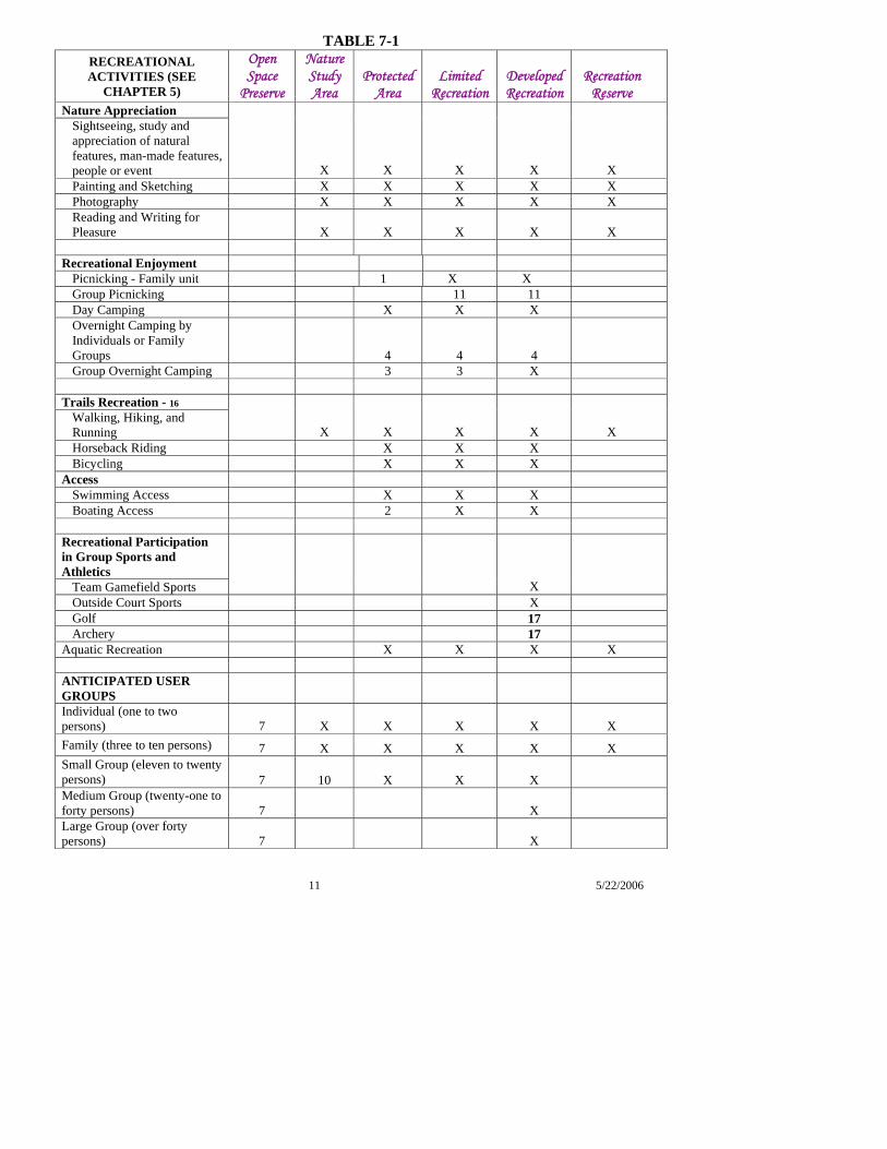
TABLE 7-1
RECREATIONAL ACTIVITIES (SEE
CHAPTER 5)
Open Space
Preserve
Nature Study Area
Protected Area
Limited Recreation
Developed Recreation
Recreation Reserve
Nature Appreciation Sightseeing, study and appreciation of natural features, man-made features, people or event X X X X X Painting and Sketching X X X X X Photography X X X X X Reading and Writing for Pleasure X X X X X
Recreational Enjoyment
Picnicking - Family unit 1 X X Group Picnicking 11 11 Day Camping X X X Overnight Camping by Individuals or Family Groups 4 4 4 Group Overnight Camping 3 3 X
Trails Recreation - 16
Walking, Hiking, and Running X X X X X Horseback Riding X X X Bicycling X X X
Access Swimming Access X X X Boating Access 2 X X
Recreational Participation in Group Sports and Athletics
Team Gamefield Sports X Outside Court Sports X Golf 17 Archery 17
Aquatic Recreation X X X X ANTICIPATED USER GROUPS Individual (one to two persons) 7 X X X X X Family (three to ten persons) 7 X X X X X Small Group (eleven to twenty persons) 7 10 X X X Medium Group (twenty-one to forty persons) 7 X Large Group (over forty persons) 7 X
11 5/22/2006
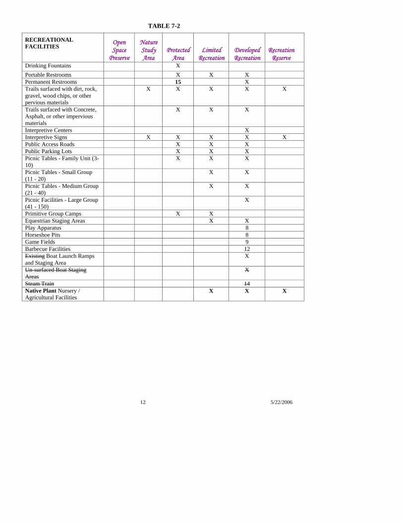
TABLE 7-2
RECREATIONAL FACILITIES
Open Space
Preserve
Nature Study Area
Protected Area
Limited Recreation
Developed Recreation
Recreation Reserve
Drinking Fountains X Portable Restrooms X X X Permanent Restrooms 15 X Trails surfaced with dirt, rock, gravel, wood chips, or other pervious materials
X X X X X
Trails surfaced with Concrete, Asphalt, or other impervious materials
X X X
Interpretive Centers X Interpretive Signs X X X X X Public Access Roads X X X Public Parking Lots X X X Picnic Tables - Family Unit (3-10)
X X X
Picnic Tables - Small Group (11 - 20)
X X
Picnic Tables - Medium Group (21 - 40)
X X
Picnic Facilities - Large Group (41 - 150)
X
Primitive Group Camps X X Equestrian Staging Areas X X Play Apparatus 8 Horseshoe Pits 8 Game Fields 9 Barbecue Facilities 12 Existing Boat Launch Ramps and Staging Area
X
Un-surfaced Boat Staging Areas
X
Steam Train 14
Native Plant Nursery / Agricultural Facilities
X X X
12 5/22/2006
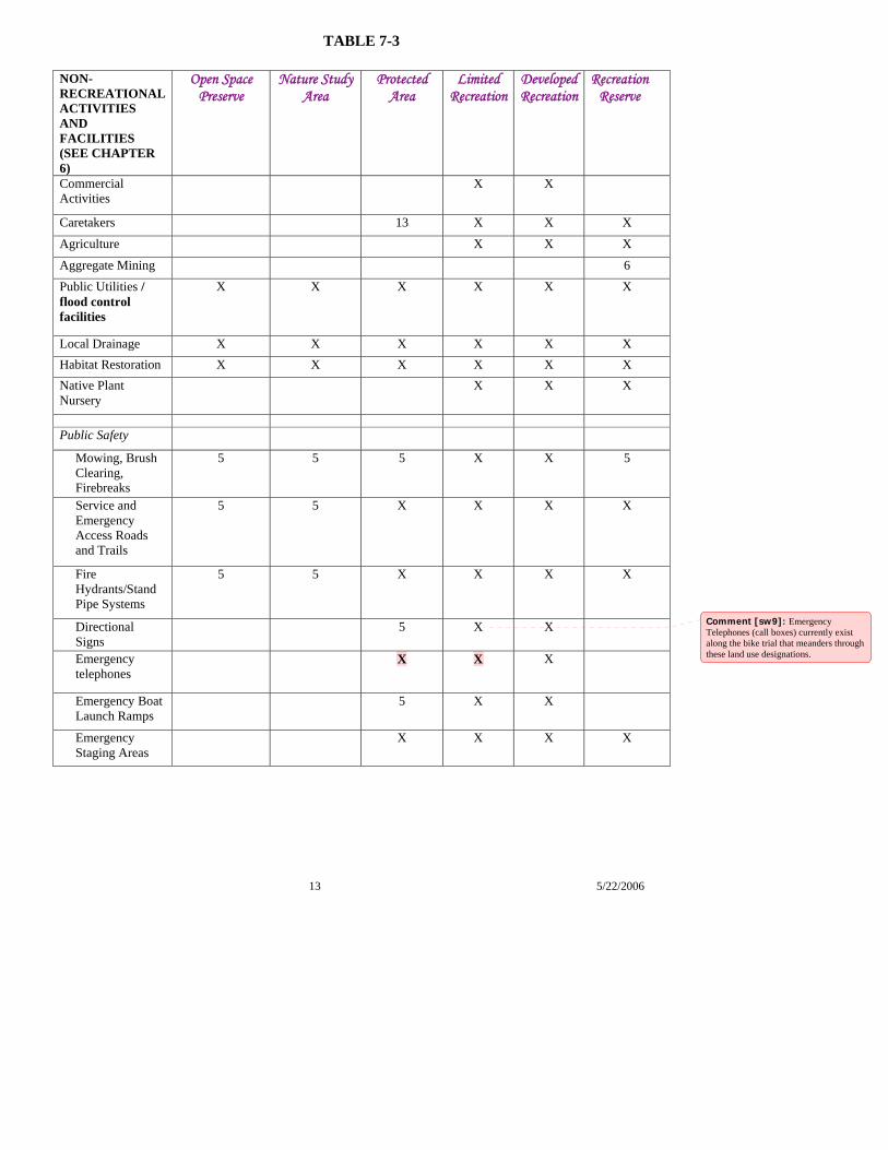
TABLE 7-3
NON-RECREATIONAL ACTIVITIES AND FACILITIES (SEE CHAPTER 6)
Open Space Preserve
Nature Study Area
Protected Area
Limited Recreation
Developed Recreation
Recreation Reserve
Commercial Activities
X X
Caretakers 13 X X X
Agriculture X X X
Aggregate Mining 6 Public Utilities / flood control facilities
X X X X X X
Local Drainage X X X X X X Habitat Restoration X X X X X X Native Plant Nursery
X X X
Public Safety
Mowing, Brush Clearing, Firebreaks
5 5 5 X X 5
Service and Emergency Access Roads and Trails
5 5 X X X X
Fire Hydrants/Stand Pipe Systems
5 5 X X X X
13 5/22/2006
Directional Signs
5 X X
Emergency telephones
X X X
Emergency Boat Launch Ramps
5 X X
Emergency Staging Areas
X X X X
Comment [sw9]: Emergency Telephones (call boxes) currently exist along the bike trial that meanders through these land use designations.
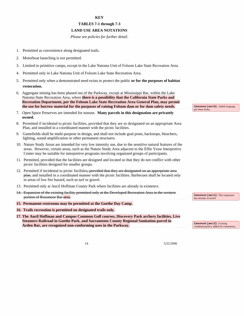
14 5/22/2006
KEY
TABLES 7-1 through 7-3
LAND USE AREA NOTATIONS Please see policies for further detail.
1. Permitted as convenience along designated trails.
2. Motorboat launching is not permitted.
3. Limited to primitive camps, except in the Lake Natoma Unit of Folsom Lake State Recreation Area.
4. Permitted only in Lake Natoma Unit of Folsom Lake State Recreation Area.
5. Permitted only when a demonstrated need exists to protect the public or for the purposes of habitat restoration.
6. Aggregate mining has been phased out of the Parkway, except at Mississippi Bar, within the Lake Natoma State Recreation Area, where there is a possibility that the California State Parks and Recreation Department, per the Folsom Lake State Recreation Area General Plan, may permit the use for borrow material for the purposes of raising Folsom dam or for dam safety needs.
7. Open Space Preserves are intended for nonuse. Many parcels in this designation are privately owned.
8. Permitted if incidental to picnic facilities, provided that they are so designated on an appropriate Area Plan, and installed in a coordinated manner with the picnic facilities.
9. Gamefields shall be multi-purpose in design, and shall not include goal posts, backstops, bleachers, lighting, sound amplification or other permanent structures.
10. Nature Study Areas are intended for very low intensity use, due to the sensitive natural features of the areas. However, certain areas, such as the Nature Study Area adjacent to the Effie Yeaw Interpretive Center may be suitable for interpretive programs involving organized groups of participants.
11. Permitted, provided that the facilities are designed and located so that they do not conflict with other picnic facilities designed for smaller groups.
12. Permitted if incidental to picnic facilities, provided that they are designated on an appropriate area plan, and installed in a coordinated manner with the picnic facilities. Barbecues shall be located only in areas of low fire hazard, such as turf or gravel.
13. Permitted only at Ancil Hoffman County Park where facilities are already in existence.
14. Expansion of the existing facility permitted only at the Developed Recreation Area in the western portion of Rossmoor Bar area.
15. Permanent restrooms may be permitted at the Goethe Day Camp.
16. Trails recreation is permitted on designated trails only.
17. The Ancil Hoffman and Campus Common Golf courses, Discovery Park archery facilities, Live Steamers Railroad in Goethe Park, and Sacramento County Regional Sanitation parcel in Arden Bar, are recognized non-conforming uses in the Parkway.
Comment [sw10]: Added language per State Parks,
Comment [sw11]: This expansion has already occurred.
Comment [sw12]: Existing conditions/policy added for consistency.
1 5/22/2006
CHAPTER 8 PUBLIC ACCESS AND TRAILS
Public access and trails are essential to safely and conveniently bring people from adjacent communities and throughout the region into the Parkway to experience, appreciate and discover the natural values and recreational facilities of the Parkway. This chapter describes the appropriate design, location, and purpose of public access types and trails, and the facilities that support the recreational activities addressed in Chapter 5 – Recreational Use of the Parkway. Trails and access should be designed to protect the Parkway’s valuable natural resources and habitat that can be damaged by heavy human use. The Parkway Plan’s land use designations (discussed in Chapter 7) provide the ability to protect the Parkway’s valuable natural resources and habitat that can be damaged by heavy human use, by directing use away from sensitive resources to areas that are better able to support and sustain greater use. The policies in this chapter work in conjunction with the Parkway’s land use regulations to ensure that access and trails are consistent with the Parkway’s goal to both preserve naturalistic open space and provide for recreational pursuits in a natural environment.
8.0 Public Access
8.1 Public accesses for equestrians, pedestrians, bicyclists, and vehicles are appropriate in all land use categories except in Nature Study Areas, Open Space Preserve Areas, and Recreation Reserve Areas.
8.2 Access points and parking lots shall be located where there is the least potential environmental damage and adverse impact on the Parkway’s environment and surrounding neighborhoods.
8.3 It is the preference of this Plan that jurisdictions adjacent to the Parkway plan for safe and convenient routes on local streets for bicyclist and pedestrians traveling to designated Parkway access points.
8.4 Parkway managers shall encourage walking, bicycling, horseback riding, public transit and boating as forms of transportation to the Parkway. This is particularly important during peak use holidays and weekends to reduce traffic congestion and air pollution. In addition to its importance for recreational activities, the Jedediah Smith Memorial Trail is recognized and shall be maintained as an important bicycle transportation route in the Sacramento region.
8.5 Parking lots and public access roads should be designed and constructed using best management practices to ensure permeability and reduce run-off damage, and buffered by native vegetation plantings. Pavement should be discouraged as a part of new projects.
8.6 New public vehicular roads shall not permit through passage between access points.
8.7 Paved public vehicular roadways for visitor access within the Parkway shall be strictly limited and should be perpendicular to the river rather than parallel to it.
8.8 General public vehicular travel must remain on designated roads.
8.9 Existing unpaved and dirt roadways within the Parkway may be used for maintenance, emergency and management access. Unnecessary roadways shall be restored to a naturalistic condition appropriate to the area.
Comment [slh1]: Suggestions from Lea, per the UCAC direction that staff work with Lea to improve this policy.
Comment [slh2]: UCAC feedback not to use the word structured, because it is not a commonly understood term, instead describe the intention. Added buffers to be consistent with the 1985 plan narrative.
Comment [slh3]: Minor changes to ensure consistent language
2 5/22/2006
Trails
8.10 Three designated, continuous trails for pedestrians, equestrians/hikers, and bicyclists, shall be maintained along the full length of the Parkway.
8.11 Parkway trail connections to other local, regional and State trails shall be designed and located to support bicycle commuting and recreation with minimal damage to the Parkway’s ecosystem.
Equestrian Staging, Boating and Fishing Access
8.12 Equestrian accesses should have unpaved staging areas (trailer loading and unloading) and parking to accommodate horse trailers.
8.13 Boat staging facilities shall be designed to minimize automobile contact with the river, or its immediate shore, in order to reduce visual and noise impacts and pollution of the water. Vehicle parking should be provided near these staging areas.
8.14 The design of the boat ramp facilities should be sensitive to the riparian habitat and features, and take into consideration the hydrology of the area, degree of possible erosion, amount and type of use, and protection of water quality in determining the most effective construction design. Boating access should be designed to minimize impacts on other Parkway users.
8.15 Boat ramp facilities should be designed to minimize dependence on regular, on-going maintenance operations, and avoid activities that would damage the environment in order to remain operational.
8.16 A variety of primitive and developed fishing accesses shall continue to be maintained.
Access for Persons with Disabilities
8.17 All new facilities and renovations or alterations of existing facilities, where applicable for the intended use and access of the facility, shall be accessible to persons with disabilities. Designated entryways for accessible trails shall be installed at several locations throughout the Parkway. All trails designated for persons with disabilities shall be appropriately signed to serve persons with disabilities.
Bridges
8.18 If new bridge crossings are constructed, they shall be designed and located in such a manner as to result in the least negative impact to the Parkway environment, aesthetic values, and natural resources. Bridge crossings should be located within developed recreation or limited recreation areas.
8.19 Bridge crossings should incorporate river themes and the Parkway context into its design and use muted, earth toned colors.
8.20 If new automobile bridges are considered, expanding existing bridge capacity is preferred to
constructing new bridges. If after careful study of all other alternatives, another crossing is required, a map amendment to the locally-adopted area plan shall be required.
Comment [slh4]: Consistent with changed approved by UCAC in Chapter 5 to rename the equestrian trail the equestrian/hiking trail to convey its dual use.
Comment [slh5]: Per UCAC
Comment [sw6]: Added per mtg w/ County disability staff:Cheryl Bennet and John Franklin 5-16-06
Comment [LK7]: UCAC agreed that they wanted to keep the concept of expanding existing capacity first, but they didn’t want to imply that more auto traffic was a fait accompli.
3 5/22/2006
8.21 If new automobile bridges are to be constructed over the American River or existing automobile bridges enlarged, these facilities should provide a path for bicycles and pedestrians that is separated from vehicle lanes and include viewing platforms where appropriate.
8.22 New bridges for bikes, pedestrians, and equestrians may be considered when there is a need to improve Parkway connectivity, circulation and access, and shall require a map amendment to the locally-adopted area plan(s).
Informational and Directional Signage
8.23 Informational and directional signage shall be used to educate visitors about the Parkway’s history, ecology, hydrology and cultural resources, to protect sensitive resources, to recognize Parkway stewardship, and to promote public safety. 8.23.1 Informational signage should alert visitors to avoid sensitive natural resources and
habitat areas, such as redds (gravel areas where salmon bury their eggs).
8.24 Informational and directional signage shall be designed to protect the visual qualities and aesthetic values of the Parkway. Signage shall use natural colors and materials to blend in with the surrounding environment, while being strategically located to be easily seen. Ground pavement stenciling is an effective means of signing with minimal Parkway impact.
8.25 Informational and directional signage shall be placed at strategic trail access points that expressly state the permitted user groups, activities and right-of-way hierarchy. Periodic directional signage shall be placed on the trail between access points.
8.26 Information and directional signage shall incorporate designs to serve persons with disabilities.
8.27 The Parkway manager should partner with surrounding jurisdictions to create a consistent and uniform signage program This program should ensure consistent and uniform signage that improves routing to the Parkway from throughout the Sacramento area.
Public Access Designating Parkway accesses requires balancing environmental preservation and recreational needs. A point by point selection of the types and locations of Parkway entries is illustrated on the Access and Trails Map. They furnish convenient entries for the majority of users and funnel heavy use to areas capable of withstanding such use. Access Types
Five types of access to the Parkway have been provided:
Pedestrian
This access generally leads to hiking trails. Pedestrian accesses are found in five of the six land use categories. All land use excluding Open Space Preserve. Parking is not normally provided.
Comment [slh8]: Minor wording change suggested by County transportation department.
Comment [slh9]: Changed from “signage and wayfinding” throughout
Comment [slh10]: Per UCAC expanded the purposes to include stewardship, public safety and protection of sensitive resources (see 8.20.1)
Comment [slh11]: Per County Disabled Advisory Committee feedback and consistent with Ch. 11 Implementation Measures
4 5/22/2006
Pedestrian and Bicycle
This access leads to pedestrian and bicycle trails. Pedestrian and bicycle access points are found in the Protected, Limited Recreation, and Developed Recreation Areas. Parking is not normally provided.
Equestrian and Pedestrian
This access leads to all types of trails. These are located in Protected, Nature Study, Limited Recreation, and Developed Recreation Areas.
Vehicular and Boating Access
Vehicular access requires parking inside or outside the Parkway. Vehicle access roads are permitted in Developed Recreation, Limited Recreation and Protected areas. Equestrian, pedestrian, and bicycle entry points are also permitted.
Fishing Access
Fishing accesses are found at many locations along the river. Some have vehicle access and some can only be reached by foot. Many anglers prefer the less developed accesses where competition with rafters, swimmers and other recreationists is minimal. Since early mornings and late evenings provide optimal fishing conditions and reduce competition from other users, efforts should be made to ensure that the vehicle accesses are opened early and remain open in the evenings so that anglers can return to their vehicles and exit the Parkway.
Roads, Transit and Staging Areas
To protect natural values and provide maximum recreational opportunities, vehicular travel in the Parkway shall be strictly limited. However, access roads for autos are appropriate to certain fishing and boat launching locations and to Developed Recreation Areas. These roads should be hard-surfaced; constructed with permeable or structured materials; clearly marked, and maintained to restrict vehicles to authorized routes. Permeable and structured materials provide a more porous surface that is able to absorb water, preventing a source for erosion and allows for natural ground water hydrology replenishment. With few exceptions, roads should not permit through passage between access points. Vehicular accesses should be perpendicular to the river rather than parallel to it and roads shall not cut through natural areas or dissect corridors important to wildlife species. The general public must travel on designated roadways.
Some non-public roads are necessary in the Parkway for maintenance, management and emergency access. (See Chapter 9, “Public Safety”). All unnecessary roads shall be eliminated and planted with native vegetation, consistent with the land use designation.
Parking
Parking is provided at all vehicular accesses, either inside or just outside the Parkway. In those instances where parking at pedestrian and bicycle accesses is deemed desirable, the size of the lot shall be limited, and proper design considerations utilized. Parking within the Parkway must be consistent with approved area plans and constructed using best management practices to ensure permeability and reduce run-off damage and buffered by native vegetation plantings. Pavement should be discouraged as a part of new projects.
5 5/22/2006
Equestrian Staging
Designated equestrian staging areas should be provided at several vehicle access points along equestrian trails. These staging areas provide convenient, safe locations for transferring horses in and out of vehicles. The areas should be large enough to permit on-site trailer parking, and should include facilities for tethering and watering horses where possible. Boundaries of the staging areas should be defined by post-and-cable or other similar means. Entrances and exits should be located so that vehicles can drive through without the necessity of turning around. Equestrian staging areas should be unpaved, as horses tend to lose their footing on hard surfaces.
Transit and Non-automobile Transportation
Walking, bicycling, horseback riding, public transit and boating shall be encouraged as forms of transportation to the Parkway. These uses do not require roads and parking and help to reduce traffic congestion and air pollution. This is particularly important during peak use holidays and weekends, when weekend and holiday bus shuttles, utilization of outlying satellite parking, and special bus drop-off and pick-up facilities are needed. Through cooperation with public transportation agencies, auto congestion and overcrowding of certain parking areas can be reduced and access to the Parkway can be enhanced. Special contract shuttle buses currently operate to serve raft rental customers and operate on a seasonal basis. Shuttle operations should continue to occur between the Sunrise Bridge Area and points downstream. It is important that such contracts assure convenient schedules, to encourage patronage and reduce the demand for parking in the high demand areas in the Parkway.
The preferred Downtown-Natomas-Airport (DNA) light rail project includes a crossing of the American River through the Discovery Park area. The approved alignment crosses the Parkway along the Truxel Road alignment. This area includes a most vibrant riparian habitat area, often referred to as the most pristine riparian area in the Parkway. The protection and avoidance of harm to the Parkway’s sensitive habitat shall be of primary concern in the design and construction of the span crossing the Parkway. The alignment shall span the entire Parkway and provide bike/pedestrian access into the Parkway at either levee side. A bicycle/pedestrian bridge should be attached to the rail line’s span and shall not include a station within the Parkway boundaries. A station should be placed adjacent to the Parkway that would provide alternate modes of access to the Parkway.
Boat Staging and Launching
Public boat staging areas are designated at several vehicle access areas along the river. These staging areas provide the opportunity for vehicles to load and unload boats and other equipment near the water. Boat staging facilities should be designed to minimize automobile contact with the river or its immediate shore, in order to reduce pollution of the water. Paved launching ramps accommodate the larger boats which must be trailered, as well as providing less contact between vehicles and water. Currently, boat launches exist in defined locations where the natural substrate and topography allow. In other locations, concrete ramps have been constructed to facilitate ease of access for trailered motorized and non-motorized boats. Concrete ramps also provide ease of
6 5/22/2006
access for car-top boat and inflatable launching by providing direct access to the water and stable footing. The surfaced ramp design is often easier to maintain, however, the more naturalistic unsurfaced ramps are preferred when feasible. The most important issues to consider in determining the most effective construction design are the hydrology of the area, degree of possible erosion, potential sedimentation, ease of maintenance, amount of use, type of use, potential for interaction with other Parkway users, vehicle contact with the river, and protection of water quality.
Some fishing boats on the Lower American River are small enough to be carried from staging areas; launching ramps are not always needed. Care should be taken in the design of boat launching ramps and staging areas to avoid conflicts between vehicles, bicycles and pedestrians on the Parkway and to minimize visual impacts from the river.
Trails
Both the Sacramento County General Plan and this Parkway Plan envision the Parkway as a unit bound together by the river and a system of equestrian, hiking, and bicycle trails. The Parkway trails are key elements in the County, regional, and State trails networks. Access and trails should enhance connectivity within the Parkway and to adjacent communities. Trail connectivity should be assessed to determine if trail segments should be added, consistent with land use designations, to enhance user safety and circulation within the Parkway.
The Access and Trails Map, and the area plan maps illustrate the general location of the equestrian, pedestrian, and bicycle trails. Access and staging facilities are also shown. In staging areas, the trails are necessarily close to one another and should be separated by vegetation or berms when necessary to prevent collisions. The trails may have to be temporarily closed to permit recovery of overused or damaged areas.
The needs of equestrian, pedestrian, and bicycle users cause two kinds of problems that must be considered in designing the trail system:
• Incompatibility among the three recreational trail activities from the standpoint of safety and peace of mind for full aesthetic enjoyment of the Parkway by all trail users; and
• Desired trail surfaces and widths differ for equestrians, pedestrians, and bicyclists.
To solve these problems, it is recommended that the system consist of three designated trails:
Equestrian Trails
Equestrians prefer narrow, scenic trails, with a dirt surface, on varied terrain for day outings. These trails should be six feet wide and kept separate from the pedestrian and bicycle trails to avoid conflicts between horses and other modes of transportation. Hikers and runners are permitted users on the equestrian trails. Equestrian trails can be used to serve several purposes as a trail, maintenance access and fire break. New trail sections should avoid heavily vegetated areas and low floodplain locations subject to frequent inundation.
Pedestrian Trails
The pedestrian trail must meet a wide range of needs including nature-hiking, “noon-hour” jogging loops, and cross-country jogging. Hikers and joggers generally use the pedestrian trail, which is generally adjacent to the bicycle trail, or the equestrian trail. Conflicts may arise between
Comment [AMW12]: Boat ramps would either be surfaced or unsurfaced depending on the type of boat access being provided, amount of use, and best design for the protection of the bank and river quality.
7 5/22/2006
these different modes of recreation as increasing numbers of people use the trails. Locating the pedestrian trail near or adjacent to the bicycle trail enhances user safety, provides greater flexibility for disabled users, and reduces maintenance and patrol burdens. Pedestrian trails can be used to serve several purposes as a trail, maintenance access and fire break. New trail sections should avoid heavily vegetated areas and low floodplain locations subject to frequent inundation.
Separate pedestrian trails should not be paved; instead they should have a natural, compacted surface that is stable, firm and slip resistant. The pedestrian trail should be a minimum of 36” wide, preferably 48” where feasible. In areas where the pedestrian trail cannot be located immediately adjacent to the paved trail, if the separated section is longer than 200’ in length, a 60” by 60” turnaround/passing area is required every 200’ in order to support assistive devices for persons with disabilities.
Bicycle Trails
The bicycle trail is a corridor for Parkway and non-Parkway destinations, providing access for bicyclists and in-line skaters between downtown Sacramento and points east. The Jedediah Smith Memorial Trail (bicycle trail) has become a well established commuter route and vital recreational asset. Bicyclists require wide trails and a smooth surface to accommodate a large number of users, a wide range of speeds (up to 15 mph speed limit), and often, long distances. An all-weather, rubberized asphalt concrete (RAC) surface is preferred.
Off-pavement bicycle use may be permitted at the discretion of the Parkway Manager on existing or reconfigured maintenance and emergency roadways per the conditions listed in Chapter 5 – Recreational Use of the Parkway.
Bicycle Commuting
The Jedediah Smith Memorial Trail’s importance as a bicycle commuter route was recognized by Sacramento County voters in the passage of Measure A in November 2004, which includes $1 million per year for the “American River Parkway/Bikeway Network Improvement Program,” for a 30-year period commencing in 2009. As part of this program Parkway managers will develop a schedule for non-routine maintenance of the trail, such as resurfacing and restriping, to prolong the integrity of the bike trail surface.
The needs of bicycle commuters are somewhat different than those of recreational users of the Parkway. Bicycle commuters often ride the bicycle trail before dawn and after sunset, especially in winter. In addition, bicycle commuters believe the 15 mph speed limit is slow and suggest that enforcement be based on speed that is unsafe for conditions. This Parkway Plan recommends as an implementation measure evaluating the County ordinance restricting bicycle speed to 15 mph on the bike trail. This evaluation should consider the needs of bicycle commuters and potential impacts to other recreational users of the bicycle trail.
To safely use the trail, bicyclists should follow the California Vehicle Code, which requires that bicyclists have a white front light, a rear red reflector, side reflectors front and rear of center and pedal reflectors visible from front and rear.
Comment [slh13]: Al Freitas’ suggestion to be consistent with recreation policy here.
Comment [slh14]: Additional details about the needs of bicycle commuters, drafted with input from Lea Brooks, at the direction of the UCAC to work with Lea to expand this section.
8 5/22/2006
Periodic flooding of the Parkway and bike trail can be an impediment to bicycle commuting. This 2006 update of the Parkway Plan recommends constructing a trail to class 1 construction standards along the north levee from Del Paso Boulevard to the Capital City Freeway, which will improve bicycle commuting options in that area.
When the bike trail is flooded, Parkway managers, working with county and local city transportation staff, post locations of the flooding as quickly as possible on the County Regional Parks Web site (http://www.sacparks.net/), place barriers with signs directing cyclists and other trail users to detours, and notify local cycling groups of the flooding and detours. It is the responsibility of the California Department of Transportation to post signs notifying cyclists to use the shoulders of Interstate 5 when Discovery Park is flooded and to remove debris from the shoulders of the Interstate 5 crossing of Discovery Park for bicyclists.
One of the challenges in responding to Parkway flooding is that conditions often fluctuate, giving the Parkway Manager little warning. Water levels in the river sometimes change dramatically overnight. As a result, early morning bicycle commuters may become aware of flooding at the same time as the Parkway Manager. To address rapidly changing conditions, it is important to give cycling commuters access to the same information the Parkway Manager has. The County Regional Parks Web site in the future will include a link to the State Department of Water Resources web site that lists Lower American River water levels and will include guidance for bicycle commuters to help them interpret whether flooding may be occurring. .
The Parkway Manager should continue to work with the Sacramento City-County Bicycle Advisory Committee and other BACs that advise the jurisdictions within the Parkway regarding maintenance issues and promoting the trail as a safe, convenient and fun transportation route. Access for Persons with Disabilities County Regional Parks is committed to providing access to the Parkway for persons with disabilities. Currently, the Parkway has access for persons with disabilities to the bike trail at several locations and access from a pier to the pond at the William B. Pond recreation area. Motorized assistive devices for persons with disabilities are also permitted on the bicycle trail. In recent years access improvements for persons with disabilities have been made to new and existing restrooms, the new building at the Effie Yeaw Nature Center, and the new Visitor Center at the William B. Bond area.
To continue to improve access for persons with disabilities in the Parkway, parking lots, the bicycle trail, constructed dock facilities, pedestrian pathways including curb ramps and detectable warnings, signage, restrooms, drinking fountains, picnic tables and other permanent public building facilities shall comply with the appropriate provisions as set forth in the California Code of Regulations (CCR) Title 24, Part II, Chapter 11B and Title II of the Americans with Disabilities Act, where applicable. In particular, designated access trails should be installed at several locations within the Parkway in close proximity to public transportation. These trails would provide access for persons with disabilities to have opportunities for a range of recreational experiences, such as access to the river areas, Nature Study Areas, picnic facilities and game fields. Informational and directional signage should be designed to serve persons with disabilities. This Parkway Plan recommends as an implementation measure in
9 5/22/2006
Chapter 11 the development of a Parkway signage plan, which includes investigating alternatives for detectable warnings at points where the pedestrian trail intersects with vehicular traffic. Facility and trail improvements should integrate universal design elements whenever possible so that the Parkway’s diverse recreational opportunities are available to the widest range of people. Bridge crossings of the American River Parkway
The Lower American River, between Folsom Dam and the Sacramento River is crossed by two freeways, nine local thoroughfares, two train bridges, five pedestrian/bicycle bridges, and one dam. The policies of this Plan are intended to provide guidance for careful and thorough consideration of the Parkway’s natural and aesthetic resources when evaluating proposed expansions to existing crossings or new crossings of the river. Proposed bridges that are identified on area plans as of the 2006 Update of the Parkway Plan are conceptual, showing approximate location of proposed bridge crossings and are not intended to dictate a specific alignment. A thorough study should be performed prior to constructing any new crossing to evaluate the impact upon the natural habitat so that the design results in the least impact to the Parkway environment, aesthetic values and natural resources. Evaluation of site conditions, project goals, environmental considerations and alternatives in preparation of detailed site plans will determine the exact alignment. Automobile Bridges In 1979, the voters of Sacramento County eliminated and denied a proposed automobile crossing (Route 143) at the present Harrington and Gristmill access sites. The idea of additional crossings of the river continues to generate considerable debate in the Sacramento community. Each automobile crossing degrades the aesthetic and cultural values of the Parkway, and adversely impacts the recreational user who experiences the effects of the bridge for some distance on either side. Adverse impacts include noise, visual intrusion, pollution, removal and damage of vegetation, degradation of wildlife habitat, and indiscriminate access. Automobile bridges at additional locations will not only further degrade the natural resources and aesthetic values of the American River Parkway, but may cause increased use and congestion on adjacent streets, degrading the quality of life in the vicinity of the Parkway. If new automobile bridges are considered, expanding existing bridge capacity is preferred to constructing new bridges. If after careful study of all other alternatives, which could include a tunnel, another crossing is required, a map amendment to the locally-adopted area plan shall be required. While all crossings can degrade the Parkway in some way, crossings designed for automobiles cause greater impacts than those designed for pedestrians, bicyclists, and equestrians in terms of noise, light, possible litter, quantity of use, duration of use throughout the day and night, and size and scale of the crossing itself. There are currently automobile bridges that do not include separated sidewalks for bike and pedestrian crossing. Whenever possible, these automobile bridges should be retrofitted to include bike and pedestrian crossings with Parkway access.
10 5/22/2006
Non-Automobile Bridges Non-automobile bridge crossings are for bicycles, pedestrians, equestrians or transit. As noted above, non- automobile bridge crossings can have less impact than vehicular bridges in terms of noise, light, possible litter, quantity of use, duration of use throughout the day and night, and size and scale of the crossing itself. Crossings for pedestrian, bikes and equestrian are integral to providing good community access and a well-connected trail system. This is particularly true in areas where the bulk of the Parkway is on one side of the River.
Informational and Directional Signage Signage is an important communication tool to provide Parkway users with directional assistance, educate, interpret and promote stewardship of the Parkway’s natural resources, and improve public safety by informing users about trail etiquette, permitted activities and use regulations Signage can be provided in various forms. For example, pavement stenciling on the bike trail is a more efficient way to communicate with cyclists and other trail users who are constantly in motion. Stenciling also does not require the building of additional structures within the Parkway. Other forms of signage include: kiosks, directional sign posts, access entryways, and trail head boards. Structures should not visually impact the enjoyment and experience of the Parkway. Signage should blend in with the natural environment while being strategically located so that it can be easily seen. Structures shall be constructed with naturalistic materials and colors that blend in with the surrounding landscape and vegetation. They should not include any commercial advertising or lighting. Placement of any signage should be easily accessible to the various types of Parkway users and strategically located along trails and near access points. This Parkway Plan recommends the development of a Parkway signage plan to implement this policy guidance regarding signage purposes, design, and accessibility (see Chapter 11, implementation measures).
1 5/22/2006
CHAPTER 9 PUBLIC SAFETY
The intent of the Public Safety Chapter of this Plan is to establish minimum standards for the provision of safety within the Parkway and for those areas immediately adjacent to it. The issue of safety encompasses many facets of the Parkway, including flood events, law enforcement, and wildfires. The complexity of these issues derive from the American River Parkway’s unique blend of landscapes ranging from developed recreation areas capable of accommodating millions of visits annually, to environmentally sensitive areas that are able to sustain only light visitation. This range of landscapes and associated visitor activities can create unique challenges for public safety. Additionally, wilderness elements of the Parkway that are highly valued by many, often have associated risks. The cold, deceptively swift-moving American River presents challenges for many swimmers, waders, and boaters. Large expanses of open space and dense vegetative cover can create a sense of isolation and insecurity in the minds of many. Valued riverine habitat can certainly provide concealment for a variety of illegal activities. Catastrophic wild land fires not only threaten public safety, but are capable of severely degrading the integrity and species composition of this riparian ecosystem for years to come. Wildlife encounters enjoyed and sought after by many, can be unsettling to others. Threats to public safety, real or perceived, can be a significant barrier to visitation. 9.0 Public Safety
Emergency Vehicle Access 9.1 Emergency vehicle access shall be accommodated at all public vehicle accesses.
Emergency vehicle access to the Parkway may be provided at other locations approved by the County Recreation and Parks Commission and the Fire District having jurisdiction over the site.
9.2 Emergency vehicle access within the Parkway may be provided via parking areas, service roads, levee crowns, equestrian trails, pedestrian trails, bicycle trails, and fire breaks. Service roads shall be interconnected where possible to permit through travel by emergency vehicles only. Levee roads shall have access to lower levels at regular intervals.
9.3 Emergency vehicle access routes shall be capable of supporting the imposed load of emergency vehicles. The routes shall have an unencumbered clear width of 20 feet, have turnarounds at intervals to the satisfaction of the local fire agency, and shall have a vertical clearance of 13 feet, 6 inches.
9.4 Public parking shall be restricted by signs, painted curbs, or physical means so as not to obstruct emergency access or barricades. Illegally parked cars which obstruct emergency access shall be subject to citation or towing.
9.5 Barricades shall be placed to prevent non-emergency vehicles from using trails, service roads, and emergency vehicle access routes. These barricades shall be of post-and-cable type, gate type, or drop-post types, shall have adequate width for emergency apparatus and shall take into account the need to make sharp turns near the gates. Barricades shall be vandal resistant, with locking devices to be
2 5/22/2006
used in locations requiring emergency access. Standard locks shall be consistent with County ordinances for security access.
9.6 Certain non-vehicular water access trails shall be maintained with a minimum of four feet clear width to accommodate hose line extensions in a rapid manner. These designated trails shall be mapped and distributed to fire service agencies as part of an emergency access plan of those agencies.
9.7 Should new motor vehicle bridges be needed within the Parkway for interior Parkway use, these bridges should be constructed to meet the imposed load of emergency fire apparatus.
9.8 Barbecue facilities, fire rings and permanent camp sites shall only be located where an adequate water supply is available or can be transported to, as determined by the responsible fire agency.
Emergency Boat Access 9.9 The design should allow rapid launching from a boat trailer by a two wheel-drive
vehicle at any normal water level. 9.10 Launching ramps which are to be used for emergencies shall be a minimum of 12
feet in width, and have sufficient staging area for maneuvering equipment so that a boat can be launched quickly.
9.11 Launching facilities which are exclusively for emergencies shall be signed and physically restricted to prohibit public use. They shall not be constructed of concrete or another permanent surface that may generate demand for use by the general public. Landing mats or other temporary surfaces may be used where appropriate.
9.12 Public launching and staging areas which may be used for emergency response shall be signed so that access is not blocked by parked vehicles.
9.13 Launching facilities shall be located in proximity to open areas which can be used to land a helicopter for medical purposes.
9.14 Facilities shall be identifiable by water and by air with distinctive, but unobtrusive, markers. Where practical, existing structures or other features shall be used as a reference.
9.15 Installation of launching facilities shall be accomplished with a minimum of grading and minimal removal of riparian vegetation. Steep slopes or areas with inadequate vehicle access should be avoided.
9.16 Locations for emergency launching facilities shall be identified by the fire departments as part of a comprehensive access plan to be approved by the County Recreation and Parks Commission. The access plan should include site plans for each location.
Fire Breaks 9.17 Firebreaks shall be combined with emergency vehicle roads and trails, where
practical, to eliminate unnecessary removal of vegetation. 9.18 Hanging branches or accumulation of dry materials that pose fire hazards may be
trimmed or removed only as necessary as determined by the appropriate fire agency and/or by qualified staff designated by the County Department of
Comment [sw1]: Edited per UCAC 2/28
3 5/22/2006
Regional Parks, to maintain effective fire breaks or remove an immediate hazard. Careful consideration should be given to any pruning of vegetation to prevent fires from spreading from ground level into a crown type fire.
9.19 The responsible fire agency shall determine the width of all fire breaks. 9.20 The need for additional north/south oriented firebreaks shall be considered
when designing new trails or maintenance roads. The appropriate fire agency should be consulted for both the need and the location.
9.21 The visual impact of firebreaks shall be minimized by combining them with other facilities such as roads, trails, parking lots, and turfed areas where feasible.
9.22 Parkway resource managers, designated by the County Department of Regional Parks, shall yearly provide fire department personnel with updated maps that designate high priority natural resources.
Public Use and Access 9.23 Activities such as digging and climbing on the bluffs, which would damage and
cause collapse or sloughing shall be prohibited. These activities shall be citable offenses.
9.24 Access points and parking lots which are accessible to vehicles after dusk must be lit to a minimum lighting level of one foot candle per square foot of surface. All lighting shall be directed away from residential areas and public streets so as not to produce a glare as seen from such areas in order to ensure the general safety of other vehicular traffic and the privacy and well being of the residential areas. Paved parking lots in Discovery and Ancil Hoffman parks and paved parking lots serving Parkway interpretive centers shall meet Sacramento County zoning code lighting standards. All lighting shall be directed away from residential areas and public streets so as not to produce a glare as seen from such areas in order to ensure the general safety of other vehicular traffic and the privacy and well being of the residential areas. Due to the desire to minimize impacts to wildlife from introduced lighting, other parking lots are not subject to the zoning code lighting standards.
9.25 Developed Recreation Areas should provide security landscaping where sightlines are needed for enhanced patrol surveillance, including, but not limited to, low shrubs with a maximum height of 24 inches and trees pruned up to 6 feet.
9.26 Numbered mile markers shall be painted along the bike trail every half-mile to aid public safety agencies in responding to emergencies. The markings should be large enough to be seen from a helicopter.
9.27 Signage shall be properly placed, accurate, and easy to read. Such signage can help ensure that Parkway users are at minimal risk of getting lost or not finding trail heads and parking areas, and inform Parkway users about the importance of courtesy rules.
9.28 Stewardship programs should be encouraged to promote safety, responsible use of Parkway resources, and supplement existing Parkway resources.
9.29 Park resource managers, working in partnership with stewardship groups, shall encourage the development and implementation of measures to help
Comment [sw2]: These and lang. in 9.18 are added policies derived from the narrative, per UCAC 2/28
Comment [sw3]: Staff clarification.
Comment [sw4]: UCAC 2/28
Comment [sw5]: PER UCAC 2/28
4 5/22/2006
transition portions of the Parkway that have been impacted by illegal camping into a more appropriate use of the Parkway.
9.30 Call boxes should continue to be assessed for need, appropriateness and maintained for the public safety benefit of Parkway users.
COORDINATION AMONG PUBLIC SAFETY AGENCIES Interagency coordination and cooperation is important in fulfilling the goal of a safe Parkway. The Sacramento County Park Ranger Unit is responsible for day-to-day patrol and law enforcement within the area of the Parkway from Hazel Avenue to the confluence of the American and Sacramento rivers. The City of Sacramento Police, the City of Rancho Cordova Police, and the Sacramento County Sheriff’s Department have concurrent law enforcement responsibilities within their respective jurisdictions, where those jurisdictions overlap within the Parkway. Other public safety agencies that provide law enforcement within the Parkway on a less frequent basis include the California Department of Fish and Game, the California Highway Patrol, Cal Expo Police and the CSUS Police Department. Additional “eyes and ears” are provided by the American River Parkway Volunteer Equestrian Trail Patrol, a cooperating association. Emergency medical and fire protection is provided by the Sacramento City Fire Department and the Sacramento Metro Fire Department. The Lake Natoma area is under California State Parks jurisdiction and day-to-day patrol services are provided by State Park Rangers. The American River Parkway Safety Coalition was formed to provide a communications link between user groups and law enforcement. An e-mail alert system is in place to pass along crime information on a timely basis to these user groups. The Safety Coalition also sponsors and funds a reward program for crime information on certain crimes committed on the Parkway. Currently all city and county agencies are able to communicate with each other through a countywide radio system. Efforts should be made to include the state agencies within this system as a basic incident response tool where incidents or criminal activities flow from one jurisdiction to another. SAFETY AND SECURITY To provide for Parkway visitor safety, and enforcement of policies and regulations, Parkway patrol resources should be allocated for maximum visibility in areas that are unsafe, or perceived as unsafe. Allied agency collaboration, and augmentation of Sacramento County park ranger efforts should be considered when addressing safety and security issues that exceed the immediate availability of ranger staff resources. Ordinances prohibiting consumption of alcohol and possession of shopping carts have been implemented to target specific problems. Other ordinances may be needed in the future to address safety and security issues.
5 5/22/2006
Illegal campsites are occasionally found in riparian forest and woodlands throughout the Parkway, but illegal camping is especially common in the westerly five mile reach from Discovery Park to Cal Expo with the largest concentration in the area of the Highway 160 crossing of the American River. This heavy concentration of illegal camping is due, in part, to the close proximity of homeless service providers to this area of the Parkway adjacent to Highway 160. Illegal campers undermine Parkway visitor’s sense of security and safety. Vegetative clearing and trampling, and harvesting woody materials for cover or firewood, cause disturbances to vegetation in and around illegal campsites. These disturbances, including litter and debris, alter the structure and function of the riparian woodlands, and may affect plant establishment, impact recreational experiences, degrade water quality, and discourage wildlife from using otherwise suitable habitat The presence of this unpredictable population undermines other Parkway visitors’ sense of security and safety. Significant efforts are underway to address illegal camping in the Parkway. Since 1999, the County Park Ranger Unit has participated in the Public Safety Sub-committee of the Sacramento County and Cities Board on Homelessness Task Force to address the problems and possible solutions to the illegal camping issue with the other members of this committee. Beginning in 2001 a County Regional Parks’ illegal camping detail has been assigned to address illegal camping and its impacts in the Parkway. In fiscal year 2005/2006 County Regional Parks budgeted for three park rangers, one park maintenance worker and three full time equivalents of park ranger assistant and park maintenance assistant to patrol and clean up the area affected by illegal camping. County Park rangers, in coordination with other appropriate agencies, will continue as necessary to enforce rules and educate users about the impacts of illegal camping in the Parkway. This Parkway Plan provides for enhanced recreation and trailheads to encourage more eyes in and on the Parkway from legitimate users such as bicyclists, walkers, and other recreationalists. Stewardship programs can also be an important tool in helping to transition impacted portions of the Parkway into a more actively used greenspace. Additionally, in December 2005 the Sacramento City Council and the Sacramento County Board of Supervisors adopted a ten year plan to address the problem of chronic homelessness, focusing on development of housing units as a general response to the homelessness issue. EMERGENCY VEHICLE AND BOAT ACCESS Effective law enforcement and fire protection in the Parkway are dependent upon quick response time, which in turn is dependent upon adequate access. However, the Parkway is a limited access recreation area and the design of the roads within the Parkway is intended to discourage motor vehicle use as a recreational activity. In order to accomplish the conflicting objectives of limiting public vehicle access and facilitating emergency vehicle access, it is necessary to designate emergency and service routes in some areas which are closed to public vehicle use.
6 5/22/2006
It is also important that the boat patrol have access facilities for launching, evacuation and response to water-related emergencies. FIRE BREAKS Fire breaks are used to provide a protective separation between structures and grassland, and to divide large areas of open grassland, dense brush and trees. These fire breaks reduce fire danger to neighboring properties and protect Parkway resources. Fire breaks are created by disking or clear-cutting vegetation to reduce the fuel supply. These open swaths are viewed by some as detractions from the natural beauty, yet they can save many acres from unsightly fire damage. These two factors must be balanced in making decisions regarding firebreaks in the Parkway. The Parkway encompasses many old growth groves of oak and other native flora, as well as numerous restoration and habitat mitigation areas of significant value. Aside from the intrinsic values that native riparian habitats possess, habitat restoration and mitigation projects represent significant long-term monetary investments. The ability to protect and save these valuable resources from catastrophic loss is directly related to the knowledge level of responding fire department personnel. The Parkway plan provides for distribution of information to firefighters to inform them of particularly valued and sensitive habitats so that their response and strategy for fire prevention and suppression can strive to minimize impact on those areas. Firefighters may occasionally need to fall large trees in order to be able to put a fire completely out. Blowing embers from an upright smoldering tree can ignite multiple fires in other locations. Other methods in lieu of felling trees, should be encouraged and explored if the tree is not severely burned and can survive. Ranger personnel are responsible for assisting firefighters in assessing conditions and possible solutions under these circumstances. Prescribed burns provide a mechanism to manage both invasive non-native plants and fuel loads. Prescribed burns in the spring can be used to lessen the threat of large vegetation damaging fires that would occur later in the summer. Both the fire agencies and County Regional Parks have an interest in using prescribed burning as a tool to protect and enhance the Parkway. The availability of water for fire suppression is important in limiting the size and severity of fires on the Parkway. Restoration projects that include bringing in a water supply should be designed so that overhead irrigation is available in case of a fire. Fire hydrants for refilling the fire department’s grass rigs should be considered as well. BLUFF AREAS Some areas of the Parkway contain very steep terrain. In areas along the river, adjacent to Fair Oaks, that terrain is almost vertical. Measures should be taken to protect these
7 5/22/2006
and other bluffs from activities such as digging and climbing, which damage them and cause collapse or sloughing. Steps should also be taken to reduce the possibility of people falling from such surfaces. The action plan section of this Plan (Chapter 11) includes suggested measures pertaining to bluff regulations. SAFE USE OF TRAILS Trail safety is encouraged through the use of County ordinances and trail courtesy rules. Signage is located at trail access points along the Parkway with a listing of ordinances and trail courtesy rules. The Jedediah Smith Bicycle Trail Courtesy Guide includes ordinances and rules as well as safety tips and is available from the County Regional Parks Department. Efforts should be made to continue public outreach to trail user groups to educate users about the ordinance and rules that encourage safe trail use.
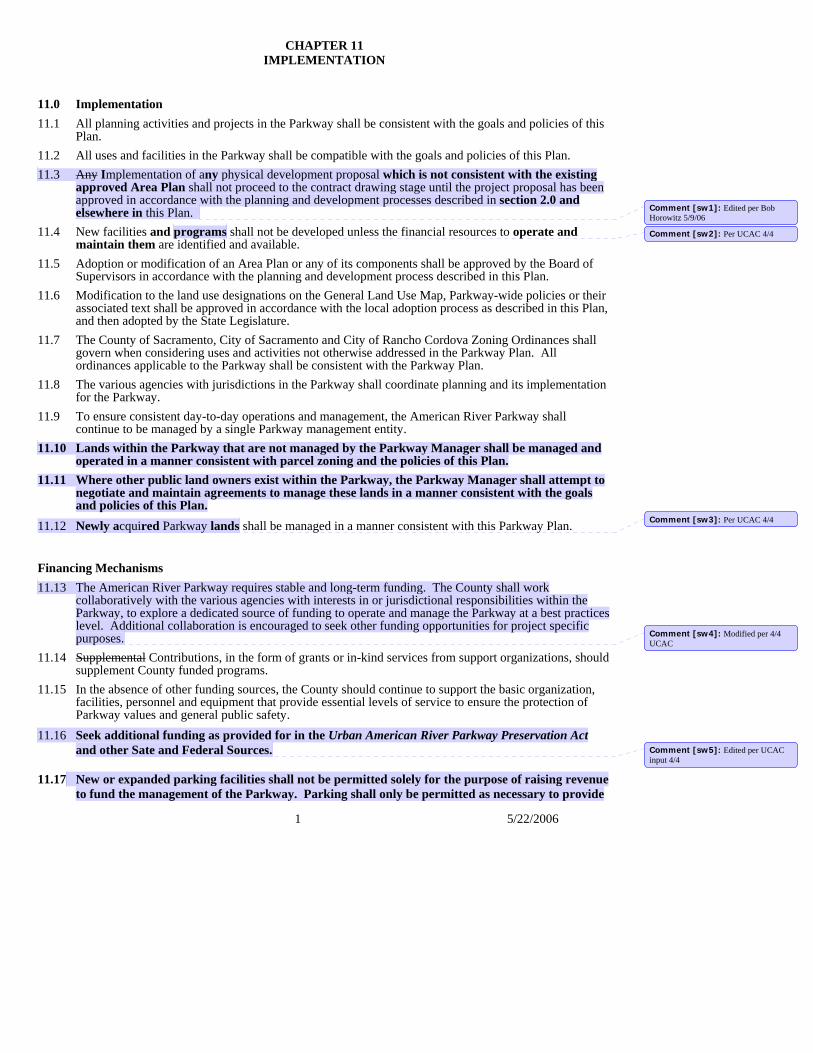
1 5/22/2006
CHAPTER 11 IMPLEMENTATION
11.0 Implementation 11.1 All planning activities and projects in the Parkway shall be consistent with the goals and policies of this
Plan. 11.2 All uses and facilities in the Parkway shall be compatible with the goals and policies of this Plan. 11.3 Any Implementation of any physical development proposal which is not consistent with the existing
approved Area Plan shall not proceed to the contract drawing stage until the project proposal has been approved in accordance with the planning and development processes described in section 2.0 and elsewhere in this Plan.
11.4 New facilities and programs shall not be developed unless the financial resources to operate and maintain them are identified and available.
11.5 Adoption or modification of an Area Plan or any of its components shall be approved by the Board of Supervisors in accordance with the planning and development process described in this Plan.
11.6 Modification to the land use designations on the General Land Use Map, Parkway-wide policies or their associated text shall be approved in accordance with the local adoption process as described in this Plan, and then adopted by the State Legislature.
11.7 The County of Sacramento, City of Sacramento and City of Rancho Cordova Zoning Ordinances shall govern when considering uses and activities not otherwise addressed in the Parkway Plan. All ordinances applicable to the Parkway shall be consistent with the Parkway Plan.
11.8 The various agencies with jurisdictions in the Parkway shall coordinate planning and its implementation for the Parkway.
11.9 To ensure consistent day-to-day operations and management, the American River Parkway shall continue to be managed by a single Parkway management entity.
11.10 Lands within the Parkway that are not managed by the Parkway Manager shall be managed and operated in a manner consistent with parcel zoning and the policies of this Plan.
11.11 Where other public land owners exist within the Parkway, the Parkway Manager shall attempt to negotiate and maintain agreements to manage these lands in a manner consistent with the goals and policies of this Plan.
11.12 Newly acquired Parkway lands shall be managed in a manner consistent with this Parkway Plan.
Financing Mechanisms 11.13 The American River Parkway requires stable and long-term funding. The County shall work
collaboratively with the various agencies with interests in or jurisdictional responsibilities within the Parkway, to explore a dedicated source of funding to operate and manage the Parkway at a best practices level. Additional collaboration is encouraged to seek other funding opportunities for project specific purposes.
11.14 Supplemental Contributions, in the form of grants or in-kind services from support organizations, should supplement County funded programs.
11.15 In the absence of other funding sources, the County should continue to support the basic organization, facilities, personnel and equipment that provide essential levels of service to ensure the protection of Parkway values and general public safety.
11.16 Seek additional funding as provided for in the Urban American River Parkway Preservation Act and other Sate and Federal Sources.
11.17 New or expanded parking facilities shall not be permitted solely for the purpose of raising revenue
to fund the management of the Parkway. Parking shall only be permitted as necessary to provide
Comment [sw1]: Edited per Bob Horowitz 5/9/06
Comment [sw2]: Per UCAC 4/4
Comment [sw3]: Per UCAC 4/4
Comment [sw4]: Modified per 4/4 UCAC
Comment [sw5]: Edited per UCAC input 4/4
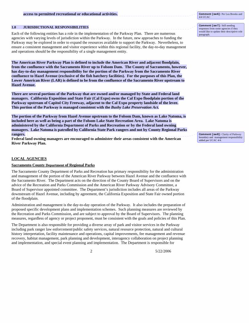
2 5/22/2006
access to permitted recreational or educational activities. 1.0 JURISDICTIONAL RESPONSIBILITIES
Each of the following entities has a role in the implementation of the Parkway Plan. There are numerous agencies with varying levels of jurisdiction within the Parkway. In the future, new approaches to funding the Parkway may be explored in order to expand the resources available to support the Parkway. Nevertheless, to ensure a consistent management and visitor experience within this regional facility, the day-to-day management and operations should be the responsibility of a single management entity.
The American River Parkway Plan is defined to include the American River and adjacent floodplain, from the confluence with the Sacramento River up to Folsom Dam. The County of Sacramento, however, has day-to-day management responsibility for the portion of the Parkway from the Sacramento River confluence to Hazel Avenue (exclusive of the fish hatchery facilities). For the purposes of this Plan, the Lower American River (LAR) is defined to be from the confluence of the Sacramento River upstream to Hazel Avenue. There are several portions of the Parkway that are owned and/or managed by State and Federal land managers. California Exposition and State Fair (Cal Expo) owns the Cal Expo floodplain portion of the Parkway upstream of Capitol City Freeway, adjacent to the Cal Expo property landside of the levee. This portion of the Parkway is managed consistent with the Bushy Lake Preservation Act. The portion of the Parkway from Hazel Avenue upstream to the Folsom Dam, known as Lake Natoma, is included here as well as being a part of the Folsom Lake State Recreation Area. Lake Natoma is administered by the California Department of Parks and Recreation or by the Federal land owning managers. Lake Natoma is patrolled by California State Park rangers and not by County Regional Parks rangers. Federal land owning managers are encouraged to administer their areas consistent with the American River Parkway Plan.
LOCAL AGENCIES
Sacramento County Department of Regional Parks The Sacramento County Department of Parks and Recreation has primary responsibility for the administration and management of the portion of the American River Parkway between Hazel Avenue and the confluence with the Sacramento River. The Department acts on the direction of the County Board of Supervisors and on the advice of the Recreation and Parks Commission and the American River Parkway Advisory Committee, a Board of Supervisor appointed committee. The Department’s jurisdiction includes all areas of the Parkway downstream of Hazel Avenue, including by agreement, the California Exposition and State Fair owned portion of the floodplain.
Administration and management is the day-to-day operation of the Parkway. It also includes the preparation of proposed specific development plans and implementation schemes. Such planning measures are reviewed by the Recreation and Parks Commission, and are subject to approval by the Board of Supervisors. The planning measures, regardless of agency or project proponent, must be consistent with the goals and policies of this Plan.
The Department is also responsible for providing a diverse array of park and visitor services in the Parkway including park ranger law enforcement/public safety services, natural resource protection, natural and cultural history interpretation, facility maintenance and operations, capital improvements, fee management and revenue recovery, habitat management, park planning and development, interagency collaboration on project planning and implementation, and special event planning and implementation. The Department is responsible for
Comment [sw6]: Per Lea Brooks and 4/4 UCAC
Comment [sw7]: Still needing responses from some agencies if they would like to update their descriptive role paragraph.
Comment [sw8]: Clarity of Parkway boundary and management responsibility added per UCAC 4/4.
3 5/22/2006
providing comment and recommendations on issues of adjacent projects that may impact the Parkway. The Department administers and implements the vision and policy directives of the American River Parkway Plan.
Sacramento County Planning and Community Development Department The Sacramento County Planning Department’s primary responsibility is to aid in the development and monitoring of long-range policies for the Parkway. The Department is also responsible for the administration of land, policy and development review for properties within or adjacent to the Parkway, or those which could have an effect upon the Parkway.
Sacramento County Sheriff’s DepartmentThe Sacramento County Sheriff is responsible for providing public safety services and public protection for the unincorporated portion of the Parkway, in cooperation with the Sacramento County Regional Parks Department and City police departments.
City of Sacramento Planning and Building Department The responsibility of the City of Sacramento Planning Department is to administer land use policy and development review within its jurisdiction in a manner which is consistent with the City’s Parkway Overlay Zone, General Plan, and the adopted Parkway Plan policies.
City of Rancho Cordova Planning and Building Department
The responsibility of the City of Rancho Cordova Planning Department is to administer land use policy and development review within its jurisdiction in a manner which is consistent with the City’s Parkway Corridor Combining Zone, General Plan, and the adopted Parkway Plan policies.
City of Sacramento Police Department
The Sacramento City Police Department is responsible for providing public safety services and public protection for that portion of the Parkway which is within the Sacramento City limits and in cooperation with the Sacramento County Regional Parks Department.
City of Rancho Cordova Police Department The Rancho Cordova City Police Department is responsible for providing public safety services and public protection for that portion of the Parkway which is within the Rancho Cordova City limits and in cooperation with the Sacramento County Regional Parks Department.
Local Fire Districts
Folsom City Fire Department
Sacramento City Fire Department
Sacramento Metropolitan Fire District
The responsibility of the fire service agencies is to provide fire protection and related emergency services to the portions of the Parkway within their respective jurisdictions.
4 5/22/2006
Flood Control Agencies
American River Flood Control District (ARFCD)
California State Department of Water Resources
Reclamation District 1000
Sacramento Area Flood Control Agency (SAFCA)
Sacramento County Department of Water Resources
State Reclamation Board
These agencies are responsible for flood control along the river. The State Reclamation Board is the state agency with primary responsibility for flood control over all levees and any development within the river floodway that might affect flood flows. Although it is administratively under the State Department of Water Resources, the Board has jurisdiction over the Department of Water Resources. The American River Flood Control District (ARFC) is responsible for the vast majority of levees, with the County having responsibility for a few private levees that are not a part of the Federal flood control system. The Sacramento Area Flood Control Agency (SAFCA) is a regional flood control agency responsible for planning and funding regional flood control projects and does not provide any direct operations and maintenance on the levees. Although they have assumed operations and maintenance responsibility for some levee improvements they constructed in the North Area, they have contracted with ARFCD to do the actual work.
Reclamation District 1000 Reclamation District 1000’s jurisdiction regarding the American River Parkway consists of inspecting and maintaining the right bank levee of Steelhead Creek (formerly, the Natomas East Main Drainage Canal) from its point of entry into the Parkway near Northgate Boulevard, continuing westward (beneath a portion of the Garden Highway) to the point of discharge into the Sacramento River at the Discovery Park boat launching ramp basin. The portion of Steelhead Creek which is located within the Parkway is commonly called Bannon Slough.
Sacramento Area Flood Control Agency (SAFCA)
SAFCA is a regional joint powers agency comprised of the County of Sacramento, the City of Sacramento, the American River Flood Control District, Reclamation District 1000, and the County of Sutter. SAFCA’s mission is to work cooperatively with the U. S. Army Corps of Engineers, the U. S. Bureau of Reclamation, the California Reclamation Board, and the State Department of Water Resources to plan and implement improvements to the portions of the Sacramento River and American River flood control systems protecting the Sacramento Area. SAFCA is legislatively mandated to carry out its flood control mission in ways that provide for the optimum protection of the environment.
STATE AGENCIES California Department of Fish and Game The State Department of Fish and Game has two primary responsibilities. The first is the enforcement of State hunting and fishing regulations. The second responsibility is the maintenance of anadromous fish populations. This responsibility is accomplished in a variety of ways such as enforcing spawning closures, holding jurisdiction over streambed alteration and operating two fish hatcheries. The fish hatchery at Nimbus Dam is funded by the Bureau of Reclamation specifically for fish replacement within the American River.
5 5/22/2006
The Mission of the California Department of Fish and Game is to manage California's diverse fish, wildlife, and plant resources, and the habitats upon which they depend, for their ecological values and for their use and enjoyment by the public. The Department of Fish and Game maintains native fish, wildlife, plant species and natural communities for their intrinsic and ecological value and their benefits to people. This includes habitat protection and maintenance in a sufficient amount and quality to ensure the survival of all species and natural communities. Within the Parkway, Fish and Game Wardens enforce State hunting and fishing regulations. The Department is also responsible for the maintenance of anadromous fish populations. This responsibility is accomplished in a variety of ways, such as protecting salmon and steelhead trout spawning areas, coordinating water releases from Nimbus Dam, making improvements to fish spawning habitat, and operating Salmon and Steelhead trout hatcheries. The fish hatchery at Nimbus Dam is funded by the Bureau of Reclamation specifically for fish propagation within the American River. The Department of Fish and Game works with the various floodway maintaining agencies and County Regional Parks where stream alteration projects fall within the jurisdiction of the Fish and Game Code.
California Department of Parks and Recreation
The California Department of Parks and Recreation (California State Parks) manages those portions of the Parkway that extend eastward from Hazel Avenue along Lake Natoma to Folsom Dam and Reservoir. Much of the land along Lake Natoma is owned by the federal government and administered by the U.S. Bureau of Reclamation (Reclamation). The Gold Fields District of California State Parks manages the recreation use and resources of these lands as part of Folsom Lake State Recreation Area through an agreement with Reclamation. Lake Natoma is a sub-unit of Folsom Lake State Recreation Area. The Folsom Powerhouse State Historic Park is a separate park unit located along Lake Natoma which also administered by California State Parks.
California Department of Transportation The California Department of Transportation (Caltrans) maintains jurisdiction and responsibility for the State highways which cross the Parkway.
California Exposition and State Fair (Cal Expo) The Bushy Lake Preservation Act designates Bushy Lake and its surroundings as a Natural Preserve, in order to preserve such features as rare or endangered plant and animal species and their supporting ecosystems, and representative examples of plant and animal communities existing in California prior to the impact of civilization.” The Board of Directors of the California Exposition and State Fair is responsible for preparing and adopting a management plan for the floodplain area of the State Fair property. This management plan must comply with all applicable Federal and State laws and policies such as the Federal and State Wild and Scenic Rivers Acts, Federal Endangered Species Act, Federal Wetlands Preservation Policy, the California Environmental Quality Act (CEQA), and the Bushy Lake Preservation Act.
The remainder of the Cal Expo floodplain is to be managed as a State park, in order to “...preserve outstanding natural, scenic, and cultural values, indigenous aquatic and terrestrial fauna and flora...” Improvements which are attractions in themselves, or which are otherwise available to the public within a reasonable distance outside the park, are not permitted.
The Cal Expo Board is responsible for assuring that no changes are made in the uses of the Cal Expo floodplain until the Board has adopted a plan in accordance with all of the above indicated Federal and State laws and policies.
6 5/22/2006
California Exposition and State Fair Police Department
The California Exposition and State Fair Police Department is responsible for providing public safety services and public protection for that portion of the Parkway which is owned by Cal Expo and in cooperation with the Sacramento County Regional Parks Department.
California State Lands Commission (Public Resources Code 6301-6314) The State acquired sovereign ownership of all tidelands and submerged lands and beds of navigable waterways upon its admission to the United States in 1850. The State holds these lands for the benefit of all the people of the State for statewide Public Trust purposes, which include waterborne commerce, navigation, fisheries, water-related recreation, habitat preservation, and open space. The landward boundaries of the State’s sovereign interests in areas that are subject to tidal action are generally based upon the ordinary high water marks of these waterways as they last naturally existed. In non-tidal navigable waterways, the State holds a fee ownership in the bed of the waterway between the two ordinary low water marks as they last naturally existed. The entire non-tidal navigable waterway between the ordinary high water marks is subject to the Public Trust. The State’s sovereign interests are under the jurisdiction of the State Lands Commission. The Lower American River is navigable from Nimbus Dam to the confluence with the Sacramento River therefore is subject to the Public Trust and permitting/leasing jurisdiction. The State Lands Commission is responsible for issuing permits for all development affecting the river bottom.
Central Valley Regional Water Quality Control Board
The Central Valley Regional Water Quality Control Board has jurisdiction over maintenance of the quality of the water in the Lower American River. The Board is responsible for issuing requirements and regulating the discharge of waste; both directly into the river and into groundwater which may ultimately reach the river. The Board is also responsible for enforcing its regulations. Enforcement can be by cease and desist orders, clean-up and abatement orders, and by court action. The Regional Board is also responsible for surveillance. It must monitor to detect new sources of pollution as well as ensure that on-going discharges meet their requirements.
State Water Resources Control Board The State Water Resources Control Board has overall responsibility for the administration of water rights and for water quality control in California. As such, it is the primary permitting agency for the appropriation of water from the American River. The State Board also acts as general overseer and reviewer of the actions of the Regional Water Quality Control Boards. FEDERAL AGENCIESAttorney General, State of California The Attorney General, State of California has jurisdiction for the determination of whether any violations of the State Wild and Scenic Rivers Act occur.
U.S. Department of the Interior and the National Park Service The National Park Service (NPS), working under the U.S. Department of the Interior, has jurisdiction for the determination of whether any violations of the Federal Wild and Scenic Rivers Act occur. The primary role of the National Park Service is to ensure that the protections under Section 7(a) of the Wild and Scenic Rivers Act, regarding the protection of Wild and Scenic Rivers from the harmful effects of proposed water resources projects, are consistently applied on these rivers.
Typically, projects subject to Section 7(a) will be triggered by a permit issued by the Army Corps of
7 5/22/2006
Engineers under Section 404 of the Clean Water Act or Section 10 of the Rivers and Harbors Act. Section 7(a) may also be triggered when a project is identified as impacting a designated WSR in the CA Department of Fish and Game's Lake and Streambed Alteration (1601) permit application.
U.S. Army Corps of Engineers (Corps)
The American River is a designated navigable waterway. As such, the U.S. Army Corps of Engineers has jurisdiction and is a permitting authority for any development or activity which may affect the river’s floodway. The Corps sets operation and maintenance standards and performs levee inspections within the floodway. The Corps frequently implements flood damage reduction construction projects in the floodway and thus has a need to implement environmental mitigation for these projects in the Parkway. U.S. Bureau of Reclamation The U.S. Bureau of Reclamation, which operates both the Folsom and Nimbus dams, is responsible for maintaining adequate water flows through the Parkway. Releases are scheduled in accordance with criteria to minimize impacts to the fishery, flooding, and erosion within the Parkway. U.S. Fish and Wildlife Service The Fish and Wildlife Service has jurisdiction over species in the Parkway (except anadromous fish) that are listed pursuant to the Federal Endangered Species Act. National Marine Fisheries Service/NOAA Fisheries The National Marine Fisheries Service has jurisdiction over listed anadromous fish (some salmon runs and steelhead). COMMUNITY INVOLVEMENT Volunteer Stewardship
Volunteerism is a very important component of the on-going efforts to protect and restore the Parkway’s naturalistic values, maintain it in a healthy and safe condition, explore alternative funding opportunities, and to create a greater understanding and sense of awareness of the value of this outstanding natural and recreational resource to the community. These “stewards” of the Parkway provide important services while building support for the Parkway and its values in the community. While the number of individuals and organizations assisting in these efforts is numerous, there are several that have been key to the Parkway’s success (listed below). The Parkway manager should continue to build cooperative relationships and coordinate efforts to improve public safety with Parkway user groups and other non-governmental organizations interested in supporting the Parkway.
The American River Natural History Association (ARNHA) is a non-profit volunteer organization that supports the Effie Yeaw Nature Center through fundraising, volunteer and docent activities to promote, aid and augment the educational activities of the Center.
The American River Parkway Foundation (ARPF) is a fundraising organization that provides support for the preservation, protection, and enhancement of the American River Parkway by restoring habitat, improving public safety, and increasing public stewardship. Fundraising and maintenance activities include Down River Day, Adopt-the-Parkway Program and the Great American River Clean-up.
The American River Parkway Volunteer Equestrian Trail Patrol founded in 1995, serves as additional “eyes
8 5/22/2006
and ears” of the Parkway. The specific and primary purpose of the organization is to provide assistance to the public by conducting mounted equestrian patrols along the American River Parkway trails.
The National Audobon Society, through its Sacramento Chapter organized in 1950, has participated in all planning processes of the Parkway Plan and is an advocate for its protection, especially its natural values. In the 1950’s, with the newly formed River Recreation and Parks Association, Audobon proposed a plan for the formation of the American River Parkway to the Sacramento County Board of Supervisors and the Sacramento City Council. This began the establishment of Parkway specific organizations supporting the creation of an American River Parkway. Audobon promoted and assisted in the initial drafting of the Urban American River Parkway Preservation Act as approved by the State legislature. Audobon also leads many interpretive field trips for the public in the Parkway.
Save the American River Association (SARA) was founded in 1961 to spearhead the establishment of the American River Parkway. SARA is an advocacy group that works to protect the American River and its associated Parkway through the sustainable use of the Lower American River.
In addition, County Regional Parks and its partners have secured funding for non-native plant removal through a variety of grant sources in recent years. The long-term management of these reclaimed areas and the establishment of replacement, self-sustaining native plant communities in these impacted areas, is supported by successful volunteer stewardship programs. These programs include the Sacramento Weed Warriors, a program of the California Native Plant Society, who work under the auspices of the American River Parkway Foundation. Future grant funding, supported by strong volunteer stewardship, will be key to the long-term success of the non-native plant removal efforts.
2.0 PLANNING AND DEVELOPMENT PROCESS
This American River Parkway Plan is a policy document and a component of the Sacramento County General Plan and is incorporated by reference in the General Plans of the Cities of Rancho Cordova and Sacramento. Its purpose is to guide the planning, protection, and use of the Parkway. In order to translate this plan into programs and physical improvements, it is essential that a logical process be followed, progressing from the general to the specific. The pertinent documents and their respective roles in this process are described in Figure 11-1, which is a schematic representation of this process. Where required, environmental documentation will be prepared.
Sacramento County General Plan Land Use Map and Text The Sacramento County General Plan, adopted by the Sacramento County Board of Supervisors, guides the general land use and development of Sacramento County. The Parkway Plan is a component of the General Plan. Amendments to the Parkway Plan must be consistent with the General Plan when considering activities or facilities deemed to have a County-wide impact. American River Parkway Plan General Land Use Map and TextThe Parkway Plan translates the County General Plan into a more detailed plan which is specific to the American River Parkway. The Parkway Plan is adopted and amended by the Sacramento County Board of Supervisors and is adopted by reference by the State Legislature through the Urban American River Parkway Preservation Act. The Parkway Plan General Land Use Map separates the Parkway into six general land use designations, and illustratively identifies locations of trails, access, and other improvements. The Land Use chapter of this text, which is the major working component of this Plan, describes acceptable activities and facilities in the Parkway. This chapter identifies the appropriate land use designations in which these uses may be permitted, provided that they are consistent with the area plans. The Land Use chapter shall be consulted first in determining consistency with the Parkway Plan.
Comment [sw9]: Per UCAC 4/4
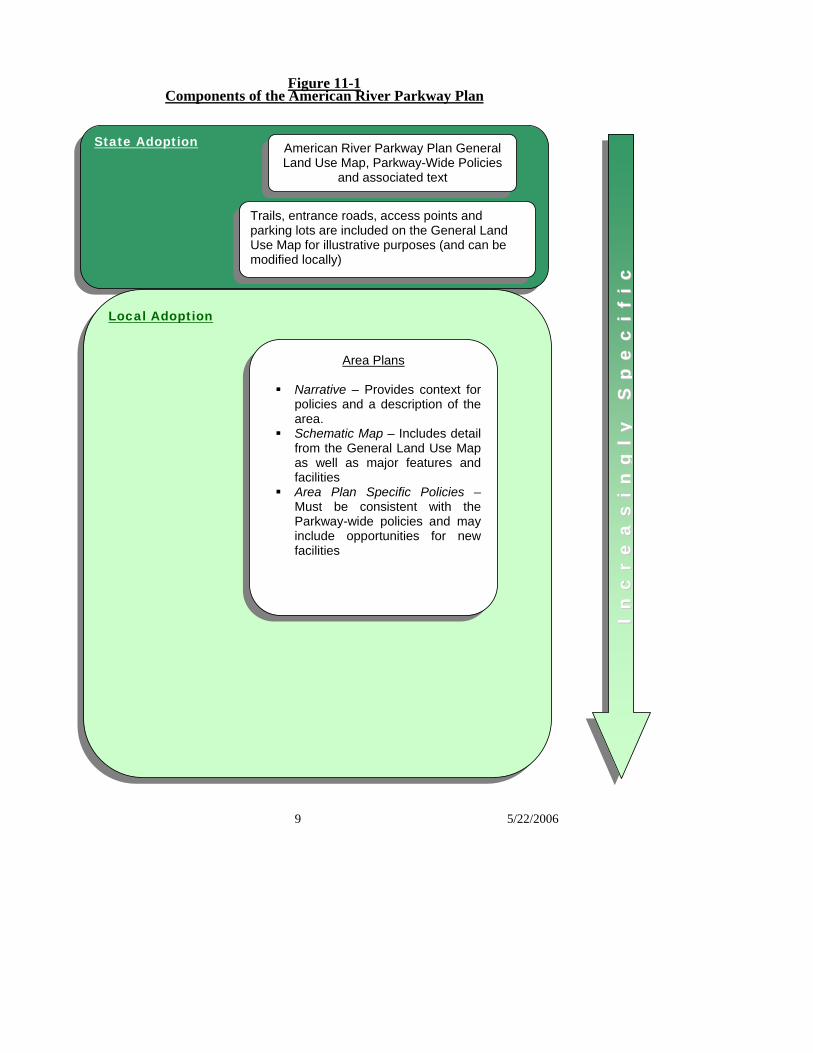
9 5/22/2006
Figure 11-1 Components of the American River Parkway Plan
IInn
ccrr
eeaa
ssii
nngg
llyy
SS
ppee
ccii
ffii
cc
State Adoption American River Parkway Plan General Land Use Map, Parkway-Wide Policies
and associated text
Local Adoption
Trails, entrance roads, access points and parking lots are included on the General Land Use Map for illustrative purposes (and can be modified locally)
Area Plans
Narrative – Provides context for policies and a description of the area.
Schematic Map – Includes detail from the General Land Use Map as well as major features and facilities
Area Plan Specific Policies – Must be consistent with the Parkway-wide policies and may include opportunities for new facilities
10 5/22/2006
Parkway Plan Goals and PoliciesThe goals and policies of this Plan provide a long range conceptual framework for the Parkway Plan. The purpose of the goals and Parkway-wide policies is to define the intent of this Plan in the protection, planning, and use of the Parkway. The goals and Parkway-wide policies are particularly useful when it becomes necessary to analyze an issue which is not specifically addressed in the Plan. When such an issue arises, it should be considered in light of these goals and policies.
Area Plans An area plan has been prepared for each of the recognized sub-units of the Parkway Plan. These plans are more detailed than the General Land Use Map and describe activities and facilities permitted within their boundaries. Each activity and facility must be consistent with the general land use designations described in the Plan text, and no facility or improvement may be installed or constructed unless consistent with its respective area plan. The area plans must be reviewed in determining the appropriateness of a physical change in the Parkway. The land use designations on the General Land Use Map, Parkway-wide policies and associated text are adopted by the State Legislature, whereas the area plans, text and area plan specific policies are adopted and managed at the local level. Area plan modifications may be approved at the local level as long as all changes remain consistent with the General Land Use Map, land use designations, Parkway-wide policies and the associated text that describes the intent of those policies. If an area plan is proposed that would modify a land use or alter an area plan policy that would then be inconsistent with a Parkway-wide policy, these modifications are required to be approved through the local adoption process and the State Legislature. There are two components of an area plan. The first component is the narrative description and area plan-specific policies, which identify the location, boundaries, natural and man-made features, general purpose of the area, opportunities and constraints for use, and many of the permitted and prohibited activities and facilities. The second component of an area plan is the schematic land use map that shows general locations of facilities and natural features, such as picnic areas, recreational facilities, parking areas, access location and type, trees and shrubs. The schematic land use map may not show precise locations or size of structures, but may indicate approximate acreages to be devoted to each general use. Depending upon the intensity of facility development and use, an area plan may be prepared at a more specific level. For instance, Sacramento Bar is largely in the Nature Study and Protected Area land use designations, and needs little additional detail unless a specific change is proposed. Ancil Hoffman Park, on the other hand, is an intensely developed, frequently used park, which warrants a more detailed schematic map to address the uses in the area. Updating Area Plans Adoption or modification of an area plan or any of its components shall be determined to be consistent with the County General Plan, Parkway goals, Parkway-wide policies, and general land use designations of this Parkway Plan. Adoption or modification of an area plan or any of its components shall be carried out by the Board of Supervisors in accordance with the public hearing process described in this Chapter. Any Implementation of any physical development proposal which is not consistent with the existing approved Area Plan shall not proceed to the contract drawing stage until the project proposal has been approved in accordance with the planning and development processes described in this Plan. If the project proposal is inconsistent with either the locally adopted area plans or the land use designations on the General Land Use map or the Parkway-wide policies, the appropriate planning, approval and adoption process must first occur. In addition to the area plans the Parkway Manager may prepare studies and specific site plans. A vegetation management plan, for example, may want to increase the level of detail for all vegetative species, their size, approximate age, and state of health. A facilities or recreation focused map may indicate the precise location size, and configuration of the facilities and significant natural features within the area plan. Elevation and perspective drawings may be incorporated into maps as well to illustrate the scale or appearance of a proposed facility. Additional maps may be created consistent with the area plan maps, to be used for interpretive, educational or management purposes.
Comment [sw10]: Edited per Bob H, matched policy 11.3
11 5/22/2006
Contract Drawings (Working Drawings) Contract drawings provide the details of the area development plan which control construction and provide the basis for contract bidding. Contract drawings are reviewed by Department of Regional Parks staff and the Department of County Engineering and are approved by the Recreation and Parks Commission prior to authorizing construction. These drawings must be substantially in conformance with adopted area plans. ConstructionConstruction of authorized projects may be done by the Department of Regional Parks for small force account projects, by other Municipal Services Agency departments, by private contractors, or by other agencies in coordination with the Department of Regional Parks. Projects distributed for bid by private contractors must be authorized by the Board of Supervisors. The Board awards bids and approves contracts. Except for small force account projects or landscape projects under $25,000, project inspection is the responsibility of the Department of County Engineering. Project acceptance is the responsibility of the Board of Supervisors upon the recommendation of the Department of County Engineering. Mitigation of Project Impacts Mitigation is defined as any project-related action taken to minimize or avoid an impact to the physical environment, or any action designed to replace, repair, or restore a resource that was physically affected by a project. Construction projects on the Parkway should be designed to first, avoid adverse environmental impacts; second, minimize adverse environmental impacts; and third, replace, repair, or restore adversely impacted resources as close as feasible in time and place to the impact. Impacts are defined as any physical change to the environment, including but not limited to aesthetics, recreational facilities and access points, water quality, soils, and all biological resources, such as native and non-native vegetation, aquatic habitat, fisheries, and special-status species. Noise, air quality (including fugitive dust), artificial lighting, and other impacts associated with construction activities are also considered to be impacts to avoid, minimize, and mitigate. Zoning The County of Sacramento, City of Sacramento and City of Rancho Cordova all have specific zoning ordinances regulating uses in and around the American River Parkway. The City of Rancho Cordova currently uses the County Parkway Corridor combining zone designation.
The County zoning ordinance is the Parkway Corridor (PC) Combining Zone. This zone is used in combination with the base zones to regulate the use of public and private property in the Parkway and on adjacent lands. The PC combining zone is intended to regulate uses that may affect the stability of bluffs or terraces, or that may have an impact on the preservation or enhancement of scenic, recreational, fishery, or wildlife values along or near the American River. Some of the development aspects that may be evaluated and conditioned include the project’s setback, bulk, footprint, height, finish materials, and colors; all landscaping elements including lighting, noise, fencing, screening, fire buffers, and disruption to natural vegetation; and all issues related to erosion control including irrigation and drainage. Some projects are reviewed and approved at the staff level by County Planning with input from County Regional Parks and for more significant projects by the County Parks Commission. If a project is not approved at the staff level, the applicant may submit an application for a conditional use permit. In addition, certain projects (such as those within the erosion zones or within certain setbacks in an erosion zone, a project affecting a bluff, or a project creating new lots) require approval of a conditional use permit from the Planning Commission. The decision of the Planning Commission may be appealed to the County Board of Supervisors.
12 5/22/2006
The Sacramento City Zoning Ordinance regulates properties in the American River Parkway. The ARP-F base zone serves a similar function as the County zoning ordinance in that it contains special development standards for all construction and a use permit requirement for most uses. The City of Sacramento Parkway Corridor Overlay Zone regulates land under the City’s jurisdiction adjacent to but outside of the Parkway boundary. The ordinance regulates building setbacks, heights, screening, exterior site and building features, and some of the operational aspects of allowed uses. It also contains a list of prohibited uses. The American River Parkway-Floodplain (ARP-F) zone regulates land within the Parkway boundary for the purposes of public safety. The County and Cities zoning ordinances were adopted to complement the Parkway Plan. These zoning ordinances must be considered for properties regulated by these zones when evaluating uses and activities in and adjacent to the Parkway. Administrative RegulationsThe administrative regulations address the day-to-day details of Parkway management, consistent with this Plan. The administrative regulations direct appropriate courses of action for activities such as group events, special events, ranger patrols and permit fees, and should include mechanisms for implementing County ordinances affecting the Parkway. These regulations are developed and administered by the Director of the Sacramento County Regional Parks Department, and may be reviewed by the Board of Supervisors for consistency with the Parkway Plan. 3.0 PUBLIC HEARING PROCESS The public hearing process provides the forum for considering changes to the Parkway in a manner consistent with these guiding principles. Several public entities and their roles in the process are described below. County of Sacramento Regional Parks DepartmentThe County of Sacramento Parks and Recreation Department is responsible for managing the activities in the Parkway and protecting its facilities and natural environment. The Department is also responsible for planning the physical changes to the Parkway in accordance with this Plan. The Director is responsible for formulating recommendations to the Recreation and Parks Commission, and is the technical staff to all public hearing bodies in matters relating to management of the Parkway. The Director may assign members of staff to assist or represent him or her at public hearings. County of Sacramento Planning and Community Development DepartmentThe County of Sacramento Planning Department is responsible for developing recommendations on zoning and policy issues affecting land or waters within or adjacent to the Parkway. The Planning Director is responsible for making recommendations to the County Planning Commission, and is technical staff for policy issues. The Planning Director communicates with the County Regional Parks Director in developing recommendations for the Parkway, and may present these recommendations directly to the County Recreation and Parks Commission if the two Directors determine this course of action to be the most expedient, otherwise all presentations to the Recreation and Parks Commission are made by the Parks and Recreation Director or the Director’s designee. The Planning Director may assign members of staff to assist or represent the Director at public hearings. County of Sacramento Recreation and Parks CommissionThe County of Sacramento Recreation and Parks Commission is appointed by the Board of Supervisors to advise the Board of Supervisors and the Parks and Recreation Director on matters relating to parks and recreation in Sacramento County. All matters pertaining to the planning, policies and management of the Parkway are first heard by the Recreation and Parks Commission before being transmitted to the Board of
Supervisors. The recommendations of this commission are included in the transmittal. The Recreation and Parks Commission holds regular meetings which are open to the public and the schedule and agendas are available from the Parks and Recreation Department.
13 5/22/2006
County of Sacramento Policy Planning Commission The County of Sacramento Policy Planning Commission is appointed by the Board of Supervisors. All matter related to policy interpretation or amendments to this Plan are transmitted from the Recreation and Parks Commission to the Policy Planning Commission for recommendation to the Board of Supervisors. The Policy Planning Commission may meet in joint session with the Recreation and Parks Commission if the two hearing bodies so choose. County of Sacramento Board of Supervisors The County of Sacramento Board of Supervisors is a governing board elected by the voters of Sacramento County. The Board is the ultimate local authority for all matters related to the planning and management of the Parkway, unless otherwise indicated by this Plan. The Board of Supervisors meets regularly in public session, all decisions of the Board are final, and may be overturned only by an appropriate court of law. Area plan maps, text and policies may be modified locally as long as they remain consistent with the State adopted sections of the Plan. City of Sacramento Planning CommissionWhen a private project proposal is within the Sacramento City limits or would have implications within the City boundaries, the recommendations of the County Recreation and Parks Commission are transmitted to the City Planning Commission simultaneously with the transmittal to the County Policy Planning Commission. The City Planning Commission coordinates with the County prior to transmitting their recommendations to the City Council. City of Sacramento City Council
The City of Sacramento City Council is the decision making body for determining private project proposal consistency with the City’s Comprehensive Zoning Ordinance including properties within and adjacent to the American River Parkway-Floodplain (ARP-F) and American River Parkway Overlay zones. After recommendation by the City Planning Commission, the City Council may forward their comments to the County Board of Supervisors.
City of Rancho Cordova City Council The City of Rancho Cordova City Council is the decision making body for determining private project proposal consistency with the City’s Parkway Corridor Combining Zone. After recommendation by the City Planning Commission, the City Council may forward their comments to the County Board of Supervisors California State Legislature The legislature adopts the American River Parkway Plan by reference through the Urban American River Parkway Preservation (UARP) Act, so as to provide coordination with local agencies in the protection and management of the diverse and valuable natural land, water, native wildlife and vegetation of the American River Parkway. The American River Parkway Plan was introduced to the State Legislature in order to afford the Parkway a higher level of regulatory support. The act recognizes that “actions undertaken by a state agency can drastically affect the American River Parkway and negate planning steps taken by appropriate local agencies.” It is the intent of this Plan to have the land use designations on the General Land Use Map, Parkway-wide policies and their associated text, to be adopted by the State Legislature. Any changes to those sections of the Plan must be approved locally, prior to approval of the State and a legal change to this Plan. Area plan maps,
text and policies may be modified locally as long as they remain consistent with the State adopted sections of the Plan.
14 5/22/2006
Public NotificationsAny proposed project within the Parkway which is inconsistent with the goals and policies or land use designations of this Plan, shall require an amendment to this Plan and is subject to public notification as required by State law. Subsequent changes to local General Plans or the County and City’s Zoning Ordinance must also be presented at designated General Plan amendment hearings. Actions which are consistent with this Plan do not require special public notice, but must be clearly posted on published agendas for the Commissions, City Council and the Board of Supervisors in order for action to be taken.
4.0 COUNTY DEPARTMENT OF REGIONAL PARKS – PERMIT PROCESS FOR THE PARKWAY
Recreation Permit Process The following is a brief description of when a recreation permit would be required and what is entailed in acquiring a recreation permit. Permit conditions for some activities are included in this Plan, such as in policy 5.9 addressing overnight camping and in Implementation Measure 5b below addressing bicycle parking and refuse recycling at special events. Recreation permit requirements are regulated by Sacramento County Ordinance (SCO). Park Regulations are contained in Chapter 9.36 of the SCO and contain language that makes it a requirement to obtain a permit before conducting certain activities. Examples of activities requiring a permit include:
• Special and/or competitive events • Camping • Sound application equipment • Concessions (Subject to Board of Supervisors approval of a concession contract) • Appropriation or encumbrance of real property • Campfires • Facility use/ reservations
In order to obtain a permit, an application must be filed with the Department of Regional Parks. An applicant must successfully demonstrate that the proposed activity is consistent with the standards for permit issuance. At a minimum, the application will request the information required by ordinance. The approved permit will also include conditions of use specific to the activity and park site requested, to ensure consistency with the application requirements. This Parkway Plan includes additional conditions necessary in the permit application process for Parkway specific activities. Depending on the nature of the activity, it is either subject to the approval of the Department of Regional Parks Director only, or in some cases the Board of Supervisors. Permits are generally valid for the day of the event/activity, although in some cases 2-3 day permits are necessary if the event/activity requires set up and take down of ancillary facilities needed to support the event. The requirements for issuing a permit are listed in SCO Section 9.36.021 Permit, Standards for
15 5/22/2006
Issuance, This section allows the director of County Regional Parks to issue a permit if the proposed activity does not interfere or detract from enjoyment of the park, does not incite disorderly conduct or violence, does not entail unusual or burdensome expense or security, and does not create user conflicts. Other requirements may be included depending upon the park site, intensity/type of use, or other factors determined necessary in the safe and effective management of the County Regional Parks system. Capital Improvement and Construction Proposals Capital improvement and construction proposals are often of a large scale and may include projects proposed by Sacramento County or other agencies. Project proponents would typically contact Regional Parks Department staff to discuss the nature and scope of the proposed project as it relates to Parks Department lands and interests. A project description could be very conceptual or it could include detailed plans, specifications, and construction drawings. The project proposal is evaluated by Regional Parks staff to determine consistency with the American River Parkway Plan. In some cases, that determination is done in consultation with the County Department of Planning and Community Development. The American River Parkway Plan does not preclude these types of projects from occurring in the Parkway, as long as the naturalistic values, goals and policies of the Plan are not compromised, and the impact to the Parkway environment and its users is minimized and appropriately mitigated. Project proponents are responsible for determining approval authorities, permit requirements, and right-of-way needs for access, staging, and construction. A large construction project (i.e. transportation, utility infrastructure, etc.) might be of such scope and scale that it exceeds the Regional Parks Director’s authority for approval. Such projects are subject to approval by the Board of Supervisors, with recommendations for conditions from the Regional Parks Department, the Recreation and Parks Commission, the Municipal Services Agency, and the Department of Environmental Review and Assessment. Real estate issues related to access and construction easements are negotiated by County Real Estate staff (in consultation with County Regional Parks staff) and are subject to approval by the Board of Supervisors. Other state and federal permits may be required for projects within the floodplain. These agencies can include, but are not limited to the California Department of Fish and Game, State Reclamation Board, local flood control and levee maintenance districts, NOAA Fisheries, U.S. Fish and Wildlife Service, and the U.S. Army Corps of Engineers. Prior to issuing an encroachment permit to allow access and construction, Regional Parks staff meets with project planners, engineers, project environmental staff, construction management, construction contractors, and building inspection personnel to finalize arrangements to accommodate construction activities. County Regional Parks issues encroachment permits on the condition that all other required permits have been obtained by the project proponent. Project proposals are typically presented by the project proponent to neighborhood organizations representing community interests in the vicinity of the project footprint, Parkway stakeholder groups, the American River Parkway Advisory Committee, the Lower American River Task Force, and the Recreation and Parks Commission. Final project approval is subject to public hearings before the Board of Supervisors.
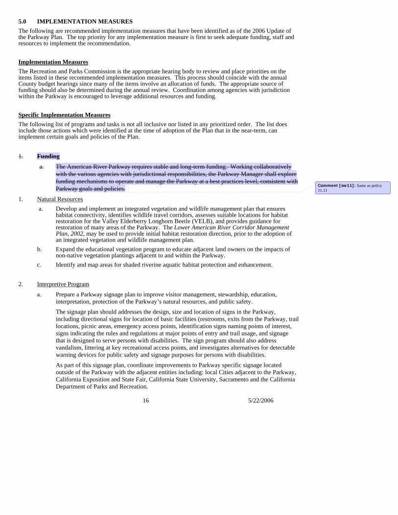
5.0 IMPLEMENTATION MEASURES
16 5/22/2006
The following are recommended implementation measures that have been identified as of the 2006 Update of the Parkway Plan. The top priority for any implementation measure is first to seek adequate funding, staff and resources to implement the recommendation. Implementation MeasuresThe Recreation and Parks Commission is the appropriate hearing body to review and place priorities on the items listed in these recommended implementation measures. This process should coincide with the annual County budget hearings since many of the items involve an allocation of funds. The appropriate source of funding should also be determined during the annual review. Coordination among agencies with jurisdiction within the Parkway is encouraged to leverage additional resources and funding. Specific Implementation MeasuresThe following list of programs and tasks is not all inclusive nor listed in any prioritized order. The list does include those actions which were identified at the time of adoption of the Plan that in the near-term, can implement certain goals and policies of the Plan.
1. Funding
a. The American River Parkway requires stable and long-term funding. Working collaboratively with the various agencies with jurisdictional responsibilities, the Parkway Manager shall explore funding mechanisms to operate and manage the Parkway at a best practices level, consistent with Parkway goals and policies.
1. Natural Resources a. Develop and implement an integrated vegetation and wildlife management plan that ensures
habitat connectivity, identifies wildlife travel corridors, assesses suitable locations for habitat restoration for the Valley Elderberry Longhorn Beetle (VELB), and provides guidance for restoration of many areas of the Parkway. The Lower American River Corridor Management Plan, 2002, may be used to provide initial habitat restoration direction, prior to the adoption of an integrated vegetation and wildlife management plan.
b. Expand the educational vegetation program to educate adjacent land owners on the impacts of non-native vegetation plantings adjacent to and within the Parkway.
c. Identify and map areas for shaded riverine aquatic habitat protection and enhancement.
2. Interpretive Program
a. Prepare a Parkway signage plan to improve visitor management, stewardship, education, interpretation, protection of the Parkway’s natural resources, and public safety.
The signage plan should addresses the design, size and location of signs in the Parkway, including directional signs for location of basic facilities (restrooms, exits from the Parkway, trail locations, picnic areas, emergency access points, identification signs naming points of interest, signs indicating the rules and regulations at major points of entry and trail usage, and signage that is designed to serve persons with disabilities. The sign program should also address vandalism, littering at key recreational access points, and investigates alternatives for detectable warning devices for public safety and signage purposes for persons with disabilities.
As part of this signage plan, coordinate improvements to Parkway specific signage located outside of the Parkway with the adjacent entities including: local Cities adjacent to the Parkway, California Exposition and State Fair, California State University, Sacramento and the California Department of Parks and Recreation.
Comment [sw11]: Same as policy 11.11
17 5/22/2006
b. Maintain a comprehensive interpretive/education plan to identify the types and locations of exhibits and nature trails necessary to interpret all currently recognized ecosystems and the three periods of history presented in the Parkway. The Effie Yeaw Nature Center should continue to be a central point for exhibits, library and naturalist services. Minor interpretive facilities, such as outdoor classrooms, should be pursued as identified in the Discovery Park and Cal Expo area plans to expand interpretive opportunities.
c. Continue to inventory and research the Parkway’s ecosystems. County Regional Parks has collaborated with UC Davis and California State University, Sacramento on research and survey projects. Special continuing effort should be made to study the legally designated rare, threatened and endangered species that inhabit the Parkway. Presentations of the findings from the Parkway research projects and surveys are educational and should be offered as educational programs to the public. Additionally, information from the surveys should be compiled and made available to the public at a nominal cost.
d. The Parks Department should have a public relations program that can perform the following duties: • Act as liaison with radio, television and the press to assure favorable and interesting features
that help protect the Parkway, • Promote programs, special events and public education within the Parkway, • Create public service announcements, and • Promote higher visibility about the Parkway with placement of signs along roadways and
bridges. For example, a sign placed on the Watt Ave. Bridge could announce that you are now crossing the American River Parkway.
• Promote Parkway stewardship and education of natural resource enhancement and protection. e. Continue to conduct workshops through the year to provide on-going Parkway educational
programs for the public. Local schools and colleges should be encouraged to use the Parkway for research and teaching and to share their results with the County staff. School districts should be encouraged to use the Parkway as an outdoor classroom. The Parks Department should work with the Sacramento County Office of Education to find a way to inform teachers that Parkway specific handbooks are available to assist educators in leading nature walks and teaching the geology, human impact on the land, plant life, wildlife and ecosystems of the Parkway. Numerous publications are available to aid educators wishing to use the American River Parkway as an educational resource.
f. Assess and monitor the ability of sensitive cultural and natural features to endure impacts from interpretive activities, and impose access conditions or restrictions by permit, as needed to ensure the long-term protection and preservation of those features.
g. Assess the suitability of areas dominated by dredge tailings for interpretive education, habitat restoration or other uses consistent with Parkway policies.
3. Erosion Control
a. Develop an educational program for the public about using proper irrigation, surface drainage and native vegetation, to help control erosion on the bluffs.
4. Commercial Activities
a. Update and formalize a procedure for the analysis of proposed commercial activity in developed recreation areas, including the following steps: • Review the approved recreational activities in the area. • Identify whether commercial activities are desired to facilitate these recreational
activities.
Comment [sw12]: Staff revised per UCAC input
18 5/22/2006
• Determine whether adequate facilities or services exist either within the Parkway or nearby and outside of the Parkway, to meet these desires.
• Determine whether the commercial activity will detrimentally affect Parkway users who are not being provided the service.
• If facilities or services are not adequate, determine the level of need. • If need is significant and verifiable, determine whether the commercial activity should be
County-operated or operated by concession. • Develop a proposal. • Continue with the standard approved Planning and Building process.
b. Assess the need and feasibility of developing a fee and permit schedule for commercial uses of the Parkway, including commercial fishing guide operations.
5. Recreational Use
a. Develop a monitoring program to ensure the Parkway’s sensitive cultural and natural resources are not being degraded or negatively impacted by recreational uses. Acquire funding and complete an analysis of trail or site locations, design elements, natural buffers, and locations of sensitive habitat types that can be used to monitor and manage all new and currently permitted recreational uses. The breadth of analysis will be in proportion to the potential impacts upon the Parkway's sensitive cultural and natural resources, other permitted Parkway users, and in relation to the additional facilities needed to serve new or expanded recreational use.
b. Promote and designate bicycle parking areas and include a condition to require recycling collection services, in permits for large special events.
c. Acquire funding and then complete an analysis of trail locations, design elements, natural buffers, and locations of sensitive habitat types that can be used to monitor and manage an off-paved trail cycling program.
d. Evaluate the needs for and the feasibility of facility locations for restrooms, potable water and refuse/recycling collections to serve in-stream recreational users between Sunrise Avenue and Goethe Park.
e. Evaluate the County ordinance restricting bicycle speed to 15 mph on the bike trail. This evaluation should consider the needs of bicycle commuters, potential impacts to other recreational users, safety of use for all recreationists on the bicycle trail, and trail design.
6. Public Safetya. Prepare a plan to address reducing the number and width of emergency access and service
roadways where they are determined to be in excess of what is needed for public safety and Parkway management.
b. Adopt an ordinance prohibiting climbing and digging on the bluffs, and making it a citable offense.
c. Maintain and provide vegetation resources maps to local fire departments highlighting those resources that are protected and should be avoided in the course of fire-fighting.
d. Coordinate with the City of Sacramento to improve public safety surrounding the 20th Street Bikeway access to the Parkway on the south side of the river.
e. Continue visible enforcement of existing park regulations and coordinate with existing public service organizations to heighten awareness of the negative impacts of illegal camping on public safety and the environment.
Comment [sw13]: This would implement policy 2.4 Added per Janel S. input.
Comment [sw14]: Edited per UCAC input 4/06
7.
19 5/22/2006
Land Acquisition a. Pursue land acquisition of privately owned lands within the Parkway. Priority land includes:
• Lands immediately upstream of Discovery Park,
• Bluffs adjacent to Effie Yeaw Nature Center in Ancil Hoffman County Park.
8. Zoning
a. Amend the zoning maps of Sacramento County, City of Sacramento, andCity of Rancho Cordova, and future Cities, with an American River Parkway zoning designation, to specifically recognize the lands that fall within the official Parkway Plan boundaries.
6.0 EXPENDITURES AND FUNDING The American River Parkway requires stable and long-term funding for the Parkway Manager to properly operate and manage the Parkway. Dependence upon the County General Fund as the primary source of funding has created budget impacts affecting program implementation, adequate levels of staffing and, at its worst, threats of Parkway closure. Therefore, it is important for the various agencies with jurisdictional responsibilities within the Parkway to work cooperatively to explore funding mechanisms to operate and manage the Parkway at a best management practices level.
Best management practices (BMP’s) do not guarantee success rather they describe the optimal strategy, implementation method and tactics known in order to achieve success. BMPs can include schedules of activities, prohibition of practices, educational practices, maintenance procedures, and other management practices. The use of BMPs is encouraged for Parkway management activities including but not limited to visitor management, public safety, construction and maintenance of facilities, habitat restoration, and floodway management, so long as these practices do not conflict with the other goals and policies of the Parkway Plan.
The adoption of the Parkway Plan by the State of California through the Urban American River Parkway Preservation Act, provides another an important mechanism through which to seek State funding assistance. in the recognition of the State-wide resource that the Parkway has been afforded. Adoption of the act provides the necessary recognition so that local planning efforts are eligible to receive planning grants through the Land and Water Conservation Fund, technical staff assistance through the National Park Service, and financial assistance through the Soil Conservations Service’s Cooperative River Basin Planning Program. Expenditures Funds for the Parkway come from a variety of sources. They are budgeted into two major categories: capital outlay and operations. Funds for capital outlay are available through County General Fund allocations, the Transient Occupancy Tax (TOT), State and Federal subvention programs (grants), State and local bond issues approved by the voters and private donations.
In the 2005-2006 budget over $6,700,000 in annual operations costs was budgeted to the Parkway. Although partially offset by revenues, funding is a major concern if the Parkway is to grow and thrive in future years.
Operating funds are allocated from the General Fund through the budget process. These funds come from property taxes, park use fees, reimbursements from other departments, rent or lease fees, and, through subventions, grants, or donations.
The 2000 American River Parkway Financial Needs Study (updated in 2006) was written to establish a comprehensive framework for identifying funding and maintenance needs for the American River Parkway. To accomplish this goal, a comparison was made between Parkway levels of operations and maintenance and best management practice levels of comparable services in similar parks. The comparison was determined by surveying similar park systems and establishing financial benchmarks as
Comment [sw15]: Added per UCAC input 4/4
20 5/22/2006
the basis for identifying ways to close gaps in the Parkway operating budget and other established needs. The study also evaluated remaining acquisition areas and related costs, as well as capital improvement needs, including major deferred maintenance.
Development of Facilities
Much of the development of recreational facilities on the Parkway has been completed. The area plans for parks and recreation areas, as shown in this document, identify both existing and future development. No time table is proposed for specific developments. A master plan titled “Project 2000: A Master Plan” was adopted by the County Board of Supervisors in 1987. Funding Because of the dollar resources necessary to operate and maintain the Parkway, it is important to consider the impact of any future development project on the cost of maintenance and operations.
In order to guarantee protection of the Parkway resources, the Board of Supervisors must take an active and positive interest in funding. Fees must be continued, not only because of revenues generated, but because of the lessened vandalism and depreciative behavior in areas where fees are charged.
The Board should also set a level of subsidy it is willing to commit to the Parkway from General Fund monies, or determine an alternative source of guaranteed financial resources. Sources such as grants from foundations should not be overlooked. The American River Parkway Foundation was formed for the purpose of raising funds to acquire land for and make capital improvements on the Parkway. FUNDING OPPORTUNITIES
Funding for the Parkway must be planned for two general purposes, operating expenses and debt financing for land acquisition and major capital improvements. The two purposes are closely linked. It is important not to develop new facilities unless the financial resources are available to maintain them. Potential revenue sources are discussed in the following sections.
Special Tax
The State constitution permits local governments to levy taxes for specific purposes if approved by a two-thirds vote of the electorate. The tax must also be authorized by state law. While cities have a broad choice of taxes which may be used in this manner, counties are much more restricted. A county may, however, use the transient occupancy tax (TOT, hotel/motel tax) for general or specific purposes. Sate local governments in California earmark this tax or a portion of it for recreation and tourism activities. The County may wish to consider a new kind of broad tax that could raise park revenue with minor impact on any group of taxpayers. Legislative authorization might be required before such a tax could be presented to the voters.
Parcel Tax
A parcel tax is decided by registered voters in the proposed service areas, typically in a one-day election which requires a two-thirds vote. In an election to approve a parcel tax, only registered voters are eligible to vote. This includes tenants who will not pay the proposed tax, and excludes property owners such as business owners, apartment owners and others who will have to pay the tax. Because non-owner voters have a significant say in parcel tax elections and many other property owners who would pay the taxes are excluded from the voting. Proposition 13 established a two-thirds (super-majority) requirement for parcel tax elections.
21 5/22/2006
Sales Tax California State law limits ballot initiatives for local sales tax increases for parks and recreation to ¼ or ½ cent, however special legislation can be pursued to allow for a 1/8 cent sales tax initiative, which may have broader voter support. Such an initiative would require the support of the County, Cities and Special Districts responsible for parks operations and maintenance overlapping or contiguous with Sacramento County, and all revenues should be shared amongst those agencies. Such sales taxes typically extend from 20-30 years, with 30 years providing greater bonding leverage. It would be important that the County, Cities and Special Districts maintain their base line budgets, and that the sales tax revenue be used to augment, not replace, existing revenue sources. Measure A – Transportation Sales Tax Measure Measure A, a twenty-year ½ percent County-wide increment to the retail sales tax to fund local transportation and air quality improvements, was approved by Sacramento County voters in 1988. The measure was approved under the provisions of the Local Transportation Authority and Improvement Act of 1986. In November 2004, voters approved an extension of the ½ percent sales tax on all goods and services in the County. Collection of the tax will start upon the expiration of the existing tax. It is expected to raise approximately $5 billion throughout a 30 year period commencing in 2009. Only projects listed in the Countywide Transportation Expenditure Plan (CTEP) are eligible for Measure A funding. The Sacramento County Transportation Expenditure Plan 2009-2039 includes a line item identified as “American River Parkway/Bikeway Network Improvement Program” which will receive $30 million (or $1 million per year). Benefit Assessment
Benefit assessments are the most common local funding alternative for recreation and park services, and such assessments have been approved in many other areas in Sacramento County. Benefit assessments are levies on real property that are based on the “special benefit” each property receives from the recreation and parks services to be funded by the assessments. Such assessments for recreation and parks services have a long history of use in California.
The application of special benefits generally means that the amount of proposed assessment will not be uniform for all properties. Properties that are deemed to receive greater benefit (larger properties and properties with higher numbers of dwelling units) will typically have relatively higher assessments.
The benefit assessment is different from other revenue vehicles in its makeup, design, and voter participation. In short, charges are levied upon parcels of real property to pay for benefits the parcels receive from local improvements and services. The charge is derived from the “special benefit” of a particular and distinct benefit over and above general benefits conferred on real property located in the county or to the public at large. Only property owners are legally eligible to vote, as they are directly affected by the assessment. Furthermore, the method of voting is through a mailed ballot procedure by which every property owner receives a ballot indicating the total amount of the proposed assessment for their property. The property owners who cast their ballots are voting based on the total dollar amount of their proposed assessment. Therefore, the results are determined by a weighting of total proposed assessments of the returned ballots. In order for the benefit assessment to pass, a simple majority of the weighted amount of the proposed assessments of the returned ballots is needed. The weighting of assessment ballots is the equivalent of one vote per dollar of proposed assessment. If the proposed assessment is $10 per home and $5.00 per quarter acre for business properties, an owner of a single home could cast a ballot that is worth $10 in weighted votes and the owner of a ¼ acre business could cast a ballot that is worth half as much, or $5.00 in weighted votes.
Because changes in local government finance mechanisms are continuing, the County should actively keep informed of future funding mechanisms that may be used for Parkway purposes.

22 5/22/2006
In-Kind and Other Funding Sources Private contributions of materials or equipment, volunteers and similar types of assistance are “funding” sources which should play a role in future Parkway maintenance, development, and interpretation.
Environmental Enhancement and Mitigation Fees
The native riparian vegetation along the American River Parkway represents a plant community that is rapidly becoming rare in California. It is a rich community supporting a greater diversity of animal life than any other plant community in this State. There are unique opportunities for enhancement and restoration of these valued areas of native vegetation. Policies contained in this Plan promote and direct short and long-term measures for the enhancement of native vegetation and the elimination of non-native vegetation in the Parkway. Obtaining funding to implement and sustain such efforts, however, can be challenging.
The American River Parkway has been the preferred location for several habitat enhancement and mitigation projects in recent years. Flood control improvement projects and other public utility maintenance projects provide opportunities to reclaim the native landscape of the Parkway through mitigation. Mitigation funding provides for the site preparation, planting and monitoring (generally for a 3-year period) of vegetative species. These projects, as well as related projects anticipated in the future, provide a significant funding mechanism and a means to accomplish the Parkway Plan’s goal for the enhancement of native vegetation, while minimizing additional fiscal impacts to the County General Fund. When a project must be located in the Parkway, the priority should continue to be avoidance of project impacts versus mitigation of those impacts.
Future permitting by the State Reclamation Board for these planting efforts is likely to be dependent on the outcome of hydraulic modeling (currently underway) to determine the cumulative effects of all existing and future ecological restoration efforts on flood water conveyance. To assist in this conveyance analysis, Sacramento County Regional Parks, in partnership with the Sacramento Area Flood Control Agency (SAFCA), is working to prepare a Floodplain Vegetation Management Plan (FVMP) for the Parkway. The goal of the FVMP is to develop a map and strategy to actively enhance and manage vegetation and wildlife habitat in the ARP through restoration and mitigation projects, consistent with flood control and floodwater conveyance objectives, recreation and land uses, and infrastructure maintenance. It is expected that the FVMP will be a single document and map that will ultimately serve to support efforts for adding and maintaining native woody vegetation in this designated floodway in a manner consistent with both SAFCA’s flood control objectives, the recommendations of the River Corridor Management Plan (RCMP), and the provisions of the American River Parkway Plan.
PARKWAY USER FEES
A relatively small but important part of the Parkway budget comes from Parkway user fees, specifically parking fees and annual parking passes (the Parkway Passport) for automobile and equestrian/boat trailer parking. Fees are collected at all Parkway access points either staffed by County Regional Parks personnel or through self-payment repositories. County Regional Parks should explore fee collection opportunities with the State Department of Fish and Game at the Nimbus Fish Hatchery where parking is currently free. These fees help to support Parkway maintenance and operations. However, there are many Parkway users who do not need to purchase a parking pass who could support the Parkway through voluntary contributions. The County should explore with Parkway user groups ways of voluntarily encouraging contributions. For example, for several years, County Regional Parks has championed the idea that all Parkway users should voluntarily purchase the Parkway Passport, regardless of whether they need the annual parking pass. The Parkway Passport, and other concepts such as a voluntary Parkway-supporter bicycle pass, are important in that they encourage greater ownership of the Parkway from all user groups and an attempt to ensure an equitable approach to funding from user groups.
23 5/22/2006
ECONOMIC BENEFITS OF THE PARKWAY1
Nationwide, numerous research studies are now defining the important benefits provided by parks, open space and trails. Researchers are finding that these facilities increase social, physical, and mental health for residents by establishing vital links to natural places and spaces. The presence of adjacent natural areas and open space also increases the economic value of the surrounding real estate and these amenities help preserve and protect the environmental health of the region.
Non-direct Economic Benefits of the American River Parkway Recreation is linked to overall happiness, family unity, health, improved educational opportunities, and deterrence of crime and substance abuse. Nationally, in a 2003 survey, 87% of Americans responded that they had participated in an outdoor recreational activity over the past twelve months. Their objectives were fun, relaxation, stress relief, experiencing nature, and exercise. Americans who recreate frequently are notably happier with their lives.2 Parks, open space and trails provide important civic places for residents to gather, help define a sense of place, and create community identity. Parks, open space and trails make communities more attractive and inviting places to live and work. Numerous research studies are now linking many benefits with living near, or having access to parks, open space, and trails. Benefits noted include increased psychological health, physical activity, social connections, and economic benefits.3
Public Health Benefits California State Parks has recently compiled and published an element of the California Outdoor Recreation Planning Program4 that overviews recent studies relating recreation and physical activity to health and social benefits and identifying the relationship between the availability of environmental infrastructure, including trails, parks and recreation centers, to people’s activity levels.
Access to parks, open space, and trails increases physical activity and improves physical and mental health of residents by providing places and pursuits to keep people active. Exposure to nature and greenery has been shown to increase psychological health and well being.5 A recent study found that the cities with the highest percentage of parkland had the highest percentage of people who walked or bicycled.6 Increased physical activity has many positive benefits. Recent studies have linked inactivity to adult and childhood obesity, which is a growing epidemic in the nation. The Centers for Disease Control and Prevention (CDC) has called for the creation of parks and playgrounds to help fight this epidemic.
Economic Benefits
Parks, open space, and trails provide a positive economic benefit by increasing real property value, increasing municipal revenue (i.e. increase in property tax, sales tax, and tourism related benefits), attracting and retaining affluent retirees, attracting knowledgeable and talented workers to the community, and positively influencing a
1 (The Dangermond Group, (April 2006) 2006 American River Parkway Financial Needs Study. The Dangermond Group. Sacramento, California).
2 Outdoor Recreation in America 2003: Recreation’s Benefits to Society Challenged by Trends, The Recreational Roundtable, 2004.
3 Why America Need More City Parks and Open Space, Trust for Public Lands, 2003.
4 The Health and Social Benefits of Recreation, an Element of the California Outdoor Recreation Planning Program. California State Parks, Sacramento, CA, 2002.
5 Trust for Public Lands, 2003.
6 Urban Green Space linked to Walking, Cycling Levels, The Journal of Health Promotion, 2005.
24 5/22/2006
homeowner’s decision to purchase.7
Increases in real estate values are reflected in both residential and commercial property. The demand for properties adjacent to preserved open space and trails continues to grow.
Environmental Benefits
With over 4,614 acres of parklands, parkway trails, and open space, the American River Parkway has created an impressive network of contiguous open space. Environmental benefits of the Parkway include the protection of biological diversity in the regional ecosystem, which supports the survival of native plant and wildlife habitats. These protected natural areas support and sustain the native ecosystems and prevent the loss of important biological resources of the region. The water that flows within the Parkway creates a rich riparian habitat for plants to flourish. Protection of natural resources supports the goals identified in Sacramento County’s Open Space Element of the General Plan and supports the County’s habitat conservation efforts.
Parkland, open space and trails also provide buffers to protect water quality. Large open grasslands and undeveloped areas create a natural filtration system. In addition, the American River receives water from tributaries and creeks that provide natural drainage for seasonal runoff. The Parkway’s contiguous natural areas help to protect the neighboring residents from rising waters during heavy rains.
Social Benefits Parks, open space, and trails provide important social benefits, including the reduction of juvenile crime, the increase of recreational opportunities, and the creation of stronger neighborhoods. By providing recreational activities for children and teens, at-risk youth are kept off the streets and given safe environments to interact with their peers.
As stated in numerous journals such as the American Academy of Pediatrics, Science, Trust for Public Land, and National Center for Health Statistics, recreational activities provide exercise; help develop muscle strength; teach coordination; teamwork; and leadership skills; help to create positive social interactions with peers; and serve as a catalyst for community bonding and social networks for children, youth, seniors, and families. People with increased social contacts and stronger support networks tend to have lower premature death rates, less heart disease and fewer health risk factors. In addition, social networks provide both emotional benefits and actual assistance in time of need.8
Open space, parks and trails create stronger neighborhoods by helping to establish neighborhood identity, creating neighborhood focal points, and providing gathering places for special events and picnics. Community events provide social connections, encourage positive interaction of residents, and establish community pride.
Direct Economic Benefits of the American River Parkway
In 2006, the estimated annual direct spending for all Parkway related goods and services in the greater Sacramento area was $375,818,706, which includes annual Parkway visitor spending for recreational related activities, estimated at $173,872,787 a year. The average spending rate for all recreational activities was estimated at $19 per visitor, per day.
7 How Cities Use Parks for Economic Development, American Planning Association, 2002.
8 Social Relationships and Health, Science, 1988.
25 5/22/2006
The American River Parkway
Sacramento County residents clearly value the substantial benefits the American River Parkway brings to the Sacramento region. The Parkway generates numerous direct and indirect economic benefits that help to support Sacramento County’s regional economy. Benefits to local residents include stimulation of the regional economy, higher real estate values, increased physical and psychological health, and greater social connectedness.
The Parkway also provides a naturalistic riparian corridor and open space greenbelt teeming with terrestrial and aquatic vegetation and wildlife. Beginning at the confluence with the Sacramento River at the northern edge of the City of Sacramento’s downtown core, the Parkway provides a refreshing respite from the pressures of urban living. From flood control, water supply, enhancement and protection of natural plant and animal communities to recreational opportunities not normally provided by other parks, the American River Parkway truly is the Sacramento regional jewel.
Reference: (The Dangermond Group, (April 2006) 2006 American River Parkway Financial Needs Study. The Dangermond Group. Sacramento, California).