Embed Size (px)
Citation preview
2011-2032 Regional Transportation Plan
Benton-Franklin Council of Governments Page 4-1
CHAPTER FOUR – THE REGIONAL MULTIMODAL TRANSPORTATION SYSTEM
INTRODUCTION The regional multi-modal transportation system consists of state highways, county roads, city streets, park-and-ride lots, pedestrian/bicycle facilities, transit facilities, airports, railroads, river transportation facilities, and pipelines (natural gas and refined petroleum products). This chapter will review and present information on the individual components of the regional transportation system. Roadways are a primary element of the regional transportation system. An inventory of the state highway system in the RTPO is presented. Components of the regional state highway system are part of various Federal or state system classifications, which are detailed following the inventory. Those to be addressed in this chapter include:
National Highway System (NHS) - The interstate system, other freeways and
expressways, select principal arterials, and access routes to major airports, ports, public transportation facilities, and inter-modal terminals.
Scenic & Recreational Highways – Part of the National Scenic Byways system with emphasis on preservation, maintenance, and enhancement of heritage resources, access to those resources, and tourism.
Highways of Statewide Significance (HSS) – NHS routes, rural highways serving
statewide travel, urban links to rural HSS, long haul freight routes, and connections to ports.
Freight and Goods Transportation System (FGTS) - The Washington State Freight and Goods Transportation System is used to classify state highways, county roads, and city streets according to the average annual gross truck tonnage they carry.
Other classifications, such as the ones below, encompass multiple modes. These taxonomies will be discussed as well.
Transportation Facilities & Services of Statewide Significance (TFSSS) – The interstate
highway system, interregional state principal arterials that serve statewide travel, intercity passenger rail, intercity high-speed ground transportation, major inter-modal terminals (excluding airports), the freight rail system, the Columbia/Snake navigable river system, major marine port facilities, and high-capacity transportation systems serving regions.
The Regional Transportation System – Defined by the Growth Management Act and designated by the MPO/RTPO for Benton, Franklin, and Walla Walla counties, consists of all state highways, all local principal arterials, selected minor arterials and collectors, airports, transit facilities and services, railroads, port facilities and the Columbia/Snake navigable river system, pedestrian and bicycle facilities, park and ride lots, and major pipelines.
2011-2032 Regional Transportation Plan
Page 4-2 Benton-Franklin Council of Governments
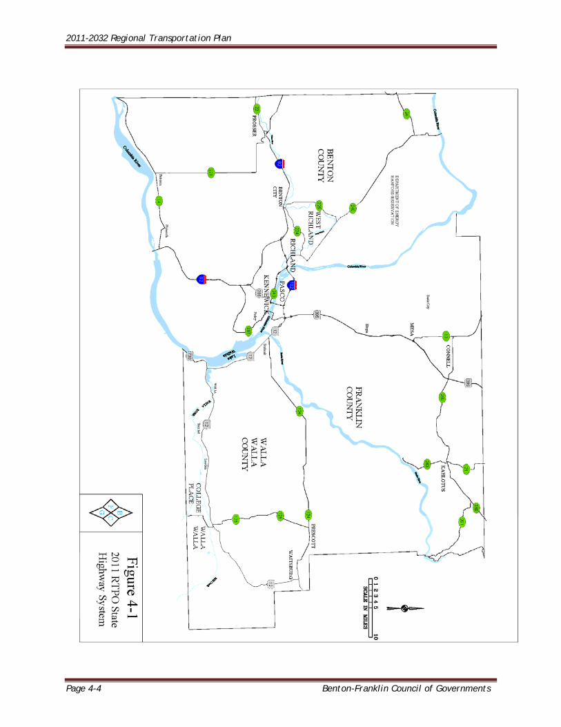
STATE HIGHWAY SYSTEM The role and function of the various components of the state highway system in the RTPO are described below. Figure 4-1 shows the state highway system in the RTPO. The four interstate and federal routes referenced below constitute the east-west and north-south backbones of the three-county highway system. These routes carry the vast majority of freight and goods movement and auto traffic throughout the region. I (Interstate) - 82 is a freeway extending from I-90 near Ellensburg, Washington, to I-84 near Hermiston, Oregon. Interstate -182 is a 16-mile interstate spur route from I-82 west of the Tri-Cities to US 395, SR 397 and US 12 in Pasco. US 12 is a cross-state route extending from the Washington Coast to Lewiston, Idaho. The RTPO portion consists of 3.07 miles in Franklin County and slightly over 64 miles in Walla Walla County. US 395 is a Highway of National Significance (see page 4-8), extending from Mexico to Canada via eastern Washington. Within the RTPO, the road extends from Umatilla, Oregon to the Adams County Line. Daily traffic volumes contain 30-35 percent trucks through this region. The remaining state routes noted below are more of local significance, for the most part with lower traffic volumes, and transport less freight and goods. SR (State Route) 14 is an east-west route along the Columbia River from Vancouver to Plymouth in Benton County south of the Tri-Cities. This route provides a two-lane alternative to I-84 on the Oregon side of the river. A notable volume of truck traffic uses this route. SR 17 extends north from U.S. 395 at Mesa to I-90 at Moses Lake and beyond. This route serves through traffic as well as farm-to-market. Trucks constitute 30-35 percent of the daily volumes. SR 21 is primarily a farm-to-market route from Kahlotus north to Lind (US 395). The initial eight miles are in Franklin County. SR 22 from Toppenish (SR 97) to Prosser (I-82) primarily serves local needs. Less than seven miles are in Benton County. Some truck traffic utilizes this route in lieu of I-82. SR 24 extends from Yakima to SR 26 at Othello. A primary function of this route is access to the west gate of the Hanford site at the SR 24/SR 240 Junction. SR 124 extends east from US 12 at Burbank through Prescott, to US 12 at Waitsburg, a distance of 45 miles. SR 125 extends Oregon's Route 11 north from Milton-Freewater into Walla Walla and on to its junction with SR 124 west of Prescott. Through Walla Walla the route functions as a city street with numerous intersections, traffic signals and commercial activities. The inherent congestion and delay are not conducive to through travel, particularly for trucks. From Walla
2011-2032 Regional Transportation Plan
Benton-Franklin Council of Governments Page 4-3
Walla north to SR 124 the route is a farm-to-market road. There have been discussions between urban area jurisdictions and WSDOT to transfer jurisdictional responsibilities for the existing SR 125 and the new Myra Road, which would become the new SR 125. SR 221 is a 26-mile local farm route from SR 22 at Prosser to SR 14 at Paterson, but attracts through traffic as well. SR 224 provides a 10-mile connection, from I-82 (Kiona/Benton City) through West Richland to Richland (SR 240). Traffic on this route is oriented to Richland and Hanford work sites and local freight movements. SR 225 extends from Kiona (I-82) through Benton City to SR 240 at Horn Rapids. DOE Route 10 extends on into the Hanford reservation. Hanford commuters dominate peak volumes on this two-lane roadway. SR 240 extends from SR 24 at the Hanford west gate to Richland and Kennewick (to a junction with US 395), a distance of 40 miles. In conjunction with SR 24 to Yakima and SR 243 north to SR 90 at Vantage, SR 240 carries regional traffic, including freight movements. It also serves as the primary route of the daily Hanford work-commute. SR 260 extends east from SR 17 to US 395 at Connell, to a junction with SR 26 at Washtucna in Adams County. Wheat hauling is a major activity on the route. SR 261 extends from SR 260, east of Kahlotus, to the Snake River crossing at Lyons Ferry, a distance of 14 miles. The route continues another 15 miles into Columbia County to a junction with US 12. Truck traffic constitutes about 20 percent of the daily volume. Some through travelers utilize this route as a shortcut to I-90 east of Ellensburg at Vantage. SR 263, a farm-to-market route with about 35-percent trucks extends from Kahlotus south 9 miles to the Port of Windust at the Snake River. SR 397 extends from I-82 at the Locust Grove interchange (exit 114) to the Finley area, then to Kennewick, across the Columbia River, and through East Pasco to the I-182/US 395 interchange. This route serves as freight access to the Port of Pasco, the Port of Kennewick and other industrial sites along the river. US 730 extends from I-84 at Boardman, Oregon, to I-82 at Umatilla, then continues along the Columbia River to a junction with US 12 in the southwest corner of Walla Walla County. Volumes on the six-mile segment from the Oregon line to US 12 at Wallula Junction are about 49 percent trucks.
2011-2032 Regional Transportation Plan
Page 4-4 Benton-Franklin Council of Governments
2011-2032 Regional Transportation Plan
Benton-Franklin Council of Governments Page 4-5
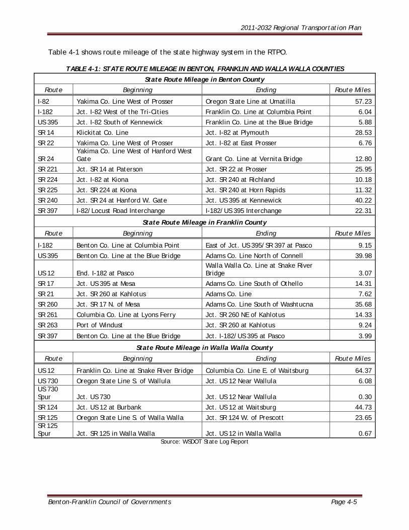
Table 4-1 shows route mileage of the state highway system in the RTPO.
TABLE 4-1: STATE ROUTE MILEAGE IN BENTON, FRANKLIN AND WALLA WALLA COUNTIES
State Route Mileage in Benton County
Route Beginning Ending Route Miles
I-82 Yakima Co. Line West of Prosser Oregon State Line at Umatilla 57.23
I-182 Jct. I-82 West of the Tri-Cities Franklin Co. Line at Columbia Point 6.04
US 395 Jct. I-82 South of Kennewick Franklin Co. Line at the Blue Bridge 5.88
SR 14 Klickitat Co. Line Jct. I-82 at Plymouth 28.53
SR 22 Yakima Co. Line West of Prosser Jct. I-82 at East Prosser 6.76
SR 24 Yakima Co. Line West of Hanford West Gate Grant Co. Line at Vernita Bridge 12.80
SR 221 Jct. SR 14 at Paterson Jct. SR 22 at Prosser 25.95
SR 224 Jct. I-82 at Kiona Jct. SR 240 at Richland 10.18
SR 225 Jct. SR 224 at Kiona Jct. SR 240 at Horn Rapids 11.32
SR 240 Jct. SR 24 at Hanford W. Gate Jct. US 395 at Kennewick 40.22
SR 397 I-82/Locust Road Interchange I-182/US 395 Interchange 22.31
State Route Mileage in Franklin County
Route Beginning Ending Route Miles
I-182 Benton Co. Line at Columbia Point East of Jct. US 395/SR 397 at Pasco 9.15
US 395 Benton Co. Line at the Blue Bridge Adams Co. Line North of Connell 39.98
US 12 End. I-182 at Pasco Walla Walla Co. Line at Snake River Bridge 3.07
SR 17 Jct. US 395 at Mesa Adams Co. Line South of Othello 14.31
SR 21 Jct. SR 260 at Kahlotus Adams Co. Line 7.62
SR 260 Jct. SR 17 N. of Mesa Adams Co. Line South of Washtucna 35.68
SR 261 Columbia Co. Line at Lyons Ferry Jct. SR 260 NE of Kahlotus 14.33
SR 263 Port of Windust Jct. SR 260 at Kahlotus 9.24
SR 397 Benton Co. Line at the Blue Bridge Jct. I-182/US 395 at Pasco 3.99
State Route Mileage in Walla Walla County
Route Beginning Ending Route Miles
US 12 Franklin Co. Line at Snake River Bridge Columbia Co. Line E. of Waitsburg 64.37
US 730 Oregon State Line S. of Wallula Jct. US 12 Near Wallula 6.08 US 730 Spur Jct. US 730 Jct. US 12 Near Wallula 0.30
SR 124 Jct. US 12 at Burbank Jct. US 12 at Waitsburg 44.73
SR 125 Oregon State Line S. of Walla Walla Jct. SR 124 W. of Prescott 23.65 SR 125 Spur Jct. SR 125 in Walla Walla Jct. US 12 in Walla Walla 0.67
Source: WSDOT State Log Report
2011-2032 Regional Transportation Plan
Page 4-6 Benton-Franklin Council of Governments
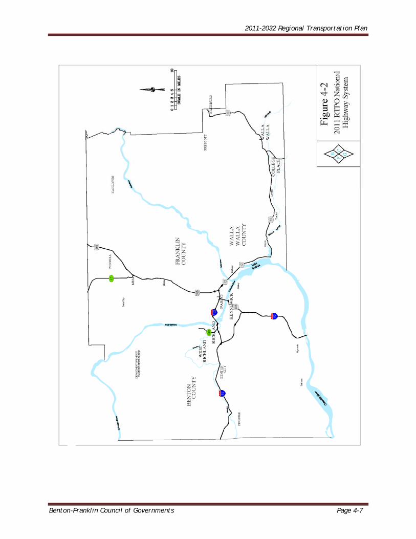
THE NATIONAL HIGHWAY SYSTEM (NHS) The National Highway System (NHS) was developed as a way of focusing federal resources on the nation's most important roads. The approximate 160,000 miles of NHS include only four percent of the nation’s roads, but they carry more than 40 percent of all highway traffic, 75 percent of heavy truck traffic, and 90 percent of tourist traffic. Important to the nation's economy, defense, and mobility, the NHS includes the following subsystems of roadways (note that a specific highway route may be on more than one subsystem): Interstate: The Interstate System of highways retains its separate identity within the
NHS. The approximate 43,400-mile Interstate Highway System accounts for almost 30 percent of NHS.
Other Principal Arterials: These are highways in rural and urban areas which provide
access between an arterial and a major port, airport, public transportation facility, or other intermodal transportation facility. This component of the NHS includes 21 congressionally designated high-priority corridors as identified in ISTEA. These corridors total about 4,500 miles. In the RTPO, US 395 is designated a high-priority corridor.
Strategic Highway Corridor Network (STRAHNET): This is a network of highways which
are important to the United States' strategic defense policy and which provide defense access, continuity and emergency capabilities for defense purposes. It totals about 15,500 miles.
Major Strategic Highway Network Connectors: These are highways which provide
access between major military installations and highways which are part of the Strategic Highway Network. They consist of more than 1,900 miles of roads linking major military installations and other defense-related facilities to the STRAHNET corridors.
Intermodal Connectors: These highways provide access between major intermodal
facilities and the other four subsystems making up the National Highway System. This includes about 91,800 miles of arterial highways that serve interstate and interregional travel and that provide connections to major ports, airports, public transportation facilities, and other intermodal facilities. In the RTPO, two road segments have been designated as NHS Intermodal Connectors: the route from I-182 north on 20th Avenue to the Pasco Airport; and in Walla Walla, the segment from US 12 northwesterly on A Street to the Airport.
All told, the NHS serves 198 ports, 207 airports, 67 Amtrak stations, 190 rail/truck terminals, 82 intercity bus terminals, 307 public transit stations, 37 ferry terminals, 58 pipeline terminals, and 20 multipurpose passenger terminals. By providing essential linkages to other modes, the NHS creates a more efficient transportation system for the rapid movement of people and products.
The NHS in Benton, Franklin, and Walla Walla Counties is shown in Figure 4-2, on the following page.
2011-2032 Regional Transportation Plan
Benton-Franklin Council of Governments Page 4-7
2011-2032 Regional Transportation Plan
Page 4-8 Benton-Franklin Council of Governments
TRANSPORTATION FACILITIES AND SERVICES OF STATEWIDE SIGNIFICANCE Transportation facilities and services of statewide significance are identified under RCW 47.06.140. These facilities provide and support transportation functions that promote and maintain significant statewide travel and economic linkages. The law emphasizes that these significant transportation facilities should be planned from a statewide perspective. Planning includes a broad range of perspectives serving the interests of all citizens in the state who depend on the system both directly or indirectly. Transportation facilities and services of statewide significance specifically include the following: The interstate highway system Interregional state principal arterials including ferry connections that serve statewide
travel Intercity passenger rail service Intercity high-speed ground transportation Major passenger inter-modal terminals excluding all airport facilities and services The freight railroad system The Columbia/Snake navigable river system Marine port facilities and services that are related solely to marine activities affecting
international and interstate trade, and High-capacity transportation systems serving regions as defined in RCW 81.104.015
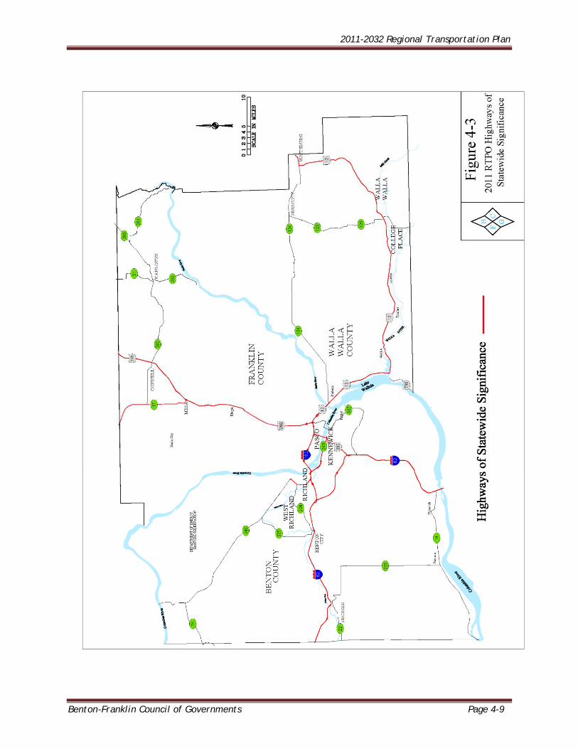
HIGHWAYS OF STATEWIDE SIGNIFICANCE Highways of Statewide Significance (HSS) include interstate highways and other principal arterials that are needed to connect major communities in the state. The designation helps assist with the allocation and direction of funding. The HSS was mandated by the 1998 legislature through enactment of House Bill 1487 and codified into RCW 47.06.140. In 1999 the legislature passed House Joint Memorial 4006 requesting that WSDOT, with the assistance of Regional Transportation Planning Organizations, update the HSS at least every five years. The latest revision to the HSS list was adopted by the Legislature in 2009. Additionally, HSS routes are exempt from local level of service standards Figure 4-3 below shows HSS routes in the RTPO.
2011-2032 Regional Transportation Plan
Benton-Franklin Council of Governments Page 4-9
2011-2032 Regional Transportation Plan
Page 4-10 Benton-Franklin Council of Governments
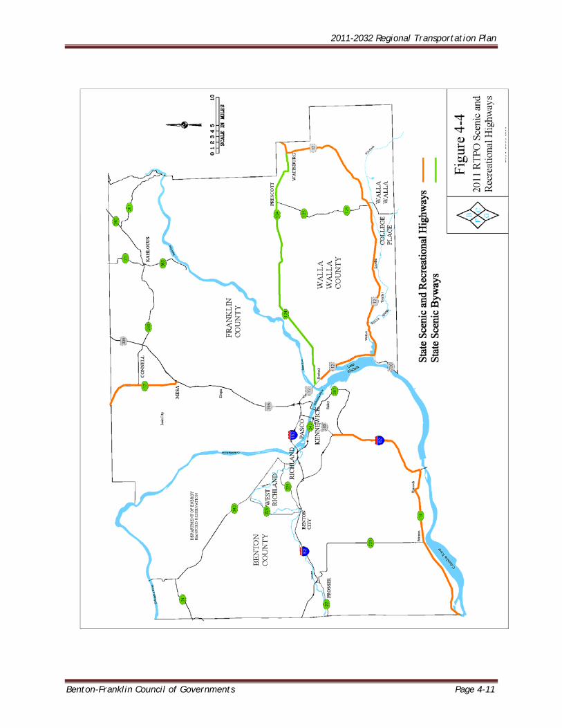
STATE SCENIC AND RECREATIONAL HIGHWAY SYSTEM Scenic and Recreational Highways are sections of Washington State Highway that are identified in State law (RCW 47.39 and 47.42) and designated due to a need to develop management plans that will protect and preserve the scenic and recreational resources from loss through inappropriate development. Approximately 4,000 miles of the more than 7,000-mile state highway system make up Washington’s Scenic and Recreational Highways. Scenic and Recreational Highways have been identified as the most important access routes to scenic and recreational resources in the State. Protection of scenic and recreational resources includes managing land use outside normal highway rights-of-way. Designation as a Scenic and Recreational Highway is required in order to apply for National Scenic Byway discretionary grants. In 1967, the state legislature enacted the State Scenic and Recreational Highway Act (the Act), which established guidance for developing designation and maintenance criteria for Washington’s Scenic and Recreational Highway System. The Act also calls for planning, design standards, and legislative approval of additions to the State’s Scenic System. As part of the Act, the state legislature provided that motor vehicle funds from the state highway construction budget may be used, if available, for specific elements including: Right of way acquisition Highway or roadway construction Access to scenic observation points Safety rest areas Highway landscaping Signs and markers
In 1990, the state legislature amended the 1967 State Scenic and Recreational Highway Act. The amended State Scenic and Recreational Highways Act calls out several funding priorities including funding further development of the state’s program, signage, and bicycle and pedestrian connections. Between 1992 and 2008, there has been approximately $25 million in state and federal funds spent on the Scenic and Recreational Highways System. This includes $9 million in state funds, primarily for traveler services like signage and rest areas, and $15 million in federal funds primarily dedicated to tourism and traveler services. Approximately 15% of the $25 million has funded Corridor Management Plans and site plans, while 3% has been dedicated to stewardship efforts. The term State Scenic Byway has also been used in the past to refer to a subset of the Scenic and Recreational Highways (RCW 47.39 & RCW 47.42) and other highways and roads primarily for marketing purposes. However, there is no legal definition of these routes. Figure 4-4 shows components of the Scenic and Recreational Highways system in the RTPO.
2011-2032 Regional Transportation Plan
Benton-Franklin Council of Governments Page 4-11
2011-2032 Regional Transportation Plan
Page 4-12 Benton-Franklin Council of Governments
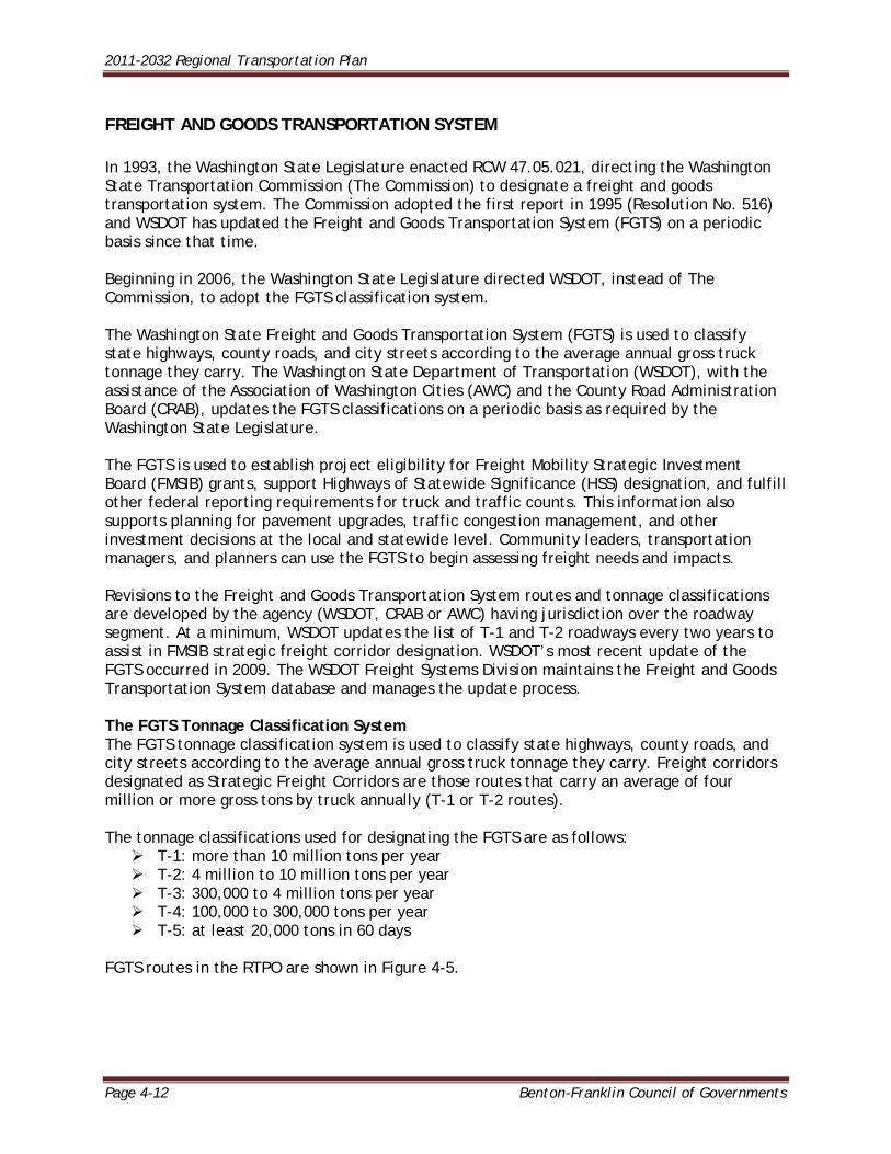
FREIGHT AND GOODS TRANSPORTATION SYSTEM In 1993, the Washington State Legislature enacted RCW 47.05.021, directing the Washington State Transportation Commission (The Commission) to designate a freight and goods transportation system. The Commission adopted the first report in 1995 (Resolution No. 516) and WSDOT has updated the Freight and Goods Transportation System (FGTS) on a periodic basis since that time. Beginning in 2006, the Washington State Legislature directed WSDOT, instead of The Commission, to adopt the FGTS classification system. The Washington State Freight and Goods Transportation System (FGTS) is used to classify state highways, county roads, and city streets according to the average annual gross truck tonnage they carry. The Washington State Department of Transportation (WSDOT), with the assistance of the Association of Washington Cities (AWC) and the County Road Administration Board (CRAB), updates the FGTS classifications on a periodic basis as required by the Washington State Legislature. The FGTS is used to establish project eligibility for Freight Mobility Strategic Investment Board (FMSIB) grants, support Highways of Statewide Significance (HSS) designation, and fulfill other federal reporting requirements for truck and traffic counts. This information also supports planning for pavement upgrades, traffic congestion management, and other investment decisions at the local and statewide level. Community leaders, transportation managers, and planners can use the FGTS to begin assessing freight needs and impacts. Revisions to the Freight and Goods Transportation System routes and tonnage classifications are developed by the agency (WSDOT, CRAB or AWC) having jurisdiction over the roadway segment. At a minimum, WSDOT updates the list of T-1 and T-2 roadways every two years to assist in FMSIB strategic freight corridor designation. WSDOT’s most recent update of the FGTS occurred in 2009. The WSDOT Freight Systems Division maintains the Freight and Goods Transportation System database and manages the update process. The FGTS Tonnage Classification System The FGTS tonnage classification system is used to classify state highways, county roads, and city streets according to the average annual gross truck tonnage they carry. Freight corridors designated as Strategic Freight Corridors are those routes that carry an average of four million or more gross tons by truck annually (T-1 or T-2 routes). The tonnage classifications used for designating the FGTS are as follows: T-1: more than 10 million tons per year T-2: 4 million to 10 million tons per year T-3: 300,000 to 4 million tons per year T-4: 100,000 to 300,000 tons per year T-5: at least 20,000 tons in 60 days
FGTS routes in the RTPO are shown in Figure 4-5.
2011-2032 Regional Transportation Plan
Benton-Franklin Council of Governments Page 4-13
2011-2032 Regional Transportation Plan
Page 4-14 Benton-Franklin Council of Governments
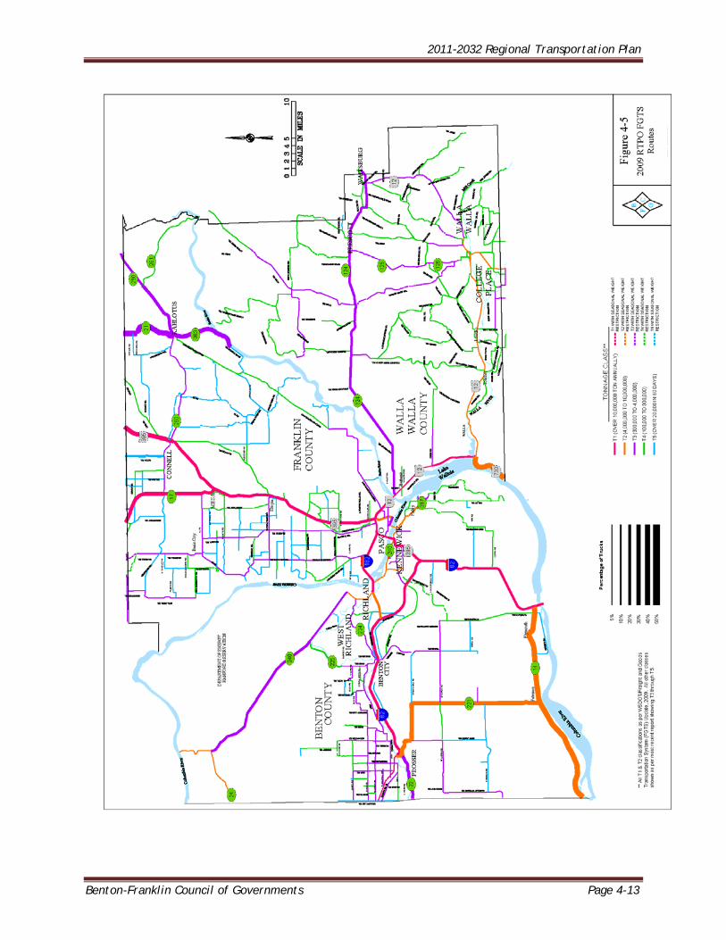
Truck Volumes on State Routes WSDOT manages multiple permanent traffic recorders (PTRs) in the RTPO and releases this data as part of their state highway system Annual Traffic Report. The data include truck percentages of Annual Average Daily Traffic (AADT). The truck volumes are estimated, not actual counts. However, they do provide data on trucking activity in the region. Table 4-2 contains estimated truck volumes at PTR sites between 2002 and 2010. The data show substantial increases in estimated truck volumes on the primary north-south and east-west corridors. That is indicative of increasing interstate and intrastate movement of freight and goods. Figure 4-6 maps the PTR sites included in the table.
TABLE 4-2: RTPO AVERAGE DAILY HIGHWAY TRUCK TRAFFIC, 2002 TO 2010
Site ID #
Route Milepost Location 2002 AADT Truck
2004 AADT Truck
2006 AADT Truck
2008 AADT Truck
2010 AADT Truck
1 SR 12 307.90 East of SR 730 Spur - Wallula 930 992 1024 992 1122
2 SR 24 43.50 At Columbia River Bridge - Vernita 680 735 792 770 858
3 SR 82 121.20 West of Coffin Road - Benton County 3450 3750 4000 3750 4250
4 SR 82 132.03 South of SR 14 - Umatilla 3680 3840 4080 4160 4320
5 SR 182 6.34 At Columbia River Bridge - Pasco 3150 4100 4230 4320 5040
6 SR 221 13.10 South of Sellards Road - Prosser 738 810 1056 960 903
7 SR 240 37.14 North of Columbia Park Trail - Richland 2800 2750 3540 3000 3350
8 SR 395 27.20 South of Vinyard Drive - Pasco 2880 3250 3640 3640 3750
9 SR 395 36.24 North of Blanton/Eltopia Road 3000 3120 3640 3640 3920 Source: WSDOT Annual Traffic Reports
THE REGIONAL MULTIMODAL TRANSPORTATION SYSTEM RCW 47.80.030 identifies transportation facilities and services to be contained in the regional multi-modal transportation system. All state facilities and services (including state highways and state-owned park and
ride lots); Regional arterials; Transit and non-motorized facilities and services; Marine ports; Airports; Rail facilities; Multi-modal and inter-modal facilities; and Non-capital programs including transportation demand management.
RCW 47.80.030 further indicates that facilities, services, and programs contained in the regional transportation system exhibit one or more of the following characteristics: Crosses member county lines; Is or will be used by a significant number of people who live or work outside the
county in which the facility, service, or project is located; Significant impacts are expected to be felt in more than one county;
2011-2032 Regional Transportation Plan
Benton-Franklin Council of Governments Page 4-15
2011-2032 Regional Transportation Plan
Page 4-16 Benton-Franklin Council of Governments
Potentially adverse impacts of the facility, service, program, or project can be better avoided or mitigated through adherence to regional policies;
Transportation needs addressed by a project have been identified by the regional transportation planning process and the remedy is deemed to have regional significance; and
Provides for system continuity.
DESIGNATION OF THE REGIONAL TRANSPORTATION SYSTEM Consistent with the state's Regional Transportation Planning Program Planning Standards, the designated regional transportation system includes: All state-owned transportation facilities and services (highways, park-and-ride lots,
etc). All local principal arterials and selected minor arterials the RTPO considers necessary
to the plan. Any other transportation facilities and services, including airports, transit facilities
and services, roadways, rail facilities, marine transportation facilities, pedestrian/bicycle facilities, etc., that the RTPO considers necessary to complete the regional plan.
Any transportation facility or service that regional need or impact places in the plan, as determined by the RTPO.
The remainder of Chapter Four will provide details and discussion on various components of the Regional Transportation System. BICYCLE AND PEDESTRIAN SYSTEM Non-motorized transportation in the MPO and RTPO is addressed in the “2010 Regional Bicycle and Pedestrian Transportation Plan for Benton, Franklin and Walla Walla Counties and Tri-Cities Urban Area”. The 2010 Plan is a component of the Regional Transportation Plan and is incorporated by reference into this document. The Plan covers multiple aspects of bicycle and pedestrian travel in the Tri-Cities and Walla Walla as well as the three counties. Keystones of plan development were workshops held in both the Tri-Cities and Walla Walla which resulted in critical metropolitan-area bicycle issues being identified and prioritized by the attendees. The plan contains bicycle and pedestrian policies and regulations, and comprehensive plan language for all cities in Benton, Franklin and Walla Walla counties and the counties themselves. Also included are jurisdictions’ project lists and system maps. State, federal and local funding sources, facility design standards and bicycle and pedestrian safety are discussed as well. The 2010 Plan may be accessed and downloaded at the Benton-Franklin Council of Governments website: www.bfcog.us.
2011-2032 Regional Transportation Plan
Benton-Franklin Council of Governments Page 4-17
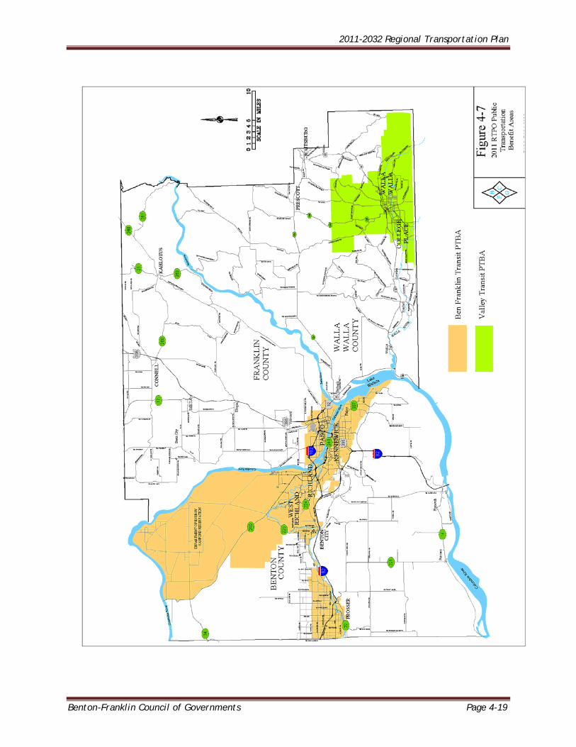
TRANSIT Public Transportation Benefit Areas The Benton Franklin and Walla Walla Public Transportation Benefit Areas (PTBAs) are municipal corporations. Ben Franklin Transit and Valley Transit, respectively, operate in the two areas. In general, dedicated public transportation is limited to urban areas served by Ben Franklin Transit and Valley Transit. Defined in statute (RCW 36.57A), a PTBA is established through a planning and electoral process wherein citizens in a defined area vote to impose up to .06 of 1 percent of a sales tax upon themselves for purposes of developing and funding a public transit agency. The PTBA boundary sets the limit of the area to be taxed and generally sets a limit on the area to receive service. The two PTBA service areas are shown in Figure 4-7. BEN FRANKLIN TRANSIT Weekday and Saturday Fixed Route Bus Service Ben Franklin Transit has 24 routes serving Benton City, Kennewick, Pasco, Prosser, Richland, and West Richland. There are five (5) Inter-City routes (which travel between cities) and 19 routes called Locals which do not leave their designated city. Buses are scheduled to arrive at the transit centers at approximately the same time and leave at the same time so transferring from bus to bus is simple to do and easy to understand. Taxi Feeder Routes A premium service which provides transit links for less travelled areas. Customers call BFT’s contractor for service and have a shared taxi ride to their final destination or are picked up near home and dropped off to catch a bus. This provides access to locations that are costly to serve with fixed route service. Dial-A-Ride Paratransit Service Dial-A-Ride Paratransit Service has the same hours as fixed route local service through a reservation system with one day’s notice of travel plans and exceeds requirements set forth in the Americans with Disabilities Act (ADA). BFT provides paratransit service throughout the PTBA. This is provided far beyond the legal ¾ mile requirement established by the ADA, with a premium fare charged beyond ¾ mile of fixed routes. Dial-A-Ride services are contracted with private providers such as ARC and Tri-City Taxi’s, as well as provided by BFT staff. Trans+Plus Night Service Trans+Plus night service operates from 7:00 p.m. to 12:30 a.m. Monday thru Saturday. Reservation lines open at 2 pm daily and riders schedule trips as needed. Night Service is currently financially capped to assure that expenditures remain within BFT’s approved annual budget. Demand Response Services Demand response services provide trips as needed in low density communities such as Prosser and Finley. Finley service is provided through a contract with reservations being taken by the contractor the day prior to travel, or by subscription. Designated stops have been established for pick-up. BFT staff provides Dial A Ride service in this area. Prosser services are pick-ups at designated stops for general public. This matches the Finley service and helps to reduce travel times and begin the establishment of future possible fixed route service.
2011-2032 Regional Transportation Plan
Page 4-18 Benton-Franklin Council of Governments
Vanpools This service is employer or community based with volunteer drivers for a shared ride. Ben Franklin Transit makes 12 passenger and mini vans available for use on specific pre-approved trips with volunteer drivers and coordinators for community non-profit or governmental groups usually of single or low frequency trips such as special events. BFT’s vanpool program will be addressed in greater detail in a later section. VALLEY TRANSIT Dial-A-Ride Dial-A-Ride is a special service which uses lift-equipped vehicles to transport people with mobility limitations that prevent them from using Valley Transit's regular fixed route bus service. Dial-A-Ride is available during the same hours as the fixed route bus service. Evenings and Saturday Service Valley Transit provides transportation service for the general public in Walla Walla and College Place on weekday evenings and Saturday afternoon. Two flex-routes, the West Loop and the East Loop, depart every 45 minutes and provide service to most of the cities' popular destinations. Flex-routes are a route deviation type of service, which means the schedule for each Flex-route provides enough time for the mini-bus to vary from the regular route to pick up people who live within one-quarter mile, about three blocks, but cannot get to the route because of a mobility limitation. Connector Part of the evening and Saturday services, the Connector is an extension of transit service to areas of Walla Walla and College Place which do not have a nearby bus route. It is available during evening and Saturday service hours to transport those who live more than one-quarter mile from the West Loop or the East Loop routes. This provides a service area similar to the seven fixed routes during weekday service hours, but with a reduced number of vehicles that is more appropriate for times with less demand. Job Access Job Access is a reservation based transportation service providing rides to and from work and activities that are necessary in order to work. Job Access is a federal grant program requiring that participants not exceed certain income guidelines. Job Access trips to work or training, including a stop at a childcare provider, are available daily from 5:00 am to 11:30 pm. Job Access customers need to register for the service by filling out an application. Vanpool Vanpool is a program for people who need to drive a long distance to work. Valley Transit will lease a 12 passenger van to a group of people to share the ride. The commute to work can either begin or end in the Walla Walla area.
2011-2032 Regional Transportation Plan
Benton-Franklin Council of Governments Page 4-19
2011-2032 Regional Transportation Plan
Page 4-20 Benton-Franklin Council of Governments
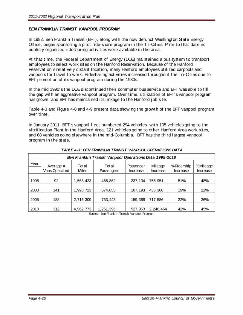
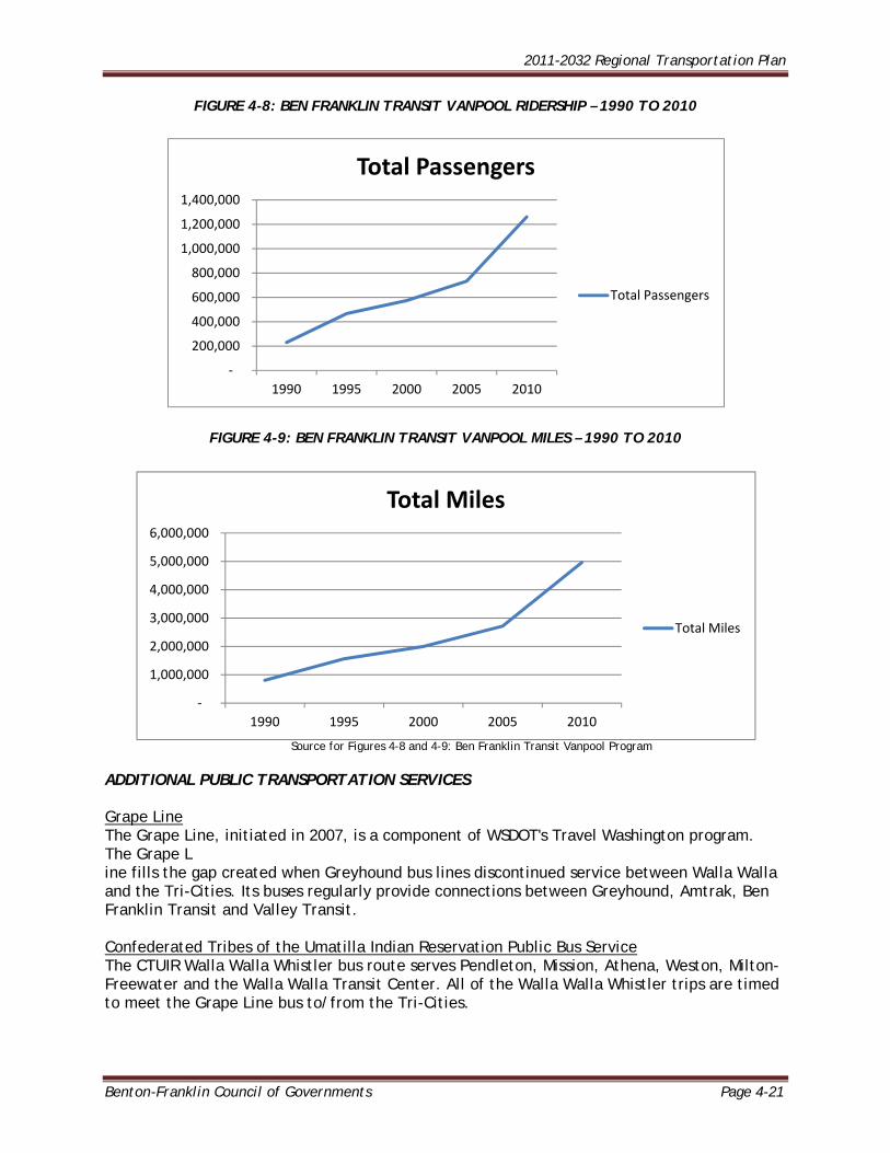
BEN FRANKLIN TRANSIT VANPOOL PROGRAM In 1982, Ben Franklin Transit (BFT), along with the now defunct Washington State Energy Office, began sponsoring a pilot ride-share program in the Tri-Cities. Prior to that date no publicly organized ridesharing activities were available in the area. At that time, the Federal Department of Energy (DOE) maintained a bus system to transport employees to select work sites on the Hanford Reservation. Because of the Hanford Reservation’s relatively distant location, many Hanford employees utilized carpools and vanpools for travel to work. Ridesharing activities increased throughout the Tri-Cities due to BFT promotion of its vanpool program during the 1980s. In the mid 1990’s the DOE discontinued their commuter bus service and BFT was able to fill the gap with an aggressive vanpool program. Over time, utilization of BFT’s vanpool program has grown, and BFT has maintained its linkage to the Hanford job site. Table 4-3 and Figure 4-8 and 4-9 present data showing the growth of the BFT vanpool program over time. In January 2011, BFT’s vanpool fleet numbered 294 vehicles, with 105 vehicles going to the Vitrification Plant in the Hanford Area, 121 vehicles going to other Hanford Area work sites, and 68 vehicles going elsewhere in the mid-Columbia. BFT has the third largest vanpool program in the state.
TABLE 4-3: BEN FRANKLIN TRANSIT VANPOOL OPERATIONS DATA
Ben Franklin Transit Vanpool Operations Data 1995-2010
Year Average # Vans Operated
Total Miles
Total Passengers
Passenger Increase
Mileage Increase
% Ridership Increase
% Mileage Increase
1995 92 1,563,423 466,862 237,134
756,951 51% 48%
2000 141 1,998,723 574,055 107,193
435,300 19% 22%
2005 188 2,716,309 733,443 159,388
717,586 22% 26%
2010 312 4,962,773 1,261,396 527,953
2,246,464 42% 45%
Source: Ben Franklin Transit Vanpool Program
2011-2032 Regional Transportation Plan
Benton-Franklin Council of Governments Page 4-21
FIGURE 4-8: BEN FRANKLIN TRANSIT VANPOOL RIDERSHIP – 1990 TO 2010
FIGURE 4-9: BEN FRANKLIN TRANSIT VANPOOL MILES – 1990 TO 2010
Source for Figures 4-8 and 4-9: Ben Franklin Transit Vanpool Program
ADDITIONAL PUBLIC TRANSPORTATION SERVICES
Grape Line The Grape Line, initiated in 2007, is a component of WSDOT's Travel Washington program. The Grape L ine fills the gap created when Greyhound bus lines discontinued service between Walla Walla and the Tri-Cities. Its buses regularly provide connections between Greyhound, Amtrak, Ben Franklin Transit and Valley Transit. Confederated Tribes of the Umatilla Indian Reservation Public Bus Service The CTUIR Walla Walla Whistler bus route serves Pendleton, Mission, Athena, Weston, Milton-Freewater and the Walla Walla Transit Center. All of the Walla Walla Whistler trips are timed to meet the Grape Line bus to/from the Tri-Cities.
‐
200,000
400,000
600,000
800,000
1,000,000
1,200,000
1,400,000
1990 1995 2000 2005 2010
Total Passengers
Total Passengers
‐
1,000,000
2,000,000
3,000,000
4,000,000
5,000,000
6,000,000
1990 1995 2000 2005 2010
Total Miles
Total Miles
2011-2032 Regional Transportation Plan
Page 4-22 Benton-Franklin Council of Governments
Columbia County Transportation This service operated by Columbia County connects Dayton, Waitsburg and Prescott to Walla Walla. It connects with the Grape Line at the Valley Transit Transfer Center. Milton-Freewater Bus The Milton-Freewater City Bus connects Milton-Freewater and Walla Walla. Connections with the Grape Line may be made at the Valley Transit Transfer Center. Greyhound Greyhound in Pasco connects to destinations throughout the United States. Amtrak Amtrak passenger rail service in Pasco connects to Spokane and Portland, and from there to farther destinations. Google Transit Google Transit is a valuable resource for trip planning. It provides suggestions for schedules, fares, and location of bus stops. Google Transit currently has local data for Ben Franklin Transit, People for People’s Prosser Shuttle, Valley Transit, Grape Line, The Confederated Tribes of the Umatilla, and the City of Milton-Freewater. PARK AND RIDE LOTS The existing park and ride system began development in the early 1980’s. Currently it is comprised of 15 formal park and ride lots in Benton and Franklin Counties and a number of informal lots. This section will review data concerning the formal park and ride lots. Occupancy data presented in this section has been collected by the WSDOT South Central Regional office in Yakima. The two-county area inventory of park and ride lots includes both park and ride and park and pool facilities, while ownership of most formal metropolitan area park and ride lots is split between the WSDOT and BFT. BFT also leases a few park and ride sites. Distinguishing between the two, WSDOT facilities are primarily park and pool lots adjacent to major roadway intersections such as SR 240/SR 224 or I-182/Queensgate and are sited to capture the vanpool and carpool user. BFT-owned park and ride facilities are located at transit centers in their respective communities. The focus of these facilities is on the transit user rather than the commuter, though commuters may use them. Also, development of the WSDOT facilities generally preceded that of the BFT lots. A critical distinction to note between the Tri-City area park and ride system and the great majority of park and ride systems is that the central purpose of the Tri-Cities park and ride system was/is to provide convenient parking facilities for vanpools and carpools. In many metropolitan areas, park and ride lots primarily provide parking for transfer to express buses or a mass transit system. Ben Franklin Transit’s service and route system are not designed to provide transportation from these facilities to work sites, though people use transit to get to work locations served by the fixed route system. Table 4-4 identifies facility ownership, facility type, and shows 2010 occupancy data for the formal park and ride lot system in the Tri-Cities area. Evaluated collectively, the average annual monthly occupancy rate, and utilization of the Tri-

2011-2032 Regional Transportation Plan
Benton-Franklin Council of Governments Page 4-23
Cities park and ride system is increasing. System capacity has risen from 657 stalls in 2001 to 1,555 stalls in 2010, an increase of more than 130 percent. Park and Ride lot usage, based on average monthly system occupancy, decreased from 2001, with 42 percent of capacity being utilized, until 2006 with 28 percent of capacity being utilized. Usage has been increasing since, with the data showing average system monthly occupancy to be at 54 percent in 2010. Of the 15 sites shown, lease agreements within the last two years have formalized use of both the TRAC facility in Pasco and the parking lot at Stevens Drive and Spengler Road in Richland. The most recent addition to the system is the lot in Kennewick at the intersection of US 395 and Yelm Street. A more detailed examination of the Tri-Cities metropolitan area park and ride system is available in the “2007 Tri-Cities Metropolitan Area Park and Ride Report”, copies of which may be obtained by contacting the BFCOG offices. Table 4-4 indexes the Park and Ride lots in Figure 4-10 and contains 2010 occupancy data for each site. Park and Ride lots in the Tri-Cities metropolitan area are shown in Figure 4-10.
TABLE 4-4: FORMAL PARK AND RIDE LOTS IN THE TRI-CITIES METROPOLITAN AREA
TRI-CITIES AREA FORMAL PARK & RIDE FACILITIES
Site ID# Facility Facility Owner
Facility Type Capacity
2010 Avg Monthly
Occupancy
2010 Avg Monthly % Occupancy
1 Stacy Avenue Station Prosser/BFT Park & Ride 28 10 48%
2 SR 225 & Dale Avenue Benton City/BFT Park & Ride 37 31 83%
3 I- 82 & SR 224 Interchange WSDOT Park & Pool 30 24 81%
4 West Richland Transit Center W Richland/BFT Park & Ride 27 19 69%
5 Flat Top Park Parking Lot West Richland Park & Ride 127 62 49%
6 SR 224 & SR 240 Intersection WSDOT Park & Pool 89 68 76%
7 I-182 & Queensgate Interchange WSDOT Park & Pool 139 6 5%
8 Knight Street & Goethals Drive BFT Park & Ride 33 7 20%
9 WSDOT - Columbia Park Trail WSDOT Park & Pool 249 196 79%
10 West 27th Avenue & South Union Street Kennewick Park & Pool 50 40 81%
11 West Clearwater Ave & North Huntington St BFT Park & Ride 135 35 26%
12 Park Street & 22nd Avenue BFT Park & Ride 50 19 38%
13 Stevens Drive & Spengler Road Port of Benton Park & Pool 350 253 72%
14 TRAC TRAC Park & Pool 172 70 40%
15 US 395 & Yelm Street Kennewick Park & Pool 39 17 43%
Source: 2007 Tri-Cities Metropolitan Area Park and Ride Lot Report; WSDOT South Central Region Monthly Park and Ride Inventory

2011-2032 Regional Transportation Plan
Page 4-24 Benton-Franklin Council of Governments
2011-2032 Regional Transportation Plan
Benton-Franklin Council of Governments Page 4-25
INTER-MODAL CONNECTIONS Inter-modal connections in the metropolitan area include fifteen park-and-ride lots, six transit transfer centers, the Tri-Cities Airport, the Pasco Inter-Modal Depot (Greyhound, Grapeline, Ben Franklin Transit and Amtrak) and trailhead parking facilities. Other resources include bike lockers, pedestrian shelters, and parking facilities at transit centers; bike racks on buses; transit shelters and short and long-range parking facilities at the Tri-Cities Airport and Pasco Inter-modal Depot; and taxi service. The availability of inter-modal choices will continue to be reviewed to support growth. This includes ensuring the metropolitan transportation system has inter-modal facilities of adequate size and number of locations to accommodate potential users at an acceptable level of service. REGIONAL AVIATION NATIONAL PLAN OF INTEGRATED AIRPORTS Nearly half of Washington’s public airports are identified as significant to the national aviation system by the FAA and included in the FAA’s National Plan of Integrated Airports (NPIAS). The NPIAS is updated every two years and provides the basis of apportioning federal Airport Improvement Program (AIP) funding. Under the federal airport classification system, airports are designated as: Primary airports, which provide scheduled passenger service and have more than
10,000 annual enplanements; Commercial service airports, which have between 2,500 and 10,000 annual
enplanements; Reliever airports, which have 100 or more based aircraft or at least 25,000 annual
itinerant operations; or General aviation airports, which do not meet the criteria for reliever airports, but
still account for significant general aviation activity. General aviation (GA) is defined by the FAA as all aviation other than scheduled commercial aviation and military aviation. GA activity spans a wide range of services including personal and business transportation, medical evacuation, search and rescue, agricultural support, and flight training. In the RTPO, the Pasco and Walla Walla facilities are Primary Airports, while the Richland and Prosser operations are classified as General Aviation facilities. Two additional airports in the RTPO, Vista Field in Kennewick and Martin Field in Walla Walla County, are non-NPIAS facilities. WASHINGTON STATE AIRPORT CLASSIFICATION SYSTEM The Washington State Department of Transportation has also developed state airport classifications for the public use airports in the state. State airport classifications do not supersede FAA classifications, but supplement them by accounting for airports that may not be significant on a national level, and are important to the state aviation system. State airport classifications, along with the identification of facilities and services appropriate for each classification, are important in helping to identify and prioritize airport improvement and funding needs.
2011-2032 Regional Transportation Plan
Page 4-26 Benton-Franklin Council of Governments
Six classifications identify the roles and service levels of Washington’s public use airports: Commercial Service Airports Regional Service Airports Community Service Airports Local Service Airports Rural Essential Airports Seaplane Bases
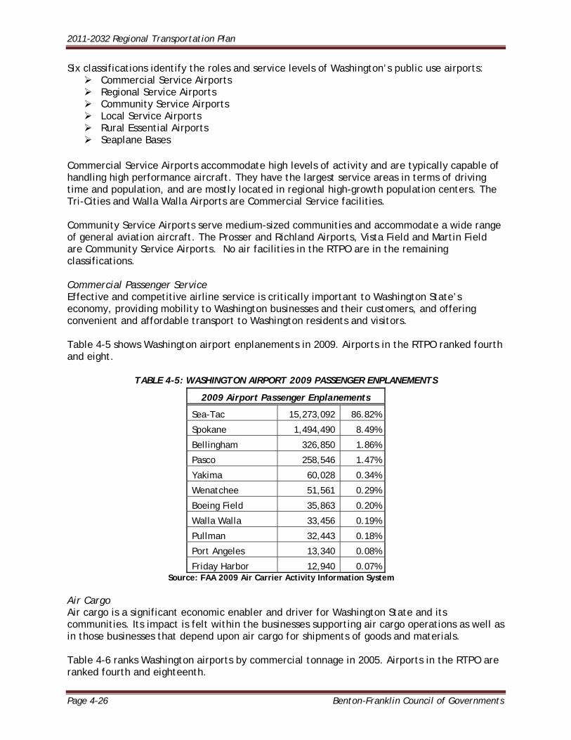
Commercial Service Airports accommodate high levels of activity and are typically capable of handling high performance aircraft. They have the largest service areas in terms of driving time and population, and are mostly located in regional high-growth population centers. The Tri-Cities and Walla Walla Airports are Commercial Service facilities. Community Service Airports serve medium-sized communities and accommodate a wide range of general aviation aircraft. The Prosser and Richland Airports, Vista Field and Martin Field are Community Service Airports. No air facilities in the RTPO are in the remaining classifications. Commercial Passenger Service Effective and competitive airline service is critically important to Washington State’s economy, providing mobility to Washington businesses and their customers, and offering convenient and affordable transport to Washington residents and visitors. Table 4-5 shows Washington airport enplanements in 2009. Airports in the RTPO ranked fourth and eight.
TABLE 4-5: WASHINGTON AIRPORT 2009 PASSENGER ENPLANEMENTS
2009 Airport Passenger Enplanements
Sea-Tac 15,273,092 86.82%
Spokane 1,494,490 8.49%
Bellingham 326,850 1.86%
Pasco 258,546 1.47%
Yakima 60,028 0.34%
Wenatchee 51,561 0.29%
Boeing Field 35,863 0.20%
Walla Walla 33,456 0.19%
Pullman 32,443 0.18%
Port Angeles 13,340 0.08%
Friday Harbor 12,940 0.07% Source: FAA 2009 Air Carrier Activity Information System
Air Cargo Air cargo is a significant economic enabler and driver for Washington State and its communities. Its impact is felt within the businesses supporting air cargo operations as well as in those businesses that depend upon air cargo for shipments of goods and materials. Table 4-6 ranks Washington airports by commercial tonnage in 2005. Airports in the RTPO are ranked fourth and eighteenth.

2011-2032 Regional Transportation Plan
Benton-Franklin Council of Governments Page 4-27
TABLE 4-6: WASHINGTON AIRPORT 2005 AIR CARGO TONNAGE
2005: Airports in Air Cargo Tonnage
Rank Airport Tonnage % of Total
1 Seattle/Tacoma 373,233 62.06%
2 Seattle Boeing Field 124,620 20.72%
3 Spokane Intl Apt 93,424 15.53%
4 Pasco 3,377 0.56%
5 Yakima Municipal Apt 2,268 0.38%
6 Bellingham 1,215 0.20%
7 Wenatchee 654 0.11%
8 Moses Lake Grant County Apt 530 0.09%
9 Port Angeles 519 0.09%
10 Mount Vernon 384 0.06%
17 Pullman/Moscow 27 0.00%
18 Walla Walla 9 0.00% Source: WSDOT 2009 Long-Term Air Transportation Study
REGIONAL AVIATION FACILITIES This section describes aviation facilities in the RTPO. Table 4-7 provides background information.
TABLE 4-7: AIRPORTS IN THE BENTON-FRANKLIN-WALLA WALLA RTPO Airports in the Benton-Franklin-Walla Walla RTPO
Airport Ownership County NPIAS Federal Service Level
State Service Level
Tri-Cities Port of Pasco Franklin Yes Primary Commercial Service
Walla Walla Regional
Port of Walla Walla
Walla Walla
Yes Primary Commercial Service
Prosser Port of Benton Benton Yes General Aviation
Community Service
Richland Port of Benton Benton Yes General Aviation
Community Service
Vista Field Port of Kennewick
Benton No - Community Service
Martin Field David Cheney Walla Walla
No - Community Service
Lower Monumental WSDOT Walla Walla
No - -
Source: Compilation of data by BFCG The Tri-Cities Airport The Tri-Cities Airport at Pasco, owned and operated by the Port of Pasco, is a primary, commercial service facility serving southeastern Washington and northeastern Oregon. Daily scheduled air service includes Delta Connection service to Salt Lake City and Minneapolis/St.
2011-2032 Regional Transportation Plan
Page 4-28 Benton-Franklin Council of Governments
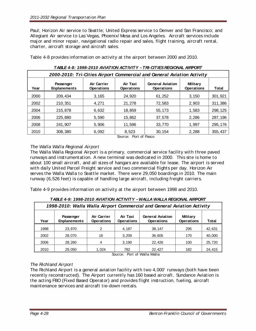
Paul; Horizon Air service to Seattle; United Express service to Denver and San Francisco; and Allegiant Air service to Las Vegas, Phoenix/Mesa and Los Angeles. Aircraft services include major and minor repair, navigational radio repair and sales, flight training, aircraft rental, charter, aircraft storage and aircraft sales. Table 4-8 provides information on activity at the airport between 2000 and 2010.
TABLE 4-8: 1998-2010 AVIATION ACTIVITY – TRI-CITIES REGIONAL AIRPORT
2000-2010: Tri-Cities Airport Commercial and General Aviation Activity
Year Passenger
Enplanements Air Carrier Operations
Air Taxi Operations
General Aviation Operations
Military Operations Total
2000 209,434 3,165 24,920 61,252 3,150 301,921
2002 210,351 4,271 21,278 72,583 2,903 311,386
2004 215,878 6,632 18,859 55,173 1,583 298,125
2006 225,880 5,590 15,862 37,578 2,286 287,196
2008 241,907 5,906 11,596 33,770 1,997 295,176
2010 308,380 6,092 8,523 30,154 2,288 355,437 Source: Port of Pasco
The Walla Walla Regional Airport The Walla Walla Regional Airport is a primary, commercial service facility with three paved runways and instrumentation. A new terminal was dedicated in 2000. This site is home to about 100 small aircraft, and all sizes of hangars are available for lease. The airport is served with daily United Parcel Freight service and two commercial flights per day. Horizon Air serves the Walla Walla to Seattle market. There were 29,050 boardings in 2010. The main runway (6,526 feet) is capable of handling large aircraft, including freight carriers. Table 4-9 provides information on activity at the airport between 1998 and 2010.
TABLE 4-9: 1998-2010 AVIATION ACTIVITY – WALLA WALLA REGIONAL AIRPORT
1998-2010: Walla Walla Airport Commercial and General Aviation Activity
Year Passenger
Enplanements Air Carrier Operations
Air Taxi Operations
General Aviation Operations
Military Operations Total
1998 23,970 2 4,187 38,147 295 42,631
2002 28,070 16 3,209 36,605 170 40,000
2006 28,260 4 3,190 22,426 100 25,720
2010 29,050 1,024 782 22,427 182 24,415 Source: Port of Walla Walla
The Richland Airport The Richland Airport is a general aviation facility with two 4,000’ runways (both have been recently reconstructed). The Airport currently has 160 based aircraft. Sundance Aviation is the acting FBO (Fixed Based Operator) and provides flight instruction, fueling, aircraft maintenance services and aircraft tie-down rentals.
2011-2032 Regional Transportation Plan
Benton-Franklin Council of Governments Page 4-29
Med Star Northwest is a medical transport company that provides transportation to critically injured and/or ill patients. Currently Med Star Northwest has a helicopter and fixed wing plane based at the Richland Airport that provides 7 days a week 24 hours a day service. The Prosser Airport The Prosser Airport is a general aviation and community service facility owned by the Port of Benton. It serves light single and twin engine propeller driven aircraft. There is one 3450-foot paved runway and no instrumentation. About 15-20 small aircraft are based here. Vista Field Vista Field, owned and operated by the Port of Kennewick, is a non-NPAIS, community service airport with one paved runway and no instrumentation. There is one 4000-foot paved runway. This facility is home base for about 30 small aircraft. A new master plan was completed in 2011 with recommendations for improvements. Martin Field Martin Field near College Place is a privately owned, non-NPAIS, community service airport with private ownership, but available for public use. The airport has a 3,800-foot paved runway with edge lighting and glideslope approach lighting, but is non-instrumented. It also has a parallel 1,300-foot turf runway. Fifty-five light aircraft are based at Martin Field and the airport has a self-service aviation fuel facility. Lower Monumental Lower Monumental is a state-owned, gravel surfaced, emergency airstrip near Kahlotus. The site is not used on a regular basis. The City of Connell is served by a privately owned, single runway (paved), non-instrumented facility. A few single engine aircraft are based here. This facility does not meet FAA criteria for general utility aircraft use. A site selection study was done for a new airport; however, no new facility has materialized.
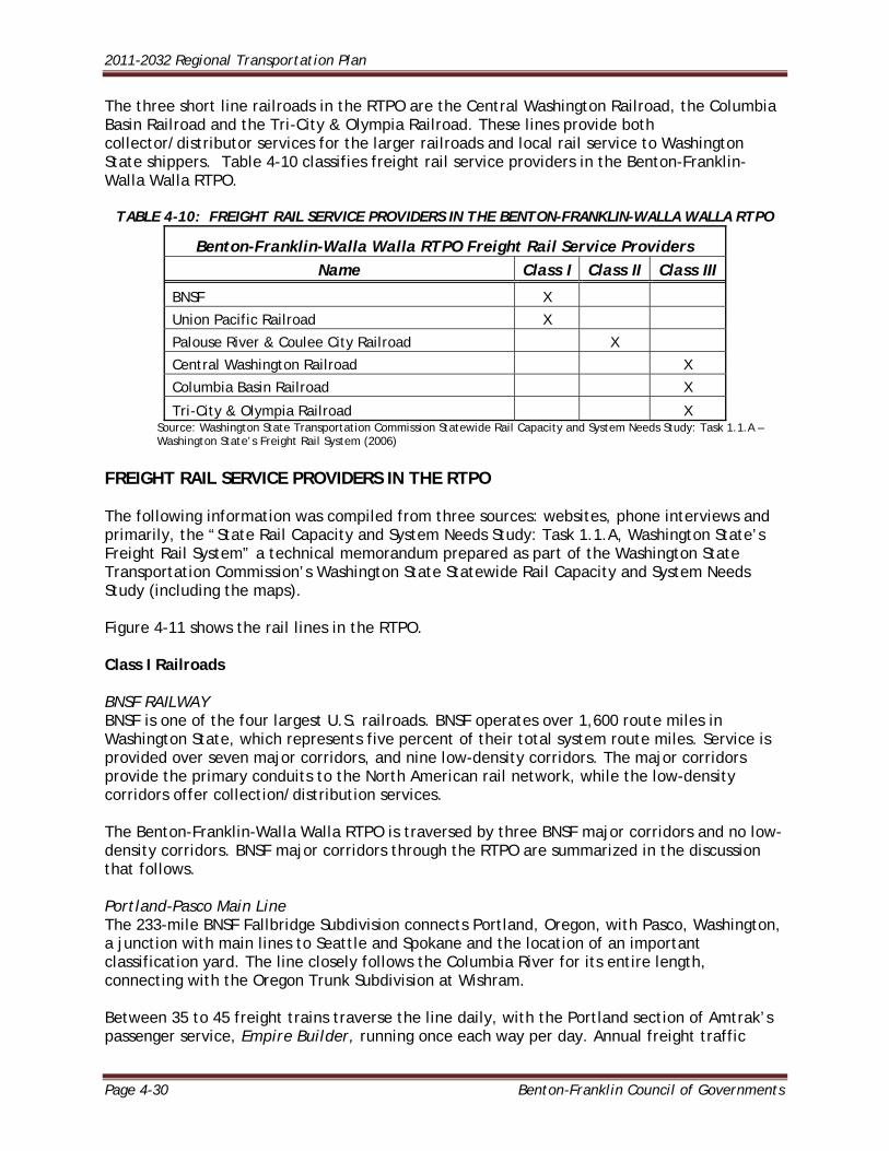
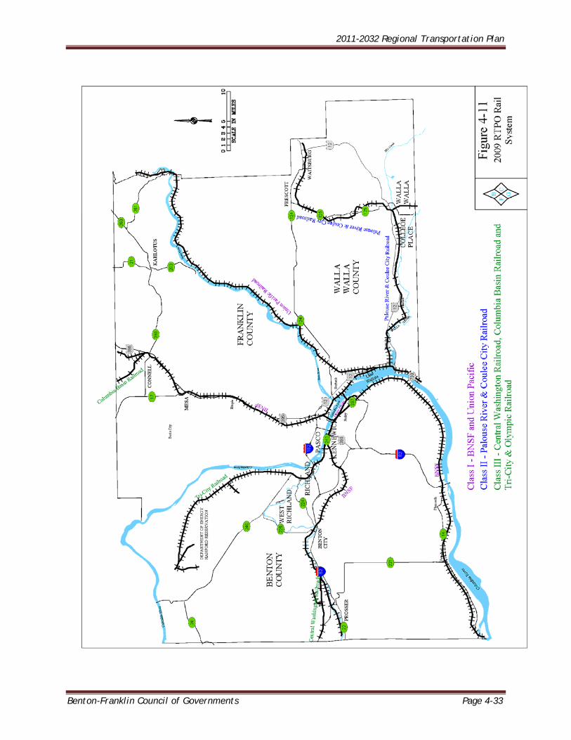
REGIONAL FREIGHT RAIL SYSTEMS Six railroads provide freight rail service in the RTPO. This section contains information on all six, as well as referencing other types of freight rail service within the RTPO. RAILROAD CLASSIFICATION Railroad classification is determined by the Surface Transportation Board, with revenue as a determining factor. The Board has defined revenue-based characteristics for Class I (the largest), Class II and Class III railroads. Freight rail service in the Benton-Franklin-Walla Walla RTPO is provided by two Class I railroads, one Class II, or regional railroad, and three Class III, or short line railroads. The two Class I railroads are the BNSF Railway (formerly Burlington Northern Santa Fe) and the Union Pacific (UP). These two railroads provide the primary connections between Washington’s ports, farmers, and industries and the rest of North America. The Class II, or regional, railroad is the Palouse River & Coulee City Railroad. It provides service to several industries, but most significantly to grain shippers. The railroad consists of a combination of privately and publicly owned track.
2011-2032 Regional Transportation Plan
Page 4-30 Benton-Franklin Council of Governments
The three short line railroads in the RTPO are the Central Washington Railroad, the Columbia Basin Railroad and the Tri-City & Olympia Railroad. These lines provide both collector/distributor services for the larger railroads and local rail service to Washington State shippers. Table 4-10 classifies freight rail service providers in the Benton-Franklin-Walla Walla RTPO.
TABLE 4-10: FREIGHT RAIL SERVICE PROVIDERS IN THE BENTON-FRANKLIN-WALLA WALLA RTPO
Benton-Franklin-Walla Walla RTPO Freight Rail Service Providers Name Class I Class II Class III
BNSF X
Union Pacific Railroad X
Palouse River & Coulee City Railroad X
Central Washington Railroad X
Columbia Basin Railroad X
Tri-City & Olympia Railroad X Source: Washington State Transportation Commission Statewide Rail Capacity and System Needs Study: Task 1.1.A – Washington State’s Freight Rail System (2006)
FREIGHT RAIL SERVICE PROVIDERS IN THE RTPO The following information was compiled from three sources: websites, phone interviews and primarily, the “State Rail Capacity and System Needs Study: Task 1.1.A, Washington State’s Freight Rail System” a technical memorandum prepared as part of the Washington State Transportation Commission’s Washington State Statewide Rail Capacity and System Needs Study (including the maps). Figure 4-11 shows the rail lines in the RTPO. Class I Railroads BNSF RAILWAY BNSF is one of the four largest U.S. railroads. BNSF operates over 1,600 route miles in Washington State, which represents five percent of their total system route miles. Service is provided over seven major corridors, and nine low-density corridors. The major corridors provide the primary conduits to the North American rail network, while the low-density corridors offer collection/distribution services. The Benton-Franklin-Walla Walla RTPO is traversed by three BNSF major corridors and no low-density corridors. BNSF major corridors through the RTPO are summarized in the discussion that follows. Portland-Pasco Main Line The 233-mile BNSF Fallbridge Subdivision connects Portland, Oregon, with Pasco, Washington, a junction with main lines to Seattle and Spokane and the location of an important classification yard. The line closely follows the Columbia River for its entire length, connecting with the Oregon Trunk Subdivision at Wishram. Between 35 to 45 freight trains traverse the line daily, with the Portland section of Amtrak’s passenger service, Empire Builder, running once each way per day. Annual freight traffic
2011-2032 Regional Transportation Plan
Benton-Franklin Council of Governments Page 4-31
consists of intermodal, forest and agricultural products, refuse, coal, chemicals and finished automobiles. Auburn-Pasco Main Line BNSF’s 227-mile main line across central Washington consists of the Stampede Subdivision between Auburn and Ellensburg, and the Yakima Valley Subdivision connecting Yakima and Pasco. The Stampede Subdivision crosses the Cascade Mountains at Stampede Pass, entering the Stampede Tunnel at the summit. The Yakima Valley Subdivision traverses the twisting Yakima River Canyon. Between 35 to 45 freight trains traverse the line daily, with the Portland section of Amtrak’s passenger service, Empire Builder, running once each way per day. Annual freight traffic consists of intermodal, forest and agricultural products, refuse, coal, chemicals and finished automobiles. Auburn-Pasco Main Line BNSF’s 227-mile main line across central Washington consists of the Stampede Subdivision between Auburn and Ellensburg, and the Yakima Valley Subdivision connecting Yakima and Pasco. The Stampede Subdivision crosses the Cascade Mountains at Stampede Pass, entering the Stampede Tunnel at the summit. The Yakima Valley Subdivision traverses the twisting Yakima River Canyon. In response to the declining rail traffic of the early 1980s and the high cost of maintaining three main lines across the State, Burlington Northern abandoned the line over Stampede Pass in 1982; the majority of the corridor was sold to the Washington Central Railroad. The line lay essentially dormant until the mid-1990s, when a period of unexpected growth stretched the capacity of BNSF’s Stevens Pass and Columbia River routes to the limit, culminating in the decision to reacquire and reopen the line to allow the diversion of low-priority traffic from the vital intermodal corridors. An average of seven trains utilizes this freight-only corridor each day. Freight traffic includes forest, agricultural and chemical products. Pasco-Spokane Main Line The 149-mile BNSF Lakeside Subdivision is a vital line connecting Pasco and Spokane. Its eastern 12 miles also host UP trains operating between Hinkle, Oregon, and Spokane. The line traverses rolling farmland as it skirts north of the Palouse Region. Approximately 33 BNSF freight trains operate on the line daily, along with a daily average of 11 UP trains on the shared line near Spokane. In addition, the Portland section of Amtrak’s Empire Builder runs once each way per day. Annual freight traffic consists of intermodal, forest and agricultural products, coal, chemicals and finished automobiles. UNION PACIFIC RAILROAD The Union Pacific Railroad (UP) is the largest railroad in North America, operating 32,400 route miles in the western United States. UP operates over 558 route miles in Washington State, which represents less than two percent of their total system route miles. Service is provided over two major corridors, and three low-density corridors. The major corridors provide the primary conduits to the nationwide rail network, while the low-density corridors offer collection/distribution services.
2011-2032 Regional Transportation Plan
Page 4-32 Benton-Franklin Council of Governments
Hinkle-Spokane Main Line UP’s 171-mile Ayer Subdivision connects Hinkle Yard in Hermiston, Oregon, to Spokane. At Fish Lake, the north end of the line, UP utilizes trackage rights on BNSF’s Lakeside Subdivision to access Spokane. The Ayer Subdivision hosts an average of 11 freight trains per day, and does not have passenger service. Freight traffic is primary forest and agricultural products, potash, and chemicals. Two UP branch lines also function within the RTPO. The 11-mile Ayer Junction-Riparia Subdivision connects the Ayer Subdivision to the Great Northwest Railroad at Riparia in Columbia County, while the 19-mile Wallula-Kennewick branch line extends from the junction with the Ayer Subdivision at Wallula to the connection with the Tri-City & Olympia Railroad at Richland Junction. Class II Railroads
THE PALOUSE RIVER & COULEE CITY RAILROAD The Palouse River & Coulee City Railroad (PCC) is a wholly owned subsidiary of Watco Companies with offices located in Lewiston, Idaho. It serves a variety of shippers of agricultural products, hauling wheat, lentils and barley over 202 mainline miles.
The PCC is comprised of three branch lines, two of which operate in Whitman and Spokane Counties. The third line, the South Subdivision, connects Wallula, located on the UP Hinkle-Spokane line, to Walla Walla, then from Walla Walla to Dayton, Washington and Weston, Oregon.
These two lines were among a group of rail lines acquired by the Blue Mountain Railroad (BLMR) in 1992 from UP; the BLMR was subsequently acquired by the PCC in 1998.
Class III Railroads
CENTRAL WASHINGTON RAILROAD The Central Washington Railroad (CWA), a wholly owned subsidiary of the Columbia Basin Railroad (CBRW), serves a series of former BNSF and UP branch lines in central Washington, predominantly in Yakima County. In the RTPO, this includes a portion of a thirty mile length of rail from Gibbon (just east of Prosser) to Granger, in Yakima County. The CWA handles various agricultural and chemical products on these lines, interchanging with BNSF at Yakima, Toppenish, and Gibbon. COLUMBIA BASIN RAILROAD COMPANY The Columbia Basin Railroad (CBRW), formerly the Washington Central Railroad Company (WCRC), is a short line railroad serving Central Washington that was started in 1996. CBRW is locally owned and operated, with offices in Yakima, Washington. The rail line is primarily an agricultural based railroad handling grain, sugar beets, fresh and frozen potatoes, fertilizers, chemicals and paper products, performing interchange with BNSF on its Pasco-Spokane line at Connell. The Washington Central Railroad Company (WCRC) began in 1986, following the purchase of 350 miles of rail in the Yakima Valley and Columbia Basin from Burlington Northern. In 1995, Burlington Northern Railroad and Santa Fe Railroad merged. The newly formed Burlington Northern Santa Fe (BNSF) decided to re-acquire the WCRC rail lines to make a third rail route
2011-2032 Regional Transportation Plan
Benton-Franklin Council of Governments Page 4-33
2011-2032 Regional Transportation Plan
Page 4-34 Benton-Franklin Council of Governments
into western Washington – Stampede Pass - available, and to provide more efficient trans-continental rail service for the Ports of Seattle and Tacoma. The owners of the WCRC sold the company to the Burlington Northern Santa Fe in December 1996. BNSF only had an interest in the Stampede Pass mainline of the WCRC. The owners of the now defunct WCRC formed the Columbia Basin Railroad Company (CBRW) and leased back the 84 rail miles between Connell and Moses Lake, which they had previously owned, from BNSF. The lease from BNSF is comprised of a collection of four former Northern Pacific and Milwaukee Road branches in central Washington. The line partly within the RTPO is a 40 mile long segment which passes between Connell in north central Franklin County and Wheeler in southeastern Grant County. Additional CBRW holdings operate in Adams, Grant and Clark Counties. TRI-CITY & OLYMPIA RAILROAD The Tri-City & Olympia Railroad (TCRY) owns two separate operations in Washington. In the RTPO, their line operates between Richland and the south border of the Hanford Site. It was leased from the Port of Benton in 2000, the Port having acquired the trackage from the United States Department of Energy (DOE) in 1998. In accordance with the Port’s goal of redeveloping the site for industrial use the TCRY leased the remaining trackage within the Hanford Site from the DOE in 2002. The other TCRY line operates in Thurston County. ADDITIONAL FREIGHT RAIL SERVICES IN THE RTPO Additional freight rail services complement the conventional rail services described above. This section provides a short overview of each one. THE GRAIN TRAIN PROGRAM The Washington Grain Train serves over 2,500 cooperative members and farmers in one of the most productive grain-growing regions in the world. The Grain Train is designed to preserve the viability of light density rail lines; reduce road maintenance costs; reduce congestion and increase road safety; and support energy efficient movement of goods. The program supplies additional rail cars to railroad companies that have been traditionally short of rail cars during the key autumn shipping season. In November 1994, the first of 29 state-sponsored grain cars began service on the Blue Mountain Railroad. In cooperation with local port districts, the program used energy rebate funds to purchase the first rail cars. In January 2011, 29 newly acquired grain hopper rail cars begin service as part of Grain Train, bringing the total number of cars in the program to 118. WSDOT oversees the entire program and the port districts collect monthly payments for the use of the program’s cars. The Grain Train program is financially self-supporting as user fees pay to operate the program and purchase cars as funds become available. The grain train program produces a number of public benefits including: Helps move Washington products reliably and efficiently to domestic and international
markets. Helps preserve Washington’s short-line railroads by generating revenues that can be
used to upgrade rail lines and support the railroad’s long-term infrastructure needs.
2011-2032 Regional Transportation Plan
Benton-Franklin Council of Governments Page 4-35
Helps support a healthy rail network that can maintain and attract new businesses –
especially in rural areas of Washington.
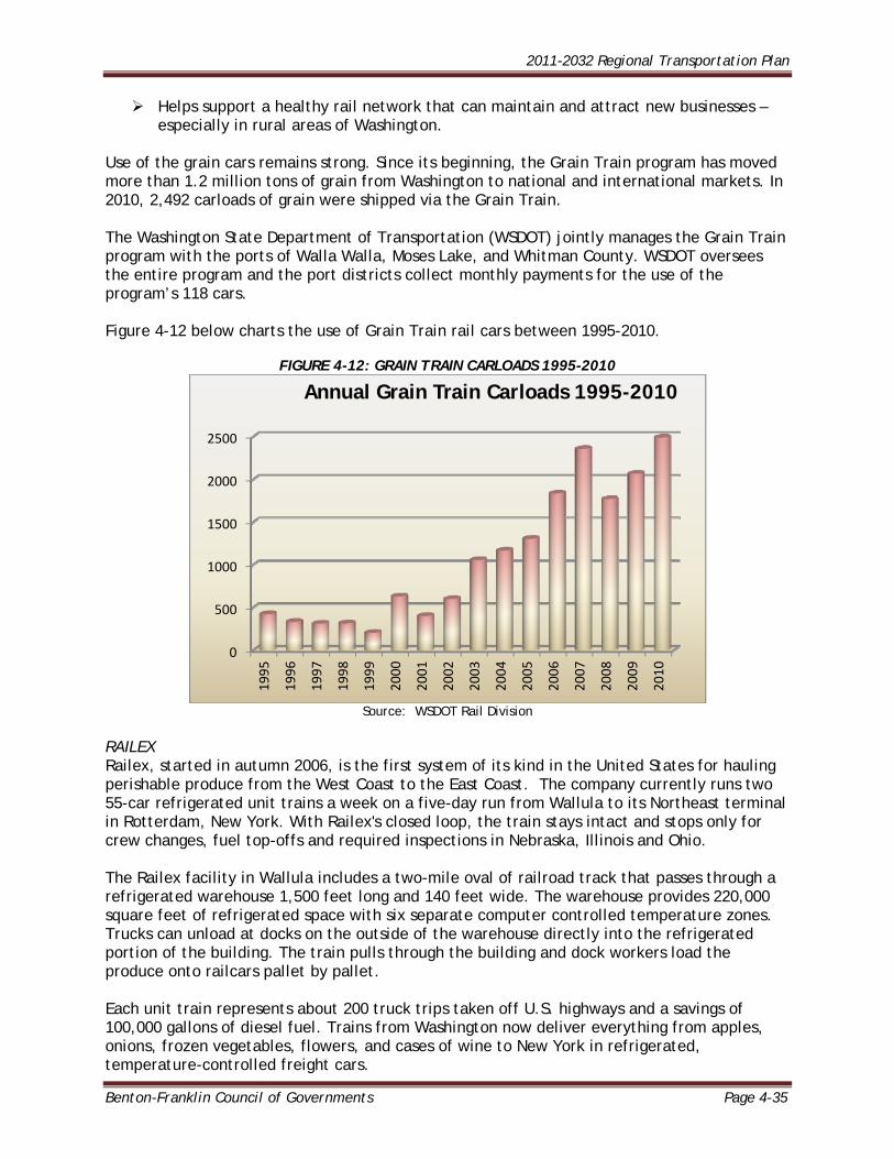
Use of the grain cars remains strong. Since its beginning, the Grain Train program has moved more than 1.2 million tons of grain from Washington to national and international markets. In 2010, 2,492 carloads of grain were shipped via the Grain Train. The Washington State Department of Transportation (WSDOT) jointly manages the Grain Train program with the ports of Walla Walla, Moses Lake, and Whitman County. WSDOT oversees the entire program and the port districts collect monthly payments for the use of the program’s 118 cars. Figure 4-12 below charts the use of Grain Train rail cars between 1995-2010.
FIGURE 4-12: GRAIN TRAIN CARLOADS 1995-2010
Source: WSDOT Rail Division
RAILEX Railex, started in autumn 2006, is the first system of its kind in the United States for hauling perishable produce from the West Coast to the East Coast. The company currently runs two 55-car refrigerated unit trains a week on a five-day run from Wallula to its Northeast terminal in Rotterdam, New York. With Railex's closed loop, the train stays intact and stops only for crew changes, fuel top-offs and required inspections in Nebraska, Illinois and Ohio. The Railex facility in Wallula includes a two-mile oval of railroad track that passes through a refrigerated warehouse 1,500 feet long and 140 feet wide. The warehouse provides 220,000 square feet of refrigerated space with six separate computer controlled temperature zones. Trucks can unload at docks on the outside of the warehouse directly into the refrigerated portion of the building. The train pulls through the building and dock workers load the produce onto railcars pallet by pallet. Each unit train represents about 200 truck trips taken off U.S. highways and a savings of 100,000 gallons of diesel fuel. Trains from Washington now deliver everything from apples, onions, frozen vegetables, flowers, and cases of wine to New York in refrigerated, temperature-controlled freight cars.
0
500
1000
1500
2000
2500
1995
1996
1997
1998
1999
2000
2001
2002
2003
2004
2005
2006
2007
2008
2009
2010
Annual Grain Train Carloads 1995-2010
2011-2032 Regional Transportation Plan
Page 4-36 Benton-Franklin Council of Governments
Union Pacific and CSX Transportation share the responsibility of making sure the shipments reach the East Coast in less than a week. In 2009, Railex added another distribution site in Delano, California, and runs two trains each way weekly between New York and California. Plans are underway to develop a facility in the southeast, opening additional potential markets to Washington products. PORT OF BENTON INTERMODAL TRANSLOAD CENTER Completed in September 2008, the Port of Benton has developed the 7,000 square foot Intermodal Transload Center to handle increased demand for shipping products by rail across America. The Port teamed up with the State of Washington, the City of Richland, and the Tri-City & Olympia Railroad, to build the Center at the Horn Rapids Industrial Park in Richland. The Transload Center is strategically located with dual rail access (Union Pacific and BNSF Railways), and daily switching provided the Tri-City & Olympia Railroad. The temperature controlled facility can handle frozen, refrigerated and dry products from a wide variety of growers and manufacturers. Small shippers are able to assemble and combine custom quantities of their agricultural products into custom shipments to customers located throughout the United States. FRONTIER RAIL Since 2006, Frontier Rail has operated a railcar switching business for Railex and Union Pacific Railroad at the Port of Walla Walla Dodd Road Industrial Park near Wallula. Frontier chiefly services the warehouse switching needs of Railex. Frontier also provides important efficiencies to the first and final mile of the UP "Produce Railexpress" the train carrying the Railex business to New York State. Services provided to UP include car interchange, railcar 0repairs, and freight car inspections/initial terminal air tests. PORT OF PASCO NORTHERN RAIL TRANSLOAD HUB The Port of Pasco over the past five years has completed a multi-phase investment in new rail in its transload facility in Big Pasco Industrial Center to secure and expand the rail connection to deep water ports for agricultural exports bound for Asian markets, to assure rail service for shippers having difficulty securing trucks, and to foster competitive freight prices for producers shipping to international markets. In addition, the investment in rail improvements maintains and improves existing access to a Class 1 railroad for regional freight and creates a Pacific Northwest distribution point for domestic westbound freight. Most recently, wind-energy components have been brought into Big Pasco on the new rail for distribution to many Pacific Northwest wind farm projects. Approximately 9,000 linear feet of rail is available on 3 parallel tracks north of the warehouses to accommodate a divided unit train or smaller segment-trains for transloading. Approximately 4-acre to 24-acre areas of land are available adjacent to rail for lease for staging transload operations. PASSENGER RAIL Amtrak passenger service, the “Empire Builder,” operates daily on the BNSF track from Seattle to Vancouver, through Pasco to Spokane. A companion route operates on BNSF track between Seattle and Spokane, where the two trains link up to continue toward Chicago. Westbound passenger service stops at the Pasco Inter-modal Depot in the early morning; eastbound service is scheduled for late evening. Arrival times vary due to heavy freight traffic on the line.
2011-2032 Regional Transportation Plan
Benton-Franklin Council of Governments Page 4-37
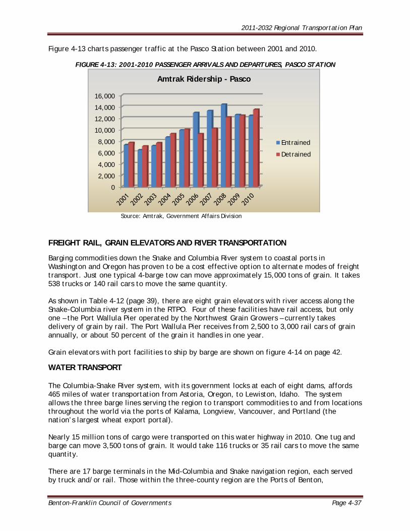
Figure 4-13 charts passenger traffic at the Pasco Station between 2001 and 2010.
FIGURE 4-13: 2001-2010 PASSENGER ARRIVALS AND DEPARTURES, PASCO STATION
Source: Amtrak, Government Affairs Division FREIGHT RAIL, GRAIN ELEVATORS AND RIVER TRANSPORTATION
Barging commodities down the Snake and Columbia River system to coastal ports in Washington and Oregon has proven to be a cost effective option to alternate modes of freight transport. Just one typical 4-barge tow can move approximately 15,000 tons of grain. It takes 538 trucks or 140 rail cars to move the same quantity. As shown in Table 4-12 (page 39), there are eight grain elevators with river access along the Snake-Columbia river system in the RTPO. Four of these facilities have rail access, but only one – the Port Wallula Pier operated by the Northwest Grain Growers – currently takes delivery of grain by rail. The Port Wallula Pier receives from 2,500 to 3,000 rail cars of grain annually, or about 50 percent of the grain it handles in one year. Grain elevators with port facilities to ship by barge are shown on figure 4-14 on page 42.
WATER TRANSPORT The Columbia-Snake River system, with its government locks at each of eight dams, affords 465 miles of water transportation from Astoria, Oregon, to Lewiston, Idaho. The system allows the three barge lines serving the region to transport commodities to and from locations throughout the world via the ports of Kalama, Longview, Vancouver, and Portland (the nation’s largest wheat export portal). Nearly 15 million tons of cargo were transported on this water highway in 2010. One tug and barge can move 3,500 tons of grain. It would take 116 trucks or 35 rail cars to move the same quantity. There are 17 barge terminals in the Mid-Columbia and Snake navigation region, each served by truck and/or rail. Those within the three-county region are the Ports of Benton,
0
2,000
4,000
6,000
8,000
10,000
12,000
14,000
16,000
Amtrak Ridership - Pasco
Entrained
Detrained
2011-2032 Regional Transportation Plan
Page 4-38 Benton-Franklin Council of Governments
Kennewick, Pasco, Walla Walla, and Windust. Seven more ports lie upriver, including the last one at Lewiston, Idaho. SNAKE RIVER/COLUMBIA RIVER DAM AND LOCK SYSTEM
The Walla Walla District of the Army Corps of Engineers (COE) is responsible for the maintenance and development of water resource projects on the Snake and Columbia Rivers. This includes four lock and dam operations on the Lower Snake River and one on the Columbia River in eastern Washington: Lower Granite Lock and Dam near Pomeroy; Little Goose Lock and Dam near Starbuck; Lower Monumental Lock and Dam near Kahlotus; Ice Harbor Lock and Dam near the Tri-Cities on the Snake River; and McNary Lock and Dam between south Benton County and Umatilla, Oregon on the
Columbia River.
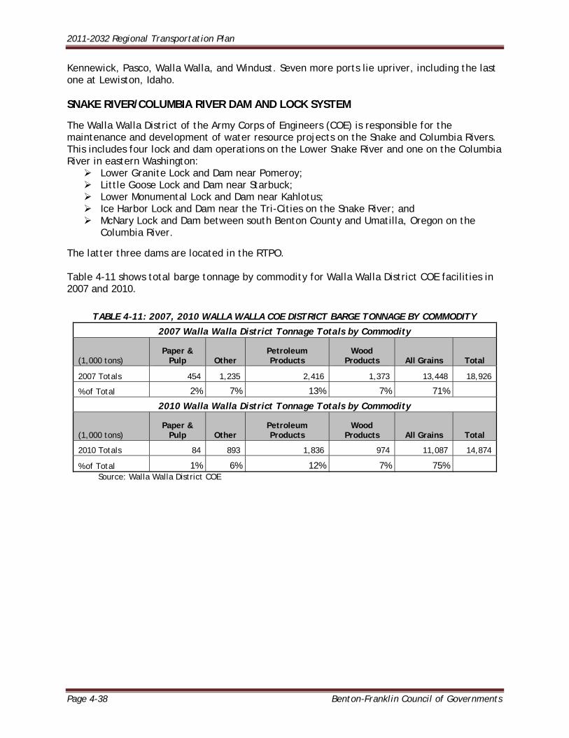
The latter three dams are located in the RTPO. Table 4-11 shows total barge tonnage by commodity for Walla Walla District COE facilities in 2007 and 2010.
TABLE 4-11: 2007, 2010 WALLA WALLA COE DISTRICT BARGE TONNAGE BY COMMODITY
2007 Walla Walla District Tonnage Totals by Commodity
(1,000 tons) Paper &
Pulp Other Petroleum Products
Wood Products All Grains Total
2007 Totals 454 1,235 2,416 1,373 13,448 18,926
% of Total 2% 7% 13% 7% 71%
2010 Walla Walla District Tonnage Totals by Commodity
(1,000 tons) Paper &
Pulp Other Petroleum Products
Wood Products All Grains Total
2010 Totals 84 893 1,836 974 11,087 14,874
% of Total 1% 6% 12% 7% 75% Source: Walla Walla District COE
2011-2032 Regional Transportation Plan
Benton-Franklin Council of Governments Page 4-39
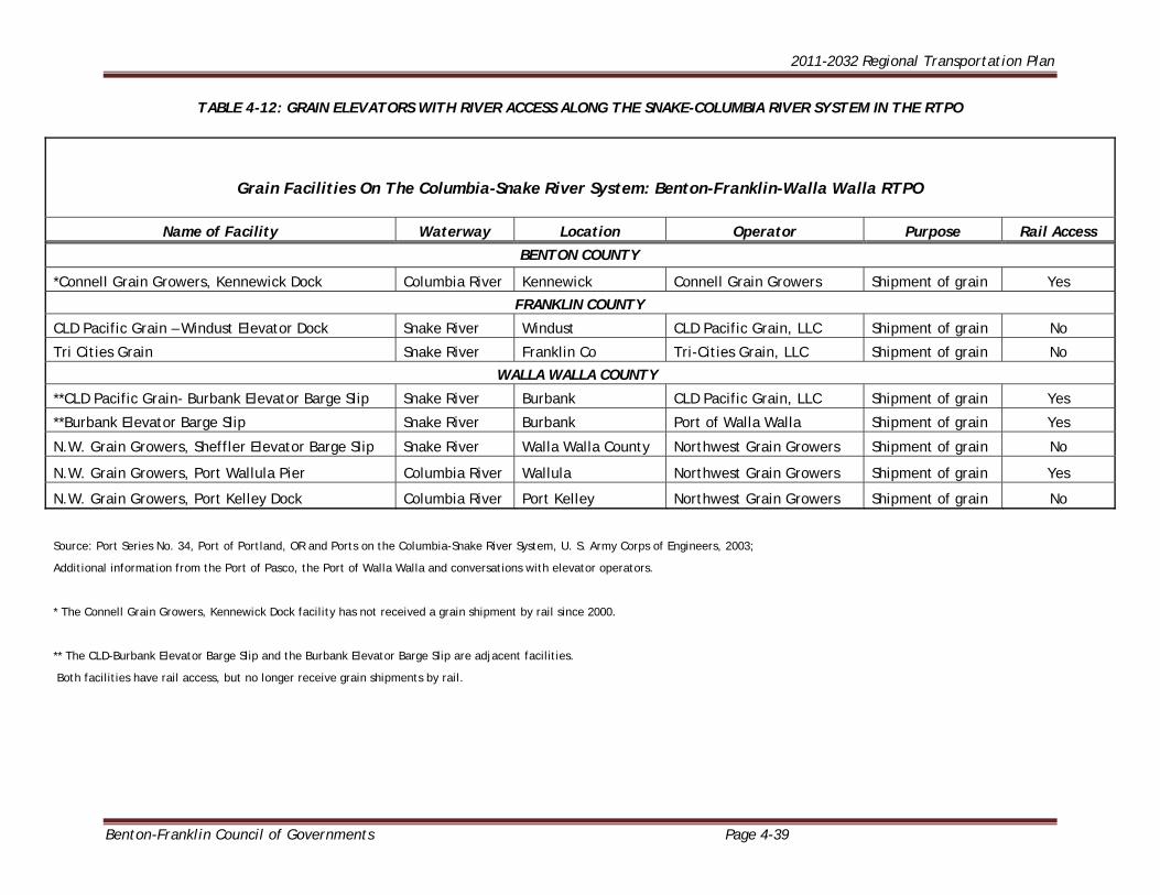
TABLE 4-12: GRAIN ELEVATORS WITH RIVER ACCESS ALONG THE SNAKE-COLUMBIA RIVER SYSTEM IN THE RTPO
Grain Facilities On The Columbia-Snake River System: Benton-Franklin-Walla Walla RTPO
Name of Facility Waterway Location Operator Purpose Rail Access
BENTON COUNTY
*Connell Grain Growers, Kennewick Dock Columbia River Kennewick Connell Grain Growers Shipment of grain Yes
FRANKLIN COUNTY
CLD Pacific Grain – Windust Elevator Dock Snake River Windust CLD Pacific Grain, LLC Shipment of grain No
Tri Cities Grain Snake River Franklin Co Tri-Cities Grain, LLC Shipment of grain No
WALLA WALLA COUNTY
**CLD Pacific Grain- Burbank Elevator Barge Slip Snake River Burbank CLD Pacific Grain, LLC Shipment of grain Yes
**Burbank Elevator Barge Slip Snake River Burbank Port of Walla Walla Shipment of grain Yes
N.W. Grain Growers, Sheffler Elevator Barge Slip Snake River Walla Walla County Northwest Grain Growers Shipment of grain No
N.W. Grain Growers, Port Wallula Pier Columbia River Wallula Northwest Grain Growers Shipment of grain Yes
N.W. Grain Growers, Port Kelley Dock Columbia River Port Kelley Northwest Grain Growers Shipment of grain No
Source: Port Series No. 34, Port of Portland, OR and Ports on the Columbia-Snake River System, U. S. Army Corps of Engineers, 2003; Additional information from the Port of Pasco, the Port of Walla Walla and conversations with elevator operators. * The Connell Grain Growers, Kennewick Dock facility has not received a grain shipment by rail since 2000. ** The CLD-Burbank Elevator Barge Slip and the Burbank Elevator Barge Slip are adjacent facilities. Both facilities have rail access, but no longer receive grain shipments by rail.
2011-2032 Regional Transportation Plan
Page 4-40 Benton-Franklin Council of Governments
Table 4-13 shows total barge tonnage by lock for Walla Walla District COE facilities in 2007 and 2010.
TABLE 4-13: 2007, 2010 WALLA WALLA COE DISTRICT BARGE TONNAGE BY LOCK
2007 Walla Walla District Tonnage Totals by Lock
(1,000 tons) McNary Ice Harbor Lower
Monumental Little Goose
Lower Granite Total
Lock Total 7,351 3,611 3,268 2,933 1,763 18,926
% of Total 39% 19% 17% 15% 9%
2010 Walla Walla District Tonnage Totals by Lock
(1,000 tons) McNary Ice Harbor Lower
Monumental Little Goose
Lower Granite Total
Lock Total 6,238 2,874 2,234 2,280 1,249 14,874
% of Total 42% 19% 15% 15% 8%
Source: Walla Walla District COE LOCAL PORT DISTRICTS - COLUMBIA RIVER FACILITIES PORT OF PASCO INTERMODAL TERMINAL The Port of Pasco owns and manages the Big Pasco Industrial Center, which has nearly two miles of waterfront on the north side of the Columbia River upstream from the mouth of the Snake River. The Container Terminal is a multi-modal rail/barge facility on the Columbia River. The terminal provides docking, loading and unloading for grain and bulk commodity barges. The facility has a fully operational container-handling terminal for loading and unloading containerized cargo. Rail facilities include 3000 feet of industrial track rail on two tracks and rail service to Seattle and Tacoma. The dock and yard area are served by a Port-owned rail spur connecting to the Burlington Northern Santa Fe. BNSF does all railcar switching. PORT OF BENTON The Port has over 6,000 feet of Columbia River frontage zoned for heavy industrial use at their Richland Technology and Business Campus located on the west bank of the Columbia River in North Richland. Their dock facilities near the north end of the site are used to unload construction materials and heavy equipment, much of which is destined for Hanford, and other cargoes bound for North Richland. PORT OF KENNEWICK The Port owns property zoned for heavy industrial use at various locations along a 12-mile stretch of the Columbia River in, adjacent to and southeast of Kennewick. Several private dock facilities are maintained and operated by industries located in the area. The port will soon construct a barge dock at their Hover site southeast of Finley. A 1,400-foot barge dock will also be built at the port’s riverfront site below McNary Dam at Columbia Mile 288. PORT OF WALLA WALLA Burbank Industrial Park Burbank Industrial Park is located on the confluence of the Columbia and Snake rivers approximately 35 miles west of the City of Walla Walla and six miles south of the City of Pasco, in Franklin County. The park is approximately 50 acres and zoned heavy industrial. Transportation access at the park
2011-2032 Regional Transportation Plan
Benton-Franklin Council of Governments Page 4-41
includes a cargo dock, two barge slips and rail served by Burlington Northern. State Route 12 and US Highway 395 are nearby. Cargill Louis Dreyfus, Inc., Schnitzer Steel and Westway Feed currently utilize the park for the shipment of grain, steel and animal-feed supplements. Wallula Junction Wallula Junction is located on the Columbia River approximately 30 miles west of the City of Walla Walla and 10 miles south of the City of Pasco, in Franklin County. Wallula Junction is approximately 25 acres and zoned industrial. Transportation access at the park includes a barge slips and rail served by Union Pacific Railroad. Northwest Grain Growers currently utilize Wallula Junction as a transload facility from rail to barge for the shipment of grain.
Port facilities in the RTPO are shown in Figure 4-14, (page 42).
PIPELINES The Benton, Franklin and Walla Walla County region is crossed by two interstate natural gas supply lines: Pacific Gas & Electric Transmission Company (PG&E) and Williams Northwest Pipeline Company; as well as a common carrier pipeline that transports refined petroleum products. The PG&E network enters Washington near Spokane, works its south to Walla Walla County, the southeast corner of Benton County, and crosses into Oregon (see Figure 4-11). The facility extends from northern Alberta, Canada to the San Francisco Bay Area and consists of parallel 36 and 42- inch pipes. The Williams Northwest Pipeline Company pipeline runs from Vancouver, B.C. to Vancouver, Washington, and up the Columbia River Gorge to Plymouth. There it branches into two lines. One serves the Tri-Cities and Spokane; the second serves the Yakima Valley and Wenatchee. The maximum pipe size is 30 inches. This system distributes natural gas to Washington’s seven utility companies for further distribution to customers. A branch line also extends into Walla Walla from Oregon. The Chevron Pipeline is a common carrier pipeline that transports refined petroleum products such as diesel and gasoline from Salt Lake City to Pasco and Spokane, where it connects with the Yellowstone Pipeline (Billings, Montana to Spokane and Moses Lake). Chevron’s pipeline consists of two, parallel, 6-inch lines up to Pasco, then an 8-inch line to Spokane. When demand exceeds supply for a given product in Pasco, additional product is barged up from Portland. Olympic Pipeline Company conducted a feasibility study for an underground pipeline to transport refined petroleum products (gasoline, diesel, aviation fuel) from Western Washington refineries to Central and Eastern Washington. The line would have ascended over Snoqualmie Pass, traversed Kittitas and Grant Counties, then swung southerly through Franklin County to the fuel distribution facility east of Pasco. A connection to an existing pipeline near Pasco would have facilitated transporting fuels to Spokane. After reviewing the feasibility study, Olympic determined that although the project does have some merits, the extensive permitting process and cost to build the pipeline make it prohibitive. Pipelines in the RTPO are shown in Figure 4-14.
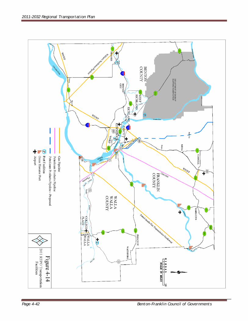
2011-2032 Regional Transportation Plan
Page 4-42 Benton-Franklin Council of Governments