Embed Size (px)
Citation preview

Raleigh has a clear strategy for addressing im-mediate pedestrian network needs. This strategy includes moving forward with installing side-walks and addressing safety and comfort needs at intersections, with complementary programs and activities. These short term tactics are those that can be completed within the existing right-of-way. Conceptual design treatments recom-mended for the six Example Locations in Chap-ter 4 fit into this category.
Consistent with the vision set out in the City’s 2030 Comprehensive Plan to make Raleigh “…workable, livable, and prosperous. . ,” the City can adopt a longer term transportation strat-egy focus on the broader pedestrian experience
by creating attractive, high quality pedestrian places. NCDOT’s Draft Final Complete Streets Planning and Design Guidelines provide an ad-ditional resource that the City has already used for major corridor projects (such as Hillsbor-ough Street) and will continue to use.
Additional staff resources are likely needed to implement this strategy, such as staff time to complete field work, traffic analysis, and public
Fiscal Year 2017 Projects
$0 31.5
Miles
Fiscal Year 2017 Projects
Extra-Territorial Jurisdiction
City of RaleighComprehensive Pedestrian Plan
CHAPTER EIGHTLONGER TERM VISION
168
Fiscal Year 2017 Projects
$0 31.5
Miles
Fiscal Year 2017 Projects
Extra-Territorial Jurisdiction
City of RaleighComprehensive Pedestrian Plan
engagement. Greater financial resources are also needed to purchase right-of-way and build the new corridors. However, the investment is worthy of the anticipated outcome.
Two approaches are described here: one that incorporates pedestrians (and bicyclists) within the roadway through “reallocating or adding to”; the other separates non-motorized and motor-ized modes, drawing on examples from other U.S. cities.
Reallocating or adding to
Three streets included in the Example Locations work are suitable for this strategy: Avent Ferry Road, Martin Luther King Jr Boulevard, and Wake Forest Road. Figure 1 shows the design concepts for the three streets. The corridor-long cross sections reflect a strategy that includes fewer motor vehicle travel lanes, the addition of bicycle lanes, wider sidewalks, and more buf-fers. In some cases, a road diet may be used to accomplish these changes. Other locations may require the purchase of additional right-of-way. Corridor-long changes include a continuous me-dian configured with pedestrian refuge features at each intersection, wider sidewalks to comfort-ably accommodate increased pedestrian traffic, a continuous buffer between sidewalks and the curb, continuous bike lanes with current stan-dards for lane merging and intersection treat-ments, a center turn lane to complement access management and reduce places where motor ve-hicles can cross the sidewalk.
169
DECEMBER 2012

Figure 3. Cross-sections and locator maps.
170
City of Raleigh Pedestrian Plan | Chapter 8

Traffic analysis is needed before proceeding with the next level of design. The City reduced the Level of Service (LOS) standard to E with the 2030 Comprehensive Plan specifically for the purpose of mul-timodal improvement. This change allows for adding pedestrian (and bicycle) elements in locations where they will have a strong benefit, understanding that motor vehicle travel will be affected. The graphic sequence below shows how level of service for pedestrians, bicyclists and motor vehicles may be changed through a series of intersection improvements aimed at improving safety for each of these modes.
Pedestrian improvement: Add a median refuge and reduce corner radii
Typical Existing Conditions: LOS for motor vehicles is higher than that for pedestrians and bicyclists.
171
DECEMBER 2012

Envisioning the transportation-land use connection
The second strategy is resolves conflicting or incompatible goals for modes traveling within the right-of-way and increases the connection between the pedestrian network and adjacent land uses. It mitigates the ever-present ten-sion between the size of the road and the ac-tivity going on along and round the road, and across the road. In some respects, this strategy is about creating successful neighborhoods by balancing its cross-ability and throughput.
This strategy is appropriate in locations where
Pedestrian improvement: Add a leading pedestrian interval and accessible signals
Bicycle improvement: Add bike lanes (bicycles on roadway, not sidewalk)
a markedly different approach – or “Big Ideas” -- may offer the best solution.
The Big Ideas strategy is useful in areas where roadways are barriers to pedestrian travel be-tween mixed-use areas intended to promote pedestrian-oriented transportation. While pe-destrians may desire easy access on foot to the commercial and residential adjacent to both sides of the roadway, the roadway serves as a barrier. Creating access requires both innova-tive solutions and a significant investment of City resources to plan, design, and implement,
172
City of Raleigh Pedestrian Plan | Chapter 8

once community buy-in is gained.
Big ideas rely on a series of steps that take into account the context, constraints, and anticipated uses of the resulting solution. It is a fundamental planning issue of connecting land use and adja-cent transportation needs. When done well, the outcome may be an icon that transforms both pedestrian transportation and land use. Successful Big Ideas include consideration of several factors, described below. These factors are relevant to a new project or a retrofit project:
» Forward-looking. The lifespan of a big ideas solution is long. Can it serve as the leading edge of the vision for the City, especially with respect to the transportation-land use connection?
» Attention to process. Does the political will exist? Is there community support? Is there a way to involve developers?
» Network significance. How does a big ideas solution add to the pedestrian network in a way that another strategy does not?
» Flexibility in design. Drawing on its network significance and expected outcome, how flexible can the design solution be? Are lane or road diets, medians, curb extensions needed to create the pedestrian and bicycle space and safety needs?
» Attention to details. It is important to get the details right so that goals are reached. Start by creating an inventory of things that need to be addressed and deal with them appropriately.
Two solution types that help mitigate conflicting and incompatible goals are drawn from examples from
. .[M]ost American land uses, with the exception of older city centers, were built for cars; modern suburbs, with their malls and strip malls, schools, offices, parks, apartment complexes, and especially the parking lots for all of them.
[However], the majority of Americans live in places, not merely along streets, which were built to be driven into . . . and out of by car. That means the distances to everyday destinations are generally too far to be walked or comfortably biked for most folks.*
From *Mighk Wilson, Smart Growth Planner, MetroPlan Orlando
173
DECEMBER 2012

other U.S. cities: Grade separation and parallel streets.
Grade Separation
While the prevailing approach to accommodat-ing modes is the Complete Streets model (i.e., accommodate the needs of all users), grade sep-aration may be an appropriate solution that of-fers a desirable outcome with respect to safety, comfort and mobility. Grade separation may be achieved by either creating pedestrian space above the intersection or moving motor vehicles under the intersection. In either case, the result-ing pedestrian space needs to be well-designed, connected with adjacent land uses, and have a sense of place. Grade separation, move pedestrians above. This solution goes well beyond the typical pedes-trian overpass that offers little more than a way to mitigate a barrier. Well-design pedestrian spaces that span a high capacity roadway or in-tersection can provide several additional func-tions such as a key missing link in the pedestrian network that may be more direct than sidewalks and crossings along the roadway, pocket parks, natural resources features and historical inter-pretation. Elements of this type of pedestrian space include comfortable connections between the ground and the elevated space; effective way-finding; sidewalk widths that can accommodate high volumes of people walking, running, bi-cycling, and playing; pedestrian-scale seating, lighting and landscaping; and higher quality fin-ish materials.
The Woodrow Wilson Bridge across the Potomac River in Washington, DC is a recent example of the “pedestrian move above” grade separation strategy. The Woodrow Wilson Bridge connects Old Town Alexandria, Virginia and the National Harbor development in Prince George’s County, Maryland. The reconstructed bridge includes an FHWA-required pedestrian and bicycle con-nection. The pedestrian and bicycle space on the
Photo 45. Interpretive signs and a viewing alcove on the Woodrow Wilson Bridge.
Photo 46. Pedestrian place is attractive for runners
Photo 44. Pedestrian space above the Woodrow Wilson Bridge serves many purposes.
174
City of Raleigh Pedestrian Plan | Chapter 8

Maryland side provides pedestrian park space that continues to National Harbor, a large mixed use development. Sited just west of a knot of roadways at the river’s edge is a large space offer-ing pedestrians and bicyclists with vistas of the river and adjacent land. The space is a destina-tion in and of itself and includes wide park space,
Photo 47. Pedestrian space offers park-like features.
Photo 48. Landscaping includes a variety of flowers, trees, and grasses.
benches, and interpretive signs.
Grade separation, move motor vehicles below. This solution provides pedestrians with a stron-ger connection with adjacent land uses, creat-ing the opportunity to enhance retail and office access on foot. This strategy puts the bulk of the traffic underground, but preserves a small amount to help activate the space and provide balance. This strategy leverages the mix of travel modes to create a vibrant, workable public space, analogous to a stream restoration or storm water management project: bury a large facility un-derground to handle most of the volume, leav-ing a smaller stream on top to create interest and provide the amenity of a stream. Design and function details are important in this strategy, as pedestrians and motorists share the public right-of-way with equal quality of service and ac-cess objectives. Design elements such as deter-mining sidewalk and street width, and sequenc-ing modes at intersections must be considered carefully, along with the inter-play of activities among buildings, the sidewalk and the roadway.
Washington, DC’s DuPont Circle is an example of this strategy. Photo 49 shows the motor ve-hicle roadway traveling under the intersection, allowing pedestrian space above. Photo 50 pro-vides a glimpse of the active street life. The de-tails of balancing pedestrian and motor vehicle activity are shown in Photo 51. The roadway is considered part of the public realm and thus incorporates pedestrian space in the roadway with well-marked crosswalks and media islands. Trees from the DuPont Circle Park itself extend along streets, extending the park’s reach.
175
DECEMBER 2012

Parallel Streets
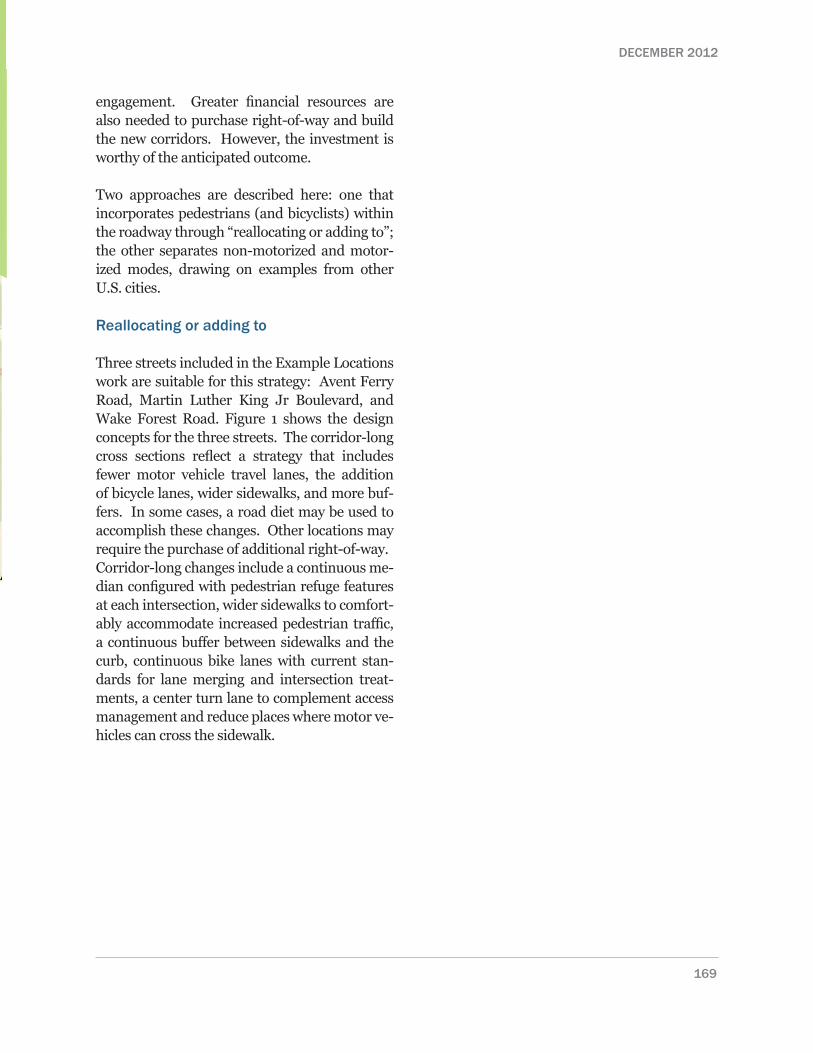
Establishing modal priority on paired parallel streets is another strategy that can be used suc-cessfully to establish a single corridor that ac-commodates high volumes for all modes. This concept involves designating one pair for higher vehicular capacity and transit use, while desig-nating the other for more exclusive pedestrian and bicycle usage. The pedestrian and bicycle scale street may be designed as a Bike boulevards (also known as a Neighborhood greenway) Ex-amples of this strategy include two sets of paired streets near the Golden Gate Bridge in San Fran-cisco, California and a redeveloped set of streets near Mizner Park in Boca Raton, Florida. The San Francisco streets were established by a se-ries of decisions about land use, infrastructure and operating standards that delineated mode priority. The streets in Boca Raton, purposefully designed during a redevelopment project, cap-ture many of the best practice Complete Street details.
City of San Francisco. The City of San Fran-cisco created different mode priorities – one for pedestrians and bicyclists and the other for motor vehicle streets. These paired streets func-tion together as a system that accommodates all modes. Two examples of these streets are the Pacific Heights neighborhood near the Gold Gate Bridge (see table X).
Both non-motorized streets offer a mix of retail and residential land uses, with sidewalks that serve as pedestrian gathering places and trans-portation, along narrow streets with slower-moving motor vehicles.
The motorized priority streets are wider, accom-modating vehicles with 3 lanes in each direction.
Photo 49. Through motor vehicles travel under DuPont Circle.
Photo 50 Street-level retail with active sidewalk space and on-street parking.
Photo 51. Pedestrian space extends into the street with well-defined crosswalks and crossing medians.
176
City of Raleigh Pedestrian Plan | Chapter 8
Non-motor-ized Priority
MotorizedPriority
East-West
Chestnut Street
Lombard Street
North-South
Polk Street Van Ness Avenue
1
2
21
Photo 52. Polk Street. Photo 53. Chestnut Street.
Photo 54. Lombard Street. Photo 55. Van Ness Avenue.
177
DECEMBER 2012
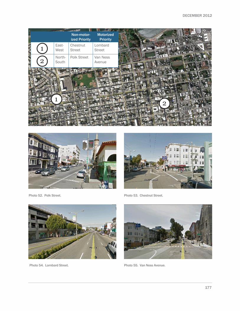
Boca Raton. Mizner Park in Boca Raton is a pedestrian-oriented retail area situated between Route 1/North Federal Highway and Mizner Road. While retail and housing lines both sides of Route 1/North Federal Highway, the motor vehicles are the priority mode, reducing its de-sirability for pedestrian travel. A redevelopment project created the opportunity to establish high quality pedestrian-priority space. Much like the DuPont Circle example, the street blends pedes-trian-priority space with a small amount of mo-tor vehicle parking and travel lanes.
Photo 59. A center greenway and gazebo serves as a gather space for pedestrians in Mizner Park.
Photo 58. Motor vehicle priority on Route 1.
Photo 56 Pedestrians and bicyclists have priority on this street in Mizner Park.
Photo 57. Mizner Park area
178
City of Raleigh Pedestrian Plan | Chapter 8

Raleigh Examples
Two intersections in Raleigh can be re-consid-ered in light of the types of solutions described in this chapter: Six Forks Road at Dartmouth (North Hills) and Martin Luther King Jr Boule-vard at Salisbury Street and Wilmington Street. Common characteristics of both intersections are:
» Designed to handle large volumes of pedestrian and motor vehicle traffic
» Both are near freeway inter-changes » Adjacent development designed for
motor vehicle access, but considered pedestrian-accessible (North Hills was
designed to be a pedestrian oriented development).
» Pedestrian crossing facilities do not provide safe and comfortable travel, owing in part to long crossing distances and dedicated right turn and left turn lanes on most approaches with protected turn phases
» Access management is generally handled well, with the exception of Six Forks north of Dartmouth and South Wilmington north of Martin Luther King Jr Boulevard
Six Forks Road, North Hills
Phased development with phase 2 (North Hills East) to be built by 2014.
Pedestrian wait times are very long, encouraging some pedestrians to cross mid-block.
In addition, characteristics specific to each intersection include:
Martin Luther King Jr. Boulevard and Salisbury/Wilmington, Shaw University
Staff recommends a traffic circle in this location. Can you show Dupont Circle example as potential solu-tion?
Current intersection configuration is the result of the interchange design and construction, just to the west.
Shaw University campus facilities are all but one cor-ner. A regional training center in southwest corner.Pedestrian-motorist conflicts are common, especially when motorists are turning.
179
DECEMBER 2012

Potential big ideas lessons for Six Forks Road, North Hills
Potential big ideas lessons for Martin Luther King Jr Boulevard, Shaw University
» Ensure parallel streets are pedestrian- and bicycle-priority through engineering and operational features.
» Shift motor vehicle traffic away from the intersection with an under pass along the road with the greatest ADT (most likely Six Forks Road).
» Use the existing topography to establish pedestrian space above the intersection, with pedestrian walkways that connect to buildings and the ground.
Photo 60 Pedestrians crossing Six Forks Road may cross up to 10 lanes of traffic.
180
City of Raleigh Pedestrian Plan | Chapter 8