Embed Size (px)
Citation preview

Chapter Eight Habitat Conservat ion Strategy Principal Authors: Al i Duval l , Dave Smith, Josh Vest
Photo by Hannah Ryan

8.2 Intermountain West Joint Venture | C o n s e r v i n g H a b i t a t T h ro u g h P a r t n e r s h i p s | www.iwjv.org
Ha
bit
at
Co
ns
erv
ati
on
Str
ate
gy
Inside this Chapter
Introduction .......................................................................................................................... 8.2
Targeting Conservation ........................................................................................................ 8.3
Wetland Habitat Conservation .............................................................................................. 8.4
• Priority Wetland Dependent Bird Species .......................................................................... 8.6
• Key Threats to Wetlands .................................................................................................. 8.6
• Wetland Conservation at the JV Scale .............................................................................. 8.8
• Southern Oregon and Northeastern California (SONEC)................................................... 8.10
• Great Salt Lake (GSL) .................................................................................................... 8.13
• Status of Conservation Planning and Science for Wetland Focal Areas ............................ 8.16
• Funding Opportunities ................................................................................................... 8.16
• Resources ..................................................................................................................... 8.16
Sagebrush Habitat Conservation ........................................................................................ 8.17
• Priority Sagebrush Bird Species ..................................................................................... 8.18
• Key Threats to Sagebrush Habitat .................................................................................. 8.18
• Sagebrush Conservation at the JV Scale ........................................................................ 8.20
• Funding Opportunities ................................................................................................... 8.24
• Resources ..................................................................................................................... 8.24
Grassland Habitat Conservation ......................................................................................... 8.25
• Priority Grassland Bird Species ...................................................................................... 8.25
• Key Threats to Grasslands ............................................................................................. 8.25
• Grassland Conservation at the JV Scale ......................................................................... 8.26
• Funding Opportunities ................................................................................................... 8.27
• Resources ..................................................................................................................... 8.27
Literature Cited .................................................................................................................. 8.28
The Implementation Plans of the 18 U.S. Habitat Joint Ventures are intended to provide Joint Venture (JV) partnerships with a roadmap for the protection, restoration, enhancement, and management of habitat needed to support populations of birds at desired levels. In simple terms, the plans describe the most important areas for birds within the JV and define what needs to be done in a coordinated fashion to conserve habitat as needed to support bird populations at continental goal levels. The hallmark of a JV Implementation Plan is that it helps coordinate habitat conservation through partnerships.
The Waterfowl, Shorebird, Waterbird, and Landbird Chapters of the IWJV 2013 Implementation Plan represent an important biological assessment of birds and habitats in the Intermountain West—defining population objectives, focal species, threats, priority habitats, and in some cases habitat objectives for certain groups of birds.
The intent of this chapter is to define the IWJV conservation strategy and current habitat priorities for coordinated implementation by partners. Each habitat section explains the JV perspective on the importance of the habitat, priority bird species, key threats, goals, actions, and approach to conservation.

8.3 Intermountain West Joint Venture | C o n s e r v i n g H a b i t a t T h ro u g h P a r t n e r s h i p s | www.iwjv.orgIntermountain West Joint Venture | C o n s e r v i n g H a b i t a t T h ro u g h P a r t n e r s h i p s | www.iwjv.org
Joint Ventures are recognized for their investment in a strong biological foundation to inform conservation efforts and respected for their investment in partnerships to achieve meaningful conservation. The IWJV uses a strategic habitat conservation framework as a business model to facilitate these partnerships.
The IWJV is one of the largest and most ecologically diverse JVs in North America, encompassing all or significant portions of 11 western states and 10 Bird Conservation Regions. By continuing to improve the science regarding the habitat requirements of birds, the IWJV intends to inform and encourage more partnerships across the Intermountain West. Towards this end, a series of three technical planning documents produced by the IWJV (Donnelly and Vest 2012a) describe the overarching philosophy and conceptual components that can facilitate the conservation of priority bird habitats through partnerships in an informed, targeted, and adaptive manner. These documents collectively describe the process used by the IWJV to identify priority habitats, focal areas, and surrogate species for investment of JV science resources over a 5-year planning period.
The targeting of habitat conservation delivery is presently informed by: 1) state-based bird conservation planning, 2) recent IWJV modeling efforts for specific groups of birds in certain landscapes, and 3) the science and planning of conservation partners. Priorities for bird habitat conservation exist at the state and landscape scales through an array of partner-based conservation planning endeavors. These priorities are described in documents including State Wildlife Action Plans, U.S. Fish and Wildlife Service (USFWS) Partners for Fish and Wildlife Program focal area plans, and the strategic plans of numerous state and federal agencies and non-governmental conservation organizations (NGOs). The information presented in many of those conservation
plans was used to identify priority landscapes for wetland conservation. This habitat conservation strategy will be refined and enhanced as new information becomes available.
The IWJV habitat conservation strategy is defined as follows:
Foster and facilitate landscape-scale, partnership-based habitat conservation in the Intermountain West to support populations of birds at desired levels. Wetlands, sagebrush-steppe, and grasslands are the three habitats that have been identified as conservation priorities. Within these three habitats, the IWJV will compile, and distribute the best available science to help guide habitat conservation action by partners. Specific habitat conservation goals and objectives are identified where information currently exists. In areas with less information, general prescriptions are provided.
Wetland, sagebrush-steppe, and grassland conservation is the present focus due to IWJV partner emphasis on conservation planning for specific bird groups and species, strategic habitat evaluation, and the potential to
TARGETING CONSERVATION
Photo by A l i Duva l l
The IWJV works to foster and facilitate landscape-scale, partnership-based habitat conservation in the Intermountain West to support populations of birds at desired levels.

8.4 Intermountain West Joint Venture | C o n s e r v i n g H a b i t a t T h ro u g h P a r t n e r s h i p s | www.iwjv.orgIntermountain West Joint Venture | C o n s e r v i n g H a b i t a t T h ro u g h P a r t n e r s h i p s | www.iwjv.org
WETLAND HABITAT CONSERVATION
maximize conservation investments. Conservation goals and objectives for other important habitats, such as aspen and dry forest, can be referenced in the state-based 2005 Coordinated Implementation Plans for Bird Conservation.
The conservation of wetland habitat continues to be a priority for the IWJV, dating back to the JV’s inception. Wetlands are characterized by high biological diversity and productivity that make them among the most important wildlife habitats in the Intermountain West. Wetlands also have other significant ecological, economic, and social values (IWJV 1995, McKinstry 2004, Donnelly and Vest 2012a).
Much of the Intermountain West is characterized as North American Desert Biome (58%) resulting in water-limited systems where limited precipitation combined with high evaporation rates further constricts the distribution of water resources (Donnelly and Vest 2012a). Wetlands in the Intermountain West are therefore highly dynamic systems but are also widely dispersed (Fig. 1), comprising roughly 18.4 million acres according to the National Wetlands Inventory (<2% of the total surface area of the IWJV).
Figure 1 Wetland density and distribution assessed using available digital National Wetlands Inventory (NWI) data and 16 Km² sampling grid. Results were interpolated using an inverse weighted distance technique. NWI data was obtained from the NWI program at http:www.fws.wetlands/Data//Download.html.
Photo by R io de la V is ta

8.5 Intermountain West Joint Venture | C o n s e r v i n g H a b i t a t T h ro u g h P a r t n e r s h i p s | www.iwjv.orgIntermountain West Joint Venture | C o n s e r v i n g H a b i t a t T h ro u g h P a r t n e r s h i p s | www.iwjv.org
More than 80% of wildlife species common to the region depend on wetlands to meet some portion of their life cycle needs. Despite their limited abundance, wetland systems in the Intermountain West are keystone habitats because they help drive ecosystem form and function. In the IWJV, wetlands structure biotic communities far beyond their areal extent (McKinstry 2004).
The Intermountain West is an important region for wetland dependent birds throughout the annual cycle by providing breeding, migration, and wintering habitat. As many as 12–18 million ducks, 1–2 million geese, and 60,000 swans utilize wetlands within this region for roosting and feeding
habitat during fall and spring migration (IWJV 1995). The Intermountain West hosts 66% of the shorebird species that commonly occur in North America with more than 2.5 million individuals occurring during migration (Oring et al. 2000, Brown et al. 2001). Additionally, approximately 40 species of waterbirds breed or migrate through portions of the Intermountain West (Ivey and Herziger 2006). Wetland complexes in the Intermountain West support substantial proportions of continental populations of many species (Table 1).
Table 1 Percent of continental populations for wetland dependent birds of note occurring in the Intermountain West by annual cycle. Adapted from Donnelly and Vest (2012a).
ANNUAL CYCLE
GUILD SPECIES BREEDING MIGRATION WINTER
Waterfowl
Cinnamon Teal >60%
Northern Pintail 30%
Tundra Swan (Western) 80%
Trumpeter Swan (Rocky Mountain) 10% >80%
Greater White-fronted Geese (Pacific Flyway, Tule) >50%
Shorebirds
American Avocet 56% 93%
Black-necked Stilt 69%
Snowy Plover (Interior) 75%
Long-billed Curlew 57%
Marbled Godwit 75%
Wilson's Phalarope 50%
Long/Short-billed Dowitchers 53%
Waterbirds
White-faced Ibis 73%
California Gull 75%
Eared Grebe 90%
American White Pelican 32%
Greater Sandhill Crane
Central Valley 42% >90%
Lower Colorado River Valley 100% >90%
Rocky Mountain 100% 100% 90%
Lesser Sandhill Crane (Pacific Flyway) >90%
WETLAND HABITAT CONSERVATION

8.6 Intermountain West Joint Venture | C o n s e r v i n g H a b i t a t T h ro u g h P a r t n e r s h i p s | www.iwjv.orgIntermountain West Joint Venture | C o n s e r v i n g H a b i t a t T h ro u g h P a r t n e r s h i p s | www.iwjv.org
Wetlands provide an array of ecological services including fish and wildlife habitat, temporary storage of surface water, aquifer recharge, stream flow maintenance, sediment retention, shoreline stabilization, carbon storage, and transformation of nutrients and pollutants (Dugan 1990, McKinstry et al. 2004, Copeland et al. 2010). Wetlands are important from an agricultural production standpoint as well. Forage provided by wetlands are the most productive portions of many working ranchlands playing an important role in sustaining grass-based agricultural systems (e.g., flood-irrigated habitat) that also provide critical habitat for migratory birds.
For more information on the value of wetlands from a biological and social perspective, continental bird populations supported by wetland complexes in the Intermountain West, or background on why wetlands are a habitat priority for the IWJV, see Identifying Science Priorities 2013-2018: Wetland Focal Strategies.
Table 2 Percent of total wetland loss, by state, between the 1870s and mid-1980s from Dahl (1990).
STATE LOSS 1870S-1980S
Arizona -36%
California* -91%
Colorado -50%
Idaho -56%
Montana* -27%
Nevada -52%
New Mexico -33%
Oregon -38%
Utah -30%
Washington -31%
Wyoming -38%
*Majority of wetland loss occurred in areas of the state outside the IWJV.
Priority Wetland Dependent Bird SpeciesWaterfowl: American Widgeon, Cinnamon Teal, Northern Pintail, Mallard, Lesser Scaup, Redhead, Tundra Swan, and Trumpeter Swan
Shorebirds: American Avocet, Black-necked Stilt, Snowy Plover, Long-billed Curlew, Marbled Godwit, Wilson’s Phalarope, Long/Short-billed Dowitchers, Willet
Waterbirds: White-faced Ibis, American Bittern, Sora, and Greater Sandhill Crane (Rocky Mountain Population)
Wetland Associated Landbirds: Lewis’ Woodpecker, Rufous Hummingbird, Willow Flycatcher
Key Threats to WetlandsAlthough 70% of the Intermountain West surface ownership falls within federal, state, or tribal trust, approximately 70% of emergent wetlands occur on private lands (Donnelly and Vest 2012). These statistics highlight the relationships between water resources, productive land for agricultural use and rural development, and the vulnerability of existing wetland complexes. The potential impact to wetlands is high when considering issues of water supply and demand across the West. The continued expansion of human development (i.e., urbanization, mining, and energy extraction) places significant strains on water supplies that in many areas are already over-allocated (Downard 2010) contributing to continued loss of some wetland types. Long-term wetland loss in this region means that remaining wetland habitats are critically important because they must provide most of the resources required to sustain bird and other wildlife populations. Because water is so important to both people and birds, remaining wetland resources are at considerable risk of loss and degradation.
Wetland Habitat Loss and DegradationEarly human settlement patterns in the Intermountain West were closely associated with water and wetland resources. Wide-scale and systematic development of water resources for agricultural, energy, industrial, and domestic uses has had tremendous impacts on wetland systems. These and other anthropogenic modifications reduced abundance of wetlands in western states 30–91% between the 1780s and mid-1980s, with an estimated loss of 57% of historic wetlands in the Intermountain West (Dahl 1990, Ratti and Kadlec 1992; Table 2). Although the rate of wetland loss nationally has slowed over time, the loss of freshwater emergent marsh habitat has continued (Dahl 2006, Copeland et al. 2010). For example, traditional flood irrigation often provides important spring and early summer wetland habitat during spring and early summer in the Intermountain West. Steady loss of these agricultural practices to housing, urbanization, and conversion of flood-irrigated agriculture to sprinkler irrigation has occurred over the past 20 years (Kenny et al. 2009). Wetlands and their associated uplands are changing rapidly due to large scale changes in land-use patterns throughout the Intermountain West. Specifically, expanding ex-urban development increases habitat fragmentation rates , alters hydrologic patterns, diminishes water table recharge rates, and reduces habitat suitability for many plant and animal communities, especially wetland dependent birds (Maestas 2003).
WETLAND HABITAT CONSERVATION

8.7 Intermountain West Joint Venture | C o n s e r v i n g H a b i t a t T h ro u g h P a r t n e r s h i p s | www.iwjv.orgIntermountain West Joint Venture | C o n s e r v i n g H a b i t a t T h ro u g h P a r t n e r s h i p s | www.iwjv.org
Water Supply and SecurityThe availability of water supplies presents one of the greatest challenges to conserving wetland habitats for birds in the Intermountain West (IWJV 1995, McKinstry 2004). Historic and contemporary policies pertaining to the protection and use of water in the arid West prioritize agriculture and municipal uses over environmental uses such as wetland management for migratory birds (Downard 2010).
Rapid human population growth is one of the most significant threats to wetland water supplies in the Intermountain West. Human population growth rates in the West have increased dramatically since the 1990s, with many states exceeding national growth rates. This population growth has placed increased demands and competition on water for urban, municipal, industrial, and agricultural irrigation uses. Urbanization can alter wetland hydrology directly but it also results in indirect impacts such as the depletion of water tables and diminishing of aquifer recharge rates required to sustain functional wetland environments. Further competition among water users for increasingly limited water resources prolongs the effects of periodic droughts on wetland systems and makes those droughts worse. Conservation measures that secure water resources for important wetland complexes are needed to insuring the integrity and wetland functions that can sustain avian populations into the future.
Water QualityMany of the major wetland complexes in the Intermountain West are located at the terminus of snow-pack driven systems and irrigated landscapes, which makes agricultural return flows an important source of water. Typically, these return flows are relatively high in concentrations of salts or nutrient, and can contain elevated concentrations of toxic or potentially toxic trace elements (e.g., arsenic, selenium) and other contaminants that accumulate in terminal basins. Many wetland and riverine systems in the Intermountain West remain polluted by historic mining activities and associated trace element accumulations. Poor water quality and reductions in available water supply to wetlands can further concentrate both contaminants and reduce bird populations.
Climate ChangeChanges in average temperature, precipitation patterns, snowpack levels, and spring melt dates in the Intermountain West are changing dramatically, and negatively affecting bird habitats throughout this vast area (Mote 2005, Stewart et al. 2005, Seager et al. 2007). In general, average temperatures are expected to continue to rise throughout much of the Intermountain West. Precipitation patterns are more uncertain (except in the arid Southwest where there is greater certainty that conditions will be increasingly dry) (Seager et al. 2007). Significant declines in snowpack and earlier spring snowmelts are well documented and those trends are expected to continue (Mote 2005, Bedford and Douglas 2008). There is strong consistency among climate models regarding continued reductions in snowpack with the potential for reductions of up to 70% in eastern and northeastern California (Mote 2005, PRBO 2011). Wetlands in the Intermountain West are at particular risk because many rely on snowmelt for spring recharge (NABCI 2010).
Indirect effects of climate change such as changes in vegetation, spread of invasive species, increased frequency and magnitude of flood and drought events, increases in fire events, and greater water demands from the rapidly growing human population all have the potential to act in concert and negatively impact wetlands and their associated uplands. Climate change has the potential to significantly alter the phenology, distribution, abundance, reproductive success, and survival of wetland birds throughout the Intermountain West (NABCI 2010). Conservation measures that ensure water supplies and maintain functional values will increase the resiliency of wetland systems to changing environmental conditions and land-use patterns.
The following is a description of what needs to be done regarding on-the-ground habitat delivery to conserve wetland habitat during the next five years as the IWJV strengthens its science foundation with additional biological and spatial planning information and sets of habitat objectives.
WETLAND HABITAT CONSERVATION

8.8 Intermountain West Joint Venture | C o n s e r v i n g H a b i t a t T h ro u g h P a r t n e r s h i p s | www.iwjv.orgIntermountain West Joint Venture | C o n s e r v i n g H a b i t a t T h ro u g h P a r t n e r s h i p s | www.iwjv.org
Wetland Conservation at the JV Scale
Conservation Goal
Conserve wetland habitat by implementing practices to maintain, restore, and enhance wetland hydrology and productivity as needed to sustain bird populations at desired levels.
Partnership Goals
1. Encourage State Conservation Partnerships and local stakeholders to coordinate and implement strategic wetland habitat conservation.
2. Facilitate biological planning regarding priority wetland systems and birds to develop habitat objectives and spatially-explicit decision support tools.
3. Catalyze strategic wetland habitat conservation in focal areas to benefit priority bird species by guiding existing and new funding programs to implement conservation strategies and actions.
4. Maintain a comprehensive list of wetland habitat conservation actions and tools deployed by the partnership.
5. Provide capacity to deliver strategic wetland habitat conservation.
Approach to Conservation
The IWJV was born out of the North American Waterfowl Management Plan (NAWMP) and initially existed as a waterfowl conservation partnership. As such, the first IWJV Implementation Plan created in 1995 emphasized a set of wetland focal areas for waterfowl.
In 1999, the IWJV moved into the arena of “all-bird” conservation to support implementation of all major bird conservation initiatives, including NAWMP, United States Shorebird Conservation Plan (USSCP), Partners in Flight (PIF), and Waterbird Conservation for the Americas (WCA). To support this expanded focus, the IWJV developed a 2005 Implementation Plan using a “state-by-state, ground-up, all-bird” planning process to identify priority habitats and focal areas to guide conservation action. The plan identified 383 focal or bird habitat conservation areas, many that included complexes of wetlands. This approach informed partners of important wetland areas within each state but did not identify priorities among wetland complexes across the Intermountain West. As such, an additional step was needed to mesh these two planning approaches relative to wetlands.
For this plan, a JV-wide analysis of wetlands was conducted by the IWJV as part of its science prioritization process (Donnelly and Vest 2012). Wetland abundance and distribution data were evaluated along with existing IWJV and partner planning documents to identify important wetland landscapes within the Intermountain West. From this exercise, 18 areas of high wetland abundance were identified for further evaluation relative to science and planning investments (Fig. 2; see Identifying Science Priorities 2013-2018: Wetland Focal Strategies). These 18 Wetland Focal Areas represent important landscapes for wetland-dependent birds, based on our current understanding of bird populations and wetland habitats, in the Intermountain West.
Conservation Actions
Conservation actions should be guided by science and informed decision-making. Targeted actions include:
• Protect wetlands through conservation easements or fee-title acquisition from willing sellers.
• Restore wetland hydrology and enhance wetlands to mimic historic function and value.
• Secure adequate water supplies for managed wetlands and terminal basins to conserve their ecological integrity and functional values.
• Aggressively control exotic and invasive species to maintain productivity and functional values of wetlands.
WETLAND HABITAT CONSERVATION

8.9 Intermountain West Joint Venture | C o n s e r v i n g H a b i t a t T h ro u g h P a r t n e r s h i p s | www.iwjv.orgIntermountain West Joint Venture | C o n s e r v i n g H a b i t a t T h ro u g h P a r t n e r s h i p s | www.iwjv.org
Figure 2 Wetland Focal Areas in the Intermountain West (2012).
The status of wetland assessment, conservation planning, and step-down implementation varies by focal area. The IWJV website provides a detailed narrative of each Wetland Focal Area, including a characterization of the wetland habitat, bird values, threats, conservation opportunities, key resources, and links.
The IWJV facilitated biological planning for wetland-dependent birds in three of these landscapes—southern Oregon and northeastern California (SONEC), Great Salt Lake, and the Columbia Basin (see Chapters 4 and 5). Specifically, the SONEC and Great Salt Lake landscapes have long been assumed to contain considerably higher wetland resource values for a wide diversity of bird
populations than any of the other Wetland Focal Areas. Recent IWJV assessments confirm that these two focal areas contain disproportionate wetland and migratory bird values, representing approximately 25% of the inventoried wetland abundance in the Intermountain West (Donnelly and Vest 2012). Thus, SONEC and the Great Salt Lake are the “major migrational hubs” of the Intermountain West for wetland-dependent migratory birds. The science-based efforts to understand bird use and habitat in SONEC and the Great Salt Lake reflect a JV-approach to developing wetland habitat goals, objectives, and implementation strategies explicitly linked to continental bird population objectives.
WETLAND HABITAT CONSERVATION

8.10 Intermountain West Joint Venture | C o n s e r v i n g H a b i t a t T h ro u g h P a r t n e r s h i p s | www.iwjv.orgIntermountain West Joint Venture | C o n s e r v i n g H a b i t a t T h ro u g h P a r t n e r s h i p s | www.iwjv.org
Southern Oregon and Northeastern California (SONEC)
The SONEC region (Fig. 3) is of continental significance for waterfowl, shorebird, and waterbird populations in North America. Up to 80% of Pacific Flyway waterfowl move through the SONEC region annually. The SONEC region contains eight of the 18 IWJV Shorebird Key Sites. The region hosts continentally significant portions of several waterbird populations including Clark’s Grebes, Sandhill Cranes, and White-faced Ibis. The region is also critically important to waterfowl populations during fall and spring migration.
At NAWMP goal levels, the region would support over 4.8 million dabbling ducks for an estimated average duration of 21 days spring migration, making it one of the most important spring staging areas in North America. This concentration occurs immediately prior to the breeding season, and hence has particular importance to the annual life cycle. Because of the region’s significance, habitat objectives for spring migrating waterfowl were developed as a first step in a long-term effort to develop a comprehensive wetlands conservation strategy for the SONEC Region.
Figure 3 Wetland planning units for SONEC, a critical area for migrating birds in the Intermountain West Joint Venture.
Public LandsThe network of protected and intensively managed wetlands on National Wildlife Refuges (NWR), state wildlife areas, and other protected lands (collectively referred to as “public wetlands” herein) play a major role in sustaining waterfowl populations during fall and spring migration. The public wetlands within the Lower Klamath sub-region, particularly Lower Klamath and Tule Lake NWRs, are critically important due to their vast wetland acreage (up to 50,000 acres during spring migration). State wildlife areas including Honey Lake, Ash Creek, Butte Valley, Shasta Valley, Summer Lake. These wetlands and refuges, such as Modoc NWR and Malheur NWR, collectively provide critical migration and breeding habitat.
Private LandsMost spring-flooded wetland habitat in the SONEC Region occurs on working ranches where flood irrigation of wet meadows is used for hay production and grazing. The timing of flooding and the annual vegetation management practices conducted on these privately managed ranchlands fits well with the needs of spring-migrating waterfowl. These wet meadows are typically flood irrigated from March through July, hayed in late summer, and grazed during the winter. This productive form of wetland habitat management capitalizes on the snowmelt-driven hydrology of the largely closed-basin SONEC landscape. Used in this way, the wet meadows provide spring migrating waterfowl with abundant food resources and desired shallow, open-water wetland conditions. The SONEC Region contains 79,300 acres of flood-irrigated wetland habitat available to spring migrating waterfowl (Fleskes and Gregory 2010).
Photo by Bruce Tay lo r
WETLAND HABITAT CONSERVATION

The productivity of flood-irrigated wetlands during spring is a function of wetland management following the natural hydroperiod for seasonal wetlands in the SONEC landscape – i.e., wet in the spring, dry in the fall. Further, the annual disturbance that flood-irrigated wetlands in SONEC receive from haying and winter grazing contributes to the maintenance of early successional wetland plant communities that are manipulated to a low structural height during the spring migration period – an ideal scenario for spring staging waterfowl.
The Modeling ProcessThe IWJV used a bioenergetic modeling process to determine the food energy needs of spring migrating waterfowl in SONEC given these bird distribution patterns and a population objective of 4.8 million dabbling ducks (see Chapter 4 for details on the modeling process). Estimates of waterfowl food densities in flood-irrigated habitats were used to calculate the amount of flood-irrigated habitats required to meet population energy demands in each sub-region (Fleskes et al. 2013). Public lands are expected to meet all of the energetic demands of spring migrating dabbling ducks within the Lower Klamath sub-region and 25% of the food energy for dabbling ducks during spring migration outside the Lower Klamath sub-region of SONEC. Consequently, the remaining 75% of the food energy needs in spring must be met on private lands through flood-irrigation or wetland hydrology restoration and management that results in shallow, open-water habitats similar to those on flood-irrigated ranchlands. This process calculated that 64,700 acres of flood-irrigated wetland habitat must be provided annually during spring migration to support waterfowl populations at NAWMP goal levels (Table 3).
These lands should be flooded to coincide with spring migration chronology (generally early February through mid-May) and be disturbed annually through summer haying and/or fall-winter grazing to maintain open-water conditions the following spring. This form of wetland habitat management is generally consistent with management practices used by ranchers to produce forage for livestock on wet meadows throughout SONEC. As such, achievement of this habitat objective largely involves securing and enhancing existing habitat as opposed to creating new habitat.
Table 3 The amount of flood-irrigated habitat required to meet 75% of dabbling duck needs (acres). Dabbling duck needs not met by this habitat are assumed to be met by public lands.
SONEC SUB-REGION
EXISTING HABITAT (ACRES)
HABITAT REQUIRED TO MEET 75% OF
DABBLING DUCK NEEDS (ACRES)
Modoc Plateau 13,000 13,500
Malheur 15,300 5,300
NE California 13,500 9,800
Upper Klamath 18,800 17,300
Summer Lake 4,100 8,300
Warner Valley 7,500 10,500
Lower Klamath 7,100 Not Determined
Totala 79,300 64,700
a This est imate excludes that port ion of the the SONEC Region dab-bl ing duck populat ion that re l ies on the Lower Klamath sub-region.
8.11 Intermountain West Joint Venture | C o n s e r v i n g H a b i t a t T h ro u g h P a r t n e r s h i p s | www.iwjv.orgIntermountain West Joint Venture | C o n s e r v i n g H a b i t a t T h ro u g h P a r t n e r s h i p s | www.iwjv.org
Photo by Lar r y K ruckenberg
WETLAND HABITAT CONSERVATION

8.12 Intermountain West Joint Venture | C o n s e r v i n g H a b i t a t T h ro u g h P a r t n e r s h i p s | www.iwjv.orgIntermountain West Joint Venture | C o n s e r v i n g H a b i t a t T h ro u g h P a r t n e r s h i p s | www.iwjv.org
SONEC Habitat Goal, Objective, and Conservation Actions
GOAL: Maintain high quality wetland habitat conditions in SONEC on private and public lands to benefit migrating waterfowl.
HABITAT OBJECTIVE: Maintain 64,700 acres of shallow, open wetland habitat on private lands and 14,600 acres of additional required habitat on public lands to support the energy demands of spring migrating waterfowl at NAWMP goal levels.
CONSERVATION ACTIONS:1. Conserve flood-irrigated habitat on working
ranchlands. The crucial base of flood-irrigated wetland habitat is mostly unprotected and susceptible to degradation of habitat values from changes in water management practices, agricultural patterns, or rural development. The conservation of flood-irrigated habitat will require working with private landowners to improve irrigation infrastructure (much of which is aging and in need of repair), communicating the values of these unique flood-irrigated habitats to other stakeholders, and, ultimately, acquiring working lands conservation easements that recognize the compatibility between wetland habitat values, flood irrigation, and sustainable ranching. Conservation easements in SONEC designed to secure the spring migration habitat base should be tailored to discourage the conversion of flood to sprinkler irrigation, and allow haying and grazing as reserved rights under a conservation plan.
2. Restore and enhance wetland habitat on NWRs, wildlife areas, and other protected lands. Public wetlands must play a major role in meeting spring migrating waterfowl habitat needs. In addition, these lands must supply essentially all the waterfowl habitat during fall migration (since flood-irrigated wetlands are dry during the fall) and a sizeable component of summer breeding habitat for waterfowl, shorebirds, and waterbirds. In many instances, this requires active wetland management to maintain wetland productivity and specifically address the needs of wetland-dependent birds at different times of the year. These needs should be addressed through hydrology restoration, water conveyance improvements, re-instituting grazing and haying, de-leveling former wetlands that were leveled for crop production, disking or rotational cropping, carp removal, and management of invasive weeds, among other land management
practices. Most NWRs and state wildlife areas are unable to accomplish ideal land management because of inadequate financial resources and staffing shortages. Investments should be made in wetland enhancement projects on these complexes to support the wetland and food energy needs of waterfowl, shorebird, and waterbird populations, while also managing and/or minimizing long-term land management operations and maintenance costs.
3. Secure adequate water supplies for public wetlands. The Lower Klamath sub-region is extremely important to spring migrating waterfowl, with dabbling duck population objectives surpassing that of other SONEC sub-regions. However, recent water shortages at the Lower Klamath NWR are unprecedented and cause for concern regarding future capability of the refuge to meet the needs of spring migrating waterfowl. Failure to provide the expected food energy would necessitate re-crafting the spring migration habitat objective, increasing it from the currently planned 64,700 acres. Given the compounded challenges associated with achieving a larger habitat objective, provision of adequate water supplies to Lower Klamath NWR is critical to maintaining healthy populations of waterfowl during spring and should be a focus of the IWJV partnership. Securing adequate water supplies is also critical to the continued provision of wetland bird habitat (see Chapters 4-6). Water supplies for other public wetlands in SONEC are generally far more secure than at Lower Klamath NWR, but these issues exist with other refuges and wildlife areas and should be addressed through collaborative approaches.
4. Facilitate conservation science and planning. The significance of SONEC to wetland-dependent birds warrants development of a more comprehensive wetlands conservation strategy. This next step is articulated in Identifying Science Priorities 2013-2018: Wetland Focal Strategies. Additional biological information and planning is needed to more explicitly target wetlands conservation and to develop an integrated all-bird wetland conservation strategy for the SONEC region.
WETLAND HABITAT CONSERVATION
8.13 Intermountain West Joint Venture | C o n s e r v i n g H a b i t a t T h ro u g h P a r t n e r s h i p s | www.iwjv.orgIntermountain West Joint Venture | C o n s e r v i n g H a b i t a t T h ro u g h P a r t n e r s h i p s | www.iwjv.org
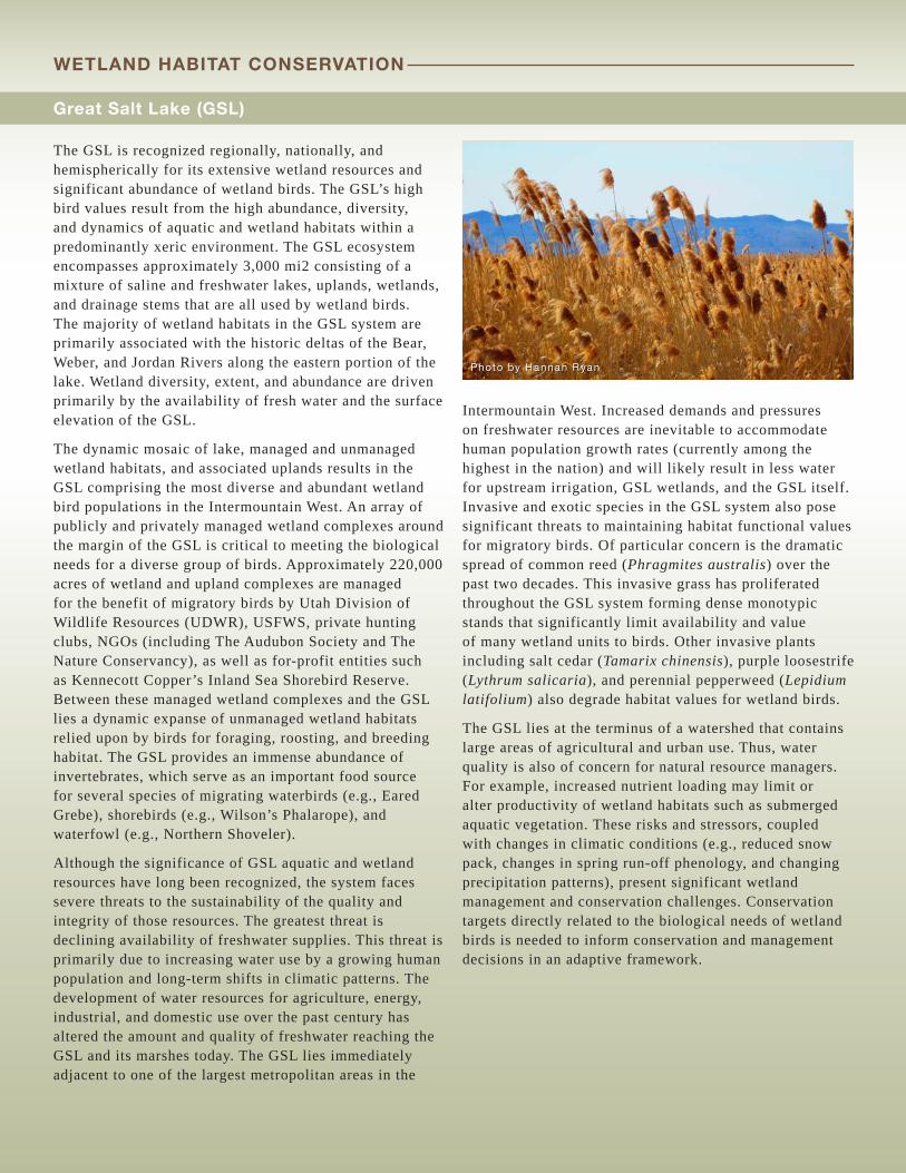
Great Salt Lake (GSL)
The GSL is recognized regionally, nationally, and hemispherically for its extensive wetland resources and significant abundance of wetland birds. The GSL’s high bird values result from the high abundance, diversity, and dynamics of aquatic and wetland habitats within a predominantly xeric environment. The GSL ecosystem encompasses approximately 3,000 mi2 consisting of a mixture of saline and freshwater lakes, uplands, wetlands, and drainage stems that are all used by wetland birds. The majority of wetland habitats in the GSL system are primarily associated with the historic deltas of the Bear, Weber, and Jordan Rivers along the eastern portion of the lake. Wetland diversity, extent, and abundance are driven primarily by the availability of fresh water and the surface elevation of the GSL.
The dynamic mosaic of lake, managed and unmanaged wetland habitats, and associated uplands results in the GSL comprising the most diverse and abundant wetland bird populations in the Intermountain West. An array of publicly and privately managed wetland complexes around the margin of the GSL is critical to meeting the biological needs for a diverse group of birds. Approximately 220,000 acres of wetland and upland complexes are managed for the benefit of migratory birds by Utah Division of Wildlife Resources (UDWR), USFWS, private hunting clubs, NGOs (including The Audubon Society and The Nature Conservancy), as well as for-profit entities such as Kennecott Copper’s Inland Sea Shorebird Reserve. Between these managed wetland complexes and the GSL lies a dynamic expanse of unmanaged wetland habitats relied upon by birds for foraging, roosting, and breeding habitat. The GSL provides an immense abundance of invertebrates, which serve as an important food source for several species of migrating waterbirds (e.g., Eared Grebe), shorebirds (e.g., Wilson’s Phalarope), and waterfowl (e.g., Northern Shoveler).
Although the significance of GSL aquatic and wetland resources have long been recognized, the system faces severe threats to the sustainability of the quality and integrity of those resources. The greatest threat is declining availability of freshwater supplies. This threat is primarily due to increasing water use by a growing human population and long-term shifts in climatic patterns. The development of water resources for agriculture, energy, industrial, and domestic use over the past century has altered the amount and quality of freshwater reaching the GSL and its marshes today. The GSL lies immediately adjacent to one of the largest metropolitan areas in the
Intermountain West. Increased demands and pressures on freshwater resources are inevitable to accommodate human population growth rates (currently among the highest in the nation) and will likely result in less water for upstream irrigation, GSL wetlands, and the GSL itself. Invasive and exotic species in the GSL system also pose significant threats to maintaining habitat functional values for migratory birds. Of particular concern is the dramatic spread of common reed (Phragmites australis) over the past two decades. This invasive grass has proliferated throughout the GSL system forming dense monotypic stands that significantly limit availability and value of many wetland units to birds. Other invasive plants including salt cedar (Tamarix chinensis), purple loosestrife (Lythrum salicaria), and perennial pepperweed (Lepidium latifolium) also degrade habitat values for wetland birds.
The GSL lies at the terminus of a watershed that contains large areas of agricultural and urban use. Thus, water quality is also of concern for natural resource managers. For example, increased nutrient loading may limit or alter productivity of wetland habitats such as submerged aquatic vegetation. These risks and stressors, coupled with changes in climatic conditions (e.g., reduced snow pack, changes in spring run-off phenology, and changing precipitation patterns), present significant wetland management and conservation challenges. Conservation targets directly related to the biological needs of wetland birds is needed to inform conservation and management decisions in an adaptive framework.
Photo by Hannah Ryan
WETLAND HABITAT CONSERVATION
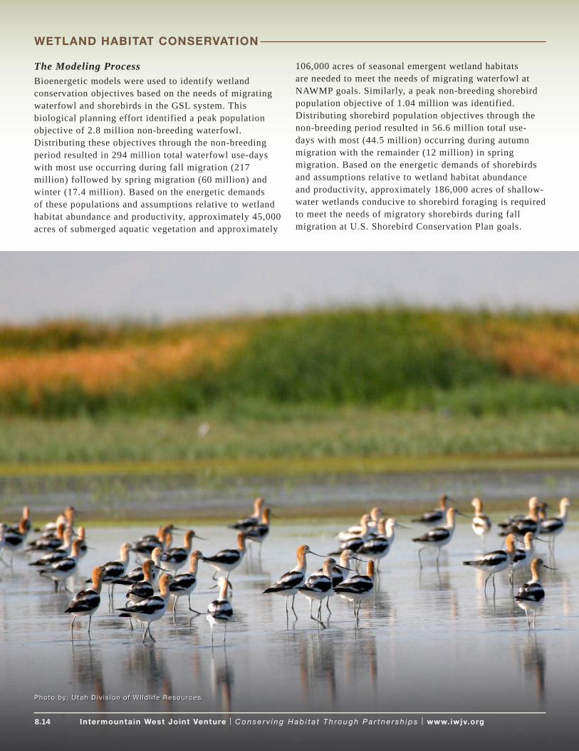
The Modeling ProcessBioenergetic models were used to identify wetland conservation objectives based on the needs of migrating waterfowl and shorebirds in the GSL system. This biological planning effort identified a peak population objective of 2.8 million non-breeding waterfowl. Distributing these objectives through the non-breeding period resulted in 294 million total waterfowl use-days with most use occurring during fall migration (217 million) followed by spring migration (60 million) and winter (17.4 million). Based on the energetic demands of these populations and assumptions relative to wetland habitat abundance and productivity, approximately 45,000 acres of submerged aquatic vegetation and approximately
106,000 acres of seasonal emergent wetland habitats are needed to meet the needs of migrating waterfowl at NAWMP goals. Similarly, a peak non-breeding shorebird population objective of 1.04 million was identified. Distributing shorebird population objectives through the non-breeding period resulted in 56.6 million total use-days with most (44.5 million) occurring during autumn migration with the remainder (12 million) in spring migration. Based on the energetic demands of shorebirds and assumptions relative to wetland habitat abundance and productivity, approximately 186,000 acres of shallow-water wetlands conducive to shorebird foraging is required to meet the needs of migratory shorebirds during fall migration at U.S. Shorebird Conservation Plan goals.
8.14 Intermountain West Joint Venture | C o n s e r v i n g H a b i t a t T h ro u g h P a r t n e r s h i p s | www.iwjv.orgIntermountain West Joint Venture | C o n s e r v i n g H a b i t a t T h ro u g h P a r t n e r s h i p s | www.iwjv.org
Photo by: Utah D iv is ion of Wi ld l i fe Resources
WETLAND HABITAT CONSERVATION

8.15 Intermountain West Joint Venture | C o n s e r v i n g H a b i t a t T h ro u g h P a r t n e r s h i p s | www.iwjv.orgIntermountain West Joint Venture | C o n s e r v i n g H a b i t a t T h ro u g h P a r t n e r s h i p s | www.iwjv.org
GSL Habitat Goal, Objectives, and Conservation Actions
GOAL: Maintain functional values and integrity of wetland habitats in the GSL on private and public lands to benefit migratory waterfowl, shorebirds, and waterbirds.
HABITAT OBJECTIVES: Waterfowl: Maintain, restore, or enhance 45,000 acres of submerged aquatic wetland habitat (i.e., pondweeds, wigeon grass) and 106,000 acres of seasonal emergent wetland habitat on public and private lands to meet the energetic needs of migrating waterfowl.
CONSERVATION ACTIONS: 1. Restore and enhance wetland habitat on federal,
state, and privately managed wetland complexes. Active management is essential to maintaining wetland productivity and meeting the biological needs of wetland birds in the GSL system throughout the annual cycle. Many of these managed complexes face challenges related to degrading wetland management infrastructure that could limit their ability to provide quality habitat. Maintenance and restoration of management infrastructure will be required to ensure that managers can efficiently provide quality habitats within system and environmental constraints that optimize resources among management objectives. Conservation and management practices including hydrologic restoration, water conveyance improvements, and management of invasive/noxious vegetation (e.g., grazing, herbicide application, mechanical manipulation) will be needed to provide and sustain quality wetland habitat for migratory birds.
2. Conserve flood-irrigated agricultural habitats. These habitats provide foraging resources for waterbirds, waterfowl, and shorebirds within the GSL system and provide a buffer against urban/suburban development. Flood-irrigated habitats are particularly important foraging areas for White-faced Ibis and Franklin’s Gull. Urban development has dramatically increased over the past decade. These developments either directly remove avian habitat from the system or compromise the integrity/value of remaining avian habitats adjacent to them. Conversion from flood to sprinkler irrigation also removes much of the avian habitat benefits of these agricultural habitats. Conserving flood-irrigated agricultural habitats will provide foraging resources for wetland birds and buffer the GSL’s important wetland complexes from development.
3. Secure adequate water supplies for public wetlands and the GSL. The security of water supplies is highly variable among publicly managed wetland complexes. For example, Bear River Migratory Bird Refuge has faced considerable shortfall in water deliveries during the growing season over the past decade. Estimates from the early 1970s suggest 1.5 million acre-feet of water is needed annually for existing marsh complexes in the GSL system which represents over 80% of the surface inflow reaching GSL each year. Given current human demographic trends, surface inflows are declining and are unlikely to reach these levels. Water is also needed to supply unmanaged wetlands that exist below dikes and many small creeks and drains that intersect the GSL shoreline. Continued declines in freshwater reaching the GSL will invariably result in increasing salinity concentrations that could impair productivity of invertebrates and impact not only migratory birds that rely on them (e.g., Eared Grebes, Wilson’s Phalarope) but commercial interests (i.e., brine shrimp industry) as well. Consequently, further efforts to quantify wetland water needs relative to potential upstream depletions and avian requirements – and secure such water – will be needed to effectively conserve GSL wetlands resources in the future.
4. Facilitate conservation science and planning. The significance of GSL to wetland birds warrants further science and planning investments to develop a more comprehensive wetland conservation strategy. Biological planning assumptions identified in this initial planning exercise require vigorous testing. Improvement or development of estimates regarding wetland habitat productivity, functional values, temporal and spatial trends in wetland abundance/availability, system stressors, and avian habitat selection will be needed to further improve conservation strategies. For more information, see Identifying Science Priorities 2013-2018: Wetland Focal Strategies.
WETLAND HABITAT CONSERVATION

Status of Conservation Planning and Science for Wetland Focal AreasWetland Focal Area planning and science varies by state throughout the IWJV boundary. Wyoming and Colorado notably have dedicated significant resources to assessing and prioritizing wetlands. Partners in Wyoming conducted a landscape-scale geospatial assessment of wetlands in Wyoming by identifying and mapping wetland complexes and quantifying the relative importance of these complexes in terms of biodiversity, recreational potential, agricultural influence, current condition, and vulnerability to future environmental changes (Copeland et al. 2010). The Wyoming State Conservation Partnership identified 9 of the 221 wetland complexes as statewide priorities. Likewise, in 2011, Colorado Parks and Wildlife and partners established Version 2 of a Wetland Wildlife Conservation Program Strategic Plan that identifies statewide goals, strategies, and tasks for wetland and riparian conservation. Please visit the IWJV website for further information on bird habitat conservation areas by state (State Conservation Partnerships).
The IWJV will seek opportunities to support state and partner efforts to develop and compile the best available science to guide habitat conservation actions in the Wetland Focal Areas.
Funding OpportunitiesThe two primary federal funding sources for strategic wetland conservation are the North American Wetlands Conservation Act (NAWCA) and Farm Bill Conservation Programs. Certain states including Colorado, California,
and Wyoming provide significant funding for wetlands conservation. See Finding Funding on the IWJV website for a description of some of the most important wetlands conservation programs.
Resources• Colorado Parks and Wildlife. 2011. Statewide Strategies
for Wetland and Riparian Conservation: Strategic Plan for Wetland Wildlife Conservation Program. Version 2.0.
• Copeland et al. 2010. Wyoming Wetlands: Conservation Priorities and Strategies. The Nature Conservancy, Lander, Wyoming.
• Donnelly, J.P. and J.L. Vest. 2012. Identifying Science Priorities 2013-2018: Wetland Focal Strategies. Intermountain West Joint Venture Technical Series 2012-2013. Intermountain West Joint Venture, Missoula, MT, USA.
• NAWMP. 2012. North American Waterfowl Management Plan 2012: People Conserving Waterfowl and Wetlands.
• NAWMP. 2012. NAWMP Action Plan: A Companion Document to the 2012 North American Waterfowl Management Plan.
• NAWMP website
• Partners in Flight website
• State of the Birds Reports website
• U.S. Shorebird Conservation Plan website
• Waterbird Conservation for the Americas website
Photo by: La r r y K ruckenberg
WETLAND HABITAT CONSERVATION
8.16 Intermountain West Joint Venture | C o n s e r v i n g H a b i t a t T h ro u g h P a r t n e r s h i p s | www.iwjv.org

8.17 Intermountain West Joint Venture | C o n s e r v i n g H a b i t a t T h ro u g h P a r t n e r s h i p s | www.iwjv.orgIntermountain West Joint Venture | C o n s e r v i n g H a b i t a t T h ro u g h P a r t n e r s h i p s | www.iwjv.org
Sagebrush1 habitat conservation is a high priority for the IWJV because the Intermountain West contains approximately 109 million acres of sagebrush habitat (or 90% of the sagebrush habitat in North America), and several species of sagebrush-dependent birds have declined due to habitat loss and degradation.
The Greater Sage-grouse (hereafter sage grouse) is often referred to as an icon of the West because the species has become the symbol for conserving sagebrush habitat (Knick and Connelly 2011). Sage grouse are on a long-term decline and absent from almost half of their estimated distribution prior to Euro-American settlement (Schroeder et al. 2004). The underlying cause is loss of suitable sagebrush habitat. In fact, this important ecosystem is one of the most imperiled in the United
States (Noss et al. 1995). Despite its large geographical distribution, the sage grouse now occupies only about 56% of its historic range and populations are highly fragmented (Schroeder et al. 2004)2.
Declines in sagebrush habitat quantity and quality not only impact sage grouse, but also increase the risk of local extirpation or regional loss of sagebrush obligate species (Davies et al. 2011). Three other sagebrush obligate species are a priority for the IWJV – Brewer’s Sparrow, Sage Thrasher, and Sage Sparrow. The Intermountain West contains 94%, 99%, and 83% of the breeding populations of Brewer’s Sparrow, Sage Thrasher, and Sage Sparrow, respectively, and also supports roughly a third of the Sage Sparrow and Sage Thrasher populations during winter (Casey 2013).
SAGEBRUSH HABITAT CONSERVATION
1 Sagebrush habitat , as def ined herein, is comprised of 13 sagebrush steppe vegetat ive associat ions – Wyoming Basins Dwarf Sagebrush Shrubland and Steppe, Columbia Plateau Steppe and Grassland, Columbia Plateau Low Sagebrush Steppe, Inter-Mountain Basins Big Sage-brush Shrubland, Great Basin Xer ic Mixed Sagebrush Shrubland, Inter-Mountain Basins Montane Sagebrush Steppe, Inter-Mountain Basins Big Sagebrush Steppe, Colorado Plateau Mixed Low Sagebrush Shrubland, Wyoming Basins Low Sagebrush Shrubland, Bit terbrush, Low Sage, and Sagebrush – der ived from regional GAP (ReGAP) layers that were the base layers for conservat ion planning in Chapter 7.
2 An exhaust ive assessment of sagebrush habitat is avai lable Greater Sage-Grouse: Ecology and Conservat ion of a Landscape Species and I ts Habitats (Knick and Connel ly 2011). In addit ion, the U.S. Geological Survey maintains SageMap – A GIS Database for Sage-grouse and Shrubsteppe Management in the Intermountain West. This data portal provides extensive information on sagebrush habitat . L inks to WAFWA assessment, SageMap, and other key resources are avai lable at the end of th is sect ion.
Photo by Bruce Tay lo r

Almost two-thirds of the sagebrush-dominated ecosystems in the United States remain in public ownership; half of the total distribution of sagebrush habitat is owned by the Bureau of Land Management (Knick and Connelly 2011). Roughly one-third of sagebrush habitat is privately owned, and these private lands are typically ranchlands in valley bottoms with deeper soils and greater availability for water. Like the wetlands of the Intermountain West, sagebrush habitat represents an important component of western agriculture and the economy.
Presently, sagebrush habitat is the rallying center of an unprecedented number of partner efforts across 11 states, which seek to reduce threats to the sage grouse and avoid listing of the species under the Endangered Species Act.
Priority Sagebrush Bird SpeciesBrewer’s Sparrow, Greater Sage-grouse, Sage Sparrow, Sage Thrasher
Key Threats to Sagebrush HabitatGlobally, temperate grasslands, savannahs, and shrublands are the least protected ecosystems (Knick and Connelly 2011). Numerous partners are invested in sagebrush habitat conservation, offering the best available science and research on management and conservation. The IWJV is focused on addressing key threats to sagebrush habitat using a suite of conservation actions and programs that are proven and strategic in terms of resource allocation. Primary threats to habitat loss and degradation include the following:
Conifer EncroachmentIn the last 150 years, conifer woodlands have expanded a staggering 600%, degrading rangeland health across large and intact sage-steppe landscapes, with >12 million acres affected by conifers in the Great Basin alone (e.g., western and Utah juniper and pinyon pine). Approximately 90%
SAGEBRUSH HABITAT CONSERVATION
Photo by Duane Coombs
8.18 Intermountain West Joint Venture | C o n s e r v i n g H a b i t a t T h ro u g h P a r t n e r s h i p s | www.iwjv.org
8.19 Intermountain West Joint Venture | C o n s e r v i n g H a b i t a t T h ro u g h P a r t n e r s h i p s | www.iwjv.orgIntermountain West Joint Venture | C o n s e r v i n g H a b i t a t T h ro u g h P a r t n e r s h i p s | www.iwjv.org
of this invaded area was once a productive and largely treeless sagebrush-steppe prior to the European settlement (Naugle et al. 2013). Specifically, tree establishment is prevalent in Utah, Nevada, Idaho, and Oregon, and varies from initial phases of encroachment to tree-dominated stands that have been closed for >50 years (Miller et al. 2011). Increasing tree canopy cover greatly reduces herbaceous understory, fragments sagebrush habitat for sagebrush obligate species, and potentially increases predation (Davies et al. 2011).
Three successional phases of conifer encroachment into shrub steppe ecosystems best describe the invasion (Miller et al. 2005). Phase I encroachment has conifer present in low densities, but shrubs and herbaceous plants are the dominant vegetation that influence ecological processes on the site. In Phase II, conifer is co-dominant with shrubs and herbaceous plants in the community but the shrub component is declining. In Phase 3, conifer is dominant, shrubs are dead or dying, and herbaceous plant productivity is significantly reduced. Inventory efforts are underway to understand the spatial extent of conifer woodlands within the sagebrush range, across 6 million acres covering Oregon, California, Nevada, and Idaho.
Exotic Annual Grasses and FireAn array of invasive grasses has influenced the structure and function of sagebrush habitat. As many as 29 species of rangeland weedy grasses are known to be present (Sheley and Petroff 1999). Specifically, cheatgrass and medusahead are the most problematic of the exotic annual grasses within the sagebrush habitat range (Miller et al. 2011). Invasive grass species alter plant community diversity, abundance, and ecological function. For example, invasion of cheatgrass changes the structure of the understory, providing more complete and continuous ground cover in contrast to sparse, cover of native perennial grasses. This type of invasion provides extremely flammable fuels resulting in fires.
Wildfire is also a key challenge for land managers working on sagebrush habitat conservation. A century of fire suppression has greatly altered historic fire regimes across the range of sagebrush. Sagebrush is intolerant of fire and recolonization after fire can take decades or more, creating serious barriers to maintaining stable populations of wildlife, like sage grouse and other obligate species (Murphy et al. 2013).
Energy Extraction and DevelopmentEnergy development has emerged as a major issue for sagebrush habitat conservation because areas currently under development contain some of the highest densities of sage grouse and other sagebrush obligate species (e.g. mule deer and songbirds). Numerous efforts are underway to understand the biological response of sage grouse to energy development, identify mechanisms causing population impacts, evaluate the extent to which development affects populations, and outline a strategy for landscape conservation (Naugle et al. 2011).
Additionally, since 1950, the western United States experienced rapid human population growth with regional rates exceeding the United States average and rural areas growing faster than urban areas in 60% of counties in the Rocky Mountain States (Odell et al. 2003). The extent of this development in the sagebrush ecosystem is being researched (Leu and Hanser 2011). The impacts of ex-urban development are most notable in the conversion of habitat to ranchettes and subdivisions, which continues to be a leading land use trend in the Intermountain West and sagebrush range.
Improper Management of Livestock GrazingLivestock grazing occurs across the entire sagebrush habitat range, and is the most widespread land use. Yet, grazing impacts vary by management intensity. Heavy grazing without rest or deferment typically impacts the sagebrush understory and facilitates the spread of exotic annual grasses. Conversely, managed grazing with periods of rest or deferment is an important management tool to reduce the risk of fire and invasive species, and maintain rangeland health (Davies et al. 2011). Management of livestock grazing and assessment is site-specific. Reliable numbers of livestock, combined with spatial and temporal information on grazing intensity and habitat characteristics, are not available to assess grazing effects for large-scale analysis (Society of Range Management 1995).
Conversion to CroplandAnother key threat to sagebrush habitat is conversion to cropland. Large-scale conversion to cropland has resulted in the greatest loss of shrub steppe in eastern Washington, north-central Oregon, southern Idaho, and eastern Montana (Wisdom et al. 2000, Knick et al. 2003). Near-total conversion to croplands in these areas has dramatically reduced sage grouse populations (Schroeder and Vander Haegen 2011). Degradation of nesting and brood-rearing has also had negative impacts.
SAGEBRUSH HABITAT CONSERVATION

8.20 Intermountain West Joint Venture | C o n s e r v i n g H a b i t a t T h ro u g h P a r t n e r s h i p s | www.iwjv.orgIntermountain West Joint Venture | C o n s e r v i n g H a b i t a t T h ro u g h P a r t n e r s h i p s | www.iwjv.org
Sagebrush Conservation at the JV ScaleConservation Goal
Conserve sagebrush habitat for the future to meet the needs of sage grouse and sagebrush obligate migratory birds by addressing threats to sagebrush habitat quantity and quality.
Partnership Goals
1. Support existing public-private partnerships to implement sagebrush habitat conservation, at regional, state, and local scales.
2. Strengthen the science foundation by supporting spatial prioritization tools (including the development of focal areas for sagebrush obligate birds) and outcomes-based monitoring focused on sage grouse and sagebrush obligate migratory birds.
3. Catalyze strategic sagebrush habitat conservation in core areas to benefit sage grouse, by guiding existing and new funding programs to implement conservation strategies and actions.
4. Maintain a comprehensive list of sagebrush habitat conservation actions and tools deployed by the partnership.
5. Provide capacity to deliver strategic sagebrush habitat conservation.
Approach to Conservation
The IWJV is heavily invested in sagebrush habitat conservation through a partnership with the Sage Grouse Initiative (SGI)—a 21st century model of targeted landscape-scale conservation developed by the U.S. Department of Agriculture Natural Resources Conservation Service (NRCS). Through voluntary, incentive-based conservation practices, public and private partners are working across 11 western states in an unprecedented fashion to reduce threats to sage grouse and sagebrush dominated ecosystems.
Actions are spurred by the March 2010 finding issued by the USFWS that sage grouse warrant protection under the Endangered Species Act, but are precluded until 2015. The USFWS identified two overarching factors that resulted in the “warranted but precluded” determination—the inadequacy of existing regulatory mechanisms to protect habitats, and habitat loss and fragmentation (USFWS 2010).
Listing has significant implications relative to energy development, ranching, and other industries. Thus, substantial national attention and funding turned to sagebrush habitat conservation due to the collective will of state and federal agencies, conservation groups, elected officials, industry, and local communities to conserve sage grouse populations.
Conservation Actions
Conservation actions should be guided by science and informed decision-making. Targeted actions include:
• Prevent subdivision of high priority sagebrush habitat through acquisition of conservation easements from willing sellers.
• Prevent conversion of sagebrush habitat to cropland through habitat restoration programs.
• Employ grazing management systems in sagebrush habitat to improve quality to benefit sage grouse during all periods of their annual cycle and sagebrush obligate migratory birds during the breeding season.
• Remove encroaching conifers to functionally restore sagebrush habitat.
• Employ integrated weed management to control or replace exotic annual grass species with perennial grasses and forbs.
• Use conservation treatments determined to be appropriate at the site scale – including mechanical manipulation, prescribed fire, and rangeland seeding – to improve sagebrush habitat quality.
• Suppress wildfire on high-priority sites susceptible to domination by exotic species.
• Mark or remove ‘high risk’ fence near leks to reduce sage grouse fence collisions.
SAGEBRUSH HABITAT CONSERVATION

8.21 Intermountain West Joint Venture | C o n s e r v i n g H a b i t a t T h ro u g h P a r t n e r s h i p s | www.iwjv.orgIntermountain West Joint Venture | C o n s e r v i n g H a b i t a t T h ro u g h P a r t n e r s h i p s | www.iwjv.org
Actions include expedited revisions of land use management plans by the Bureau of Land Management and the U.S. Forest Service to incorporate conservation measures and regulatory safeguards for sage grouse, and implementation of a myriad of state- and local-based solutions, such as the Wyoming Governor’s Sage-Grouse Executive Order that reduces the energy footprint in high-abundance sage grouse habitat (Murphy et al. 2013). NRCS entered as the newcomer to the scene, applying the power of the Farm Bill to target lands where habitats are intact and sage grouse numbers are highest.
The SGI conserves sage grouse and sagebrush habitat by capitalizing on the strong link between the conditions required to support sustainable ranching operations and habitat characteristics that support healthy sage grouse populations. The SGI strives to:
• Remove threats (e.g. conifer encroachment, subdivision, unsustainable grazing management, invasion of exotic species, and conversion to cropland) to sage grouse and improve the sustainability of working ranches.
• Implement enough of the right conservation practices in the right places to benefit populations.3
• Use science to assess effectiveness, quantify benefits and adapt program delivery.
3 Pr imary conservat ion pract ices include: 1) conservat ion easements to al leviate conversion and subdivis ion threats, 2) grazing systems to increase hiding cover for birds, 3) conifer removal to el iminate ta l l structures from otherwise suitable habitats, and 4) fence marking and removal to reduce col l is ions near leks. New and independent science reaff i rms that these pract ices cont inue to be appl ied and are helping maintain the sagebrush habitat ecosystem (Davies et a l . 2011).
Photo by Conser vat ion Media
SAGEBRUSH HABITAT CONSERVATION

8.22 Intermountain West Joint Venture | C o n s e r v i n g H a b i t a t T h ro u g h P a r t n e r s h i p s | www.iwjv.orgIntermountain West Joint Venture | C o n s e r v i n g H a b i t a t T h ro u g h P a r t n e r s h i p s | www.iwjv.org
Figure 4 Sage grouse range-wide breeding density thresholds. Breeding ground, or lek, data have been widely used by agencies to monitor sage grouse population trends and are considered a reasonable index for abundance (Walsh et al. 2004, Reese and Bowyer 2007).
The SGI targets resources to high sage grouse abundance centers or ‘core areas’ (Fig. 4; Doherty et al. 2010) to maintain large and intact habitats rather than provide palliative care to small and declining populations (Doherty et al. 2011). Once viewed as a defeatist approach, conservation triage (Bottrill et al. 2008, 2009) is now heralded as a proactive approach for allocating limited resources to maximize biological returns on conservation investments (Neudecker et al. 2011).
The IWJV works to implement the SGI through facilitating the SGI Strategic Watershed Action Team (SWAT). The SGI SWAT was established to strengthen NRCS capacity to implement the SGI and is managed by the IWJV through an Interagency Agreement between NRCS and USFWS. The IWJV, in close collaboration with the
NRCS and partners at multiple levels, deliver sage grouse conservation through the SWAT by implementing the following tasks:
• Increase field-level capacity by placing specialized human skill sets at critical geographic ‘pinch points’ to increase the SGI benefits. Create and support 24 field positions for the duration of five years.
• Increase science capacity to better focus the SGI implementation, assess biological outcomes, and continually improve program delivery. Work closely with the SGI Science Advisor to fund and contract outcome-based research or decision support tools to advance the SGI.
SAGEBRUSH HABITAT CONSERVATION

8.23 Intermountain West Joint Venture | C o n s e r v i n g H a b i t a t T h ro u g h P a r t n e r s h i p s | www.iwjv.orgIntermountain West Joint Venture | C o n s e r v i n g H a b i t a t T h ro u g h P a r t n e r s h i p s | www.iwjv.org
• Improve and enhance outreach and communication strategies to increase partner buy-in and the SGI participation from landowners. Work with the SGI Communications Specialist to develop strategic communication strategies and tools, including a website, Facebook page, and other tactics as necessary.
• Expand the SGI partnership to further leverage NRCS contributions, thereby improving participation and outcome.
The IWJV is also fostering strategic habitat conservation to sustain sagebrush-obligate bird populations at desired levels. Initial investments are focused on evaluating sage grouse as an umbrella species with coarse scale co-occurrence models examining relationships with Brewer’s sparrow, sage sparrow, and sage thrasher. Future conservation implementation will be focused on two tactics: 1) analyzing potential impacts of the SGI Core Area Strategy on sagebrush obligates to better understand how various species may benefit from conservation practices and, 2) development and utilization of spatially-explicit decision support tools to identify focal areas for sagebrush obligates and target conservation investments and resources.
The Habitat and Population Strategy (HABPOPS) Database (see Chapter 7) is another important tool which was developed to put habitat conservation in the context of bird populations, and will be tested and utilized to achieve both tactics referenced above. It combines estimates of current habitat extent and condition with the best available data describing occupancy rates and density to derive population estimates at the Bird Conservation Region (BCR)/State polygon scale. The HABPOPS was used to develop bottom-up, habitat-based population objectives and to develop species models for each of the three sagebrush obligate species. Additionally, spatially-explicit decision support tools were produced through this modeling exercise to identify hotspots for these species and guide sagebrush conservation investments.
The HABPOPS can also be used to predict outcomes (e.g. sage grouse core areas support 36% of the breeding Brewer’s sparrows in BCR 9 and 54% in BCR 10), or document how the SGI practices are resulting in measurable increases in sagebrush obligate bird populations through reduced conifer encroachment, improved herbaceous understory as a result of rest-rotation grazing, and other practices.
Emphasis for sagebrush migratory bird conservation will be placed on the following landscapes pending more detailed planning:
• Nevada, particularly the northeastern portion,
• Central Oregon,
• Green River Basin of Wyoming,
• Southwest Montana,
• South-central Washington, and
• Sage grouse breeding core areas in BCR 16.
Chapter 7 provides additional details on the recommended conservation actions.
The IWJV’s strategy for sagebrush obligates is part of a much larger collaborative effort to conserve sagebrush habitat for priority landbirds through development of decision-support tools and defensible habitat objectives. Numerous landbird monitoring and population-habitat modeling projects are underway, collectively contributing to a stronger science foundation for sagebrush obligate conservation in the Intermountain West.4 The IWJV fully supports and embraces these efforts as a critical step in supporting increasingly targeted sagebrush habitat conservation delivery.
To understand the status of state-based SGI conservation, partners are encouraged to visit the SGI website, state fish and wildlife agency websites, and the IWJV website for further information on bird habitat conservation areas by state (State Conservation Partnerships).
4 An important example of th is col laborat ion: the Integrated Monitor ing in Bird Conservat ion Regions project is a coordinated bird monitor ing effort among state and federal agencies, NGOs, and others that seeks to: 1) provide a f ramework to integrate bird monitor ing efforts across bird conservat ion regions, 2) provide robust populat ion density and occupancy est imates that account for incomplete detect ion and are comparable at di fferent geographic extents, 3) use annual populat ion est imates to monitor populat ion trend and evaluate causes of popula-t ion change, 4) provide basic habitat associat ion data for most landbird species to address habitat management issues, 5) maintain a high-qual i ty database that is accessible to al l col laborators as wel l as to the publ ic over the internet, in the form of raw and summarized data and, 6) generate decis ion support tools that help guide conservat ion efforts and provide a quant i tat ive measure of conservat ion success.
SAGEBRUSH HABITAT CONSERVATION

Funding OpportunitiesThe primary funding sources for sagebrush habitat conservation include Farm Bill conservation programs (predominantly through the SGI), state habitat conservation programs (e.g., Utah Watershed Restoration Initiative), and private and corporate habitat programs. See Finding Funding on the IWJV website for a description of some of the most important sagebrush habitat conservation programs.
Resources• The following links provide additional resource
information for the conservation of sagebrush habitat:
• Avian Knowledge Alliance website
• Knick, S.T. and J.W. Connelly. 2011. Greater Sage-Grouse: Ecology and Conservation of a Landscape Species and Its Habitats. University of California Press, Berkeley, California.
• Integrated Monitoring in Bird Conservation Regions website
• Partners in Flight Western Working Group website
• Sage Grouse Initiative website
• Sage Map-GIS Database for Sage-grouse and Shrubsteppe Management in the Intermountain West
• State of the Birds Reports website
Photo by R ick McEwan
SAGEBRUSH HABITAT CONSERVATION
8.24 Intermountain West Joint Venture | C o n s e r v i n g H a b i t a t T h ro u g h P a r t n e r s h i p s | www.iwjv.org

8.25 Intermountain West Joint Venture | C o n s e r v i n g H a b i t a t T h ro u g h P a r t n e r s h i p s | www.iwjv.orgIntermountain West Joint Venture | C o n s e r v i n g H a b i t a t T h ro u g h P a r t n e r s h i p s | www.iwjv.org
More than 46 million acres of grassland occurs within the Intermountain West. Several species of grassland birds are in a decline due to habitat loss and degradation, making this habitat a priority for coordinated partnership efforts across the Intermountain West.
Grassland habitat, as defined herein, is comprised of 28 vegetative associations derived from the regional Gap Analysis Program (GAP). The vast majority of grassland habitat within the IWJV region is concentrated in New Mexico and Wyoming; New Mexico includes 42% of the grasslands in the Intermountain West, followed by Wyoming and Idaho with 10% each, and Montana and Arizona with 7% each. While the Northern Rockies, Great Basin, and Southern Rockies BCRs (BCR 9,10, and 16) comprise the vast majority of the Intermountain West, 13.8 million acres of the grasslands – 30% of the total – occurs in the 7 “fringe” BCRs (BCR 33, 34, 17, 18, 15, 32, and 5), primarily in New Mexico and southeastern Wyoming. These grasslands extensions of larger grassland systems shared with the Rio Grande, Playa Lakes, and Northern Great Plains Joint Ventures.
The IWJV is currently prioritizing grassland habitat conservation that meets the needs of Long-billed Curlew, Grasshopper Sparrow, and Columbian Sharp-tailed Grouse. The Long-billed Curlew is a PIF Watch List species that has been listed as Species of Greatest Conservation Need in 7 of the 11 State Wildlife Action
Plans (Chapter 7, Table 1). Grasshopper Sparrows are much more widespread but have experienced significant population declines in the Intermountain West. Columbian Sharp-tailed Grouse are an important species for state fish and wildlife agencies in several states, notably Idaho and Washington, and are highly dependent upon grassland habitat restored through the Conservation Reserve Program (CRP). The IWJV conservation planning utilized the Long-billed Curlew and Grasshopper Sparrow as focal species (see Chapter 7).
Priority Grassland Bird SpeciesColumbian Sharp-tailed Grouse, Grasshopper Sparrow, Long-billed Curlew, Swainson’s Hawk, Ferruginous Hawk
Key Threats to GrasslandsGrasslands of the Intermountain West are threatened by a variety of anthropogenic impacts including, but not limited to: 1) fragmentation from subdivision and energy development, 2) conversion to cropland, 3) shrub and conifer encroachment, 4) invasive and exotic species, and 5) over-grazing. Many of these threats are inter-related, particularly pertaining to grazing management and fire suppression. This plan does not provide a review of the threats facing grasslands because such assessments are readily available in other plans (e.g., Arizona PIF; see Resources).
GRASSLAND HABITAT CONSERVATION
Photo by Washington Depar tment of F ish and Wi ld l i fe

8.26 Intermountain West Joint Venture | C o n s e r v i n g H a b i t a t T h ro u g h P a r t n e r s h i p s | www.iwjv.orgIntermountain West Joint Venture | C o n s e r v i n g H a b i t a t T h ro u g h P a r t n e r s h i p s | www.iwjv.org
Approach to Conservation
Recent analysis by the IWJV has determined that 50% of the grasslands within the Intermountain West occur on public lands and the other 50% occur on private lands [Vest and Donnelly 2012(b)]. Conservation of adequate habitat for grassland birds requires investment in protection of grasslands from fragmentation and restoration of site conditions relative to functions and values (e.g., treatments to reduce shrub cover or control noxious weeds).
From a conservation planning perspective, the IWJV will work with partners to develop focal areas at the regional scale for priority grassland bird species. The Long-billed Curlew and Grasshopper Sparrow models for BCRs 9, 10, and 16 (see Chapter 7) provide a starting point for spatial prioritization of targeted conservation activities.
Presently, the partnership is focused on advancing grasslands conservation on private and public lands where programs, funding, and capacity exists, such as Western Montana’s Long-billed Curlew Initiative. Land trusts and other NGOs are highly focused on grasslands as a priority, and have key relationships with private landowners and the ranching community. The IWJV will support partner efforts to build coalitions for grassland conservation to prevent the future degradation and loss of grassland bird habitat.
Important partners in this effort include PIF, American Bird Conservancy, bird observatories, state fish and wildlife agencies. Please visit the IWJV website for further information on bird habitat conservation areas by state (State Conservation Partnerships).
Grassland Conservation at the JV ScaleConservation Goal
Conserve grassland habitat for the future to meet the needs of priority birds by addressing threats to the quantity and quality of grassland habitat.
Partnership Goals
1. Support existing public-private partnerships to implement grassland habitat conservation, at regional, state, and local scales.
2. Strengthen the science foundation by supporting spatial prioritization tools (including the development of focal areas for grassland birds) and outcome-based evaluation tools.
3. Catalyze strategic grassland habitat conservation in Bird Habitat Conservation Areas or other designated focal areas, by guiding existing and new funding programs to implement conservation strategies and actions.
4. Maintain a comprehensive list of grassland habitat conservation actions and tools deployed by the partnership.
5. Provide capacity to deliver strategic grassland habitat conservation.
Conservation Actions
Conservation actions should be guided by science and informed decision-making. Targeted actions include:
• Prevent subdivision of high priority grassland habitats through acquisition of conservation easements from willing sellers.
• Improve grazing systems on large and intact grasslands to improve breeding and wintering habitat for grassland birds.
• Maintain native grassland, and prevent to cropland, through habitat restoration programs, such as CRP.
• Minimize shrub encroachment and maintain large, unfragmented stands of relatively pure desert and great plains grasslands.
• Use conservation treatments determined to be appropriate at the site scale – including mechanical manipulation, herbicide treatment, and prescribed fire – to improve grasslands that have been degraded through shrub or conifer encroachment.
• Employ integrated weed management and applicable restoration treatments to control or replace exotic annual grass species with perennial grasses and forbs.
GRASSLAND HABITAT CONSERVATION

8.27 Intermountain West Joint Venture | C o n s e r v i n g H a b i t a t T h ro u g h P a r t n e r s h i p s | www.iwjv.orgIntermountain West Joint Venture | C o n s e r v i n g H a b i t a t T h ro u g h P a r t n e r s h i p s | www.iwjv.org
Funding OpportunitiesThe primary federal funding source for grassland habitat conservation includes Farm Bill conservation programs, specifically the CRP. The Bureau of Land Management, state fish and wildlife agencies, NGOs, conservation districts, and other partners are implementing grassland habitat conservation through collaborative funding mechanisms (e.g., the Restore New Mexico initiative). Land trusts are also effective at securing federal, state, and private funding for acquisition of conservation easements that protect native grasslands on large working ranches. The NAWCA program supports the conservation of associated uplands proximate to wetland systems. For more information on grassland habitat conservation programs, see Finding Funding on the IWJV website.
Resources• CRP Statistics, Farm Services Agency webpage
• Partners in Flight Western Working Group website
• Partners in Flight website
• State of the Birds Reports website
• State Wildlife Action Plans website
GRASSLAND HABITAT CONSERVATION

8.28 Intermountain West Joint Venture | C o n s e r v i n g H a b i t a t T h ro u g h P a r t n e r s h i p s | www.iwjv.orgIntermountain West Joint Venture | C o n s e r v i n g H a b i t a t T h ro u g h P a r t n e r s h i p s | www.iwjv.org
LITERATURE CITED
Bedford, D., and A. Douglass. 2008. Changing properties of snowpack in the Great Salt Lake Basin, Western United States, from a 26-year SNOTEL record. Professional Geographer 60:-374-386.
Bottrill, M.C., L.N. Joseph, J. Carwardine, M. Bode, C. Cook, E.T. Game, H. Grantham, S. Kark, S. Linke, E. McDonald-Madden, R.L. Pressey, S. Walker, K.A. Wilson, and H.P. Possingham. 2008. Is conservation triage just smart decision making? Trends in Ecology and Evolution 23:649-654.
Bottrill, M.C., L.N. Joseph, J. Carwardine, M. Bode, C. Cook, E.T. Game, H. Grantham, S. Kark, S. Linke, E. McDonald-Madden, R.L. Pressey, S. Walker, K.A. Wilson, and H.P. Possingham. 2009. Finite conservation funds mean triage is unavoidable. Trends in Ecology and Evolution 24:183-184.
Brown, S., C. Hickey, B. Harrington & R. Gill, eds. 2001. United States Shorebird Conservation Plan. Second edition. Manomet Center for Conservation Sciences, Manomet, Massachusetts.
Casey, D. 2013. Landbirds. Intermountain West Joint Venture 2013 Implementation Plan. Intermountain West Joint Venture, Missoula, Montana.
Connelly, J.W., S.T. Knick, M.A. Schroeder, and S.J. Stiver. 2004. Conservation assessment of Greater Sage-Grouse and sagebrush habitats. Western Association of Fish and Wildlife Agencies, Cheyenne, Wyoming.
Copeland, H. E., S. A. Tessman, E. H. Girvetz, L. Roberts, C. Enquist, A. Orabona, S. Patla, and J. Kiesecker. 2010. A geospatial assessment on the distribution, condition, and vulnerability of Wyoming’s wetlands. Ecological Indicators 10:869–879.
Dahl, T. E. 1990. Wetland losses in the United States 1780’s to 1980’s. U.S. Department of Interior, Fish and Wildlife Service, Washington, D.C., USA.
Dahl, T.E. 2006. Status and Trends of Wetlands in the Conterminous United States 1998 to 2004. U.S. Department of the Interior, Fish and Wildlife Service, Washington, D.C. 112 pp.
Davies, K.W., C.S. Boyd, J.L. Beck, J.D. Bates, T.J. Svejcar, and M.A. Gregg. 2011. Saving the sagebrush sea: An ecosystem conservation plan for big sagebrush communities. Publications from USDA-ARS/UNL Faculty. Paper 848. http://digitalcommons.unl.edu/usdaarsfacpub/848
Doherty , K.E., D.E. Naugle, H. Copeland, A. Pocewicz, and J. Kiesecker. 2011. Energy development and conservation tradeoffs: Systematic planning for greater sage-grouse in their eastern range. Pages 505-516 in Knick, S.T., and J.W. Connelly, editors. Greater Sage-Grouse: Ecology and Conservation of a Landscape Species and Its Habitats. University of California Press, Berkeley, California.
Donnelly, J. P., and J. L. Vest. 2012a. Identifying Science Priorities 2013–2018: Wetland Focal Strategies. Intermountain West Joint Venture Technical Series 2012-3. Intermountain West Joint Venture, Missoula, Montana, USA.
Donnelly, J. P., and J. L. Vest. 2012b. Identifying Science Priorities: Habitat Prioritization. Intermountain West Joint Venture Technical Series 2012-2. Intermountain West Joint Venture, Missoula, Montana, USA.
Dugan, P. J. 1990. Wetland conservation: a review of current issues and required action. IUCN, Gland, Switzerland.
Downard, R. 2010. Keeping wetlands wet: The hydrology of wetlands in the Bear River Basin. 2010. All Graduate Thesis and Dissertations. Paper 829. Utah State University. Graduate Studies, School of DigitalCommons@USU. Online: http://digitalcommons.usu.edu/etd/829/.
Fleskes, J.P. and C.J. Gregory. 2010. Distribution and dynamics of water bird habitat during spring in southern Oregon–northeastern California. Western North American Naturalist 70:26–38.
Fleskes, J. P., J. L. Yee, D. A. Skalos, J. D. Kohl, D. S. Battaglia, C. J. Gregory, and D. R. Thomas. 2013. Ecology of waterfowl and their habitats during spring migration in Southern Oregon-Northeastern California (SONEC): A major Pacific Flyway staging area. Ecology and Conservation of North American Waterfowl. 27-31 January 2013, Memphis, Tennessee.
[IWJV] Intermountain West Joint Venture. 1995. Intermountain West Joint Venture Implementation Plan. Intermountain West Joint Venture, Salt Lake City, Utah, USA.
Ivey, G. L., and C. P. Herziger. 2006. Intermountain West Waterbird Conservation Plan, Version 1.2. A plan associate with the Waterbird Conservation for the Americas Initiative. U.S. Fish and Wildlife Service, Portland, Oregon, USA. Online: http://www.waterbirdconservation.org/pdfs/regional/maintextv12nocover.pdf.

8.29 Intermountain West Joint Venture | C o n s e r v i n g H a b i t a t T h ro u g h P a r t n e r s h i p s | www.iwjv.orgIntermountain West Joint Venture | C o n s e r v i n g H a b i t a t T h ro u g h P a r t n e r s h i p s | www.iwjv.org
LITERATURE CITED
Kenny, J.F., N.L. Barber, S.S. Hutson, K.S. Linsey, J.K. Lovelace, and M.A. Maupin. 2009. Estimated use of water in the United States in 2005: U.S. Geological Survey Circular 1344, 52 pp.
Knick, S.T., D.S. Dobkin, J.T. Rotenberry, M.A. Schroeder, W.M. Vander Haegen, and C. Van Riper, III. 2003. Teetering on the edge or too late? Conservation and research issues for avifauna of sagebrush habitats. Condor 105:611-634.
Knick, S.T., and J.W. Connelly. 2011a. Greater sage-grouse and sagebrush: an introduction to the landscape. Pages 1-2 in Knick, S.T., and J.W. Connelly, editors. Greater Sage-Grouse: Ecology and Conservation of a Landscape Species and Its Habitats. University of California Press, Berkeley, California.
Knick, S.T. 2011. Historical development, principal federal legislation, and current management of sagebrush habitats. Pages 24-31 in Knick, S.T., and J.W. Connelly, editors. Greater Sage-Grouse: Ecology and Conservation of a Landscape Species and Its Habitats. University of California Press, Berkeley, California.
Leu, M. and S.E. Hanser. 2011. Influences of the human footprint on sagebrush landscape patterns. Pages 253-271 in Knick, S.T., and J.W. Connelly, editors. Greater Sage-Grouse: Ecology and Conservation of a Landscape Species and Its Habitats. University of California Press, Berkeley, California.
Maestas, J. D., R. L. Knight, and W. C. Gilgert. 2003. Biodiversity across a rural land-use gradient. Conservation Biology 17:1425–1434.
McKinstry, M. C. 2004. Conclusions and future directions. Pages 397–303 in M. C. McKinstry, W. A. Hubert, and S. H. Anderson, editors. Wetland and Riparian Areas of the Intermountain West: Ecology and Management. University of Texas Press, Austin, Texas.
Miller , R.F., S.T. Knick, D.A. Pyke, C.W. Meinke, S.E. Hanser, M.J. Wisdom, and A.L. Hild. 2011. Characteristics of sagebrush habitats and limitations to long-term conservation. Pages 145-184 in Knick, S.T., and J.W. Connelly, editors. Greater Sage-Grouse: Ecology and Conservation of a Landscape Species and Its Habitats. University of California Press, Berkeley, California.
Mote, P. W., A. F. Hamlet, M. P. Clark, and D. P. Lettenmaier. 2005. Declining mountain snowpack in western North America. Bulletin of American Meteorological Society 86: 39–49.
Murphy, T., D.E. Naugle, R. Eardley, J.D. Maestas, T. Griffiths, M. Pellant, and S.J. Stiver. 2013. Trial by fire: improving our ability to reduce wildlife impacts to sage-grouse and sagebrush ecosystems through accelerated partner collaboration. Rangelands 35(3):2-10.
[NABCI] North American Bird Conservation Initiative, U.S. Committee. 2010. The State of the Birds 2010 Report on Climate Change, United States of America. U.S. Department of the Interior, Washington, DC.
Naugle, D.E., J.P. Donnelly, and M.J. Falkowski. 2013. Sage-grouse hate trees: A range-wide solution for increasing bird benefits through accelerated conifer removal. Proposal for Landscape Conservation Cooperative Funding.
Naugle, D.E. 2011. 2011. Energy Development and Wildlife Conservation in Western North America. Island Press, Washington, D.C.
Noss, R.F., E.T. LaRoe, III, and J.M. Scott. 1995. Endangered ecosystems of the United States: a preliminary assessment of loss and degradation. Biological Report 28. USDI National Biological Service, Washington, D.C.
Odell, E.A., D.M. Theobald, and R.L. Knight. 2003. Incorporating ecology into land use planning. Journal of the American Planning Association 69:72-82.
Oring, L.W., L. Neel, K. E. Oring. 2000. Intermountain West Regional Shorebird Plan, version 1.0. Regional report of the U.S. Shorebird Conservation Plan. Manomet Center for Conservation Sciences., Manomet, Massachusetts 02345 (www.manomet.org).
PRBO Conservation Science. 2011. Projected effects of climate change in California: ecoregional summaries emphasizing consequences for wildlife. Version 1.0. http://data.prbo.org/apps/bssc/climatechange.
Ratti, J. T., and J. A. Kadlec. 1992. Concept plan for the preservation of wetland habitat of the Intermountain West: North American Waterfowl Management Plan. United States Fish and Wildlife Service, Portland, Oregon, USA.
Reese, K.P., and R.T. Bowyer. 2007. Monitoring populations of Sage-Grouse. College of Natural Resources Experiment Station Bulletin 88. University of Idaho, Moscow, Idaho.
Seager, R., M. Ting, I. Held, Y. Kushnir, J. Lu, G. Vecchi, H. Huang, N. Harnik, A. Leetmaa, N. Lau, C. Li, J. Velez, and N. Naik. 2007. Model projections of an imminent transition to a more arid climate in southwestern North America. Science 316:1181–1184.

8.30 Intermountain West Joint Venture | C o n s e r v i n g H a b i t a t T h ro u g h P a r t n e r s h i p s | www.iwjv.orgIntermountain West Joint Venture | C o n s e r v i n g H a b i t a t T h ro u g h P a r t n e r s h i p s | www.iwjv.org
Schroeder, M.A., C.L. Aldridge, A.D. Apa, J.R. Bohne, C.E. Braun, S.D. Bunnell, J.W. Connelly, P.A. Deibert, S.C. Garnder, M.A. Hilliand, G.D. Kobriger, S.M. McAdam, C.W. McCarthy, J.J. McCarthy, D.L. Mitchell, E.V. Rickerson, and S.J. Stiver. 2004. Distribution of sage-grouse in North America. Condor 106:363-376.
Schroeder, M.A. and W.M. Vander Haegen. 2011. Response to greater sage-grouse to the Conservation Reserve Program in Washington State. Pages 517-530 in Knick, S.T., and J.W. Connelly, editors. Greater Sage-Grouse: Ecology and Conservation of a Landscape Species and Its Habitats. University of California Press, Berkeley, California.
Sheley, R.L., and J.K. Petroff. 1999. Biology and Management of Noxious Rangeland Weeds. Oregon State University Press, Corvallis, Oregon.
Society of Range Management. 1995. New concepts for assessment of rangeland condition. Journal of Range Management 48:271-282.
Stewart , I. T., D. R. Cayan, M. D. Dettinger. 2005. Changes toward earlier streamflow timing across Western North America. Journal of Climate 18:1136–1155.
Stiver, S.J., A.D. Apa, J.R. Bohne, S.D. Bunnell, P.A. Deibert, S.C. Gardner, M.A. Hilliard, C.W. McCarthy, and M.A. Schroeder. 2006. Greater Sage-grouse Comprehensive Conservation Strategy. Western Association of Fish and Wildlife Agencies. Unpublished Report. Cheyenne, Wyoming.
[USFWS] United States Fish and Wildlife Service. 2010. 12-month finding for petitions to list the greater sage-grouse (Centrocercus urophasianus) as threatened or endangered; proposed rule. 75 Federal Register 13910.
Walsh, D.P. G.C. White, T.E. Remington, and D.C. Bowden. 2004. Evaluation of lek-count index for Greater Sage-Grouse. Wildlife Society Bulletin 32:56-68.
Wisdom, M.J., R.S. Holthausen, B.C. Wales, C.D. Hargis, V.A. Saab, D.C. Lee, W.J. Hann, T.D. Rich, M.M. Rowland, W.J. Murphy, and M.R. Eames. 2000. Source habitats for terrestrial vertebrates of focus in the interior Columbia Basin: broad-scale trends and management implications. General Technical Report PNW-GTR-485. USDA Forest Service, Portland, OR.
LITERATURE CITED