Embed Size (px)
Citation preview
Final Report The Study on the Road Network Development in the Kingdom of Cambodia October 2006
FS-A-4-1
CHAPTER A-4 CONSTRUCTION PLAN, COST ESTIMATE AND IMPLEMENTATION PROGRAM
4.1 Construction Plan
4.1.1 Construction Policy
The construction plan has been prepared based on the following policies:
1) Proper consideration shall be given to local regulations required in Cambodia for construction work to proceed.
2) The construction method and schedule shall be agreeable with local conditions and local practice.
3) Local construction equipment and materials shall be utilized as much as possible. When necessary these can be imported from Thailand or other countries, based on the most economical within the range of specified quality.
4.1.2 Considerations on Construction Planning
The following are considered in planning the construction schedule, taking into account the local conditions:
1) The clearance of landmines and UXOs is indispensable prior to the commencement of the detailed design, due to the fact that NR.57 is notorious for serious landmine contamination.
2) The project is divided into two stages, based upon the progress of landmine clearance. Stage-1 includes the improvement of the road and facilities from Km3 to Km50, where landmines have already been cleared and it is safe within 15m on each side of the road. Stage-2 comprises of the rest of NR.57, where landmines are yet to be cleared and it is recommended that the clearing be carried out during the detailed design period for Stage-1.
3) Commencement of the construction work is scheduled to start in November, in order to avoid interference by high water levels during the rainy season, which in Cambodia, starts in May and ends in October.
4) To ensure on-going traffic is not disturbed during construction work, a detour is provided for each bridge site adjacent to the existing bridge.

Final Report The Study on the Road Network Development in the Kingdom of Cambodia October 2006
FS-A-4-2
4.1.3 Landmines and UXO
As stated in the preceding section, NR.57 is notorious for landmine and UXO contamination. Figure 4.1.1 shows the progress of clearing landmines in the vicinity of NR.57. Landmines have already been cleared up to approximately 50 km from Battambang along NR.57. The clearance is limited to 15 m on each side from the road centre. Landmine and UXO clearance is indispensable prior to the commencement of the detailed design.
From the information provided by CMAC, it will take about four months with a cost of three hundred thousand (300,000) US$ to clear the remaining area.

Final Report The Study on the Road N
etwork D
evelopment
in the Kingdom
of Cam
bodia O
ctober 2006
FS-A-4-3
Figure 4.1.1 Landmine Contamination Map Along NR.57
Source: Cambodian Mine Action Center (CMAC)
Beginning of NR.57
Battambang
End of NR.57
Clearing of Minefield CompletedClearing of Minefield Remained
Km50Pailin
Final Report The Study on the Road Network Development in the Kingdom of Cambodia October 2006
FS-A-4-4
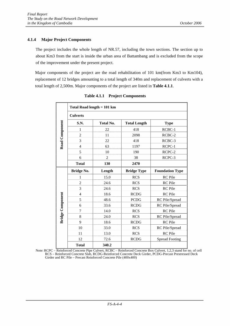
4.1.4 Major Project Components
The project includes the whole length of NR.57, including the town sections. The section up to about Km3 from the start is inside the urban area of Battambang and is excluded from the scope of the improvement under the present project.
Major components of the project are the road rehabilitation of 101 km(from Km3 to Km104), replacement of 12 bridges amounting to a total length of 340m and replacement of culverts with a total length of 2,500m. Major components of the project are listed in Table 4.1.1.
Table 4.1.1 Project Components
Total Road length = 101 km
Culverts
S.N. Total No. Total Length Type
1 22 418 RCBC-1 2 11 2098 RCBC-2 3 22 418 RCBC-3 4 63 1197 RCPC-1 5 10 190 RCPC-2 6 2 38 RCPC-3
Roa
d C
ompo
nent
Total 130 2470
Bridge No. Length Bridge Type Foundation Type
1 15.0 RCS RC Pile 2 24.6 RCS RC Pile 3 24.6 RCS RC Pile 4 18.6 RCDG RC Pile 5 48.6 PCDG RC Pile/Spread 6 33.6 RCDG RC Pile/Spread 7 14.0 RCS RC Pile 8 24.0 RCS RC Pile/Spread 9 18.6 RCDG RC Pile
10 33.0 RCS RC Pile/Spread 11 13.0 RCS RC Pile 12 72.6 RCDG Spread Footing
Bri
dge
Com
pone
nt
Total 340.2 Note: RCPC – Reinforced Concrete Pipe Culvert, RCBC – Reinforced Concrete Box Culvert, 1,2,3 stand for no. of cell RCS – Reinforced Concrete Slab, RCDG-Reinforced Concrete Deck Girder, PCDG-Precast Prestressed Deck Girder and RC Pile – Precast Reinforced Concrete Pile (400x400)
Final Report The Study on the Road Network Development in the Kingdom of Cambodia October 2006
FS-A-4-5
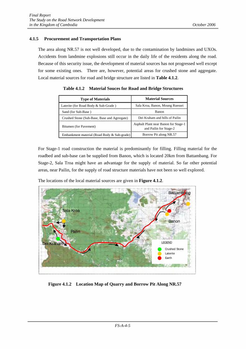
4.1.5 Procurement and Transportation Plans
The area along NR.57 is not well developed, due to the contamination by landmines and UXOs. Accidents from landmine explosions still occur in the daily life of the residents along the road. Because of this security issue, the development of material sources has not progressed well except for some existing ones. There are, however, potential areas for crushed stone and aggregate. Local material sources for road and bridge structure are listed in Table 4.1.2.
Table 4.1.2 Material Souces for Road and Bridge Structures
Type of Materials
Laterite (for Road Body & Sub-Grade )
Sand (for Sub-Base )
Crushed Stone (Sub-Base, Base and Agrregate)
Bitumen (for Pavement)
Embankment material (Road Body & Sub-grade) Borrow Pit along NR.57
Banon
Material Sources
Sala Kroa, Banon, Moung Ruessei
Dei Kraham and hills of Pailin
Asphalt Plant near Banon for Stage-1and Pailin for Stage-2
For Stage-1 road construction the material is predominantly for filling. Filling material for the roadbed and sub-base can be supplied from Banon, which is located 20km from Battambang. For Stage-2, Sala Troa might have an advantage for the supply of material. So far other potential areas, near Pailin, for the supply of road structure materials have not been so well explored.
The locations of the local material sources are given in Figure 4.1.2.
Battambang
Pailin
Banon
Sala Kroa
Dei Kraham
Figure 4.1.2 Location Map of Quarry and Borrow Pit Along NR.57
Crushed Stone Laterite Earth
LEGEND

Final Report The Study on the Road Network Development in the Kingdom of Cambodia October 2006
FS-A-4-6
4.1.6 Share of the Work
The project is considered to be financed by External Resources. The share of work responsibility between the External Resources and the Government of Cambodia is shown in Table 4.1.3.
Table 4.1.3 Share of Work between External Resources and the Government of Cambodia
OtherCountries Cambodia
Purchase and transport ofequipment and material ○
Improvement of road for inlandtransport ○
○Before the workcommencement
Land acquisition &conpensation etc. needed for
the construction works○
Site office, stock andwork yards,
Preparation works other thanthe above ○
Shift of Public Utilites such asWater supply line, Power
supply line, communicationcable
○Before the workcommencement
Removal of existing bridges ○
Project components Construction of bridges androads, other related works ○
Project Preparation
Item Content
Survey and evacuation of landmine and UXO
Procurement ofEquipment and
MaterialsCustom clearance of the above
RemarksShare
○

Final Report The Study on the Road Network Development in the Kingdom of Cambodia October 2006
FS-A-4-7
4.2 Cost Estimate
4.2.1 Construction Cost
For the purpose of cost estimates, the costs of temporary and indirect works have been estimated based on similar projects in Cambodia and are given in Table 4.2.1.
Table 4.2.1 Share of Temporary and Indirect Works
Direct Cost A (a+b)Direct Construction Work aSite Temporary Work b a*10%
Temporary Works in Common B a*5%Site Management C a*7%General Management D (A+B+C)*6%
Detailed Design & Construction Supervision 10%Detailed Design and Supervision
For NR.57 (Road: 101km, 12 Bridges: 340m)
Construction Works
Site temporary works include:
1. Temporary work on Site, 2. Machine use and depreciation 3. Engineer’s dispatching 4. Others
Temporary works in common include: 1. Preparation works, including leasing fees for detours and other purposes. 2. Plant installation 3. Import, transportation and other costs for imported materials and equipment 4. Security cost 5. Quality control 6. Building and maintenance of project offices and consumable goods
Site Management includes: 1. Labor management cost 2. Safety precaution costs for sanitary and others 3. Insurance cost 4. Wages and other allowances of project staff and workers 5. Welfare cost 6. Transportation and communication cost 7. Others General Management includes: 1. Management cost of head office 2. Profit
Final Report The Study on the Road Network Development in the Kingdom of Cambodia October 2006
FS-A-4-8
The summary of estimated construction costs is given in Table 4.2.2.
Table 4.2.2 Estimated Construction Cost
Construction Cost of NR.57 Amount (x 1,000 US$)
Km3 - Km104 35,529
12 Bridges on NR.57 3,888
Pipe and Box Culverts on NR.57 3,378
Total of Construction Works 42,795
Engineering Works
Detailed Design & Construction SV 4,280
TOTAL CONSTRUCTION COST 47,075
(1) Shared cost by External Resources
Preliminary Cost Estimate(x 1,000 US$) Components
Stage-1 (~50km) Stage-2 (50km~)
Road &Bridge Construction 29,573 22,222
Detailed Design, Construction Supervision 2,057 2,222
Sub-Total 22,631 24,444
Grand Total 47,075
(2) Shared cost by the Government of Cambodia
Items (Equivalent in x1,000 US$) Remarks
Land Acquisition 28.4
Clearing of Land Mines and UXOs 300.0 (0.57US$/m2)
Relocation of Public Utilities (Electricity, Water & Communication ) 10.0
Total 338.4

Final Report The Study on the Road Network Development in the Kingdom of Cambodia October 2006
FS-A-4-9
(3) Total Project Cost
The Total Project Cost is estimated as the total of the cost shared by external resources and by the Government of Cambodia and is estimated to be US$ 47,413,400.
Table 4.2.3 Total Project Cost Unit:1,000US$
External Resources Cambodia Government
Construction Cost 42,795.0 Detailed Design & Construction Supervision 4,280.0
Land Acquisition 28.4 Landmine and UXO Clearance 300.0 Relocation of Public Utilities 10.0 Total 47,075.0 338.4 Grand Total 47,413.4
4.2.2 Conditions
Cost estimation has been done with the conditions mentioned below:
1. Time of cost estimation: June 2006
2. Exchange rate: 1 US Dollar = 4,113.5 Riels
3. Construction period: The project is to have 2 Stages as mentioned in the implementation schedule.
Final Report The Study on the Road Network Development in the Kingdom of Cambodia October 2006
FS-A-4-10
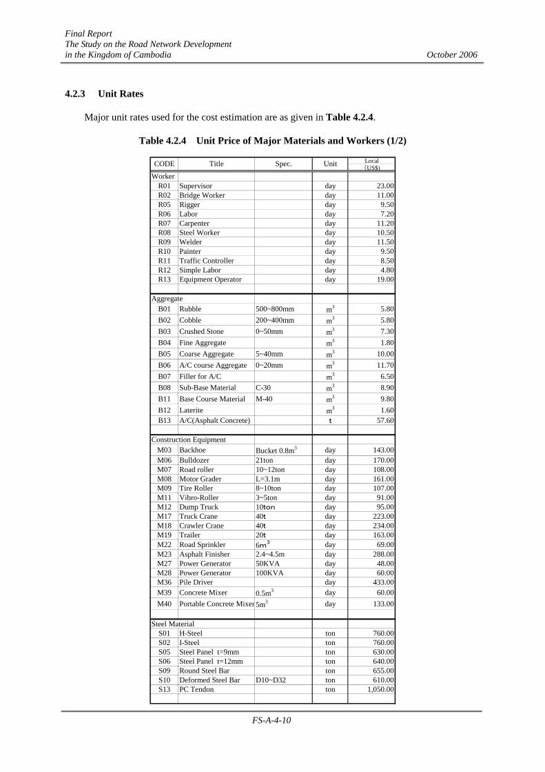
4.2.3 Unit Rates
Major unit rates used for the cost estimation are as given in Table 4.2.4.
Table 4.2.4 Unit Price of Major Materials and Workers (1/2)
Local(US$)
WorkerR01 Supervisor day 23.00R02 Bridge Worker day 11.00R05 Rigger day 9.50R06 Labor day 7.20R07 Carpenter day 11.20R08 Steel Worker day 10.50R09 Welder day 11.50R10 Painter day 9.50R11 Traffic Controller day 8.50R12 Simple Labor day 4.80R13 Equipment Operator day 19.00
AggregateB01 Rubble 500~800mm m3 5.80B02 Cobble 200~400mm m3 5.80B03 Crushed Stone 0~50mm m3 7.30B04 Fine Aggregate m3 1.80B05 Coarse Aggregate 5~40mm m3 10.00B06 A/C course Aggregate 0~20mm m3 11.70B07 Filler for A/C m3 6.50B08 Sub-Base Material C-30 m3 8.90B11 Base Course Material M-40 m3 9.80B12 Laterite m3 1.60B13 A/C(Asphalt Concrete) t 57.60
Construction EquipmentM03 Backhoe Bucket 0.8m3 day 143.00M06 Bulldozer 21ton day 170.00M07 Road roller 10~12ton day 108.00M08 Motor Grader L=3.1m day 161.00M09 Tire Roller 8~10ton day 107.00M11 Vibro-Roller 3~5ton day 91.00M12 Dump Truck 10ton day 95.00M17 Truck Crane 40t day 223.00M18 Crawler Crane 40t day 234.00M19 Trailer 20t day 163.00M22 Road Sprinkler 6m3 day 69.00M23 Asphalt Finisher 2.4~4.5m day 288.00M27 Power Generator 50KVA day 48.00M28 Power Generator 100KVA day 60.00M36 Pile Driver day 433.00M39 Concrete Mixer 0.5m3 day 60.00M40 Portable Concrete Mixer 5m3 day 133.00
Steel MaterialS01 H-Steel ton 760.00S02 I-Steel ton 760.00S05 Steel Panel t=9mm ton 630.00S06 Steel Panel t=12mm ton 640.00S09 Round Steel Bar ton 655.00S10 Deformed Steel Bar D10~D32 ton 610.00S13 PC Tendon ton 1,050.00
CODE Title Spec. Unit

Final Report The Study on the Road Network Development in the Kingdom of Cambodia October 2006
FS-A-4-11
Table 4.2.4 Unit Price of Major Materials and Workers (2/2) Local(US$)
C02 Cement ton 72.00C03 Ready Mixed Concrete 18N/mm2 m3 48.00C04 Ready Mixed Concrete 21N/mm2 m3 51.08C05 Ready Mixed Concrete 24N/mm2 m3 52.86C06 Ready Mixed Concrete 30N/mm2 m3 54.64C07 Ready Mixed Concrete 40N/mm2 m3 62.50
WorkerE01 Civil Engineer 20 years month 1,595.00E02 Civil Engineer 10 years month 920.00E03 Civil Engineer 5 years month 570.00E04 Surveyor 10 years month 920.00E05 Surveyor's assistant month 388.00E06 Power Engineer 10 years month 920.00E07 Power Engineer's Assistant month 570.00E08 Chief Auditor 10 years month 820.00E09 Chief Clark 10 years month 618.00E10 Typist month 313.00E11 Driver month 288.00E12 Security Guard month 200.00
FuelF01 Diesel L 0.790F02 Gasoline L 1.000F03 Prime Cost CSS-1 ton 287.00F04 Tack Coat MC70 ton 355.00F05 Straight Asphalt Grade 60/70 ton 277.00
OthersK01 PC Concrete Pile 400*400, 6m m 86.00K02 Concrete Pile 400*400、10.9m No. 970.00K03 Bailey Bridge Month 4,800.00K05 Wooden Peg φ150, L=1500 No. 2.40K06 Wooden Peg φ150, L=2000 No. 3.20
Construction Equipment(RCC)RC01 Backhoe (RCC) 0.6m3 Day 195.00RC02 Vibro-Roller(RCC) Day 27.00RC03 Motor Grader (RCC) 3.1m Day 164.00RC04 Road Roller (RCC) 10~12t Day 111.00RC05 Truck Crane 2.9t (RCC) Day 68.00RC06 Crawler Crane (RCC) Day 460.00
CODE Title Spec. Unit
Ref. RCC “the Road Construction Center”
Final Report The Study on the Road Network Development in the Kingdom of Cambodia October 2006
FS-A-4-12
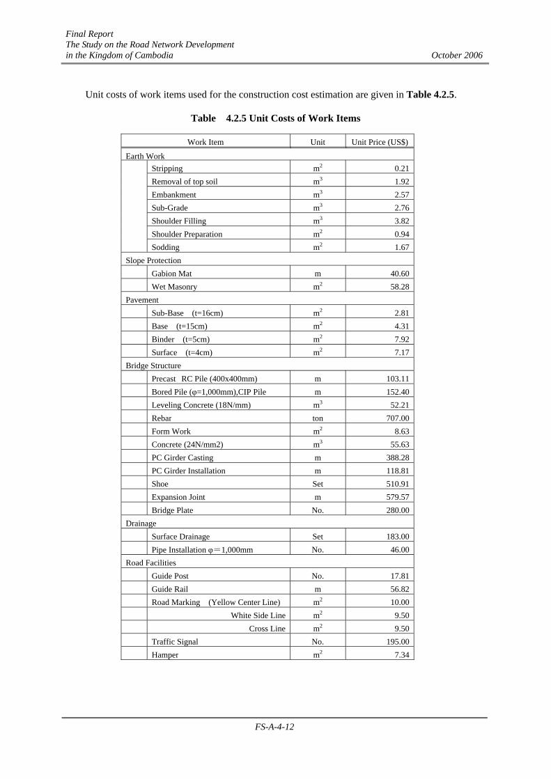
Unit costs of work items used for the construction cost estimation are given in Table 4.2.5.
Table 4.2.5 Unit Costs of Work Items
Work Item Unit Unit Price (US$)
Earth WorkStripping m2 0.21 Removal of top soil m3 1.92 Embankment m3 2.57 Sub-Grade m3 2.76 Shoulder Filling m3 3.82 Shoulder Preparation m2 0.94
Sodding m2 1.67 Slope Protection
Gabion Mat m 40.60 Wet Masonry m2 58.28 Pavement
Sub-Base (t=16cm) m2 2.81 Base (t=15cm) m2 4.31 Binder (t=5cm) m2 7.92 Surface (t=4cm) m2 7.17 Bridge Structure
Precast RC Pile (400x400mm) m 103.11 Bored Pile (φ=1,000mm),CIP Pile m 152.40
Leveling Concrete (18N/mm) m3 52.21 Rebar ton 707.00
Form Work m2 8.63 Concrete (24N/mm2) m3 55.63 PC Girder Casting m 388.28 PC Girder Installation m 118.81 Shoe Set 510.91 Expansion Joint m 579.57 Bridge Plate No. 280.00 Drainage
Surface Drainage Set 183.00 Pipe Installation φ=1,000mm No. 46.00 Road Facilities
Guide Post No. 17.81 Guide Rail m 56.82 Road Marking (Yellow Center Line) m2 10.00 White Side Line m2 9.50 Cross Line m2 9.50 Traffic Signal No. 195.00 Hamper m2 7.34
Final Report The Study on the Road Network Development in the Kingdom of Cambodia October 2006
FS-A-4-13
4.3 Maintenance Plan
4.3.1 Preparation of Maintenance Plan
NR.57 is 104 km long from the Rong Vong, Moul Preah intersection of NR.5 to the Thailand border. The jurisdiction of 66 km long belongs to the DPWT in Battambang and the remaining 38 km long belongs to the DPWT in Pailin. The project road is being maintained in accordance with the following classifications:
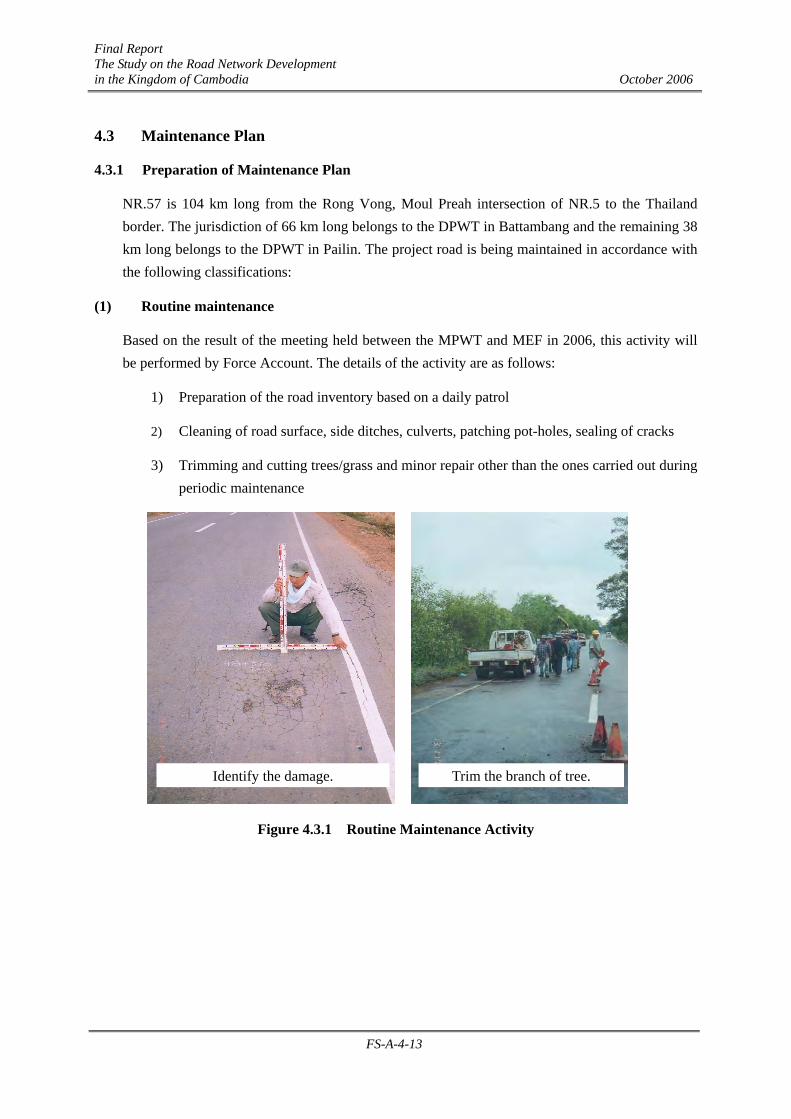
(1) Routine maintenance
Based on the result of the meeting held between the MPWT and MEF in 2006, this activity will be performed by Force Account. The details of the activity are as follows:
1) Preparation of the road inventory based on a daily patrol
2) Cleaning of road surface, side ditches, culverts, patching pot-holes, sealing of cracks
3) Trimming and cutting trees/grass and minor repair other than the ones carried out during periodic maintenance
Figure 4.3.1 Routine Maintenance Activity
Identify the damage. Trim the branch of tree.
Final Report The Study on the Road Network Development in the Kingdom of Cambodia October 2006
FS-A-4-14
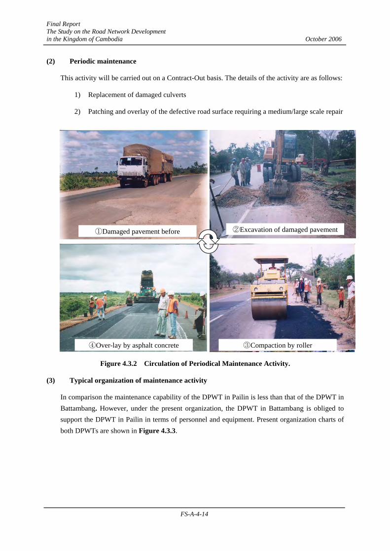
(2) Periodic maintenance
This activity will be carried out on a Contract-Out basis. The details of the activity are as follows:
1) Replacement of damaged culverts
2) Patching and overlay of the defective road surface requiring a medium/large scale repair
Figure 4.3.2 Circulation of Periodical Maintenance Activity.
(3) Typical organization of maintenance activity
In comparison the maintenance capability of the DPWT in Pailin is less than that of the DPWT in Battambang. However, under the present organization, the DPWT in Battambang is obliged to support the DPWT in Pailin in terms of personnel and equipment. Present organization charts of both DPWTs are shown in Figure 4.3.3.
②Excavation of damaged pavement
③Compaction by roller
①Damaged pavement before
④Over-lay by asphalt concrete

Final Report The Study on the Road Network Development in the Kingdom of Cambodia October 2006
FS-A-4-15
Figure 4.3.3 Organization Charts of the DPWTs Concerned
4.3.2 Maintenance Operation Plan
(1) Organization and Operation
As road authorities where this project is located, the MPWTs and DPWTs of Battambang and Pailin will undertake the maintenance of the proposed improvement of national road No.57.
These provinces belong to the west region where the study team presented the proposal requesting considerations to perform training, personnel exchange and equipment supply. The DPWT in Battambang is the group leader in the region. The DPWT in Battambang will maintain NR.57 in good road condition and, at the same time, support the DPWT in Pailin in terms of personnel and equipment.
(a) Implementation and Arrangement of the Maintenance Activities A critical issue is the upgrade the service capacity of the maintenance system, to cope with the demand of the country’s economic development. Without appropriate maintenance works the
Director
Deputy Director Technical
Deputy DirectorTransportation
Deputy DirectorProvincial Works
Public works office
Responsible for maintenance
Road office
DPWT in Battambang
Equipment office
Director
Deputy Director Public Works
Deputy DirectorTransportation
Deputy DirectorAdministration
Public works office (Maintenance)
Responsible for maintenance
Public works office (District)
DPWT in Pailin

Final Report The Study on the Road Network Development in the Kingdom of Cambodia October 2006
FS-A-4-16
road is deterioring with increasing speed. Under such conditions and with limited technical and financial resources, the road authorities still have to take full responsibility for maintaining this asset.
Demarcation of maintenance works between the MPWT and the DPWT is shown in Table 4.3.1.
Table 4.3.1 Demarcation of Maintenance Management
Activity MPWT DPWT Daily and Monthly Patrol 1. Evaluation of monthly
inspection record by Public Works Research Center (PWRC).
1. Patrol to be conducted to check road condition, structure, facilities, obstacles, illegal occupancy and so on.
2. Visual inspection and road serviceability check are conducted.
3. Inspection sheet to be recorded. Routine Maintenance Works 1. Assessment of DPWT’s budget
request by DOR. 2. Preparation of project
estimation by DOR. 3. Bidding and preparation of
contract, force account or contract-out to be determined by a bidding committee.
4. Supervising of project by DOR.5. Inspection of project by DOR.
1. Preparation of routine maintenance plan based on daily and monthly patrol record for the request of budget to MPWT.
2. Implementation or supervising of project.
3. Preparation of routine progress & final report
Periodic Maintenance Works
1. Preparation of project estimations, bill of quantities, designs & spec. by PWRC.
2. Bidding and preparation of contract by a bidding committee.
3. Supervising and reporting of project by PWRC.
4. Hand over of management to DOR.
1. Inspection sheet shall be recorded conducting regular patrol.
2. Transfer of management from PWRC.
Emergency Works 1. Conducting inspection by PWRC & DPWT
2. Preparation of project estimations, designs & spec. by PWRC.
3. Bidding and preparation of contract by PWRC
4. Supervision and reporting of project by PWRC.
5. Hand over of management to DOR.
1. Conducting inspection by PWRC & DPWT
2. Transfer of management from PWRC.
Final Report The Study on the Road Network Development in the Kingdom of Cambodia October 2006
FS-A-4-17
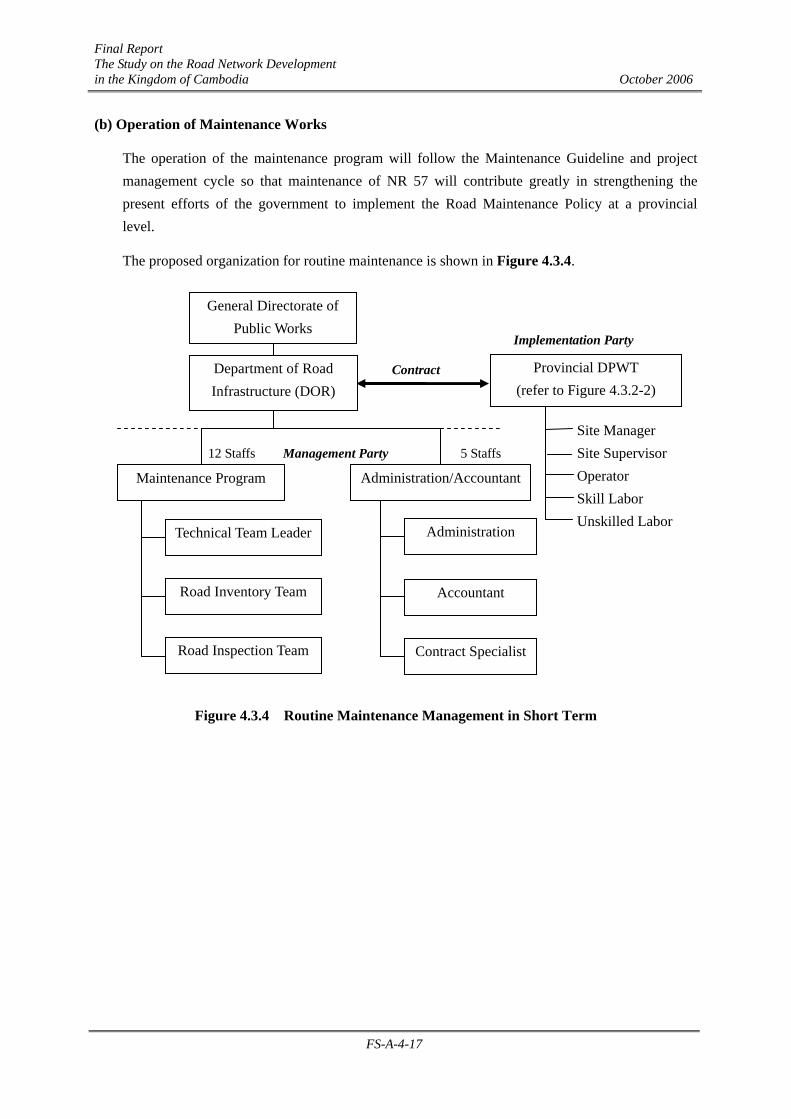
(b) Operation of Maintenance Works
The operation of the maintenance program will follow the Maintenance Guideline and project management cycle so that maintenance of NR 57 will contribute greatly in strengthening the present efforts of the government to implement the Road Maintenance Policy at a provincial level.
The proposed organization for routine maintenance is shown in Figure 4.3.4.
Figure 4.3.4 Routine Maintenance Management in Short Term
Road Inspection Team
Road Inventory Team
Technical Team Leader Administration
Accountant
Administration/Accountant
Contract Specialist
Contract
Management Party 12 Staffs 5 Staffs
Department of Road Infrastructure (DOR)
Site Manager Site Supervisor Operator Skill Labor Unskilled Labor
Provincial DPWT (refer to Figure 4.3.2-2)
General Directorate of Public Works
Maintenance Program
Implementation Party

Final Report The Study on the Road Network Development in the Kingdom of Cambodia October 2006
FS-A-4-18
(2) Financial Program
(a) Required Maintenance Cost
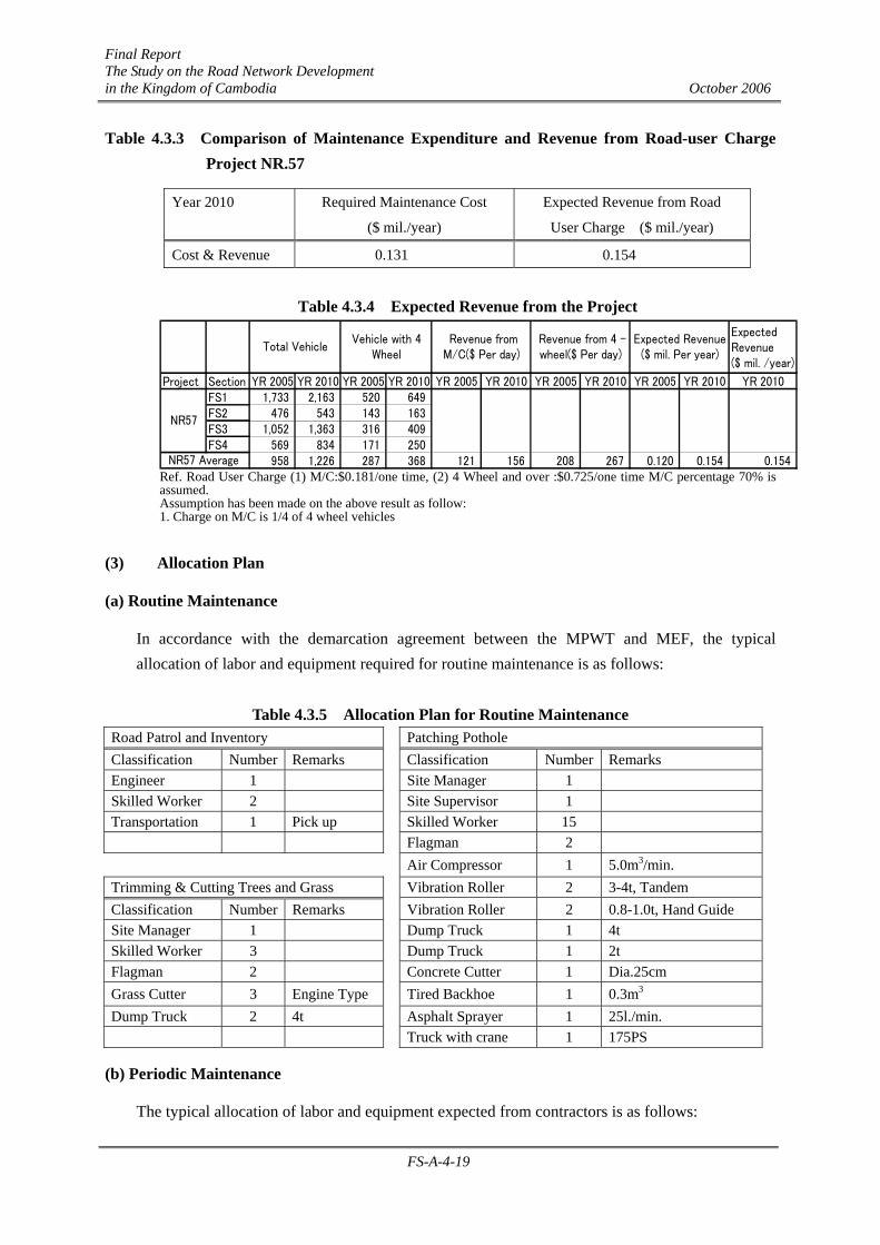
Total maintenance cost for NR.57 is estimated to be about $0.131million per annum, as shown in Table 4.3.2, by applying a unit maintenance cost per km, which consists of a routine patrol cost, cleaning-up cost and patching work to the subject length of the NR.57.
Table 4.3.2 Estimation of Annual Maintenance Cost for NR. 57 Unit Maintenance
Cost ($/km) Maintenance Cost ($ mil/year)
NR.57 Dist.(km)
Patrol Patching Patrol Patching Total
Battambang - Pailin 104.0 32 866 0.0401 0.0904 0.131 Frequency of Patrol: 1 time a month Frequency of Patching : 1 time a year
(b) Financial Plan
With regard to the future financing plan for urgent projects, there are two alternatives as described below:
Alt. 1; Financing by Road Maintenance Added Tax
On the basis of the expected amount of gasoline the expected revenue from added tax or road maintenance special fund in 2010 is forecasted to be about $30 million, of which about $22.0 million is scheduled for the maintenance of the existing roads in the nation. The required maintenance cost of $0.13 million is far below the $8 million balance between the expected revenue and expenditure of the fund.
Alt. 2; Financing by charging a maintenance charge on road users
This is a method to cater for the maintenance cost by charging a fee on the road users. This type of charge has already been introduced on the sections on NR.4 nearby Phnom Penh where a certain amount of fee is being charged on vehicles passing on the route.
If the level of charge is equivalent to that presently charged on NR.4 a simple analysis suggests that the fund achieved from fees levied by this method would be about $ 0.154 million in 2010, which is a sufficient amount of revenue to cover the maintenance cost; refer Table 4.3.3 and Table 4.3.4.
It can be concluded that one of these methods can be used to procure road maintenance funds from road users, therefore reducing the burden of extra expenses on the MPWT.
Final Report The Study on the Road Network Development in the Kingdom of Cambodia October 2006
FS-A-4-19
Table 4.3.3 Comparison of Maintenance Expenditure and Revenue from Road-user Charge Project NR.57
Year 2010 Required Maintenance Cost
($ mil./year)
Expected Revenue from Road
User Charge ($ mil./year)
Cost & Revenue 0.131 0.154
Table 4.3.4 Expected Revenue from the Project j
ExpectedRevenue($ mil. /year)
Project Section YR 2005 YR 2010 YR 2005 YR 2010 YR 2005 YR 2010 YR 2005 YR 2010 YR 2005 YR 2010 YR 2010FS1 1,733 2,163 520 649FS2 476 543 143 163FS3 1,052 1,363 316 409FS4 569 834 171 250
958 1,226 287 368 121 156 208 267 0.120 0.154 0.154NR57 Average
Expected Revenue($ mil. Per year)
NR57
Total VehicleVehicle with 4
Wheel Revenue fromM/C($ Per day)
Revenue from 4 -wheel($ Per day)
Ref. Road User Charge (1) M/C:$0.181/one time, (2) 4 Wheel and over :$0.725/one time M/C percentage 70% is assumed. Assumption has been made on the above result as follow: 1. Charge on M/C is 1/4 of 4 wheel vehicles
(3) Allocation Plan
(a) Routine Maintenance
In accordance with the demarcation agreement between the MPWT and MEF, the typical allocation of labor and equipment required for routine maintenance is as follows:
Table 4.3.5 Allocation Plan for Routine Maintenance
Road Patrol and Inventory Patching Pothole Classification Number Remarks Classification Number Remarks Engineer 1 Site Manager 1 Skilled Worker 2 Site Supervisor 1 Transportation 1 Pick up Skilled Worker 15 Flagman 2 Air Compressor 1 5.0m3/min. Trimming & Cutting Trees and Grass Vibration Roller 2 3-4t, Tandem Classification Number Remarks Vibration Roller 2 0.8-1.0t, Hand Guide Site Manager 1 Dump Truck 1 4t Skilled Worker 3 Dump Truck 1 2t Flagman 2 Concrete Cutter 1 Dia.25cm Grass Cutter 3 Engine Type Tired Backhoe 1 0.3m3 Dump Truck 2 4t Asphalt Sprayer 1 25l./min. Truck with crane 1 175PS
(b) Periodic Maintenance
The typical allocation of labor and equipment expected from contractors is as follows:

Final Report The Study on the Road Network Development in the Kingdom of Cambodia October 2006
FS-A-4-20
Table 4.3.6 Allocation Plan for Periodical Maintenance
Patching Pothole Asphalt Concrete Overlay Classification Number Remarks Classification Number Remarks Site Manager 1 Site Manager 1 Site Supervisor 1 Site Supervisor 1 Skilled Worker 20 Skilled Worker 15 Flagman 2 Flagman 2 Wheel Roller 1 1.2m3 Macadam Roller 1 6t Macadam Roller 1 6t Tandem Roller 1 1t Rammer 1 80kg Pneumatic Roller 3-5 8-20t Tandem Roller 1 1t Dump Truck 3-5 10t Dump truck 2 10t Tractor Bloomer 1 Concrete Cutter 1 Dia.25cm Asphalt Finisher 1 Tired Backhoe 1 0.4m3 Asphalt Distributor 1 6m3 Asphalt Distributor 1 6m3 Water Tank 1 6m3 Truck with crane 1 175PS Trailer 1 Trailer 1
(c) Frequency
The pavement structure of NR.57 is expected to be designed with asphalt concrete and the following maintenance frequency is recommended:
Table 4.3.7 Frequency of Maintenance
Activity Frequency Remarks
Road Patrol At least once a month
Inventory Once a year Information shall be transmitted to Technical
Research Center
Routine
Maintenance
Based on Road Patrol
Result
Periodic
Maintenance
Based on Inventory
Result
Standard life of asphalt concrete is 10 years and
medium scale of damage is considered to occur five
years after completion of the improvement
Final Report The Study on the Road Network Development in the Kingdom of Cambodia October 2006
FS-A-4-21
4.4 Implementation Plan
4.4.1 Project Components
The construction of NR.57 consists of a total of 101 km of road component including a total of 2470m of culverts and a bridge component of 12 bridges with a total length of 340m as detailed previously in Table 4.1.1.
4.4.2 Procurement Source
The material procurement sources for bridges and pavement are given in Table 4.4.1.
Large cranes, reverse circulation drills, vibration hammers etc. are not locally available. If required, these can be procured from Thailand. The procurement plan for major equipment is shown in the Table 4.4.2.
4.4.3 Implementation Schedule
The schedule below has been prepared with the following considerations:
(1) Preparation Work
Clearance of landmines and UXOs is essential before the commencement of the detailed design of Stage-2. Four (4) months is considered necessary to carry out the work in parallel to the
Table 4.4.1 Material Procurement Sources
Cambodia OthersStructural Materials Crushed stone (foundation, sub-base) ○ Domestically Cement ○ Domestically Sand ○ Domestically Crushed stone(Aggregate) ○ Domestically Rebar:D6~D32 ○ Domestically Admixture for Concrete ○ Thailand Pre-stressing tendon ○ Thailand Shoe ○ Thailand Non-shrink cement ○ Domestically Pre-stressing device for PC ○ Thailand Crushed stone for masonry ○ Domestically Steel Concrete Tube ○ Domestically Bitumen ○ Phnom Penh Gabion ○ Thailand, Corner Stone ○ Domestically Concrete Peg ○ Domestically Wooden Peg ○ Domestically Steel sheet pile ○ Domestically Sealing strip ○ Domestically Timber ○ Domestically Expansion Joint ○ Thailand Guard Rail ○ Thailand
Material Source Source Country Sources
Table 4.4.2 Sources of Major Construction Equipment
Equipment Spec.PhnomPenh
RCCThird
Country
Backhoe 0.2m2 ○
Backhoe 0.6m2 ○ ○
Bulldozer 21t ○ ○
Bulldozer 15t ○
Motor Grader 3.1m ○ ○
Road roller 8t ○ ○
Tyreroller 8-20t ○
Concrete Mixer 0.1m3 ○
Concrete Mixer 0.5m3 ○
Concrete Plant Weigh Mix ○
Road Sprinkler 4.kl ○ ○
Dumptruck 6t ○
Dumptruck 10t ○
Truckcrane 11t ○
Crawler Crane 40t ○
Crawler Crane 50t ○
Crawler Crane 100t ○
Crawler Crane 150t ○
Diesel Hammer 2.5t ○
Vibro-Hammer 40kw ○
Reverse Driller ○
Water Tank 50m3 ○
Girder Erection Facilities ○
Power Generator 250KVA ○
Power Generator 100KVA ○
Power Generator 45KVAPower Generator 15KVA ○
Submersible Pump 150mm ○
Submersible Pump 100mm ○
Compressor 5m3 ○
Truck 2t ○
Truck 4t ○

Final Report The Study on the Road Network Development in the Kingdom of Cambodia October 2006
FS-A-4-22
detailed design of Stage-1.
(2) Detailed design
The main scope of works for the detailed design includes the review of the preliminary design including preliminary design drawings, construction planning, procurement planning and cost estimation. The period required for the detailed design is estimated to be 6 months.
(3) Preparation of Tender Documents
Main tasks scheduled from public announcement to the establishment of the construction contract are as follows: • Preparation of tender documents • Public announcement • Pre-qualification of bidders • Tendering • Tender evaluation • Promotion of contract establishment
The period required for the above is estimated to be 3 months.
(4) Construction supervision
The followings are the major items: • Collation and approval of survey data and construction planning • Quality control • Schedule control • Progress quantity check • Safety management • Handover
It is estimated that a total time of 5 years will be required for both the stages; 2 years for Stage-1 and 3 years for Stage-2.
(5) Construction Equipment
All construction equipment, which is not already available, will have to be imported as there is no local leasing company. For some equipment such as backhoe, bulldozer and tire roller, large size crane, reverse circulation drill and vibration-hammer, it is believed that there is enough in Cambodia at present to cope with the demand. If required equipment may be sourced from Thailand.
(6) Construction Schedule
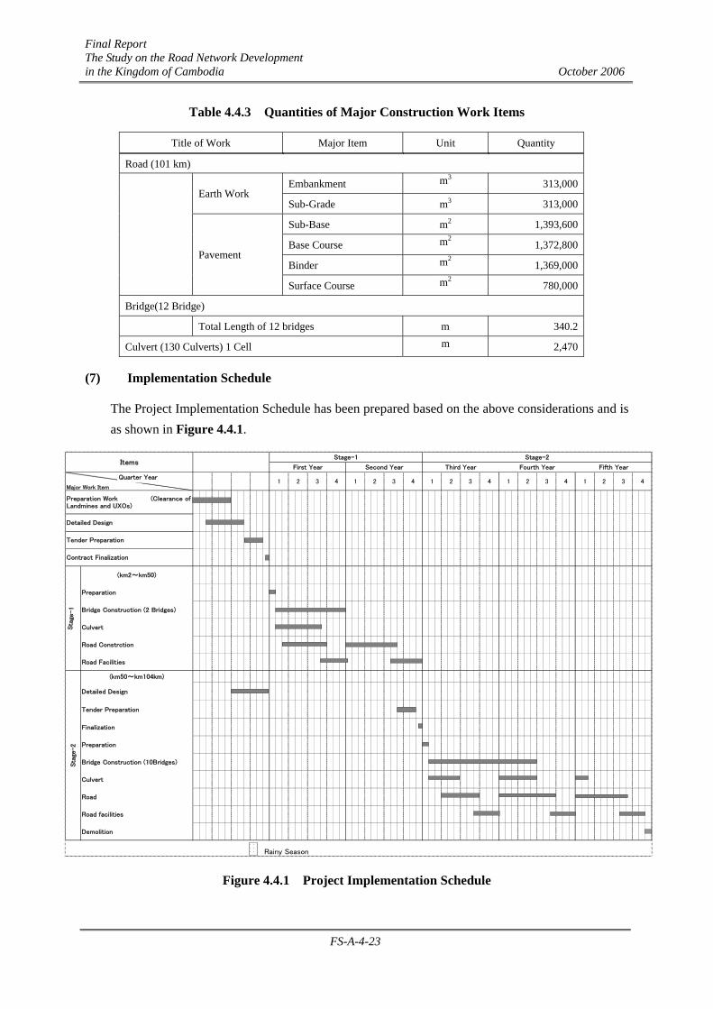
The construction schedule has been prepared based upon the quantities involved in the major construction work and construction method. The quantities are as shown in Table 4.4.3.
Final Report The Study on the Road Network Development in the Kingdom of Cambodia October 2006
FS-A-4-23
Table 4.4.3 Quantities of Major Construction Work Items
Title of Work Major Item Unit Quantity
Road (101 km)
Embankment m3 313,000
Earth Work
Sub-Grade m3 313,000
Sub-Base m2 1,393,600
Base Course m2 1,372,800
Binder m2 1,369,000
Pavement
Surface Course m2 780,000
Bridge(12 Bridge)
Total Length of 12 bridges m 340.2
Culvert (130 Culverts) 1 Cell m 2,470
(7) Implementation Schedule
The Project Implementation Schedule has been prepared based on the above considerations and is as shown in Figure 4.4.1.
(km2~km50)
Preparation
Bridge Construction (2 Bridges)
Culvert
Road Constrction
Road Facilities
(km50~km104km)
Detailed Design
Tender Preparation
Finalization
Preparation
Bridge Construction (10Bridges)
Culvert
Road
Road facilities
Demolition
Rainy Season
41 2 3 43 4 1 2
Sta
ge-2
Stage-1
First Year Second YearItems
Preparation Work (Clearance ofLandmines and UXOs)
Stage-2
Sta
ge-1
Detailed Design
Tender Preparation
Contract Finalization
Major Work Item1 2
Fifth YearThird Year Fourth Year
3 4 3 4 1 21 2 3Quarter Year
Figure 4.4.1 Project Implementation Schedule

Final Report The Study on the Road Network Development in the Kingdom of Cambodia October 2006
FS-A-5-1
CHAPTER A-5 PROJECT EVALUATION
5.1 Study Approach
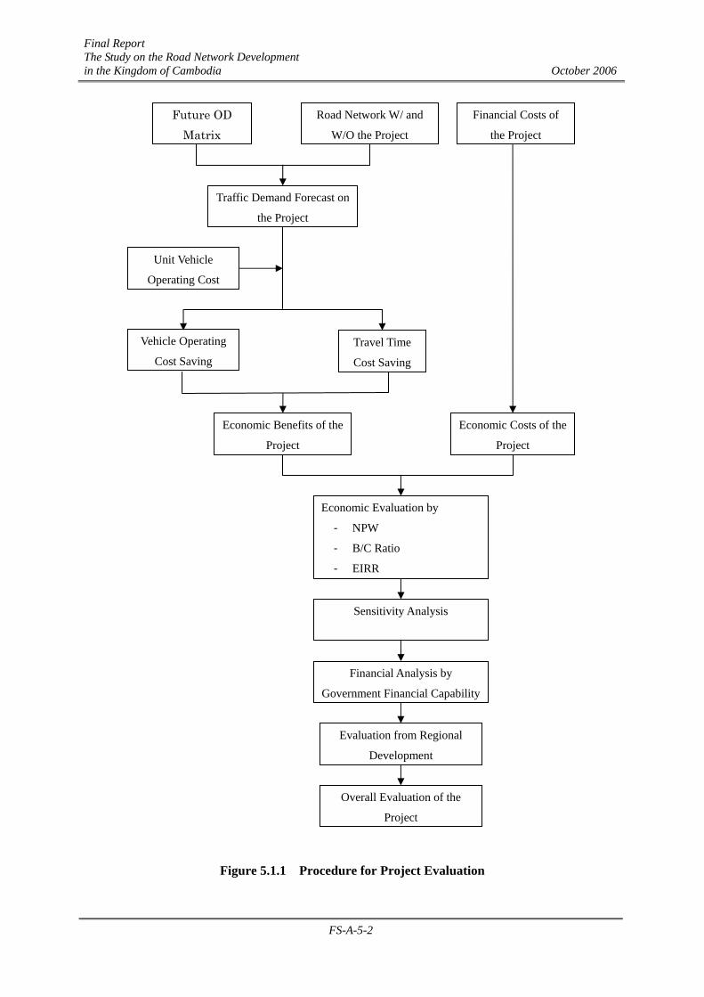
The purpose of this chapter is to evaluate the project for National Road No.57 from the traffic, economic, financial, and regional development points of view.
In order to achieve the purpose of the study, the following steps are carried out:
Step 1: Forecast traffic demand “with” and “without” the project,
Step 2: Estimation of economic benefits based on the traffic demand on the project road and unit vehicle operating costs,
Step 3: Estimation of economic costs based on the estimated financial costs mentioned in the previous section,
Step 4: Economic evaluation using economic benefits and economic costs
Step 5: Sensitivity analysis by varying factors of influence on the economic indicators
Step 6: Evaluation from a financial viewpoint
Step 7: Identification of impacts on regional development
Step 8: Overall evaluation
Figure 5.1.1 shows the procedure for the project evaluation.
Final Report The Study on the Road Network Development in the Kingdom of Cambodia October 2006
FS-A-5-2
Figure 5.1.1 Procedure for Project Evaluation
Future OD Matrix
Road Network W/ and
W/O the Project
Financial Costs of
the Project
Traffic Demand Forecast on
the Project
Unit Vehicle
Operating Cost
Vehicle Operating
Cost Saving Travel Time
Cost Saving
Economic Benefits of the
Project
Economic Costs of the
Project
Economic Evaluation by
- NPW
- B/C Ratio
- EIRR
Sensitivity Analysis
Financial Analysis by
Government Financial Capability
Evaluation from Regional
Development
Overall Evaluation of the
Project
Final Report The Study on the Road Network Development in the Kingdom of Cambodia October 2006
FS-A-5-3
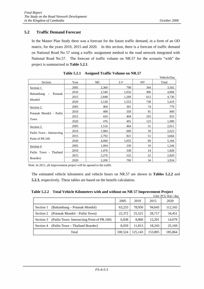
5.2 Traffic Demand Forecast
In the Master Plan Study there was a forecast for the future traffic demand, in a form of an OD matrix, for the years 2010, 2015 and 2020. In this section, there is a forecast of traffic demand on National Road No 57 using a traffic assignment method to the road network integrated with National Road No.57. The forecast of traffic volume on NR.57 for the scenario “with” the project is summarized in Table 5.2.1.
Table 5.2.1 Assigned Traffic Volume on NR.57 Vehicle/Day
Section Year MC LV HV Total
2005 2,360 798 344 3,5022010 2,540 1,032 496 4,0682015 2,848 1,269 613 4,730
Section 1
Battambang - Potanak
Mondol 2020 3,128 1,553 738 5,4192005 404 301 74 7792010 408 350 91 8492015 416 404 103 923
Section 2
Potanak Mondol – Pailin
Town 2020 476 491 123 1,0902005 1,516 464 31 2,0112010 1,984 600 39 2,6232015 2,792 821 51 3,664
Section 3
Pailin Town - Intersecting
Point of PR.160 2020 4,060 1,055 69 5,1842005 1,004 230 10 1,2442010 1,476 338 14 1,8282015 2,276 522 22 2,820
Section 4
Pailin Town - Thailand
Boarder) 2020 3,200 700 34 3,934
Note: In 2011, all improvement project will be opened to the traffic
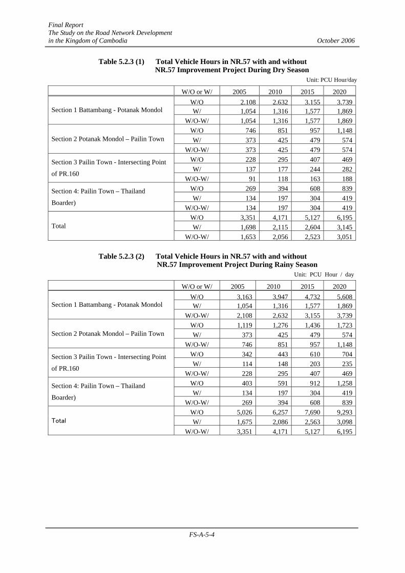
The estimated vehicle kilometers and vehicle hours on NR.57 are shown in Tables 5.2.2 and 5.2.3, respectively. These tables are based on the benefit calculation.
Table 5.2.2 Total Vehicle Kilometers with and without on NR 57 Improvement Project Unit: PCU Km / day
2005 2010 2015 2020
Section 1 (Battambang – Potanak Mondol) 63,255 78,950 94,645 112,165
Section 2 (Potanak Mondol – Pailin Town) 22,372 25,521 28,717 34,451
Section 3 (Pailin Town- Intersecting Point of PR.160) 6,838 8,860 12,201 14,079
Section 4 (Pailin Town – Thailand Boarder) 8,059 11,813 18,243 25,169
Total 100,524 125,143 153,805 185,864
Final Report The Study on the Road Network Development in the Kingdom of Cambodia October 2006
FS-A-5-4
Table 5.2.3 (1) Total Vehicle Hours in NR.57 with and without NR.57 Improvement Project During Dry Season
Unit: PCU Hour/day
W/O or W/ 2005 2010 2015 2020W/O 2,108 2,632 3,155 3,739W/ 1,054 1,316 1,577 1,869Section 1 Battambang - Potanak Mondol
W/O-W/ 1,054 1,316 1,577 1,869W/O 746 851 957 1,148W/ 373 425 479 574Section 2 Potanak Mondol – Pailin Town
W/O-W/ 373 425 479 574W/O 228 295 407 469W/ 137 177 244 282
Section 3 Pailin Town - Intersecting Point
of PR.160 W/O-W/ 91 118 163 188
W/O 269 394 608 839W/ 134 197 304 419
Section 4: Pailin Town – Thailand
Boarder) W/O-W/ 134 197 304 419
W/O 3,351 4,171 5,127 6,195W/ 1,698 2,115 2,604 3,145Total
W/O-W/ 1,653 2,056 2,523 3,051
Table 5.2.3 (2) Total Vehicle Hours in NR.57 with and without NR.57 Improvement Project During Rainy Season
Unit: PCU Hour / day
W/O or W/ 2005 2010 2015 2020W/O 3,163 3,947 4,732 5,608W/ 1,054 1,316 1,577 1,869Section 1 Battambang - Potanak Mondol
W/O-W/ 2,108 2,632 3,155 3,739W/O 1,119 1,276 1,436 1,723W/ 373 425 479 574Section 2 Potanak Mondol – Pailin Town
W/O-W/ 746 851 957 1,148W/O 342 443 610 704W/ 114 148 203 235
Section 3 Pailin Town - Intersecting Point
of PR.160 W/O-W/ 228 295 407 469
W/O 403 591 912 1,258W/ 134 197 304 419
Section 4: Pailin Town – Thailand
Boarder) W/O-W/ 269 394 608 839
W/O 5,026 6,257 7,690 9,293W/ 1,675 2,086 2,563 3,098Total
W/O-W/ 3,351 4,171 5,127 6,195
Final Report The Study on the Road Network Development in the Kingdom of Cambodia October 2006
FS-A-5-5
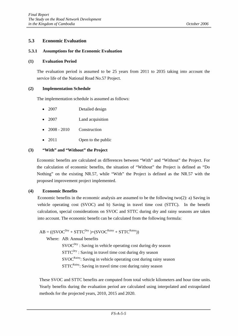
5.3 Economic Evaluation
5.3.1 Assumptions for the Economic Evaluation
(1) Evaluation Period
The evaluation period is assumed to be 25 years from 2011 to 2035 taking into account the service life of the National Road No.57 Project.
(2) Implementation Schedule
The implementation schedule is assumed as follows:
• 2007 Detailed design
• 2007 Land acquisition
• 2008 - 2010 Construction
• 2011 Open to the public
(3) “With” and “Without” the Project
Economic benefits are calculated as differences between “With” and “Without” the Project. For the calculation of economic benefits, the situation of “Without” the Project is defined as “Do Nothing” on the existing NR.57, while “With” the Project is defined as the NR.57 with the proposed improvement project implemented.
(4) Economic Benefits Economic benefits in the economic analysis are assumed to be the following two(2): a) Saving in vehicle operating cost (SVOC) and b) Saving in travel time cost (STTC). In the benefit calculation, special considerations on SVOC and STTC during dry and rainy seasons are taken into account. The economic benefit can be calculated from the following formula: AB = ((SVOCDry + STTCDry )+(SVOCRainy + STTCRainy)) Where: AB: Annual benefits SVOCDry : Saving in vehicle operating cost during dry season STTCDry : Saving in travel time cost during dry season SVOCRainy: Saving in vehicle operating cost during rainy season STTCRainy: Saving in travel time cost during rainy season These SVOC and STTC benefits are computed from total vehicle kilometers and hour time units. Yearly benefits during the evaluation period are calculated using interpolated and extrapolated methods for the projected years, 2010, 2015 and 2020.
Final Report The Study on the Road Network Development in the Kingdom of Cambodia October 2006
FS-A-5-6
(5) Economic Costs
For the economic analysis, costs in terms of financial prices are converted to be in terms of economic prices.
In this economic analysis, all the costs are classified into items of a) trade goods, b) non-trade goods and c) transfer items. It is assumed that trade goods are equivalent to the foreign currency portion, and the aggregation of non-trade goods is the local currency portion. Transfer items are the portions for taxes.
The economic prices for all non-trade goods are obtained by applying the standard conversion factor (SCF).
The SCF is estimated to be 0.893 according to the statistical data regarding foreign trade and government revenues in Cambodia,.
(6) Price Indices and Project Life
For the economic and financial evaluation, the following assumptions are made:
• Pricing date: As of March 2006
• Foreign Exchange Rate 1US Dollar = 4,000 Riel
(7) Economic Indicators
The economic evaluation method principally employed is the benefit cost analysis. The economic indicators used in this study are as follows:
Net Present Value (NPV)
Benefit Cost Ratio, (BCR), and
Economic Internal Rate of Return (EIRR)
Final Report The Study on the Road Network Development in the Kingdom of Cambodia October 2006
FS-A-5-7
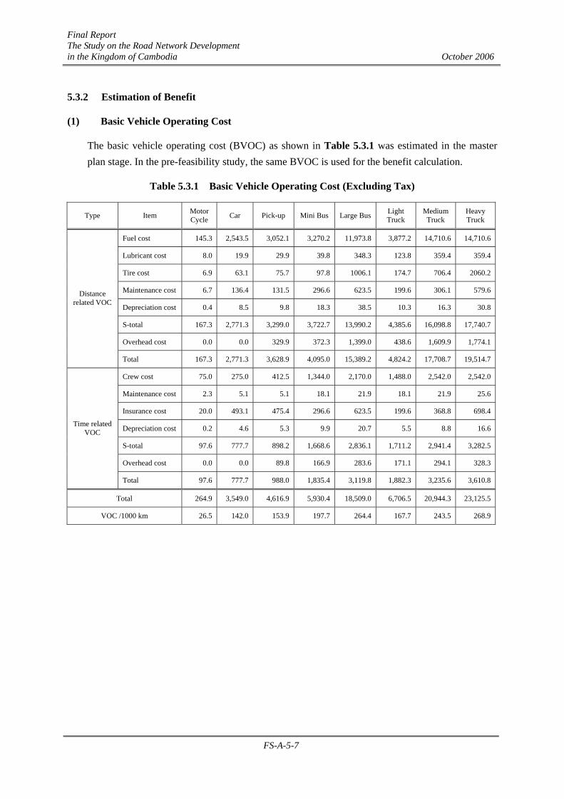
5.3.2 Estimation of Benefit
(1) Basic Vehicle Operating Cost
The basic vehicle operating cost (BVOC) as shown in Table 5.3.1 was estimated in the master plan stage. In the pre-feasibility study, the same BVOC is used for the benefit calculation.
Table 5.3.1 Basic Vehicle Operating Cost (Excluding Tax)
Type Item Motor Cycle Car Pick-up Mini Bus Large Bus Light
Truck Medium Truck
Heavy Truck
Fuel cost 145.3 2,543.5 3,052.1 3,270.2 11,973.8 3,877.2 14,710.6 14,710.6
Lubricant cost 8.0 19.9 29.9 39.8 348.3 123.8 359.4 359.4
Tire cost 6.9 63.1 75.7 97.8 1006.1 174.7 706.4 2060.2
Maintenance cost 6.7 136.4 131.5 296.6 623.5 199.6 306.1 579.6
Depreciation cost 0.4 8.5 9.8 18.3 38.5 10.3 16.3 30.8
S-total 167.3 2,771.3 3,299.0 3,722.7 13,990.2 4,385.6 16,098.8 17,740.7
Overhead cost 0.0 0.0 329.9 372.3 1,399.0 438.6 1,609.9 1,774.1
Distance related VOC
Total 167.3 2,771.3 3,628.9 4,095.0 15,389.2 4,824.2 17,708.7 19,514.7
Crew cost 75.0 275.0 412.5 1,344.0 2,170.0 1,488.0 2,542.0 2,542.0
Maintenance cost 2.3 5.1 5.1 18.1 21.9 18.1 21.9 25.6
Insurance cost 20.0 493.1 475.4 296.6 623.5 199.6 368.8 698.4
Depreciation cost 0.2 4.6 5.3 9.9 20.7 5.5 8.8 16.6
S-total 97.6 777.7 898.2 1,668.6 2,836.1 1,711.2 2,941.4 3,282.5
Overhead cost 0.0 0.0 89.8 166.9 283.6 171.1 294.1 328.3
Time related VOC
Total 97.6 777.7 988.0 1,835.4 3,119.8 1,882.3 3,235.6 3,610.8
Total 264.9 3,549.0 4,616.9 5,930.4 18,509.0 6,706.5 20,944.3 23,125.5
VOC /1000 km 26.5 142.0 153.9 197.7 264.4 167.7 243.5 268.9
Final Report The Study on the Road Network Development in the Kingdom of Cambodia October 2006
FS-A-5-8
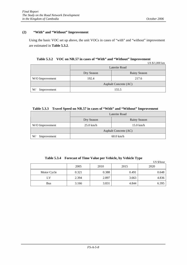
(2) “With” and “Without” Improvement
Using the basic VOC set up above, the unit VOCs in cases of “with” and “without” improvement are estimated in Table 5.3.2.
Table 5.3.2 VOC on NR.57 in cases of “With” and “Without” Improvement US $/1,000 km
Laterite Road
Dry Season Rainy Season
W/O Improvement 192.4 217.6
Asphalt Concrete (AC)
W/ Improvement 155.5
Table 5.3.3 Travel Speed on NR.57 in cases of “With” and “Without” Improvement Laterite Road
Dry Season Rainy Season
W/O Improvement 25.0 km/h 15.0 km/h
Asphalt Concrete (AC)
W/ Improvement 60.0 km/h
Table 5.3.4 Forecast of Time Value per Vehicle, by Vehicle Type US $/hour
2005 2010 2015 2020
Motor Cycle 0.321 0.388 0.491 0.648
LV 2.394 2.897 3.663 4.836
Bus 3.166 3.831 4.844 6.395
Final Report The Study on the Road Network Development in the Kingdom of Cambodia October 2006
FS-A-5-9
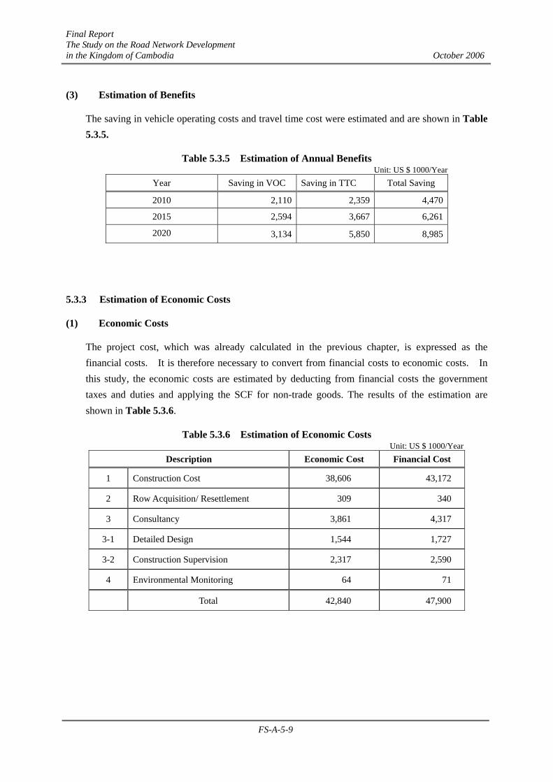
(3) Estimation of Benefits
The saving in vehicle operating costs and travel time cost were estimated and are shown in Table 5.3.5.
Table 5.3.5 Estimation of Annual Benefits Unit: US $ 1000/Year
Year Saving in VOC Saving in TTC Total Saving
2010 2,110 2,359 4,470
2015 2,594 3,667 6,261
2020 3,134 5,850 8,985
5.3.3 Estimation of Economic Costs
(1) Economic Costs
The project cost, which was already calculated in the previous chapter, is expressed as the financial costs. It is therefore necessary to convert from financial costs to economic costs. In this study, the economic costs are estimated by deducting from financial costs the government taxes and duties and applying the SCF for non-trade goods. The results of the estimation are shown in Table 5.3.6.
Table 5.3.6 Estimation of Economic Costs Unit: US $ 1000/Year
Description Economic Cost Financial Cost
1 Construction Cost 38,606 43,172
2 Row Acquisition/ Resettlement 309 340
3 Consultancy 3,861 4,317
3-1 Detailed Design 1,544 1,727
3-2 Construction Supervision 2,317 2,590
4 Environmental Monitoring 64 71
Total 42,840 47,900
Final Report The Study on the Road Network Development in the Kingdom of Cambodia October 2006
FS-A-5-10
(2) Maintenance Cost
The maintenance cost, which consists of routine maintenance and periodic maintenance, was estimated in 4.3.2. The maintenance cost is converted to the economic cost as follows:
Table 5.3.7 Annual Maintenance Cost Estimate Unit: US $ 1000/Year
Economic Cost Financial Cost
Routine maintenance Cost 193 216 Periodic Maintenance Cost 193 216
5.3.4 Economic Evaluation
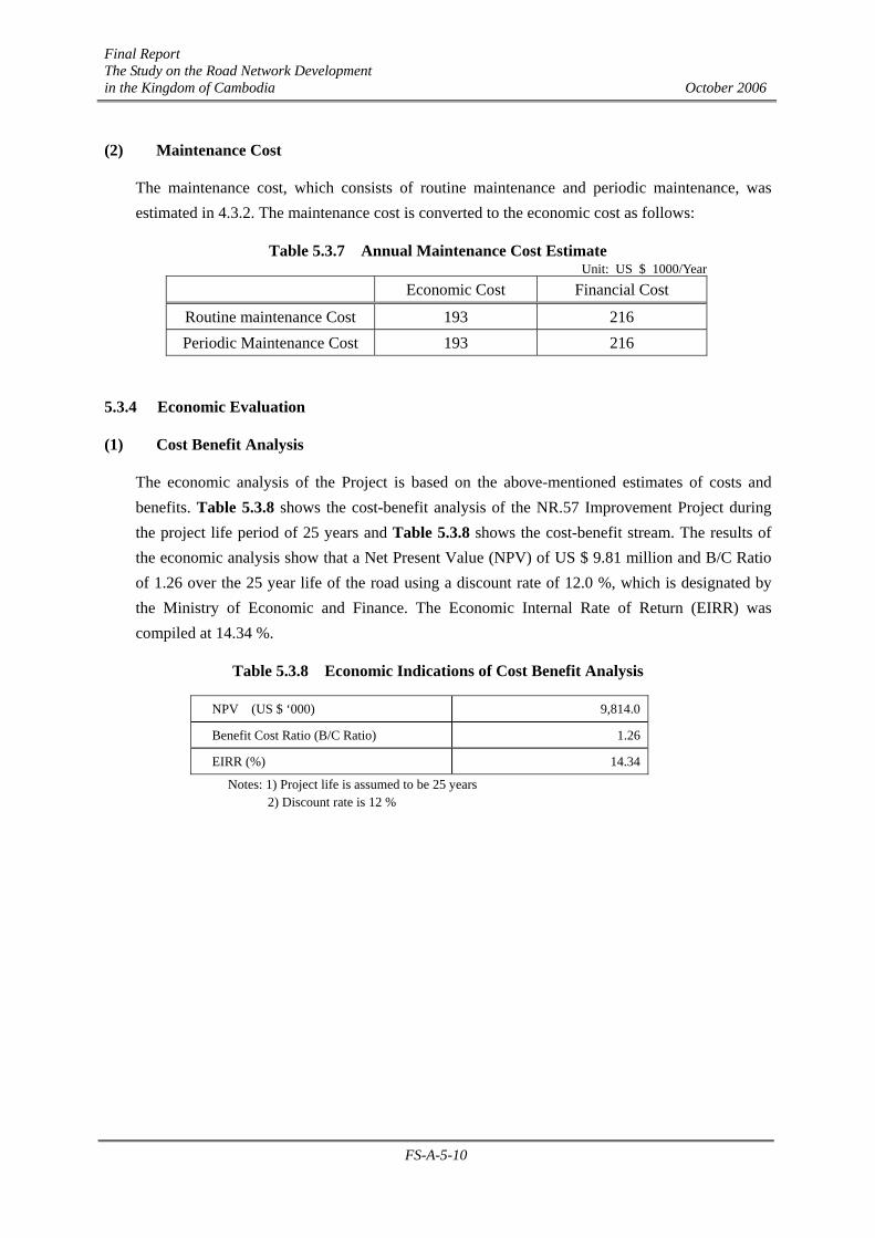
(1) Cost Benefit Analysis
The economic analysis of the Project is based on the above-mentioned estimates of costs and benefits. Table 5.3.8 shows the cost-benefit analysis of the NR.57 Improvement Project during the project life period of 25 years and Table 5.3.8 shows the cost-benefit stream. The results of the economic analysis show that a Net Present Value (NPV) of US $ 9.81 million and B/C Ratio of 1.26 over the 25 year life of the road using a discount rate of 12.0 %, which is designated by the Ministry of Economic and Finance. The Economic Internal Rate of Return (EIRR) was compiled at 14.34 %.
Table 5.3.8 Economic Indications of Cost Benefit Analysis
NPV (US $ ‘000) 9,814.0
Benefit Cost Ratio (B/C Ratio) 1.26
EIRR (%) 14.34
Notes: 1) Project life is assumed to be 25 years 2) Discount rate is 12 %

Final Report The Study on the Road Network Development in the Kingdom of Cambodia October 2006
FS-A-5-11
(2) Sensitivity Analysis
The sensitivity analysis is conducted under a worse case scenario incorporating increases and/or decreases of the estimation of costs and benefits. Table 5.3.9 shows the results of the sensitivity analysis.
Table 5.3.9 Sensitivity Analysis regarding Costs and Benefits for NR.57 Improvement Project
Benefits Indicator
10% down Base Case 10% up
10% down
NPV (US ’000)
B/C Ratio
EIRR (%)
8,617
1.25
14.3
13,361
1.39
15.4
18,104
1.53
16.5
Base Case
NPV (US ’000)
B/C Ratio
EIRR (%)
5,071
1.13
13.3
9814
1.26
14.3
14,557
1.39
15.4
Costs
10% up
NPV (US ’000)
B/C Ratio
EIRR (%)
1,524
1.04
12.4
6,267
1.15
13.4
11,011
1.27
14.3
Note: The life of the project is assumed to be 25 years
(3) Summary of Economic Analysis
Since the economic indicators in most cases are over the cut-off level, which is considered to be 12 % of EIRR in Cambodia, the implementation of the National Road No. 57 Improvement Project is justified from a national economic point of view.
Final Report The Study on the Road Network Development in the Kingdom of Cambodia October 2006
FS-A-5-12
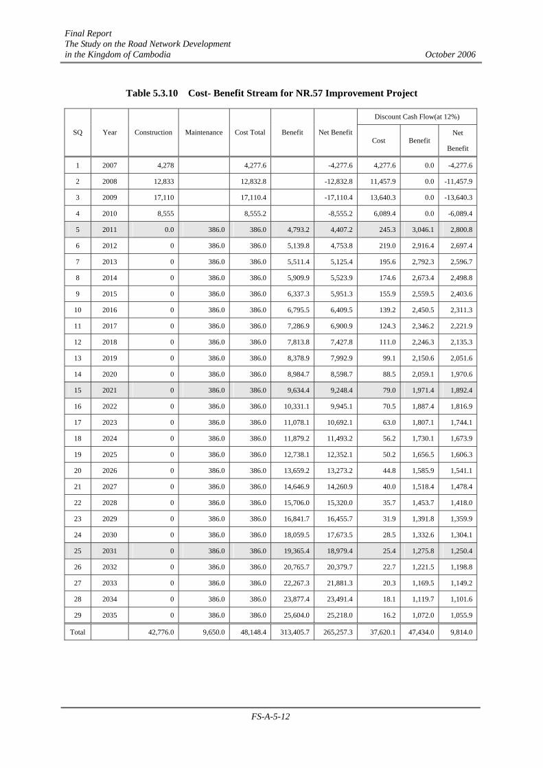
Table 5.3.10 Cost- Benefit Stream for NR.57 Improvement Project
Discount Cash Flow(at 12%)
SQ Year Construction Maintenance Cost Total Benefit Net BenefitCost Benefit
Net
Benefit
1 2007 4,278 4,277.6 -4,277.6 4,277.6 0.0 -4,277.6
2 2008 12,833 12,832.8 -12,832.8 11,457.9 0.0 -11,457.9
3 2009 17,110 17,110.4 -17,110.4 13,640.3 0.0 -13,640.3
4 2010 8,555 8,555.2 -8,555.2 6,089.4 0.0 -6,089.4
5 2011 0.0 386.0 386.0 4,793.2 4,407.2 245.3 3,046.1 2,800.8
6 2012 0 386.0 386.0 5,139.8 4,753.8 219.0 2,916.4 2,697.4
7 2013 0 386.0 386.0 5,511.4 5,125.4 195.6 2,792.3 2,596.7
8 2014 0 386.0 386.0 5,909.9 5,523.9 174.6 2,673.4 2,498.8
9 2015 0 386.0 386.0 6,337.3 5,951.3 155.9 2,559.5 2,403.6
10 2016 0 386.0 386.0 6,795.5 6,409.5 139.2 2,450.5 2,311.3
11 2017 0 386.0 386.0 7,286.9 6,900.9 124.3 2,346.2 2,221.9
12 2018 0 386.0 386.0 7,813.8 7,427.8 111.0 2,246.3 2,135.3
13 2019 0 386.0 386.0 8,378.9 7,992.9 99.1 2,150.6 2,051.6
14 2020 0 386.0 386.0 8,984.7 8,598.7 88.5 2,059.1 1,970.6
15 2021 0 386.0 386.0 9,634.4 9,248.4 79.0 1,971.4 1,892.4
16 2022 0 386.0 386.0 10,331.1 9,945.1 70.5 1,887.4 1,816.9
17 2023 0 386.0 386.0 11,078.1 10,692.1 63.0 1,807.1 1,744.1
18 2024 0 386.0 386.0 11,879.2 11,493.2 56.2 1,730.1 1,673.9
19 2025 0 386.0 386.0 12,738.1 12,352.1 50.2 1,656.5 1,606.3
20 2026 0 386.0 386.0 13,659.2 13,273.2 44.8 1,585.9 1,541.1
21 2027 0 386.0 386.0 14,646.9 14,260.9 40.0 1,518.4 1,478.4
22 2028 0 386.0 386.0 15,706.0 15,320.0 35.7 1,453.7 1,418.0
23 2029 0 386.0 386.0 16,841.7 16,455.7 31.9 1,391.8 1,359.9
24 2030 0 386.0 386.0 18,059.5 17,673.5 28.5 1,332.6 1,304.1
25 2031 0 386.0 386.0 19,365.4 18,979.4 25.4 1,275.8 1,250.4
26 2032 0 386.0 386.0 20,765.7 20,379.7 22.7 1,221.5 1,198.8
27 2033 0 386.0 386.0 22,267.3 21,881.3 20.3 1,169.5 1,149.2
28 2034 0 386.0 386.0 23,877.4 23,491.4 18.1 1,119.7 1,101.6
29 2035 0 386.0 386.0 25,604.0 25,218.0 16.2 1,072.0 1,055.9
Total 42,776.0 9,650.0 48,148.4 313,405.7 265,257.3 37,620.1 47,434.0 9,814.0
Final Report The Study on the Road Network Development in the Kingdom of Cambodia October 2006
FS-A-5-13
5.4 Financial Appraisal
In the Master Plan Study, the overall financial analysis of the implementation program for the improvement and rehabilitation projects proposed has been examined. As a result, the implementation program as shown in Table 5.4.1 of the Master Plan Study was recommended. This project is principally in accordance with the recommended implementation program and there are no problems for the implementation of the project from a financial point of view.
Table 5.4.1 Financial Analysis of the Project (US Dollar Million)
Description Short Term
(2006-2010)
A.. Fund to be Procured
(1) International fund 428
(2) Domestic fund 135
Total 563
B. Proposed Implementation Program in M/P
(1) Improvement / Rehabilitation 403
・ NR.57 Improvement Project 47
(2) Maintenance 157.7
(3) Urgent Rehabilitation Program (20)
Total 516
C. Amount of Balance 47
5.5 Impacts on Regional Development
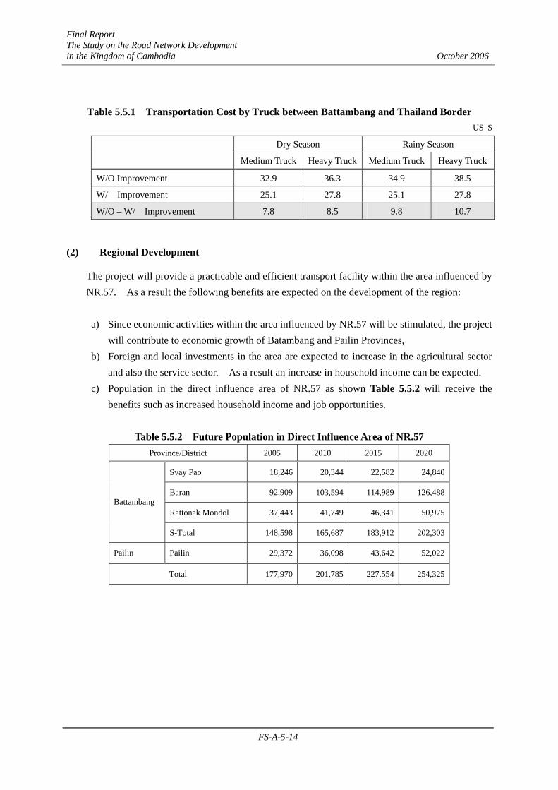
(1) Reduction of Transport Cost
Table 5.5.1 shows the transport cost for medium and heavy trucks. Battambang traders exporting agricultural products such as rice to Thailand will receive reductions in transport costs per truck of about 8 dollars during the dry season and 10 dollars during the rainy season. Such reduction in the transport cost will promote a) an increase in export of agricultural products in Pailin and Battambang Provinces, and b) a reduction of consumer prices for consumer’s goods.
Final Report The Study on the Road Network Development in the Kingdom of Cambodia October 2006
FS-A-5-14
Table 5.5.1 Transportation Cost by Truck between Battambang and Thailand Border US $
Dry Season Rainy Season
Medium Truck Heavy Truck Medium Truck Heavy Truck
W/O Improvement 32.9 36.3 34.9 38.5
W/ Improvement 25.1 27.8 25.1 27.8
W/O – W/ Improvement 7.8 8.5 9.8 10.7
(2) Regional Development
The project will provide a practicable and efficient transport facility within the area influenced by NR.57. As a result the following benefits are expected on the development of the region:
a) Since economic activities within the area influenced by NR.57 will be stimulated, the project
will contribute to economic growth of Batambang and Pailin Provinces, b) Foreign and local investments in the area are expected to increase in the agricultural sector
and also the service sector. As a result an increase in household income can be expected. c) Population in the direct influence area of NR.57 as shown Table 5.5.2 will receive the
benefits such as increased household income and job opportunities.
Table 5.5.2 Future Population in Direct Influence Area of NR.57 Province/District 2005 2010 2015 2020
Svay Pao 18,246 20,344 22,582 24,840
Baran 92,909 103,594 114,989 126,488
Rattonak Mondol 37,443 41,749 46,341 50,975 Battambang
S-Total 148,598 165,687 183,912 202,303
Pailin Pailin 29,372 36,098 43,642 52,022
Total 177,970 201,785 227,554 254,325

Final Report The Study on the Road Network Development in the Kingdom of Cambodia October 2006
FS-A-6-1
CHAPTER A-6 CONCLUSIONS AND RECOMMENDATIONS
6.1 Conclusions
The Pre-Feasibility Study for NR.57 has shown that this project is technically and economically viable with a high economic internal rate of return as discussed in Chapter FS-A-5.
This project should be implemented as early as possible due to its importance as indicated in the implementation schedule proposed in Chapter FS-A-4.
6.2 Recommendations
It is recommended that the Royal Government of Cambodia take the following actions to ensure that this project is implemented successfully.
6.2.1 Preparation Aspects
(1) Allocation of Budget for Project Preparation The project costs do not include the cost of the resettlement of residents or the relocation of houses and public property from the construction areas, camp yards, stock yards, borrow pits and spoil areas. For the smooth implementation of this project the Royal Government of Cambodia needs to allocate a budget for the above preparatory works.
(2) Clearing of Landmines and UXOs
As a consequence of the history of the region, the area from Km50 to the end of the project is still contaminated with landmines and UXOs.
For the safety of the people involved in the project, as well as the local inhabitants, this contaminated area must be cleared before field investigations such as topographic and geotechnical surveys are undertaken.
6.2.2 Management Aspects
(1) Operation and Maintenance
This project is for the construction of a road consisting of asphalt concrete pavements and concrete bridges. These structures will deteriorate on a daily basis if maintenance is neglected.
Therefore, maintenance activities shall be conducted in accordance with Chapter FS-A-4 in order to ensure that the road facilities are kept safe, to prolong the life of the road to and preserve this important asset.
(2) Recycling of the Existing Temporary Superstructure
The existing temporary superstructures and Bailey bridge structures that are in a good condition
Final Report The Study on the Road Network Development in the Kingdom of Cambodia October 2006
FS-A-6-2
should be recycled for use as bridges on provincial roads or rural roads in the future.
(3) Education on Traffic Safety, Rules and User Behavior
After the completion of the project, it is predicted that the volume of traffic and vehicle speeds will increase. It is therefore recommended that steps should be taken to organize traffic safety education and improve traffic rules and user behavior, and that traffic regulations should be strictly observed in order to decrease the number of traffic accidents.
6.2.3 Environmental Aspects
The annex of the sub-decree on the environmental impact assessment process No.72.ANRK.BK, 11 August, 1999 stipulates which projects are required to have an environmental impact assessment (EIA). According to the sub-decree, the construction of national roads exceeding 100 km in length requires a full scale EIA. The project length of NR.57 is 104 km, which is more than 100 km. Therefore a full scale EIA is required for the NR.57 project.
However, the necessary survey could not be conducted during the preparation of this Pre-Feasibility Study for NR.57, as this study is still at a preliminary level.
Therefore, it is recommended that the EIA should be conducted as soon as possible once it has been decided to proceed with the project. When conducting the EIA, the following should be considered and included in the EIA by the MPWT, as the project owner.
(1) Samlaut Multiple Use Area
Part of NR.57 is on the border-line of the protected Samlaut multiple use area, which is stipulated in declaration (Parkas) No.1033 on Protected Areas, June 3, 1944. The unique characteristics of the protected area are described in annex E of the declaration as follows:
It is an evergreen forest area within the watershed of the Battambang River. It has been denuded by mining operations causing severe erosion and increased sedimentation of the river which flows into the Tonle Sap Lake.
Investigations and necessary mitigation measures should be considered, together with MOE, in order to protect the environment in the area.
(2) Resettlement
There is a possibility that a certain amount of resettlement will be required due to the project. The social impacts should be examined and necessary measures should be considered. A Resettlement Action Plan (RAP) should also be formulated.
To ensure the appropriate resettlement of residents there should be adequate public consultation, a public awareness survey and a clear cut-off date.
Final Report The Study on the Road Network Development in the Kingdom of Cambodia October 2006
FS-A-6-3
(3) Other items
In addition to the usual items that are required for an EIA, the following items in particular should be considered and included in the EIA:
- Local economy, land use and local resources: Disordered development and land speculation may occur along the road. An environmental and social impact survey should be conducted, including a baseline survey, before the project is implemented. If some impacts are expected, the necessary measures should be undertaken in cooperation with the relevant governmental agencies.
- Infectious diseases: A large numbers of construction workers will travel to the site from other areas. Measures against infectious diseases, such as HIV/AIDS, should be considered.
- Air pollution, noise and vibrations, especially in the urban areas of Battambang and Pailin: Detours and earthworks during the construction period may cause air pollution, and construction machines and equipment may cause noise and vibrations. Air pollution, noise and vibrations may also occur with the increased traffic volumes after the project completion. Monitoring, including a baseline survey, should be considered. The necessary mitigation measures, especially in the urban area, should be considered.
- Environmental management plan (EMP): An EMP, including the monitoring of resettlement activities, should be included in the EIA.
- Landmines and UXOs: There are a large number of landmines and UXOs in the project area. The clearance of these landmines and UXOs is crucial before the project implementation.
- Other Items: There may be UXOs and landmines around the construction areas, including in the borrow pit camp yard, and stock yard. Clearance of these items should be undertaken in cooperation with the Cambodian Mine Action Center (CMAC).
In addition to the above points, there should be an information disclosure to not only the PAPs, but also all stakeholders, such as other people along NR.57 and the NGOs.
PACKAGE B
THE URGENT BRIDGE REHABILITATION
PROGRAM
Final Report The Study on the Road Network Development in the Kingdom of Cambodia October 2006
FS-B-1-1
CHAPTER B-1 INTRODUCTION
1.1 General
In the Road Network Development Master Plan Study, the JICA Study Team has proposed a road network development plan up to 2020 and an implementation plan for road development including prioritization of the projects and improvement measures.
The Urgent Bridge Rehabilitation Program was identified as one of the highest priority projects and therefore a pre-feasibility was conducted.
1.2 Purpose of Pre-feasibility Study
The purpose of this Pre-feasibility Study is to comprehensively evaluate the feasibility of this program based on the following aspects:
(1) Estimation of the project cost based on the preliminary design and the implementation plan based on the optimum construction method and schedule
(2) Economic and financial analysis (3) Estimation of the maintenance cost (4) Initial Environmental Impact Analysis
1.3 Project Description for the Urgent Bridge Rehabilitation Program
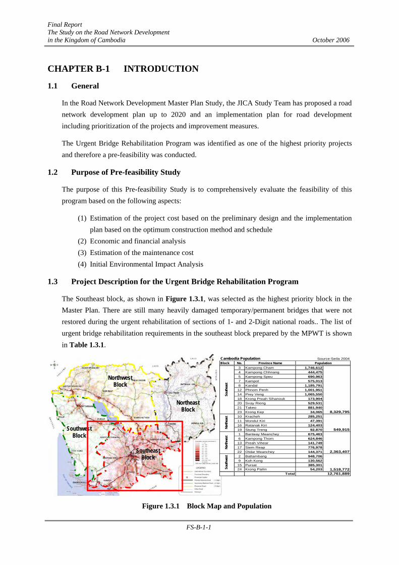
The Southeast block, as shown in Figure 1.3.1, was selected as the highest priority block in the Master Plan. There are still many heavily damaged temporary/permanent bridges that were not restored during the urgent rehabilitation of sections of 1- and 2-Digit national roads.. The list of urgent bridge rehabilitation requirements in the southeast block prepared by the MPWT is shown in Table 1.3.1.
Figure 1.3.1 Block Map and Population
Northeast Block
Northwest Block
Southwest Block
Southeast Block
Source:Seila 2004Block No. Province Name
3 Kampong Cham 1,746,6124 Kampong Chhnang 444,4755 Kampong Speu 690,9637 Kampot 575,0138 Kandal 1,185,79112 Phnom Penh 1,001,95114 Prey Veng 1,065,55018 Krong Preah Sihanouk 173,90420 Svay Rieng 529,53121 Takeo 881,94023 Krong Kep 34,06510 Kracheh 285,25111 Mondul Kiri 47,39116 Ratanak Kiri 124,40319 Stung Treng 92,8701 Banteay Meanchey 675,4636 Kampong Thom 624,84613 Preah Vihear 141,74917 Siem Reap 776,97822 Otdar Meanchey 144,3712 Battambang 948,7069 Koh Kong 130,56215 Pursat 385,30124 Krong Pailin 54,203
Total 12,761,889
Sout
hwes
t
Cambodia PopulationPopulation
8,329,795
549,915
2,363,407
1,518,772
Sout
heas
tNo
rthea
stNo
rthwe
st

Final Report The Study on the Road Network Development in the Kingdom of Cambodia October 2006
FS-B-1-2
Table 1.3.1 List of Urgent Bridge Rehabilitation (Southeast Block) prepared by MPWT Code No.
Rd. No. STA. Prov. Type W
(m) L
(m) Con- dition Others
1 105+985 Bailey 4.20 48.00 Poor 2 107+000 Bailey 4.20 18.00 Poor
3 3
148+600 Steel+Concrete 4.50 277.60 - Under construction on the new route
4 31 120+000 Concrete 4.20 55.00 Poor
5 005+050 Compact 200 4.50 87.00 - Collapsed on Jan. 27, 2006
6 33
036+540
Kampot
Bailey 4.20 30.00 Poor 7 33 160+250 Kep Concrete 7.00 11.00 Poor
8 083+811 I-Steel 5.40 42.20 Poor New concrete substructure by ADB
9 084+900 I-Steel 5.40 42.20 Poor 10 088+094 I-Steel 5.40 84.20 Poor 11 089+060 I-Steel 4.90 54.00 Poor 12 103+475 I-Steel 4.85 48.00 Poor 13
11
127+100
Prey Veng
I-Steel 4.85 24.10 Poor
14 7 (Old) 340+200 I-Steel+Wooden 4.50 36.00 Poor
15 7 277+200 Bailey+Concrete 4.50 130.00 Poor
16 7 (Old) 355+300
Kratie
Bailey+Wooden 4.50 92.00 Poor
17 022+608 Compact 7.00 15.00 Poor 18 2 028+180 Compact 7.00 18.00 Poor 19 3 025+927 Bailey 4.50 37.00 Poor 20 024+414 Compact 100 4.10 18.00 Poor 21 031+684 Concrete 3.50 7.50 Poor Khmer Rouge Regime22 036+671 Concrete 5.10 24.00 Poor Khmer Rouge Regime23 039+812 I-Steel 4.10 24.00 Poor Khmer Rouge Regime24 040+554 I-Steel 4.10 24.00 Poor Khmer Rouge Regime25 045+801 Concrete 3.60 11.80 Poor Khmer Rouge Regime26 052+436 Concrete 3.50 14.20 Poor Khmer Rouge Regime27 054+477 Compact 100 4.10 54.00 Poor Khmer Rouge Regime28 056+430 Concrete 3.80 8.50 Poor Khmer Rouge Regime29 060+051 Compact 100 4.10 27.00 Poor 30 061+407 Compact 100 4.10 48.00 Poor 31 068+042 Compact 100 4.10 27.00 Poor 32
21
074+875
Kandal
Compact 100 4.10 48.00 Poor 33 034+190 Steel 4.00 8.20 Poor 34 2 046+700 Steel 4.00 8.00 Poor 35 091+552 Bailey 4.20 12.00 Poor 36 3 094+002
Takeo
Concrete 7.00 16.00 Poor
There are many beneficiaries around these bridges and as such there will be very high socio-economic benefits. However bridges are not very long, if may not be financially feasible. Hence, basically this program shall be conducted by grant aid.
In the list provided by the MPWT, there are many bridges that are still comparatively good structurally and also some bridges that are already under re-construction.
Therefore, it was decided to short-list the high priority bridges.
1.3.1 Screening of the Urgent Bridge Rehabilitation in Southeast Block
The above list was evaluated and screened by the JICA Study for including in a proposal to the donors for aid, taking into consideration the following criteria:
Final Report The Study on the Road Network Development in the Kingdom of Cambodia October 2006
FS-B-1-3
1) The bridge length should be more than 30 meters, which may need the technological assistance of the donors. The Cambodian Government can improve shorter bridges.
2) The basic human needs of a large number of people in and around the project area should be improved.
The urgent bridges to be rehabilitated are screened as the 1st screening by the following criteria:
1st Screening
(1) The lengths of No.2, 7, 13, 17, 18, 20, 21, 22, 23, 24, 25, 26, 28, 29, 31, 33, 34, 35 and 36 bridges are less than 30m and hence are screened out.
(2) The following bridges have also been screened out for the indicated reasons. A new bridge is under construction in an alternative route in parallel to No.3 bridge in NR.3. No.5 bridge in NR.33 is under construction urgently by the MPWT after it collapsed.
The concrete substructure of No.8 bridge in NR.11 has already been constructed by ADB. (3) No.14 and No.16 bridges are located in old NR.7 alignment, and hence are screened out.
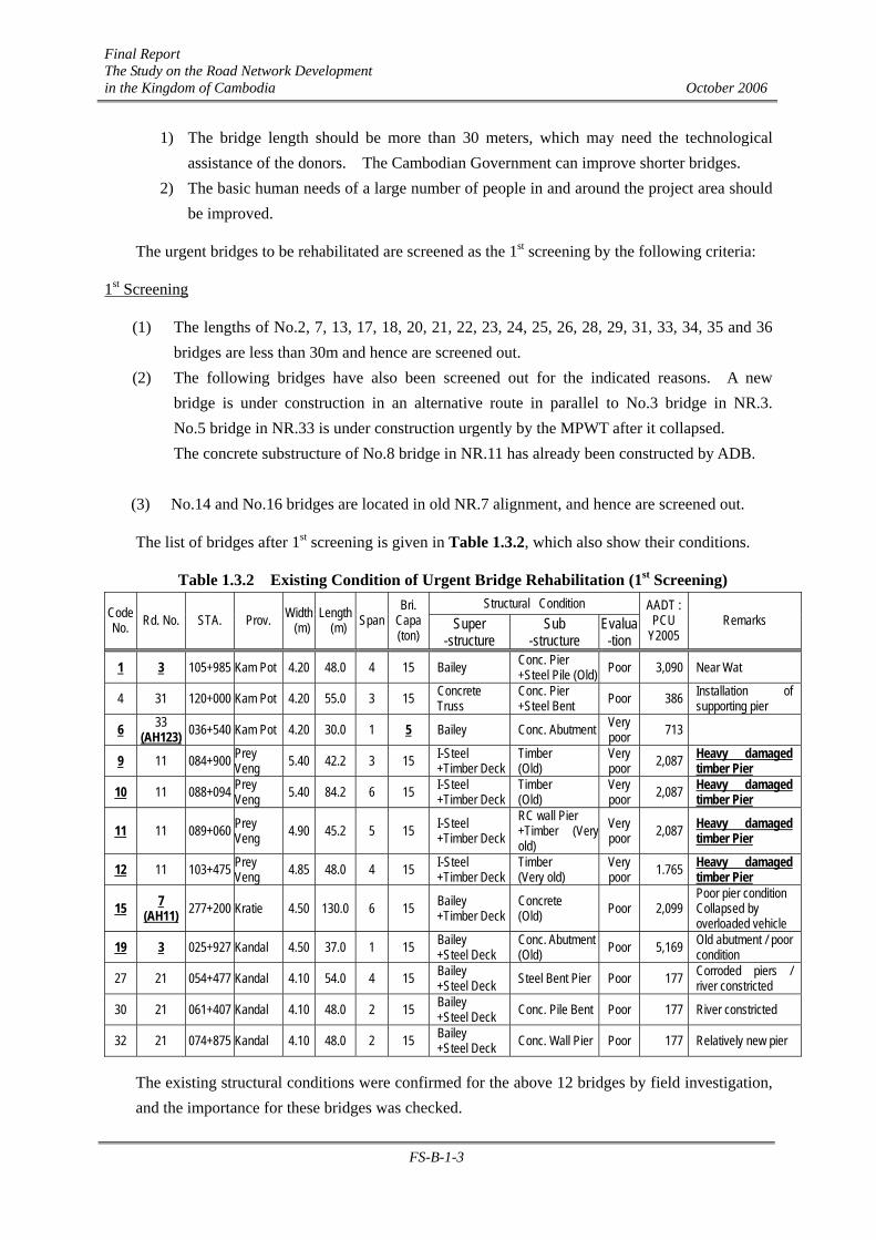
The list of bridges after 1st screening is given in Table 1.3.2, which also show their conditions.
Table 1.3.2 Existing Condition of Urgent Bridge Rehabilitation (1st Screening) Structural Condition
Code No. Rd. No. STA. Prov. Width
(m) Length (m) Span
Bri. Capa (ton)
Super -structure
Sub -structure
Evalua -tion
AADT : PCU
Y2005 Remarks
1 3 105+985 Kam Pot 4.20 48.0 4 15 Bailey Conc. Pier +Steel Pile (Old) Poor 3,090 Near Wat
4 31 120+000 Kam Pot 4.20 55.0 3 15 Concrete Truss
Conc. Pier +Steel Bent Poor 386 Installation of
supporting pier
6 33 (AH123) 036+540 Kam Pot 4.20 30.0 1 5 Bailey Conc. Abutment Very
poor 713
9 11 084+900 Prey Veng 5.40 42.2 3 15 I-Steel
+Timber Deck Timber (Old)
Very poor 2,087 Heavy damaged
timber Pier
10 11 088+094 Prey Veng 5.40 84.2 6 15 I-Steel
+Timber Deck Timber (Old)
Very poor 2,087 Heavy damaged
timber Pier
11 11 089+060 Prey Veng 4.90 45.2 5 15 I-Steel
+Timber Deck RC wall Pier +Timber (Very old)
Very poor 2,087 Heavy damaged
timber Pier
12 11 103+475 Prey Veng 4.85 48.0 4 15 I-Steel
+Timber Deck Timber (Very old)
Very poor 1.765 Heavy damaged
timber Pier
15 7 (AH11) 277+200 Kratie 4.50 130.0 6 15 Bailey
+Timber Deck Concrete (Old) Poor 2,099
Poor pier condition Collapsed by overloaded vehicle
19 3 025+927 Kandal 4.50 37.0 1 15 Bailey +Steel Deck
Conc. Abutment (Old) Poor 5,169 Old abutment / poor
condition
27 21 054+477 Kandal 4.10 54.0 4 15 Bailey +Steel Deck Steel Bent Pier Poor 177 Corroded piers /
river constricted
30 21 061+407 Kandal 4.10 48.0 2 15 Bailey +Steel Deck Conc. Pile Bent Poor 177 River constricted
32 21 074+875 Kandal 4.10 48.0 2 15 Bailey +Steel Deck Conc. Wall Pier Poor 177 Relatively new pier
The existing structural conditions were confirmed for the above 12 bridges by field investigation, and the importance for these bridges was checked.
Final Report The Study on the Road Network Development in the Kingdom of Cambodia October 2006
FS-B-1-4
2nd Screening
The poor structural condition, insufficient existing bridge capacity and their importance rated on current traffic volume, lead to the following bridges being selected: (1) Bridges No.4, 9, 10, 11, 12 and 19 were selected due to their poor structural conditions and
insufficient bridge capacity. (2) Bridges No.1, 15 and 19 were selected from their importance and high traffic volume.
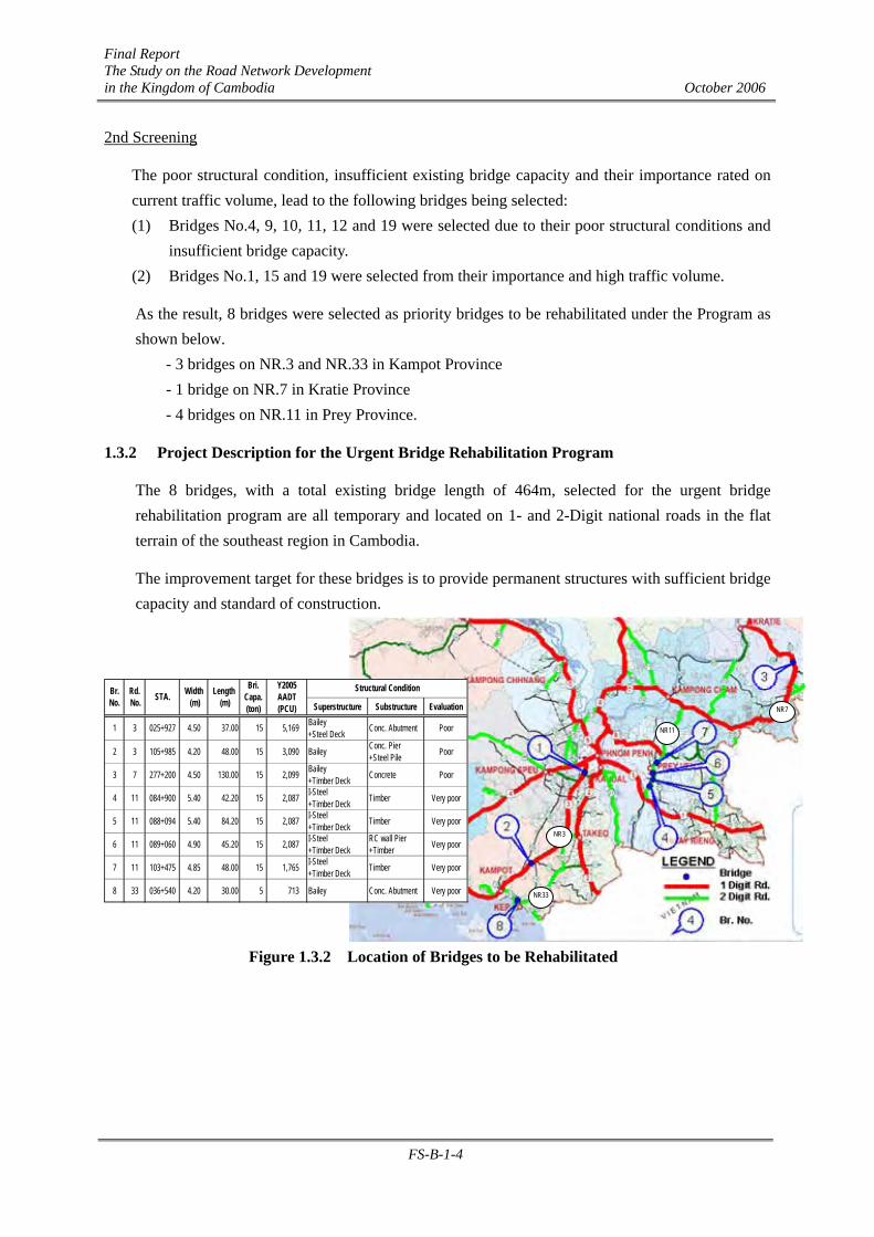
As the result, 8 bridges were selected as priority bridges to be rehabilitated under the Program as shown below.
- 3 bridges on NR.3 and NR.33 in Kampot Province - 1 bridge on NR.7 in Kratie Province - 4 bridges on NR.11 in Prey Province.
1.3.2 Project Description for the Urgent Bridge Rehabilitation Program
The 8 bridges, with a total existing bridge length of 464m, selected for the urgent bridge rehabilitation program are all temporary and located on 1- and 2-Digit national roads in the flat terrain of the southeast region in Cambodia.
The improvement target for these bridges is to provide permanent structures with sufficient bridge capacity and standard of construction.
Figure 1.3.2 Location of Bridges to be Rehabilitated
NR33
NR7
NR11
Superstructure Substructure Evaluation
1 3 025+927 4.50 37.00 15 5,169 Bailey+Steel Deck Conc. Abutment Poor
2 3 105+985 4.20 48.00 15 3,090 Bailey Conc. Pier+Steel Pile Poor
3 7 277+200 4.50 130.00 15 2,099 Bailey+Timber Deck Concrete Poor
4 11 084+900 5.40 42.20 15 2,087 I-Steel+Timber Deck Timber Very poor
5 11 088+094 5.40 84.20 15 2,087 I-Steel+Timber Deck Timber Very poor
6 11 089+060 4.90 45.20 15 2,087 I-Steel+Timber Deck
RC wall Pier+Timber Very poor
7 11 103+475 4.85 48.00 15 1,765 I-Steel+Timber Deck Timber Very poor
8 33 036+540 4.20 30.00 5 713 Bailey Conc. Abutment Very poor
Br.No.
Rd. No. STA. Width
(m)Length
(m)
Bri.Capa.(ton)
Y2005AADT(PCU)
Structural Condition
NR3

Final Report The Study on the Road Network Development in the Kingdom of Cambodia October 2006
FS-B-2-1
CHAPTER B-2 GENERAL CONDITION AND ENGINEERING SURVEY
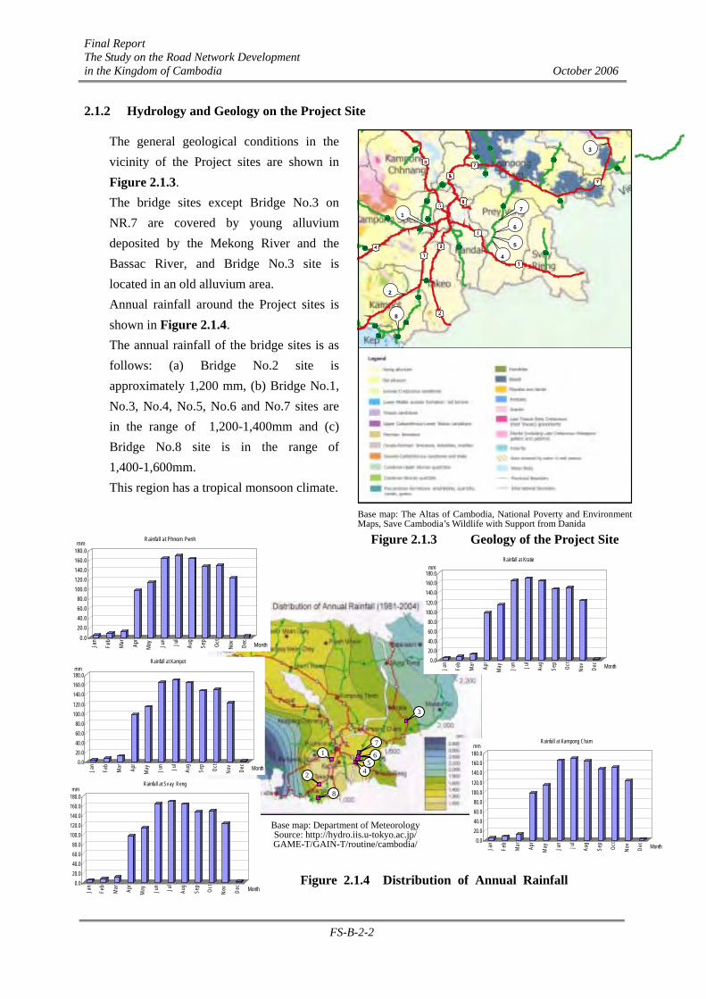
2.1 Natural Condition
2.1.1 Geography and Geology on the Project Site The bridge sites are in relatively flat geographic areas except for the Bridge No.3 site on NR.7. Notably, Bridges No.4 to No.7 are located in the Mekong river floodplain area. The site conditons of each bridge are classified as follows: (1) Flat and Low Elevation and also Flood Area: Bridge No.4, No.5, No.6 and No.7 on NR.11 (2) Flat and Low Elevation Area: Bridge No.1 and No.2 on NR.3, and No.8 on NR.33 (3) Mountanious Area: Bridge No.3 on NR.7
Base map: The Altas of Cambodia, National Poverty and Environment Maps, Save Cambodia’s Wildlife with Support from Danida
Figure 2.1.1 Elevations of the Project Site
The existing road elevations around each bridge and the Y2000 flood level at MOWRAM stations near the project sites are shown in Figure 2.1.2.
Figure 2.1.2 Year 2000 Flood in Cambodia with Flood Levels at MOWRAM Stations
51
21
51
42
61
5376
74
7211
73
13
22
44
46
233
33a 33
31
31
71
70
60No.3: +62.5m
No.1: +14.0m
No.7: +9.0m No.6: +9.3m
No.5: + 9.5m
No.4: +9.3m
No.8: +3.0m
No.2: +29.0m
NEAK LOEUNG EL. +7.79m
KOH KHEL EL. +6.94m
CHAK TOMUK EL. +10.18m
Legend : Bridge No. and EL.
: Y2000 Flood Level
: Y2000 Flood
: 1-digit Road
: 2-digit Road
No.8: +3.0m
CHAK TOMUK EL. +10.18m
51
21
51
42
61
5376
74
7211
73
13
22
44
46
3233
33a 33
31
31
71
70
60 No.3
No.1 No.7
No.6
No.5
No.4
No.8
No.2
Final Report The Study on the Road Network Development in the Kingdom of Cambodia October 2006
FS-B-2-2
51
21
51
42
61
53
74
7211
73
13
22
44
46
33
33a 33
31
31
71
70
60
8
2
1
4
5
6
7
3
Base map: The Altas of Cambodia, National Poverty and Environment Maps, Save Cambodia’s Wildlife with Support from Danida
Figure 2.1.3 Geology of the Project Site
2.1.2 Hydrology and Geology on the Project Site
The general geological conditions in the vicinity of the Project sites are shown in Figure 2.1.3. The bridge sites except Bridge No.3 on NR.7 are covered by young alluvium deposited by the Mekong River and the Bassac River, and Bridge No.3 site is located in an old alluvium area. Annual rainfall around the Project sites is shown in Figure 2.1.4. The annual rainfall of the bridge sites is as follows: (a) Bridge No.2 site is approximately 1,200 mm, (b) Bridge No.1, No.3, No.4, No.5, No.6 and No.7 sites are in the range of 1,200-1,400mm and (c) Bridge No.8 site is in the range of 1,400-1,600mm. This region has a tropical monsoon climate.
Base map: Department of Meteorology Source: http://hydro.iis.u-tokyo.ac.jp/ GAME-T/GAIN-T/routine/cambodia/
Figure 2.1.4 Distribution of Annual Rainfall
1
2
3
4 5
6
7
8
0.020.040.060.080.0
100.0120.0140.0160.0180.0mm
Jan
Feb
Mar Ap
r
May Ju
n Jul
Aug
Sep
Oct
Nov
Dec
Month
Rainfall at Phnom Penh
0.020.040.060.080.0
100.0120.0140.0160.0180.0
mm
Jan
Feb
Mar Ap
r
May Ju
n Jul
Aug
Sep
Oct
Nov
Dec Month
Rainfall at Kratie
0.020.040.060.080.0
100.0120.0140.0160.0180.0mm
Jan
Feb
Mar Ap
r
May Ju
n Jul
Aug
Sep
Oct
Nov
Dec Month
Rainfall at Kampot
0.020.040.060.080.0
100.0120.0140.0160.0180.0mm
Jan
Feb
Mar Ap
r
May Ju
n Jul
Aug
Sep
Oct
Nov
Dec Month
Rainfall at Sv ay Reng
0.020.040.060.080.0
100.0120.0140.0160.0180.0mm
Jan
Feb
Mar Ap
r
May Ju
n Jul
Aug
Sep
Oct
Nov
Dec Month
Rainfall at Kampong Cham
Final Report The Study on the Road Network Development in the Kingdom of Cambodia October 2006
FS-B-2-3
2.2 Socio-Economic Condition
2.2.1 Bridge No.1 on NR.3
(1) Population
Bridge No.1 site is located at 25.927 km on National Road No. 3 (NR.3) towards the southern part of Phnom Penh, which is at the boundaries of Phnom Penh, Kandal and Kampong Speu Provinces.
The population of the area directly influenced by Bridge No.1 on NR.3 is estimated at approximately 338,160 in 2005 of which, that in Dangkao district is 127,315 persons, that in Kandal Stueng district is 94,712 persons and that in Kong Pisei is about 116,136 persons. It is expected to increase to 384,500 persons in 2010, 434,160 person in 2015, and 486,330 persons in 2020 as shown in Table 2.2.1.
Table 2.2.1 Existing and Future Population in the Bridge No.1 Area, 2005-2020
Province/District 2005 2010 2015 2020 AAGR (%)
Phnom Penh Dangkao 127,315 148,704 172,497 198,544 1.030
Kandal Kandal Stueng 94,712 104,562 114,286 123,315 1.018
Pampong Speu Kong Pisei 116,136 131,234 147,376 164,472 1.023
Total 338,163 384,500 434,159 486,331 1.025
Notes: 2005: Estimated on the basis of 2004 village data
2010, 2015, 2020: forecasted based on the growth rate in the Master Plan
(2) Land use
Land use around Bridge No.1 on NR.3 consists of rich irrigated paddy fields. However, since the site is within the Phnom Penh Metropolitan area light industries, such as the garment industry and vehicle repair industry, are being developed in the area influenced by this bridge site as shown in Figure 2.2.1.
2.2.2 Bridge No. 2 on NR.3
(1) Population
Bridge No.2 site, which is located at 105.985 km on National Road No. 3 (NR.3) from Phnom Penh, belongs to Chhuk and Dang Tong Districts of Kampot Province.
The population around the Bridge No.2 site on NR.3 is estimated at approximately 145,520 in 2005, which is lower than that at Bridge No.1 site. Of this population, that in Chhuk district is 91,830 persons and that in Dang Tong is about 53,690 persons. It is expected to increase to 158,900 in 2010, 172,730 in 2015, and 185,850 in 2020 as shown in Table 2.2.2.

Final Report The Study on the Road Network Development in the Kingdom of Cambodia October 2006
FS-B-2-4
Table 2.2.2 Existing and Future Population in the Bridge No. 2 Area, 2005-2020
Province/District 2005 2010 2015 2020 AAGR (%)
Chhuk 91,827 100,275 108,999 117,283 1.016Kampot
Dang Tong 53,688 58,627 63,728 68,571 1.016
Total 145,515 158,902 172,727 185,854 1.016
Notes: 2005: Estimated on the basis of 2004 village data
2010, 2015, 2020: forecasted based on the growth rate in the Master Plan
(2) Land use
Land use around Bridge No.2 on NR.3 consists of paddy and flooded paddy fields as well as marshland. However, since the site is far from the Phnom Penh and Sihanoukville, there is no industrial development or commercial activity found in the area influenced by this bridge site as shown in Figure 2.2.1.
Figure 2.2.1 Land Use around Bridge No.1 and 2 Sites
2.2.3 Bridge No.3 on NR.7 (1) Population
The Bridge No.3 site, which is located at 277.200 km on National Road No.7 (NR.7) north east of Phnom Penh, belongs in the Snuol district of Kratie Province.
The population around the Bridge No.3 site on NR.7, which can be said to be an unpopulated area,
Settlement Shrub
Paddy Field Deciduous Forest
Field Crops Open Forest
Village Garden Crops Garden Crop
LEGEND
4
22
Bridge No.1
2
3 Bridge No.2
Takeo
Kampong Speu

Final Report The Study on the Road Network Development in the Kingdom of Cambodia October 2006
FS-B-2-5
is estimated at approximately 42,970 persons in 2005. It is expected to increase to 48,800 persons in 2010, 54,800 persons in 2015 and 60,800 persons in 2020 as shown in Table 2.2.3.
Table 2.2.3 Existing and Future Population in the Bridge No. 3 Area, 2005-2020
Province/District 2005 2010 2015 2020 AAGR (%)
Kratie Chhuk 42,972 48,816 54,820 60,795 1.023
Notes: 2005: Estimated on the basis of 2004 village data
2010, 2015, 2020: forecasted based on the growth rate in the Master Plan
(2) Land use
Land use around Bridge No.3 on NR.7 consists of dense forest with some grassland as shown in Figure 2.2.2.
Figure 2.2.2 Land Use around Bridge No.3 Site
2.2.4 Bridges No.4, 5, 6 and 7 on NR.11
(1) Population
Bridge No.4, 5, 6 and 7 sites are located at 84.900, 88.094, 89.060 and 103.475 km respectively on National Road No.11 (NR.11) towards the east direction from Phnom Penh. These bridges belong to the Peam Ro, Kampong Leav and Prey Veang districts of Prey Veang Province.
The population around Bridge No.4, 5, 6 and 7 sites on NR.11 is estimated at approximately 225,000 in 2005, of which that in Peam Po district is 64,290 persons, that in Dang Tong is about 58,790 persons and that in Prey Veang is about 101,930 persons. It is expected to increase from 225,000 in 2005 to 241,660 in 2010, 256,160 in 2015 and 269,220 in 2020 as shown in Table 2.2.4.
Settlement Shrub
Paddy Field Deciduous Forest
Field Crops Open Forest
Village Garden Crops Garden Crop
LEGEND
7
76
Bridge No.3
74

Final Report The Study on the Road Network Development in the Kingdom of Cambodia October 2006
FS-B-2-6
Table 2.2.4 Existing and Future Population in the Bridge No. 4, 5, 6 & 7 Areas, 2005-2020
Province/District 2005 2010 2015 2020 AAGR (%)
Peam Ro 64,291 69,049 73,192 76,925 1.012
Kampong Leav 58,788 63,138 66,926 70,339 1.012Prey Veang
Prey Veang 101,930 109,473 116,041 121,959 1.012
Total 225,009 241,660 256,159 269,223 1.012
Notes: 2005: Estimated on the basis of 2004 village data
2010, 2015,2020: forecasted based on the growth rate in the Master Plan
(2) Land Use
Land use around Bridges No.4, 5, 6 and 7 on NR.11 consists of rich flooded and irrigated paddy fields. The land use in the areas influenced by these bridge sites is shown in Figure 2.2.3.
Figure 2.2.3 Land use around Bridges 4, 5, 6 and 7 Sites
2.2.5 Bridge No.8 on NR.33
(1) Population
The Bridge No.8 site is located at 36.540 km on National Road No.33 (NR.33) to the east of Sihanoukville. This bridge belongs to Kampong Trach district of Kampot Province.
1
7
11
Bridge No.7
Bridge No.6
Bridge No.5
Bridge No.4
Settlement Shrub
Paddy Field Deciduous Forest
Field Crops Open Forest
Village Garden Crops Garden Crop
LEGEND
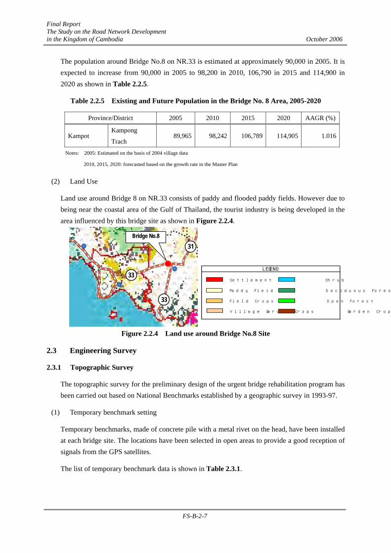
Final Report The Study on the Road Network Development in the Kingdom of Cambodia October 2006
FS-B-2-7
The population around Bridge No.8 on NR.33 is estimated at approximately 90,000 in 2005. It is expected to increase from 90,000 in 2005 to 98,200 in 2010, 106,790 in 2015 and 114,900 in 2020 as shown in Table 2.2.5.
Table 2.2.5 Existing and Future Population in the Bridge No. 8 Area, 2005-2020
Province/District 2005 2010 2015 2020 AAGR (%)
Kampot Kampong
Trach 89,965 98,242 106,789 114,905 1.016
Notes: 2005: Estimated on the basis of 2004 village data
2010, 2015, 2020: forecasted based on the growth rate in the Master Plan
(2) Land Use
Land use around Bridge 8 on NR.33 consists of paddy and flooded paddy fields. However due to being near the coastal area of the Gulf of Thailand, the tourist industry is being developed in the area influenced by this bridge site as shown in Figure 2.2.4.
Figure 2.2.4 Land use around Bridge No.8 Site
2.3 Engineering Survey
2.3.1 Topographic Survey
The topographic survey for the preliminary design of the urgent bridge rehabilitation program has been carried out based on National Benchmarks established by a geographic survey in 1993-97.
(1) Temporary benchmark setting
Temporary benchmarks, made of concrete pile with a metal rivet on the head, have been installed at each bridge site. The locations have been selected in open areas to provide a good reception of signals from the GPS satellites.
The list of temporary benchmark data is shown in Table 2.3.1.
Settlement Shrub
Paddy Field Deciduous Forest
Field Crops Open Forest
Village Garden Crops Garden Crop
LEGEND33
31
33
Bridge No.8
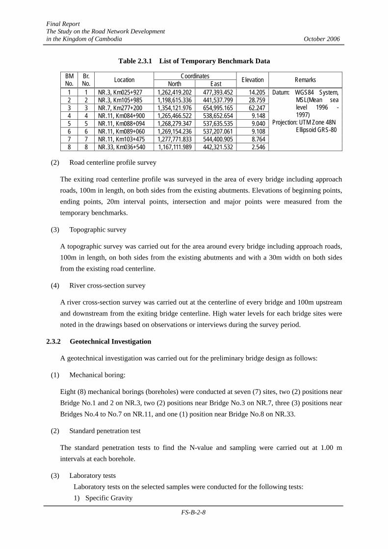
Final Report The Study on the Road Network Development in the Kingdom of Cambodia October 2006
FS-B-2-8
Table 2.3.1 List of Temporary Benchmark Data
Coordinates BM No.
Br. No. Location North East Elevation Remarks
1 1 NR.3, Km025+927 1,262,419.202 477,393.452 14.205 2 2 NR.3, Km105+985 1,198,615.336 441,537.799 28.759 3 3 NR.7, Km277+200 1,354,121.976 654,995.165 62.247 4 4 NR.11, Km084+900 1,265,466.522 538,652.654 9.148 5 5 NR.11, Km088+094 1,268,279.347 537,635.535 9.040 6 6 NR.11, Km089+060 1,269,154.236 537,207.061 9.108 7 7 NR.11, Km103+475 1,277,771.833 544,400.905 8.764 8 8 NR.33, Km036+540 1,167,111.989 442,321.532 2.546
Datum: WGS84 System, MSL(Mean sea level 1996 - 1997)
Projection: UTM Zone 48N Ellipsoid GRS-80
(2) Road centerline profile survey
The exiting road centerline profile was surveyed in the area of every bridge including approach roads, 100m in length, on both sides from the existing abutments. Elevations of beginning points, ending points, 20m interval points, intersection and major points were measured from the temporary benchmarks.
(3) Topographic survey
A topographic survey was carried out for the area around every bridge including approach roads, 100m in length, on both sides from the existing abutments and with a 30m width on both sides from the existing road centerline.
(4) River cross-section survey
A river cross-section survey was carried out at the centerline of every bridge and 100m upstream and downstream from the exiting bridge centerline. High water levels for each bridge sites were noted in the drawings based on observations or interviews during the survey period.
2.3.2 Geotechnical Investigation
A geotechnical investigation was carried out for the preliminary bridge design as follows:
(1) Mechanical boring:
Eight (8) mechanical borings (boreholes) were conducted at seven (7) sites, two (2) positions near Bridge No.1 and 2 on NR.3, two (2) positions near Bridge No.3 on NR.7, three (3) positions near Bridges No.4 to No.7 on NR.11, and one (1) position near Bridge No.8 on NR.33.
(2) Standard penetration test
The standard penetration tests to find the N-value and sampling were carried out at 1.00 m intervals at each borehole.
(3) Laboratory tests Laboratory tests on the selected samples were conducted for the following tests: 1) Specific Gravity
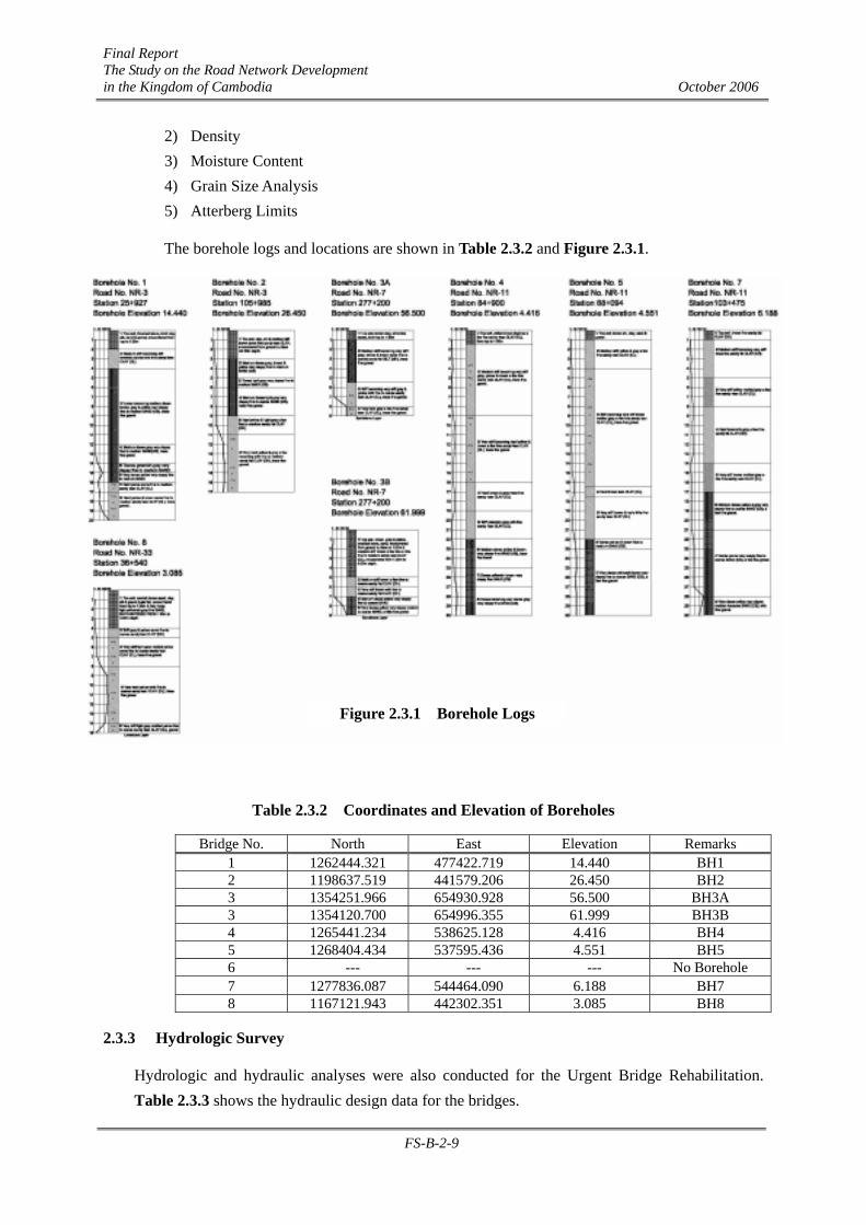
Final Report The Study on the Road Network Development in the Kingdom of Cambodia October 2006
FS-B-2-9
2) Density 3) Moisture Content 4) Grain Size Analysis 5) Atterberg Limits
The borehole logs and locations are shown in Table 2.3.2 and Figure 2.3.1.
Table 2.3.2 Coordinates and Elevation of Boreholes
Bridge No. North East Elevation Remarks 1 1262444.321 477422.719 14.440 BH1 2 1198637.519 441579.206 26.450 BH2 3 1354251.966 654930.928 56.500 BH3A 3 1354120.700 654996.355 61.999 BH3B 4 1265441.234 538625.128 4.416 BH4 5 1268404.434 537595.436 4.551 BH5 6 --- --- --- No Borehole 7 1277836.087 544464.090 6.188 BH7 8 1167121.943 442302.351 3.085 BH8
2.3.3 Hydrologic Survey
Hydrologic and hydraulic analyses were also conducted for the Urgent Bridge Rehabilitation. Table 2.3.3 shows the hydraulic design data for the bridges.
Figure 2.3.1 Borehole Logs
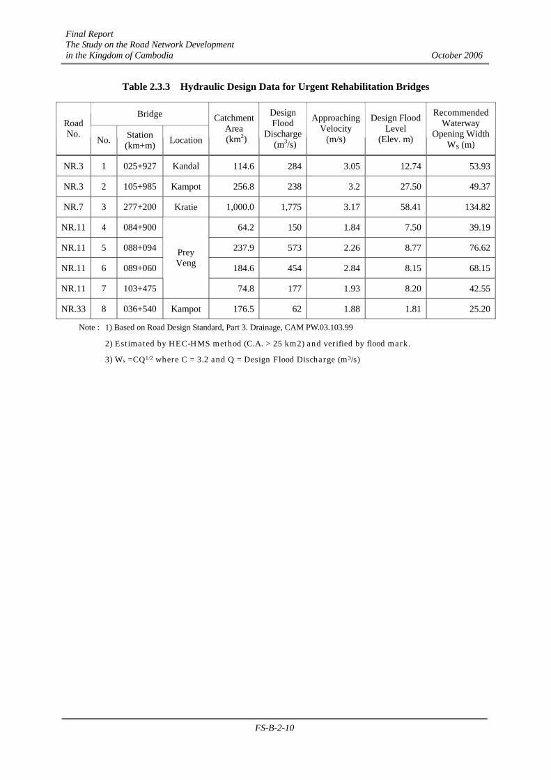
Final Report The Study on the Road Network Development in the Kingdom of Cambodia October 2006
FS-B-2-10
Table 2.3.3 Hydraulic Design Data for Urgent Rehabilitation Bridges
Bridge Road No.
No. Station (km+m) Location
Catchment Area
(km2)
Design Flood
Discharge (m3/s)
Approaching Velocity
(m/s)
Design Flood Level
(Elev. m)
Recommended Waterway
Opening WidthWS (m)
NR.3 1 025+927 Kandal 114.6 284 3.05 12.74 53.93
NR.3 2 105+985 Kampot 256.8 238 3.2 27.50 49.37
NR.7 3 277+200 Kratie 1,000.0 1,775 3.17 58.41 134.82
NR.11 4 084+900 64.2 150 1.84 7.50 39.19
NR.11 5 088+094 237.9 573 2.26 8.77 76.62
NR.11 6 089+060 184.6 454 2.84 8.15 68.15
NR.11 7 103+475
Prey Veng
74.8 177 1.93 8.20 42.55
NR.33 8 036+540 Kampot 176.5 62 1.88 1.81 25.20
Note : 1) Based on Road Design Standard, Part 3. Drainage, CAM PW.03.103.99
2) Estimated by HEC-HMS method (C.A. > 25 km2) and verified by flood mark.
3) Ws =CQ1/2 where C = 3.2 and Q = Design Flood Discharge (m3/s)

Final Report The Study on the Road Network Development in the Kingdom of Cambodia October 2006
FS-B-3-1
CHAPTER B-3 PRELIMINARY DESIGN
3.1 Design Concept and Criteria
3.1.1 Design Concept and Criteria for Road
(1) Design Concept
The following design concepts have been considered in the access road design:
• The existing road alignment shall be maintained as much as possible to minimize the construction cost and to minimize the negative socio-environmental impacts during construction.
• The road profile shall be adjusted accordingly to meet the minimum requirements of bridge design flood freeboard.
• The road geometric and cross-section shall comply with the Cambodian Highway road classification requirements. However, since the total road improvement at bridge locations will be carried-out at a later stage, the R4/U4 geometric road class standard (CRDS) with 80 km/hr design speed is adopted for the access road design.
(2) Design Criteria
1) Applicable Design Standards
The design standard used for the design of access roads is basically
• The Cambodia ROAD DESIGN STANDARD (CRDS), Department of Public Works and Transport (MPWT), 2003
⇒ Part-1 Geometry (CAM PW.03.101.99), ⇒ Part-2 Pavement (CAM PW.03.102.99) and, ⇒ Part-3 Drainage (CAM PW.03.103.99).
When no provision exists in the Road Design Standard of Cambodia, AASHTO (A Policy on Geometric Design of Highways and Streets, 2001), JRSO (Japan Road Structure Ordinance), AASHTO Guide for Design of Pavement Structures, 1993) etc. have been applied.
2) Geometric Design Criteria
The summary of geometric design criteria applied in the design is given in Table 3.1.1. The roads where the bridges were selected are National Roads NR.3, NR.7, NR.11 and NR33. Although the roads NR.3 and NR.7 are 1-Digit National Highway eligible to be classified as R5, the design speed for all the approach roads were taken as 80 km/hr because the access roads may be temporary and may need adjustment when the whole length of road is rehabilitated.
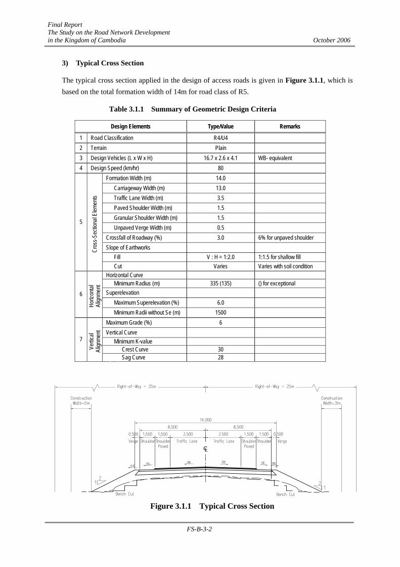
Final Report The Study on the Road Network Development in the Kingdom of Cambodia October 2006
FS-B-3-2
3) Typical Cross Section
The typical cross section applied in the design of access roads is given in Figure 3.1.1, which is based on the total formation width of 14m for road class of R5.
Table 3.1.1 Summary of Geometric Design Criteria
Design Elements Type/Value Remarks
1 Road Classification R4/U4 2 Terrain Plain 3 Design Vehicles (L x W x H) 16.7 x 2.6 x 4.1 WB- equivalent 4 Design Speed (km/hr) 80
Formation Width (m) 14.0 Carriageway Width (m) 13.0 Traffic Lane Width (m) 3.5 Paved Shoulder Width (m) 1.5 Granular Shoulder Width (m) 1.5 Unpaved Verge Width (m) 0.5 Crossfall of Roadway (%) 3.0 6% for unpaved shoulder Slope of Earthworks Fill V : H = 1:2.0 1:1.5 for shallow fill
5
Cros
s-Sec
tiona
l Elem
ents
Cut Varies Varies with soil condition Horizontal Curve Minimum Radius (m) 335 (135) () for exceptional Superelevation Maximum Superelevation (%) 6.0
6
Horiz
ontal
Al
ignme
nt
Minimum Radii without Se (m) 1500 Maximum Grade (%) 6 Vertical Curve Minimum K-value Crest Curve 30
7
Vertic
al Al
ignme
nt
Sag Curve 28
Figure 3.1.1 Typical Cross Section
CL
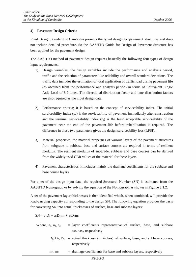
Final Report The Study on the Road Network Development in the Kingdom of Cambodia October 2006
FS-B-3-3
4) Pavement Design Criteria
Road Design Standard of Cambodia presents the typed design for pavement structures and does not include detailed procedure. So the AASHTO Guide for Design of Pavement Structure has been applied for the pavement design.
The AASHTO method of pavement design requires basically the following four types of design input requirements:
1) Design variables; the design variables include the performance and analysis period, traffic and the selection of parameters like reliability and overall standard deviations. The traffic data includes the estimation of total application of traffic load during pavement life (as obtained from the performance and analysis period) in terms of Equivalent Single Axle Load of 8.2 tones. The directional distribution factor and lane distribution factors are also required as the input design data.
2) Performance criteria; it is based on the concept of serviceability index. The initial serviceability index (p0) is the serviceability of pavement immediately after construction and the terminal serviceability index (pt) is the least acceptable serviceability of the pavement near the end of the pavement life before rehabilitation is required. The difference in these two parameters gives the design serviceability loss (∆PSI).
3) Material properties; the material properties of various layers of the pavement structures from subgrade to subbase, base and surface courses are required in terms of resilient modulus. The resilient modulus of subgrade, subbase and base courses can be derived from the widely used CBR values of the material for these layers.
4) Pavement characteristics; it includes mainly the drainage coefficients for the subbase and base course layers.
For a set of the design input data, the required Structural Number (SN) is estimated from the AASHTO Nomograph or by solving the equation of the Nomograph as shown in Figure 3.1.2.
A set of the pavement layer thicknesses is then identified which, when combined, will provide the load-carrying capacity corresponding to the design SN. The following equation provides the basis for converting SN into actual thicknesses of surface, base and subbase layers:
SN = a1D1 + a2D2m2 + a3D3m3
Where, a1, a2, a3 = layer coefficients representative of surface, base, and subbase courses, respectively
D1, D2, D3 = actual thickness (in inches) of surface, base, and subbase courses, respectively
m2, m3 = drainage coefficients for base and subbase layers, respectively
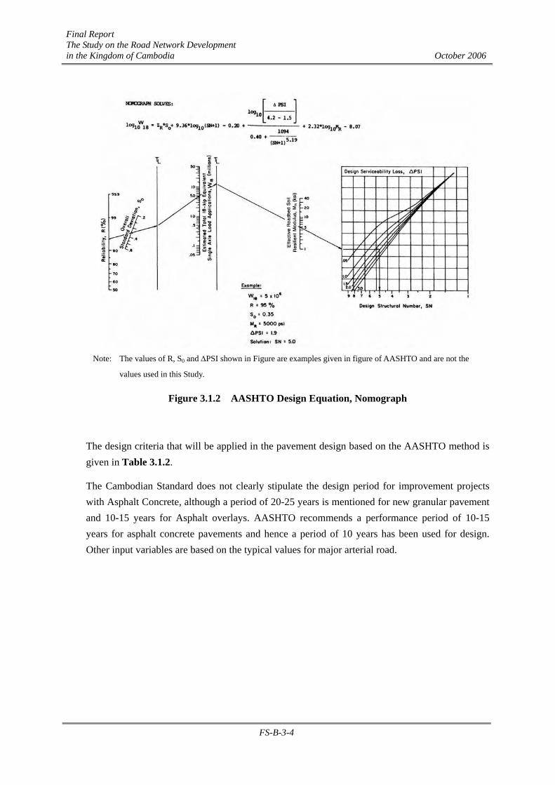
Final Report The Study on the Road Network Development in the Kingdom of Cambodia October 2006
FS-B-3-4
Figure 3.1.2 AASHTO Design Equation, Nomograph
The design criteria that will be applied in the pavement design based on the AASHTO method is given in Table 3.1.2.
The Cambodian Standard does not clearly stipulate the design period for improvement projects with Asphalt Concrete, although a period of 20-25 years is mentioned for new granular pavement and 10-15 years for Asphalt overlays. AASHTO recommends a performance period of 10-15 years for asphalt concrete pavements and hence a period of 10 years has been used for design. Other input variables are based on the typical values for major arterial road.
Note: The values of R, S0 and ∆PSI shown in Figure are examples given in figure of AASHTO and are not the
values used in this Study.

Final Report The Study on the Road Network Development in the Kingdom of Cambodia October 2006
FS-B-3-5
Table 3.1.2 Summary of Design Criteria for Pavement Design
Design Input Requirements Value Reference
Performance Period (years) 10 General Analysis Period (years) 10 General
Traffic
Equivalent Single Axle Load (ton) 8.2 AASHTO
Directional Distribution Factor, DD 0.6 AASHTO
Lane Distribution Factor, DL 1.0 AASHTO
Reliability (%) 85 AASHTO
1 Design Variables
Overall Standard Deviation 0.45 AASHTO
Initial Serviceability Index, p0 4.2 AASHTO Terminal Serviceability Index, pt 2.2 AASHTO 2
Performance
Criteria Design Serviceability Loss, ∆PSI 2.0 AASHTO
Effective Roadbed Soil Resilient Modulus, MR (psi) 1500 × CBR General
Layer Coefficient for Subbase Course, a3 from CBR AASHTO chart
Layer Coefficient for Base Course, a2 from CBR AASHTO chart 3
Material
Properties
Layer Coefficient for Asphalt Concrete, a1 Resilient Mod. AASHTO chart
4 Pavement Characteristics Drainage Coefficients for Base and Subbase Course, m2, m3 1.0 AASHTO
3.1.2 Design Concept and Criteria for Bridge
(1) Design Concept
In order to meet the project objectives, the following design concepts are adopted to establish the design criteria:
• The bridge shall have the same functional standard as the road – its geometric and cross-sectional elements shall comply with the requirements of the road functional class or category;
• The existing bridge alignment/location (where geometric elements comply with the road standard) shall be maintained as much as possible to minimize additional right-of-way;
• The bridge shall be designed to have minimum adverse social impact through proper selection of route alignment, proper construction method in urban areas, and minimum disturbance to population and encroachment to private properties;
• Environmental preservation shall be a primary concern through (a) selection of design and construction methodology that will minimize impact and damage to environment, (b) minimum encroachment to rivers and waterways, (d) sufficient clearance to design water level, and (d) provision of proper river protection;

Final Report The Study on the Road Network Development in the Kingdom of Cambodia October 2006
FS-B-3-6
• The bridge shall incorporate appropriate traffic safety facilities in design and construction.
• The scale and type of bridge shall be determined based on:
Bridge Length and Superstructure – river width, river discharge, design flood level, freeboard, design loads and durability,
Substructure and Foundation – pier height, foundation embedment depth, bearing layer and capacity, design loads, and river protection, and
Structure Type – economy/cost-effectiveness, durability, vertical alignment, environmental impacts, constructability, and maintainability.
(2) Design Criteria
1) Applicable Design Standards
• Australian Bridge Design Code, CAM PW.04.101.99, AUSTROADS, 1996
• Cambodian Bridge Design Standard (CBDS),CAM PW.04.102.99, MPWT, 2003
• Cambodian Road Design Standard, Part 3. Drainage (CRDS), CAM PW.03.103.99, MPWT, 2003
• Standard Specifications for Highway Bridges, AASHTO, 1996
• Specifications for Highway Bridges, Japan Road Association, 1996, 2002
• Specification for River Facilities, Japan River Association, 1998.
The basic design requirements will be referred to the Cambodian Bridge Design Standard. However, when the said guidelines do not cover other aspects of design or when a safer, more efficient requirement is needed, the design of bridges shall refer to other standards.
2) Bridge Location Considerations
The bridges for the proposed Urgent Bridge Rehabilitation are all located in the existing national road alignment. However, some important conditions to be considered in the selection of bridge location include:
• Stability of river course – changes in river course for braided, straight and meandering streams require spanning the entire channel, stabilizing banks around abutment and designing for anticipated scour, and
• Condition of river bank both upstream and down stream – condition of river bank stability may require bank protection to control erosion and meandering.
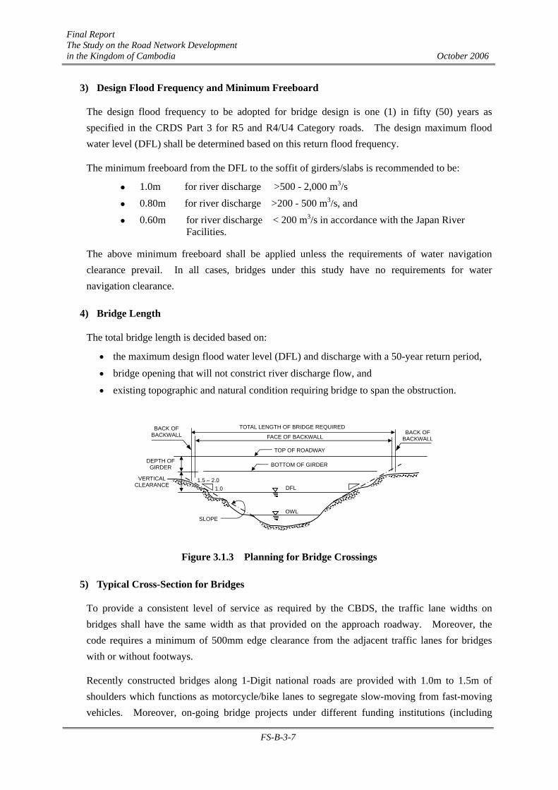
Final Report The Study on the Road Network Development in the Kingdom of Cambodia October 2006
FS-B-3-7
3) Design Flood Frequency and Minimum Freeboard
The design flood frequency to be adopted for bridge design is one (1) in fifty (50) years as specified in the CRDS Part 3 for R5 and R4/U4 Category roads. The design maximum flood water level (DFL) shall be determined based on this return flood frequency.
The minimum freeboard from the DFL to the soffit of girders/slabs is recommended to be:
1.0m for river discharge >500 - 2,000 m3/s 0.80m for river discharge >200 - 500 m3/s, and 0.60m for river discharge < 200 m3/s in accordance with the Japan River
Facilities.
The above minimum freeboard shall be applied unless the requirements of water navigation clearance prevail. In all cases, bridges under this study have no requirements for water navigation clearance.
4) Bridge Length
The total bridge length is decided based on:
• the maximum design flood water level (DFL) and discharge with a 50-year return period, • bridge opening that will not constrict river discharge flow, and
• existing topographic and natural condition requiring bridge to span the obstruction.
Figure 3.1.3 Planning for Bridge Crossings
5) Typical Cross-Section for Bridges
To provide a consistent level of service as required by the CBDS, the traffic lane widths on bridges shall have the same width as that provided on the approach roadway. Moreover, the code requires a minimum of 500mm edge clearance from the adjacent traffic lanes for bridges with or without footways.
Recently constructed bridges along 1-Digit national roads are provided with 1.0m to 1.5m of shoulders which functions as motorcycle/bike lanes to segregate slow-moving from fast-moving vehicles. Moreover, on-going bridge projects under different funding institutions (including
OWL
BOTTOM OF GIRDER
DFL
TOP OF ROADWAY
DEPTH OF GIRDER
VERTICAL CLEARANCE
SLOPE
FACE OF BACKWALL
TOTAL LENGTH OF BRIDGE REQUIREDBACK OF
BACKWALL
BACK OF BACKWALL
1.0 1.5 – 2.0
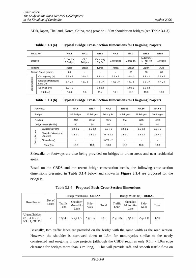
Final Report The Study on the Road Network Development in the Kingdom of Cambodia October 2006
FS-B-3-8
ADB, Japan, Thailand, Korea, China, etc.) provide 1.50m shoulder on bridges (see Table 3.1.3).
Table 3.1.3 (a) Typical Bridge Cross-Section Dimensions for On-going Projects
Route No. NR.1 NR.2 NR.3 NR.3 NR.3 NR.2 NR.5
Bridges C1 Section, 2 Bridges
C2,5 Bridges
Kampong Bay Br. 13 bridges Slakou Br.
Ta Khmau II, Prek Ho
Br. 1 bridge
Funding Japan Japan Korea Korea Japan Japan ADB
Design Speed (km/hr) 80 - - - 60 60 80
Carriageway (m) 3.5 x 2 3.5 x 2 3.5 x 2 3.5 x 2 3.5 x 2 3.5 x 2 3.5 x 2
Shoulder/Motorcycle Lane (m) 2.5 x 2 1.0 x 2 1.0 x 2 1.55 x 2 1.5 x 2 1.5 x 2 1.5 x 2
Sidewalk (m) 1.0 x 2 - 1.2 x 2 - 1.0 x 2 1.5 x 2 -
Cros
s-Se
ctio
n
Total (m) 14.0 9.0 11.4 10.1 12.0 13.0 10.0
Table 3.1.3 (b) Typical Bridge Cross-Section Dimensions for On-going Projects
Route No. NR.6 NR.7 NR.7 NR.48 NR.56 NR.68
Bridges 46 Bridges 12 Bridges Sekong Br. 4 Bridges 19 Bridges 20 Bridges
Funding ADB China China Thai ADB ADB
Design Speed (km/hr) 80 80 80 - 80 80
Carriageway (m) 3.5 x 2 3.5 x 2 3.5 x 2 3.5 x 2 3.5 x 2 3.5 x 2
Shoulder/Motorcycle Lane (m) 1.5 x 2 1.5 x 2 0.75 x 2 1.5 x 2 1.5 x 2 1.5 x 2
Sidewalk (m) - - 0.75 x 2 - - -
Cros
s-Se
ctio
n
Total (m) 10.0 10.0 10.0 10.0 10.0 10.0
Sidewalks or footways are also being provided on bridges in urban areas and near residential areas.
Based on the CBDS and the recent bridge construction trends, the following cross-section dimensions presented in Table 3.1.4 below and shown in Figure 3.1.4 are proposed for the bridges:
Table 3.1.4 Proposed Basic Cross-Section Dimensions
Bridge Width (m) - URBAN Bridge Width (m) - RURAL
Road Name No. of Lanes Traffic
Lane
Shoulder/ Motorbike
Lane
Side- walk Total Traffic
Lane
Shoulder/ Motorbike
Lane
Side- walk Total
Urgent Bridges (NR.3, NR.7, NR.11, NR.33)
2 2 @ 3.5 2 @ 1.5 2 @ 1.5 13.0 2 @ 3.5 2 @ 1.5 2 @ 1.0 12.0
Basically, two traffic lanes are provided on the bridge with the same width as the road section. However, the shoulder is narrowed down to 1.5m for motorcycles similar to the newly constructed and on-going bridge projects (although the CBDS requires only 0.5m - 1.0m edge clearance for bridges more than 30m long). This will provide safe and smooth traffic flow on
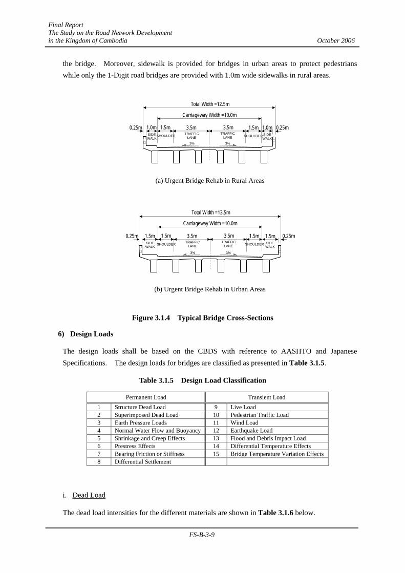
Final Report The Study on the Road Network Development in the Kingdom of Cambodia October 2006
FS-B-3-9
the bridge. Moreover, sidewalk is provided for bridges in urban areas to protect pedestrians while only the 1-Digit road bridges are provided with 1.0m wide sidewalks in rural areas.
(a) Urgent Bridge Rehab in Rural Areas
(b) Urgent Bridge Rehab in Urban Areas
Figure 3.1.4 Typical Bridge Cross-Sections
6) Design Loads
The design loads shall be based on the CBDS with reference to AASHTO and Japanese Specifications. The design loads for bridges are classified as presented in Table 3.1.5.
Table 3.1.5 Design Load Classification
Permanent Load Transient Load 1 Structure Dead Load 9 Live Load 2 Superimposed Dead Load 10 Pedestrian Traffic Load 3 Earth Pressure Loads 11 Wind Load 4 Normal Water Flow and Buoyancy 12 Earthquake Load 5 Shrinkage and Creep Effects 13 Flood and Debris Impact Load 6 Prestress Effects 14 Differential Temperature Effects 7 Bearing Friction or Stiffness 15 Bridge Temperature Variation Effects 8 Differential Settlement
i. Dead Load
The dead load intensities for the different materials are shown in Table 3.1.6 below.
3.5m 3.5m 1.5m 1.5m
Carriageway Width =10.0m
Total Width =12.5m
1.0m 0.25m 0.25m 1.0m TRAFFIC
LANE TRAFFIC
LANE SIDE WALK
SIDE WALK
3% 3%
SHOULDERSHOULDER
3.5m 3.5m 1.5m 1.5m
Carriageway Width =10.0m
Total Width =13.5m
1.5m 0.25m 0.25m 1.5m TRAFFIC
LANE TRAFFIC
LANE SIDE WALK
SIDE WALK
3% 3%
SHOULDER SHOULDER
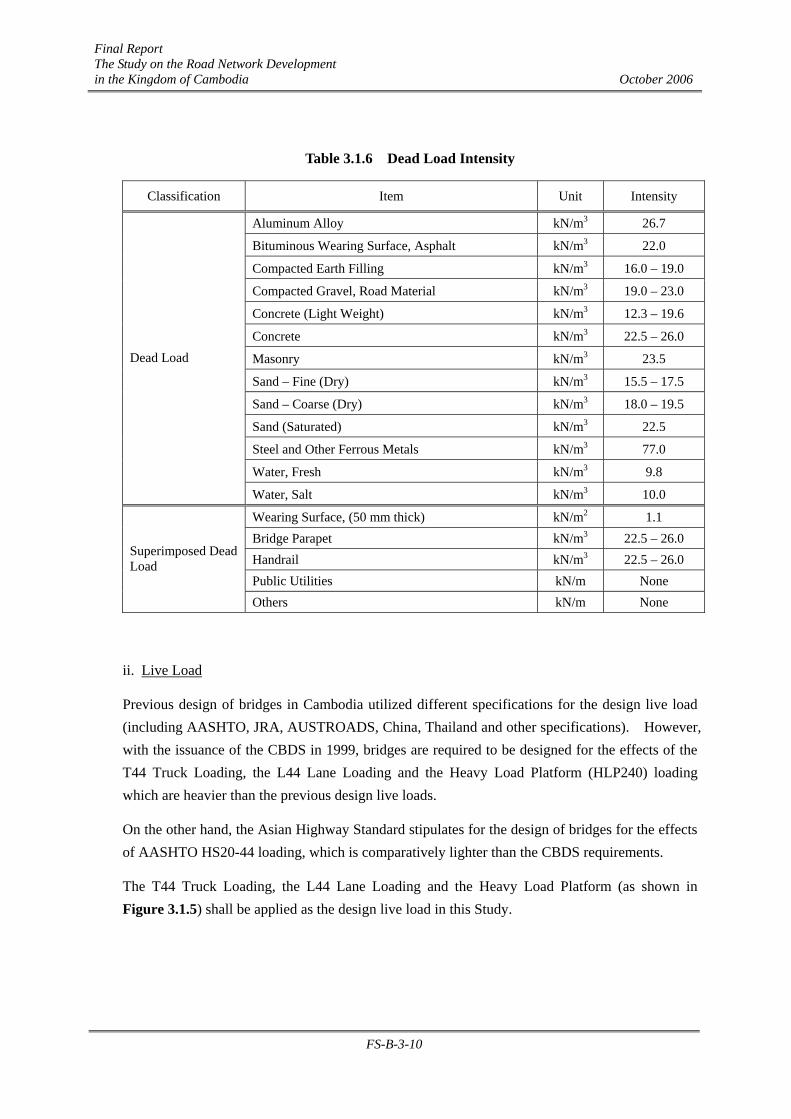
Final Report The Study on the Road Network Development in the Kingdom of Cambodia October 2006
FS-B-3-10
Table 3.1.6 Dead Load Intensity
Classification Item Unit Intensity
Aluminum Alloy kN/m3 26.7
Bituminous Wearing Surface, Asphalt kN/m3 22.0
Compacted Earth Filling kN/m3 16.0 – 19.0
Compacted Gravel, Road Material kN/m3 19.0 – 23.0
Concrete (Light Weight) kN/m3 12.3 – 19.6
Concrete kN/m3 22.5 – 26.0
Masonry kN/m3 23.5
Sand – Fine (Dry) kN/m3 15.5 – 17.5
Sand – Coarse (Dry) kN/m3 18.0 – 19.5
Sand (Saturated) kN/m3 22.5
Steel and Other Ferrous Metals kN/m3 77.0
Water, Fresh kN/m3 9.8
Dead Load
Water, Salt kN/m3 10.0
Wearing Surface, (50 mm thick) kN/m2 1.1 Bridge Parapet kN/m3 22.5 – 26.0 Handrail kN/m3 22.5 – 26.0 Public Utilities kN/m None
Superimposed Dead Load
Others kN/m None
ii. Live Load
Previous design of bridges in Cambodia utilized different specifications for the design live load (including AASHTO, JRA, AUSTROADS, China, Thailand and other specifications). However, with the issuance of the CBDS in 1999, bridges are required to be designed for the effects of the T44 Truck Loading, the L44 Lane Loading and the Heavy Load Platform (HLP240) loading which are heavier than the previous design live loads.
On the other hand, the Asian Highway Standard stipulates for the design of bridges for the effects of AASHTO HS20-44 loading, which is comparatively lighter than the CBDS requirements.
The T44 Truck Loading, the L44 Lane Loading and the Heavy Load Platform (as shown in Figure 3.1.5) shall be applied as the design live load in this Study.
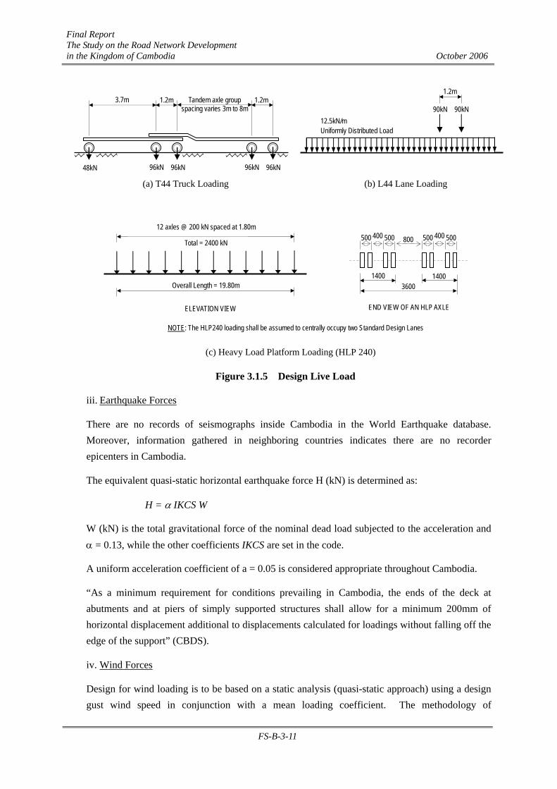
Final Report The Study on the Road Network Development in the Kingdom of Cambodia October 2006
FS-B-3-11
(a) T44 Truck Loading (b) L44 Lane Loading
(c) Heavy Load Platform Loading (HLP 240)
Figure 3.1.5 Design Live Load
iii. Earthquake Forces
There are no records of seismographs inside Cambodia in the World Earthquake database. Moreover, information gathered in neighboring countries indicates there are no recorder epicenters in Cambodia.
The equivalent quasi-static horizontal earthquake force H (kN) is determined as:
H = α IKCS W
W (kN) is the total gravitational force of the nominal dead load subjected to the acceleration and α = 0.13, while the other coefficients IKCS are set in the code.
A uniform acceleration coefficient of a = 0.05 is considered appropriate throughout Cambodia.
“As a minimum requirement for conditions prevailing in Cambodia, the ends of the deck at abutments and at piers of simply supported structures shall allow for a minimum 200mm of horizontal displacement additional to displacements calculated for loadings without falling off the edge of the support” (CBDS).
iv. Wind Forces
Design for wind loading is to be based on a static analysis (quasi-static approach) using a design gust wind speed in conjunction with a mean loading coefficient. The methodology of
90kN
1.2m
90kN 12.5kN/m Uniformly Distributed Load
3.7m 1.2m 1.2m Tandem axle group spacing varies 3m to 8m
96kN 96kN 96kN 96kN 48kN
12 axles @ 200 kN spaced at 1.80m
Total = 2400 kN
Overall Length = 19.80m
500 500 400 500 500 400 800
3600 1400 1400
ELEVATION VIEW END VIEW OF AN HLP AXLE
NOTE: The HLP240 loading shall be assumed to centrally occupy two Standard Design Lanes
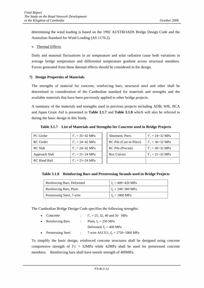
Final Report The Study on the Road Network Development in the Kingdom of Cambodia October 2006
FS-B-3-12
determining the wind loading is based on the 1992 AUSTROADS Bridge Design Code and the Australian Standard for Wind Loading (AS 1170.2).
v. Thermal Effects
Daily and seasonal fluctuations in air temperature and solar radiation cause both variations in average bridge temperature and differential temperature gradient across structural members. Forces generated from these thermal effects should be considered in the design.
7) Design Properties of Materials
The strengths of material for concrete, reinforcing bars, structural steel and other shall be determined in consideration of the Cambodian standard for materials and strengths and the available materials that have been previously applied to other bridge projects.
A summary of the materials and strengths used in previous projects including ADB, WB, JICA and Japan Grant Aid is presented in Table 3.1.7 and Table 3.1.8 which will also be referred to during the basic design in this Study.
Table 3.1.7 List of Materials and Strengths for Concrete used in Bridge Projects
PC Girder f’c = 35~42 MPa Abutment, Piers f’c = 24~32 MPa
RC Girder f’c = 24~42 MPa RC Pile (Cast-in Place) f’c = 30~32 MPa
RC Slab f’c = 24~42 MPa RC Pile (Precast) f’c = 30~32 MPa
Approach Slab f’c = 21~24 MPa Box Culvert f’c = 21~32 MPa
RC Hand Rail f’c = 21~24 MPa
Table 3.1.8 Reinforcing Bars and Prestressing Strands used in Bridge Projects
Reinforcing Bars, Deformed fy = 400~420 MPa
Reinforcing Bars, Plain fy = 240~300 MPa
Prestressing Steel, 7-wire fp = 1860 MPa
The Cambodian Bridge Design Code specifies the following strengths:
• Concrete : f’c = 25, 32, 40 and 50 MPa • Reinforcing Bars : Plain, fy = 250 MPa Deformed, fy = 400 MPa • Prestressing Steel : 7-wire AS1311, fp = 1750~1860 MPa
To simplify the basic design, reinforced concrete structures shall be designed using concrete compressive strength of f’c = 32MPa while 42MPa shall be used for prestressed concrete members. Reinforcing bars shall have tensile strength of 400MPa.
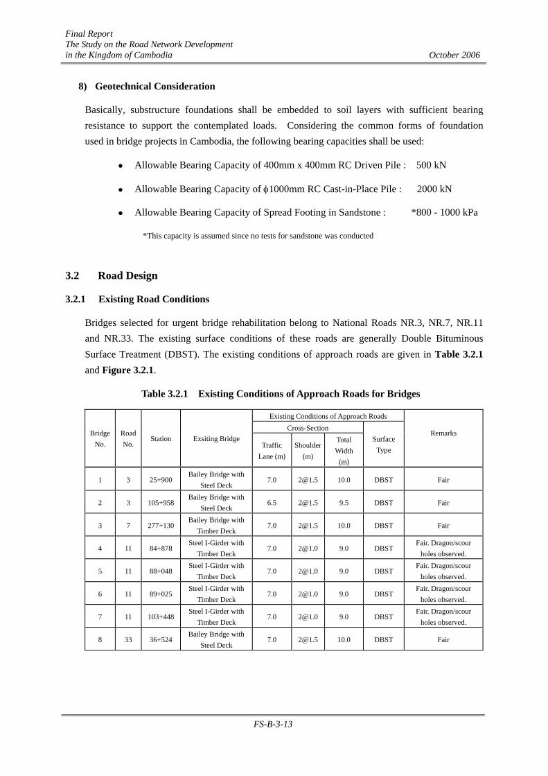
Final Report The Study on the Road Network Development in the Kingdom of Cambodia October 2006
FS-B-3-13
8) Geotechnical Consideration
Basically, substructure foundations shall be embedded to soil layers with sufficient bearing resistance to support the contemplated loads. Considering the common forms of foundation used in bridge projects in Cambodia, the following bearing capacities shall be used:
Allowable Bearing Capacity of 400mm x 400mm RC Driven Pile : 500 kN
Allowable Bearing Capacity of φ1000mm RC Cast-in-Place Pile : 2000 kN
Allowable Bearing Capacity of Spread Footing in Sandstone : *800 - 1000 kPa
*This capacity is assumed since no tests for sandstone was conducted
3.2 Road Design
3.2.1 Existing Road Conditions
Bridges selected for urgent bridge rehabilitation belong to National Roads NR.3, NR.7, NR.11 and NR.33. The existing surface conditions of these roads are generally Double Bituminous Surface Treatment (DBST). The existing conditions of approach roads are given in Table 3.2.1 and Figure 3.2.1.
Table 3.2.1 Existing Conditions of Approach Roads for Bridges
Existing Conditions of Approach Roads Cross-Section
Bridge No.
Road No.
Station Exsiting Bridge Traffic
Lane (m)Shoulder
(m)
Total Width
(m)
Surface Type
Remarks
1 3 25+900 Bailey Bridge with
Steel Deck 7.0 [email protected] 10.0 DBST Fair
2 3 105+958 Bailey Bridge with
Steel Deck 6.5 [email protected] 9.5 DBST Fair
3 7 277+130 Bailey Bridge with
Timber Deck 7.0 [email protected] 10.0 DBST Fair
4 11 84+878 Steel I-Girder with
Timber Deck 7.0 [email protected] 9.0 DBST
Fair. Dragon/scour holes observed.
5 11 88+048 Steel I-Girder with
Timber Deck 7.0 [email protected] 9.0 DBST
Fair. Dragon/scour holes observed.
6 11 89+025 Steel I-Girder with
Timber Deck 7.0 [email protected] 9.0 DBST
Fair. Dragon/scour holes observed.
7 11 103+448 Steel I-Girder with
Timber Deck 7.0 [email protected] 9.0 DBST
Fair. Dragon/scour holes observed.
8 33 36+524 Bailey Bridge with
Steel Deck 7.0 [email protected] 10.0 DBST Fair
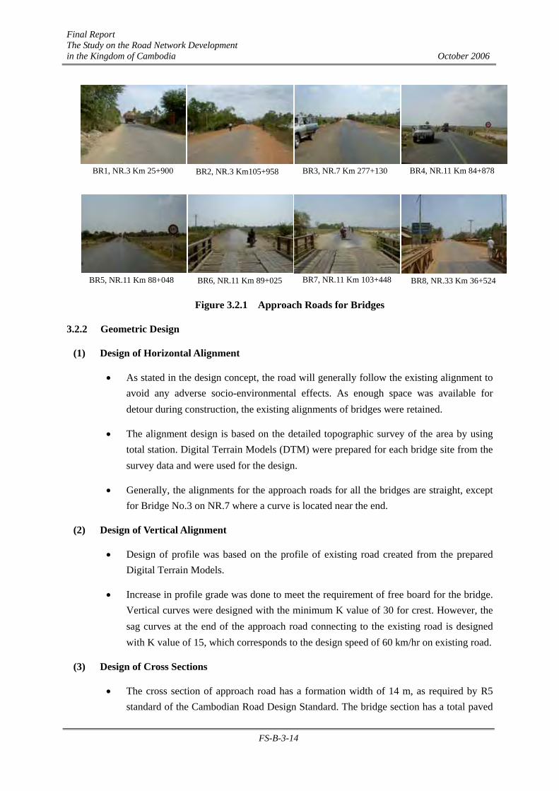
Final Report The Study on the Road Network Development in the Kingdom of Cambodia October 2006
FS-B-3-14
Figure 3.2.1 Approach Roads for Bridges
3.2.2 Geometric Design
(1) Design of Horizontal Alignment
• As stated in the design concept, the road will generally follow the existing alignment to avoid any adverse socio-environmental effects. As enough space was available for detour during construction, the existing alignments of bridges were retained.
• The alignment design is based on the detailed topographic survey of the area by using total station. Digital Terrain Models (DTM) were prepared for each bridge site from the survey data and were used for the design.
• Generally, the alignments for the approach roads for all the bridges are straight, except for Bridge No.3 on NR.7 where a curve is located near the end.
(2) Design of Vertical Alignment
• Design of profile was based on the profile of existing road created from the prepared Digital Terrain Models.
• Increase in profile grade was done to meet the requirement of free board for the bridge. Vertical curves were designed with the minimum K value of 30 for crest. However, the sag curves at the end of the approach road connecting to the existing road is designed with K value of 15, which corresponds to the design speed of 60 km/hr on existing road.
(3) Design of Cross Sections
• The cross section of approach road has a formation width of 14 m, as required by R5 standard of the Cambodian Road Design Standard. The bridge section has a total paved
BR1, NR.3 Km 25+900 BR2, NR.3 Km105+958
BR8, NR.33 Km 36+524
BR3, NR.7 Km 277+130 BR4, NR.11 Km 84+878
BR5, NR.11 Km 88+048 BR6, NR.11 Km 89+025 BR7, NR.11 Km 103+448
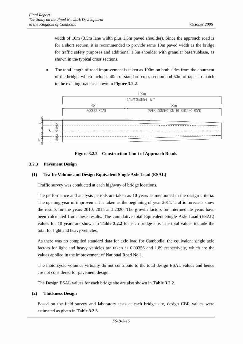
Final Report The Study on the Road Network Development in the Kingdom of Cambodia October 2006
FS-B-3-15
width of 10m (3.5m lane width plus 1.5m paved shoulder). Since the approach road is for a short section, it is recommended to provide same 10m paved width as the bridge for traffic safety purposes and additional 1.5m shoulder with granular base/subbase, as shown in the typical cross sections.
• The total length of road improvement is taken as 100m on both sides from the abutment of the bridge, which includes 40m of standard cross section and 60m of taper to match to the existing road, as shown in Figure 3.2.2.
Figure 3.2.2 Construction Limit of Approach Roads
3.2.3 Pavement Design
(1) Traffic Volume and Design Equivalent Single Axle Load (ESAL)
Traffic survey was conducted at each highway of bridge locations.
The performance and analysis periods are taken as 10 years as mentioned in the design criteria. The opening year of improvement is taken as the beginning of year 2011. Traffic forecasts show the results for the years 2010, 2015 and 2020. The growth factors for intermediate years have been calculated from these results. The cumulative total Equivalent Single Axle Load (ESAL) values for 10 years are shown in Table 3.2.2 for each bridge site. The total values include the total for light and heavy vehicles.
As there was no compiled standard data for axle load for Cambodia, the equivalent single axle factors for light and heavy vehicles are taken as 0.00356 and 1.89 respectively, which are the values applied in the improvement of National Road No.1.
The motorcycle volumes virtually do not contribute to the total design ESAL values and hence are not considered for pavement design.
The Design ESAL values for each bridge site are also shown in Table 3.2.2.
(2) Thickness Design
Based on the field survey and laboratory tests at each bridge site, design CBR values were estimated as given in Table 3.2.3.

Final Report The Study on the Road Network Development in the Kingdom of Cambodia October 2006
FS-B-3-16
Where the field CBR values are less than or equal 4, replacement of subgrade is necessary to obtain the required Design CBR values. Possibility of using subgrade material of higher CBR shall also be investigated in detail along with more detailed investigation of existing road bed material during detailed design stages.
Table 3.2.2 Cumulative ESAL Values for Each Bridge Site
Cumulative Total ESAL Values
BR1 BR2 BR3 BR4 BR5 BR6 BR7 BR8
2011 494874 402950 129128 434465 434465 434465 419854 20331
2012 551623 423218 133284 539869 539869 539869 523891 22562
2013 614883 444505 137574 670845 670845 670845 653710 25039
2014 685400 466862 142002 833600 833600 833600 815699 27790
2015 764008 490345 146573 1035844 1035844 1035844 1017832 30845
2016 858589 551752 150296 1098988 1098988 1098988 1079978 34131
2017 964878 620853 154115 1165985 1165985 1165985 1145922 37768
2018 1084326 698611 158031 1237071 1237071 1237071 1215897 41792
2019 1218560 786111 162047 1312496 1312496 1312496 1290149 46245
2020 1369413 884573 166166 1392525 1392525 1392525 1368942 51172
Both Directions 8606553 5769779 1479216 9721688 9721688 9721688 9531874 337675
Per Lane 5163932 3461867 887530 5833013 5833013 5833013 5719125 202605
Design ESAL 5.2 million 3.5 million 0.9 million 5.8 million 5.8 million 5.8 million 5.7 million 0.2 million
Table 3.2.3 Estimated CBR for Each Bridge Site
Bridge
No. Soil Description Field CBR Design CBR
No.1 Sandy lean clay with N-value of 12. Gravel/Sand content of about 30%. 7 6
No.2 Medium stiff brown and fine sandy lean clay with N-Value of 4 to 7.
Sieving size of #200 passed is 73%. 7 6
No.3 Brown, clay, silt & fine sandy lean clay with N-value of 7 to 14, which is
part of embankment. Sieving size of #200 passed is 73%. 7 6
No.4
Yellow, brown, and a few fine sandy clay, silt & fine sandy lean clay
with N-value of 3, which is part ofembankment. Sieving size of #200
passed is 92%.
4 4 with
replacement
No.5 Brown silt, clay & gravel with N-value of 5 to 7, which is part of
embankment. Sieving size of #200 passed is 94%. 5 4
No.6 Ditto 5 4
No.7 Brown fine sand fat clay with N-value of 8, which is part of embankment.
Sieving size of #200 passed is 98%. 6 4
No.8 Redish brown sand, clay, silt &gravel (laterite) with N-value of 1 to 9,
which is part of embankment. Sieving size of #200 passed is 98%. 2
4 with
replacement
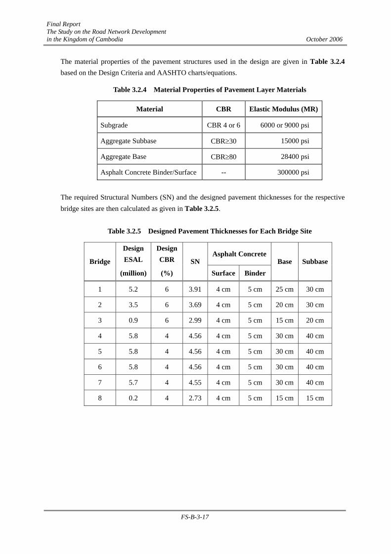
Final Report The Study on the Road Network Development in the Kingdom of Cambodia October 2006
FS-B-3-17
The material properties of the pavement structures used in the design are given in Table 3.2.4 based on the Design Criteria and AASHTO charts/equations.
Table 3.2.4 Material Properties of Pavement Layer Materials
Material CBR Elastic Modulus (MR)
Subgrade CBR 4 or 6 6000 or 9000 psi
Aggregate Subbase CBR≥30 15000 psi
Aggregate Base CBR≥80 28400 psi
Asphalt Concrete Binder/Surface -- 300000 psi
The required Structural Numbers (SN) and the designed pavement thicknesses for the respective bridge sites are then calculated as given in Table 3.2.5.
Table 3.2.5 Designed Pavement Thicknesses for Each Bridge Site
Design ESAL
DesignCBR
Asphalt ConcreteBridge
(million) (%) SN
Surface BinderBase Subbase
1 5.2 6 3.91 4 cm 5 cm 25 cm 30 cm
2 3.5 6 3.69 4 cm 5 cm 20 cm 30 cm
3 0.9 6 2.99 4 cm 5 cm 15 cm 20 cm
4 5.8 4 4.56 4 cm 5 cm 30 cm 40 cm
5 5.8 4 4.56 4 cm 5 cm 30 cm 40 cm
6 5.8 4 4.56 4 cm 5 cm 30 cm 40 cm
7 5.7 4 4.55 4 cm 5 cm 30 cm 40 cm
8 0.2 4 2.73 4 cm 5 cm 15 cm 15 cm


![Revised 35% Design Construction Cost Estimate Studies/1 Design Estimate Fish... · Revised 35% Design Construction Cost Estimate ... Ready-To-Advertise [ ] ... SUMMARY REPORTS SUMMARY](https://img.pdfslide.us/doc/110x75/5b31ae777f8b9a2c328cb136/revised-35-design-construction-cost-studies1-design-estimate-fish-revised.jpg)